Embed Size (px)
Citation preview
A Newsletter for Emergency Managers, Core Storm Spotters,
Media, and Public Officials in Eastern Nebraska and
Southwest Iowa
Comments and suggestions are always welcome.
Your feedback is very important to us!
Please contact us by telephone,
e-mail, or regular mail.
National Weather Service 6707 N 288th Street
Valley, Nebraska 68064
This publication also is available on-line at
http://www.crh.noaa.gov/oax/
news/newsletter.pdf
Chief Editor:
Barbara Mayes
Fall 2010
by Rebecca Kern, Meteorologist
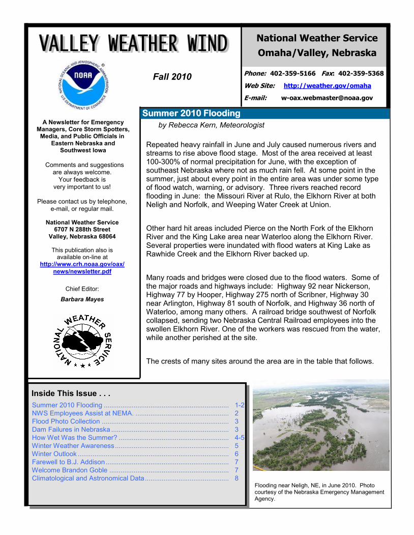
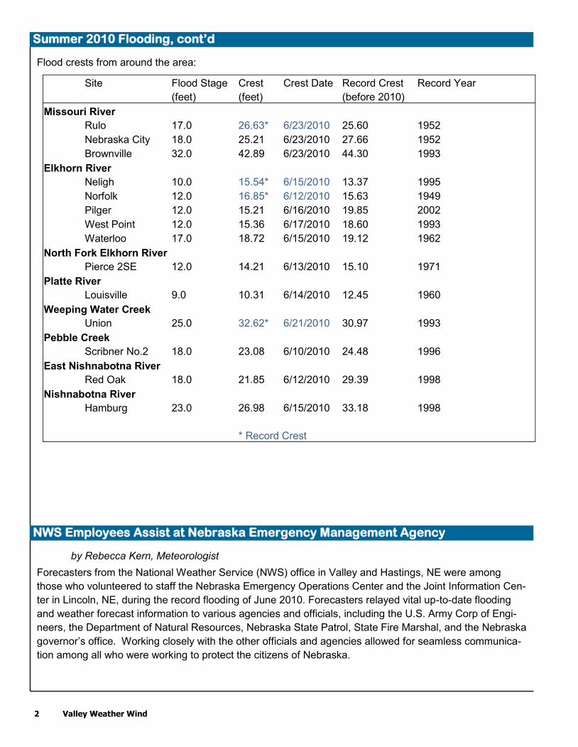
Repeated heavy rainfall in June and July caused numerous rivers and streams to rise above flood stage. Most of the area received at least 100-300% of normal precipitation for June, with the exception of southeast Nebraska where not as much rain fell. At some point in the summer, just about every point in the entire area was under some type of flood watch, warning, or advisory. Three rivers reached record flooding in June: the Missouri River at Rulo, the Elkhorn River at both Neligh and Norfolk, and Weeping Water Creek at Union.
Other hard hit areas included Pierce on the North Fork of the Elkhorn River and the King Lake area near Waterloo along the Elkhorn River. Several properties were inundated with flood waters at King Lake as Rawhide Creek and the Elkhorn River backed up.
Many roads and bridges were closed due to the flood waters. Some of the major roads and highways include: Highway 92 near Nickerson, Highway 77 by Hooper, Highway 275 north of Scribner, Highway 30 near Arlington, Highway 81 south of Norfolk, and Highway 36 north of Waterloo, among many others. A railroad bridge southwest of Norfolk collapsed, sending two Nebraska Central Railroad employees into the swollen Elkhorn River. One of the workers was rescued from the water, while another perished at the site.
The crests of many sites around the area are in the table that follows.
Summer 2010 Flooding
National Weather Service
Omaha/Valley, Nebraska
Web Site: http://weather.gov/omaha
E-mail: [email protected]
Phone: 402-359-5166 Fax: 402-359-5368
Inside This Issue . . .
Summer 2010 Flooding ................................................................... 1-2
NWS Employees Assist at NEMA. .................................................. 2
Flood Photo Collection .................................................................... 3
Dam Failures in Nebraska ............................................................... 3
How Wet Was the Summer? ........................................................... 4-5
Winter Weather Awareness ............................................................. 5
Winter Outlook ................................................................................. 6
Farewell to B.J. Addison .................................................................. 7
Welcome Brandon Goble ................................................................ 7
Climatological and Astronomical Data ............................................. 8 Flooding near Neligh, NE, in June 2010. Photo courtesy of the Nebraska Emergency Management Agency.
2 Valley Weather Wind
Flood crests from around the area:
Summer 2010 Flooding, cont’d
Site Flood Stage Crest Crest Date Record Crest Record Year
(feet) (feet) (before 2010)
Missouri River
Rulo 17.0 26.63* 6/23/2010 25.60 1952
Nebraska City 18.0 25.21 6/23/2010 27.66 1952
Brownville 32.0 42.89 6/23/2010 44.30 1993
Elkhorn River
Neligh 10.0 15.54* 6/15/2010 13.37 1995
Norfolk 12.0 16.85* 6/12/2010 15.63 1949
Pilger 12.0 15.21 6/16/2010 19.85 2002
West Point 12.0 15.36 6/17/2010 18.60 1993
Waterloo 17.0 18.72 6/15/2010 19.12 1962
North Fork Elkhorn River
Pierce 2SE 12.0 14.21 6/13/2010 15.10 1971
Platte River
Louisville 9.0 10.31 6/14/2010 12.45 1960
Weeping Water Creek
Union 25.0 32.62* 6/21/2010 30.97 1993
Pebble Creek
Scribner No.2 18.0 23.08 6/10/2010 24.48 1996
East Nishnabotna River
Red Oak 18.0 21.85 6/12/2010 29.39 1998
Nishnabotna River
Hamburg 23.0 26.98 6/15/2010 33.18 1998
* Record Crest
by Rebecca Kern, Meteorologist
Forecasters from the National Weather Service (NWS) office in Valley and Hastings, NE were among
those who volunteered to staff the Nebraska Emergency Operations Center and the Joint Information Cen-
ter in Lincoln, NE, during the record flooding of June 2010. Forecasters relayed vital up-to-date flooding
and weather forecast information to various agencies and officials, including the U.S. Army Corp of Engi-
neers, the Department of Natural Resources, Nebraska State Patrol, State Fire Marshal, and the Nebraska
governor’s office. Working closely with the other officials and agencies allowed for seamless communica-
tion among all who were working to protect the citizens of Nebraska.
NWS Employees Assist at Nebraska Emergency Management Agency
Valley Weather Wind 3
by Rebecca Kern, Meteorologist
Although no dams were breached or overtopped across the NWS Omaha/Valley, NE, county warning area,
heavy rain caused several dams across parts of western and central Nebraska to fail. The flooding caused
the failure of six dams : Bredthauer Dam in Valley County, Ericson Dam in Wheeler County, Gracie Creek
Road Dam in Loup County, Morgan Dam in Loup County, Ord-North Loup Diversion Dam in Valley County,
and Taylor-Ord Diversion Dam in Loup County. Six other dams across the state were overtopped by flood-
waters but did not fail. Some of these failures caused rises in rivers that run through the Omaha/Valley, NE
county warning area. The dam failures did not cause any significant property damage; however, a few
flash flood warnings were issued directly downstream of the dam failures. Fortunately, no loss of life oc-
curred because of the dam failures. Source: Nebraska Department of Natural Resources
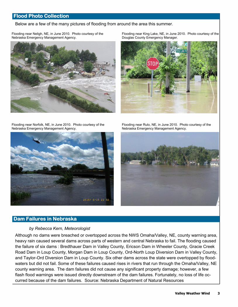
Below are a few of the many pictures of flooding from around the area this summer.
Flood Photo Collection
Dam Failures in Nebraska
Flooding near Neligh, NE, in June 2010. Photo courtesy of the Nebraska Emergency Management Agency.
Flooding near King Lake, NE, in June 2010. Photo courtesy of the Douglas County Emergency Manager.
Flooding near Norfolk, NE, in June 2010. Photo courtesy of the Nebraska Emergency Management Agency.
Flooding near Rulo, NE, in June 2010. Photo courtesy of the Nebraska Emergency Management Agency.
4 Valley Weather Wind
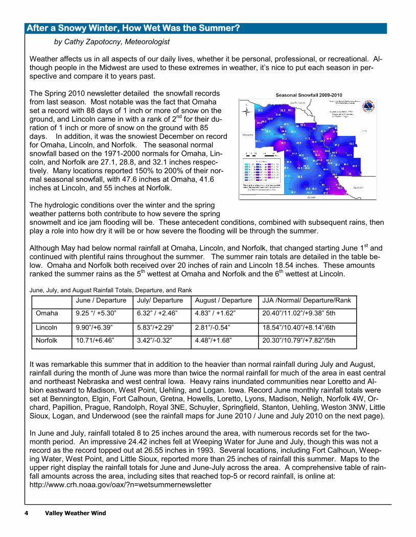
by Cathy Zapotocny, Meteorologist Weather affects us in all aspects of our daily lives, whether it be personal, professional, or recreational. Al-though people in the Midwest are used to these extremes in weather, it’s nice to put each season in per-spective and compare it to years past. The Spring 2010 newsletter detailed the snowfall records from last season. Most notable was the fact that Omaha set a record with 88 days of 1 inch or more of snow on the ground, and Lincoln came in with a rank of 2
nd for their du-
ration of 1 inch or more of snow on the ground with 85 days. In addition, it was the snowiest December on record for Omaha, Lincoln, and Norfolk. The seasonal normal snowfall based on the 1971-2000 normals for Omaha, Lin-coln, and Norfolk are 27.1, 28.8, and 32.1 inches respec-tively. Many locations reported 150% to 200% of their nor-mal seasonal snowfall, with 47.6 inches at Omaha, 41.6 inches at Lincoln, and 55 inches at Norfolk. The hydrologic conditions over the winter and the spring weather patterns both contribute to how severe the spring snowmelt and ice jam flooding will be. These antecedent conditions, combined with subsequent rains, then play a role into how dry it will be or how severe the flooding will be through the summer. Although May had below normal rainfall at Omaha, Lincoln, and Norfolk, that changed starting June 1st and continued with plentiful rains throughout the summer. The summer rain totals are detailed in the table be-low. Omaha and Norfolk both received over 20 inches of rain and Lincoln 18.54 inches. These amounts ranked the summer rains as the 5
th wettest at Omaha and Norfolk and the 6
th wettest at Lincoln.
June, July, and August Rainfall Totals, Departure, and Rank
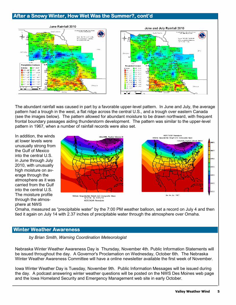
It was remarkable this summer that in addition to the heavier than normal rainfall during July and August, rainfall during the month of June was more than twice the normal rainfall for much of the area in east central and northeast Nebraska and west central Iowa. Heavy rains inundated communities near Loretto and Al-bion eastward to Madison, West Point, Uehling, and Logan. Iowa. Record June monthly rainfall totals were set at Bennington, Elgin, Fort Calhoun, Gretna, Howells, Loretto, Lyons, Madison, Neligh, Norfolk 4W, Or-chard, Papillion, Prague, Randolph, Royal 3NE, Schuyler, Springfield, Stanton, Uehling, Weston 3NW, Little Sioux, Logan, and Underwood (see the rainfall maps for June 2010 / June and July 2010 on the next page). In June and July, rainfall totaled 8 to 25 inches around the area, with numerous records set for the two-month period. An impressive 24.42 inches fell at Weeping Water for June and July, though this was not a record as the record topped out at 26.55 inches in 1993. Several locations, including Fort Calhoun, Weep-ing Water, West Point, and Little Sioux, reported more than 25 inches of rainfall this summer. Maps to the upper right display the rainfall totals for June and June-July across the area. A comprehensive table of rain-fall amounts across the area, including sites that reached top-5 or record rainfall, is online at: http://www.crh.noaa.gov/oax/?n=wetsummernewsletter
June / Departure July/ Departure August / Departure JJA /Normal/ Departure/Rank
Omaha 9.25 “/ +5.30” 6.32” / +2.46” 4.83” / +1.62” 20.40”/11.02”/+9.38” 5th
Lincoln 9.90”/+6.39” 5.83”/+2.29” 2.81”/-0.54” 18.54”/10.40”/+8.14”/6th
Norfolk 10.71/+6.46” 3.42”/-0.32” 4.48”/+1.68” 20.30”/10.79”/+7.82”/5th
After a Snowy Winter, How Wet Was the Summer?
Valley Weather Wind 5
by Brian Smith, Warning Coordination Meteorologist
Nebraska Winter Weather Awareness Day is Thursday, November 4th. Public Information Statements will be issued throughout the day. A Governor's Proclamation on Wednesday, October 6th. The Nebraska Winter Weather Awareness Committee will have a online newsletter available the first week of November. Iowa Winter Weather Day is Tuesday, November 9th. Public Information Messages will be issued during the day. A podcast answering winter weather questions will be posted on the NWS Des Moines web page and the Iowa Homeland Security and Emergency Management web site in early October.
The abundant rainfall was caused in part by a favorable upper-level pattern. In June and July, the average pattern had a trough in the west, a flat ridge across the central U.S., and a trough over eastern Canada (see the images below). The pattern allowed for abundant moisture to be drawn northward, with frequent frontal boundary passages aiding thunderstorm development. The pattern was similar to the upper-level pattern in 1967, when a number of rainfall records were also set. In addition, the winds at lower levels were unusually strong from the Gulf of Mexico into the central U.S. in June through July 2010, with unusually high moisture on av-erage through the atmosphere as it was carried from the Gulf into the central U.S. The moisture profile through the atmos-phere at NWS Omaha, measured as “precipitable water” by the 7:00 PM weather balloon, set a record on July 4 and then tied it again on July 14 with 2.37 inches of precipitable water through the atmosphere over Omaha.
After a Snowy Winter, How Wet Was the Summer?, cont’d
Winter Weather Awareness
6 Valley Weather Wind
Winter Outlook
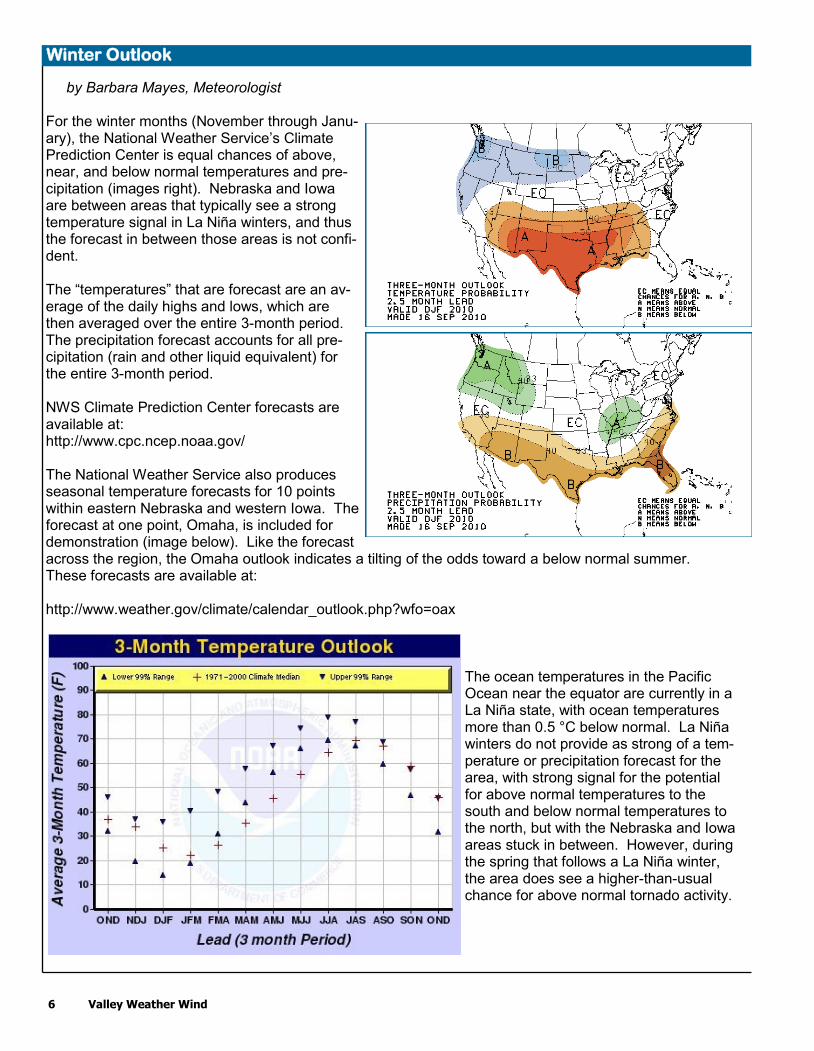
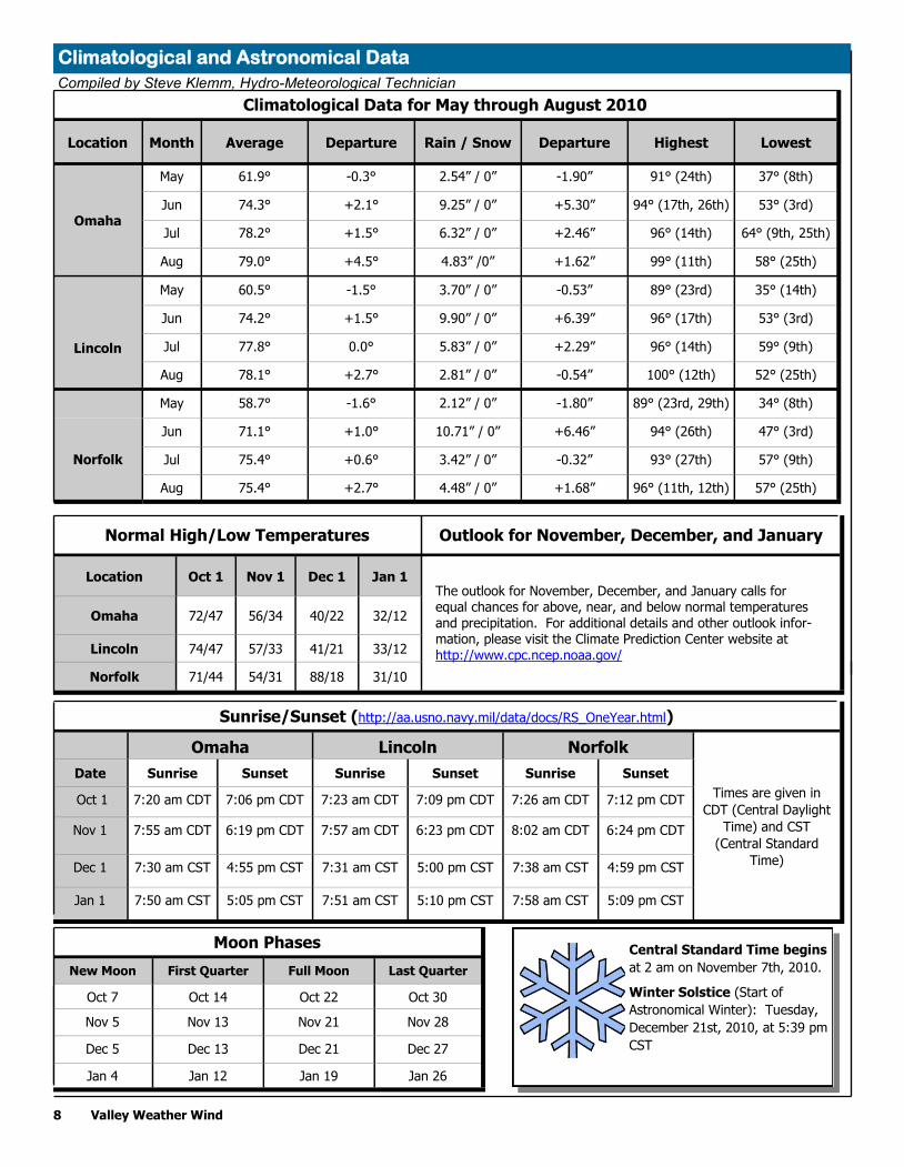
by Barbara Mayes, Meteorologist For the winter months (November through Janu-ary), the National Weather Service’s Climate Prediction Center is equal chances of above, near, and below normal temperatures and pre-cipitation (images right). Nebraska and Iowa are between areas that typically see a strong temperature signal in La Niña winters, and thus the forecast in between those areas is not confi-dent. The “temperatures” that are forecast are an av-erage of the daily highs and lows, which are then averaged over the entire 3-month period. The precipitation forecast accounts for all pre-cipitation (rain and other liquid equivalent) for the entire 3-month period. NWS Climate Prediction Center forecasts are available at: http://www.cpc.ncep.noaa.gov/ The National Weather Service also produces seasonal temperature forecasts for 10 points within eastern Nebraska and western Iowa. The forecast at one point, Omaha, is included for demonstration (image below). Like the forecast across the region, the Omaha outlook indicates a tilting of the odds toward a below normal summer. These forecasts are available at: http://www.weather.gov/climate/calendar_outlook.php?wfo=oax
The ocean temperatures in the Pacific Ocean near the equator are currently in a La Niña state, with ocean temperatures more than 0.5 °C below normal. La Niña winters do not provide as strong of a tem-perature or precipitation forecast for the area, with strong signal for the potential for above normal temperatures to the south and below normal temperatures to the north, but with the Nebraska and Iowa areas stuck in between. However, during the spring that follows a La Niña winter, the area does see a higher-than-usual chance for above normal tornado activity.

Valley Weather Wind 7
Welcome to New Administrative Assistant Brandon Goble
After 39 years with one constant Administrative Assistant (ASA) at National Weather Service (NWS) Omaha/Valley, we have a brand new one! We are very lucky to have Brandon Goble as new ASA. What else would one expect but to welcome Brandon to the NWS with some powerful thunderstorms and severe weather. Brandon was born and raised in rural Nebraska, attended college at the University of Nebraska at Kearney, and began his career with the Federal Government in 2008 when he accepted a secretary position with the Bureau of Reclamation's Civil Rights Office/Equal Employment Opportunity Headquarters in Denver, Colo-rado. During his year with Reclamation's Civil Rights Office, he was also elected chair of the Denver Admin-istrative Support Council and appointed chair of the Employee Appreciation Day Committee. He then trans-ferred to the National Park Service Midwest Regional Office in Omaha, Nebraska, and began working in the Park Operations and Education/Law Enforcement Division. In addition to serving as division secretary and the personal assistant to the Regional Chief Law Enforcement Ranger, Brandon also oversaw a $10.5 million budget as a portion of the Environ-mental Protection Agency $270 million Great Lakes Restoration Initiative, and he was responsible for all aspects of budget formulation, planning, and reconciliation. Prior to working on the civilian side of the federal government, Brandon enlisted in the active duty U.S. Army from 2004-2007, where he served as an Arabic linguist for the 229th Military Intelligence Battalion in Monterey, California. Brandon said he is very happy to be with the National Weather Service and is looking forward to making a meaning-ful contribution to the agency's daily operations. Welcome Brandon, and we are thrilled to have you as the newest member of our NWS family at WFO Omaha.
Betty Jo (B.J.) Addison, the Administrative Assistant (ASA) at National Weather Service (NWS) Omaha, retired on July 3rd after 39 years of service. Family and friends had a wonderful retirement party with BJ on July 24 at Izaak Walton Park in Fre-mont, Nebraska. After a nice meal, BJ was given a "friendly" roast with many of her friends and coworkers sharing some of the more entertaining experiences of her career. During B.J.’s NWS career, she had worked with six Meteorolo-gists in Charge and had been directly involved in the mov-ing/building of a new office twice. She was a part of the National Weather Service as it evolved from teletypes, manual typewriters, and tube-type radars to today’s Doppler radar, AWIPS work stations, e-mail, and cell phones. B.J. had numerous opportunities to be involved in vari-ous facets of the NWS, including the first NWS Women’s Conference held in 1993 in Silver Spring, MD. B.J. looked back at her career with the thought that it had been both a privilege and pleasure to have worked for the National Weather Service. B.J. said her memorable experiences will be her many associa-tions with the unique, dedicated and talented family of NWS employees. B.J. went on to say she had en-joyed the camaraderie that came from sharing the work, accomplishments and laughter. Upon retirement, B.J. is enjoying working with her certified pet therapy dog, Coco, visiting care centers, li-braries, and schools. B.J. and her husband, Jim, plan to spend more time with their families, golf, and pur-sue new interests and activities. The NWS Omaha staff wishing B.J. nothing but the very best in her happy retirement years.
Long-Time Omaha Administrative Assistant Betty Jo Addison Retires
Climatological and Astronomical Data
Central Standard Time begins
at 2 am on November 7th, 2010.
Winter Solstice (Start of
Astronomical Winter): Tuesday,
December 21st, 2010, at 5:39 pm
CST
Moon Phases
New Moon First Quarter Full Moon Last Quarter
Oct 7 Oct 14 Oct 22 Oct 30
Nov 5 Nov 13 Nov 21 Nov 28
Dec 5 Dec 13 Dec 21 Dec 27
Jan 4 Jan 12 Jan 19 Jan 26
Sunrise/Sunset (http://aa.usno.navy.mil/data/docs/RS_OneYear.html)
Omaha Lincoln Norfolk
Times are given in
CDT (Central Daylight
Time) and CST
(Central Standard
Time)
Date Sunrise Sunset Sunrise Sunset Sunrise Sunset
Oct 1 7:20 am CDT 7:06 pm CDT 7:23 am CDT 7:09 pm CDT 7:26 am CDT 7:12 pm CDT
Nov 1 7:55 am CDT 6:19 pm CDT 7:57 am CDT 6:23 pm CDT 8:02 am CDT 6:24 pm CDT
Dec 1 7:30 am CST 4:55 pm CST 7:31 am CST 5:00 pm CST 7:38 am CST 4:59 pm CST
Jan 1 7:50 am CST 5:05 pm CST 7:51 am CST 5:10 pm CST 7:58 am CST 5:09 pm CST
Normal High/Low Temperatures Outlook for November, December, and January
Location Oct 1 Nov 1 Dec 1 Jan 1
Omaha 72/47 56/34 40/22 32/12
Lincoln 74/47 57/33 41/21 33/12
Norfolk 71/44 54/31 88/18 31/10
Climatological Data for May through August 2010
Location Month Average Departure Rain / Snow Departure Highest Lowest
Omaha
May 61.9° -0.3° 2.54” / 0” -1.90” 91° (24th) 37° (8th)
Jun 74.3° +2.1° 9.25” / 0” +5.30” 94° (17th, 26th) 53° (3rd)
Jul 78.2° +1.5° 6.32” / 0” +2.46” 96° (14th) 64° (9th, 25th)
Aug 79.0° +4.5° 4.83” /0” +1.62” 99° (11th) 58° (25th)
Lincoln
May 60.5° -1.5° 3.70” / 0” -0.53” 89° (23rd) 35° (14th)
Jun 74.2° +1.5° 9.90” / 0” +6.39” 96° (17th) 53° (3rd)
Jul 77.8° 0.0° 5.83” / 0” +2.29” 96° (14th) 59° (9th)
Aug 78.1° +2.7° 2.81” / 0” -0.54” 100° (12th) 52° (25th)
May 58.7° -1.6° 2.12” / 0” -1.80” 89° (23rd, 29th) 34° (8th)
Jun 71.1° +1.0° 10.71” / 0” +6.46” 94° (26th) 47° (3rd)
Norfolk Jul 75.4° +0.6° 3.42” / 0” -0.32” 93° (27th) 57° (9th)
Aug 75.4° +2.7° 4.48” / 0” +1.68” 96° (11th, 12th) 57° (25th)
8 Valley Weather Wind
The outlook for November, December, and January calls for equal chances for above, near, and below normal temperatures and precipitation. For additional details and other outlook infor-mation, please visit the Climate Prediction Center website at http://www.cpc.ncep.noaa.gov/
Compiled by Steve Klemm, Hydro-Meteorological Technician