Embed Size (px)
Citation preview
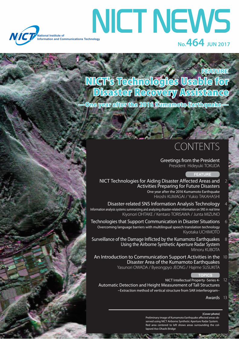
No.464 JUN 2017
NICT's Technologies Usable for Disaster Recovery Assistance
[Cover photo]Preliminary image of Kumamoto Earthquake affected areas ob-served using NICT Airborne Synthetic Aperture Radar System. Red area centered to left shows areas surrounding the col-lapsed Aso Ohashi Bridge
Greetings from the PresidentPresident Hideyuki TOKUDA
NICT Technologies for Aiding Disaster Affected Areas and Activities Preparing for Future Disasters
One year after the 2016 Kumamoto EarthquakeHiroshi KUMAGAI / Yukio TAKAHASHI
Disaster-related SNS Information Analysis TechnologyInformation analysis systems summarizing and analyzing disaster-related information on SNS in real time
Kiyonori OHTAKE / Kentaro TORISAWA / Junta MIZUNO
Technologies that Support Communication in Disaster SituationsOvercoming language barriers with multilingual speech translation technology
Kiyotaka UCHIMOTO
Surveillance of the Damage Inflicted by the Kumamoto Earthquakes Using the Airborne Synthetic Aperture Radar System
Minoru KUBOTA
An Introduction to Communication Support Activities in the Disaster Area of the Kumamoto Earthquakes
Yasunori OWADA / Byeongpyo JEONG / Hajime SUSUKITA
NICT Intellectual Property -Series 4-Automatic Detection and Height Measurement of Tall Structures
–Extraction method of vertical structure from SAR interferogram–
Awards
CONTENTS
— One year after the 2016 Kumamoto Earthquake —
2
4
6
8
10
12
13
FEATURE
TOPICS
In the field of ICT, technologies with
effects that span all of society have re-
cently been attracting attention, such as
the Internet of Things (IoT), Big Data,
AI, and cybersecurity. Great changes are
happening in society, even in everyday
life. The rise of the sharing economy
is bringing a transition from owning to
using, with services like Uber and Airb-
nb, Mobility-as-a-Service is integrating
modes of transport such as self-driving
cars with ICT, and IoT is being used to
turn products into services (Product-as-
a-Service).
To be appointed as the President of
NICT, at this important time with great
paradigm shifts, is a sobering prospect.
While I still have much to learn, I look
forward to contributing to basic, funda-
mental R&D, realizing innovation that
will create new value in society, and
building social systems and infrastruc-
ture in the new, cyber-physical space in
which we live.
NICT’s five strategic R&D areas of
focus
In April 2016, NICT began the Fourth
Medium- to Long-term Plan. We are en-
gaging in leading edge R&D on basic,
fundamental ICT, prioritizing five strate-
gic areas of focus. These can be summa-
rized as: "Watch" the real world through
ICT, "Connect" society through wireless
and optical communications technolo-
gies, "Create" new value through data
utilization, etc., "Protect" society from
sophisticated and complicated cyberat-
tacks, and "Develop" new horizons of
information and communications.
Three concepts
In addition to these five areas, I would
also like to identify three important con-
cepts: which I abbreviate as C-O-C. The
first C is for collaboration, the O is for
Leading the World Regarding Three Concepts H
ideyuki TOK
UD
A
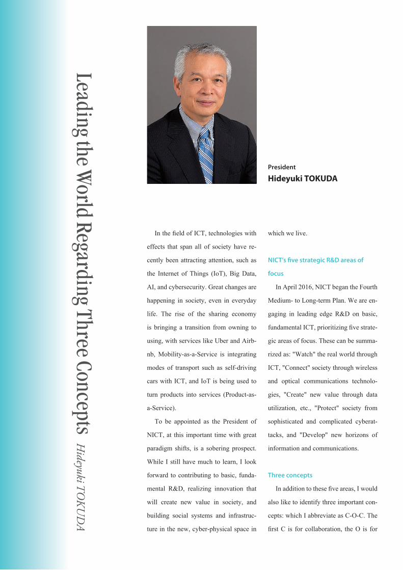
President
Hideyuki TOKUDA
open mind and open innovation, and the
second C is for challenger spirit.
Concept 1: Collaboration
Regarding collaboration, it is certain-
ly necessary to have one’s own R&D
capabilities in order to advance R&D
at a world-class level, but beyond our
own conventional R&D, it will be im-
portant to collaborate with a variety of
stakeholders from research institutions
at home and abroad, enterprises, univer-
sities, and local governments. Methodol-
ogies such as co-creation and co-design,
and international development and im-
plementation of technologies in society
can be done more efficiently by strength-
ening international collaboration among
consortiums and alliances aiming to de-
velop and spread technology.
To produce new value, collaboration
with research groups in different fields,
and not just groups with the same spe-
cialization, is also very important.
Concept 2: Open mind and open
innovation
Regarding open mind and open inno-
vation, NICT established an Open Inno-
vation Promotion Headquarters under
the Fourth Medium- to Long-Term Plan
and initiated activities involving various
stakeholders. An open mind is also very
important in further invigorating and ad-
vancing such open innovation projects
and forum activities.
Beyond technical innovation, it is
also important to establish an innovation
ecosystem, including social and societal
innovation as well.
Concept 3: Challenger spirit
Regarding challenger spirit, NICT
must be a world-leading research institu-
tion in the ICT field, so it must constant-
ly act with a spirit of meeting challenges.
It is my intention to push forward with
my work regarding these three concepts
to fulfill NICT’s mission.
I look forward to your support and en-
couragement in these pursuits.
September 1990 Employed by Keio UniversityMay 1997 Keio University Permanent DirectorJune 2001 Keio University Graduate School Policy/Media Program ChairmanOctober 2007 Keio University, Faculty of Environment and Information Studies, DeanOctober 2009 Keio University Graduate School Policy/Media Program ChairmanApril 2017 Current position
[Career Summary]
1NICT NEWS JUN 2017
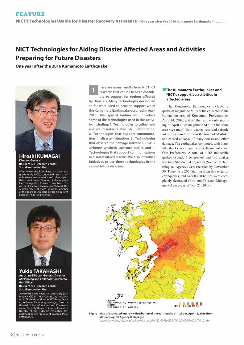
Figure Map of estimated intensity distribution of the earthquake at 1:25 am, April 16, 2016 (from Meteorological Agency Web page)
http://www.data.jma.go.jp/svd/eew/data/suikei/201604160125_741/201604160125_741_2.html
here are many results from NICT ICT research that can be used to contrib-ute to support for regions affected
by disasters. Many technologies developed so far were used to provide support when the Kumamoto Earthquake occurred in April 2016. This special feature will introduce some of the technologies used in this activi-ty, including: 1. Technologies to collect and analyze disaster-related SNS information, 2. Technologies that support communica-tion in disaster situations 3. Technologies that observe the damage inflicted (Pi-SAR2 airborne synthetic aperture radar), and 4. Technologies that support communications in disaster affected areas. We also introduce initiatives to use these technologies in the case of future disasters.
■The Kumamoto Earthquakes and NICT's supportive activities in affected areas
The Kumamoto Earthquakes included a quake of magnitude M6.5 at the epicenter in the Kumamoto area of Kumamoto Prefecture on April 14, 2016, and another in the early morn-ing of April 16 of magnitude M7.3 in the same area (see map). Both quakes recorded seismic intensity (Shindo) of 7 in the town of Mashiki, and caused collapse of many houses and other damage. The earthquakes continued, with many aftershocks occurring across Kumamoto and Oita Prefectures. A total of 4,165 noticeable quakes (Shindo 1 or greater) and 140 quakes reaching Shindo of 4 or greater (Source: Meteo-rological Agency) were recorded by November 30. There were 205 fatalities from this series of earthquakes, and over 8,400 houses were com-pletely destroyed (Fire and Disaster Manage-ment Agency, as of Feb. 21, 2017).
NICT Technologies for Aiding Disaster Affected Areas and Activities Preparing for Future DisastersOne year after the 2016 Kumamoto Earthquake
T
Hiroshi KUMAGAIDirector GeneralResilient ICT Research CenterSocial Innovation UnitAfter joining the Radio Research Laborato-ry (currently NICT), conducted research on radio-wave measurement and other topics. Held positions of Director of the Applied Electromagnetic Research Institute, Di-rector of the New Generation Network Re-search Center, NICT Vice President, Member of the Board of Directors before his current position. Ph.D. (Engineering).
Yukio TAKAHASHIAssociate Director General/Director of Planning and Collaboration Promo-tion OfficeResilient ICT Research CenterSocial Innovation UnitJoined the Radio Research Laboratory (cur-rently NICT) in 1982, conducting research on VLBI. Held positions as JST Group lead-er, Keihanna Laboratory Manager, Director General of the Information and Communi-cation Security Research Center, Executive Director of the Outcome Promotion De-partment before his current position. Ph.D. (Informatics).
2 NICT NEWS JUN 2017
NICT's Technologies Usable for Disaster Recovery Assistance —One year after the 2016 Kumamoto Earthquake—
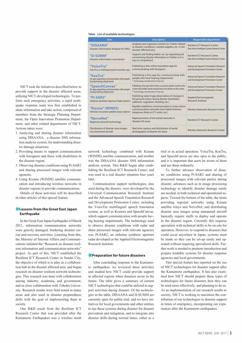
Table List of available technologies
NICT took the initiatives described below to provide support in the disaster affected areas, utilizing NICT-developed technologies. To per-form such emergency activities, a rapid earth-quake response team was first established to share information and take action, comprised of members from the Strategic Planning Depart-ment, the Open Innovation Promotion Depart-ment, and other related departments of NICT. Actions taken were:1. Analyzing and sharing disaster information
using DISAANA, a disaster SNS informa-tion analysis system, for understanding disas-ter damage situations.
2. Providing means to support communication with foreigners and those with disabilities in the disaster region.
3. Observing disaster conditions using Pi-SAR2 and sharing processed images with relevant agencies.
4. Using Kizuna (WINDS) satellite communi-cation and introducing wireless networks in disaster regions to provide communications.Details of these activities will be described
in other articles of this special feature.
■Lessons from the Great East Japan Earthquake
In the Great East Japan Earthquake of March 2011, information communication networks were gravely damaged, hindering disaster res-cue and recovery activities. Learning from this, the Ministry of Internal Affairs and Communi-cations initiated the “Research on disaster resil-ient information and communication networks” project. As part of this, NICT established the Resilient ICT Research Center in Sendai City, the objective of which is to play as a collabora-tion hub in the disaster affected area, and began research on disaster resilient network technolo-gies. This research was done with collaboration among industry, academia, and government, and in close collaboration with Tohoku Univer-sity. Research results were field tested in many areas and also used in disaster preparedness drills with the goal of implementing them in society.
One R&D result from the Resilient ICT Research Center that was provided after the Kumamoto Earthquakes was a wireless mesh
network technology combined with Kizuna (WINDS) satellite communication, and another was the DISAANA disaster SNS information analysis system. This R&D began after estab-lishing the Resilient ICT Research Center, and was used in a real disaster situation four years later.
Communication support technologies, also used during the disaster, were developed by the Universal Communication Research Institute and the Advanced Speech Translation Research and Development Promotion Center, including the VoiceTra multilingual speech translation system, as well as Koetora and SpeechCanvas, which support communication with people hav-ing hearing impairments. The technology used to observe disaster conditions with radar and share processed images with relevant agencies was Pi-SAR2, an airborne synthetic aperture radar developed at the Applied Electromagnetic Research Institute.
■Preparation for future disasters
After concluding response to the Kumamo-to earthquakes, we reviewed these activities and studied how NICT could provide support in affected regions when disasters occur in the future. The table gives a summary of current NICT technologies that could be utilized in sup-port activities during disaster. Of the technolo-gies in the table, DISAANA and D-SUMM are currently open for public trial, and we have ini-tiatives for local governments and other entities to use these systems during disaster for disaster prevention and mitigation, and to integrate into disaster drills during normal times, either as a
trial or in actual operation. VoiceTra, KoeTra, and SpeechCanvas are also open to the public, and it is important that users be aware of them and use them ordinarily.
To further advance observation of disas-ter conditions using Pi-SAR2 and sharing of processed images with relevant parties during disaster, advances such as in image processing technology to identify disaster damage easily are needed, in both technical and operational as-pects. Toward the bottom of the table, the items providing regional networks using Kizuna satellite relays and NerveNet, and distributing disaster area images using unmanned aircraft basically require staffs to deploy and operate in the disaster region. Currently this requires specialists with technical skills to be on-site for operation. However, to respond to disasters that could occur anywhere in Japan, systems must be made so they can be set-up easily and op-erated without requiring specialized skills. Fur-ther work is needed to promote introduction and prepare lendable systems for disaster response agencies and local governments.
This special feature has reported on the use of NICT technologies for disaster support after the Kumamoto earthquakes. It has also exam-ined how NICT should prepare these types of technologies for future disasters, how they can be used more effectively, and planning to do so. As an implementation of our research results to society, NICT is working to maximize the con-tribution of our technologies to disaster support in times of emergency, incorporating our expe-riences after the Kumamoto earthquakes.
3NICT NEWS JUN 2017
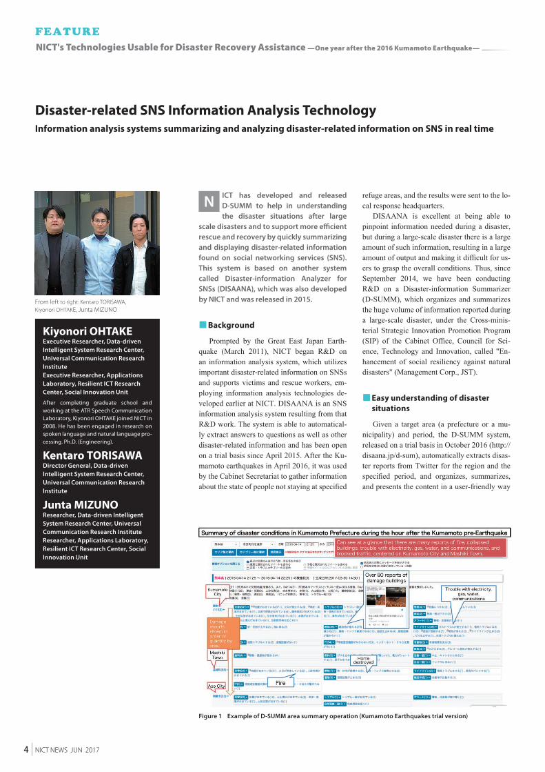
Figure 1 Example of D-SUMM area summary operation (Kumamoto Earthquakes trial version)
From left to right: Kentaro TORISAWA, Kiyonori OHTAKE, Junta MIZUNO
ICT has developed and released D-SUMM to help in understanding the disaster situations after large
scale disasters and to support more efficient rescue and recovery by quickly summarizing and displaying disaster-related information found on social networking services (SNS). This system is based on another system called Disaster-information Analyzer for SNSs (DISAANA), which was also developed by NICT and was released in 2015.
■ Background
Prompted by the Great East Japan Earth-quake (March 2011), NICT began R&D on an information analysis system, which utilizes important disaster-related information on SNSs and supports victims and rescue workers, em-ploying information analysis technologies de-veloped earlier at NICT. DISAANA is an SNS information analysis system resulting from that R&D work. The system is able to automatical-ly extract answers to questions as well as other disaster-related information and has been open on a trial basis since April 2015. After the Ku-mamoto earthquakes in April 2016, it was used by the Cabinet Secretariat to gather information about the state of people not staying at specified
refuge areas, and the results were sent to the lo-cal response headquarters.
DISAANA is excellent at being able to pinpoint information needed during a disaster, but during a large-scale disaster there is a large amount of such information, resulting in a large amount of output and making it difficult for us-ers to grasp the overall conditions. Thus, since September 2014, we have been conducting R&D on a Disaster-information Summarizer (D-SUMM), which organizes and summarizes the huge volume of information reported during a large-scale disaster, under the Cross-minis-terial Strategic Innovation Promotion Program (SIP) of the Cabinet Office, Council for Sci-ence, Technology and Innovation, called "En-hancement of social resiliency against natural disasters" (Management Corp., JST).
■ Easy understanding of disaster situations
Given a target area (a prefecture or a mu-nicipality) and period, the D-SUMM system, released on a trial basis in October 2016 (http://disaana.jp/d-sum), automatically extracts disas-ter reports from Twitter for the region and the specified period, and organizes, summarizes, and presents the content in a user-friendly way
N
Disaster-related SNS Information Analysis TechnologyInformation analysis systems summarizing and analyzing disaster-related information on SNS in real time
Kiyonori OHTAKEExecutive Researcher, Data-driven Intelligent System Research Center, Universal Communication Research InstituteExecutive Researcher, Applications Laboratory, Resilient ICT Research Center, Social Innovation Unit
After completing graduate school and working at the ATR Speech Communication Laboratory, Kiyonori OHTAKE joined NICT in 2008. He has been engaged in research on spoken language and natural language pro-cessing. Ph.D. (Engineering).
Kentaro TORISAWADirector General, Data-driven Intelligent System Research Center, Universal Communication Research Institute
Junta MIZUNOResearcher, Data-driven Intelligent System Research Center, Universal Communication Research InstituteResearcher, Applications Laboratory, Resilient ICT Research Center, Social Innovation Unit
4 NICT NEWS JUN 2017
NICT's Technologies Usable for Disaster Recovery Assistance —One year after the 2016 Kumamoto Earthquake—
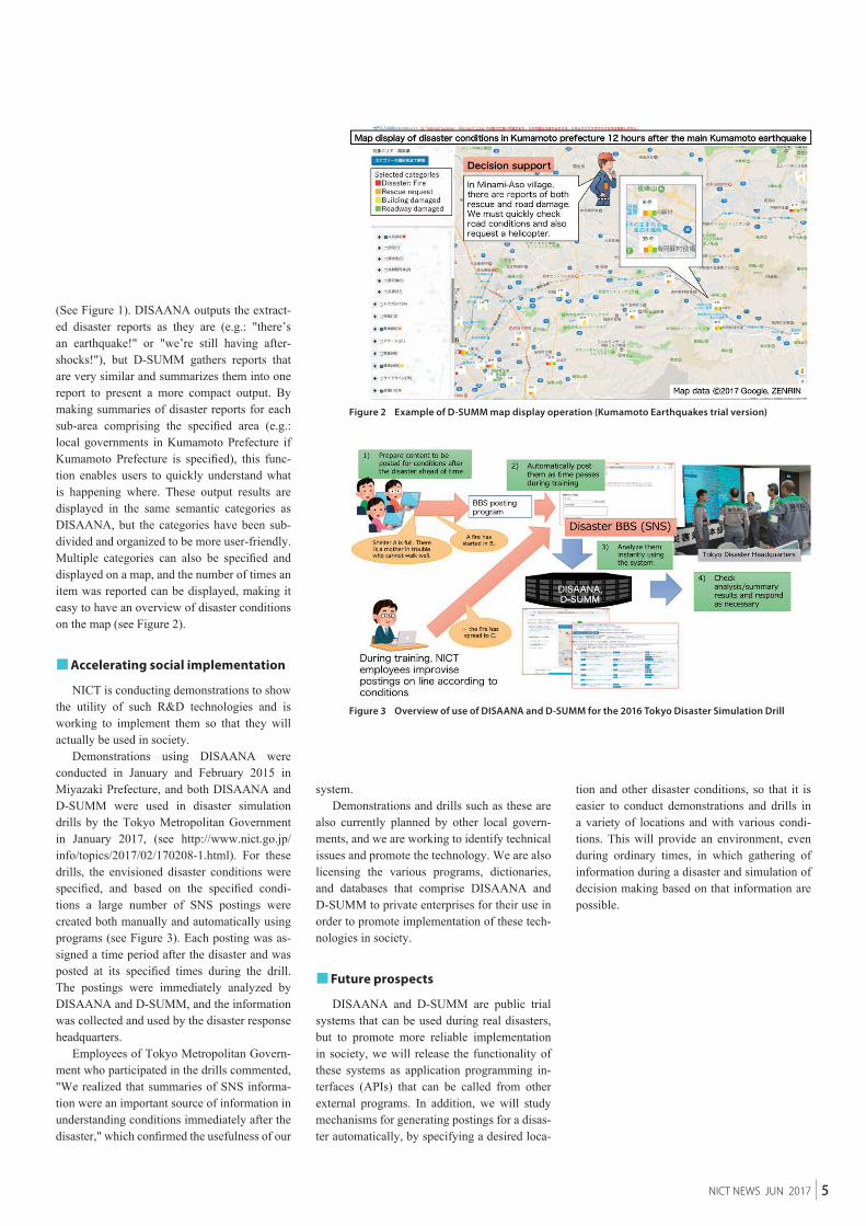
Figure 2 Example of D-SUMM map display operation (Kumamoto Earthquakes trial version)
Figure 3 Overview of use of DISAANA and D-SUMM for the 2016 Tokyo Disaster Simulation Drill
(See Figure 1). DISAANA outputs the extract-ed disaster reports as they are (e.g.: "there’s an earthquake!" or "we’re still having after-shocks!"), but D-SUMM gathers reports that are very similar and summarizes them into one report to present a more compact output. By making summaries of disaster reports for each sub-area comprising the specified area (e.g.: local governments in Kumamoto Prefecture if Kumamoto Prefecture is specified), this func-tion enables users to quickly understand what is happening where. These output results are displayed in the same semantic categories as DISAANA, but the categories have been sub-divided and organized to be more user-friendly. Multiple categories can also be specified and displayed on a map, and the number of times an item was reported can be displayed, making it easy to have an overview of disaster conditions on the map (see Figure 2).
■ Accelerating social implementation
NICT is conducting demonstrations to show the utility of such R&D technologies and is working to implement them so that they will actually be used in society.
Demonstrations using DISAANA were conducted in January and February 2015 in Miyazaki Prefecture, and both DISAANA and D-SUMM were used in disaster simulation drills by the Tokyo Metropolitan Government in January 2017, (see http://www.nict.go.jp/info/topics/2017/02/170208-1.html). For these drills, the envisioned disaster conditions were specified, and based on the specified condi-tions a large number of SNS postings were created both manually and automatically using programs (see Figure 3). Each posting was as-signed a time period after the disaster and was posted at its specified times during the drill. The postings were immediately analyzed by DISAANA and D-SUMM, and the information was collected and used by the disaster response headquarters.
Employees of Tokyo Metropolitan Govern-ment who participated in the drills commented, "We realized that summaries of SNS informa-tion were an important source of information in understanding conditions immediately after the disaster," which confirmed the usefulness of our
system.Demonstrations and drills such as these are
also currently planned by other local govern-ments, and we are working to identify technical issues and promote the technology. We are also licensing the various programs, dictionaries, and databases that comprise DISAANA and D-SUMM to private enterprises for their use in order to promote implementation of these tech-nologies in society.
■ Future prospects
DISAANA and D-SUMM are public trial systems that can be used during real disasters, but to promote more reliable implementation in society, we will release the functionality of these systems as application programming in-terfaces (APIs) that can be called from other external programs. In addition, we will study mechanisms for generating postings for a disas-ter automatically, by specifying a desired loca-
tion and other disaster conditions, so that it is easier to conduct demonstrations and drills in a variety of locations and with various condi-tions. This will provide an environment, even during ordinary times, in which gathering of information during a disaster and simulation of decision making based on that information are possible.
5NICT NEWS JUN 2017

Figure 1 VoiceTra Figure 2 Speech translation framework
he number of foreign visitors to Japan has continued to increase in recent years and is expected to ex-
ceed 40 million by the year 2020, when the Tokyo Olympic and Paralympic Games will be held. Given these conditions, the Minis-try of Internal Affairs and Communications (MIC) announced in April 2014 the "Global Communication Plan," which aims to elimi-nate the language barriers around the world and to realize free global exchange. To achieve this goal, NICT, in collaboration with private companies, is working to improve performance of the multilingual speech translation technology, to expand the num-ber of languages and fields supported, and to conduct verification testing. We envision a society where foreign visitors can travel without concern for the language barriers by 2020.
■ R&D on multilingual speech translation technology and its expansion in society
NICT's multilingual speech translation tech-nology has been implemented in "VoiceTra," a network-based speech-to-speech translation app (Figure 1), and is available on the App
Store and Google Play. The framework of the technology is shown in Figure 2; the speech input through a smartphone or other device is transmitted via network to the servers on the cloud, where it is processed with speech recog-nition, machine translation, and speech synthe-sis. The translation results are then sent back to the device, which outputs the audio. The speech recognition, machine translation, and speech synthesis technologies all adopt corpus-based approaches, in which a machine* is trained sta-tistically from a database of words. The perfor-mance of speech translation depends heavily on the corpus on which it is based, and gathering a rich corpus, in terms of quality and quantity, is the key to achieving our goal.
■ Support communication during disasters and in times of emergency
There are two main issues to be overcome when applying multilingual speech translation technology to support communication during emergencies. One is the need to support specif-ic expressions used during emergencies, i.e., the corpus must be enriched with respect to the rel-evant fields. Aside from the travel field, NICT is expanding the domain of the corpus to support communication in various scenarios, such as
T
Technologies that Support Communication in Disaster SituationsOvercoming language barriers with multilingual speech translation technology
Kiyotaka UCHIMOTODirector of Planning Office,Advanced Speech Translation Re-search and Development Promotion Center
Kiyotaka UCHIMOTO joined the Commu-nications Research Laboratory, Ministry of Posts and Telecommunications (currently NICT) in 1996. He is engaged in research on natural language processing as well as returning research results to society. He was seconded to The Cabinet Office of Japan from October 2009 to March 2011. Ph.D. (Informatics).
* Deep learning is one such form.
6 NICT NEWS JUN 2017
NICT's Technologies Usable for Disaster Recovery Assistance —One year after the 2016 Kumamoto Earthquake—
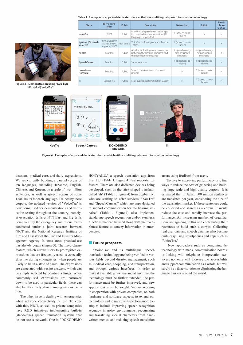
Table 1 Examples of apps and dedicated devices that use multilingual speech translation technology
Figure 3 Demonstration using "Kyu-kyu (First-Aid) VoiceTra"
Figure 4 Examples of apps and dedicated devices which utilize multilingual speech translation technology
KoeTra SpeechCanvas DOKODEMO HONYAKU
ili
Name Service pro-vider Public Description Networked Built-in
Fixed- phrase feature
VoiceTra NICT PublicMultilingual speech translation app for travel-related conversations (31 languages supported)
Y (speech trans-lation) N N
Kyu-kyu (First-Aid) VoiceTra
Fire & Disaster Management Agency / NICT
Not public VoiceTra for Emergency and Rescue Teams
Y (speech trans-lation) N Y
KoeTra Feat Inc. PublicApp for facilitating communication between the hearing-impaired and the non-hearing-impaired
Y (speech recog-nition/ speech
synthesis)
Y (speech recog-nition/ speech
synthesis)Y
SpeechCanvas Feat Inc. Public Same as above Y (speech recog-nition)
Y (speech recog-nition) Y
Dokodemo Honyaku Feat Inc. Public Speech translation app for smart-
phones N Y (speech trans-lation) N
ili Logbar Inc. Public Stick-type speech translation system N Y (speech trans-lation) N
disasters, medical care, and daily expressions. We are currently building a parallel corpus of ten languages, including Japanese, English, Chinese, and Korean, on a scale of two million sentences, as well as speech corpus of some 1,500 hours for each language. Trained by these corpora, the updated version of "VoiceTra" is now being used for demonstrations and verifi-cation testing throughout the country, namely, at evacuation drills at NTT East and fire drills being held by the emergency and rescue teams conducted under a joint research between NICT and the National Research Institute of Fire and Disaster of the Fire and Disaster Man-agement Agency. In some areas, practical use has already begun (Figure 3). The fixed-phrase feature, which allows users to pre-register ex-pressions that are frequently used, is especially effective during emergencies, when people are likely to be in a state of panic. The expressions are associated with yes/no answers, which can be simply selected by pointing a finger. When commonly-used expressions are narrowed down to be used in particular fields, these can also be effectively shared among various facil-ities.
The other issue is dealing with emergencies when network connectivity is lost. To cope with this, NICT, as well as private companies have R&D initiatives implementing built-in (standalone) speech translation systems that do not use a network. One is "DOKODEMO
HONYAKU," a speech translation app from Feat Ltd. (Table 1, Figure 4) that supports this feature. There are also dedicated devices being developed, such as the stick-shaped translator called "ili" (Table 1, Figure 4) from Logbar Inc. who are starting to offer services. "KoeTra" and "SpeechCanvas," which are apps designed to support communication for the hearing im-paired (Table 1, Figure 4) also implement standalone speech recognition and/or synthesis functions that can be used along with the fixed-phrase feature to convey information in emer-gencies.
■ Future prospects
"VoiceTra" and its multilingual speech translation technology are being verified in var-ious fields beyond disaster management, such as medical care, shopping, and transportation, and through various interfaces. In order to make it available anywhere and at any time, the technology must be further extended, the per-formance must be further improved, and new applications must be sought. We are working in cooperation with private companies, on both hardware and software aspects, to extend our technology and to improve its performance. Ex-amples include improving speech recognition accuracy in noisy environments, recognizing and translating special characters from hand-written menus, and reducing speech translation
errors using feedback from users.The key to improving performance is to find
ways to reduce the cost of gathering and build-ing large-scale and high-quality corpora. It is estimated that in Japan, 500 million sentences are translated per year, considering the size of the translation market. If these sentences could be collected and shared as a corpus, it would reduce the cost and rapidly increase the per-formance. An increasing number of organiza-tions are agreeing to this and contributing their resources to build such a corpus. Collecting real user data and speech data has also become quite easy using smartphones and apps such as "VoiceTra."
New approaches such as combining the technology with maps, communication boards, or linking with telephone interpretation ser-vices, not only will increase the accessibility and support communication as a whole, but will surely be a faster solution to eliminating the lan-guage barriers around the world.
7NICT NEWS JUN 2017
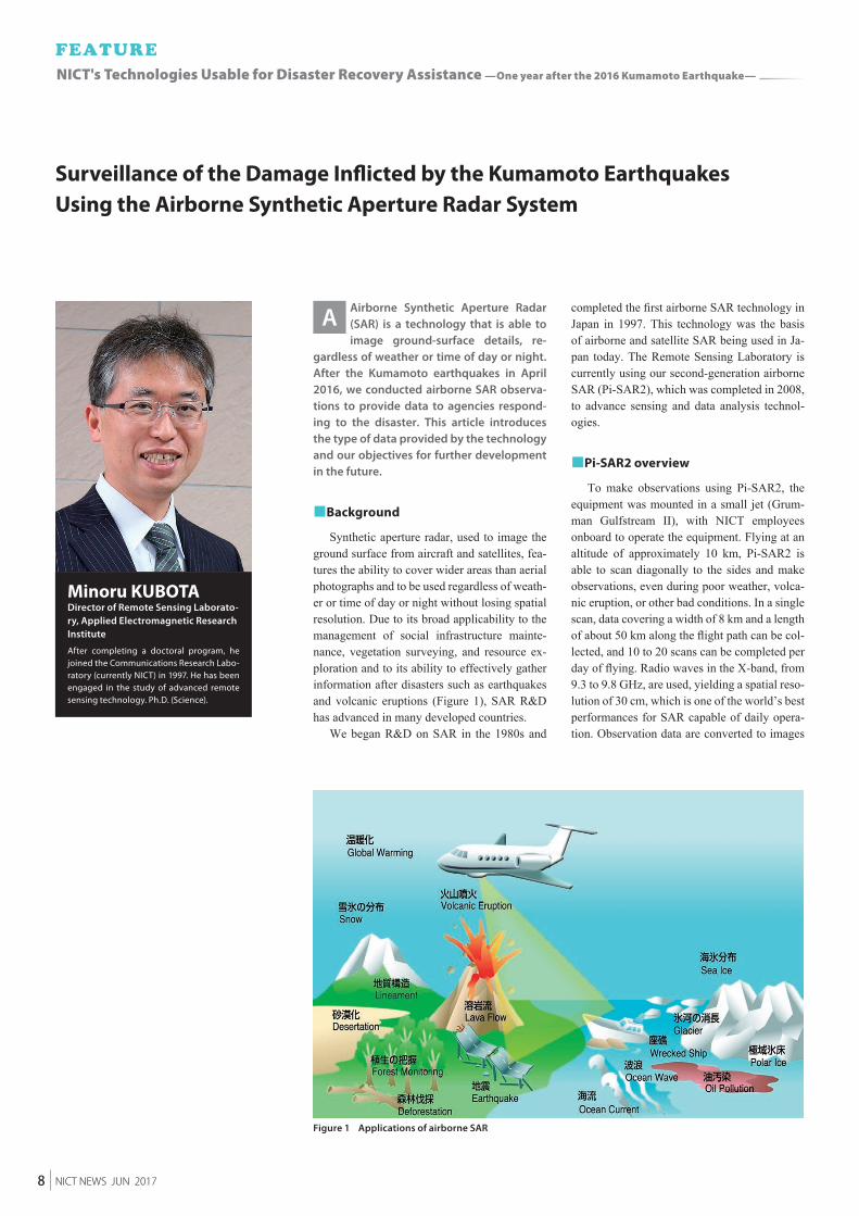
Figure 1 Applications of airborne SAR
Airborne Synthetic Aperture Radar (SAR) is a technology that is able to image ground-surface details, re-
gardless of weather or time of day or night. After the Kumamoto earthquakes in April 2016, we conducted airborne SAR observa-tions to provide data to agencies respond-ing to the disaster. This article introduces the type of data provided by the technology and our objectives for further development in the future.
■Background
Synthetic aperture radar, used to image the ground surface from aircraft and satellites, fea-tures the ability to cover wider areas than aerial photographs and to be used regardless of weath-er or time of day or night without losing spatial resolution. Due to its broad applicability to the management of social infrastructure mainte-nance, vegetation surveying, and resource ex-ploration and to its ability to effectively gather information after disasters such as earthquakes and volcanic eruptions (Figure 1), SAR R&D has advanced in many developed countries.
We began R&D on SAR in the 1980s and
completed the first airborne SAR technology in Japan in 1997. This technology was the basis of airborne and satellite SAR being used in Ja-pan today. The Remote Sensing Laboratory is currently using our second-generation airborne SAR (Pi-SAR2), which was completed in 2008, to advance sensing and data analysis technol-ogies.
■Pi-SAR2 overview
To make observations using Pi-SAR2, the equipment was mounted in a small jet (Grum-man Gulfstream II), with NICT employees onboard to operate the equipment. Flying at an altitude of approximately 10 km, Pi-SAR2 is able to scan diagonally to the sides and make observations, even during poor weather, volca-nic eruption, or other bad conditions. In a single scan, data covering a width of 8 km and a length of about 50 km along the flight path can be col-lected, and 10 to 20 scans can be completed per day of flying. Radio waves in the X-band, from 9.3 to 9.8 GHz, are used, yielding a spatial reso-lution of 30 cm, which is one of the world’s best performances for SAR capable of daily opera-tion. Observation data are converted to images
A
Surveillance of the Damage Inflicted by the Kumamoto Earthquakes Using the Airborne Synthetic Aperture Radar System
Minoru KUBOTADirector of Remote Sensing Laborato-ry, Applied Electromagnetic Research Institute
After completing a doctoral program, he joined the Communications Research Labo-ratory (currently NICT) in 1997. He has been engaged in the study of advanced remote sensing technology. Ph.D. (Science).
8 NICT NEWS JUN 2017
NICT's Technologies Usable for Disaster Recovery Assistance —One year after the 2016 Kumamoto Earthquake—
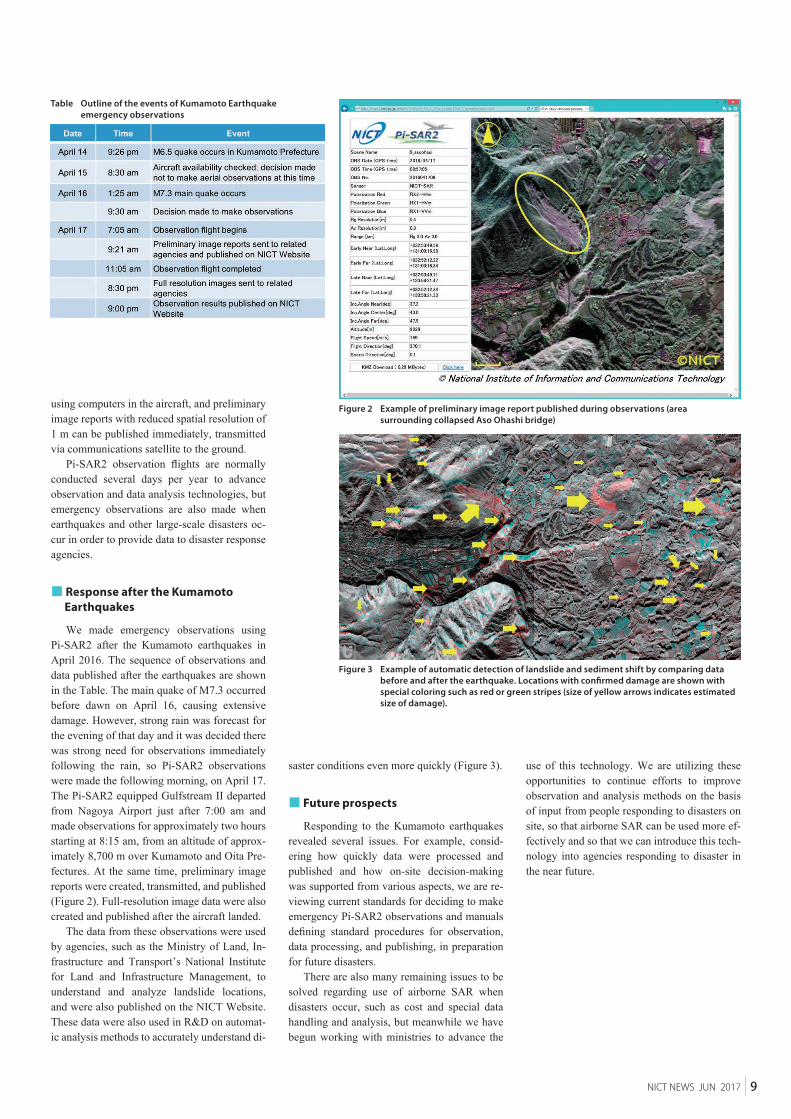
Figure 2 Example of preliminary image report published during observations (area surrounding collapsed Aso Ohashi bridge)
Figure 3 Example of automatic detection of landslide and sediment shift by comparing data before and after the earthquake. Locations with confirmed damage are shown with special coloring such as red or green stripes (size of yellow arrows indicates estimated size of damage).
Table Outline of the events of Kumamoto Earthquake emergency observations
using computers in the aircraft, and preliminary image reports with reduced spatial resolution of 1 m can be published immediately, transmitted via communications satellite to the ground.
Pi-SAR2 observation flights are normally conducted several days per year to advance observation and data analysis technologies, but emergency observations are also made when earthquakes and other large-scale disasters oc-cur in order to provide data to disaster response agencies.
■ Response after the Kumamoto Earthquakes
We made emergency observations using Pi-SAR2 after the Kumamoto earthquakes in April 2016. The sequence of observations and data published after the earthquakes are shown in the Table. The main quake of M7.3 occurred before dawn on April 16, causing extensive damage. However, strong rain was forecast for the evening of that day and it was decided there was strong need for observations immediately following the rain, so Pi-SAR2 observations were made the following morning, on April 17. The Pi-SAR2 equipped Gulfstream II departed from Nagoya Airport just after 7:00 am and made observations for approximately two hours starting at 8:15 am, from an altitude of approx-imately 8,700 m over Kumamoto and Oita Pre-fectures. At the same time, preliminary image reports were created, transmitted, and published (Figure 2). Full-resolution image data were also created and published after the aircraft landed.
The data from these observations were used by agencies, such as the Ministry of Land, In-frastructure and Transport’s National Institute for Land and Infrastructure Management, to understand and analyze landslide locations, and were also published on the NICT Website. These data were also used in R&D on automat-ic analysis methods to accurately understand di-
saster conditions even more quickly (Figure 3).
■ Future prospects
Responding to the Kumamoto earthquakes revealed several issues. For example, consid-ering how quickly data were processed and published and how on-site decision-making was supported from various aspects, we are re-viewing current standards for deciding to make emergency Pi-SAR2 observations and manuals defining standard procedures for observation, data processing, and publishing, in preparation for future disasters.
There are also many remaining issues to be solved regarding use of airborne SAR when disasters occur, such as cost and special data handling and analysis, but meanwhile we have begun working with ministries to advance the
use of this technology. We are utilizing these opportunities to continue efforts to improve observation and analysis methods on the basis of input from people responding to disasters on site, so that airborne SAR can be used more ef-fectively and so that we can introduce this tech-nology into agencies responding to disaster in the near future.
9NICT NEWS JUN 2017
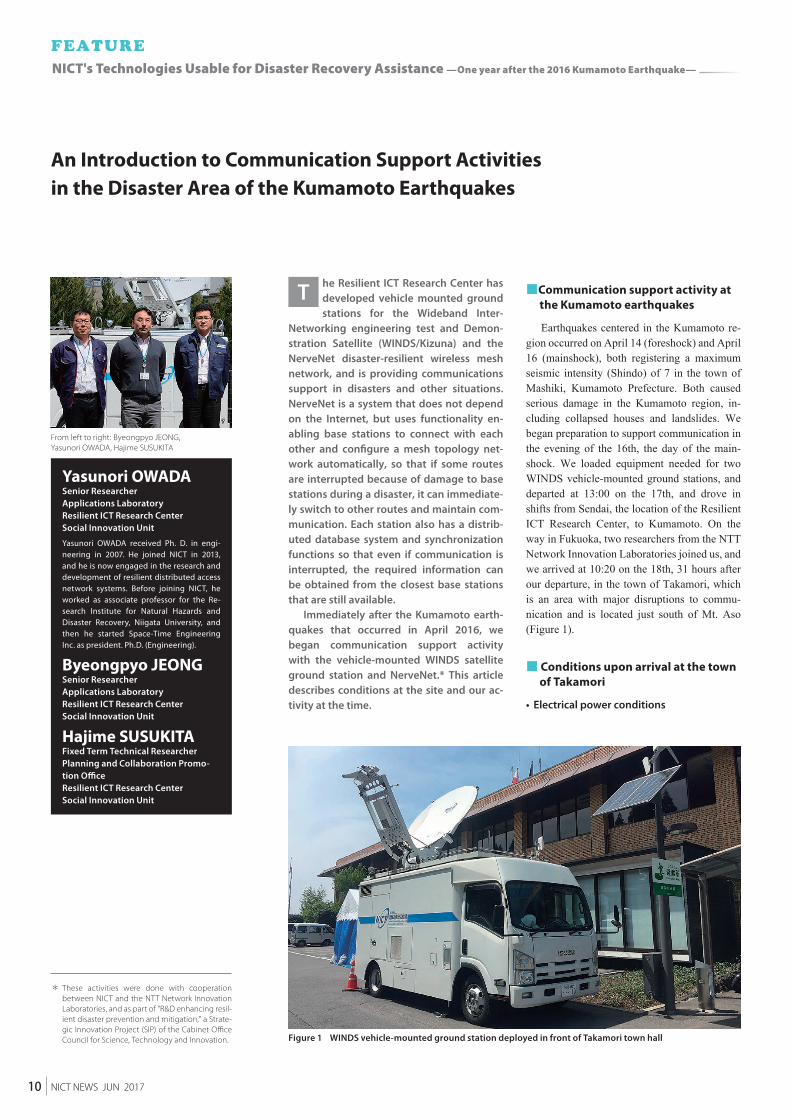
Figure 1 WINDS vehicle-mounted ground station deployed in front of Takamori town hall
From left to right: Byeongpyo JEONG, Yasunori OWADA, Hajime SUSUKITA
he Resilient ICT Research Center has developed vehicle mounted ground stations for the Wideband Inter-
Networking engineering test and Demon-stration Satellite (WINDS/Kizuna) and the NerveNet disaster-resilient wireless mesh network, and is providing communications support in disasters and other situations. NerveNet is a system that does not depend on the Internet, but uses functionality en-abling base stations to connect with each other and configure a mesh topology net-work automatically, so that if some routes are interrupted because of damage to base stations during a disaster, it can immediate-ly switch to other routes and maintain com-munication. Each station also has a distrib-uted database system and synchronization functions so that even if communication is interrupted, the required information can be obtained from the closest base stations that are still available.
Immediately after the Kumamoto earth-quakes that occurred in April 2016, we began communication support activity with the vehicle-mounted WINDS satellite ground station and NerveNet.* This article describes conditions at the site and our ac-tivity at the time.
■ Communication support activity at the Kumamoto earthquakes
Earthquakes centered in the Kumamoto re-gion occurred on April 14 (foreshock) and April 16 (mainshock), both registering a maximum seismic intensity (Shindo) of 7 in the town of Mashiki, Kumamoto Prefecture. Both caused serious damage in the Kumamoto region, in-cluding collapsed houses and landslides. We began preparation to support communication in the evening of the 16th, the day of the main-shock. We loaded equipment needed for two WINDS vehicle-mounted ground stations, and departed at 13:00 on the 17th, and drove in shifts from Sendai, the location of the Resilient ICT Research Center, to Kumamoto. On the way in Fukuoka, two researchers from the NTT Network Innovation Laboratories joined us, and we arrived at 10:20 on the 18th, 31 hours after our departure, in the town of Takamori, which is an area with major disruptions to commu-nication and is located just south of Mt. Aso (Figure 1).
■ Conditions upon arrival at the town of Takamori
• Electrical power conditions
T
An Introduction to Communication Support Activities in the Disaster Area of the Kumamoto Earthquakes
Yasunori OWADASenior ResearcherApplications LaboratoryResilient ICT Research CenterSocial Innovation Unit
Yasunori OWADA received Ph. D. in engi-neering in 2007. He joined NICT in 2013, and he is now engaged in the research and development of resilient distributed access network systems. Before joining NICT, he worked as associate professor for the Re-search Institute for Natural Hazards and Disaster Recovery, Niigata University, and then he started Space-Time Engineering Inc. as president. Ph.D. (Engineering).
Byeongpyo JEONGSenior ResearcherApplications LaboratoryResilient ICT Research CenterSocial Innovation Unit
Hajime SUSUKITAFixed Term Technical ResearcherPlanning and Collaboration Promo-tion OfficeResilient ICT Research CenterSocial Innovation Unit
* These activities were done with cooperation between NICT and the NTT Network Innovation Laboratories, and as part of "R&D enhancing resil-ient disaster prevention and mitigation," a Strate-gic Innovation Project (SIP) of the Cabinet Office Council for Science, Technology and Innovation.
10 NICT NEWS JUN 2017
NICT's Technologies Usable for Disaster Recovery Assistance —One year after the 2016 Kumamoto Earthquake—
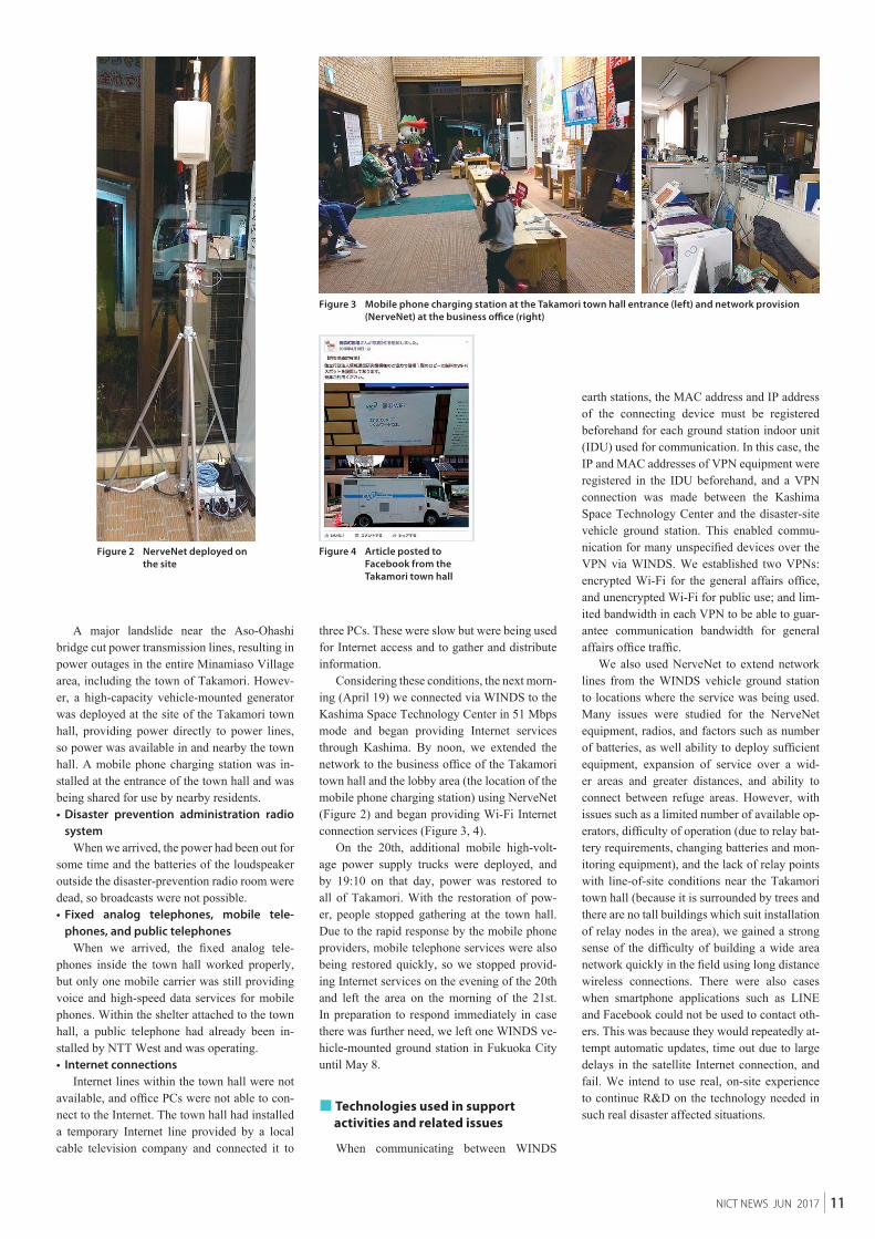
Figure 2 NerveNet deployed on the site
Figure 4 Article posted to Facebook from the Takamori town hall
Figure 3 Mobile phone charging station at the Takamori town hall entrance (left) and network provision (NerveNet) at the business office (right)
A major landslide near the Aso-Ohashi bridge cut power transmission lines, resulting in power outages in the entire Minamiaso Village area, including the town of Takamori. Howev-er, a high-capacity vehicle-mounted generator was deployed at the site of the Takamori town hall, providing power directly to power lines, so power was available in and nearby the town hall. A mobile phone charging station was in-stalled at the entrance of the town hall and was being shared for use by nearby residents.• Disaster prevention administration radio
systemWhen we arrived, the power had been out for
some time and the batteries of the loudspeaker outside the disaster-prevention radio room were dead, so broadcasts were not possible.• Fixed analog telephones, mobile tele-
phones, and public telephonesWhen we arrived, the fixed analog tele-
phones inside the town hall worked properly, but only one mobile carrier was still providing voice and high-speed data services for mobile phones. Within the shelter attached to the town hall, a public telephone had already been in-stalled by NTT West and was operating.• Internet connections
Internet lines within the town hall were not available, and office PCs were not able to con-nect to the Internet. The town hall had installed a temporary Internet line provided by a local cable television company and connected it to
three PCs. These were slow but were being used for Internet access and to gather and distribute information.
Considering these conditions, the next morn-ing (April 19) we connected via WINDS to the Kashima Space Technology Center in 51 Mbps mode and began providing Internet services through Kashima. By noon, we extended the network to the business office of the Takamori town hall and the lobby area (the location of the mobile phone charging station) using NerveNet (Figure 2) and began providing Wi-Fi Internet connection services (Figure 3, 4).
On the 20th, additional mobile high-volt-age power supply trucks were deployed, and by 19:10 on that day, power was restored to all of Takamori. With the restoration of pow-er, people stopped gathering at the town hall. Due to the rapid response by the mobile phone providers, mobile telephone services were also being restored quickly, so we stopped provid-ing Internet services on the evening of the 20th and left the area on the morning of the 21st. In preparation to respond immediately in case there was further need, we left one WINDS ve-hicle-mounted ground station in Fukuoka City until May 8.
■ Technologies used in support activities and related issues
When communicating between WINDS
earth stations, the MAC address and IP address of the connecting device must be registered beforehand for each ground station indoor unit (IDU) used for communication. In this case, the IP and MAC addresses of VPN equipment were registered in the IDU beforehand, and a VPN connection was made between the Kashima Space Technology Center and the disaster-site vehicle ground station. This enabled commu-nication for many unspecified devices over the VPN via WINDS. We established two VPNs: encrypted Wi-Fi for the general affairs office, and unencrypted Wi-Fi for public use; and lim-ited bandwidth in each VPN to be able to guar-antee communication bandwidth for general affairs office traffic.
We also used NerveNet to extend network lines from the WINDS vehicle ground station to locations where the service was being used. Many issues were studied for the NerveNet equipment, radios, and factors such as number of batteries, as well ability to deploy sufficient equipment, expansion of service over a wid-er areas and greater distances, and ability to connect between refuge areas. However, with issues such as a limited number of available op-erators, difficulty of operation (due to relay bat-tery requirements, changing batteries and mon-itoring equipment), and the lack of relay points with line-of-site conditions near the Takamori town hall (because it is surrounded by trees and there are no tall buildings which suit installation of relay nodes in the area), we gained a strong sense of the difficulty of building a wide area network quickly in the field using long distance wireless connections. There were also cases when smartphone applications such as LINE and Facebook could not be used to contact oth-ers. This was because they would repeatedly at-tempt automatic updates, time out due to large delays in the satellite Internet connection, and fail. We intend to use real, on-site experience to continue R&D on the technology needed in such real disaster affected situations.
11NICT NEWS JUN 2017
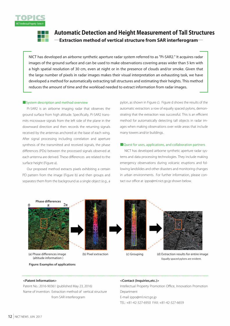
Figure: Examples of applications
Equally spaced pylons are evident.
(d) Extraction results for entire image
Phase differences
(a) Phase differences image (altitude information )
(b) Pixel extraction (c) Grouping
NICT Intellectual Property -Series 4-
<Patent Information>
Patent No.: 2016-90361 (published May 23, 2016)
Name of invention: Extraction method of vertical structure
from SAR interferogram
<Contact (Inquiries,etc.)>
Intellectual Property Promotion Office, Innovation Promotion
Department
E-mail:
TEL: +81-42-327-6950 FAX: +81-42-327-6659
■System description and method overview
Pi-SAR2 is an airborne imaging radar that observes the
ground surface from high altitude. Specifically, Pi-SAR2 trans-
mits microwave signals from the left side of the plane in the
downward direction and then records the returning signals
received by the antennas anchored at the base of each wing.
After signal processing including correlation and aperture
synthesis of the transmitted and received signals, the phase
differences (PDs) between the processed signals observed at
each antenna are derived. These differences are related to the
surface height (Figure a).
Our proposed method extracts pixels exhibiting a certain
PD pattern from the image (Figure b) and then groups and
separates them from the background as a single object (e.g., a
pylon, as shown in Figure c). Figure d shows the results of the
automatic extraction: a row of equally spaced pylons, demon-
strating that the extraction was successful. This is an efficient
method for automatically detecting tall objects in radar im-
ages when making observations over wide areas that include
many towers and/or buildings.
■Quest for uses, applications, and collaboration partners
NICT has developed airborne synthetic aperture radar sys-
tems and data processing technologies. They include making
emergency observations during volcanic eruptions and fol-
lowing landslides and other disasters and monitoring changes
in urban environments. For further information, please con-
tact our office at shown below.
NICT has developed an airborne synthetic aperture radar system referred to as "Pi-SAR2." It acquires radar
images of the ground surface and can be used to make observations covering areas wider than 5 km with
a high spatial resolution of 30 cm, even at night or in the presence of clouds and/or smoke. Given that
the large number of pixels in radar images makes their visual interpretation an exhausting task, we have
developed a method for automatically extracting tall structures and estimating their heights. This method
reduces the amount of time and the workload needed to extract information from radar images.
Automatic Detection and Height Measurement of Tall Structures─Extraction method of vertical structure from SAR interferogram─
12 NICT NEWS JUN 2017
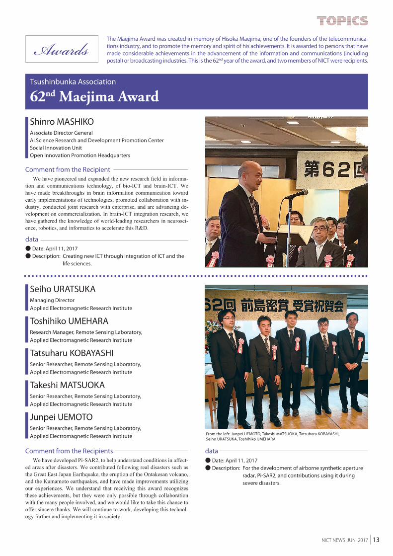
From the left: Junpei UEMOTO, Takeshi MATSUOKA, Tatsuharu KOBAYASHI, Seiho URATSUKA, Toshihiko UMEHARA
The Maejima Award was created in memory of Hisoka Maejima, one of the founders of the telecommunica-tions industry, and to promote the memory and spirit of his achievements. It is awarded to persons that have made considerable achievements in the advancement of the information and communications (including postal) or broadcasting industries. This is the 62nd year of the award, and two members of NICT were recipients.
Shinro MASHIKOAssociate Director GeneralAI Science Research and Development Promotion Center Social Innovation UnitOpen Innovation Promotion Headquarters
Seiho URATSUKAManaging DirectorApplied Electromagnetic Research Institute
Toshihiko UMEHARAResearch Manager, Remote Sensing Laboratory,Applied Electromagnetic Research Institute
Tatsuharu KOBAYASHISenior Researcher, Remote Sensing Laboratory, Applied Electromagnetic Research Institute
Takeshi MATSUOKASenior Researcher, Remote Sensing Laboratory, Applied Electromagnetic Research Institute
Junpei UEMOTOSenior Researcher, Remote Sensing Laboratory, Applied Electromagnetic Research Institute
● Date: April 11, 2017● Description: Creating new ICT through integration of ICT and the
life sciences.
62nd Maejima Award
We have pioneered and expanded the new research field in informa-tion and communications technology, of bio-ICT and brain-ICT. We have made breakthroughs in brain information communication toward early implementations of technologies, promoted collaboration with in-dustry, conducted joint research with enterprise, and are advancing de-velopment on commercialization. In brain-ICT integration research, we have gathered the knowledge of world-leading researchers in neurosci-ence, robotics, and informatics to accelerate this R&D.
Tsushinbunka Association
Comment from the Recipient
data
We have developed Pi-SAR2, to help understand conditions in affect-ed areas after disasters. We contributed following real disasters such as the Great East Japan Earthquake, the eruption of the Ontakesan volcano, and the Kumamoto earthquakes, and have made improvements utilizing our experiences. We understand that receiving this award recognizes these achievements, but they were only possible through collaboration with the many people involved, and we would like to take this chance to offer sincere thanks. We will continue to work, developing this technol-ogy further and implementing it in society.
Comment from the Recipients● Date: April 11, 2017● Description: For the development of airborne synthetic aperture
radar, Pi-SAR2, and contributions using it during severe disasters.
data
13NICT NEWS JUN 2017

NICT NEWS No.464 JUN 2017Published byPublicRelationsDepartment,NationalInstituteofInformationandCommunicationsTechnology<NICT NEWS URL> http://www.nict.go.jp/en/data/nict-news/
4-2-1 Nukui-Kitamachi, Koganei, Tokyo 184-8795, JapanTEL: +81-42-327-5392 FAX: +81-42-327-7587E-mail: URL: http://www.nict.go.jp/en/Twitter: @NICT_Publicity ISSN2187-4050(Online)