Embed Size (px)
Citation preview
DISCLAIMER
The Department for Water and its employees do not warrant or make any representation regarding the use, or results of use of the information contained herein as to its correctness, accuracy, reliability, currency or otherwise. The Department for Water and its employees expressly disclaim all liability or responsibility to any person using the information or advice
TECHNICAL REPORT NON-PRESCRIBED GROUNDWATER RESOURCES ASSESSMENT – ALINYTJARA WILURARA NATURAL RESOURCES MANAGEMENT REGION PHASE 1 – LITERATURE AND DATA REVIEW
2011/18
NON-PRESCRIBED GROUNDWATER RESOURCES ASSESSMENT – ALINYTJARA WILURARA NATURAL RESOURCES MANAGEMENT REGION
PHASE 1 – LITERATURE AND DATA REVIEW
Enys Watt and Volmer Berens
Science, Monitoring and Information Division Department for Water
June 2011
Technical Report DFW 2011/18
Department for Water | Technical Report DFW 2011/18 ii Non-prescribed groundwater resources assessment – Alinytjara Wilurara Natural Resources Management Region Phase 1 – Literature and Data Review
Science, Monitoring and Information Division
Department for Water
25 Grenfell Street, Adelaide
GPO Box 2834, Adelaide SA 5001
Telephone National (08) 8463 6946
International +61 8 8463 6946
Fax National (08) 8463 6999
International +61 8 8463 6999
Website www.waterforgood.sa.gov.au
Disclaimer
The Department for Water and its employees do not warrant or make any representation regarding the use, or
results of the use, of the information contained herein as regards to its correctness, accuracy, reliability, currency
or otherwise. The Department for Water and its employees expressly disclaims all liability or responsibility to any
person using the information or advice. Information contained in this document is correct at the time of writing.
© Government of South Australia, through the Department for Water 2010
This work is Copyright. Apart from any use permitted under the Copyright Act 1968 (Cwlth), no part may be
reproduced by any process without prior written permission obtained from the Department for Water. Requests
and enquiries concerning reproduction and rights should be directed to the Chief Executive, Department for
Water, GPO Box 2834, Adelaide SA 5001.
ISBN 978-1-921923-13-5
Preferred way to cite this publication
Watt EL and Berens V, 2011, Non-prescribed groundwater resources assessment – Alinytjara Wilurara Natural
Resources Management Region. Phase 1 – Literature and Data Review, DFW Technical Report 2011/18,
Government of South Australia, through Department for Water, Adelaide
Download this document at: http://www.waterconnect.sa.gov.au/TechnicalPublications/Pages/default.aspx

Department for Water | Technical Report DFW 2011/18 iii Non-prescribed groundwater resources assessment – Alinytjara Wilurara Natural Resources Management Region Phase 1 – Literature and Data Review
FOREWORD
South Australia’s Department for Water leads the management of our most valuable resource—water.
Water is fundamental to our health, our way of life and our environment. It underpins growth in
population and our economy—and these are critical to South Australia’s future prosperity.
High quality science and monitoring of our State’s natural water resources is central to the work that we
do. This will ensure we have a better understanding of our surface and groundwater resources so that
there is sustainable allocation of water between communities, industry and the environment.
Department for Water scientific and technical staff continue to expand their knowledge of our water
resources through undertaking investigations, technical reviews and resource modelling.
Scott Ashby CHIEF EXECUTIVE DEPARTMENT FOR WATER
Department for Water | Technical Report DFW 2011/18 iv Non-prescribed groundwater resources assessment – Alinytjara Wilurara Natural Resources Management Region Phase 1 – Literature and Data Review
CONTENTS
FOREWORD ............................................................................................................................................ iii
1. INTRODUCTION ............................................................................................................................. 9
1.1. OBJECTIVES ....................................................................................................................... 9
2. ALINYTJARA WILURARA .............................................................................................................. 11
2.1. CLIMATE .......................................................................................................................... 13
2.2. TOPOGRAPHY AND GEOMORPHOLOGY ........................................................................... 14
2.3. LAND USE ........................................................................................................................ 14
2.4. WATER RESOURCES ......................................................................................................... 14
2.4.1. Community Water Supplies ............................................................................................. 15
2.4.2. Groundwater Usage ........................................................................................................ 15
2.4.3. Surface Water ................................................................................................................. 16
2.5. DEMAND AND SUPPLY ..................................................................................................... 17
2.5.1. Mining ............................................................................................................................ 17
3. GEOLOGY ..................................................................................................................................... 21
3.1. GAWLER CRATON ............................................................................................................ 21
3.2. MUSGRAVE BLOCK........................................................................................................... 21
3.3. OFFICER BASIN ................................................................................................................ 22
3.4. ARCKARINGA BASIN ......................................................................................................... 23
3.5. EROMANGA BASIN .......................................................................................................... 23
3.6. EUCLA BASIN AND PALAEODRAINAGE .............................................................................. 24
3.6.1. Palaeovalleys .................................................................................................................. 24
4. HYDROGEOLOGY ......................................................................................................................... 28
4.1. GAWLER CRATON ............................................................................................................ 28
4.2. MUSGRAVE BLOCK........................................................................................................... 28
4.3. OFFICER BASIN ................................................................................................................ 28
4.4. ARCKARINGA BASIN ......................................................................................................... 29
4.5. EROMANGA BASIN .......................................................................................................... 29
4.6. EUCLA BASIN AND PALAEODRAINAGE .............................................................................. 29
4.6.1. Palaeovalleys .................................................................................................................. 29
5. GROUNDWATER DATA ................................................................................................................ 30
5.1. DATA ............................................................................................................................... 30
5.1.1. Monitoring ...................................................................................................................... 31
5.1.2. Regional Groundwater Salinity ........................................................................................ 31
5.1.3. Regional Water Levels ..................................................................................................... 31
5.1.4. Regional Well Yields ........................................................................................................ 32
5.2. 1:250 000 MAP SHEET DATA ............................................................................................ 36
5.2.1. MANN ............................................................................................................................. 36
5.2.2. WOODROFFE .................................................................................................................. 38
CONTENTS
Department for Water | Technical Report DFW 2011/18 v Non-prescribed groundwater resources assessment – Alinytjara Wilurara Natural Resources Management Region Phase 1 – Literature and Data Review
5.2.3. ALBERGA ......................................................................................................................... 40
5.2.4. BIRKSGATE ...................................................................................................................... 41
5.2.5. LINDSAY .......................................................................................................................... 43
5.2.6. EVERARD ......................................................................................................................... 44
5.2.7. NOORINA, WELLS and WYOLA ......................................................................................... 46
5.2.8. GILES............................................................................................................................... 48
5.2.9. MAURICE ........................................................................................................................ 50
5.2.10. TALLARINGA .................................................................................................................... 52
5.2.11. COOK and COOMPANA.................................................................................................... 54
5.2.12. OOLDEA .......................................................................................................................... 55
5.2.13. NULLARBOR .................................................................................................................... 57
5.2.14. BARTON, FOWLER and CHILDARA .................................................................................... 58
6. GROUNDWATER RESOURCES ...................................................................................................... 61
6.1. GAWLER CRATON ............................................................................................................ 61
6.2. MUSGRAVE BLOCK........................................................................................................... 62
6.3. OFFICER BASIN ................................................................................................................ 63
6.4. ARCKARINGA BASIN ......................................................................................................... 64
6.5. EROMANGA BASIN .......................................................................................................... 64
6.6. EUCLA BASIN ................................................................................................................... 65
6.7. PALAEOVALLEYS .............................................................................................................. 65
6.8. QUATERNARY .................................................................................................................. 66
6.9. GROUNDWATER POTENTIAL ............................................................................................ 70
6.9.1. Future Assessments ........................................................................................................ 70
6.10. POTENTIAL CLIMATE CHANGE IMPACTS ........................................................................... 71
7. RECOMMENDED FURTHER INVESTIGATIONS .............................................................................. 73
7.1. DATA CAPTURE AND DATA VALIDATION – SA GEODATA .................................................. 73
7.2. GROUNDWATER MONITORING ........................................................................................ 73
7.2.1. Monitored Aquifers ......................................................................................................... 74
7.3. AQUIFER EXTENT ............................................................................................................. 74
7.4. GEOPHYSICAL DATA ......................................................................................................... 75
7.5. AQUIFER HYDRAULIC PROPERTIES ................................................................................... 75
7.6. PALAEOVALLEYS .............................................................................................................. 75
7.7. FRACTURED ROCK AQUIFERS ........................................................................................... 76
7.7.1. Basement Interpretation ................................................................................................. 76
7.8. GROUNDWATER RECHARGE ............................................................................................ 76
7.9. PRODUCTS ....................................................................................................................... 77
7.9.1. 3-D Mapping ................................................................................................................... 77
7.9.2. Online PDF Maps ............................................................................................................. 77
8. CONCLUSION ............................................................................................................................... 78
APPENDIX .............................................................................................................................................. 80
A. ALINYTJARA WILURARA GEOLOGICAL FORMATIONS SUMMARY ...................................... 80
Archaean to Mesoproterozoic ....................................................................................................... 80
Neoproterozoic ............................................................................................................................ 82
CONTENTS
Department for Water | Technical Report DFW 2011/18 vi Non-prescribed groundwater resources assessment – Alinytjara Wilurara Natural Resources Management Region Phase 1 – Literature and Data Review
Cambrian ...................................................................................................................................... 84
Ordovician to Silurian ................................................................................................................... 85
Devonian ...................................................................................................................................... 86
Permian ....................................................................................................................................... 86
Jurassic to Cretaceous................................................................................................................... 87
Tertiary ....................................................................................................................................... 88
Tertiary to Quaternary .................................................................................................................. 90
Quaternary ................................................................................................................................... 90
UNITS OF MEASUREMENT ..................................................................................................................... 92
GLOSSARY ............................................................................................................................................. 93
REFERENCES ........................................................................................................................................ 103
CONTENTS
Department for Water | Technical Report DFW 2011/18 vii Non-prescribed groundwater resources assessment – Alinytjara Wilurara Natural Resources Management Region Phase 1 – Literature and Data Review
LIST OF FIGURES
Figure 1. The Alinytjara Wilurara NRM Region .................................................................................. 12
Figure 2. Surface geology of the Alinytjara Wilurara NRM Region ..................................................... 19
Figure 3. Land use within the Alinytjara Wilurara NRM Region .......................................................... 20
Figure 4. Geological map of the Musgrave Block (Major & Conor 1993) ............................................ 22
Figure 5. Geological map of the Officer Basin (Rogers 2002) ............................................................. 23
Figure 6. Geological provinces of the Alinytjara Wilurara NRM Region .............................................. 26
Figure 7. Palaeovalley network of the Alinytjara Wilurara NRM Region ............................................. 27
Figure 8. Regional distribution of groundwater salinity within the Alinytjara Wilurara NRM Region ................................................................................................................................ 33
Figure 9. Regional distribution of groundwater standing water levels within the Alinytjara Wilurara NRM Region ......................................................................................................... 34
Figure 10. Regional distribution of groundwater well yields within the Alinytjara Wilurara NRM Region ................................................................................................................................ 35
LIST OF TABLES
Table 1. Towns and Aboriginal communities and homelands within the Alinytjara Wilurara NRM Region ....................................................................................................................... 11
Table 2. Monthly climate statistics for the Alinytjara Wilurara NRM Region (BoM 2011) .................. 13
Table 3. Annual groundwater usage for the Alinytjara Wilurara NRM Region’s major Aboriginal communities (AGT 2010c) .................................................................................................. 16
Table 4. Groundwater data summary showing the periods over which water quality and water level data have been collected. .......................................................................................... 30
Table 5. The monitoring network within the Alinytjara Wilurara NRM Region .................................. 31
Table 6. Summary of salinity, standing water level and yield data and the associated median values (with number of data points in brackets) for MANN ................................................ 37
Table 7. Summary of salinity, standing water level and yield data and the associated median values (with number of data points in brackets) for WOODROFFE ...................................... 39
Table 8. Summary of salinity, standing water level and yield data and the associated median values (with number of data points in brackets) for ALBERGA; includes data from ABMINGA ........................................................................................................................... 41
Table 9. Summary of salinity, standing water level and yield data and the associated median values (with number of data points in brackets) for BIRKSGATE .......................................... 42
Table 10. Summary of salinity, standing water level and yield data and the associated median values (with number of data points in brackets) for LINDSAY .............................................. 44
Table 11. Summary of salinity, standing water level and yield data and the associated median values (with number of data points in brackets) for EVERARD; includes data from WINTINNA.......................................................................................................................... 45
Table 12. Summary of salinity, standing water level and yield data and the associated median values (with number of data points in brackets) for NOORINA, WELLS and WYOLA ............ 47
Table 13. Summary of salinity, standing water level and yield data and the associated median values (with number of data points in brackets) for GILES; includes data from MURLOOCOPPIE................................................................................................................. 49
Table 14. Summary of salinity, standing water level and yield data and the associated median values (with number of data points in brackets) for MAURICE ............................................ 51
CONTENTS
Department for Water | Technical Report DFW 2011/18 viii Non-prescribed groundwater resources assessment – Alinytjara Wilurara Natural Resources Management Region Phase 1 – Literature and Data Review
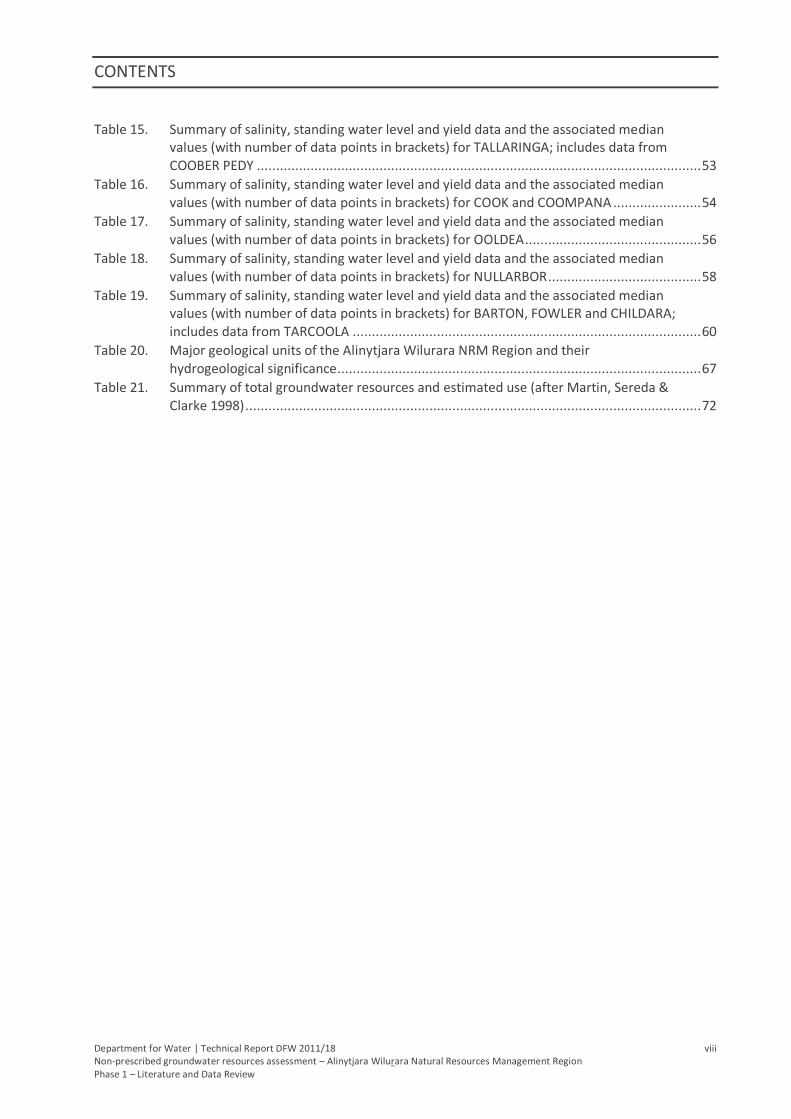
Table 15. Summary of salinity, standing water level and yield data and the associated median values (with number of data points in brackets) for TALLARINGA; includes data from COOBER PEDY .................................................................................................................... 53
Table 16. Summary of salinity, standing water level and yield data and the associated median values (with number of data points in brackets) for COOK and COOMPANA ....................... 54
Table 17. Summary of salinity, standing water level and yield data and the associated median values (with number of data points in brackets) for OOLDEA .............................................. 56
Table 18. Summary of salinity, standing water level and yield data and the associated median values (with number of data points in brackets) for NULLARBOR ........................................ 58
Table 19. Summary of salinity, standing water level and yield data and the associated median values (with number of data points in brackets) for BARTON, FOWLER and CHILDARA; includes data from TARCOOLA ........................................................................................... 60
Table 20. Major geological units of the Alinytjara Wilurara NRM Region and their hydrogeological significance ............................................................................................... 67
Table 21. Summary of total groundwater resources and estimated use (after Martin, Sereda & Clarke 1998) ....................................................................................................................... 72
Department for Water | Technical Report DFW 2011/18 9 Non-prescribed groundwater resources assessment – Alinytjara Wilurara Natural Resources Management Region Phase 1 – Literature and Data Review
1. INTRODUCTION
In its Water for Good plan, the Government of South Australia (2009) states that resource assessment,
monitoring and management of non-prescribed groundwater resources are crucial and necessary
elements which will assist in achieving sustainable use of the resource. The Department for Water has
lead agency responsibility for ensuring the sustainable management of groundwater resources of the
state of South Australia (the State) and has developed the Groundwater Program to fulfil responsibilities
under the Natural Resources Management Act 2004 and in response to water security issues facing the
State. This report presents findings of the sub-program Non-prescribed groundwater resource
assessments – Alinytjara Wilurara Natural Resources Management Region.
In an environment where water resources are increasingly scarce, a better understanding of both
potable and non-potable water resources capacity and a more proactive approach to management is
required. The Government of South Australian (2009) in its Water for Good plan, identified that the
State’s non-prescribed water resources require monitoring and management to enhance sustainable
development opportunities and avoid them being over exploited. Water for Good supports this through
an action to expand monitoring networks and increase the regularity of assessments and reporting.
There is only limited understanding of groundwater resources in most non-prescribed regions across the
State. Current knowledge gaps regarding the occurrence, storage and quality of groundwater resources
present significant barriers to the management and future development of many groundwater systems.
Addressing these gaps is especially important due to anticipated increases in demand for water, changes
in land use and potential impacts associated with a changing climate.
The pressure to access new water resources will also increase. The impacts of land use change such as
mining and energy operations may go undetected unless suitable monitoring and assessment is in place
(Government of South Australia 2009). New pressures are likely to be realised for non-potable resources
that traditionally have not been utilised or managed. Baseline information is important to allow
appropriate planning to avoid unsustainable extraction and detrimental resource decline.
Through the Department for Water’s Groundwater Program, an opportunity exists to deliver an
improved understanding of the State’s groundwater resources and to better understand the potential
for further groundwater development. Benefits to stakeholders include a better understanding of the
potential for groundwater to support South Australia’s social and economic development and the
identification of resources that require a strong focus on detailed scientific investigation and effective
monitoring.
1.1. OBJECTIVES
The objective of this project is to improve the understanding of non-prescribed groundwater resources
in the Alinytjara Wilurara Natural Resources Management Region (AWNRM Region). Water resources
are important for sustaining pastoral activities, mining, environmental, cultural assets and communities,
but non-prescribed regions have traditionally been poorly understood due to limited monitoring and
investigation programs. A better understanding of the potential for groundwater development will
benefit a broad range of stakeholders and assist to identify areas that require further investigation and
effective monitoring.
The aim of this report is to integrate and describe the existing data and knowledge about the non-
prescribed groundwater resources in the AWNRM Region. This assessment aims to compile geological
and hydrogeological data, giving particular attention to the identification of major hydrogeological units
INTRODUCTION
Department for Water | Technical Report DFW 2011/18 10 Non-prescribed groundwater resources assessment – Alinytjara Wilurara Natural Resources Management Region Phase 1 – Literature and Data Review
and related groundwater information. Based on the available information, discussions on groundwater
salinity, level and yield are supported by a selection of map products. The report identifies further steps
required to identify priority areas for further assessment and to address the knowledge gaps that may
exist.
Department for Water | Technical Report DFW 2011/18 11 Non-prescribed groundwater resources assessment – Alinytjara Wilurara Natural Resources Management Region Phase 1 – Literature and Data Review
2. ALINYTJARA WILURARA
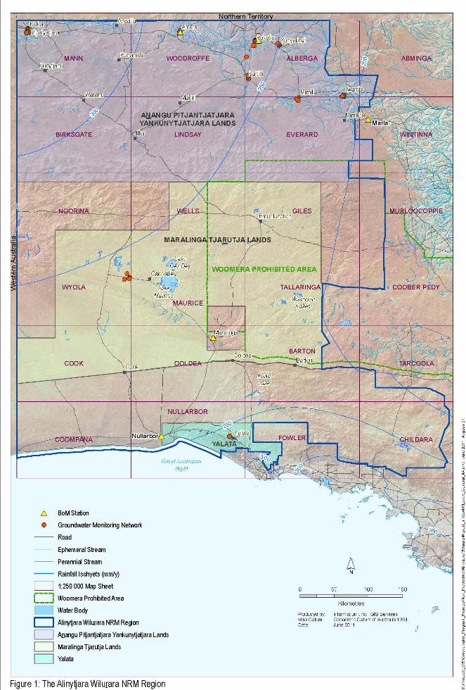
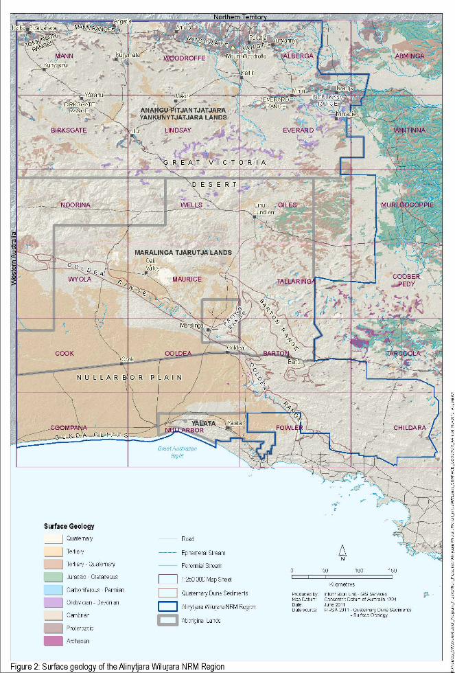
The Alinytjara Wilurara study site is defined by the AWNRM Region (Fig. 1) which covers more than
250 000 km2 which is nearly 26% of the area of the State. It is bounded to the north and west by the
borders of the Northern Territory and Western Australia and by the Great Australian Bight to the south.
The region consists of the following Aboriginal lands (Fig. 1):
Anangu Pitjantjatjara Yankunytjatjara (APY) Lands (vested in the Anangu Pitjantjatjara under the
Anangu Pitjantjatjara Yankunytjatjara Land Rights Act 1981)
Maralinga Tjarutja (MT) Lands (vested in the Maralinga Tjarutja under the Maralinga Tjarutja
Land Rights Act 1984)
Yalata (vested in the Aboriginal Lands Trust under the Aboriginal Lands Trust Act 1966)
Areas adjoining the Yalata and Maralinga Tjarutja Lands, dedicated under the South Australian
National Parks and Wildlife Act 1972 and Wilderness Protection Act 1992, including:
Mamungari Conservation Park
Tallaringa Conservation Park
Yumbarra Conservation Park
Yellabinna Regional Reserve and Yellabinna Wilderness Area
Nullarbor Regional Reserve and Nullarbor National Park
The region has a population of approximately 2200 people, although numbers fluctuate with the
seasons, community events and traditional ceremonies (AWNRMB 2009). The Homelands Program
allows indigenous people to return to traditional lifestyles and maintain their natural resources, while
providing them with housing, electricity and water (Rowe et al. 2006). The settlements (Table 1; Fig. 1)
rely on local sources of groundwater; Oak Valley being the exception with water drawn from wells
around 30 km away (AGT 2010a).
Table 1. Towns and Aboriginal communities and homelands within the Alinytjara Wilurara NRM Region
Area Town, Community or Homeland
APY Lands Kalka, Pipalyatjara, Kunytjanu, Angatja, Kunamata, Iltur, Makiri, Amata, Pukatja, Kaltjiti, Mimili, Yunyarinyi, Iwantja and Mintabie
MT Lands Oak Valley, Ooldea and Barton
Yalata Yalata
ALINYTJARA WILURARA
Department for Water | Technical Report DFW 2011/18 13 Non-prescribed groundwater resources assessment – Alinytjara Wilurara Natural Resources Management Region Phase 1 – Literature and Data Review
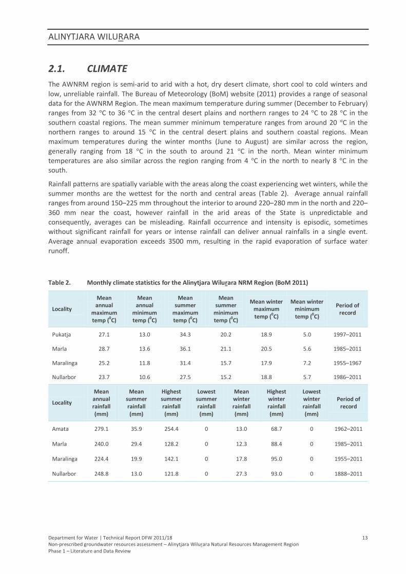
2.1. CLIMATE
The AWNRM region is semi-arid to arid with a hot, dry desert climate, short cool to cold winters and
low, unreliable rainfall. The Bureau of Meteorology (BoM) website (2011) provides a range of seasonal
data for the AWNRM Region. The mean maximum temperature during summer (December to February)
ranges from 32 °C to 36 °C in the central desert plains and northern ranges to 24 °C to 28 °C in the
southern coastal regions. The mean summer minimum temperature ranges from around 20 °C in the
northern ranges to around 15 °C in the central desert plains and southern coastal regions. Mean
maximum temperatures during the winter months (June to August) are similar across the region,
generally ranging from 18 °C in the south to around 21 °C in the north. Mean winter minimum
temperatures are also similar across the region ranging from 4 °C in the north to nearly 8 °C in the
south.
Rainfall patterns are spatially variable with the areas along the coast experiencing wet winters, while the
summer months are the wettest for the north and central areas (Table 2). Average annual rainfall
ranges from around 150–225 mm throughout the interior to around 220–280 mm in the north and 220–
360 mm near the coast, however rainfall in the arid areas of the State is unpredictable and
consequently, averages can be misleading. Rainfall occurrence and intensity is episodic, sometimes
without significant rainfall for years or intense rainfall can deliver annual rainfalls in a single event.
Average annual evaporation exceeds 3500 mm, resulting in the rapid evaporation of surface water
runoff.
Table 2. Monthly climate statistics for the Alinytjara Wilurara NRM Region (BoM 2011)
Locality
Mean annual
maximum temp (0C)
Mean annual
minimum temp (0C)
Mean summer
maximum temp (0C)
Mean summer
minimum temp (0C)
Mean winter maximum temp (0C)
Mean winter minimum temp (0C)
Period of record
Pukatja 27.1 13.0 34.3 20.2 18.9 5.0 1997–2011
Marla 28.7 13.6 36.1 21.1 20.5 5.6 1985–2011
Maralinga 25.2 11.8 31.4 15.7 17.9 7.2 1955–1967
Nullarbor 23.7 10.6 27.5 15.2 18.8 5.7 1986–2011
Locality
Mean annual rainfall (mm)
Mean summer rainfall (mm)
Highest summer rainfall (mm)
Lowest summer rainfall (mm)
Mean winter rainfall (mm)
Highest winter rainfall (mm)
Lowest winter rainfall (mm)
Period of record
Amata 279.1 35.9 254.4 0 13.0 68.7 0 1962–2011
Marla 240.0 29.4 128.2 0 12.3 88.4 0 1985–2011
Maralinga 224.4 19.9 142.1 0 17.8 95.0 0 1955–2011
Nullarbor 248.8 13.0 121.8 0 27.3 93.0 0 1888–2011
ALINYTJARA WILURARA
Department for Water | Technical Report DFW 2011/18 14 Non-prescribed groundwater resources assessment – Alinytjara Wilurara Natural Resources Management Region Phase 1 – Literature and Data Review
2.2. TOPOGRAPHY AND GEOMORPHOLOGY
The northern AWNRM Region is dominated by the mountain belt formed by the Musgrave and Mann
Ranges (Fig. 2). The Musgrave Ranges extend for 210 km with many peaks greater than 1100 m AHD, the
highest being Mount Woodroffe, which at 1435 m AHD, is the highest peak in South Australia (EB 2010).
Smaller isolated granite ranges of the Tomkinson, Everard, Birksgate and Indulkana Ranges are also
located in the area. Sediment deposited by creeks draining the ranges forms an apron of coalescing
alluvial fans with a level surface dipping gently away from the ranges (Rowe et al. 2006).
South of the northern ranges and blanketing much of the AWNRM Region is the Great Victoria Desert
(Fig. 2). This forms the southern part of the large anti-clockwise whorl of dunefields that covers much of
central Australia (Callen & Benbow 1995). Sand plains and dunefields are the dominant landform but the
desert also consists of many small sand hills, grassland plains, gibber plains, lunettes, rocky prominences
and salt lakes. The longitudinal dunes typically trending east–west, can extend for up to a hundred
kilometres, reach five to 30 metres in height and have an average spacing of less than 300 m, however,
there are local variations (Krieg 1973; Callen & Benbow 1995; Rogers 2000; Fairclough, Benbow &
Rogers 2007).
Along the southern margin of the Great Victoria Desert lies the Ooldea Range, a 650 km-long quartz
sand ridge that extends west into Western Australia and south-east towards Ceduna (Fairclough,
Benbow & Rogers 2007). The range has a height of up to 300 m AHD and is between 40 m and 160 m
above the surrounding terrain with a width of 10–25 km (Rankin et al. 1996; Fairclough, Benbow &
Rogers 2007). The Paling Range connects the Ooldea Range to the parallel Barton Range (Fig. 2).
The Ooldea Range acts as a boundary between the Great Victoria Desert and the Nullarbor Plain (Fig. 2).
With an area of 200 000 km2, the Nullarbor Plain is a vast, flat and featureless limestone dominated
terrain that is the largest semi-arid to arid karst region in the world (Rankin et al. 1996). The Plain has a
general south-easterly decline in elevation with local undulations and subtle karstic features that include
dongas and intervening shoulders, low ridges and short, shallow creeks (Fairclough, Benbow & Rogers
2007).
The Bunda Cliffs of the Great Australian Bight form the southern boundary of the Nullarbor Plain (Fig. 2).
The cliffs are 70–90 m high and stretch unbroken for 200 km from Western Australia to the Head of
Bight, where the cliffs are replaced by the massive Yalata Dune system (AWNRMB 2009).
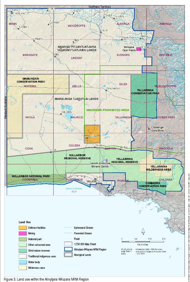
2.3. LAND USE
There is no privately-owned land within the AWNRM Region, with the primary land tenure being
formally recognised Aboriginal Lands, National Parks, Wildlife Reserves and Wilderness Areas (AWNRMB
2009; Fig. 3). Other land uses include residential townships, mineral exploration licences, pastoral land
and areas administered by the Department of Defence, including the Maralinga Restricted Area, which
remains part of the Woomera Prohibited Area (GHD 2009). Mimili has a commercial native-garden
venture providing bush tucker within the APY Lands (DTEI 2005). Pastoralism is expanding within the
eastern APY Lands and there is also one farming facility cleared for grain and sheep grazing within Yalata
(DTEI 2005).
2.4. WATER RESOURCES
As there is no regional reticulated water system and no permanent surface water resources, local
groundwater resources are the key source of water upon which the AWNRM Region relies. Historically,
the AWNRM Region has been largely devoid of industry with groundwater used primarily for Aboriginal
ALINYTJARA WILURARA
Department for Water | Technical Report DFW 2011/18 15 Non‐prescribed groundwater resources assessment – Alinytjara Wilurara Natural Resources Management Region Phase 1 – Literature and Data Review
communities’ town water supply and some pastoral activities. Demand for water has increased over
time due to growing mining activity in the region. This stress on water resources has been compounded
by expansion of the agricultural sector. Furthermore, water resources are recognised in playing a crucial
role in the conservation of the region’s natural biodiversity assets.
2.4.1. COMMUNITY WATER SUPPLIES
The AWNRM Region encompasses eleven major Aboriginal communities and homelands and numerous
smaller settlements, with groundwater providing the majority of community water supplies. The
provision of potable water to communities is challenging as the settlements are widely dispersed;
although only small water supplies are needed for each community, the infrastructure costs are great
(Rowe et al. 2006).
The APY Lands town water supplies are extracted from wells typically located near the community. The
groundwater is then either gravity fed from a storage container or pumped via an overhead tank to the
community (DTEI 2005). An upgrade of water supply systems, including the installation of ultraviolet
disinfection systems, was recently completed in all APY communities (DPC 2008). In the MT Lands, water
is extracted from five wells 25–30 km east of Oak Valley and, along with rainwater collected in a series
of tanks scattered across the Lands, is carted by tanker to the community (DTEI 2005). Water for the
Yalata community is extracted from two wells, treated by reverse osmosis and reticulated to the
community via a dual supply system (DTEI 2005).
Town water supplies for the majority of Aboriginal communities are extracted from low‐yielding wells,
from aquifers of limited extent. This includes weathered and fractured rock aquifers and alluvial
outwash aquifers in and around the northern ranges, or more extensive sediments such as dunefields,
where localised recharge creates discrete pockets of fresh water (AGT 2010a). If production from these
resources increases, declining water levels and increasing salinity may occur (AGT 2010a). Increases in
community populations may therefore require additional supply wells, but these would need to be
located away from existing wells to prevent interference with current supply (AGT 2010a). Finding
suitable alternative supplies could prove difficult given the declining water levels and low yields found at
some communities.
Community groundwater supplies are also potentially at risk from unsustainable pumping rates,
inadequate water treatment facilities and poor sanitation, lack of reserve water supplies and poor
construction, condition and/or maintenance of wells and associated reticulation/holding tanks (GHD
2009).
2.4.2. GROUNDWATER USAGE
Groundwater use across the AWNRM Region has traditionally supported small communities and
pastoral stock and domestic demands. Pastoral activity is not well understood across much of the region
with location, stock numbers, groundwater extraction and well condition not documented.
Total regional water consumption within the region is ambiguous. The Australian Bureau of Statistics
(ABS 2006) reports estimated surface water and groundwater use for the AWNRM region over the 2004‐
05 period with five ‘water management areas’ (Mackay, Musgrave, Warburton, Eromanga and Eucla
water). For these areas (Plus the South West Eromanga area) the estimated total regional surface water
consumption is 7572 ML, with approximately 91% used for pastoral activities, 4% for domestic water
supply, 3% for other uses and mining and manufacturing using the remainder.
Groundwater sustainable yields are currently undetermined with groundwater extraction categorised as
less than 500 ML/y for each of the water management areas by the Australian Water Resources 2005.
ALINYTJARA WILURARA
Department for Water | Technical Report DFW 2011/18 16 Non‐prescribed groundwater resources assessment – Alinytjara Wilurara Natural Resources Management Region Phase 1 – Literature and Data Review
For these areas the availability of ‘management indicators’ is limited suggesting a low level of
knowledge.
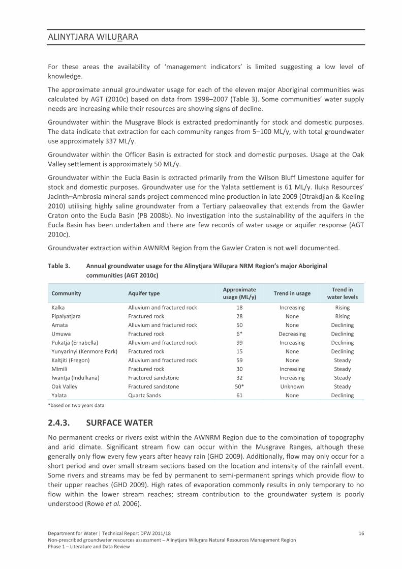
The approximate annual groundwater usage for each of the eleven major Aboriginal communities was
calculated by AGT (2010c) based on data from 1998–2007 (Table 3). Some communities’ water supply
needs are increasing while their resources are showing signs of decline.
Groundwater within the Musgrave Block is extracted predominantly for stock and domestic purposes.
The data indicate that extraction for each community ranges from 5–100 ML/y, with total groundwater
use approximately 337 ML/y.
Groundwater within the Officer Basin is extracted for stock and domestic purposes. Usage at the Oak
Valley settlement is approximately 50 ML/y.
Groundwater within the Eucla Basin is extracted primarily from the Wilson Bluff Limestone aquifer for
stock and domestic purposes. Groundwater use for the Yalata settlement is 61 ML/y. Iluka Resources’
Jacinth–Ambrosia mineral sands project commenced mine production in late 2009 (Otrakdjian & Keeling
2010) utilising highly saline groundwater from a Tertiary palaeovalley that extends from the Gawler
Craton onto the Eucla Basin (PB 2008b). No investigation into the sustainability of the aquifers in the
Eucla Basin has been undertaken and there are few records of water usage or aquifer response (AGT
2010c).
Groundwater extraction within AWNRM Region from the Gawler Craton is not well documented.
Table 3. Annual groundwater usage for the Alinytjara Wilurara NRM Region’s major Aboriginal
communities (AGT 2010c)
Community Aquifer type Approximate usage (ML/y)
Trend in usageTrend in
water levels
Kalka Alluvium and fractured rock 18 Increasing Rising
Pipalyatjara Fractured rock 28 None Rising
Amata Alluvium and fractured rock 50 None Declining
Umuwa Fractured rock 6* Decreasing Declining
Pukatja (Ernabella) Alluvium and fractured rock 99 Increasing Declining
Yunyarinyi (Kenmore Park) Fractured rock 15 None Declining
Kaltjiti (Fregon) Alluvium and fractured rock 59 None Steady
Mimili Fractured rock 30 Increasing Steady
Iwantja (Indulkana) Fractured sandstone 32 Increasing Steady
Oak Valley Fractured sandstone 50* Unknown Steady
Yalata Quartz Sands 61 None Declining
*based on two years data
2.4.3. SURFACE WATER
No permanent creeks or rivers exist within the AWNRM Region due to the combination of topography
and arid climate. Significant stream flow can occur within the Musgrave Ranges, although these
generally only flow every few years after heavy rain (GHD 2009). Additionally, flow may only occur for a
short period and over small stream sections based on the location and intensity of the rainfall event.
Some rivers and streams may be fed by permanent to semi‐permanent springs which provide flow to
their upper reaches (GHD 2009). High rates of evaporation commonly results in only temporary to no
flow within the lower stream reaches; stream contribution to the groundwater system is poorly
understood (Rowe et al. 2006).
ALINYTJARA WILURARA
Department for Water | Technical Report DFW 2011/18 17 Non‐prescribed groundwater resources assessment – Alinytjara Wilurara Natural Resources Management Region Phase 1 – Literature and Data Review
During dry periods the only source of available surface water is from water holes, springs and soaks, but
these are also susceptible to drying up (AWNRMB 2009). Unlike rockholes, which are recharged by
accumulated surface water following a rain event, water holes, springs and soaks are recharged by local
groundwater. Water holes hold cultural significance for indigenous communities (AWNRMB 2009) but
are at risk of damage and contamination from feral animals, particularly camels and domestic stock, as
well as from sedimentation. Historically, local Aboriginal people have managed the water resources of
the AWNRM Region with traditional practises such as water hole cleaning (Rowe et al. 2006). However,
the disruption of the traditional Aboriginal lifestyle since European settlement has made it difficult to
preserve and pass on these skills and as such, these water resources are under threat (AWNRMG 2004).
Other temporary surface water bodies are clay pans, which are natural, small topographic depressions
lined with clay (due to sedimentation) where water can accumulate after periods of rain. They have
been found in some interdunal corridors of the Yellabinna area (Copley & Kemper 1992). Clay pan water
is generally fresh but susceptible to contamination and usually short‐lived due to high evaporation rates
(GHD 2009).
2.5. DEMAND AND SUPPLY
A key commitment in Water for Good is the development of Regional Demand and Supply Statements to
ensure that long‐term water security solutions for each region are based on a thorough understanding
of the state of all local water resources, the demand for these resources and likely future pressures
(DFW 2011).
The Demand and Supply Statements provide demand and supply projections for the scenarios of high
and low population growth and high and low greenhouse gas emission. Two projection sets address the
demand and supply for (1) drinking quality water only; and (2) for all water sources and human
demands.
The main sectors of water source usage (both potable and non‐potable) are likely to be for stock use,
residential use and non‐residential purposes (e.g. industrial, commercial and institutional). Minor use
sectors include mining and irrigation. Mining and agricultural activities have been identified as key risks
to the quality, availability and ecological integrity of culturally and/or environmentally significant water
features (GHD 2009). However, there is no information currently available on the use of water for
agricultural purposes within the AWNRM Region.
The Department of Primary Industries and Resources South Australia (PIRSA) has indicated that the
AWNRM Region is considered highly prospective for mineral development (AGT 2010a) and this is
consistent with other evidence that there will be significant growth in the mining industry over the next
40 years and beyond (e.g. Government of South Australia 2007; RESIC 2010). Mining operations require
significant volumes of water, but can typically be of a lower quality than is required for stock or
irrigation. The Resources and Energy Infrastructure Council (2010) reported that the water demand
across the State’s resource sector will increase from approximately 43 GL/y in 2010 to 130 GL/y in 2019.
It is important that associated water resource demands are considered, planned for and managed to
support this development, while balancing this against environmental and social requirements.
2.5.1. MINING
The AWNRM Region is considered to be highly prospective for mineralisation (AGT 2010a). There are
currently 101 exploration licences and 140 mineral exploration licence applications, eight petroleum
explorations licences and 18 petroleum exploration licence applications held within the AWNRM Region.
The Jacinth–Ambrosia Mineral Sands project is the only large‐scale operational mine currently located
ALINYTJARA WILURARA
Department for Water | Technical Report DFW 2011/18 18 Non‐prescribed groundwater resources assessment – Alinytjara Wilurara Natural Resources Management Region Phase 1 – Literature and Data Review
within the AWNRM Region. Opal mining occurs in the Mintabie Precious Stones Field. The Challenger
Gold Mine, while located outside the AWNRM boundary, sources 580 ML of groundwater from
palaeovalley and weathered and fractured rock aquifers in the Gawler Craton. As groundwater within
the palaeovalleys of the Gawler Craton is known to drain westwards into the Eucla Basin, the mine could
have some impact on groundwater resources within the region.
Although mining operations require significant volumes of water, the quality of the water is typically of
less importance. Depending on the type of mine, highly saline water can be used for processing and
auxiliary uses with potable water often produced on site via reverse osmosis. Dewatering of mines and
supply well‐fields can cause the development of considerable cones of depression within the targeted
aquifer (AGT 2010a). This has the potential to affect the water supply for communities in close proximity
to the mine if they are accessing water from the same aquifer. Guidelines from the Mining Act 1971 and
PIRSA require any new mining project to assess the risks to the environment and stakeholders.
Therefore, if significant drawdown effects occurred at community supply wells due to mining, for
example, the company would be responsible for supplying the town with potable water from the mine
dewatering or its own potable supply (AGT 2010a).
Department for Water | Technical Report DFW 2011/18 21 Non-prescribed groundwater resources assessment – Alinytjara Wilurara Natural Resources Management Region Phase 1 – Literature and Data Review
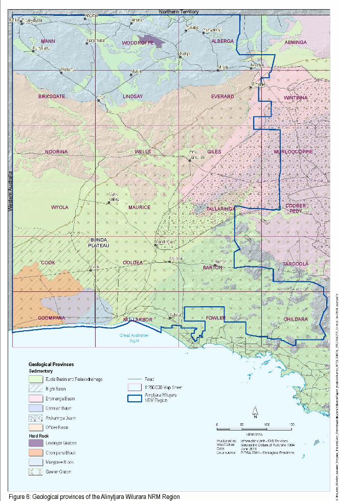
3. GEOLOGY
There are five major geological provinces of the AWNRM Region (Fig. 6):
Gawler Craton, comprising Precambrian gneiss, schist, granite and banded iron formation,
overlain locally by Palaeozoic, Mesozoic and Tertiary sedimentary rocks
Musgrave Block, comprising Precambrian volcanics, granites and metamorphic complexes
Officer Basin, comprising late Proterozoic and early Palaeozoic sedimentary rocks such as
sandstone, siltstone and shale
Great Artesian Basin (GAB), comprising Mesozoic sediments of the Eromanga Basin underlain by
Cambrian sediments of the Arckaringa basin.
Eucla Basin, comprising Tertiary limestones and siliciclastic sediments underlain by sandstones
of the Bight Basin.
3.1. GAWLER CRATON
The Gawler Craton geological province encompasses approximately 440 000 km2 of central South
Australia. The craton is a stable crystalline basement province comprising Archaean to
Palaeoproterozoic gneiss, schist, granite and banded iron formations, with the Mulgathing Complex the
dominant rock unit within the study area (Lewis et al. 2010; Table 20). Weathering may occur to depths
of up to 50 m (Dodds 1996). Late Proterozoic to early Palaeozoic sediments of the Officer Basin overlie
the craton to the north-west (Dodds 1996; Fig. 5). Late Palaeozoic to early Mesozoic sediments of the
Arckaringa Basin and Late Mesozoic sequences of the Eromanga Basin onlap the older rocks of the
craton to the north-east (Dodds 1996; Fig. 5). Overlying Permian clays are generally restricted to narrow
east–west trending troughs (Dodds 1996). Tertiary sediments of the Eucla Basin infill the widely
distributed palaeovalleys incised into the older rocks and also cover the craton at the surface along with
a thin cover of Quaternary dune sand, calcrete and colluvium (Lewis et al. 2010; Fig. 5).
West of the Gawler Craton, the Coompana Block is concealed beneath the Nullarbor Plain. Information
on Precambrian units is lacking due to limited exploratory drilling and geological appraisal, but it is
thought to consist of basement of possibly Archaean to Mesoproterozoic age and likely
Mesoproterozoic-age basic intrusives, volcanics and minor clastic sediments (Drexel, Preiss & Parker
1993). The depth to the Coompana Block is around 300 m near the Western Australia border and
coastline, increasing to the east and north (Flint & Daly 1993).
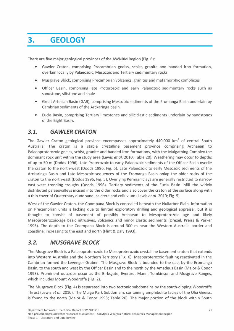
3.2. MUSGRAVE BLOCK
The Musgrave Block is a Palaeoproterozoic to Mesoproterozoic crystalline basement craton that extends
into Western Australia and the Northern Territory (Fig. 6). Mesoproterozoic faulting reactivated in the
Cambrian formed the Levenger Graben. The Musgrave Block is bounded to the east by the Eromanga
Basin, to the south and west by the Officer Basin and to the north by the Amadeus Basin (Major & Conor
1993). Prominent outcrops occur as the Birksgate, Everard, Mann, Tomkinson and Musgrave Ranges,
which includes Mount Woodroffe (Fig. 2).
The Musgrave Block (Fig. 4) is separated into two tectonic subdomains by the south-dipping Woodroffe
Thrust (Lewis et al. 2010). The Mulga Park Subdomain, containing amphibolite facies of the Olia Gneiss,
is found to the north (Major & Conor 1993; Table 20). The major portion of the block within South
GEOLOGY
Department for Water | Technical Report DFW 2011/18 22 Non-prescribed groundwater resources assessment – Alinytjara Wilurara Natural Resources Management Region Phase 1 – Literature and Data Review
Australia, the Fregon Subdomain, containing granulite facies of the Birksgate Complex, is to the south of
the thrust (Table 20). The Pitjantjatjara Supersuite and intrusives of the Giles Complex are also found
throughout the block (Table 20).
Pliocene to Pleistocene sediments consisting of unconsolidated clays with sands and limestone, were
deposited in the extensive network of palaeovalleys that are incised into the Musgrave Block (Lewis et
al. 2010). These sediments have undergone deep weathering which has led to the development of
ferricrete and silcrete (Magee 2009). Where basement outcrop does not occur, Quaternary sand dunes
of the Great Victoria Desert blanket the region and include Pleistocene calcrete and Holocene alluvial,
fluvial and aeolian deposits that are generally unconsolidated and consist of gravel, sands and clays with
some thin limestone (Lewis et al. 2010; Fig. 2).
Figure 4. Geological map of the Musgrave Block (Major & Conor 1993)
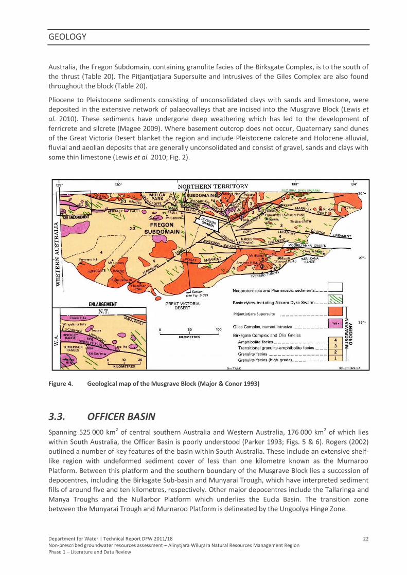
3.3. OFFICER BASIN
Spanning 525 000 km2 of central southern Australia and Western Australia, 176 000 km2 of which lies
within South Australia, the Officer Basin is poorly understood (Parker 1993; Figs. 5 & 6). Rogers (2002)
outlined a number of key features of the basin within South Australia. These include an extensive shelf-
like region with undeformed sediment cover of less than one kilometre known as the Murnaroo
Platform. Between this platform and the southern boundary of the Musgrave Block lies a succession of
depocentres, including the Birksgate Sub-basin and Munyarai Trough, which have interpreted sediment
fills of around five and ten kilometres, respectively. Other major depocentres include the Tallaringa and
Manya Troughs and the Nullarbor Platform which underlies the Eucla Basin. The transition zone
between the Munyarai Trough and Murnaroo Platform is delineated by the Ungoolya Hinge Zone.
Pitjantjatjara Supersuite
GEOLOGY
Department for Water | Technical Report DFW 2011/18 23 Non-prescribed groundwater resources assessment – Alinytjara Wilurara Natural Resources Management Region Phase 1 – Literature and Data Review
The basin consists of Neoproterozoic to early Palaeozoic clastic sedimentary rocks that are typically
greater than 500 m thick and can exceed six kilometres (Milton & Parker 1973; Table 20). The rock units,
including the Murnaroo and Trainor Hill Sandstones, are thought to dip gently towards the centre of the
basin from the north and south (Martin, Sereda & Clarke 1998). Basin sediments are overthrust by the
Musgrave Block at its northern margin (Martin, Sereda & Clarke 1998) and overlie the crystalline
basement rocks of the Gawler Craton to the south-east. To the east, sediments are overlain by Mesozoic
sequences of the Eromanga Basin. Tertiary sequences infill palaeovalleys incised into Officer Basin
sediments. The Officer Basin is overlain primarily by undifferentiated Quaternary aeolian sediments of
the Great Victoria Desert (Fig. 2).
Figure 5. Geological map of the Officer Basin (Rogers 2002)
3.4. ARCKARINGA BASIN
The Permian Arckaringa Basin underlies the Eromanga Basin of the GAB (Fig. 6). It consists of diamictite
of the Boorthanna Formation, mudstone, sandstone and siltstone of the Stuart Range Formation and
siltstone, sandstone, shale and coal of the Mt Toondina Formation (Cotton, Scardigno & Hibburt 2006;
Table 20).
3.5. EROMANGA BASIN
Within the AWNRM Region, the western extent of the Great Artesian Basin is represented by the
Eromanga Basin (Fig. 6). The Jurassic to Cretaceous Eromanga Basin consists of sandstones of the
GEOLOGY
Department for Water | Technical Report DFW 2011/18 24 Non-prescribed groundwater resources assessment – Alinytjara Wilurara Natural Resources Management Region Phase 1 – Literature and Data Review
Algebuckina Sandstone and Cadna-owie Formation and the fossiliferous mudstone of the Bulldog Shale
(Cotton, Scardigno & Hibburt 2006; Table 20).
3.6. EUCLA BASIN AND PALAEODRAINAGE
Over a third of the area of the Eucla Basin (176 000 km2) lies within South Australia with the remainder
occurring within Western Australia. Archaean to Mesoproterozoic rocks of the Gawler Craton and
Coompana Block comprise much of the regional basement. These are overlain by the late Proterozoic to
early Palaeozoic sediments of the Officer Basin. Permian sediments underlying the Eucla Basin in the
southern coastal region are named the Denman Basin (Fig. 6). Also underlying the Eucla Basin is the
Early to Late Cretaceous Bight Basin which comprises coarse sandstone, siltstone and shale of the
Loongana and Madura Formations (Fig. 6; Table 20).
The Eucla Basin is the largest onshore Cainozoic basin in the world (Lewis et al. 2010) and has related
palaeodrainage that has headwaters in the Musgrave Block and the Gawler Craton (Fairclough, Benbow
& Rogers 2007; Fig. 6). The delineation of the Eucla Basin presented herein is more extensive than
previous limits and includes Neogene and Palaeogene sediments associated with the palaeovalleys and
palaeodrainage from the northern and eastern geological provinces (Hou et al. in press).
The Tertiary sequence is divided into the middle Eocene to Middle Miocene marine limestones of the
Eucla Group, the Early Miocene to Early Pliocene terrigenous sediments of the Immarna Group and the
Middle to Late Eocene sediments of the Burdunga Subgroup (Benbow, Lindsay & Alley 1995). The Eucla
Group comprises the Wilson Bluff and Nullarbor limestones, the Immarna Group includes the Garford
and Narlaby Formations and Yarle Sandstone and the Pidinga Formation, Hampton Sandstone and
Ooldea Sand make up the Burdunga Subgroup (Table 20). Undifferentiated Quaternary aeolian
sediments overlie the Tertiary sequences in the far north of the basin and to the south-east, with
Bridgewater Formation found along the far north-west coast of the Eyre Peninsula.
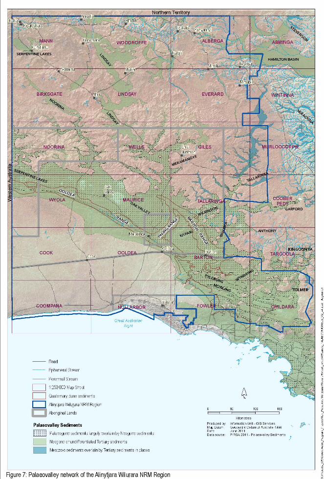
3.6.1. PALAEOVALLEYS
Throughout much of the early to middle Cainozoic, palaeorivers draining the Musgrave Block, Stuart
Range and Gawler Ranges deposited sediments in the Eucla Basin (Lewis et al. 2010; Fig. 7). The
Serpentine Lakes (which drain through South Australia and Western Australia), Noorina, Lindsay and
Meramangye palaeovalleys were incised into bedrock of the Musgrave Block and Officer Basin. The
Kingoonya Palaeovalley dominates the central Gawler Craton with a large tributary network that
develops into a complex mouth near the eastern margins of the Barton and Ooldea Ranges (Magee
2009). Smaller distributary palaeovalleys (Wynbring, Anthony and Tolmer) are found in the lower
reaches. The Tallaringa Palaeovalley occurs at the northern Gawler Craton margin and trends south to
south-west linking with the Garford Palaeovalley near its mouth at the boundary of the AWNRM Region
(Magee 2009). Tallaringa has an extensive tributary network including branches which trend south-
easterly towards the main drainage feature. The Garford Palaeovalley has an extensive tributary
network and a small proportion of the Narlaby Palaeovalley extends in the AWNRM Region at its south-
eastern extent.
The Pidinga and Garford Formations have been identified as palaeovalley deposits in the Musgrave
region (Zang & Stoian 2006, cited in Magee 2009). The Garford Formation, as well as the Mangatitja
Limestone, was also identified as the main sedimentary unit within palaeovalleys trending southwards
from the Musgrave Block across the Officer Basin to the Eucla Basin (Lau et al. 1995, cited in Magee
2009; Table 20). Palaeovalley deposits at Oak Valley have been identified as Pidinga Formation overlain
by the Hampton Sandstone and are overlain by sand dunes of the Great Victoria Desert. Where sand
GEOLOGY
Department for Water | Technical Report DFW 2011/18 25 Non-prescribed groundwater resources assessment – Alinytjara Wilurara Natural Resources Management Region Phase 1 – Literature and Data Review
dunes are absent, calcrete and gypsum-rich playa sediments dominate, particularly in the Meramangye
and Tallaringa palaeovalleys (Lewis et al. 2010). Within the Kingoonya Palaeovalley and its tributaries,
sediments consist primarily of Pidinga Formation overlain by the Kingoonya Member of the Garford
Formation (Hou et al. 2003).
Hou et al. (2007) mapped palaeodrainage channels of South Australia in response to high levels of
exploration activity for uranium and heavy mineral sands which are associated with palaeovalley
sediments. Their areal extent was delineated through the integration of drillhole data, interpretation of
geophysical and remotely sensed data and sedimentary history records (Rogers & Zang 2006). While
most channels are greater than 100 km in length and some up to around 500 km (Frakes & White 1997),
their dimensions are greatly variable. The widths of the palaeovalleys range from tens of metres to
around 30 km and can reach depths of 120 m (Hou et al. 2003).
Magee (2009) found that within the arid centre of Australia, the key surface geology technique that can
aid in the identification of palaeovalleys is mapping the distribution of calcrete deposits. On a
demonstration site within the Musgrave Block, mapping the extent of near-surface calcrete deposits
proved an effective and relatively simple first-pass technique for identifying the spatial location and
areal extent of major palaeovalley systems.
Department for Water | Technical Report DFW 2011/18 28 Non-prescribed groundwater resources assessment – Alinytjara Wilurara Natural Resources Management Region Phase 1 – Literature and Data Review
4. HYDROGEOLOGY
Regional aquifers within the AWNRM Region are closely linked to the geological provinces (GHD 2009):
Gawler Craton – igneous and metamorphic rocks form the regional fractured rock aquifer
overlain locally by unconsolidated granular aquifers associated with palaeovalley deposits
Musgrave Block – the igneous and metamorphic rocks of the Musgrave Ranges form a regional
fractured rock aquifer of highly variable yield and generally limited resource potential
Officer Basin – groundwater within the Officer Basin is associated with the sandstone rocks as
well as Tertiary palaeovalley deposits
Great Artesian Basin – compared with other areas of the GAB, the sedimentary sequence of the
Arckaringa and Eromanga Basins comprise fractured rock aquifers of relatively limited potential
and are beyond the limit of artesian conditions
Eucla Basin – Tertiary limestones and sandstones comprise regional fractured rock/karstic
aquifers throughout the Eucla Basin with an underlying confined aquifer associated with the
sandstones of the Bight Basin
Palaeovalleys – Tertiary deposits are typically several metres to 50 m thick, but can reach up to
80 m (Hou et al. 2003) and have the potential to contain significant volumes of water.
4.1. GAWLER CRATON
Groundwater of the Gawler Craton occurs within fractured and weathered Precambrian basement
rocks. Incised Tertiary sediments in widely distributed palaeovalleys are likely to be significant
volumetric groundwater resources, although limited information is available within this study area.
4.2. MUSGRAVE BLOCK
Groundwater within the Musgrave Block occurs within Precambrian basement rocks, shallow poorly
consolidated Tertiary palaeovalley sediments and localised Quaternary alluvial deposits (GHD 2009). In
the Indulkana Range, groundwater is found within fractured sandstone.
Palaeovalleys containing predominantly unconsolidated silts, sands and gravels are incised into the
crystalline basement rock of the Musgrave Block. The Lindsay Palaeovalley is one of the major
palaeovalleys within the region and extends from the Musgrave Ranges, across the Officer Basin and
merges with the Meramangye Palaeovalley that drains into the Eucla Basin in the south.
Small localised freshwater aquifers may also be found in shallower Quaternary alluvium, sand or
calcrete deposits in streambeds and adjacent to basement outcrop where recharge occurs by direct
infiltration from rainfall (Rowe et al. 2006).
4.3. OFFICER BASIN
Little is known of groundwater in the Officer Basin as the area is generally data poor. Fractured rock and
Quaternary fluvial outwash aquifers are not documented in the area, leaving Palaeozoic sediments and
Tertiary palaeovalley deposits as the possible aquifer systems (Lewis et al. 2010).
HYDROGEOLOGY
Department for Water | Technical Report DFW 2011/18 29 Non-prescribed groundwater resources assessment – Alinytjara Wilurara Natural Resources Management Region Phase 1 – Literature and Data Review
The Noorina and Lindsay palaeovalleys cross the Officer Basin from north-west to south-east and are
likely to provide a regional groundwater system (Buxton 2005). Sediments are recognised as the
Hampton Sandstone and Pidinga Formation, but only the latter has been identified below the
watertable (Tewkesbury & Dodds 1996).
4.4. ARCKARINGA BASIN
The Permian Arckaringa Basin underlies the Eromanga Basin and contains aquifers within the
Boorthanna and Mount Toondina Formations with the Stuart Range Formation acting as an aquitard
between the two (AGT 2010b). Palaeovalleys consisting of predominantly unconsolidated silts, sands
and gravels form intergranular aquifers that incise these sediments of the Arckaringa Basin (GHD 2009).
4.5. EROMANGA BASIN
The GAB is a confined groundwater basin comprising multi-layered aquifers of Triassic, Jurassic and
Cretaceous sediments of three groundwater basins, the Eromanga Basin being the largest (Radke et al.
2000). Basin sediments within the AWNRM Region are beyond the limit of artesian groundwater
conditions found to the east. Together, the Jurassic Algebuckina Sandstone and Cretaceous Cadna-owie
Formation (often referred to as the J-K aquifer) form the major aquifer system within the Eromanga
Basin (Love et al. 2000). At the western margin of the basin, these aquifers are hydraulically
interconnected and are therefore treated as one aquifer which reaches a maximum combined thickness
of approximately 200 m (Love et al. 2000). The overlying Bulldog Shale forms a regional aquitard over
much of the region and can reach a maximum thickness of several hundred metres (Love et al. 2000).
4.6. EUCLA BASIN AND PALAEODRAINAGE
Underlying the Eucla Basin, Neoproterozoic basement rocks of the Gawler Craton are not recognised
aquifers, as the overlying late Palaeozoic Denman Basin is believed to act as an aquitard (GHD 2009).
The spatially extensive Loongana Formation of the Bight Basin is generally less than 33 m thick, with a
maximum recorded thickness of 190 m and forms a confined sandstone aquifer under moderate
pressure (PB 2008a).
Of the Eucla Basin sediments, the Pidinga Formation, Hampton Sandstone, Ooldea Sand and the Wilson
Bluff Limestone have been identified as potential aquifers. The Nullarbor Limestone is largely
unsaturated and the Bridgewater Formation is not considered a significant aquifer due to its elevation
above the watertable (PB 2005).
Tertiary palaeovalley units between 40–50 m thick (PB 2008a) extend from the Musgrave Block and
Gawler Craton into the northern and eastern margins of the basin (Lewis et al. 2010).
4.6.1. PALAEOVALLEYS
Within the AWNRM Region, fractured rock and surficial sedimentary aquifers are considerably more
extensive than palaeovalley aquifers, but are generally less effective at transmitting or storing
groundwater (Magee 2009). Lateral leakage from surrounding basement and outwash aquifers provides
the majority of groundwater to palaeovalley aquifers (Magee 2009). The regional groundwater heads
indicate flow towards the southern discharge points in playas and at depth to the Eucla Basin (Lau et al.
1995, cited in Magee 2009).
Department for Water | Technical Report DFW 2011/18 30 Non-prescribed groundwater resources assessment – Alinytjara Wilurara Natural Resources Management Region Phase 1 – Literature and Data Review
5. GROUNDWATER DATA
5.1. DATA
Data used in the production of this report have been sourced principally from South Australia’s
geodatabase (SA Geodata) which is administered by the Department for Water (DFW) and Primary
Industries and Resources, South Australia (PIRSA). Whilst every effort is made to present information
from the database as accurately as possible, there will be limitations on data accuracy in relation to data
being up-to-date, validated or complete. Other sources of information accessed in support of these
assessments include available literature and publicly available state and national geoservers – namely,
PIRSA’s South Australian Resource Information Geoserver (SARIG) and Geoscience Australia’s (GA)
geoserver.
Recent water level and salinity data are available for current active groundwater observation networks.
These data can be accessed via the groundwater information database (Obswell) on the DFW’s
WaterConnect website. In areas that are not currently monitored, it is common to find that only a few
groundwater parameters (e.g. salinity and water level) have been sporadically recorded since 1999.
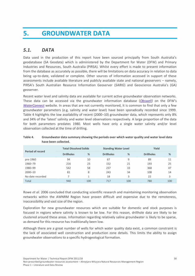
Table 4 highlights the low availability of recent (2000–10) groundwater data, which represents only 8%
and 34% of the ‘latest’ salinity and water level observations respectively. A large proportion of the data
for both parameters predates 1980. Most wells have only a single water salinity and/or level
observation collected at the time of drilling.
Table 4. Groundwater data summary showing the periods over which water quality and water level data
have been collected.
Period of record Total Dissolved Solids Standing Water Level Yield
Drillholes % Drillholes % Drillholes %
pre-1960 94 10 67 9 89 11
1960–79 216 23 152 21 193 25
1980–99 542 58 237 33 368 47
2000–10 81 8 243 34 108 14
No date recorded 7 1 18 3 22 3
Total 940 100 717 100 780 100
Rowe et al. 2006 concluded that conducting scientific research and maintaining monitoring observation
networks within the AWNRM Region have proven difficult and expensive due to the remoteness,
inaccessibility and vast size of the region.
Exploration for new groundwater resources which are suitable for domestic and stock purposes is
focused in regions where salinity is known to be low. For this reason, drillhole data are likely to be
clustered around these areas. Information regarding relatively saline groundwater is likely to be sparse,
as demand for this resource has traditionally been low.
Although there are a great number of wells for which water quality data exist, a common constraint is
the lack of associated well construction and production zone details. This limits the ability to assign
groundwater observations to a specific hydrogeological formation.
GROUNDWATER DATA
Department for Water | Technical Report DFW 2011/18 31 Non-prescribed groundwater resources assessment – Alinytjara Wilurara Natural Resources Management Region Phase 1 – Literature and Data Review
5.1.1. MONITORING
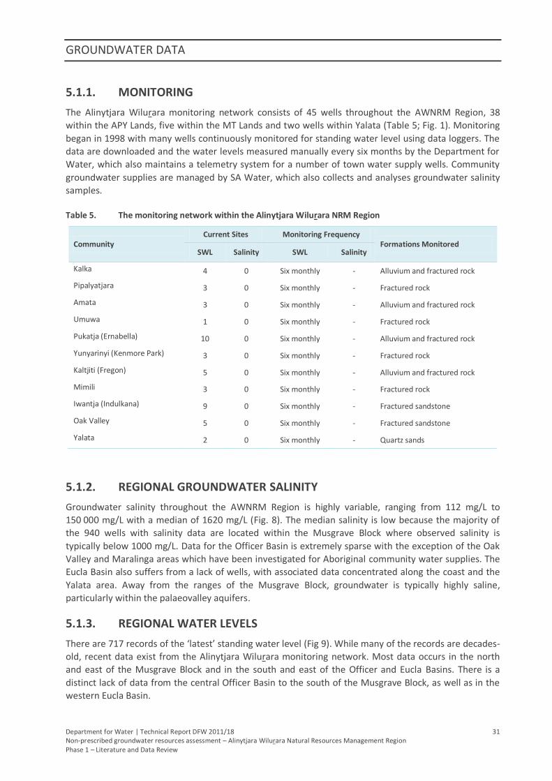
The Alinytjara Wilurara monitoring network consists of 45 wells throughout the AWNRM Region, 38
within the APY Lands, five within the MT Lands and two wells within Yalata (Table 5; Fig. 1). Monitoring
began in 1998 with many wells continuously monitored for standing water level using data loggers. The
data are downloaded and the water levels measured manually every six months by the Department for
Water, which also maintains a telemetry system for a number of town water supply wells. Community
groundwater supplies are managed by SA Water, which also collects and analyses groundwater salinity
samples.
Table 5. The monitoring network within the Alinytjara Wilurara NRM Region
Community Current Sites Monitoring Frequency
Formations Monitored SWL Salinity SWL Salinity
Kalka 4 0 Six monthly - Alluvium and fractured rock
Pipalyatjara 3 0 Six monthly - Fractured rock
Amata 3 0 Six monthly - Alluvium and fractured rock
Umuwa 1 0 Six monthly - Fractured rock
Pukatja (Ernabella) 10 0 Six monthly - Alluvium and fractured rock
Yunyarinyi (Kenmore Park) 3 0 Six monthly - Fractured rock
Kaltjiti (Fregon) 5 0 Six monthly - Alluvium and fractured rock
Mimili 3 0 Six monthly - Fractured rock
Iwantja (Indulkana) 9 0 Six monthly - Fractured sandstone
Oak Valley 5 0 Six monthly - Fractured sandstone
Yalata 2 0 Six monthly - Quartz sands
5.1.2. REGIONAL GROUNDWATER SALINITY
Groundwater salinity throughout the AWNRM Region is highly variable, ranging from 112 mg/L to
150 000 mg/L with a median of 1620 mg/L (Fig. 8). The median salinity is low because the majority of
the 940 wells with salinity data are located within the Musgrave Block where observed salinity is
typically below 1000 mg/L. Data for the Officer Basin is extremely sparse with the exception of the Oak
Valley and Maralinga areas which have been investigated for Aboriginal community water supplies. The
Eucla Basin also suffers from a lack of wells, with associated data concentrated along the coast and the
Yalata area. Away from the ranges of the Musgrave Block, groundwater is typically highly saline,
particularly within the palaeovalley aquifers.
5.1.3. REGIONAL WATER LEVELS
There are 717 records of the ‘latest’ standing water level (Fig 9). While many of the records are decades-
old, recent data exist from the Alinytjara Wilurara monitoring network. Most data occurs in the north
and east of the Musgrave Block and in the south and east of the Officer and Eucla Basins. There is a
distinct lack of data from the central Officer Basin to the south of the Musgrave Block, as well as in the
western Eucla Basin.
GROUNDWATER DATA
Department for Water | Technical Report DFW 2011/18 32 Non-prescribed groundwater resources assessment – Alinytjara Wilurara Natural Resources Management Region Phase 1 – Literature and Data Review
The majority of water levels for the Eucla Basin are more than 50 m below the ground surface, leaving
the Nullarbor Limestone largely unsaturated. Depth to groundwater generally decreases with distance
from the coast; however, water levels within the Musgrave Block are quite variable. Across the AWNRM
Region, standing water levels range up to 174 m with a median depth below the surface of 15 m.
Corresponding water-cut depths range up to 250 m with a median of 27 m. Many of the region’s
aquifers experience confined or sub-artesian conditions.
5.1.4. REGIONAL WELL YIELDS
Throughout the AWNRM Region, the overwhelming majority of wells yield less than one litre per second
(Fig. 10). From the 780 wells with yield data, yield ranges between 0.0001 L/s and 34 L/s with a median
of just 0.9 L/s. Fifteen wells have an observed yield of 15 L/s to 34 L/s. These wells are located in the
Eucla Basin beneath the eastern margin of the Nullarbor Plain. This is likely due to the cavernous nature
and high porosity exhibited by the Wilson Bluff Limestone in the area (PB 2005).

GROUNDWATER DATA
Department for Water | Technical Report DFW 2011/18 36 Non-prescribed groundwater resources assessment – Alinytjara Wilurara Natural Resources Management Region Phase 1 – Literature and Data Review
5.2. 1:250 000 MAP SHEET DATA
This report has compiled groundwater data available from within the SA Geodata database for the
AWNRM Region. Information on groundwater salinity, standing water level, yields and data age are
tabulated by 1:250 000 map sheets and where applicable, information on associated water cuts and
maximum well depth are included.
Stratigraphic information sourced from SA Geodata is also included in the data summaries to give a
general representation of the location and thickness of potential aquifer units. The median thickness of
a stratigraphic unit is calculated using only fully-penetrating samples, that is, when the entire thickness
of a unit is intercepted.
For consistency, the reference to map sheet areas will follow a uniform naming convention. For
example, the MANN 1:250 000 map sheet area will be referred to in this report as MANN.
5.2.1. MANN
MANN covers the north-west corner of the APY Lands and contains the
Aboriginal communities of Pipalyatjara and Kalka as well as numerous
homelands including Kunytjanu, Angatja and Kunamata. Seven
observation wells from the Alinytjara Wilurara monitoring network are
situated within the Tomkinson Ranges. Three wells are located at or
near Pipalyatjara; the other four wells are located at or near Kalka. The
majority of wells with groundwater quality data and stratigraphic
information are located in the Tomkinson Ranges in the north-west and
extending east to the south-eastern extent of the Mann Ranges. Apart
from a few wells near Kunytjanu and in the south of MANN, the
remaining areas contain no data.
Surface Geology
Proterozoic basement of the Musgrave Block crops out predominantly along the north of MANN in the
form of the Tomkinson and Mann Ranges. Away from outcrop, the surface geology of MANN is
dominated by undifferentiated Quaternary aeolian sediments of the Great Victoria Desert (Fig. 2).
Quaternary alluvial/fluvial sediments are commonly found surrounding basement outcrop and large
tracts of calcrete are found throughout the western half of MANN. Quaternary red sand typically
covered with mulga is also found across the centre and south of MANN.
Stratigraphy
The depth to Mesoproterozoic basement rocks of the Birksgate Complex can be up to 150 m but the
median is a shallow 12 m. Tertiary sequences have only minor outcrop and have been found at depths
of up to 114 m, but have a median thickness of 12 m. The northern section of the Serpentine Lakes
Palaeovalley is found in the north and west of MANN and the Lindsay Palaeovalley is found in the north-
east. The Tertiary Mangatitja Formation has been intercepted in the palaeovalleys from the surface to
depths of up to 20 m with a median thickness of 18 m. Quaternary sediments have a median thickness
of eight metres.
Groundwater Data
Salinity is generally low (435–5761 mg/L; median 770 mg/L), with 86% of wells recording a salinity below
1500 mg/L (Table 6; Fig. 8). One well with a salinity of 25 600 mg/L is open to Quaternary alluvial
GROUNDWATER DATA
Department for Water | Technical Report DFW 2011/18 37 Non-prescribed groundwater resources assessment – Alinytjara Wilurara Natural Resources Management Region Phase 1 – Literature and Data Review
sediments with a depth to water of around seven metres, possibly indicating groundwater affected by
evapotranspiration.
Standing water levels (SWL) are between four and 49 metres below the surface with a median of 16 m
(Table 6; Fig. 9). Water cut (WC) depths are between seven and 70 metres below the surface with a
median of 27 m. Standing water levels and water cut depths follow no spatial pattern. There are 56
wells with standing water elevations higher than their respective water cuts. Differences are up to 42 m,
but based on well construction details, no apparent spatial pattern is exhibited within stratigraphic
units. Yields are variable (0.01–12 L/s; Table 6; Fig. 10), but are generally low with a median of 0.75 L/s
and show no correlation between water cut depth or location.
Based on production zone details, the weathered and fractured rock basement aquifers of the Musgrave
Block (20 wells) contain groundwater of good quality (540–1710 mg/L; median 750 mg/L), but are
generally low yielding (0.01–2.5 L/s; median of 0.5 L/s, with one well at 5 L/s). Standing water levels are
variable but generally shallow (4–27 m; median 11 m) and are often tens of metres above the water cut
depth (8.5–52 m; median 26 m) which is typical of fractured rock environments.
The Tertiary palaeovalley sequences (13 wells), including the Mangatitja Formation, contain
groundwater of similar, although generally higher, salinity (488–1775 mg/L; median 1680 mg/L), but
return higher, albeit still low, yields (0.3–9 L/s; median 0.9 L/s). Standing water levels and water cut
depths are similar to that of the basement rocks (SWL 8–27 m, median 12.7 m; WC 8–70 m, median 26
m).
Observations from Quaternary sediments (14 wells) have greater yields again (0.23–12 L/s, median 1.45
L/s) and apart from the saline well previously mentioned, generally have good quality water (435–3090
mg/L, median 925 mg/L) which suggests direct recharge from rainfall is occurring. Standing water levels
are also tens of metres higher than the original water cut depths (SWL 4–21 m, median 10.2 m; WC 12–
42 m, median 24 m).
Table 6. Summary of salinity, standing water level and yield data and the associated median values (with
number of data points in brackets) for MANN
Associated median well data
Total number of wells
Salinity (mg/L)
<1000 1000–1499
1500–2999
3000–4999
5000–9999
10 000–19 999
>20 000
% (100) 74 (74) 12 (12) 9 (9) 2 (2) 2 (2) - 1 (1)
SWL (m) (65) 18.5 (45) 9.1 (10) 9.1 (6) 7.4 (1) 15.3 (2) - 7.6 (1)
Water cut (m) (81) 27 (55) 25.5 (12) 26 (9) 16.1 (2) 16 (2) - 18 (1)
Yield (L/s) (77) 0.8 (52) 0.9 (12) 0.4 (9) 3.3 (1) 0.5 (2) - 4 (1)
Max well depth (m) (100) 45.1 (74) 38 (12) 40 (9) 27 (2) 39.8 (2) - 30 (1)
Year of observation 1996 1997 1992 1994 1982 - 1997
Associated median well data
Total number of wells
Standing Water Level (metres below ground)
<5 5–9.99 10–19.99 20–29.99 30–49.99 50–99.99 >100
% (71) 2 (3) 15 (21) 30 (42) 19 (27) 5 (7) - -
Water cut (m) (63) 24.5 (2) 18 (13) 24.4 (27) 27 (17) 37.8 (4) - -
Max well depth (m) (70) 38 (2) 34 (15) 40 (29) 41.3 (19) 44.5 (5) - -
Year of observation 2000 2003 2003 1997 1965 - -
GROUNDWATER DATA
Department for Water | Technical Report DFW 2011/18 38 Non-prescribed groundwater resources assessment – Alinytjara Wilurara Natural Resources Management Region Phase 1 – Literature and Data Review
Associated median well data
Total number of wells
Yield (L/s)
<1 1–2.99 3–4.99 5–9.99 >10
% (83) 60 (50) 23 (19) 12 (10) 4 (3) 1 (1)
Water cut (m) (80) 24.7 (48) 30 (19) 22 (9) 27 (3) 22 (1)
Max well depth (m) (83) 37.8 (50) 47 (19) 39.4 (10) 38 (3) 36.8 (1)
Year of observation 1982 1990 1997 1999 1996
5.2.2. WOODROFFE
WOODROFFE covers the northern APY Lands and includes Amata, a
major Aboriginal community located in the Musgrave Ranges, as well as
a number of homelands. Three monitoring wells from the Alinytjara
Wilurara observation network are located within two kilometres of the
township (Fig. 1). Stratigraphic and groundwater data for WOODROFFE
is generally confined to the Musgrave Ranges in the north, with the
west and south of WOODROFFE particularly devoid of data.
Surface Geology
Exposures of Proterozoic basement form the Musgrave Ranges along
the north of WOODROFFE and include the Olia Gneiss which crops out
extensively above the Woodroffe Thrust (Fig. 2). Tertiary sediments are found in outcrop, primarily in
the west but also occur scattered throughout WOODROFFE. Undifferentiated Quaternary aeolian
sediments of the Great Victoria Desert dominate WOODROFFE but are absent from the Musgrave
Ranges and most of the south-east. Red Quaternary sand is found extensively in the south-east, but also
the south, central and north. Quaternary alluvial/fluvial sediments are found in the north surrounding
basement outcrop and Quaternary calcrete is found in the south, east and west.
Stratigraphy
Depth to basement rocks of the Mesoproterozoic Birksgate Complex is shallow across WOODROFFE,
from outcrop to 33 m with a median depth to basement of nine metres. The top of Tertiary sediments,
including lacustrine dolomite, clay, sand and silt, are found at the surface to depths of up to 30 m and
have a median thickness of 11 m. The Tertiary Mangatitja Formation can be found in the palaeovalleys
adjacent to the Musgrave Ranges from the surface to depths of up to nine metres with median thickness
of ten metres. The Lindsay Palaeovalley covers much of WOODROFFE and an unnamed palaeovalley
occupies the south-east corner but no stratigraphic data is available. Quaternary sediments have a
median thickness of four metres.
Groundwater Data
Salinity is typically low (235–4407 mg/L, median 984 mg/L; 90% <3000 mg/L, Table 7; Fig. 8), with the
exception of two wells which have an observed salinity of 11 300 mg/L. These two shallow wells (9 and
14 m) are situated in the mapped location of the Levenger Graben but lack stratigraphic or production
zone information. Elsewhere, no relationship between salinity and water level elevation or water cut
depth is apparent. Yields are highly variable (five orders of magnitude) but are typically low with a
median of 0.9 L/s (Table 7; Fig. 10). Water cut depths are variable but generally shallow (2–48 m;
median 18.5 m), with standing water levels often shallower (1–27 m, median of 11 m; Table 7; Fig. 9).
GROUNDWATER DATA
Department for Water | Technical Report DFW 2011/18 39 Non-prescribed groundwater resources assessment – Alinytjara Wilurara Natural Resources Management Region Phase 1 – Literature and Data Review
Based on production zone data, weathered and fractured rock aquifers of the Musgrave Ranges (22
wells) produce groundwater of relatively good quality (346–4407 mg/L; median 984 mg/L) at low yields
0.25–4 L/s; median 1.2 L/s). Like the basement aquifers on MANN, standing water level elevations are
typically much higher than water cut depths indicating sub-artesian conditions within the rock fractures
(SWL 3–18 m, median 9.4 m; WC 5.5–48 m, median 18 m). This is also true for the Tertiary sediments (8
wells; SWL 4.5–23 m, median 10 m; WC 10–45 m, median 19 m). Known Tertiary salinities and yields are
also low (684–2290 mg/L, median 1225 mg/L; 0.25–3.7 L/s, median 1.5 L/s). Just three wells are
screened in Quaternary sediments which have salinity of 488 mg/L and 1085 mg/L (two wells), SWL of
nine, ten and 25 metres; water cuts of nine, 18 and 36 metres and yields of 1.5, 3.2 and 3.7 L/s,
respectively.
Table 7. Summary of salinity, standing water level and yield data and the associated median values (with
number of data points in brackets) for WOODROFFE
Associated median well data
Total number of wells
Salinity (mg/L)
<1000 1000–1499
1500–2999
3000–4999
5000–9999
10 000–19 999
>20 000
% (100) 54 (54) 21 (21) 15 (15) 8 (8) - 2 (2) -
SWL (m) (48) 14.6 (28) 9.5 (11) 12.1 (8) 8.8 (1) - - -
Water cut (m) (81) 21 (45) 18 (17) 18 (11) 12.5 (6) - 11.5 (2) -
Yield (L/s) (82) 0.9 (44) 1.8 (19) 0.8 (13) 0.8 (6) - - -
Max well depth (m) (96) 32.3 (52) 26 (21) 31 (15) 30.5 (6) - 14 (2) -
Year of observation 1988 1996 1988 1987 - 1976 -
Associated median well data
Total number of wells
Standing Water Level (metres below ground)
<5 5–9.99 10–19.99 20–29.99 30–49.99 50–99.99 >100
% (57) 16 (9) 25 (14) 47 (27) 12 (7) - - -
Water cut (m) (42) 8 (5) 15 (11) 19.3 (20) 29.4 (6) - - -
Max well depth (m) (56) 27 (9) 26 (13) 30 (27) 47.55 (7) - - -
Year of observation 2002 2001 1998 1970 - - -
Associated median
well data
Total
number
of wells
Yield (L/s)
<1 1–2.99 3–4.99 5–9.99 >10
% (99) 52 (51) 34 (34) 11 (11) 2 (2) 1 (1)
Water cut (m) (87) 22 (43) 17.5 (30) 15 (11) 21 (2) 21 (1)
Max well depth (m) (99) 31.1 (51) 31.3 (34) 30 (11) 39.5 (2) 30 (1)
Year of observation 1985 1988 1995 1994 1983
GROUNDWATER DATA
Department for Water | Technical Report DFW 2011/18 40 Non-prescribed groundwater resources assessment – Alinytjara Wilurara Natural Resources Management Region Phase 1 – Literature and Data Review
5.2.3. ALBERGA
This summary also includes data from the small section of ABMINGA
that falls within the AWNRM Region. ALBERGA covers the north-
eastern corner of the APY Lands and includes the Aboriginal
communities of Pukatja (Ernabella), Kaltjiti (Fregon), Yunyarinyi
(Kenmore Park) and Iwantja (Indulkana) and many homelands.
Twenty-eight wells within the Alinytjara Wilurara observation network
are located within ALBERGA (Fig. 1). Ten wells are located within
about ten kilometres of Pukatja centre and another is located about
24 km south-west. Three monitoring wells are located near
Yunyarinyi. There are four monitoring wells within two kilometres of
Kaltjiti town centre and one well about five kilometres north. The
remaining nine wells are situated within the Indulkana Range west–south-west of Iwantja. Wells with
groundwater and stratigraphic data are concentrated in the Musgrave Ranges in the north-west, the
Indulkana Range in the south-east and in the unnamed palaeovalley near Kaltjiti in the south-west.
Surface Geology
Proterozoic basement consisting of Birksgate Complex, Pitjantjatjara Supersuite, Wataru Gneiss and
Alcurra Dolerite crops out extensively in the tail end of the Musgrave Ranges in the north/north-west
and in the south-east (Fig. 2). Small outcrops of Pindyin Sandstone are found in the Indulkana Range in
the south-east. Cambrian sediments crop out in the south-east and there is a small scattering of Tertiary
outcrop primarily through the centre of ALBERGA. Undifferentiated Quaternary aeolian sediments form
a thick belt from the south-west corner stretching into the centre of ALBERGA. Red Quaternary sand
dominates the surface geology for the rest of ALBERGA.
Stratigraphy
The Proterozoic basement is found in outcrop to depths of 133 m, with the deeper rocks found primarily
in the south/south-east, particularly beneath the Hamilton Basin Palaeovalley. The Jurassic to
Cretaceous Cadna-owie Formation and Algebuckina Sandstone of the western margin of the Great
Artesian Basin start from depths of 74 to 124 m below the surface, with a median thickness of 16 m. The
overlying Bulldog Shale is found from depths of six to 84 metres with a median thickness of 42 m.
The Hamilton Basin Palaeovalley is found in the south-east and an unnamed palaeovalley in the south-
west corner of ALBERGA. Tertiary sequences are found from up to eight metres below the surface with a
median thickness of seven metres but have been found to a depth of 84 m in the palaeovalleys.
Quaternary sediments are found as deep as 42 m below the surface, again in the palaeovalleys, but are
generally thin with a median thickness of two metres.
Groundwater Data
Salinity is variable (112–23 000 mg/L) but generally of good quality (median 1124 mg/L; 44% of salinity
records <1000 mg/L, or 80% of salinity records <3000 mg/L; Table 8). The freshest groundwater is
located primarily in the north-west and west (Fig. 8). Water level elevations are often higher than water
cut depths (SWL 0.13–60 m, median 10 m; WC 2.5–69 m, median 16.5 m; Table 8; Fig. 9). Yields are
highly variable (five orders of magnitude) but predominantly low (median 0.7 L/s; Table 8; Fig. 10).
Fractured rock aquifers of the Musgrave Block contain groundwater of reasonable quality (487–9067
mg/L; median 1788 mg/L) at low yields (0.57–5 L/s; median 1.37 L/s), Tertiary sediments (six wells)
contain good quality water (424–1250 mg/L; median 693 mg/L) at low yields (1.24 L/s) and Quaternary
GROUNDWATER DATA
Department for Water | Technical Report DFW 2011/18 41 Non-prescribed groundwater resources assessment – Alinytjara Wilurara Natural Resources Management Region Phase 1 – Literature and Data Review
sediments (three wells) can supply good yields (0.7, 4.6 and 7.2 L/s) of low salinity water (890 mg/L from
one well). However, this summation is based on limited production zone data.
Table 8. Summary of salinity, standing water level and yield data and the associated median values (with
number of data points in brackets) for ALBERGA; includes data from ABMINGA
Associated median well data
Total number of wells
Salinity (mg/L)
<1000 1000–1499
1500–2999
3000–4999
5000–9999
10 000–19 999
>20 000
% (278) 44 (122) 18.3 (51) 18.3 (51) 8 (23) 5 (13) 6 (17) 0.4 (1)
SWL (m) (148) 10.3 (72) 8.5 (27) 8.7 (27) 7.8 (10) 5.2 (6) 10.9 (6) -
Water cut (m) (172) 16 (86) 20 (30) 13.7 (27) 15.2 (11) 15.5 (6) 18 (11) 4.6 (1)
Yield (L/s) (203) 0.9 (88) 0.6 (41) 0.8 (37) 0.7 (16) 0.5 (10) 0.2 (10) 0.3 (1)
Max well depth (m) (254) 27 (114) 30 (46) 30 (46) 19.5 (20) 17.4 (12) 25 (15) 44.4 (1)
Year of observation 1994 1987 1984 1983 1984 1972 1969
Associated median well data
Total number of wells
Standing Water Level (metres below ground)
<5 5–9.99 10–19.99 20–29.99 30–49.99 50–99.99 >100
% (186) 11 (20) 37 (70) 37 (70) 8 (14) 5 (9) 2 (3) -
Water cut (m) (95) 6.8 (6) 12.5 (32) 18 (45) 22 (5) 54 (5) 61 (2) -
Max well depth (m) (177) 12.3 (18) 19 (66) 29 (67) 38 (14) 55 (9) 90.7 (3) -
Year of observation 1978 1999 1999 1972 2001 2010 -
Associated median well data
Total number of wells
Yield (L/s)
<1 1–2.99 3–4.99 5–9.99 >10
% (244) 62 (152) 27 (65) 5 (13) 5 (12) 1 (2)
Water cut (m) (187) 16 (109) 15 (54) 16.8 (12) 18.5 (10) 14.8 (2)
Max well depth (m) (240) 30 (148) 27.5 (65) 30 (13) 30 (12) 24.8 (2)
Year of observation 1984 1989 1982 1993 1993
5.2.4. BIRKSGATE
BIRKSGATE covers the south-east corner of the APY Lands and is home
to the remote but well-established Aboriginal community of Watarru
(Fig. 1). Information on groundwater quality and stratigraphic units is
extremely limited as no observation wells exist and large areas of
BIRKSGATE are completely devoid of data.
Surface Geology
The boundary between the Musgrave Block and the Officer Basin occurs
within BIRKSGATE (Fig. 6). Mesoproterozoic basement rocks of the
Musgrave Block (including the Pitjantjatjara Supersuite and Wataru
Gneiss) crop out across the northern half of BIRKSGATE from the north
to the east in the form of the Birksgate Range (Fig. 2) Neoproterozoic to early Palaeozoic Officer Basin
units (including the Pindyin Sandstone, Punkerri Sandstone and Wirrildar beds) are found throughout
the rest of BIRKSGATE. Tertiary outcrop is found in the north-west, north-east and south/south-west
GROUNDWATER DATA
Department for Water | Technical Report DFW 2011/18 42 Non-prescribed groundwater resources assessment – Alinytjara Wilurara Natural Resources Management Region Phase 1 – Literature and Data Review
overlying the Noorina Palaeovalley. Undifferentiated Quaternary aeolian sediments of the Great Victoria
Desert dominate the surface geology of BIRKSGATE, with red sand found in the east, north-east and
north and calcrete and alluvial/fluvial sediments also present.
Stratigraphy
From the limited stratigraphic data available, the depth to Mesoproterozoic basement rocks of the
Musgrave Block is as much as 90 m, with a median depth to basement of 22 m. The top of
Neoproterozoic to early Palaeozoic Officer Basin sequences in the south are intercepted from 24 to 160
m below the surface with a median depth to the top of 155 m. Tertiary palaeovalley infill sediments of
the Mangatitja Formation, Pidinga Formation and Yarle Sandstone are found from outcrop to 54 m
below the surface with a median thickness of 23 m. Quaternary units have a median thickness of 16 m.
Groundwater Data
Observed salinities are variable (390–38 710 mg/L; Table 9; Fig. 8) but generally low (median of 1210
mg/L) and yields are low (0.03–2 L/s, median 0.4 L/s; Table 9; Fig. 10), with saline groundwater likely to
be from the Noorina Palaeovalley aquifers. Most wells have standing water levels above water cut
depths (the difference ranging between 4–48 m).
Construction details are extremely limited with just three wells indicated to have screens intercepting
basement rocks of the Musgrave Block. Associated salinities are 390, 845 and 994 mg/L, standing water
levels are 17, 29 and 38 m, water cuts are 61, 29 and 86 m and yield 1.5, 0.05 and 0.4 L/s, respectively.
One well within Cambrian sediments has a salinity of 26 850 mg/L, SWL of 13 m, WC of 21 m and yield of
1.5 L/s. Five wells screened within Tertiary sediments have salinities between 570 and 9250 mg/L
(median 585 mg/L), standing water levels between 17 and 37 m (median 18 m), water cuts between 18
and 131 m (median 36 m) and yields between 0.2 and 0.7 L/s. The one well screened exclusively in
Quaternary sediments has a salinity of 1060 mg/L, SWL of 39 m, water cut of 54 m and yield of 0.4 L/s.
Table 9. Summary of salinity, standing water level and yield data and the associated median values (with
number of data points in brackets) for BIRKSGATE
Associated median well data
Total number of wells
Salinity (mg/L)
<1000 1000–1499
1500–2999
3000–4999
5000–9999
10 000–19 999
>20 000
% (22) 41 (9) 14 (3) 4 (1) 14 (3) 9 (2) 4 (1) 14 (3)
SWL (m) (17) 31 (8) 35.8 (3) 37.1 (1) 25 (1) 18.3 (1) - 10.1 (3)
Water cut (m) (19) 52 (7) 54 (3) 37 (1) 32 (2) 13.1 (2) 431.9 (1) 10.5 (3)
Yield (L/s) (19) 0.4 (7) 0.4 (3) 0.2 (1) 0.3 (2) 0.3 (2) 0.7 (1) 1.5 (3)
Max well depth (m) (22) 86 (9) 71.4 (3) 48.2 (1) 70 (3) 46 (2) 646.1 (1) 15 (3)
Year of observation 1997 1997 1990 1998 1984.5 1966 1987
Associated median well data
Total number of wells
Standing Water Level (metres below ground)
<5 5–9.99 10–19.99 20–29.99 30–49.99 50–99.99 >100
% (19) - 5 (1) 26 (5) 21 (4) 48 (9) - -
Water cut (m) (17) - 10.5 (1) 21 (5) 45 (3) 52 (8) - -
Max well depth (m) (19) - 15 (1) 46.5 (5) 68.8 (4) 71.4 (9) - -
Year of observation - 1976 1993 2000 1997 - -
GROUNDWATER DATA
Department for Water | Technical Report DFW 2011/18 43 Non-prescribed groundwater resources assessment – Alinytjara Wilurara Natural Resources Management Region Phase 1 – Literature and Data Review
Associated median well data
Total number of wells
Yield (L/s)
<1 1–2.99 3–4.99 5–9.99 >10
% (21) 81 (17) 19 (4) - - -
Water cut (m) (21) 45 (17) 40.5 (4) - - -
Max well depth (m) (21) 60 (17) 99.5 (4) - - -
Year of observation 1990 1990 - - -
5.2.5. LINDSAY
LINDSAY covers the southern APY Lands. A small number of Aboriginal
homelands are located within LINDSAY, including the Makiri Homeland
in the north and the Iltur Homeland in the west. There are no
observation wells within LINDSAY and virtually no groundwater quality
or stratigraphic information, with a small number of wells found
between Iltur and Makiri and in the north-east.
Surface Geology
The boundary between the Musgrave Block and the Officer Basin lies
within LINDSAY (Fig. 6). Mesoproterozoic basement of the Musgrave
Block (including the Birksgate Complex, Pitjantjatjara Supersuite and
Wataru Gneiss), is found in scattered outcrop across the northern section of LINDSAY from the west to
the north-east. Officer Basin Palaeozoic sequences (including the Pindyin and Punkerri Sandstones,
Wirrildar beds and the Mimili Formation) are found stretching across the southern section of LINDSAY
from the south-west to the east.
Outcrops of Tertiary sediments are found overlying parts of the Lindsay Palaeovalley in the north and an
unnamed palaeovalley in the north-east. Quaternary aeolian sediments of the Great Victoria Desert
dominate the surface geology of LINDSAY with Quaternary red sand found extensively in the west and
north-east. Very limited stratigraphic information precludes the provision of a stratigraphic summary for
LINDSAY.
Groundwater Data
From the limited groundwater data available, salinities are low (500–3680 mg/L, median 1035 mg/L;
Table 10; Fig. 8), as are yields (0.08–2.7 L/s, median 1 L/s; Table 10; Fig. 10). Standing water levels are
comparable with water cut depths (SWL 3–46 m, median 22 m; WC 3–55 m, median of 25 m; Table 10;
Fig. 9).
Five wells have production zone details. Two wells screened in the Wataru Gneiss have salinities of 517
and 2500 mg/L, SWL of 21 and 35 m, water cuts of 45 and 40 m and yields of 0.08 and 1 L/s,
respectively. Two Tertiary wells have salinities of 500 and 3680 mg/L, standing water levels of 21 and 46
m, water cuts of 29 and 51 m and yields of 2.7 and 0.1 L/s, respectively. The one well in the Quaternary
has no salinity value, a SWL of 25 m, a water cut of 24.2 m and yield of 1.25 L/s.
GROUNDWATER DATA
Department for Water | Technical Report DFW 2011/18 44 Non-prescribed groundwater resources assessment – Alinytjara Wilurara Natural Resources Management Region Phase 1 – Literature and Data Review
Table 10. Summary of salinity, standing water level and yield data and the associated median values (with
number of data points in brackets) for LINDSAY
Associated median well data
Total number of wells
Salinity (mg/L)
<1000 1000–1499
1500–2999
3000–4999
5000–9999
10 000–19 999
>20 000
% (11) 46 (5) 18 (2) 27 (3) 9 (1) - - -
SWL (m) (8) 28.6 (4) 24.9 (1) 12.2 (2) 21.3 (1) - - -
Water cut (m) (10) 45.5 (4) 25 (2) 29 (3) 29 (1) - - -
Yield (L/s) (9) 0.2 (4) 1.4 (1) 1 (3) 2.7 (1) - - -
Max well depth (m) (11) 53 (5) 43.5 (2) 45 (3) 39 (1) - - -
Year of observation 1997 1981 1997 1999 - - -
Associated median well data
Total number of wells
Standing Water Level (metres below ground)
<5 5–9.99 10–19.99 20–29.99 30–49.99 50–99.99 >100
% (9) 22 (2) - - 56 (5) 22 (2) - -
Water cut (m) (9) 3.4 (2) - - 29 (5) 45.5 (2) - -
Max well depth (m) (9) 22.6 (2) - - 39 (5) 57.5 (2) - -
Year of observation 2003 - - 2003 2000 - -
Associated median well data
Total number of wells
Yield (L/s)
<1 1–2.99 3–4.99 5–9.99 >10
% (13) 54 (7) 46 (6) - - -
Water cut (m) (13) 29 (7) 24.1 (6) - - -
Max well depth (m) (13) 45 (7) 36.6 (6) - - -
Year of observation 1987 1990 - - -
5.2.6. EVERARD
This summary also includes data from the small section of WINTINNA
that falls within the AWNRM Region. The majority of EVERARD covers
the south-eastern corner of the APY Lands, with an 18 km-wide strip
along the southern border covering the Woomera Prohibited Area
(Fig. 1). The Mintabie opal mining community is located in the east of
EVERARD. The Mimili (Everard Park) Aboriginal community is located
in the north in the eastern Everard Range; three observation wells are
located within five kilometres south-west of the township (Fig. 1).
Numerous Aboriginal homelands are scattered throughout the north
of EVERARD. Stratigraphic information and groundwater quality data
is predominantly limited to the Everard Range in the north-west, the
Indulkana Range in the north-east and east and west of Mintabie. The southern and western regions of
EVERARD are mostly devoid of data.
Surface Geology
The boundary between the Musgrave Block and the Officer Basin lies within EVERARD (Fig. 6).
Mesoproterozoic basement of the Musgrave Block (including the Birksgate Complex, Pitjantjatjara
GROUNDWATER DATA
Department for Water | Technical Report DFW 2011/18 45 Non-prescribed groundwater resources assessment – Alinytjara Wilurara Natural Resources Management Region Phase 1 – Literature and Data Review
Supersuite and Wataru Gneiss) crops out across the north/north-west of EVERARD to form the Everard
Range. Neoproterozoic to Palaeozoic units of the Officer Basin (including the Observatory Hill
Formation, Trainor Hill Sandstone and Mimili Formation), crop out extensively over the remainder of
EVERARD, particularly in the north-east where they form the Indulkana Range. Small outcrops of the
Cretaceous Cadna-owie Formation are found in the south-east and the north-east. Quaternary aeolian
sediments of the Great Victoria Desert blanket the low-lying areas of EVERARD (Fig. 2).
Stratigraphy
Stratigraphic data is limited to several wells across the northern and eastern margins of EVERARD. The
depth to Mesoproterozoic basement rocks of the Musgrave Block ranges from outcrop to a depth of 19
m, with median depth to basement of 11 m. The depth to Palaeozoic rocks of the Officer Basin is as
much as 114 m, but the median is just six metres. The Jurassic to Cretaceous Cadna-owie Formation and
Algebuckina Sandstone of the Eromanga Basin are initially intercepted at depths of up to 66 m with a
median thickness of 23 m. A thin unnamed palaeovalley has been identified extending from EVERARD’s
western boundary, with another dissecting the eastern section of EVERARD from north to south (Hou et
al. 2007). Tertiary sequences have a median thickness of six metres and Quaternary sediments have a
median thickness of ten metres.
Groundwater Data
Observed groundwater salinities are generally less than 3000 mg/L (82%; Table 11; Fig. 8) but ranges
from 400 to 17 800 mg/L (median 1255 mg/L) with greatly variable yields (five orders of magnitude,
maximum of 11.4 L/s, median 0.4L/s; Table 11; Fig. 10). Three shallow wells (12–30 m) with high
salinities (18 200–41 450 mg/L) are located at the Mintabie Opal Fields.
Standing water levels are variable but generally shallow (0.5–56 m, median 12.8 m; Table 11; Fig. 9) and
are typically at higher elevation than corresponding water cut depths (3.5–176 m; median 24 m). Based
on depth and location, the wells with differences between SWL and water cut are most likely in
fractured rock environments. Across EVERARD, just one northern well has production zone details; it is
screened in the Birksgate Complex and has salinity of 1050 mg/L, SWL of 16 m, WC of 24 m and yield of
2 L/s.
Table 11. Summary of salinity, standing water level and yield data and the associated median values (with
number of data points in brackets) for EVERARD; includes data from WINTINNA
Associated median well data
Total number of wells
Salinity (mg/L)
<1000 1000–1499
1500–2999
3000–4999
5000–9999
10 000–19 999
>20 000
% (140) 31 (44) 28 (39) 23 (32) 9 (12) 4 (6) 4 (5) 1 (2)
SWL (m) (96) 13.9 (34) 14.7 (23) 12.4 (22) 11.5 (9) 6.5 (4) 32.4 (3) 12.2 (1)
Water cut (m) (57) 21.5 (16) 16 (19) 30 (12) 42 (4) 176 (3) 33.1 (2) 12 (1)
Yield (L/s) (73) 0.7 (23) 0.6 (23) 0.4 (16) 0.7 (6) 3 (3) 0.2 (2) -
Max well depth (m) (128) 19.2 (41) 30 (35) 35.4 (29) 35.8 (12) 40 (5) 41.6 (4) 19.8 (2)
Year of observation 1994 1994 1986 1990 1982 1986 1985
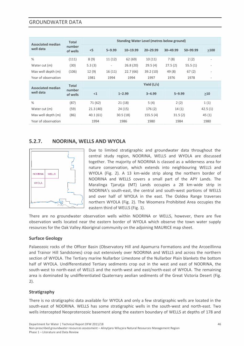
GROUNDWATER DATA
Department for Water | Technical Report DFW 2011/18 46 Non-prescribed groundwater resources assessment – Alinytjara Wilurara Natural Resources Management Region Phase 1 – Literature and Data Review
Associated median well data
Total number of wells
Standing Water Level (metres below ground)
<5 5–9.99 10–19.99 20–29.99 30–49.99 50–99.99 >100
% (111) 8 (9) 11 (12) 62 (69) 10 (11) 7 (8) 2 (2) -
Water cut (m) (30) 5.3 (3) - 26.8 (20) 29.5 (4) 27.5 (2) 55.5 (1) -
Max well depth (m) (106) 12 (9) 16 (11) 22.7 (66) 39.2 (10) 49 (8) 67 (2) -
Year of observation 1981 1994 1994 1997 1976 1978 -
Associated median well data
Total number of wells
Yield (L/s)
<1 1–2.99 3–4.99 5–9.99 >10
% (87) 71 (62) 21 (18) 5 (4) 2 (2) 1 (1)
Water cut (m) (59) 21.3 (40) 24 (15) 176 (2) 14 (1) 42.5 (1)
Max well depth (m) (86) 40.1 (61) 30.5 (18) 155.5 (4) 31.5 (2) 45 (1)
Year of observation 1994 1986 1980 1984 1980
5.2.7. NOORINA, WELLS AND WYOLA
Due to limited stratigraphic and groundwater data throughout the
central study region, NOORINA, WELLS and WYOLA are discussed
together. The majority of NOORINA is classed as a wilderness area for
nature conservation, which extends into neighbouring WELLS and
WYOLA (Fig. 2). A 13 km-wide strip along the northern border of
NOORINA and WELLS covers a small part of the APY Lands. The
Maralinga Tjarutja (MT) Lands occupies a 28 km-wide strip in
NOORINA’s south-east, the central and south-west portions of WELLS
and over half of WYOLA in the east. The Ooldea Range traverses
northern WYOLA (Fig. 2). The Woomera Prohibited Area occupies the
eastern third of WELLS (Fig. 1).
There are no groundwater observation wells within NOORINA or WELLS, however, there are five
observation wells located near the eastern border of WYOLA which observe the town water supply
resources for the Oak Valley Aboriginal community on the adjoining MAURICE map sheet.
Surface Geology
Palaeozoic rocks of the Officer Basin (Observatory Hill and Apamurra Formations and the Arcoeillinna
and Trainor Hill Sandstones) crop out extensively over NOORINA and WELLS and across the northern
section of WYOLA. The Tertiary marine Nullarbor Limestone of the Nullarbor Plain blankets the bottom
half of WYOLA. Undifferentiated Tertiary sediments crop out in the west and east of NOORINA, the
south-west to north-east of WELLS and the north-west and east/north-east of WYOLA. The remaining
area is dominated by undifferentiated Quaternary aeolian sediments of the Great Victoria Desert (Fig.
2).
Stratigraphy
There is no stratigraphic data available for WYOLA and only a few stratigraphic wells are located in the
south-east of NOORINA. WELLS has some stratigraphic wells in the south-west and north-east. Two
wells intercepted Neoproterozoic basement along the eastern boundary of WELLS at depths of 178 and
GROUNDWATER DATA
Department for Water | Technical Report DFW 2011/18 47 Non-prescribed groundwater resources assessment – Alinytjara Wilurara Natural Resources Management Region Phase 1 – Literature and Data Review
898 m. Across NOORINA and WELLS, the maximum depth to Palaeozoic rocks is 39 m with a median
depth to top of six metres. Palaeovalley sediments underlie large regions of all three map sheets. The
Noorina Palaeovalley occupies the north-east quadrant of NOORINA and the Serpentine Lakes
Palaeovalley meanders down the western side of NOORINA and WYOLA. The western extent of the large
Oak Valley Palaeovalley occupies the north-east corner of WYOLA and south of NOORINA. The Lindsay
Palaeovalley covers much of the north of WELLS and joins into the Meramangye Palaeovalley, which
occurs across most of the eastern half of WELLS. However, due to limited drilling, only thin, shallow
Tertiary sediments of the Garford and Mangatitja Formations have been intercepted (1–4 m, median
thickness of six metres). Quaternary sediments have a median thickness of just one metre.
Groundwater Data
Groundwater data is extremely scarce for all three map sheets (Table 12). Data are available for the
south-east of NOORINA, the north-east of WYOLA and southern half of WELLS (Figs. 8, 9 & 10). Salinities
are generally brackish but highly variable (330–98 000 mg/L; median 7400 mg/L) and yields are generally
very low (0.02–3.8 L/s; median 0.3 L/s). Good quality groundwater (330–740 mg/L) was recorded in
2001, 25–30 km west of Oak Valley which is currently used for the community water supply despite
extremely poor yields (0.02–0.09 L/s). More recent salinity records are not available. Drilling reports
from Read (1988) indicate these wells are screened within the Observatory Hill Formation. Evidence of a
weak correlation between increasing yield and increasing water cut depth was found. Water cuts are
generally deeper than standing water levels (WC 12–75 m, median 28 m; SWL 1.8–46 m, median 20 m).
Production zone details are available for just one well which is located in the south of WELLS within the
Meramangye Palaeovalley. Screened within the Garford Formation, the salinity is 9090 mg/L (measured
in 1993), SWL is 24 m, WC 26 m and yield 3 L/s.
Table 12. Summary of salinity, standing water level and yield data and the associated median values (with
number of data points in brackets) for NOORINA, WELLS and WYOLA
Associated median well data
Total number of wells
Salinity (mg/L)
<1000 1000–1499
1500–2999
3000–4999
5000–9999
10 000–19 999
>20 000
% (23) 17 (4) - - 13 (3) 31 (7) 17 (4) 22 (5)
SWL (m) (13) 15.5 (4) - - 16.3 (3) 25.9 (3) - 30.1 (3)
Water cut (m) (19) 20.5 (4) - - 20 (2) 26 (5) 49.5 (4) 33.3 (4)
Yield (L/s) (19) 0.05 (4) - - 1 (3) 2 (5) 1.25 (3) 0.34 (4)
Max well depth (m) (23) 31.5( 4) - - 35( 3) 60( 7) 54.5( 4) 115.4( 5)
Year of observation 2001 - - 1997 1993 1987 1993
Associated median well data
Total number of wells
Standing Water Level (metres below ground)
<5 5–9.99 10–19.99 20–29.99 30–49.99 50–99.99 >100
% (14) - 1 (7) 5 (35) 4 (29) 4 (29) - -
Water cut (m) (9) - 12 (1) 21 (5) 32 (2) 28 (1) - -
Max well depth (m) (14) - 15 (1) 32 (5) 88.5 (4) 121.3 (4) - -
Year of observation - 2009 2009 1993 1993 - -
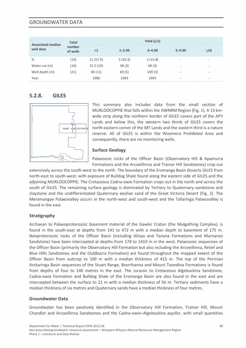
GROUNDWATER DATA
Department for Water | Technical Report DFW 2011/18 48 Non-prescribed groundwater resources assessment – Alinytjara Wilurara Natural Resources Management Region Phase 1 – Literature and Data Review
Associated median well data
Total number of wells
Yield (L/s)
<1 1–2.99 3–4.99 5–9.99 >10
% (19) 11 (57.9) 5 (26.3) 3 (15.8) - -
Water cut (m) (16) 22.5 (10) 38 (3) 68 (3) - -
Well depth (m) (21) 40 (11) 69 (5) 109 (3) - -
Year 1986 1993 1993 - -
5.2.8. GILES
This summary also includes data from the small section of
MURLOOCOPPIE that falls within the AWNRM Region (Fig. 1). A 13 km-
wide strip along the northern border of GILES covers part of the APY
Lands and below this, the western two thirds of GILES covers the
north-eastern corner of the MT Lands and the eastern third is a nature
reserve. All of GILES is within the Woomera Prohibited Area and
consequently, there are no monitoring wells.
Surface Geology
Palaeozoic rocks of the Officer Basin (Observatory Hill & Apamurra
Formations and the Arcoeillinna and Trainor Hill Sandstones) crop out
extensively across the south-west to the north. The boundary of the Eromanga Basin dissects GILES from
north-east to south-west; with exposure of Bulldog Shale found along the eastern side of GILES and the
adjoining MURLOOCOPPIE. The Cretaceous Cadna-owie Formation crops out in the north and across the
south of GILES. The remaining surface geology is dominated by Tertiary to Quaternary sandstone and
claystone and the undifferentiated Quaternary aeolian sand of the Great Victoria Desert (Fig. 2). The
Meramangye Palaeovalley occurs in the north-west and south-west and the Tallaringa Palaeovalley is
found in the east.
Stratigraphy
Archaean to Palaeoproterozoic basement material of the Gawler Craton (the Mulgathing Complex), is
found in the south-east at depths from 141 to 472 m with a median depth to basement of 175 m.
Neoproterozoic rocks of the Officer Basin (including Alinya and Tanana Formations and Murnaroo
Sandstone) have been intercepted at depths from 178 to 1410 m in the west. Palaeozoic sequences of
the Officer Basin (primarily the Observatory Hill Formation but also including the Arcoeillinna, Relief and
Blue Hills Sandstones and the Ouldburra Formation) are found throughout the mapped extent of the
Officer Basin from outcrop to 100 m with a median thickness of 413 m. The top of the Permian
Arckaringa Basin sequences of the Stuart Range, Boorthanna and Mount Toondina Formations is found
from depths of four to 140 metres in the east. The Jurassic to Cretaceous Algebuckina Sandstone,
Cadna-owie Formation and Bulldog Shale of the Eromanga Basin are also found in the east and are
intercepted between the surface to 21 m with a median thickness of 56 m. Tertiary sediments have a
median thickness of six metres and Quaternary sands have a median thickness of four metres.
Groundwater Data
Groundwater has been positively identified in the Observatory Hill Formation, Trainor Hill, Mount
Chandler and Arcoeillinna Sandstones and the Cadna-owie–Algebuckina aquifer, with small quantities
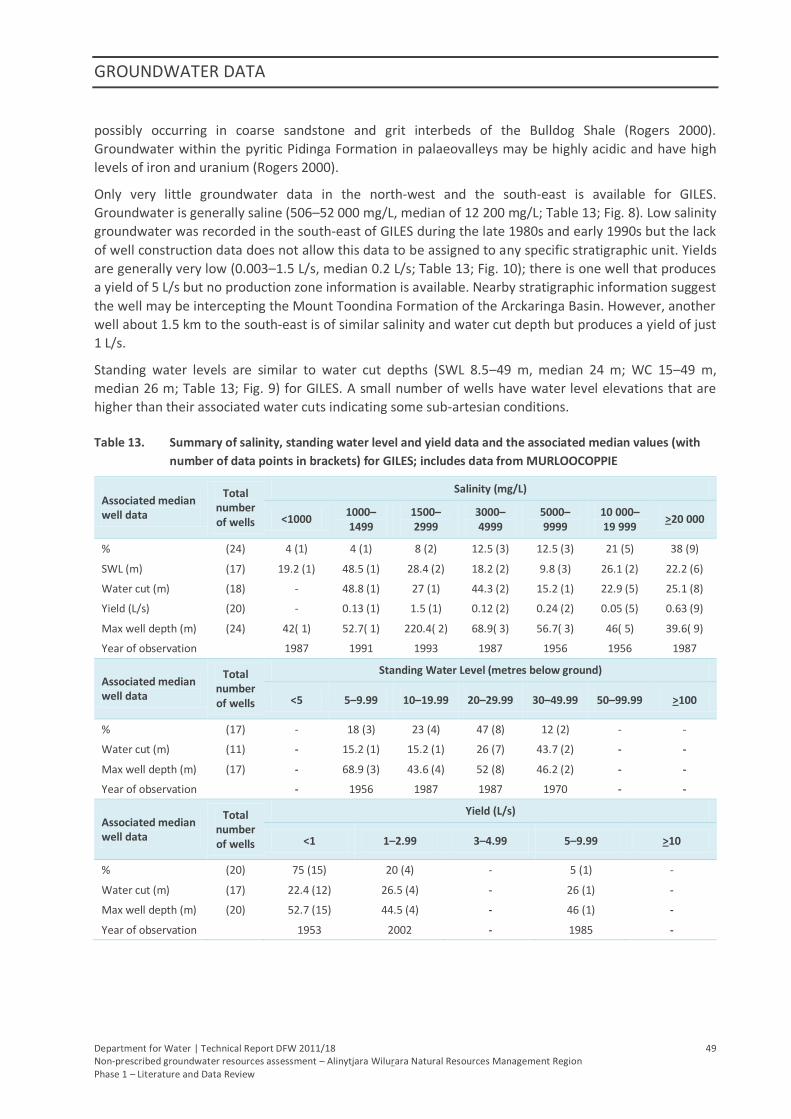
GROUNDWATER DATA
Department for Water | Technical Report DFW 2011/18 49 Non-prescribed groundwater resources assessment – Alinytjara Wilurara Natural Resources Management Region Phase 1 – Literature and Data Review
possibly occurring in coarse sandstone and grit interbeds of the Bulldog Shale (Rogers 2000).
Groundwater within the pyritic Pidinga Formation in palaeovalleys may be highly acidic and have high
levels of iron and uranium (Rogers 2000).
Only very little groundwater data in the north-west and the south-east is available for GILES.
Groundwater is generally saline (506–52 000 mg/L, median of 12 200 mg/L; Table 13; Fig. 8). Low salinity
groundwater was recorded in the south-east of GILES during the late 1980s and early 1990s but the lack
of well construction data does not allow this data to be assigned to any specific stratigraphic unit. Yields
are generally very low (0.003–1.5 L/s, median 0.2 L/s; Table 13; Fig. 10); there is one well that produces
a yield of 5 L/s but no production zone information is available. Nearby stratigraphic information suggest
the well may be intercepting the Mount Toondina Formation of the Arckaringa Basin. However, another
well about 1.5 km to the south-east is of similar salinity and water cut depth but produces a yield of just
1 L/s.
Standing water levels are similar to water cut depths (SWL 8.5–49 m, median 24 m; WC 15–49 m,
median 26 m; Table 13; Fig. 9) for GILES. A small number of wells have water level elevations that are
higher than their associated water cuts indicating some sub-artesian conditions.
Table 13. Summary of salinity, standing water level and yield data and the associated median values (with
number of data points in brackets) for GILES; includes data from MURLOOCOPPIE
Associated median well data
Total number of wells
Salinity (mg/L)
<1000 1000–1499
1500–2999
3000–4999
5000–9999
10 000–19 999
>20 000
% (24) 4 (1) 4 (1) 8 (2) 12.5 (3) 12.5 (3) 21 (5) 38 (9)
SWL (m) (17) 19.2 (1) 48.5 (1) 28.4 (2) 18.2 (2) 9.8 (3) 26.1 (2) 22.2 (6)
Water cut (m) (18) - 48.8 (1) 27 (1) 44.3 (2) 15.2 (1) 22.9 (5) 25.1 (8)
Yield (L/s) (20) - 0.13 (1) 1.5 (1) 0.12 (2) 0.24 (2) 0.05 (5) 0.63 (9)
Max well depth (m) (24) 42( 1) 52.7( 1) 220.4( 2) 68.9( 3) 56.7( 3) 46( 5) 39.6( 9)
Year of observation 1987 1991 1993 1987 1956 1956 1987
Associated median well data
Total number of wells
Standing Water Level (metres below ground)
<5 5–9.99 10–19.99 20–29.99 30–49.99 50–99.99 >100
% (17) - 18 (3) 23 (4) 47 (8) 12 (2) - -
Water cut (m) (11) - 15.2 (1) 15.2 (1) 26 (7) 43.7 (2) - -
Max well depth (m) (17) - 68.9 (3) 43.6 (4) 52 (8) 46.2 (2) - -
Year of observation - 1956 1987 1987 1970 - -
Associated median well data
Total number of wells
Yield (L/s)
<1 1–2.99 3–4.99 5–9.99 >10
% (20) 75 (15) 20 (4) - 5 (1) -
Water cut (m) (17) 22.4 (12) 26.5 (4) - 26 (1) -
Max well depth (m) (20) 52.7 (15) 44.5 (4) - 46 (1) -
Year of observation 1953 2002 - 1985 -
GROUNDWATER DATA
Department for Water | Technical Report DFW 2011/18 50 Non-prescribed groundwater resources assessment – Alinytjara Wilurara Natural Resources Management Region Phase 1 – Literature and Data Review
5.2.9. MAURICE
Apart from a small area in the south-east corner which is used for
defence facilities, MAURICE covers part of the MT Lands. The eastern
third of MAURICE also includes the Woomera Prohibited Area. Two salt
lakes, Lake Dey-Dey and Lake Maurice, are located slightly to the north-
west, with the Oak Valley Aboriginal community to the west of these
features (Fig. 1). The Ooldea Range runs across the south-west corner
of MAURICE and marks the transition between the Officer and Eucla
Basins, separating the Nullarbor Plain from the Great Victoria Desert
(Fig. 2). There are no observation wells on MAURICE and a paucity of
wells with stratigraphic and groundwater quality data. Available well
data are concentrated to the north and south of Oak Valley in the west
and were drilled in the hope of finding potable quality water to supply the community. There is also a
group of wells within the Woomera Prohibited Area; some were drilled in the mid-1950s at the
commencement of nuclear testing, with a number of wells drilled during the subsequent clean up in the
late-1980s.
Surface Geology
Cambrian outcrop (Observatory Hill and Apamurra Formations and the Arcoeillinna and Trainor Hill
Sandstones) is found in the north/north-east part of MAURICE. Tertiary outcrop of predominantly
lacustrine dolomite, clay, sand and silt covers most of MAURICE but is absent in the south-west and
north-east, with a thick strip of fluvial marine sand also found in the south-west. Undifferentiated
Quaternary aeolian sediments of the Great Victoria Desert are found elsewhere (Fig. 2).
Stratigraphy
An assessment of the Lake Maurice area for the Oak Valley community water supplies (Dodds 1997)
found a Neoproterozoic Officer Basin sequence, the Murnaroo Formation, at a depth of 475 m twelve
kilometres north of Oak Valley and at a depth of 117 m 70 km east–south-east of the community (Dodds
1997). The overlying Observatory Hill Formation is the youngest sequence of the Officer Basin in the
area and varies from a few metres below the surface to more than 60 m. Overlying the Officer Basin
units are mostly Tertiary sediments with a thin veneer of Quaternary sands. Tertiary units include the
Ooldea Sand comprising the Ooldea Range and the palaeovalley deposits of the Pidinga Formation and
Hampton Sandstone (Dodds 1997).
Groundwater Data
Officer Basin sediments are shallowest (<30 m) to the west of Oak Valley, deepening eastwards and
south-eastwards to at least 50 m at the community, to more than one hundred metres 20 km to the
south (Dodds 1997). The deeper sediments are believed to be within a palaeovalley as the groundwater
is saline (>30 000 mg/L), acidic (pH <4) and high in iron and uranium (Dodds 1997). Other palaeovalleys
in the area may contain more suitable groundwater, although it is expected that any water in the
Pidinga Formation will have similar characteristics due to its pyritic nature (Dodds 1997). Highly saline
groundwater (25 000–150 000 mg/L) within palaeovalley deposits of the Pidinga Formation in the Oak
Valley area display these same properties with yields of less than one litre per second.
Two wells with low salinity (1385 and 2789 mg/L) are found in the south-east corner of MAURICE in the
Maralinga Prohibited Area at a depth of around 26 m with very low yields (0.1 L/s), but stratigraphic
information is not available. Saline water (27 000–36 000 mg/L) has also been found in the same area
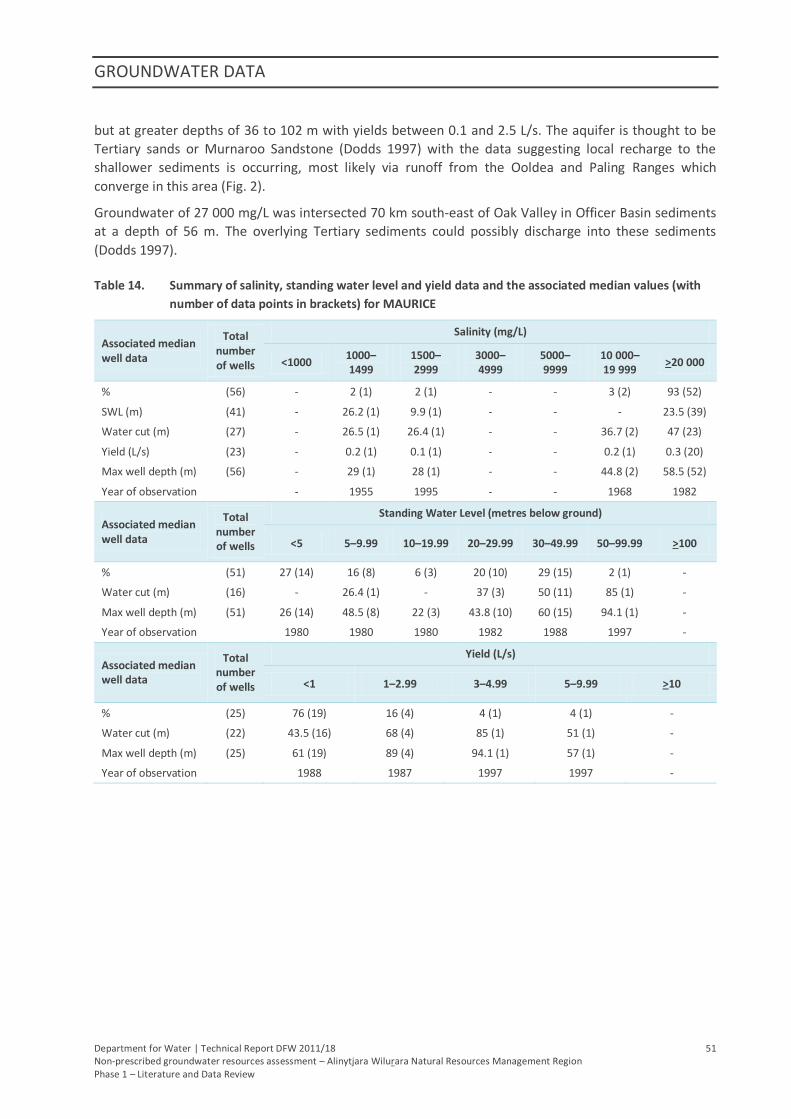
GROUNDWATER DATA
Department for Water | Technical Report DFW 2011/18 51 Non-prescribed groundwater resources assessment – Alinytjara Wilurara Natural Resources Management Region Phase 1 – Literature and Data Review
but at greater depths of 36 to 102 m with yields between 0.1 and 2.5 L/s. The aquifer is thought to be
Tertiary sands or Murnaroo Sandstone (Dodds 1997) with the data suggesting local recharge to the
shallower sediments is occurring, most likely via runoff from the Ooldea and Paling Ranges which
converge in this area (Fig. 2).
Groundwater of 27 000 mg/L was intersected 70 km south-east of Oak Valley in Officer Basin sediments
at a depth of 56 m. The overlying Tertiary sediments could possibly discharge into these sediments
(Dodds 1997).
Table 14. Summary of salinity, standing water level and yield data and the associated median values (with
number of data points in brackets) for MAURICE
Associated median well data
Total number of wells
Salinity (mg/L)
<1000 1000–1499
1500–2999
3000–4999
5000–9999
10 000–19 999
>20 000
% (56) - 2 (1) 2 (1) - - 3 (2) 93 (52)
SWL (m) (41) - 26.2 (1) 9.9 (1) - - - 23.5 (39)
Water cut (m) (27) - 26.5 (1) 26.4 (1) - - 36.7 (2) 47 (23)
Yield (L/s) (23) - 0.2 (1) 0.1 (1) - - 0.2 (1) 0.3 (20)
Max well depth (m) (56) - 29 (1) 28 (1) - - 44.8 (2) 58.5 (52)
Year of observation - 1955 1995 - - 1968 1982
Associated median well data
Total number of wells
Standing Water Level (metres below ground)
<5 5–9.99 10–19.99 20–29.99 30–49.99 50–99.99 >100
% (51) 27 (14) 16 (8) 6 (3) 20 (10) 29 (15) 2 (1) -
Water cut (m) (16) - 26.4 (1) - 37 (3) 50 (11) 85 (1) -
Max well depth (m) (51) 26 (14) 48.5 (8) 22 (3) 43.8 (10) 60 (15) 94.1 (1) -
Year of observation 1980 1980 1980 1982 1988 1997 -
Associated median well data
Total number of wells
Yield (L/s)
<1 1–2.99 3–4.99 5–9.99 >10
% (25) 76 (19) 16 (4) 4 (1) 4 (1) -
Water cut (m) (22) 43.5 (16) 68 (4) 85 (1) 51 (1) -
Max well depth (m) (25) 61 (19) 89 (4) 94.1 (1) 57 (1) -
Year of observation 1988 1987 1997 1997 -
GROUNDWATER DATA
Department for Water | Technical Report DFW 2011/18 52 Non-prescribed groundwater resources assessment – Alinytjara Wilurara Natural Resources Management Region Phase 1 – Literature and Data Review
5.2.10. TALLARINGA
This summary includes data from the small section of COOBER PEDY
that falls within the AWNRM Region. TALLARINGA is within the
Woomera Prohibited Area; the MT Lands incorporates the western
two-thirds of TALLARINGA and the eastern third encompasses the
south-western corner of the Tallaringa Conservation Park (Fig. 3). The
northern extent of the Barton Range is found to the south-west and
trends south-east towards the railway siding of Barton (Fig. 2). The
Wilkinson Lakes are found in the centre of TALLARINGA (Fig. 3). The
Mobella station located in the south-east, outside the AWNRM
Region, is the only settlement within TALLARINGA and there are no
observation wells.
Draining from the north, the Tallaringa Palaeovalley crosses the north-east of TALLARINGA. The Garford
and Anthony palaeovalleys, which originate from the Gawler Craton outside the eastern extent of the
AWNRM Region, converge with the Tallaringa Palaeovalley at its southern extent and feed into the large
palaeodrainage system that dominates the southern half of TALLARINGA and includes the smaller
palaeovalleys of Wilkinson and Wuldra (Fig. 7). The boundary of the Eromanga Basin encroaches on the
east and north of TALLARINGA and the south-western limb of the deeper Arckaringa Basin extends over
much of TALLARINGA.
Surface Geology
Archaean to Proterozoic basement of predominantly Mulgathing Complex is found in very small
outcrops in the south-east of TALLARINGA. Palaeozoic rocks are found in the centre of TALLARINGA and
in small outcrops in the north-west. Small outcrops of Jurassic–Cretaceous sequences are found in the
centre and the east. Tertiary sediments are found extensively in the centre and northern half of
TALLARINGA. The undifferentiated Quaternary aeolian sediments of the Great Victoria Desert dominate
TALLARINGA, especially the south-west (Fig. 2). Quaternary calcrete is found from the north-west
through to the south-east and the red sand is present over much of the northern half of TALLARINGA.
Stratigraphy
Stratigraphic information is available for much of TALLARINGA although the north and west have little
data. Basement material of the Gawler Craton is primarily the Archaean to Palaeoproterozoic
Mulgathing Complex. The depth to basement varies from outcrop to 463 m with a median of 38 m. The
depth to Neoproterozoic to Cambrian rocks of the Officer Basin, primarily the Observatory Hill
Formation, is between four and 210 metres with a median thickness of 104 m. The Permian sequences
of the Arckaringa Basin (the Boorthanna, Mount Toondina and Stuart Range Formations) begin at depths
from up to 141 m with a median thickness of 60 m. The top of the Jurassic to Cretaceous Algebuckina
Sandstone, Cadna-owie Formation and Bulldog Shale of the Eromanga Basin are recorded from one to
26 metres with a median thickness of 36 m. Tertiary sequences include the Pidinga, Garford and
Munjena Formations and are found from the surface to 38 m with a median thickness of 19 m.
Quaternary sediments have a median thickness of seven metres.
Groundwater Data
Wells with groundwater quality data are limited (Table 15) and are absent from much of TALLARINGA
(Figs. 8, 9 & 10). Groundwater in the south is generally high with brackish to highly saline water (3000–
114 750 mg/L; median 25 475 mg/L). Lower salinity water (428–7300 mg/L; median 2900 mg/L) is found
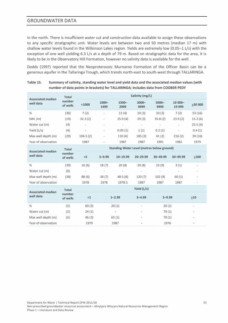
GROUNDWATER DATA
Department for Water | Technical Report DFW 2011/18 53 Non-prescribed groundwater resources assessment – Alinytjara Wilurara Natural Resources Management Region Phase 1 – Literature and Data Review
in the north. There is insufficient water cut and construction data available to assign these observations
to any specific stratigraphic unit. Water levels are between two and 50 metres (median 17 m) with
shallow water levels found in the Wilkinson Lakes region. Yields are extremely low (0.05–1 L/s) with the
exception of one well yielding 6.3 L/s at a depth of 79 m. Based on stratigraphic data for the area, it is
likely to be in the Observatory Hill Formation, however no salinity data is available for the well.
Dodds (1997) reported that the Neoproterozoic Murnaroo Formation of the Officer Basin can be a
generous aquifer in the Tallaringa Trough, which trends north-east to south-west through TALLARINGA.
Table 15. Summary of salinity, standing water level and yield data and the associated median values (with
number of data points in brackets) for TALLARINGA; includes data from COOBER PEDY
Associated median well data
Total number of wells
Salinity (mg/L)
<1000 1000–1499
1500–2999
3000–4999
5000–9999
10 000–19 999
>20 000
% (30) 7 (2) - 13 (4) 10 (3) 10 (3) 7 (2) 53 (16)
SWL (m) (19) 32.3 (2) - 25.9 (4) 29 (3) 35.8 (2) 23.9 (2) 15.2 (6)
Water cut (m) (4) - - - - - - 23.5 (4)
Yield (L/s) (4) - - 0.05 (1) 1 (1) 0.2 (1) - 0.4 (1)
Max well depth (m) (29) 104.5 (2) - 110 (4) 185 (3) 41 (2) 216 (2) 39 (16)
Year of observation 1987 - 1987 1987 1991 1982 1979
Associated median well data
Total number of wells
Standing Water Level (metres below ground)
<5 5–9.99 10–19.99 20–29.99 30–49.99 50–99.99 >100
% (39) 16 (6) 18 (7) 20 (8) 20 (8) 23 (9) 3 (1) -
Water cut (m) (0) - - - - - - -
Max well depth (m) (38) 88 (6) 38 (7) 48.5 (8) 120 (7) 102 (9) 60 (1) -
Year of observation 1978 1978 1978.5 1987 1987 1987 -
Associated median well data
Total number of wells
Yield (L/s)
<1 1–2.99 3–4.99 5–9.99 >10
% (5) 60 (3) 20 (1) - 20 (1) -
Water cut (m) (2) 24 (1) - - 79 (1) -
Max well depth (m) (5) 46 (3) 65 (1) - 79 (1) -
Year of observation 1979 1987 - 1976 -
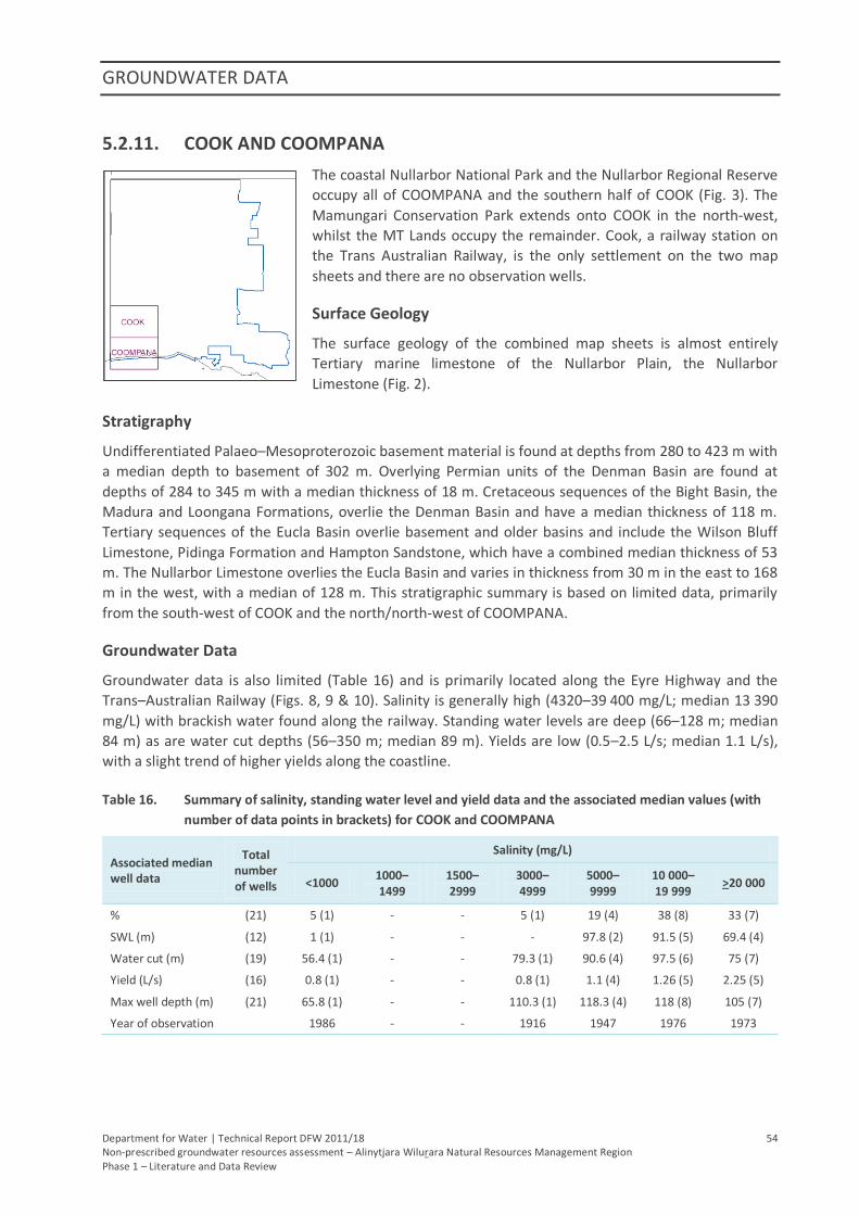
GROUNDWATER DATA
Department for Water | Technical Report DFW 2011/18 54 Non-prescribed groundwater resources assessment – Alinytjara Wilurara Natural Resources Management Region Phase 1 – Literature and Data Review
5.2.11. COOK AND COOMPANA
The coastal Nullarbor National Park and the Nullarbor Regional Reserve
occupy all of COOMPANA and the southern half of COOK (Fig. 3). The
Mamungari Conservation Park extends onto COOK in the north-west,
whilst the MT Lands occupy the remainder. Cook, a railway station on
the Trans Australian Railway, is the only settlement on the two map
sheets and there are no observation wells.
Surface Geology
The surface geology of the combined map sheets is almost entirely
Tertiary marine limestone of the Nullarbor Plain, the Nullarbor
Limestone (Fig. 2).
Stratigraphy
Undifferentiated Palaeo–Mesoproterozoic basement material is found at depths from 280 to 423 m with
a median depth to basement of 302 m. Overlying Permian units of the Denman Basin are found at
depths of 284 to 345 m with a median thickness of 18 m. Cretaceous sequences of the Bight Basin, the
Madura and Loongana Formations, overlie the Denman Basin and have a median thickness of 118 m.
Tertiary sequences of the Eucla Basin overlie basement and older basins and include the Wilson Bluff
Limestone, Pidinga Formation and Hampton Sandstone, which have a combined median thickness of 53
m. The Nullarbor Limestone overlies the Eucla Basin and varies in thickness from 30 m in the east to 168
m in the west, with a median of 128 m. This stratigraphic summary is based on limited data, primarily
from the south-west of COOK and the north/north-west of COOMPANA.
Groundwater Data
Groundwater data is also limited (Table 16) and is primarily located along the Eyre Highway and the
Trans–Australian Railway (Figs. 8, 9 & 10). Salinity is generally high (4320–39 400 mg/L; median 13 390
mg/L) with brackish water found along the railway. Standing water levels are deep (66–128 m; median
84 m) as are water cut depths (56–350 m; median 89 m). Yields are low (0.5–2.5 L/s; median 1.1 L/s),
with a slight trend of higher yields along the coastline.
Table 16. Summary of salinity, standing water level and yield data and the associated median values (with
number of data points in brackets) for COOK and COOMPANA
Associated median well data
Total number of wells
Salinity (mg/L)
<1000 1000–1499
1500–2999
3000–4999
5000–9999
10 000–19 999
>20 000
% (21) 5 (1) - - 5 (1) 19 (4) 38 (8) 33 (7)
SWL (m) (12) 1 (1) - - - 97.8 (2) 91.5 (5) 69.4 (4)
Water cut (m) (19) 56.4 (1) - - 79.3 (1) 90.6 (4) 97.5 (6) 75 (7)
Yield (L/s) (16) 0.8 (1) - - 0.8 (1) 1.1 (4) 1.26 (5) 2.25 (5)
Max well depth (m) (21) 65.8 (1) - - 110.3 (1) 118.3 (4) 118 (8) 105 (7)
Year of observation 1986 - - 1916 1947 1976 1973
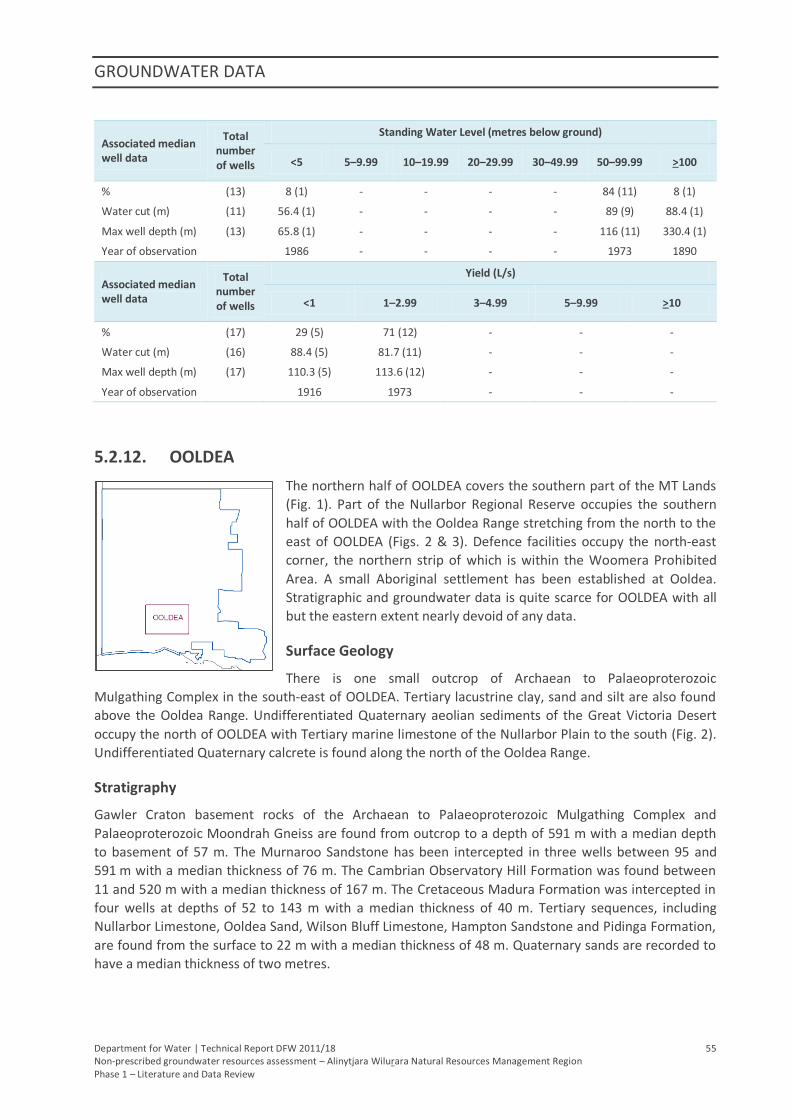
GROUNDWATER DATA
Department for Water | Technical Report DFW 2011/18 55 Non-prescribed groundwater resources assessment – Alinytjara Wilurara Natural Resources Management Region Phase 1 – Literature and Data Review
Associated median well data
Total number of wells
Standing Water Level (metres below ground)
<5 5–9.99 10–19.99 20–29.99 30–49.99 50–99.99 >100
% (13) 8 (1) - - - - 84 (11) 8 (1)
Water cut (m) (11) 56.4 (1) - - - - 89 (9) 88.4 (1)
Max well depth (m) (13) 65.8 (1) - - - - 116 (11) 330.4 (1)
Year of observation 1986 - - - - 1973 1890
Associated median well data
Total number of wells
Yield (L/s)
<1 1–2.99 3–4.99 5–9.99 >10
% (17) 29 (5) 71 (12) - - -
Water cut (m) (16) 88.4 (5) 81.7 (11) - - -
Max well depth (m) (17) 110.3 (5) 113.6 (12) - - -
Year of observation 1916 1973 - - -
5.2.12. OOLDEA
The northern half of OOLDEA covers the southern part of the MT Lands
(Fig. 1). Part of the Nullarbor Regional Reserve occupies the southern
half of OOLDEA with the Ooldea Range stretching from the north to the
east of OOLDEA (Figs. 2 & 3). Defence facilities occupy the north-east
corner, the northern strip of which is within the Woomera Prohibited
Area. A small Aboriginal settlement has been established at Ooldea.
Stratigraphic and groundwater data is quite scarce for OOLDEA with all
but the eastern extent nearly devoid of any data.
Surface Geology
There is one small outcrop of Archaean to Palaeoproterozoic
Mulgathing Complex in the south-east of OOLDEA. Tertiary lacustrine clay, sand and silt are also found
above the Ooldea Range. Undifferentiated Quaternary aeolian sediments of the Great Victoria Desert
occupy the north of OOLDEA with Tertiary marine limestone of the Nullarbor Plain to the south (Fig. 2).
Undifferentiated Quaternary calcrete is found along the north of the Ooldea Range.
Stratigraphy
Gawler Craton basement rocks of the Archaean to Palaeoproterozoic Mulgathing Complex and
Palaeoproterozoic Moondrah Gneiss are found from outcrop to a depth of 591 m with a median depth
to basement of 57 m. The Murnaroo Sandstone has been intercepted in three wells between 95 and
591 m with a median thickness of 76 m. The Cambrian Observatory Hill Formation was found between
11 and 520 m with a median thickness of 167 m. The Cretaceous Madura Formation was intercepted in
four wells at depths of 52 to 143 m with a median thickness of 40 m. Tertiary sequences, including
Nullarbor Limestone, Ooldea Sand, Wilson Bluff Limestone, Hampton Sandstone and Pidinga Formation,
are found from the surface to 22 m with a median thickness of 48 m. Quaternary sands are recorded to
have a median thickness of two metres.
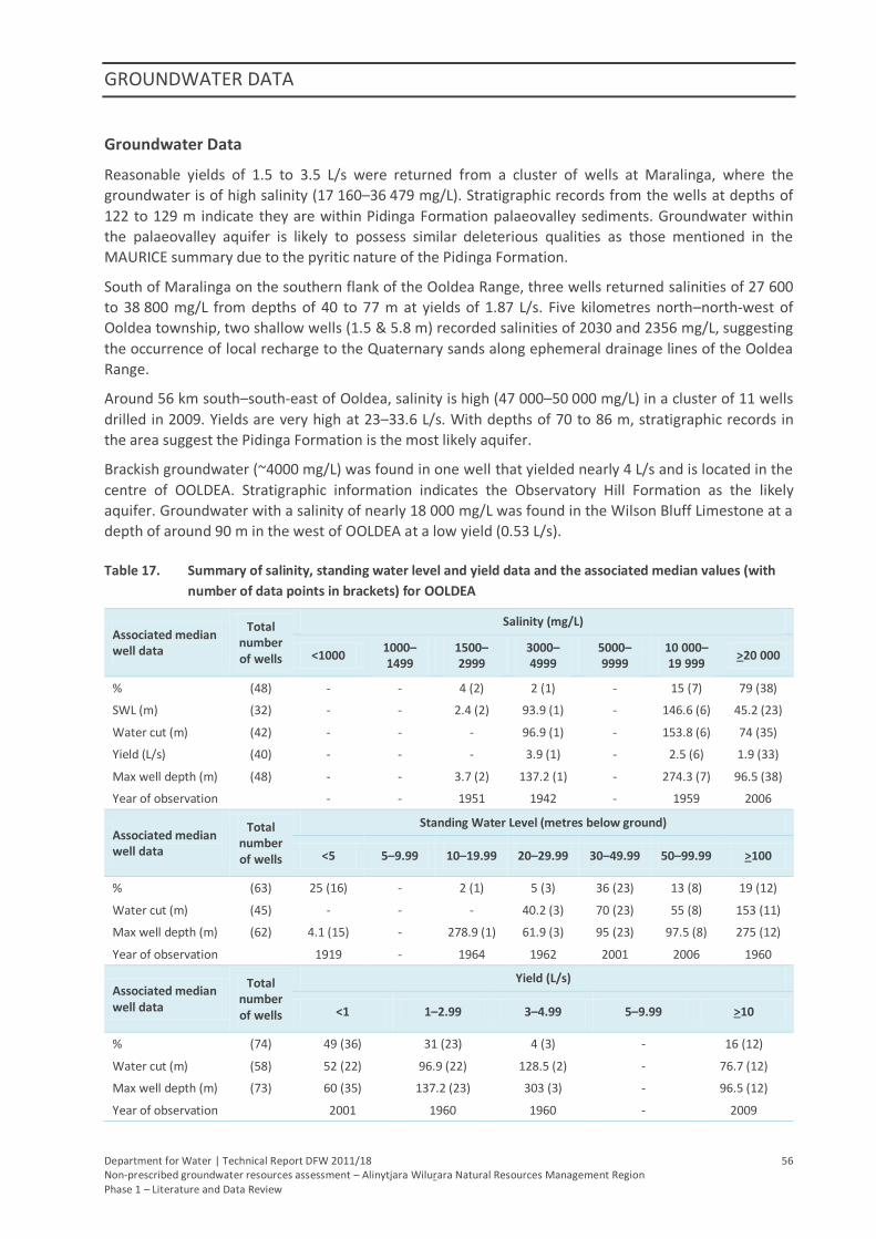
GROUNDWATER DATA
Department for Water | Technical Report DFW 2011/18 56 Non-prescribed groundwater resources assessment – Alinytjara Wilurara Natural Resources Management Region Phase 1 – Literature and Data Review
Groundwater Data
Reasonable yields of 1.5 to 3.5 L/s were returned from a cluster of wells at Maralinga, where the
groundwater is of high salinity (17 160–36 479 mg/L). Stratigraphic records from the wells at depths of
122 to 129 m indicate they are within Pidinga Formation palaeovalley sediments. Groundwater within
the palaeovalley aquifer is likely to possess similar deleterious qualities as those mentioned in the
MAURICE summary due to the pyritic nature of the Pidinga Formation.
South of Maralinga on the southern flank of the Ooldea Range, three wells returned salinities of 27 600
to 38 800 mg/L from depths of 40 to 77 m at yields of 1.87 L/s. Five kilometres north–north-west of
Ooldea township, two shallow wells (1.5 & 5.8 m) recorded salinities of 2030 and 2356 mg/L, suggesting
the occurrence of local recharge to the Quaternary sands along ephemeral drainage lines of the Ooldea
Range.
Around 56 km south–south-east of Ooldea, salinity is high (47 000–50 000 mg/L) in a cluster of 11 wells
drilled in 2009. Yields are very high at 23–33.6 L/s. With depths of 70 to 86 m, stratigraphic records in
the area suggest the Pidinga Formation is the most likely aquifer.
Brackish groundwater (~4000 mg/L) was found in one well that yielded nearly 4 L/s and is located in the
centre of OOLDEA. Stratigraphic information indicates the Observatory Hill Formation as the likely
aquifer. Groundwater with a salinity of nearly 18 000 mg/L was found in the Wilson Bluff Limestone at a
depth of around 90 m in the west of OOLDEA at a low yield (0.53 L/s).
Table 17. Summary of salinity, standing water level and yield data and the associated median values (with
number of data points in brackets) for OOLDEA
Associated median well data
Total number of wells
Salinity (mg/L)
<1000 1000–1499
1500–2999
3000–4999
5000–9999
10 000–19 999
>20 000
% (48) - - 4 (2) 2 (1) - 15 (7) 79 (38)
SWL (m) (32) - - 2.4 (2) 93.9 (1) - 146.6 (6) 45.2 (23)
Water cut (m) (42) - - - 96.9 (1) - 153.8 (6) 74 (35)
Yield (L/s) (40) - - - 3.9 (1) - 2.5 (6) 1.9 (33)
Max well depth (m) (48) - - 3.7 (2) 137.2 (1) - 274.3 (7) 96.5 (38)
Year of observation - - 1951 1942 - 1959 2006
Associated median well data
Total number of wells
Standing Water Level (metres below ground)
<5 5–9.99 10–19.99 20–29.99 30–49.99 50–99.99 >100
% (63) 25 (16) - 2 (1) 5 (3) 36 (23) 13 (8) 19 (12)
Water cut (m) (45) - - - 40.2 (3) 70 (23) 55 (8) 153 (11)
Max well depth (m) (62) 4.1 (15) - 278.9 (1) 61.9 (3) 95 (23) 97.5 (8) 275 (12)
Year of observation 1919 - 1964 1962 2001 2006 1960
Associated median well data
Total number of wells
Yield (L/s)
<1 1–2.99 3–4.99 5–9.99 >10
% (74) 49 (36) 31 (23) 4 (3) - 16 (12)
Water cut (m) (58) 52 (22) 96.9 (22) 128.5 (2) - 76.7 (12)
Max well depth (m) (73) 60 (35) 137.2 (23) 303 (3) - 96.5 (12)
Year of observation 2001 1960 1960 - 2009
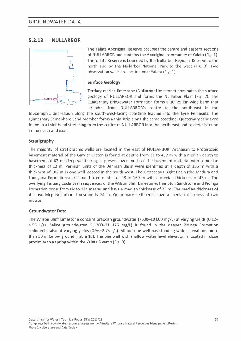
GROUNDWATER DATA
Department for Water | Technical Report DFW 2011/18 57 Non-prescribed groundwater resources assessment – Alinytjara Wilurara Natural Resources Management Region Phase 1 – Literature and Data Review
5.2.13. NULLARBOR
The Yalata Aboriginal Reserve occupies the centre and eastern sections
of NULLARBOR and contains the Aboriginal community of Yalata (Fig. 1).
The Yalata Reserve is bounded by the Nullarbor Regional Reserve to the
north and by the Nullarbor National Park to the west (Fig. 3). Two
observation wells are located near Yalata (Fig. 1).
Surface Geology
Tertiary marine limestone (Nullarbor Limestone) dominates the surface
geology of NULLARBOR and forms the Nullarbor Plain (Fig. 2). The
Quaternary Bridgewater Formation forms a 10–25 km-wide band that
stretches from NULLARBOR’s centre to the south-east in the
topographic depression along the south-west-facing coastline leading into the Eyre Peninsula. The
Quaternary Semaphore Sand Member forms a thin strip along the same coastline. Quaternary sands are
found in a thick band stretching from the centre of NULLARBOR into the north-east and calcrete is found
in the north and east.
Stratigraphy
The majority of stratigraphic wells are located in the east of NULLARBOR. Archaean to Proterozoic
basement material of the Gawler Craton is found at depths from 21 to 437 m with a median depth to
basement of 62 m; deep weathering is present over much of the basement material with a median
thickness of 12 m. Permian units of the Denman Basin were identified at a depth of 335 m with a
thickness of 102 m in one well located in the south-west. The Cretaceous Bight Basin (the Madura and
Loongana Formations) are found from depths of 98 to 169 m with a median thickness of 43 m. The
overlying Tertiary Eucla Basin sequences of the Wilson Bluff Limestone, Hampton Sandstone and Pidinga
Formation occur from six to 134 metres and have a median thickness of 25 m. The median thickness of
the overlying Nullarbor Limestone is 24 m. Quaternary sediments have a median thickness of two
metres.
Groundwater Data
The Wilson Bluff Limestone contains brackish groundwater (7500–10 000 mg/L) at varying yields (0.12–
4.55 L/s). Saline groundwater (11 200–31 175 mg/L) is found in the deeper Pidinga Formation
sediments, also at varying yields (0.56–2.75 L/s). All but one well has standing water elevations more
than 30 m below ground (Table 18). The one well with shallow water level elevation is located in close
proximity to a spring within the Yalata Swamp (Fig. 9).
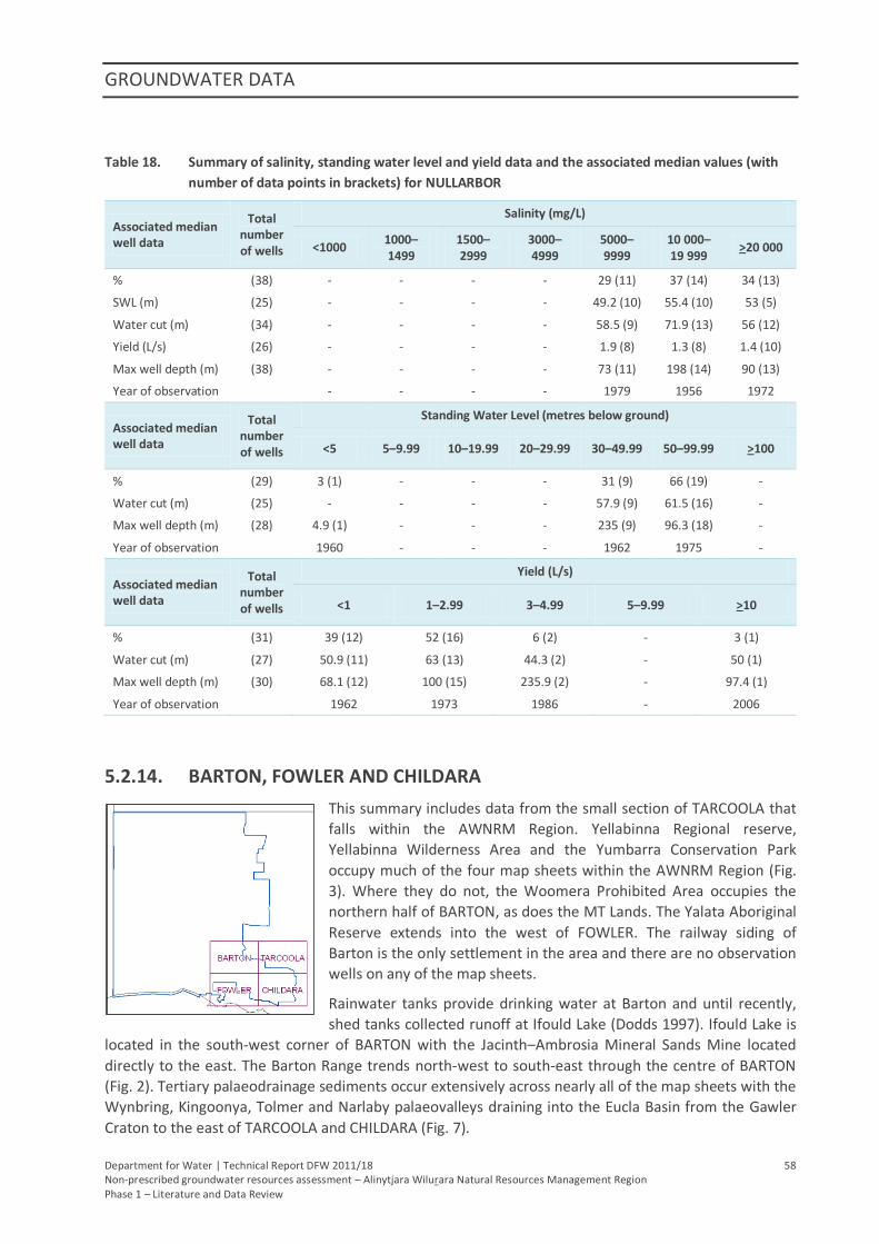
GROUNDWATER DATA
Department for Water | Technical Report DFW 2011/18 58 Non-prescribed groundwater resources assessment – Alinytjara Wilurara Natural Resources Management Region Phase 1 – Literature and Data Review
Table 18. Summary of salinity, standing water level and yield data and the associated median values (with
number of data points in brackets) for NULLARBOR
Associated median well data
Total number of wells
Salinity (mg/L)
<1000 1000–1499
1500–2999
3000–4999
5000–9999
10 000–19 999
>20 000
% (38) - - - - 29 (11) 37 (14) 34 (13)
SWL (m) (25) - - - - 49.2 (10) 55.4 (10) 53 (5)
Water cut (m) (34) - - - - 58.5 (9) 71.9 (13) 56 (12)
Yield (L/s) (26) - - - - 1.9 (8) 1.3 (8) 1.4 (10)
Max well depth (m) (38) - - - - 73 (11) 198 (14) 90 (13)
Year of observation - - - - 1979 1956 1972
Associated median well data
Total number of wells
Standing Water Level (metres below ground)
<5 5–9.99 10–19.99 20–29.99 30–49.99 50–99.99 >100
% (29) 3 (1) - - - 31 (9) 66 (19) -
Water cut (m) (25) - - - - 57.9 (9) 61.5 (16) -
Max well depth (m) (28) 4.9 (1) - - - 235 (9) 96.3 (18) -
Year of observation 1960 - - - 1962 1975 -
Associated median well data
Total number of wells
Yield (L/s)
<1 1–2.99 3–4.99 5–9.99 >10
% (31) 39 (12) 52 (16) 6 (2) - 3 (1)
Water cut (m) (27) 50.9 (11) 63 (13) 44.3 (2) - 50 (1)
Max well depth (m) (30) 68.1 (12) 100 (15) 235.9 (2) - 97.4 (1)
Year of observation 1962 1973 1986 - 2006
5.2.14. BARTON, FOWLER AND CHILDARA
This summary includes data from the small section of TARCOOLA that
falls within the AWNRM Region. Yellabinna Regional reserve,
Yellabinna Wilderness Area and the Yumbarra Conservation Park
occupy much of the four map sheets within the AWNRM Region (Fig.
3). Where they do not, the Woomera Prohibited Area occupies the
northern half of BARTON, as does the MT Lands. The Yalata Aboriginal
Reserve extends into the west of FOWLER. The railway siding of
Barton is the only settlement in the area and there are no observation
wells on any of the map sheets.
Rainwater tanks provide drinking water at Barton and until recently,
shed tanks collected runoff at Ifould Lake (Dodds 1997). Ifould Lake is
located in the south-west corner of BARTON with the Jacinth–Ambrosia Mineral Sands Mine located
directly to the east. The Barton Range trends north-west to south-east through the centre of BARTON
(Fig. 2). Tertiary palaeodrainage sediments occur extensively across nearly all of the map sheets with the
Wynbring, Kingoonya, Tolmer and Narlaby palaeovalleys draining into the Eucla Basin from the Gawler
Craton to the east of TARCOOLA and CHILDARA (Fig. 7).
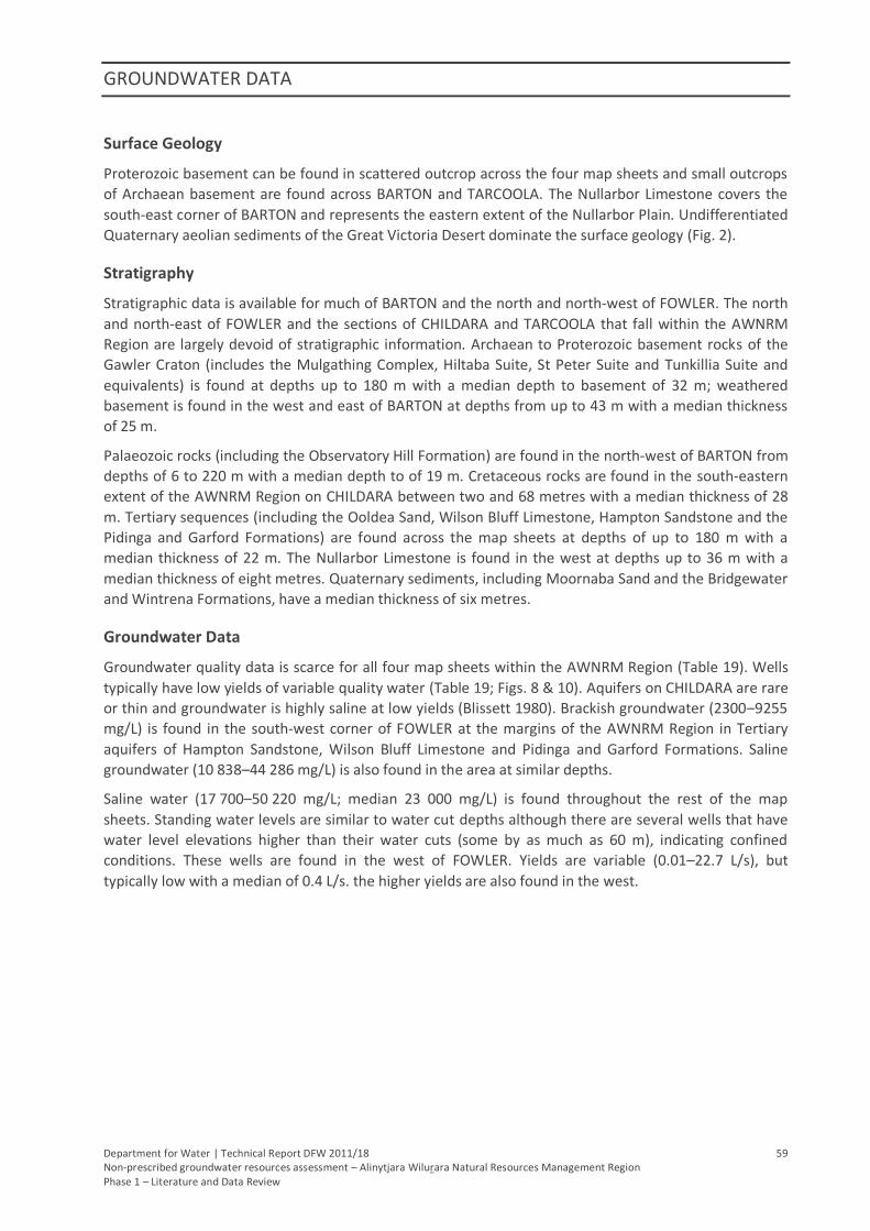
GROUNDWATER DATA
Department for Water | Technical Report DFW 2011/18 59 Non-prescribed groundwater resources assessment – Alinytjara Wilurara Natural Resources Management Region Phase 1 – Literature and Data Review
Surface Geology
Proterozoic basement can be found in scattered outcrop across the four map sheets and small outcrops
of Archaean basement are found across BARTON and TARCOOLA. The Nullarbor Limestone covers the
south-east corner of BARTON and represents the eastern extent of the Nullarbor Plain. Undifferentiated
Quaternary aeolian sediments of the Great Victoria Desert dominate the surface geology (Fig. 2).
Stratigraphy
Stratigraphic data is available for much of BARTON and the north and north-west of FOWLER. The north
and north-east of FOWLER and the sections of CHILDARA and TARCOOLA that fall within the AWNRM
Region are largely devoid of stratigraphic information. Archaean to Proterozoic basement rocks of the
Gawler Craton (includes the Mulgathing Complex, Hiltaba Suite, St Peter Suite and Tunkillia Suite and
equivalents) is found at depths up to 180 m with a median depth to basement of 32 m; weathered
basement is found in the west and east of BARTON at depths from up to 43 m with a median thickness
of 25 m.
Palaeozoic rocks (including the Observatory Hill Formation) are found in the north-west of BARTON from
depths of 6 to 220 m with a median depth to of 19 m. Cretaceous rocks are found in the south-eastern
extent of the AWNRM Region on CHILDARA between two and 68 metres with a median thickness of 28
m. Tertiary sequences (including the Ooldea Sand, Wilson Bluff Limestone, Hampton Sandstone and the
Pidinga and Garford Formations) are found across the map sheets at depths of up to 180 m with a
median thickness of 22 m. The Nullarbor Limestone is found in the west at depths up to 36 m with a
median thickness of eight metres. Quaternary sediments, including Moornaba Sand and the Bridgewater
and Wintrena Formations, have a median thickness of six metres.
Groundwater Data
Groundwater quality data is scarce for all four map sheets within the AWNRM Region (Table 19). Wells
typically have low yields of variable quality water (Table 19; Figs. 8 & 10). Aquifers on CHILDARA are rare
or thin and groundwater is highly saline at low yields (Blissett 1980). Brackish groundwater (2300–9255
mg/L) is found in the south-west corner of FOWLER at the margins of the AWNRM Region in Tertiary
aquifers of Hampton Sandstone, Wilson Bluff Limestone and Pidinga and Garford Formations. Saline
groundwater (10 838–44 286 mg/L) is also found in the area at similar depths.
Saline water (17 700–50 220 mg/L; median 23 000 mg/L) is found throughout the rest of the map
sheets. Standing water levels are similar to water cut depths although there are several wells that have
water level elevations higher than their water cuts (some by as much as 60 m), indicating confined
conditions. These wells are found in the west of FOWLER. Yields are variable (0.01–22.7 L/s), but
typically low with a median of 0.4 L/s. the higher yields are also found in the west.
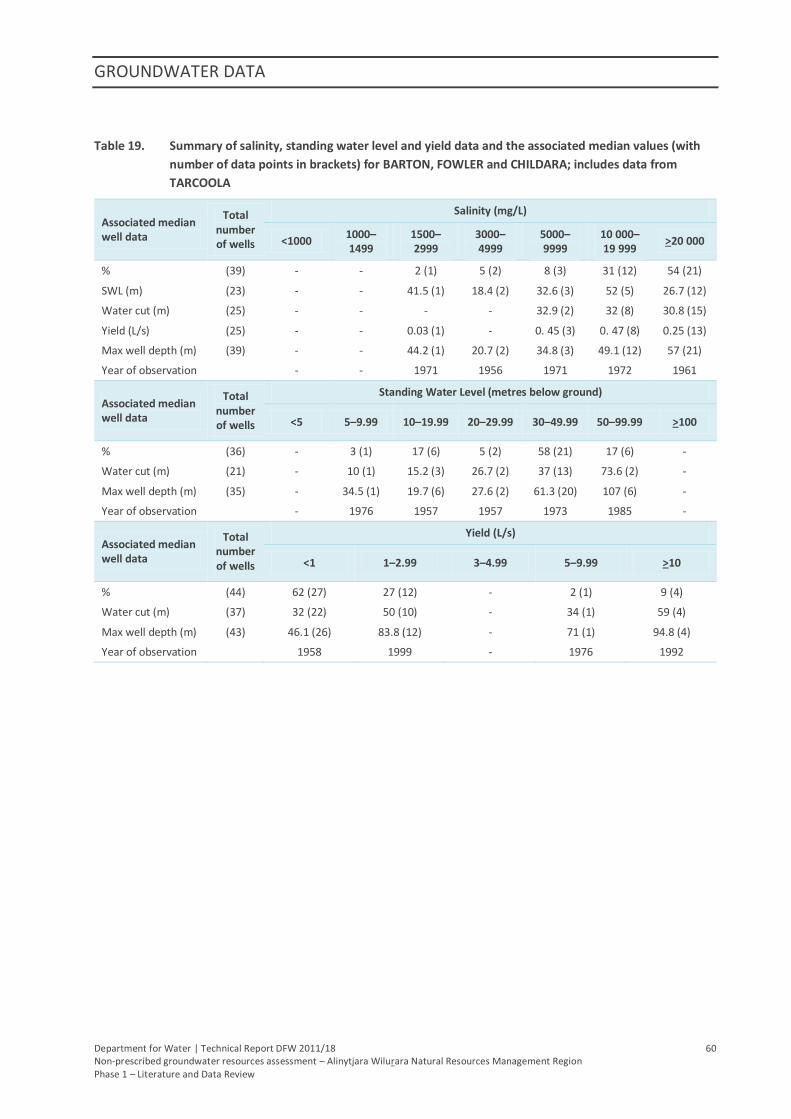
GROUNDWATER DATA
Department for Water | Technical Report DFW 2011/18 60 Non-prescribed groundwater resources assessment – Alinytjara Wilurara Natural Resources Management Region Phase 1 – Literature and Data Review
Table 19. Summary of salinity, standing water level and yield data and the associated median values (with
number of data points in brackets) for BARTON, FOWLER and CHILDARA; includes data from
TARCOOLA
Associated median well data
Total number of wells
Salinity (mg/L)
<1000 1000–1499
1500–2999
3000–4999
5000–9999
10 000–19 999
>20 000
% (39) - - 2 (1) 5 (2) 8 (3) 31 (12) 54 (21)
SWL (m) (23) - - 41.5 (1) 18.4 (2) 32.6 (3) 52 (5) 26.7 (12)
Water cut (m) (25) - - - - 32.9 (2) 32 (8) 30.8 (15)
Yield (L/s) (25) - - 0.03 (1) - 0. 45 (3) 0. 47 (8) 0.25 (13)
Max well depth (m) (39) - - 44.2 (1) 20.7 (2) 34.8 (3) 49.1 (12) 57 (21)
Year of observation - - 1971 1956 1971 1972 1961
Associated median well data
Total number of wells
Standing Water Level (metres below ground)
<5 5–9.99 10–19.99 20–29.99 30–49.99 50–99.99 >100
% (36) - 3 (1) 17 (6) 5 (2) 58 (21) 17 (6) -
Water cut (m) (21) - 10 (1) 15.2 (3) 26.7 (2) 37 (13) 73.6 (2) -
Max well depth (m) (35) - 34.5 (1) 19.7 (6) 27.6 (2) 61.3 (20) 107 (6) -
Year of observation - 1976 1957 1957 1973 1985 -
Associated median well data
Total number of wells
Yield (L/s)
<1 1–2.99 3–4.99 5–9.99 >10
% (44) 62 (27) 27 (12) - 2 (1) 9 (4)
Water cut (m) (37) 32 (22) 50 (10) - 34 (1) 59 (4)
Max well depth (m) (43) 46.1 (26) 83.8 (12) - 71 (1) 94.8 (4)
Year of observation 1958 1999 - 1976 1992
Department for Water | Technical Report DFW 2011/18 61 Non-prescribed groundwater resources assessment – Alinytjara Wilurara Natural Resources Management Region Phase 1 – Literature and Data Review
6. GROUNDWATER RESOURCES
Groundwater resources of the AWNRM Region are found in Quaternary, Tertiary, Mesozoic, Palaeozoic
and Neoproterozoic sediments and weathered and fractured rock aquifers of Precambrian age. The
region’s major stratigraphic units have been summarised in Table 20. Particular attention is paid to
stratigraphic units of hydrogeological significance; more detailed descriptions are presented in Appendix
A.
Groundwater and well data is greatest in the north with reasonable amounts of data also found along
the coast and near Oak Valley and Maralinga. This leaves a great expanse of land in the centre of the
region that is largely devoid of groundwater data making commentary on the resource difficult.
Although the spatial occurrence of potential aquifers can be derived from stratigraphic logs, geological
information for the region is sparse, with a higher density along the eastern boundary of the region.
Where groundwater data does exist, correlation with a specific aquifer formation is often difficult due to
lack of adequate well construction information.
Occurrences of groundwater with salinities less than 3000 mg/L are predominantly found within the
Tomkinson, Mann, Musgrave, Indulkana, Everard and Birksgate Ranges of the Musgrave Block. South of
the Musgrave Block, there is a modicum of low salinity water through the centre of the region towards
the coast. This area is dominated by groundwater with salinity greater than 10 000 mg/L, predominantly
within palaeovalley aquifers.
Regional standing water levels indicate that groundwater can be intersected at shallow depth
throughout much of the region. It can be expected where favourable water resources are encountered
at shallow depth, limited groundwater information and knowledge exists for the deeper aquifer
formations.
Well yields throughout the study region are predominately less then 1 L/s, which would not favour the
needs of high volume users, however data may not be reliable and improved well construction and
aquifer testing could provide higher well yields in target areas.
6.1. GAWLER CRATON
Groundwater of the Gawler Craton occurs within fractured and weathered Precambrian basement
rocks. These groundwater resources are not largely utilised and not well understood. Throughout the
region, exposure of the Gawler Craton is limited to the south east (Fig. 2) and aquifers of the overlying
provinces are typically the preferred target.
Incised palaeovalley sediments of the Pidinga Formation, Ooldea Sand and Garford Formation are likely
to hold significant volumetric groundwater resources, although limited information is available within
the AWNRM Region.
Recharge information for the Gawler Craton within the AWNRM Region is extremely scarce. Where
limited exposures exist, recharge to the fractured basement rock and Tertiary palaeovalley aquifers is
likely to occur via infiltration of rainfall (GHD 2009). However, recharge is assumed to be minimal
because of the highly variable and often infrequent rainfall and high potential evapotranspiration
(Martin, Sereda & Clarke 1998).
Groundwater discharge from the Precambrian basement rocks of the Gawler Craton is poorly
understood but is likely to occur to the surrounding Tertiary palaeovalley aquifers, which in turn
GROUNDWATER RESOURCES
Department for Water | Technical Report DFW 2011/18 62 Non-prescribed groundwater resources assessment – Alinytjara Wilurara Natural Resources Management Region Phase 1 – Literature and Data Review
discharge to the Eucla Basin (Hou et al. 2003). Salt lakes are often sites of evaporative discharge from
the palaeovalley aquifers; however, the palaeovalley aquifers are not always geographically associated
with salt lakes (Martin, Sereda & Clarke 1998).
6.2. MUSGRAVE BLOCK
The crystalline basement rocks of the Birksgate Complex and Olia Gneiss form a regional fractured rock
aquifer with groundwater flow occurring along fractures and faults and within the weathered zone,
which is generally 60–100 m below the surface (GHD 2009). The weathered and fractured rock
basement aquifers are utilised primarily in regions of outcropping and shallow basement; in particular in
and around the Tomkinson, Mann, Musgrave, Indulkana, Everard and Birksgate Ranges. Due to the
relatively higher rainfall in the Musgrave area, these aquifers are recharged more often and can typically
host low salinity groundwater (<1000 mg/L). In some areas these aquifers are heavily relied on by local
communities (Rowe et al. 2006). In deeper fractured rock, groundwater is often highly saline (Rowe et
al. 2006).
The mapped lateral extents of the palaeovalleys incising the Musgrave Block indicate their potential to
contain significant volumes of water; although the groundwater is generally considered to be high in
salinity (Lewis et al. 2010).
Wells drilled into the shallower Quaternary alluvium, sand or calcrete deposits return low yields but can
be suitable for stock watering requirements (Rowe et al. 2006).
Little is known regarding the potential for groundwater supplies in the Musgrave Block. Groundwater
investigations have focussed on providing high quality, low yielding supplies for a small number of
Aboriginal settlements. Many available wells are not solely open to basement rock material, making it
difficult to isolate groundwater properties. With highly spatially variable hydraulic conductivity and yield
and currently no reliable methods for estimating their sustainable or specific yields, very little is known
about how water is stored and transported within these fractured rock aquifers (Rowe et al. 2006).
Closer inspection and additional data validation of construction information may improve the
knowledge of basement aquifers in isolation of overlying sedimentary aquifers; sampling of existing and
new wells will be required to accurately assess the potential of basement aquifers.
Where groundwater resources have been encountered in the overlying sedimentary sequences, little
groundwater information is available for the deeper fractured rock aquifers. The assessment of the
groundwater resource potential of fractured rock aquifers is far more difficult than for sedimentary
formations and this is particularly true for the AWNRM Region where only limited information is
available.
Weathered and fractured basement rock aquifers and Quaternary alluvial deposits of the Musgrave
Block are recharged primarily by rainfall; either directly in areas of outcrop or by surface runoff in
streams (Tewksbury & Dodds 1996). Recharge typically occurs after significant rainfall events rather
than smaller, more frequent rains, rendering annual rainfall figures of limited value in recharge
calculations. Potential evapotranspiration greatly exceeding rainfall in the area further complicates
recharge estimates.
Recharge due to significant rainfall events was reported from community town water supply wells in the
Musgrave Ranges from 1998 to 2002 (Dodds & Sampson 2002). The majority of these wells are screened
in weathered or fractured bedrock aquifers, with some supposedly screened in palaeovalley aquifers.
Wells located at the Iwantja, Amata, Pukatja Yunyarinyi and Pipalyatjara communities showed rises in
water levels after rainfall events, indicative of major recharge. Over the same period, wells at Mimili,
Fregon and Kalka showed no recharge effects, most likely due to insufficient rainfall (Dodds & Sampson
GROUNDWATER RESOURCES
Department for Water | Technical Report DFW 2011/18 63 Non-prescribed groundwater resources assessment – Alinytjara Wilurara Natural Resources Management Region Phase 1 – Literature and Data Review
2002). Of particular interest was the contrast in results for Kalka and Pipalyatjara. Located only six
kilometres apart on either side of a hill in the Tomkinson Ranges, Kalka received less than half the
rainfall that Pipalyatjara did for the six months before May 2002 and showed no signs of recharge. This
highlights the extremely variable nature of rainfall in the area as well as the complexity of recharge in
fractured rock environments.
Within the Musgrave Block, groundwater from the weathered and fractured basement rocks discharges
to the surrounding palaeovalley and Quaternary aquifers and also the sedimentary rocks of the
adjoining Officer Basin via throughflow. Small amounts of groundwater discharge to the surface in the
form of soaks, springs and water holes.
6.3. OFFICER BASIN
Little is known of groundwater in the Officer Basin as the area is generally data poor. Small occurrences
of relatively low salinity groundwater are regarded as fossil water, derived from recharge along the
southern margin of the Musgrave Block (Martin, Sereda & Clarke 1998).
Occurring widely throughout the north-east of the basin, the Trainor Hill Sandstone is recognised as one
of the main aquifers in the region; groundwater is typically saline with low yields (Martin, Sereda &
Clarke 1998). In the Maralinga area, the Marinoan Murnaroo Sandstone is thought to be a noteworthy
groundwater resource, occurring at depths of less than 20 m and the equivalent Tanana Formation has
been confirmed as an aquifer with limited yield; both aquifers are considered to be of moderate salinity
(Dodds 1997). The Punkerri Sandstone occurs over the western portion of the Officer Basin and may be
an aquifer of potential significance, although very little is known about its extent and groundwater
properties (Martin, Sereda & Clarke 1998). Dodds (1997) suggested possible sub-artesian conditions
within the Neoproterozoic sediments may enable the upward transfer of groundwater into fractures of
the overlying Observatory Hill Formation or Tertiary sediments and an eroded zone south of the Ooldea
Range could also facilitate upward leakage into Eucla Basin sediments.
Palaeovalley sediments, primarily the Pidinga Formation, are likely to provide groundwater that is highly
saline and acidic with high levels of iron and radioactive elements (Buxton 2005).
The Ooldea and Barton Ranges, together with the underlying Hampton Sandstone, could potentially
provide additional groundwater supplies as the palaeovalleys draining from the Musgrave Block and
Officer Basin appear to terminate along this margin (Martin, Sereda & Clarke 1998).
Throughflow originating in the ranges of the Musgrave Block and adjacent palaeovalleys is the most
likely source of groundwater recharge to the Officer Basin (Tewkesbury & Dodds 1996). Throughflow
from the Ooldea Range and direct infiltration of rainfall have also been suggested by Tewkesbury and
Dodds (1996), but these recharge mechanisms remain unproven. The throughflow of groundwater from
the Musgrave Block basement rocks is thought to be structurally controlled by faults at the northern
edge of the basin (Alexander & Dodds 1997). Again, the amount of recharge is difficult to estimate but is
believed to be minimal due to low annual rainfall and high evapotranspiration. Studies in arid-zone
groundwater recharge suggest the monthly rainfall must exceed 130 mm for any contribution to
recharge to occur (Jacobson et al. 1994, cited in GHD 2009), with local recharge a rare event, occurring
on average every 4 to 15 years (Alexander & Dodds 1997).
Groundwater within Officer Basin sediments is believed to discharge to the chain of playa lakes north of
the Ooldea Range, of which Lake Dey-Dey and Lake Maurice are the largest (Tewkesbury & Dodds 1996).
Surface discharge in this area is thought to occur due to the presence of the Wirrildar beds, which act as
an aquitard, restricting the transfer of groundwater south into the Eucla Basin (Alexander & Dodds
GROUNDWATER RESOURCES
Department for Water | Technical Report DFW 2011/18 64 Non-prescribed groundwater resources assessment – Alinytjara Wilurara Natural Resources Management Region Phase 1 – Literature and Data Review
1997). An eroded zone south of the Ooldea Range may allow some groundwater from the Officer Basin
to leak upwards into Eucla Basin sediments (Dodds 1997).
There are occasional salt lakes 10–15 km south of the Ooldea Range at an elevation of about 150 m,
which may also indicate discharge into the sand dunes between the range and the Nullarbor Plain
(Dodds 1997).
Some modern groundwater discharge may also occur across the eastern margin of the Officer Basin near
Marla into adjacent Eromanga sediments of the Western Recharge Zone of the GAB (Herczeg & Love
2007).
6.4. ARCKARINGA BASIN
The Permian sediments infilling the Arckaringa Basin comprise two main aquifer systems (GHD 2009).
The upper portion of the Mount Toondina Formation is known to comprise some sandy units and may
act as a permeable aquifer. The Boorthanna Formation forms an aquifer in several zones separated by
significant layers of low permeability sediments, especially in the eastern parts of the AWNRM Region
where thicker and deeper Boorthanna Formation intersections occur. The Stuart Range Formation,
where it occurs, forms an effective aquitard between the two aquifers.
6.5. EROMANGA BASIN
Information about the non-artesian aquifers of the GAB is not well documented and is generally limited
to specific mining projects. Termite Resources’ Cairn Hill Project has recently identified a 0.5 ML/d
supply of brackish groundwater from the Eromanga Basin (Termite Resources 2009, cited in AGT 2010b).
Feasibility studies into mining of the Wintinna and Weedina Permian coal deposits identified significant
GAB aquifers overlying the deeper coal seams. While these present a substantial dewatering challenge
for mining of the coal deposits, they also represent a significant available groundwater resource
(Meekatharra Mineral 1884; Getty Australian Coal Company 1985, cited in AGT 2010b).
In the south-west of the basin, groundwater is too saline for stock, although fresher water can occur
after recharge from rainfall as the system becomes generally semi-confined to un-confined in this area
(SAALNRMB 2009). However, the saturated thickness of the Algebuckina Sandstone is typically less than
ten metres and evapotranspiration can occur from shallow watertables resulting in salinity increases in
poorly flushed sections of the aquifer (SAALNRMB 2009).
The portion of the Eromanga Basin within the AWNRM Region is part of the GAB’s Western Recharge
Zone. Here, periodic rainfall events facilitating recharge involve considerably low volumes of infiltrated
water, reflecting the lower rainfall and climatic variability of this area. Within the AWNRM Region,
recharge is believed to occur along the shared border of GILES and MURLOOCOPPIE via the outcropping
Cadna-owie Formation (Pitt 1978). Ephemeral stream recharge via fractures within the overlying
confining layer of the Bulldog Shale may also provide recharge from surface drainage features such as
creeks and clay pans (Mason 1975).
The majority of discharge within the GAB is via diffuse vertical leakage through the confining layer at the
down flow end of the basin (Herczeg & Love 2007). From the Western Recharge Zone within the
AWNRM Region, this is in a south-easterly and easterly direction. Minor discharge from the basin occurs
via a series of springs to the south-west of Lake Eyre and into adjacent sedimentary basins (Herczeg &
Love 2007). Anthropogenic discharge occurs via free or controlled artesian flow and pumped extraction
from wells (Radke et al. 2000).
GROUNDWATER RESOURCES
Department for Water | Technical Report DFW 2011/18 65 Non-prescribed groundwater resources assessment – Alinytjara Wilurara Natural Resources Management Region Phase 1 – Literature and Data Review
6.6. EUCLA BASIN
The total resource of the Eucla Basin appears large, with isolated pockets of good quality groundwater
scattered throughout the basin where recharge potential is highest (Martin, Sereda & Clarke 1998).
Martin, Sereda and Clarke (1998) estimated that there is additional fresh groundwater available from
the Eucla Basin based on natural recharge and predicted usage.
The Pidinga Formation contains minor confined sand aquifers and the Hampton Sandstone comprises an
unconfined aquifer that occurs extensively around the inner Eucla Basin margins to depths up to 25 m
(PB 2008a). The Wilson Bluff Limestone has been identified as a likely source of large volumes of highly
saline groundwater due to its highly porous nature. The Ooldea Sand of the Ooldea and Barton Ranges,
together with the underlying Hampton Sandstone, could potentially provide additional groundwater
supplies as the palaeovalleys draining from the Musgrave Block and Officer Basin appear to terminate
along this margin (Martin, Sereda & Clarke 1998). The Nullarbor Limestone is largely unsaturated but
can contain water-filled caves less than 30 m deep, some of which extend at depth into the Wilson Bluff
Limestone (Webb, Grimes & Osborne 2003). The overlying Bridgewater Formation is not considered a
significant aquifer due to its elevation above the watertable (PB 2005).
The majority of recharge to the Eucla Basin occurs in the north-western part of the basin in Western
Australia (PB 2005). The Ooldea Range, situated at the north-eastern margin of the Eucla Basin (Fig. 2),
may provide fresh water recharge via local rainfall due to highly permeable stratigraphic units (GHD
2009). Throughout the Nullarbor Plain, regional recharge can occur via direct rainfall infiltration through
karstic features within the Nullarbor Limestone (GHD 2009). Recharge via upward leakage of
groundwater from the Murnaroo Sandstone of the Officer Basin may occur through fractures in the
overlying Observatory Hill Formation (Tewkesbury & Dodds 1996).
Groundwater discharge within the Eucla Basin is not well understood but is believed to be to the
Southern Ocean (AGT 2010a).
6.7. PALAEOVALLEYS
Palaeovalley sediments that are incised into basement material of the Musgrave Block, Officer Basin and
Gawler Craton have the potential to contain significant volumes of groundwater. However, this water is
likely to be highly saline and acidic with high levels of iron and radioactive elements. The Iluka Jacinth–
Ambrosia Mineral Sands Mining Project Water sources groundwater from a Tertiary palaeovalley
draining the Gawler Craton at the eastern margin of the Eucla Basin. Supply wells yield up to 18 L/s, with
approximately 9500 ML/y of highly saline groundwater (30 000–70 000 mg/L) extracted (PB 2008b). The
potential for other palaeovalleys in the area to supply large volumes of groundwater is untested but the
considerable volume sourced by Iluka Resources may be indicative of other similar groundwater
resources.
The following information of recharge to palaeovalley aquifers is largely referenced from a review of
palaeovalley groundwater resources in arid and semi-arid Australia (Magee 2009). Direct recharge to
palaeovalley aquifers within the AWNRM Region is generally regarded as minimal. The Oligocene to
Miocene fine-grained lacustrine upper sequence is typically ubiquitous and occupies a larger area of the
palaeovalley than the underlying palaeovalley aquifers and as such, direct recharge via rainfall is
prevented. Despite the absence of the upper confining unit from most palaeovalleys’ upper reaches,
unconfined conditions are present along only a small fraction of total palaeovalley length and direct
recharge via rainfall is subsequently only a small proportion of total aquifer recharge. The majority of
recharge to palaeovalley aquifers is therefore likely to be predominantly via slow vertical and lateral
leakage from surrounding saturated weathered bedrock and the overlying upper sequence. Direct
GROUNDWATER RESOURCES
Department for Water | Technical Report DFW 2011/18 66 Non-prescribed groundwater resources assessment – Alinytjara Wilurara Natural Resources Management Region Phase 1 – Literature and Data Review
rainfall recharge does occur to unconfined palaeovalley calcrete aquifers as they often extend over
considerable areas of the palaeovalley and are usually exposed at the ground surface or buried by thin
unconsolidated surficial sediments.
Recharge to palaeovalley aquifers is more likely sourced from throughflow from the primary recharge
zones in the ranges of the Musgrave Block (Dodds 1997). Leakage from sub-artesian groundwater in
underlying formations of the Officer Basin may also provide recharge, especially further south near the
Ooldea Range where the permeable Murnaroo Sandstone occurs at shallower levels (Dodds 1997).
Playa lakes within the AWNRM Region can also be the sites of evaporative discharge from the
palaeovalley aquifers (Rowe et al. 2006). Mapping the location and size of playa lakes within
palaeovalleys can help locate major groundwater discharge areas (Magee 2009).
6.8. QUATERNARY
While Quaternary sands are extensive across the AWNRM Region in the form of the Great Victoria
Desert, sequences are typically thin and unsaturated. Alluvial/fluvial deposits are common adjacent to
outcropping basement along ephemeral drainage lines. Localised direct recharge from rainfall to these
sediments can result in discrete occurrences of freshwater; however, these are unlikely to provide
reliable or sustainable supplies of good quality water due to the highly variable nature of recharge in the
area. Additionally, high rates of evapotranspiration can lead to the depletion and salinisation of these
resources.
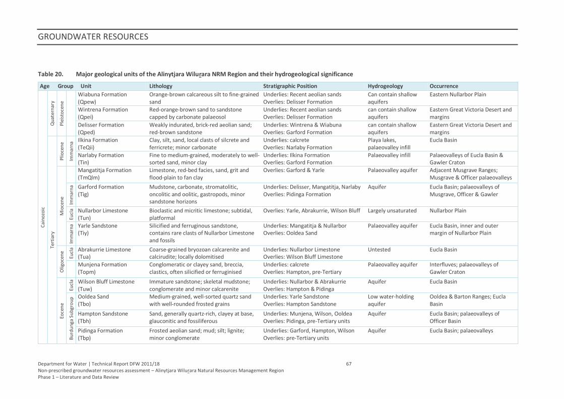
GROUNDWATER RESOURCES
Department for Water | Technical Report DFW 2011/18 67 Non-prescribed groundwater resources assessment – Alinytjara Wilurara Natural Resources Management Region Phase 1 – Literature and Data Review
Table 20. Major geological units of the Alinytjara Wilurara NRM Region and their hydrogeological significance
Age Group Unit Lithology Stratigraphic Position Hydrogeology Occurrence
Cai
no
zoic
Qu
ater
nar
y
Ple
isto
cen
e
Wiabuna Formation (Qpew)
Orange-brown calcareous silt to fine-grained sand
Underlies: Recent aeolian sands Overlies: Delisser Formation
Can contain shallow aquifers
Eastern Nullarbor Plain
Wintrena Formation (Qpei)
Red-orange-brown sand to sandstone capped by carbonate palaeosol
Underlies: Recent aeolian sands Overlies: Delisser Formation
can contain shallow aquifers
Eastern Great Victoria Desert and margins
Delisser Formation (Qped)
Weakly indurated, brick-red aeolian sand; red-brown sandstone
Underlies: Wintrena & Wiabuna Overlies: Garford Formation
can contain shallow aquifers
Eastern Great Victoria Desert and margins
Tert
iary
Plio
cen
e
Imm
arn
a Ilkina Formation
(TeQii) Clay, silt, sand, local clasts of silcrete and ferricrete; minor carbonate
Underlies: calcrete Overlies: Narlaby Formation
Playa lakes, palaeovalley infill
Eucla Basin
Narlaby Formation (Tin)
Fine to medium-grained, moderately to well-sorted sand, minor clay
Underlies: Ilkina Formation Overlies: Garford Formation
Palaeovalley infill Palaeovalleys of Eucla Basin & Gawler Craton
Mio
cen
e
Mangatitja Formation (TmQlm)
Limestone, red-bed facies, sand, grit and flood-plain to fan clay
Overlies: Garford & Yarle Palaeovalley aquifer Adjacent Musgrave Ranges; Musgrave & Officer palaeovalleys
Imm
arn
a
Garford Formation (Tig)
Mudstone, carbonate, stromatolitic, oncolitic and oolitic, gastropods, minor sandstone horizons
Underlies: Delisser, Mangatitja, Narlaby Overlies: Pidinga Formation
Aquifer Eucla Basin; palaeovalleys of Musgrave, Officer & Gawler
Eucl
a Nullarbor Limestone (Tun)
Bioclastic and micritic limestone; subtidal, platformal
Overlies: Yarle, Abrakurrie, Wilson Bluff Largely unsaturated Nullarbor Plain
Imm
arn
a
Yarle Sandstone (Tiy)
Silicified and ferruginous sandstone, contains rare clasts of Nullarbor Limestone and fossils
Underlies: Mangatitja & Nullarbor Overlies: Ooldea Sand
Palaeovalley aquifer Eucla Basin, inner and outer margin of Nullarbor Plain
Olig
oce
ne
Eucl
a Abrakurrie Limestone (Tua)
Coarse-grained bryozoan calcarenite and calcirudite; locally dolomitised
Underlies: Nullarbor Limestone Overlies: Wilson Bluff Limestone
Untested Eucla Basin
Munjena Formation (Topm)
Conglomeratic or clayey sand, breccia, clastics, often silicified or ferruginised
Underlies: calcrete Overlies: Hampton, pre-Tertiary
Palaeovalley aquifer Interfluves; palaeovalleys of Gawler Craton
Eoce
ne
Eucl
a Wilson Bluff Limestone (Tuw)
Immature sandstone; skeletal mudstone; conglomerate and minor calcarenite
Underlies: Nullarbor & Abrakurrie Overlies: Hampton & Pidinga
Aquifer Eucla Basin
Bu
rdu
nga
Su
bgr
ou
p Ooldea Sand
(Tbo) Medium-grained, well-sorted quartz sand with well-rounded frosted grains
Underlies: Yarle Sandstone Overlies: Hampton Sandstone
Low water-holding aquifer
Ooldea & Barton Ranges; Eucla Basin
Hampton Sandstone (Tbh)
Sand, generally quartz-rich, clayey at base, glauconitic and fossiliferous
Underlies: Munjena, Wilson, Ooldea Overlies: Pidinga, pre-Tertiary units
Aquifer Eucla Basin; palaeovalleys of Officer Basin
Pidinga Formation (Tbp)
Frosted aeolian sand; mud; silt; lignite; minor conglomerate
Underlies: Garford, Hampton, Wilson Overlies: pre-Tertiary units
Aquifer Eucla Basin; palaeovalleys
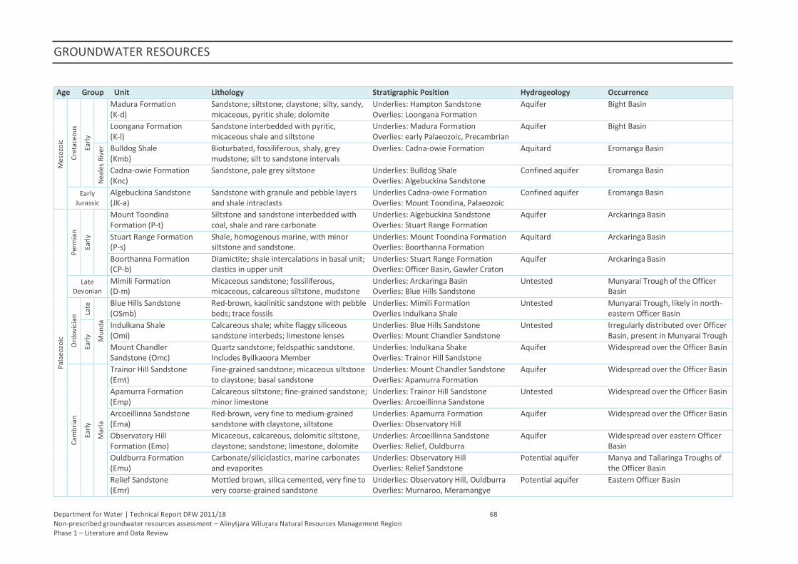
GROUNDWATER RESOURCES
Department for Water | Technical Report DFW 2011/18 68 Non-prescribed groundwater resources assessment – Alinytjara Wilurara Natural Resources Management Region Phase 1 – Literature and Data Review
Age Group Unit Lithology Stratigraphic Position Hydrogeology Occurrence
Mes
ozo
ic
Cre
tace
ou
s
Earl
y
Madura Formation (K-d)
Sandstone; siltstone; claystone; silty, sandy, micaceous, pyritic shale; dolomite
Underlies: Hampton Sandstone Overlies: Loongana Formation
Aquifer Bight Basin
Loongana Formation (K-l)
Sandstone interbedded with pyritic, micaceous shale and siltstone
Underlies: Madura Formation Overlies: early Palaeozoic, Precambrian
Aquifer Bight Basin
Nea
les
Riv
er
Bulldog Shale (Kmb)
Bioturbated, fossiliferous, shaly, grey mudstone; silt to sandstone intervals
Overlies: Cadna-owie Formation Aquitard Eromanga Basin
Cadna-owie Formation (Knc)
Sandstone, pale grey siltstone Underlies: Bulldog Shale Overlies: Algebuckina Sandstone
Confined aquifer Eromanga Basin
Early Jurassic
Algebuckina Sandstone (JK-a)
Sandstone with granule and pebble layers and shale intraclasts
Underlies Cadna-owie Formation Overlies: Mount Toondina, Palaeozoic
Confined aquifer Eromanga Basin
Pal
aeo
zoic
Per
mia
n
Earl
y
Mount Toondina Formation (P-t)
Siltstone and sandstone interbedded with coal, shale and rare carbonate
Underlies: Algebuckina Sandstone Overlies: Stuart Range Formation
Aquifer Arckaringa Basin
Stuart Range Formation (P-s)
Shale, homogenous marine, with minor siltstone and sandstone.
Underlies: Mount Toondina Formation Overlies: Boorthanna Formation
Aquitard Arckaringa Basin
Boorthanna Formation (CP-b)
Diamictite; shale intercalations in basal unit; clastics in upper unit
Underlies: Stuart Range Formation Overlies: Officer Basin, Gawler Craton
Aquifer Arckaringa Basin
Late Devonian
Mimili Formation (D-m)
Micaceous sandstone; fossiliferous, micaceous, calcareous siltstone, mudstone
Underlies: Arckaringa Basin Overlies: Blue Hills Sandstone
Untested Munyarai Trough of the Officer Basin
Ord
ovi
cian
Late
Mu
nd
a
Blue Hills Sandstone (OSmb)
Red-brown, kaolinitic sandstone with pebble beds; trace fossils
Underlies: Mimili Formation Overlies Indulkana Shale
Untested Munyarai Trough, likely in north-eastern Officer Basin
Earl
y
Indulkana Shale (Omi)
Calcareous shale; white flaggy siliceous sandstone interbeds; limestone lenses
Underlies: Blue Hills Sandstone Overlies: Mount Chandler Sandstone
Untested Irregularly distributed over Officer Basin, present in Munyarai Trough
Mount Chandler Sandstone (Omc)
Quartz sandstone; feldspathic sandstone. Includes Byilkaoora Member
Underlies: Indulkana Shake Overlies: Trainor Hill Sandstone
Aquifer Widespread over the Officer Basin
Cam
bri
an
Earl
y
Mar
la
Trainor Hill Sandstone (Emt)
Fine-grained sandstone; micaceous siltstone to claystone; basal sandstone
Underlies: Mount Chandler Sandstone Overlies: Apamurra Formation
Aquifer Widespread over the Officer Basin
Apamurra Formation (Emp)
Calcareous siltstone; fine-grained sandstone; minor limestone
Underlies: Trainor Hill Sandstone Overlies: Arcoeillinna Sandstone
Untested Widespread over the Officer Basin
Arcoeillinna Sandstone (Ema)
Red-brown, very fine to medium-grained sandstone with claystone, siltstone
Underlies: Apamurra Formation Overlies: Observatory Hill
Aquifer Widespread over the Officer Basin
Observatory Hill Formation (Emo)
Micaceous, calcareous, dolomitic siltstone, claystone; sandstone; limestone, dolomite
Underlies: Arcoeillinna Sandstone Overlies: Relief, Ouldburra
Aquifer Widespread over eastern Officer Basin
Ouldburra Formation (Emu)
Carbonate/siliciclastics, marine carbonates and evaporites
Underlies: Observatory Hill Overlies: Relief Sandstone
Potential aquifer Manya and Tallaringa Troughs of the Officer Basin
Relief Sandstone (Emr)
Mottled brown, silica cemented, very fine to very coarse-grained sandstone
Underlies: Observatory Hill, Ouldburra Overlies: Murnaroo, Meramangye
Potential aquifer Eastern Officer Basin
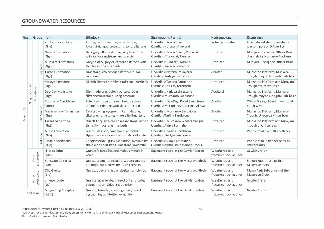
GROUNDWATER RESOURCES
Department for Water | Technical Report DFW 2011/18 69 Non-prescribed groundwater resources assessment – Alinytjara Wilurara Natural Resources Management Region Phase 1 – Literature and Data Review
Age Group Unit Lithology Stratigraphic Position Hydrogeology Occurrence
Pro
tero
zoic
Ne
op
rote
rozo
ic
Ad
elai
dea
n
Un
goo
lya
Punkerri Sandstone (N-u)
Purple, red-brown flaggy sandstone; feldspathic, quartzose sandstone, siltstone
Underlies: Marla Group Overlies: Narana, Munyarai
Potential aquifer Birksgate Sub-basin, maybe in western part of Officer Basin
Narana Formation (Ngn)
Dark grey silty mudstone; silty limestone with minor sandstone and breccia
Underlies: Marla Group, Punkerri Overlies: Munyarai, Tanana
Untested Munyarai Trough of Officer Basin, channels in Murnaroo Platform
Munyarai Formation (Ngm)
Grey to dark-grey calcareous siltstone with thin limestone interbeds
Underlies: Punkerri, Narana Overlies: Tanana Formation
Untested Munyarai Trough of Officer Basin
Tanana Formation (Ngt)
Limestone; calcareous siltstone; minor sandstone
Underlies: Narana, Munyarai Overlies: Karlaya Limestone
Aquifer Murnaroo Platform, Munyarai Trough, maybe Birksgate Sub-basin
Karlaya Limestone (Ngk)
Micritic limestone; silty mudstone interbeds Underlies: Tanana Formation Overlies: Dey-Dey Mudstone
Untested Murnaroo Platform and Munyarai Trough of Officer Basin
Dey-Dey Mudstone (Ngd)
Silty mudstone; dolomitic, calcareous siltstone/mudstone; conglomerate
Underlies; Karlaya Limestone Overlies: Murnaroo Sandstone
Aquitard Murnaroo Platform, Munyarai Trough, maybe Birksgate Sub-basin
Lake
Mau
rice
Murnaroo Sandstone (Nqm)
Pale grey-green to green, fine to coarse-grained sandstone with shale interbeds
Underlies: Dey-Dey, Relief Sandstone Overlies: Meramangye, Tarlina, Alinya
Aquifer Officer Basin, absent in west and north-west
Meramangye Formation (Nqe)
Red-brown, grey-green silty mudstone, siltstone, sandstone; minor silty limestone
Underlies: Murnaroo Sandstone Overlies: Tarlina Sandstone
Aquifer Murnaroo Platform, Munyarai Trough, Ungoolya Hinge Zone
Tarlina Sandstone (Nqt)
Quartz to quartz–feldspar sandstone, minor thin silty mudstone interbeds
Underlies: Murnaroo & Meramangye Overlies: Alinya Formation
Untested Murnaroo Platform and Munyarai Trough of Officer Basin
Cal
lan
na
Alinya Formation (N-a)
Lower: siltstone, sandstone, anhydrite Upper: same as lower with shale, dolomite
Underlies: Tarlina Sandstone Overlies: Pindyin Sandstone
Untested Widespread over Officer Basin
Pindyin Sandstone (N-p)
Conglomerate, gritty sandstone, overlain by shale with chert beds, limestone, dolomite
Underlies: Alinya Formation Overlies: crystalline basement rocks
Untested Widespread in deeper parts of Officer Basin
Mes
o-
pro
tero
zoic
Hiltaba Suite (Mh)
Granite/adamellite, anomalous metals in veins
Basement rocks of the Gawler Craton Weathered and fractured rock aquifer
Gawler Craton
Birksgate Complex (Mr)
Gneiss, granulite. Includes Wataru Gneiss, Pitjantjatjara Supersuite, Giles Complex
Basement rocks of the Musgrave Block Weathered and fractured rock aquifer
Fregon Subdomain of the Musgrave Block
Pal
aeo
-
pro
tero
zoic
Olia Gneiss (L-o)
Gneiss, quartz-feldspar-biotite-hornblende Basement rocks of the Musgrave Block Weathered and fractured rock aquifer
Mulga Park Subdomain of the Musgrave Block
St Peter Suite (Lp)
Granite; adamellite; granodiorite; diorite; pegmatite; amphibolite; dolerite
Basement rocks of the Gawler Craton Weathered and fractured rock aquifer
Gawler Craton
Archaean Mulgathing Complex (ALm)
Granite; tonalite; gneiss; gabbro; basalt; pyroxenite; peridotite; komatiite
Basement rocks of the Gawler Craton Weathered and fractured rock aquifer
Gawler Craton
GROUNDWATER RESOURCES
Department for Water | Technical Report DFW 2011/18 70 Non-prescribed groundwater resources assessment – Alinytjara Wilurara Natural Resources Management Region Phase 1 – Literature and Data Review
6.9. GROUNDWATER POTENTIAL
Across South Australia, few assessments have addressed regional groundwater storages. The Spencer
Region Strategic Water Management Study (Martin, Sereda & Clarke 1998) provided first-order
assessments of groundwater storage for a number of geological and groundwater provinces. Available
knowledge of shallow groundwater salinity was also considered to group groundwater storages by
salinity class.
The provinces assessed, which included the Eucla, Officer and Great Artesian Basins and palaeovalley
resources (Table 21), do not cover all areas of South Australia and large regions remain devoid of
information suitable to conduct a meaningful assessment.
To determine the total storage estimates, data were interpreted from limited drillhole information
within each of the individual provinces. Where suitable data were available, saturated aquifer thickness
was evaluated, providing a representative value to extrapolate for each province. An effective porosity
of 10% was used to determine a total resource volume. It is important to recognise that the estimates
are only first-order approximations and that more detailed and targeted assessments will be required to
refine the estimates of the total resource (Martin, Sereda & Clarke. 1998).
These preliminary estimates of total groundwater storages within each province could potentially be an
over-estimate and it is likely that they are based on data that lacks a high degree of validation.
Additionally, the ability to improve estimates of the resource volumes is dependent upon local scale
issues including land access, drillhole specification and well and aquifer efficiency. Any estimates should
be treated with caution until a more detailed and reliable assessment of groundwater resources can be
addressed in subsequent investigations. Should future demand occur within these regions, it is
recommended that groundwater resources be evaluated for their supply potential.
6.9.1. FUTURE ASSESSMENTS
Groundwater is available in most locations but is highly variable in quality and quantity. Improved
estimates of resource potential should be made based on revised and more detailed knowledge of
aquifer formations, their hydrogeological properties and associated water levels.
6.9.1.1. Sedimentary Aquifers
Sedimentary sequence information (e.g. mean thickness and range of occurrence) within Quaternary,
Tertiary, Mesozoic, Palaeozoic and Neoproterozoic sequences, can be calculated for a defined region
(e.g. 1:100 000 map sheet), or geological feature (e.g. palaeovalleys). As a preliminary assumption,
locations of greater sedimentary thickness may have a potential for larger volumes of groundwater
storage. However, it is important that this assumption is coupled with the knowledge of groundwater
levels to determine saturated thicknesses before estimates of saturated sedimentary thickness and
groundwater volume can be derived.
6.9.1.2. Fractured Rock Aquifers
Fractured rock aquifers are far more complex than sedimentary sequences and hence groundwater
resource estimates require more simplifying assumptions about porosity and the degree of and depth to
which water-bearing fractures extend.
GROUNDWATER RESOURCES
Department for Water | Technical Report DFW 2011/18 71 Non-prescribed groundwater resources assessment – Alinytjara Wilurara Natural Resources Management Region Phase 1 – Literature and Data Review
6.9.1.3. Groundwater Use
The use of groundwater in non-prescribed regions can be difficult to quantify beyond the knowledge of
town water supply volumes. Landowner surveys, land use maps and satellite imagery can be used to
investigate land use practise and estimate the levels of groundwater-dependent irrigation.
6.10. POTENTIAL CLIMATE CHANGE IMPACTS
Water resources are climate dependent and climate changes may pose future limitations on
groundwater resources in the AWNRM Region. Climate change impacts and the understanding of its
implications will vary across the State; regional water demand and supply plans will undertake regional
scale assessments of the impact of climate change where this has not already occurred (Water for Good
2009).
Regional climate change scenarios for the AWNRM Region have been developed, based on statewide
climate modelling conducted by the CSIRO Marine and Atmospheric Research Group (Suppiah et al.
2006). Projections include:
an increase in the mean annual temperature of between 0.5–1.5 °C by 2030 and 1.2–4.7 °C by
2070
changes in mean annual rainfall of between -9 and +1% by 2030 and between -25 and +4% by
2070
an increase in mean annual evaporation of 1.2–5.8 mm/y, based on data obtained from
Woomera
if CO2 emissions stabilise, significantly reduced warming and smaller rainfall changes would likely
result
Impacts to the hydrology due to climate change include a reduction in the volume of surface water
runoff and groundwater recharge. This problem is likely to be compounded by an enhanced
unpredictability in temporal and spatial distribution of rainfall. Predictions of decreased rainfall and
increased evapotranspiration due to rising temperatures are expected to impact the groundwater
resources by an increase in demand and a reduction in supply source.
The Department for Water is undertaking assessments of groundwater resources which are vulnerable
to the impacts of climate change through the Impacts of Climate Change on Water Resources (ICCWR)
project. Detailed modelling of groundwater resources under various CO2 emission scenarios is currently
being conducted and forecasts made of potential climate change impacts on the rate of rainfall
recharge. The scope of the ICCWR project is currently limited to Prescribed Wells Areas and Prescribed
Water Resource Areas.
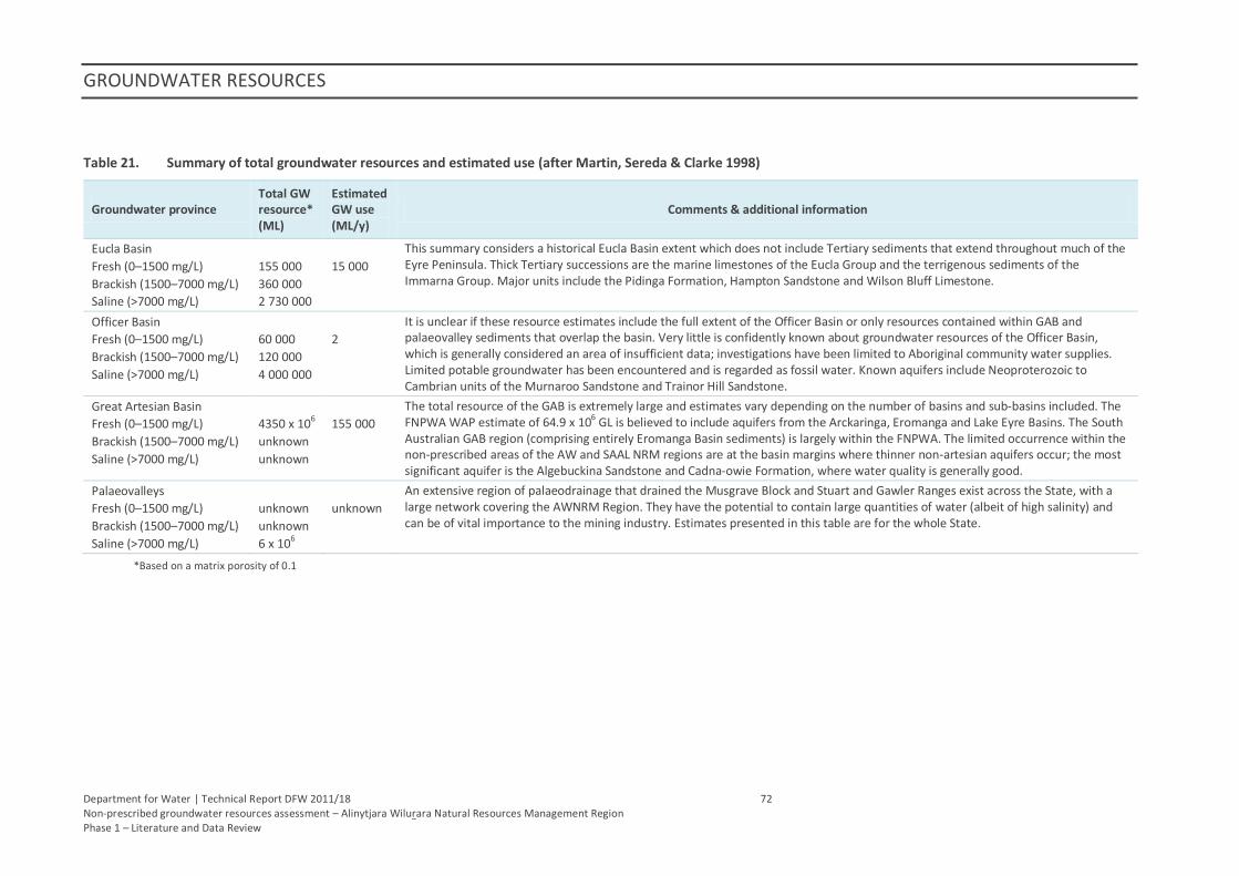
GROUNDWATER RESOURCES
Department for Water | Technical Report DFW 2011/18 72 Non-prescribed groundwater resources assessment – Alinytjara Wilurara Natural Resources Management Region Phase 1 – Literature and Data Review
Table 21. Summary of total groundwater resources and estimated use (after Martin, Sereda & Clarke 1998)
Groundwater province Total GW resource* (ML)
Estimated GW use (ML/y)
Comments & additional information
Eucla Basin
Fresh (0–1500 mg/L)
Brackish (1500–7000 mg/L)
Saline (>7000 mg/L)
155 000
360 000
2 730 000
15 000
This summary considers a historical Eucla Basin extent which does not include Tertiary sediments that extend throughout much of the Eyre Peninsula. Thick Tertiary successions are the marine limestones of the Eucla Group and the terrigenous sediments of the Immarna Group. Major units include the Pidinga Formation, Hampton Sandstone and Wilson Bluff Limestone.
Officer Basin
Fresh (0–1500 mg/L)
Brackish (1500–7000 mg/L)
Saline (>7000 mg/L)
60 000
120 000
4 000 000
2
It is unclear if these resource estimates include the full extent of the Officer Basin or only resources contained within GAB and palaeovalley sediments that overlap the basin. Very little is confidently known about groundwater resources of the Officer Basin, which is generally considered an area of insufficient data; investigations have been limited to Aboriginal community water supplies. Limited potable groundwater has been encountered and is regarded as fossil water. Known aquifers include Neoproterozoic to Cambrian units of the Murnaroo Sandstone and Trainor Hill Sandstone.
Great Artesian Basin
Fresh (0–1500 mg/L)
Brackish (1500–7000 mg/L)
Saline (>7000 mg/L)
4350 x 106
unknown
unknown
155 000
The total resource of the GAB is extremely large and estimates vary depending on the number of basins and sub-basins included. The FNPWA WAP estimate of 64.9 x 10⁶ GL is believed to include aquifers from the Arckaringa, Eromanga and Lake Eyre Basins. The South Australian GAB region (comprising entirely Eromanga Basin sediments) is largely within the FNPWA. The limited occurrence within the non-prescribed areas of the AW and SAAL NRM regions are at the basin margins where thinner non-artesian aquifers occur; the most significant aquifer is the Algebuckina Sandstone and Cadna-owie Formation, where water quality is generally good.
Palaeovalleys
Fresh (0–1500 mg/L)
Brackish (1500–7000 mg/L)
Saline (>7000 mg/L)
unknown
unknown
6 x 10⁶
unknown
An extensive region of palaeodrainage that drained the Musgrave Block and Stuart and Gawler Ranges exist across the State, with a large network covering the AWNRM Region. They have the potential to contain large quantities of water (albeit of high salinity) and can be of vital importance to the mining industry. Estimates presented in this table are for the whole State.
*Based on a matrix porosity of 0.1
Department for Water | Technical Report DFW 2011/18 73 Non-prescribed groundwater resources assessment – Alinytjara Wilurara Natural Resources Management Region Phase 1 – Literature and Data Review
7. RECOMMENDED FURTHER INVESTIGATIONS
This initial investigation has collated groundwater information for the AWNRM Region and presents a
regional description of the non-prescribed groundwater resources. Geological and hydrogeological data
have been compiled with particular attention given to the identification of major hydrogeological units
and related groundwater information.
Additional assessment of non-prescribed groundwater resources will be addressed in a prioritised
manner and structured to allow stakeholders an opportunity to provide feedback on their priority needs
for groundwater resources. The ‘Phase 2’ assessments will be developed to advance the understanding
of groundwater resources for areas within the AWNRM Region deemed to have a greater short term
need for improved knowledge. Areas for further and more detailed assessments in Phase 2 will be
defined based on criteria including importance of and proximity to, proposed and projected
development activities (e.g. mining or other industrial economic developments), as well as population
development needs. It is anticipated that Phase 2 assessments will involve more detailed desktop
analysis of the available information but may need to be supported by targeted field activities to fill
information gaps.
The following recommendations are made with a view to guide project planning for future non-
prescribed groundwater assessments. Identified key knowledge gaps include groundwater storage,
sustainable yield, rates and volumes of groundwater abstraction and processes of groundwater
recharge. Better knowledge of these parameters is fundamental to formulating strategies for
sustainable water use.
7.1. DATA CAPTURE AND DATA VALIDATION – SA GEODATA
It is recommended that greater attention be focused on groundwater data capture and validation and
ensuring that all available historical groundwater data (e.g. microfiche and exploration files) are
available via the State geodatabase, SA Geodata. Salinity or water level data, which is many decades old,
may be valuable for analyses of trends in the condition of the groundwater resource. Also, lengthy time
series are useful in calibrating and validating numerical groundwater models. Importantly, archived data
not yet entered into SA Geodata may include well construction details, which is invaluable as it enables
a more robust assessment of groundwater resources by identifying the specific aquifer(s) from which
groundwater samples have been taken.
PIRSA’s Plan for Accelerated Exploration (PACE 2020) aims to improve the knowledge of groundwater
occurrence and water quality by supporting exploration companies through co-funding drilling grants. It
is expected that where suitable exploration methods are used, well yield, water cuts and standing water
level are recorded and groundwater samples are collected. Following the relinquishment of Mineral
Exploration Licenses, PIRSA captures stratigraphic information for inclusion into SA Geodata. A process
needs to be implemented to ensure that all drillhole data from mineral exploration activities are
captured, which could include groundwater levels, salinity, chemistry, well yields and lithological logs.
7.2. GROUNDWATER MONITORING
A detailed review of the monitoring network within the AWNRM Region (AGT 2010c) found it to be
satisfactory for the majority of communities. However, the review noted that the network only records
water levels with no salinity sampling occurring and ideally, groundwater samples for salinity monitoring
should be collected twice a year to capture any seasonal changes. Several communities have no
RECOMMENDED FURTHER INVESTIGATIONS
Department for Water | Technical Report DFW 2011/18 74 Non-prescribed groundwater resources assessment – Alinytjara Wilurara Natural Resources Management Region Phase 1 – Literature and Data Review
monitored wells apart from production wells and the installation of observation wells beyond the extent
of drawdown cones was recommended. Additional recommendations included:
installation of observation wells at some communities (beyond extent of drawdown cones)
audit monitoring on regular basis (10 years)
monitor creek flow for groundwater recharge analysis
field recording of 'native wells', soaks and rock-holes.
In addition to the limited groundwater monitoring outside PWAs, the most recent available regional
water well data (i.e. water level, salinity and yield), for most areas, are several decades old. The lack of
recent groundwater information does not allow an accurate appraisal of the groundwater condition and
hampers the assessment of the resource potential. Groundwater assessments or investigations that
utilise historical data should be treated cautiously.
It is recommended that a regional monitoring program be developed, particularly for non-prescribed
areas with a high probability of future development, to enable review of the status of both potable and
non-potable groundwater resource. A suitable approach may target a broad network of operational
wells for which stratigraphic and production zone information exists.
Recommendations and activities that relate to groundwater monitoring and associated infrastructure
requirements will be closely linked with the Groundwater Program’s Statewide Groundwater and Water
Monitoring System project. This is a project that aims to deliver a reliable ‘fit for purpose’ State
groundwater monitoring network that is under regular review with respect to current suitability and
future needs.
7.2.1. MONITORED AQUIFERS
As part of this project, the occurrence of individual stratigraphic units of hydrogeological significance
were examined and used to develop a hydrogeological discussion around the available groundwater
data. For a limited number of suitable wells, available well production zone information was correlated
with the associated stratigraphic intervals to indicate the geological interval(s) to which the well is open.
Knowledge of the open-aquifer interval would allow for a more robust analysis of the available
groundwater data. Further interpretation of lithological logs to hydrostratigraphic intervals coupled with
validation of well production zones would allow an aquifer monitored description to be linked to a
greater amount of groundwater observations.
7.3. AQUIFER EXTENT
To determine volumetric estimates of groundwater storages, better definition of the vertical and areal
extents of hydrostratigraphic units is required. Refined estimates of aquifer extent would aid in 3-D
mapping of groundwater systems (Section 7.9.1.). Furthermore, refining the hydrogeological significance
of various geological units could be achieved via the generation of stratigraphic logs from existing
lithological logs. However, large areas can be devoid of drillhole information (e.g. within the Officer
Basin) and drilling programs would best define the likely areal extent of groundwater resources.
However, drilling programs are extremely resource intensive and geophysical methods may be favoured
where budgetary constraints restrict drilling programs.
RECOMMENDED FURTHER INVESTIGATIONS
Department for Water | Technical Report DFW 2011/18 75 Non-prescribed groundwater resources assessment – Alinytjara Wilurara Natural Resources Management Region Phase 1 – Literature and Data Review
7.4. GEOPHYSICAL DATA
Geophysical datasets often provide valuable interpretation that could not otherwise be obtained
without expensive conventional groundwater investigations. Where paucity of data presents barriers to
defining aquifer extent, geophysical methods (e.g. gravity; electromagnetic; shallow seismic) may be the
most cost-effective option for filling data gaps. Airborne geophysical techniques can acquire vast
amounts of data within a short time frame over complex terrain.
The AWNRM Region has numerous existing geophysical datasets collected for mineral exploration and
there is a potential to revisit these data and reinterpret from a groundwater perspective. High priority
areas for groundwater development may benefit from the use of geophysical surveying to provide an
improved knowledge of aquifer formations extents and groundwater salinity distribution.
Magnetic Resonance Sounding provides a qualitative evaluation of sub-surface water content and
although in the early stages of application in Australia, this approach promises to be a valuable
geophysical tool to aid in groundwater status assessments.
7.5. AQUIFER HYDRAULIC PROPERTIES
Hydraulic properties of an aquifer such as transmissivity and storage (specific yield or specific storage)
can be determined by conducting aquifer tests. Tests targeted at specific hydrostratigraphic units would
result in a more robust understanding of groundwater conditions across the AWNRM Region. Aquifer
testing could be focused on areas where demand for groundwater is likely to be greatest. However, it
should be noted that good quality data from aquifer tests are contingent on meeting numerous
assumptions, two of which are: (1) The aquifer of interest is the only aquifer that is pumped/observed
and (2) the well(s) from which data are collected are screened across the entire thickness of the aquifer.
Appropriately constructed wells can indicate the capacity of a groundwater system to supply water in
the long term and in a sustainable manner.
7.6. PALAEOVALLEYS
Palaeovalleys are considered to be an important source of groundwater. Such resources already provide
supplies to the Jacinth–Ambrosia mineral sands mine in the region’s south. The lateral extent of
palaeovalleys in the AWNRM Region has been progressively updated, but very limited groundwater
information has been reported. Geoscience Australia’s Palaeovalley Groundwater Resources in Arid and
Semi-Arid Australia project, funded by the National Water Commission, has applied and researched new
methodologies to investigate these resources, providing an improved basis for evaluating their capacity.
Techniques applied to date include aerial and ground geophysical datasets, targeted groundwater
sampling and aquifer testing, digital elevation model manipulations and remote sensing imagery to
differentiate thermal mass, soil moisture and vegetation indexes. The use of ESRI’s Arc Hydro®
groundwater tools have also been adopted, particularly for three dimensional representations of areas
with a high density of data.
The palaeovalleys of the Musgrave Block were included in the palaeovalley project conducted by
Geoscience Australia. The use of these investigation methods should be considered for the remaining
AWNRM Region to improve the understanding of these potentially high volume groundwater resources.
Initially, additional assessments of existing available data could be completed for the palaeovalleys and
first order groundwater resource potential estimates calculated. On ground works, including water
sampling, hydrochemical analysis and the pump testing of suitable wells would facilitate a more
accurate appraisal.
RECOMMENDED FURTHER INVESTIGATIONS
Department for Water | Technical Report DFW 2011/18 76 Non-prescribed groundwater resources assessment – Alinytjara Wilurara Natural Resources Management Region Phase 1 – Literature and Data Review
7.7. FRACTURED ROCK AQUIFERS
Basement or fractured rock aquifers are utilised in a number of areas across the AWNRM Region. They
are important to the overall groundwater resource capacity of the region but a large knowledge gap
exists with regard to their development potential. Little reliable data is available due the existence of
shallower resources that limits the drilling of the deeper water wells.
An investigation targeting bedrock aquifers in key areas, that includes a field sampling component,
would allow greater certainty in the potential of these groundwater resources. The use of
hydrochemical data would be important in defining the origin of water and connectivity with other
aquifer formations.
7.7.1. BASEMENT INTERPRETATION
A regional definition of depth to basement is a valuable product in the estimation of sedimentary
thickness and groundwater storage volumes. The subtraction of the basement layer from a land surface
layer yields a sediment thickness and when linked to groundwater levels, indicates a saturated thickness
and allows better estimates of resource potential. A basement map utilising geophysical data including
shallow seismic, regional gravity and magnetic data is recommended for the development of more
accurate resource assessments.
A valuable related product would be a map of saturated sedimentary thickness. Such a spatial product
could be coupled with a distribution map of salinity and a well capacity rating, based on the knowledge
of the formation type and well yields. Such a product would require detailed well and groundwater data
validation and a program of aquifer testing.
7.8. GROUNDWATER RECHARGE
Recharge to the groundwater system is an important component to the water budget and estimates of
recharge are essential to define a resource’s capacity to sustain supply over a given time period. Further
investigation is required to better understand the magnitude and processes of natural groundwater
recharge in non-prescribed areas.
In order to better estimate recharge to unconfined aquifers, the feasibility of regional modelling of
recharge using such packages as the WAVES model as used in the Murray–Darling Basin (Crosbie et al.
2008) should be investigated. Estimating rates of rainfall recharge within fractured rock environments is
especially challenging. Numerical modelling and/or water balance studies may aid in constraining
estimated ranges of recharge to fractured rock aquifers.
Extending the scope of the Department for Water’s Impacts of Climate Change on Water Resources
project may aid in estimating future recharge rates of the non-prescribed groundwater resources across
the AWNRM Region, in addition to facilitating the evaluation of climate change impacts on recharge into
the future.
GHD (2009) conducted a rainfall-recharge-runoff model based on PERFECT, a one-dimensional computer
simulation cropping and soil moisture balance model to produce some initial estimates of recharge and
runoff within the AWNRM Region. While this was completed, calibration of the model is severely lacking
due to the paucity of flow and groundwater data. GHD (2009) recommended the collection of
additional field data to improve the confidence in the model.
RECOMMENDED FURTHER INVESTIGATIONS
Department for Water | Technical Report DFW 2011/18 77 Non-prescribed groundwater resources assessment – Alinytjara Wilurara Natural Resources Management Region Phase 1 – Literature and Data Review
7.9. PRODUCTS
To enable easier interpretation of groundwater data, a number of mapping products have been
generated by this study. These mapping products will also improve accessibility to groundwater
information for key stakeholders and the public. At the conclusion of this study, additional mapping
products have been identified that could potentially augment the new products presented here. Also,
optimal technologies by which they might be delivered have been explored.
7.9.1. 3-D MAPPING The petroleum and mining industries are well advanced in using 3-D mapping and visualisation
techniques to aid in the assessment of potential reserves of oil or ore. Hydrogeologists in Australia are
beginning to take advantage of these technologies to aid in the development of conceptual
hydrogeologic models within a virtual 3-D environment. Manipulating and evaluating data within a 3-D
environment enables volumetric assessment (e.g. groundwater storage) of the resource in addition to
state-of-the-art static visualisation and animation.
7.9.1.1. Arc Hydro®
Arc Hydro® is a geodatabase design and incorporates a suite of accompanying tools tailored for support
of water resource assessment applications within ESRI’s ArcGIS® (Geographic Information System, or
GIS) environment. Arc Hydro® is compatible with Microsoft Access® and ArcGIS® thereby providing an
interface between the State’s stratigraphic database and GIS software. It is expected that the main
benefits will be improvements in the way that groundwater data is queried, superior reporting products,
3-D visualisation and capabilities including the calculation of stratigraphic geo-volumes, which can be
used to develop estimates of groundwater storage.
7.9.2. ONLINE PDF MAPS
The most recent available datasets of groundwater and aquifer formations could be arranged and
presented (for download) as high quality Portable Document Format (PDF) mapping products. These
would deliver the functional advantages of spatial software through a layered information structure.
Users (such as industry and community) would be able to toggle layers and annotations on and off,
zoom in and out and query groundwater related layers and labels. Such a product could be delivered to
the wider audience via the internet and current freeware (Adobe Reader). Any new data or knowledge
generated and incorporated into the database can be updated to the PDF products in later iterations of
the data maps.
Department for Water | Technical Report DFW 2011/18 78 Non-prescribed groundwater resources assessment – Alinytjara Wilurara Natural Resources Management Region Phase 1 – Literature and Data Review
8. CONCLUSION
Groundwater within the AWNRM Region is a scarce and precious resource that is mainly used for
Aboriginal community water supplies, some pastoral activities and the Jacinth–Ambrosia Mineral Sands
Mine. Occurrences of potable-quality groundwater are primarily found within the weathered and
fractured rock aquifers of the Musgrave Block. A discrete supply of good quality water has been found
around 30 km west of Oak Valley and is used for that community’s town water supply. Low saline
groundwater has also been recorded in the south-east of Giles and north/north-east of Tallaringa
1:250 000 map sheets, but the aquifer has not been positively identified. Throughout the rest of the
AWNRM Region, observations of groundwater indicate it is mostly saline and is predominantly
associated with palaeovalley deposits.
Weathered and fractured rock aquifers are utilised primarily in regions of outcropping and shallow
basement. The quality of groundwater held within basement rocks at greater depths is largely unknown.
Palaeozoic sediments of the Officer Basin may contain a number of potential aquifers but remain largely
unexplored. Groundwater has been found primarily within the Murnaroo Sandstone and the
Observatory Hill Formation. A large number of other stratigraphic units have been identified within the
Officer Basin but their potential as aquifers is unclear.
The Permian formations of the Arckaringa Basin and the Jurassic–Cretaceous Cadna-owie Formation and
Algebuckina Sandstone of the overlying Eromanga Basin are known to contain groundwater. The limited
extent of these basins within the AWNRM Region is part of the non-artesian and western recharge zone
for the Great Artesian Basin. Groundwater extractions in the confined portion of the GAB to the east
may potentially affect resources available along the western margin.
The Tertiary Wilson Bluff Limestone in the Eucla Basin may provide the best opportunity for further
groundwater development. It is thought to be able to provide large volumes of highly saline water due
to the favourable porosity of the aquifer. Tertiary deposits within palaeovalleys also hold much potential
for further development. These palaeovalley resources are present throughout the AWNRM Region,
draining from the Musgrave Block and Gawler Craton into the Eucla Basin. Sequences such as the
Mangatitja, Garford and Pidinga Formations and the Hampton Sandstone are thought to host large
volumes of saline groundwater although variable yields may limit reliability.
Quaternary Alluvial/fluvial aquifers are of limited extent and both groundwater quality and quantity are
highly variable. As such, they are highly unlikely to provide reliable or sustainable groundwater
resources.
Across the AWNRM Region, aquifers are recharged primarily via rainfall, whether it is direct infiltration
to Quaternary and Tertiary sediments or outcropping basement, or indirect recharge via throughflow.
Due to the large degree of spatial and temporal variability of rainfall within the region and the high rate
of evapotranspiration, recharge is similarly highly variable. As the predicted impacts of climate change
include a reduction in rainfall and an increase in temperatures (and thus evapotranspiration), the
amount of recharge is likely to fall, while the anticipated demand for groundwater resources will
probably increase. The development of commercial tourism and an increase in livestock numbers and
mining activities are drivers for the increased pressure on groundwater resources.
While every effort has been made to provide an accurate discussion of the groundwater resources of
the AWNRM Region, confident assessment has been greatly limited by the lack of data and recent data
in particular. The occurrence of individual stratigraphic units of hydrogeological significance were
CONCLUSION
Department for Water | Technical Report DFW 2011/18 79 Non-prescribed groundwater resources assessment – Alinytjara Wilurara Natural Resources Management Region Phase 1 – Literature and Data Review
examined and used to develop a hydrogeological discussion around the available groundwater data.
However, much of the groundwater data, due to a lack of supporting well construction information, is
unable to be confidently assigned to an aquifer formation and is often several decades old.
A project of further data validation and acquisition of new well and groundwater data would support a
more robust interpretation of aquifer formations, allowing for more meaningful discussion and
assessment of the groundwater resources.
Identified knowledge gaps include groundwater storage, sustainable yield, rates and volumes of
groundwater abstraction and processes of groundwater recharge. Better knowledge of these
parameters is fundamental to formulating strategies for sustainable water use. Additional assessments
of non-prescribed groundwater resources will be addressed in ‘Phase 2’ of this program. Consideration
of stakeholders needs for groundwater resources and criteria including importance of and proximity to,
proposed and projected development activities will prioritise areas for further assessment. It is
anticipated that ‘Phase 2’ assessments will involve more detailed desktop analysis of the available
information, but may need to be supported by targeted field activities to fill information gaps.
Department for Water | Technical Report DFW 2011/18 80 Non-prescribed groundwater resources assessment – Alinytjara Wilurara Natural Resources Management Region Phase 1 – Literature and Data Review
APPENDIX
A. ALINYTJARA WILURARA GEOLOGICAL FORMATIONS SUMMARY
More detailed descriptions of the geological formations summarised in Table 20 are presented in this
section. Much of the material is derived from The Geology of South Australia, Bulletin 54, Volumes 1 and
2 (Drexel, Preiss & Parker 1993; Drexel & Preiss 1995) and Chapter 6 of Petroleum Geology of South
Australia, Volume 3 - Officer Basin (Morton 1997).
ARCHAEAN TO MESOPROTEROZOIC
For the purpose of this report, weathered basement and hard crystalline basement have not been
differentiated. Groundwater can occur within weathered crystalline basement and other fractured rock
formations and despite often low salinity within the Musgrave Block, yields are unpredictable, but
typically low.
Mulgathing Complex (ALm)
The Archaean to Palaeoproterozoic Mulgathing Complex occurs on the central and northern Gawler
Craton. Outcrop is poor, discontinuous and structurally complex but exceeds 6 000 km2 and is
predominantly banded iron formation and quartz and feldspar rich ortho- and paragneisses. The extent
of basic and ultrabasic rocks is unknown but believed to be subordinate. The complex contains 11 rock
units:
Christie Gneiss — Archaean to Palaeoproterozoic gneiss with migmatitic layers, paragneiss,
carbonate, calcsilicate and quartzite; some banded iron formation
Kenella Gneiss — Archaean to Palaeoproterozoic gneiss with local pegmatitic separations and
possible metavolcanics. Concordant with Christie Gneiss
Hopeful Hill Basalt — Archaean to Palaeoproterozoic medium to fine-grained metatholeiitic
basalt with plagioclase, hornblende and diopside
South Lake Gabbro — Archaean to Palaeoproterozoic metagabbro with plagioclase and
pyroxene
Lake Harris Komatiite — Archaean to Palaeoproterozoic bright green, illite-tremolite-chlorite-
serpentine metabasic rock; green-grey komatiite
Blackfellow Hill Pyroxenite — Archaean to Palaeoproterozoic gabbro and norite
Aristarchus Peridotite — Archaean peridotite; pyroxenite; norite and gabbro cumulate. Intruded
by tonalite and granodiorite
Mobella Tonalite — Archaean to Palaeoproterozoic grey, coarse-grained, poorly foliated,
plagioclase-quartz-biotite tonalite
Devils Playground Volcanics — Archaean low metamorphic grade, weakly deformed rhyodacite,
andesite and basalt
APPENDIX
Department for Water | Technical Report DFW 2011/18 81 Non-prescribed groundwater resources assessment – Alinytjara Wilurara Natural Resources Management Region Phase 1 – Literature and Data Review
Glenloth Granite — Archaean to Palaeoproterozoic pink-brown to grey granite and granodiorite
with quartz, microcline and plagioclase and remnants of gneiss and biotite and hornblende
schlieren
Paxton Granite — Palaeoproterozoic coarse-grained slightly K-feldspar porphyritic monzogranite
consisting of subequal amounts of quartz and K-feldspar; plagioclase, lesser biotite, hornblende
and titanite with accessory magnetite, apatite, zircon and allanite.
St Peter Suite (Lp)
The St Peter Suite consists of a Palaeoproterozoic complex of comagmatic intrusive rock types. Five
main phases are evident, although their composition and texture greatly vary within isolated exposures
and from one exposure to the next and consist of pale pink through to red granites, adamellites,
granodiorites, dolerite, diorite and amphibolite.
Olia Gneiss (L-o)
Olia Gneiss refers to the Palaeo to Mesoproterozoic gneisses within the Mulga Park Subdomain and
comprises mainly quartz-feldspar-biotite-hornblende gneisses with occasional interlayers of biotite-
muscovite pelitic schist and rare amphibolite and quartzite. Gneisses include augen and migmatitic
varieties, and are intruded by pegmatite and dolerite dykes. In the northern Musgrave Ranges, augen
gneiss is intruded by biotite and hornblende-bearing porphyritic granite and adamellite. Granulite is very
rare in this subdomain and is restricted to orthopyroxene-bearing acid and basic varieties, but the
relationship to granulites within the Fregon Subdomain is unknown.
Birksgate Complex (Mr)
Rocks of the Birksgate Complex are dominant throughout the Fregon Subdomain of the Musgrave Block
and are predominantly made up of Mesoproterozoic gneisses. Although the contribution of the various
minerals varies greatly in different areas and lithologies, a broad regional pattern has emerged. The
Tomkinson, Mann and Musgrave Ranges form a core characterised by granulite-facies rocks, which pass
southwards and eastwards into lower grade amphibolite-facies rocks. Hornblende-bearing granulites are
distributed across the central and southern portions of the subdomain.
Hiltaba Suite (Mh)
The Hiltaba Suite is a collective term for massive Mesoproterozoic anorogenic granitoids forming large
batholiths and smaller plutons in the Gawler Craton. Compositionally, granites predominate but the
suite is bimodal. Mafic Iithologies occur in the Olympic Dam, Andamooka and Kingoonya areas. Massive
dioritic and gabbroic intrusives occur elsewhere. Felsic lithologies are chiefly granite and adamellite,
aplite and pegmatite to a lesser extent. Granites are typically a distinctive red due to abundant minute
iron oxide inclusions within plagioclase and K-feldspars. Perthitic orthoclase and microcline are
abundant and exhibit a well-developed granophyric texture with quartz. Plagioclase is a relatively minor
constituent while chloritised biotite, apatite and fluorite are common accessory minerals.
APPENDIX
Department for Water | Technical Report DFW 2011/18 82 Non-prescribed groundwater resources assessment – Alinytjara Wilurara Natural Resources Management Region Phase 1 – Literature and Data Review
NEOPROTEROZOIC
Callanna Group
Pindyin Sandstone (N-p)
The Pindyin Sandstone is the oldest unmetamorphosed Precambrian sedimentary rock on BIRKSGATE
and LINDSAY and comprises a Torrensian aged sequence of sandstone and shale resting on crystalline
basement underlying the Alinya Formation. It has a basal pebble conglomerate of rounded quartz
pebbles, up to 15 centimetres thick, covered by talus. The conglomerate is overlain by about three
metres of coarse-grained to granule sized feldspathic sandstone containing some very thin beds of
quartz pebbles. Overlying these rocks are about 200 m of a medium to coarse-grained flaggy sandstone
and quartzite which is generally white when fresh but weathers to pale brown. These may be
feldspathic, pebbly or have rare clay pebbles in some horizons. In the type area, there is about 200
metres of shale and siltstone which weathers very pale green, overlying this sandstone. It has lenticular
chert beds near the base and some thin beds of limestone and dolomite near the exposed top.
Alinya Formation (N-a)
The Willouran to Torrensian aged Alinya Formation has been divided into upper and lower units. The
lower unit consists of red-brown siltstone and sandstone and anhydrite. The upper unit comprises
stacked cycles of grey siltstone, black shale, grey-green silty shale, anhydrite and red-brown siltstone
and dolomite beds rich in cyanobacterial mats, with sand capping the cycles. The unit is widespread and
may occur on the Nullarbor Platform. A thickness of 56 m has been recorded in northwestern GILES, but
according to seismic data, may reach 500 m. The formation overlies the Pindyin Sandstone and underlies
the Tarlina Sandstone.
Lake Maurice Group
Tarlina Sandstone (Nqt)
The Tarlina Sandstone occurs over the Murnaroo Platform and is interpreted to occur in the Munyarai
Trough from seismic data. It may also occur in the Tallaringa Trough and on the Nullarbor Platform. The
unit overlies the Alinya Formation or metamorphic basement and underlies either the Meramangye or
Murnaroo Formations. The Marinoan aged formation is largely sandstone with minor thin silty
mudstone interbeds. The sandstone is brown to light brown, fine to coarse-grained, quartzose to
feldspathic. The base is conglomeratic and the amount of mudstone increases upwards. The formation
has a thickness of 169 m in northwestern GILES, increasing to 373 m in western WINTINNA.
Meramangye Formation (Nqe)
The Marinoan aged Meramangye Formation occurs on the Murnaroo Platform and is interpreted
seismically in the Ungoolya Hinge Zone and Munyarai Trough. It underlies the Murnaroo Formation and
overlies the Tarlina Sandstone. The formation comprises red-brown and minor green-grey silty
mudstone interbedded with thin siltstone or fine-grained sandstone, with minor silty limestone. The
thickness ranges from 195 m in northwestern GILES to over 239 m thick in the Munyarai Trough.
Murnaroo Sandstone (Nqm)
The Murnaroo Formation is a widespread, thick Marinoan aged sequence of fine to coarse-grained
quartz-rich clastic sediments, predominantly sandstone. The sandstone is coloured pale grey-green to
pale green when fresh but most has been weathered to dark brown and dark red-brown by iron oxide
APPENDIX
Department for Water | Technical Report DFW 2011/18 83 Non-prescribed groundwater resources assessment – Alinytjara Wilurara Natural Resources Management Region Phase 1 – Literature and Data Review
contained in groundwater. It is typically poorly sorted with occasional, very well-rounded, fine to coarse-
grained and minor granule quartz sand that is rarely conglomeratic. Shale interbeds are more common
near the top but are scattered randomly throughout the section. Cement is mostly silica with carbonate
to a lesser extent. Accessory minerals include feldspar, rare gypsum and possibly glauconite. The unit
overlies the Tarlina Sandstone and the Meramangye and Alinya Formations and underlies the Dey-Dey
Mudstone or Relief Sandstone. The thickness is variable, ranging from four metres in northeastern GILES
to 391 m in southeastern MAURICE.
Ungoolya Group
Dey-Dey Mudstone (Ngd)
The late Neoproterozoic Dey-Dey Mudstone is widespread over the Murnaroo Platform and in the
Munyarai Trough and most likely occurs in the Birksgate Sub-basin. It overlies the Murnaroo Formation
and underlies the Karlaya Limestone. The formation is divided into two units separated by a bed of
dolomitic ribbon intraclasts on the Murnaroo Platform. The lower unit comprises mainly red-brown,
with some green-grey, silty mudstone; the upper unit contains dolomitic or calcareous siltstone and
mudstone. Thickness varies from 86 m to 298 m and generally thickens towards the Munyarai Trough
where it may be up to 900 m thick.
Karlaya Limestone (Ngk)
The Marinoan aged Karlaya Limestone occurs over the Murnaroo Platform and Munyarai Trough where
it overlies the Dey-Dey Mudstone and underlies the Tanana Formation. Thickness ranges from 13 m
northeast of Emu Junction to 64 m in southwestern EVERARD. It is predominantly horizontal thin-
bedded micritic limestone with thin, dark grey silty mudstone interbeds with the occasional limestone
intraclasts.
Tanana Formation (Ngt)
The mid-Marinoan aged Tanana Formation consists of limestone, calcareous siltstone and minor
sandstone. The limestone unit at the top is fractured and contains intraclasts. The upper part of the
formation contains red-brown to green-grey siltstone interbedded with thin sandstone. The formation is
distributed over the Murnaroo Platform and Munyarai Trough and may occur in the Birksgate Sub-basin.
Thickness ranges from 118 m east of Mintabie, to 665 m in northwestern GILES.
Munyarai Formation (Ngm)
The mid- to late Marinoan aged Munyarai Formation is distributed over the Munyarai Trough with a
thickness of 448 m. It overlies the Tanana Formation, underlies the Narana Formation and consists of
grey to dark grey calcareous siltstone with thin limestone interbeds in the lower part.
Narana Formation (Ngn)
The late Marinoan aged Narana Formation is distributed over the Munyarai Trough and in channels
incised into the Murnaroo Platform. It overlies the Munyarai or Tanana Formations and underlies Marla
Group sequences. The formation comprises sandstone, dark grey silty mudstone, silty limestone and a
conglomerate of mudstone, sandstone and micritic and oolitic limestone, in varying proportions in
different areas. Thicknesses of up to 1500 m in the northeastern Munyarai Trough have been indicated
by seismic investigations.
APPENDIX
Department for Water | Technical Report DFW 2011/18 84 Non-prescribed groundwater resources assessment – Alinytjara Wilurara Natural Resources Management Region Phase 1 – Literature and Data Review
Punkerri Sandstone (N-u)
The Marinoan aged Punkerri Sandstone consists of at least 265 m of purple or red-brown, medium-
grained flaggy quartzose sandstone with some feldspar and biotite, overlain by at least 935 m of red and
white medium-grained feldspathic sandstone and some quartzose sandstone with interbedded red
sandstone and siltstone sandstone. A conglomerate band in the lower sandstone contains oolitic chert
clasts, while the upper unit contains rare metazoan fossils related to the Ediacara assemblage. Outcrops
of the Punkerri are restricted to the southern half of BIRKSGATE, but it is presumed to occur at depth in
the western Officer Basin.
CAMBRIAN
Marla Group
Wirrildar beds (Emi)
The Early Cambrian Wirrildar beds unconformably overlie the Neoproterozoic Punkerri Sandstone on
BIRKSGATE and LINDSAY and are overlain unconformably by Munda Group sequences. Generally, the
poorly exposed beds, which may reach a thickness of 2700 m, are gently folded but they are more
intensely folded adjacent to the Musgrave Block. Most of the Wirrildar beds are fine-grained,
micaceous, feldspathic sandstone and sandy siltstone with flaggy dolomite in the middle levels. Lower
exposures are coarse-grained to granule arkose and feldspathic sandstone. Isolated outcrops of shale,
red siltstone, feldspathic sandstone and silicified conglomerate are also assigned tentatively to the
Wirrildar beds.
Relief Sandstone (Emr)
In general, the Early Cambrian formation is characterised by well sorted, fine to medium-grained or
poorly sorted fine to coarse-grained slightly feldspathic sandstone with clay coated grains (illite, variably
corroded). Quartz overgrowths and carbonate cement are found mainly in the Marla area. The
formation underlies and intertongues with the Ouldburra Formation and overlies either sequences of
the Ungoolya Group or earlier Murnaroo or Meramangye Formations. Thickness varies from 23 m in
southwestern GILES to 168 m in western-central WINTINNA.
Ouldburra Formation (Emu)
The Early Cambrian Ouldburra Formation is present in the Manya and Tallaringa Troughs and comprises
mainly interbedded muddy limestone, dolostone, sandstone and evaporites. In the type section, the
basal part is typified by halite and minor sandstone grading up to stacked sand–silt–mudstone sets
which become increasingly calcareous. These are overlain by a thick sequence of calcareous and
dolomitic carbonates with sporadic clastics and gypsum–anhydrite interbeds. The carbonate lithofacies
are dominated by laminated and silty carbonate mudstone. The top of the formation is typically an
intercalation of laminated carbonate mudstone and redbed siltstone with abundant nodular sulphate
evaporite and bedded anhydrite. The Ouldburra Formation overlies Ungoolya Group sequences or
earlier Murnaroo or Meramangye Formations. In northeastern EVERARD it overlies the Relief Sandstone
and underlies the Observatory Hill Formation. The thickness ranges from 114 m east of Marla to 987 m
around 43 km to the south.
APPENDIX
Department for Water | Technical Report DFW 2011/18 85 Non-prescribed groundwater resources assessment – Alinytjara Wilurara Natural Resources Management Region Phase 1 – Literature and Data Review
Observatory Hill Formation (Emo)
The Early Cambrian Observatory Hill Formation was deposited over a wide area of the eastern Officer
Basin above the Ouldburra Formation or Relief Sandstone and the Ungoolya Group in the Manya and
Munyarai Troughs. Thickness varies from 155 m in southwestern GILES to 466 m in northeastern
EVERARD. The chief component of the formation comprises multicoloured micaceous siltstone and
claystone, calcareous and dolomitic in part, with minor light yellow-brown, very fine-grained sandstone
and light grey to dark grey limestone and dolomite. The siltstone and claystone are predominantly red-
brown to brown but range through purple and greenish grey to dark grey, especially where they are
interbedded with the carbonates.
Arcoeillinna Sandstone (Ema)
This Ealry Cambrian unit, like the underlying Observatory Hill Formation, is widespread throughout the
Officer Basin. In outcrop near Mintabie, it is very fine to medium-grained, cross-bedded, red-brown
feldspathic sandstone with minor siltstone and claystone interbeds. The sandstone overlies the
Observatory Hill Formation and underlies the Apamurra Formation.
Apamurra Formation (Emp)
The Early Cambrian Apamurra Formation occurs throughout the eastern Officer Basin from the Lake
Maurice area up to Mintabie. It consists of an upper unit of red-brown, fine to very fine-grained
calcareous and dolomitic sandstone and siltstone up to 70 m thick with minor limestone and medium-
grained, well-rounded sandstone at middle levels. The thin basal unit comprises conglomerate and
sandstone.
Trainor Hill Sandstone (Emt)
The Early to Middle Cambrian Trainor Hill Sandstone occurs widely across the Officer Basin and is
composed of a well-sorted, medium to fine-grained, white to light grey, kaolinitic and feldspathic
sandstone, with minor interbeds of red-brown micaceous siltstone and claystone and pebbly horizons.
The sandstone becomes light red-brown, feldspathic, calcareous and dolomitic towards the top.
Thicknesses range from 87 m in western EVERARD to 420 m in outcrop near Mintabie and 520 m in
northwestern GILES, but widespread erosion has gradually removed the unit, in some places entirely.
ORDOVICIAN TO SILURIAN
Munda Group
Mount Chandler Sandstone (Omc)
The Ordovician Mount Chandler Sandstone overlies Trainor Hill Sandstone or older units of the Marla
Group. In outcrop, the Mount Chandler Sandstone approaches 300 m in thickness and extends at depth
across the northern Officer Basin. Lower beds consist of very well-rounded and sorted, fine to medium-
grained, porous quartz sandstone, though commonly silicified in outcrop. The upper section is more
feldspathic and planar cross-beds are outlined by heavy-mineral laminae. 'Pipe-rock' bioturbation and
quartzose lithologies are common.
Indulkana Shale (Omi)
The Late Ordovician Indulkana Shale is maroon, occasionally green along bedding and joint planes and is
pale green, slightly calcareous shale at Blue Hills. White, flaggy siliceous sandstone beds 0.05-0.15 m
APPENDIX
Department for Water | Technical Report DFW 2011/18 86 Non-prescribed groundwater resources assessment – Alinytjara Wilurara Natural Resources Management Region Phase 1 – Literature and Data Review
thick with pale green clay galls are locally present near the base and top. Thin limestone lenses occur in
the Indulkana Range and red sandy siltstone and micaceous silty sandstone beds may be present. The
formation is generally irregularly distributed over the Officer Basin due to removal by erosion and is best
developed in the Indulkana Range and along the northern flank of the Mount Johns Range where it is up
to 60 m thick and overlies Mount Chandler Sandstone quite sharply. The unit is only around ten metres
thick in western EVERARD and northwestern GILES.
Blue Hills Sandstone (OSmb)
The Early Ordovician to Early Silurian Blue Hills Sandstone overlies the Indulkana Shale and has a similar
distribution to the Mount Chandler Sandstone. In eastern EVERARD, 162 m of Blue Hills Sandstone is
overlain by the Mimili Formation. The Blue Hills Sandstone is red-brown, fine to medium-grained,
kaolinitic quartz sandstone with gritty and pebbly bands and well-sorted, clean intervals that can reach
800 m thick in outcrop. Upward-coarsening cycles 7 to 15 m thick, consisting of basal fine-grained clay-
rich sandstone with shale interbeds and passing up to thinly bedded then cross-bedded quartz
sandstone occur in lower parts of the formation. Upper sections at Blue Hills are characterised by large
trough cross-sets up to three metres thick.
DEVONIAN
Mimili Formation (D-m)
Three units have been recognised in the type section of the Late Devonian Mimili Formation. The
lowermost unit comprises fine to medium-grained micaceous and occasionally calcareous clean arkosic
sandstone. The middle unit is fossil-bearing and composed of interbedded greenish grey micaceous,
calcareous mudstone with minor siltstone and fine to medium-grained sandstone. The uppermost unit is
generally ferruginised, muddy brown arkosic sandstone. The Mimili Formation is over 1018 m thick in
western EVERARD with seismic data indicating it may be up to 2000 m thick and restricted to the
Munyarai Trough area.
PERMIAN
Boorthanna Formation (CP-b)
The Mount Toondina, Stuart Range and Boorthanna Formations form the Arckaringa Basin, which
underlies the southwestern Eromanga Basin. The Early Permian Boorthanna Formation includes a basal
unit dominated by diamictite with shale intercalations and an upper unit of rhythmically-bedded coarse
and fine clastics. The diamictite unit is a sandy to bouldery claystone, which is often calcareous and
sometimes dolomitic, interbedded with shale and occasionally thin sandstone or carbonate. The upper
unit is generally medium to coarse-grained sandstone but ranges from siltstone to boulder beds.
Diamictite and clastics are not confined to one stratigraphic level in the southwestern section of the
basin and the uppermost part of the formation is absent in localised areas.
Stuart Range Formation (P-s)
The Stuart Range and Boorthanna Formations intertongue locally in the southwestern Arckaringa Basin.
The Stuart Range Formation is generally homogenous marine shale of Early Permian age with minor
siltstone and sandstone and may have oil-shale potential.
APPENDIX
Department for Water | Technical Report DFW 2011/18 87 Non-prescribed groundwater resources assessment – Alinytjara Wilurara Natural Resources Management Region Phase 1 – Literature and Data Review
Mount Toondina Formation (P-t)
The Mount Toondina Formation typically overlies the Stuart Range Formation but may overlie the
Boorthanna Formation in some parts of the basin. It contains Early Permian siltstone and sandstone
interbedded with coal, shale and rare carbonate with the coal generally restricted to the upper part of
the formation.
JURASSIC TO CRETACEOUS
Algebuckina Sandstone (JK-a)
Together the Early Jurassic to Early Cretaceous Algebuckina Sandstone and Cretaceous Cadna-owie
Formation form the major aquifer system of the Eromanga Basin. The Algebuckina Sandstone reaches a
maximum recorded thickness of 750 m near the South Australian border with the Northern Territory
and Queensland. The fine to coarse-grained quartzose sandstone contains granule and pebble layers
with shale intraclasts common in the coarser beds. Secondary silicification, ferruginisation and
carbonate cementation has occurred at the top of the unit in some places of outcrop with occasional
preservation of abundant plant relics.
Neales River Group
Cadna-owie Formation (Knc)
Underlying the Bulldog Shale and extending throughout the Eromanga Basin is the Cadna-owie
Formation, a thin, mainly fine-grained Early Cretaceous sequence. It has a typical thickness of 10 to 20 m
around the basin margin, increasing to 75 to 100 m in the deeper parts. The formation is a pale grey
siltstone and very fine to fine-grained sandstone with laterally extensive or locally developed medium to
very coarse sandstone interbeds and minor carbonaceous claystone intervals with the upper boundary
marked by a sudden upward change from calcareous sandstone to shaly mudstone. Pebbly layers,
diamictites and coarse breccia layers occur locally and large, rounded lonestones up to boulder size are
widely distributed around the basin margin. Aside from quartz, the primary mineral components are
mica, feldspar, heavy minerals, pyrite and glauconite. Extremely coarse calcite crystals enclosing quartz
grains cement sandstone beds occurring regionally at or near the top of the unit. Intense ferruginisation
in thin, distinct layers is also common and calcareous sandstone beds containing ooids form a minor
constituent of the unit. In the central parts of the basin, the unit has been recorded as a single, uniform
lithological unit coarsening upward from grey siltstone into fine to occasionally medium-grained
calcareous sandstone.
Bulldog Shale (Kmb)
The Bulldog Shale forms a regional aquitard over much of the Eromanga Basin, the largest within the
Great Artesian Basin (Love et al. 2000). The maximum known thickness is around 340 m in northeastern
South Australia, decreasing to less than 200 m in areas of outcrop in central South Australia where the
unit has commonly undergone chemical alteration by weathering events. It thins further westwards with
outlying remnants of Bulldog Shale recorded in Andamooka, Woomera and the northern Flinders
Ranges. The Early Cretaceous unit comprises dark grey, bioturbated and fossiliferous shaly mudstone,
with pale grey micaceous silt to very fine sand intervals. Carbonaceous matter and pyrite are also
present. The sandy fraction mainly consists of detrital quartz, glauconite and feldspar. Organic-rich dark
shale forms the basal 10 to 25 m of the unit, which in marginal areas contains numerous rounded
lonestones up to very large boulder size like those in the underlying Cadna-owie Formation.
APPENDIX
Department for Water | Technical Report DFW 2011/18 88 Non-prescribed groundwater resources assessment – Alinytjara Wilurara Natural Resources Management Region Phase 1 – Literature and Data Review
Ungrouped
Loongana Formation (K-l)
Underlying the Madura Formation within the Bight Basin is a sandy to shaly sequence of Early
Cretaceous age known as the Loongana Formation. It unconformably overlies either early Palaeozoic
sediments or Precambrian basement and comprises interbedded sandstone, siltstone and shale.
Sandstone is commonly white to light grey, quartzose, feldspathic in part, lithic, anhydritic, dolomitic in
part, medium to coarse-grained, subangular to subrounded, poorly sorted and commonly poorly
cemented. It is locally conglomeratic, with granule-sized granite and other lithic fragments. Shale is grey,
dark brown or black, pyritic in part, micaceous and occasionally contains carbonised wood fragments.
The formation extends offshore.
Madura Formation (K-d)
Disconformably underlying the Tertiary Hampton Sandstone, the Madura Formation comprises
sandstone, siltstone, cIaystone and shale of Early to Late Cretaceous age. The formation ranges in
thickness from 26 to 474 m and together with the underlying Loongana Formation, forms the Bight
Basin. The type section consists of glauconitic and carbonaceous sandstone, siltstone, claystone and
shale. Sandstone is micaceous, clayey, poorly sorted and interbedded with claystone; shale is dark grey,
silty, sandy, micaceous and pyritic. Thin microcrystalline dolomite bands occur sporadically within the
cIaystone and shale beds.
TERTIARY
Immarna Group
Pidinga Formation (Tbp)
These terrigenous clastics, averaging 30 to 60 m in thickness, are generally carbonaceous and include
poor quality lignite. Onshore they are mostly confined to topographically low settings such as
palaeovalleys. The Pidinga Formation overlies the Mesozoic Bight Basin, Palaeozoic Officer Basin
sediments and Precambrian basement. The underlying rocks southwest of Lake Maurice are commonly
deeply weathered and the base of the Tertiary succession is generally well defined. Locally, however,
the basal Pidinga Formation may not be easily distinguished from the underlying weathered rocks, due
to reworking and/or weathering. The basal sediments in the palaeovalleys are commonly coarse-grained
sand and grit. The oldest onshore part of the Pidinga Formation is correlated with the Middle Eocene.
Much of the formation around the northeastern margin of the Eucla Basin contains palynofloras
correlative with the Middle-Late Eocene.
Hampton Sandstone (Tbh)
The lensoid to sheet-like marine, estuarine and fluvial Hampton Sandstone overlies the Pidinga
Formation. Originally described from the central and western part of the Eucla Basin, these quartz-rich
sands are widespread around the inner margin. The formation is partly clayey at the base and
glauconitic and fossiliferous at the top, where it is overlain by Wilson Bluff Limestone. Over the central
part of the Eucla Basin, the Hampton Sandstone is late Middle Eocene. However, a widespread younger,
phase in the northern reaches is up to 50 m thick and bears siliceous sponge spicules in part. Very thin
Wilson Bluff Limestone is interbedded in the middle of the Hampton Sandstone beneath the Ooldea
Range east of Ooldea.
APPENDIX
Department for Water | Technical Report DFW 2011/18 89 Non-prescribed groundwater resources assessment – Alinytjara Wilurara Natural Resources Management Region Phase 1 – Literature and Data Review
Ooldea Sand (Tbo)
The Ooldea Sand formed the large dunes of the Ooldea and Barton Ranges during the Middle to Late
Eocene and mainly consists of medium-grained quartz sand up to at least 112 m thick. The well-rounded
sand varies from clean to slightly clayey, although some horizons are clay-rich and trace amounts of
heavy minerals are present, particularly east of Ooldea.
Yarle Sandstone (Tiy)
The narrow coastal terrigenous clastic unit of Early to Middle Miocene age found around the eastern
limit of the Nullarbor Limestone is the Yarle Sandstone. Thirteen kilometres southwest of Maralinga at
Yarle Lakes, this silicified and ferruginous sandstone contains rare clasts of syndepositionally deformed
Nullarbor Limestone and fossils.
Garford Formation (Tig)
The Middle Miocene to Pliocene aged Garford Formation comprises extensive lacustrine carbonate, 10–
20 m thick, between the Ooldea and Barton Ranges and in the Wilkinson Lakes region. These sediments
include stromatolitic, oncolitic and oolitic mudstone with gastropods and minor sandstone horizons.
There is an upward change from argillaceous mudstone to carbonate mudstone.
Narlaby Formation (Tin)
The Narlaby Formation overlies the Garford Formation within the Narlaby Palaeovalley. It consists of
fine to medium-grained, moderately to well-sorted sand with little clay and is up to 60 m thick. The Early
Pliocene-age sediments are partly silicified, iron-stained and varicoloured.
Eucla Group
Wilson Bluff Limestone (Tuw)
Averaging up to 150 m thickness east of the Coompana Block, the Wilson Bluff Limestone increases
westwards to about 300 m in Western Australia. Deposited during the Middle to Late Eocene, the
formation is predominantly white to grey immature sandstone, skeletal mudstone (mud is micritic and
microbioclastic) and conglomerate with minor calcarenite. It is very thinly to thickly bedded, but without
well-developed partings; beds have sharp or transitional boundaries and are defined by differences in
grain-size, texture or induration. At the Head of Bight, the limestone displays discontinuous lamination
and scour channels infilled with coarser grained, less muddy sediment. The basal part of the formation
beneath the Bunda Plateau is a locally sandy glauconitic marl.
Abrakurrie Limestone (Tua)
The late Oligocene to Early Miocene Abrakurrie Limestone is the least extensive of the limestones of the
Eucla Basin. Up to 100 m thick in Western Australia, it is generally less than 10 m thick in South
Australia. The Abrakurrie Limestone consists predominantly of bryozoal-rich skeletal limestone ranging
in texture from fine-grained sand and mud to coarse-grained conglomerate. A distinct yellow-brown
band extending across the length of the Bunda Cliffs includes the Abrakurrie Limestone and grainy facies
of the Wilson Bluff Limestone.
APPENDIX
Department for Water | Technical Report DFW 2011/18 90 Non-prescribed groundwater resources assessment – Alinytjara Wilurara Natural Resources Management Region Phase 1 – Literature and Data Review
Nullarbor Limestone (Tun)
The Nullarbor Limestone is mostly a Middle Miocene to Early Pliocene bioclastic and micritic limestone
deposited over much of the Eucla Basin. Unlike the underlying carbonates, the Nullarbor Limestone is
remarkably uniform in thickness, averaging 20-35 m with a maximum of 45 m. Poorly to better-sorted
clay, sand and grit, was deposited at the base of the Nullarbor Limestone in some parts of the basin.
Carbonate mudstone marks the top and most proximal part of the formation north of Cook and local
base in the lfould Lake area.
Ungrouped
Munjena Formation (Topm)
Up to three metres of poorly-sorted conglomeratic sand, clayey sand and breccia of the Munjena
Formation blankets wide areas of interfluves and palaeovalleys around the margin of the Eucla Basin.
Where it overlies pre-Tertiary rocks, the mostly Oligocene unit commonly contains rounded quartz
pebbles, which may be scattered throughout or form discrete, flat-lying horizons. In the palaeovalleys
the unit is not as pebbly and unconformably overlies the Hampton Sandstone.
TERTIARY TO QUATERNARY
Mangatitja Formation (TmQlm)
The Mangatitja Formation was deposited in palaeovalleys adjacent to the Musgrave Ranges during the
Miocene to Pliocene and is up to 30 m thick. The extensive limestone facies described contains oogonia
of Characeae, ostracods and gastropods. Major alluvial redbed facies occur, including sand, grit and
flood-plain to fan clay.
Immarna Group
Ilkina Formation (TeQii)
The Ilkina Formation was deposited in the palaeovalleys during the Late Pliocene or Early Pleistocene
and consists of laminated to thinly bedded clay, silt and sand up to five metres thick in the Narlaby
Palaeovalley. It also forms the beds of playas such as Ifould Lake where it contains clasts of silcrete and
ferricrete. The upper part of the formation is commonly gypseous and capped by a gypsum crust.
QUATERNARY
Delisser Formation (Qped)
The Delisser Formation appears to be the oldest widespread Quaternary aeolian sands, although dune
forms have not been recognised. The weakly indurated, brick-red Pleistocene sand of the Delisser
Formation is exposed around some playa lakes, including those to the west of Lake Anthony. Equivalent
and possibly older, bioturbated yellow to orange-brown aeolian sand is found at Lake Anthony.
Wintrena Formation (Qpei)
The Pleistocene to Holocene Wintrena Formation of the Great Victoria Desert is a widespread sand unit
that varies in colour but is commonly red-brown and orange-brown and up to 20 m in thickness. It is
exposed around the margins of playa lakes near the Ooldea Range and is often capped by a major,
variable carbonate palaeosol that includes mottled, indurated, massive and nodular calcrete up to four
APPENDIX
Department for Water | Technical Report DFW 2011/18 91 Non-prescribed groundwater resources assessment – Alinytjara Wilurara Natural Resources Management Region Phase 1 – Literature and Data Review
metres thick. The oldest dunes of the Kwaterski Dune Field adjacent to the Gawler Ranges are weakly to
moderately indurated and locally contain red-brown carbonate palaeosols. The youngest overlying
sands are mobile and currently active. Gypsum and quartz sand lunettes are commonly present around
playa lakes, including those around Ifould Lake.
Wiabuna Formation (Qpew)
The eastern Nullarbor Plain is mantled in part by of the Pleistocene Wiabuna Formation. It consists of
orange-brown calcareous silt to fine-grained sand, pale brown quartz or shell sand with carbonate silt.
The upper part contains carbonates of the Loveday Soil in most places. It locally thickens and is
conglomeratic along the flanks of playas such as Ifould Lake. A weakly developed carbonate palaeosol
has formed locally.
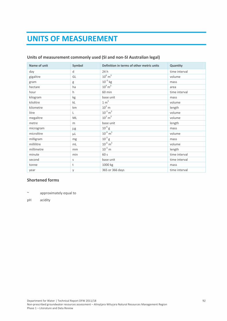
Department for Water | Technical Report DFW 2011/18 92 Non-prescribed groundwater resources assessment – Alinytjara Wilurara Natural Resources Management Region Phase 1 – Literature and Data Review
UNITS OF MEASUREMENT
Units of measurement commonly used (SI and non-SI Australian legal)
Name of unit Symbol Definition in terms of other metric units Quantity
day d 24 h time interval
gigalitre GL 106 m
3 volume
gram g 10–3 kg mass
hectare ha 104 m2 area
hour h 60 min time interval
kilogram kg base unit mass
kilolitre kL 1 m3 volume
kilometre km 103 m length
litre L 10-3 m3 volume
megalitre ML 103 m3 volume
metre m base unit length
microgram g 10-6 g mass
microlitre L 10-9
m3 volume
milligram mg 10-3 g mass
millilitre mL 10-6 m3 volume
millimetre mm 10-3 m length
minute min 60 s time interval
second s base unit time interval
tonne t 1000 kg mass
year y 365 or 366 days time interval
Shortened forms
~ approximately equal to
pH acidity
Department for Water | Technical Report DFW 2011/18 93 Non-prescribed groundwater resources assessment – Alinytjara Wilurara Natural Resources Management Region Phase 1 – Literature and Data Review
GLOSSARY
Geological terms are largely taken from the Collins Internet-linked Dictionary of Geology
ABS — Australian Bureau of Statistics
Acidic — having a high hydrogen ion content (pH < 7)
Act (the) — in this document, refers to the Natural Resources Management (SA) Act 2004, which supersedes the Water Resources (SA) Act 1997
Aeolian — pertaining to or caused by wind
Age — (1) unit of geological time, shorter than an epoch, during which rocks of that period were formed; (2) the position of any feature relative to the geological time scale
AGT — Australian Groundwater Technologies
AHD — Australian Height Datum; the geodetic datum for altitude measurement in Australia. In 1971 the mean sea level for 1966–1968 was assigned the value of zero on the Australian Height Datum at thirty tide gauges around the coast of the Australian continent.
Alluvial — composed of or pertaining to alluvium, or deposited by running water
Alluvial fan — an outspread mass of alluvium deposited by flowing water where it debouches from a steep narrow canyon on to a plain or valley floor. The abrupt change of gradient eventually reduces the transport of sediment by the issuing stream. Viewed from above, the deposits are usually fan-shaped; they are especially prominent in arid areas
Alluvium — general term for detrital deposits made by rivers or streams or found on alluvial fans, floodplains, etc. Alluvium consists of gravel, sand, silt and clay and often contains organic matter. It does not include the subaqueous sediments of lakes and seas
Amphibole — important group of rock-forming minerals that occur in a wide range of igneous and metamorphic rocks whose molecular structure is based on silica tetrahedral linked to give double chains, (Si4O11)n, in a lattice that gives scope for very extensive ionic substitution
Amphibolite — metamorphic rock consisting mainly of amphibole and plagioclase, little or no quartz and crystalloblastic texture
Anthropogenic — of, relating to, or resulting from the influence of human beings on nature
Apron — a broadly extended deposit of unconsolidated material at the base of a mountain or in front of a glacier
Aquifer — an underground layer of rock or sediment that holds water and allows water to percolate through it
Aquifer, confined — aquifer in which the upper surface is impervious (see ‘confining layer’) and the water is held at greater than atmospheric pressure; water in a penetrating well will rise above the surface of the aquifer
Aquifer test — a hydrological test performed on a well, aimed to increase the understanding of the aquifer properties, including any interference between wells and to more accurately estimate the sustainable use of the water resources available for development from the well
Aquifer, unconfined — aquifer in which the upper surface has free connection to the ground surface and the water surface is at atmospheric pressure
Aquitard — a layer in the geological profile that separates two aquifers and restricts the flow between them
Archaean — the eon of the Precambrian between 4000 Ma and 2500 Ma; the rocks that formed in that time
Arid lands — in South Australia, arid lands are usually considered to be areas with an average annual rainfall of less than 250 mm and support pastoral activities instead of broadacre cropping
GLOSSARY
Department for Water | Technical Report DFW 2011/18 94 Non-prescribed groundwater resources assessment – Alinytjara Wilurara Natural Resources Management Region Phase 1 – Literature and Data Review
Artesian — an aquifer in which the water surface is bounded by an impervious rock formation; the water surface is at greater than atmospheric pressure and hence rises in any well which penetrates the overlying confining aquifer
Artificial recharge — the process of artificially diverting water from the surface to an aquifer; artificial recharge can reduce evaporation losses and increase aquifer yield; see also ‘natural recharge’, ‘aquifer’
AWNRMG — Alinytjara Wilurara Natural Resources Management Group
AWNRMB — Alinytjara Wilurara Natural Resources Management Board
Banded iron formation — sedimentary rocks that are typically bedded or laminated and composed of at least 25% iron
Baseflow — the water in a stream that results from groundwater discharge to the stream; often maintains flows during seasonal dry periods and has important ecological functions
Basement — the surface beneath which sedimentary rocks are not found
Basin — the area drained by a major river and its tributaries
Bedded — arranged in layers
Biodiversity — (1) the number and variety of organisms found within a specified geographic region. (2) The variability among living organisms on the earth, including the variability within and between species and within and between ecosystems
BoM — Bureau of Meteorology, Australia
Cainozoic — the (‘recent life’) era covering the last 66 Ma; it is subdivided into the Tertiary and Quaternary periods
Calcrete — a limestone precipitated as surface or near-surface crusts and nodules by the evaporation of soil moisture in semi-arid climates
Cambrian — the oldest of the Palaeozoic Era, having a duration of about 50 Ma and beginning about 544 Ma ago
Catchment — that area of land determined by topographic features within which rainfall will contribute to runoff at a particular point
Catchment Water Management Board — a statutory body established under the Act whose prime function is to implement a catchment water management plan for its area
Catchment water management plan — the plan prepared by a CWMB and adopted by the Minister in accordance with the Act
Claypan — dense, clayey subsoil layer that is hard when dry but may be plastic when wet
Codes of practice — standards of management developed by industry and government, promoting techniques or methods of environmental management by which environmental objectives may be achieved
Colluvium — unconsolidated material at the bottom of a cliff or slope, generally moved by gravity alone
Cone of depression — an inverted cone-shaped space within an aquifer caused by a rate of groundwater extraction that exceeds the rate of recharge; continuing extraction of water can extend the area and may affect the viability of adjacent wells, due to declining water levels or water quality
Confining layer — a rock unit impervious to water, which forms the upper bound of a confined aquifer; a body of impermeable material adjacent to an aquifer; see also ‘aquifer, confined’
Conjunctive use — the utilisation of more than one source of water to satisfy a single demand
Consolidation — any process whereby soft or loose earth materials become firm
Contaminant — a material added by humans or natural activities that may, in sufficient concentrations, render the environment unacceptable for biota; the presence of these materials is not necessarily harmful
Craton — part of the continental crust that has been stable for at least 1000 Ma
Crystalline — having a regular atomic or molecular structure but without developing easily discernible crystal faces
GLOSSARY
Department for Water | Technical Report DFW 2011/18 95 Non-prescribed groundwater resources assessment – Alinytjara Wilurara Natural Resources Management Region Phase 1 – Literature and Data Review
Crystalloblastic — of a crystalline texture formed by metamorphic conditions of high viscosity and regional pressure, as distinct from igneous rock textures
CSIRO — Commonwealth Scientific and Industrial Research Organisation
CWMB — Catchment Water Management Board
Data comparability — The characteristics that allow information from many sources to be of definable or equivalent quality, so that this information can be used to address program objectives not necessarily related to those for which the data were collected. These characteristics need to be defined but would likely include detection limit precision, accuracy, bias, etc
DES — Drillhole Enquiry System; a database of groundwater wells in South Australia, compiled by the South Australian Department of Water, Land and Biodiversity Conservation (DWLBC)
DFW — Department for Water (Government of South Australia)
Diamictite — a terrigenous sedimentary rock containing a mixture of particles
Discharge — groundwater discharge is the removal of water from the saturated zone across the watertable surface, together with the associated flow toward the watertable within the saturated zone
Domestic purpose — the taking of water for ordinary household purposes; includes the watering of land in conjunction with a dwelling not exceeding 0.4 hectares
Donga — a gully formed by the erosion of surficial deposits by runoff
Downgradient — the direction that groundwater flows; similar to downstream for surface water
DPC — Department of Premier and Cabinet (Government of South Australia)
Drillhole — See ‘well’. A hole or passage made by a drill; usually made for exploratory purposes. Typically used in the mining industry.
Dryland salinity — the process whereby salts stored below the surface of the ground are brought close to the surface by the rising watertable. The accumulation of salt degrades the upper soil profile, with impacts on agriculture, infrastructure and the environment.
DTEI — Department of Transport, Energy and Infrastructure (Government of South Australia)
Dunefield —an area covered by extensive sand dunes
DWLBC — Department of Water, Land and Biodiversity Conservation (Government of South Australia)
Ecology — the study of the relationships between living organisms and their environment
Ecosystem — any system in which there is an interdependence upon and interaction between, living organisms and their immediate physical, chemical and biological environment
Environmental values — the uses of the environment that are recognised as being of value to the community. This concept is used in setting water quality objectives under the Environment Protection (Water Quality) Policy, which recognises five environmental values — protection of aquatic ecosystems, recreational water use and aesthetics, potable (drinking water) use, agricultural and aquaculture use and industrial use. It is not the same as ecological values, which are about the elements and functions of ecosystems.
Environmental water provisions — that part of environmental water requirements that can be met; what can be provided at a particular time after consideration of existing users’ rights and social and economic impacts
Environmental water requirements — the water regimes needed to sustain the ecological values of aquatic ecosystems, including their processes and biological diversity, at a low level of risk
Eocene — the middle epoch of the Tertiary period between the Palaeocene and Oligocene epochs
Eon — a division of geological time, the longest time unit, next in order above era; the term is also used for an interval of 109 years
GLOSSARY
Department for Water | Technical Report DFW 2011/18 96 Non-prescribed groundwater resources assessment – Alinytjara Wilurara Natural Resources Management Region Phase 1 – Literature and Data Review
Ephemeral streams or wetlands — streams or wetlands that usually contain water only on an occasional basis after rainfall events. Many arid zone streams and wetlands are ephemeral.
Epoch — an interval of geological time longer than an age and shorter than a period during which the rocks of a particular series were formed
Equivalent — agreeing or corresponding in geological age or position within the stratigraphical profile
Era — a geological time unit one order of magnitude below eon
Erosion — natural breakdown and movement of soil and rock by water, wind or ice; the process may be accelerated by human activities
Evapotranspiration — the total loss of water as a result of transpiration from plants and evaporation from land and surface water bodies
Exposure — an area where rocks can be seen free from the soil and vegetation cover
Facies — an assemblage or association of mineral, rock or fossil features reflecting the environment and conditions of the origin of the rock; it refers to the appearance and peculiarities that distinguish a rock unit from associated or adjacent units
Ferricrete — an amalgam of surface sand and gravel cemented into a mass by iron oxide
Fissile — capable of being split or cleft or divided easily along close parallel planes of weakness
Flow regime — the character of the timing and amount of flow in a stream
Fluvial — of or pertaining to rivers; produced by the action of a river or stream
Fossil water — groundwater that has remained sealed in an aquifer for a long period of time
Fossiliferous — (of rocks or strata) containing or bearing fossils
Fractured rock aquifer — aquifer in which groundwater flow occurs along fractures, faults and weathered zone (secondary porosity)
Fresh — a short duration, small volume pulse of streamflow generated by a rainfall event that temporarily, but noticeably, increases stream discharge above ambient levels
Fully-penetrating well — in theory this is a well hole that is screened throughout the full thickness of the target aquifer; in practice, any screen that is open to at least the mid 80% of a confined aquifer is regarded as fully-penetrating
GAB — Great Artesian Basin
Geological features — includes geological monuments, landscape amenity and the substrate of land systems and ecosystems
Geological province — an extensive area characterised by similar geological history and development
Geomorphic — pertaining to or related to the physical properties of the Earth or its surface features
Geomorphology — the scientific study of the landforms on the Earth’s surface and of the processes that have fashioned them
Gibber plain — a residual layer of wind-polished, closely concentrated rock fragments covering a desert surface because of the removal of loose silt and sand
GIS — Geographic Information System; computer software linking geographic data (for example land parcels) to textual data (soil type, land value, ownership). It allows for a range of features, from simple map production to complex data analysis
Gneiss — a foliated metamorphic rock formed under conditions of high-grade regional metamorphism
Granite — in the strict sense a coarse-grained alkali-rich plutonic igneous rock composed primarily of quartz and one or two feldspars
GLOSSARY
Department for Water | Technical Report DFW 2011/18 97 Non-prescribed groundwater resources assessment – Alinytjara Wilurara Natural Resources Management Region Phase 1 – Literature and Data Review
Granulite — a high-grade metamorphic rock composed of equal-sized, interlocking grains
Gravel — an unconsolidated accumulation consisting of particles larger than sand (diameter >2 mm), i.e. granules, pebbles, cobbles, boulders or any combination of these
Groundwater — water occurring naturally below ground level or water pumped, diverted and released into a well for storage underground; see also ‘underground water’
Habitat — the natural place or type of site in which an animal or plant, or communities of plants and animals, live
Headwaters — small streams that make up the source and uppermost portion of a river or stream before the main tributaries join it
Hydrogeology — the study of groundwater, which includes its occurrence, recharge and discharge processes and the properties of aquifers; see also ‘hydrology’
Igneous rock — a rock that solidified from molten rock material (magma) that was generated deep within the Earth
Indigenous species — a species that occurs naturally in a region
Infiltration — the movement of a fluid into a solid substance through pores or cracks, in particular the movement of water into soil or porous rock
Interdunal — between dunes
Irrigation — watering land by any means for the purpose of growing plants
Karst — a type of topography characterised by caves and sinkholes shaped by the dissolution of soluble bedrock, usually carbonate rock such as limestone
Lake — a natural lake, pond, lagoon, wetland or spring (whether modified or not) that includes part of a lake and a body of water declared by regulation to be a lake. A reference to a lake is a reference to the bed, banks and shores of the lake or the water for the time being held by the bed, banks and shores of the lake, or both, depending on the context.
Land — whether under water or not and includes an interest in land and any building or structure fixed to the land
Limestone — a rock composed primarily of calcareous sediments consisting of calcium carbonate (CaCO3)
Lunette — an arcuate dune formed on the lee side of a lake basin or river bed in semi-arid areas
m AHD — defines elevation in metres (m) according to the Australian Height Datum (AHD)
Ma — abbreviation for 106 years (one million years)
Marinoan — youngest chronostratigraphic unit of the Adelaidean period
Mesoproterozoic — middle era of the Proterozoic that occurred between 1600–1000 Ma
Mesozoic — era of geological time between 251 and 66 Ma
Metadata — information that describes the content, quality, condition and other characteristics of data, maintained by the Federal Geographic Data Committee
Metamorphic rock — any of a class of rocks that are the result of partial or complete recrystallisation in the solid state of pre-existing rocks under conditions of temperature and pressure that are significantly different from those obtaining at the surface of the Earth
Miocene — the epoch of the Tertiary Period between the Oligocene and the Pliocene epochs from 23–5 Ma
Model — a conceptual or mathematical means of understanding elements of the real world that allows for predictions of outcomes given certain conditions. Examples include estimating storm runoff, assessing the impacts of dams or predicting ecological response to environmental change
Monitoring — (1) the repeated measurement of parameters to assess the current status and changes over time of the parameters measured; (2) periodic or continuous surveillance or testing to determine the level of compliance with statutory requirements and/or pollutant levels in various media or in humans, animals and other living things
GLOSSARY
Department for Water | Technical Report DFW 2011/18 98 Non-prescribed groundwater resources assessment – Alinytjara Wilurara Natural Resources Management Region Phase 1 – Literature and Data Review
Mudstone — a mud-supported carbonate sedimentary rock containing less than 10% particles of clay and fine silt size
Native species — any animal and plant species originally in Australia; see also ‘indigenous species’
Natural recharge — the infiltration of water into an aquifer from the surface (rainfall, streamflow, irrigation etc). See also recharge area, artificial recharge
Natural resources — soil, water resources, geological features and landscapes, native vegetation, native animals and other native organisms, ecosystems
Neogene — the youngest of the Tertiary periods (23–2.6 Ma), subdivided into the Miocene and the Pliocene epochs
Neoproterozoic — the youngest era of the Proterozoic (1000–542 Ma)
Nodule — an irregular, spherical to ellipsoidal, flattened to cylindrical body, commonly composed of calcite, pyrite and chert
NRM — Natural Resources Management; all activities that involve the use or development of natural resources and/or that impact on the state and condition of natural resources, whether positively or negatively
NLWRA — National Land and Water Resource Audit; ‘The Audit’
Observation well — a narrow well or piezometer whose sole function is to permit water level measurements
Obswell — Observation Well Network
Onlap — the successive increase in the area covered by beds in a sedimentary sequence. The term ‘overlap’ describes the relationship between beds in a sequence above an unconformity. The term ‘onlap’ refers to the process by which overlap is produced
Outcrop — an exposure of bedrock or superficial deposits at the surface of the Earth
Outwash — gravel and sand deposited by meltwater streams on land
Overthrust — when pressure pushes rock strata up until one side folds over onto the second side; this will cause younger rock layers to be located under older layers
PACE 2020 — Plan for Accelerated Exploration
Palaeochannel — ancient buried river channel formed by palaeorivers in arid areas of the state
Palaeochannel deposits — refer to the sediments that infill the palaeochannels
Palaeodrainage — refers to a network of palaeorivers
Palaeogene — the oldest of the Tertiary periods from 66–23 Ma; consists of the Palaeocene, Eocene and Oligocene epochs, from oldest to youngest
Palaeoproterozoic — The oldest of the Proterozoic Eon, from 2500–1600 Ma
Palaeoriver — refers to an ancient fluvial system responsible for a particular feature
Palaeovalleys — refers to the valleys incised by the palaeorivers
Palaeozoic — the era extending from about 542–251 Ma. The lower Palaeozoic includes the Cambrian, Ordovician and Silurian periods; the upper Palaeozoic includes the Devonian, Carboniferous and Permian periods. It was preceded by the Precambrian and followed by the Mesozoic
PB — Parsons Brinckerhoff
Pasture — grassland used for the production of grazing animals such as sheep and cattle
Penetrating well — see ‘fully-penetrating well’
Perennial streams — permanently inundated surface stream courses. Surface water flows throughout the year except in years of infrequent drought.
GLOSSARY
Department for Water | Technical Report DFW 2011/18 99 Non-prescribed groundwater resources assessment – Alinytjara Wilurara Natural Resources Management Region Phase 1 – Literature and Data Review
Permeable — allowing a gas or fluid to move through it at an appreciable rate
Permeability — a measure of the ease with which water flows through an aquifer or aquitard, measured in m2/d
Permian — the period at the end of the Palaeozoic Era, from 299–251 Ma and is subdivided into the Cisuralian, Guadalupian and Lopingian epochs from oldest to youngest
Piezometer — a narrow tube, pipe or well; used for measuring moisture in soil, water levels in an aquifer, or pressure head in a tank, pipeline, etc
PIRSA — Primary Industries and Resources South Australia (Government of South Australia)
Plagioclase — a series of feldspars with compositions in the range of NaAlSi3O8 to CaAl2Si2O8
Playa — a flat, dry barren plain at the bottom of a desert basin, underlain by silt, clay and evaporates; it is often the bed of an ephemeral lake and may be covered with white salts
Playa lake — a shallow recurring lake that covers a playa after rains but disappears during a dry period
Pleistocene — the oldest epoch of the Quaternary Period
Pliocene — the youngest epoch of the Tertiary Period
Potable water — water suitable for human consumption such as drinking or cooking water
Potentiometric head — the potentiometric head or surface is the level to which water rises in a well due to water pressure in the aquifer, measured in metres (m); also known as piezometric surface
Precambrian — the period of time from the formation of the Earth, 4600 Ma to about 542 Ma ago, during which the Earth’s crust was formed and the first organisms appeared. The Precambrian is now used informally to describe the Hadean (4600–4000 Ma), Archaean (4000–2500 Ma) and Proterozoic (2500–542 Ma) eons
Precipitation — (1) the falling to earth of any form of water (rain or snow or hail or sleet or mist); (2) the formation of a solid in a solution or inside another solid during a chemical reaction or by diffusion in a solid
Proterozoic — the last of the three major subdivisions of the Precambrian. The Proterozoic has been divided into three eras; the Palaeoproterozoic (2500–1600 Ma), Mesoproterozoic (1600–1000 Ma) and the Neoproterozoic (1000–542 Ma)
Prescribed water resource — a water resource declared by the Governor to be prescribed under the Act and includes underground water to which access is obtained by prescribed wells. Prescription of a water resource requires that future management of the resource be regulated via a licensing system.
Prescribed well — a well declared to be a prescribed well under the Act
Production well — the pumped well in an aquifer test, as opposed to observation wells; a wide-hole well, fully developed and screened for water supply, drilled on the basis of previous exploration wells
PWA — Prescribed Wells Area
PWCA — Prescribed Watercourse Area
PWRA — Prescribed Water Resources Area
Quaternary — the most recent period of geological time, a division of the Cainozoic
Radioactivity — a property of certain elements that spontaneously and constantly emit ionising and penetrating radiation
Recharge — see natural recharge, artificial recharge
Recharge area — the area of land from which water from the surface (rainfall, streamflow, irrigation, etc.) infiltrates into an aquifer. See also artificial recharge, natural recharge
Reverse fault — the hanging wall (the wall rock above a fault), has moved upward relative to the footwall (mass of rock below a fault plane)
Reticulated water — water supplied through a piped distribution system
GLOSSARY
Department for Water | Technical Report DFW 2011/18 100 Non-prescribed groundwater resources assessment – Alinytjara Wilurara Natural Resources Management Region Phase 1 – Literature and Data Review
Riparian — of, pertaining to, or situated or dwelling on the bank of a river or other water body
Rockhole — a shallow, small depression in rock outcrops, often rounded in form and holding water after rains
Runoff — that part of precipitation that appears in or makes its way to surface streams
SA Geodata — a collection of linked databases storing geological and hydrogeological data which the public can access through the offices of PIRSA. Custodianship of data related to minerals and petroleum and groundwater, is vested in PIRSA and DFW, respectively. DFW should be contacted for database extracts related to groundwater
Salt lake — a body of water in an arid or semi-arid region having no outlet to the ocean and containing high concentration of salt
Sandstone — a sedimentary rock composed of sand-sized particles with varying amounts of a fine-grained matrix of clay or silt
SA Water — South Australian Water Corporation (Government of South Australia)
Schist — a metamorphic rock that is not defined by mineral composition but by the well-developed parallel orientation of more than 50% of the minerals present
Seasonal watercourses or wetlands — those watercourses or wetlands that contain water on a seasonal basis, usually over the winter–spring period, although there may be some flow or standing water at other times
Sediment — solid material, organic or inorganic in origin, that has settled out from a state of suspension in a fluid and has been transported and deposited by wind, water or ice; loose sediment such as sand and mud may become consolidated and/or cemented to form coherent sedimentary rock
Sedimentary — containing sediment or formed by its deposition
Sedimentation — the process of depositing sediments
Shale — a fine-grained fissile sedimentary rock formed by the compaction of clay or silt; it is the most abundant of all sedimentary rocks
Silcrete — a hard surface deposit composed of sand and gravel cemented by opal, chert and quartz, formed by chemical weathering and water evaporation in semi-arid climates
Siliciclastic — a clastic rock whose clasts are predominantly of silicate minerals
Siltstone — a fine-grained sedimentary rock principally composed of silt-grade material
Sink hole — an approximately circular depression in limestone terrain into which water drains and collects
Soak — A soak is where good-quality or marginally saline groundwater is held in an aquifer close to the surface
Specific storage (Ss) — specific storativity; the amount of stored water realised from a unit volume of aquifer per unit decline in head; it is dimensionless
Specific yield (Sy) — the volume ratio of water that drains by gravity, to that of total volume of the porous medium. It is dimensionless
Spring — a natural flow of water from underground where the watertable intersects the ground surface
State Water Plan — policy document prepared by the Minister that sets the strategic direction for water resource management in the State and policies for achieving the objects of the Natural Resources Management (SA) Act 2004
Stratigraphy — all characteristics and attributes of rocks as they are in strata and the interpretation of strata in terms of derivation and geological background
Stock use — the taking of water to provide drinking water for stock other than stock subject to intensive farming (as defined by the Act)
Storativity (S) — storage coefficient; the volume of groundwater released or taken into storage per unit plan area of aquifer per unit change of head; it is dimensionless
GLOSSARY
Department for Water | Technical Report DFW 2011/18 101 Non-prescribed groundwater resources assessment – Alinytjara Wilurara Natural Resources Management Region Phase 1 – Literature and Data Review
Surface water — (a) water flowing over land (except in a watercourse), (i) after having fallen as rain or hail or having precipitated in any another manner, (ii) or after rising to the surface naturally from underground; (b) water of the kind referred to in paragraph (a) that has been collected in a dam or reservoir
Surficial — pertaining to or occurring on or near the Earth's surface
Sustainable yield — the amount of groundwater able to be extracted from an aquifer without adverse consequences to the system
Sustainability — the ability of an ecosystem to maintain ecological processes and functions, biological diversity and productivity over time
SWL — Depth to groundwater below the natural ground surface
TDS — total dissolved solids, measured in milligrams per litre (mg/L); a measure of water salinity
Tectonic — relating to structures of, or forces associated with, tectonics
Tectonics — branch of geology that deals with the geometry of rocks and the forces and movements that produced them
Tertiary — oldest geological period of the Cainozoic Era (66–2.6 Ma)
Tertiary aquifer — a term used to describe a water-bearing rock formation deposited in the Tertiary geological period
Terrigenous — see siliciclastic
Throughflow — the movement of water horizontally beneath the land surface
Thrust — a low-angle reverse fault
Topography — the general configuration of a land surface, including size, relief and elevation
Tributary — a river or creek that flows into a larger river
Underground water (groundwater) — water occurring naturally below ground level or water pumped, diverted or released into a well for storage underground
Volcanics — relating to a volcano
Volumetric allocation — an allocation of water expressed on a water licence as a volume (e.g. kilolitres) to be used over a specified period of time, usually per water use year (as distinct from any other sort of allocation)
Water allocation — (1) in respect of a water licence means the quantity of water that the licensee is entitled to take and use pursuant to the licence; (2) in respect of water taken pursuant to an authorisation under s.11 means the maximum quantity of water that can be taken and used pursuant to the authorisation
Water allocation, area based — an allocation of water that entitles the licensee to irrigate a specified area of land for a specified period of time usually per water–use year
Water cut — The depth at which a water-bearing unit is intersected during the process of drilling a well
Water hole — a depression where water collects
WAP — Water Allocation Plan; a plan prepared by a CWMB or water resources planning committee and adopted by the Minister in accordance with the Act
Water body — includes watercourses, riparian zones, floodplains, wetlands, estuaries, lakes and groundwater aquifers
Watercourse — a river, creek or other natural watercourse (whether modified or not) and includes: a dam or reservoir that collects water flowing in a watercourse; a lake through which water flows; a channel (but not a channel declared by regulation to be excluded from the this definition) into which the water of a watercourse has been diverted; and part of a watercourse
Water-dependent ecosystems — those parts of the environment, the species composition and natural ecological processes, that are determined by the permanent or temporary presence of flowing or standing water, above or
GLOSSARY
Department for Water | Technical Report DFW 2011/18 102 Non-prescribed groundwater resources assessment – Alinytjara Wilurara Natural Resources Management Region Phase 1 – Literature and Data Review
below ground; the in-stream areas of rivers, riparian vegetation, springs, wetlands, floodplains, estuaries and lakes are all water-dependent ecosystems
Water plans — The State Water Plan, catchment water management plans, water allocation plans and local water management plans prepared under Part 7 of the Act
Water quality data — chemical, biological and physical measurements or observations of the characteristics of surface and groundwaters, atmospheric deposition, potable water, treated effluents, and wastewater and of the immediate environment in which the water exists
Water quality information — derived through analysis, interpretation and presentation of water quality and ancillary data
Water quality monitoring — an integrated activity for evaluating the physical, chemical and biological character of water in relation to human health, ecological conditions and designated water uses
Water resource monitoring — an integrated activity for evaluating the physical, chemical and biological character of water resources, including (1) surface waters, groundwaters, estuaries and near-coastal waters; and (2) associated aquatic communities and physical habitats, which include wetlands
Water resource quality — (1) the condition of water or some water-related resource as measured by biological surveys, habitat-quality assessments, chemical-specific analyses of pollutants in water bodies and toxicity tests; (2) the condition of water or some water-related resource as measured by habitat quality, energy dynamics, chemical quality, hydrological regime and biotic factors
WDE — water dependent ecosystem
Weathering — destructive natural processes by which rocks are altered with little or no transport of the fragmented or altered material
Well — (1) an opening in the ground excavated for the purpose of obtaining access to underground water; (2) an opening in the ground excavated for some other purpose but that gives access to underground water; (3) a natural opening in the ground that gives access to underground water
Wetland — defined by the Act as a swamp or marsh and includes any land that is seasonally inundated with water. This definition encompasses a number of concepts that are more specifically described in the definition used in the Ramsar Convention on Wetlands of International Importance. This describes wetlands as areas of permanent or periodic to intermittent inundation, whether natural or artificial, permanent or temporary, with water that is static or flowing, fresh, brackish or salt, including areas of marine water, the depth of which at low tides does not exceed six metres.
Whorl — a pattern of concentric circles
Department for Water | Technical Report DFW 2011/18 103 Non‐prescribed groundwater resources assessment – Alinytjara Wilurara Natural Resources Management Region Phase 1 – Literature and Data Review
REFERENCES
ABS 2006, Experimental Estimates of Regional Water Use, Australia, 2004‐2005, Australian Bureau of Statistics,
Canberra, viewed December 2010,
http://www.abs.gov.au/AUSSTATS/[email protected]/Lookup/4610.0.55.002Main+Features12004‐2005?OpenDocument
AGT 2010a, Alinytjara Wilurara Natural Resources Management Region Groundwater Review, Report No.
2009/993, Australian Groundwater Technologies, Mile End
AGT 2010b, Review of the Basic Capacity of the Groundwater Resources in the Far North, Australian Groundwater
Technologies, Mile End
AGT 2010c, Review of Groundwater Monitoring Kangaroo Island NRM Board Area Alinytjara Wilurara NRM Board
Area, Report No. 2010/1013B, Australian Groundwater Technologies, Mile End
Alexander, EM and Dodds, AR 1997, ‘Infrastructure and Groundwater’, in Morton, JGG and Drexel, JF (eds), The
Petroleum Geology of South Australia, Vol. 3, Officer Basin, Report Book 97/19, Department of Mines and Energy,
South Australia
AWNRMG 2004, Integrated Natural Resources Management Plan for the Aboriginal Lands Integrated Natural
Resources Management Region of South Australia, Alinytjara Wilurara Natural Resources Management Group
AWNRMB 2009, Alinytjara Wilurara Draft Regional NRM Plan, Alinytjara Wilurara Natural Resources Management
Board, Adelaide
Benbow, MC, Lindsay, JM & Alley, NF 1995, ‘Eucla Basin and palaeodrainage’, in Drexel, JF & Preiss, WV (eds), The
Geology of South Australia, Vol. 2, The Phanerozoic, Bulletin 54, Geological Survey, Adelaide, pp.178‐186
Blissett, AH (compiler) 1980, Explanatory Notes for the CHILDARA 1:250 000 Geological Map, Department of Mines
and Energy, Sheet SH/53‐14, Geological Survey of South Australia
Brookes, JD & Lewis, DM 2006 Water Resources in the Maralinga Tjarutja Lands – The Current State: Final Report,
University of Adelaide, December 2006
BoM 2011, Monthly Climate Statistics, Bureau of Meteorology, viewed January 2011,
http://www.bom.gov.au/climate/data/
Buxton, P 2005, Alinytjara Wilurara Natural Resources Management Region — Water Monitoring Review,
Department of Water, Land and Biodiversity Conservation
Callen, RA and Benbow, MC 1995, ‘The Deserts — Playas, Dunefields and Watercourses’, in Drexel, JF & Preiss, WV
(eds), The Geology of South Australia, Vol. 2, The Phanerozoic, Bulletin 54, Geological Survey, Adelaide, pp.244‐251
Copley, PB & Kemper, CM 1992, A Biological Survey of the Yellabinna Region, South Australia in October 1987,
Adelaide, South Australia
Cotton, TB, Scardigno, MF and Hibburt, JE (Eds) 2006, The petroleum geology of South Australia, Vol. 2: Eromanga
Basin, 2nd edn, Department of Primary Industries and Resources, Petroleum Geology of South Australia Series,
South Australia
Crosbie, RS, McCallum, JL, Walker, GR and Chiew, FHS 2008, Diffuse groundwater recharge modelling across the
Murray‐Darling Basin, A report to the Australian government from the CSIRO Murray‐Darling Basin Sustainable
Yields Project, CSIRO, Australia
DFW 2011, Eyre Peninsula Demand and Supply Statement, Department For Water, Government of South Australia,
Adelaide
REFERENCES
Department for Water | Technical Report DFW 2011/18 104 Non-prescribed groundwater resources assessment – Alinytjara Wilurara Natural Resources Management Region Phase 1 – Literature and Data Review
DPC 2008, Progress on the Lands, Update on the Anangu Pitjantjatjara Yankunytjatjara (APY) Lands, Department of
Premier and Cabinet, South Australia, October 2008
Dodds, AR 1996, A Groundwater and Basement Surface Study of the North-west Gawler Craton, SA, Department of
Mines and Energy, Report Book 97/6, Geological Survey of South Australia, Adelaide
Dodds, S 1997, An Assessment of the Groundwater Resources of the Lake Maurice Area, North-west South
Australia, for the Oak Valley Community, Maralinga Tjarutja Aboriginal Lands, Report Book 97/56, Department of
Mines and Energy, Adelaide
Dodds, AR and Sampson, LD 2002, Hydrogeological Report on Water Well Monitoring in Aboriginal Lands to May
2002, Department of Water, Land and Biodiversity Conservation, Report 2002/26, South Australia
Drexel, JF, Preiss, WV and Parker, AJ 1993, The Geology of South Australia. Volume 1, The Precambrian, South
Australia Geological Survey, Bulletin 54, Adelaide
Drexel, JF and Preiss, WV 1995, The Geology of South Australia. Volume 2, The Phanerozoic, South Australia
Geological Survey, Bulletin 54, Adelaide
DTEI 2005, Strategic Infrastructure Plan for South Australia 2005/6–2014/15, Department of Energy and
Infrastructure, Adelaide
Fairclough, MC, Benbow, MC and Rogers, PA 2007, Explanatory Notes for the OOLDEA 1:250 000 Geological Map,
Department of Primary Industries and Resources, Report Book 2007/11, Geological Survey of South Australia,
Adelaide
Fitzgerald, J, Cunliffe, D, Rainow, S, Dodds, S, Hostetler, S & Jacobson, G 2000, Groundwater Quality and
Environmental Health Implications, Anangu Pitjantjatjara Lands, South Australia, Bureau of Rural Sciences,
Canberra
Fitzpatrick, A 2010, ‘Direct water detection and hydraulic properties estimation using the latest Magnetic
Resonance Sounding technology in Australia’, Groundwater 2010 National Groundwater Conference, Canberra
Flint, RB and Daly, SJ 1993, ‘Coompana Block’, in Drexel, JF & Preiss, WV (eds), The Geology of South Australia, Vol.
1, The Precambrian, Bulletin 54, Geological Survey, Adelaide, pp.168-169
Frakes, LA & White, M 1997, ‘Tertiary palaeochannels draining the Gawler Craton’, in MESA Journal, 6, pp.10–11
GHD 2009, Report for Future Management of Water Resources: Consolidated Report for Stages, 3, 4 and 5,
Unpublished draft report for the Alinytjara Wilurara Natural Resources Management Board, August 2009
Harding, C and O’Connor, P 2010, A Preliminary Risk Assessment of Water Dependent Ecosystems in South
Australia – Phase 1, DFW Technical Report 2011/XX, Government of South Australia, through Department for
Water, Adelaide
Herczeg, AL and Love, AJ 2007, Review of Recharge Mechanisms for the Great Artesian Basin, CSIRO
Hou, B, Frakes, LA, Alley, NF and Clarke, JDA 2003, Characteristics and evolution of the Tertiary Palaeovalleys in the
North-west Gawler Craton, South Australia, Australian Journal of Earth Sciences, 50, pp. 215-230
Hou, B, Zang, W, Fabris, A, Keeling, J, Stoian, L & Fairclough, M (compilers) 2007, Palaeodrainage and Tertiary
Coastal Barriers of South Australia, Digital Geological Map of South Australia, 1:2 000 000 Series (1st Edition), CRC
LEME, Geological Survey Branch, Primary Industries Resources South Australia
Hou, B, Frakes, LA, Sandiford, M, Worrall, L, Keeling, J, Alley, NF 2008, Cenozoic Eucla Basin and Associated
Palaeovalleys, Southern Australia - Climatic and Tectonic Influences on Landscape Evolution, Sedimentation and
Heavy Mineral Accumulation, in Sedimentary Geology, 203 (1-2), pp. 112-130
REFERENCES
Department for Water | Technical Report DFW 2011/18 105 Non-prescribed groundwater resources assessment – Alinytjara Wilurara Natural Resources Management Region Phase 1 – Literature and Data Review
Hou, B, Keeling, J, Reid, A, Warland, I, Belousova, E, Frakes, LA, Hocking, R and Fairclough, M (in press), Heavy
Mineral Sands in the Eucla basin, Southern Australia: Deposition and Province-scale Prospectivity, Economic
Geology
Lewis, SJ, English, PM, Wischusen, JDH, Woodgate, M, Gow, L, Hanna, A, Kilgour, P 2010, The Palaeovalley
Groundwater Project: Operational Update on Demonstration Study Sites, Geoscience Australia
Magee, JW 2009, Palaeovalley groundwater resources in arid and semi-arid Australia – A Literature Review,
Geoscience Australia, Record 2009/03, Canberra
Major, RB & Conor, CHH 1993, ‘Musgrave Block’, in Drexel, JF & Preiss, WV (eds), The Geology of South Australia,
Vol. 1, The Precambrian, Bulletin 54, Geological Survey, Adelaide, pp.156-167
Martin, R, Sereda, A & Clarke, D 1998, Spencer Regions strategic water management study, Report Book 98/19,
Primary Industries and Resources South Australia, Adelaide
Mason, MG 1975, Groundwater Near Giddi Giddinna Creek, North-east of Coober Pedy, South Australia, Geological
Survey of South Australia, Quarterly Geological Notes, 56, pp. 2-6
Milton, BE & Parker, AJ 1973, An Interpretation of Geophysical Observations on the Northern Margin of the Eastern
Officer Basin, Geological Survey of South Australia, Quarterly Geological Notes, 46, pp. 10-14
Morton, JGG 1997, ‘Litostratigraphy and Environments of Deposition’, in Morton, JGG & Drexel, JF (eds), Petroleum
Geology of South Australia, Volume 3 — Officer Basin, Department of Mines and Energy Resources, Report Book
97/19, pp. 47-86
Government of South Australia 2009, Water for Good - A plan to ensure our water future to 2050, Office for Water
Security, Government of South Australia, Adelaide
Parker, AJ 1993, ‘Geological Framework’, in Drexel, JF & Preiss, WV (eds), The Geology of South Australia, Vol. 1,
The Precambrian, Bulletin 54, Geological Survey, Adelaide, pp.9-31
PB 2005, Eucla Basin Hydrology Desktop Review, Parsons Brinckerhoff, Adelaide
PB 2008a, Jacinth-Ambrosia Mineral Sands Mining Project — Mining and Rehabilitation Program (Early Works),
Parsons Brinckerhoff, Adelaide
PB 2008b, Jacinth-Ambrosia Mineral Sands Mining Project — Mining and Rehabilitation Program Operations),
Parsons Brinckerhoff, Adelaide
Pitt, GM (Compiler) 1978, Explanatory Notes for the MURLOOCOPPIE 1:250 000 Geological Map, Department of
Mines and Energy, Sheet SH/53-2, Geological Survey of South Australia
Radke, BM, Ferguson, J, Cresswell, RG, Ransley, TR and Habermehl, MA 2000, Hydrochemistry and implied
hydrodynamics of the Cadna-owie — Hooray Aquifer, Great Artesian Basin, Bureau of Rural Sciences, Canberra
Read, RE 1988, Maralinga Lands — 1987 Drilling, Department of Mines and Energy, Report Book 88/10, Geological
Survey of South Australia, Adelaide
Rogers, PA 2000, Explanatory Notes for the GILES 1:250 000 Geological Map, Primary Industries and Resources
South Australia, Sheet SH/53-1, Geological Survey of South Australia
Rogers, PA 2002, ‘Officer Basin’, in Heithersay, PS, Drexel, J F, Hibburt, JE and Thomas, CA (eds), South Australian
Mineral Explorers Guide, Department of Primary Industries and Resources, Office of Minerals and Energy
Resources, South Australia, Chapter 9
Rogers, PA & Zang, W 2006, Guide to the sedimentary cover of the central Gawler Craton (Harris Greenstone Belt
region), Report Book 2006/001, Department of Primary Industries and Resources, Adelaide
REFERENCES
Department for Water | Technical Report DFW 2011/18 106 Non-prescribed groundwater resources assessment – Alinytjara Wilurara Natural Resources Management Region Phase 1 – Literature and Data Review
Rowe, K, Woods, J, Denny, M & Mackenzie, E 2006, Alinytjara Wilurara Natural Resources Management Region
Draft Catchment Water Management Plan, South Australian Arid Lands Natural Resources Management Board and
Australian Water Environments
South Australia’s Strategic Plan 2007, South Australia’s State Strategic Plan, Government of South Australia,
Adelaide
Suppiah, R, Preston, B, Whetton, PH, McInnes, KL, Jones, RN, Macadam, I, Bathols, J and Kirono, D 2006, Climate
change under enhanced greenhouse conditions in South Australia, Climate Impacts and Risks Group, CSIRO Marine
and Atmospheric Research, Commonwealth Scientific Industrial Research Organisation
Tewkesbury, PS and Dodds, AR 1996, Oak Valley Groundwater Investigation, report Book 96/9, Department of
Mines and Energy, Geological Survey, South Australia
Webb, J, Grimes, K and Osborne, A 2003, ‘Black Holes: Caves in the Australian Landscape’, in Finlayson, B and
Hamilton-Smith, E (eds), Beneath the Surface – A Natural History of Australian Caves, University of New South
Wales Press, Sydney, pp. 1-52


![Unsustainable use of groundwater resources in … use of groundwater resources in ... subsidence, groundwater overexploitation, Permanent Scatterers ... [1, 2] to detect, map and quantify](https://img.pdfslide.net/doc/110x75/5b2043c07f8b9afb1e8b5673/unsustainable-use-of-groundwater-resources-in-use-of-groundwater-resources-in-.jpg)