Embed Size (px)
Citation preview

BEFORE THE ENVIRONMENT COURT AT WELLINGTON
ENV-2015-WLG-024 IN THE MATTER of the Resource
Management Act 1991 AND IN THE MATTER of applications for
resource consent by Site 10 Redevelopment Limited Partnership and Wellington City Council in respect of the area known as Site 10
STATEMENT OF EVIDENCE OF MARY PATRICIA O’KEEFFE
ON BEHALF OF SITE 10 REDEVELOPMENT LIMITED PARTNERSHIP AND WELLINGTON CITY COUNCIL
3 July 2015
Barristers & Solicitors
Simpson Grierson Solicitors PO Box 2402 Wellington 6410 Tel: 04 499 4599 Fax: 04 472 6986 Solicitor Acting: Duncan Laing / Lizzy Wiessing Email: [email protected] / [email protected]
1
INTRODUCTION
1. My full name is Mary Patricia O’Keeffe.
2. I am a consultant archaeologist, and have run my own consultancy (Heritage
Solutions) for the last eighteen years. I have also worked as an archaeologist
or heritage professional with the New Zealand Historic Places Trust Pouhere
Taonga and the Department of Conservation. I hold a Bachelor of Arts and a
Post Graduate Diploma in Anthropology from Otago University, and a Masters
of Literature in Anthropology from the University of Auckland.
3. I am a current member and past president of International Council of
Monuments and Sites (ICOMOS) New Zealand, a member of the New Zealand
Archaeological Association (NZAA), a member of the Australasian Society of
Historic Archaeologists, a member and previous New Zealand Councillor for
the Australasian Institute of Maritime Archaeology and I am the NZAA
representative on the Royal Society’s Social Science Committee.
4. I have undertaken archaeological assessment on numerous urban and rural
developments in Wellington and the Kapiti Coast, including large infrastructure
projects and smaller developments. Current and recent projects include the
MacKays to Peka Peka Expressway and Transmission Gully, the construction
of the Wellington Regional Hospital, the refurbishment of Government House
and the Telecom Building site in inner Wellington.
5. Work I have undertaken on or in the vicinity of the Wellington waterfront
includes archaeological assessments of the proposed Hilton Hotel on
Wellington’s Queen’s Wharf, the Ferry wharf, the Interislander and Glasgow
wharves, investigations of a seawall revealed during development, and work at
the Wellington railways yards in areas of reclamation. I have also undertaken
historical research on the development of Wellington, including its waterfront
and reclamations for policy work for the Wellington City Council.
6. I have given evidence as an expert witness in the Environment Court in
respect of the Wellington Inner City Bypass, Kapiti Coast’s Western Link Road,
Meridian’s Project West Wind wind farm, and the proposed Hilton Hotel on
Wellington’s Queen’s Wharf. I have given evidence before a Board of Inquiry in
respect of the MacKays to Peka Peka Expressway, Transmission Gully
Motorway project and the Basin Bridge proposal.
2
CODE OF CONDUCT
7. I confirm that I have read the Code of Conduct for Expert Witnesses contained
in the Environment Court Practice Note 2014 and that I agree to comply with it.
I confirm that I have considered all the material facts that I am aware of that
might alter or detract from the opinions that I express, and that this evidence is
within my area of expertise.
EVIDENCE
8. I have been asked to provide evidence on the archaeological values and
effects of the applications.
9. The key issues are:
(a) Whether there are archaeological sites and features within the area of
proposed work; and
(b) How the proposed work might adversely affect these sites and
features; and
(c) Whether avoidance or mitigation of adverse effects is possible.
10. To investigate these issues I prepared the technical report titled “North
Kumutoto Precinct Project, Wellington: Archaeological assessment of
proposed redevelopment of site” included as appendix 8 of the AEE for the
applications. A copy of the technical report is attached as Attachment A of
this statement of evidence. As part of this work, I walked around the area of
proposed work. In addition, I referenced previous archaeological work
undertaken in the area by me and colleagues.
11. In summary, the findings expressed in the technical report are:
(a) Sites 8 and 10 Kumutoto and the Whitmore Plaza are not
archaeological sites, as they were reclaimed after 1900AD, and thus
do not fulfil the definition of archaeological sites contained within the
Heritage New Zealand Act 2014. There are no structures on them,
extant or demolished, that predate 1900AD.
3
(b) However, they sit within a wider landscape of harbour structures that
collectively contribute to the history and development of Wellington
from a small town to the nation’s capital. The sites have strong
linkages with the other built structures along the Wellington
waterfront, including the other wharves, the areas of reclamation and
the harbour and port buildings and structures. Together they tell the
story of the development of Wellington as a harbour city, and the
central and vital role played by the harbour and waterfront in landing
goods and people and facilitating communication and trade with the
rest of the country and the world. Queens Wharf is one of the earliest
sites of European origin still extant in Wellington City, and is the
oldest wharf at one of the oldest and busiest ports in New Zealand.
(c) As the proposed area of redevelopment does not fall within the
requirements of Part 3 of the Heritage New Zealand Act 2014, no
application for an archaeological authority to modify or destroy
archaeological sites is required.
(d) The developers (Site 10 Redevelopment Limited Partnership and
Wellington City Council) therefore have no statutory obligations in
terms of Part 3 of the Heritage New Zealand Act 2014. However, as
heritage fabric is very likely to be revealed by site clearance and
excavation work for the proposed new building on Site 10, the
developer is encouraged to engage an archaeologist to monitor and
record heritage fabric and features as they are revealed. This material
has the potential to contribute to our understanding of the use and
development of the Wellington waterfront.
12. I confirm that I hold the same views and conclusions as expressed in the
technical report.
SUBMISSIONS 13. Reviewing the submissions on the applications, I note that submissions 29
(Mitcalfe) and 43 (Galloway) make reference to matters within my area of
expertise. I wish to address the following matters raised in these submissions:
4
(a) Submitter 29 refers to the historical and cultural activities that took
place on the harbour edge, including food gathering and cultivation. I
note there is no documentary historical evidence or recorded
archaeological evidence of any food gathering or processing in the
area of the proposed work, and reclamation is likely to have
destroyed any sites of food gathering or processing that may have
been present.
(b) Submitter 43 refers to historic wharves in the vicinity of the proposed
area of work, specifically the Tug Wharf beside the former
Eastbourne Ferry building. I undertook an archaeological
assessment of the Tug Wharf in June 2004 for Wellington Waterfront
Ltd, when this company was undertaking remedial work on the wharf.
The Tug Wharf was constructed in 1897. It is in fact located near but
south of Kumutoto Sites 8 and 10. The submitter is correct in his
description of the reclamation methodology, of dumping fill; however
no in situ remains of original features of the Tug Wharf are likely to be
encountered in Site 10, as the Tug Wharf was away to the south of
the proposed excavation works.
SECTION 87F REPORT 14. I have read the section 87F reports prepared for this matter. I note the
Wellington City Council reporting officer concurs with my conclusions and
recommendations. The reporting officer supports my specific recommendation
that archaeological monitoring, investigation and recording are undertaken,
even though this is not a statutory requirement in terms of the Heritage New
Zealand Act 2014.
15. I also concur with the reporting officer’s recommendations around
incorporating in situ heritage fabric where practicable, and keeping the
landscape plan flexible enough to achieve this outcome.
CONCLUSIONS
16. In summary, I confirm that Sites 8 and 10 Kumutoto and Whitmore Plaza are
not archaeological sites, as they were reclaimed after 1900AD, and thus do not
fulfil the definition of archaeological sites contained within the Heritage New
5
Zealand Act 2014. There are no structures on them, extant or demolished, that
predate 1900 AD. However, as heritage fabric may be revealed by site
clearance and excavation work for the proposed new building on Site 10, I
encourage the developers to engage an archaeologist to monitor and record
heritage fabric and features as they are revealed. This material has the
potential to contribute to our understanding of the use and development of the
Wellington waterfront.
Mary Patricia O’Keeffe
3 July 2015
6
ATTACHMENT A
North Kumutoto Precinct Project, Wellington: Archaeological assessment of proposed redevelopment of site
North Kumutoto Precinct Project, Wellington: Archaeological assessment of proposed
redevelopment of site
Report to Willis Bond & Co
Mary O’Keeffe Heritage Solutions
56 View Rd Melrose, Wellington
October 2014
Contents
1 INTRODUCTION ............................................................................................. 1
1.1 DESCRIPTION OF SITE ...................................................................................................... 1 1.2 CONTEXT AND DATA ...................................................................................................... 2 1.3 SCOPE AND LIMITATIONS OF THIS REPORT .................................................................. 3
2 ARCHAEOLOGICAL RESOURCE .................................................................. 4
2.1 RECORDED HISTORY OF THE SITE ................................................................................. 4 2.1.1 Kumutoto sites 8 and 10 and immediate environs ........................................................ 10
2.2 STATUTORY LISTS ........................................................................................................... 14
3 CURRENT SITE ............................................................................................. 16
3.1 PROPOSED WORK, AND IMPACT OF PROPOSED WORK .............................................. 16
4 ASSESSMENT ................................................................................................. 18
4.1 ARCHAEOLOGICAL POTENTIAL .................................................................................... 18 4.2 SUMMARY OF ASSESSMENT ............................................................................................ 18
5 CONCLUSIONS AND RECOMMENDATIONS ......................................... 19
SOURCES ............................................................................................................... 20
Figures Figure 1: Location of Sites 8 and 10 Kumutoto on Wellington’s inner waterfront ... 1 Figure 2: Queens Wharf, 1865 ................................................................................... 6 Figure 3: Queens Wharf, 1905 ................................................................................... 7 Figure 4: SO 23656, Reclamations in Wellington Harbour ...................................... 9 Figure 5: Detail from Wellington City Council plan, 1887 ..................................... 10 Figure 6: Detail from SO 23656, 1956 ...................................................................... 11 Figure 7: Buildings near site 10 Kumutoto, 1915 .................................................... 12 Figure 8: Wellington waterfront, Dec 1947 ............................................................. 12 Figure 9: Proposed area of work ............................................................................. 17
1
1 Introduction The “North Kumutoto Precinct Project” (the Project) consists of the construction maintenance and use of a five-level commercial building at 10 Waterloo Quay (Site 10) and the construction use and maintenance of public open spaces, including Site 8 and the Whitmore Plaza, on the Wellington inner city waterfront. The Project Partners are Site 10 Redevelopment Limited Partnership and Wellington Waterfront Limited. Site 10 Redevelopment Limited Partnership is seeking consent for the Site 10 building. Wellington Waterfront Limited is seeking consent for the development of the public open spaces. As the Wellington waterfront contains structures and buildings that predate AD1900, an archaeological assessment in terms of the Heritage New Zealand Act 2014 is required. Willis Bond & Co (WBC) has been engaged to obtain the necessary consents; WBC engaged Mary O’Keeffe of Heritage Solutions (the consultant) to provide this assessment.
1.1 Description of site
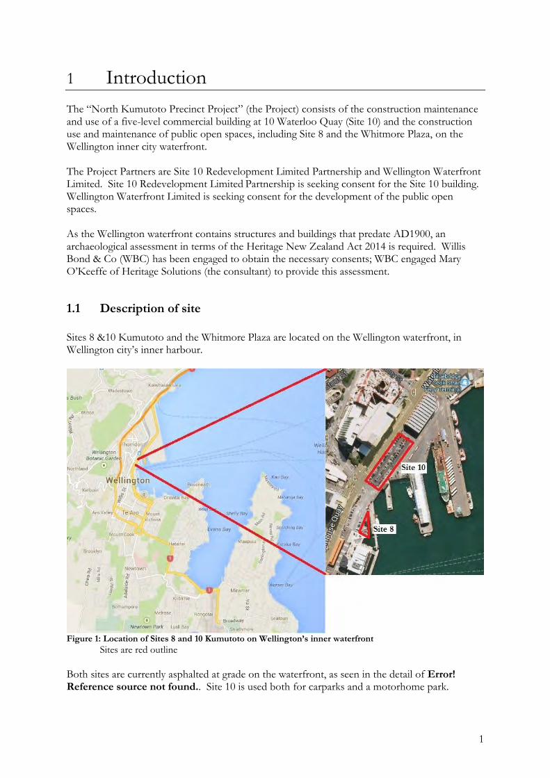
Sites 8 &10 Kumutoto and the Whitmore Plaza are located on the Wellington waterfront, in Wellington city’s inner harbour.
Figure 1: Location of Sites 8 and 10 Kumutoto on Wellington’s inner waterfront
Sites are red outline
Both sites are currently asphalted at grade on the waterfront, as seen in the detail of Error! Reference source not found.. Site 10 is used both for carparks and a motorhome park.
2
1.2 Context and Data
Archaeological sites are defined in the Heritage New Zealand Act 2014 (the Act) as:
(a) any place in New Zealand, including any building or structure (or part of a building or structure), that—
(i) was associated with human activity that occurred before 1900 or is the site of the wreck of any vessel where the wreck occurred before 1900; and (ii) provides or may provide, through investigation by archaeological methods, evidence relating to the history of New Zealand; and
(b) includes a site for which a declaration is made under section 43(1)1 All archaeological sites in New Zealand that conform to the definition from the Act cited above have legal protection under Part 3 of the Act, whether or not they are recorded or their existence is known. Authorities must be obtained from Heritage New Zealand to modify or destroy archaeological sites. Archaeological sites in New Zealand are recorded by the New Zealand Archaeological Association (NZAA) and records entered into the NZAA file as part of its site database (ArchSite). A site will be included simply by virtue of its existence; the NZAA file is a non-statutory database of recorded archaeological sites and excludes any scoring or ranking of sites. Grid references provided for archaeological sites included in the file indicate the site’s location, but do not demarcate a site’s full extent. In addition, some sites included in the NZAA database may no longer exist, as they may have been destroyed since they were recorded. In addition, section 6(f) of the RMA provides for the protection of historic heritage from inappropriate subdivision, use and development as a matter of national importance. Historic heritage is defined as those natural and physical resources that contribute to an understanding and appreciation of New Zealand’s history and cultures, derived from archaeological, architectural, cultural, historic, scientific, or technological qualities. Natural and physical resources are, by implication, tangible. Under the RMA, historic heritage includes: Historic sites, structures, places and areas Archaeological sites Sites of significance to Maori, including wahi tapu Surroundings associated with the natural and physical resources
1 Heritage New Zealand Act 2014, Interpretation

3
Archaeological sites are, by implication, physical and tangible; they can be observed and measured. Sites can be examined by archaeological methodology, that is, by applying a variety of scientific techniques to examine and rationalise the data. Equally, archaeological sites only have a sense of meaning if they are examined in the context of a cultural landscape, that is, when they are viewed and understood in the wider context of the physical environment in which they lie, in relation to the other sites and site types that may surround them, and in relation to the cultural context of the use and occupation of that land. Archaeology can never definitively indicate “what happened” on a site or a landscape; instead, data and information is gathered, and a hypothesis is proposed to explain the possible relationships between data, known information and possible interpretations. Archaeological sites may be of Maori origin and therefore of significance to Maori. There may also be other sites of spiritual or traditional significance to Maori and which may have no physical or tangible remains, and therefore do not fall within the legal definition of an archaeological site. This report focuses solely on the archaeological values within the study area, and does not attempt in any way to comment on or judge the Maori values of these sites. This is not meant to detract from or undermine the value of these places of significance to Maori; rather, it is an acknowledgement that it is inappropriate for an archaeologist to comment on matters of significance to Tangata Whenua. Data for this study was sourced from Archsite, the on-line database of the NZ Archaeological Association’s (NZAA) site recording file. Data was also obtained from the Historic Places Trust and the Wellington City Council District Plan, Land Information New Zealand, Wellington City Archives and the Alexander Turnbull Library. The definition of an archaeological site is noted above, and this definition includes places of both Maori and European origin. Archaeological sites in New Zealand are recorded by the NZAA and records entered into the site recording scheme. A site will be included simply by virtue of its existence; the NZAA file is an information database and makes no selection or ranking. Grid references given for an archaeological site are simply an indication of the site’s location, and do not delimit the site’s extent. In addition, some sites included in the NZAA list may no longer exist, as they may have been destroyed since they were recorded.
1.3 Scope and limitations of this report
This report presents an archaeological assessment of the proposed area of work, but it is only that. The land and wider vicinity may also be of significance to the Iwi through tradition or association; this report does not constitute an assessment of Maori values as required by Heritage New Zealand’s application form for an authority to modify or destroy an archaeological site.

4
2 Archaeological resource
2.1 Recorded history of the site
Information for this assessment has been gathered from a variety of sources: the key historical texts for Wellington (see bibliography), historical photos held by the Alexander Turnbull Library; relevant historical survey plans held at Land Information New Zealand (LINZ) and maps and records at Wellington City Archives. Survey plans can be rich in archaeological or historical detail, as the surveyors of the time often noted many extant features, including settlements, buildings and other landscape sites and features. Traditionally Te Whanganui A Tara - the Great Harbour of Tara - was formed as the mouth of the fish hauled to the surface by Maui. Kupe later visited the harbour, and left his two daughters in the harbour as the islands Matiu and Makoro. The harbour was named by Tara, one of the sons of Whatonga from Mahia, praised the harbour on his return to Mahia from a long journey of exportation. Pipitea is named for the abundant beds of white shining pipi in the sands of the point. It was a significant food gathering and cultivation point, along with the fisheries in the harbour. Its associated streams of Pipitea, Waipiro, and Waikoukou provided fresh water fish and plant species, as well as fresh clean water2. The Kumutoto Stream was one of the areas main assets in pre-colonial times, as a food and irrigation source. The stream still exists and drains the area leading up to the Victoria University site and the Botanical Gardens. Te Aro was a renowned area of fresh and marine fisheries. The associated swamp provided spawning grounds for eels and whitebait. It had the Waitangi and Waimapihi streams feeding into the area, and was a substantial cultivation area3. All these areas, as well as Waititi, were beaching areas for waka. They had direct and unimpeded access to te moana (the sea)4. Europeans first formally charted Wellington Harbour in 1839 (Cook passed by but did not enter the harbour on any of his three voyages). Following reports from Cook and subsequent sealers, whalers and traders, the New Zealand Company was formed in 1825 to establish agricultural and commercial settlements in New Zealand. Two vessels, the Rosanna and the Lambton, were sent on an exploratory expedition in 1826, under the command of Captain James Herd5.
2 Raukura Consultants, 2005 3 ibid 4 ibid 5 Johnson, 1996:5
5
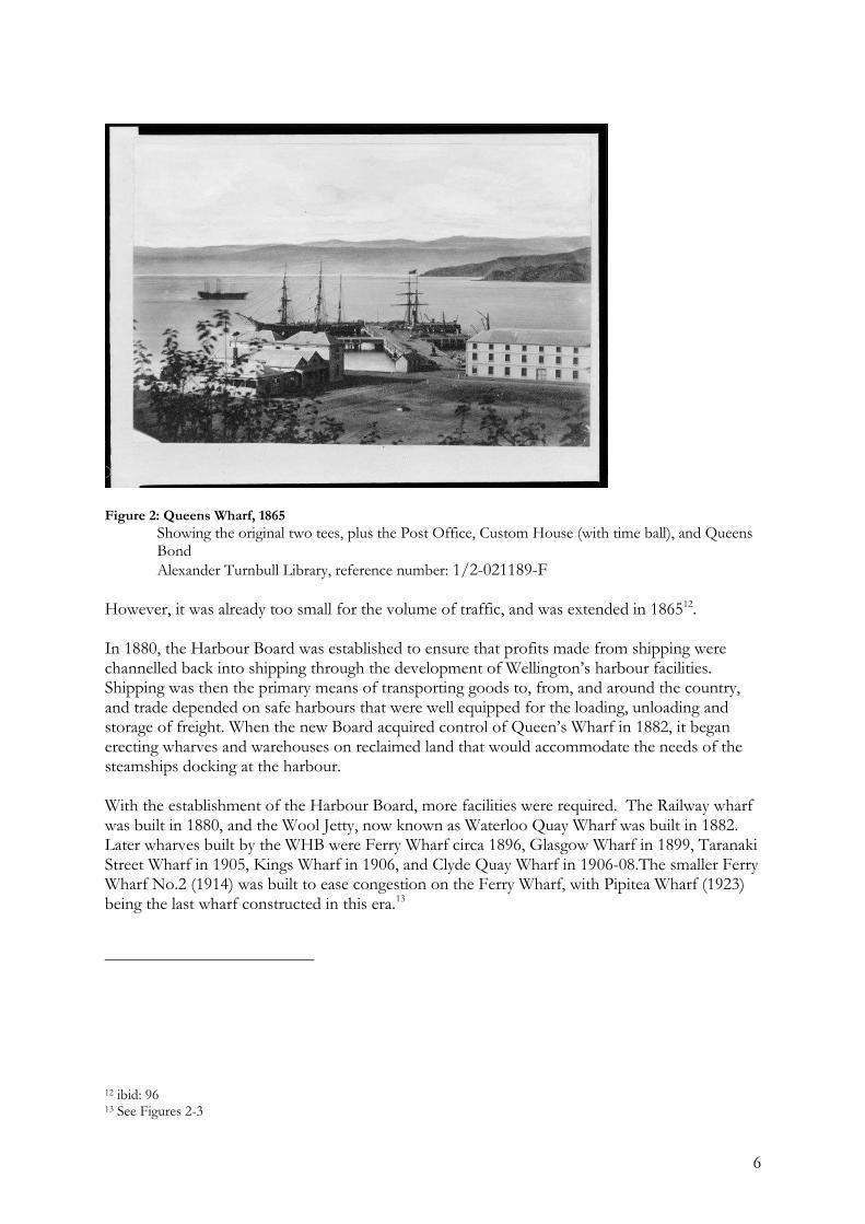
The New Zealand Company ships with their load of largely British settlers arrived in Wellington harbour in 1840, with a plan to buy land for a new settlement. Mein Smith’s now familiar plan of Wellington was largely designed in London, as can be seen in details of street alignments where in fact topography would not allow. The settlement of Wellington was divided into 1100 one-acre blocks, or town acres, for sale. Mein Smith’s original plan of the city was laid out in 1840; the city seen in this first plan is largely recognisable as the Wellington of today. A significant difference, however, is the pre-1855 earthquake shoreline, which at that time lay near present-day Lambton Quay and Wakefield St round to Oriental Bay. By the 1850s, the harbour was busy with arriving people and goods, and a large public wharf was needed. The first wharf in Wellington Harbour had been privately built in 1841 by Waitt and Tyser, located on the seaward edge of what is now Wakefield St, in the vicinity of the present-day Wellington City Council building6. Several other privately owned wharves followed in the same vicinity owned by Messrs Fitzherbert and Rhodes7, including the Commercial Wharf, built by a company formed for the purpose, and which opened for business a month after Waitt and Tyser’s wharf8. Major reclamation began after the 1855 earthquake raised the harbour by several metres. A reclamation was formed in 1856 in the triangle bounded by the newly formed Custom House Quay, Lambton Quay and just beyond Grey St, in 1857. The apex of the triangle formed was reserved for a Custom House and post office. The Provincial Council constructed Queens Wharf, originally known as the Deepwater wharf between 1861 and 1863. The original wharf extended 550 feet (168m) into the harbour from Customhouse Quay. It was built in the shape of a double T, that is, a central stem had two lateral extensions on each side. The first tee of the Deepwater Wharf, as it was first known, was completed by March 1863, when the passengers landed from the first ship to moor there. Construction was nearly compete in June 1863, when the volume of vessels and goods using the cross tees showed the two cross tees were too short, and the decision was made to lengthen them9. The wharf was completed by October 1863, and by this time was being referred to as Queens Wharf10. The completion of the wharf, together with the volume of traffic, was seen as “…a symbol that Wellington was becoming a port rather than merely a harbour”11. The completed wharf is seen in Figure 2, in 1865.
6 O’Keeffe, 1990: 31 7 ibid 8 Johnson, 1996:47 9 Johnson, 1996:82 10 Some early plans show the word “Queen’s” with the grammatically correct apostrophe. This appears to have been dropped over time. 11 Johnson, 1996: 83
6
Figure 2: Queens Wharf, 1865
Showing the original two tees, plus the Post Office, Custom House (with time ball), and Queens Bond
Alexander Turnbull Library, reference number: 1/2-021189-F However, it was already too small for the volume of traffic, and was extended in 186512. In 1880, the Harbour Board was established to ensure that profits made from shipping were channelled back into shipping through the development of Wellington’s harbour facilities. Shipping was then the primary means of transporting goods to, from, and around the country, and trade depended on safe harbours that were well equipped for the loading, unloading and storage of freight. When the new Board acquired control of Queen’s Wharf in 1882, it began erecting wharves and warehouses on reclaimed land that would accommodate the needs of the steamships docking at the harbour. With the establishment of the Harbour Board, more facilities were required. The Railway wharf was built in 1880, and the Wool Jetty, now known as Waterloo Quay Wharf was built in 1882. Later wharves built by the WHB were Ferry Wharf circa 1896, Glasgow Wharf in 1899, Taranaki Street Wharf in 1905, Kings Wharf in 1906, and Clyde Quay Wharf in 1906-08.The smaller Ferry Wharf No.2 (1914) was built to ease congestion on the Ferry Wharf, with Pipitea Wharf (1923) being the last wharf constructed in this era.13
12 ibid: 96 13 See Figures 2-3
7
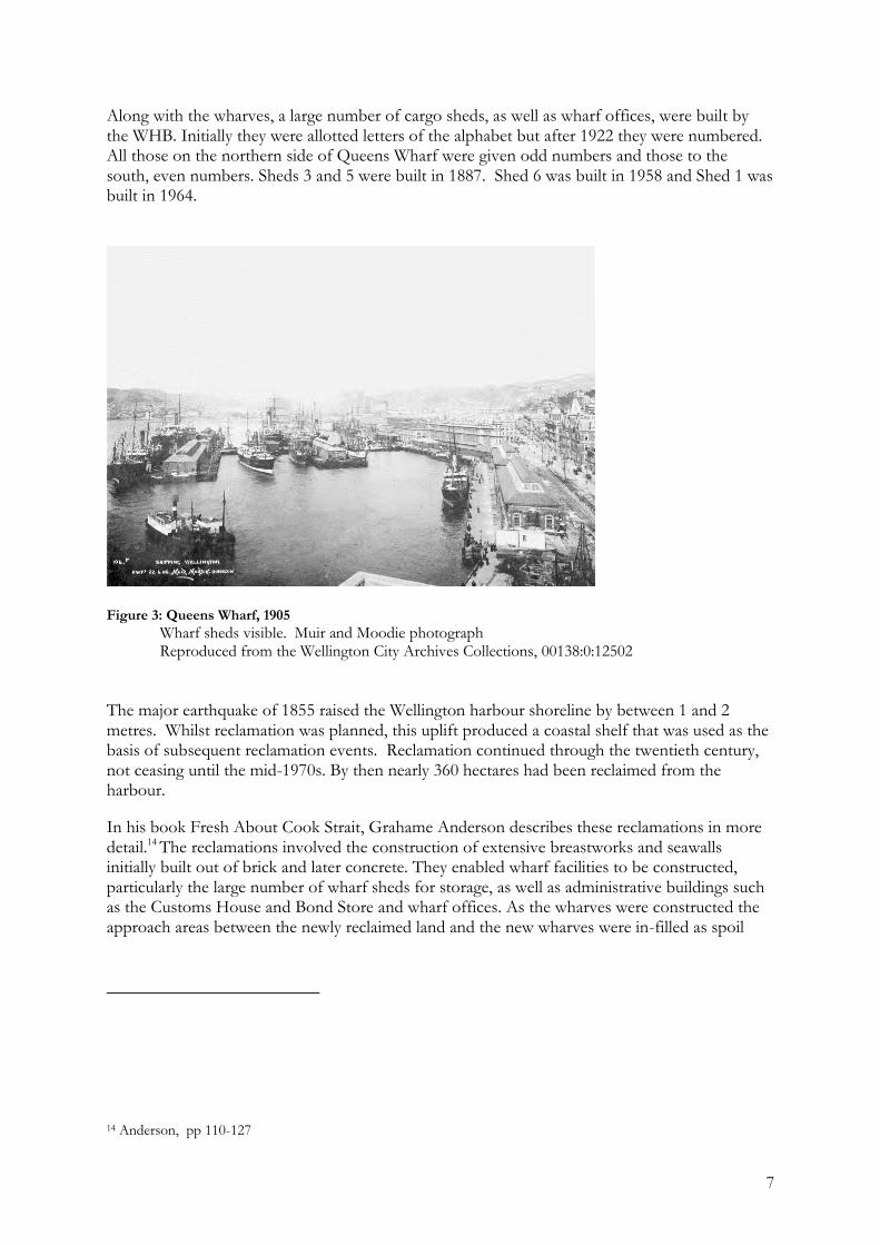
Along with the wharves, a large number of cargo sheds, as well as wharf offices, were built by the WHB. Initially they were allotted letters of the alphabet but after 1922 they were numbered. All those on the northern side of Queens Wharf were given odd numbers and those to the south, even numbers. Sheds 3 and 5 were built in 1887. Shed 6 was built in 1958 and Shed 1 was built in 1964.
Figure 3: Queens Wharf, 1905
Wharf sheds visible. Muir and Moodie photograph Reproduced from the Wellington City Archives Collections, 00138:0:12502
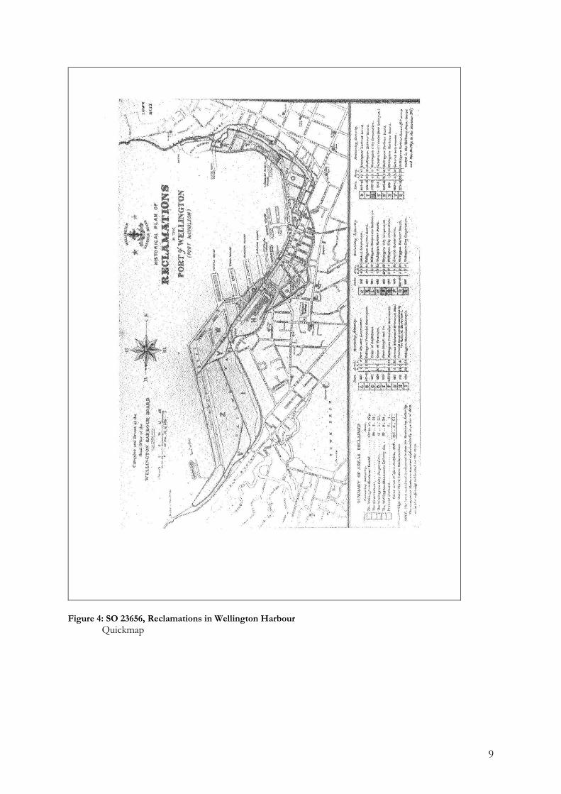
The major earthquake of 1855 raised the Wellington harbour shoreline by between 1 and 2 metres. Whilst reclamation was planned, this uplift produced a coastal shelf that was used as the basis of subsequent reclamation events. Reclamation continued through the twentieth century, not ceasing until the mid-1970s. By then nearly 360 hectares had been reclaimed from the harbour. In his book Fresh About Cook Strait, Grahame Anderson describes these reclamations in more detail.14 The reclamations involved the construction of extensive breastworks and seawalls initially built out of brick and later concrete. They enabled wharf facilities to be constructed, particularly the large number of wharf sheds for storage, as well as administrative buildings such as the Customs House and Bond Store and wharf offices. As the wharves were constructed the approach areas between the newly reclaimed land and the new wharves were in-filled as spoil
14 Anderson, pp 110-127
8
became available.15 Many of the early seawalls were later buried in subsequent reclamation and harbour development work. The first reclamation in the inner harbour however, predated the 1855 earthquake. Survey office plan SO 23656 (Figure 4) shows the various reclamations that have taken place along the Wellington waterfront since the 1850s.
15 The Wellington Harbour Board Year Books provide a review of these developments
9
Figure 4: SO 23656, Reclamations in Wellington Harbour
Quickmap
10
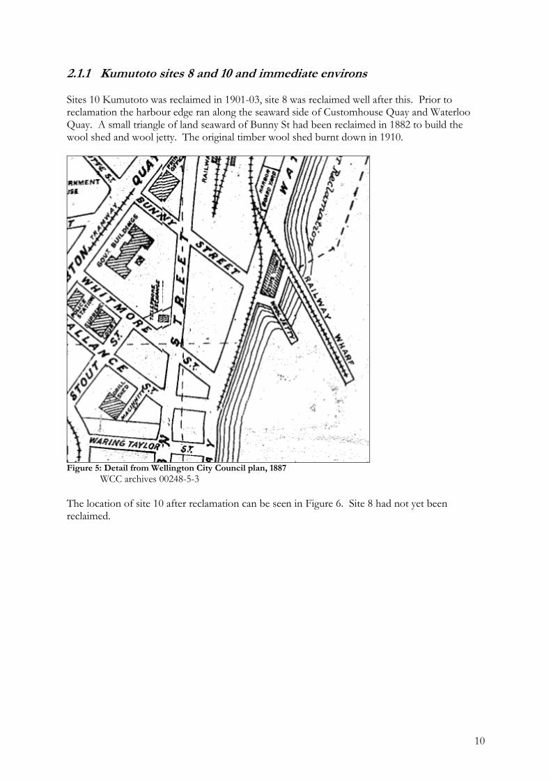
2.1.1 Kumutoto sites 8 and 10 and immediate environs Sites 10 Kumutoto was reclaimed in 1901-03, site 8 was reclaimed well after this. Prior to reclamation the harbour edge ran along the seaward side of Customhouse Quay and Waterloo Quay. A small triangle of land seaward of Bunny St had been reclaimed in 1882 to build the wool shed and wool jetty. The original timber wool shed burnt down in 1910.
Figure 5: Detail from Wellington City Council plan, 1887
WCC archives 00248-5-3
The location of site 10 after reclamation can be seen in Figure 6. Site 8 had not yet been reclaimed.
11
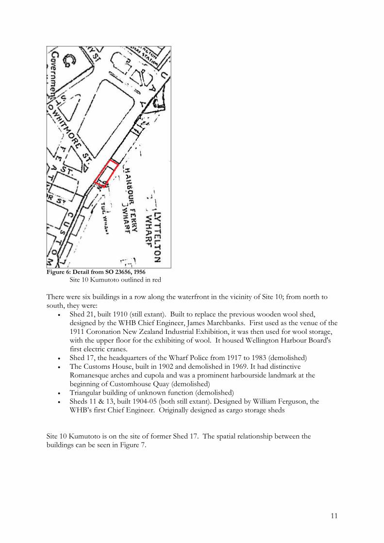
Figure 6: Detail from SO 23656, 1956
Site 10 Kumutoto outlined in red
There were six buildings in a row along the waterfront in the vicinity of Site 10; from north to south, they were:
Shed 21, built 1910 (still extant). Built to replace the previous wooden wool shed, designed by the WHB Chief Engineer, James Marchbanks. First used as the venue of the 1911 Coronation New Zealand Industrial Exhibition, it was then used for wool storage, with the upper floor for the exhibiting of wool. It housed Wellington Harbour Board's first electric cranes.
Shed 17, the headquarters of the Wharf Police from 1917 to 1983 (demolished) The Customs House, built in 1902 and demolished in 1969. It had distinctive
Romanesque arches and cupola and was a prominent harbourside landmark at the beginning of Customhouse Quay (demolished)
Triangular building of unknown function (demolished) Sheds 11 & 13, built 1904-05 (both still extant). Designed by William Ferguson, the
WHB’s first Chief Engineer. Originally designed as cargo storage sheds
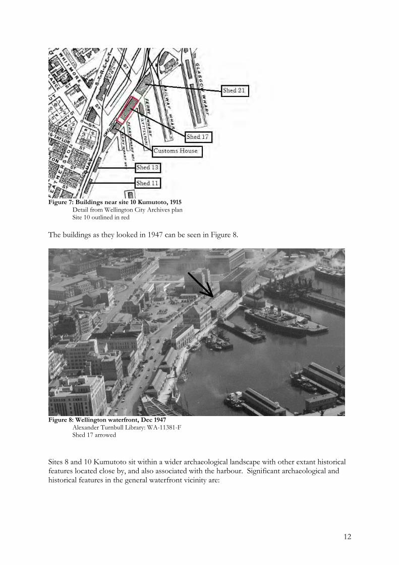
Site 10 Kumutoto is on the site of former Shed 17. The spatial relationship between the buildings can be seen in Figure 7.
12
Figure 7: Buildings near site 10 Kumutoto, 1915 Detail from Wellington City Archives plan Site 10 outlined in red
The buildings as they looked in 1947 can be seen in Figure 8.
Figure 8: Wellington waterfront, Dec 1947
Alexander Turnbull Library: WA-11381-F Shed 17 arrowed
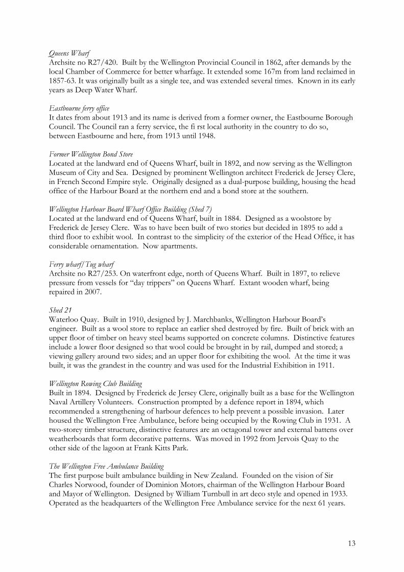
Sites 8 and 10 Kumutoto sit within a wider archaeological landscape with other extant historical features located close by, and also associated with the harbour. Significant archaeological and historical features in the general waterfront vicinity are:
13
Queens Wharf Archsite no R27/420. Built by the Wellington Provincial Council in 1862, after demands by the local Chamber of Commerce for better wharfage. It extended some 167m from land reclaimed in 1857-63. It was originally built as a single tee, and was extended several times. Known in its early years as Deep Water Wharf. Eastbourne ferry office It dates from about 1913 and its name is derived from a former owner, the Eastbourne Borough Council. The Council ran a ferry service, the fi rst local authority in the country to do so, between Eastbourne and here, from 1913 until 1948. Former Wellington Bond Store Located at the landward end of Queens Wharf, built in 1892, and now serving as the Wellington Museum of City and Sea. Designed by prominent Wellington architect Frederick de Jersey Clere, in French Second Empire style. Originally designed as a dual-purpose building, housing the head office of the Harbour Board at the northern end and a bond store at the southern. Wellington Harbour Board Wharf Office Building (Shed 7) Located at the landward end of Queens Wharf, built in 1884. Designed as a woolstore by Frederick de Jersey Clere. Was to have been built of two stories but decided in 1895 to add a third floor to exhibit wool. In contrast to the simplicity of the exterior of the Head Office, it has considerable ornamentation. Now apartments. Ferry wharf/Tug wharf Archsite no R27/253. On waterfront edge, north of Queens Wharf. Built in 1897, to relieve pressure from vessels for “day trippers” on Queens Wharf. Extant wooden wharf, being repaired in 2007. Shed 21 Waterloo Quay. Built in 1910, designed by J. Marchbanks, Wellington Harbour Board’s engineer. Built as a wool store to replace an earlier shed destroyed by fire. Built of brick with an upper floor of timber on heavy steel beams supported on concrete columns. Distinctive features include a lower floor designed so that wool could be brought in by rail, dumped and stored; a viewing gallery around two sides; and an upper floor for exhibiting the wool. At the time it was built, it was the grandest in the country and was used for the Industrial Exhibition in 1911. Wellington Rowing Club Building Built in 1894. Designed by Frederick de Jersey Clere, originally built as a base for the Wellington Naval Artillery Volunteers. Construction prompted by a defence report in 1894, which recommended a strengthening of harbour defences to help prevent a possible invasion. Later housed the Wellington Free Ambulance, before being occupied by the Rowing Club in 1931. A two-storey timber structure, distinctive features are an octagonal tower and external battens over weatherboards that form decorative patterns. Was moved in 1992 from Jervois Quay to the other side of the lagoon at Frank Kitts Park. The Wellington Free Ambulance Building The first purpose built ambulance building in New Zealand. Founded on the vision of Sir Charles Norwood, founder of Dominion Motors, chairman of the Wellington Harbour Board and Mayor of Wellington. Designed by William Turnbull in art deco style and opened in 1933. Operated as the headquarters of the Wellington Free Ambulance service for the next 61 years.
14
Wharf sheds 3 and 5 Located on Queens Wharf: shed 3 was built in 1887 and shed 5 in 1886-7. Shed 3 is now Dockside restaurant, Shed 5 is Shed 5 Restaurant. Shed 5 is the last remaining wooden warehouse on Queens Wharf. A top storey was added to Shed 3 in the early 20th century to house the Wellington Harbour Board tug and pilot service staff. Shed 22 Located on corner of Cable and Taranaki Streets, completed in 1921. Built by the Wellington Harbour Board under the aegis of James Marchbanks, Chief Engineer. Exterior is constructed in brick masonry strengthened with brick piers. Built as a warehouse and has an unusual interior overhead electrically driven winch. Wellington Harbour Board Iron Gates & Railings Run from end of Shed 21 through to relocated gates and railings at Head Office and Bond Building, Waterloo and Customhouse Quays. Gates on Queens Wharf were originally constructed in 1899. Were made by a British company called Bayliss, Jones & Bayliss and shipped to New Zealand. Are the first gates of this type used for enclosing the Wellington Harbour Board owned land. Pillars are made of cast-iron and the gates of wrought iron with cast-iron spandrels and ornaments. The Post & Telegraph Building Herd Street. Architect was Edmund Anscombe and the date of construction 1939, style is streamlined Moderne. Was used as a Post and Telegraph Exchange. Constructed of painted cement render, has copper window flashing, steel window joinery and terrazzo flooring. Originally, the building was one storey lower with two full-size tennis courts on the roof, but another floor was added. It is unique because of its large scale in this style. Boulder seawall Archsite no R27/333. Built 1889, edge of reclamation, concrete and boulder seawall, exposed on the edge of Frank Kitts lagoon.
2.2 Statutory lists
Sites 8 and 10 Kumutoto are not included in Heritage New Zealand’s List of historic places, historic areas, wahi tapu and wahi tapu areas. Site 10 is, however, included in a draft research report being researched with a view to possible registration as part of an historic area together with other waterfront features16. Neither is Site 10 included in the Wellington City Council District Plan list of heritage items. However, it is within the designated Lambton Harbour Area. The following adjacent items are listed within Heritage New Zealand’s list or the district plan:
16 Historic Places Trust n.d.
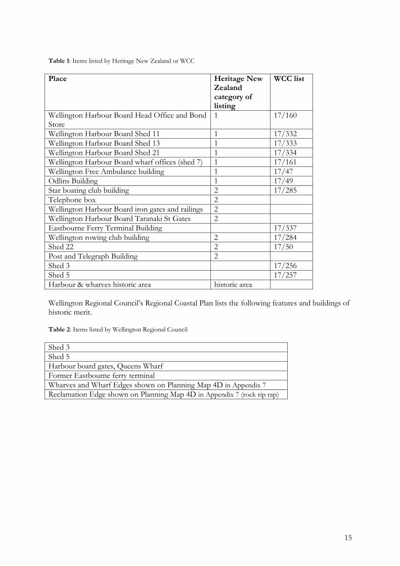
15
Table 1: Items listed by Heritage New Zealand or WCC
Place Heritage New Zealand category of listing
WCC list
Wellington Harbour Board Head Office and Bond Store
1 17/160
Wellington Harbour Board Shed 11 1 17/332
Wellington Harbour Board Shed 13 1 17/333
Wellington Harbour Board Shed 21 1 17/334
Wellington Harbour Board wharf offices (shed 7) 1 17/161
Wellington Free Ambulance building 1 17/47
Odlins Building 1 17/49
Star boating club building 2 17/285
Telephone box 2
Wellington Harbour Board iron gates and railings 2
Wellington Harbour Board Taranaki St Gates 2
Eastbourne Ferry Terminal Building 17/337
Wellington rowing club building 2 17/284
Shed 22 2 17/50
Post and Telegraph Building 2
Shed 3 17/256
Shed 5 17/257
Harbour & wharves historic area historic area
Wellington Regional Council’s Regional Coastal Plan lists the following features and buildings of historic merit. Table 2: Items listed by Wellington Regional Council
Shed 3
Shed 5
Harbour board gates, Queens Wharf
Former Eastbourne ferry terminal
Wharves and Wharf Edges shown on Planning Map 4D in Appendix 7
Reclamation Edge shown on Planning Map 4D in Appendix 7 (rock rip rap)
16
3 Current site Site 10 Kumutoto is currently being used as carparking and as a motorhome park for overnight stays. The area has no built structures on it. The surface is asphalt over presumably original wooden bearers (there is possibly a concrete slab beneath the asphalt). The site is bounded by Shed 21 on its north side, Waterloo Quay on its west side, the railway and ferry wharves on its east side and the continuing waterfront open space on its south side. Site 8 and the Whitmore Plaza are paved open spaces adjoining the wharf edge. Site 8 is being used for carparking.
3.1 Proposed work, and impact of proposed work
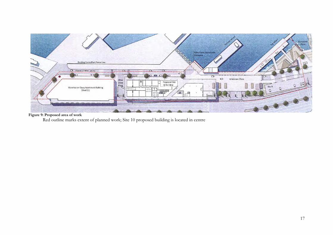
Site 10 Redevelopment Limited Partnership proposes to construct a five storey commercial building on the site of Site 10. The proposed building will occupy the entire site footprint. The building will be constructed on driven piles, and there will be a basement level below ground. The basement will destroy any extant archaeological features that may be present within its footprint. Site 8 and the Whitmore Plaza are to be redeveloped as open recreational space, with landscaping and planting
17
Figure 9: Proposed area of work
Red outline marks extent of planned work; Site 10 proposed building is located in centre
18
4 Assessment
4.1 Archaeological potential
The area beneath Site 10 Kumutoto was reclaimed in 1901-03. The site itself is therefore not archaeological as it falls outside the 1900 date of the definition contained in the Act. However, it is possible that work on the western side of the site will impact on the edge of the reclamation, and reveal material that predates 1900. In 2010, Jones monitored trenching from site 7 through sites 8 & 9 Kumutoto to extend an existing watermain and provide electric supply to the motorhome park on site 10. Sites 7, 8 and 9 are south of Site 10. In this work, Jones recorded part of the 1900 seawall, and a substantial brick wall interpreted to be the southeastern foundation of the Custom House. In addition, remnants of the original woodblock paving which would have been in the entire wharf area can be seen outside the former Eastbourne Ferry Terminal Building, adjacent to Site 10. It is possible these wooden cobbles are extant beneath the more recent asphalt. Construction work on Site 10 has the potential to reveal subsurface heritage features associated with previous buildings and structures. Site 8 and the Whitmore Plaza were reclaimed well after 1903. There have never been any built structures beneath it so there is no possibility of subsurface heritage features.
4.2 Summary of assessment
Site 8 and 10 Kumutoto and the Whitmore Plaza were reclaimed after 1900 AD and therefore are not archaeological sites in their own right. However, they sit within a wider landscape of harbour structures that collectively contribute to the history and development of Wellington from a small town to the nation’s capital. The sites have strong linkages with the other built structures along the Wellington waterfront, including the other wharves, the areas of reclamation and the harbour and port buildings and structures. Together they tell the story of the development of Wellington as a harbour city, and the central and vital role played by the harbour and waterfront in landing goods and people and facilitating communication and trade with the rest of the country and the world. Queens Wharf is one of the earliest sites of European origin still extant in Wellington City, and is the oldest wharf at one of the oldest and busiest ports in New Zealand.
19
5 Conclusions and recommendations Sites 8 and 10 Kumutoto and the Whitmore Plaza are not archaeological sites, as they were reclaimed after 1900AD, and thus do not fulfil the definition of archaeological sites contained within the Heritage New Zealand Act 2014. There are no structures on them, extant or demolished, that predate 1900 AD. Sites 8 and 10 and the Whitmore Plaza sit within a wider heritage landscape. Wellington harbour was the means by which all settlers, Polynesian and European, arrived in the Wellington region, and formed the basis of the settlement that followed. Very soon after the establishment of the European settlement of Wellington, small private wharves were built for landing goods and people. The entire harbour and waterfront area, with the reclaimed land, the wharves, the buildings and other structures represents the vital role played by the harbour in the growth and development of the city, through trade and transport. As the proposed area of redevelopment does not fall within the requirements of Part 3 of the Heritage New Zealand Act 2014, no application for an archaeological authority to modify or destroy archaeological sites is required. The developers (Site 10 Redevelopment Limited Partnership and WWL) therefore have no statutory obligations in terms of Part 3 of the Heritage New Zealand Act 2014. However, as heritage fabric is very likely to be revealed by site clearance and excavation work for the proposed new building on Site 10, the developer is encouraged to engage an archaeologist to monitor and record heritage fabric and features as they are revealed. This material has the potential to contribute to our understanding of the use and development of the Wellington waterfront.
20
Sources Primary: Archsite Heritage New Zealand register of historic places, historic areas, wahi tapu and wahi tapu areas Historic Places Trust. n.d. Wellington Wharves Historic Areas. Unpublished draft report Jones, K. 2010. Kumutoto Precinct Archaeology Monitoring. Unpublished report to Wellington
Waterfront Ltd Land Information New Zealand survey plans: SO 10408 1840 SO 10313 1848 SO 10315 c.1850 SO 14413 1898 O’Keeffe, M. 1990. An Archival Study of Wellington Maps 1840-1860. Part 1: Dept of Survey
and Land Information. Unpublished report to Dept. of Conservation, Wellington ibid. 2007. Ferry Wharf, Wellington: Archaeological monitoring of repair work. Unpublished
report to Historic Places Trust Raukura Consultants. 2005. Hilton Hotel, Cultural Impact Report. Unpublished report to
Waterfront Investments Ltd Ward, T. Survey of Wellington City, 1891 and 1900, Wellington City Archives Wellington City Council Maritime Heritage Trail, n.d. Wellington City Archives files Secondary: Adkin, G L. 1959. The Great Harbour of Tara. Whitcombe and Tombs, Wellington Hamer, D & R Nicholls (eds.) 1990. The making of Wellington 1800-1914. Victoria University
Press, Wellington. Johnson, D. 1996. Wellington Harbour. Wellington Maritime Museum Trust. McLean, G. 2000. Wellington. The first years of European Settlement 1840-1850. Penguin Books,
New Zealand Ward, L. n.d., reprinted 1928. Early Wellington. Southern Reprints, Papakura.


![17 DECEMBER 2014 - REV C - CERTIFIED ISSUE · 2015. 3. 2. · Appendix 1: DRAWING SET Site Specific Management Plan 002 - [sector 330-340-350] MacKays to Peka Peka Expressway 17 DECEMBER](https://img.pdfslide.net/doc/110x75/6017c67960a7d25e4c59d433/17-december-2014-rev-c-certified-issue-2015-3-2-appendix-1-drawing-set.jpg)