Embed Size (px)
Citation preview

Observations on Ice Regions of the Arctic OceanAuthor(s): Arthur C. Aufderheide and Gerald PitzlSource: Arctic, Vol. 23, No. 2 (Jun., 1970), pp. 133-136Published by: Arctic Institute of North AmericaStable URL: http://www.jstor.org/stable/40507718 .
Accessed: 17/06/2014 00:35
Your use of the JSTOR archive indicates your acceptance of the Terms & Conditions of Use, available at .http://www.jstor.org/page/info/about/policies/terms.jsp
.JSTOR is a not-for-profit service that helps scholars, researchers, and students discover, use, and build upon a wide range ofcontent in a trusted digital archive. We use information technology and tools to increase productivity and facilitate new formsof scholarship. For more information about JSTOR, please contact [email protected].
.
Arctic Institute of North America is collaborating with JSTOR to digitize, preserve and extend access to Arctic.
http://www.jstor.org
This content downloaded from 195.78.108.147 on Tue, 17 Jun 2014 00:35:35 AMAll use subject to JSTOR Terms and Conditions
SHORT PAPERS AND NOTES 133
i Ki. 1. Dorsal view.
í ig. 2. Post-cranial view.
fig. 3. Ventral view.
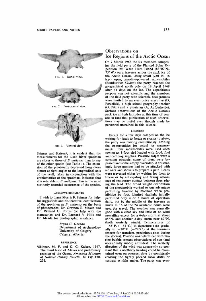
Skinner and Kaisen1, it is evident that the measurements for the Liard River specimen are closer to those of B. antiquus than to any of the other species (see Table 1). The exten- sion of the proximally depressed horn cores almost at right angles to the longitudinal axis of the skull, taken in conjunction with the craniometries of the specimen, indicates that it is referable to B. antiquus. This is the most northerly recorded occurrence of the species.
ACKNOWLEDGEMENTS
I wish to thank Morris F. Skinner for help- ful suggestions and his tentative identification of the specimen as B. antiquus on the basis of photographs; Dr. Grayson E. Meade and Dr. Richard G. Forbis for help with the manuscript; and Dr. Leonard V. Hills and Dr. Meade for photographic assistance.
Bryan C. Gordon Department of Archaeology University of Calgary Calgary, Alberta.
REFERENCE
iSkinner, M. F. and O. C. Kaisen, 1947. The fossil bison of Alaska and preliminary revision of the Genus. American Museum of Natural History Bulletin, 89 (3): 130- 256.
Observations on Ice Regions of the Arctic Ocean On 7 March 1968 the six members compos- ing the field party of the Plaisted Polar Ex- pedition left Ward Hunt Island (83°07'N., 75 °W.) on a traverse across the pack ice of the Arctic Ocean. Using small (250 lb. 18 h.p.) open, gasoline-powered snowmobiles (Bombardier Skidoo) the party reached the geographical north pole on 19 April 1968 after 44 days on the ice. The expedition's purpose was not scientific and the members of the field party with scientific backgrounds were limited to an electronics executive (D. Powellek), a high school geography teacher (G. Pitzl) and a physician (A. Aufderheide). Surface observations of the Arctic Ocean's pack ice at high latitudes at this time of year are so rare that publication of such observa- tions may be useful even though made by personnel untrained in this science.
LOGISTICS
Except for a few days camped on the ice waiting for leads to freeze or storms to abate, the party was moving continuously, limiting the opportunities for actual ice measure- ments. Four snowmobiles were used each towing an 8 -foot sled loaded with food, fuel and camping supplies. Pressure ridges were a constant obstacle; some of them were by- passed and some simply overriden. A f rustrat- ingly large number had to be attacked with ice axes and shovels to prepare a path. Leads were traversed either by waiting for them to freeze or by anticipating and taking advan- tage of temporary contact between floes edg- ing the lead. The broad weight distribution of the snowmobile worked to our advantage permitting traverse by machine when pro- hibitive by foot. Limited daylight initially permitted only 4 or 5 hours of operation daily, but by the middle of the traverse as much as 16 of the 24 available hours were used for travel. The weather was generally good with a clear sky and little or no wind prevailing except for a 6-day storm at about 85°N. and another 2-day storm near 87°N. (both westerly winds). Temperatures of -62°F. (- 52°C.) at departure rose gradu- ally to - 20 °F. (- 29 °C.) at the terminus (except for transient, precipitous rises during the storms). Position was determined with ma- rine bubble sextant observations of sun (and occasionally moon) altitudes1. The westerly direction of the wind was apparently so con- stant that a northerly heading could be main- tained even on overcast days by consistently crossing the tightly packed snow drifts or sastrugi at right angles. The party was evac-
This content downloaded from 195.78.108.147 on Tue, 17 Jun 2014 00:35:35 AMAll use subject to JSTOR Terms and Conditions
134 SHORT PAPERS AND NOTES
uated by air after reaching the geographical north pole once its position there had been verified by a United States Air Force over- flight. Data for this report came from the personnel log books of the authors where it was recorded for this purpose at the time.
ZONES OBSERVED
We were impressed with common surface features characterizing 3 different areas which for convenience we shall refer to as Zones I, II and III. The border between Zones I and II was nebulous, characterized by a gradual transition. On the other hand the border between Zones II and III was remarkably distinct, marked by a lead two miles wide.
Zone I: 7 to 23 March (83°N. to 84°N.) The gently undulating surface of the shelf
ice of northern Ellesmere Island extended about 5 miles. The junction with the pack ice was abrupt and at some points here the pressure ridge exceeded 40 feet in height, surpassing by 10 feet the highest pressure ridge encountered in the remainder of the traverse. In the initial 500 yards beyond this point many large ice "boulders" measuring 8 to 10 feet in diameter were scattered about in disarray. These were often roughly round, bore no flat surfaces, and gave the impression that they were subsurface fragments of shelf ice abraded by the action of the pack ice grinding against the immovable shelf ice. Be- tween these and extending to about 5 miles beyond this point were innumerable large (5 to 30 feet in diameter) flat-topped fragments 3 to 7 feet thick, scattered about with no de- tectable pattern and upended at every con- ceivable angle. Many of these demonstrate icicle-like structures composed of frost-cov- ered frozen brine dripping from the bottom of such upended fragments. These structures were oriented perpendicular to the present ocean surface plane, rather than to the plane of the flat tops of the fragments, suggesting that they had been formed since the last ice activity. Some of these were 10 inches long. The edges of most of these fragments were quite sharply angular. The chaotic disarray of the initial 5 miles made even walking dif- ficult, and machine traverse was possible only because of the abundant snow cover. In some areas the snow was hard packed, but in most it was very soft and as much as 2 or 3 feet in depth. In this initial 5 to 10 miles there were occasional areas where narrow leads, recently frozen, could be defined, but these were only 2 to 3 feet wide.
Beginning about 9 miles out on the pack we began to encounter small floes with some
regularity, but in the first 15 miles we en- countered no floe larger than 200 feet in diameter. At 15 miles out we met a very broad area of frozen leads. Buckled areas provided clues to a thickness judged to vary from 2 to 3 feet. Such frozen leads were somewhat serpentine, measuring as much as 2 miles wide and 6 or 7 miles long. They contained scattered, snow-ramped small floes. The next 10 miles were made up of rather unusual ice for which there had been no precedent and which was not later en- countered. The surface was quite monotonous and generally flat, but with innumerable "buckled" areas, some of which were shaped like an inverted "V" whereas others were upended flat fragments. The unusual feature lay in the fact that most of these fragments were about the same size (about 10 feet long), were quite regularly, though not strictly geometrically, spaced at about 100 foot in- tervals, were all oriented in the same direc- tion (flat surface of the upended fragments facing west) and averaged 1 to 1.5 feet thick. Furthermore, this area was without pressure ridges. The area contained a thick (up to 2 feet) snow cover. A few frozen leads were scattered through this area measuring from 20 to 200 feet in diameter, and at these leads it could be noted that the previously de- scribed areas consisted of floes whose surface was about 1 to 2 feet above the level of the lead ice.
At about 25 miles out we began to en- counter old floes quite frequently. These varied up to 800 feet in diameter, had sur- faces riding as much as 3 feet above the level of the lead ice adjacent to them, contained an undulating surface of snow, frequently hard- packed and with occasional hummocks of buckled ice. The latter generally had rounded edges and some had small, flat, meltwater ice "ponds" on their surface up to 30 feet in diameter. These features indicate that the floes had weathered at least one summer. Frozen leads up to 6 feet wide often sur- rounded these floes and high pressure ridges up to 20 feet marked their periphery. These, as most pressure ridges in Zone I, were made up largely of thin ice fragments Vi to XVi feet thick, whose edges were sharply angular. Abundant snow covered the ice fragments of the pressure ridges.
Thus, Zone I could be characterized as a "shatter" zone where the pack ice meets the resistance of the shelf ice producing a pat- ternless, tumbled, crushed, sometimes over- riding mass of ice with evidence of old, broad leads near shore. There are signs of remark- able stability of this through the winter sea- son although most of it does not appear to
This content downloaded from 195.78.108.147 on Tue, 17 Jun 2014 00:35:35 AMAll use subject to JSTOR Terms and Conditions
SHORT PAPERS AND NOTES 135
have seen a summer. About 25 miles out the disorderly pattern very gradually begins to fade into the type of surface characterizing Zone II. A large "shore lead" up to 1,000 feet wide opened in Zone I only half a mile from the shore edge of the pack ice on 3 April 1968; this was observed by the pilot of the supply aircraft.
Zone II: 24 March to 7 April (84° N. to 87° N.). This was an area of considerable variation
in ice structure. Moderately-sized floes, most- ly old, alternated abruptly with broad (up to 2 miles) areas of patternless, crushed, jum- bled, fragmented ice. The southern end (84°N. to 85°30'N.) appeared more stable, being composed of larger, old floes many of which were 1.5 miles to 2 miles in diameter. In this portion they were separated by very high and mostly new pressure ridges averag- ing 20 feet, and by leads. The latter were generally frozen firmly, and most were only a few feet wide (some might more accurately be described as "cracks"). At about 85 °N. an occasional old pressure ridge could be de- tected. These ridges became more frequent until about one half of the pressure ridges gave evidence of having survived at least one arctic summer. At about the same latitude, 85 °N., an unusually large pressure ridge was encountered exceeding 30 feet in height, oriented on an east-west axis. Its southern face was vertical whereas its northern face demonstrated a gradual incline extending over several hundred feet beyond which there was a very complex and jumbled area. Be- tween 86°N. and 87 °N. the variation in the surface characteristics was unusually marked. Broad old floes several miles wide lay ad- jacent to areas of chaotically crushed and overriding fragmentation, the entire complex interlaced with literally dozens of cracks and narrow leads (a few of which were not frozen but only one of which was wide enough to impede progress). The first unfrozen lead wide enough to stop the forward progress of the party was met at 86°20'N. on 3 April 1968. This was about 200 yards wide. The number of new pressure ridges in the north- ern end of Zone II exceeded the number of old ones.
Thus, Zone II was characterized by an exceedingly variable surface: broad, old floes constituting the basic feature, separated by areas of extensive fragmentation.
Zone III: 8 to 20 April (87°N. to 90°N.). Two distinctive features characterized this
zone: the large size and the old age of the floes, and the sharply defined southern limit of the zone, marked by a lead of prodigious
proportions. Until 87 °N., with the one mod- est exception noted above, new leads were narrow and quite easily traversed. Thus the open lead encountered at 87 °N. on 8 April had no precedence. The pilot of the supply aircraft estimated its average width at 2 miles and it extended beyond his range of vision when viewed from 5,000 feet. No other lead even approaching such enormous dimensions was encountered in the remainder of the tra- verse. During the 2 days we were camped at the edge of this lead sextant readings estab- lished an easterly drift of 8 miles. As in other zones most leads were oriented in an east- west direction. In the entire traverse we en- countered only 1 new lead created by the splitting of a previously intact floe (at 87° 20'N.). This lead was about 200 feet wide and contained evidence of 2 successive epi- sodes of floe separation with open water at the centre. Its edges were abrupt and without the usual jumbled ice or pressure ridge. The surface of the floe was only about 1 foot above the surface of the lead ice. An exten- sive area of old, thoroughly frozen, large intersecting leads was encountered at about 88°40'N.
The floes throughout Zone III mostly were very old and very large. These were encountered abruptly after crossing the large lead at 87 °N. Most were 4 or 5 miles in diameter and 1 was measured at 8 miles long and estimated 3 miles wide. Their surfaces were quite flat with hard packed snow. Old pressure ridges outnumbered the new, and were generally smaller than in Zone II. In spite of this there were still occasional broad areas of fragmented ice scattered between old, large floes.
In Zone III several extensive leads were experienced which, for a significant distance, were aligned in a north-south direction. One such frozen lead was used as an avenue of effortless travel for over 10 miles before it gradually realigned itself to the characteristic east-west axis.
The terrain at the north pole was similar to that of the remainder of Zone III with many old, large floes separated by large, well- frozen leads and a very occasional, rather narrow new lead. While camped for 2 days near the north pole, readings made with the sextant demonstrated a drift of 6 miles from 89°50'N.to89°56'N.
DISCUSSION
We were impressed with evidence that the ice in Zone I had apparently moved very little during the winter of 1967-68. One or 2-foot-wide leads with surfaces frozen 2 feet or more were observed. Not until 3 April
This content downloaded from 195.78.108.147 on Tue, 17 Jun 2014 00:35:35 AMAll use subject to JSTOR Terms and Conditions
136 SHORT PAPERS AND NOTES
1968, several days after the new moon, did the large shore lead appear. It may be coin- cidence that the field party was halted for the first time by a substantial lead on the same day. It is tempting to speculate that both leads were caused by spring tides, but that hypothesis was not sustained by the ob- servation that the shore lead did not close with disappearance of the postulated tide but instead persisted and froze "in position." Leads of a size great enough to halt progress were fewer than expected. The lead at 87 °N. was so enormous and delineated such a dis- tinctive alteration in the character of the ice that we considered it a unique structure. In 1909 Peary noted the presence of extensive lead formation at that latitude. His "sound- ing wire" did not reach bottom here at 1260 fathoms. Perhaps this is a somewhat fixed océanographie phenomenon responding to subsurface conditions of current and ocean floor.
The persistence of snow drifts throughout the traverse testified to a west wind. It was also noted that no major ice movement or lead formation could be attributed to the wind. Indeed, when camped for 7 days at 84°30'N. during a 6-day storm with con- tinuous winds estimated at averaging 45 knots, sextant readings before and after the storm detected no change in position, nor could new lead formation be detected by either the supply plane or the field party.
Arthur C. Aufderheide Gerald Pitzl Plaisted Polar Expedition 1968
REFERENCE
iPitzl, G. 1969. Navigating to the North Pole: A Surface Traverse. Navigation: Journal of the Institute of Navigation, 16:32-36.
Disturbed Sediments in a Small Alpine Lake in Colorado Palynologists, students of paleolimnology and others interested in former ecological conditions may study cores of sediments de- posited in present or now-dry lake basins. Undisturbed sequences are crucial to draw- ing correct inferences from sedimentary records. Recently Nichols1 called attention to the disruption of tundra pond sediments by blocks of ice floating from the basin bottom to the water surface.
This note records the derangement of sedi- ments in a small alpine lake; while the actual disturbance was not witnessed, this type of event may be of frequent occurrence in re- mote mountainous areas and go unnoticed.
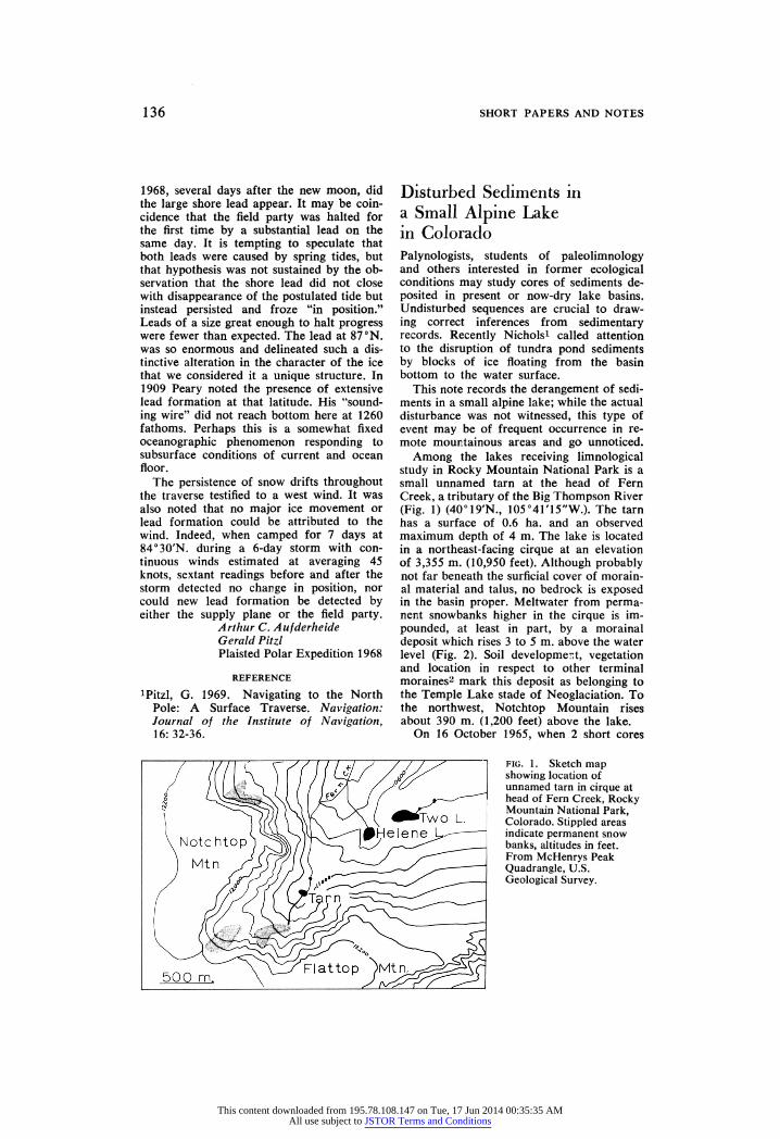
Among the lakes receiving limnological study in Rocky Mountain National Park is a small unnamed tarn at the head of Fern Creek, a tributary of the Big Thompson River (Fig. 1) (40°19'N, 105°41'15"W.). The tarn has a surface of 0.6 ha. and an observed maximum depth of 4 m. The lake is located in a northeast-facing cirque at an elevation of 3,355 m. (10,950 feet). Although probably not far beneath the surficial cover of morain- al material and talus, no bedrock is exposed in the basin proper. Meltwater from perma- nent snowbanks higher in the cirque is im- pounded, at least in part, by a morainal deposit which rises 3 to 5 m. above the water level (Fig. 2). Soil development, vegetation and location in respect to other terminal moraines2 mark this deposit as belonging to the Temple Lake stade of Neoglaciation. To the northwest, Notchtop Mountain rises about 390 m. (1,200 feet) above the lake.
On 16 October 1965, when 2 short cores
fig. 1. Sketch map showing location of unnamed tarn in cirque at head of Fern Creek, Rocky Mountain National Park, Colorado. Stippled areas indicate permanent snow banks, altitudes in feet. From McHenrys Peak Quadrangle, U.S. Geological Survey.
This content downloaded from 195.78.108.147 on Tue, 17 Jun 2014 00:35:35 AMAll use subject to JSTOR Terms and Conditions