Embed Size (px)
Citation preview
State of California The Natural Resources Agency Edmund G. Brown Jr., Governor
DEPARTMENT OF PARKS AND RECREATION Off-Highway Motor Vehicle Recreation Division
1725 23rd
Street, Suite 200 • Sacramento, CA • 916-324-4442 • [email protected]
OHMVR COMMISSION MEETING San Benito County Board of Supervisors Chambers
December 1, 2012
STAFF REPORT: SVRA Habitat Management Systems 2nd Generation (HMS2)
STAFF: Dan Canfield, OHMVR Division Planning Manager Christopher Huitt, OHMVR Division Environmental Program Manager Robert J. Meese, Ph.D., University of California at Davis
SUBJECT: Implementation of HMS2 at SVRAs
Summary
The OHMVR Division is in the process of updating and improving its program for monitoring habitat conditions in the State Vehicular Recreation Areas (SVRAs). These improvements are guided by a peer review performed by professionals from the University of California at Davis (UCD) at the request of the Division. The peer review outlined a number of changes and improvements needed by the program in order to meet the program’s mission of effectively managing the natural resources in the SVRAs.
UCD staff will be providing a report on the status of HMS2 implementation.
Discussion
Pursuant to Public Resource Code Section 5090.35(c), the OHMVR Division implements wildlife habitat protection programs (WHPP) and habitat management systems (HMS) for the eight SVRAs. Currently the OHMVR Division, in partnership with the UCD is designing and implementing a second generation WHPP/HMS system (i.e., HMS2) that is expressly designed to inform management on making decisions to meet the habitat management needs of the SVRAs and achieve greater statutory compliance.
At the request of the OHMVR Division, in 2009 UCD staff completed a peer review of the OHMVR Division’s existing HMS which provided insight and recommendations for improvements (see Attachment 1). The recommendations for improvement included:
Modifying the SVRA’s habitat management and monitoring activities to better address management concerns such as funding and staffing levels.
Implement an improved HMS2 with more stringent experimental design standards for replication and random sampling.
The HMS2 should have greater focus on ecosystem monitoring and indicator species as barometers of SVRA environmental health.

2
Implement a HMS2 data management system.
SVRAs to utilize HMS2 analyses in an adaptive management context.
The OHMVR Division accepted the recommendations identified in the UCD peer review report and entered into an agreement with UCD to implement HMS2.
To date, UCD environmental scientists have visited all SVRAs, at least twice, to refine monitoring techniques and standardize reporting tools. The UCD staff has consulted closely with the SVRA staff environmental scientists to establish “reference plots” and “control plots” that allow for comparison of habitat health in riding areas versus non-riding areas. Also, UCD staff has started entering historical monitoring data collected from the SVRAs into the HMS2 data management system.
Once fully implemented, HMS2 will provide SVRA managers with better information, including habitat data, to aide in well-informed management decisions.
Commission Action
For information only
Attachments
Attachment 1: Scientific Peer Review and Assessment of the OHMVR Division Habitat Monitoring System
SCIENTIFIC PEER REVIEW AND ASSESSMENT OF THE CALIFORNIA DEPARTMENT OF PARKS AND RECREATION
OFF-HIGHWAY MOTOR VEHICLE RECREATION DIVISION HABITAT MANAGEMENT SYSTEM
FINAL REPORT
Robert J. Meese Department of Environmental Science & Policy
University of California One Shields Avenue
Davis, CA 95616
Geoffrey R. Geupel PRBO Conservation Science
3820 Cypress Drive #11 Petaluma, CA 94954
Kent Reeves County of Yolo Parks & Resources Department
120 West Main Street, Suite C Woodland, CA 95695
James Weigand Bureau of Land Management
California State Office 2800 Cottage Way, Room 1928
Sacramento, CA 95825
TableofContents ACKNOWLEDGEMENTS ........................................................................................................... 3
ABSTRACT ................................................................................................................................... 3
INTRODUCTION .......................................................................................................................... 4
METHODS..................................................................................................................................... 8
RESULTS .................................................................................................................................... 10
DISCUSSION.............................................................................................................................. 12
RECOMMENDATIONS ............................................................................................................. 17
FUTURE CONSIDERATIONS ................................................................................................. 23
Appendix I. Site-specific Recommendations. ........................................................................ 29
Prairie City ............................................................................................................................... 29
Ocotillo Wells and Heber Dunes .......................................................................................... 29
Hollister Hills ........................................................................................................................... 30
Carnegie .................................................................................................................................. 30
Hungry Valley.......................................................................................................................... 31
Oceano Dunes ........................................................................................................................ 32
Clay Pit..................................................................................................................................... 32
2
ACKNOWLEDGEMENTS
We thank the Superintendents (Jeff Gaffney, Peter Yarbrough, Andy Zilke, Kathy
Dolinar, Bob Williamson) and Environmental Scientists (Stephanie Buss, Patty Forbes,
Ronnie Glick, Kim Matthews, and Eric Hollenbeck) who met with us, answered our
questions and helped us to understand the history and current implementation of the
Wildlife Habitat Protection Plan and Habitat Monitoring System. We thank the staff at
Oceano Dunes for providing an OHV riding opportunity for the review panel.
ABSTRACT We evaluated, through on-site interviews with senior staff and field review of
materials and methods, the Habitat Protection Plans (HPPs) and Habitat Monitoring
Systems (HMSs) of California State Vehicular Recreation Areas (SVRAs). We found
that these systems, devised by outside contractors nearly two decades ago (OHMVRD,
1999), provide protocols and standards that are robust and comprehensive but that
have been inconsistently implemented and not adequately informed by management
needs as articulated by site staff. We recommend that:
1. the existing systems of habitat protection and monitoring be modified with an
emphasis on priorities defined by management needs and staff and funding
constraints as identified by SVRA staff, including superintendents, environmental
scientists, and maintenance personnel
2. the revised HPP and HMS be implemented more consistently within and among
SVRAs
3
3. a greater emphasis be placed on data management, including the accumulation,
documentation, and digitization of existing data and reports
4. all data be analyzed to examine trends in species distributions and abundances
with an emphasis on comparisons between riding and non-riding areas
5. utilization of the results of these analyses in management activities and planning
efforts in an adaptive management context.
INTRODUCTION
The California Department of Parks and Recreation seeks to conserve the
biological integrity of while providing access to and outdoor recreational opportunities on
the 1.4 million acres of land that it manages. The Off-Highway Motor Vehicle Division
(OHMVRD, or “Division”) of the Department of Parks and Recreation was created with
the Chappie-Z’Berg Off-Highway Motor Vehicle Law of 1971 in response to increasing
demands for off-highway motorized vehicle recreation opportunities (Bedrossian and
Reynolds, 2007). This legislation was intended to provide increased opportunities for
motorized, off-highway recreation at designated sites (State Vehicular Recreation
Areas, or SVRAs) while simultaneously conserving natural resources (water, soil,
plants, and animals). This and subsequent legislation, primarily SB877, Chapter
1027/87 PRC, the Off-Highway Motor Vehicle Recreation Act of 1988 (Garamendi,
1988), required the Division to: 1) inventory plants and animals and to conserve soils, 2)
prepare wildlife habitat protection programs and 3) monitor soils, vegetation, and wildlife
on SVRAs in an attempt to assess the impacts of motorized recreation on soils, plants,
and animals. The Division’s off-highway motor vehicle recreation program is widely
viewed as a model for OHV recreation in the rest of the United States.
4
Funding for the program comes from sources related to off-highway vehicle use
(fuel tax revenues, fines, OHV registration stickers, day use and camping fees, special
event and concessionaire fees, and interest) and supports program maintenance as
well as a grants program undertaken with federal agency and local government
partners.
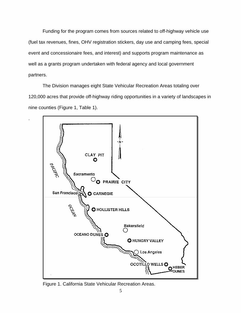
The Division manages eight State Vehicular Recreation Areas totaling over
120,000 acres that provide off-highway riding opportunities in a variety of landscapes in
nine counties (Figure 1, Table 1).
.
Figure 1. California State Vehicular Recreation Areas. 5
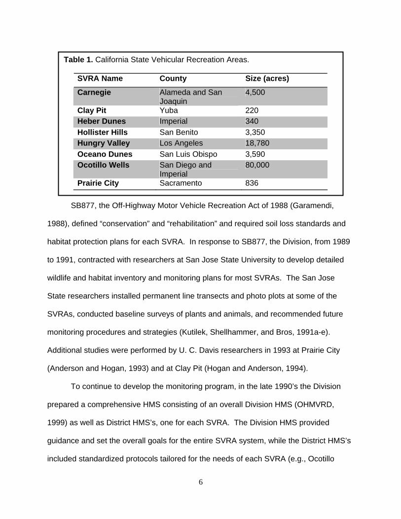
Table 1. California State Vehicular Recreation Areas.
SVRA Name County Size (acres)
Carnegie Alameda and San Joaquin
4,500
Clay Pit Yuba 220 Heber Dunes Imperial 340 Hollister Hills San Benito 3,350 Hungry Valley Los Angeles 18,780 Oceano Dunes San Luis Obispo 3,590 Ocotillo Wells San Diego and
Imperial 80,000
Prairie City Sacramento 836
SB877, the Off-Highway Motor Vehicle Recreation Act of 1988 (Garamendi,
1988), defined “conservation” and “rehabilitation” and required soil loss standards and
habitat protection plans for each SVRA. In response to SB877, the Division, from 1989
to 1991, contracted with researchers at San Jose State University to develop detailed
wildlife and habitat inventory and monitoring plans for most SVRAs. The San Jose
State researchers installed permanent line transects and photo plots at some of the
SVRAs, conducted baseline surveys of plants and animals, and recommended future
monitoring procedures and strategies (Kutilek, Shellhammer, and Bros, 1991a-e).
Additional studies were performed by U. C. Davis researchers in 1993 at Prairie City
(Anderson and Hogan, 1993) and at Clay Pit (Hogan and Anderson, 1994).
To continue to develop the monitoring program, in the late 1990’s the Division
prepared a comprehensive HMS consisting of an overall Division HMS (OHMVRD,
1999) as well as District HMS’s, one for each SVRA. The Division HMS provided
guidance and set the overall goals for the entire SVRA system, while the District HMS’s
included standardized protocols tailored for the needs of each SVRA (e.g., Ocotillo
6
Wells in 1997 [McClenaghan et al., 1997] and Heber Dunes in 1998 [McClenaghan et
al., 1998]). At this time Division staff began annual monitoring of vegetation and wildlife.
The Resource Ecologist/Environmental Scientist for each SVRA was directed to
conduct or to oversee most of the monitoring and to prepare an annual Habitat
Monitoring Report based on the HMS format and protocols. Large amounts of both
biotic and abiotic trend data have been collected for the SVRAs over the past several
years; these additional data have been added to the baseline data collected in the late
1980’s and early 1990’s.
Following the development and implementation of the HMS, the Division
prepared WHPPs for most of the SVRAs. The goals of the WHPPs are to document
and to maintain current wildlife populations and their habitats, and to conserve soils.
The WHPPs are intended to be adaptive, that is, as new information is made available
through monitoring, management practices will change or “adapt” as warranted by the
new information. The WHPPs and the district HMSs however, were not developed
together (the HMSs were developed first), nor have the goals and objectives of the
WHPPs been linked with the design of the monitoring program within an overall
adaptive management framework. An effective monitoring program needs to be able to
assess progress towards explicit and meaningful population and habitat protection goals
and program objectives (Elzinga et al., 2001; Atkinson et al., 2004).
Both the HMSs and WHPPs are expected to keep pace with evolving science to
ensure that they continue to be effective and appropriate to meet program goals. Both
were to have been evaluated annually by a Division resource team and periodically
reviewed by scientists and resource professionals outside the Division, if necessary
7
(OHMVRD, 1999). Neither the district HMSs nor the WHPPs have had independent,
outside review to help the Division to evaluate and update, as needed, its wildlife habitat
protection and monitoring programs. An outside, independent assessment is
particularly necessary now in light of the more stringent performance and accountability
standards being required of the OHV grant recipients and the current thinking among
scientists and resource professionals about the benefits of designing monitoring
programs that link to the goals and objectives of adaptively-managed conservation or
habitat protection plans. The purpose of this assessment is to provide an independent
peer review of existing HMS and WHPP efforts, as called for by the enabling legislation
as well as previous investigators (OHMVRD, 1999).
METHODS The peer review consisted of six individuals, two from the OHMVR Division and
four from outside the Division. Division staff facilitated the peer review process,
including providing names and contact information for SVRA staff, providing relevant
documents, and providing logistical support for site visits. Division representatives were
Karen Feldheim, who served as program manager, and Sarah Cumber, who served as
program assistant. Robert Meese, an ecologist at the University of California, Davis,
served as coordinator of the peer review, recruited the review panel, participated in the
peer review process, and integrated the reports of the peer review panelists into the
final report.
The review panel consisted of three individuals: James Weigand, plant ecologist
with the U.S. Department of the Interior, Bureau of Land Management, Sacramento,
who examined the HMSs and WHPPs for plants; Geoff Geupel, Director of the
8
Terrestrial Ecology Division, PRBO Conservation Science, Petaluma, who examined the
HMSs and WHPPs with an emphasis on birds, and Kent Reeves, senior planner for
Yolo County, California, who examined the HMSs and WHPPs with an emphasis on
amphibians, reptiles, and mammals.
The peer review process consisted of four elements: 1) a review of existing HMS
and WHPP documents, 2) site visits to each State Vehicular Recreation Area, 3) this
final report, and 4) a presentation of findings and recommendations at OHMVR Division
HQ in Sacramento.
The SVRAs were visited according to the following schedule:
i. Orientation at OHMVR Division HQ, Sacramento: 2/7/2008
ii. Prairie City: 2/27/2008
iii. Ocotillo Wells: 3/24-3/25/2008
iv. Hollister Hills: 4/4/2008
v. Carnegie: 5/13/2008
vi. Hungry Valley: 6/9-6/10/2008
vii. Oceano Dunes: 9/23-9/24/2008; Geoff Geupel 11/17-11/18/2008
viii. Clay Pit: 11/18/2008
Prior to each site visit, panelists were provided with electronic copies of existing
reports (HMS, WHPP, and annual reports) and data sets (typically Excel® spreadsheet
files) for their review. Each site visit consisted of two elements: 1) an initial introduction
of peer review panelists and an overview of the goals of the peer review followed by a
question and answer period with the site superintendent and senior environmental
scientist, and in some cases the senior maintenance staff person, and 2) a review of
9
existing protocols and methods in the field with the senior environmental scientist and
additional natural resource staff members.
Panelists provided individual reports of their findings, conclusions, and
recommendations to Robert Meese, who synthesized the individual reports into a draft
final report that was returned to the panelists for their review and then submitted to the
OHMVR Division program manager following the presentation at Division headquarters
in Sacramento.
RESULTS The SVRA environmental scientists are competent, knowledgeable, and
committed to performing the tasks associated with monitoring plant and animal
populations on SVRAs. All had the training and experience necessary to implement the
methods as recommended in the original WHPP and HMS reports (Kutilek,
Shellhammer, and Bose, 1991a-e; OHMVRD, 1999), but the SVRA environmental staffs
are too small to conduct the comprehensive ecosystem-based monitoring as originally
devised (Kutilek, Shellhammer, and Bose, 1991a-e; OHMVRD, 1999). Staff at most
sites are dedicated to or heavily focused on needs as dictated by conservation priority,
and monitoring of listed species typically dominates staff time and resources at the
expense of more broadly-based habitat and ecosystem monitoring or monitoring of non-
listed “indicator” species. Existing and historical emphasis appears to be on how to do
monitoring and in implementing recommended monitoring protocols, including data
analysis and reporting, but not analysis, and questions related to why to do monitoring
and the role(s) of results of monitoring in directing management activities are poorly
addressed. At present, monitoring does not appear to be tied to specific, well-defined
10
management goals, except in the case of listed species (e.g., snowy plover at Oceano
Dunes), and we learned of very few examples of monitoring results being used to inform
management. Generally, natural resource monitoring appears to occur in isolation from
site management and results of monitoring activities are not used in making
management decisions except, again, in cases of listed species (e.g., beach closures to
protect nest sites of snowy plovers at Oceano Dunes).
Data collection is often idiosyncratic, inconsistent, and strongly influenced by
staff time conflicts and turnover and regulatory concerns (listed species receive
disproportionate attention yet may not yield much information on more general question
of how species abundances are changing through time). Several sites have
experienced gaps in data collection as well as in the reporting of results, whereas both
the enabling legislation (SB877) in Section 11, paragraph (c) as well as the HMS
(OHMVRD, 1999) calls for the annual monitoring of birds, biennial monitoring of
vegetation and mammals. As far as we are aware, the every-two-year aerial
photographic record recommended in the HMS document (OHMVRD, 1999) as a
means to monitor habitat and to document changes in vegetation cover and density
does not exist, and this recommendation has not been implemented. The Hungry
Valley HMS 2006 annual report refers to a switch from aerial photography to digital
satellite imagery in 2004 (Hungry Valley SVRA, 2007), but it is unclear whether this
change was implemented system-wide.
Field data are well recorded and documented on paper field forms but are
inconsistently documented in annual reports and not readily accessible to off-site (e.g.
Division HQ) staff nor other interested persons. Data analyses of the type performed in
11
the original monitoring plans (Kutilek, Shellhammer, and Bose, 1991a-e), which
included numerous statistical analyses, appear to be lacking in most of the annual
reports submitted by site environmental scientists. The annual reports of Ocotillo Wells
are notably more faithful to the original methods of data analysis and interpretation.
Similarly, thorough interpretation of the results of data collection and analysis efforts are
in general missing from annual reports.
The calculation of diversity indices is widespread but the subsequent analyses of
trends utilizing indices of diversity is lacking. Diversity indices are expressly designed to
enable the comparison of index values through time or space (Magurran, 1988), as
illustrated in the original Kutilek, Shellhammer, and Bose (1999a-e) and Oceano Dunes
2000 annual reports (Oceano Dunes SVRA, 2001); however, results of comparisons of
multiple indices are rarely reported in the annual site reports, and thus the utility of
calculating these indices is lost. Despite the explicit goals of the WHPP/HMS systems
(Kutilek, Shellhammer, and Bose, 1999a-e; OHMVRD, 1999), i.e. to detect trends, we
are aware of few examples of analyses of trends in either vegetation coverage or
species populations; an exception is the comparisons of 1994 to 2000 vegetation
coverage at several locations at Oceano Dunes (Oceano Dunes SVRA, 2001).
DISCUSSION
Our interviews and field reviews with SVRA staff demonstrated that a clear dis-
connect currently exists between field work and the goals of the field work, such that the
methods historically and currently being used are generally appropriate for monitoring
plant and animal populations, but the reasons why the monitoring is occurring and the
12
ultimate use or application of results of monitoring and how they relate to management
of natural resources are unclear and not well documented.
The reporting of results of monitoring efforts in annual reports is inconsistent and
idiosyncratic and detracts from the Division’s mission to comprehensively monitor the
natural resources on its system of SVRAs in an integrated and systematic program.
The dependence upon a long, and growing, series of annual reports that are produced
in different ways at different sites with different levels of analysis and interpretation
impedes efforts to get a picture of whether and/or how conditions are changing on
SVRAs, let alone understand the reasons why these changes may be occurring.
The existing WHPP and HMS programs divide data collection into activities to
acquire quantitative AND qualitative information (OHMVRD, 1998). Monitoring that is
scientifically credible and able to withstand challenges in a court of law needs to be
objective (i.e., requires random sampling), accurate, unbiased (precise, not dictated by
convenience; Anderson, 2001), and statistically robust. Careful selection of variables,
statistical design, efficient sampling, appropriate sampling methods, quality assurance
for data collection, and quality control for data recording and storage are the elements
of an effective monitoring system (Elzinga et al., 1999).
The authors of the OHMVR monitoring system regard monitoring as important for
providing baseline estimates followed by trends in plant and animal population sizes as
well as for characterizing initial and deviations from original habitat conditions (various
measurements of vegetation). General criteria for tasks in the vegetation monitoring
system for use in SVRAs come from an EPA document cited on pages G-12 and G-13
13
of the HMS report (OHMVRD, 1999) and include the following (somewhat reworded for
brevity and clarity):
a. test the effectiveness of vegetation management practices in OHV recreation
settings to meet existing regulations, standards, and guidelines
b. compare results of management with control sites where management does
not occur
c. identify significant changes, their trends, and rates of change
d. achieve within the constraints of available labor and capital
We did not examine the monitoring hypotheses for T&E species because other
authorities, the U.S. Fish & Wildlife Service, National Oceanic and Atmospheric
Administration, and the California Department of Fish and Game, have jurisdiction over
T&E species protocols and their implementation. The hypotheses that furnish the basis
of the existing monitoring system for SVRAs are not explicitly stated in the HMS
document; however, the focus of plant and animal monitoring described in the
document suggests that perhaps three hypotheses are intended for testing across all
SVRAs (Ho: indicates the null hypothesis while H1 indicates the alternative or research
hypothesis):
H0: Extent of vegetation cover of SVRAs is not changing. H1: Extent vegetation cover of SVRAs is changing.
H0: Species diversity of plants and animals in SVRAs is not changing. H1: Species diversity of plants and animals in SVRAs is changing.
H0: Evenness of species populations in SVRAs is not changing. H1: Evenness of species populations in SVRAs is changing.
These global hypotheses reflect OHMVR Division-wide concern that motorized
recreation may have impacts on the amount and type of plants, animals, and vegetative
14
cover within an SVRA. An evaluation of the necessity and sufficiency of these
hypotheses for managers and the public should be on-going based on evolving policy,
current scientific knowledge, available technology, and statistical design. The
monitoring system should provide information to management and should continue to
develop in response to the needs of SVRA natural resource managers (i.e., monitoring
should occur within an adaptive management framework).
Our evaluation of the existing WHPP/HMS program examines four questions in
regard to the hypotheses that form the basis of a monitoring system:
(1) Do current observations continue to validate the observations that prompted
the hypotheses?
(2) Are the hypotheses correctly and completely stated?
(3) Are the monitoring protocols and the statistical design chosen to determine
hypothesis adequate to provide data needed by ecologists and SVRA managers with
the required confidence for further decision making by SVRA managers?
(4) What additional hypotheses need to be tested, if any, to meet the needs of
natural resource managers?
The existing system (OHMVRD, 1999) utilizes data collection methods that
characterize plant and animal communities generally - they use a comprehensive
approach to cover multiple variables that may or may not be of immediate concern to
managers but are more likely to detect an unanticipated or previously unnoticed change
from the baselines established in the Kutilek et al. (1999a-e) reports. This strategy is
different from monitoring site-specific variables of immediate concern to SVRA
environmental scientists and managers in response to an outcome or unforeseen
15

consequence of a management action to control a variable of concern. Because the
general strategy to detect change is diffuse and not focused on concerns expressed by
site environmental scientists or managers, the data collected may or may not be
relevant to management goals. This observation, noted at several SVRAs, may explain
the apparent disconnect in interest and application of information from monitoring
between environmental scientists and managers.
It is apparent that the designers of the monitoring system have experience in
assessment and data collection methods for plant community and animal population
inventories and provide a series of well-justified methods to analyze monitoring data
(Kutilek et al., 1999a-e); however, less attention is paid to the interpretation and
application of results to serve a role in guiding management for SVRAs in a process of
iterative evaluation to improve and refine management of natural resources and
motorized recreation (adaptive management) nor have the protocols and analyses been
uniformly implemented among sites. We recommend that environmental scientists in
collaboration with superintendents and maintenance managers discuss protocols used
to gather as well as to analyze and interpret the data collected to make the results of
monitoring efforts most appropriate, available, and comprehensible to both biologists
and resource and administrative managers. Recommendations for management
actions must be based upon and backed up by reliable methods of data collection,
analysis, and interpretation, but be presented to decision-makers in ways that are most
readily understood by them in an iterative process that engages both managers and
field staff. These discussions may lead to decisions to modify existing methods given
16
the constraints of staff and financial resources but must continue to implement broad-
based, ecosystem-level habitat monitoring that meet SVRA management needs.
RECOMMENDATIONS We recommend that the OHMVR Division design a second generation
WHPP/HMS system that is expressly designed to meet the needs of the State Vehicular
Recreation Areas in fulfilling the goals set forth in SB877 and subsequent legislation as
well as legal obligations as described in state and federal statutes. We recommend that
the Division engage senior environmental and management staff, with or without
outside assistance, in designing the second generation WHPP/HMS system that is
focused on answering questions of greatest management interest and need. In similar
settings, state and federal biologists have designed large-scale monitoring programs
according to a multi-step process that applies a step-wise approach (e.g., Atkinson et
al., 2004; Elliot et al., 2004). Such a step-wise approach appears to be lacking in the
design and implementation of the existing HMS yet is essential to the Division if it
desires to collect, analyze, and interpret data and answer questions that are enable it to
fulfill its mission of monitoring and conserving the natural resources on the State
Vehicular Recreation Areas. The following schema, adapted from Atkinson et al.
(2004), is suggested as a guide to Division attempts to re-design, re-think, and re-focus
energies, talents, and resources.
Step 1. Identify the goals and objectives of the habitat management plan; this is
an essential first step, and one that the panelists found lacking in the
existing HMS schema. The papers by Anderson (2001), Oakley et al.
(2003), and Atkinson et al. (2004) and the excellent book by Elzinga et al.
17

(2001) stress the importance of planning in the development and
implementation of successful long-term monitoring efforts.
Step 2. Identify the scope of monitoring program – what species, habitats, and
other variables will be measured, over what temporal and spatial scales?
Step 3. Compile information relevant to monitoring program design – this report
may serve as a guide to relevant independent literature
Step 4. Strategically divide the system and prioritize for monitoring program
development; what species and habitats will be chosen for annual,
biennial, or other (every 5 years?) monitoring? Modify existing design to
use focal and/or surrogate species that are linked to specific
management objectives.
Step 5. Develop simple management-oriented conceptual models
Step 6. Identify monitoring recommendations and critical uncertainties
Step 7. Determine strategy for implementing monitoring. To some extent this
was the goal of the original work by the San Jose State and U.C. Davis
researchers, but strategic input for the design and implementation of the
HPPs and HMSs must come from within the Division, perhaps with the
assistance of outside consultants from academia or other agencies, as
only the Division can identify and articulate the questions that the HPPs
and HMSs are intended to answer as well as define the constraints
(funding, staff, time, effort) that affect design and implementation
decisions. SVRA management considerations must guide the
18
development of the HPPs and HMSs and be guided by the results of these
programs.
Step 8. Develop data quality assurance, data management, analysis, and
reporting strategies. Although not lacking in the existing HMS, there is a
great need for improved data management that scales from the field site
to the SVRA to the Division level – the Division environmental scientists
ought to be able to access and query site data from the Sacramento HQ
and to quickly and easily identify particular data sets that important for
documenting trends. The original HMS documents (Kutilek,
Shellhammer, and Bose, 1991a-e) called for such a custom database
application that contained automated statistical routines to test for
differences in percent-cover of plants and changes in abundances of
animals. We specifically recommend that all existing data and reports be
accumulated into a central repository and that all data and reports be
made electronic. Existing paper-copy reports should be scanned and
converted into portable document format (pdf) files and stored and
archived appropriately. This is easily done with a flat-bad scanner,
automatic document feeder and appropriate software.
Step 9. Complete the adaptive management loop (Figure 2) by ensuring effective
feedback to decision-making. The results of analyses of field data (e.g.,
the detection of a declining amphibian population or a reduction in
percent cover or other abundance measure of a plant species or plant
community type) ought to lead to appropriate management actions (e.g.,
19
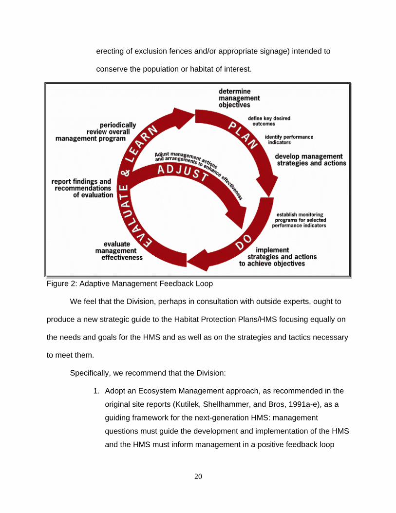
erecting of exclusion fences and/or appropriate signage) intended to
conserve the population or habitat of interest.
Figure 2: Adaptive Management Feedback Loop
We feel that the Division, perhaps in consultation with outside experts, ought to
produce a new strategic guide to the Habitat Protection Plans/HMS focusing equally on
the needs and goals for the HMS and as well as on the strategies and tactics necessary
to meet them.
Specifically, we recommend that the Division:
1. Adopt an Ecosystem Management approach, as recommended in the
original site reports (Kutilek, Shellhammer, and Bros, 1991a-e), as a
guiding framework for the next-generation HMS: management
questions must guide the development and implementation of the HMS
and the HMS must inform management in a positive feedback loop
20
2. Measure vegetation and create an index of OHV use at all bird count
and pit trap array locations to enhance the results and utility of the data
collected. Collection of these additional data will allow future analyses
of animal-habitat relationships, habitat suitability indices and spatial
predictive models of species occurrence which will greatly increase the
relevance of monitoring data to management. At a minimum, a
vegetation ‘relevé’, as described in Ralph et al. (1993), page 38,
should be conducted for each point count/pit trap location to
characterize and document the vegetation matrix (= habitat) that
surrounds these points.
3. The assessment of OHV trails, perhaps as described by McCreedy et
al. (2007), should include the distance from the center of point count/pit
trap locations and estimate trail density within a fixed radius.
4. Superintendents and environmental scientists, in consultation with
maintenance staff, should collaborate on creating management plans
that identify specific management needs and goals. The purpose(s) of
species and habitat monitoring should be made explicit and related to
stated management objectives
5. Conduct an “inventory of inventories”: require all SVRAs to document
all existing data and reports and then accumulate these into a central
repository, regardless of original sources (paper, word processor files,
spreadsheets, annual, consultant, or other reports, user reports, etc.).
All paper information, including data and reports of SVRA staff, the
original HMS and WHPP documents, peer-reviewed publications,
theses, and reports submitted by outside consultants should be
digitized and deposited into a centralized electronic data repository.
This repository is needed to archive (safeguard) existing information
and to serve as a resource available to SVRA and Division personnel
as well as qualified persons outside the Division who seek to answer a
multitude of questions of management interest and to identify within
and among-site trends.
21
6. We recommend the development of a dedicated data management
system consisting of a shared database with on-line data entry
capability that includes: 1) the ability to generate geographic
coordinates (as with an API to Google Maps®), 2) accumulate and
store geo-referenced image files (digital photographs taken at known
times and locations), 3) query data via pre-defined as well as user-
defined queries, 4) analyze and visualize data via pre-defined tools
(statistical tests, plots of abundance over time, etc.) and 5) output data
via preformatted reports of species inventories as well as graphs of
species abundance and percent coverage through time. Data
reporting should look at among-year results and illustrate trends by
fitting a line to the abundance data through time and automatically
determine whether the slope of the fitted line <> 0 (that is, automate
the process of performing a linear regression to tell you whether
abundance is increasing or decreasing through time) or document
complex relationships.
7. Encourage outside research by nearby academic institutions to answer
questions of management interest. Faculty and their graduate
students are typically well-trained and have knowledge and experience
that may complement that of site staff. In addition, in most cases
graduate student stipends are of considerably lower cost than are
costs associated with environmental consultants, thus, the sites may
obtain the information they need while conserving financial resources.
Examples of such studies include the work of Beauchamp et al. (1998)
on flat-tailed horned lizards (Phrynosoma mcallii) in Ocotillo Wells
SVRA and Fridell’s (1990) work on Hungry Valley SVRA.
8. Extend outreach efforts to encourage user groups (riders, campers,
birders, and others) to report observations. Methods may include
providing handouts to users as they enter SVRAs and encouraging
reports of observations during educational activities or while giving
public presentations.
22
9. Provide a mechanism to rapidly and reliably record observations
provided by public. The most efficient means to record these
observations would be to create a module within the recommended
HMS data management system that accumulated observation records
(who, what, when, where; although the primary purpose of the
recommended HMS data management system would be to manage
and report results of formal monitoring activities).
10. Do more outreach: the public needs to be educated about the benefits
to wildlife and its habitats of concentrating riders on well-managed
SVRAs and why riding on SVRAs is preferable to riding on public lands
with minimal protection and enforcement. Encourage the kinds of
multiple-use activities that are common at Hungry Valley SVRA but
less so elsewhere in the system.
FUTURE CONSIDERATIONS As the global human population increases, attendant impacts on natural systems
will continue to increase. Among the many considerations for land managers is the
emerging emphasis on appropriate responses to global climate change. For the
WHPP/HMS systems, applicable considerations include:
• Stratifying sampling points by elevation in those SVRAs with substantial
topographic relief in an attempt to detect changes in species abundances as a
function of elevation
• Include trail width as a variable to be assessed, as changes in vehicle type, as
from motorcycles to “quads”, may lead to increases in trail widths, which may
impact some bird species (Holmes and Geupel, 2005).
23
LITERATURE CITED
Anderson, D.R. 2001. The need to get the basics right in wildlife field studies. Wildl.
Soc. Bull. 24: 1294 – 1297.
Anderson, D.W. and B. Hogan. 1993. Prairie City SVRA wildlife and habitat inventory
and monitoring plan. Dept. of Wildlife and Fisheries Biology. University of
California Davis, Davis, California. Report for the Dept. of Parks and Rec.,
OHMVR Division. 45pp.
Atkinson, A.J., P.C. Trenham, R.N. Fisher, S.A. Hathaway, B.S. Johnson, S.G. Torrres,
and Y.C. Moore. 2004. Designing Monitoring Programs in an Adaptive
Management Context for Regional Multiple Species Conservation Plans.
U.S.G.S. Western Ecological Research Center, Sacramento, California, in
partnership with the California Department of Fish & Game, Habitat Conservation
Division, and the U.S. Fish & Wildlife Service, Carlsbad, California. Available
from the Western Ecological Research Center website at:
http://www.werc.usgs.gov/sandiego/pdfs/NCCP%20Monitoring%20Framework-
10-12-04.pdf.
Beauchamp, B., B. Wone, S. Bros, and M. Kutilek. 1998. Habitat use of the flat-tailed
horned lizard (Phrynosoma mcallii) in a disturbed environment. J. Herp. 32: 210-
216.
Bedrossian, T.L. and S.D. Reynolds. 2007. Development of a soil conservation standard
and guidelines for OHV recreation management in California. Env. & Eng.
Geoscience 13: 241-253.
Chase, M K. and G. R. Geupel. 2005. The use of avian focal species for conservation
24
planning in California. p 130-142 In Proceedings of the Third International
Partners in Flight conference, C.J. Ralph and T.D. Rich eds. USDA Forest
Service Gen. Tech. Report PSW-GTR-191. Available from:
http://www.fs.fed.us/psw/publications/documents/psw_gtr191/Asilomar/pdfs/130-
142.pdf.
Dale, V.H. and S.C. Beyeler. 2001. Challenges in the development and use of
ecological indicators. Ecological Indicators 1: 3 – 10.
Elliot, G., M. Chase, G. Geupel, and E. Cohen. 2004. Developing and Implementing an
Adaptive Conservation Strategy: A Guide for Improving Adaptive Management
and Sharing the Learning Among Conservation Practitioners. Petaluma,
California: PRBO Conservation Science. Available for download from:
http://www.prbo.org/cms/279
Elzinga, C.L., D.W. Salzer, and J.W. Willoughby. 1999. Measuring and monitoring plant
populations. U.S.D.I. Bureau of Land Management Technical Reference 1730-1.
Available from: http://www.blm.gov/nstc/library/techref.htm.
Elzinga, C.L., D.W. Salzer, J.W. Willoughby, and J.P. Gibbs. 2001. Monitoring plant and
animal populations. Malden, MA: Blackwell Science (with associated internet
resources available at: http://www.esf.edu/efb/gibbs/monitor/popmonroot.html).
Fridell, D.A. 1990. Analysis of the impacts of off-road vehicle use in Hungry Valley
California State Vehicular Recreation Area. Masters Thesis. Dept. of Geography,
San Diego State University. San Diego, California. 103 pp.
Garamendi 1988. Senate Bill No. 877: Off-highway vehicles. Chapter 1027. 15 pp.
25
Hogan, B. and D.W. Anderson. 1994. Clay Pit State Vehicular Recreation Area Wildlife
and Habitat Monitoring Plan. Prepared for California Department of Parks and
Recreation, Off-Highway Motor Vehicle Recreation Division. Sacramento, CA.
Holmes, A.L. and G.R. Geupel. 2005. Effects of trail width on the densities of four
species of breeding birds in chaparral. p 610-613 In Proceedings of the Third
International Partners in Flight conference, C.J. Ralph and T.D. Rich eds. USDA
Forest Service Gen. Tech. Report PSW-GTR-191.
Hungry Valley State Vehicular Recreation Area. 2007. 2006 Hungry Valley State
Vehicular Recreation Area Habitat Monitoring Annual Report. Prepared by
California Department of Parks and Recreation, Off-Highway Motor Vehicle
Recreation Division, Hungry Valley District Staff Environmental Scientist Kim
Matthews.
Kakiba, K.M. and R.J. Vogl. 1986. The impact of off-road vehicles on the perennial
desert vegetation at Ocotillo Wells SVRA, San Diego County, California. Dept. of
Biology, California State University, Los Angeles. Report for the Dept. of Parks
and Rec., OHMVR Division. 103 pp.
Kutilek, Michael, H. Shellhammer, and W. Bros. 1991a. Inventory, wildlife habitat
protection program and monitoring program for Hollister Hills SVRA, California.
Dept. of Biological Sciences, San Jose State University, San Jose, Calif. Report
for the Dept. of Parks and Rec., OHMVR Division. 81 pp.
Kutilek, Michael, H. Shellhammer, and W. Bros. 1991b. Inventory, wildlife habitat
protection program and monitoring program for Carnegie SVRA, California. Dept.
26
of Biological Sciences, San Jose State University, San Jose, Calif. Report for the
Dept. of Parks and Rec., OHMVR Division. 60 pp.
Kutilek, Michael, H. Shellhammer, and W. Bros. 1991c. Inventory, wildlife habitat
protection program and monitoring program for Ocotillo Wells SVRA, California.
Dept. of Biological Sciences, San Jose State University, San Jose, Calif. Report
for the Dept. of Parks and Rec., OHMVR Division. 64 pp.
Kutilek, Michael, H. Shellhammer, and W. Bros. 1991d. Inventory, wildlife habitat
protection program and monitoring program for Pismo Dunes SVRA, California.
Dept. of Biological Sciences, San Jose State University, San Jose, Calif. Report
for the Dept. of Parks and Rec., OHMVR Division. 55 pp.
Kutilek, Michael, H. Shellhammer, and W. Bros. 1991e. Inventory, wildlife habitat
protection program and monitoring program for Hungry Valley SVRA, California.
Dept. of Biological Sciences, San Jose State University, San Jose, Calif. Report
for the Dept. of Parks and Rec., OHMVR Division. 74 pp.
Magurran, A.E. 1988. Ecological Diversity and Its Measurement. Princeton, New
Jersey: Princeton Univ. Press.
McClenaghan, Lee, T. Zink, J. Tizler and D. Wood, 1997. Ocotillo Wells State Vehicular
Recreation Area Vegetation and Wildlife Survey. San Diego State University, San
Diego, Calif. Report prepared for the California Department of Parks and
Recreation, OHMVR Division.
McClenaghan, Lee, T. Zink, F. Edwards, L. Heffernan and D. Wood, 1998. Heber
Dunes Vegetation and Wildlife Survey. San Diego State University, San Diego,
27
Calif. Report prepared for the California Department of Parks and Recreation,
OHMVR Division.
Oakley, K.L., L.P. Thomas, and S.G. Fancy. 2003. Guidelines for long-term monitoring
protocols.
Oceano Dunes SVRA. 2001. 2000 Annual Report, Habitat Monitoring. California
Department of Parks and Recreation, Off-Highway Motor Vehicle Recreation
Division, Oceano Dunes District.
Off Highway Motor Vehicle Recreation Division, California Department of Parks and
Recreation (no author). 1998. Habitat Monitoring System.
Pudoff, T.J. 1992. The spatial and temporal effects of off-highway vehicles on
vegetation and landforms in an arid environment: a case study of Ocotillo Wells
SVRA, California. Unpubl. Masters Thesis, San Diego State University.
Ralph, C.J., G.R. Geupel, P. Pyle, T.E. Martin, and D.F. DeSante 1993. Handbook of
field methods for monitoring landbirds. USDA Forest Service Publication, PSW-
GTR 144, Albany, CA. 41p. Available on-line at:
http://www.fs.fed.us/psw/publications/documents/psw_gtr144/psw_gtr144.pdf.
HTML version available on-line at:
http://www.fs.fed.us/psw/publications/documents/gtr-144/.
28
Appendix I. Site-specific Recommendations.
Prairie City
1. Need stratified-random bird point count surveys in riding and non-riding (buffer) areas. Higher concentrations of point count locations in sensitive habitats (coastal scrub) may also be warranted.
2. Evaluate effects of invasive species, especially bullfrogs, as these are known to deleteriously affect many amphibian species.
3. Evaluate effects of non-riding areas (buffer zones) on decreasing noise and dust and providing habitat for vertebrates. Documenting their use by vertebrates must be a goal of monitoring program.
4. Updated management plan, currently being written by a consultant, needs to integrate with current and future results of a monitoring program. A spatially explicit occupancy model using monitoring data should be built (and updated annually) to guide design of riding trails and non-riding areas that maximize species protection and minimize urban noise/dust issues.
Ocotillo Wells and Heber Dunes
1. Need stratified-random bird point count surveys in riding and non-riding areas. Higher concentrations of point count locations in sensitive habitats may also be warranted. Areas with minimal to no vegetation could probably be excluded from vertebrate surveys.
2. Point counts of birds should begin in February, as breeding by some desert resident species, for example thrashers, may start as early as February.
3. Surveys during winter to coincide with heavy-use interval would provide much useful information on impacts on resident species.
4. Enhance communication with Anza-Borrego State Park to make maximum use of staff time and avoid duplication of effort. A coordinated monitoring program across both sites and additional properties being considered for inclusion (and other public lands) would help to define habitat relationships, prioritize species of management interest, and aid in the coordination of management responsibilities among sites.
5. Include impacts of campgrounds on vertebrates and habitats in monitoring program.
6. Document wildlife responses to vegetation protection in Heber Dunes as the importance of this small island of habitat in the surrounding sea of agriculture is
29
worth documenting. Less intensive and more limited use over time should be a long-range objective of this unique area.
Hollister Hills
1. Need stratified-random bird point count surveys in riding and non-riding areas. Higher concentrations of point count locations in sensitive habitats may also be warranted.
2. Site appears mostly driven by ‘compliance’ monitoring thanks to a 1992-2001 lawsuit over dust, noise and traffic. A multi-species ‘effective’ monitoring program as described in this report would help to guide management and give the site a more proactive response to threats and opportunities (listed below) and lawsuits.
3. We recommend enhanced outreach and use of the site’s natural areas in the non-riding season to the riding and non-riding public.
4. If an HCP is being developed for the county, the site and its monitoring data should be included and the site recognized for contributing to the conservation of plants and animals, especially T&E species.
5. Fire may be used as an effective management tool to reduce risk of catastrophic wildfires while promoting habitats for T&E species.
6. Invasive species, especially yellow star thistle and pigs, require active control/eradication programs.
7. Excellent opportunity to develop resource management/field biologist intern program with West Valley College and San Jose State University programs. Such an internship program would help to build public support and provide the site with future dedicated, well-trained staff.
8. New low-use trails are being established; obtaining pre-riding baseline data could yield interesting results and help to guide trail design and related management decisions in future.
Carnegie
1. Need stratified-random bird point count surveys in riding and non-riding areas coupled with an assessment of surrounding vegetation. Higher concentrations of point count locations in sensitive habitats may also be warranted.
2. Must address potential observer-dependent bias, as multiple observers were used in 2005 and only one observer was used in 2006, potentially affecting results and interpretation.
3. Bird surveys should be concentrated in the winter (= riding) and spring (= breeding) seasons.
30
4. Need to guide riders away from sensitive areas when amphibians are out; therefore, frequent randomized geospatially referenced sampling with associated vegetation component is warranted. This schema will allow environmental scientists to identify/predict peak activity periods and delimit sensitive areas. May want to overlap with bird count locations to investigate the use of easier to monitor surrogate species.
5. In the newly acquired area, need to: a. Identify sensitive sites or hot spots for protection b. Establish a baseline for subsequent comparison (pre- vs. post-use) c. Design trail system to minimize impacts on soils, vegetation, and wildlife d. Heritage oaks likely have unique bird species that warrant/require
protection 6. Integrate monitoring plan with new general plan being developed by consultant
(EDAW) 7. Continue restoration in riparian area and monitor to evaluate results of efforts 8. Continuity of staff an issue; may want to develop an intern program. 9. Volunteer trails proliferating, must seek to limit riding to established, approved
trails and areas. Perhaps limit number of riders in SVRA – establish a site “carrying capacity”
10. Monitoring for small mammals, including bats in mines, especially those that may be near the limits of their geographical ranges, to detect distribution and abundance changes associated with riding and/or climate change. Specific management actions for some of these species?
Hungry Valley
1. Need stratified-random bird point count surveys in riding and non-riding areas coupled with an assessment of surrounding vegetation. Higher concentrations of point count locations in sensitive habitats (riparian area and oak woodlands) and additional points at random in other habitat types (e.g., grassland) may be warranted.
2. Inventory then monitor bat populations. 3. Overall, an exceptionally well-managed SVRA with a team oriented approach to
management with a close relationship and good communication between resource and management staff. Some unique and innovative ideas that could serve as examples for other SVRAs include:
a. Trail crew working under resource staff b. Riparian areas closed to riding c. Open riding being reduced on highly erodible soils d. Low staff turnover as resource personnel are part of core staff
31
e. Active public relations/outreach program that includes an interpretive assistant and wildflower walks for visitors on non-riding days. Interestingly, and significantly, this SVRA is used by 300,000-500,000 people year-round and visitors include Sierra Club members.
4. Coordinate monitoring and management with USFS neighbor. Oceano Dunes
1. An exceptionally well organized, well funded, and concentrated monitoring and management program focused on endangered species. As part of an HCP, monitoring results are used daily to guide management, protect sensitive areas, and limit use, as needed. May serve as a model for other SVRAs.
2. Seek to expand existing multi-species shorebird count along the beach. 3. Evaluate biological responses to habitat island restorations. 4. Interact with staff at the California Avian Data Center (CADC) to enhance
database management for snowy plover nest, color band, and shorebird census data.
5. Open garbage bins attracting predators; document increases in gull numbers and attendant impacts around garbage bins to justify recommendation to cover garbage bins.
6. Excellent interpretive program including a boardwalk for non-riders. Clay Pit
1. Need more-frequent monitoring, as brief visit on 11/18/2008 added one new bird species (Ferruginous hawk) to species inventory.
2. Encourage local birders to report observations? Close enough to urban area (Oroville) that many birders likely in local community and would be delighted to be asked to help.
3. Establish stratified-random bird point count surveys and pit traps in riding and to-be-established non-riding areas. Protect (fence off) and document vertebrate use of sensitive habitats (riparian area, cottonwood groves). Take advantage of opportunity to document pre-development conditions.
4. Encourage non-riding use of cottonwood groves (picnic and rest areas) while permitting the groves to expand and to provide more shade for riders and additional habitat for birds and other vertebrates.
32