Embed Size (px)
Citation preview
Loughborough UniversityInstitutional Repository
On Great Hungary and theimportance of minorgeopolitical traditions
This item was submitted to Loughborough University's Institutional Repositoryby the/an author.
Citation: ANTONSICH, M. and SZALKAI, K., 2014. On Great Hungary andthe importance of minor geopolitical traditions. Political Geography, 39, March2014, pp. A1�A4, DOI: 10.1016/j.polgeo.2012.10.005
Additional Information:
• This is a guest editorial. NOTICE: this is the author's version of a workthat was accepted for publication in Political Geography. Changes result-ing from the publishing process, such as peer review, editing, corrections,structural formatting, and other quality control mechanisms may not bereflected in this document. Changes may have been made to this worksince it was submitted for publication. A definitive version was subse-quently published in Political Geography, [Volume 39, March 2014, PagesA1�4] DOI: DOI: 10.1016/j.polgeo.2012.10.005
Metadata Record: https://dspace.lboro.ac.uk/2134/16080
Version: Accepted for publication
Publisher: c© Elsevier Ltd.
Rights: This work is made available according to the conditions of the Cre-ative Commons Attribution-NonCommercial-NoDerivatives 4.0 International(CC BY-NC-ND 4.0) licence. Full details of this licence are available at:https://creativecommons.org/licenses/by-nc-nd/4.0/
Please cite the published version.
1
On Great Hungary and the importance
of minor geopolitical traditions
Marco Antonsich
Department of Geography Loughborough University Loughborough, Leicestershire LE11 3TU United Kingdom EMAIL: [email protected]
Kinga Szalkai
Corvinus University of Budapest Doctoral School of International Relations 8 Fővám tér Budapest, 1093 Hungary EMAIL: [email protected]
It’s a Monday morning of a hot summer day in Budapest. A well-dressed, old lady
climbs the stairs of the Trolley Bus 75, in the centre of Pest. She sits besides another
woman, also well-dressed, in her early forties. A polite conversation starts about the hot
weather and the catastrophes that it causes. When the younger lady observes that
Hungary, in general, has very favourable climate conditions, her interlocutor abruptly
replies:
“Yes, this is why so many nations envy us!”
2
“Why, is it because we recovered from so many tragedies and
catastrophes?”
“No, I mean Hungary has always been attacked because our forefather
Árpád had a perfect choice with this country. This is why Hungary fought
through so many centuries, and this is why many people died and Hungary
got divided. This beautiful huge country, just imagine how beautiful it
was! [and then] Trianon came”
“Mmmmm, mmmm”
“And this country is a total disaster since then! They took away what they
could […]”
More than ninety years have passed since the Treaty of Trianon (1920), which left
Hungary with less than a third of its original territory and about 3.3 million ethnic
Hungarians living in the neighbouring countries of then Romania, Czechoslovakia, and
the Kingdom of Serbs, Croats and Slovenes. Yet, Trianon and the idea of Great Hungary
are far from being relics of the past. They can commonly surface in daily conversations,
enter the political debate, or even find expressions in artistic installations, like the
controversial giant carpet inaugurated in January 2011, in Brussels, to mark Hungary’s
EU rotating presidency, featuring among others a map of Great Hungary.1
Trianon is still present in Hungarian collective consciousness because since then –
the argument simplistically goes – the borders of the country no longer match the borders
of the nation. This certainly is not a unique case in the world. Yet, we contend that to pay
attention to the ways in which the notion of Great Hungary was discursively constructed
allows for a perspective on geopolitics different from the one traditionally encountered in
the Anglo-American geopolitical traditions. In the case of Hungary, geopolitics – and, in
particular, its environmental determinist variant – was not deployed as a tool of
imperialism and territorial expansionism, but as a discourse legitimizing the existing
borders of the state. In other words, it was not outward, but inward oriented, resembling
3
in some aspects the ways it featured in another minor geopolitical tradition (Hepple,
1986). Here below we shall briefly look into the Hungarian geopolitical tradition to
substantiate this point.
On the eve of the Trianon peace talks, a group of Hungarian academics published
an appeal to the negotiators for preserving the territorial unity of Great Hungary (Polner
et al., 1918). Their main argument was “the so-called principle of geopolitics
(geopolitika)”, according to which stable states’ formation relies on areas which belong
together geographically and thus are interconnected economically. Only states based on
permanent natural circumstances can survive throughout history, whereas “national
belonging” (i.e. the principle of nationality) can only provide an “intellectual connection”
which will never be permanent. Thus, on the table of the peace conference – the authors
claimed – “we should not lay the map of nationalities, but the oro- and hydrographic
map” (Polner et al., 1918: 10, 14-15).
The construction of Great Hungary as a geographical unity defined by the natural
borders of the Carpathian basin had already come to the fore in the second half of the
nineteenth century, thanks in particular to the work of János Hunfalvy (1863-1865), the
father of Hungarian geographical science and founder of the Hungarian Geographical
Society (1872). Yet, in the years before and after Trianon, Hungarian geographers gave
further substance to this idea as a way to defend first and to reclaim later the territorial
unity of the country. According to one of the main experts on the history of Hungarian
geography, it was indeed during the preparation for the peace process at Versailles when
modern Hungarian geography developed (Hajdú, 2000; Hajdú, 2001). Relying on the
organicism of Carl Ritter and Friedrich Ratzel, eclectically mixed with ideas from Paul
Vidal de la Blache, Elisée Reclus, Jean Brunhes, Eduard Suess, and William Morris
Davis – all used to justify the importance of natural factors in shaping socio-economic
life – Hungarian geographers produced a vast scholarship aimed at one single aim: to
demonstrate the natural, organic unity of Great Hungary. Attempts were also made to
convince foreign readers of such a unity, like the edited book by one of the most
influential Hungarian geographers of the time, Lajos Lóczy (1918), translated in German
and Croatian (English, French and Italian editions were also planned, but at the end could
not be published) (Hajdú, 2000). The Hungarian Geographical Society (1918) also
4
published an appeal to “the geographical societies of the world”, and in particular to the
ones of the victorious powers of World War I, defending once again the indivisibility of
Great Hungary on the basis of the organic unity which people form with their natural
habitat, irrespective of their ethnic and linguistic differences. To capture this organic
unity, the notion of Lebensraum was at times also used, like in the case of the works of
two of the most prominent Hungarian geographers of the interwar period – Gyula Prinz
and Pál Teleki (the latter became Prime Minister twice, in 1920-21 and in 1939-41). Yet,
this notion was adopted in relation to the internal space of the country, without any
reference to the state’s territorial growth – Great Hungary indeed as “a separate
Lebensraum” (Prinz and Teleki, 1937: 30). While in the neighbouring countries, the
notion of race was also increasingly used to support geopolitical discourses (Bassin
1987), it did not play a significant role in Hungarian geopolitics. Although there were
clear references to the existence of a Hungarian race (Lóczy, 1918: 137-147) and the
need for its protection (Kalmár 1942: 15-18), overall Great Hungary was not constructed
in ethno-racial terms (Bartucz, 1938). This would have obviously questioned the unity of
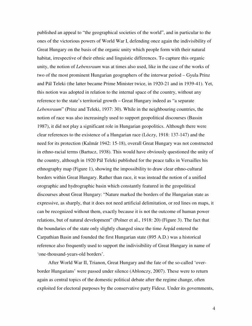
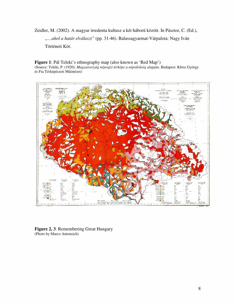
the country, although in 1920 Pál Teleki published for the peace talks in Versailles his
ethnography map (Figure 1), showing the impossibility to draw clear ethno-cultural
borders within Great Hungary. Rather than race, it was instead the notion of a unified
orographic and hydrographic basin which constantly featured in the geopolitical
discourses about Great Hungary: “Nature marked the borders of the Hungarian state as
expressive, as sharply, that it does not need artificial delimitation, or red lines on maps, it
can be recognized without them, exactly because it is not the outcome of human power
relations, but of natural development” (Polner et al., 1918: 20) (Figure 3). The fact that
the boundaries of the state only slightly changed since the time Árpád entered the
Carpathian Basin and founded the first Hungarian state (895 A.D.) was a historical
reference also frequently used to support the indivisibility of Great Hungary in name of
‘one-thousand-years-old borders’.
After World War II, Trianon, Great Hungary and the fate of the so-called ‘over-
border Hungarians’ were passed under silence (Ablonczy, 2007). These were to return
again as central topics of the domestic political debate after the regime change, often
exploited for electoral purposes by the conservative party Fidesz. Under its governments,
5
a series of legal measures were adopted (status law, citizenship law, and electoral law),
all aimed at empowering the rights of over-border Hungarians. Moreover in 2011, the
Fidesz government promulgated the new Constitution, whose article D expressly
acknowledges “the ideal of a unified Hungarian nation” and reiterates Hungary’s
“responsibility for the destiny of Hungarians living outside her borders” – a principle
already codified into the Hungarian constitution after the regime change.
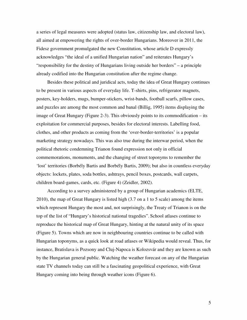
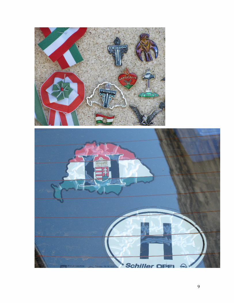
Besides these political and juridical acts, today the idea of Great Hungary continues
to be present in various aspects of everyday life. T-shirts, pins, refrigerator magnets,
posters, key-holders, mugs, bumper-stickers, wrist-bands, football scarfs, pillow cases,
and puzzles are among the most common and banal (Billig, 1995) items displaying the
image of Great Hungary (Figure 2-3). This obviously points to its commodification – its
exploitation for commercial purposes, besides for electoral interests. Labelling food,
clothes, and other products as coming from the ‘over-border-territories’ is a popular
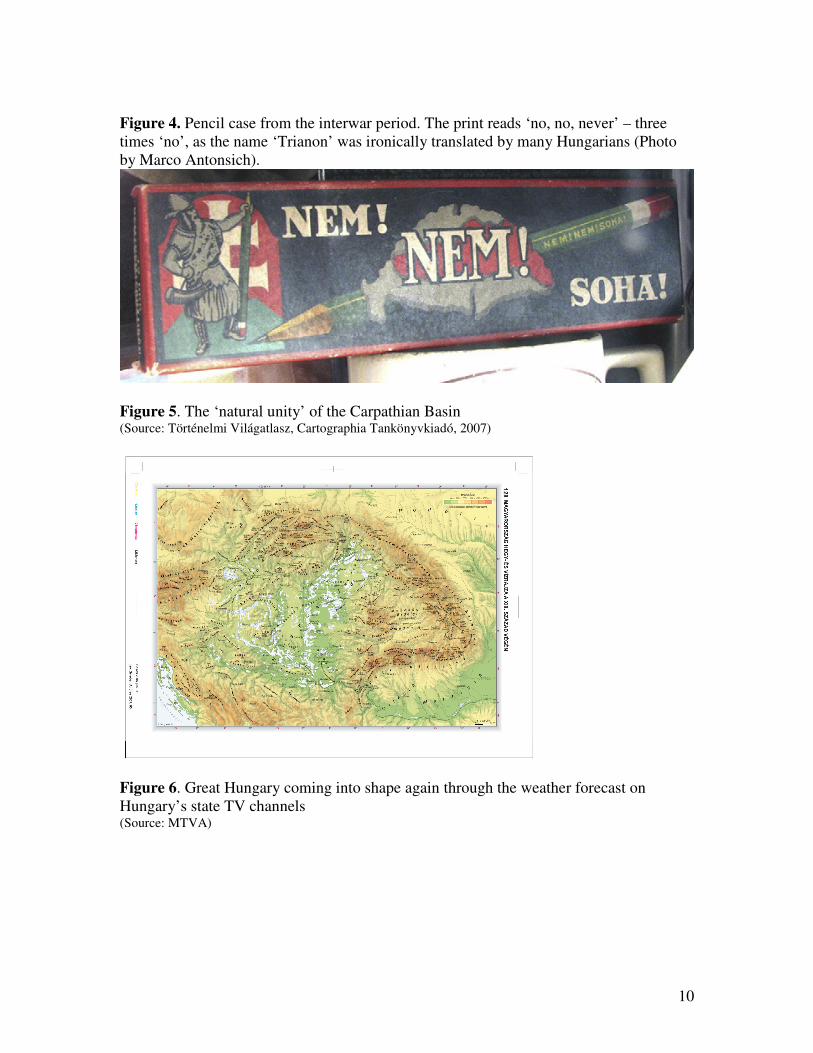
marketing strategy nowadays. This was also true during the interwar period, when the
political rhetoric condemning Trianon found expression not only in official
commemorations, monuments, and the changing of street toponyms to remember the
‘lost’ territories (Borbély Bartis and Borbély Bartis, 2009); but also in countless everyday
objects: lockets, plates, soda bottles, ashtrays, pencil boxes, postcards, wall carpets,
children board-games, cards, etc. (Figure 4) (Zeidler, 2002).
According to a survey administered by a group of Hungarian academics (ELTE,
2010), the map of Great Hungary is listed high (3.7 on a 1 to 5 scale) among the items
which represent Hungary the most and, not surprisingly, the Treaty of Trianon is on the
top of the list of “Hungary’s historical national tragedies”. School atlases continue to
reproduce the historical map of Great Hungary, hinting at the natural unity of its space
(Figure 5). Towns which are now in neighbouring countries continue to be called with
Hungarian toponyms, as a quick look at road atlases or Wikipedia would reveal. Thus, for
instance, Bratislava is Pozsony and Cluj-Napoca is Kolozsvár and they are known as such
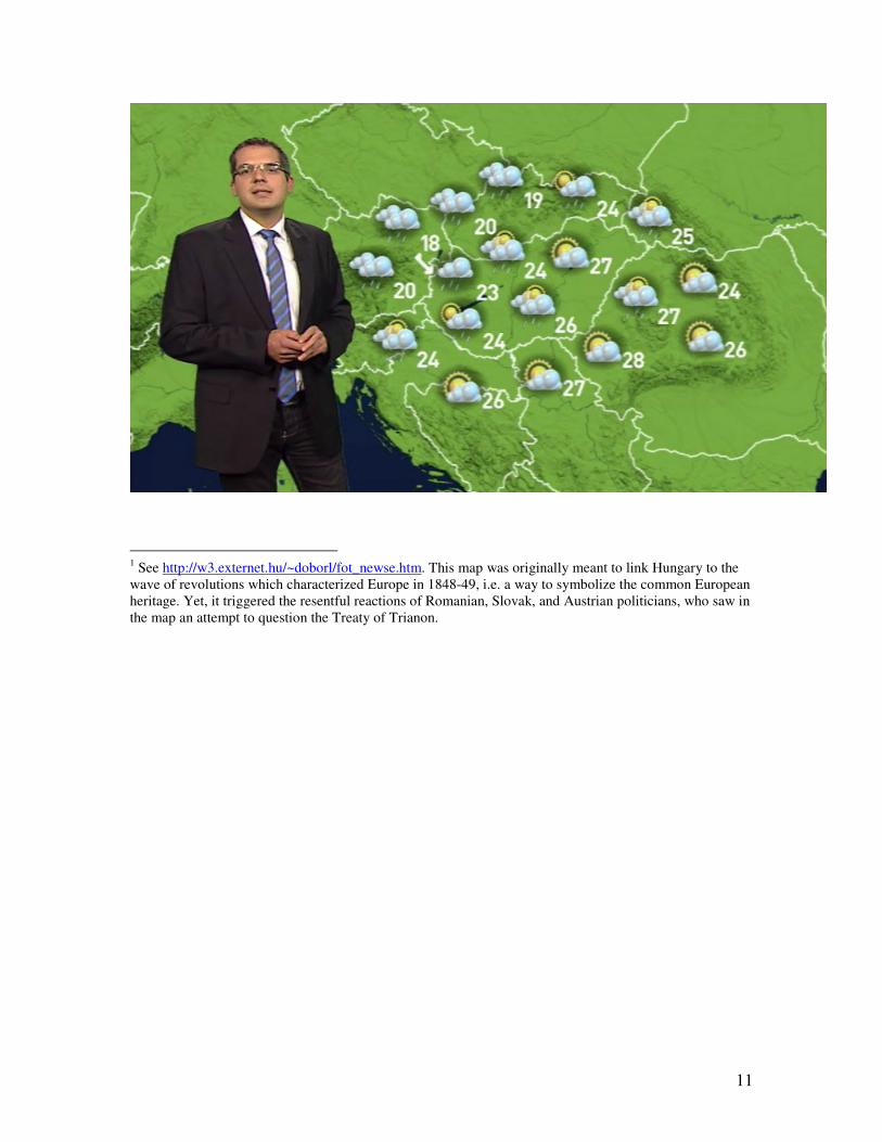
by the Hungarian general public. Watching the weather forecast on any of the Hungarian
state TV channels today can still be a fascinating geopolitical experience, with Great
Hungary coming into being through weather icons (Figure 6).
6
Although almost a century has passed since Trianon, Great Hungary is still part of
Hungarians’ memory and imaginary, feeding and being fed by the ‘natural unity’
discourse. By briefly surveying the way in which this geopolitical idea has been re-
produced, this editorial has attempted to underline the importance of moving away from
mainstream geopolitical traditions. This move would not only fulfil the promise of
critical geopolitics to open up the terrain for ‘other’ voices, but it would also contribute –
as recently discussed in this journal (Moisio et al., 2011) – to explore the numerous ways
in which geopolitics can be bended to adapt to specific regional and historical contexts,
thus exposing its semantic plurality and malleability.
References
Ablonczy, B. (2007). Trianon-problémák. Kommentár, 4, 57-67.
Bartucz, L. (1938). A magyar ember. Budapest: Egyetemi Nyomda.
Bassin, M. (1987). Race contra space: the conflict between German Geopolitik and
National Socialism. Political Geography Quarterly, 6(2), 115-134.
Billig, M. (1995). Banal nationalism. London: Sage.
Borbély Bartis, J., & Borbély Bartis, E. (2009). Budapest. Budapest: Közdok.
ELTE (2010). Nemzeti tudat, nemzeti tragédiák. ELTE. Available at
http://konfliktuskutato.hu/index.php?option=com_content&view=article&id=276:n
emzeti-tudat-nemzeti-tragediak&catid=32:konfliktusmonitoring (accessed
11/09/2012).
7
Hajdú, Z. (2000). A magyar földrajztudomány és a trianoni békeszerződés.
Kisebbségkutatás, 2, 224-233.
Hajdú, Z. (2001) The influence of Friedrich Ratzel on Hungarian geography. In
Antonsich, M., Kolossov, V. & M.P. Pagnini (Eds) Europe between political
geography and geopolitics (pp.129-143). Roma: Società Geografica Italiana, 2001.
Hepple, L.W. (1986). Geopolitics, generals and the state in Brazil. Political Geography
Quarterly, S5, S79–S90.
Hunfalvy, J. (1863-1865). A magyar birodalom természeti viszonyainak leirása. Pest:
Emich Gusztáv.
Kalmár, G. (1942). Magyar geopolitika. Budapest: Stádium.
Lóczy, L. (Ed.), (1918). A Magyar Szent Korona Országainak földrajzi,
társadalomtudományi, közművelődési és közgazdasági leírása. Budapest: Kilián.
Magyar Földrajzi Társaság (1918). A Magyar Földrajzi Társaság szózata a világ Földrajzi
Társaságaihoz. Földrajzi Közlemények, XLVI, 7-10, 289-320.
Moisio, S., Stokke, K., Sæther, E., Gutzon Larsen H., Ek, R., & Hanse, A.L. (2011).
Interventions in Nordic political geographies. Political Geography, 30, 241-249.
Polner, Ö., Kováts, F., Hodinka, A., Prinz, Gy., & Lukinich, I. (1918). Pro Hungaria.
Pozsony: Pozsonyi Magyar Tudományegyetem.
Prinz, Gy., & Teleki, P. (1937). A magyar munka földrajza. Budapest: Egyetemi
Nyomda.
8
Zeidler, M. (2002). A magyar irredenta kultusz a két háború között. In Pásztor, C. (Ed.),
„…ahol a határ elválaszt” (pp. 31-46). Balassagyarmat-Várpalota: Nagy Iván
Történeti Kör.
Figure 1: Pál Teleki’s ethnography map (also known as ‘Red Map’) (Source: Teleki, P. (1920). Magyarország néprajzi térképe a népsűrűség alapján. Budapest: Klösz György és Fia Térképészeti Műintézet)
Figure 2, 3. Remembering Great Hungary (Photo by Marco Antonsich)
9
10
Figure 4. Pencil case from the interwar period. The print reads ‘no, no, never’ – three times ‘no’, as the name ‘Trianon’ was ironically translated by many Hungarians (Photo by Marco Antonsich).
Figure 5. The ‘natural unity’ of the Carpathian Basin (Source: Történelmi Világatlasz, Cartographia Tankönyvkiadó, 2007)
Figure 6. Great Hungary coming into shape again through the weather forecast on Hungary’s state TV channels (Source: MTVA)
11
1 See http://w3.externet.hu/~doborl/fot_newse.htm. This map was originally meant to link Hungary to the wave of revolutions which characterized Europe in 1848-49, i.e. a way to symbolize the common European heritage. Yet, it triggered the resentful reactions of Romanian, Slovak, and Austrian politicians, who saw in the map an attempt to question the Treaty of Trianon.