Embed Size (px)
Citation preview
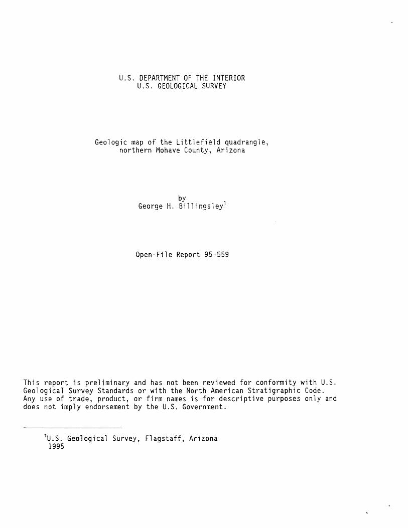
U.S. DEPARTMENT OF THE INTERIOR U.S. GEOLOGICAL SURVEY
Geologic map of the Littlefield quadrangle, northern Mohave County, Arizona
George H. Billingsley
Open-File Report 95-559
This report is preliminary and has not been reviewed for conformity with U.S. Geological Survey Standards or with the North American Stratigraphic Code. Any use of trade, product, or firm names is for descriptive purposes only and does not imply endorsement by the U.S. Government.
1 U.S. Geological Survey, Flagstaff, Arizona 1995
INTRODUCTIONThe Littlefield 7.5' quadrangle lies in the extreme northwestern corner
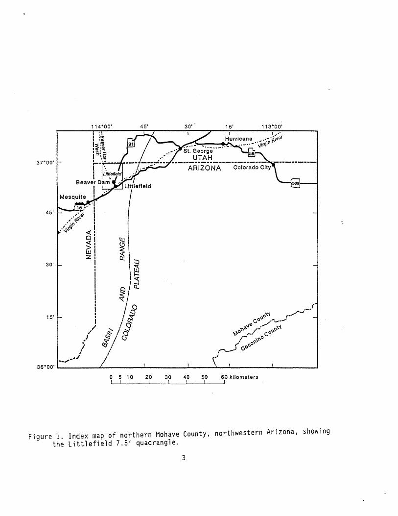
of Mohave County, Arizona (fig. 1). Elevations range from about 536.5 m (1,760 ft) at the Virgin River (south-central edge of quadrangle) to 975 m (3,200 ft) in the Beaver Dam Mountains (northeastern corner of quadrangle). Interstate Arizona Highway 15 and U.S. Highway 91 provides a general access to the quadrangle while several unimproved dirt roads lead to remote areas of the quadrangle. The community of Littlefield, Arizona is just southeast of Interstate 15 along the west bank of the Virgin River, and the community of Beaver Dam, Arizona is just northwest of Interstate 15 in the valley of Beaver Dam Wash (fig. 1). Population of both communities is about 300 people. The environment, topography, and geography is typical of the Mohave Desert of Nevada and California.
There are about 9 sections of private land in the quadrangle and 5 sections belonging to the state of Arizona. The balance is public land administrated by the U.S. Bureau of Land Management, Arizona Strip District in St. George, Utah. The area supports sparse growth of desert shrubs, mainly creosote bush and cactus. Dense growths of tamerisk (Salt Cedar), cottonwood, and willow trees thrive along the alluvial terraces and banks of the Virgin River. A variety of water loving plants thrive in warm spring waters on the east side of the Virgin River near the Interstate 15 bridge, and in Beaver Dam Wash, northwest corner of the quadrangle.
PREVIOUS WORKThe quadrangle area is included on two Arizona state geologic maps, one
by Wilson and others (1969), and the other by Reynolds (1988), but these maps show only regional geology at a scale 1:500,000 and 1:1,000,000. A regional geologic map showing a little more geologic detail of the area at 1:62,500 scale was published by Moore (1972). A preliminary geologic map of the Mountain Sheep Spring quadrangle, east of this quadrangle, was made by Hintze (1986). Another geologic map of the Mountain Sheep Spring quadrangle was made by Bohannon and others (1991).
MAPPING METHODSA preliminary geologic map of this quadrangle was made from 1:24,000
scale 1976 aerial photographs. In particular, many of the Quaternary alluvial units having similar lithologies and intertonguing boundaries were mapped using photogeologic methods. These units were differentiated from one another by topographic expression, amount of dissection by washes, difference in albedo, morphologic character, physical position, and amounts and types of covering vegetation. Field investigations were then conducted to check photo interpretations and to obtain descriptions of map units. All Quaternary map units are mapped as shown on 1976 aerial photos. Some terrace deposits along Beaver Dam Wash and the Virgin River will change because of erosion and flood alterations.
GEOLOGIC SETTINGThe Littlefield quadrangle lies along the eastern edge of the Virgin
River depression (Bohannon and others, 1993), one of several basins in the eastern part of the Basin and Range physiographic province of northwestern Arizona. The Virgin River depression abuts the Beaver Dam Mountains (northeast corner of the quadrangle) and the Virgin Mountains (southeast corner of the quadrangle). The Beaver Dam and Virgin Mountains are the easternmost mountains in this part of the Basin and Range, and they are
114'00'
37«00' -
36*00
Beaver Dam i
Mesquite
15' -
0 5 10 20 30 40 50 60 kilometers
Figure 1. Index map of northern Mohave County, northwestern Arizona, showing the Littlefield 7.5' quadrangle.
separated from the Colorado Plateau province by the Grand Wash Fault about 13 km (8 mi) east of this quadrangle.
The Virgin River depression is approximately 4,875 m (16,000 ft) deep and filled with intra-basin alluvial sediments (Bohannon and others, 1993). Only the top 60 m (200 ft) of these sediments, the Muddy Creek Formation (Miocene and Pliocene), which includes ancestral conglomerate of Beaver Dam Wash and the Virgin River, are exposed in this quadrangle. The Beaver Dam and Virgin Mountains were formed by middle Miocene extension and strike-slip faulting resulting in the exposure of Proterozoic crystalline metamorphic and igneous rocks that are overlain by extensively faulted and folded Paleozoic and Mesozoic strata.
The Paleozoic and Proterozoic rocks in the Beaver Dam and Virgin Mountains of this quadrangle correlate with those described by Hintze (1986), Bohannon and others (1991), and Bohannon and Lucchitta (1991). Tertiary strata of the Muddy Creek Formation include siltstone, sandstone, calcrete, and conglomerate. Conglomerate beds within the Muddy Creek consists of an older multicolored, well-rounded quartzite clasts about 30 to 35 m (100 to 115 ft) below the top-most exposed beds of the Muddy Creek about 1 km south and southwest of this quadrangle (sec. 15, T. 40 N., R. 16 W.). A younger conglomerate contains rhyolitic clasts near Beaver Dam Wash, and basaltic clasts near the Virgin River. These conglomerates represent an ancestral deposit of Beaver Dam Wash and the Virgin River that pinch out within the upper fine-grained sediments of the Muddy Creek Formation (see correlation chart). The basaltic clasts within the conglomerate are probably Pliocene age or younger based on mapping and K-Ar ages of basalt flows upstream of the Virgin River in Utah and Arizona, which are late Pliocene and Pleistocene (Billingsley 1993; in press). The ancestral conglomerates of Beaver Dam Wash and the Virgin River have mixed together below the confluence of Beaver Dam Wash and the Virgin River to become one conglomeratic deposit of the ancestral Virgin River.
The Tertiary Muddy Creek Formation is overlain by a relatively thin Cenozoic deposit of pediment calcrete, except east of the Virgin River where alluvial fan deposits of unknown thickness bury the Muddy Creek Formation. The Cenozoic deposits include stream-channel deposits, sand sheets and dunes, terrace-gravels, alluvial fans, talus and colluvium, and minor landslide debris. These alluvial deposits form distinctive geomorphic features and have intertonguing or gradational contacts. The distribution of the Tertiary and Quaternary deposits are important for future considerations of human resource development and environmental and range management planning of this area by federal, state, and private organizations. Resource considerations include flood-control, roads, buildings, erosion control, farming, and endangered plant or animal habitats. The composition of materials in surficial units may have significant impact to urban and range management development.
The Quaternary age assigned to the surficial alluvial deposits in this quadrangle are based on the similarity of desert-varnish development observed for Quaternary deposits at the Nevada Test Site, (Hoover and others, 1981), to similarity of established Quaternary deposits of the Colorado Plateau area (Billingsley, 1993; 1994; in press), and to geomorphic field relationships.
GEOLOGIC STRUCTUREThe Virgin River depression is a large tectonic basin extensionally
deformed during Miocene time and filled with a thick sequence of basin-fill deposits. The reddish-brown or light-gray siltstone, sandstone, and calcrete
angle faults and grabens that have general displacements down to the west. Maximum offset on a single fault is 36 m (118 ft), northwest quarter of quadrangle.
Faulting of older alluvial fans south and north of this quadrangle are probably associated with the faulting in the Beaver Dam Wash area. Young stream deposits (Qls and Qas), sand (Qd), intermediate and younger terrace- gravel (Qg«, Qg2 , and Qg3 ), and intermediate and younger alluvial fan (Qa 1 and Qa2 ) deposits are not faulted or folded in this quadrangle. Thus, faulted strata of the upper Muddy Creek Formation, the ancestral Beaver Dam Wash and Virgin River conglomerate, and the pediment calcrete deposits suggests that the latest pulse of tectonic activity in this quadrangle began during the late Pliocene? and probably continued into the middle Pleistocene. It is probable that tectonic activity is still potentially active in this quadrangle.
The Virgin River depression is separated from the Beaver Dam and Virgin Mountains by the Piedmont Fault (Moore, 1972). The Piedmont Fault is mostly covered by several sequences of alluvial fan deposits, three of which are identified in the Littlefield quadrangle. The Piedmont Fault offsets, older and intermediate alluvial fan (Qa3 and Qa2 ) deposits along the west side of the Virgin Mountains in the Elbow Canyon quadrangle (south of this quadrangle; Bohannon, 1991), and along the western part of the Beaver Dam Mountains (Mountain Sheep Spring quadrangle; Hintze, 1986; Bohannon and others, 1991) northeast of this quadrangle. The Piedmont Fault does not offset all intermediate (Qa2 ) alluvial fans, and none of the younger (Qa^ alluvial fans, talus and colluvium (Qt), or stream (Qls and Qas) deposits in this quadrangle. Faulting of older and intermediate alluvial fan (Qa-, and Qa2 ) deposits indicate the location of the Piedmont Fault trace along the base of the Virgin Mountains in this quadrangle. Other faults similar to the Piedmont Fault are suspected under thick alluvial fan cover in the northeast corner of the Littlefield quadrangle, but are not identified on aerial photographs or by ground inspection.
DESCRIPTION OF MAP UNITSSurficial deposits (Holocene and Pleistocene)--Surficial deposits are
differentiated from one another chiefly by photogeologic techniques on the basis of difference in albedo, morphologic character, physiographic position and, to some extent, amount and types of vegetation cover as of 1976 aerial photographs
Qaf Artificial fill and quarries (Hoiocene)--Alluvial and bedrock material removed from pits and trenches to build stock tanks, roads, and drainage diversion dams. Includes quarries for sand and gravel
Qas Alluvium of active stream channels (Holocene)--Interlensing silt, sand, and pebble to boulder gravel; unconsolidated and poorly sorted. Locally overlies or inset to younger and intermediate alluvial fan (Qa 1 and Qa2 ) and floodplain (Qf) deposits; inset to intermediate and older terrace gravel (Qg2 and Qg3 ) deposits. Stream channels subject to high-energy debris flows and flash floods. Supports little or no vegetation. Contacts with other alluvial deposits approximate. Only most active channel deposits shown as on 1976 aerial photography. Exposed thickness 1 to 2 m
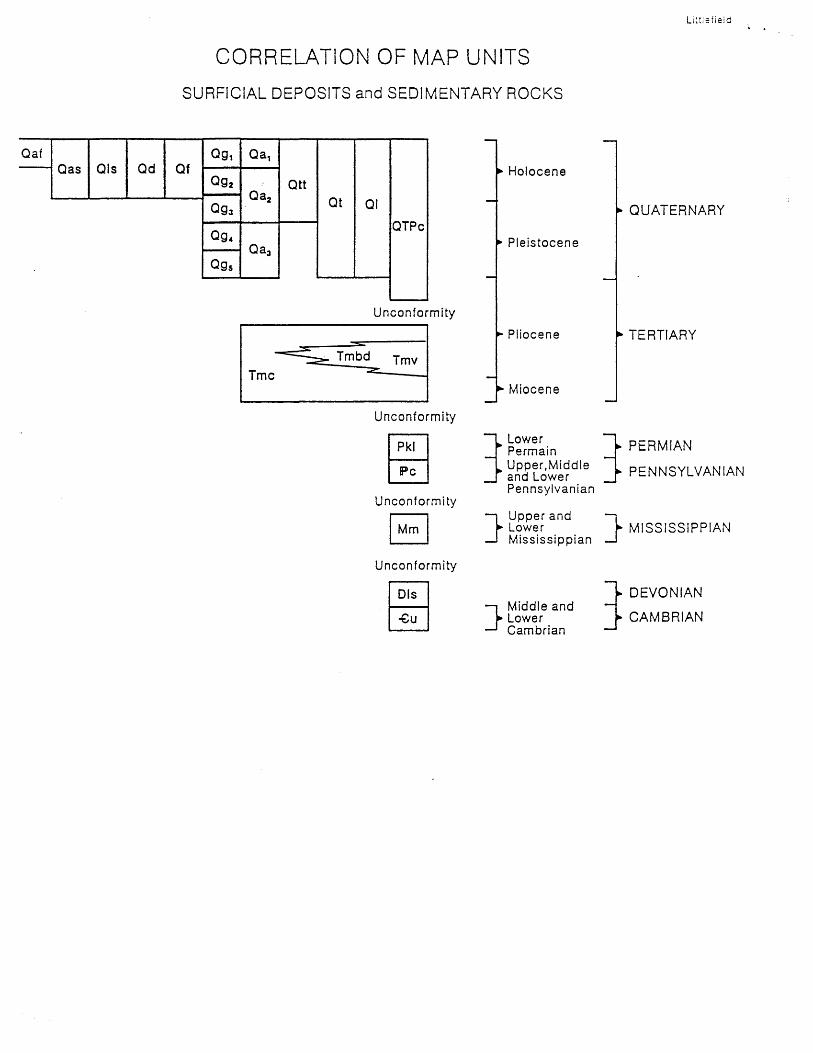
CORRELATION OF MAP UNITS
SURFiCIAL DEPOSITS and SEDIMENTARY ROCKS
Littlefieid
QafQas Qls Qd Qf
Q9t
Qg2
Qg3
Ogt
Qg 5
Qa,
Qa2
Qa3
QttQt Ql
QTPc
Tmc
Unconformity
Tmbd Tmv
Unconformity
Unconformity
Holocene
* Pleistocene
QUATERNARY
> Pliocene
Miocene
Lower Permain
^ Upper,Middle and Lower _ Pennsylvanian
i Upper and ik Lower k
_J Mississippian i
TERTIARY
PERMIAN
PENNSYLVANIAN
MISSISSIPPIAN
DIs
-Cu j Middle and
k Lower J famhrian
» DEVONIAN
* CAMBRIAN
Qls Alluvium of low-gradient stream channels (Holocene)--Similar to active stream channels (Qas), but locally subject to sheet wash flooding or temporary ponding due to sand accumulation or minor tectonic adjustment of stream gradient. Grades laterally into sand sheet (Qd), talus and colluvial (Qt) deposits, and upper part of pediment calcrete (QTpc) deposits. Locally confined to small valleys or low-gradient channels partly blocked with sand or tectonic fault movement. Contacts with other alluvial deposits approximate. Supports moderate to heavy growth of desert shrubs and grass. Exposed thickness, about 3 m
Qd Dune sand and sand sheet deposits (Holocene)--Light-reddish-orange sand on pediment calcrete (QTpc) deposits; light-gray sand along Virgin River. Very fine- to fine-grained, well-sorted, unconsolidated sand. Forms isolated sand sheets and small complex dunes on pediment calcrete (QTpc) surfaces and on floodplain (Qf) or young terrace-gravel (Qg,) deposits along Virgin River. Forms falling dunes in minor tributary drainages and along west bank of Beaver Dam Wash. Sand locally derived from eroded and weathered outcrops of Muddy Creek Formation (Tmc), Beaver Dam Wash and Virgin River conglomerate (Tmbd, and Tmv), pediment calcrete (QTpc), and talus and colluvium (Qt); distributed by southwesterly and northwesterly winds. Sand along Virgin River is locally derived from active stream channels (Qas) and floodplain (Qf) areas in dry seasons. Supports sparse to moderate growth of desert vegetation and grass. Only active sand sheets and dunes mapped, thin stabilized sand sheets not mapped. Thickness ranges from 1 to 5 m
Qf Floodplain deposits (Holocene)--Light-red or brown silt, sand, and gravel; mostly well-sorted, poorly bedded, unconsolidated. Contains reworked silt, sand, gravel and subangular to well rounded pebbles and boulders of gneiss, schist, rhyolite, basalt, pegmatite, quartzite, limestone, dolomite, sandstone, and chert derived from ancestral conglomerates of Beaver Dam Wash (Tmbd) and Virgin River (Tmv) and Muddy Creek Formation (Tmc). Also includes material eroded from alluvial fans (Qa 1 through Qa,), and terrace gravels (Qg 1 through Qg5 ). Contacts with other alluvial deposits approximate. Intertongues with active stream (Qas) deposits of Virgin River and Beaver Dam Wash, and inset to terrace-gravel (Qg 1 and Qg2 ) deposits. Forms bench 1 to 1.5 m above active stream channel of Virgin River and Beaver Dam Wash. Subject to frequent flooding and local erosion or accumulation of sediment several times per year. Supports moderate growth of grass and shrubs. Exposed thickness 0.5 to 1.5 m
Qg 1 Young terrace-gravel deposits (Holocene)--Pale-reddish-brown, gray, and light-brown silt, sand, and gravel; moderate to well-sorted, thin to massive bedded sand and silt. Contains reworked material from floodplain (Qf), alluvial fans (Qa., Qa^, and Qa3 ), talus and colluvium (Qt), Muddy Creek Formation (Tmc), Beaver Dam Wash conglomerate (Tmbd), and Virgin River conglomerate (Tmv). Forms bench about 2 to 3 m above active stream channels; inset against low intermediate terrace-gravel (Qg?), alluvial fans (Qa 1 and Qa2 ), Muddy Creek Formation (Tmc), Beaver Dam Wash conglomerate
(Tmbd), and Virgin River conglomerate (Tmv). Supports moderate to heavy growth of vegetation, mainly tamerisk, willow, and ash trees along Virgin River, desert bushes, shrubs, cactus, grass, and some cottonwood trees along parts of Beaver Dam Wash. Subject to yearly flooding and sever erosion or accumulation of sediment along Virgin River and Beaver Dam Wash. Exposed thickness, about 3 m
Qa 1 Young alluvial fan deposits (Holocene)--Light-gray and brown silt, sand, pebbles, and boulders, poorly sorted, unconsolidated. Includes lenses of poorly sorted, thin-bedded gravelly sand and pebbles. Includes boulders as much as 0.5 m diameter. Pebble and boulder clasts are angular to rounded, gneiss, schist, granite, pegmatite, quartzite, sandstone, limestone, dolomite, and chert derived from Virgin Mountains east of Virgin River, and Beaver Dam Mountains east of Beaver Dam Wash. Locally, in Beaver Dam Wash, includes reworked deposits of ancestral Beaver Dam Wash conglomerate (Tmbd), terrace-gravels (Qg 1 through Qg5 ), and intermediate alluvial fan (Qa2 ) deposits. In Virgin River channel, includes reworked deposits of ancestral Virgin River conglomerate (Tmv), terrace-gravels (Qg 2 through Qg 5 ), and intermediate alluvial fan (Qa2 ) deposits. Overlaps intermediate and older alluvial fan (Qa 1 and Qa2 ) deposits on lower alluvial fan slopes, inset against intermediate and older alluvial fan deposits on upper fan slopes. Intertongues with younger terrace-gravel (QgJ deposits, and overlaps low intermediate terrace-gravel (Qg2 ) deposits along Beaver Dam Wash and Virgin River. Subject to sheet wash erosion and high-energy flash floods and debris flows. Supports sparse growth of desert shrubs, creosote bush, and cactus. As much as 4 m exposed, estimated as much as 12 m thick
Qtt Travertine deposits (Holocene and Pleistocene?)--Gray porous travertine. Thin-bedded calcium carbonate deposits derived from warm fresh water spring outlets along east bank of Virgin River at and near Interstate Highway 15 bridge crossing. Locally includes silt, sand, pebbles and cobbles derived from sheet wash of pediment calcrete (QTpc) and intermediate alluvial fan (Qa2 ) sediment. Includes encrustation of roots, leafs, and plants of local vegetation preserved as modern fossils. Forms cliff or resistant bench. Ranges from 1 to 4 m thick
Qt Talus and colluvial deposits (Holocene and Pleistocene)--Light-reddish- brown to yellowish-gray silt, sand, pebbles, boulders, and breccia debris as loose incoherent mass of weathered or broken rock; unsorted and partly consolidated along Beaver Dam Wash. Locally includes reworked decomposed weathered material from pediment calcrete (QTpc), Muddy Creek Formation (Tmc), Beaver Dam Wash conglomerate (Tmbd), and Virgin River conglomerate (Tmv), partly cemented by calcite and gypsum. Forms secondary and thinner pediment calcrete deposit similar to pediment calcrete (QTpc) in faulted terrain along western part of quadrangle. Intertongues with low-gradient stream (Qls) deposits. Supports sparse growth of desert shrubs and creosote bush. As much as 2 m thick
Ql Landslide deposits (Holocene and Pleistocene)--Unconsolidated mass of unsorted debris that have detached and slid downslope as loose incoherent mass of broken rock and deformed strata. Landslide masses are mostly composed of strata of Muddy Creek Formation (Tmc) and ancestral Beaver Dam Wash conglomerate (Tmbd) in upper Beaver Dam Wash. Supports little or no vegetation. Unstable when wet. Minor rockfall or landslides not shown; distinct potential of future rockfall or landslide hazard is prevalent along cliffed banks both sides of Beaver Dam Wash and Virgin River. Thickness as much as 6 m
QTpc Pediment calcrete (Holocene and Pleistocene)--Pale-yellowish-brown to light-gray, moderately sorted, massive to thin-bedded, cliff- forming siltstone and sandstone. Includes thick beds or nodules of white caliche and caliche-cemented siltstone that produces lighter tone surface on aerial photographs. Unit covered locally by dune sand (Qd). Exposed caliche nodules at surface are deeply pitted or etched by solution weathering. Generally forms flat to gently sloping surfaces, locally tilted as much as 4° east in western quarter of quadrangle; dissection is variable. Subject to modern sheet wash flow and local flooding. Base of unit generally forms low angular unconformable contact with underlying Muddy Creek Formation (Tmc), Beaver Dam Wash conglomerate (Tmbd), and Virgin River conglomerate (Tmv). Generally less than 5 m thick
Qg 2 Low intermediate terrace-gravel deposits (Holocene)--Similar lithology to young terrace-gravel (QgJ and floodplain (Qf) deposits. Consists mostly of sand and silt. Locally inset to middle, high, intermediate and old terrace-gravel (Qg3 , Qg4 , and Qg5 ) deposits. Forms benches about 1 to 2 m above young terrace-gravel (Qg.,) deposits, and about 4 m above active stream (Qas) and floodplain (Qf) deposits along Virgin River and Beaver Dam Wash. Supports growth of mixed vegetation, mainly shrubs and tamerisk trees, some willow, ash and cottonwood trees. As much as 4 m thick
Qa2 Intermediate alluvial fan deposits (Holocene and Pleistocene?)--Samelithologies as younger alluvial fan (QaJ deposits but with lesser silt and sand, partly consolidated by calcite cement; stony surface. Includes boulders as much as 2 m in diameter. Rocky surface has minor to well developed desert varnish. Commonly overlapped by young alluvial fan (QaJ deposits, and incised into older alluvial fan (Qa3 ) deposits in upper fan slopes. Partly interbedded with pediment calcrete (QTpc) deposits east of upper Beaver Dam Wash, but commonly overlaps pediment calcrete (QTpc) deposits near and east of Virgin River. Intermediate fan surfaces are heavily dissected in upper part as much as 2 m deep. Subject to sheet wash and gully erosion. Supports sparse growth of desert shrubs, creosote bush, cactus and grass. About 6 m exposed, estimated maximum thickness, 90 m or more
Qg3 Middle intermediate terrace-gravel deposits (Holocene and Pleistocene)-- Similar color and lithology to young and low intermediate terrace- gravels (Qg 1 and QgJ, consists mostly of gray silt and sand; partly consolidate^. Inset against or overlying high intermediate and older terrace-gravels (Qg4 and QgJ, Muddy Creek Formation (Tmc), Beaver Dam Wash conglomerate (Tmbd), and Virgin River conglomerate (Tmv). Forms benches about 4 to 12 m above modern stream beds of Beaver Dam Wash and Virgin River. Incised locally by arroyo erosion and eroded by Virgin River or Beaver Dam Wash. Supports sparse desert vegetation, mainly creosote bush, cactus, and grass. Averages about 5 m thick
Q94 High intermediate terrace-gravel deposits (Pleistocene)--Similar color and lithology to younger terrace-gravels (Qg^ Qa2 , and Qg3 ). Inset against older terrace-gravel (Qg5 ) deposits; inset against or overlying Muddy Creek Formation (Tmc), Beaver Dam Wash conglomerate (Tmbd), and Virgin River conglomerate (Tmv). Exposed surface pebbles and boulders have desert varnish coating, limestone and dolomite clasts are pitted or deeply weathered; partly consolidated by calcite cement and incised by local erosion. Eroded material is redistributed as part of local young alluvial fan (QaJ deposits. Forms benches 1 to 2 m above middle terrace-gravels (Qg3 ), 3.5 m above modern stream bed of Virgin River, and as much as 18 m above modern stream bed of Beaver Dam Wash. Supports sparse vegetation of desert shrubs, cactus, and grass. Averages 4 m thick along Virgin River and as much as 18 m thick along Beaver Dam Wash
Qg 5 Old terrace-gravel deposits (Pleistocene)--Similar color and lithologies to younger terrace-gravels (Qg r Qg 2 , Qg3 , and Qg,), but clast characteristics are dominantly gray limestone ana dolomite as opposed to mostly igneous and metamorphic clasts in younger and lower terrace gravels. Exposed surface pebbles and boulders have desert varnish and coating of caliche on underside of clasts. Limestone, dolomite, and sandstone clasts are strongly pitted and deeply weathered on exposed surface. Inset against pediment calcrete (QTpc) and sediments of Muddy Creek Formation (Tmc), Beaver Dam Wash conglomerate (Tmbd), and Virgin River conglomerate (Tmv). Intertongues or overlapped by young and intermediate alluvial fan (Qa 1 and Qa2 ), and talus and colluvial (Qt) deposits. Forms benches about 18 to 24 m above stream bed of Virgin River, and about 30 m above modern stream bed of Beaver Dam Wash. Supports sparse desert shrubs, cactus, creosote bush, and grass. As much as 3 m thick along Virgin River and as much as 6 to 30 m thick along Beaver Dam Wash
Qa3 Older alluvial fan deposits (Pleistocene)--Similar lithologies toyounger alluvial fans (Qa 1 and Qa2 ) and active and low-gradient stream (Qas and Qls) deposits; has yellowish smooth lighter tone surface texture on aerial photos because of thin soil development as compared to younger alluvial fans (Qa 1 and Qa2 ); partly consolidated by calcite cement. Surface clasts nave well developed desert varnish, and clasts within deposit have coating of caliche. Partly overlapped by younger alluvial fans (Qa 1 and
10
Qa2 ) and active stream (Qas) deposits on upper slopes. Strongly incised and eroded by arroyos that contribute material to younger alluvial fans downslope from Qa3 . Deposits are mostly at base of Beaver Dam and Virgin Mountains and locally faulted as much as 18 m along the Piedmont Fault. Supports sparse growth of grass and cactus. Exposed thickness is 18 m, estimated as much as 50 m
Sedimentary rocks (Tertiary to Cambrian)--Stratigraphic nomenclatureestablished for rocks of the Colorado Plateau and Basin and Range Province are adopted from Hintze (1986), Bohannon and Lucchitta (1991), and Billingsley (1993). Because of limited outcrop and erosion in Beaver Dam and Virgin Mountains, part of Paleozoic stratigraphic sequence is not exposed in the quadrangle. Rocks of Mesozoic age are not present in this quadrangle. Includes upper strata of Muddy Creek Formation
Muddy Creek Formation (Miocene and PIiocene?)--Light-red and gray, fine grained, slope-forming siltstone, sandstone, and calcrete beds (Tmc). Includes conglomeratic gravel of ancestral Beaver Dam Wash (Tmbd) and Virgin River (Tmv) that forms cliff in upper part of Muddy Creek Formation (Tmc; see correlation chart). Upper fine grained Muddy Creek sediment mapped at upper part of Muddy Creek Formation (Tmc), may be ancestral Virgin River sediment. Only 60 m exposed
Tmc Fine-grained sediments Lower part; light reddish-brown, gray, andwhite, slope-forming, fine-grained, thin- to thick-bedded, calcareous, gypsifereous, siltstone, sandstone, and calcrete. Calcrete beds, 1 to 2 m (3 to 6 ft) thick containing carbonate nodules as much as 20 cm (8 in) in diameter. Siltstone and sandstone weakly cemented with calcite and gypsum. Includes thin-bedded channel lenses of medium- to coarse-grained sandstone. Lower part separated from upper part by thick-bedded, cliff-forming ancestral Beaver Dam Wash and Virgin River conglomerates that pinch out laterally within 1 km of Beaver Dam Wash and Virgin River. No apparent unconformity between upper and lower part of fine-grained sediments where not separated by Beaver Dam Wash and Virgin River conglomerate. Upper part of Muddy Creek sediments may be reworked fine-grained deposits of Muddy Creek redistributed by Beaver Dam Wash and Virgin River. About 60 m thick
Tmbd Beaver Dam Wash conglomerate--Dark-gray to brown, cliff-formingconglomerate, gravel, and sandstone; poorly sorted, moderately well-bedded. Deposits pinch out or intertongue into fine-grained sediments of Muddy Creek Formation (Tmc); overlain by fine-grained sediments of Muddy Creek Formation that may be reworked Muddy Creek deposited by Beaver Dam Wash. No unconformity observed between lower and upper fine-grained beds of Muddy Creek (Tmc) beyond conglomeratic gravel pinch out. Conglomerate clasts characterized and composed of subrounded to well-rounded pebbles, cobbles, and boulders (as much as 18" in diameter) of reddish-brown, brown, red, grayish-green, and light-green rhyolite clasts;
11
includes lesser amounts of well-rounded, black schist, gneiss, gabbro, diorite, red pegmatite and granite, white quartz, light-gray and dark-gray limestone and dolomite, and minor white, red, and multicolored chert and quartzite clasts. Clasts deposited in gray, coarse- to fine-grained gravel or gravely sandstone composed of same material as conglomerate; includes interbedded lenses of pale-red, fine grained, thin-bedded siltstone and sandstone. Calcite cement common. Schist, gneiss, gabbro, diorite, granite, limestone, dolomite, and minor sandstone clasts increase in dominance northeastward toward Beaver Dam Mountains. Intertongues or mixes with Virgin River conglomerate (Tmv) within 1 km of Virgin River and Beaver Dam Wash confluence. Pebble imbrication indicates southward flowing paleocurrent of depositing stream. Muddy Creek strata and Beaver Dam Wash conglomerate locally tilted to form angular unconformity with overlying pediment calcrete (QTpc). Faulting and further tilting occurs after deposition of pediment calcrete. Thickness increases northeastward. As much as 43 m thick
Tmv Virgin River conglomerate--Light-gray, cliff-forming,conglomeratic gravel similar to Beaver Dam Wash conglomerate (Tmbd), but characterized by abundant basalt, quartzite, limestone, dolomite, and sandstone clasts derived from northern Arizona and southern Utah; does not contain rhyoltic clasts along Virgin River 1 km above confluence of Beaver Dam Wash and Virgin River; intertongues or mixes with Beaver Dam Wash conglomerate (Tmbd) at and below confluence of Beaver Dam Wash and Virgin River, becoming Virgin River conglomerate. Unit presumably overlain by older alluvial fan (Qa^) deposits near base of Virgin Mountains because of increasing metamorphic clasts in that direction. Intertongues or unconformably overlies lower part of Muddy Creek Formation (Tmc), pinches out laterally into Muddy Creek Formation within 1 km of Virgin River; conformably overlain by upper part of finer-grained sediments of Muddy Creek Formation (Tmc) that may be reworked sediments of Muddy Creek redeposited by Virgin River. Merges with Beaver Dam Wash conglomerate near confluence of Beaver Dam Wash and Virgin River. Muddy Creek deposits and Virgin River conglomerate have been tilted to form low-angular unconformable contact with overlying pediment calcrete (QTpc). Faulting and further tilting occurs after deposition of pediment calcrete. Active stream deposits (Qas), floodplain (Qf), and terrace-gravels (Qg. through Qg5 ) are inset into Virgin River conglomerate (Tmv). Thickness ranges from 1 to 18 m
12
Pkl Pakoon Limestone (Lower Permian)--Light-gray and dark-gray, medium- to coarse-grained, thin- to medium-bedded dolomite, dolomitic sandstone, dark-gray cherty limestone, and white, arenaceous limestone; fossiliferous. Weathers brown-gray and yellow-brown with sugary texture. Bedding is 0.5 to 2 m thick. Limestone and dolomite beds separated by slope-forming, gray or purplish-gray calcareous siltstone and sandstone. Includes ledge-forming dolomitic sandstone with small-scale, low-angle crossbeds. Red and brown chert stringers and nodules common in limestone and dolomite beds. Top of unit not exposed. Contact with underlying Callville Limestone difficult to determine and appears gradational. Forms series of ledges and cliffs. Estimated thickness 130 m after erosion
FPc Callville Limestone (Upper, Middle, and Lower Pennsylvanian)--Gray, light-gray, and white limestone, cherty limestone, arenaceous limestone, and light-yellow calcareous sandstone. Weathers gray and yellowish-brown; cherty limestone weathers brown. Crossbedding common in sandstone. . Cherty limestone is about 10 to 30 percent of unit; arenaceous limestone and calcareous sandstone are interbedded with limestone and are about 10 to 20 percent of unit. Base of unit not exposed. Forms series of step-like ledges 0.5 to 2 m thick. Estimated exposed thickness, about 200 m
Mm Monte Cristo Limestone (Upper and Lower Mississippi an)--Medium gray, fine-grained, thick-bedded limestone, cherty limestone and dolomite. Lithologically equivalent to Redwall Limestone of Colorado Plateau Province (Mckee, 1963). Upper part not exposed which includes Yellowpine, Arrowhead, and upper part of Bullion Members of Monte Cristo Limestone (Hewett, 1931). Equivalent to Horseshoe Mesa Member and upper part of Mooney Falls Member of Redwall Limestone (McKee, 1963), Includes medium- to coarse grained bioclastic limestone and dolomite of Bullion Member of Monte Cristo Limestone (Mooney Falls Member of Redwall Limestone); medium-gray, medium- to coarse-grained bioclastic limestone and cherty limestone, chert beds generally white and as much as 0.5 m thick of Anchor Member of Monte Cristo Limestone (Thunder Springs Member of Redwall Limestone); medium-gray, coarse-grained, massive-bedded, crystalline and bioclastic dolomite and limestone of Dawn Member of Monte Cristo Limestone (Whitmore Wash Member of Redwall Limestone). All members tilted 70° to as much as 85* and form cliff that generally appears unbedded except where chert beds of Anchor Member are present. Estimated thickness, 200 m
Dl s Limestone (Devonian)--Light-gray to dark-gray, medium- to coarse grained, medium-bedded (0.4 to 2 m thick), dolomite, dolomitic sandstone, and limestone. Weathers dark-gray. Tilted as much as 85°. Unconformable contact with overlying Monte Cristo Limestone. Conformable or gradational contact with underlying Nopah Formation. Unit is primarily equivalent to Valentine Member of Sultan Limestone of Hewett (1931), upper part may be equivalent to Crystal Pass Member (Lower Mississippian and Upper Devonian) of same formation. Equivalent to Temple Butte Formation of Colorado Plateau province (Beus, 1980). About 60 m thick
13
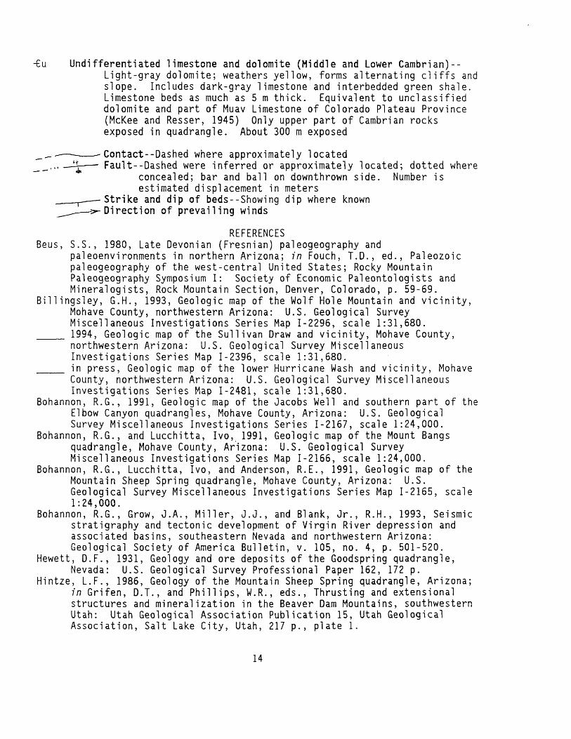
- u Undifferentiated limestone and dolomite (Middle and Lower Cambrian)--Light-gray dolomite; weathers yellow, forms alternating cliffs and slope. Includes dark-gray limestone and interbedded green shale. Limestone beds as much as 5 m thick. Equivalent to unclassified dolomite and part of Muav Limestone of Colorado Plateau Province (McKee and Resser, 1945) Only upper part of Cambrian rocks exposed in quadrangle. About 300 m exposed
Contact Dashed where approximately locatedFault Dashed were inferred or approximately located; dotted where
concealed; bar and ball on downthrown side. Number isestimated displacement in meters
Strike and dip of beds Showing dip where known Direction of prevailing winds
REFERENCESBeus, S.S., 1980, Late Devonian (Fresnian) paleogeography and
paleoenvironments in northern Arizona; in Fouch, T.D., ed., Paleozoic paleogeography of the west-central United States; Rocky Mountain Paleogeography Symposium I: Society of Economic Paleontologists and Mineralogists, Rock Mountain Section, Denver, Colorado, p. 59-69.
Billingsley, G.H., 1993, Geologic map of the Wolf Hole Mountain and vicinity, Mohave County, northwestern Arizona: U.S. Geological Survey Miscellaneous Investigations Series Map 1-2296, scale 1:31,680.
___ 1994, Geologic map of the Sullivan Draw and vicinity, Mohave County, northwestern Arizona: U.S. Geological Survey Miscellaneous Investigations Series Map 1-2396, scale 1:31,680.
___ in press, Geologic map of the lower Hurricane Wash and vicinity, Mohave County, northwestern Arizona: U.S. Geological Survey Miscellaneous Investigations Series Map 1-2481, scale 1:31,680.
Bohannon, R.G., 1991, Geologic map of the Jacobs Well and southern part of the Elbow Canyon quadrangles, Mohave County, Arizona: U.S. Geological Survey Miscellaneous Investigations Series 1-2167, scale 1:24,000.
Bohannon, R.G., and Lucchitta, Ivo, 1991, Geologic map of the Mount Bangs quadrangle, Mohave County, Arizona: U.S. Geological Survey Miscellaneous Investigations Series Map 1-2166, scale 1:24,000.
Bohannon, R.G., Lucchitta, Ivo, and Anderson, R.E., 1991, Geologic map of the Mountain Sheep Spring quadrangle, Mohave County, Arizona: U.S. Geological Survey Miscellaneous Investigations Series Map 1-2165, scale 1:24,000.
Bohannon, R.G., Grow, J.A., Miller, J.J., and Blank, Jr., R.H., 1993, Seismic stratigraphy and tectonic development of Virgin River depression and associated basins, southeastern Nevada and northwestern Arizona: Geological Society of America Bulletin, v. 105, no. 4, p. 501-520.
Hewett, D.F., 1931, Geology and ore deposits of the Goodspring quadrangle, Nevada: U.S. Geological Survey Professional Paper 162, 172 p.
Hintze, L.F., 1986, Geology of the Mountain Sheep Spring quadrangle, Arizona; in Grifen, D.T., and Phillips, W.R., eds., Thrusting and extensional structures and mineralization in the Beaver Dam Mountains, southwestern Utah: Utah Geological Association Publication 15, Utah Geological Association, Salt Lake City, Utah, 217 p., plate 1.
14
Hoover, D.L., Swadley, W.C., and Gordon, A.V., 1981, Correlationcharacteristics of surficial deposits at Yucca Mountain and vicinity, Nye County, Nevada: U.S. Geological Survey Open-File Report 81-512, 27P-
McKee, E.D., and Resser, C.E.,-1945, Cambrian history of the Grand Canyonregion: Carnegie Institution of Washington Publication 563, 232 p.
McKee, E.D., 1963, Nomenclature for lithologic subdivisions of theMississippian Redwall Limestone, Arizona: U.S. Geological SurveyProfessional Paper 475-C, p. 21-22.
Moore, R.T., 1972, Geologic map of the Virgin and Beaver Dam Mountains,Arizona; in Moore, R.T., ed., Geology of the Virgin and Beaver DamMountains, Arizona: The Arizona Bureau of Mines Bulletin 186,University of Arizona, Tucson, Arizona, 66 p., plates 1 and 2.
Reynolds, S.J., 1988, Geologic map of Arizona: Arizona Geological Survey,Tucson, Arizona, Map 26, scale 1:1,000,000.
Wilson, E.D., Moore, R.T., and Cooper, J.R., 1969, Geologic map of the Stateof Arizona: Arizona Bureau of Mines, University of Arizona, scale1:500,000.
15