Embed Size (px)
Citation preview
K..nowing the answer to the question “Do you think ordo you know?” can mean the difference betweensuccess and failure during a deployment. What you
think is something you’ve been told. What you know is whatyou have done or seen. For example, surveying in anunderdeveloped nation or nonpermissive environment is notthe same as surveying in a peacetime western environment.Successful predeployment training and relief in place (RIP)/transfer of authority (TOA) when arriving in-theater will closethe gap between the two and set the stage for successfuldeployments. The missions may vary a great deal, yet it allcomes down to whether or not personnel think they know oractually know successful deployment procedures. Whilesupporting the 130th Engineer Brigade in Iraq, Detachment 8,412th Engineer Command (ENCOM), United States ArmyReserve, was given survey missions that required all of theircombined civilian and military backgrounds. This includedprevious continental United States (CONUS), overseas, and
combat experiences molded into a proven procedure: beginningin predeployment training, continuing through RIP/TOA, andbeing continually refined during operations in Iraq. Thissuccessful deployment procedure involves more than thesimple collection of data and can be broken into six steps. Theunit—
Must have the proper equipment for the job (mostimportant).Should have training beyond the basic “schoolhouse”understanding of the equipment.Must have an understanding of survey principles and beable to apply them to the mission.Must know what data collection standards are required.Should be prepared for theater-specific issues.Should be prepared for changes.
If not managed correctly, all these things(individually or collectively) can lead tomission failure or loss of a Soldier. In-country survey missions should only bedone once. Sending a team twice due tomission failure in CONUS just means thattime was wasted, but sending Soldiersback out in a combat theater can costlives.
Tools of the TradeTotal Station
The traditional survey tool is a “totalstation,” which is a conventional surveysystem with an instrument usuallyreferred to as a gun, plus required prisms,poles, tripods, batteries, and tripod-mounted levels called tribrachs. Untilrecently, the Army version of this set wasthe Geodimeter® Automated IntegratedSurvey Instrument (AISI) 444. Thisinstrument is more than 13 years old and
By Staff Sergeant Travis Y. Johnson
July-September 2006 Engineer 23
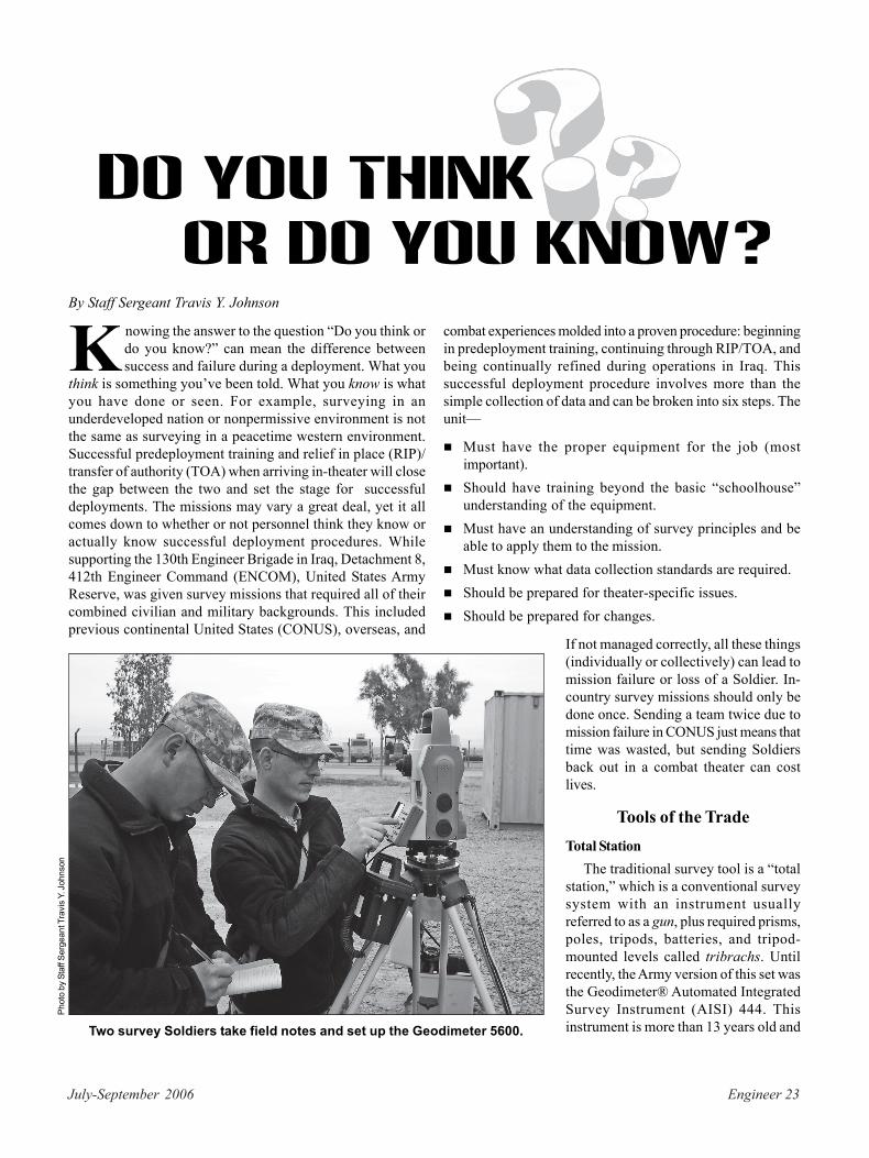
Two survey Soldiers take field notes and set up the Geodimeter 5600.
Phot
o by
Sta
ff Se
rgea
nt T
ravi
s Y.
Joh
nson
or Do You Know?Do You Think
is no longer used professionally in surveying. To meet missionrequirements, Detachment 8 acquired the Geodimeter 5600Servo Direct Reflex (DR) 200+ with the Trimble® AutomatedControl Unit (ACU) Survey Controller as the gun. The gun iscapable of measuring 5,500 meters to a prism with two-secondaccuracy over that distance or roughly 5 centimeters. This is aline-of-sight system and was acquired with global positioningsystem (GPS) gear to be used as a stand-alone system ortogether. Although not standard military equipment, the UnitedStates Army Engineer School, Fort Leonard Wood, Missouri,recently adopted the 5600 gun with a slightly different controlmodule, the Geodimeter Control Unit (CU), which is moreclosely related to the AISI 444 operational procedures.Global Positioning System
The GPS acquired to meet mission requirements is theTrimble 5800 Real-Time Kinetic (RTK) Rover. The maincomponent is the Site Positioning System (SPS) 780 Roverseries with base option, which is an antenna that can be usedas either a GPS base station or as a rover. A rover collects RTKGPS data while moving. The rover vehicle can be any platform,but is typically an all-terrain vehicle like the Polaris Ranger®4x4, which needs only minor modifications to mount the surveyrod. This GPS requires an attachable data collector, the TrimbleSurvey Controller 2 (TSC2), which can be interchanged withthe base, the rover, or the gun. This system measures at anunadjusted accuracy of 1 to 3 centimeters.Software
The Army trains and supplies TerramodelTM civil designsoftware developed to use with Trimble equipment. Othersoftware supplied and trained by the Army is AutoCAD 2004,but AutoCAD 2004 Land Desktop Development (LDD) andother Autodesk civil design series components are also avail-able. Conversion and data management software packagesare required, such as Geotrans V2, Convert 4.08, Trimble DataTransfer, and Trimble Geomatics Office. No single softwarepackage could satisfactorily meet all missions; the combinationof all this software was essential to the various missions andtheir changes. Nontechnical but important software in creatinga final product is Adobe® Acrobat® Professional, which allowsalmost any technical output to be made into a portabledocument format (PDF) that any client can view.
Predeployment Training
P.redeployment training is mandatory for all deployingSoldiers. There are core, theater-specific tasks, such asconvoy operations, that all services mandate. Military
occupational specialty (MOS) 21T technical engineerspecialists, like all Soldiers, need to train in their job-specifictasks. However, unlike 21B combat engineers, 21Ts are low-density, and not many qualified and experienced trainers areavailable. A 21T must be an expert not only in surveying butalso in drafting, computer-aided drafting (CAD), soils analysis,concrete quality control, and other critical technical engineerjobs that require considerable training and experience after
the initial schooling (military or civilian). If they only haveschoolhouse or basic MOS training, the odds are that theyonly think they know the job.
A train-the-trainer atmosphere is perfectly suited forcorrecting this problem. Given sufficient lead time, a 21T trainerfrom the Engineer School or from a training brigade may beavailable. Local vendors for survey equipment may be able toprovide hands-on training that can be very important. Even asingle experienced noncommissioned officer can successfullymentor school-trained Soldiers during predeployment training.It is also important that unit leadership be thoroughly familiarwith all the software, hardware, and applications in order toset the missions for success in planning, logistics, andspecifications. Finally, advance coordination with the unit beingreplaced can ensure that “right-seat/left-seat” training (workingside by side with someone familiar with the job), using actualongoing missions, will use the RIP/TOA period to build onpredeployment training and bring the incoming unit up to fullspeed.
General Survey Principles
T.here are a few general survey principles that need tobe reinforced during predeployment training. Theseprincipals are proper point coding, site identification,
and the location or placement of benchmarks. Errors in thesetasks must be caught and corrected on-site, without slowingthe progress, or the entire survey could be wasted. Drillingthe steps for each principle as a battle drill would ensure theSoldiers’ confidence both in themselves and the equipment.
Point CodingProper point coding steps vary with the equipment, but the
principle remains the same. Point coding is how the surveyorassigns identifiers to points. Often a 21T other than thesurveyor uses the data to develop drawings. There may bemultiple surveys, potentially creating confusion with data sets.Some coding conventions will not be read in by the software.You have to know your equipment. Having a key to the codesas part of the job files eliminates whether people know or onlythink they know the data codes.
Site Identification and Benchmarks
Proper site identification and benchmarks are also importantfor mission success. Do the surveyors know that they haveenough data at the end of a mission or do they only think theyhave enough? Everything should be collected. Experienceshows that projects can expand or become new projects. In-theater, many clients don’t fully understand how to translatetheir needs into technical requirements that can also result inadditional work. Extra data can make a new survey un-necessary. Available benchmarks should be located in allsurveys. Benchmarks make project handoff, map location, andaccuracy markedly better. Also, proper field notes streamlinesurveying, data use, and the ability to effectively change inthe middle of a mission.
24 Engineer July-September 2006
July-September 2006 Engineer 25
It is better to have the data and not need it than to need itand not have it. However, time constraints can make it difficultto get these extra details, particularly if the survey crew has totake considerable time on-site working out the details of thesurvey. A site visit before the survey with all key projectmembers—to include the client, the designers, and theconstruction supervisors—is essential for mission success.It ensures that the survey leaders can better plan the site workby seeing it, the client’s needs are worked out on the groundand understood by all, and data needs are thoroughlyunderstood.
Collection Standards
Do the survey crews know how to perform the surveyaccuracy standards for the mission? The civilianstandard of surveying is much more stringent than
that of an average military surveyor, yet those higher standardsare required for United States Army Corps of Engineers® ormilitary contract projects that the surveys support. Thedifference is in accuracy and legality. Civilian surveyors arerequired to know property laws and geospatial informationsystems (GISs) and be able to pass licensing exams. In moststates, they must have attained a bachelor of science degree.Military surveyors are not held to the same standards.However, in-theater missions can require civilian levels ofexpertise, and not being able to execute those missions candelay large projects until civilian contractors are available andfunded.
Something normally practiced by civilian surveyors, butnot by the military, is the use of an Online Positioning UserService (OPUS) for GPS coordinate correction. This system
has been recently set up in-theater and ismonitored regularly. The website is<www.ngs.noaa.gov>. Using this serviceensures that the surveyors and designersknow that benchmark data is correct ratherthan only thinking that it is.
Theater-Specific EncountersForce Protection
Force protection is always an issue in-theater. The leader for any mission shouldknow the potential threat for the site and fortravel to the site. Unexploded ordnance(UXO) could be found on a base where futureconstruction is planned. A route survey canencounter improvised explosive devices(IEDs) and small arms fires. Even secure basescan receive mortar or rocket attacks. Theseare just some of the challenges survey teamshave experienced. Unit planning must ensurethat all coordination is made, to includeaccounting for the amount of equipmentbeing transported for a mission and ensuring
that the security team understands the needs of the surveyteam. Environmental considerations include high heat, wildlife(such as scorpions and vipers), and cold weather or rain(depending on the location and the season).Drainage
Drainage is a significant issue in-theater for surveyors aswell as for designers. The soils in many of Iraq’s populatedareas are alluvial silts that seal against water shortly after beingwetted instead of allowing water to filter into the ground. Thetopography of most bases is flat and not conducive to properdrainage. On many bases, gravel is used to “put boots andwheels above the water.” This makes the situation worse. Unitsare in-theater for a year or less and typically do not see thelong-term effects. For the surveyor, it may mean recording apoint on the top of the gravel and then digging below thegravel to record a point at ground level, both for drainage and
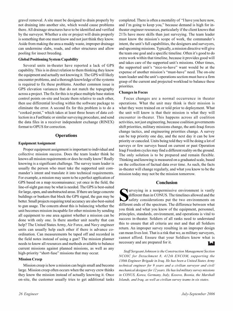
After using a rover-mounted GPS to survey a 1,000-acresite in southern Iraq, a comprehensive drainage planwas developed from the 3-D data using Terramodel.
Phot
o by
Ser
gean
t Ada
m R
usse
ll
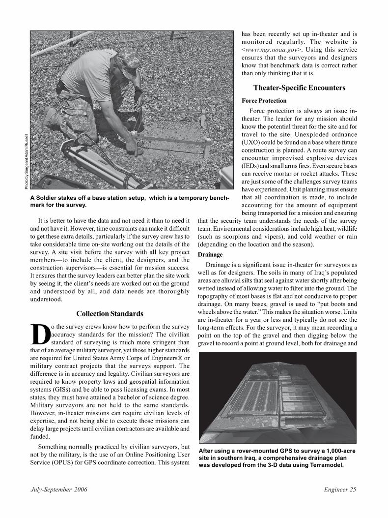
A Soldier stakes off a base station setup, which is a temporary bench-mark for the survey.
26 Engineer July-September 2006
gravel removal. A site must be designed to drain properly bynot draining into another site, which would cause problemsthere. All drainage structures have to be identified and verifiedby the surveyor. Whether a site or project will drain properlyis something that one must know and not just think they know.Aside from making the area a muddy waste, improper drainagecan undermine slabs, roads, and other structures and allowpooling for insect breeding.Global Positioning System Capability
Several units in-theater have reported a lack of GPScapability. This is in direct relation to them thinking they knowthe equipment and actually not knowing it. The GPS will likelyencounter problems, and a thorough knowledge of the systemsis required to fix these problems. Another common issue isGPS elevation variances that do not match the topographyacross a project. The fix for this is to place multiple base stationcontrol points on-site and locate them relative to each other,then use differential leveling within the software package toeliminate the error. A second fix for this problem is to do a“cooked point,” which takes at least three hours of data col-lection in a FastStatic or similar surveying procedure, and sendthe data files in a receiver independent exchange (RINEX)format to OPUS for correction.
OperationsEquipment Assignment
Proper equipment assignment is important to individual andcollective mission success. Does the team leader think heknows all mission requirements or does he really know? Reallyknowing is a significant challenge. The survey team leader isusually the person who must take the supported unit com-mander’s intent and translate it into technical requirements.For example, a mission may seem to be a perfect application ofGPS based on a map reconnaissance; yet once in the field, theline-of-sight gun may be what is needed. The GPS is best-suitedfor large, open, and unobstructed areas. If there are large concretebuildings or bunkers that block the GPS signal, the gun may bebetter. Small projects requiring total accuracy are also best-suitedto gun usage. The concern about this is balancing whether theunit becomes mission incapable for other missions by sendingall equipment to one area against whether a mission can bedone with only one. Is there another unit nearby that canhelp? The United States Army, Air Force, and Navy engineerunits can usually help each other if there is advance co-ordination. Can measurements be taped off and recorded inthe field notes instead of using a gun? The mission plannerneeds to know all resources and methods available to balancecurrent missions against planned missions, as well as anyhigh-priority “short-fuse” missions that may occur.Mission Creep
Mission creep is how a mission can begin small and becomelarge. Mission creep often occurs when the survey crew thinksthey know the mission instead of actually knowing it. Onceon-site, the customer usually tries to get additional tasks
completed. There is often a mentality of “I have you here now,and I’m going to keep you,” because demand is high for in-theater engineer resources, particularly if the client knows that21Ts have more skills than just surveying. The team leadermust know the mission’s scope of work, the commander’sintent, the unit’s full capabilities, the designers and surveyors,and upcoming missions. Typically, a mission directive will givethe team one goal and a specific timeline. Often it’s good to doextra work within that timeline, because it provides good willand takes care of the supported unit’s missions. Other times,the supported unit’s “nice-to-have” want would be at theexpense of another mission’s “must-have” need. The on-siteteam leader and the unit’s operations section must have a firmgrasp of the current and projected workload to balance thesepriorities.Changes in Focus
Focus changes are a normal occurrence in theateroperations. What the unit may think is their mission iswhat they were trained on or told prior to deployment. Whatthe unit will know is that their mission is what they willencounter in-theater. This happens across all coalitionactivities, not just engineering, because coalition governmentsshift priorities, military missions change, the anti-Iraqi forceschange tactics, and engineering priorities change. A surveycan be top priority one day, and the next day it can be lowpriority or canceled. Units being told they will be doing a lot ofsurveys or few surveys based on current or past OperationIraqi Freedom cycles may find a different reality on the ground.The only solution is to be prepared and remain flexible.Thinking and knowing is measured on a graduated scale, basedon the collection of factual data over time. As such, the factsin-theater will change regularly, and what you know to be themission today may not be the mission tomorrow.
Conclusion
Surveying in a nonpermissive environment is vastlydifferent than in CONUS. The timelines allowed and thesafety considerations put the two environments on
different ends of the spectrum. The difference between whatyou think and what you know of the equipment, personnel,principles, standards, environment, and operations is vital tosuccess in-theater. Soldiers of all ranks need to understandthis to ensure that all criteria are met and that all Soldiersreturn. An improper survey resulting in an improper designcan mean lives lost. That is a risk that we, as military surveyors,cannot afford. Ensure that your Soldiers know what isnecessary and are prepared for it.
Staff Sergeant Johnson is the Construction Management SectionNCOIC for Detachment 8, 412th ENCOM, supporting the130th Engineer Brigade in Iraq. He has been a United States Armytechnical engineer for 9 years and a civilian surveyor and civil/mechanical designer for 12 years. He has led military survey missionsin CONUS, Korea, Germany, Italy, Kosovo, Bosnia, the MarshallIslands, and Iraq, as well as civilian survey teams in six states.