Embed Size (px)
Citation preview
1
Orienteering Lesson Plans for High School and Middle School Unit objective: When finished with this program, the student should be able to demonstrate knowledge and understanding of navigation on topographic maps and compete at the Intermediate (Orange) level in the sport of Orienteering. Teacher objective: This unit has been written slanted toward the needs of the high school ROTC instructor who is looking to train a competitive orienteering team. The unit can be adapted for other grade levels, teachers and coaches. It is fairly important to stick to the prescribed order of the lessons and field trips as each is a prerequisite for the lessons and field trips that follow. The unit moves rather rapidly from topic to topic, so it may be necessary to repeat some lessons if the teacher finds the students need the reinforcement prior to moving on to the next lesson plan. It is important to use IOF standard orienteering maps. These can be obtained from orienteering clubs. Please be careful to respect map copyrights and be sure to get land manager permissions if practicing or training other than during organized orienteering club events. Whenever possible, use courses designed by trained orienteers in order to be assured of the accuracy of the course level to the subject matter. Sessions: 14 classroom/schoolyard, 3 field trips Instructional reference: “CM” references are to the U.S. Orienteering Federation’s (USOF) “Coaching Orienteering” manual. “p.” indicates page number in text, “ex.” indicates suggested classroom and field exercises in Appendix A of the manual. Note that many of the manual’s field exercises can be adapted to classroom. Evaluation: At the end of the unit, the student should be able to successfully complete an Orange level (Intermediate) course at a USOF-affiliated club’s orienteering event.
Lesson #1 – Introduction to Orienteering and the Orienteering Map
Lesson objectives: • Define the sport of Orienteering. • Explain the benefits of learning orienteering. • Recognize Orienteering’s military beginnings. • Identify the parts of and symbols on an orienteering map.
Instructional aids: • Various types of topo maps (USGS, military, etc.), if available • IOF standard orienteering maps (1 per student) • Visual aids to illustrate contours and contour intervals, if available • Chalkboard, chalk • Index cards with map legend symbols & words as described in CM ex.1
2
Instruction: Definition of Orienteering • Orienteering is a challenging outdoor activity using a detailed topographic map
and a compass to navigate through the terrain and find a series of terrain or man-made features indicated on the map. Orienteering is a competitive sport that originated as a military exercise in Scandinavia in the early 1900’s.
• Orienteering is a motivating recreational activity, which increases love of the outdoors and promotes environmental awareness. It fits into academic goals of curriculum, develops critical thinking skills and increases physical fitness. All ability levels can compete in local, regional and national events.
Instruction: Orienteering History The teacher should go over the following with the intention of giving students a historical perspective of the development of Orienteering from military beginnings.
• 1886 – The term “orienteering” was being used by the military to mean crossing unknown territory with the aid of a map and compass.
• 1897 – The world’s first public orienteering competition held in Norway. • 1919 – Major Ernst Killander of Sweden devised a cross-country competition
where runners not only ran a course but had to choose their own routes using a map and compass. He is considered the “Father of Orienteering”
• 1941-1943 – Orienteering events were held at Dartmouth College, organized by Finnish army officer Piltti Heiskanen.
• 1946 – Bjorn Kjellstrom of Sweden, the co-inventor of the protractor type, liquid-damped magnetic compass, moved to the U.S. and organized many competitions, the first of his events was held at Dunes State Park in Indiana.
• 1961 – The International Orienteering Federation was formed. • Spring 1966 – U.S. Military Academy at West Point began intramural score
orienteering in pairs. • Summer 1967 – The U.S. Marine Corps Physical Fitness Academy at Quantico,
Virginia, began orienteering activities under assistant director Jim “Yoggi” Hardin. • 1966 – The first World Orienteering Championships were held in Finland. • November 1967 – Harald Wibye of Norway organized an orienteering event at
Valley Forge, Pennsylvania. • October 1970 – The first U.S. Orienteering Championships was held at Southern
Illinois University. • August 1971 – The U.S. Orienteering Federation was formed in Virginia. • Marines won the first six U.S. men’s orienteering titles. In the early and mid-
1980’s, five-time U.S. elite champion Peter Gagarin of Massachusetts founded and coached the U.S. Team which has represented the United States at every World orienteering championship event since 1974. Among the women, not one has achieved the success of Sharon Crawford of Massachusetts, who was the top U.S. woman at seven straight World Championships and in 1989 at the age of 45 won her eleventh individual U.S. Orienteering Championship.
• 1988 – Orienteering was accepted as a U.S. Olympic Committee Class C sport, later known as an affiliated sport.
• Currently, there are approximately 60 orienteering clubs in the U.S.
3
Instruction: The Orienteering Map Hand out orienteering maps to students. Explain how a topographic map shows the shape of the terrain and detailed features that are not commonly found on other maps. If possible, have different types of topo maps (USGS, military, etc.) for comparison.
• Scale – Have students find the 1:??,000 scale on the orienteering map. Explain that scale shows the size relationship of map to earth. Point out the bar scale and that it is used in conjunction with the compass’ ruler to measure distance to be traveled.(CM p.50)
• Contour interval – Have students find the contour interval on the orienteering map. Explain that the contour interval is the elevation change between contour lines. If students are not familiar with contour lines, explain how elevation lines show the steepness and shape of the terrain. Visual models or drawings are helpful to illustrate the concepts or illustrate on the chalkboard. (CM p.50)
• Legend – Point out how the orienteering map legend shows which symbols are used on the map. Have student find several features on the map and identify them using the map legend. (CM p.49)
• Magnetic north lines – Point out the parallel lines with small arrows pointing toward magnetic North on the map. These lines are spaced on the map every 500 meters on a 1:15,000 map.
• Colors – Note and explain the colors on the orienteering map: (CM p.49) o Blue – water features o Black – rock features and man-made features o White – normal, open woods o Green – thick vegetation, shades & patterns denote type o Yellow – non-wooded land, shades & patterns denote type o Brown – natural non-rock features and contour lines
Exercise: CM ex.1 – Map Symbol Relay Assessment: The student should be able to write a brief description of Orienteering and identify 10 map symbols, the scale, control interval and the magnetic north lines on the map.
4
Lesson #2 – Map Interpretation
Lesson objectives: • Demonstrate how to interpret map symbols to identify terrain features. • Identify types of map features.
Instructional aids: • IOF standard orienteering maps (1 per student) • Blank paper and pencils for school yard map making • Legend of school yard map symbols (1 per student) • Completed school yard map, large scale or via projection • Large sheets of paper or poster board and markers, if doing CM ex.57
Instruction: Map Interpretation • What’s on and not on the map – Explain that each map maker has his own
criteria of what is significant enough to add to the orienteering map. For example, a small boulder or ditch many not be mapped, while a larger one would be mapped. The “busier” the terrain, the less often smaller features are on the map. New changes, such as fresh rootstocks and new trails, may not be on the map. Water features (lakes, seasonal streams) may change size or disappear entirely at some times of the year.
• Feature identification—Types of features on an O map: o Point features – distinct and usually small features, such as boulders,
rootstocks and pits. o Linear features – followable, long features such as trails, fences and
streams. o Contour features—features defined on the map by contour lines such as
reentrants, spurs and gullies.
Exercise – Make your own Map O The teacher takes the students outside to the school yard and gives each student a blank sheet of paper, pencil and a legend of map symbols for the features to be found in the school yard. Instruct the students to each draw a simple map of the area, visualizing scale and using the map symbols provided. They should get as much detail on the map as possible in about 15-20 minutes. Afterward, the students should self-evaluate their maps in the classroom based on a display of the teacher’s map. After they correct their maps, you might want to go back outside with the group and have them walk around the school yard, pointing out features on the map and as they appear in the terrain. It takes a while to get the idea that the map shows pretty accurately what’s on the ground. Rainy day option – Mapping a Classroom (CM ex.57) Assessment: The student’s self-made map should show an understanding of the scale and relative locations of the features depicted.
5
Lesson #3 – Map Reading Skills
Lesson objectives: • Define rough and precision map reading skills. • Explain how map reading skills are used to navigate.
Instructional aids: • IOF standard orienteering maps (1 per student) with a Yellow course
Instruction: Map Reading Skills • Rough map Reading (Map simplification) – Navigating by larger features while
filtering out small map details you don’t need to navigate the current leg segment. Requires map reading in advance of current location and memorizing upcoming details, but allows the Orienteer to move quickly through the terrain. The major pitfall is losing contact with your location on the map. (CM p.58)
• Precision map reading (Map to terrain identification) – Navigation using small map details, usually in the vicinity of the control site or when relocating after an error. Requires moving more slowly and extra concentration. (CM p.58)
Exercise: Talkin’ an O Course This exercise is done in the classroom and requires that the teacher knows precision map reading. If the teacher cannot do this, he should ask an orienteer from the local club to go through this exercise with his students. Each student should have a copy of the same orienteering map with the same Yellow course on it. The teacher describes navigating through the course for the students using precision map reading (map to terrain identification), describing how the map depicts the terrain details and explaining how to visualize what would be seen on the ground from observing map details. The teacher should describe how to follow the course strictly via map to terrain identification, checking off terrain features that would be seen along the way and pointing out how they are used to keep on course. This exercise should be done without the aid of compass. Assessment: The student should be able to identify at least one feature per course leg when map simplification (rough map reading) could have been used to increase speed.
6
Lesson #4 – The Orienteering Event
Lesson objectives: • Describe purpose of a field trip to an orienteering event. • Plan dress and equipment needed for an orienteering event. • Learn orienteering event and safety procedures. • Describe concept of “Fair Play”
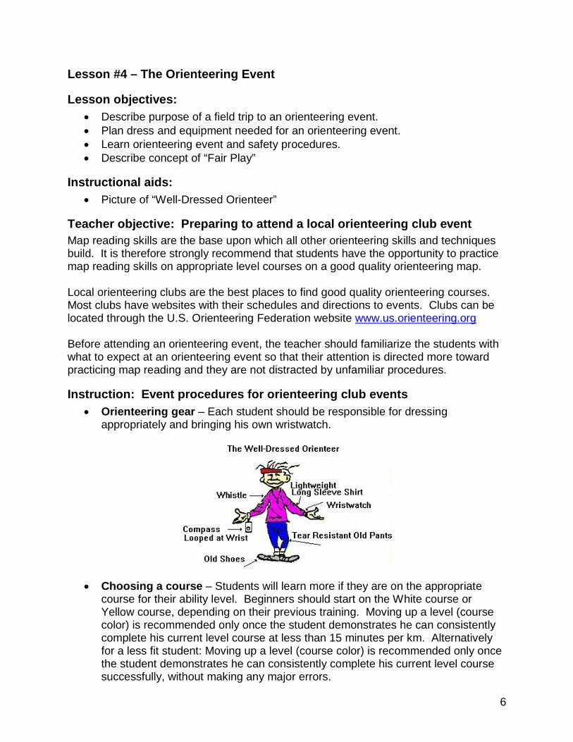
Instructional aids: • Picture of “Well-Dressed Orienteer”
Teacher objective: Preparing to attend a local orienteering club event Map reading skills are the base upon which all other orienteering skills and techniques build. It is therefore strongly recommend that students have the opportunity to practice map reading skills on appropriate level courses on a good quality orienteering map. Local orienteering clubs are the best places to find good quality orienteering courses. Most clubs have websites with their schedules and directions to events. Clubs can be located through the U.S. Orienteering Federation website www.us.orienteering.org Before attending an orienteering event, the teacher should familiarize the students with what to expect at an orienteering event so that their attention is directed more toward practicing map reading and they are not distracted by unfamiliar procedures.
Instruction: Event procedures for orienteering club events • Orienteering gear – Each student should be responsible for dressing
appropriately and bringing his own wristwatch.
• Choosing a course – Students will learn more if they are on the appropriate
course for their ability level. Beginners should start on the White course or Yellow course, depending on their previous training. Moving up a level (course color) is recommended only once the student demonstrates he can consistently complete his current level course at less than 15 minutes per km. Alternatively for a less fit student: Moving up a level (course color) is recommended only once the student demonstrates he can consistently complete his current level course successfully, without making any major errors.
7
• Registration – Each person must register, sign a waiver, and pay a fee. Most local events have day-of-event registration, but regional and national events require pre-registration. Check websites or call for details. Some clubs ask school groups to call ahead so they can be prepared with enough maps. Students under age 18 must have a parent, guardian or teacher co-sign their waiver. Students may go out individually or in pairs, but each should have a map.
• Beginner instruction – If students have not orienteered before, it’s best to allow a club coach to give them beginner instruction, even if they’ve received in-school instruction. These instructors have special training and gear that day’s instruction to the conditions and courses at the event.
• Control descriptions (Clues) – These are provided either at registration, copied from a master, or are printed on the maps. Ask!
• Master maps – Many local events have the competitors copy their courses onto “clean” maps instead of providing pre-printed courses on the maps. If so, instruct students to be very careful to copy the triangle, circles, numbers, and lines, exactly as they appear on the master map. Most clubs also provide map cases to protect the maps. Encourage their use.
• Control Markers – A 3-sided white and orange flag, on or next to the control feature, with attached control code and punching mechanism, for verifying the feature was visited.
• Punch cards (or Ecards) – Once a control marker is found, punch in the correct square on your punch card. This will prove you found the control marker. Any missing punches constitutes a result of DNF (did not finish). If Electronic punching is used on your course, your punch card will be an Ecard (finger stick) that you can rent from the organizers.(CM ex.38)
Instruction: Safety Emphasize to the students that orienteering event organizers have safety procedures and rules they must respect. Commonly they are:
• All persons must be accounted for by going through both the Start and the Finish, whether or not they are competitive, or if they’ve completed the course or not.
• Absolute time limit on the courses is 3 hours unless otherwise instructed. Please be sure each student has a watch and respects the time limit.
• If carrying a safety whistle, it may only be blown if you are injured and cannot return without assistance. Blowing the whistle if lost is considered cheating.
• Cell phones and other communications devices may be carried only for safety reasons, not for navigational communication.
• If you go out in a pair or group, you must remain with the others until all in the pair or group cross the Finish line.
8
Instruction: Concepts of “Fair Play” Emphasize to students that no matter how advantageous it is to them and their friends to violate “Fair Play” concepts, it is not allowed and will be considered cheating.
• No following or navigational cooperation with other competitors. • No helping other competitors unless they are lost, then give only the minimum
assistance required to relocate their current position. • No shouting around controls or bothering other competitors. • Unless the event is a “Score” format, controls must be visited in numerical order. • Do not move, hide or alter control markers, except to re-hang if it has fallen.
Assessment: At the orienteering event, the student should be able to do the following:
• Complete his registration for correctly. • Accurately copy his course from a master map, if needed. • Identify 70% of safety guidelines and fair play concepts.
9
Field Trip #1 -- Attend a Local Orienteering Club Event Field trip focus: Map reading practice
Field trip objectives: • Demonstrate the ability to do both rough and precision map reading. • Demonstrate how map reading skills are used to navigate.
Teacher objective: Orienteering with a local orienteering club • Orienteering club events are open to all and organizers welcome school groups.
However, please notify the event director ahead of time of the approximate number of students you will be bringing and if you are coming by bus. He may need to provide you with special instructions and can answer questions.
• Emphasize to the students that they are there to practice map to terrain identification only. It’s important that they master map-to-terrain identification before they move on to using a compass, speed and any other more advanced skills and techniques.
• The appropriate first course for most students taking this program of instruction will be the Yellow course. If any students are having a lot of map reading difficulty, they should start on the easier White course. Students will learn more if they do the courses individually, although the teacher has the option of pairing up if so desired.
Procedures for teachers bringing students to a local club event • Please be sure you have the appropriate parental permissions and can sign
event liability waivers on behalf of underage students or have parent-signed waivers.
• If you pair up students going out on an orienteering course, please be sure the both students in the pair are of like map reading and navigational skill and that they understand they are to remain together at all times while on the course. We strongly recommend that each student in the pair has his own map.
• Teachers should NEVER instruct the students to remain on the course until they have located all control sites. Students should rather be instructed that it is absolutely mandatory they return within the event director’s time limit.
• If at any time you are concerned about an overdue student, please take your concerns to the event director. NEVER send a party of students out to look for another student without event director’s permission.
• Please be sure you have accounted for all your students and that all students have checked into the Finish before you leave the event site.
Assessment: The student should complete the course within the time limit.
10
Lesson #5 – Using a Compass
Lesson objectives: • Identify the parts of a compass. • Demonstrate how to use a compass in conjunction with an orienteering map. • Identify where on a course to use map orientation, precision compass and rough
compass.
Instructional aids: • Baseplate compasses with liquid-filled housing (1 per student) • Orienteering maps with Yellow or Orange courses (1 per student) • School yard map drawn to scale with magnetic North lines, if available
Instruction: Parts of a compass • Magnetic needle – The red side always points north. • Housing – The liquid-filled housing, which may includes a 360-degrees bezel,
turns in order to line up north on the compass with the magnetic declination lines on the map.
• Base plate – The base plate acts as a protractor in order to line up the compass with the desired route on the map. It usually includes a direction of travel arrow and measurement ruler.
Instruction: When and how to use a compass Compasses can be used in several ways to assist with navigation. For orienteering, you will need a liquid-filled compass with a baseplate-mounted housing containing the magnetic needle. Lensatic compasses are not appropriate for orienteering.
• Magnetic north – Point out the magnetic north lines on the orienteering map. Explain the difference between True North and Magnetic North. Point out that orienteering maps are drawn to magnetic north, but many other maps, such as USGS topos, are drawn to true north with the magnetic declination indicated separately. (CM p.50)
• Map orientation – Maps should always be read oriented to the terrain in order to minimize directional errors. A compass’ magnetic needle points north. Instruct the students to turn the map until north on the map matches north on the compass. Map orientation should occur when leaving the start, when leaving each control site, and when making a change of direction. (CM p.51)
• Exercise: If a schoolyard map is available, CM ex.62 – Map Orientation. Assessment: The student should be able to reorient the map to north whenever he makes a change of direction.
11
• Precision compass – Using the compass to follow a precise compass bearing, also called “shooting an azimuth.” Always use precision compass in conjunction with precision map reading to avoid compass drift over distance. Normally, precision compass is used for no more than150 meters.(CM p.54).
• Exercise: Setting the compass for a precision bearing.
o Place either long side edge of the compass baseplate on the intended line of travel on the map with the direction of travel arrow pointing in the direction you intend to travel on the map.
o Rotate the compass housing until the magnetic north orienting lines painted inside the compass housing are parallel to the magnetic north lines on the map AND the orienting arrow on the compass housing is pointing toward north on the map (N on bezel points to north on map).
o Measure the distance on the map to be traveled on this bearing. o Take the compass off of the map and hold it in the palm of your hand with
your hand parallel to the ground and with the thumb along the side of the baseplate and the direction of travel arrow pointing the same direction as your nose.
o Rotate your entire body until the red end of the magnetic needle comes to rest inside the north magnetic orienting arrow on the compass housing.
o Follow the direction of travel arrow on the compass while keeping track of where you are on the map.
Assessment: The student should be able to accurately set a compass to the desired azimuth.
• Rough compass – Using the compass to follow a general direction, such as
ENE or SSW. The compass is used to orient the map, then to determine and follow a general direction. Rough compass is used to travel longer distances quickly. While on rough compass, the orienteer should maintain contact with the map via rough map reading in order to avoid parallel errors.(CM p.55)
• Exercise: Setting the compass for a rough/general direction. o Fold and hold your map so that your general direction of travel on the map
is the same direction as your nose. o Measure or estimate the distance on the map to be traveled. o Place your compass on the map with one side edge roughly on, but to the
side of, your planned line of travel with the direction of travel arrow pointing in the direction you intend to travel.
o Rotate your body to orient the map using the magnetic needle on the compass.
o Note your general direction of travel on the map (ENE, SSW, SE, etc.) o Holding the compass and the map in the same hand, follow your general
direction of travel while periodically glancing at the compass to re-orient your map to north.
o Use rough map reading to keep track of where you are on the map as you move quickly through the terrain.
Assessment: The student should be able to determine and set a rough/general compass direction for a leg on a course using the map.
12
• Map vs. compass – Emphasize the compass as a tool to use with them map, not the primary navigational tool. Novices tend to rely too much on the compass and do not do enough map reading.
Exercise – Endangered Azimuth O Explain that precision compass (shooting azimuths) should only be used when necessary as they waste competition time and detract from the higher skill of map reading. Students will remember this if you tell them, “Azimuths are an endangered species because Boy Scouts shoot too many of them!” On their orienteering maps, have the students identify where on the course they will need to use a compass. They should use the following compass use key, writing the appropriate letters on the map at the location where they will use each method:
• “O” where you need to orient your map • “R” where you need rough compass • “P” where you need precision compass (shoot an endangered azimuth)
Assessment: The student should demonstrate the following with at least 70% accuracy during the Endangered Azimuth exercise:
• Map orientation “O” at the following map locations: o Start triangle o Each control circle o Each change of direction
• Rough compass “R” at the following map locations: o When following a linear terrain feature o When following a long contour feature (ridge, spur, major reentrant)
• Precision compass “P” at the following map locations: o When course requires precision map reading, but for no longer than 150
meters without resetting the compass between identifiable mapped features.
o When crossing an area with little or no features by which to navigate.
13
Lesson #6 –Measurement Part 1 – Pace Counting
Lesson objectives: • Demonstrate using a bar scale to measure distance on a map. • Define pace counting. • Derive your individual pace counts and demonstrate how they are used to
measure distance.
Instructional aids: • Baseplate compasses with liquid-filled housing (1 per student) • Masking tape and pens • Orienteering maps with Yellow or Orange courses (1 per student)
Instruction: Measurement is very important! “Those who do not measure everything will measure their lost time in minutes. Those who measure everything correctly and apply the information properly will measure their lost time in seconds.” Instruction: Precision measurement – Just as there are precision and rough skills in map reading and compass use; there are similar skills in measuring distances. Precision measurement involves taking exact map measurements and counting your paces.
• Putting the scale on your compass – In order to use the correct measurement scale for the map, have students place a piece of masking tape over the short front edge of their compass baseplate. Carefully copy the bar scale on the map onto the masking tape, marking “100”, “200” etc. under the appropriate tick marks. This enables quick yet accurate measurements of distance while under competitive pressure. The students should check and change, if necessary, this marked scale each map use.(CM p.52)
• Exercise – Using the orienteering map, have students measure legs using the bar scale they’ve copied onto the masking tape on the compass.
• Pace counting (Pacing) - Counting actual steps. Some orienteers count every other step and call it a pace; some count every third step, etc. The major factor is consistency and accuracy. Explain that whenever precision compass is used, pacing is mandatory. (CM p.52)
Exercise – Pacing the Sidelines A football field, plus one end zone, is approximately 100 meters. Referencing CM p.52-53, take the students to the football field and have them do CM ex.16 – Pacing 100 meters, learning their walking, jogging and running paces. Assessment: The student should be able to accurately recall his own pace count for each speed. Follow-up: Encourage students to practice pacing while doing training running to make it a habit and readily available during competitions.
14
Lesson #7 – Measurement Part 2 – Distance Estimation
Lesson objectives: • Acquire the ability estimate distances on the ground. • Acquire the ability to estimate distances on a map.
Instructional aids: • Baseplate compasses (1 per student) • Orienteering map used in Lesson #5 for Endangered Azimuth O (1 per student)
Instruction: Measurement and distance estimation is very important! “Those who do not measure everything will measure their lost time in minutes. Those who measure everything correctly and apply the information properly will measure their lost time in seconds.”
Instruction: Precision vs. rough measurement Precision measurement and pace counting is not accurate over distances. It also is time consuming and moving quickly is essential for competition. A quick form of measurement is distance estimation. When on rough compass, speed can be increased by learning to estimate distances on the map. Feature identification is more accurate when distance to the feature can be visually estimated. Acquiring the ability to estimate distances accurately is done through practice. The teacher will need to take the students outside and give them the opportunity to practice estimating distances on the ground. Estimating distances on a map is acquired by visualizing the map bar scale onto the distance to be measured on the map. Exercise: CM ex.18 – Distance Estimations – in school yard
Exercise – Far and Away O Have students take the map they used for Endangered Azimuth O and write beside each letter an estimate of how far they would travel on each “P” (Precision compass) leg and each “R” (Rough compass) leg. Have students make or check the masking tape bar scale on the compass against the bar scale on the map for accuracy. Then have them measure the same routes with the masking tape bar scale on their compasses and write the actual distance beside their estimates. Note the difference between estimates and measured distances. Assessment: The student should be able to:
• Estimate visually a distance on the ground of up to 100 meters with 90% accuracy.
• Estimate a distance on a map with 90% accuracy. • Measure a mapped distance by pace counting to it with 90% accuracy.
15
Field Trip #2 -- Attend a Local orienteering Club event Field trip focus: Map Reading along with compass use
Field trip objectives: • Demonstrate precision map reading and with precision compass use along with
measurement and pacing. • Demonstrate rough map reading and rough compass use with distance
estimation. • Describe how to choose between precision skills and rough skills.
Teacher objective: At this point, a second field trip to a local orienteering club event is strongly recommended. Students are now ready to practice compass and distance skills. Each student should now be ready to do a Yellow course individually. Emphasize to the students that they must determine when precision map reading and precision compass use is needed and when it is more appropriate to use rough map reading and rough compass use.
Procedure reminders for teachers • Please notify the event director ahead of time of the approximate number of
students you will be bringing and if you are coming by bus. He may need to provide you with special instructions and can answer questions.
• Please be sure you have the appropriate parental permissions and can sign event liability waivers on behalf of underage students or have parent-signed waivers.
• If you pair up students going out on an orienteering course, please be sure the both students in the pair are of like map reading and navigational skill and that they understand they are to remain together at all times while on the course. We strongly recommend that each student in the pair has his own map.
• Teachers should NEVER instruct the students to remain on the course until they have located all control sites. Students should rather be instructed that it is absolutely mandatory they return within the event director’s time limit.
• If at any time you are concerned about an overdue student, please take your concerns to the event director. NEVER send a party of students out to look for another student without event director’s permission.
• Please be sure you have accounted for all your students and that all students have checked into the Finish before you leave the event site.
Assessment: The student will not always make the best choice, but he should be able to demonstrate an awareness of precision vs. rough in both map reading and compass use and be able to state a reason why he made the choice.
16
Lesson #8 – Control Descriptions
Lesson objectives: • Describe the purpose and use of Control Descriptions. • Recognize the symbols used in Control Descriptions.
Instructional aids: • Control Description instruction sheet* from (1 per student) • Blank control description sheets* (1 per student) • Orienteering maps with courses, control descriptions should be folded back or
temporarily covered up. (1 per student)
*Control description sheets and instructions follow lesson. Control description sheet created for this lesson and may be duplicated for use with it. Instructions reprinted with permission and may be duplicated for classroom use. Please see IOF website for full IOF specifications.
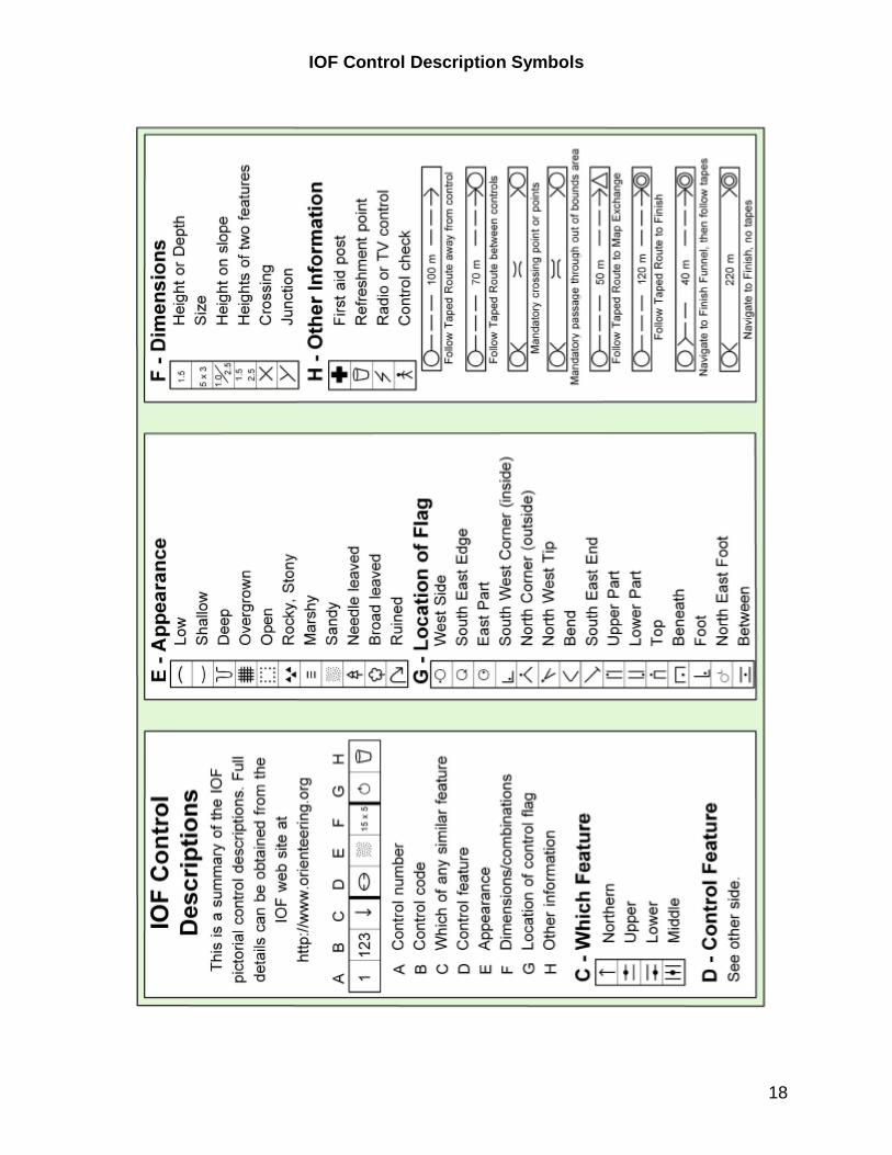
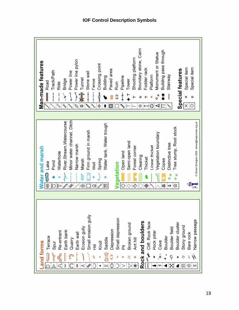
Instruction: Control descriptions (Clues) There may be several items inside a control circle on the map. In order to know which item is the control feature and other necessary-to-have information about the control site, you are given control descriptions, colloquially “Clues”.
• What they are – The International Orienteering Federation (IOF), the world-wide governing body for orienteering, established a set of symbols and a methodology for displaying control descriptions in a symbol grid, known as a Clue sheet. Beginner (White and Yellow) courses usually also have written-out control descriptions for beginners who do not yet know the symbols.
• Why you need them – Each control marker has a unique code with which the Orienteer can verify that he has found the correct marker. This code is found on the Clue sheet. Control descriptions also give you other information such as where in relation to the feature the marker is hanging, the size of the feature, and whatever other information the course setter deems important so that the marker is found by navigational skill, not luck.
Exercise – Haven’t Got a Clue O Give each student a blank control description sheet and the instructions for the control description symbols and methodology. Give each a map with a course on it, but with the control descriptions folded to the back or covered up. Instruct students to use the materials to make a clue sheet for the course, assuming the feature is in the precise center of the circle. Afterward, compare it to the control description sheet on the map. For more practice in learning Control Descriptions, an online quiz on control descriptions can be found at www.fortnet.org/icd . Assessment: The student should be able to identify the correct symbol for the control feature and place it in column D of the correct row of the description sheet with 80% accuracy.
17
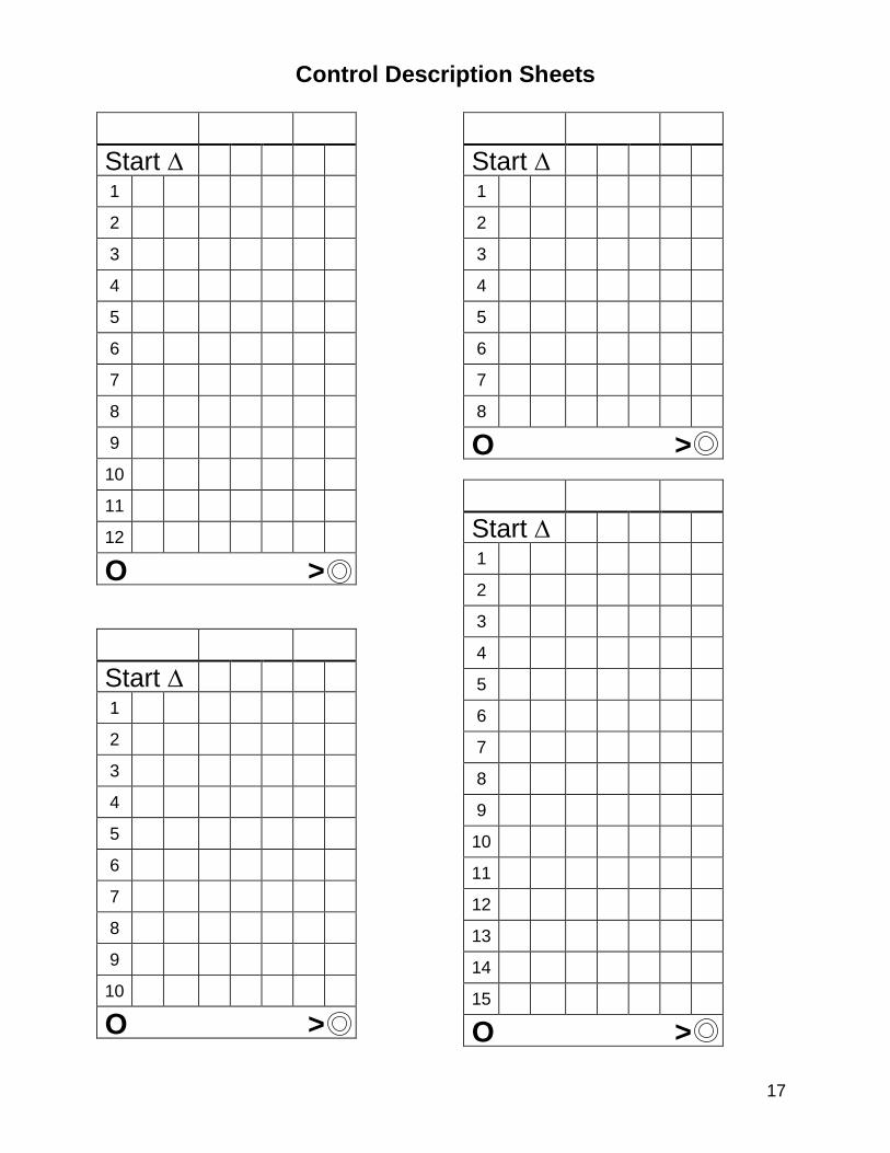
Control Description Sheets
Start ∆
1
2
3
4
5
6
7
8
9
10
11
12
O >
Start ∆
1
2
3
4
5
6
7
8
9
10
O >
Start ∆
1
2
3
4
5
6
7
8
O >
Start ∆
1
2
3
4
5
6
7
8
9
10
11
12
13
14
15
O >
18
IOF Control Description Symbols
19
IOF Control Description Symbols
20
Lesson #9 – Navigation Part 1
Lesson objectives: • Explain the importance of pre-competition study of map and control descriptions. • Acquire awareness of visibility of terrain for navigational purposes. • Demonstrate map folding and thumbing as a navigational aid.
Instructional aids: • Orienteering maps with Yellow course (1 per student)
Instruction: Navigation Part 1 -- Overview Navigation is the key element in orienteering. Orienteering courses are designed to be 50% mental and 50% physical, but most young orienteers forget that and, in their hurry to win a competition, try to out-race their opponents physically. Course setters take advantage of that mind-set and design courses to allow those that are not thinking clearly and navigating carefully to fail. Remember, Orienteering is “The Thinking Sport.”
• Map study –Before orienteering, if there is an existing map of the area available, or if he is given the map prior to the Start, the student should study the map, noting scale, contour interval, types of terrain, map symbols. If the control descriptions (Clues) are given ahead, the student should make sure he’s familiar with all the symbols and can visualize what each description would look like in the forest. (CM p.61)
• Thumbing & folding the map – No orienteer can keep his eyes on his map all the time, so it’s important to keep track of where you are on the map by keeping your thumb on your current location on the map. This not only prevents wasted time, but helps eliminate parallel and similar-terrain errors. Folding the map and keeping it oriented, along with thumbing, will enable the orienteer to maintain a good mental contact with the map. (CM p.51)
• Navigational order – Unless the course is a “score” course, you must follow the numerical order of controls. A course isn’t really a series of control sites, but rather a series of legs to navigate between control sites. (CM p.55)
• Visual distance & size estimation – As you move through the woods, you need to be aware of the size of features and how visible they will be. Depending on the terrain and season, visibility can change drastically. (CM p.61)
Exercise – I Can See Clearly O Have students visualize going through the course on the map in the classroom.
• Have students estimate, based on current season and nearby forests, the visibility factors they would face if they were orienteering that course.
• Assign each student a leg of the course to describe and give students 5 minutes to study the map and control descriptions before taking turns describing legs.
Assessment: The student should be able to describe knowledgably what he would see as he mentally moves along his leg of the course, keeping the map folded and thumb on the location being described.
21
Lesson #10 – Navigation Part 2
Lesson objectives: • Explain the importance of contours or the map. • Demonstrate the ability to read contours and use them for navigation.
Instructional aids: • Worksheet of contours and side-view illustration as described in CM ex.12 • Orienteering maps with Orange course (1 per student)
Instruction: Navigation Part 2 – Contours On most orienteering maps, the majority of information is contour information. Contours are the most important, and most likely ignored, features on a topo map. Contours show the shape and steepness of the terrain. They should be read in groups; one contour line rarely gives you sufficient information about the terrain. Exercise: CM ex.12 – Armchair O Assessment: The student should be able to determine the correct answers on the ex.12 worksheet 70% of the time.
Exercise – Contouring My Way Along Have students find contour features as they go through a course on the map in the classroom.
• Assign each student a leg of the course to describe and give students 5 minutes to study the contour information on the legs.
• Have each student describe what contour information he would see as he mentally moves along his leg of the course.
• Remind students to keep the map folded and thumb on the location being described.
• Encourage other students to try to spot other contour information that the describer misses. After each leg description, have other students add to the description.
Assessment: The student should be able to identify at least 2 contour features he could use when describing navigating his leg during the Exercise above.
22
Lesson #11 – Navigation Part 3
Lesson objectives: • Explain the importance of studying the control area as part of navigation. • Describe specific techniques for navigating into the control site.
Instructional aids: • Orienteering maps with Orange course (1 per student)
Instruction: Navigation Part 3 – Control Area The control site and its surroundings are the goal of navigating an orienteering leg. There are certain techniques that can help the student make the process of finding the control marker easier.
• Control enlargement – No control feature is sitting out there by itself; there’s always something around it or nearby it. Enlarge your perception of the control by making it physically bigger and thus easier to find. For example, see the control feature not as just a boulder, but a boulder on a specific hill. Find the hill first and finding the boulder becomes easier. (CM p.60)
• Picking attack points – Attack points are features that are near your control feature but easier to find. Pick an attack point and navigate to it, then precision navigate from there to the control. Using attack points is probably the most helpful orienteering technique and should be used for every control. (CM p.59)
• Using the control descriptions to determine approach – Sometimes the location of the marker in relation to the control feature will determine your attack point. For example, if the control is on top of a cliff, you will want to approach the cliff from above. The location of the marker relative to the control feature is specified on the control descriptions if the course setter deems it will make a significant difference when picking an attack point. (CM p.51)
• Collecting & catching features – Collecting features guide you into a control. Catching features stop you from going too far beyond a control. Using collecting and catching features are wonderful error-prevention techniques. You may want to pick you attack point based on the presence of collecting and catching features. (CM p.59)
Exercise – Control Diagramming For each control circle on the Orange course map, have students:
• Place an “A” by each attack point and a “1” by the attack point they would chose, with an asterisk if the attack point was chosen based on an approach determined by its control description.
• Place a “B” by any collecting features they could use. • Pace a “C” by any catching features they could use.
Assessment: The student should be able to find at least one attack point for each control circle. The should be able to identify either a collecting or a catching feature for 70% of the control sites.
23
Lesson #12 – Navigation Part 4
Lesson objectives: • Explain the importance of studying the control leg in navigation. • Describe how to decide upon the best navigation route for their skill level. • Demonstrate specific techniques for planning route choices.
Instructional aids: • Orienteering maps with Orange course (1 per student) • Highlighters (1 per student)
Instruction: Navigation Part 4 –Routes and Choices • Breaking legs into leg segments – By breaking a leg from control to control
into smaller segments, you are in effect making the leg simpler to navigate. Each segment can be navigated using the skills and techniques right for that segment, as well as at different speeds. (CM p.59 “Green light, yellow light, red light”)
• Obvious and subtle handrails – A handrail can be any features you can follow on your way to a control feature. Obvious handrails include trails, streams and edges of clearings. Subtle handrails are usually contour features such as ridges and edges of hillsides. (CM p.59)
• Aiming off – If you are taking a compass bearing to find a point on a linear feature, you might miss it due to drifting off your bearing. Try setting your compass to deliberately miss the point to the left. Then when you hit the linear feature, you know to turn right to arrive at your point. For example, set your compass to hit a trail North of a trail junction, knowing that you would only have to go a short distance South on the trail to find the junction. (CM p.60)
• Planning routes—The smart navigator begins a leg by looking first at the control site and working backwards to where he is now. You want to plan your route in the following order: (CM p.61)
o Identify control on the map and read the control description. o Enlarge the control and identify surrounding terrain. o Look for attack points, collecting and catching features. o Identify handrails that could help guide you to the control vicinity. o Plan at least 2 routes from your current location to the control. o Break each route into leg segments and determine skills and techniques
needed for each segment. o Choose the route choice that is within your navigation abilities with the
least amount of error probability.
Exercise – Doing O My Way Using their maps from Diagram O in Lesson #11, have students decide on and highlight their personal best route choice to their chosen attack point for each course leg, breaking the leg into segments and using handrails when appropriate. Assessment: The student should be able to show a route choice for the course which uses at least one direction change on 80% of the legs and at least one handrail choice on the course. The student should identify an attack point for 80% of the control circles.
24
Lesson #13 – Navigation Part 5
Lesson objectives: • Explain the need to balance the physical and mental aspects of orienteering. • Explain the importance of concentration in navigation. • Describe how to re-acquire your location on an orienteering map.
Instructional aids: • Orienteering maps with Orange course (1 per student) • Paper, pens or pencils for CM ex.56
Instruction: Navigation Part 5 – Executing the Plan Executing Routes – Executing a route choice requires concentration combined with physical effort. Balancing them is important; your brain needs oxygen to think, but you won’t do well if you don’t move quickly. If you have properly planned your route choice, you should have no trouble executing it unless: (CM p.62)
• You over-estimated your map reading skills • You under-estimated how much oxygen your brain needs • You got distracted and wandered off course • You didn’t properly evaluate the visibility of the terrain • You didn’t trust your abilities and followed someone.
Instruction: Recovery & relocation Contrary to most claims, the map and compass are most likely not to be blamed for poorly executed routes. But there’s hope; you just need to determine your current location and plan your route again. If you don’t know where you are: (CM p.62)
• Stop! Don’t make the situation worse. • Remember your last know location and mentally list several features you’ve seen
since and try to find them on the map. • Determine features around you and try to find them on the map. • Determine likely mistakes and where they might have led you. • If you have a likely guess of location, verify it by testing that location on a short
leg, identifying features you would find. • No “creative landscaping”, don’t lie to yourself. • If quick relocation fails, determine the nearest linear feature you can’t miss on a
rough compass bearing, run to it, then run along it, looking at features, until you can positively identify your location on the map.
• Be aware of time limits and how long it will take you to get to the Finish line. Do not allow yourself to be overtime.
Exercise: CM ex.56 – Map Memory Under Stress, in school yard or athletic field. Assessment: The student should be able to accurately draw at least one leg during ex.56. Less fit students should be given less physical stress.
25
Lesson #14 – Going for the Championship!
Lesson objectives: • Describe competition strategy in orienteering. • Describe how to evaluate your competition and determine training needs.
Instructional aids: • Competition and training logs and/or diaries • Orienteering maps of course students have run • Pens or highlighters
Instruction: Competition strategy & evaluation Students are now ready to attempt their first Orange Course and begin training for winning that championship trophy for their school team. This lesson is an ongoing one that should be repeated for every competition until it becomes routine. Students will strongly desire to move up level to level as quickly as possible. However, they will learn more and compete more successfully if they are on the appropriate course for their ability level. Moving up a level (course color) is recommended only once the student demonstrates he can consistently complete his current level course at less than 15 minutes per km. Alternatively for a less fit student: Moving up a level (course color) is recommended only once the student demonstrates he can consistently complete his current level course successfully, without making any major errors.
• Pre-competition Strategy (CM p.62) o Get plenty of sleep, eat breakfast, hydrate, relax. o Set a goal for the event based on previous errors. o Evaluate your physical and mental well being and adjust competition
strategy to compensate for any weakness or injury. o Dress appropriately. Tape as recommend by trainer. o Be sure you have compass, watch, whistle, punch card or Ecard. o Take your time going to #1 (don’t blow the first control). o Whenever possible, plan your routes before you need to take them in
order to minimize standing still. o As you approach a marker, plan your exit, either in the direction of your
next route, or to move away from the marker to plan. Do not give away the marker location to your competitors.
o Check the control code and punch, as efficiently as possible. o Quickly move off in the direction you have already determined. o Don’t let other competitors distract you. o Keep hydrated, drink water at water stops or carry your own. o Keep track of your time, don’t panic, breath evenly.
26
• Post-competition procedures and Evaluation (CM p.63) o After you finish, re-hydrate, then pull out your map and a pen and a
highlighters. Draw your route as you actually ran. o Draw (in another color), any alternative routes that might have worked
better, plus any attack points you should have used and didn’t. Mark where you feel you made an error.
o Put your name, date and elapsed time on the map. o In your competition log, write a self-evaluation of your course. Note
particularly any trends or tendencies for error. Suggest goals for future events and what you need to work on in training.
o Ask your coach to go over your run with you and make suggestions for training and future competition strategies and goals.
o Take your map home where you can study it, re-run the course mentally, and think about improvements in navigation.
Assessment: The student should set up and maintain a competition log that the teacher evaluates periodically.
27
Field Trip #3 -- Attend a Local orienteering Club event Field trip focus: Evaluation
Field trip objectives: Demonstrate orienteering skills and techniques acquired:
o Precision map reading and precision compass use along with measurement and pace counting
o Rough map reading and rough compass use with distance estimation o Pre-competition map study o Folding and thumbing the map o Visual distance & size estimation o Interpreting and using contour information o Control enlargement o Choosing and using attack points o Using collecting and catching features o Identifying route choices o Use of handrails o Aiming off with a compass o Executing a route choice o Recovery from a navigational error
Teacher objective: Purpose of attending the orienteering event A field trip to a local orienteering club event should be done as an evaluation of what the students have learned and in what areas they need more training. Each student should now be ready to do an Orange course individually. Emphasize to the students that they are there to practice all the navigational skills and techniques they have learned and to learn from the experience in order to adjust both physical and mental training for future competitions.
Exercises: The following should be done after every orienteering competition: CM ex.58 – Post Mortem and Course Evaluation CM ex.59 – Drawing Course in Review Assessment: The student should demonstrate his ability to draw his actual route on his course map. He should be able to knowledgably discuss his errors and complete an analysis of competition entry into his competition log. Unit Evaluation: The student should be able to complete an Orange course within 15 minutes per km; or for less fit students, within the time limit without making any major errors.
28
Additional Internet Resources for Orienteering U.S. Orienteering Federation (USOF): http://www.us.orienteering.org International Orienteering Federation (IOF): http://www.orienteering.org “Clue” (download shareware for creating control description sheets, $10):
http://www.dvoa.org/events/evdir/clue/index.php
IOF Control Descriptions: http://www.orienteering.org/i3/index.php?/iof2006/content/download/830/3903/file/Control%20Descriptions%202004%20symbols%20only.pdf OCAD (Orienteering mapping software, some free downloads): http://www.ocad.com/ O in Schools (USOF committee) http://www.ocin.org/school/ U.S. Geological Survey (USGS) website: http://www.usgs.gov/ Virtual Binder of USOF documents: http://www.us.orienteering.org/binder/ U.S. Orienteering Federation contact address: Glen Schorr, Executive Director PO Box 505 Riderwood Station Baltimore MD 21139
29
Glossary of Orienteering Terminology For a Visual Glossary with map examples, please see http://orienteeringunlimited.com/visualglossary.htm Aiming Off – Set the compass to deliberately miss to one side of a point on a linear feature so that you know which way to turn upon hitting the linear feature to see the desired point. Attack – The process of getting you from the attack point to the control feature. Attack Point – An easier-to-find feature near the control feature from which the control feature can be located. Azimuth or Bearing – The numeric degree indicating direction of travel on a compass. Bar Scale – A measurement aid on a map, showing the length on the map of intervals of a common distance, usually 100 meters. Baseplate – The clear, usually rectangular part of a compass on which the housing is mounted, which acts as a protractor for the compass. Bezel – Part of the compass housing printed with the numeric azimuth directions. Blue Course – The longest expert level orienteering course. Brown Course – The shortest expert level orienteering course. Cairn – A man-made rock pile, initially meant to mark a trail direction. Catching Feature – A linear feature located beyond a control feature and perpendicular to the line of travel which is used as a backstop in case the desired feature has been overshot. Check-off Feature – A feature in the terrain which can be positively identified on the map, used to verifying current location, a landmark. Climb – The uphill elevation change of the course setter’s optimal route for an orienteering course. Clues – Another name for control descriptions Collecting Feature – A feature which funnels into, occurs just before, or otherwise guides you to the desired feature. Compass – A device for determining direction, consisting of a magnetic needle which aligns with the earth’s magnetic field. The needle is suspended in a liquid filled housing, usually mounted on baseplate protractor. Contour Lines (Contours) – Brown lines on a topo map that connect points of equal elevation. Contour Interval – The elevation change between contour lines on a map. Contour Feature – A feature on the map depicted by contour lines, such as a reentrant, spur or ridge.
30
Control – A general term used to designate the control site or control marker. Control Marker – A standard 3-sided white and orange flag, on or next to the control feature, with attached control code and punching mechanism, for verifying the feature was visited. Control Circle – A circle drawn around a feature on the map to indicate the location of a control marker; the area in the terrain designated by the circle on the map. The control feature should be in the exact center of the circle. Control Code – Letters or numbers on a control marker which identify the marker. This identification for the control marker is also on the control description sheet. Control Description (Clues) – A list given to each participant which, for each control circle on the map, gives the control code and describes the physical location of the control feature within the circle on the map. Uses IOF symbology for mid and upper level courses. Control Enlargement – The process of mentally and visually expanding the control feature to include the larger feature on which the control feature sits, including surrounding features, for the purpose of navigation. Control Feature – A mapped terrain feature which is the navigational goal of the course’s leg. Control Number – An identifying number drawn beside each control circle on a map, which identifies the control and indicates the order in which the controls must be visited. Control Punch – A small plastic device with a specific pin design attached to the control marker and used to verify the control feature has been visited when manual punching is used. See “Control Unit” for electronic punching. Control Site – The location of a control marker in the terrain. Control Unit – A small electronic box attached to the control maker used to load verification of visit onto an Ecard when electronic punching is used. Course – A series of circles on the map which indicate the control markers to be visited, or the route in the terrain between the control markers. Course Length – The distance, as the crow flies, of an orienteering course, going through each control feature but around uncross able water (lakes). Course Setter – The designer of the course, the person who places the control markers in the terrain. Creative Landscaping – Talking yourself into believing that the terrain around you matches a location on the map where you wish to be when it does not. Direction of Travel Arrow – The painted arrow on the compass baseplate that is used to indicate direction of travel once the compass is set and aligned to magnetic north.
31
Distance Estimation – Gauging length of travel or by judgment rather than measurement. DNF – Did Not Finish – Designation for results when all control markers on the course were not visited in the allowed time limit. Download – Having your Ecard (finger stick) read into the Results computer at orienteering event using Epunching. Ecard (or finger stick) – A plastic stick containing an electronic chip, attached to a loop that fits the finger, used to record punches at control when electronic punching is used. Epunching (electronic punching) – A system of electronic verification of visits to control markers. Feature – A specific terrain detail or object depicted on a map. Finger Stick – Another name for Ecard. Finish – A double circle used to locate the end of the course on the map, the actual location where elapsed time ends on the course. Five-Color – The IOF standard of ink colors used to depict features on the map, actually six colors, since the map paper would already be white.
• Blue – water features • Black – rock features and man-made features • White – normal, open woods • Green – thick vegetation, shades & patterns denote type • Yellow – non-wooded land, shades & patterns denote type • Brown – natural non-rock features and contour lines
Form Line – A dashed contour line indicating a terrain shape between contour intervals. Green Course – A medium-length expert level orienteering course. Handrail – A linear feature which can be followed during navigation. Housing – The part of a compass that contains the magnetic needle, usually filled with fluid and turnable. Index Contour – Every 5th contour line, drawn bolder to aid in determining elevation change. IOF – The International Orienteering Federation, which sets standards for map, rules and other methodology for orienteering world-wide. Knoll – A small mound or hill indicated by a brown dot on the map. Leg – The portion of a course between two control features. Leg Segment – A portion of the leg, broken down for separate navigation techniques.
32
Legend – A list of the symbols use to represent features on the map. Linear Feature – A feature with measurable length such as a trail, stream or fence. Magnetic Declination – The angle between true north and magnetic north. Magnetic North – The direction toward the earth’s magnetic pole, the north indication to which orienteering maps are aligned. Magnetic North Lines – Thin lines running through the map with an arrow on the end of the lines pointing north. These lines are at 500 meter intervals on a 1:15,000 scale map. Magnetic North Orienting Lines – The part of the compass housing that has painted lines. The housing is turned so these line match the magnetic north lines on the map when taking a precision compass bearing. Magnetic Needle – The part of a compass that points to magnetic north. Map Contact – The process of maintaining awareness of current location on the map. Map Memory – The process of memorizing details of the map, then associating those details with features in the terrain without having to refer to the map. Map Orientation – The process of turning the map to match magnetic north with the north markings on the map and/or with the surrounding terrain. Map Symbol – The figure used to represent a feature on a map. Map to Terrain Identification – The process of matching features on the map to features in the terrain, used to maintain awareness of current location. Map Simplification – Filtering out detailed map information, looking only at the large features on a map. Map Study – Intensive pre-examination of a map in order to become as familiar as possible with the mapped terrain and how the map depicts the terrain. Marker (Control marker) – The orange and white flag that marks the control point feature, with attached punching mechanism for verifying the feature was found. Master Map – A map displayed near the start from which competitors copy their courses onto their clean maps if pre-printed courses are not provided. Navigation – The process of determining and applying the appropriate skills, techniques and route choices to travel from one point to another. Orange Course – The intermediate level orienteering course. Orienteering – A competitive outdoor activity using a detailed topographic map and a compass to navigate through the terrain and find a series of natural or man-made features indicated on the map, the act of navigating through terrain.
33
Orienteering Club – A group of people who work together to make orienteering maps and hold orienteering events in a specific geographical area. Orienteering Map – The two-dimensional topographic depiction on paper of the terrain, drawn to IOF standards. Orienting Arrow – The painted arrow on a compass housing, used for aligning the compass to north on the map and for aligning the compass to the magnetic needle during the process of taking a precision compass bearing. Orienting the Map – Turning the map to match magnetic north with the north markings on the map, matching the orientation of the map to the features in the terrain. Overtime – Violating the time limit on a course during competition. Pace Counting (Pacing) – A system of counting steps or double-steps to measure distance. Point Feature – A distinct feature in the terrain that is not linear, a precise location. Precision Compass – Setting and following a numeric compass bearing or azimuth. Precision Map Reading – Map reading by careful matching of map to terrain. Protractor – A device for measuring angles to enable a compass to set a direction of travel. Punch Card – A scorecard which is marked by a punch at each control marker, verifying the marker was visited when manual punching is used. Punch – A small plastic device with a specific pin design attached to the control marker and used to verify the control feature has been visited when manual punching is used. See “Control Unit” for electronic punching. Punching – The act of marking a punch card or Ecard at the control marker to prove it has been visited on the course. Red Course – The medium-long length expert level orienteering course. Recovery – Re-planning of navigation after making an error and relocating. Reentrant – A small valley or draw defined by contour lines which is a natural water runoff. Relocation/Relocating – The process of re-establishing location on a map, used when map contact has been lost. Rootstock – The upturned roots of a fallen tree, with or without the trunk. Rough Compass – Following a general compass direction, such as ENE or SW. Rough Map Reading – Reading only the amount of map information needed for the current navigational technique being used. Route – The actual line of travel taken on a course.
34
Route Choice – A series of navigational processes for getting from one control feature to another, the actual route on the map to be navigated. Saddle – The low point between two hilltops bisected by two reentrants.
Scale – The size relationship existing between the map and the terrain. Score Event – A variation of standard orienteering in which control sites can be visited in any order and all control sites do not have to be visited. Sighting – Picking out an object ahead in your direction of travel and quickly moving to it, then picking out another object ahead; used to eliminate the need for constantly glancing at your compass. Size Estimation – Visualizing how sizeable and visible a map feature will be in the terrain. Spur – A slender finger of land jutting out from a hillside. Start – A triangle used to locate the beginning of the course on the map, the actual location of the starting point of the course. Tag lines – Small lines drawn at right angles off a contour line, indicating the downhill direction, used when up and down cannot be clearly determined. Terrain – The surface features of an area of land. Thumbing – Keeping the tip of your thumb on your current location on the map, a technique for folding and holding the map with the thumb on your location. Topographic (Topo) Map – A map depicting terrain, drawn to scale and showing relative position of features and elevation. Orienteering maps are a type of topo map. True North – The direction toward the earth’s geographic pole. USOF – The United States Orienteering Federation, which is the governing body and sets rules and guidelines for the sport of Orienteering in the USA. Vetter – An experienced orienteer who tests the courses and advises the course setter as to their accuracy. Visual Distance/Visibility – The sight distance existing in the mapped terrain, usually changes by season. White Course – The basic beginning orienteering course and competitive course for those age 12 and under. Yellow Course – The orienteering course for beginners who have some map reading skills, the competitive course for those age 13-14.
7/24/2009