Embed Size (px)
Citation preview
PALAEONTOLOGICAL DESKTOP ASSESSMENT FOR THE
PROSPECTING ACTIVITIES ON THE FARMS COLLECTIVELY REFERRED TO AS THE DANNHAUSER FARMS, SOUTH OF DANNHAUSER, DANNHAUSER
AMAJUBA DISTRICT MUNICIPALITY OF THE QWAZULU-NATAL PROVINCE
For:
HIA CONSULTANTS
DATE: 20 January 2016
By
Gideon Groenewald 078 713 6377
ii
EXECUTIVE SUMMARY Gideon Groenewald was appointed by PGS Heritage to undertake a desktop survey, assessing the potential palaeontological impact of the proposed prospecting activities on the farms collectively referred to as the Dannhauser farms, south of Dannhauser, Dannhauser Local Municipality, Amajuba District Municipality of the KwaZulu-Natal Province.
This Palaeontological Assessment forms part of the Heritage Impact Assessment (HIA) and complies with the requirements of the South African National Heritage Resource Act No 25 of 1999 as well as the KwaZulu-Natal Heritage Act No 4 of 2008. In accordance with Section 38 of the National Resources Act No 25 of 1999 (Heritage Resources Management), a HIA is required to assess any potential impacts to palaeontological heritage within the development footprint.
The exploration Development Area on the Dannhauser farms, south of Dannhauser, Dannhauser Local Municipality, Amajuba District Municipality of the KwaZulu-Natal Province is underlain by Permain aged rocks of the Ecca Group and Permian to Triassic aged rocks of the Beaufort Group with Jurassic aged dolerite and Quaternary aged alluvium. Highly significant fossils are associated with the Permian aged rocks of the Vryheid and Normandien Formations of the Ecca and Beaufort Groups and rocks of the Volksrust Formation contain significant trace fossils. Alluvial deposits can reveal new finds of fossils whist dolerite will not contain fossils. Due to the nature of oil and gas exploration, the in-house geologists, employed by the prospecting company, are bound to find evidence of micro fossil remains in core samples from the drilling process. These recordings will be extremely important for the purposes of reconstructing palaeo-environments and it would be appreciated if this information can be reported to the HIA team and palaeontologist, who will inform AMAFA and SAHRA of the chance finds of micro-fossils in core samples. The fossils will not be visible to the naked eye and will only be identified during microscopic and electron microscope studies that should form part of the assessment of the possible reservoir capacity of the Vryheid Formation. If the recording of micro-fossils do not form part of the terms of reference for the responsible geologists (which is highly unlikely), no further mitigation for micro-palaeontology is applicable. The recommendation is specifically aimed at a voluntary association of the geological team of the exploration company with the HIA team. Recommendations:
1. The EAP as well as the ECO for this project must be made aware of the fact that sediments of the Vryheid and Normandien Formations will contain highly significant fossil remains of both macro and micro fossils. If access roads to drilling sites or drilling sites are in areas with significant outcrops of these formations, a qualified palaeontologist must be appointed to do a Phase 1 PIA report before exploration is done. Recording of micro-fossils during inspection of core samples will be highly appreciated and the HIA team and palaeontologist must report all relevant information to AMAFA and SAHRA if this information is provided by the in-house geologists of the exploration team. It is explicitly noted that this provision of data must be based on an agreement between the HIA team and the exploration team and there should be no financial implications for the exploration company save a few e-mail messages.
2. The Volksrust Formation might contain significant trace fossils and the Alluvium might contain as yet, unrecorded Quaternary aged fossils. The fact that access roads to drilling sites will be the only disturbance foreseen, this impact is allocated a medium to high impact rating. The chance find of fossils must be reported to the appointed palaeontologist, AMAFA and SAHRA. The dolerite will not contain fossils.
3. It is recommended that these recommendations form part of the EMPr for this development.

iii
4.
iv
TABLE OF CONTENT 2. INTRODUCTION ............................................................................................................................... 1
2.1. Background ............................................................................................................................. 1 2.2. SOUTH AFRICAN NATIONAL HERITAGE RESOURCE ACT NO 25/1999 AND KWAZULU-NATAL HERITAGE ACT NO 4/2008 .................................................................................................................. 1 2.3. Aims and Methodology ........................................................................................................... 1 2.4. Scope and Limitations of the Desktop Study .......................................................................... 3
3. DESCRIPTION OF THE PROPOSED DEVELOPMENT .......................................................................... 4 4. GEOLOGY ......................................................................................................................................... 4
4.1. Karoo Supergroup ................................................................................................................... 4 4.1.1. Ecca Group ...................................................................................................................... 4 4.1.2. Beaufort Group ............................................................................................................... 5
4.2. Dolerite ................................................................................................................................... 5 4.3. Alluvium .................................................................................................................................. 6
5. PALAEONTOLOGY OF THE AREA ..................................................................................................... 6 5.1. Karoo Supergroup ................................................................................................................... 6
5.1.1. Ecca Group ...................................................................................................................... 6 5.1.2. Beaufort Group ............................................................................................................... 7 5.1.3. Dolerite ........................................................................................................................... 7
5.2. Alluvium .................................................................................................................................. 7 6. PALAEONTOLOGICAL SENSITIVITY .................................................................................................. 7 7. CONCLUSION AND RECOMMENDATIONS ....................................................................................... 8 8. REFERENCES .................................................................................................................................. 10 9. QUALIFICATIONS AND EXPERIENCE OF THE AUTHOR .................................................................. 11 10. DECLARATION OF INDEPENDENCE ........................................................................................... 11
LIST OF FIGURES
Figure 1. Locality of the study area ......................................................................................................... 4 Figure 2 Geology of the study area ......................................................................................................... 5 Figure 3. Palaeontological Sensitivity of study area. For colour coding see Table 1 above .................. 8
LIST OF TABLES
Table 1 Palaeontological Sensitivity Analysis Outcome Classification .................................................... 2
1
2. INTRODUCTION
2.1. Background
Gideon Groenewald was appointed by PGS Heritage to undertake a desktop survey, assessing the potential palaeontological impact of the proposed prospecting activities on the farms collectively referred to as the Dannhauser farms, south of Dannhauser, Dannhauser Local Municipality, Amajuba District Municipality of the KwaZulu-Natal Province.
2.2. SOUTH AFRICAN NATIONAL HERITAGE RESOURCE ACT NO 25/1999 AND KWAZULU-NATAL HERITAGE ACT NO 4/2008
This Palaeontological Assessment forms part of the Heritage Impact Assessment (HIA) and complies with the requirements of the South African National Heritage Resource Act No 25 of 1999 as well as the KwaZulu-Natal Heritage Act No 4 of 2008. In accordance with Section 38 of the National Resources Act No 25 of 1999 (Heritage Resources Management), a HIA is required to assess any potential impacts to palaeontological heritage within the development footprint. Categories of heritage resources recognised as part of the National Estate in Section 3 of the Heritage Resources Act, and which therefore fall under its protection, include:
geological sites of scientific or cultural importance;
objects recovered from the soil or waters of South Africa, including archaeological and palaeontological objects and material, meteorites and rare geological specimens;
objects with the potential to yield information that will contribute to an understanding of South Africa’s natural or cultural heritage.
2.3. Aims and Methodology
Following the “SAHRA APM Guidelines: Minimum Standards for the Archaeological & Palaeontological Components of Impact Assessment Reports” the aims of the palaeontological impact assessment are:
to identify exposed and subsurface rock formations that are considered to be palaeontologically significant;
to assess the level of palaeontological significance of these formations;
to comment on the impact of the development on these exposed and/or potential fossil resources and
to make recommendations as to how the developer should conserve or mitigate damage to these resources.
In preparing a palaeontological desktop study the potential fossiliferous rock units (groups, formations etc.) represented within the study area are determined from geological maps (2728 Frankfort, 2730 Vryheid, 2828 Harrismith and 2830 Dundee). The known fossil heritage within each rock unit is inventoried from the published scientific literature and previous palaeontological impact studies in the same region. The likely impact of the proposed development on local fossil heritage is determined on the basis of the palaeontological sensitivity of the rock units concerned and the nature and scale of the development itself, most notably the extent of fresh bedrock excavation envisaged. The different sensitivity classes used are explained in Table 1 below.
2
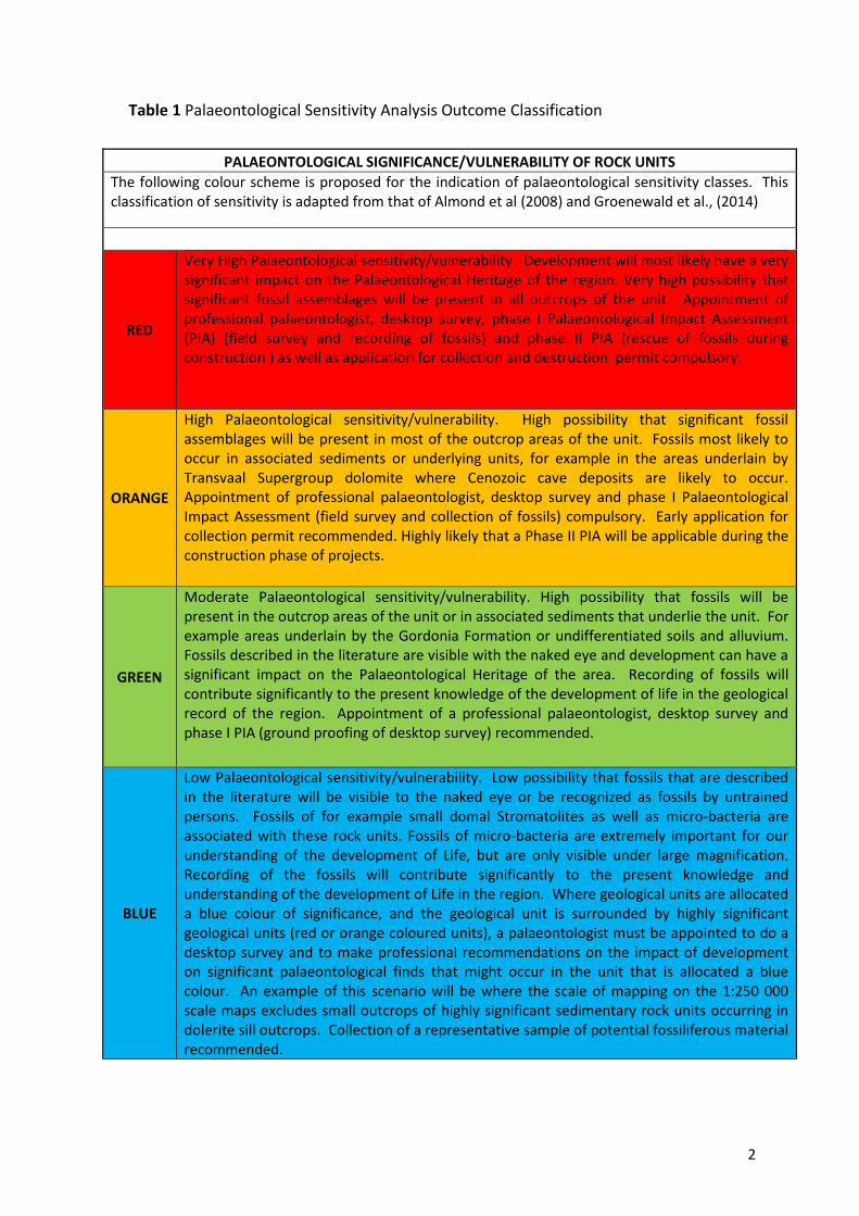
Table 1 Palaeontological Sensitivity Analysis Outcome Classification
PALAEONTOLOGICAL SIGNIFICANCE/VULNERABILITY OF ROCK UNITS
The following colour scheme is proposed for the indication of palaeontological sensitivity classes. This classification of sensitivity is adapted from that of Almond et al (2008) and Groenewald et al., (2014)
RED
Very High Palaeontological sensitivity/vulnerability. Development will most likely have a very significant impact on the Palaeontological Heritage of the region. Very high possibility that significant fossil assemblages will be present in all outcrops of the unit. Appointment of professional palaeontologist, desktop survey, phase I Palaeontological Impact Assessment (PIA) (field survey and recording of fossils) and phase II PIA (rescue of fossils during construction ) as well as application for collection and destruction permit compulsory.
ORANGE
High Palaeontological sensitivity/vulnerability. High possibility that significant fossil assemblages will be present in most of the outcrop areas of the unit. Fossils most likely to occur in associated sediments or underlying units, for example in the areas underlain by Transvaal Supergroup dolomite where Cenozoic cave deposits are likely to occur. Appointment of professional palaeontologist, desktop survey and phase I Palaeontological Impact Assessment (field survey and collection of fossils) compulsory. Early application for collection permit recommended. Highly likely that a Phase II PIA will be applicable during the construction phase of projects.
GREEN
Moderate Palaeontological sensitivity/vulnerability. High possibility that fossils will be present in the outcrop areas of the unit or in associated sediments that underlie the unit. For example areas underlain by the Gordonia Formation or undifferentiated soils and alluvium. Fossils described in the literature are visible with the naked eye and development can have a significant impact on the Palaeontological Heritage of the area. Recording of fossils will contribute significantly to the present knowledge of the development of life in the geological record of the region. Appointment of a professional palaeontologist, desktop survey and phase I PIA (ground proofing of desktop survey) recommended.
BLUE
Low Palaeontological sensitivity/vulnerability. Low possibility that fossils that are described in the literature will be visible to the naked eye or be recognized as fossils by untrained persons. Fossils of for example small domal Stromatolites as well as micro-bacteria are associated with these rock units. Fossils of micro-bacteria are extremely important for our understanding of the development of Life, but are only visible under large magnification. Recording of the fossils will contribute significantly to the present knowledge and understanding of the development of Life in the region. Where geological units are allocated a blue colour of significance, and the geological unit is surrounded by highly significant geological units (red or orange coloured units), a palaeontologist must be appointed to do a desktop survey and to make professional recommendations on the impact of development on significant palaeontological finds that might occur in the unit that is allocated a blue colour. An example of this scenario will be where the scale of mapping on the 1:250 000 scale maps excludes small outcrops of highly significant sedimentary rock units occurring in dolerite sill outcrops. Collection of a representative sample of potential fossiliferous material recommended.
3
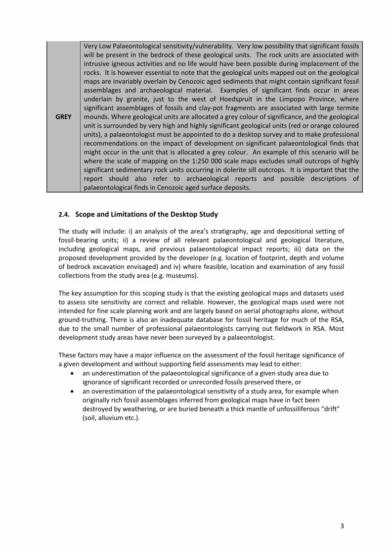
GREY
Very Low Palaeontological sensitivity/vulnerability. Very low possibility that significant fossils will be present in the bedrock of these geological units. The rock units are associated with intrusive igneous activities and no life would have been possible during implacement of the rocks. It is however essential to note that the geological units mapped out on the geological maps are invariably overlain by Cenozoic aged sediments that might contain significant fossil assemblages and archaeological material. Examples of significant finds occur in areas underlain by granite, just to the west of Hoedspruit in the Limpopo Province, where significant assemblages of fossils and clay-pot fragments are associated with large termite mounds. Where geological units are allocated a grey colour of significance, and the geological unit is surrounded by very high and highly significant geological units (red or orange coloured units), a palaeontologist must be appointed to do a desktop survey and to make professional recommendations on the impact of development on significant palaeontological finds that might occur in the unit that is allocated a grey colour. An example of this scenario will be where the scale of mapping on the 1:250 000 scale maps excludes small outcrops of highly significant sedimentary rock units occurring in dolerite sill outcrops. It is important that the report should also refer to archaeological reports and possible descriptions of palaeontological finds in Cenozoic aged surface deposits.
2.4. Scope and Limitations of the Desktop Study
The study will include: i) an analysis of the area’s stratigraphy, age and depositional setting of fossil-bearing units; ii) a review of all relevant palaeontological and geological literature, including geological maps, and previous palaeontological impact reports; iii) data on the proposed development provided by the developer (e.g. location of footprint, depth and volume of bedrock excavation envisaged) and iv) where feasible, location and examination of any fossil collections from the study area (e.g. museums). The key assumption for this scoping study is that the existing geological maps and datasets used to assess site sensitivity are correct and reliable. However, the geological maps used were not intended for fine scale planning work and are largely based on aerial photographs alone, without ground-truthing. There is also an inadequate database for fossil heritage for much of the RSA, due to the small number of professional palaeontologists carrying out fieldwork in RSA. Most development study areas have never been surveyed by a palaeontologist. These factors may have a major influence on the assessment of the fossil heritage significance of a given development and without supporting field assessments may lead to either:
an underestimation of the palaeontological significance of a given study area due to ignorance of significant recorded or unrecorded fossils preserved there, or
an overestimation of the palaeontological sensitivity of a study area, for example when originally rich fossil assemblages inferred from geological maps have in fact been destroyed by weathering, or are buried beneath a thick mantle of unfossiliferous “drift” (soil, alluvium etc.).
4
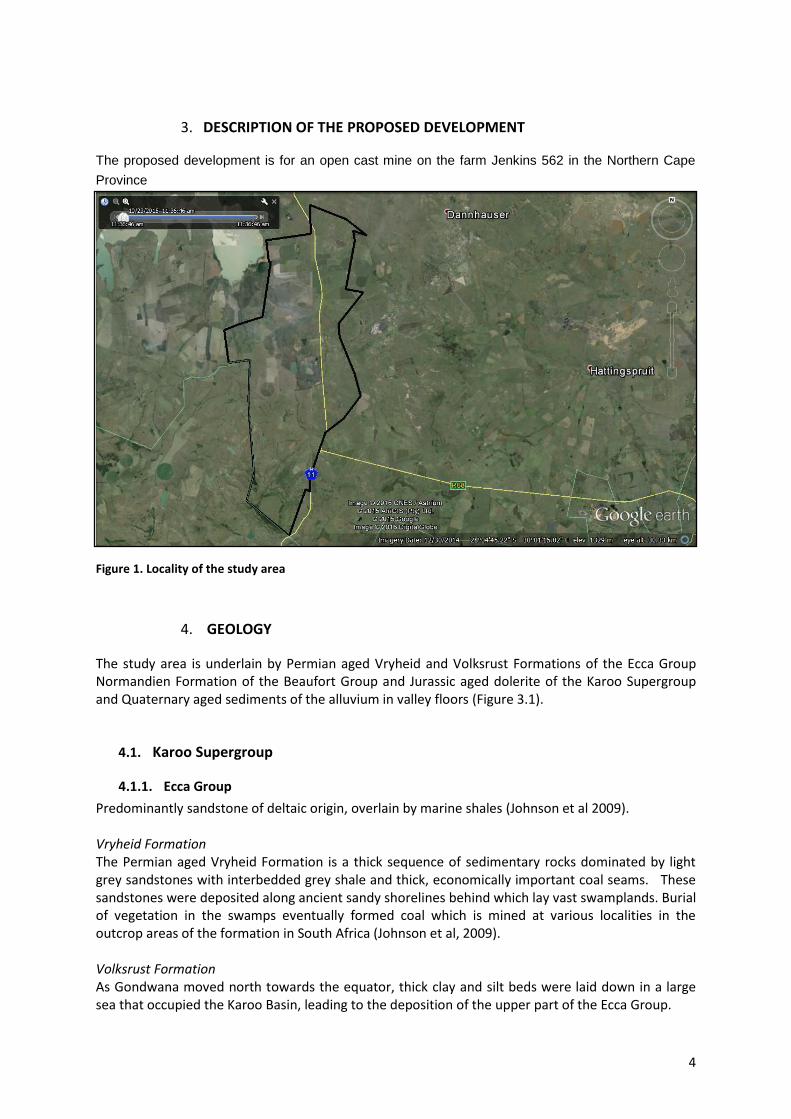
3. DESCRIPTION OF THE PROPOSED DEVELOPMENT
The proposed development is for an open cast mine on the farm Jenkins 562 in the Northern Cape
Province
4. GEOLOGY
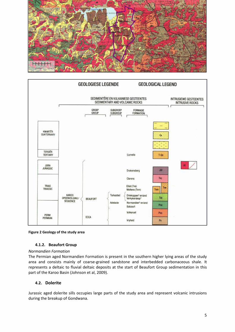
The study area is underlain by Permian aged Vryheid and Volksrust Formations of the Ecca Group Normandien Formation of the Beaufort Group and Jurassic aged dolerite of the Karoo Supergroup and Quaternary aged sediments of the alluvium in valley floors (Figure 3.1).
4.1. Karoo Supergroup
4.1.1. Ecca Group
Predominantly sandstone of deltaic origin, overlain by marine shales (Johnson et al 2009). Vryheid Formation The Permian aged Vryheid Formation is a thick sequence of sedimentary rocks dominated by light grey sandstones with interbedded grey shale and thick, economically important coal seams. These sandstones were deposited along ancient sandy shorelines behind which lay vast swamplands. Burial of vegetation in the swamps eventually formed coal which is mined at various localities in the outcrop areas of the formation in South Africa (Johnson et al, 2009). Volksrust Formation As Gondwana moved north towards the equator, thick clay and silt beds were laid down in a large sea that occupied the Karoo Basin, leading to the deposition of the upper part of the Ecca Group.
Figure 1. Locality of the study area
5
4.1.2. Beaufort Group
Normandien Formation The Permian aged Normandien Formation is present in the southern higher lying areas of the study area and consists mainly of coarse-grained sandstone and interbedded carbonaceous shale. It represents a deltaic to fluvial deltaic deposits at the start of Beaufort Group sedimentation in this part of the Karoo Basin (Johnson et al, 2009).
4.2. Dolerite
Jurassic aged dolerite sills occupies large parts of the study area and represent volcanic intrusions during the breakup of Gondwana.
Figure 2 Geology of the study area
6
4.3. Alluvium
The Tertiary aged surface sand and clay underlies the lower lying areas of the study area.
5. PALAEONTOLOGY OF THE AREA
5.1. Karoo Supergroup
5.1.1. Ecca Group
The Ecca Group is well-known for the wealth of fossils present in this sequence (MacRae, 1999). Vryheid Formation
The Vryheid Formation is well-known for the occurrence of coal beds that resulted from the
accumulation of plant material over long periods of time. Plant fossils described by Bamford (2011)
from the Vryheid Formation are; Azaniodendron fertile, Cyclodendron leslii, Sphenophyllum
hammanskraalensis, Annularia sp., Raniganjia sp., Asterotheca spp., Liknopetalon enigmata,
Glossopteris > 20 species, Hirsutum 4 spp., Scutum 4 spp., Ottokaria 3 spp., Estcourtia sp., Arberia 4
spp., Lidgetonnia sp., Noeggerathiopsis sp. and Podocarpidites sp.
According to Bamford (2011) “Little data have been published on these potentially fossiliferous
deposits. Around the coal mines there is most likely to be good material and yet in other areas the
exposures may be too poor to be of interest. When they do occur fossil plants are usually abundant
and it would not be feasible to preserve and maintain all the sites, however, in the interests of
heritage and science such sites should be well recorded, sampled and the fossils kept in a suitable
institution.
Although no vertebrate fossils have been recorded from the Vryheid Formation, invertebrate trace
fossils have been described in some detail by Mason and Christie (1985). It should be noted,
however, that the aquatic reptile, Mesosaurus, which is the earliest known reptile from the Karoo
Basin, as well as fish (Palaeoniscus capensis), have been recorded in equivalent-aged strata in the
Whitehill Formation in the southern part of the basin (MacRae, 1999; Modesto, 2006). Indications
are that the Whitehill Formation in the main basin might be correlated with the mid-Vryheid
Formation. If this assumption proves correct, there is a possibility that Mesosaurus could be found
in the Vryheid Formation.
The late Carboniferous to early Jurassic Karoo Supergroup of South Africa includes economically
important coal deposits within the Vryheid Formation of Natal. The Karoo sediments are almost
entirely lacking in body fossils but ichnofossils (trace fossils) are locally abundant. Modern
sedimentological and ichnofaunal studies suggest that the north-eastern part of the Karoo basin was
marine. In KwaZulu-Natal a shallow basin margin accommodated a prograding fluviodeltaic complex
forming a broad sandy platform on which coal-bearing sediments were deposited. Ichnofossils
include U-burrows (formerly Corophioides) which are assigned to ichnogenus Diplocraterion (Mason
and Christie, 1985).
Volksrust Formation While fossils are generally absent from the Volksrust Formation, trace fossils have been recorded from the upper layers Linstrom (1987).
7
Volksrust Formation Fossils are predominantly trace fossils that are recorded from the bedding planes of the shale beds in the formation. The fossils are difficult to find in areas of deep weathering and seldom recorded. The recording of fossils will however contribute significantly to our understanding of the palaeoenvironments in this part of the Karoo Basin.
5.1.2. Beaufort Group
Adelaide Subgroup/Normandien Formation The Permian to Triassic Adelaide Subgroup or also referred to as the Normandien Formation in the study area overlies the Volksrust Formation of the Ecca Group and the transition from deep water deposits of the Volksrust Formation to pro-delataic and deltaic deposits of the Beaufort Group. This rock unit presents fieldworkers with problems in mapping these units (Groenewald, 1984; Muntingh, 1989; Johnson and Verster, 1994; Johnson et al, 2009). The Adelaide Subgroup and Normandien Formation comprise the Cistecephalus Assemblage Zone, Dicynodon Assemblage Zone as well as the overlying Lystrosaurus Assemblage Zone of the Karoo Supergroup. It also contains abundant plant fossils of the Glossopteris Assemblage.
5.1.3. Dolerite
Due to the igneous nature of this rock type it will not contain fossils. It is important to note that the scale of mapping might exclude important local outcrops of Karoo sediments that “drift” in the dolerite sill areas and these deposits can contain significant fossil remains.
5.2. Alluvium
Wide range of fossils can be present in these surface deposits, including mammalian bones and teeth, tortoise remains and ostrich egg shells. The construction of access roads to drilling sites might uncover some alluvium beds and the recording of fossils will be significant.
6. PALAEONTOLOGICAL SENSITIVITY
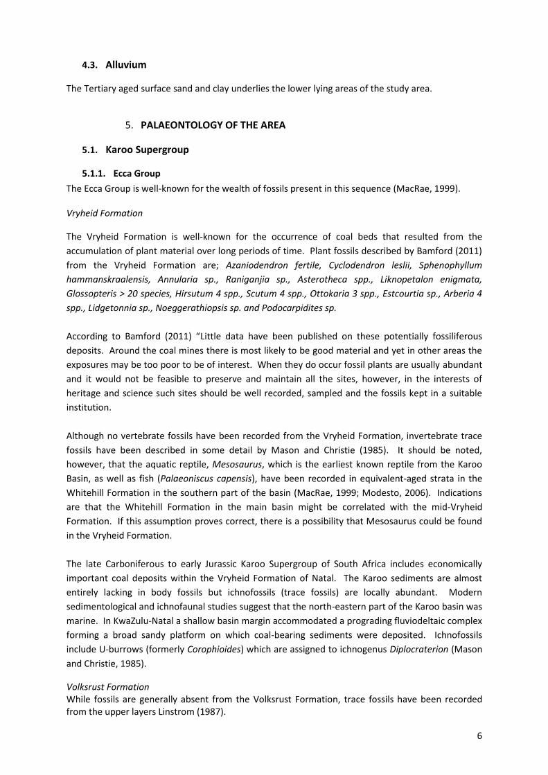
The likely impact of the proposed development on local fossil heritage is determined on the basis of the palaeontological sensitivity of the rock units concerned and the nature and scale of the development itself, most notably the extent of fresh bedrock excavation envisaged (Figure 5.1). The different sensitivity classes used are explained in Table 1 above. The Permian aged Vryheid and Normandien Formations are allocated a Very High Palaeontological sensitivity and the recording of macro and micro-fossils during detailed analyses of ore samples must be reported to SAHRA. This requirement must be recorded in the scope of the EMP of the project and is of high academic interest as the geological analyses of core samples for oil and gas exploration by definition requires detailed recording of micro fossils. A High sensitivity rating for Palaeontological Heritage is allocated to the area of the farms underlain by shales of the Volksrust Formation whereas surface Alluvium is allocated a Moderate Palaeontological Sensitivity. Exploration activity in this area is however restricted to surface infrastructure and significant fossil finds are expected only if new roads will be excavated in areas underlain by Vryheid Formation rocks, Normandien Formation sediments and Alluvium. Micro-fossils will however most likely be present in core samples. Dolerite will not contain fossils.
8
7. CONCLUSION AND RECOMMENDATIONS
The exploration Development Area on the Dannhauser farms, south of Dannhauser, Dannhauser Local Municipality, Amajuba District Municipality of the KwaZulu-Natal Province is underlain by Permain aged rocks of the Ecca Group and Permian to Triassic aged rocks of the Beaufort Group with Jurassic aged dolerite and Quaternary aged alluvium. Highly significant fossils are associated with the Permian aged rocks of the Vryheid and Normandien Formations of the Ecca and Beaufort Groups and rocks of the Volksrust Formation contain significant trace fossils. Alluvial deposits can reveal new finds of fossils whist dolerite will not contain fossils. Due to the nature of oil and gas exploration, the in-house geologists, employed by the prospecting company, are bound to find evidence of micro fossil remains in core samples from the drilling process. These recordings will be extremely important for the purposes of reconstructing palaeo-environments and it would be appreciated if this information can be reported to the HIA team and palaeontologist, who will inform AMAFA and SAHRA of the chance finds of micro-fossils in core samples. The fossils will not be visible to the naked eye and will only be identified during microscopic and electron microscope studies that should form part of the assessment of the possible reservoir capacity of the Vryheid Formation. If the recording of micro-fossils do not form part of the terms of reference for the responsible geologists (which is highly unlikely), no further mitigation for micro-palaeontology is applicable. The recommendation is specifically aimed at a voluntary association of the geological team of the exploration company with the HIA team. Recommendations:
1. The EAP as well as the ECO for this project must be made aware of the fact that sediments of the Vryheid and Normandien Formations will contain highly significant fossil remains of both macro and micro fossils. If access roads to drilling sites or drilling sites are in areas with significant outcrops of these formations, a qualified palaeontologist must be appointed to do a Phase 1 PIA report before exploration is done. Recording of micro-fossils during inspection
Figure 3. Palaeontological Sensitivity of study area. For colour coding see Table 1 above

9
of core samples will be highly appreciated and the HIA team and palaeontologist must report all relevant information to AMAFA and SAHRA if this information is provided by the in-house geologists of the exploration team. It is explicitly noted that this provision of data must be based on an agreement between the HIA team and the exploration team and there should be no financial implications for the exploration company save a few e-mail messages.
2. The Volksrust Formation might contain significant trace fossils and the Alluvium might contain as yet, unrecorded Quaternary aged fossils. The fact that access roads to drilling sites will be the only disturbance foreseen, this impact is allocated a medium to high impact rating. The chance find of fossils must be reported to the appointed palaeontologist, AMAFA and SAHRA. The dolerite will not contain fossils.
3. It is recommended that these recommendations form part of the EMPr for this development.
10
8. REFERENCES
Almond J.E. and Pether J. 2008. Palaeontological Heritage of the Western Cape. Internal Report Heritage Western Cape.
Almond J.E., De Klerk B. and Gess R., 2009. Palaeontological Heritage of the Eastern Cape. Internal Report, SAHRA.
Bamford M. 2011. Desktop study Palaeontology Ermelo to Empangeni – Eskom powerline. Internal report Bernard Price Institute for Palaeontological Research, University of the Witwatersrand.
Groenewald G.H., Groenewald D.P. and Groenewald S.M., 2014. Palaeontological Heritage of the Free State, Gauteng, Limpopo, Mpumalanga and North West Provinces. Internal Palaeotechnical Reports, SAHRA.
Johnson MR , Anhaeusser CR and Thomas RJ (Eds). 2009. The Geology of South Africa. GSSA, Council for Geoscience, Pretoria. Linstrom W. 1987 Die Geologie van die gebied Durban. Explanation Sheet 2930 (1:250 000). Geological Survey of South. Africa.
MacRae C. 1999. Life Etched in Stone. Geological Society of South Africa, Linden, South Africa.
Mason TR and Christie ADM 1986. Palaeoevironmental significance of ichnogenus Diplocraterion torell from the Permian Vryheid Formation of the Karoo Supergroup, South Africa. Palaeogeography, Palaeoclimatology, Palaeoecology 53(3-4):249-265.
McCarthy T and Rubidge BS. 2005. Earth and Life. 333pp. Struik Publishers, Cape Town.
11
9. QUALIFICATIONS AND EXPERIENCE OF THE AUTHOR
Dr Gideon Groenewald has a PhD in Geology from the University of Port Elizabeth (Nelson Mandela Metropolitan University) (1996) and the National Diploma in Nature Conservation from Technicon RSA (the University of South Africa) (1989). He specialises in research on South African Permian and Triassic sedimentology and macrofossils with an interest in biostratigraphy, and palaeoecological aspects. He has extensive experience in the locating of fossil material in the Karoo Supergroup and has more than 20 years of experience in locating, collecting and curating fossils, including exploration field trips in search of new localities in the southern, western, eastern and north-eastern parts of the country. His publication record includes multiple articles in internationally recognized journals. Dr Groenewald is accredited by the Palaeontological Society of Southern Africa (society member for 25 years).
10. DECLARATION OF INDEPENDENCE
I, Gideon Groenewald, declare that I am an independent specialist consultant and have no financial, personal or other interest in the proposed development, nor the developers or any of their subsidiaries, apart from fair remuneration for work performed in the delivery of palaeontological heritage assessment services. There are no circumstances that compromise the objectivity of my performing such work.
Dr Gideon Groenewald Geologist