Embed Size (px)
Citation preview
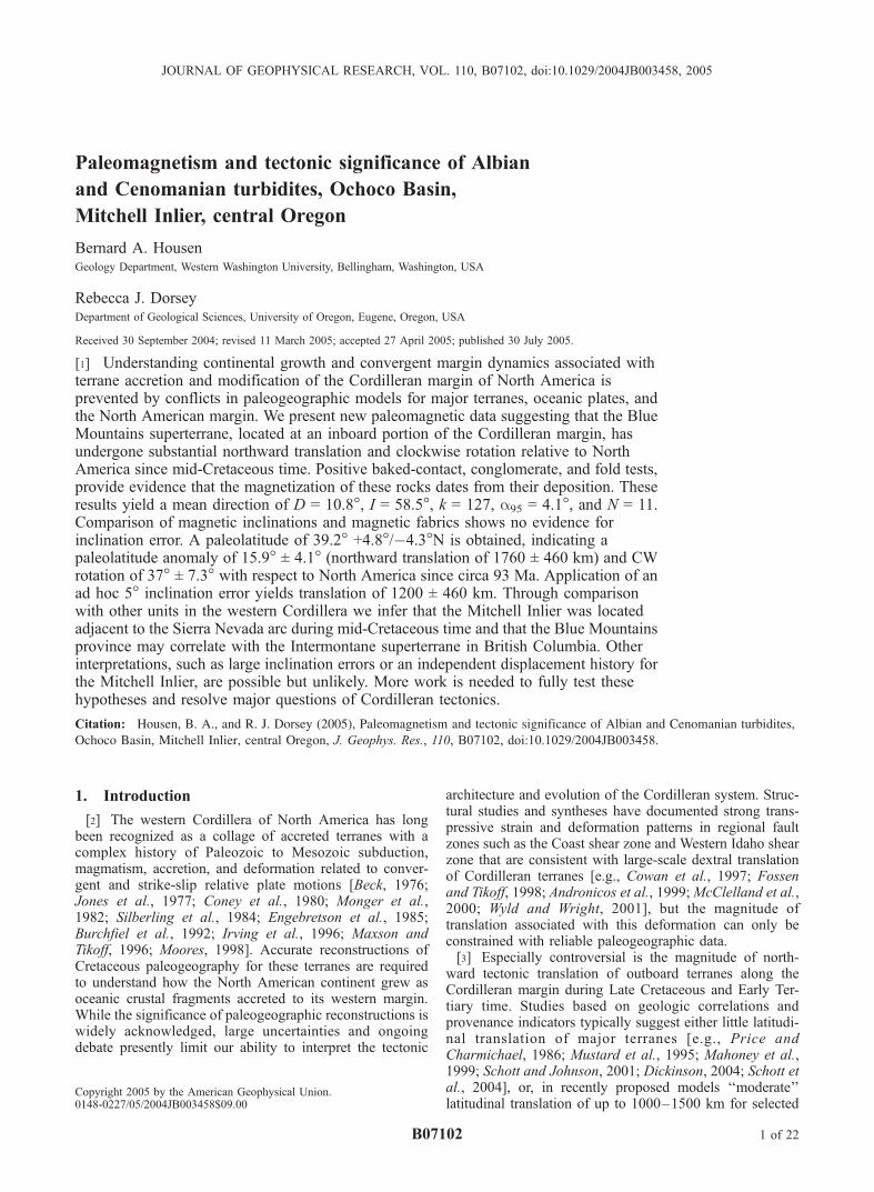
Paleomagnetism and tectonic significance of Albian
and Cenomanian turbidites, Ochoco Basin,
Mitchell Inlier, central Oregon
Bernard A. HousenGeology Department, Western Washington University, Bellingham, Washington, USA
Rebecca J. DorseyDepartment of Geological Sciences, University of Oregon, Eugene, Oregon, USA
Received 30 September 2004; revised 11 March 2005; accepted 27 April 2005; published 30 July 2005.
[1] Understanding continental growth and convergent margin dynamics associated withterrane accretion and modification of the Cordilleran margin of North America isprevented by conflicts in paleogeographic models for major terranes, oceanic plates, andthe North American margin. We present new paleomagnetic data suggesting that the BlueMountains superterrane, located at an inboard portion of the Cordilleran margin, hasundergone substantial northward translation and clockwise rotation relative to NorthAmerica since mid-Cretaceous time. Positive baked-contact, conglomerate, and fold tests,provide evidence that the magnetization of these rocks dates from their deposition. Theseresults yield a mean direction of D = 10.8�, I = 58.5�, k = 127, a95 = 4.1�, and N = 11.Comparison of magnetic inclinations and magnetic fabrics shows no evidence forinclination error. A paleolatitude of 39.2� +4.8�/�4.3�N is obtained, indicating apaleolatitude anomaly of 15.9� ± 4.1� (northward translation of 1760 ± 460 km) and CWrotation of 37� ± 7.3� with respect to North America since circa 93 Ma. Application of anad hoc 5� inclination error yields translation of 1200 ± 460 km. Through comparisonwith other units in the western Cordillera we infer that the Mitchell Inlier was locatedadjacent to the Sierra Nevada arc during mid-Cretaceous time and that the Blue Mountainsprovince may correlate with the Intermontane superterrane in British Columbia. Otherinterpretations, such as large inclination errors or an independent displacement history forthe Mitchell Inlier, are possible but unlikely. More work is needed to fully test thesehypotheses and resolve major questions of Cordilleran tectonics.
Citation: Housen, B. A., and R. J. Dorsey (2005), Paleomagnetism and tectonic significance of Albian and Cenomanian turbidites,
Ochoco Basin, Mitchell Inlier, central Oregon, J. Geophys. Res., 110, B07102, doi:10.1029/2004JB003458.
1. Introduction
[2] The western Cordillera of North America has longbeen recognized as a collage of accreted terranes with acomplex history of Paleozoic to Mesozoic subduction,magmatism, accretion, and deformation related to conver-gent and strike-slip relative plate motions [Beck, 1976;Jones et al., 1977; Coney et al., 1980; Monger et al.,1982; Silberling et al., 1984; Engebretson et al., 1985;Burchfiel et al., 1992; Irving et al., 1996; Maxson andTikoff, 1996; Moores, 1998]. Accurate reconstructions ofCretaceous paleogeography for these terranes are requiredto understand how the North American continent grew asoceanic crustal fragments accreted to its western margin.While the significance of paleogeographic reconstructions iswidely acknowledged, large uncertainties and ongoingdebate presently limit our ability to interpret the tectonic
architecture and evolution of the Cordilleran system. Struc-tural studies and syntheses have documented strong trans-pressive strain and deformation patterns in regional faultzones such as the Coast shear zone and Western Idaho shearzone that are consistent with large-scale dextral translationof Cordilleran terranes [e.g., Cowan et al., 1997; Fossenand Tikoff, 1998; Andronicos et al., 1999;McClelland et al.,2000; Wyld and Wright, 2001], but the magnitude oftranslation associated with this deformation can only beconstrained with reliable paleogeographic data.[3] Especially controversial is the magnitude of north-
ward tectonic translation of outboard terranes along theCordilleran margin during Late Cretaceous and Early Ter-tiary time. Studies based on geologic correlations andprovenance indicators typically suggest either little latitudi-nal translation of major terranes [e.g., Price andCharmichael, 1986; Mustard et al., 1995; Mahoney et al.,1999; Schott and Johnson, 2001; Dickinson, 2004; Schott etal., 2004], or, in recently proposed models ‘‘moderate’’latitudinal translation of up to 1000–1500 km for selected
JOURNAL OF GEOPHYSICAL RESEARCH, VOL. 110, B07102, doi:10.1029/2004JB003458, 2005
Copyright 2005 by the American Geophysical Union.0148-0227/05/2004JB003458$09.00
B07102 1 of 22
terranes [Butler et al., 2001; Umhoefer, 2003; Umhoeferand Blakey, 2005; Wyld et al., 2005]. In contrast paleomag-netic studies yielding anomalously shallow magnetic incli-nations are indicative of large (approximately 2000–3500 km) northward terrane translation [e.g., Beck, 1976;Beck et al., 1981; Irving et al., 1995; Johnston et al., 1996;Wynne et al., 1995; Irving et al., 1996; Wynne et al.,1998; Enkin et al., 2001, 2003; Housen et al., 2003; Bogueand Gromme, 2004; Kim and Kodama, 2004]. Some studiesbased on geologic data such as paleoflora temperaturereconstructions [Miller et al., 2003] and interpretations ofdetrital zircon ages [Housen and Beck, 1999] are alsoconsistent with the large-translation models.[4] The Blue Mountains province of eastern Oregon
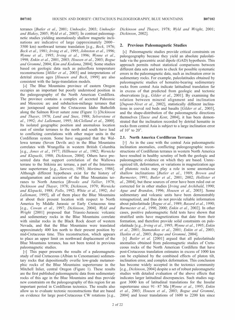
occupies an important but poorly understood position inthe paleogeography of the North American Cordillera.The province contains a complex of accreted Paleozoicand Mesozoic arc and subduction-melange terranes thatare juxtaposed against the Cretaceous Idaho Batholithalong the Salmon River suture zone (Figure 1) [Dickinsonand Thayer, 1978; Lund and Snee, 1988; Selverstone etal., 1992; Ave Lallemant, 1995; McClelland et al., 2000].Its isolated geographic position and anomalous locationeast of similar terranes to the north and south have leadto conflicting correlations with other major units in theCordilleran system. Some have suggested that the Wal-lowa terrane (Seven Devils arc) in the Blue Mountainscorrelates with Wrangellia in western British Columbia[e.g., Jones et al., 1977; Hillhouse et al., 1982; Wernickeand Klepacki, 1988; Dickinson, 2004]. Others have pre-sented data that support correlation of the Wallowaterrane to the Stikinia arc terrane, a part of the Intermon-tane superterrane [e.g., Sarewitz, 1983; Mortimer, 1986].Although different hypotheses exist for the history ofamalgamation and accretion of the Blue Mountains ter-ranes to North America [Brooks and Vallier, 1978;Dickinson and Thayer, 1978; Dickinson, 1979; Wernickeand Klepacki, 1988; Follo, 1992; White et al., 1992; AveLallemant, 1995], all of them place the Blue Mountainsat about their present location with respect to NorthAmerica by Middle Jurassic or Early Cretaceous time[e.g., Cowan et al., 1997; Dickinson, 2004]. Wyld andWright [2001] proposed that Triassic-Jurassic volcanicand sedimentary rocks in the Blue Mountains correlatewith similar rocks in the Black Rock desert of westernNevada, and that the Blue Mountains were translatedapproximately 400 km north to their present position bymid-Cretaceous time. This reconstruction, which appearsto place an upper limit on northward displacement of theBlue Mountains terranes, has not been tested in previouspaleomagnetic studies.[5] This paper presents the results of a paleomagnetic
study of mid Cretaceous (Albian to Cenomanian) sedimen-tary rocks that depositionally overlie low-grade metamor-phic rocks of the Blue Mountains superterrane in theMitchell Inlier, central Oregon (Figure 1). These resultsare the first published paleomagnetic data from sedimentaryrocks of this age in the Blue Mountains and thus providenew constraints on the paleogeography of this region for animportant period in Cordilleran tectonics. The results alsoallow us to evaluate tectonic reconstructions that are basedon evidence for large post-Cretaceous CW rotations [e.g.,
Dickinson and Thayer, 1978; Wyld and Wright, 2001;Dickinson, 2002].
2. Previous Paleomagnetic Studies
[6] Paleomagnetic studies provide critical constraints onpaleogeography because they yield an absolute paleolati-tude via the geocentric axial dipole (GAD) hypothesis. Thisapproach permits robust statistical comparisons betweendifferent data sets and tests to check for possible systematicerrors in the paleomagnetic data, such as inclination error insedimentary rocks. For example, paleolatitudes obtained bypaleomagnetic studies of hematite-bearing sedimentaryrocks from central Asia indicate latitudinal translation farin excess of that predicted from geologic and tectonicobservations [e.g., Gilder et al., 2001]. By examining therelation between mineral alignment and inclination[Dupont-Nivet et al., 2002], statistically different inclina-tions in coeval red beds and basalts [Gilder et al., 2003],and the shape-distribution of the paleomagnetic directionsthemselves [Tauxe and Kent, 2004], it has been demon-strated that the inclination recorded by detrital hematite inrocks from central Asia is subject to a large inclination errorof 10� to 20�.
2.1. North America Cordilleran Terranes
[7] As in the case with the central Asia paleomagneticinclination anomalies, conflicting paleogeographic recon-structions of Cordilleran terranes in western North Americahave resulted in healthy scrutiny of both the geologic andpaleomagnetic evidence on which they are based. Unrec-ognized tilt, deformation, or variations in magnetization ageof plutonic rocks may play a role in some anomalousshallow inclinations [Butler et al., 1989; Brown andBurmester, 1991; Butler et al., 2001; 2002; Hollister etal., 2004], but these sources of error have been ruled out orcorrected for in other studies [Irving and Archibald, 1990;Ague and Brandon, 1996; Housen et al., 2003]. Somesedimentary and volcanic units have been demonstrablyremagnetized, and thus do not provide reliable informationabout paleolatitude [Bogue et al., 1989; Bazard et al., 1990;Burmester et al., 1990, 2000; Enkin et al., 2002]. In othercases, positive paleomagnetic field tests have shown thatstratified units have magnetizations that date from theirformation, and therefore provide solid constraints on pale-olatitude [e.g., Irving et al., 1995; Wynne et al., 1995; Enkinet al., 2001; Stamatakos et al., 2001; Enkin et al., 2003;Haskin et al., 2003; Bogue and Gromme, 2004].[8] Butler et al. [2001] argued that all paleolatitude
anomalies obtained from paleomagnetic studies of Creta-ceous rocks of the North American Cordillera that havepost-Cretaceous translation estimates in excess of 1000 kmcan be explained by the combined effects of pluton tilt,inclination error, and complex deformation. This conclusionhas become widely accepted in the tectonics community[e.g., Dickinson, 2004] despite a set of robust paleomagneticstudies with detailed evaluation of the above effects thatindicates larger latitudinal discrepancies. Such studies sug-gest 3000 km of latitudinal translations for the Insularsuperterrane since 91–87 Ma [Wynne et al., 1995; Enkinet al., 2003; Housen et al., 2003; Bogue and Gromme,2004] and lesser translations of 1600 to 2200 km since
B07102 HOUSEN AND DORSEY: CRETACEOUS PALEOGEOGRAPHY, BLUE MOUNTAINS
2 of 22
B07102
about 80 Ma [Enkin et al., 2001; Stamatakos et al., 2001;Kim and Kodama, 2004]. The Intermontane superterranecontains paleomagnetic evidence for translations of 1100–1400 km since 105 Ma [e.g., Irving et al., 1995; Haskin etal., 2003]. Paleomagnetic results show that Cretaceousrocks of the Omineca Belt, located inboard of the Inter-montane superterrane, have experienced no significant post-Cretaceous latitudinal translation [Irving and Archibald,1990]. In light of unresolved contradictions between the
above studies and the conclusions of Butler et al. [2001],there presently is no consensus on the paleogeography,paleolatitude, and history terrane translations in the NorthAmerican Cordillera.
2.2. Blue Mountains Paleomagnetism
[9] Previous paleomagnetic research in the Blue Moun-tains has focused on two tectonic questions. The firstconcerns the paleogeography of Triassic volcanic and vol-
Figure 1. Regional tectonic setting of the Ochoco basin. (a) Simplified pre-Tertiary geology of thewestern United States, modified from Wyld and Wright [2001]. Dashed line through Oregon andWashington defines Columbia embayment and follows approximate trend of fabrics in accreted terranesof the Blue Mountains and Klamath Mountains. Line for SRSZ coincides with 87Sr/86Sr isotope boundaryof Armstrong et al. [1977; and Figure 1b]. (b) Distribution of accreted terranes in central and easternOregon, which together make up the Blue Mountains superterrane. Black areas indicate Cretaceous strataof the Ochoco basin; circled dots show location of subsurface wells [Thompson et al., 1984]. Modifiedfrom Dickinson [1979]. Approximate extent of Ochoco basin is indicated with dashed line in Figures 1aand 1b. AR, Antone Ranch; BM, Blue Mountains; BR, Bernard Ranch; CLMSZ, Cuyamaca-LagunaMountains shear zone; GR, Goose Rock; HB, Hornbrook Basin; IB, Idaho Batholith; J, Jurassic; KM,Klamath Mountains; MSLF, Mojave-Snow Lake Fault; MZ, Mesozoic; OB, Ochoco Basin; Pc,Precambrian; Pz, Paleozoic; SCSZ, Sierra Crest Shear Zone System; SDM, Seven Devils Mountains;SFTB, Sevier Fold and Thrust Belt; SRSZ, Salmon River Suture; WM, Wallowa Mountains; WNS,Western Nevada Shear Zone.
B07102 HOUSEN AND DORSEY: CRETACEOUS PALEOGEOGRAPHY, BLUE MOUNTAINS
3 of 22
B07102
caniclastic rocks of the Wallowa and Olds Ferry terranes(Seven Devils and Huntington arcs), and their possiblecorrelation to Wrangellia [Hillhouse et al., 1982; see alsoDickinson, 2004]. Paleomagnetic data from Triassic rocks[Hillhouse et al., 1982] indicate that during Triassic time theWallowaandOldsFerry terraneswereatpaleolatitudes similarto those of Wrangellia (Insular superterrane) [Hillhouse andGromme, 1984;Yole and Irving, 1980], and that large verticalaxis rotations of these rocks have occurred.[10] The second question concerns the history of vertical
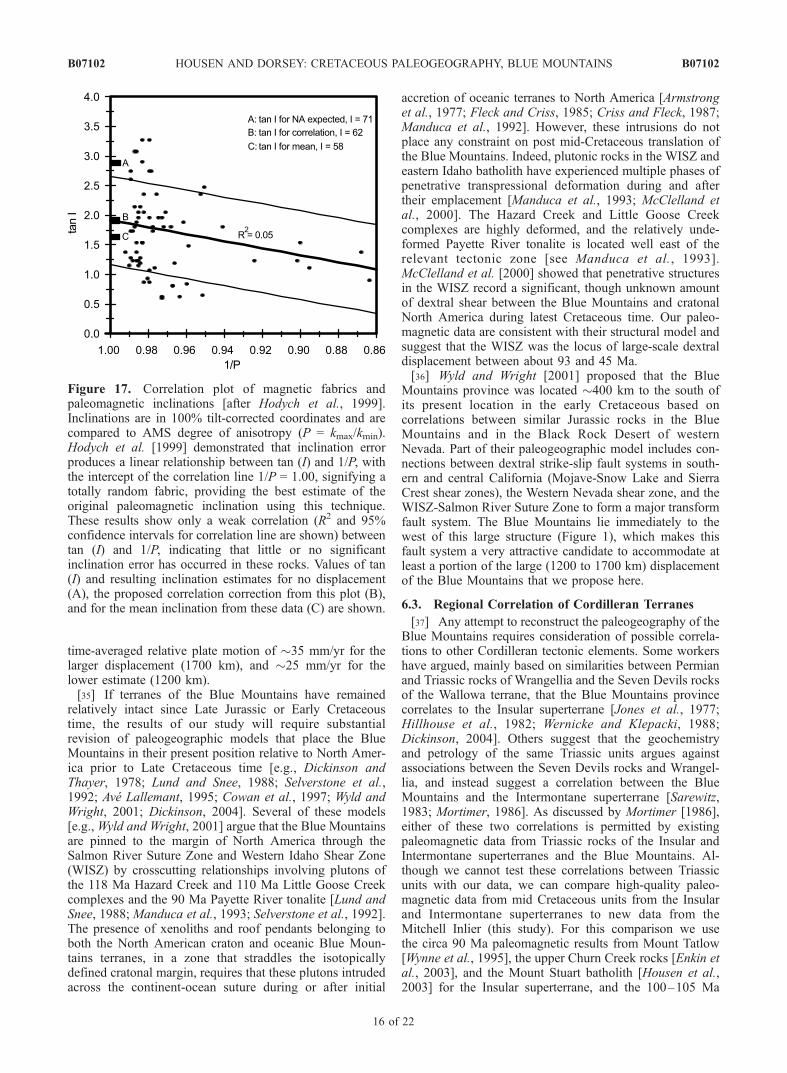
axis oroclinal rotation of the Blue Mountains as originallyproposed for the Columbia Embayment [Hamilton andMyers, 1966]. Wilson and Cox [1980] concluded that theBlue Mountains have undergone 60� of CW rotation and nosignificant latitudinal displacement of the Blue Mountainsrelative to North America since early Cretaceous time. Therotation estimate provided by Wilson and Cox [1980] isconsistent with the oroclinal rotation of the Blue Mountainsto form the Columbia Embayment and has been widelyutilized in a number of tectonic reconstructions [Dickinsonand Thayer, 1978; Hillhouse et al., 1982; Wernicke andKlepacki, 1988; Wyld and Wright, 2001; Dickinson, 2002],even though the rotation estimate has significant uncertaintydue to lack of paleohorizontal control and the small numberof sites. A more robust indicator of rotation, in youngerrocks, is provided by paleomagnetic data from more than40 sites in the Eocene Clarno volcanics compiled byGromme et al. [1986]. They found that the portion of theBlue Mountains overlain by the Clarno Volcanics has apaleolatitude consistent with that expected for their present
location in North America, and that 16� ± 10� of CWrotation has occurred since Eocene time. This rotation wasattributed to extensional tectonics in the northern Basin andRange province.
3. Geology of the Mitchell Inlier
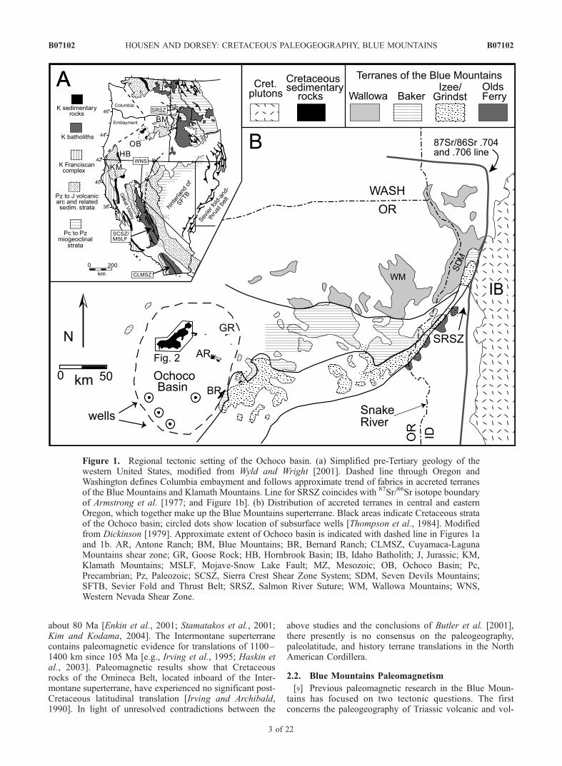
[11] The Mitchell Inlier is a surface exposure of Creta-ceous sedimentary rocks of the larger Ochoco Basin in eastcentral Oregon (Figures 1 and 2). These rocks have beendivided into two conformable and interbedded lithologies,the Hudspeth Formation (primarily fine-grained turbiditicmudstone and siltstone) and the Gable Creek Formation(primarily fine- to coarse-grained sandstone with someintraformational conglomerate and sedimentary breccias)[Wilkinson and Oles, 1968; Oles and Enlows, 1971]. Bothformations contain submarine slope and fan deposits. Theage of the sediments is known from ammonite biostratigra-phy, which shows that the Main Mudstone member of theHudspeth Formation is Albian and the overlying GableCreek Formation, though lacking good fossil control, isCenomanian based on its conformable interfingering con-tact with the Hudspeth Formation [McKnight, 1964;Wilkinson and Oles, 1968; Kleinhans et al., 1984; P. Rodda,personal communication, 2000]. Some workers have sug-gested that the rocks of the Ochoco Basin are correlative tosimilarly aged sedimentary rocks of the Hornbrook Forma-tion in the Klamath Mountains, southwestern Oregon[Kleinhans et al., 1984; Nilsen, 1986]. Andesitic volcanicand volcaniclastic rocks of the Eocene Clarno Formation
Figure 2. Simplified geologic map of the Mitchell Inlier showing distribution of the Hudspeth andGable Creek formations, NE trending Mitchell anticline, and other geologic features (modified fromKleinhans et al. [1984] with original map from Oles and Enlows [1971]). Paleomagnetic sampling sitesare shown as solid dots.
B07102 HOUSEN AND DORSEY: CRETACEOUS PALEOGEOGRAPHY, BLUE MOUNTAINS
4 of 22
B07102
unconformably overlie Cretaceous sedimentary rocks in theMitchell area [Wilkinson and Oles, 1968; Oles and Enlows,1971; Gromme et al., 1986].[12] The structural geology of the Mitchell Inlier is
dominated by a set of NE trending folds, the largest ofwhich is the Mitchell anticline (Figure 2) [Oles and Enlows,1971]. Most folds in this area formed during Tertiary time,based on involvement of the overlying Eocene rocks inthese structures. However, detailed structural and sedimen-tological analysis has documented an episode of Albiansyndepositional folding affecting the oldest part of the Cre-taceous section at Toney Butte, north of the paleomagneticsampling area [Lenegan, 2001, R. J. Dorsey and R. L.Lenegan, Structural controls on middle Cretaceous sedimen-tation in the Toney Butte area, Ochoco basin, central Oregon,in Convergent Margin Terranes and Associated Regions,edited by M. Cloos, submitted to Special Paper of theGeological Society of America, 2005]. The Mitchell Fault isa strike-slip fault that cuts Eocene volcanic rocks and iskinematically associated with Tertiary folding [Wilkinsonand Oles, 1968; Oles and Enlows, 1971] (Figure 2).
4. Sampling and Methods
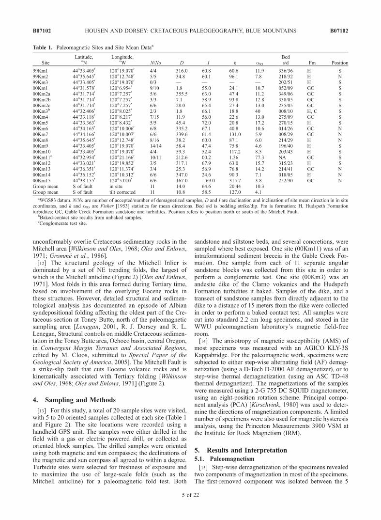
[13] For this study, a total of 20 sample sites were visited,with 5 to 20 oriented samples collected at each site (Table 1and Figure 2). The site locations were recorded using ahandheld GPS unit. The samples were either drilled in thefield with a gas or electric powered drill, or collected asoriented block samples. The drilled samples were orientedusing both magnetic and sun compasses; the declinations ofthe magnetic and sun compass all agreed to within a degree.Turbidite sites were selected for freshness of exposure andto maximize the use of large-scale folds (such as theMitchell anticline) for a paleomagnetic fold test. Both
sandstone and siltstone beds, and several concretions, weresampled where best exposed. One site (00Km11) was of anintraformational sediment breccia in the Gable Creek For-mation. One sample from each of 11 separate angularsandstone blocks was collected from this site in order toperform a conglomerate test. One site (00Km3) was anandesite dike of the Clarno volcanics and the HudspethFormation turbidites it baked. Samples of the dike, and atransect of sandstone samples from directly adjacent to thedike to a distance of 15 meters from the dike were collectedin order to perform a baked contact test. All samples werecut into standard 2.2 cm long specimens, and stored in theWWU paleomagnetism laboratory’s magnetic field-freeroom.[14] The anisotropy of magnetic susceptibility (AMS) of
most specimens was measured with an AGICO KLY-3SKappabridge. For the paleomagnetic work, specimens weresubjected to either step-wise alternating field (AF) demag-netization (using a D-Tech D-2000 AF demagnetizer), or tostep-wise thermal demagnetization (using an ASC TD-48thermal demagnetizer). The magnetizations of the sampleswere measured using a 2-G 755 DC SQUID magnetometer,using an eight-position rotation scheme. Principal compo-nent analysis (PCA) [Kirschvink, 1980] was used to deter-mine the directions of magnetization components. A limitednumber of specimens were also used for magnetic hysteresisanalysis, using the Princeton Measurements 3900 VSM atthe Institute for Rock Magnetism (IRM).
5. Results and Interpretation
5.1. Paleomagnetism
[15] Step-wise demagnetization of the specimens revealedtwo components of magnetization in most of the specimens.The first-removed component was isolated between the 5
Table 1. Paleomagnetic Sites and Site Mean Dataa
SiteLatitude,
�NLongitude,
�W N/No D I k a95
Beds/d Fm Position
99Km1 44�33.4050 120�19.0700 4/4 316.0 60.8 60.6 11.9 336/36 H S99Km2 44�35.6450 120�12.7480 5/5 34.8 60.1 96.1 7.8 218/32 H N99Km3 44�33.4050 120�19.0700 0/3 — — — — 202/51 H S00Km1 44�31.5780 120�6.9540 9/10 1.8 55.0 24.1 10.7 052/09 GC S00Km2a 44�31.7140 120�7.2570 5/6 355.5 63.0 47.4 11.2 349/06 GC S00Km2b 44�31.7140 120�7.2570 3/3 7.1 58.9 93.8 12.8 338/05 GC S00Km2c 44�31.7140 120�7.2570 6/6 28.0 65.4 27.4 13.0 235/05 GC S00Km3b 44�32.4060 120�8.0250 2/3 1.8 66.1 18.8 40 008/10 H, C S00Km4 44�33.1180 120�8.2170 7/15 11.9 56.0 22.6 13.0 275/09 GC S00Km5 44�33.3630 120�8.4320 5/5 45.4 72.0 20.8 17.2 270/15 H S00Km6 44�34.1650 120�10.0060 6/8 335.2 67.1 40.8 10.6 014/26 GC N00Km7 44�34.1660 120�10.0070 6/6 339.6 61.4 131.0 5.9 008/29 GC N00Km8 44�35.6450 120�12.7480 8/16 38.2 60.0 87.1 6.0 214/29 H N00Km9 44�33.4050 120�19.0700 14/14 58.4 47.4 75.8 4.6 196/40 H S00Km10 44�33.4050 120�19.0700 4/4 59.3 52.4 117.2 8.5 203/43 H S00Km11c 44�32.9540 120�21.1660 10/11 212.6 00.2 1.36 77.3 NA GC S00Km12 44�33.0210 120�19.8520 3/5 317.1 67.9 63.0 15.7 315/23 H S00Km13 44�36.3510 120�11.3740 3/4 25.3 56.9 76.8 14.2 214/41 GC N00Km14 44�36.1520 120�10.3120 6/6 347.0 24.6 90.3 7.1 018/05 H N00Km15 44�38.1550 120�5.0100 6/6 167.0 �69.0 315.7 3.8 252/30 GC NGroup mean S of fault in situ 11 14.0 64.6 20.44 10.3Group mean S of fault tilt corrected 11 10.8 58.5 127.0 4.1
aWGS83 datum. N/No are number of accepted/number of demagnetized samples, D and I are declination and inclination of site mean direction in in situcoordinates, and k and a95 are Fisher [1953] statistics for mean directions. Bed s/d is bedding strike/dip. Fm is formation: H, Hudspeth Formationturbidites; GC, Gable Creek Formation sandstone and turbidites. Position refers to position north or south of the Mitchell Fault.
bBaked-contact site results from unbaked samples.cConglomerate test site.
B07102 HOUSEN AND DORSEY: CRETACEOUS PALEOGEOGRAPHY, BLUE MOUNTAINS
5 of 22
B07102
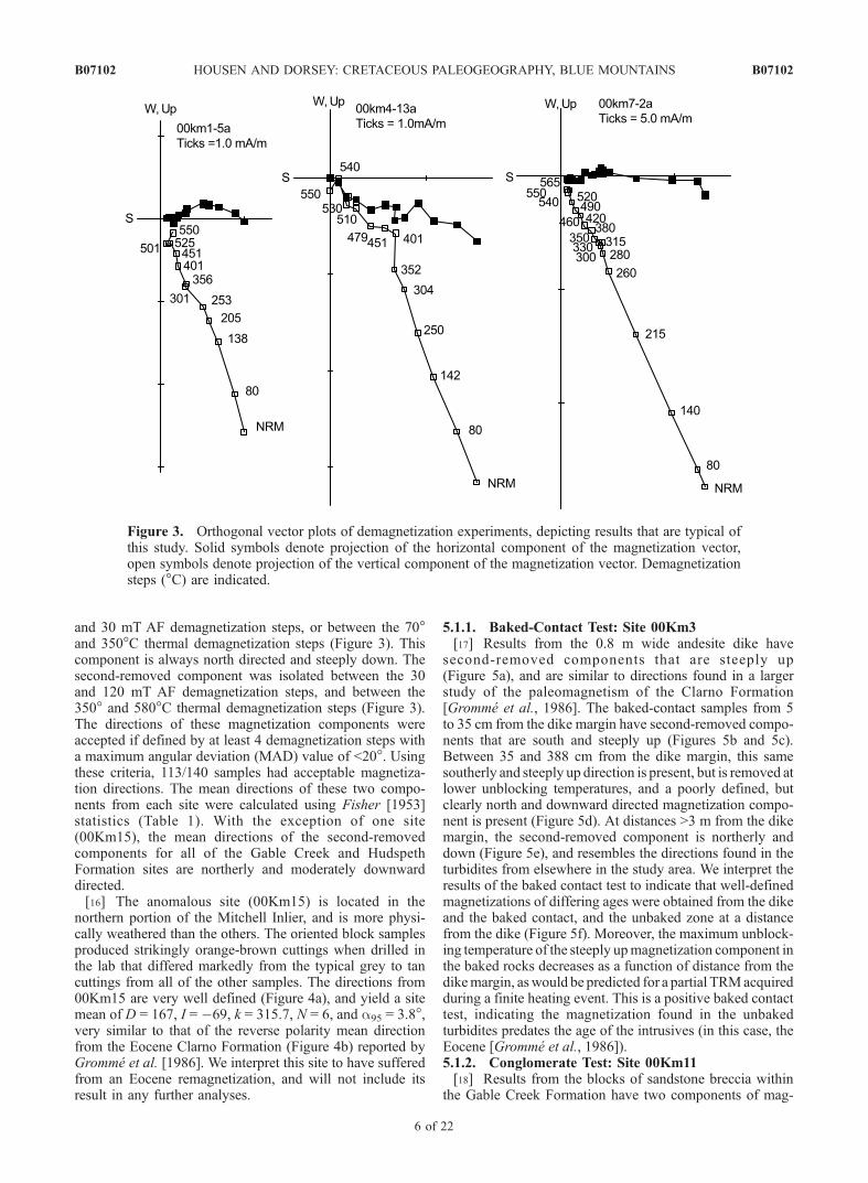
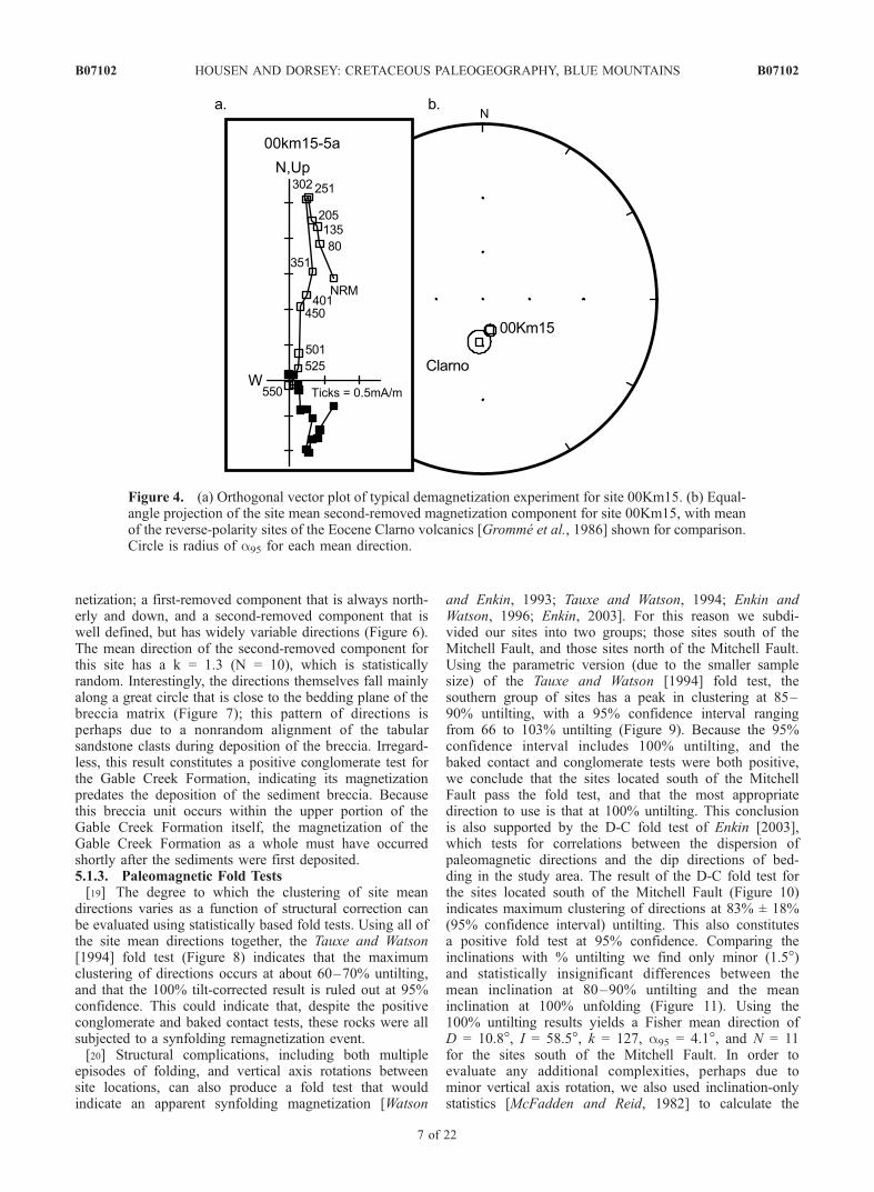
and 30 mT AF demagnetization steps, or between the 70�and 350�C thermal demagnetization steps (Figure 3). Thiscomponent is always north directed and steeply down. Thesecond-removed component was isolated between the 30and 120 mT AF demagnetization steps, and between the350� and 580�C thermal demagnetization steps (Figure 3).The directions of these magnetization components wereaccepted if defined by at least 4 demagnetization steps witha maximum angular deviation (MAD) value of <20�. Usingthese criteria, 113/140 samples had acceptable magnetiza-tion directions. The mean directions of these two compo-nents from each site were calculated using Fisher [1953]statistics (Table 1). With the exception of one site(00Km15), the mean directions of the second-removedcomponents for all of the Gable Creek and HudspethFormation sites are northerly and moderately downwarddirected.[16] The anomalous site (00Km15) is located in the
northern portion of the Mitchell Inlier, and is more physi-cally weathered than the others. The oriented block samplesproduced strikingly orange-brown cuttings when drilled inthe lab that differed markedly from the typical grey to tancuttings from all of the other samples. The directions from00Km15 are very well defined (Figure 4a), and yield a sitemean of D = 167, I = �69, k = 315.7, N = 6, and a95 = 3.8�,very similar to that of the reverse polarity mean directionfrom the Eocene Clarno Formation (Figure 4b) reported byGromme et al. [1986]. We interpret this site to have sufferedfrom an Eocene remagnetization, and will not include itsresult in any further analyses.
5.1.1. Baked-Contact Test: Site 00Km3[17] Results from the 0.8 m wide andesite dike have
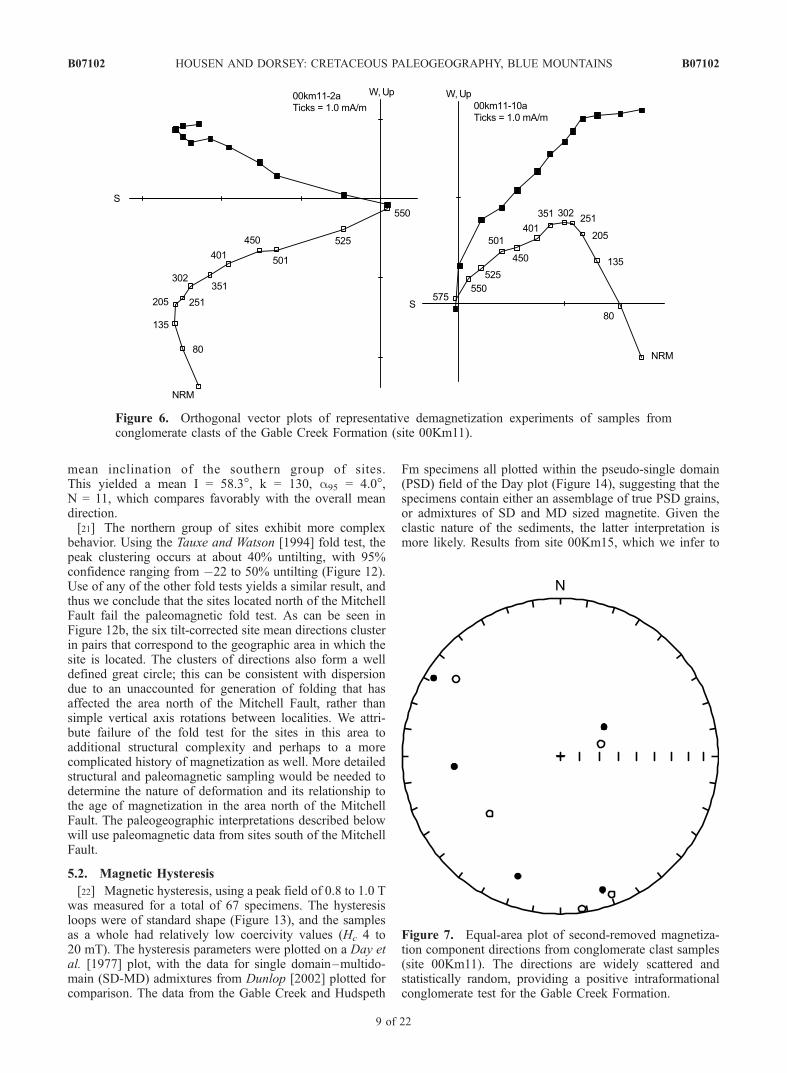
second-removed components that are steeply up(Figure 5a), and are similar to directions found in a largerstudy of the paleomagnetism of the Clarno Formation[Gromme et al., 1986]. The baked-contact samples from 5to 35 cm from the dike margin have second-removed compo-nents that are south and steeply up (Figures 5b and 5c).Between 35 and 388 cm from the dike margin, this samesoutherly and steeply up direction is present, but is removed atlower unblocking temperatures, and a poorly defined, butclearly north and downward directed magnetization compo-nent is present (Figure 5d). At distances >3 m from the dikemargin, the second-removed component is northerly anddown (Figure 5e), and resembles the directions found in theturbidites from elsewhere in the study area. We interpret theresults of the baked contact test to indicate that well-definedmagnetizations of differing ages were obtained from the dikeand the baked contact, and the unbaked zone at a distancefrom the dike (Figure 5f). Moreover, the maximum unblock-ing temperature of the steeply upmagnetization component inthe baked rocks decreases as a function of distance from thedikemargin, aswould be predicted for a partial TRMacquiredduring a finite heating event. This is a positive baked contacttest, indicating the magnetization found in the unbakedturbidites predates the age of the intrusives (in this case, theEocene [Gromme et al., 1986]).5.1.2. Conglomerate Test: Site 00Km11[18] Results from the blocks of sandstone breccia within
the Gable Creek Formation have two components of mag-
Figure 3. Orthogonal vector plots of demagnetization experiments, depicting results that are typical ofthis study. Solid symbols denote projection of the horizontal component of the magnetization vector,open symbols denote projection of the vertical component of the magnetization vector. Demagnetizationsteps (�C) are indicated.
B07102 HOUSEN AND DORSEY: CRETACEOUS PALEOGEOGRAPHY, BLUE MOUNTAINS
6 of 22
B07102
netization; a first-removed component that is always north-erly and down, and a second-removed component that iswell defined, but has widely variable directions (Figure 6).The mean direction of the second-removed component forthis site has a k = 1.3 (N = 10), which is statisticallyrandom. Interestingly, the directions themselves fall mainlyalong a great circle that is close to the bedding plane of thebreccia matrix (Figure 7); this pattern of directions isperhaps due to a nonrandom alignment of the tabularsandstone clasts during deposition of the breccia. Irregard-less, this result constitutes a positive conglomerate test forthe Gable Creek Formation, indicating its magnetizationpredates the deposition of the sediment breccia. Becausethis breccia unit occurs within the upper portion of theGable Creek Formation itself, the magnetization of theGable Creek Formation as a whole must have occurredshortly after the sediments were first deposited.5.1.3. Paleomagnetic Fold Tests[19] The degree to which the clustering of site mean
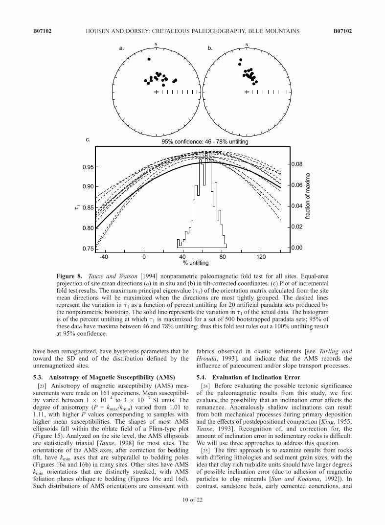
directions varies as a function of structural correction canbe evaluated using statistically based fold tests. Using all ofthe site mean directions together, the Tauxe and Watson[1994] fold test (Figure 8) indicates that the maximumclustering of directions occurs at about 60–70% untilting,and that the 100% tilt-corrected result is ruled out at 95%confidence. This could indicate that, despite the positiveconglomerate and baked contact tests, these rocks were allsubjected to a synfolding remagnetization event.[20] Structural complications, including both multiple
episodes of folding, and vertical axis rotations betweensite locations, can also produce a fold test that wouldindicate an apparent synfolding magnetization [Watson
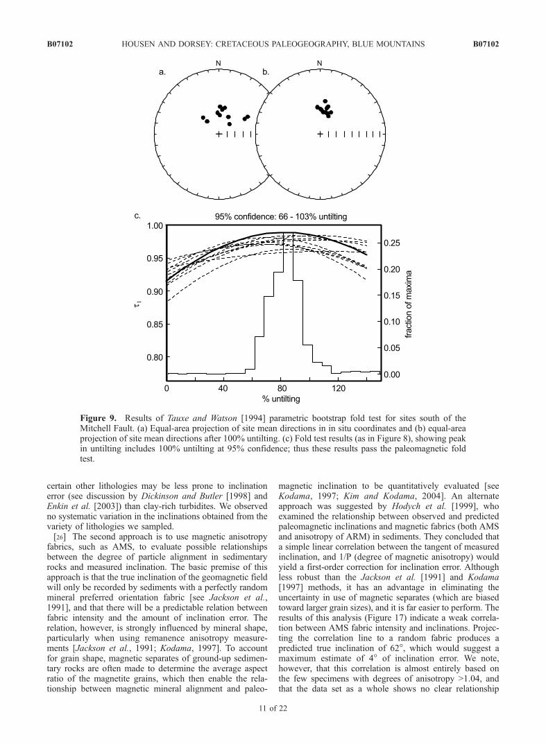
and Enkin, 1993; Tauxe and Watson, 1994; Enkin andWatson, 1996; Enkin, 2003]. For this reason we subdi-vided our sites into two groups; those sites south of theMitchell Fault, and those sites north of the Mitchell Fault.Using the parametric version (due to the smaller samplesize) of the Tauxe and Watson [1994] fold test, thesouthern group of sites has a peak in clustering at 85–90% untilting, with a 95% confidence interval rangingfrom 66 to 103% untilting (Figure 9). Because the 95%confidence interval includes 100% untilting, and thebaked contact and conglomerate tests were both positive,we conclude that the sites located south of the MitchellFault pass the fold test, and that the most appropriatedirection to use is that at 100% untilting. This conclusionis also supported by the D-C fold test of Enkin [2003],which tests for correlations between the dispersion ofpaleomagnetic directions and the dip directions of bed-ding in the study area. The result of the D-C fold test forthe sites located south of the Mitchell Fault (Figure 10)indicates maximum clustering of directions at 83% ± 18%(95% confidence interval) untilting. This also constitutesa positive fold test at 95% confidence. Comparing theinclinations with % untilting we find only minor (1.5�)and statistically insignificant differences between themean inclination at 80–90% untilting and the meaninclination at 100% unfolding (Figure 11). Using the100% untilting results yields a Fisher mean direction ofD = 10.8�, I = 58.5�, k = 127, a95 = 4.1�, and N = 11for the sites south of the Mitchell Fault. In order toevaluate any additional complexities, perhaps due tominor vertical axis rotation, we also used inclination-onlystatistics [McFadden and Reid, 1982] to calculate the
Figure 4. (a) Orthogonal vector plot of typical demagnetization experiment for site 00Km15. (b) Equal-angle projection of the site mean second-removed magnetization component for site 00Km15, with meanof the reverse-polarity sites of the Eocene Clarno volcanics [Gromme et al., 1986] shown for comparison.Circle is radius of a95 for each mean direction.
B07102 HOUSEN AND DORSEY: CRETACEOUS PALEOGEOGRAPHY, BLUE MOUNTAINS
7 of 22
B07102
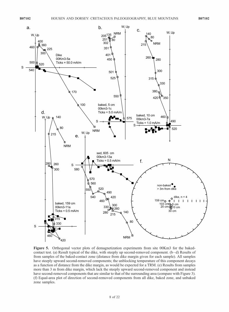
Figure 5. Orthogonal vector plots of demagnetization experiments from site 00Km3 for the baked-contact test. (a) Result typical of the dike, with steeply up second-removed component. (b–d) Results offrom samples of the baked-contact zone (distance from dike margin given for each sample). All sampleshave steeply upward second-removed components; the unblocking temperature of this component decaysas a function of distance from the dike margin, as would be expected for a TRM. (e) Results from samplesmore than 3 m from dike margin, which lack the steeply upward second-removed component and insteadhave second-removed components that are similar to that of the surrounding area (compare with Figure 3).(f) Equal-area plot of direction of second-removed components from all dike, baked zone, and unbakedzone samples.
B07102 HOUSEN AND DORSEY: CRETACEOUS PALEOGEOGRAPHY, BLUE MOUNTAINS
8 of 22
B07102
mean inclination of the southern group of sites.This yielded a mean I = 58.3�, k = 130, a95 = 4.0�,N = 11, which compares favorably with the overall meandirection.[21] The northern group of sites exhibit more complex
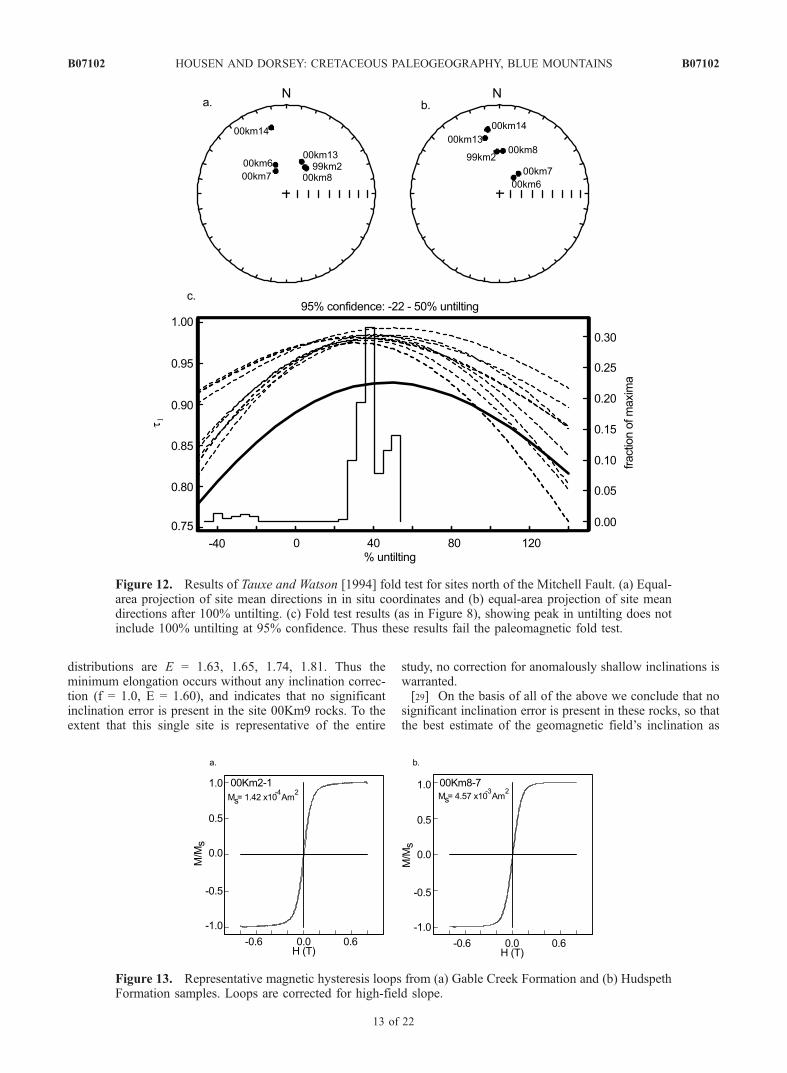
behavior. Using the Tauxe and Watson [1994] fold test, thepeak clustering occurs at about 40% untilting, with 95%confidence ranging from �22 to 50% untilting (Figure 12).Use of any of the other fold tests yields a similar result, andthus we conclude that the sites located north of the MitchellFault fail the paleomagnetic fold test. As can be seen inFigure 12b, the six tilt-corrected site mean directions clusterin pairs that correspond to the geographic area in which thesite is located. The clusters of directions also form a welldefined great circle; this can be consistent with dispersiondue to an unaccounted for generation of folding that hasaffected the area north of the Mitchell Fault, rather thansimple vertical axis rotations between localities. We attri-bute failure of the fold test for the sites in this area toadditional structural complexity and perhaps to a morecomplicated history of magnetization as well. More detailedstructural and paleomagnetic sampling would be needed todetermine the nature of deformation and its relationship tothe age of magnetization in the area north of the MitchellFault. The paleogeographic interpretations described belowwill use paleomagnetic data from sites south of the MitchellFault.
5.2. Magnetic Hysteresis
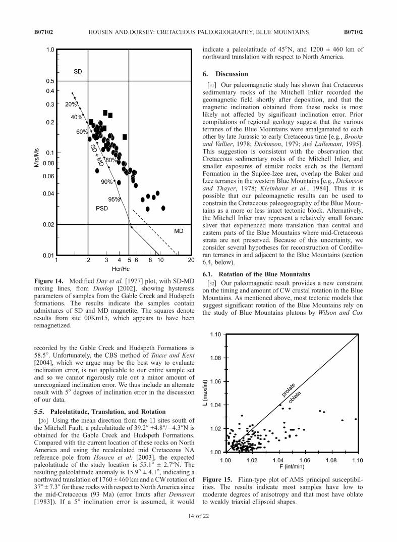
[22] Magnetic hysteresis, using a peak field of 0.8 to 1.0 Twas measured for a total of 67 specimens. The hysteresisloops were of standard shape (Figure 13), and the samplesas a whole had relatively low coercivity values (Hc 4 to20 mT). The hysteresis parameters were plotted on a Day etal. [1977] plot, with the data for single domain–multido-main (SD-MD) admixtures from Dunlop [2002] plotted forcomparison. The data from the Gable Creek and Hudspeth
Fm specimens all plotted within the pseudo-single domain(PSD) field of the Day plot (Figure 14), suggesting that thespecimens contain either an assemblage of true PSD grains,or admixtures of SD and MD sized magnetite. Given theclastic nature of the sediments, the latter interpretation ismore likely. Results from site 00Km15, which we infer to
Figure 6. Orthogonal vector plots of representative demagnetization experiments of samples fromconglomerate clasts of the Gable Creek Formation (site 00Km11).
Figure 7. Equal-area plot of second-removed magnetiza-tion component directions from conglomerate clast samples(site 00Km11). The directions are widely scattered andstatistically random, providing a positive intraformationalconglomerate test for the Gable Creek Formation.
B07102 HOUSEN AND DORSEY: CRETACEOUS PALEOGEOGRAPHY, BLUE MOUNTAINS
9 of 22
B07102
have been remagnetized, have hysteresis parameters that lietoward the SD end of the distribution defined by theunremagnetized sites.
5.3. Anisotropy of Magnetic Susceptibility (AMS)
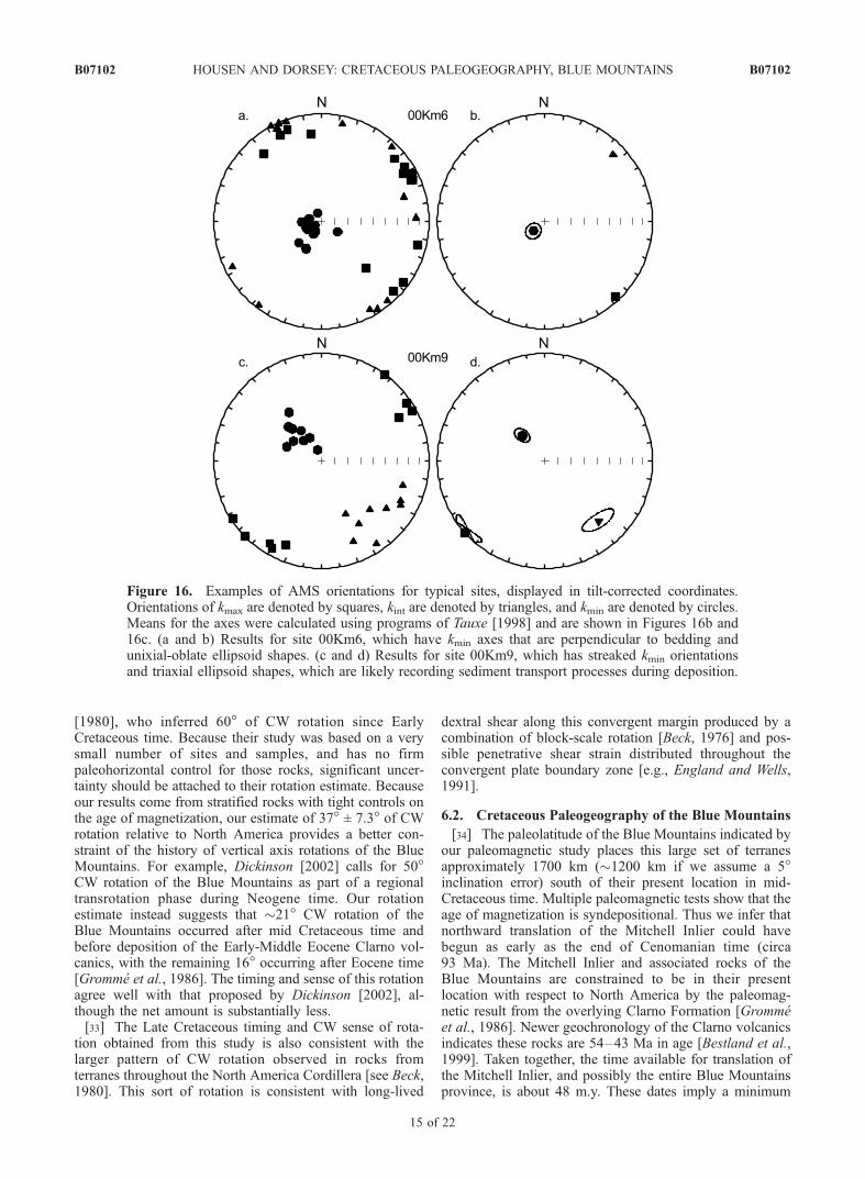
[23] Anisotropy of magnetic susceptibility (AMS) mea-surements were made on 161 specimens. Mean susceptibil-ity varied between 1 � 10�4 to 3 � 10�3 SI units. Thedegree of anisotropy (P = kmax/kmin) varied from 1.01 to1.11, with higher P values corresponding to samples withhigher mean susceptibilities. The shapes of most AMSellipsoids fall within the oblate field of a Flinn-type plot(Figure 15). Analyzed on the site level, the AMS ellipsoidsare statistically triaxial [Tauxe, 1998] for most sites. Theorientations of the AMS axes, after correction for beddingtilt, have kmin axes that are subparallel to bedding poles(Figures 16a and 16b) in many sites. Other sites have AMSkmin orientations that are distinctly streaked, with AMSfoliation planes oblique to bedding (Figures 16c and 16d).Such distributions of AMS orientations are consistent with
fabrics observed in clastic sediments [see Tarling andHrouda, 1993], and indicate that the AMS records theinfluence of paleocurrent and/or slope transport processes.
5.4. Evaluation of Inclination Error
[24] Before evaluating the possible tectonic significanceof the paleomagnetic results from this study, we firstevaluate the possibility that an inclination error affects theremanence. Anomalously shallow inclinations can resultfrom both mechanical processes during primary depositionand the effects of postdepositional compaction [King, 1955;Tauxe, 1993]. Recognition of, and correction for, theamount of inclination error in sedimentary rocks is difficult.We will use three approaches to address this question.[25] The first approach is to examine results from rocks
with differing lithologies and sediment grain sizes, with theidea that clay-rich turbidite units should have larger degreesof possible inclination error (due to adhesion of magnetiteparticles to clay minerals [Sun and Kodama, 1992]). Incontrast, sandstone beds, early cemented concretions, and
Figure 8. Tauxe and Watson [1994] nonparametric paleomagnetic fold test for all sites. Equal-areaprojection of site mean directions (a) in in situ and (b) in tilt-corrected coordinates. (c) Plot of incrementalfold test results. The maximum principal eigenvalue (t1) of the orientation matrix calculated from the sitemean directions will be maximized when the directions are most tightly grouped. The dashed linesrepresent the variation in t1 as a function of percent untilting for 20 artificial paradata sets produced bythe nonparametric bootstrap. The solid line represents the variation in t1 of the actual data. The histogramis of the percent untilting at which t1 is maximized for a set of 500 bootstrapped paradata sets; 95% ofthese data have maxima between 46 and 78% untilting; thus this fold test rules out a 100% untilting resultat 95% confidence.
B07102 HOUSEN AND DORSEY: CRETACEOUS PALEOGEOGRAPHY, BLUE MOUNTAINS
10 of 22
B07102
certain other lithologies may be less prone to inclinationerror (see discussion by Dickinson and Butler [1998] andEnkin et al. [2003]) than clay-rich turbidites. We observedno systematic variation in the inclinations obtained from thevariety of lithologies we sampled.[26] The second approach is to use magnetic anisotropy
fabrics, such as AMS, to evaluate possible relationshipsbetween the degree of particle alignment in sedimentaryrocks and measured inclination. The basic premise of thisapproach is that the true inclination of the geomagnetic fieldwill only be recorded by sediments with a perfectly randommineral preferred orientation fabric [see Jackson et al.,1991], and that there will be a predictable relation betweenfabric intensity and the amount of inclination error. Therelation, however, is strongly influenced by mineral shape,particularly when using remanence anisotropy measure-ments [Jackson et al., 1991; Kodama, 1997]. To accountfor grain shape, magnetic separates of ground-up sedimen-tary rocks are often made to determine the average aspectratio of the magnetite grains, which then enable the rela-tionship between magnetic mineral alignment and paleo-
magnetic inclination to be quantitatively evaluated [seeKodama, 1997; Kim and Kodama, 2004]. An alternateapproach was suggested by Hodych et al. [1999], whoexamined the relationship between observed and predictedpaleomagnetic inclinations and magnetic fabrics (both AMSand anisotropy of ARM) in sediments. They concluded thata simple linear correlation between the tangent of measuredinclination, and 1/P (degree of magnetic anisotropy) wouldyield a first-order correction for inclination error. Althoughless robust than the Jackson et al. [1991] and Kodama[1997] methods, it has an advantage in eliminating theuncertainty in use of magnetic separates (which are biasedtoward larger grain sizes), and it is far easier to perform. Theresults of this analysis (Figure 17) indicate a weak correla-tion between AMS fabric intensity and inclinations. Projec-ting the correlation line to a random fabric produces apredicted true inclination of 62�, which would suggest amaximum estimate of 4� of inclination error. We note,however, that this correlation is almost entirely based onthe few specimens with degrees of anisotropy >1.04, andthat the data set as a whole shows no clear relationship
Figure 9. Results of Tauxe and Watson [1994] parametric bootstrap fold test for sites south of theMitchell Fault. (a) Equal-area projection of site mean directions in in situ coordinates and (b) equal-areaprojection of site mean directions after 100% untilting. (c) Fold test results (as in Figure 8), showing peakin untilting includes 100% untilting at 95% confidence; thus these results pass the paleomagnetic foldtest.
B07102 HOUSEN AND DORSEY: CRETACEOUS PALEOGEOGRAPHY, BLUE MOUNTAINS
11 of 22
B07102
between fabric development and inclination (Figure 17).Large (10� or greater) inclination error in these rocksappears to be ruled out by these data. The best interpretationof these data, given the weak correlation between fabricdevelopment and inclination, would be that no significantinclination error exists in these rocks.[27] The third approach is to examine the spatial distri-
butions of paleomagnetic directions to test for anomalouselongations that will be produced by inclination error [Tauxeand Kent, 2004; Krijgsman and Tauxe, 2004]. On the basisof geomagnetic field geometry (see Beck [1999] and Tauxeand Kent [2004] for discussion) a predictable relation existsbetween the shape (orientation and magnitude of N-S andE-W elongation) of directional data distributions and geo-graphic latitude. An inclination error will introduce ananomalous E-W elongation of directional data. Becausethe shapes of directional data distributions can be sensitiveto small errors, large data sets (100 or more sites for a study-level calculation, and approximately 20 or more samples fora site-level evaluation) are called for by Tauxe and Kent[2004]. Application of this technique to the problem ofdisplaced terranes can be complicated by structural factors.In regions subject to noticeable deformation, a significantcomplication will be the effect of vertical axis rotation
between sites, which will also produce data that are elongatein E-W directions (see Beck [1999] for many good examplesof this). The correction-by-site (CBS) method outlined byTauxe and Kent [2004] may be superior for studies such asthis, because the problem of unaccounted for vertical axisrotation will be avoided at the site level. The drawback offull implementation of the CBS method is that a largenumber of directions are needed for each paleomagneticsite. Tauxe and Kent [2004] suggested >20 samples per sitewould be required, while Beck [1999] demonstrated that 15or more samples would be sufficient to ensure that theelongation of a single data set was significant at 95%confidence.[28] Although we cannot fully implement the CBSmethod
for our entire study, we do have one site (00Km9) with alarge number of samples (n = 14), which nearly fulfills theBeck [1999] criteria. The elongation of the directional data,calculated according to either Tauxe [1998] or Beck [1999],has an E = 1.60. Taking these same data, we corrected theinclinations by:
tan Ic ¼ 1=fð Þ tan Imð Þ ð1Þ
where Ic is the corrected paleomagnetic inclination, Im is themeasured paleomagnetic inclination, and f is the paleomag-netic flattening factor. The inclination correction thatproduces the minimum elongation of the distribution ofsite-level directions provides the best estimate of the correctamount of inclination error [Tauxe and Kent, 2004]. Usingtrial calculations for 3�, 5�, 10�, and 15� degree inclinationerrors (f = 0.89, 0.82, 0.65, 0.49, respectively), thecalculated values for elongations of the directional data
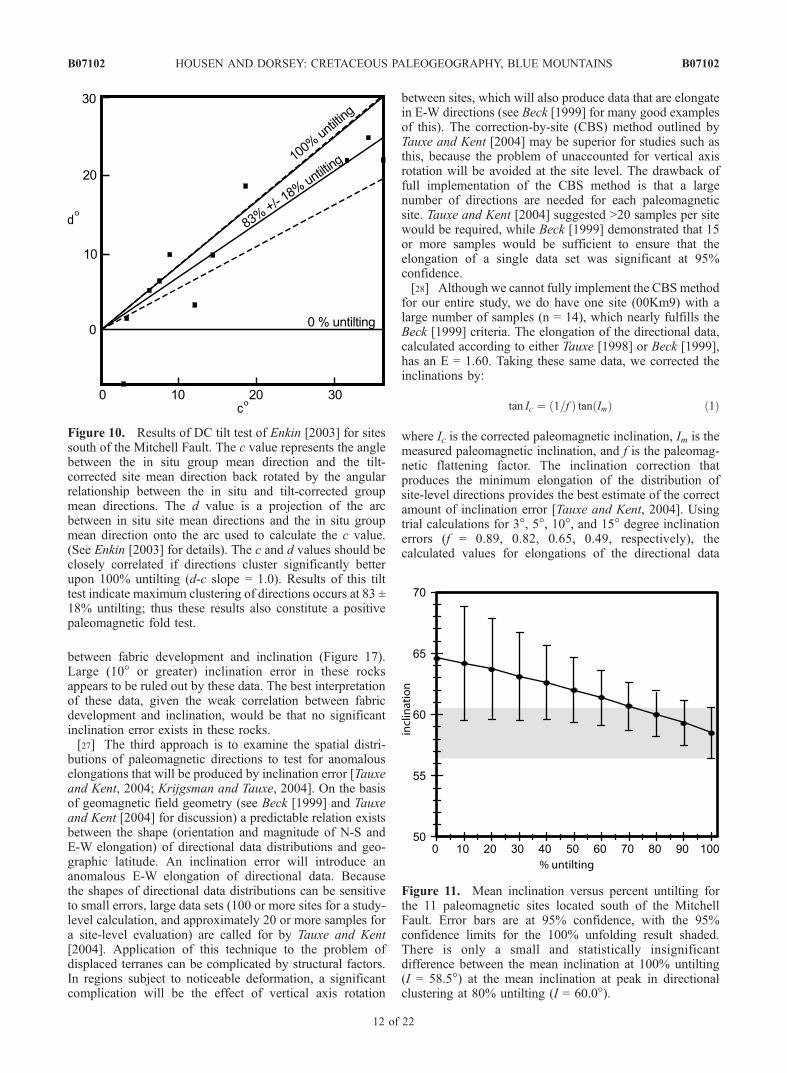
Figure 10. Results of DC tilt test of Enkin [2003] for sitessouth of the Mitchell Fault. The c value represents the anglebetween the in situ group mean direction and the tilt-corrected site mean direction back rotated by the angularrelationship between the in situ and tilt-corrected groupmean directions. The d value is a projection of the arcbetween in situ site mean directions and the in situ groupmean direction onto the arc used to calculate the c value.(See Enkin [2003] for details). The c and d values should beclosely correlated if directions cluster significantly betterupon 100% untilting (d-c slope = 1.0). Results of this tilttest indicate maximum clustering of directions occurs at 83 ±18% untilting; thus these results also constitute a positivepaleomagnetic fold test.
Figure 11. Mean inclination versus percent untilting forthe 11 paleomagnetic sites located south of the MitchellFault. Error bars are at 95% confidence, with the 95%confidence limits for the 100% unfolding result shaded.There is only a small and statistically insignificantdifference between the mean inclination at 100% untilting(I = 58.5�) at the mean inclination at peak in directionalclustering at 80% untilting (I = 60.0�).
B07102 HOUSEN AND DORSEY: CRETACEOUS PALEOGEOGRAPHY, BLUE MOUNTAINS
12 of 22
B07102
distributions are E = 1.63, 1.65, 1.74, 1.81. Thus theminimum elongation occurs without any inclination correc-tion (f = 1.0, E = 1.60), and indicates that no significantinclination error is present in the site 00Km9 rocks. To theextent that this single site is representative of the entire
study, no correction for anomalously shallow inclinations iswarranted.[29] On the basis of all of the above we conclude that no
significant inclination error is present in these rocks, so thatthe best estimate of the geomagnetic field’s inclination as
Figure 12. Results of Tauxe and Watson [1994] fold test for sites north of the Mitchell Fault. (a) Equal-area projection of site mean directions in in situ coordinates and (b) equal-area projection of site meandirections after 100% untilting. (c) Fold test results (as in Figure 8), showing peak in untilting does notinclude 100% untilting at 95% confidence. Thus these results fail the paleomagnetic fold test.
Figure 13. Representative magnetic hysteresis loops from (a) Gable Creek Formation and (b) HudspethFormation samples. Loops are corrected for high-field slope.
B07102 HOUSEN AND DORSEY: CRETACEOUS PALEOGEOGRAPHY, BLUE MOUNTAINS
13 of 22
B07102
recorded by the Gable Creek and Hudspeth Formations is58.5�. Unfortunately, the CBS method of Tauxe and Kent[2004], which we argue may be the best way to evaluateinclination error, is not applicable to our entire sample setand so we cannot rigorously rule out a minor amount ofunrecognized inclination error. We thus include an alternateresult with 5� degrees of inclination error in the discussionof our data.
5.5. Paleolatitude, Translation, and Rotation
[30] Using the mean direction from the 11 sites south ofthe Mitchell Fault, a paleolatitude of 39.2� +4.8�/�4.3�N isobtained for the Gable Creek and Hudspeth Formations.Compared with the current location of these rocks on NorthAmerica and using the recalculated mid Cretaceous NAreference pole from Housen et al. [2003], the expectedpaleolatitude of the study location is 55.1� ± 2.7�N. Theresulting paleolatitude anomaly is 15.9� ± 4.1�, indicating anorthward translation of 1760 ± 460 km and a CW rotation of37� ± 7.3� for these rocks with respect to North America sincethe mid-Cretaceous (93 Ma) (error limits after Demarest[1983]). If a 5� inclination error is assumed, it would
indicate a paleolatitude of 45�N, and 1200 ± 460 km ofnorthward translation with respect to North America.
6. Discussion
[31] Our paleomagnetic study has shown that Cretaceoussedimentary rocks of the Mitchell Inlier recorded thegeomagnetic field shortly after deposition, and that themagnetic inclination obtained from these rocks is mostlikely not affected by significant inclination error. Priorcompilations of regional geology suggest that the variousterranes of the Blue Mountains were amalgamated to eachother by late Jurassic to early Cretaceous time [e.g., Brooksand Vallier, 1978; Dickinson, 1979; Ave Lallemant, 1995].This suggestion is consistent with the observation thatCretaceous sedimentary rocks of the Mitchell Inlier, andsmaller exposures of similar rocks such as the BernardFormation in the Suplee-Izee area, overlap the Baker andIzee terranes in the western Blue Mountains [e.g., Dickinsonand Thayer, 1978; Kleinhans et al., 1984]. Thus it ispossible that our paleomagnetic results can be used toconstrain the Cretaceous paleogeography of the Blue Moun-tains as a more or less intact tectonic block. Alternatively,the Mitchell Inlier may represent a relatively small forearcsliver that experienced more translation than central andeastern parts of the Blue Mountains where mid-Cretaceousstrata are not preserved. Because of this uncertainty, weconsider several hypotheses for reconstruction of Cordille-ran terranes in and adjacent to the Blue Mountains (section6.4, below).
6.1. Rotation of the Blue Mountains
[32] Our paleomagnetic result provides a new constrainton the timing and amount of CW crustal rotation in the BlueMountains. As mentioned above, most tectonic models thatsuggest significant rotation of the Blue Mountains rely onthe study of Blue Mountains plutons by Wilson and Cox
Figure 14. Modified Day et al. [1977] plot, with SD-MDmixing lines, from Dunlop [2002], showing hysteresisparameters of samples from the Gable Creek and Hudspethformations. The results indicate the samples containadmixtures of SD and MD magnetite. The squares denoteresults from site 00Km15, which appears to have beenremagnetized.
Figure 15. Flinn-type plot of AMS principal susceptibil-ities. The results indicate most samples have low tomoderate degrees of anisotropy and that most have oblateto weakly triaxial ellipsoid shapes.
B07102 HOUSEN AND DORSEY: CRETACEOUS PALEOGEOGRAPHY, BLUE MOUNTAINS
14 of 22
B07102
[1980], who inferred 60� of CW rotation since EarlyCretaceous time. Because their study was based on a verysmall number of sites and samples, and has no firmpaleohorizontal control for those rocks, significant uncer-tainty should be attached to their rotation estimate. Becauseour results come from stratified rocks with tight controls onthe age of magnetization, our estimate of 37� ± 7.3� of CWrotation relative to North America provides a better con-straint of the history of vertical axis rotations of the BlueMountains. For example, Dickinson [2002] calls for 50�CW rotation of the Blue Mountains as part of a regionaltransrotation phase during Neogene time. Our rotationestimate instead suggests that �21� CW rotation of theBlue Mountains occurred after mid Cretaceous time andbefore deposition of the Early-Middle Eocene Clarno vol-canics, with the remaining 16� occurring after Eocene time[Gromme et al., 1986]. The timing and sense of this rotationagree well with that proposed by Dickinson [2002], al-though the net amount is substantially less.[33] The Late Cretaceous timing and CW sense of rota-
tion obtained from this study is also consistent with thelarger pattern of CW rotation observed in rocks fromterranes throughout the North America Cordillera [see Beck,1980]. This sort of rotation is consistent with long-lived
dextral shear along this convergent margin produced by acombination of block-scale rotation [Beck, 1976] and pos-sible penetrative shear strain distributed throughout theconvergent plate boundary zone [e.g., England and Wells,1991].
6.2. Cretaceous Paleogeography of the Blue Mountains
[34] The paleolatitude of the Blue Mountains indicated byour paleomagnetic study places this large set of terranesapproximately 1700 km (�1200 km if we assume a 5�inclination error) south of their present location in mid-Cretaceous time. Multiple paleomagnetic tests show that theage of magnetization is syndepositional. Thus we infer thatnorthward translation of the Mitchell Inlier could havebegun as early as the end of Cenomanian time (circa93 Ma). The Mitchell Inlier and associated rocks of theBlue Mountains are constrained to be in their presentlocation with respect to North America by the paleomag-netic result from the overlying Clarno Formation [Grommeet al., 1986]. Newer geochronology of the Clarno volcanicsindicates these rocks are 54–43 Ma in age [Bestland et al.,1999]. Taken together, the time available for translation ofthe Mitchell Inlier, and possibly the entire Blue Mountainsprovince, is about 48 m.y. These dates imply a minimum
Figure 16. Examples of AMS orientations for typical sites, displayed in tilt-corrected coordinates.Orientations of kmax are denoted by squares, kint are denoted by triangles, and kmin are denoted by circles.Means for the axes were calculated using programs of Tauxe [1998] and are shown in Figures 16b and16c. (a and b) Results for site 00Km6, which have kmin axes that are perpendicular to bedding andunixial-oblate ellipsoid shapes. (c and d) Results for site 00Km9, which has streaked kmin orientationsand triaxial ellipsoid shapes, which are likely recording sediment transport processes during deposition.
B07102 HOUSEN AND DORSEY: CRETACEOUS PALEOGEOGRAPHY, BLUE MOUNTAINS
15 of 22
B07102
time-averaged relative plate motion of �35 mm/yr for thelarger displacement (1700 km), and �25 mm/yr for thelower estimate (1200 km).[35] If terranes of the Blue Mountains have remained
relatively intact since Late Jurassic or Early Cretaceoustime, the results of our study will require substantialrevision of paleogeographic models that place the BlueMountains in their present position relative to North Amer-ica prior to Late Cretaceous time [e.g., Dickinson andThayer, 1978; Lund and Snee, 1988; Selverstone et al.,1992; Ave Lallemant, 1995; Cowan et al., 1997; Wyld andWright, 2001; Dickinson, 2004]. Several of these models[e.g., Wyld and Wright, 2001] argue that the Blue Mountainsare pinned to the margin of North America through theSalmon River Suture Zone and Western Idaho Shear Zone(WISZ) by crosscutting relationships involving plutons ofthe 118 Ma Hazard Creek and 110 Ma Little Goose Creekcomplexes and the 90 Ma Payette River tonalite [Lund andSnee, 1988; Manduca et al., 1993; Selverstone et al., 1992].The presence of xenoliths and roof pendants belonging toboth the North American craton and oceanic Blue Moun-tains terranes, in a zone that straddles the isotopicallydefined cratonal margin, requires that these plutons intrudedacross the continent-ocean suture during or after initial
accretion of oceanic terranes to North America [Armstronget al., 1977; Fleck and Criss, 1985; Criss and Fleck, 1987;Manduca et al., 1992]. However, these intrusions do notplace any constraint on post mid-Cretaceous translation ofthe Blue Mountains. Indeed, plutonic rocks in the WISZ andeastern Idaho batholith have experienced multiple phases ofpenetrative transpressional deformation during and aftertheir emplacement [Manduca et al., 1993; McClelland etal., 2000]. The Hazard Creek and Little Goose Creekcomplexes are highly deformed, and the relatively unde-formed Payette River tonalite is located well east of therelevant tectonic zone [see Manduca et al., 1993].McClelland et al. [2000] showed that penetrative structuresin the WISZ record a significant, though unknown amountof dextral shear between the Blue Mountains and cratonalNorth America during latest Cretaceous time. Our paleo-magnetic data are consistent with their structural model andsuggest that the WISZ was the locus of large-scale dextraldisplacement between about 93 and 45 Ma.[36] Wyld and Wright [2001] proposed that the Blue
Mountains province was located �400 km to the south ofits present location in the early Cretaceous based oncorrelations between similar Jurassic rocks in the BlueMountains and in the Black Rock Desert of westernNevada. Part of their paleogeographic model includes con-nections between dextral strike-slip fault systems in south-ern and central California (Mojave-Snow Lake and SierraCrest shear zones), the Western Nevada shear zone, and theWISZ-Salmon River Suture Zone to form a major transformfault system. The Blue Mountains lie immediately to thewest of this large structure (Figure 1), which makes thisfault system a very attractive candidate to accommodate atleast a portion of the large (1200 to 1700 km) displacementof the Blue Mountains that we propose here.
6.3. Regional Correlation of Cordilleran Terranes
[37] Any attempt to reconstruct the paleogeography of theBlue Mountains requires consideration of possible correla-tions to other Cordilleran tectonic elements. Some workershave argued, mainly based on similarities between Permianand Triassic rocks of Wrangellia and the Seven Devils rocksof the Wallowa terrane, that the Blue Mountains provincecorrelates to the Insular superterrane [Jones et al., 1977;Hillhouse et al., 1982; Wernicke and Klepacki, 1988;Dickinson, 2004]. Others suggest that the geochemistryand petrology of the same Triassic units argues againstassociations between the Seven Devils rocks and Wrangel-lia, and instead suggest a correlation between the BlueMountains and the Intermontane superterrane [Sarewitz,1983; Mortimer, 1986]. As discussed by Mortimer [1986],either of these two correlations is permitted by existingpaleomagnetic data from Triassic rocks of the Insular andIntermontane superterranes and the Blue Mountains. Al-though we cannot test these correlations between Triassicunits with our data, we can compare high-quality paleo-magnetic data from mid Cretaceous units from the Insularand Intermontane superterranes to new data from theMitchell Inlier (this study). For this comparison we usethe circa 90 Ma paleomagnetic results from Mount Tatlow[Wynne et al., 1995], the upper Churn Creek rocks [Enkin etal., 2003], and the Mount Stuart batholith [Housen et al.,2003] for the Insular superterrane, and the 100–105 Ma
Figure 17. Correlation plot of magnetic fabrics andpaleomagnetic inclinations [after Hodych et al., 1999].Inclinations are in 100% tilt-corrected coordinates and arecompared to AMS degree of anisotropy (P = kmax/kmin).Hodych et al. [1999] demonstrated that inclination errorproduces a linear relationship between tan (I) and 1/P, withthe intercept of the correlation line 1/P = 1.00, signifying atotally random fabric, providing the best estimate of theoriginal paleomagnetic inclination using this technique.These results show only a weak correlation (R2 and 95%confidence intervals for correlation line are shown) betweentan (I) and 1/P, indicating that little or no significantinclination error has occurred in these rocks. Values of tan(I) and resulting inclination estimates for no displacement(A), the proposed correlation correction from this plot (B),and for the mean inclination from these data (C) are shown.
B07102 HOUSEN AND DORSEY: CRETACEOUS PALEOGEOGRAPHY, BLUE MOUNTAINS
16 of 22
B07102
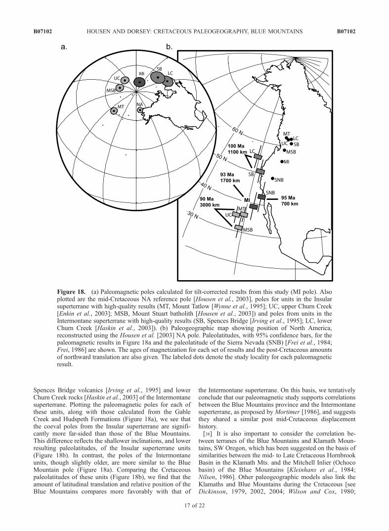
Spences Bridge volcanics [Irving et al., 1995] and lowerChurn Creek rocks [Haskin et al., 2003] of the Intermontanesuperterrane. Plotting the paleomagnetic poles for each ofthese units, along with those calculated from the GableCreek and Hudspeth Formations (Figure 18a), we see thatthe coeval poles from the Insular superterrane are signifi-cantly more far-sided than those of the Blue Mountains.This difference reflects the shallower inclinations, and lowerresulting paleolatitudes, of the Insular superterrane units(Figure 18b). In contrast, the poles of the Intermontaneunits, though slightly older, are more similar to the BlueMountain pole (Figure 18a). Comparing the Cretaceouspaleolatitudes of these units (Figure 18b), we find that theamount of latitudinal translation and relative position of theBlue Mountains compares more favorably with that of
the Intermontane superterrane. On this basis, we tentativelyconclude that our paleomagnetic study supports correlationsbetween the Blue Mountains province and the Intermontanesuperterrane, as proposed by Mortimer [1986], and suggeststhey shared a similar post mid-Cretaceous displacementhistory.[38] It is also important to consider the correlation be-
tween terranes of the Blue Mountains and Klamath Moun-tains, SW Oregon, which has been suggested on the basis ofsimilarities between the mid- to Late Cretaceous HornbrookBasin in the Klamath Mts. and the Mitchell Inlier (Ochocobasin) of the Blue Mountains [Kleinhans et al., 1984;Nilsen, 1986]. Other paleogeographic models also link theKlamaths and Blue Mountains during the Cretaceous [seeDickinson, 1979, 2002, 2004; Wilson and Cox, 1980;
Figure 18. (a) Paleomagnetic poles calculated for tilt-corrected results from this study (MI pole). Alsoplotted are the mid-Cretaceous NA reference pole [Housen et al., 2003], poles for units in the Insularsuperterrane with high-quality results (MT, Mount Tatlow [Wynne et al., 1995]; UC, upper Churn Creek[Enkin et al., 2003]; MSB, Mount Stuart batholith [Housen et al., 2003]) and poles from units in theIntermontane superterrane with high-quality results (SB, Spences Bridge [Irving et al., 1995]; LC, lowerChurn Creek [Haskin et al., 2003]). (b) Paleogeographic map showing position of North America,reconstructed using the Housen et al. [2003] NA pole. Paleolatitudes, with 95% confidence bars, for thepaleomagnetic results in Figure 18a and the paleolatitude of the Sierra Nevada (SNB) [Frei et al., 1984;Frei, 1986] are shown. The ages of magnetization for each set of results and the post-Cretaceous amountsof northward translation are also given. The labeled dots denote the study locality for each paleomagneticresult.
B07102 HOUSEN AND DORSEY: CRETACEOUS PALEOGEOGRAPHY, BLUE MOUNTAINS
17 of 22
B07102
Gromme et al., 1986; Wyld and Wright, 2001]. If thiscorrelation is correct, rocks in the Klamath Mountainsshould have a mid Cretaceous paleolatitude similar to thatindicated by our paleomagnetic study. There is a limited(2 sites) paleomagnetic data set from the Hornbrook For-mation [Mankinen and Irwin, 1982]. These results wereoriginally compared with coeval rocks of the Great ValleyGroup, and found by Mankinen and Irwin [1982] to fail aregional fold test on that basis. The tilt-corrected directionsfor the Hornbrook Formation reported by Mankinen andIrwin, [1982] are essentially identical to those we havefound from the Mitchell Inlier rocks supporting a linkbetween the Hornbrook and Ochoco Basins during themid-Cretaceous. Unfortunately the small number of sitesin the Hornbrook Formation makes a detailed statisticalcomparison between the two studies of limited significance.[39] The Klamaths and Sierra Nevada arc are commonly
treated as a single entity for most of Mesozoic time in manycompilations of regional geology [e.g., Ingersoll andSchweickert, 1986; Saleeby, 1990; Hacker and Peacock,1990; Hacker et al., 1995; Irwin and Mankinen, 1998;Irwin, 2003; Dickinson, 2004]. We can consider possibleconstraints on the paleogeographic position of the combinedKlamaths-Sierra Nevada block that are suggested by ourresults in the Mitchell Inlier. The consensus of mostpaleogeographic models summarized above, as well asthose of Dickinson and Butler [1998], Wyld and Wright[2001], Umhoefer [2003], Umhoefer and Blakey [2005], andWyld et al. [2005], is that the Sierra Nevada arc was locatedat its present latitude (49.1�N) relative to North Americaduring the Cretaceous. Paleomagnetic data from mid-Cretaceous Sierra Nevada plutons [Frei et al., 1984; Frei,1986] indicate a paleolatitude of 42.8� ± 5�N for this arc.This result is commonly interpreted to indicate that littlesignificant latitudinal translation of the Sierra Nevada hasoccurred since Late Cretaceous time, based on the overlapbetween the expected (in place with respect to NorthAmerica) paleolatitude and the 95% confidence intervalon the paleolatitude calculated from the combined resultsof Frei et al. [1984] and Frei [1986]. The mid-LateCretaceous reference pole for North America recalculatedby Housen et al. [2003] has a somewhat smaller 95%confidence interval than that used by Frei [1986]; theresulting paleolatitude anomaly becomes 6.3� ± 4.6� (indi-cating transport of 700 ± 500 km) for the Sierra Nevadabatholith. The paleomagnetic results placing the SierraNevada approximately 6� further south during mid Creta-ceous time put the Klamath-Sierra Nevada block and theBlue Mountains at similar paleolatitudes (Figure 18b). Thuscorrelations between the Klamath-Sierra Nevada and theBlue Mountains appear to be supported by both paleomag-netic and geological data.
6.4. Paleogeographic Models
[40] On the basis of the discussion above, we presentthree working models for the Late Cretaceous paleogeog-raphy of the Cordilleran margin of North America.6.4.1. Model 1: Intermontane-Blue Mountains-Klamath-Sierra Nevada[41] In our preferred model, Cretaceous strata and under-
lying melange rocks in the Mitchell Inlier are relativelycontiguous with the larger Blue Mountains province
(Figure 1) and the Intermontane superterrane, and link theIntermontane to the Klamath-Sierra Nevada system in mid-Cretaceous time [e.g., Silver and Smith, 1983; Mortimer,1986; Moores, 1998]. In this model, these units weretranslated approximately 1200 to 1700 km northward dur-ing the Late Cretaceous and early Tertiary. The SierraNevada/Salinia arc shared 700 km of this translation [seealso Whidden et al., 1998] with the remaining 600 to1100 km representing additional post-93 Ma translation ofthe Blue Mountains. If the Blue Mountains were located ator near the southern end of the Sierra Nevada (perhaps nearthe restored position of the Salinia block [see Dickinson andButler, 1998; Whidden et al., 1998]), a dextral fault systemseparating the Blue Mountains from the Sierra Nevadawould be suggested. Although our proposed timing doesnot match, a new model suggesting that the southern GreatValley province was a transtensional/translational forearcbasin [Wright, 2004] agrees well with the style of deforma-tion that we call for here. For displacement occurring afterthe Blue Mountains had moved north of the Sierra Nevada,the extensive dextral fault system in western Idaho, NWNevada, and eastern California [Wyld and Wright, 2001] isoriented favorably to have accommodated a significantportion of this displacement, although the displacementwe propose is 500 to 1200 km greater than the estimatesof Wyld and Wright [2001]. The paleomagnetic results fromthis study, and our interpretation of Sierra Nevada paleo-magnetic data also produces estimates of translation that aresignificantly larger than those proposed by Umhoefer andBlakey [2005] and Wyld et al. [2005]. Our preferred modelalso suggests significant displacement (1300–1800 km) ofthe outboard Insular superterrane relative to the Intermon-tane-Blue Mountain-Klamath-Sierra block. If the Insularsuperterrane was located adjacent to North America (butfurther south), a second system of dextral faults locatedoutboard of the Intermontane-Blue Mountain-Klamath-Sierra block would be called for (as proposed by Irving etal. [1996], Cowan et al. [1997], McClelland et al. [2000],and Umhoefer [2003]). Objections to this paleogeographybased on the ‘‘space problem’’ arising from overlap betweenCretaceous arcs and subduction zones (see discussions byMonger et al. [1982], Butler et al. [2001], and Dickinson[2004], for example) could be addressed by adoption of thePhilippine plate-like ‘‘Cordilleria’’ model of Moores [1998].In his model the Intermontane-Klamath-Sierra Nevadaformed a long arc province located adjacent to the NorthAmerican margin throughout much of Mesozoic time, andthe Insular superterrane was part of an outboard arc systemthat was separated from the marginal arc by an interveningoceanic plate [see Moores, 1998, Figure 10]. The paleo-magnetic data discussed above fit the Moores [1998] modelremarkably well.6.4.2. Model 2: Ochoco and Hornbrook Basin Sliver[42] In this model, the Ochoco basin in the western Blue
Mountains and the Hornbrook basin of the Klamath Moun-tains belong to a small sliver of forearc crust that experi-enced more northward displacement than the rest of theBlue Mountains province. In this case, our paleomagneticresults would apply only to this smaller crustal block. Theremaining, more easterly parts of the Blue Mountains,Klamaths, and Sierra Nevada would be located as proposedby Wyld and Wright [2001]. The Ochoco-Hornbrook sliver
B07102 HOUSEN AND DORSEY: CRETACEOUS PALEOGEOGRAPHY, BLUE MOUNTAINS
18 of 22
B07102
would be located outboard and south of the Sierra Nevadaarc during mid Cretaceous time, and may have beenassociated with the Salinian Block. An important faultboundary would be needed to separate this sliver from thecentral and eastern parts of the Blue Mountains, perhapssimilar to faults depicted by Cowan et al. [1997] andUmhoefer [2003], but located farther east between theMitchell Inlier and the remainder of the Blue Mountains.Northward translation of this sliver may have been associ-ated with part of the translation of the Insular superterrane,with the Ochoco-Hornbrook basins representing portions ofBaja-BC that were scraped off and left behind duringterrane displacement (the ‘‘paint on the bumper’’ of Maxsonand Tikoff [1996]). While we believe this model is possible,we presently do not favor it because (1) little deformed mid-Cretaceous strata of the Mitchell Inlier can be tracedeastward into the Suplee-Izee area where they overlap older,tectonically juxtaposed rocks of the Baker and Izee terranes[e.g., Dickinson and Thayer, 1978; Kleinhans et al., 1984];and (2) abundant prior work has shown that the Izee,Baker, and other terranes of the Blue Mountains wereamalgamated and stitched together by Late Jurassic or EarlyCretaceous time [e.g., Brooks and Vallier, 1978; Dickinsonand Thayer, 1978; Dickinson, 1979; White et al., 1992; AveLallemant, 1995]. If correct, these geological relations mayrule out this model.6.4.3. Model 3: Greater Inclination Error[43] Our third model attributes the entire paleomagnetic
inclination anomaly to effects of inclination error in excessof what we have detected in this study. If there was about12� of inclination error in the Gable Creek and HudspethFormations, the Late Cretaceous paleolatitude of the Mitch-ell Inlier rocks would be concordant with that expected fortheir present location in North America. Inclination errors ofthis magnitude have been proposed for similar rocks byDickinson and Butler [1998] and Butler et al. [2001], andslightly smaller (9�) errors were proposed for the NanaimoGroup by Kim and Kodama [2004]. If correct, existingpaleogeographic models that place the Blue Mountains intheir present position by Early Cretaceous time [e.g., AveLallemant, 1995; Umhoefer, 2003; Dickinson, 2004] wouldbe compatible with 12� of inclination error. This model, orsomething close to it, would also be consistent with thereconstruction proposed by Wyld and Wright [2001], whichcalls for �400 km of translation of the Blue Mountains.Additional tests for such a large magnitude of inclinationerror would be required to support this ad hoc adjustment,because the data presented above do not support thisinterpretation. We also note that if there had been nonorthward translation of the Mitchell Inlier, the mid-Creta-ceous magnetic inclination recorded in these rocks would beapproximately 71�. According to models of inclination error[see, e.g., Tauxe and Kent, 2004] such steep inclinations areless likely to experience significant compaction shallowing.Flattening factors of f = 0.5 to 0.6 would be needed toproduce our observed mean inclination from this expectedinclination; examination of model results [Jackson et al.,1991] and fabric-inclination studies [Hodych et al., 1999;Kim and Kodama, 2004] suggests that significant magneticanisotropies (P > 1.10) would likely be needed to achievethis degree of inclination error. Most of our magnetic fabricresults have P < 1.04, so our data are not consistent with the
degree of flattening needed to erase the paleomagneticinclination anomaly we propose for these rocks. Clearlymore work on detection of, and methods of correction for,significant inclination error in sedimentary rocks is neededto fully evaluate this model.
7. Conclusions
[44] Our paleomagnetic study has found that Albian andCenomanian sedimentary rocks of the Gable Creek andHudspeth Formations in the Blue Mountains, central Ore-gon, record the mid-Cretaceous geomagnetic field based onpositive fold, baked-contact, and conglomerate tests. Exam-ination of magnetic fabrics and the shape distribution ofdirectional data indicates that there is little evidence forsignificant inclination error. We therefore conclude that the100% untilting mean direction of D = 10.8�, I = 58.5�, k =127, a95 = 4.1�, and N = 11 for the sites south of theMitchell fault provides the best paleomagnetic data forconstraints on the paleogeography of these rocks. Thisresult places the Mitchell Inlier at a paleolatitude of 39.2�+4.8�/�4.3�N and indicates a paleolatitude anomaly of15.9� ± 4.1� relative to North America, giving a northwardtranslation of 1760 ± 460 km, and a CW rotation of 37� ±7.3� for these rocks since circa 93 Ma. These data providefirm support for prior models invoking large CW rotation ofthe Blue Mountains during post-Cretaceous time, but indi-cate a need for major revision of paleogeographic modelsthat place the Blue Mountains in their present position alongthe North America margin in Early Cretaceous time.[45] We suggest that, based on prior geological correla-
tions and similar post mid-Cretaceous translation histories,the Blue Mountains province likely correlates with theIntermontane superterrane [e.g., Mortimer, 1986], and thatthe Intermontane-Blue Mountains-Klamath-Sierra Nevadamay have formed a large, quasi-continuous arc-forearcprovince during this time [e.g., Moores, 1998]. Clast com-positions and paleocurrents of the Gable Creek Formation[Little, 1986; Lenegan, 2001], when corrected for the CWrotation, do not support derivation of detritus in the Ochocobasin from the nearby Western Idaho shear zone. On thebasis of the similar mid-Cretaceous paleolatitudes of theOchoco Basin (39�N) and Sierra Nevada (43�N), we pro-pose that the Sierra Nevada magmatic arc and batholith mayhave been the source of detritus in the Gable CreekFormation.[46] We consider other models, such as the Ochoco and
Hornbrook basins occupying an anomalous forearc sliver oflimited extent, or large amounts of inclination error due tocompaction shallowing, to be possible but less likely. Futurework is clearly needed to test these contradictory hypothe-ses and resolve major uncertainties concerning the tectonicarchitecture and evolution of the western U.S. Cordilleransystem.
[47] Acknowledgments. We would like to thank many people forongoing discussions of Blue Mountains geology and tectonics, not all ofwhom will agree with our conclusions. These include Paul Umhoefer,Sandra Wyld, Jim Wright, Brian Mahoney, Basil Tikoff, Ken Kodama, andNed Brown. We also thank Associate Editor Randy Enkin and reviewersScott Bogue and Darrel Cowan for many useful comments that improvedthis manuscript. Housen would like to thank Myrl Beck and RussBurmester for many good discussions of these and other data. Funding
B07102 HOUSEN AND DORSEY: CRETACEOUS PALEOGEOGRAPHY, BLUE MOUNTAINS
19 of 22
B07102
from NSF grants EAR-9727032 (for the WWU Cryogenic Magnetometer)and EAR-0073888 and from the WWU Bureau for Faculty Researchsupported this work. Hysteresis measurements were made possible by anIRM visiting fellowship award from the University of Minnesota toHousen.
ReferencesAgue, J. J., and M. T. Brandon (1996), Regional tilt of the Mount Stuartbatholith, Washington, determined using Al-in-hornblende barometry:Implications for northward translation of Baja BC, Geol. Soc. Am. Bull.,108, 471–488.
Andronicos, C. L., L. S. Hollister, C. Davidson, and D. Chardon (1999),Kinematics and tectonic significance of transpressive structures withinthe Coast Plutonic Complex, British Columbia, J. Struct. Geol., 21, 229–243.
Armstrong, R. L., W. H. Taubeneck, and O. Hales (1977), Rb-Sr and K-Argeochronometry of Mesozoic granitic rocks and their Sr isotopic compo-sition: Oregon, Washington, and Idaho, Geol. Soc. Am. Bull., 88, 397–411.
Ave Lallemant, H. G. (1995), Pre-Cretaceous tectonic evolution of the BlueMountains Province, northeastern Oregon, U.S. Geol. Surv. Prof. Pap.,1438, 271–304.
Bazard, D. R., et al. (1990), Paleomagnetism of the Methow region, north-central Washington: Structural application of paleomagnetic data in acompletely deformed, variably remagnetized terrane, Can. J. EarthSci., 27, 330–343.
Beck, M. E., Jr. (1976), Discordant paleomagnetic poles positions as evi-dence of regional shear in the Western Cordillera of North America, Am.J. Sci., 276, 694–712.
Beck, M. E., Jr. (1980), Paleomagnetic record of plate-margin tectonicprocesses along the western edge of North America, J. Geophys. Res.,85, 7115–7131.
Beck, M. E., Jr. (1999), On the shape of paleomagnetic data sets, J. Geo-phys. Res., 104, 25,427–25,441.
Beck, M. E., R. F. Burmester, and R. Schoonover (1981), Paleomagnetismand tectonics of the Cretaceous Mt. Stuart Batholith of Washington:Translation or tilt?, Earth Planet. Sci. Lett., 56, 336–342.
Bestland, E. A., E. Hammond, D. L. S. Blackwell, M. A. Kays, G. J.Retallack, and J. Stimac (1999), Geologic framework of the Clarno Unit,John Day Fossil Beds National Monument, central Oregon, Oreg. Geol.,61, 3–19.
Bogue, S. W., and C. S. Gromme (2004), Structural correction of paleo-magnetic vectors dispersed about two fold axes and application to theDuke Island (Alaska) ultramafic complex, J. Geophys. Res., 109,B11102, doi:10.1029/2004JB002989.
Bogue, S. W., D. S. Cowan, and J. I. Garver (1989), Paleomagnetic evi-dence for poleward transport of Upper Jurassic rocks in the Decaturterrane, San Juan Islands, Washington, J. Geophys. Res., 94, 10,415–10,427.
Brooks, H. C., and T. L. Vallier (1978), Mesozoic rocks and tectonic evolu-tion of Oregon and western Idaho, Mesozoic paleogeography of thewestern United States, in Mesozoic Paleogeography of the Western Uni-ted States: Society of Economic Paleontologists and Mineralogists, Pa-cific Section, Paleogeography Symposium, vol. 2, edited by D. G. Howelland K. A. McDougall, pp. 133–145, Soc. for Sediment. Geol., Tulsa,Okla.
Brown, E. H., and R. F. Burmester (1991), Metamorphic evidence for tilt ofthe Spuzzum pluton: Diminished basis for the ‘‘Baja British Columbia’’concept, Tectonics, 10, 978–985.
Burchfiel, B. C., D. S. Cowan, and G. A. Davis (1992), Tectonic overviewof the Cordilleran orogen in the western United States, in Geology ofNorth America, Conterminous U.S., vol. G-3, The Cordilleran Orogen,edited by B. C. Burchfiel et al., pp. 407–479, Geol. Soc. of Am.,Boulder, Colo.
Burmester, R. F., D. R. Bazard, and M. E. Beck (1990), Post-foldingremagnetization that passes the fold test, Geophys. J. Int., 102, 455–463.
Burmester, R. F., M. C. Blake Jr., and D. C. Engebretson (2000), Remag-netization during Cretaceous normal superchron in eastern San Juan Is-lands, WA: Implications for tectonic history, Tectonophysics, 326, 73–92.
Butler, R., G. Gehrels, W. McClelland, S. May, and D. Klepacki (1989),Discordant paleomagnetic poles from the Canadian coast plutonic com-plex: Regional tilt rather than large scale displacement?, Geology, 17,691–694.
Butler, R. F., G. E. Gehrels, and K. Kodama (2001), A moderate translationalternative to the Baja British Columbia hypothesis,GSA Today, 11, 4–10.
Butler, R. F., G. E. Gehrels, S. E. Baldwin, and C. Davidson (2002),Paleomagnetism and geochronology of the Ecstall pluton in the CoastMountains orogen of British Columbia: Local deformation rather than
large-scale transport, J. Geophys. Res., 107(B1), 2009, doi:10.1029/2001JB000270.
Coney, J., D. L. Jones, and J. W. H. Monger (1980), Cordilleran suspectterranes, Nature, 288, 329–333.
Cowan, D. S., M. T. Brandon, and J. I. Garver (1997), Geologic tests ofhypotheses for large coastwise displacements: A critique illustrated bythe Baja British Columbia controversy, Am. J. Sci., 297, 117–173.
Criss, R. E., and R. J. Fleck (1987), Petrogenesis, geochronology, andhydrothermal systems of the northern Idaho batholith and adjacent areasbased on 18O/16O, D/H/87Sr/86Sr, A-Ar, and 40Ar-39Ar studies, in Geol-ogy of the Blue Mountains Region of Oregon, Idaho, and Washington,edited by T. L. Vallier and H. C. Brooks, U.S. Geol. Surv. Prof. Pap.,1436, 171–196.
Day, R., M. Fuller, and V. A. Schmidt (1977), Hysteresis properties oftitanomagnetites: Grain-size and compositional dependence, Phys. EarthPlanet. Inter., 13, 260–267.
Demarest, H. H. (1983), Error analysis of the determination of tectonicrotation from paleomagnetic data, J. Geophys. Res., 88, 4321–4328.
Dickinson, W. R. (1979), Mesozoic forearc basin in central Oregon, Geol-ogy, 7, 166–170.
Dickinson, W. R. (2002), The Basin and Range province as a compositeextensional domain, Int. Geol. Rev., 44, 1–38.
Dickinson, W. R. (2004), Evolution of the North American Cordillera, Ann.Rev. Earth Planet. Sci., 32, 13–45.
Dickinson, W. R., and R. F. Butler (1998), Coastal and Baja Californiapaleomagnetism revisited, Geol. Soc. Am. Bull., 110, 1268–1280.
Dickinson, W. R., and T. Thayer (1978), Paleogeographic and paleotectonicimplications of Mesozoic stratigraphy and structure in the John Day inlierof central Oregon, in Mesozoic Paleogeography of the Western UnitedStates: Society of Economic Paleontologists and Mineralogists, PacificSection, Paleogeography Symposium, vol. 2, edited by D. G. Howell andK. A. McDougall, pp. 147–161, Soc. for Sediment. Geol., Tulsa, Okla.
Dunlop, D. J. (2002), Theory and application of the Day plot (Mrs/Ms
versus Hcr/Hc): 2. Application to data for rocks, sediments, and soils,J. Geophys. Res., 107(B3), 2057, doi:10.1029/2001JB000487.
Dupont-Nivet, G., Z. Guo, R. Butler, and C. Jia (2002), Discordant paleo-magnetic direction in Miocene rocks from the central Tarim Basin: Evi-dence for local deformation and inclination shallowing, Earth Planet. Sci.Lett., 199, 473–482.
Engebretson, D. C., A. Cox, and R. G. Gordon (1985), Relative motionbetween oceanic and continental plates in the Pacific Basin, Spec. Pap.Geol. Soc. Am., 206, 1–59.
England, P. C., and R. E. Wells (1991), Neogene rotations and continuumdeformation of the Pacific Northwest convergent margin, Geology, 19,978–981.
Enkin, R. J. (2003), The direction-correction tilt test: An all-purpose tilt/fold test for paleomagnetic studies, Earth Planet. Sci. Lett., 212, 151–166.
Enkin, R. J., and G. S. Watson (1996), Statistical analysis of palaeomag-netic inclination data, Geophys. J. Int., 126, 495–504.
Enkin, R. J., J. Baker, and P. S. Mustard (2001), Paleomagnetism of theUpper Cretaceous Nanaimo Group, southwestern Canadian Cordillera,Can. J. Earth Sci., 38, 1403–1422.
Enkin, R. J., J. B. Mahoney, J. Baker, M. Keissling, and R. A. Haugerud(2002), Syntectonic remagnetization in the southern Methow block: Re-solving large displacements in the southern Canadian Cordillera, Tec-tonics, 21(4), 1036, doi:10.1029/2001TC001294.
Enkin, R. J., J. B. Mahoney, J. Baker, J. Riesterer, and M. L. Haskin (2003),Deciphering shallow paleomagnetic inclinations: 2. Implications fromLate Cretaceous strata overlapping the Insular/Intermontane Superterraneboundary in the southern Canadian Cordillera, J. Geophys. Res., 108(B4),2186, doi:10.1029/2002JB001983.
Fisher, R. A. (1953), Dispersion on a sphere, Proc. R. Soc London, Ser. A.,217, 295–305.
Fleck, R. J., and R. E. Criss (1985), Strontium and oxygen isotopic varia-tions in Mesozoic and Tertiary plutons of central Idaho, Contrib. Mineral.Petrol., 90, 291–308.
Follo, M. F. (1992), Conglomerates as clues to the sedimentary and tectonicevolution of a suspect terrane: Wallowa Mountains, Oregon, Geol. Soc.Am. Bull., 104, 1561–1576.
Fossen, H., and B. Tikoff (1998), Extended models of transpression andtranstension, and application to tectonic settings, in Continental Trans-pressional and Transtensional Tectonics, edited by R. E. Holdsworth,R. A. Strachan, and J. F. Dewey, Geol. Soc. Spec. Publ., 135, 15–33.
Frei, L. S. (1986), Additional paleomagnetic results from the Sierra Nevada:Further constraints on Basin and Range extension and northward displace-ment in the western United States, Geol. Soc. Am. Bull., 97, 840–849.
Frei, L. S., J. Magill, and A. Cox (1984), Paleomagnetic results from thecentral Sierra Nevada: Constraints on reconstruction of the western Uni-ted States, Tectonics, 3, 157–177.
B07102 HOUSEN AND DORSEY: CRETACEOUS PALEOGEOGRAPHY, BLUE MOUNTAINS
20 of 22
B07102
Gilder, S., Y. Chen, and S. Sen (2001), Oligo-Miocene magnetostratigraphyand rock magnetism of the Xishuigou section, Subei (Gansu Province,western China) and implications for shallow inclinations in central Asia,J. Geophys. Res., 106, 30,505–30,521.
Gilder, S., Y. Chen, J. Cogne, X. Tan, V. Courtillot, D. Sun, and Y. Li(2003), Paleomagnetism of Upper Jurassic to Lower Cretaceous volcanicand sedimentary rocks from the western Tarim Basin and implications forinclination shallowing and absolute dating of the M-O (ISEA?) chron,Earth Planet. Sci. Lett., 206, 587–600.
Gromme, C. S., M. E. Beck Jr., and D. C. Engebretson (1986), Paleomag-netism of the Tertiary Clarno Formation of central Oregon and its sig-nificance for the tectonic history of the Pacific Northwest, J. Geophys.Res., 91, 14,089–14,103.
Hacker, B. R., and S. M. Peacock (1990), Comparison of the CentralMetamorphic Belt and Trinity terrane of the Klamath Mountains withthe Feather River terrane of the Sierra Nevada, in Paleozoic and EARLYMESOZOIC Paleogeographic Relations: Sierra Nevada, Klamath Moun-tains, and Related Terranes, edited by D. S. Harwood and M. M. Miller,Spec. Pap. Geol. Soc. Am., 255, 75–92.
Hacker, B. R., M. M. Donato, C. G. Barnes, M. O. McWilliams, and W. G.Ernst (1995), Timescales of orogeny: Jurassic construction of the Kla-math Mountains, Tectonics, 14, 677–703.
Hamilton, W., and W. B. Myers (1966), Cenozoic tectonics of the westernUnited States, Rev. Geophys., 4, 509–549.
Haskin, M. L., R. J. Enkin, J. B. Mahoney, P. S. Mustard, and J. Baker(2003), Deciphering shallow paleomagnetic inclinations: 1. Implicationsfrom correlation of Albian volcanic rocks along the Insular/IntermontaneSuperterrane boundary in the southern Canadian Cordillera, J. Geophys.Res., 108(B4), 2185, doi:10.1029/2002JB001982.
Hillhouse, J. W., and C. S. Gromme (1984), Northward displacement andaccretion of Wrangellia: New paleomagnetic evidence from Alaska,J. Geophys. Res., 89, 4461–4477.
Hillhouse, J. W., C. S. Gromme, and T. L. Vallier (1982), Paleomagnetismand Mesozoic tectonics of the Seven Devils volcanic arc in northeasternOregon, J. Geophys. Res., 87, 3777–3794.
Hodych, J., S. Bijaksana, and R. Paetzold (1999), Using magnetic aniso-tropy to correct for paleomagnetic inclination shallowing in some mag-netite-bearing deep-sea turbidites and limestones, Tectonophysics, 307,191–205.
Hollister, L. S., R. B. Hargraves, T. S. James, and R. Renne (2004), Thepaleomagnetic effects of reheating the Ecstall pluton, British Columbia,Earth Planet. Sci. Lett., 221, 397–407.
Housen, B. A., and M. E. Beck Jr. (1999), Testing terrane transport: Aninclusive approach to the Baja B.C. controversy, Geology, 27, 1143–1146.
Housen, B. A., et al. (2003), Paleomagnetism of the Mount Stuart Batholithrevisited again: What has been learned since 1972?, Am. Sci, J., 303,263–299.
Ingersoll, R., and R. A. Schweickert (1986), A plate-tectonic model for LateJurassic ophiolite genesis, Nevadan orogeny and forearc initiation, north-ern California, Tectonics, 5, 901–912.
Irving, E., and D. A. Archibald (1990), Bathozonal tilt corrections to pa-leomagnetic data from mid-Cretaceous plutonic rocks: Examples fromthe Omineca Belt, British Columbia, J. Geophys. Res., 95, 4579–4585.
Irving, E., D. J. Thorkelson, M. Wheadon, and R. J. Enkin (1995), Paleo-magnetism of the Spences Bridge Group and northward displacements ofthe Intermontane Belt, British Columbia: A second look, J. Geophys.Res., 100, 6057–6071.
Irving, E., P. J. Wynne, D. J. Thorkelson, and P. Schiarizza (1996), Large(1000 to 4000 km) northward movements of tectonic domains in thenorthern Cordillera, 83–45 Ma, J. Geophys. Res., 101, 17,901–17,916.
Irwin, W. P. (2003), Correlation of the Klamath Mountains and SierraNevada, U.S. Geol. Surv. Open File Rep., 02-490, 2 sheets.
Irwin, W. P., and E. A. Mankinen (1998), Rotational and accretionaryevolution of the Klamath Mountains, California and Oregon, from De-vonian to present time, U.S. Geol. Surv. Open File Rep., 98-114, 114 pp.
Jackson, M. J., S. K. Banerjee, R. Lu, and W. Gruber (1991), Detritalremanence, inclination errors, and anhysteretic remanence anisotropy:Quantitative model and experimental results, Geophys. J. Int., 104,95–103.
Johnston, S. T., P. J. Wynne, D. Francis, C. J. R. Hart, R. J. Enkin, and D. C.Engebretson (1996), Yellowstone in the Yukon: The Late CretaceousCarmacks Group, Geology, 24, 997–1000.
Jones, D. L., N. J. Silberling, and J. W. Hillhouse (1977), Wrangellia, adisplaced terrane in northwestern North America, Can. J. Earth Sci., 14,2565–2577.
Kim, B.-Y., and K. P. Kodama (2004), A compaction correction for thepaleomagnetism of the Nanaimo Group sedimentary rocks: Implicationsfor the Baja British Columbia hypothesis, J. Geophys. Res., 109, B02102,doi:10.1029/2003JB002696.
King, R. F. (1955), The remanent magnetism of artificially deposited sedi-ments, Mon. Not. R. Astron. Soc., Geophys. Suppl., 7, 115–134.
Kirschvink, J. L. (1980), The least-squares line and plane and the analysisof paleomagnetic data, Geophys. J. R. Astron. Soc., 62, 699–718.
Kleinhans, L. C., E. A. Barcells-Baldwin, and R. E. Jones (1984), A pa-leogeographic reinterpretation of some middle Cretaceous units, north-central Oregon: Evidence for a submarine turbidite system, in ed.,Geology of the Upper Cretaceous Hornbrook Formation, Oregon andCalifornia, Fieldtrip Guidebk., vol. 42, edited by T. H. Nilsen, pp. 239–257, Soc. for Sediment. Geol., Tulsa, Okla.
Kodama, K. P. (1997), A successful rock magnetic technique for correctingpaleomagnetic inclination shallowing: Case study of the Nacimiento For-mation, New Mexico, J. Geophys. Res., 102, 5193–5205.
Krijgsman, W., and L. Tauxe (2004), Shallow bias in Mediterranean paleo-magnetic directions caused by inclination error, Earth Planet Sci. Lett.,222, 685–695.
Lenegan, R. J. (2001), Middle Cretaceous sedimentation and tectonics ofthe Mitchell inlier, Wheeler County, central Oregon, M.S. thesis, 125 pp.,Univ. of Oreg., Eugene.
Little, S. W. (1986), Stratigraphy, petrology, and provenance of the Cretac-eous Gable Creek Formation, Wheeler County, Oregon, M.S. thesis, 133pp., Oreg. State Univ., Corvallis.
Lund, K., and L. W. Snee (1988), Metamorphism, structural development,and age of the continent-island arc juncture in west-central Idaho, in Me-tamorphism and Crustal Evolution of the Western United States, edited byW. G. Ernst, pp. 297–331, Prentice-Hall, Upper Saddle River, N. J.
Mahoney, J. B., P. S. Mustard, J. W. Haggart, R. M. Friedman, C. M.Fanning, and J. McNicoll (1999), Archean zircons in Cretaceous strataof the western Canadian Cordillera: The ‘‘Baja B.C.’’ hypothesis fails a‘‘crucial test,’’ Geology, 27, 195–198.
Manduca, C. A., L. T. Silver, and H. Taylor (1992), 87Sr/86Sr and 18O/16Oisotopic systematics and geochemistry of granitoid plutons across asteeply dipping boundary between contrasting lithospheric blocks in wes-tern Idaho, Contrib. Mineral. Petrol., 109, 355–372.
Manduca, C. A., M. A. Kuntz, and L. T. Silver (1993), Emplacement anddeformation history of the western margin of the Idaho Batholith nearMcCall, Idaho: Influence of a major terrane boundary, Geol. Soc. Am.Bull., 105, 749–765.
Mankinen, E. A., and W. P. Irwin (1982), Paleomagnetic study of someCretaceous and Tertiary sedimentary rocks of the Klamath Mountainsprovince, California, Geology, 10, 82–87.
Maxson, J., and B. Tikoff (1996), Hit-and-run collision model for theLaramide orogeny, western United States, Geology, 24, 672–698.
McClelland, W. C., B. Tikoff, and C. A. Manduca (2000), Two-phaseevolution of accretionary margins: Examples from the North AmericanCordillera, Tectonophysics, 326, 37–55.
McFadden, L., and A. B. Reid (1982), Analysis of paleomagnetic inclina-tion data, Geophys. J. R. Astron. Soc., 69, 307–319.
McKnight, B. K. (1964), A stratigraphic study of the marine Cretaceousrocks near Mitchell, Oregon, M.S. thesis, 89 pp., Oreg. State Univ.,Corvallis.
Miller, I. M., L. J. Hickey, and M. T. Brandon (2003), A paleobotanicalmethod for restoring far-travelled terranes, Geol. Soc. Am. Abstr. Pro-grams, 35, 113.
Monger, J. W. H., R. A. Price, and D. J. Templeman-Kluit (1982), Tectonicaccretion and the origin of the two major metamorphic and plutonic weltsin the Canadian Cordillera, Geology, 10, 70–75.
Monger, J. W. H., P. van der Heyden, J. M. Journeay, C. A. Evenchick, andJ. B. Mahoney (1994), Jurassic-Cretaceous basins along the CanadianCoast Belt: Their bearing on pre-mid-Cretaceous sinistral displacements,Geology, 22, 175–178.
Moores, E. M. (1998), Ophiolites, the Sierra Nevada ‘‘Cordilleria,’’ andorogeny along the Pacific and Caribbean margins of North and SouthAmerica, Int. Geol. Rev., 40, 40–54.
Mortimer, N. (1986), Late Triassic, arc-related, potassic igneous rocks inthe North American Cordillera, Geology, 14, 1035–1038.
Mustard, P. S., R. R. Parrish, and V. McNicoll (1995), Provenance of theUpper Cretaceous Nanaimo Group, British Columbia: Evidence from U–Pb analyses of detrital zircons, in Stratigraphic Development in ForelandBasins, edited by S. L. Dorobek and G. M. Ross, Spec. Publ. SEPM Soc.Sediment. Geol., 52, 112–127.
Nilsen, T. H. (1986), Cretaceous paleogeography of western North Amer-ica, in Abbott, L., ed., Cretaceous Stratigraphy of Western North Amer-ica, pp. 1–39, Soc. for Sediment. Geol., Tulsa, Okla.
Oles, K. F., and H. E. Enlows (1971), Bedrock geology of the Mitchellquadrangle, Wheeler County, Oregon, Bull. Oreg. Dep. Geol. Miner. Ind.,72, 62 pp.
Price, R. A., and D. M. Charmichael (1986), Geometric test for Late Cre-taceous–Paleogene intracontinental transform faulting in the CanadianCordillera, Geology, 14, 468–471.
B07102 HOUSEN AND DORSEY: CRETACEOUS PALEOGEOGRAPHY, BLUE MOUNTAINS
21 of 22
B07102
Saleeby, J. B. (1990), Progress in tectonic and petrogenetic studies in anexposed cross-section of young (circa 100 Ma) continental crust, southernSierra Nevada, California, in Exposed Cross Sections of the ContinentalCrust, edited by M. H. Salisbury, pp. 137–158, Springer, New York.
Sarewitz, D. (1983), Seven Devils terrane: Is it really a piece of Wrangel-lia?, Geology, 11, 634–637.
Schott, R. C., and C. M. Johnson (2001), Garnet-bearing trondhjemite andother conglomerate clasts from the Gualala Basin, California: Sedimen-tary record of the missing western portion of the Salinian magmatic arc?,Geol. Soc. Am. Bull., 113, 870–880.
Schott, R. C., C. M. Johnson, and J. R. O-Neil (2004), Late Cretaceoustectonic history of the Sierra-Salinia-Mojave arc as recorded in conglom-erates of the Upper Cretaceous and Paleocene Gualala Formation, north-ern California, J. Geophys. Res., 109, B02204, doi:10.1029/2003JB002845.
Selverstone, J., B. Wernicke, and E. A. Aliberti (1992), Intracontinentalsubduction and hinged unroofing along the Salmon River suture zone,west central Idaho, Tectonics, 11, 124–144.
Silberling, N. J., D. L. Jones, M. C. Blake Jr., and D. G. Howell (1984),Lithotectonic terrane map of the western conterminous United States,U.S. Geol. Surv. Open File Rep., 84-0523, C1–C43.
Silver, E. A., and R. B. Smith (1983), Comparison of terrane accretion inmodern southeast Asia and the Mesozoic North American Cordillera,Geology, 11, 198–202.
Stamatakos, J. A., J. M. Trop, and K. D. Ridgway (2001), Late Cretaceouspaleogeography of the MacColl Ridge Formation, southern Alaska, re-visited, Geology, 29, 947–950.
Sun, W. W., and K. P. Kodama (1992), Magnetic anisotropy, scanningelectron microscopy, and X-ray pole figure goniometry study of inclina-tion shallowing in a compacting clay-rich sediment, J. Geophys. Res., 97,19,599–19,615.
Tarling, D. H., and F. Hrouda (1993), The Magnetic Anisotropy of Rocks,217 pp., CRC Press, Boca, Raton, Fla.
Tauxe, L. (1993), Sedimentary records of relative paleointensity of thegeomagnetic field: Theory and practice, Rev. Geophys., 31, 319–354.
Tauxe, L. (1998), Paleomagnetic Principles and Practice, 299 pp., Springer,New York.
Tauxe, L., and D. V. Kent (2004), A simplified statistical model for thegeomagnetic field and the detection of shallow bias in paleomagneticinclinations: Was the ancient magnetic field dipolar?, in Timescales ofthe Paleomagnetic Field, Geophys. Monogr. Ser., vol. 145, edited by J. E.T. Channell et al., pp. 101–115, AGU, Washington, D. C.
Tauxe, L., and G. S. Watson (1994), The fold test: An eigen analysisapproach, Earth Planet. Sci. Lett., 122, 331–341.
Thompson, G. G., J. R. Yett, and K. E. Green (1984), Subsurface strati-graphy of the Ochoco Basin, Oregon, Oil Gas Invest. Oreg. Dep. Geol.Miner. Ind., 8, 18 pp.
Umhoefer, P. J. (2003), A speculative model on the North America Cordil-lera in the Early Cretaceous: Tectonic escape related to arc collision of theGuerrero terrane and a change in North America plate motion, Spec. Pap.Geol. Soc. Am., 374, 117–134.
Umhoefer, P. J., and R. C. Blakey (2005), Moderate (1600 km) northwardtranslation of Baja British Columbia from southern California: An
attempt at reconciliation of paleomagnetism and geology, in Paleogeo-graphy of Western North America: Evidence for and Against Large-ScaleDisplacements, edited by J. W. Haggart, R. J. Enkin, and J. W. H.Monger, Geol. Assoc. Can. Spec. Pap., in press.
Watson, G. S., and R. J. Enkin (1993), The fold test in paleomagnetism as aparameter estimation problem, Geophys. Res. Lett., 20, 2135–2137.
Wernicke, B., and D. W. Klepacki (1988), Escape hypothesis for the StikineBlock, Geology, 16, 461–464.
Whidden, K. J., S. P. Lund, D. J. Bottjer, D. Champion, and D. G. Howell(1998), Paleomagnetic evidence the central block of Salinia (California)is not a far-traveled terrane, Tectonics, 17, 329–343.
White, J. D. L., D. L. White, T. L. Vallier, G. D. Stanley Jr., and S. R. Ash(1992), Middle Jurassic strata link Wallowa, Olds Ferry, and Izee terranesin the accreted Blue Mountains island arc, northeastern Oregon, Geology,20, 729–732.
Wilkinson, W. D., and K. F. Oles (1968), Stratigraphy and paleoenviron-ments of Cretaceous rocks, Mitchell Quadrangle, Oregon, AAPG Bull.,52, 129–161.
Wilson, D., and A. Cox (1980), Paleomagnetic evidence for tectonic rota-tion of Jurassic plutons in Blue Mountains, eastern Oregon, J. Geophys.Res., 85, 3681–3689.
Wright, J. E. (2004), Did the Great Valley Group accumulate in a transla-tional rather than stationary fore arc basin?, Geol. Soc. Am. Abstr. Pro-grams, 36, 120.
Wyld, S. J., and J. E. Wright (2001), New evidence for Cretaceous strike-slip faulting in the United States Cordillera and implications for terrane-displacement, deformation patterns, and plutonism, Am. J. Sci., 301,150–181.
Wyld, S. J., P. J. Umhoefer, and J. E. Wright (2005), Reconstructing north-ern Cordilleran terranes along known Cretaceous and Cenozoic strike-slipfaults: Implications for the Baja B.C. hypothesis and other models, inPaleogeography of Western North America: Evidence for and AgainstLarge-Scale Displacements, edited by J. W. Haggart, R. J. Enkin, andJ. W. H. Monger, Geol. Assoc. Can. Spec. Pap., in press.
Wynne, P. J., E. Irving, J. A. Maxson, and K. L. Kleinspehn (1995), Pa-leomagnetism of the Upper Cretaceous strata of Mount Tatlow: Evidencefor 3000 km of northward displacement of the eastern Coast Belt, BritishColumbia, J. Geophys. Res., 100, 6073–6091.
Wynne, P. J., R. J. Enkin, J. Baker, S. T. Johnston, and C. J. R. Hart (1998),The big flush: Paleomagnetic signature of a 70 Ma regional hydrothermalevent in displaced rocks of the northern Canadian Cordillera, Can. J.Earth Sci., 35, 657–671.
Yole, R. W., and E. Irving (1980), Displacement of Vancouver Island:Paleomagnetic evidence from the Karmutsen Formation, Can. J. EarthSci., 17, 1210–1288.
�����������������������R. J. Dorsey, Department of Geological Sciences, University of Oregon,
Eugene, OR 97403, USA.B. A. Housen, Geology Department, Western Washington University,
Bellingham, WA 98225, USA. ([email protected])
B07102 HOUSEN AND DORSEY: CRETACEOUS PALEOGEOGRAPHY, BLUE MOUNTAINS
22 of 22
B07102