Embed Size (px)
Citation preview
PALEONTOLOGICAL RESOURCES ASSESSMENT FOR THE ALAMO SOLAR PROJECT SAN BERNARDINO COUNTY, CALIFORNIA
Prepared for:
E.ON Climate & Renewables, North America 20 California Street, Suite 500 San Francisco, California 94111 Prepared by:
4225 Executive Square, Suite 1600 La Jolla, CA 92037 URS Project Number 28907452 July 30, 2013
PALEONTOLOGICAL RESOURCES ASSESSMENT
ALAMO SOLAR PROJECT
P:\28907396 E.ON Alamo Solar Project\600 DLVR\601 - URS Prepared\Paleo - SCE T-Line\Paleo Assessment Report.docx i
TABLE OF CONTENTS
Section Page 1.0 INTRODUCTION....................................................................................................... 1-1 1.1 PROJECT DESCRIPTION .................................................................................. 1-1 1.1.1 Project Location ....................................................................................... 1-1 1.1.2 Interconnection and Distribution System Upgrades ................................ 1-1 1.1.3 Project Operations .................................................................................... 1-3 1.2 SCOPE OF STUDY AND PERSONNEL ........................................................... 1-3 2.0 ENVIRONMENTAL SETTING ............................................................................... 2-1 2.1 TOPOGRAPHY AND PHYSIOGRAPHY ......................................................... 2-1 2.2 GEOLOGIC SETTING ....................................................................................... 2-1 3.0 REGULATORY SETTING ....................................................................................... 3-1 3.1 STATE LEVEL ................................................................................................... 3-1 3.1.1 California Environmental Quality Act ..................................................... 3-1 3.2 LOCAL LEVEL................................................................................................... 3-1 3.2.1 County of San Bernardino ....................................................................... 3-1 4.0 METHODS .................................................................................................................. 4-1 4.1 PALEONTOLOGICAL RESOURCES RECORDS SEARCH ........................... 4-1 4.2 LITERATURE SEARCH .................................................................................... 4-1 5.0 RESULTS .................................................................................................................... 5-1 5.1 PALEONTOLOGICAL RESOURCES RECORDS SEARCH ........................... 5-1 5.2 LITERATURE SEARCH .................................................................................... 5-1 6.0 SUMMARY OF RESULTS AND MITIGATION ................................................... 6-1 7.0 REFERENCES CITED .............................................................................................. 7-1
PALEONTOLOGICAL RESOURCES ASSESSMENT
ALAMO SOLAR PROJECT
P:\28907396 E.ON Alamo Solar Project\600 DLVR\601 - URS Prepared\Paleo - SCE T-Line\Paleo Assessment Report.docx ii
Figures Follows Page Figure 1a Alamo Solar Project Topographic Map ............................................................... 1-1 Figure 1b Alamo Solar Project Topographic Map ............................................................... 1-1 Figure 2 Alamo Solar Project Site Geology Map............................................................... 5-1 Appendices Appendix A Paleontology Records Review, Alamo Solar Project, City of Victorville and
Vicinity, San Bernardino County, California
PALEONTOLOGICAL RESOURCES ASSESSMENT
ALAMO SOLAR PROJECT
P:\28907396 E.ON Alamo Solar Project\600 DLVR\601 - URS Prepared\Paleo - SCE T-Line\Paleo Assessment Report.docx iii
LIST OF ABBREVIATIONS AND ACRONYMS
AC alternating current CEQA California Environmental Quality Act KA thousand years ago kV kilovolts MA million years ago MW megawatt PV photovoltaic SBCM San Bernardino County Museum SCE Southern California Edison SCLA Southern California Logistics Airport SVP Society of Vertebrate Paleontology
PALEONTOLOGICAL RESOURCES ASSESSMENT
ALAMO SOLAR PROJECT
P:\28907396 E.ON Alamo Solar Project\600 DLVR\601 - URS Prepared\Paleo - SCE T-Line\Paleo Assessment Report.docx 1-1
SECTION 1.0 INTRODUCTION
1.1 PROJECT DESCRIPTION
E. ON Climate & Renewables commissioned a paleontological assessment of the Alamo Solar Project as part of the California Environmental Quality Act (CEQA) review process. The Alamo Solar Project (Project) is being developed by Alamo Solar, LLC. (Applicant) to provide solar photovoltaic (PV) power to serve the electrical load requirements of California. The Project will generate approximately 20 MW of alternating current photovoltaic modules on approximately 123 acres of the 175-acre site. The Project will tie in electrically to a new project substation that would be located near the northwest corner of Melrose Road and Bryman Road. This substation will be the project’s point of change of ownership from the project developer to the interconnection utility, Southern California Edison (SCE). From the substation the Project will connect electrically with the existing SCE Victor-Helendale 33-kV transmission line that runs north-south along National Trails Highway (SR-66). SCE will undertake distribution line upgrades and modifications along this line that are described in the following pages. This assessment addresses potential project impacts to paleontological resources that may result at the Project site and along the SCE distribution line.
1.1.1 Project Location
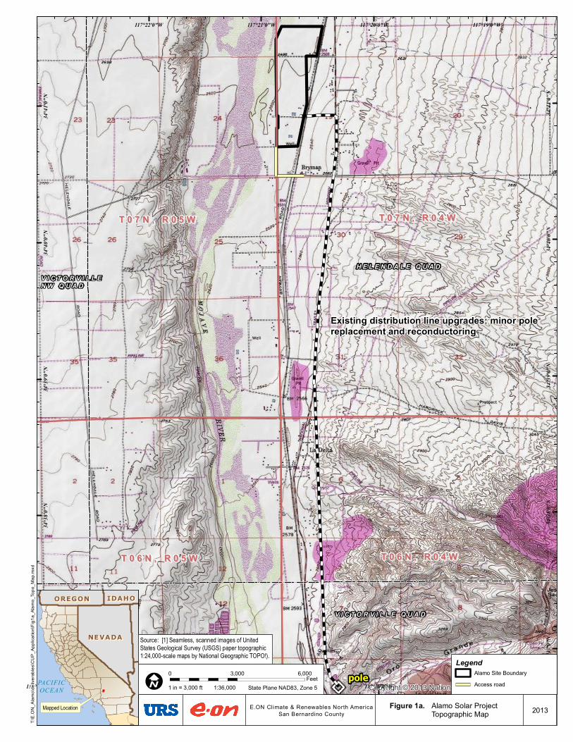
The Project site is situated in the western Mojave Desert, approximately 0.1 mile east of the seasonal Mojave River, and approximately 3 miles north of Oro Grande, 3.5 miles south of Helendale, 7.5 miles northeast of Adelanto, and approximately 10.5 miles northwest of downtown Victorville, California. Figures 1a and 1b illustrate the Project site and transmission line locations. The Project site is bordered to the north by agricultural lands; to the east by Bryman Road, the Atchison, Topeka & Santa Fe (AT&SF) Railroad, SR-66 and agricultural uses and vacant undeveloped lands; to the south by a combination of rural residential development and fallow agricultural land; and to the west by the Mojave River and agricultural uses. The parcels that make up the project site are primarily fallowed agricultural land with houses and outbuildings, all of which will be cleared prior to construction.
1.1.2 Interconnection and Distribution System Upgrades
The project includes distribution system upgrades that SCE will make from the project site to a point approximately five miles south near Oro Grande Canyon Road. These upgrades include wooden pole replacement and reconductoring. Construction of the upgrades will include use of staging areas, stringing locations, temporary construction easements and SCE’s existing permanent 10-foot wide easement. Short segments of new poles will also be
pole
V I C T O R V I L L E Q U A D
AD
ELA
NTO
QU
AD
H E L E N D A L E Q U A DV I C T O R V I L L E N W Q U A D
T 0 7 N , R 0 4 WT 0 7 N , R 0 4 WT 0 7 N , R 0 5 WT 0 7 N , R 0 5 W
T 0 6 N , R 0 4 WT 0 6 N , R 0 4 WT 0 6 N , R 0 5 WT 0 6 N , R 0 5 W
Copyright:© 2013 National Geographic Society, i-cubed117°19'0"W
117°19'0"W
117°20'0"W
117°20'0"W
117°21'0"W
117°21'0"W
117°22'0"W
117°22'0"W
117°23'0"W
34°4
1'0"N
34°4
1'0"N
34°4
0'0"N
34°4
0'0"N
34°3
9'0"N
34°3
9'0"N
34°3
8'0"N
34°3
8'0"N
34°3
7'0"N
34°3
7'0"N
T:\E.
ON_A
lamo\d
elive
rables
\CUP
_App
licatio
n\Fig1
a_Ala
mo_T
opo_
Map.m
xd
Mapped Location
PACIFICOCEAN
NEVADANEVADA
OREGONOREGON IDAHOIDAHO
2013E.ON Climate & Renewables North AmericaSan Bernardino County
Figure 1a. Alamo Solar ProjectTopographic Map
I0 3,000 6,000Feet
1:36,0001 in = 3,000 ft State Plane NAD83, Zone 5
Source: [1] Seamless, scanned images of UnitedStates Geological Survey (USGS) paper topographic1:24,000-scale maps by National Geographic TOPO!).
Existing distribution line upgrades: minor pole replacement and reconductoring
LegendAlamo Site BoundaryAccess road
pole
Dip poleNorth Riser
T 0 6 N , R 0 4 WT 0 6 N , R 0 4 WT 0 6 N , R 0 5 WT 0 6 N , R 0 5 W
T 0 5 N , R 0 4 WT 0 5 N , R 0 4 WT 0 5 N , R 0 5 WT 0 5 N , R 0 5 W
V I C T O R V I L L E Q U A D
Copyright:© 2013 National Geographic Society, i-cubed117°18'0"W
117°18'0"W
117°19'0"W
117°19'0"W
117°20'0"W
117°20'0"W
117°21'0"W
117°21'0"W
117°22'0"W
117°22'0"W
34°3
7'0"N
34°3
6'0"N
34°3
6'0"N
34°3
5'0"N
34°3
5'0"N
34°3
4'0"N
34°3
4'0"N
34°3
3'0"N
34°3
3'0"N
T:\E.
ON_A
lamo\d
elive
rables
\CUP
_App
licatio
n\Fig1
b_Ala
mo_T
opo_
Map.m
xd
Mapped Location
PACIFICOCEAN
NEVADANEVADA
OREGONOREGON IDAHOIDAHO
2013
I0 3,000 6,000Feet
1:36,0001 in = 3,000 ft State Plane NAD83, Zone 5
E.ON Climate & Renewables North AmericaSan Bernardino County
Source: [1] Seamless, scanned images of UnitedStates Geological Survey (USGS) paper topographic1:24,000-scale maps by National Geographic TOPO!).
Distribution line upgrades:undergrounding
Figure 1b. Alamo Solar ProjectTopographic Map
PALEONTOLOGICAL RESOURCES ASSESSMENT
ALAMO SOLAR PROJECT
P:\28907396 E.ON Alamo Solar Project\600 DLVR\601 - URS Prepared\Paleo - SCE T-Line\Paleo Assessment Report.docx 1-2
required and some existing 40-foot tall wooden poles would be replaced by 50-foot tall wooden poles.
Gen-tie line upgrades for the Project are planned to begin at the Project substation near the northwest corner of Melrose Road and Bryman /Aster Road, which represents the point of change of ownership between the project owner and SCE. Near the project substation, the Project owner will install a new customer-owned switch, and SCE will install a closer pole and a metering pole.
From this point, the current gen-tie line runs east for about 1,500 feet along the Melrose Road alignment, and then turns south along SR-66. Along the Melrose Road alignment, SCE will replace the existing 40-foot poles that now support a 4 kV line with taller, 50-foot poles to support both the existing 4 kV circuit and a new 33.5 kV circuit. Three new poles will be added along this segment; two within the project site and one additional pole at the intersection of the Melrose Road alignment and SR-66.
From the intersection of Melrose Road and National Trails Highway, the line will run south for about 2,500 feet to the intersection of SR-66 and Bryman Road. Along this segment, the line will use the existing SCE right-of-way for approximately 1,500 feet. SCE will replace the 40-foot poles with 50-foot poles, and add a third circuit of 33 kV to the two existing 33 kV and 4 kV circuits. The number and positions of all poles along this segment will remain the same. At this point, the line will shift approximately 40 feet west before continuing to run south within the public right-of-way along SR-66. Approximately four new poles will be added within this 1,000 foot segment before the line reaches the intersection of Bryman Road and SR-66. The four new poles will assume roughly the same horizontal positions as the poles that run along the existing alignment.
From the intersection of Bryman Road and SR-66, the line continues south within its present alignment for approximately 1.75 miles. New wires will be installed along this segment, and some poles will be replaced due to age, though all poles will remain in the same location.
Just south of the intersection of Barbosa Road and SR-66, the line breaks from the right-of-way of SR-66 and proceeds south along the east side of the highway within SCE’s current right-of-way. This segment will be upgraded with new wires. Due to the heavier conductor, some poles along this 35-pole segment will be added to shorten the spans, and some poles will be replaced due to age. Approximately 11 new poles will be added and 9 poles will be replaced.
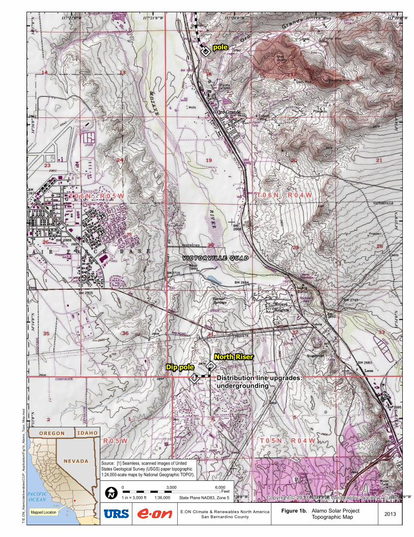
A final portion of the Project’s distribution upgrades will occur in an area that is not contiguous to the other upgrades and is located approximately 3.8 miles southeast of the terminus of the distribution feeder. This area is the southernmost portion of the distribution system illustrated in Figure 1b. This section occurs at the intersection of Village Drive and Rancho Road. The circuit starts at a riser pole on village road, runs south to Ranch Road, and
PALEONTOLOGICAL RESOURCES ASSESSMENT
ALAMO SOLAR PROJECT
P:\28907396 E.ON Alamo Solar Project\600 DLVR\601 - URS Prepared\Paleo - SCE T-Line\Paleo Assessment Report.docx 1-3
proceeds west to a second riser pole. The overall length of the affected duct bank is approximately 1,850 feet. Because the existing circuit was installed in conduit, the new conductors can be installed without modification to the conduit duct bank. Upgrades to this segment will occur without ground disturbance.
1.1.3 Project Operations
The solar facility would be unmanned and no new ground disturbance would occur.
1.2 SCOPE OF STUDY AND PERSONNEL
The scope of work for this paleontological assessment included searches of paleontological resource records at the San Bernardino County Museum (SBCM) and a search of pertinent published and unpublished geological and paleontological literature. No field visit was made for this study. The paleontological records search was requested of the SBCM on 24 May, 2013. Eric Scott of the SBCM provided the records search report on July 9, 2013 (Appendix A). URS paleontologist Dr. Joe Stewart prepared this assessment in conformance with the guidelines established by the SVP (SVP 1995).
PALEONTOLOGICAL RESOURCES ASSESSMENT
ALAMO SOLAR PROJECT
P:\28907396 E.ON Alamo Solar Project\600 DLVR\601 - URS Prepared\Paleo - SCE T-Line\Paleo Assessment Report.docx 2-1
SECTION 2.0 ENVIRONMENTAL SETTING
2.1 TOPOGRAPHY AND PHYSIOGRAPHY
The Project site lies on the eastern floodplain and terraces of the Mojave River. The site is relatively flat; elevation of the site ranges from approximately 2,490 feet above sea level (asl) to 2,520 feet asl, with topography gradually sloping to the north-northwest. Topographically, the Project site is dominated by the Mojave River and much high ground to the west and by the rolling slopes of Silver Mountain, Sparkhule Mountain, and Quartzite Mountain to the east. The Project site and most of the SCE gen-tie improvement corridor are located on the Helendale 7.5’ quadrangle. The rest of the gen-tie is located on the Victorville 7.5’ quadrangle. The Project lies within the Mojave Desert physiographic province (Norris and Webb 1990).
2.2 GEOLOGIC SETTING
The project site is situated on the southwestern edge of the Mojave block. The geology of the Project site is dominated by mountains, alluvial fans, and the Mojave River.
Multiple authors have mapped the geology of the project area. Dibblee (1967) mapped the Quartzite Mountain area at a scale of 1:36,875 and the western Mojave block at a scale of 1:125,000. Bortugno and Spittler (1986) mapped the San Bernardino quadrangle at a scale of 1:250,000. Hernandez et al., (2008) mapped the Victorville 7.5’ quadrangle at a scale of 1:24,000. Bezore and Shumway (1994) mapped the geology of southwestern San Bernardino County at a scale of 1:62,500.
Our study area lies within the southwest part of Northeast Mojave block. For millions of years, all of what is now southern California was part of the North American Plate. During this time, the Pacific Plate was being subducted beneath the California plate. Volcanism in the Barstow area accompanied this subduction. When subduction ceased in offshore southern California around 17-18 ma, the Pacific-North American transform boundary (San Andreas Fault) formed and associated rotation of the northeast Mojave block took place. Both crustal rotation and strike-slip faulting occurred in the area 17-18 Ma. After creation of the Pacific-North American transform boundary (the San Andreas Fault system), the Project area remained part of the North American Plate, but more southerly and westerly parts of southern California became part of the Pacific Plate.
Cox and Hillhouse (2000) summarized previous research and documented their own findings on Pleistocene geologic events of the Victorville/Helendale area.
PALEONTOLOGICAL RESOURCES ASSESSMENT
ALAMO SOLAR PROJECT
P:\28907396 E.ON Alamo Solar Project\600 DLVR\601 - URS Prepared\Paleo - SCE T-Line\Paleo Assessment Report.docx 3-1
SECTION 3.0 REGULATORY SETTING
CEQA provides regulations concerning significant impacts to paleontological resources. The following is a concise description of the state and local laws and regulations.
3.1 STATE LEVEL
3.1.1 California Environmental Quality Act
CEQA provides protection for paleontological resources through environmental legislation. Direction regarding significant impacts on paleontological resources is found under Appendix G (part V) of the CEQA Guidelines. The guidelines state, “A project will normally result in a significant impact on the environment if it will disrupt or adversely affect a paleontological resource or site or unique geologic feature, except as part of a scientific study.” Per section 5097.5 of the Public Resources Code, it is unlawful to remove paleontological remains without authorization and can result in a misdemeanor. In addition, Section 622.5 of the California Penal Code sets the penalties for damage or removal of paleontological resources.
3.2 LOCAL LEVEL
3.2.1 County of San Bernardino
The County of San Bernardino’s Development Code requires evaluation of potential paleontological resources as part of its CEQA review of proposed projects.
PALEONTOLOGICAL RESOURCES ASSESSMENT
ALAMO SOLAR PROJECT
P:\28907396 E.ON Alamo Solar Project\600 DLVR\601 - URS Prepared\Paleo - SCE T-Line\Paleo Assessment Report.docx 4-1
SECTION 4.0 METHODS
The methods used to develop the paleontological resource inventory of the Project site and surrounding area are described below. These procedures follow guidelines from the County of San Bernardino (County of San Bernardino, 2007) and the Society of Vertebrate Paleontology (SVP) (1995) and include both a literature search and a paleontological records search. No field visit was done for this study.
4.1 PALEONTOLOGICAL RESOURCES RECORDS SEARCH
On February 12, 2013, URS enlisted a paleontological records search through the Division of Geological Sciences at the SBCM in Redlands, California. Site records with supporting maps and documents are maintained at this facility. The record search included the examination of current geologic maps and any fossil localities inside the Project locality and within a one-mile radius around the Project boundaries. The record search is used to determine if any paleontological resources have been recovered within and around the project site, and establish a foundation for gauging the sensitivity of the Project site for additional and buried paleontological resources.
4.2 LITERATURE SEARCH
Pertinent published and unpublished geological literature, paleontological literature, and geologic mapping were searched for information on the area of the Project.
PALEONTOLOGICAL RESOURCES ASSESSMENT
ALAMO SOLAR PROJECT
P:\28907396 E.ON Alamo Solar Project\600 DLVR\601 - URS Prepared\Paleo - SCE T-Line\Paleo Assessment Report.docx 5-1
SECTION 5.0 RESULTS
5.1 PALEONTOLOGICAL RESOURCES RECORDS SEARCH
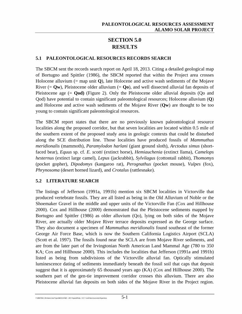
The SBCM sent the records search report on April 18, 2013. Citing a detailed geological map of Bortugno and Spittler (1986), the SBCM reported that within the Project area crosses Holocene alluvium (= map unit Q), late Holocene and active wash sediments of the Mojave River (= Qw), Pleistocene older alluvium (= Qo), and well dissected alluvial fan deposits of Pleistocene age (= Qod) (Figure 2). Only the Pleistocene older alluvial deposits (Qo and Qod) have potential to contain significant paleontological resources; Holocene alluvium (Q) and Holocene and active wash sediments of the Mojave River (Qw) are thought to be too young to contain significant paleontological resources.
The SBCM report states that there are no previously known paleontological resource localities along the proposed corridor, but that seven localities are located within 0.5 mile of the southern extent of the proposed study area in geologic contexts that could be disturbed along the SCE distribution line. Those localities have produced fossils of Mammuthus meridionalis (mammoth), Paramylodon harlani (giant ground sloth), Arctodus simus (short-faced bear), Equus sp. cf. E. scotti (extinct horse), Hemiauchenia (extinct llama), Camelops hesternus (extinct large camel), Lepus (jackrabbit), Sylvilagus (cottontail rabbit), Thomomys (pocket gopher), Dipodomys (kangaroo rat), Perognathus (pocket mouse), Vulpes (fox), Phrynosoma (desert horned lizard), and Crotalus (rattlesnake).
5.2 LITERATURE SEARCH
The listings of Jefferson (1991a, 1991b) mention six SBCM localities in Victorville that produced vertebrate fossils. They are all listed as being in the Old Alluvium of Noble or the Shoemaker Gravel in the middle and upper units of the Victorville Fan (Cox and Hillhouse 2000). Cox and Hillhouse (2000) demonstrated that the Pleistocene sediments mapped by Bortugno and Spittler (1986) as older alluvium (Qo), lying on both sides of the Mojave River, are actually older Mojave River terrace deposits expressed as the George surface. They also document a specimen of Mammuthus meridionalis found southeast of the former George Air Force Base, which is now the Southern California Logistics Airport (SCLA) (Scott et al. 1997). The fossils found near the SCLA are from Mojave River sediments, and are from the later part of the Irvingtonian North American Land Mammal Age (780 to 350 KA; Cox and Hillhouse 2000). This includes the localities that Jefferson (1991a and 1991b) listed as being from subdivisions of the Victorville alluvial fan. Optically stimulated luminescence dating of sediments immediately beneath the fossil soil that caps that deposit suggest that it is approximately 65 thousand years ago (KA) (Cox and Hillhouse 2000). The southern part of the gen-tie improvement corridor crosses this alluvium. There are also Pleistocene alluvial fan deposits on both sides of the Mojave River in the Project region.
")
!(
%
#Y
Path
:G:\g
is\pr
ojec
ts\15
77\2
8907
396\
map
_doc
s\m
xd\P
aleo
\Geo
logy
_USG
S.m
xd,p
aul_
mor
eno,
7/29
/201
3,10
:43:
16AM
SOURCES: Geologic Map (USGS, 1986)
SITE GEOLOGY MAPALAMO SOLAR
SAN BERNARDINO COUNTY, CA
CREATED BY: DS
PM: AR PROJ. NO: 28907452.00016
FIG. NO:
2SCALE: 1" = 1 Mile (1:63,360)
0.5 0 0.5 1 Miles
OSCALE CORRECT WHEN PRINTED AT 11X17
DATE: 7/29/2013
Legend
Alamo Site Boundary
Distribution Upgrades
Interconnection Facilities/Disribution Upgrades
Interconnection InterconnectionFacilities/Distribution Upgrades
!( Dip pole
North Riser
#Y Point Of Change Of Ownership
!A Point of Interconnection
% Victor Substation
") Pole
Geologic Map Units
Alluvium (Undifferentiated)
Older wash deposits (Alluvial deposits of abandoned washes)
Older alluvium (Undifferentiated)
Well dissected alluvial fans
Mesozoic metavolcanic rocks
Jurassic or Cretaceous granite
Upper Paleozoic limestone and marble
PALEONTOLOGICAL RESOURCES ASSESSMENT
ALAMO SOLAR PROJECT
P:\28907396 E.ON Alamo Solar Project\600 DLVR\601 - URS Prepared\Paleo - SCE T-Line\Paleo Assessment Report.docx 5-2
Research for permitting of a petroleum pipeline indicated that the Los Angeles County Museum of Natural History (LACM) has a locality on the bluffs of the west side of the Mojave River [presumably in the Qod (well-dissected alluvial fan deposits)] northwest of La Delta and southwest of Bryman (URS 2008). This would be just west of the Project. That locality produced fossils of Equus (horse) and Mammuthus columbi (mammoth). The same Qod sedimentary unit is crossed by the gen-tie improvement corridor (see Figure 2).
More recent geologic mapping (Hernandez et al. 2008) shows more detailed mapping of the Project area, and indicates that part of the southern end of the project may pass through landslide sediments. If this proves to be true, landslide sediments usually do not have high paleontological sensitivity.
PALEONTOLOGICAL RESOURCES ASSESSMENT
ALAMO SOLAR PROJECT
P:\28907396 E.ON Alamo Solar Project\600 DLVR\601 - URS Prepared\Paleo - SCE T-Line\Paleo Assessment Report.docx 6-1
SECTION 6.0 SUMMARY OF RESULTS AND MITIGATION
The paleontological resources records search conducted by SBCM and literature search shows that portions of the SCE gen-tie improvement corridor cross Pleistocene older alluvial deposits (Qo and Qod) that have potential to contain significant paleontological resources in surface and near surface contexts. Grading, trenching or other earth-moving activities in in such deposits have high potential to adversely impact significant nonrenewable paleontologic resources. County Development Code 82.20.040 requires that a qualified paleontologist develop a paleontological mitigation program including, but not limited to, a field survey before grading, monitoring during grading, and recovery, preparation, identification, reporting, and curation of recovered fossils. The paleontological monitor shall have the authority to halt grading to collect uncovered paleontological resources. However, if geotechnical evidence reveals that undisturbed Pleistocene sediments will not be impacted by excavations, paleontological monitoring would not be recommended.
The SBCM paleontology records review (Appendix A) provides a more detailed description of required mitigation measures.
PALEONTOLOGICAL RESOURCES ASSESSMENT
ALAMO SOLAR PROJECT
P:\28907396 E.ON Alamo Solar Project\600 DLVR\601 - URS Prepared\Paleo - SCE T-Line\Paleo Assessment Report.docx 7-1
SECTION 7.0 REFERENCES CITED
Bezore, S. P., and D. O. Shumway. 1994. Mineral land classification of a part of southwestern San Bernardino County: the Barstow-Victorville Area, California. California Geologic Survey Open-File Report 94-04.1:62,500.
Bortugno, E. J., and T. F. Spittler (compilers). 1986. Geologic map of the San Bernardino Quadrangle. California Division of Mines and Geology Regional Geologic Map Series Map 3A (Geologic). 1:250,000.
County of San Bernardino. 2007. 2007 Development Code.
Cox, B. F., and J. W. Hillhouse. 2000. Pliocene and Pleistocene evolution of the Mojave River, and associated tectonic development of the Transverse Ranges and Mojave Desert, based on borehole stratigraphy studies near Victorville, California. USGS Open File Report OF 00-147.
Hernandez, J. L., H. J. Brown, and B. F. Cox. 2008. Geologic map of the Victorville 7.5’ quadrangle, San Bernardino County, California: a digital database. California Geological Survey, Preliminary Geologic Maps. Scale 1:24,000.
Jefferson, G. T. 1991a. A catalogue of Late Quaternary Vertebrates from California: Part One, nonmarine lower vertebrate and avian taxa. Natural History Museum of Los Angeles County Technical Reports no. 5.
Jefferson, G. T. 1991b. A catalogue of Late Quaternary Vertebrates from California: Part Two, Mammals. Natural History Museum of Los Angeles County Technical Reports no. 7.
Scott, E., K. E. Springer, and L.K. Murray. 1997. New records of early Pleistocene vertebrates from the west-central Mojave Desert, San Bernardino County, California. Journal of Vertebrate Paleontology 17:75A.
URS Corporation. 2008. Calnev Pipeline Project: Paleontological Assessment Report. Report prepared for: Kinder Morgan. Report prepared by: URS Corporation, 1615 Murray Canyon Road, Suite 1000, San Diego, CA 92108.
PALEONTOLOGICAL RESOURCES ASSESSMENT
ALAMO SOLAR PROJECT
P:\28907396 E.ON Alamo Solar Project\600 DLVR\601 - URS Prepared\Paleo - SCE T-Line\Paleo Assessment Report.docx 1
APPENDIX A PALEONTOLOGY RECORDS REVIEW, ALAMO SOLAR PROJECT,
CITY OF VICTORVILLE AND VICINITY, SAN BERNARDINO COUNTY, CALIFORNIA