Embed Size (px)
Citation preview
planning and design guidelines manual section one community character and design 9
1Development Patterns
Spatial and Functional Relationships
Site Planning
Treatment of Transition Areas
Land Use
Residentail Neighborhoods
Non-Residential Development
Streetscape
Residential Neighborhoods
Non-Residential Development
10
10
16
17
17
18
18
18
19
planning and design guidelines manual section one community character and design10
chapter one
planning and design guidelines manual section one community character and design 11
development patterns
D E V E L O P M E N T PAT T E R N S
Community development patterns result from the location, site orientation and development of streets and land use components; and the spatial and functional interrelationships of these components. These guidelines are intended to encourage creative planning and design approaches for developing new raw land and infill sites in a manner that respect existing and adjacent community development patterns, while at the same time, providing for the formation of new development patterns to meet the desires of the community.
Spatial and Functional Relationship – Guidelines address the location, arrangement and orientation of land uses and buildings on a site to provide functional and visual connections to one another; immediately adjacent developments and the community as a whole.
S I T E P L A N N I N G
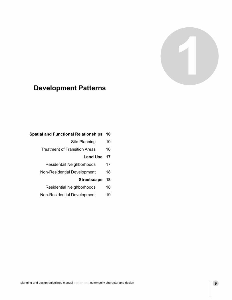
• At the pre-application meeting with City Staff, an applicant for new development should demonstrate knowledge and familiarity with the community’s preferences for the type and quality of new development desired; as well as the community’s desire to plan and design new development in a manner that is sensitive to the land and recognizes and gives consideration to adjoining existing and planned developments as well as the overall community.
Synthesis
Pre-Application Meetings
Illustrative Concepts
Prefered Concept
Final Plan Application
Hearings
Gather Info
figure 1.1: Development Application Process
planning and design guidelines manual section one community character and design10
chapter one
planning and design guidelines manual section one community character and design 11
development patterns
• To demonstrate the applicant’s awareness of community desires concerning new development, the applicant, at the pre-application meeting, should submit a written and illustrative planning/design concept which clearly identifies: the type, quality and character of the proposed development; how the development relates to, and connects physically with, adjacent development and the community as a whole; the significant site features and how they are incorporated into the project design; and the reasoning behind the proposed site plan and architecture.
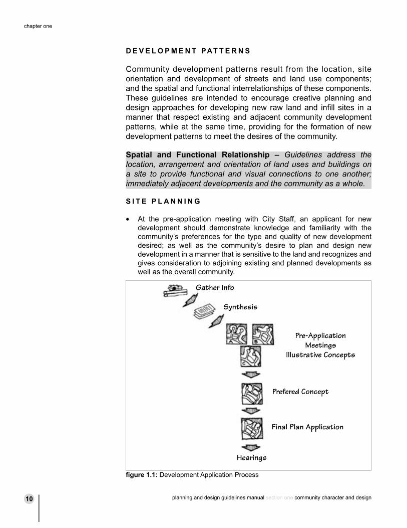
• Large development projects proposed for phased development should, to the greatest degree possible, be planned and designed so that each phase is complete and can exist independently in terms of its functional, vehicular and pedestrian circulation, open space, parking, drainage, landscaping and visual aspects; as well as its connectivity to adjoining existing developments and project phases yet to be completed.
• Site plans, building design and landscaping must reflect sensitivity to natural features of the site; including topography; adjacent uses and development; and views of surrounding mountains.
Through Road
Phase 1
Phase 2
Phase 3
figure 1.2: Phased Development
figure 1.3: View Corridor
planning and design guidelines manual section one community character and design12
chapter one
planning and design guidelines manual section one community character and design 13
development patterns
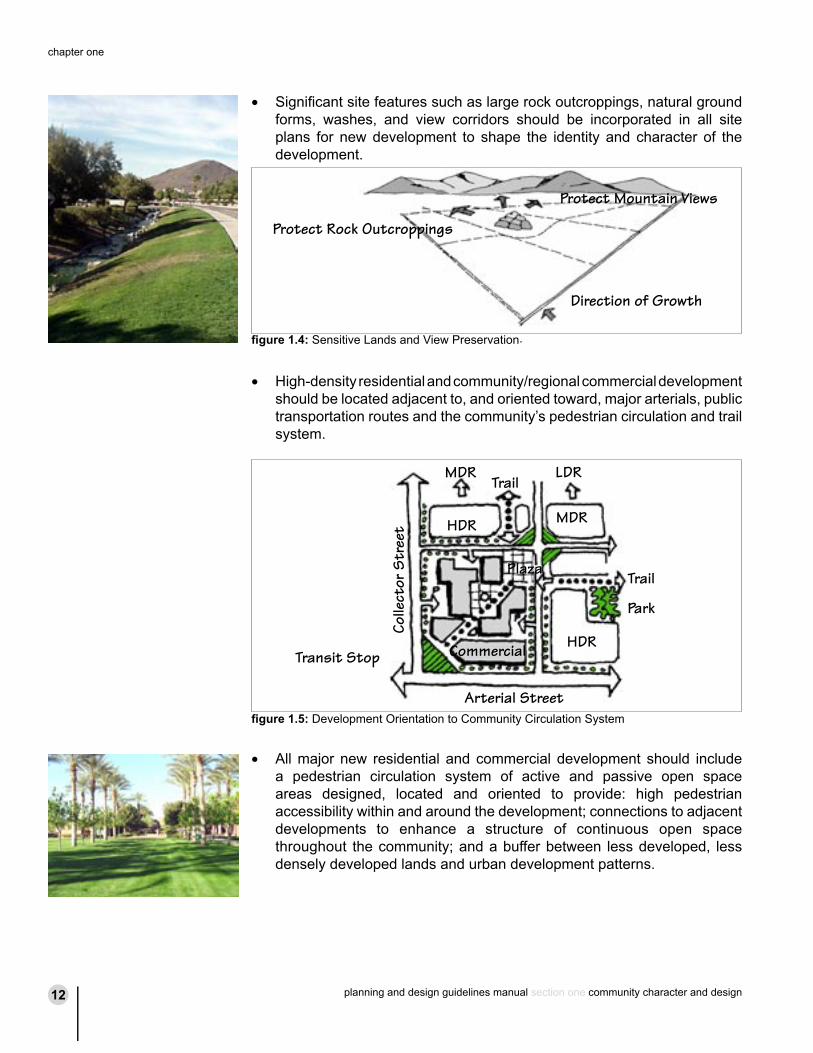
• Significant site features such as large rock outcroppings, natural ground forms, washes, and view corridors should be incorporated in all site plans for new development to shape the identity and character of the development.
• High-density residential and community/regional commercial development should be located adjacent to, and oriented toward, major arterials, public transportation routes and the community’s pedestrian circulation and trail system.
• All major new residential and commercial development should include a pedestrian circulation system of active and passive open space areas designed, located and oriented to provide: high pedestrian accessibility within and around the development; connections to adjacent developments to enhance a structure of continuous open space throughout the community; and a buffer between less developed, less densely developed lands and urban development patterns.
MDR
HDR
LDR
MDR
HDR
Park
Trail
Arterial Street
Colle
ctor
Str
eet
Commercial
Plaza
Trail
Transit Stop
figure 1.5: Development Orientation to Community Circulation System
Protect Mountain Views
Protect Rock Outcroppings
Direction of Growth
figure 1.4: Sensitive Lands and View Preservation.
planning and design guidelines manual section one community character and design12
chapter one
planning and design guidelines manual section one community character and design 13
development patterns
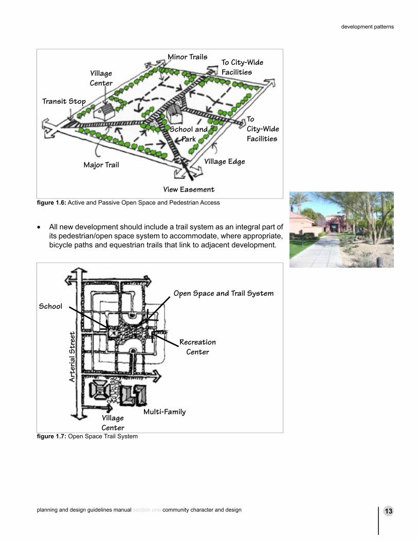
• All new development should include a trail system as an integral part of its pedestrian/open space system to accommodate, where appropriate, bicycle paths and equestrian trails that link to adjacent development.
School
Open Space and Trail System
Multi-FamilyVillage Center
Art
eria
l Str
eet
Recreation Center
figure 1.7: Open Space Trail System
Village Edge
View Easement
Major Trail
ToCity-Wide Facilities
To City-WideFacilities
School and Park
Transit Stop
VillageCenter
Minor Trails
figure 1.6: Active and Passive Open Space and Pedestrian Access
planning and design guidelines manual section one community character and design14
chapter one
planning and design guidelines manual section one community character and design 15
development patterns
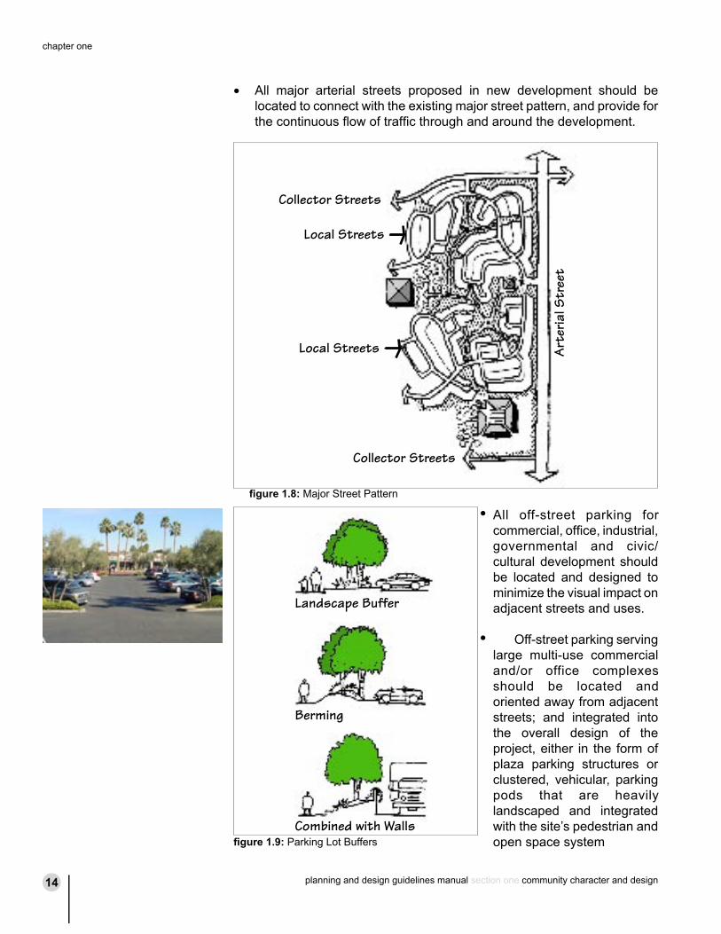
• All major arterial streets proposed in new development should be located to connect with the existing major street pattern, and provide for the continuous flow of traffic through and around the development.
All off-street parking for commercial, office, industrial, governmental and civic/cultural development should be located and designed to minimize the visual impact on adjacent streets and uses.
Off-street parking serving large multi-use commercial and/or office complexes should be located and oriented away from adjacent streets; and integrated into the overall design of the project, either in the form of plaza parking structures or clustered, vehicular, parking pods that are heavily landscaped and integrated with the site’s pedestrian and open space system
Landscape Buffer
Berming
Combined with Wallsfigure 1.9: Parking Lot Buffers
•
•
Collector Streets
Local Streets
Local Streets
Collector Streets
Art
eria
l Str
eet
figure 1.8: Major Street Pattern
planning and design guidelines manual section one community character and design14
chapter one
planning and design guidelines manual section one community character and design 15
development patterns
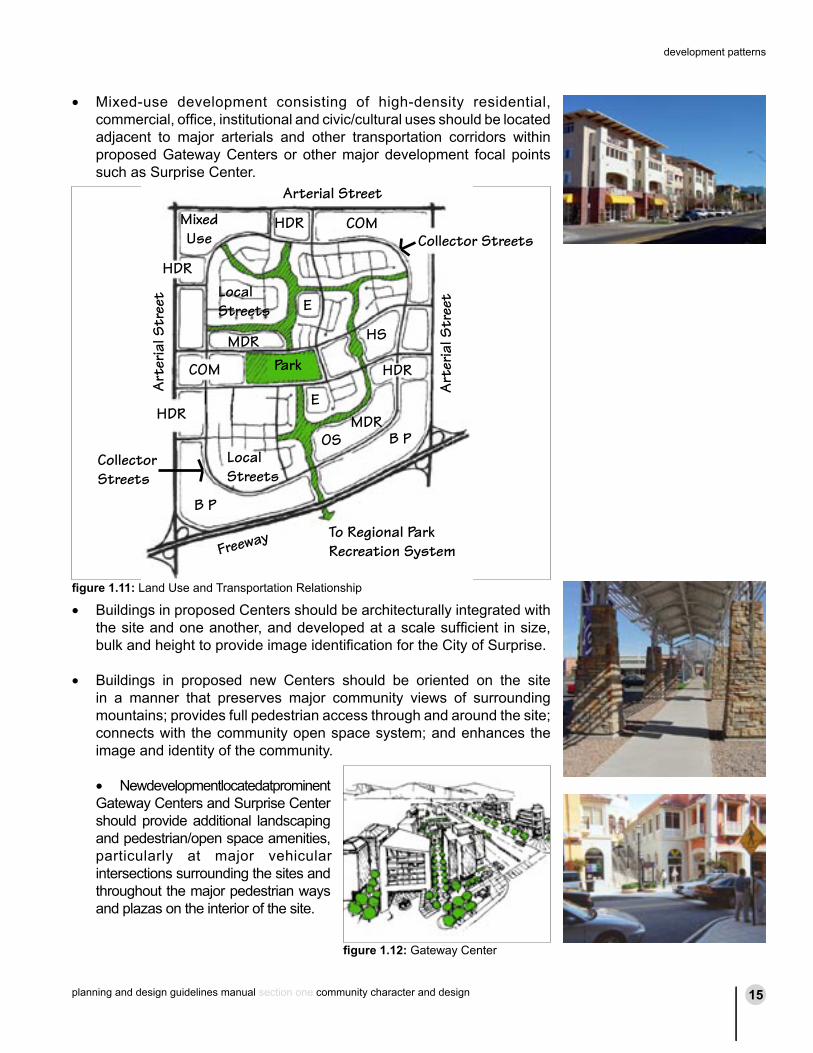
• Mixed-use development consisting of high-density residential, commercial, office, institutional and civic/cultural uses should be located adjacent to major arterials and other transportation corridors within proposed Gateway Centers or other major development focal points such as Surprise Center.
• Buildings in proposed Centers should be architecturally integrated with the site and one another, and developed at a scale sufficient in size, bulk and height to provide image identification for the City of Surprise.
• Buildings in proposed new Centers should be oriented on the site
in a manner that preserves major community views of surrounding mountains; provides full pedestrian access through and around the site; connects with the community open space system; and enhances the image and identity of the community.
• New development located at prominent Gateway Centers and Surprise Center should provide additional landscaping and pedestrian/open space amenities, particularly at major vehicular intersections surrounding the sites and throughout the major pedestrian ways and plazas on the interior of the site.
Arterial Street
Collector Streets
Park
Local Streets
Local Streets
Collector Streets
B P
B P
Freeway To Regional Park Recreation System
HDR
HDR
HDR
HDR
COM
OS
COM
HS
E
E
MixedUse
MDR
MDR
Art
eria
l Str
eet
Art
eria
l Str
eet
figure 1.11: Land Use and Transportation Relationship
figure 1.12: Gateway Center
planning and design guidelines manual section one community character and design16
chapter one
planning and design guidelines manual section one community character and design 17
development patterns
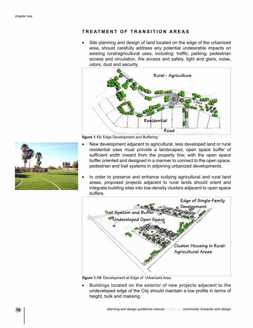
T R E AT M E N T O F T R A N S I T I O N A R E A S
• Site planning and design of land located on the edge of the urbanized area, should carefully address any potential undesirable impacts on existing rural/agricultural uses, including: traffic; parking; pedestrian access and circulation, fire access and safety, light and glare, noise, odors, dust and security.
• New development adjacent to agricultural, less developed land or rural residential uses must provide a landscaped, open space buffer of sufficient width inward from the property line; with the open space buffer oriented and designed in a manner to connect to the open space, pedestrian and trail systems in adjoining urbanized developments.
• In order to preserve and enhance outlying agricultural and rural land areas, proposed projects adjacent to rural lands should orient and integrate building sites into low-density clusters adjacent to open space buffers.
• Buildings located on the exterior of new projects adjacent to the undeveloped edge of the City should maintain a low profile in terms of height, bulk and massing.
Road
Rural - Agriculture
Residential
Undeveloped Open Space
Edge of Single-Family Development
Cluster Housing in Rural-Agricultural Areas
Trail System and Buffer
figure 1.13: Edge Development and Buffering
figure 1.14: Development at Edge of Urbanized Area
planning and design guidelines manual section one community character and design16
chapter one
planning and design guidelines manual section one community character and design 17
development patterns
• Major infill projects in existing neighborhoods should orient buildings, lighting, signage, parking and landscaping on the site to minimize the visual, solar access, noise, and lighting impact on adjacent uses and developments.
Land Use – Guidelines address appropriate location and intensity of residential and non-residential land uses.
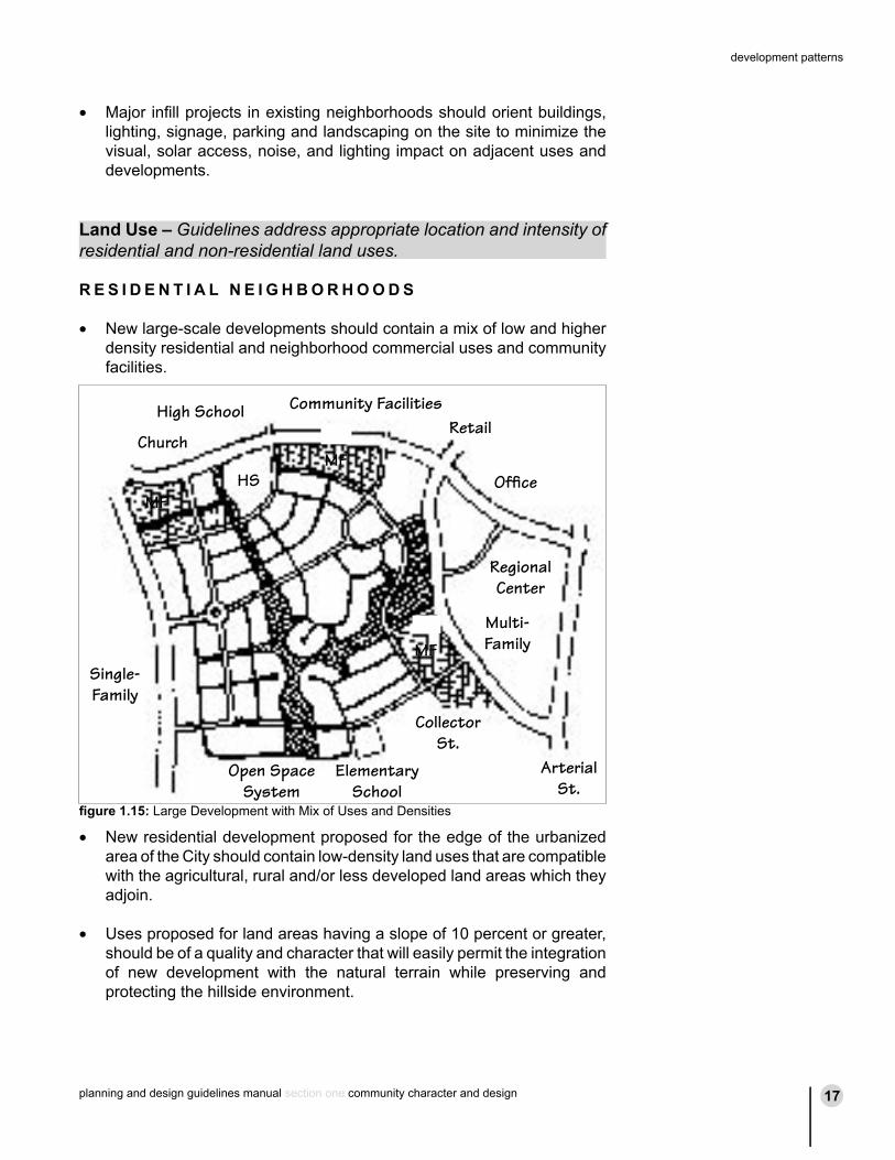
R E S I D E N T I A L N E I G H B O R H O O D S
• New large-scale developments should contain a mix of low and higher density residential and neighborhood commercial uses and community facilities.
• New residential development proposed for the edge of the urbanized area of the City should contain low-density land uses that are compatible with the agricultural, rural and/or less developed land areas which they adjoin.
• Uses proposed for land areas having a slope of 10 percent or greater, should be of a quality and character that will easily permit the integration of new development with the natural terrain while preserving and protecting the hillside environment.
Church
High School
HS
Community FacilitiesRetail
Office
Regional Center
Multi-FamilyMF
MF
MF
ArterialSt.
CollectorSt.
ElementarySchool
Open SpaceSystem
Single-Family
figure 1.15: Large Development with Mix of Uses and Densities
planning and design guidelines manual section one community character and design18
chapter one
planning and design guidelines manual section one community character and design 19
development patterns
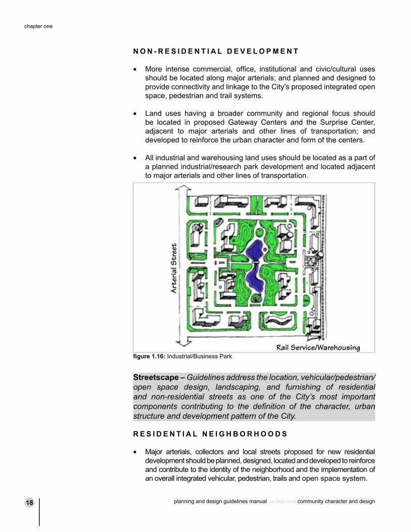
N O N - R E S I D E N T I A L D E V E L O P M E N T
• More intense commercial, office, institutional and civic/cultural uses should be located along major arterials; and planned and designed to provide connectivity and linkage to the City’s proposed integrated open space, pedestrian and trail systems.
• Land uses having a broader community and regional focus should be located in proposed Gateway Centers and the Surprise Center, adjacent to major arterials and other lines of transportation; and developed to reinforce the urban character and form of the centers.
• All industrial and warehousing land uses should be located as a part of a planned industrial/research park development and located adjacent to major arterials and other lines of transportation.
Streetscape – Guidelines address the location, vehicular/pedestrian/open space design, landscaping, and furnishing of residential and non-residential streets as one of the City’s most important components contributing to the definition of the character, urban structure and development pattern of the City.
R E S I D E N T I A L N E I G H B O R H O O D S
• Major arterials, collectors and local streets proposed for new residential development should be planned, designed, located and developed to reinforce and contribute to the identity of the neighborhood and the implementation of an overall integrated vehicular, pedestrian, trails and open space system.
Rail Service/Warehousing
Art
eria
l Str
eet
figure 1.16: Industrial/Business Park
planning and design guidelines manual section one community character and design18
chapter one
planning and design guidelines manual section one community character and design 19
development patterns
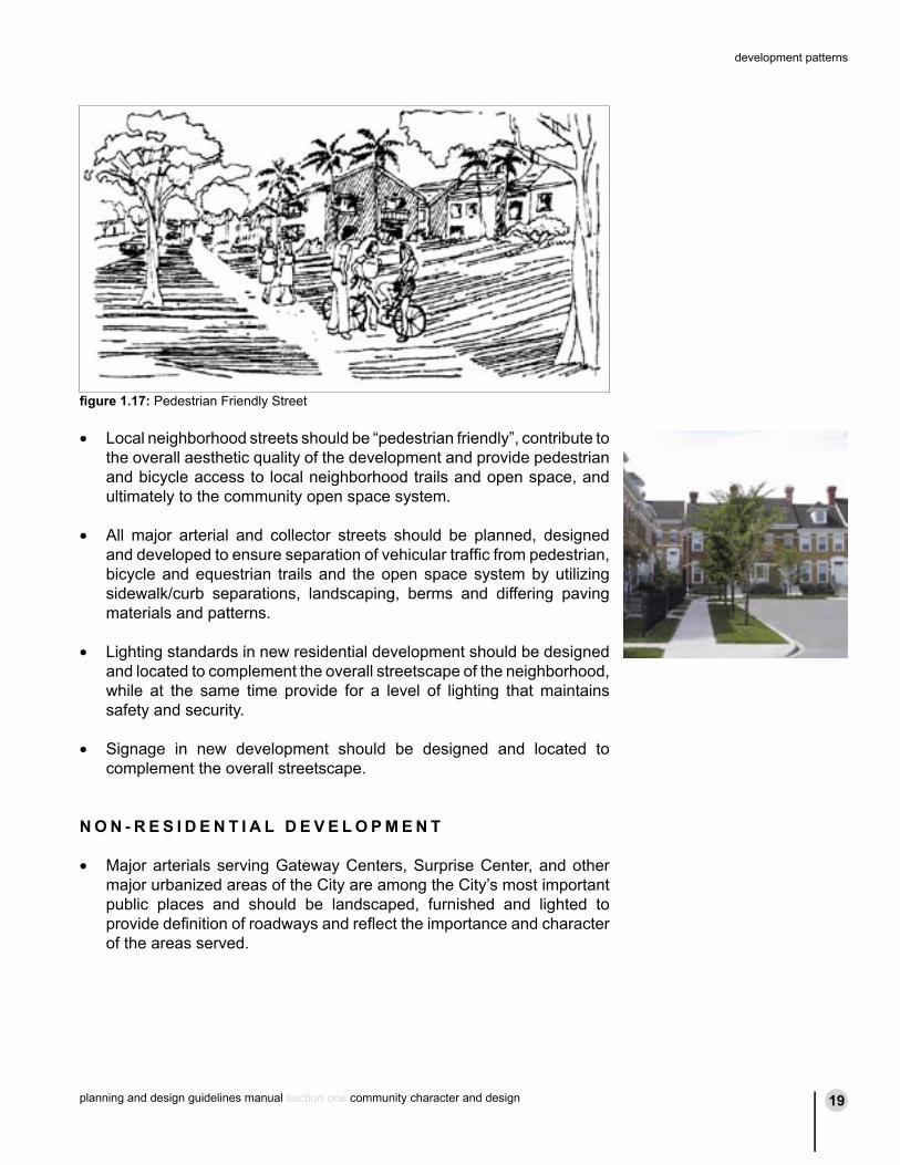
• Local neighborhood streets should be “pedestrian friendly”, contribute to the overall aesthetic quality of the development and provide pedestrian and bicycle access to local neighborhood trails and open space, and ultimately to the community open space system.
• All major arterial and collector streets should be planned, designed and developed to ensure separation of vehicular traffic from pedestrian, bicycle and equestrian trails and the open space system by utilizing sidewalk/curb separations, landscaping, berms and differing paving materials and patterns.
• Lighting standards in new residential development should be designed and located to complement the overall streetscape of the neighborhood, while at the same time provide for a level of lighting that maintains safety and security.
• Signage in new development should be designed and located to complement the overall streetscape.
N O N - R E S I D E N T I A L D E V E L O P M E N T
• Major arterials serving Gateway Centers, Surprise Center, and other major urbanized areas of the City are among the City’s most important public places and should be landscaped, furnished and lighted to provide definition of roadways and reflect the importance and character of the areas served.
figure 1.17: Pedestrian Friendly Street
planning and design guidelines manual section one community character and design20
chapter one
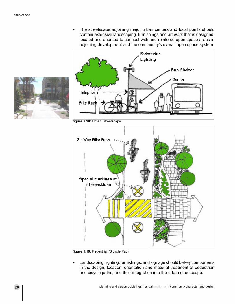
• The streetscape adjoining major urban centers and focal points should contain extensive landscaping, furnishings and art work that is designed, located and oriented to connect with and reinforce open space areas in adjoining development and the community’s overall open space system.
• Landscaping, lighting, furnishings, and signage should be key components in the design, location, orientation and material treatment of pedestrian and bicycle paths, and their integration into the urban streetscape.
PedestrianLighting
Telephone
Bike Rack
Bus Shelter
Bench
Special markings at intersections
2 - Way Bike Path
figure 1.18: Urban Streetscape
figure 1.19: Pedestrian/Bicycle Path