Embed Size (px)
Citation preview
1
The Real Time GPS Tracking on the Image Satellite by using Geographical Information System Program
Sabah Hussein Ali
Remote Sensing Center University of Mosul
AbstractSpatial data is the crucial component of a GIS. The important sources of spatial data are the already existing digital files, maps, which can be digitized, image satellite, aerial photography and more recently GPS. GPS (mapping type receivers) can be used to map an area and the data can be converted into GIS compatible forms. The principle objective of the present study, is to combine a portable (GPS, type: GPSMAP76SCx) device with the GIS software (Global Mapper 10.0) a laptop computer as a one tracking system, to monitor the real time tracking path of the moving vehicle on the image satellite of the Mosul University Campus (i.e.; integrate image-based road tracking (local) and GPS (global) data) and to study the effect of the spatial resolution and the georeferncing coordinate system of the image satellite on the positional accuracy of the GPS tracking path. In order to present consistent representation of reality, several layers of GIS datasets with different resolution have been used to view the GPS tracking path. The results show that the level of the positional accuracy of the GPS tracking path depend on the type and accuracy of the used GPS, the accuracy of georeferncing coordinate system and spatial resolution of the adopted image satellites (GIS layers). It's also show that the applying of satellite images in consecutive time can be give an illustration for the updating the maps in the GIS database for the purpose of planning, mapping, and surveying applications.
1031

2
یة باستخدام برامجیات نظم المعلومات المسار اآلني لمنظومة تحدید الموقع العالمي على البیانات الفضائالجغرافیة
صباح حسين علي
مركز التحسس النائي
جامعة الموصل
الملخص
البيانات المكانية من العناصر الجوهرية في برامجيات نظم المعلومات الجغرافية، والمصـادر المهمـة تعتبر
إلـى باإلضـافة ، البيانـات الفضـائية الجوية صورالملفات البيانات الرقمية ، الخرائط ، : لهذه البيانات هي
حيث يمكن اسـتخدام اجهـزة تحديـد المواقـع ). GPS(البيانات المستلمة من اجهزة تحديد المواقع العالمي
في تحديد ورسم معالم منطقة معينة وتشكيل خارطة لها وبالتـالي تحويـل ) المستقبالت نوع راسمة الخرائط(
. امتداد يتوافق مع برامجيات نظم المعلومات الجغرافية لغرض المعالجة والتحليلإلىبيانات هذه الخارطة
لمسار مركبة متحركة على بيـان فضـائي ضـمن اآلنيمن الدراسة الحالية هو العرض األساسيالهدف إن
الحرم الجامعي لجامعة الموصل من خالل بناء منظومة تتبع مالحية متكون جهـاز لتحديـد المواقـع نـوع
)PSMAP76SCxG (جيات نظم المعلومات الجغرافية ميتفاعل مع احد برا)Global Mapper10.0 ( مـن
ودراسة تأثير نظام اإلحداثيات والدقة المكانية للبيان الفضائي على دقـة المسـار اآلنـي خالل حاسبة دفترية
وبدقة مختلفة لغرض توضيح لقد تم استخدام عدة طبقات من البيانات الفضائية. لجهاز منظومة تحديد المواقع
تعتمد لمنظومة تحديد المواقع اآلنيالنتائج أن دقة المسار أظهرت. تأثير دقة البيان الفضائي على نتائج البحث
. المعتمـدة لبيانـات الفضـائية دقة نظام اإلحداثيات والدقة المكانية لعلى على نوع ودقة الجهاز المستخدم ، و
استخدام بيانات فضائية ألي منطقة دراسة وبفترات زمنية متعاقبة ستعتبر عامال وأظهرت النتائج أيضا إلى أن
ألغراض التخطيط ورسم الخرائط والمسـح مهما لتحديث الخرائط في قاعدة بيانات نظم المعلومات الجغرافية
. الميداني
1032
3
IntroductionRemote sensing techniques make it possible to obtain and distribute information rapidly over large areas by means of sensors operating in several spectral bands, mounted on aircraft or satellites. The spectral bands used by these sensors cover the whole range between visible and microwaves. Rapid developments in computer technology and the Geographical Information Systems (GIS) help to process Remote Sensing (RS) observations from satellites in a spatial format of maps[1]. The integration of information derived from RS techniques with other datasets - both in spatial and non-spatial formats provides tremendous potential for the ability of identification, monitoring of the moving targets.A Geographic Information System is a collection of geographically referenced information along with software that provides the capability of organizing, manipulating and visualizing that information datasets. Datasets are organized as layers to create a digital representation of an area. Each layer provides some information about the reality. A layer can be a surface model of the terrain, an aerial image, a street map, or a distribution of population for a given area [2]. These maps or images are useful to locate the address of a moving target fitted with GPS receiver.The widespread used of GPS in a terrestrial, marine, and airborne applications [3, 4, 5] has been participated by its accuracy (with respect to the applied map scale) and global availability. The high accuracy that GPS provides has GIS professionals storing and managing their data in new ways. GIS now supports a double precision database, and GIS users are developing new methods for improving the spatial quality of the existing data in their systems. GPS provides a key component for this, but there are many considerations when using GPS to obtain and understand accurate positions. In this paper we present a study of the functionality, accuracy issues and processes of data collection via GPS and demonstrates the ability to provide an effective real-time track navigation capability by the integration of GPS data into a GIS software.
GPS and Mapping programsThe principle behind GPS is that receivers are able to use the technique of "trilateration " to calculate their coordinates on earth by measuring the time taken for signals from various satellites to reach them. [6]. The GPS receiver convert the satellites' signals into position, velocity, and time. This information is used for navigation, positioning, time dissemination, and research.However, the GPS software will account for any irregularities in the signal strength and clock differences between itself and the GPS satellite network by using signals from four separate satellites to improve the positional accuracy [7]. Usually the coordinates are then used to calculate the GPS device on a map, which is either display to the user or used as a basis for calculating routes, navigation, or as an input into mapping programs (such as: ArcGIS Desktop, Global Mapper and OziExplorer …etc.). The readout GPS accuracy is defines the estimated horizontal position errorindicated by a GPS receiver and can be calculated by the following equation [ 8 ]:
1033
4
N
ErrorErrorRMS
N
ii
1
2
_ ………………….. 1
Where N is represent the number of errors
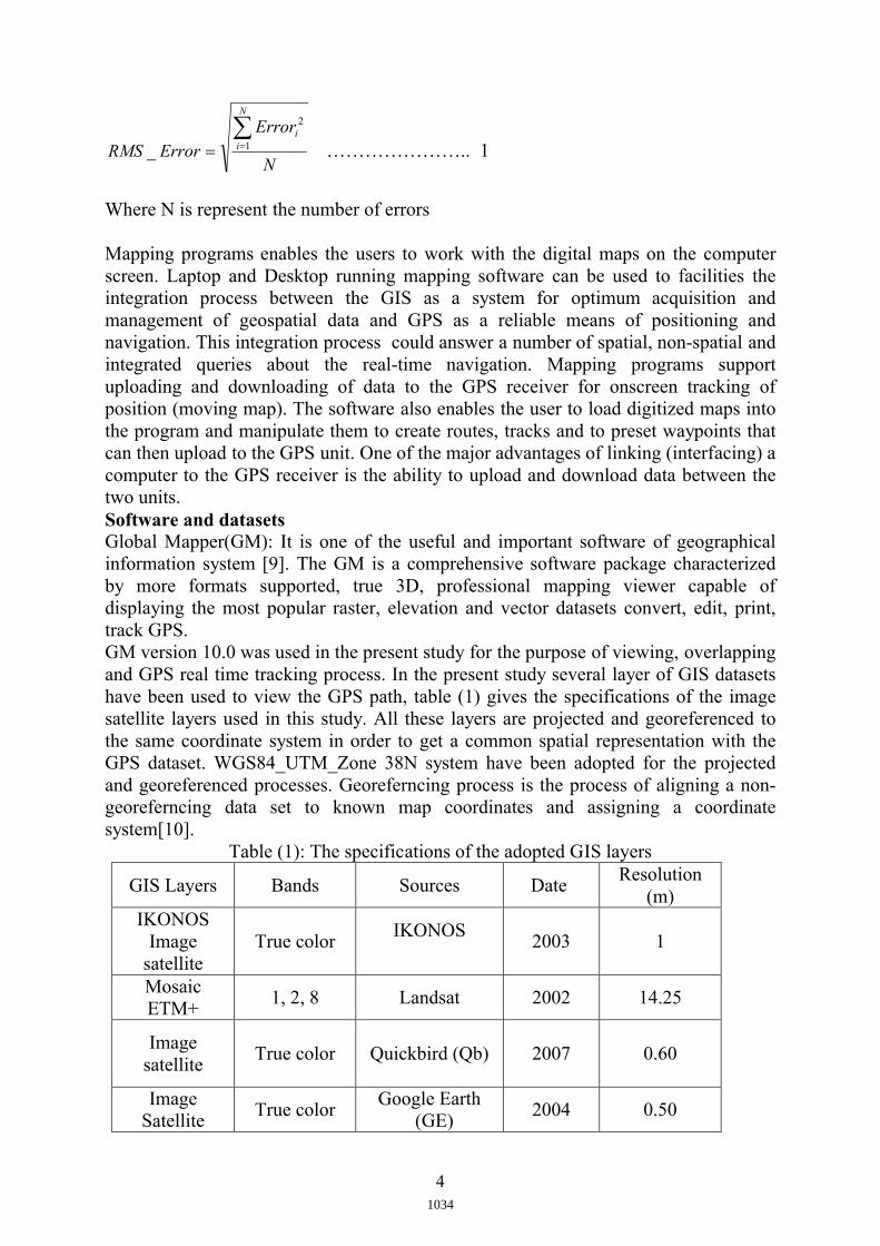
Mapping programs enables the users to work with the digital maps on the computer screen. Laptop and Desktop running mapping software can be used to facilities the integration process between the GIS as a system for optimum acquisition and management of geospatial data and GPS as a reliable means of positioning and navigation. This integration process could answer a number of spatial, non-spatial and integrated queries about the real-time navigation. Mapping programs support uploading and downloading of data to the GPS receiver for onscreen tracking of position (moving map). The software also enables the user to load digitized maps into the program and manipulate them to create routes, tracks and to preset waypoints thatcan then upload to the GPS unit. One of the major advantages of linking (interfacing) a computer to the GPS receiver is the ability to upload and download data between the two units.Software and datasetsGlobal Mapper(GM): It is one of the useful and important software of geographical information system [9]. The GM is a comprehensive software package characterizedby more formats supported, true 3D, professional mapping viewer capable of displaying the most popular raster, elevation and vector datasets convert, edit, print, track GPS.GM version 10.0 was used in the present study for the purpose of viewing, overlapping and GPS real time tracking process. In the present study several layer of GIS datasetshave been used to view the GPS path, table (1) gives the specifications of the image satellite layers used in this study. All these layers are projected and georeferenced to the same coordinate system in order to get a common spatial representation with the GPS dataset. WGS84_UTM_Zone 38N system have been adopted for the projected and georeferenced processes. Georeferncing process is the process of aligning a non-georeferncing data set to known map coordinates and assigning a coordinate system[10].
Table (1): The specifications of the adopted GIS layersResolution
(m)Date SourcesBandsGIS Layers
12003IKONOS
True colorIKONOS
Image satellite
14.252002Landsat1, 2, 8Mosaic ETM+
0.602007Quickbird (Qb) True colorImage
satellite
0.502004Google Earth
(GE)True color
Image Satellite
1034
5
The applied of different layers in GIS with GPS, gives attempted to present a consistent representation of the reality. All the image satellites listed in the table (1) have been originally georeferncing-corrected except the Google earth' image have been corrected by the author by using the Modify layer position / projection (Re-Rectify ) option in the GM10.0. The georeferncing process was performed according to UTM_WGS84_38N system.
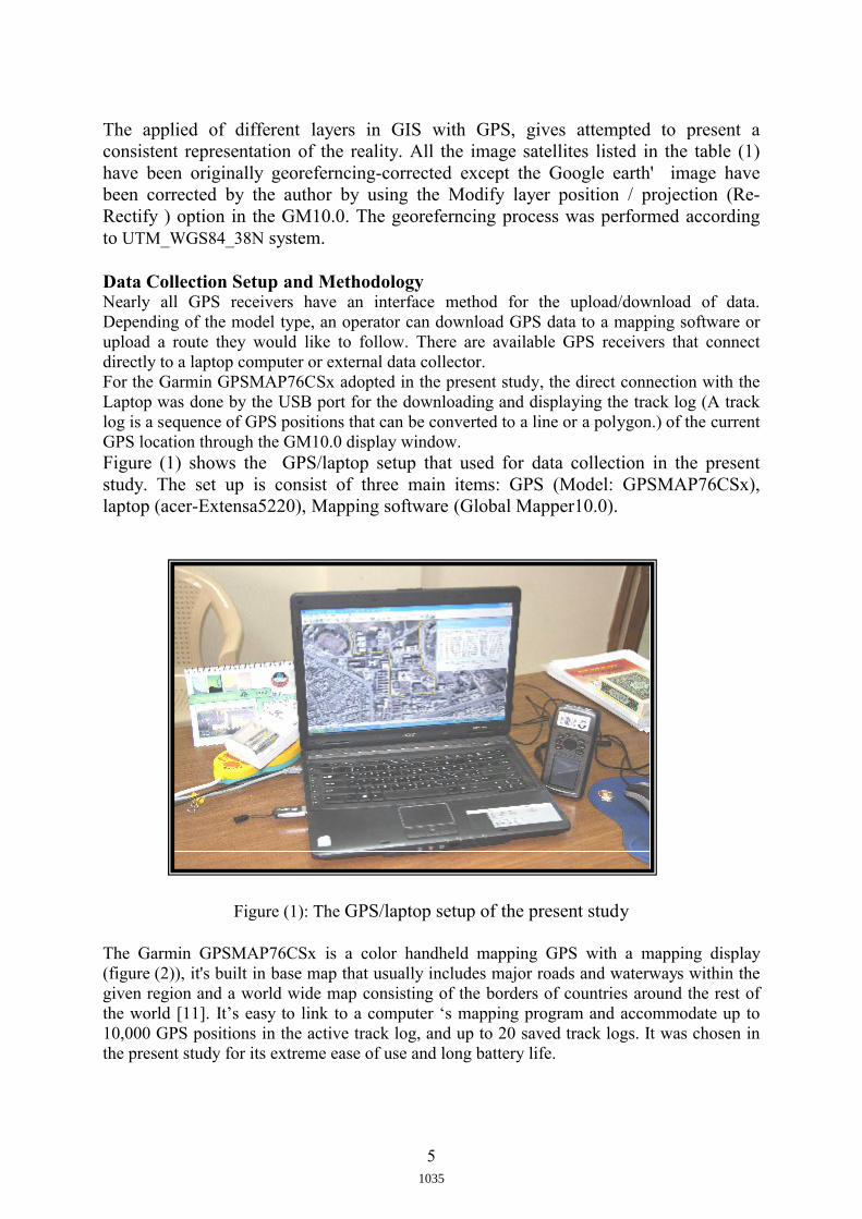
Data Collection Setup and MethodologyNearly all GPS receivers have an interface method for the upload/download of data. Depending of the model type, an operator can download GPS data to a mapping software or upload a route they would like to follow. There are available GPS receivers that connect directly to a laptop computer or external data collector. For the Garmin GPSMAP76CSx adopted in the present study, the direct connection with the Laptop was done by the USB port for the downloading and displaying the track log (A track log is a sequence of GPS positions that can be converted to a line or a polygon.) of the current GPS location through the GM10.0 display window. Figure (1) shows the GPS/laptop setup that used for data collection in the present study. The set up is consist of three main items: GPS (Model: GPSMAP76CSx), laptop (acer-Extensa5220), Mapping software (Global Mapper10.0).
Figure (1): The GPS/laptop setup of the present study
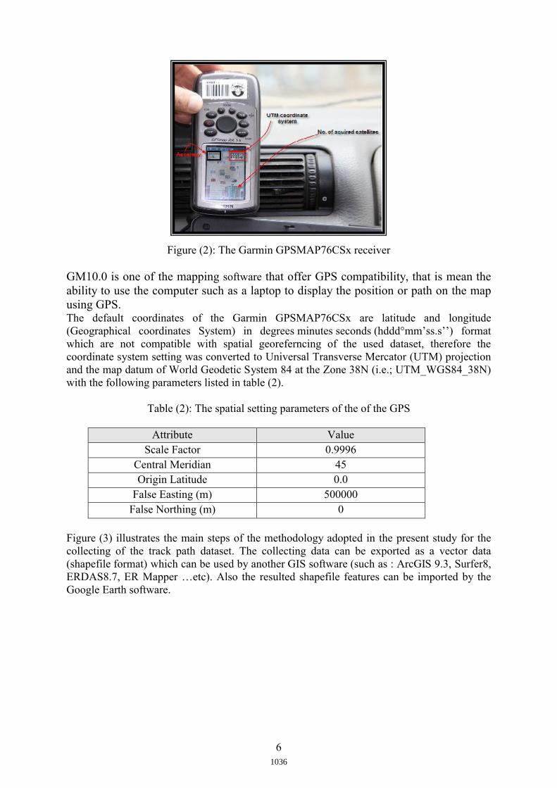
The Garmin GPSMAP76CSx is a color handheld mapping GPS with a mapping display(figure (2)), it's built in base map that usually includes major roads and waterways within the given region and a world wide map consisting of the borders of countries around the rest of the world [11]. It’s easy to link to a computer ‘s mapping program and accommodate up to 10,000 GPS positions in the active track log, and up to 20 saved track logs. It was chosen in the present study for its extreme ease of use and long battery life.
1035
6
Figure (2): The Garmin GPSMAP76CSx receiver
GM10.0 is one of the mapping software that offer GPS compatibility, that is mean the ability to use the computer such as a laptop to display the position or path on the map using GPS. The default coordinates of the Garmin GPSMAP76CSx are latitude and longitude(Geographical coordinates System) in degrees minutes seconds (hddd°mm’ss.s’’) format which are not compatible with spatial georeferncing of the used dataset, therefore the coordinate system setting was converted to Universal Transverse Mercator (UTM) projection and the map datum of World Geodetic System 84 at the Zone 38N (i.e.; UTM_WGS84_38N) with the following parameters listed in table (2).
Table (2): The spatial setting parameters of the of the GPS
Attribute ValueScale Factor 0.9996
Central Meridian 45Origin Latitude 0.0
False Easting (m) 500000False Northing (m) 0
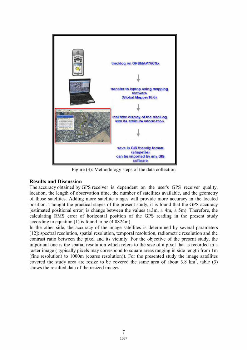
Figure (3) illustrates the main steps of the methodology adopted in the present study for the collecting of the track path dataset. The collecting data can be exported as a vector data (shapefile format) which can be used by another GIS software (such as : ArcGIS 9.3, Surfer8, ERDAS8.7, ER Mapper …etc). Also the resulted shapefile features can be imported by the Google Earth software.
1036
7
Figure (3): Methodology steps of the data collection
Results and DiscussionThe accuracy obtained by GPS receiver is dependent on the user's GPS receiver quality, location, the length of observation time, the number of satellites available, and the geometry of those satellites. Adding more satellite ranges will provide more accuracy in the located position. Thought the practical stages of the present study, it is found that the GPS accuracy(estimated positional error) is change between the values (±3m, ± 4m, ± 5m). Therefore, the calculating RMS error of horizontal position of the GPS reading in the present study according to equation (1) is found to be (4.0824m). In the other side, the accuracy of the image satellites is determined by several parameters[12]: spectral resolution, spatial resolution, temporal resolution, radiometric resolution and the contrast ratio between the pixel and its vicinity. For the objective of the present study, the important one is the spatial resolution which refers to the size of a pixel that is recorded in a raster image ( typically pixels may correspond to square areas ranging in side length from 1m (fine resolution) to 1000m (coarse resolution)). For the presented study the image satellitescovered the study area are resize to be covered the same area of about 3.8 km2, table (3) shows the resulted data of the resized images.
1037
8
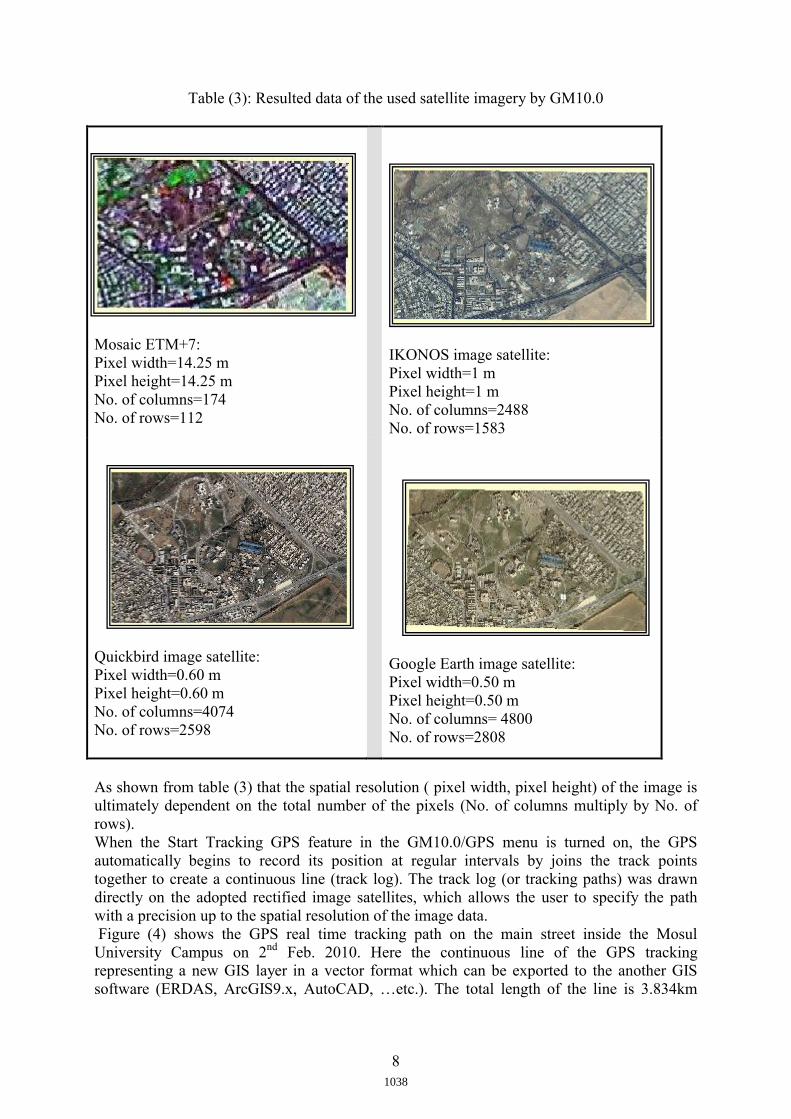
Table (3): Resulted data of the used satellite imagery by GM10.0
Mosaic ETM+7:Pixel width=14.25 mPixel height=14.25 mNo. of columns=174No. of rows=112
IKONOS image satellite:Pixel width=1 mPixel height=1 mNo. of columns=2488No. of rows=1583
Quickbird image satellite:Pixel width=0.60 mPixel height=0.60 mNo. of columns=4074No. of rows=2598
Google Earth image satellite:Pixel width=0.50 mPixel height=0.50 mNo. of columns= 4800No. of rows=2808
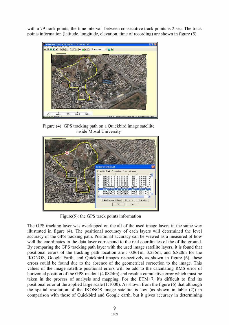
As shown from table (3) that the spatial resolution ( pixel width, pixel height) of the image is ultimately dependent on the total number of the pixels (No. of columns multiply by No. of rows). When the Start Tracking GPS feature in the GM10.0/GPS menu is turned on, the GPS automatically begins to record its position at regular intervals by joins the track pointstogether to create a continuous line (track log). The track log (or tracking paths) was drawn directly on the adopted rectified image satellites, which allows the user to specify the path with a precision up to the spatial resolution of the image data.Figure (4) shows the GPS real time tracking path on the main street inside the Mosul University Campus on 2nd Feb. 2010. Here the continuous line of the GPS tracking representing a new GIS layer in a vector format which can be exported to the another GIS software (ERDAS, ArcGIS9.x, AutoCAD, …etc.). The total length of the line is 3.834km
1038
9
with a 79 track points, the time interval between consecutive track points is 2 sec. The track points information (latitude, longitude, elevation, time of recording) are shown in figure (5).
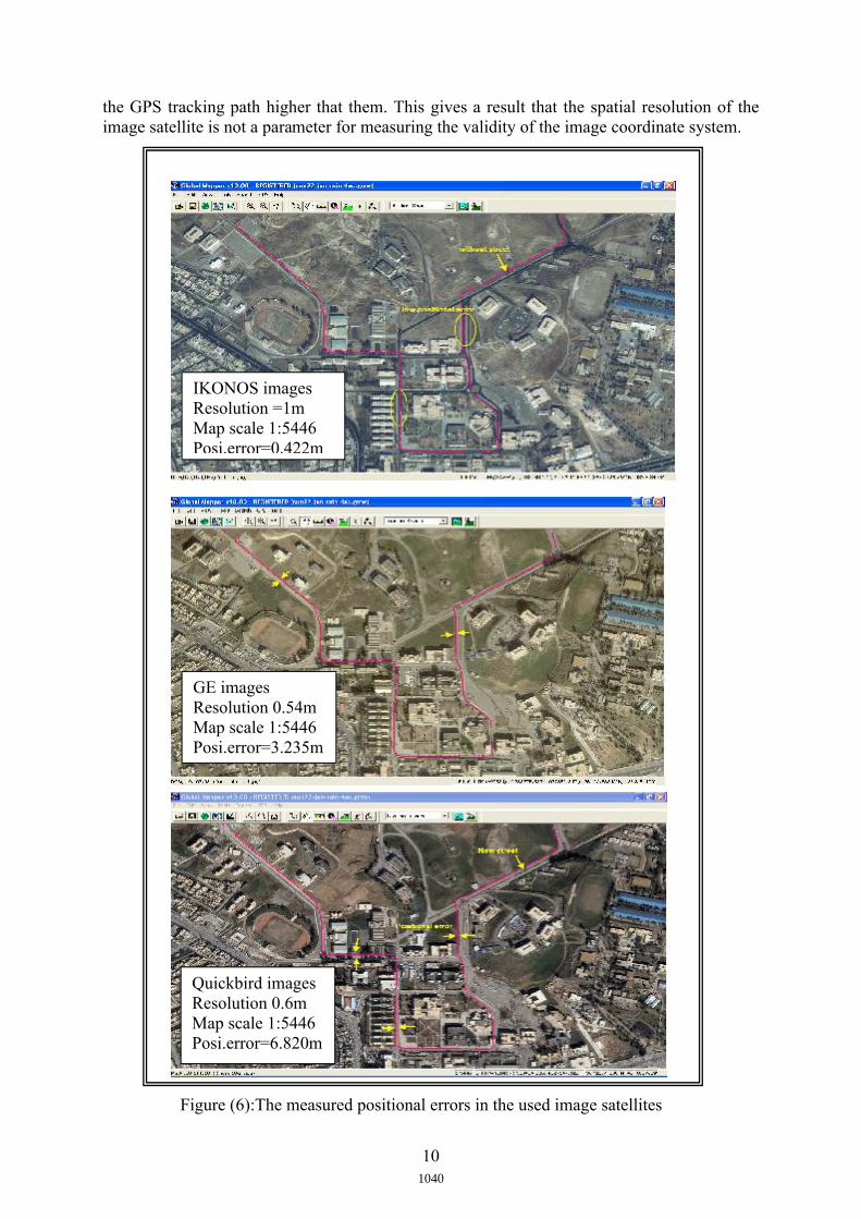
The GPS tracking layer was overlapped on the all of the used image layers in the same way illustrated in figure (4). The positional accuracy of each layers will determined the level accuracy of the GPS tracking path. Positional accuracy can be viewed as a measured of how well the coordinates in the data layer correspond to the real coordinates of the of the ground.By comparing the GPS tracking path layer with the used image satellite layers, it is found that positional errors of the tracking path location are : 0.861m, 3.235m, and 6.820m for the IKONOS, Google Earth, and Quickbird images respectively as shown in figure (6), these errors could be found due to the absence of the geometrical correction to the image. This values of the image satellite positional errors will be add to the calculating RMS error of horizontal position of the GPS readout (4.0824m) and result a cumulative error which must be taken in the process of analysis and mapping. For the ETM+7, it's difficult to find its positional error at the applied large scale (1:1000). As shown from the figure (6) that although the spatial resolution of the IKONOS image satellite is low (as shown in table (2)) in comparison with those of Quickbird and Google earth, but it gives accuracy in determining
Figure (4): GPS tracking path on a Quickbird image satellite inside Mosul University
Figure(5): the GPS track points information
1039
10
the GPS tracking path higher that them. This gives a result that the spatial resolution of the image satellite is not a parameter for measuring the validity of the image coordinate system.
IKONOS images Resolution =1m Map scale 1:5446Posi.error=0.422m
GE images Resolution 0.54m Map scale 1:5446Posi.error=3.235m
Quickbird images Resolution 0.6m Map scale 1:5446Posi.error=6.820m
Figure (6):The measured positional errors in the used image satellites
1040
11
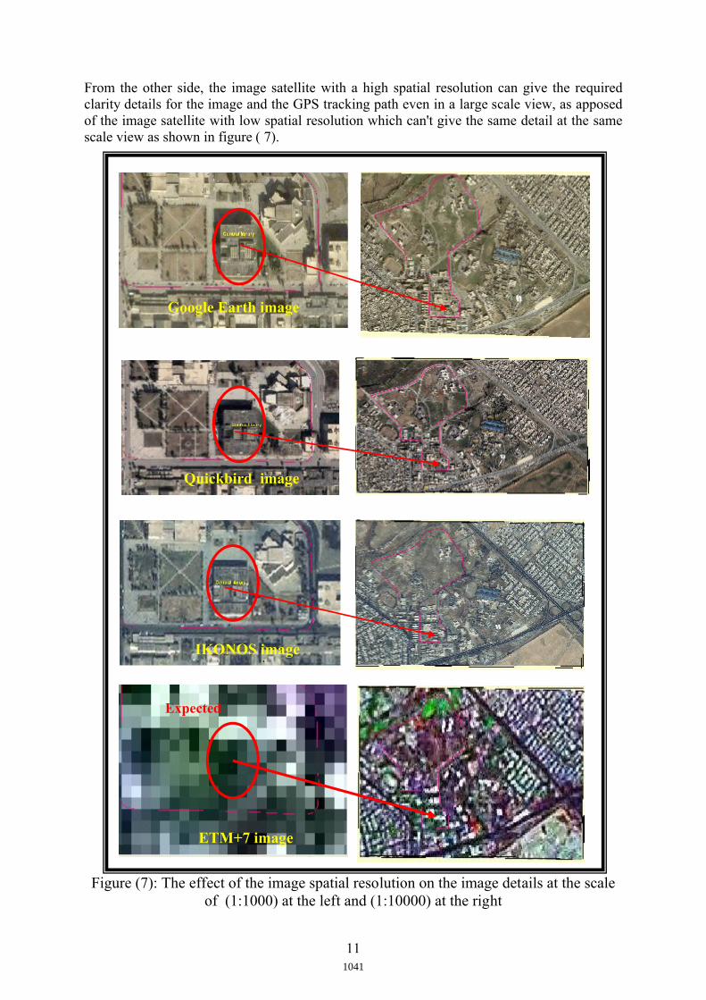
From the other side, the image satellite with a high spatial resolution can give the required clarity details for the image and the GPS tracking path even in a large scale view, as apposed of the image satellite with low spatial resolution which can't give the same detail at the same scale view as shown in figure ( 7).
Figure (7): The effect of the image spatial resolution on the image details at the scale of (1:1000) at the left and (1:10000) at the right
Expected location
Google Earth image
ETM+7 image
IKONOS image image
Quickbird image
1041
12
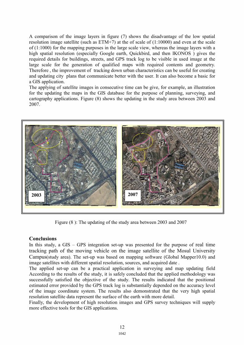
A comparison of the image layers in figure (7) shows the disadvantage of the low spatial resolution image satellite (such as ETM+7) at the of scale of (1:10000) and even at the scale of (1:1000) for the mapping purposes in the large scale view, whereas the image layers with a high spatial resolution (especially Google earth, Quickbird, and then IKONOS ) gives the required details for buildings, streets, and GPS track log to be visible in used image at the large scale for the generation of qualified maps with required contents and geometry. Therefore , the improvement of tracking down urban characteristics can be useful for creating and updating city plans that communicate better with the user. It can also become a basic for a GIS application. The applying of satellite images in consecutive time can be give, for example, an illustration for the updating the maps in the GIS database for the purpose of planning, surveying, and cartography applications. Figure (8) shows the updating in the study area between 2003 and 2007.
Conclusions In this study, a GIS – GPS integration set-up was presented for the purpose of real time tracking path of the moving vehicle on the image satellite of the Mosul University Campus(study area). The set-up was based on mapping software (Global Mapper10.0) and image satellites with different spatial resolution, sources, and acquired date . The applied set-up can be a practical application in surveying and map updating field According to the results of the study, it is safely concluded that the applied methodology was successfully satisfied the objective of the study. The results indicated that the positional estimated error provided by the GPS track log is substantially depended on the accuracy level of the image coordinate system. The results also demonstrated that the very high spatial resolution satellite data represent the surface of the earth with more detail.Finally, the development of high resolution images and GPS survey techniques will supply more effective tools for the GIS applications.
2003 2007
Figure (8 ): The updating of the study area between 2003 and 2007
1042
13
References 1. Amin P. C., 2002, "GIS–GPS INTEGRATION: CHALLENGES OF UNCERTAIN
REALITY", A thesis of M.Sc. in computer science, University of California/ SANTA CRUZ, 152p.
2. Raju, P.L., 2004, "Spatial Data Analysis", Satellite Remote Sensing and GIS application in Agriculture Meteorology", pp.151-174.
3. Alfred L., 2007 ," GIS and GPS Integration Eases Public Road Inventory", Spring issue of ArcNews magazine, ESRI Publications, pp. 1-8.
4. Li B., Yan W., 2008, " Fusing image, GPS and GIS for road tracking using multiple condensation particle filters", Intelligent Vehicles Symposium, IEEEVolume, Issue: 4-6 June, pp.162 – 167.
5. Paul D., 2008, "GPS from the ground up", Technology No.1, AOPA Air Safety Foundation, Available at: www.asf.org, accessed at: 26/ Jan./2009, 8P.
6. Christopher B. J., 1997, "Geographical Information Systems and Computer Cartography", Addison Wesley Longman, pp.95-96.
7. Santiago, A., Dennis, M., Stephen, M. R., 2004, " Performance Analysis and Architectures for INS-Aided GPS Tracking Loops", Department pf Aeronautics and Astronautics, Stanford University, USA, 12p.
8. " GPS Horizontal Position Accuracy", available at : http://users.erols.com/dlwilson/gpsacc.htm, accessed at : 9th/July/2010, pp.1-8.
9. http://www.GlobalMapper.com10. Stephen R. G., 2006, " Geographical Information Systems Demystified", Artech
House, Inc., p.8 11. GPSMAP76CSx, owner's manual – 2005 , Garmin International, Inc.,
www.garmin.com. 118 p.12. Lillesand , T.M. and Kiefer , R.W., 1994. Remote sensing and image
interpretation, 2 nd Ed. John Wiley & Sons, Inc. , p8-10.
1043