Embed Size (px)
Citation preview
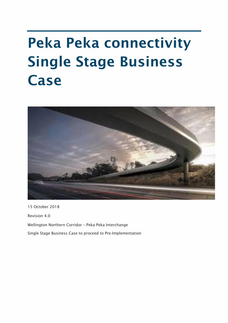
Peka Peka connectivity
Single Stage Business
Case
15 October 2018
Revision 4.0
Wellington Northern Corridor – Peka Peka Interchange
Single Stage Business Case to proceed to Pre-Implementation
Peka Peka Connectivity SSBC
Copyright information
This publication is copyright © NZ Transport Agency. Material in it may be reproduced for
personal or in-house use without formal permission or charge, provided suitable
acknowledgement is made to this publication and the NZ Transport Agency as the source.
Requests and enquiries about the reproduction of material in this publication for any other
purpose should be made to:
Manager, Information
NZ Transport Agency
Private Bag 6995
Wellington 6141
The permission to reproduce material in this publication does not extend to any material for
which the copyright is identified as being held by a third party. Authorisation to reproduce
material belonging to a third party must be obtained from the copyright holder(s)
concerned.
Disclaimer
The NZ Transport Agency has endeavoured to ensure material in this document is
technically accurate and reflects legal requirements. However, the document does not
override governing legislation. The NZ Transport Agency does not accept liability for any
consequences arising from the use of this document. If the user of this document is unsure
whether the material is correct, they should refer directly to the relevant legislation and
contact the NZ Transport Agency.
More information
NZ Transport Agency
Published September 2017
If you have further queries, call our contact centre on 0800 699 000 or write to us:
NZ Transport Agency
Private Bag 6995
Wellington 6141
This document is available from the NZ Transport Agency on request.
Peka Peka Connectivity SSBC
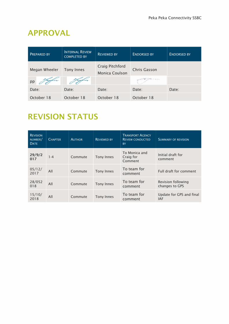
APPROVAL
PREPARED BY INTERNAL REVIEW
COMPLETED BY REVIEWED BY ENDORSED BY ENDORSED BY
Megan Wheeler Tony Innes
Craig Pitchford
Monica Coulson
Chris Gasson
pp
Date: Date: Date: Date: Date:
October 18 October 18 October 18 October 18
REVISION STATUS
REVISION
NUMBER/
DATE
CHAPTER AUTHOR REVIEWED BY
TRANSPORT AGENCY
REVIEW CONDUCTED
BY
SUMMARY OF REVISION
29/9/2
017 1-4 Commute Tony Innes
To Monica and
Craig for
Comment
Initial draft for
comment
05/12/
2017 All Commute Tony Innes
To team for
comment Full draft for comment
28/052
018 All Commute Tony Innes
To team for
comment
Revision following
changes to GPS
15/10/
2018 All Commute Tony Innes
To team for
comment
Update for GPS and final
IAF
Peka Peka Connectivity SSBC
NZ Transport Agency October 2018 i
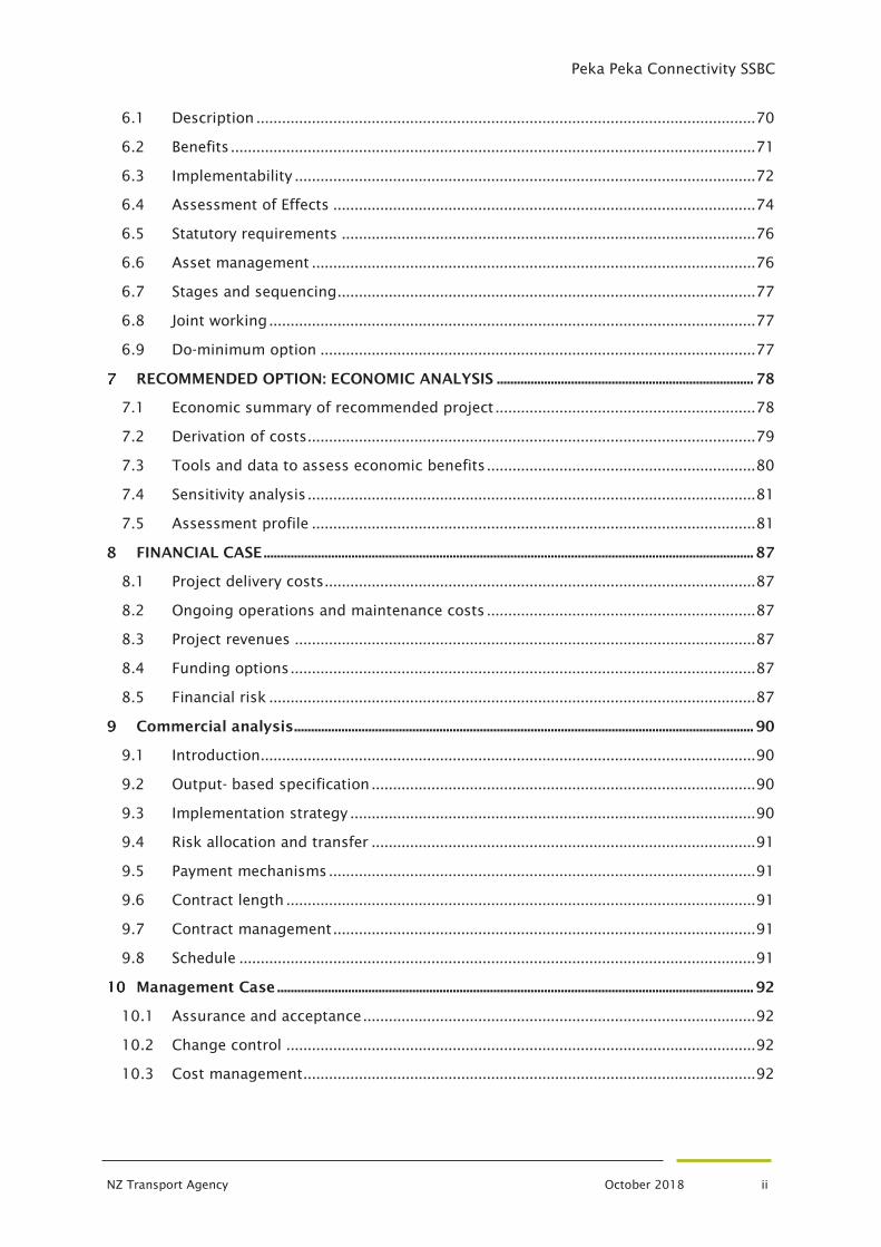
Table of Contents
APPROVAL ......................................................................................................................................................................... iii
REVISION STATUS ......................................................................................................................................................... iii
GLOSSARY OF TERMS ................................................................................................................................................. vi
EXECUTIVE SUMMARY ................................................................................................................................................. 1
BACKGROUND ......................................................................................................................................................... 2
1.1 General ............................................................................................................................. 2
1.2 Peka Peka Connectivity Single Stage Business Case ..................................................... 4
History of Kapiti Expressway .......................................................................................... 5
1.4 Project governance and organisation structure ............................................................ 8
PROBLEMS AND EVIDENCE BASE .................................................................................................................. 9
2.1 Context ............................................................................................................................. 9
2.2 Defining the problem .................................................................................................... 18
2.3 Evidence Base ................................................................................................................. 19
CUSTOMER AND SYSTEM OUTCOMES ................................................................................................... 26
3.1 Strategic outcomes ........................................................................................................ 26
3.2 Project Benefits .............................................................................................................. 28
3.3 Project investment objectives and measures .............................................................. 29
3.4 Customer Outcomes ...................................................................................................... 30
3.5 System Outcomes .......................................................................................................... 31
STAKEHOLDERS .................................................................................................................................................. 32
4.1 Consultation and communication approach ................................................................ 32
4.2 Key Stakeholders ........................................................................................................... 32
4.3 Stakeholder engagement .............................................................................................. 34
ALTERNATIVES AND OPTION ASSESSMENT ....................................................................................... 35
5.1 Option Development and Assessment Process ........................................................... 35
5.2 Option Assessment ........................................................................................................ 36
5.3 Long List Option Development ..................................................................................... 38
5.4 Long List to Short List ................................................................................................... 41
5.5 Community Response .................................................................................................... 51
5.6 Revision of Shortlisted options ..................................................................................... 53
5.7 Short List Option Refinement........................................................................................ 54
5.8 Selection of Recommended Option .............................................................................. 66
RECOMMENDED PROJECT OPTION .......................................................................................................... 70
Peka Peka Connectivity SSBC
NZ Transport Agency October 2018 ii
6.1 Description ..................................................................................................................... 70
6.2 Benefits ........................................................................................................................... 71
6.3 Implementability ............................................................................................................ 72
6.4 Assessment of Effects ................................................................................................... 74
6.5 Statutory requirements ................................................................................................. 76
6.6 Asset management ........................................................................................................ 76
6.7 Stages and sequencing .................................................................................................. 77
6.8 Joint working .................................................................................................................. 77
6.9 Do-minimum option ...................................................................................................... 77
RECOMMENDED OPTION: ECONOMIC ANALYSIS ............................................................................ 78
7.1 Economic summary of recommended project ............................................................. 78
7.2 Derivation of costs ......................................................................................................... 79
7.3 Tools and data to assess economic benefits ............................................................... 80
7.4 Sensitivity analysis ......................................................................................................... 81
7.5 Assessment profile ........................................................................................................ 81
FINANCIAL CASE ................................................................................................................................................. 87
8.1 Project delivery costs ..................................................................................................... 87
8.2 Ongoing operations and maintenance costs ............................................................... 87
8.3 Project revenues ............................................................................................................ 87
8.4 Funding options ............................................................................................................. 87
8.5 Financial risk .................................................................................................................. 87
Commercial analysis ........................................................................................................................................ 90
9.1 Introduction.................................................................................................................... 90
9.2 Output- based specification .......................................................................................... 90
9.3 Implementation strategy ............................................................................................... 90
9.4 Risk allocation and transfer .......................................................................................... 91
9.5 Payment mechanisms .................................................................................................... 91
9.6 Contract length .............................................................................................................. 91
9.7 Contract management ................................................................................................... 91
9.8 Schedule ......................................................................................................................... 91
Management Case ............................................................................................................................................. 92
10.1 Assurance and acceptance ............................................................................................ 92
10.2 Change control .............................................................................................................. 92
10.3 Cost management .......................................................................................................... 92
Peka Peka Connectivity SSBC
NZ Transport Agency October 2018 iii
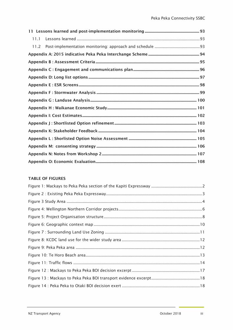
Lessons learned and post-implementation monitoring ............................................................. 93
11.1 Lessons learned ............................................................................................................. 93
11.2 Post-implementation monitoring: approach and schedule ........................................ 93
Appendix A: 2015 indicative Peka Peka Interchange Scheme ......................................................... 94
Appendix B : Assessment Criteria .................................................................................................................... 95
Appendix C : Engagement and communications plan .......................................................................... 96
Appendix D: Long list options ............................................................................................................................ 97
Appendix E : ESR Screens ....................................................................................................................................... 98
Appendix F : Stormwater Analysis ................................................................................................................... 99
Appendix G : Landuse Analysis ....................................................................................................................... 100
Appendix H : Waikanae Economic Study .................................................................................................... 101
Appendix I: Cost Estimates ................................................................................................................................ 102
Appendix J : Shortlisted Option refinement ............................................................................................ 103
Appendix K: Stakeholder Feedback .............................................................................................................. 104
Appendix L : Shorlisted Option Noise Assessment ............................................................................ 105
Appendix M: consenting strategy ................................................................................................................ 106
Appendix N: Notes from Workshop 2 .......................................................................................................... 107
Appendix O: Economic Evaluation ................................................................................................................. 108
TABLE OF FIGURES
Figure 1: Mackays to Peka Peka section of the Kapiti Expressway ............................................. 2
Figure 2 : Existing Peka Peka Expressway ..................................................................................... 3
Figure 3 Study Area ........................................................................................................................ 4
Figure 4: Wellington Northern Corridor projects .......................................................................... 6
Figure 5: Project Organisation structure ....................................................................................... 8
Figure 6: Geographic context map .............................................................................................. 10
Figure 7 : Surrounding Land Use Zoning .................................................................................... 11
Figure 8: KCDC land use for the wider study area ..................................................................... 12
Figure 9: Peka Peka area .............................................................................................................. 12
Figure 10: Te Horo Beach area ..................................................................................................... 13
Figure 11: Traffic flows ................................................................................................................ 14
Figure 12 : Mackays to Peka Peka BOI decision excerpt ............................................................ 17
Figure 13 : Mackays to Peka Peka BOI transport evidence excerpt ........................................... 18
Figure 14 : Peka Peka to Otaki BOI decision exert ..................................................................... 18
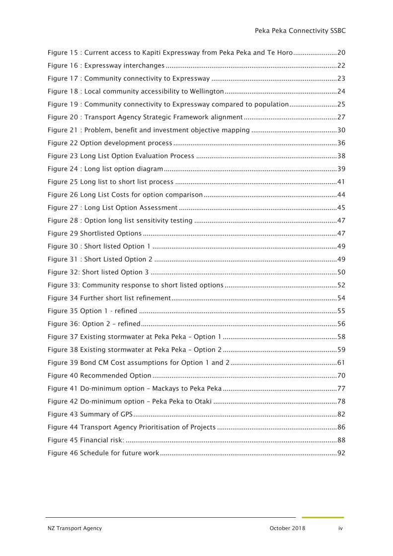
Peka Peka Connectivity SSBC
NZ Transport Agency October 2018 iv
Figure 15 : Current access to Kapiti Expressway from Peka Peka and Te Horo ....................... 20
Figure 16 : Expressway interchanges .......................................................................................... 22
Figure 17 : Community connectivity to Expressway .................................................................. 23
Figure 18 : Local community accessibility to Wellington ........................................................... 24
Figure 19 : Community connectivity to Expressway compared to population ......................... 25
Figure 20 : Transport Agency Strategic Framework alignment ................................................. 27
Figure 21 : Problem, benefit and investment objective mapping ............................................. 30
Figure 22 Option development process ...................................................................................... 36
Figure 23 Long List Option Evaluation Process .......................................................................... 38
Figure 24 : Long list option diagram ........................................................................................... 39
Figure 25 Long list to short list process ..................................................................................... 41
Figure 26 Long List Costs for option comparison ...................................................................... 44
Figure 27 : Long List Option Assessment ................................................................................... 45
Figure 28 : Option long list sensitivity testing ........................................................................... 47
Figure 29 Shortlisted Options ...................................................................................................... 47
Figure 30 : Short listed Option 1 ................................................................................................. 49
Figure 31 : Short Listed Option 2 ................................................................................................ 49
Figure 32: Short listed Option 3 .................................................................................................. 50
Figure 33: Community response to short listed options ........................................................... 52
Figure 34 Further short list refinement ....................................................................................... 54
Figure 35 Option 1 - refined ........................................................................................................ 55
Figure 36: Option 2 – refined ....................................................................................................... 56
Figure 37 Existing stormwater at Peka Peka – Option 1 ............................................................ 58
Figure 38 Existing stormwater at Peka Peka – Option 2 ............................................................ 59
Figure 39 Bond CM Cost assumptions for Option 1 and 2 ........................................................ 61
Figure 40 Recommended Option ................................................................................................. 70
Figure 41 Do-minimum option – Mackays to Peka Peka ............................................................ 77
Figure 42 Do-minimum option – Peka Peka to Otaki ................................................................. 78
Figure 43 Summary of GPS ........................................................................................................... 82
Figure 44 Transport Agency Prioritisation of Projects ............................................................... 86
Figure 45 Financial risk: ............................................................................................................... 88
Figure 46 Schedule for future work ............................................................................................. 92
Peka Peka Connectivity SSBC
NZ Transport Agency October 2018 v
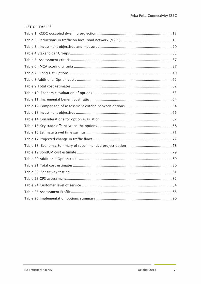
LIST OF TABLES
Table 1: KCDC occupied dwelling projection ............................................................................. 13
Table 2: Reductions in traffic on local road network (M2PP) ..................................................... 15
Table 3 : Investment objectives and measures........................................................................... 29
Table 4 Stakeholder Groups ......................................................................................................... 33
Table 5: Assessment criteria ........................................................................................................ 37
Table 6 : MCA scoring criteria ..................................................................................................... 37
Table 7 : Long List Options .......................................................................................................... 40
Table 8 Additional Option costs .................................................................................................. 62
Table 9 Total cost estimates ........................................................................................................ 62
Table 10: Economic evaluation of options .................................................................................. 63
Table 11: Incremental benefit cost ratio ..................................................................................... 64
Table 12 Comparison of assessment criteria between options ................................................ 64
Table 13 Investment objectives ................................................................................................... 66
Table 14 Considerations for option evaluation .......................................................................... 67
Table 15 Key trade-offs between the options ............................................................................. 68
Table 16 Estimate travel time savings ......................................................................................... 71
Table 17 Projected change in traffic flows .................................................................................. 72
Table 18: Economic Summary of recommended project option ............................................... 78
Table 19 BondCM cost estimate .................................................................................................. 79
Table 20 Additional Option costs ................................................................................................ 80
Table 21 Total cost estimates ...................................................................................................... 80
Table 22: Sensitivity testing ......................................................................................................... 81
Table 23 GPS assessment ............................................................................................................. 82
Table 24 Customer level of service ............................................................................................. 84
Table 25 Assessment Profile ........................................................................................................ 86
Table 26 Implementation options summary ............................................................................... 90
Peka Peka Connectivity SSBC
NZ Transport Agency October 2018 vi
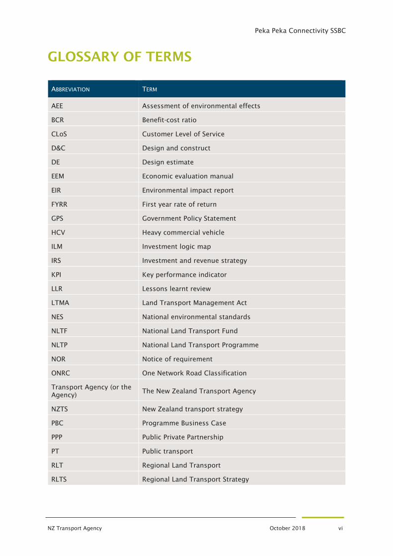
GLOSSARY OF TERMS
ABBREVIATION TERM
AEE Assessment of environmental effects
BCR Benefit-cost ratio
CLoS Customer Level of Service
D&C Design and construct
DE Design estimate
EEM Economic evaluation manual
EIR Environmental impact report
FYRR First year rate of return
GPS Government Policy Statement
HCV Heavy commercial vehicle
ILM Investment logic map
IRS Investment and revenue strategy
KPI Key performance indicator
LLR Lessons learnt review
LTMA Land Transport Management Act
NES National environmental standards
NLTF National Land Transport Fund
NLTP National Land Transport Programme
NOR Notice of requirement
ONRC One Network Road Classification
Transport Agency (or the
Agency) The New Zealand Transport Agency
NZTS New Zealand transport strategy
PBC Programme Business Case
PPP Public Private Partnership
PT Public transport
RLT Regional Land Transport
RLTS Regional Land Transport Strategy

Peka Peka Connectivity SSBC
NZ Transport Agency October 2018 vii
RMA Resource Management Act
RoNS Road of national significance
SH(#) State Highway (number)
TA Territorial Authority
WEBs Wider economic benefits
Peka Peka Connectivity SSBC
NZ Transport Agency October 2018 i
EXECUTIVE SUMMARY
In February 2017 the Transport Agency opened the $400M Kapiti Expressway, a section of
the Wellington northern corridor Roads of National Significance between Mackays and Peka
Peka. This represented a step change in the capacity, performance and operation of the
transport system in this area of the network.
As part of the expressway’s implementation, a partial
interchange was constructed at Peka Peka (only north
facing ramps) that did not preclude the provision of
south facing ramps in the future. The partial
interchange was provided due to the additional cost
of the south facing ramps and concerns by Kapiti
Coast District Council (KCDC) at the land use impacts
associated with the provision of a full interchange.
Post implementation monitoring has shown that
traffic volumes have been greater than forecast and
customers from the Peka Peka and Te Horo
communities are becoming increasingly frustrated at
the poor level of access they have to the new
expressway. These customers are dissatisfied with the
confusing and out of context impact the partial
interchange at Peka Peka is having on their lives and
believe they are living with the effects of the
expressway but do not receive all the associated
access benefits.
The current layout is therefore not providing the best
outcome for customers in this area, nor is it providing
a transport system commensurate with the level of
investment in the transport system in this area of the
network.
This single stage business case has worked closely with KCDC and other stakeholders to
investigate the options for improving connectivity for the Peka Peka and Te Horo
communities. This resulted in alignment on the following problems, benefits and
investment objectives:
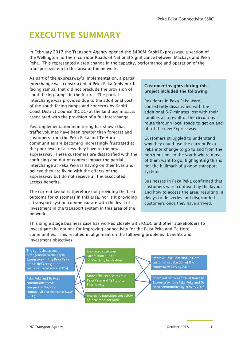
Customer insights during this
project included the following:
Residents in Peka Peka were
consistently dissatisfied with the
additional 6-7 minutes lost with their
families as a result of the circuitous
route through local roads to get on and
off of the new Expressway.
Customers struggled to understand
why they could use the current Peka
Peka interchange to go to and from the
north but not to the south where most
of them want to go, highlighting this is
not the hallmark of a good transport
system.
Businesses in Peka Peka confirmed that
customers were confused by the layout
and how to access the area, resulting in
delays to deliveries and disgruntled
customers once they have arrived.
Peka Peka Connectivity SSBC
NZ Transport Agency October 2018 ii
These problem, benefit and investment objectives were reviewed after the 2018 GPS was
confirmed. To better align with the GPS the second investment objective was reworded
slightly to remove travel time references and include access:
Improved customer access to Expressway from Peka
Peka and Te Horo communities by 30% by 2023
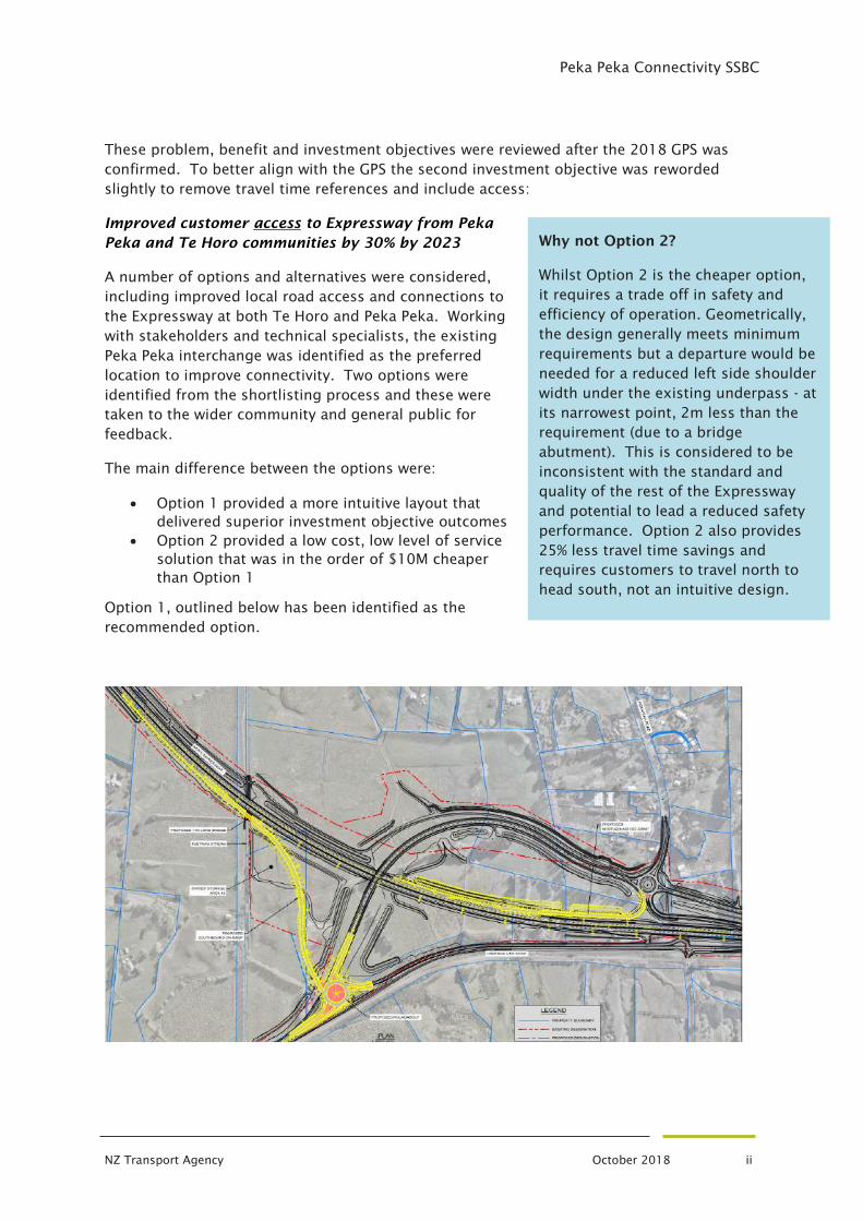
A number of options and alternatives were considered,
including improved local road access and connections to
the Expressway at both Te Horo and Peka Peka. Working
with stakeholders and technical specialists, the existing
Peka Peka interchange was identified as the preferred
location to improve connectivity. Two options were
identified from the shortlisting process and these were
taken to the wider community and general public for
feedback.
The main difference between the options were:
• Option 1 provided a more intuitive layout that
delivered superior investment objective outcomes
• Option 2 provided a low cost, low level of service
solution that was in the order of $10M cheaper
than Option 1
Option 1, outlined below has been identified as the
recommended option.
Why not Option 2?
Whilst Option 2 is the cheaper option,
it requires a trade off in safety and
efficiency of operation. Geometrically,
the design generally meets minimum
requirements but a departure would be
needed for a reduced left side shoulder
width under the existing underpass - at
its narrowest point, 2m less than the
requirement (due to a bridge
abutment). This is considered to be
inconsistent with the standard and
quality of the rest of the Expressway
and potential to lead a reduced safety
performance. Option 2 also provides
25% less travel time savings and
requires customers to travel north to
head south, not an intuitive design.
Peka Peka Connectivity SSBC
NZ Transport Agency October 2018 iii
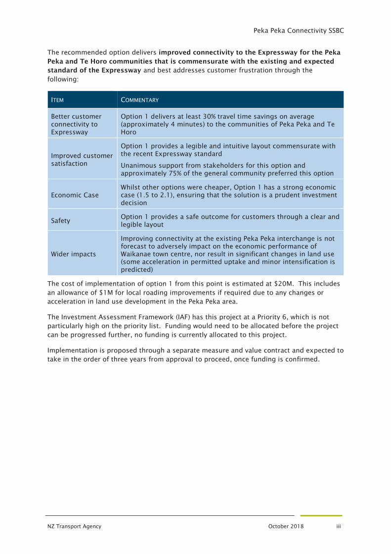
The recommended option delivers improved connectivity to the Expressway for the Peka
Peka and Te Horo communities that is commensurate with the existing and expected
standard of the Expressway and best addresses customer frustration through the
following:
ITEM COMMENTARY
Better customer
connectivity to
Expressway
Option 1 delivers at least 30% travel time savings on average
(approximately 4 minutes) to the communities of Peka Peka and Te
Horo
Improved customer
satisfaction
Option 1 provides a legible and intuitive layout commensurate with
the recent Expressway standard
Unanimous support from stakeholders for this option and
approximately 75% of the general community preferred this option
Economic Case
Whilst other options were cheaper, Option 1 has a strong economic
case (1.5 to 2.1), ensuring that the solution is a prudent investment
decision
Safety Option 1 provides a safe outcome for customers through a clear and
legible layout
Wider impacts
Improving connectivity at the existing Peka Peka interchange is not
forecast to adversely impact on the economic performance of
Waikanae town centre, nor result in significant changes in land use
(some acceleration in permitted uptake and minor intensification is
predicted)
The cost of implementation of option 1 from this point is estimated at $20M. This includes
an allowance of $1M for local roading improvements if required due to any changes or
acceleration in land use development in the Peka Peka area.
The Investment Assessment Framework (IAF) has this project at a Priority 6, which is not
particularly high on the priority list. Funding would need to be allocated before the project
can be progressed further, no funding is currently allocated to this project.
Implementation is proposed through a separate measure and value contract and expected to
take in the order of three years from approval to proceed, once funding is confirmed.

Peka Peka Connectivity SSBC
NZ Transport Agency October 2018 1
PART A: THE CASE FOR
THE PROJECT
Peka Peka Connectivity SSBC
NZ Transport Agency October 2018 2
BACKGROUND
1.1 General
The Wellington Northern Corridor is one of the governments first RoNS projects announced
in 2009 via the Government Policy Statement on land transport. The Wellington Northern
corridor is currently being delivered in stages.
In February 2017, the Mackays to Peka Peka section of the Kapiti Expressway opened to
traffic. As part of the post opening monitoring, the Transport Agency has reviewed
operation of this section. It has becomed apparent that as the customers have become used
to the altered transport network there have been some operational challenges for customers
identified at the northern end of the project.
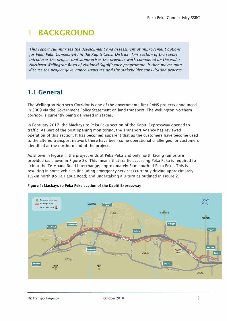
As shown in Figure 1, the project ends at Peka Peka and only north facing ramps are
provided (as shown in Figure 2). This means that traffic accessing Peka Peka is required to
exit at the Te Moana Road interchange, approximately 5km south of Peka Peka. This is
resulting in some vehicles (Including emergency services) currently driving approximately
1.5km north (to Te Hapua Road) and undertaking a U-turn as outlined in Figure 2.
Figure 1: Mackays to Peka Peka section of the Kapiti Expressway
This report summarises the development and assessment of improvement options
for Peka Peka Connectivity in the Kapiti Coast District. This section of the report
introduces the project and summarises the previous work completed on the wider
Northern Wellington Road of National Significance programme. It then moves onto
discuss the project governance structure and the stakeholder consultation process.

Peka Peka Connectivity SSBC
NZ Transport Agency October 2018 3
Figure 2 : Existing Peka Peka Expressway
A contract has recently been awarded for the extension of the expressway from Peka Peka to
Otaki. This will address the U-turn issue as access to Te Hapua Road will no longer be
available. The expressway extension will however not address the routing issue for Peka
Peka traffic as the next interchange north of Peka Peka is at Otaki, approximately 9km
northwards.
Because of these operational issues and customer feedback, the Transport Agency is
assessing the connectivity for Peka Peka and its surrounding communities and investigating
the long-term access arrangements for this section of the network.
The Transport Agency has met with local residents and the Mayor of Kapiti to discuss the
issues and share the Transport Agency process for investigation.
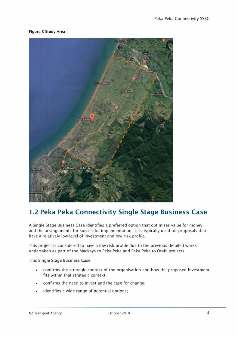
This business case looks at connectivity considerations from Peka Peka through to Otaki
River, south of Otaki as outlined in Figure 3.
Peka Peka Connectivity SSBC
NZ Transport Agency October 2018 4
Figure 3 Study Area
1.2 Peka Peka Connectivity Single Stage Business Case
A Single Stage Business Case identifies a preferred option that optimises value for money
and the arrangements for successful implementation. It is typically used for proposals that
have a relatively low level of investment and low risk profile.
This project is considered to have a low risk profile due to the previous detailed works
undertaken as part of the Mackays to Peka Peka and Peka Peka to Otaki projects.
This Single Stage Business Case:
• confirms the strategic context of the organisation and how the proposed investment
fits within that strategic context;
• confirms the need to invest and the case for change;
• identifies a wide range of potential options;
Peka Peka Connectivity SSBC
NZ Transport Agency October 2018 5
• determines the preferred option which optimises value for money, by undertaking a
detailed analysis of the costs, benefits and risks of the short-listed options;
• prepares the proposal for procurement;
• outlines the necessary funding and management arrangements for the successful
delivery of the project; and
• informs a proposal to decision-makers to approach the market and finalise the
arrangements for implementation of the project.
History of Kapiti Expressway
1.3.1 Wellington Northern Corridor
SH1 between Levin and the Wellington airport is the main roading connection in, through
and out of the Wellington region. It provides a critical link to the lower North Island and key
regional destinations including the Wellington CBD (the region’s main employment centre),
CentrePort, the Interislander ferry, and the Wellington International Airport. In 2009, the
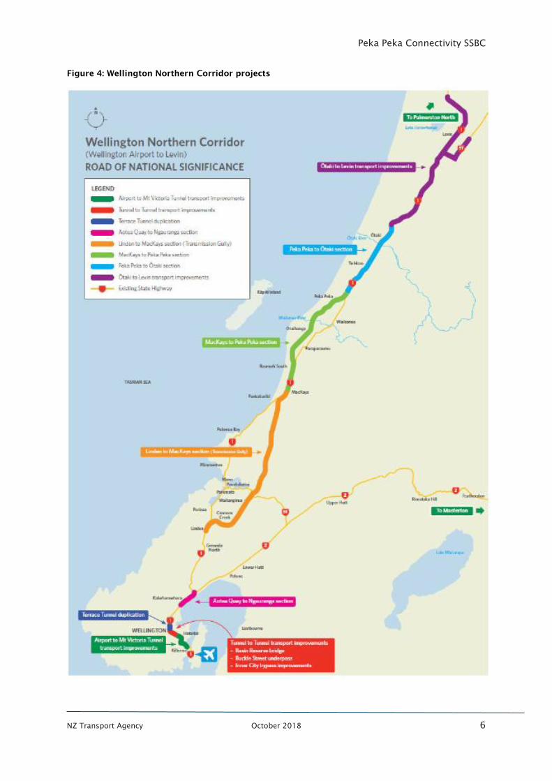
Wellington Northern Corridor RoNS project was announced using a staggered
implementation timeframe for each of the sections as outlined in Figure 4.
The objectives of the Wellington Northern Corridor RoNS are to:
• enhance inter regional and national economic growth and productivity;
• improve access to Wellington’s CBD, key industrial and employment centres, port,
airport and hospital;
• provide relief from severe congestion on the state highway and local road networks;
• improve the journey time reliability of travel on the section of SH1 between Levin and
the Wellington airport; and
• improve the safety of travel on state highways.
The benefits of the investment were expressed for the region and include:
• supporting the land-use and economic growth aspirations of the region; and
• improving connectivity between regional economic hubs.
For the Peka Peka Connectivity project, the Wellington Northern Corridor RoNS project sets
the context for each of the sections of the Kapiti Expressway and overall programme
objectives. The RoNS objectives focus on strategic movements between key destinations in
terms of safety, efficiency and reliability.
The Peka Peka and Te Horo areas are not identified as key industrial and employment
centres or economic hub. However, additional connectivity could be considered to
contribute to supporting the land-use and economic growth aspirations of the region.
Peka Peka Connectivity SSBC
NZ Transport Agency October 2018 6
Figure 4: Wellington Northern Corridor projects
Peka Peka Connectivity SSBC
NZ Transport Agency October 2018 7
1.3.2 Mackays to Peka Peka
In 2012 the NZ Transport Agency lodged a notice of requirement for designation and a
resource consent application for the Mackays to Peka Peka project (M2PP). The application
sought approval for the proposed designation of the M2PP project corridor to allow the
construction, operation and maintenance of a State Highway formed to an expressway
standard from north of Mackays Crossing to Peka Peka.
The final Board of Inquiry conditions confirmed local access to and from the alignment
primarily via two new full interchanges - one at Kapiti Road, and one at Te Moana Road, plus
partial interchanges at the northern and southern tie-ins to the existing SH1. The partial
interchanges were confirmed as south-facing ramps only at the southern tie-in at Poplar
Avenue, and north-facing ramps only at the northern tie-in at Peka Peka.
At the time of the design in 2011, the decision to construct a partial interchange at Peka
Peka was made based on demand modelling suggesting there being insufficient demand to
justify the additional cost of a full interchange. Based on KCDC’s expressed concern, south
facing ramps were considered to have the potential to have an adverse effect on the land
use and planning in the District, which in turn could create an adverse effect on the
Expressway through an increase in short trips compromising the through traffic efficiency
and safety. Therefore, only north facing ramps were proposed.
In 2015, the Mackays to Peka Peka Alliance were required to make some changes to the
Peka Peka Link Road. As part of this work, the Alliance considered the potential for a future
interchange and developed the attached schematic as a result (see Appendix A). It is
understood that the future interchange did not progress at this time due to funding
constraints.
In February 2017, the Mackays to Peka Peka section of the Kapiti Expressway opened to
traffic.
1.3.3 Peka Peka to Otaki
In 2014 the Transport Agency was granted approval for the Peka Peka to Otaki section of
the RoNS and in November 2016 Fletchers were awarded the implementation contract.
Construction of this section is forecast to be completed in 2020.
During the hearing process there was discussion from some submitters in relation to the
lack of an interchange south of Otaki (Otaki was the scheme’s only interchange with the
current network), however the decision was approved without the requirement for any
additional interchange locations to those proposed in the original application.
Peka Peka Connectivity SSBC
NZ Transport Agency October 2018 8
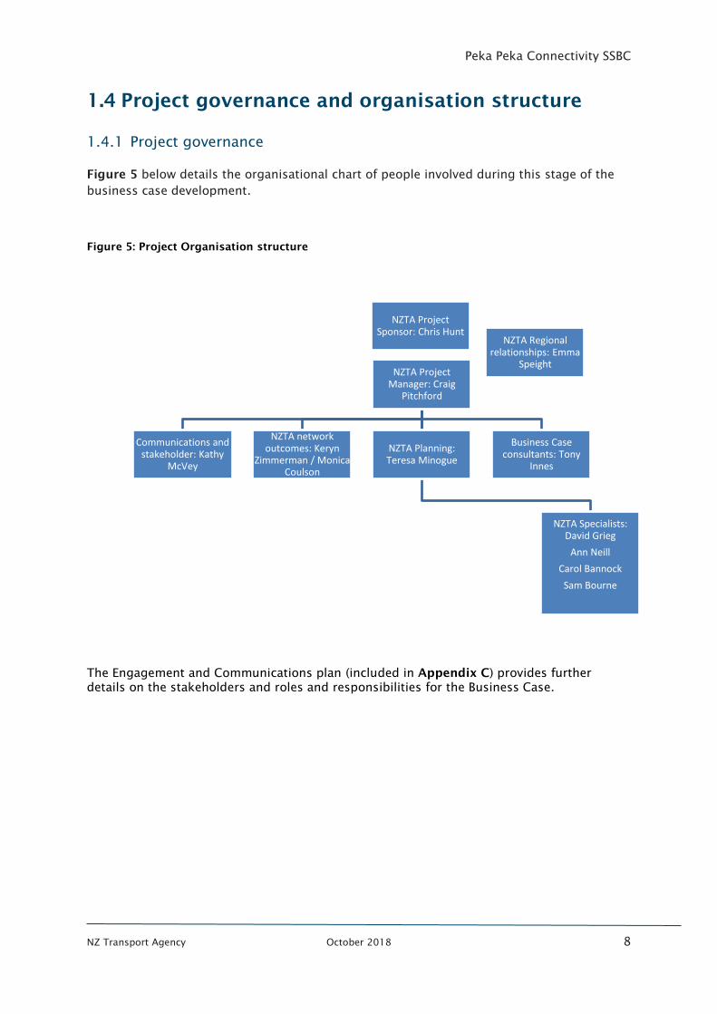
1.4 Project governance and organisation structure
1.4.1 Project governance
Figure 5 below details the organisational chart of people involved during this stage of the
business case development.
Figure 5: Project Organisation structure
The Engagement and Communications plan (included in Appendix C) provides further
details on the stakeholders and roles and responsibilities for the Business Case.
NZTA Project Sponsor: Chris Hunt
NZTA Project Manager: Craig
Pitchford
Communications and stakeholder: Kathy
McVey
NZTA network outcomes: Keryn
Zimmerman / Monica Coulson
NZTA Planning: Teresa Minogue
Business Case consultants: Tony
Innes
NZTA Specialists: David Grieg
Ann Neill
Carol Bannock
Sam Bourne
NZTA Regional relationships: Emma
Speight
Peka Peka Connectivity SSBC
NZ Transport Agency October 2018 9
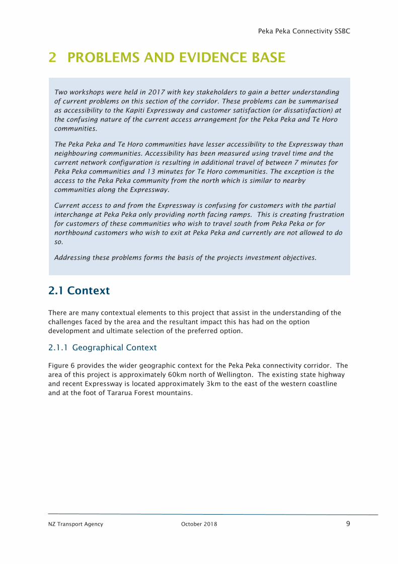
PROBLEMS AND EVIDENCE BASE
2.1 Context
There are many contextual elements to this project that assist in the understanding of the
challenges faced by the area and the resultant impact this has had on the option
development and ultimate selection of the preferred option.
2.1.1 Geographical Context
Figure 6 provides the wider geographic context for the Peka Peka connectivity corridor. The
area of this project is approximately 60km north of Wellington. The existing state highway
and recent Expressway is located approximately 3km to the east of the western coastline
and at the foot of Tararua Forest mountains.
Two workshops were held in 2017 with key stakeholders to gain a better understanding
of current problems on this section of the corridor. These problems can be summarised
as accessibility to the Kapiti Expressway and customer satisfaction (or dissatisfaction) at
the confusing nature of the current access arrangement for the Peka Peka and Te Horo
communities.
The Peka Peka and Te Horo communities have lesser accessibility to the Expressway than
neighbouring communities. Accessibility has been measured using travel time and the
current network configuration is resulting in additional travel of between 7 minutes for
Peka Peka communities and 13 minutes for Te Horo communities. The exception is the
access to the Peka Peka community from the north which is similar to nearby
communities along the Expressway.
Current access to and from the Expressway is confusing for customers with the partial
interchange at Peka Peka only providing north facing ramps. This is creating frustration
for customers of these communities who wish to travel south from Peka Peka or for
northbound customers who wish to exit at Peka Peka and currently are not allowed to do
so.
Addressing these problems forms the basis of the projects investment objectives.
Peka Peka Connectivity SSBC
NZ Transport Agency October 2018 10
Figure 6: Geographic context map
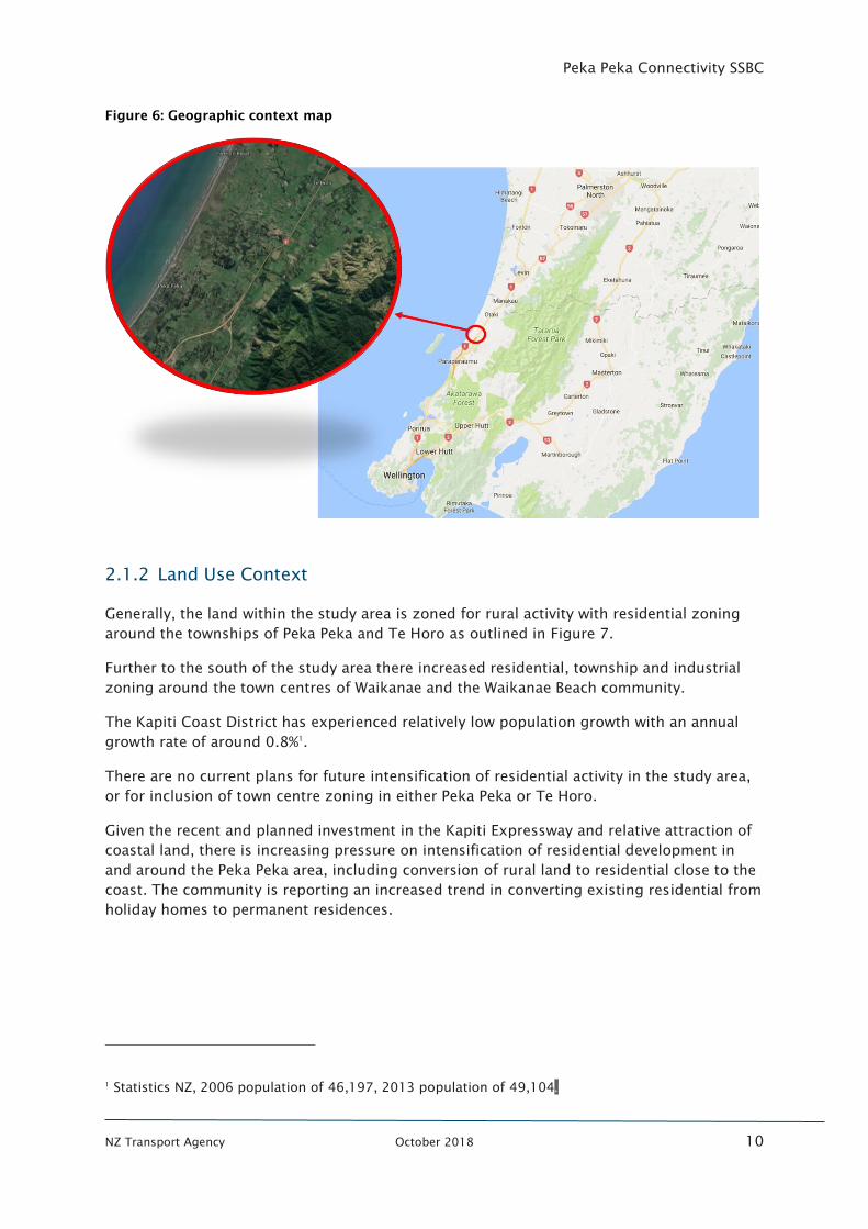
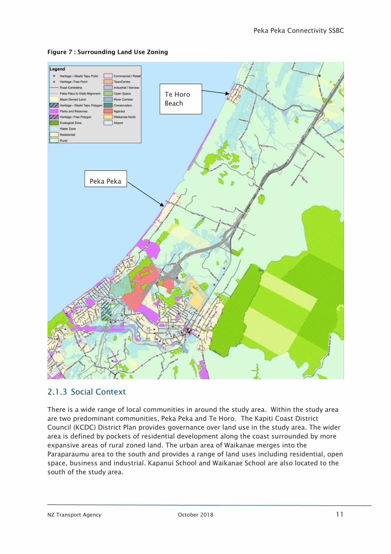
2.1.2 Land Use Context
Generally, the land within the study area is zoned for rural activity with residential zoning
around the townships of Peka Peka and Te Horo as outlined in Figure 7.
Further to the south of the study area there increased residential, township and industrial
zoning around the town centres of Waikanae and the Waikanae Beach community.
The Kapiti Coast District has experienced relatively low population growth with an annual
growth rate of around 0.8%1
.
There are no current plans for future intensification of residential activity in the study area,
or for inclusion of town centre zoning in either Peka Peka or Te Horo.
Given the recent and planned investment in the Kapiti Expressway and relative attraction of
coastal land, there is increasing pressure on intensification of residential development in
and around the Peka Peka area, including conversion of rural land to residential close to the
coast. The community is reporting an increased trend in converting existing residential from
holiday homes to permanent residences.
1
Statistics NZ, 2006 population of 46,197, 2013 population of 49,104.
Peka Peka Connectivity SSBC
NZ Transport Agency October 2018 11
Figure 7 : Surrounding Land Use Zoning
2.1.3 Social Context
There is a wide range of local communities in around the study area. Within the study area
are two predominant communities, Peka Peka and Te Horo. The Kapiti Coast District
Council (KCDC) District Plan provides governance over land use in the study area. The wider
area is defined by pockets of residential development along the coast surrounded by more
expansive areas of rural zoned land. The urban area of Waikanae merges into the
Paraparaumu area to the south and provides a range of land uses including residential, open
space, business and industrial. Kapanui School and Waikanae School are also located to the
south of the study area.
Peka Peka
Te Horo
Beach
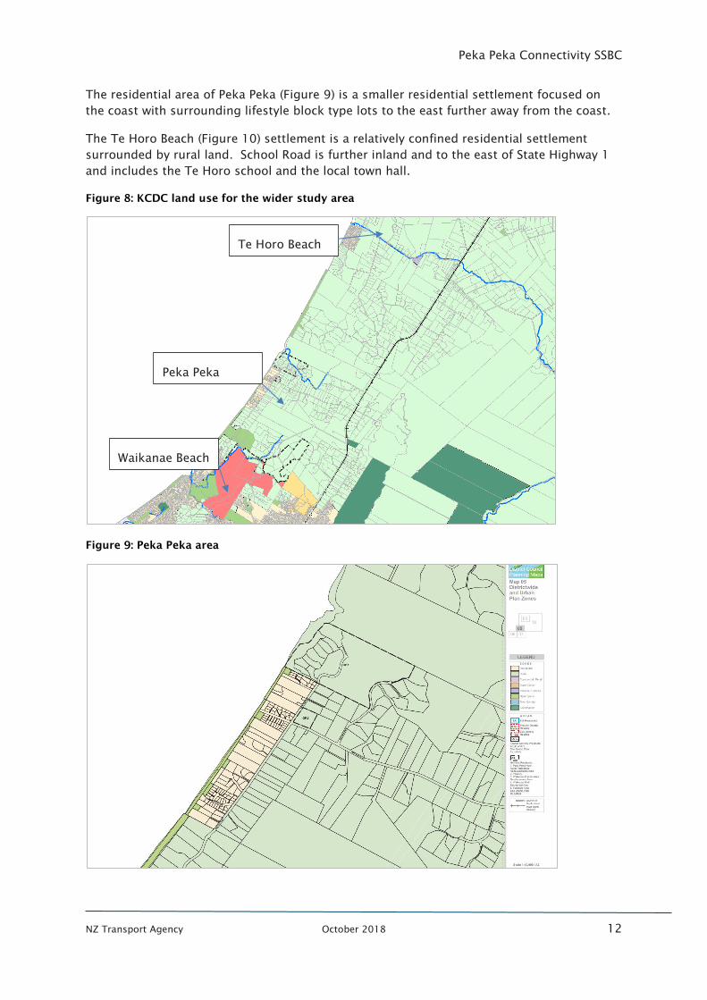
Peka Peka Connectivity SSBC
NZ Transport Agency October 2018 12
The residential area of Peka Peka (Figure 9) is a smaller residential settlement focused on
the coast with surrounding lifestyle block type lots to the east further away from the coast.
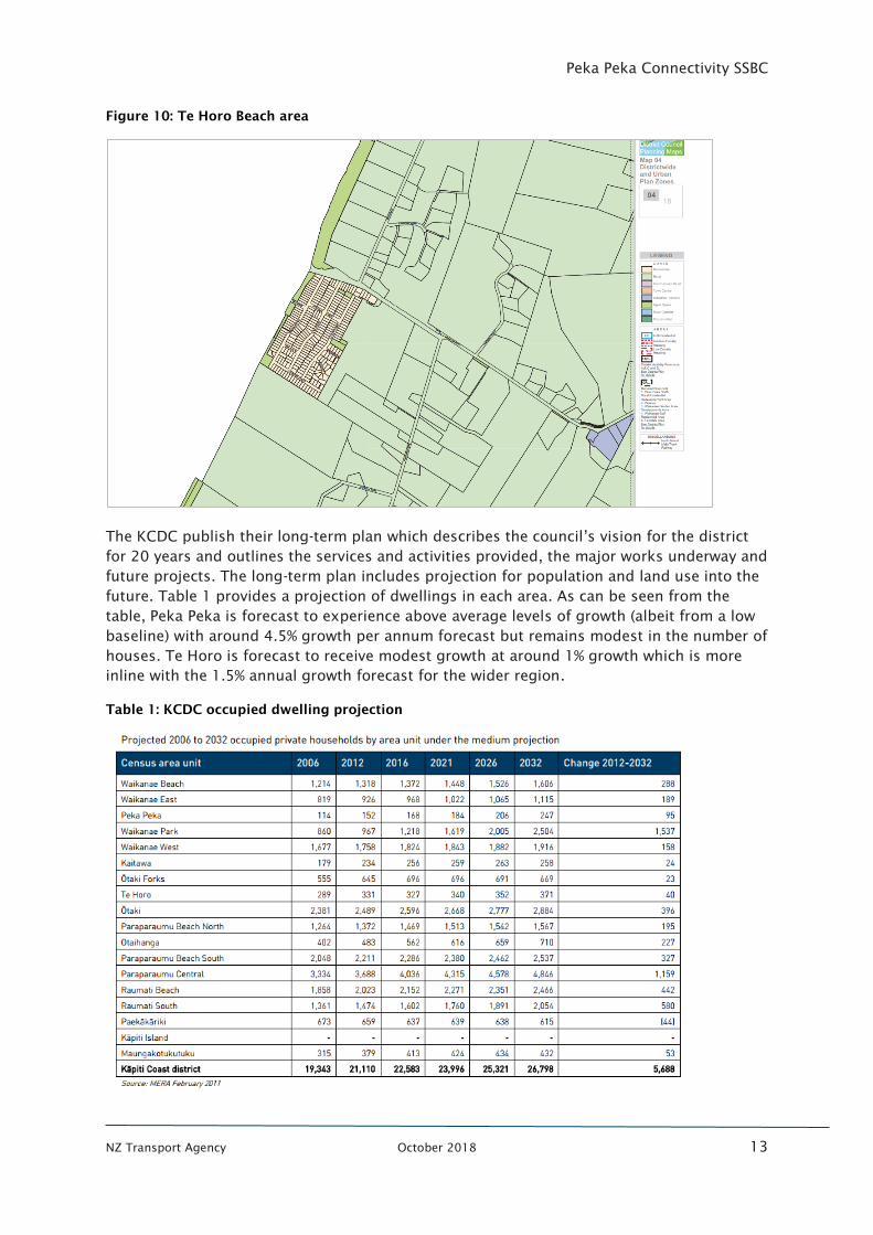
The Te Horo Beach (Figure 10) settlement is a relatively confined residential settlement
surrounded by rural land. School Road is further inland and to the east of State Highway 1
and includes the Te Horo school and the local town hall.
Figure 8: KCDC land use for the wider study area
Figure 9: Peka Peka area
Waikanae Beach
Peka Peka
Te Horo Beach
Peka Peka Connectivity SSBC
NZ Transport Agency October 2018 13
Figure 10: Te Horo Beach area
The KCDC publish their long-term plan which describes the council’s vision for the district
for 20 years and outlines the services and activities provided, the major works underway and
future projects. The long-term plan includes projection for population and land use into the
future. Table 1 provides a projection of dwellings in each area. As can be seen from the
table, Peka Peka is forecast to experience above average levels of growth (albeit from a low
baseline) with around 4.5% growth per annum forecast but remains modest in the number of
houses. Te Horo is forecast to receive modest growth at around 1% growth which is more
inline with the 1.5% annual growth forecast for the wider region.
Table 1: KCDC occupied dwelling projection
Peka Peka Connectivity SSBC
NZ Transport Agency October 2018 14
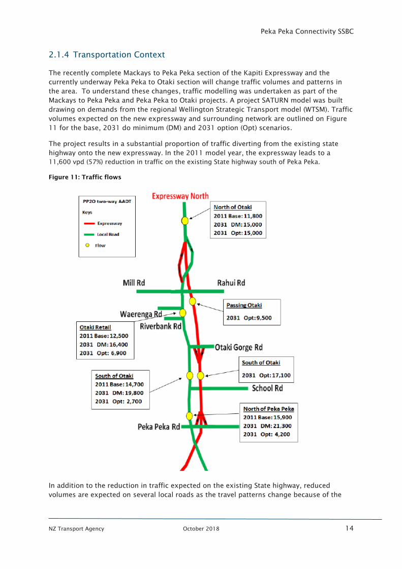
2.1.4 Transportation Context
The recently complete Mackays to Peka Peka section of the Kapiti Expressway and the
currently underway Peka Peka to Otaki section will change traffic volumes and patterns in
the area. To understand these changes, traffic modelling was undertaken as part of the
Mackays to Peka Peka and Peka Peka to Otaki projects. A project SATURN model was built
drawing on demands from the regional Wellington Strategic Transport model (WTSM). Traffic
volumes expected on the new expressway and surrounding network are outlined on Figure
11 for the base, 2031 do minimum (DM) and 2031 option (Opt) scenarios.
The project results in a substantial proportion of traffic diverting from the existing state
highway onto the new expressway. In the 2011 model year, the expressway leads to a
11,600 vpd (57%) reduction in traffic on the existing State highway south of Peka Peka.
Figure 11: Traffic flows
In addition to the reduction in traffic expected on the existing State highway, reduced
volumes are expected on several local roads as the travel patterns change because of the
Peka Peka Connectivity SSBC
NZ Transport Agency October 2018 15
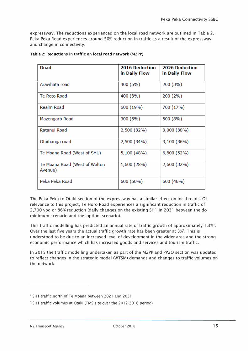
expressway. The reductions experienced on the local road network are outlined in Table 2.
Peka Peka Road experiences around 50% reduction in traffic as a result of the expressway
and change in connectivity.
Table 2: Reductions in traffic on local road network (M2PP)
The Peka Peka to Otaki section of the expressway has a similar effect on local roads. Of
relevance to this project, Te Horo Road experiences a significant reduction in traffic of
2,700 vpd or 86% reduction (daily changes on the existing SH1 in 2031 between the do
minimum scenario and the 'option' scenario).
This traffic modelling has predicted an annual rate of traffic growth of approximately 1.3%2
.
Over the last five years the actual traffic growth rate has been greater at 3%3
. This is
understood to be due to an increased level of development in the wider area and the strong
economic performance which has increased goods and services and tourism traffic.
In 2015 the traffic modelling undertaken as part of the M2PP and PP2O section was updated
to reflect changes in the strategic model (WTSM) demands and changes to traffic volumes on
the network.
2
SH1 traffic north of Te Moana between 2021 and 2031
3
SH1 traffic volumes at Otaki (TMS site over the 2012-2016 period)
Peka Peka Connectivity SSBC
NZ Transport Agency October 2018 16
A review of travel to work data for the wider Kapiti area4
has shown a strong reliance on the
private vehicle for travel to work, at 58% with 10% using public transport (9% by train and 1%
using bus) and 10% working from home.
As part of the Mackays to Peka Peka project, a shared path has been provided along the
expressway corridor. The shared path provides walking and cycling access through the
corridor and connects communities along the route. As part of the Peka Peka to Otaki
project, the shared path will be extended to the north towards Otaki.
2.1.5 Environmental Context
The project area is contained within the M2PP and PP2O project extents.
The M2PP project has only recently been completed and was subject to a complex suite of
designation and resource consent conditions relating to a range of matters including:
• Stormwater/ ecological and Wetland impacts
• Offset mitigation removal/relocation effects.
The project area is predominantly flat and there is a high ground water level given the
proximity of the coast. This results in areas susceptible to flooding and careful management
of flood storage in high rainfall events will be required. Any design will also need to ensure
that there are no ‘barrier’ effects relative to the east-west catchment flows or negative
interaction with the Kapiti districts wetland systems, aquifers and bore use.
A number of streams are located in the project area and sediment runoff from earthworks
during construction has the potential to adversely affect freshwater habitats and species.
The project area is not directly adjacent a marine environment, however the coastal water is
the ultimate receiving environment for any sediment-carrying water from the project.
The dominant ground conditions in the project area are deep peat which provides some
technical challenge for road construction.
Since the opening of the Expressway, the community has expressed concerns at the
resultant noise levels. This is being actively managed by the Transport Agency and indicates
the sensitive nature of this issue in this area.
2.1.6 Cultural Context
Between the Waikanae River and Te Moana Road the Mackays to Peka Peka Expressway
crosses land that’s of great historic and cultural significant to local iwi. Whakarongotai
Mārae used to be in this area in what was called the Tuku Rakau village. This whole area is
waahi tapu (sacred land) and contains the Takamore Urupa, an operating burial ground,
where many tipuna (ancestors) rest.
As part of the Mackays to Peka Peka project, the Agency worked very closely with iwi to
make sure construction in this special place happened with respect and sensitivity. This was
4
Statistics New Zealand Travel to Work data for Kapiti District for 2013
Peka Peka Connectivity SSBC
NZ Transport Agency October 2018 17
guided by Memoranda of Understanding with Te Atiawa ki Whakarongotai and the Takamore
Charitable Trust as well as working groups with directly affected Māori landowners.
Of the Iwi in the Kapiti Coast District, the following are believed to have Mana Whenua over
the study area for the Peka Peka connectivity Business Case:
• Te Āti Awa ki Whakarongotai - south of Peka Peka
• Ngāti Raukawa ki te Tonga - from Peka Peka to Otaki North
It is understood that Ngati Raukawa ki te Tonga have a current lease arrangement with the
Transport Agency for land within the Peka Peka interchange.
2.1.7 Consideration during previous phases
Connectivity in the study area has been explored through the Board of Inquiry process for
both the Mackays to Peka Peka and Peka Peka to Otaki projects.
During both hearings, there was evidence and discussion on the form of the Peka Peka
interchange and the need for further accessibility (to that proposed by the Transport
Agency) in the Peka Peka and Te Horo areas.
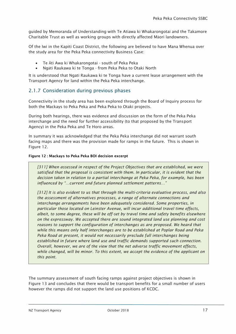
In summary it was acknowledged that the Peka Peka interchange did not warrant south
facing maps and there was the provision made for ramps in the future. This is shown in
Figure 12.
Figure 12 : Mackays to Peka Peka BOI decision excerpt
[311] When assessed in respect of the Project Objectives that are established, we were
satisfied that the proposal is consistent with them. In particular, it is evident that the
decision taken in relation to a partial interchange at Peka Peka, for example, has been
influenced by “…current and future planned settlement patterns…”
[312] It is also evident to us that through the multi-criteria evaluative process, and also
the assessment of alternatives processes, a range of alternate connections and
interchange arrangements have been adequately considered. Some properties, in
particular those located on Leinster Avenue, will incur additional travel time effects,
albeit, to some degree, these will be off-set by travel time and safety benefits elsewhere
on the expressway. We accepted there are sound integrated land use planning and cost
reasons to support the configuration of interchanges as are proposed. We heard that
while this means only half interchanges are to be established at Poplar Road and Peka
Peka Road at present, it would not necessarily preclude full interchanges being
established in future where land use and traffic demands supported such connection.
Overall, however, we are of the view that the net adverse traffic movement effects,
while changed, will be minor. To this extent, we accept the evidence of the applicant on
this point.
The summary assessment of south facing ramps against project objectives is shown in
Figure 13 and concludes that there would be transport benefits for a small number of users
however the ramps did not support the land use positions of KCDC.
Peka Peka Connectivity SSBC
NZ Transport Agency October 2018 18
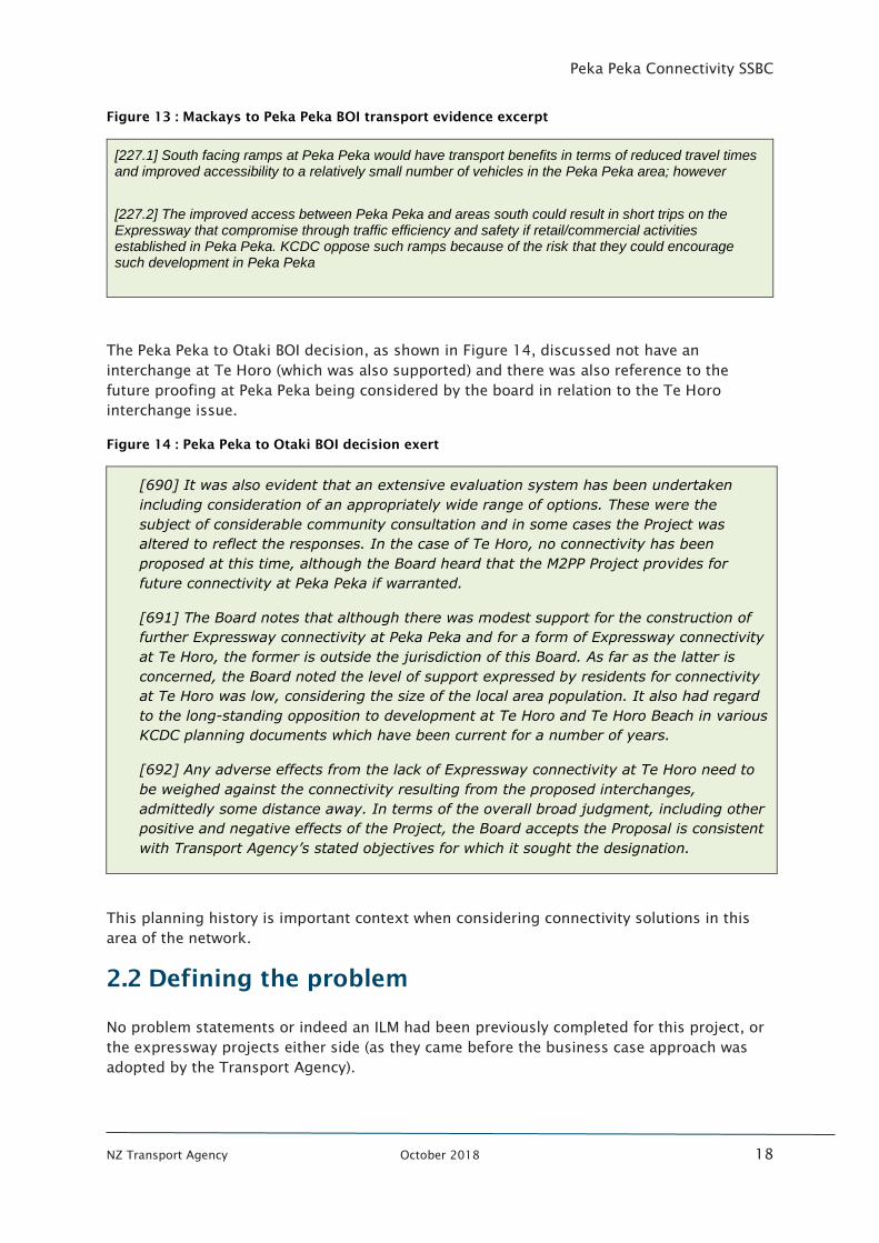
Figure 13 : Mackays to Peka Peka BOI transport evidence excerpt
[227.1] South facing ramps at Peka Peka would have transport benefits in terms of reduced travel times and improved accessibility to a relatively small number of vehicles in the Peka Peka area; however
[227.2] The improved access between Peka Peka and areas south could result in short trips on the Expressway that compromise through traffic efficiency and safety if retail/commercial activities established in Peka Peka. KCDC oppose such ramps because of the risk that they could encourage such development in Peka Peka
The Peka Peka to Otaki BOI decision, as shown in Figure 14, discussed not have an
interchange at Te Horo (which was also supported) and there was also reference to the
future proofing at Peka Peka being considered by the board in relation to the Te Horo
interchange issue.
Figure 14 : Peka Peka to Otaki BOI decision exert
[690] It was also evident that an extensive evaluation system has been undertaken
including consideration of an appropriately wide range of options. These were the
subject of considerable community consultation and in some cases the Project was
altered to reflect the responses. In the case of Te Horo, no connectivity has been
proposed at this time, although the Board heard that the M2PP Project provides for
future connectivity at Peka Peka if warranted.
[691] The Board notes that although there was modest support for the construction of
further Expressway connectivity at Peka Peka and for a form of Expressway connectivity
at Te Horo, the former is outside the jurisdiction of this Board. As far as the latter is
concerned, the Board noted the level of support expressed by residents for connectivity
at Te Horo was low, considering the size of the local area population. It also had regard
to the long-standing opposition to development at Te Horo and Te Horo Beach in various
KCDC planning documents which have been current for a number of years.
[692] Any adverse effects from the lack of Expressway connectivity at Te Horo need to
be weighed against the connectivity resulting from the proposed interchanges,
admittedly some distance away. In terms of the overall broad judgment, including other
positive and negative effects of the Project, the Board accepts the Proposal is consistent
with Transport Agency’s stated objectives for which it sought the designation.
This planning history is important context when considering connectivity solutions in this
area of the network.
2.2 Defining the problem
No problem statements or indeed an ILM had been previously completed for this project, or
the expressway projects either side (as they came before the business case approach was
adopted by the Transport Agency).
Peka Peka Connectivity SSBC
NZ Transport Agency October 2018 19
Through this SSBC (at workshop 1) problems were explored with stakeholders. The
following problem statements and their associated weightings were identified and confirmed
at the second workshop.
1. The confusing access arrangement to the Kapiti Expressway in the Peka Peka area is
delivering poor customer satisfaction (50%)
2. Peka Peka and Te Horo communities have comparatively poor connectivity to the
Kapiti Expressway (50%)
The problem identified by the project stakeholders is due to the confusing nature of access
to the Expressway for Peka Peka and Te Horo communities and that this access is not as
direct as other communities experience along the route. Due to the partial interchange at
Peka Peka (only north facing ramps) there is an interchange shown on maps, however from
the south there is no access to Peka Peka. This is confusing for visitors who can see there is
an interchange on Google Maps (as an example) but cannot use it. In addition, once
customers exit at Te Moana interchange (the correct interchange to access Peka Peka from
the south) the signage directs you inland via the Waikanae town centre, which is counter
intuitive (as Peka Peka is to the west, not towards the east which is the way the signage
sends customers). Again, this is confusing and frustrating for customers.
Using the Te Moana interchange also requires an additional travel time of approximately 2-5
minutes (depending on route) as compared to access being provided directly at Peka Peka.
This is causing frustration for customers.
2.3 Evidence Base
This section investigates the evidence to support the problem statements developed
following the initial workshop with stakeholders.
2.3.1 Confusing Access
The Issue
Customer feedback from the Peka Peka and Te Horo communities has indicated that the
current configuration of the Kapiti Expressway is impacting journey planning and access to
their communities. In particular, the customers find the layout of the Peka Peka interchange
confusing and frustrating.
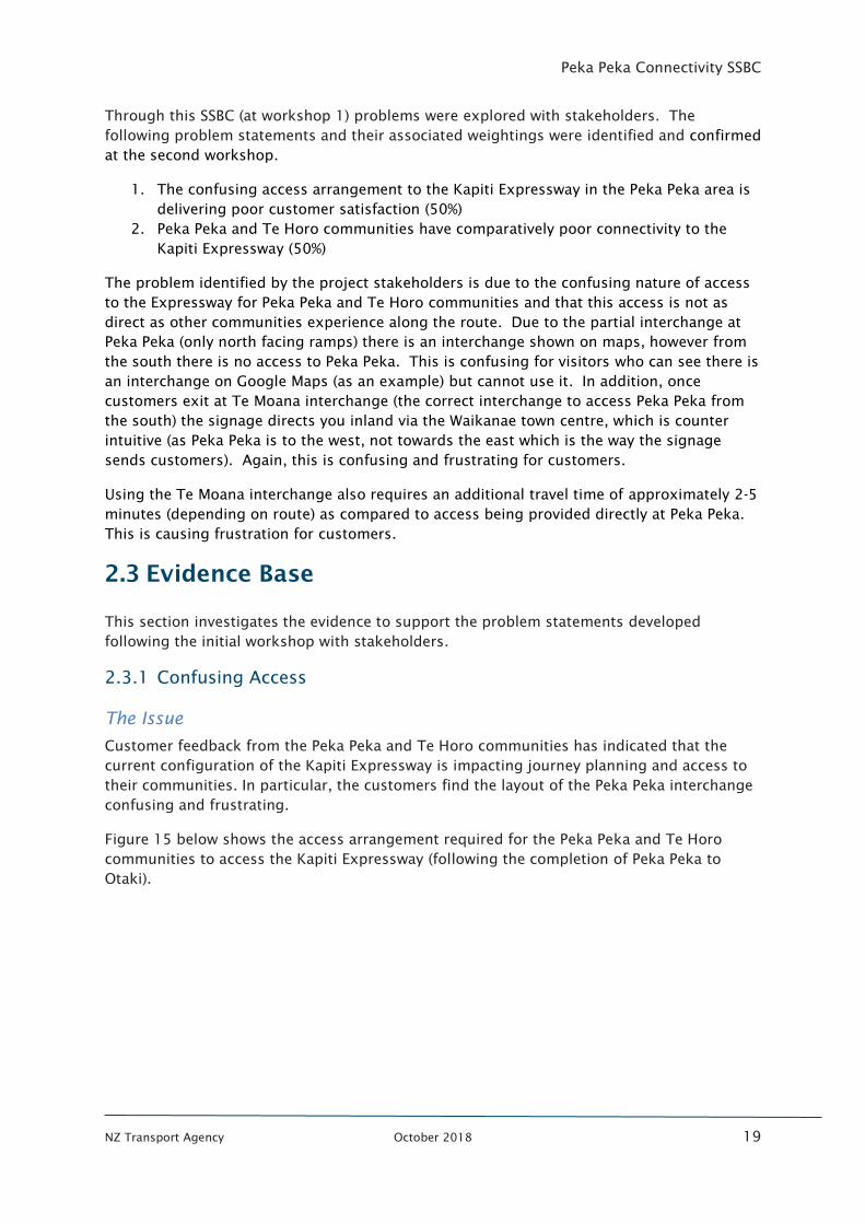
Figure 15 below shows the access arrangement required for the Peka Peka and Te Horo
communities to access the Kapiti Expressway (following the completion of Peka Peka to
Otaki).
Peka Peka Connectivity SSBC
NZ Transport Agency October 2018 20
Figure 15 : Current access to Kapiti Expressway from Peka Peka and Te Horo
Residents in Te Horo wanting to travel south on the Expressway are required to travel
approximately 16km to access the nearest south facing ramps. Heading northbound
requires a trip through the Otaki township, or a 6km journey south to the Peka Peka
interchange to head north. Neither of these options are particularly attractive and in some
instances, are in fact counterintuitive.
Peka Peka residents have direct access (approximately 2.5km) to the Expressway for
northbound trips, however the dominant southbound trip requires a 5.5km trip through
Waikanae Beach or a signposted route of 10km trip through Waikanae town centre.
The traffic count data on Peka Peka Road indicates approximately 1000 vehicles a day less
than before the Expressway was built, indicating local Peka Peka residents are travelling
through Waikanae Beach to head south.
The local communities consider this discrepancy in time and trip length to be confusing and
frustrating for their travel planning. The level of this frustration was confirmed at
Workshop 1 of this business case. In addition, stakeholders reported:
• Local communities are now lobbying their local Members of Parliament for
improvement to access
• Rat running has increased through local community streets rather than following the
signposted routes
• There is concern that business is being impacted by this confusing access.
Peka Peka Connectivity SSBC
NZ Transport Agency October 2018 21
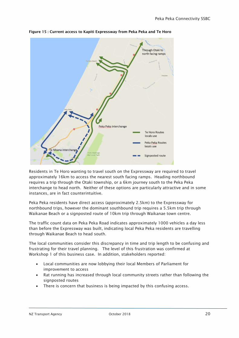
Trip Legibility
The confusing nature of the trips that stakeholders have raised is known as trip ‘Legibility’.
In the transport context this is defined as “Legibility - A legible environment makes
navigation and movement easy and seamless, helping improve people's understanding,
enjoyment and experience”.
The concept of good legibility of design is used throughout the transport system and across
all modes. From an Expressway perspective, good legibility would include interchanges
looking and feeling the same, and importantly providing for all movements. This allows
people to access the Expressway from the same location as they exited and vice versa. This
has been shown to provide a more understandable and enjoyable customer experience.
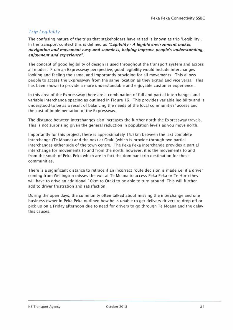
In this area of the Expressway there are a combination of full and partial interchanges and
variable interchange spacing as outlined in Figure 16. This provides variable legibility and is
understood to be as a result of balancing the needs of the local communities’ access and
the cost of implementation of the Expressway.
The distance between interchanges also increases the further north the Expressway travels.
This is not surprising given the general reduction in population levels as you move north.
Importantly for this project, there is approximately 15.5km between the last complete
interchange (Te Moana) and the next at Otaki (which is provide through two partial
interchanges either side of the town centre. The Peka Peka interchange provides a partial
interchange for movements to and from the north, however, it is the movements to and
from the south of Peka Peka which are in fact the dominant trip destination for these
communities.
There is a significant distance to retrace if an incorrect route decision is made i.e. if a driver
coming from Wellington misses the exit at Te Moana to access Peka Peka or Te Horo they
will have to drive an additional 10km to Otaki to be able to turn around. This will further
add to driver frustration and satisfaction.
During the open days, the community often talked about missing the interchange and one
business owner in Peka Peka outlined how he is unable to get delivery drivers to drop off or
pick up on a Friday afternoon due to need for drivers to go through Te Moana and the delay
this causes.
Peka Peka Connectivity SSBC
NZ Transport Agency October 2018 22
Figure 16 : Expressway interchanges
Problem 1 Confirmation
This evidence confirms that the customers of the Expressway in the Peka Peka and Te Horo
communities are frustrated with the form and proximity of their access to the Expressway.
Part of this frustration is the confusing access arrangement and the need to change their
travel plan depending on the duration of travel. It is also resulting in visitors to the area
being confused with the access arrangements and subsequently making inefficient travel
decisions.
Peka Peka Connectivity SSBC
NZ Transport Agency October 2018 23
This confirms the problem statement:
The confusing access arrangement to the Kapiti Expressway in the Peka Peka area is
delivering poor customer satisfaction (50%)
2.3.2 Comparatively poor connectivity to Kapiti Expressway
As outlined above, as well as the confusing nature of the current access to the Expressway
the Peka Peka and Te Horo communities consider that they have a reduced level of
accessibility compared to neighbouring communities along the Expressway.
Due to the mix of full and partial interchanges along the Expressway there are different
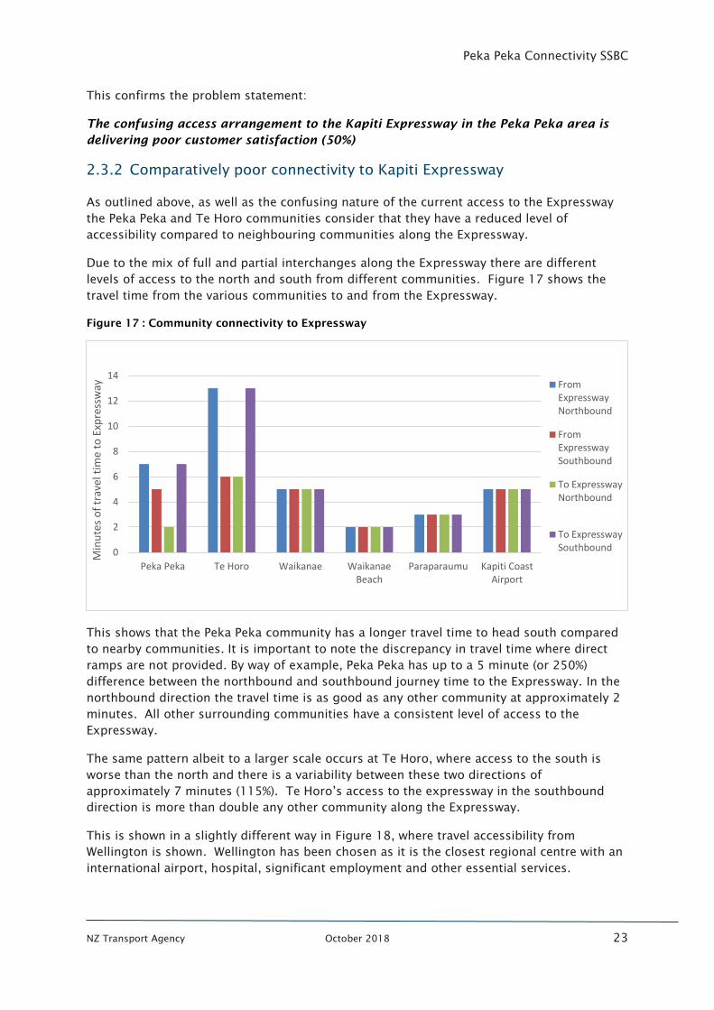
levels of access to the north and south from different communities. Figure 17 shows the
travel time from the various communities to and from the Expressway.
Figure 17 : Community connectivity to Expressway
This shows that the Peka Peka community has a longer travel time to head south compared
to nearby communities. It is important to note the discrepancy in travel time where direct
ramps are not provided. By way of example, Peka Peka has up to a 5 minute (or 250%)
difference between the northbound and southbound journey time to the Expressway. In the
northbound direction the travel time is as good as any other community at approximately 2
minutes. All other surrounding communities have a consistent level of access to the
Expressway.
The same pattern albeit to a larger scale occurs at Te Horo, where access to the south is
worse than the north and there is a variability between these two directions of
approximately 7 minutes (115%). Te Horo’s access to the expressway in the southbound
direction is more than double any other community along the Expressway.
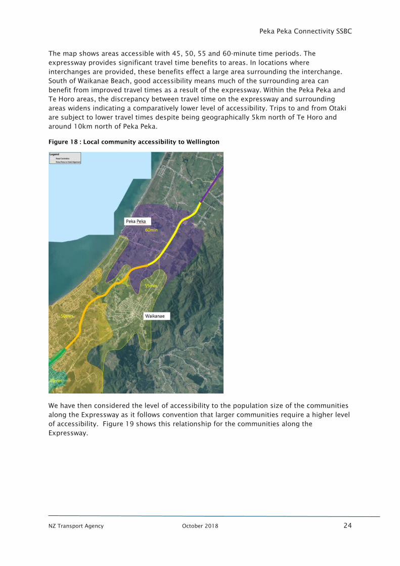
This is shown in a slightly different way in Figure 18, where travel accessibility from
Wellington is shown. Wellington has been chosen as it is the closest regional centre with an
international airport, hospital, significant employment and other essential services.
0
2
4
6
8
10
12
14
Peka Peka Te Horo Waikanae WaikanaeBeach
Paraparaumu Kapiti CoastAirport
Min
ute
s o
f tr
avel
tim
e to
Exp
ress
way From
ExpresswayNorthbound
FromExpresswaySouthbound
To ExpresswayNorthbound
To ExpresswaySouthbound
Peka Peka Connectivity SSBC
NZ Transport Agency October 2018 24
The map shows areas accessible with 45, 50, 55 and 60-minute time periods. The
expressway provides significant travel time benefits to areas. In locations where
interchanges are provided, these benefits effect a large area surrounding the interchange.
South of Waikanae Beach, good accessibility means much of the surrounding area can
benefit from improved travel times as a result of the expressway. Within the Peka Peka and
Te Horo areas, the discrepancy between travel time on the expressway and surrounding
areas widens indicating a comparatively lower level of accessibility. Trips to and from Otaki
are subject to lower travel times despite being geographically 5km north of Te Horo and
around 10km north of Peka Peka.
Figure 18 : Local community accessibility to Wellington
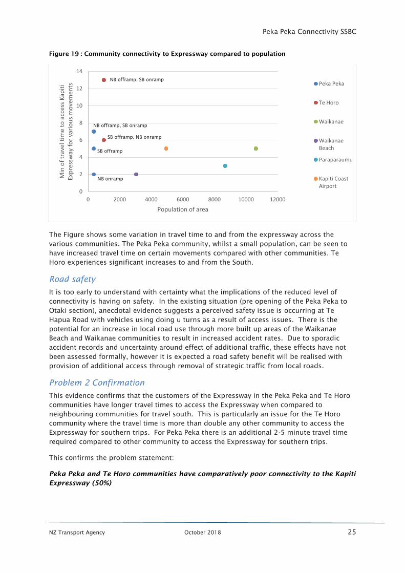
We have then considered the level of accessibility to the population size of the communities
along the Expressway as it follows convention that larger communities require a higher level
of accessibility. Figure 19 shows this relationship for the communities along the
Expressway.
Peka Peka Connectivity SSBC
NZ Transport Agency October 2018 25
Figure 19 : Community connectivity to Expressway compared to population
The Figure shows some variation in travel time to and from the expressway across the
various communities. The Peka Peka community, whilst a small population, can be seen to
have increased travel time on certain movements compared with other communities. Te
Horo experiences significant increases to and from the South.
Road safety
It is too early to understand with certainty what the implications of the reduced level of
connectivity is having on safety. In the existing situation (pre opening of the Peka Peka to
Otaki section), anecdotal evidence suggests a perceived safety issue is occurring at Te
Hapua Road with vehicles using doing u turns as a result of access issues. There is the
potential for an increase in local road use through more built up areas of the Waikanae
Beach and Waikanae communities to result in increased accident rates. Due to sporadic
accident records and uncertainty around effect of additional traffic, these effects have not
been assessed formally, however it is expected a road safety benefit will be realised with
provision of additional access through removal of strategic traffic from local roads.
Problem 2 Confirmation
This evidence confirms that the customers of the Expressway in the Peka Peka and Te Horo
communities have longer travel times to access the Expressway when compared to
neighbouring communities for travel south. This is particularly an issue for the Te Horo
community where the travel time is more than double any other community to access the
Expressway for southern trips. For Peka Peka there is an additional 2-5 minute travel time
required compared to other community to access the Expressway for southern trips.
This confirms the problem statement:
Peka Peka and Te Horo communities have comparatively poor connectivity to the Kapiti
Expressway (50%)
0
2
4
6
8
10
12
14
0 2000 4000 6000 8000 10000 12000
Min
of
trav
el t
ime
to a
cces
s K
apit
i Ex
pre
ssw
ay f
or
vari
ou
s m
ove
men
ts
Population of area
Peka Peka
Te Horo
Waikanae
WaikanaeBeach
Paraparaumu
Kapiti CoastAirport
NB onramp
NB offramp, SB onramp
SB offramp, NB onramp
NB offramp, SB onramp
SB offramp
Peka Peka Connectivity SSBC
NZ Transport Agency October 2018 26
CUSTOMER AND SYSTEM OUTCOMES
3.1 Strategic outcomes
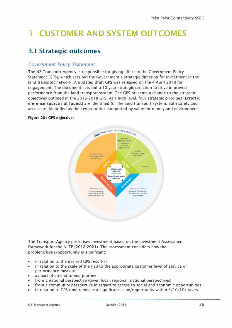
Government Policy Statement
The NZ Transport Agency is responsible for giving effect to the Government Policy
Statement (GPS), which sets out the Government’s strategic direction for investment in the
land transport network. A updated draft GPS was released on the 4 April 2018 for
engagement. The document sets out a 10-year strategic direction to drive improved
performance from the land transport system. The GPS presents a change to the strategic
objectives outlined in the 2015-2018 GPS. At a high level, four strategic priorities (Error! R
eference source not found.) are identified for the land transport system. Both safety and
access are identified as the key priorities, supported by value for money and environment.
Figure 20 : GPS objectives
The Transport Agency prioritises investment based on the Investment Assessment
framework for the NLTP (2018-2021). The assessment considers how the
problem/issue/opportunity is significant:
• in relation to the desired GPS result(s)
• in relation to the scale of the gap to the appropriate customer level of service or
performance measure
• as part of an end-to-end journey
• from a national perspective (given local, regional, national perspectives)
• from a community perspective in regard to access to social and economic opportunities
• in relation to GPS timeframes ie a significant issue/opportunity within 3/10/10+ years.
Peka Peka Connectivity SSBC
NZ Transport Agency October 2018 27
There is alignment between some of the identified benefits of this project and the strategic
priorities of the Transport Agency, particularly as they relate to addressing a Gap in
customer level of service and contribute to an end-to-end journey for customers in the Peka
Peka and Te Horo communities.
One Network Road Classification
The ONRC defines various performance outcomes and customer levels of service that should
be developed for different classifications of road throughout New Zealand. The ONRC further
defines various levels of customer service in relation to travel time reliability, resilience,
optimal speeds, safety, amenity and accessibility.
SH1 is classified in the One Network Road Classification (ONRC) system as a High Volume
National road. This is the highest classification and reflects the important role of
connecting the regional centre of Wellington and its associated Port, Airport and other
infrastructure with the rest of the north island. The ONRC sets out Customer Levels of
Service which vary by road classification. Broadly, they relate to travel time reliability,
resilience, optimal speeds, safety, amenity and accessibility with specific details to be found
in the ONRC5
.
The focus in this area of the network is on through capacity for access to and from
Wellington. The Expressway undertakes this function well and additional connectivity to the
Expressway in this area of the network would need to ensure this strategic through function
was not compromised.
Kapiti District Economic Growth Strategy
The Kapiti District Economic Development Strategy seeks to continue the development of
the Kapiti economy and to create a “Thriving economy, vibrant culture and diverse
community”. The strategy details the elements to achieve this outcome.
The strategy identifies five key economic drivers which are most likely to have the greatest
impact on our economic prosperity and competitiveness. These are designed to ensure that
the district harnesses its strengths in each area and focuses efforts in those areas that
require improvement.
One of those five areas is “Good connectivity: Infrastructure, digital, logistics and
communities” and ensuring (that KCDC) “Co-ordinate our efforts to maximise short and
long-term benefits of the Expressway project.”
Providing greater connectivity to the Expressway is consistent with this important district
strategy.
Wellington Northern Corridor Business Case
The Wellington Northern Corridor business case was approved in 2009 by the Transport
Agency board and updated in 2013. The WNC programme objectives, were as follows:
• To enhance inter regional and national economic growth and productivity
5
https://www.Transport Agency.govt.nz/roads-and-rail/road-efficiency-group/one-network-road-classification/key-
documents/
Peka Peka Connectivity SSBC
NZ Transport Agency October 2018 28
• To improve access to Wellington’s CBD, key industrial and employment centres, port,
airport and hospital
• To provide relief from severe congestion on the state highway and local road
networks
• To improve the resilience of the transport network
• To improve safety and journey time reliability on SH1 between Levin and the
Wellington airport.
Improving connectivity in and around the Peka Peka and Te Horo communities would not be
inconsistent with the objectives of this corridor programme. It will be important that any
additional connectivity did not adversely impact the strategic through movement of the
Expressway.
Kapiti Town Centres and Connectors Transformation
In 2014, KCDC undertook a strategic case to understand the post Expressway shape of
Kapiti’s town centres. This identified the following problems:
• Problem one: Lack of quality town centre design results in a lost opportunity to
catalyse growth
• Problem two: Lack of a main street results in economic and retail activity occurring
elsewhere in the region or district
• Problem three: Poor transport connections result in low quality transport
arrangements.
The potential benefits of successfully investing to address these were identified as follows:
• Benefit one: Improved social, cultural and economic public life for Kapiti communities
• Benefit two: Private sector investment stimulates jobs and vibrancy in the town
centres
• Benefit three: Improved access and connection.
The strategic case identified the need to ensure that the town centres of Waikanae and
Paraparaumu were carefully considered and that there was a strong case for investment in
these towns to realise the benefits identified.
Improved connectivity to the Peka Peka and Te Horo communities will need to consider any
potential impacts on the surrounding area.
3.2 Project Benefits
Following Workshop 1 of this business case the following benefits were identified if the
problems were addressed:
• Benefit 1: Improved customer satisfaction due to connectivity frustrations (40%)
• Benefit 2: More efficient access from the Peka Peka and Te Horo communities to the
Expressway (40%)
• Benefit 3: Improved operation and safety of local road network (20%)
The first two benefits respond directly to the problems identified. The additional benefit
relates to the desire for the improved safety and operation of the local road network. As
Peka Peka Connectivity SSBC
NZ Transport Agency October 2018 29
identified in the previous problem sections of this report, there is currently rat running
through residential local roads (Peka Peka residents travelling through Waikanae Beach
instead of Peka Peka Road). Improving connectivity should therefore provide improved
operation and safety outcomes for implied local roads.
3.3 Project investment objectives and measures
A critical component of a business case is the development of investment objectives, which
provide the objectives upon which an investor in the project is seeking to achieve. These
investment objectives have been derived from the benefits identified above and are used to
assess the performance of potential options. They were confirmed by regional stakeholders
at Workshop 1.
The identified investment objectives and the measures to determine if they are being
realised are summarised in Table 3.
Table 3 : Investment objectives and measures
INVESTMENT OBJECTIVE OBJECTIVE
WEIGHTING MEASURE
1
Improve Peka Peka and Te Horo
communities’ customer
satisfaction of the Expressway by
75% by 2025
50%
Bi-annual customer satisfaction study
completed at least twice before the
preferred option is implemented and for
at least 2 years post implementation
2
Improved customer travel times
to Expressway from Peka Peka
and Te Horo communities by 30%
by 2023
50%
Travel time measure to the Expressway
from:
· Intersection of Peka Peka Road
and Paetawa Road
· Intersection of Te Horo Beach
Road and Sims Road
· Te Horo School Road
Investment Objective 1: responds to the current frustration and customer dissatisfaction at
the variable (between north and southbound access to the Expressway) and confusing
nature of access to the Expressway. A 75% increase in customer satisfaction has been
selected as this is considered to provide a tangible increase in satisfaction. The 2025 date
has been adopted as this is two years after possible implementation to give time to collect
the required data.
Whilst a baseline satisfaction survey is required to accurately determine the baseline for this
criterion, the recent workshops have indicated the current arrangement is delivering a low
customer satisfaction level (estimated to be less than 20%). It is intended that this survey
would be developed with the Transport Agency’s Customer Experience and Behaviours team.
Likely questions could include:
• Where do you currently live?
• Where do you travel to and how frequent are these trips?
• How has your trip changed since the opening of the M2PP Expressway?
Peka Peka Connectivity SSBC
NZ Transport Agency October 2018 30
• Do you consider there is an issue with connectivity in the Peka Peka/ Te Horo area?
• How does this affect you?
• How satisfied are you with you level of connectivity to the Expressway?
A 50% weighting has been selected as this is considered an equally important investment
objective and has driven the undertaking of this business case to this stage.
Investment Objective 2: ensures that the identified concerns with comparative accessibility
to the Expressway is an investment focus. A reduction in travel time of 30% has been
selected to the Expressway as this would bring the travel time more in line with that
experienced by neighbouring communities. The year 2023 has been chosen to represent an
obtainable timeframe to make this level of change to outcomes.
The current baseline travel time is 7 minutes for southbound movements at Peka Peka and
13 minutes for southbound movements at Te Horo.
A 50% weighting has been selected as this is considered an equally important investment
outcome.
These investment objectives address the identified project problems and map well on the
identified benefits as shown in Figure 21.
Figure 21 : Problem, benefit and investment objective mapping
These problem, benefit and investment objectives were reviewed after the 2018 GPS was
confirmed. To better align with the GPS the second investment objective was reworded
slightly to remove travel time references and include access as shown below.
Improved customer access to Expressway from Peka Peka and Te Horo communities by
30% by 2023
3.4 Customer Outcomes
The investment objectives would make travel clearer and more efficient for our customers.
This would result in improved satisfaction levels, which are currently at low levels.
Customer insights during this project included the following:
Peka Peka Connectivity SSBC
NZ Transport Agency October 2018 31
Residents in Peka Peka were consistently dissatisfied with the additional 6-7 minutes lost
with their families as a result of the circuitous route through local roads to get on and off of
the new Expressway.
Customers struggled to understand why they could use the current Peka Peka interchange to
go to and from the north but not to the south where most of them want to go, highlighting
this is not the hallmark of a good transport system.
Businesses in Peka Peka confirmed that customers were confused by the layout and how to
access the area, resulting in delays to deliveries and disgruntled customers once they have
arrived.
3.5 System Outcomes
Peka Peka and Te Horo communities will be able to exit at Peka Peka (from Wellington) but
to head to Wellington are required to drive through to Te Moana. This is confusing for our
customers and visitors to the area.
These investment objectives would result in a more efficient transport system, with less
travel on local roads through residential areas and a more intuitive connectivity outcome for
users of the transport system. Solving these problems would also maximise the return on
investment of the recently completed Kapiti Expressway through the provision of a more
intuitive and legible transport system that made sense to our customers, thereby improving
the efficiency of their trips and their level of journey satisfaction.
Peka Peka Connectivity SSBC
NZ Transport Agency October 2018 32
STAKEHOLDERS
4.1 Consultation and communication approach
An inclusive approach with stakeholders is a key aspect of the business case approach and
has been used successful to date in the development of this business case. This has
included engagement with key stakeholders through workshops and individual meetings on
specific topics as outlined in Peka Peka Connectivity Engagement Strategy (September
2017).
The public have also been consulted on the shortlisted options as part of this SSBC.
4.2 Key Stakeholders
All communications and engagement processes have adopted the principles of the
International Association of Public Participation (IAP2). The Peka Peka Connectivity
Engagement Strategy includes the following forms of engagement:
• Newsletters
• Interactive website
• Individual meetings
• Social media
• Open days
• Workshops
• Formal letters (property owners)
As well as public consultation, there has also been engagement with stakeholders that have
been identified in the following groups in Table 4.
Stakeholders have been involved throughout the SSBC process through workshops and/or
one-on-one meetings. This engagement has built upon the existing relationship with the
Council and the wider community established as part of the neighbouring Mackays to
Peka Peka and Peka Peka to Otaki projects.
Public consultation was a part of this engagement through public open days in October
2017 where short listed options were presented for feedback and wider feedback was
sought through a formal feedback form.
This consultation has informed the recommended option, including its location, form and
function.
The preferred option will be confirmed to the wider community once endorsement of this
business case is obtained.
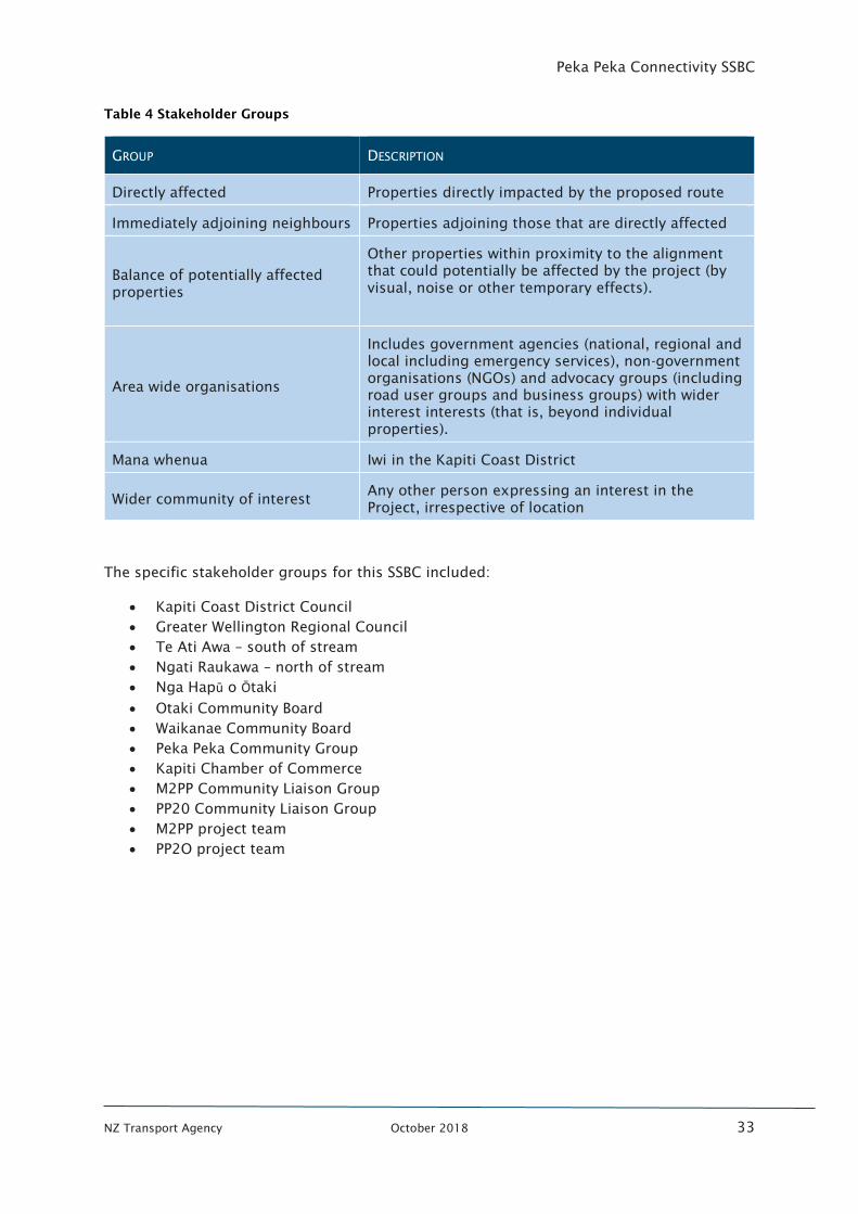
Peka Peka Connectivity SSBC
NZ Transport Agency October 2018 33
Table 4 Stakeholder Groups
GROUP DESCRIPTION
Directly affected Properties directly impacted by the proposed route
Immediately adjoining neighbours Properties adjoining those that are directly affected
Balance of potentially affected
properties
Other properties within proximity to the alignment
that could potentially be affected by the project (by
visual, noise or other temporary effects).
Area wide organisations
Includes government agencies (national, regional and
local including emergency services), non-government
organisations (NGOs) and advocacy groups (including
road user groups and business groups) with wider
interest interests (that is, beyond individual
properties).
Mana whenua Iwi in the Kapiti Coast District
Wider community of interest Any other person expressing an interest in the
Project, irrespective of location
The specific stakeholder groups for this SSBC included:
• Kapiti Coast District Council
• Greater Wellington Regional Council
• Te Ati Awa – south of stream
• Ngati Raukawa – north of stream
• Nga Hapū o Ōtaki
• Otaki Community Board
• Waikanae Community Board
• Peka Peka Community Group
• Kapiti Chamber of Commerce
• M2PP Community Liaison Group
• PP20 Community Liaison Group
• M2PP project team
• PP2O project team
Peka Peka Connectivity SSBC
NZ Transport Agency October 2018 34
4.3 Stakeholder engagement
4.3.1 Mana Whenua engagement
Mana Whenua have been invited to all project workshops and there have been one on one
discussions with the Transport Agency throughout the project. Mana Whenua are particularly
interested in ensuring the same principles agreed for the Expressway project are applied to
this project.
4.3.2 Stakeholder engagement
One-on-one meetings with stakeholders have been held as required to understand key
issues and technical aspects of the project. In addition, two combined workshops have been
held for the stakeholder groups identified above. These were held at the Kapiti Hockey
Pavilion on:
• Workshop 1 – 15th
November 2017
• Workshop 2 – 21st November 2017
4.3.3 Public consultation
Public consultation was undertaken as part of this business case development. This occurred
through public open days on the 28th
and 29th
of October 2017 and wider feedback through
a formal feedback form. This consultation has informed the recommended option,
including its location, form and function.
The preferred option will be communicated to the community once this SSBC is endorsed.
Subsequent sections of this report will outline the outcomes of this consultation which has
shown strong support for the project generally.
In addition, the consultation process for the Peka Peka connectivity project is documented
and implemented through an Engagement and Communications Plan included in Appendix
C. Consultation is a fundamental part of the project and to date has actively involved KCDC,
key stakeholders, Tangata Whenua, directly affected landowners and the community. A
variety of communication techniques has been used to consult with all parties, including
open days, feedback forms, site meetings, newsletters, and phone discussions. The Plan is
a “live” document that will be changed (if necessary) as the project develops and as the
consultation process continues.
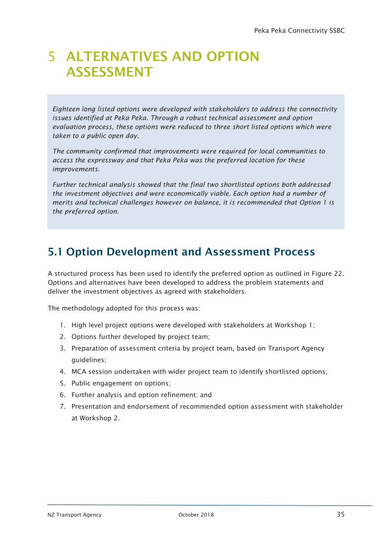
Peka Peka Connectivity SSBC
NZ Transport Agency October 2018 35
ALTERNATIVES AND OPTION
ASSESSMENT
5.1 Option Development and Assessment Process
A structured process has been used to identify the preferred option as outlined in Figure 22.
Options and alternatives have been developed to address the problem statements and
deliver the investment objectives as agreed with stakeholders.
The methodology adopted for this process was:
1. High level project options were developed with stakeholders at Workshop 1;
2. Options further developed by project team;
3. Preparation of assessment criteria by project team, based on Transport Agency
guidelines;
4. MCA session undertaken with wider project team to identify shortlisted options;
5. Public engagement on options;
6. Further analysis and option refinement; and
7. Presentation and endorsement of recommended option assessment with stakeholder
at Workshop 2.
Eighteen long listed options were developed with stakeholders to address the connectivity
issues identified at Peka Peka. Through a robust technical assessment and option
evaluation process, these options were reduced to three short listed options which were
taken to a public open day.
The community confirmed that improvements were required for local communities to
access the expressway and that Peka Peka was the preferred location for these
improvements.
Further technical analysis showed that the final two shortlisted options both addressed
the investment objectives and were economically viable. Each option had a number of
merits and technical challenges however on balance, it is recommended that Option 1 is
the preferred option.
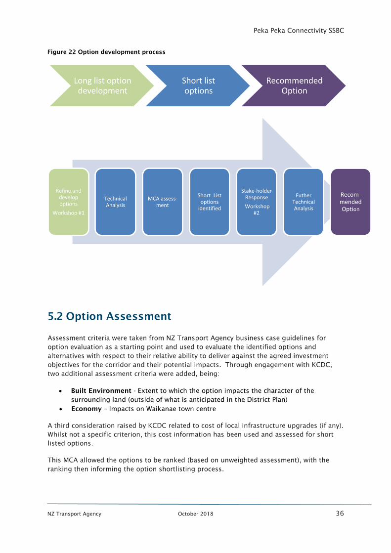
Peka Peka Connectivity SSBC
NZ Transport Agency October 2018 36
Figure 22 Option development process
5.2 Option Assessment
Assessment criteria were taken from NZ Transport Agency business case guidelines for
option evaluation as a starting point and used to evaluate the identified options and
alternatives with respect to their relative ability to deliver against the agreed investment
objectives for the corridor and their potential impacts. Through engagement with KCDC,
two additional assessment criteria were added, being:
• Built Environment - Extent to which the option impacts the character of the
surrounding land (outside of what is anticipated in the District Plan)
• Economy – Impacts on Waikanae town centre
A third consideration raised by KCDC related to cost of local infrastructure upgrades (if any).
Whilst not a specific criterion, this cost information has been used and assessed for short
listed options.
This MCA allowed the options to be ranked (based on unweighted assessment), with the
ranking then informing the option shortlisting process.
Long list option development
Short list options
Recommended Option
Refine and develop options
Workshop #1
Technical Analysis
MCA assess-ment
Short List options
identified
Stake-holder Response
Workshop #2
Futher Technical Analysis
Recom-mended Option
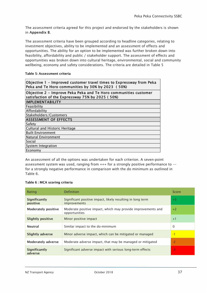
Peka Peka Connectivity SSBC
NZ Transport Agency October 2018 37
The assessment criteria agreed for this project and endorsed by the stakeholders is shown
in Appendix B.
The assessment criteria have been grouped according to headline categories, relating to
investment objectives, ability to be implemented and an assessment of effects and
opportunities. The ability for an option to be implemented was further broken down into
feasibility, affordability and public / stakeholder support. The assessment of effects and
opportunities was broken down into cultural heritage, environmental, social and community
wellbeing, economy and safety considerations. The criteria are detailed in Table 5
Table 5: Assessment criteria
An assessment of all the options was undertaken for each criterion. A seven-point
assessment system was used, ranging from +++ for a strongly positive performance to ---
for a strongly negative performance in comparison with the do minimum as outlined in
Table 6.
Table 6 : MCA scoring criteria
Rating Definition Score
Significantly
positive
Significant positive impact, likely resulting in long term
improvements
+3
Moderately positive Moderate positive impact, which may provide improvements and
opportunities
+2
Slightly positive Minor positive impact +1
Neutral Similar impact to the do-minimum 0
Slightly adverse Minor adverse impact, which can be mitigated or managed -1
Moderately adverse Moderate adverse impact, that may be managed or mitigated -2
Significantly
adverse
Significant adverse impact with serious long-term effects -3
Objective 1 - Improved customer travel times to Expressway from Peka
Peka and Te Horo communities by 30% by 2023 ( 50%)
Objective 2 - Improve Peka Peka and Te Horo communities customer
satisfaction of the Expressway 75% by 2025 ( 50%)
IMPLEMENTABILITY
Feasibility
Affordability
Stakeholders/Customers
ASSESSMENT OF EFFECTS
Safety
Cultural and Historic Heritage
Built Environment
Natural Environment
Social
System Integration
Economy
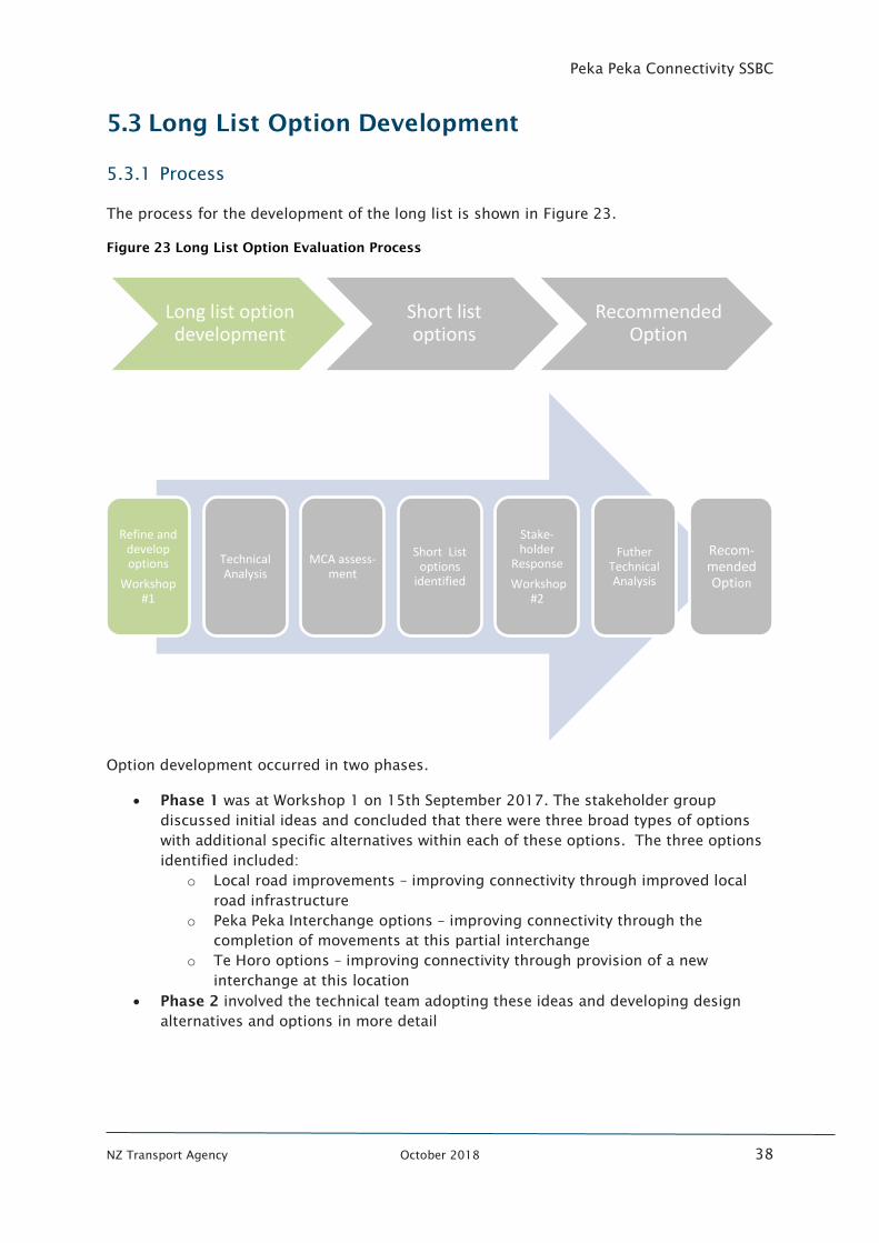
Peka Peka Connectivity SSBC
NZ Transport Agency October 2018 38
5.3 Long List Option Development
5.3.1 Process
The process for the development of the long list is shown in Figure 23.
Figure 23 Long List Option Evaluation Process
Option development occurred in two phases.
• Phase 1 was at Workshop 1 on 15th September 2017. The stakeholder group
discussed initial ideas and concluded that there were three broad types of options
with additional specific alternatives within each of these options. The three options
identified included:
o Local road improvements – improving connectivity through improved local
road infrastructure
o Peka Peka Interchange options – improving connectivity through the
completion of movements at this partial interchange
o Te Horo options – improving connectivity through provision of a new
interchange at this location
• Phase 2 involved the technical team adopting these ideas and developing design
alternatives and options in more detail
Long list option development
Short list options
Recommended Option
Refine and develop options
Workshop #1
Technical Analysis
MCA assess-ment
Short List options
identified
Stake-holder
Response
Workshop #2
Futher Technical Analysis
Recom-mended Option
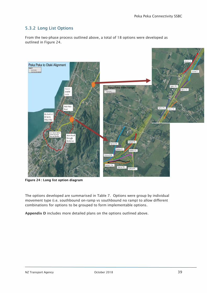
Peka Peka Connectivity SSBC
NZ Transport Agency October 2018 39
5.3.2 Long List Options
From the two-phase process outlined above, a total of 18 options were developed as
outlined in Figure 24.
Figure 24 : Long list option diagram
The options developed are summarised in Table 7. Options were group by individual
movement type (i.e. southbound on-ramp vs southbound no ramp) to allow different
combinations for options to be grouped to form implementable options.
Appendix D includes more detailed plans on the options outlined above.
Peka Peka Connectivity SSBC
NZ Transport Agency October 2018 40
Table 7 : Long List Options
OPTION TYPE MOVEMENT IDENTIFICATION DESCRIPTION Local R
oad
Rutherford
Drive
Enhancements to Rutherford Drive to
improve access to Te Moana interchange
Main Road Improvements to the main road through
Waikanae town centre
Ngarara farm
arterial
New link from Ngarara development to
local road network in the north
Future coastal
route
Development of a new link along the
coast linking Te Horo and Peka Peka
Peka Peka
Southbound
On-ramp P1
Access from Hadfields link Road to
Expressway
P2a Access from Hadfields/Peka Peka
intersection onto Expressway
P2B Access from Peka Peka Road overbridge
onto Expressway
P6 Overbridge from Hadfields onto
Expressway
P7 Refinement of option 2a to reduce land
Northbound
Off-ramp P3
Link from Expressway directly onto Peka
Peka Road, west of current roundabout
P4 Link from Expressway directly onto Peka
Peka Road at overbridge
P5 Link from Expressway directly onto Peka
Peka Road at current roundabout
Te H
oro
Southbound
Off-ramp T1
New Ramp at proposed PP2O overbridge
linking Te Horo with existing SH1
Southbound
On-ramp T2
New Ramp at proposed PP2O overbridge
linking Te Horo with existing SH1
T3
New ramp at School Road intersection
(would require relocating proposed PP2O
bridge
Northbound
Off-ramp T4
New ramp at School Road intersection
(would require relocating proposed PP2O
bridge
T5 New Ramp at proposed PP2O overbridge
linking Te Horo with existing SH1
Northbound
On-ramp T6
New Ramp at proposed PP2O overbridge
linking Te Horo with existing SH1
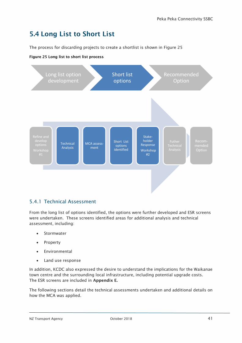
Peka Peka Connectivity SSBC
NZ Transport Agency October 2018 41
5.4 Long List to Short List
The process for discarding projects to create a shortlist is shown in Figure 25
Figure 25 Long list to short list process
5.4.1 Technical Assessment
From the long list of options identified, the options were further developed and ESR screens
were undertaken. These screens identified areas for additional analysis and technical
assessment, including:
• Stormwater
• Property
• Environmental
• Land use response
In addition, KCDC also expressed the desire to understand the implications for the Waikanae
town centre and the surrounding local infrastructure, including potential upgrade costs.
The ESR screens are included in Appendix E.
The following sections detail the technical assessments undertaken and additional details on
how the MCA was applied.
Long list option development
Short list options
Recommended Option
Refine and develop options
Workshop #1
Technical Analysis
MCA assess-ment
Short List options
identified
Stake-holder
Response
Workshop #2
Futher Technical Analysis
Recom-mended Option
Peka Peka Connectivity SSBC
NZ Transport Agency October 2018 42
Stormwater
One of the more significant technical issues in the project area is stormwater management
and flooding. The low-lying area is prone to flooding as the ground water level is just below
the surface. There are existing areas of flood storage located in and around the Peka Peka
interchange and considerable flooding risks have been identified in the Te Horo sector.
A desktop stormwater assessment of the option long list was undertaken and this is
provided in Appendix F.
This concluded:
• Local road options can manage any stormwater impacts appropriately
• Peka Peka interchange options carry stormwater risk with lost flood storage
mitigation a likely issue on many of the options. This is will likely result in the two
existing ‘dry’ flood storage areas, being converted to ‘wet’ storage areas (wetlands)
• Te Horo has similar stormwater challenges as Peka Peka.
Stormwater management is one technical area where different options at a certain location
(such as the southbound on-ramps at Peka Peka interchange) had different effects.
Therefore, these effects were reflected in the MCA assessment with a range of rankings
depending on the severity of the effect
Property
There are a number of sensitive property issues in this area of the transport network. These
issues include on-going private property negotiations for other projects, Mana Whenua land
implications and existing lease arrangements and crown owned property implications.
The initial assessment indicated that the Peka Peka interchange options would generate the
least property risk due to the existence of a partial interchange and adjacent Transport
Agency landholding. Te Horo was considered to carry significant property risks due to the
complexity of current property negotiations, the interface between Kiwirail and the roading
network, Mana Whenua land interests in and around the Te Horo area and the presence of
commercial operations.
The Local road network options were considered to have moderate property implications
given the likely need for road widening and properties required to new road alignments
Environmental
The environmental impacts for the MCA analysis related to ecology and the streams in the
area. There was also consideration of other impacts including potential cultural impacts and
noise.
Existing consent conditions at Peka Peka provide clear rules for mitigation required to off-
set any impacts on streams. As such, the Peka Peka options for this project that further
impact the Paetawa stream were considered likely to require mitigation for the stream.
These options would also bring noise closer to the residents in the land holdings to the
south east of the Peka Peka interchange.
Te Horo options were considered to have stream impacts and localised noise considerations.
No major environmental effects were reported for the local road options.
Peka Peka Connectivity SSBC
NZ Transport Agency October 2018 43
Land use response
During stakeholder discussions a concern was raised that there could be unintended
consequences of improved connectivity to the land use in the area. An analysis was
undertaken to understand what this impact could be. In summary it concluded that the
most likely land use response would be:
• Local road options were considered unlikely to drive a change in land use.
• Peka Peka options could accelerate residential intensification of the surrounding area
by approximately 200 dwellings by possibly 10 years earlier.
• Te Horo options could accelerate residential intensification of the surrounding area
by approximately 250 dwellings by possibly 10 years earlier.
This analysis informed the evaluation of the option long list, but was even more useful in
the assessment of potential implications of the recommended option (once identified). The
details of this assessment are included in Appendix G.
Waikanae Town Centre
For the long list to short listing process an initial assessment on the potential implications
on Waikanae town centre was undertaken based on the likely transportation effects of the
options.
This assessment is provided in Appendix H and concluded that:
• Local road options would be unlikely to have an impact on the Waikanae town
centre.
• Peka Peka options could reduce the traffic through Waikanae by around 16% which
is considered a minor impact.
• Te Horo options could reduce the traffic through Waikanae by around 7% which is
considered a minor impact.
Overall, it was considered that there has been an economic impact from the implementation
of the Expressway itself, however the incremental change from these additional connectivity
options is considered minor.
A more detailed assessment was undertaken after the short list options were identified.
Costs
Long list options were costed by Bond CM as outlined in Appendix I to enable comparison
between the on-ramp and off-ramp options. Commute transportation compiled the local
road network costs from similar projects. A summary of costs is shown in Figure 26.
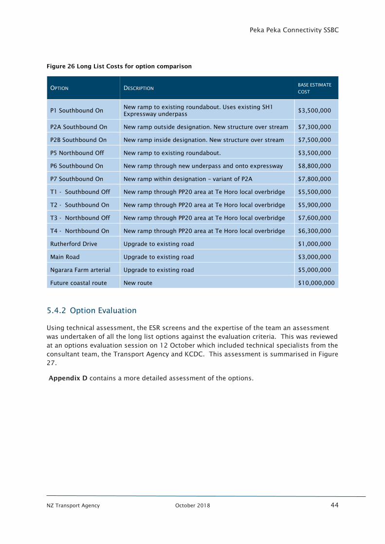
Peka Peka Connectivity SSBC
NZ Transport Agency October 2018 44
Figure 26 Long List Costs for option comparison
OPTION DESCRIPTION BASE ESTIMATE
COST
P1 Southbound On New ramp to existing roundabout. Uses existing SH1
Expressway underpass $3,500,000
P2A Southbound On New ramp outside designation. New structure over stream $7,300,000
P2B Southbound On New ramp inside designation. New structure over stream $7,500,000
P5 Northbound Off New ramp to existing roundabout. $3,500,000
P6 Southbound On New ramp through new underpass and onto expressway $8,800,000
P7 Southbound On New ramp within designation – variant of P2A $7,800,000
T1 - Southbound Off New ramp through PP20 area at Te Horo local overbridge $5,500,000
T2 - Southbound On New ramp through PP20 area at Te Horo local overbridge $5,900,000
T3 - Northbound Off New ramp through PP20 area at Te Horo local overbridge $7,600,000
T4 - Northbound On New ramp through PP20 area at Te Horo local overbridge $6,300,000
Rutherford Drive Upgrade to existing road $1,000,000
Main Road Upgrade to existing road $3,000,000
Ngarara Farm arterial Upgrade to existing road $5,000,000
Future coastal route New route $10,000,000
5.4.2 Option Evaluation
Using technical assessment, the ESR screens and the expertise of the team an assessment
was undertaken of all the long list options against the evaluation criteria. This was reviewed
at an options evaluation session on 12 October which included technical specialists from the
consultant team, the Transport Agency and KCDC. This assessment is summarised in Figure
27.
Appendix D contains a more detailed assessment of the options.
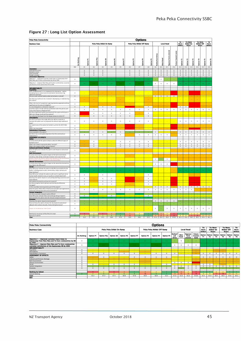
Peka Peka Connectivity SSBC
NZ Transport Agency October 2018 45
Figure 27 : Long List Option Assessment
Peka Peka Connectivity
Business Case
Te
Horo
Sthbd
Te
Horo
Nthbd
Do
No
thin
g
Op
tio
n P
1
Op
tio
n P
2a
Op
tio
n 2
B
Op
tio
n P
6
Op
tio
n P
7
Op
tio
n P
3
Op
tio
n P
4
Op
tio
n P
5
Ru
the
rfo
rd D
rive
Mai
n R
oad
Nga
rara
Far
m a
rte
rial
Futu
re C
oas
tal r
ou
te
Op
tio
n T
1
Op
tio
n T
2
Op
tio
n T
3
Op
tio
n T
4
Op
tio
n T
5
Op
tio
n T
6
DM O1 O2 O3 O4 O5 O6 O7 O8 O9 O10 O11 O12 O13 O14 O15 O16 O17 O18
Customers
International visitor 0 0 0 0 0 0 0 0 0 0 0 0 0 0 0 0
Domestic visitor 0 0 0 0 0 0 0 0 0 0 0 0 0 0 0 0
Local customer 0 0 0 0 0 0 0 0 0 0 0 0 0 0 0 0
Freight customer 0 0 0 0 0 0 0 0 0 0 0 0 0 0 0 0
Investment Objectives
Objective 1 - Improved customer travel times to Expressway from
Peka Peka and Te Horo communities by X% by 20XX0 ++ ++ ++ ++ ++ ++ ++ ++ + 0 + + ++ ++ ++ ++ ++ ++
Objective 2 - Improve Peka Peka and Te Horo communities customer
satisfaction of the Expressway X% by 20XX0 ++ +++ ++ ++ +++ ++ +++ ++ 0 0 0 0 ++ ++ ++ ++ ++ ++
IMPLEMENTABILITY
Feasibility
How straightforward is it to implement this alternative / option,
including social, cultural and environmental interventions (eg
additional planting)?
0 - -- -- -- -- -- - - -- -- -- --- -- -- --- --- -- --
Are any novel/untried/leading edge technologies involved? 0 - - - - - - - - 0 0 0 0 - - -- -- - -
Are there any technical risks involved in developing or implementing
this option?0 -- -- - - -- - - -- - - - - - - -- -- - -
What is the level of complexity in gaining statutory approvals and how
significant are the costs of mitigation?0 - -- -- -- -- -- - -- -- -- -- --- -- -- --- --- -- --
Is a new designation or alteration required? 0 0 -- 0 0 - --- -- 0 -- -- -- --- 0 0 --- --- -- --
Could the option include activities prohibited under the policies and
rules of the District or Regional Plan?0 0 0 0 0 0 0 0 0 0 0 0 0 0 0 0 0 0 0
Are there significant hazards associated with the option which pose a
H&S risk in design, build and final product?0 --- 0 0 0 0 0 -- 0 - - - - - - - - - -
Can safety be developed into the design process to control it? 0 -- 0 0 0 0 0 - 0 - - - - - - - - - -
Affordability
Are there any factors that might affect the ability to operate or
maintain the option over its projected life without major additional
costs?
0 0 0 0 0 0 0 0 0 - - - - 0 0 0 0 0 0
Can capital costs of the option be funded ( e.g from the NLTP, NEA,
TIF)?0 - -- -- --- -- --- -- - - - - --- -- -- -- -- -- --
What is the likely BCR? 0 - -- -- --- -- --- -- - -- -- -- --- -- -- --- --- -- --
Stakeholders/Customers
How acceptable is the option? 0 + 0 0 + 0 + + + 0 - - -- 0 0 0 0 0 0
Are there real or anticipated objections from the community or
stakeholders?0 0 0 0 0 0 -- 0 0 0 0 0 -- 0 0 0 0 0 0
ASSESSMENT OF EFFECTS
Safety
To what extent will the option enhance safety for different types of
transport users?0 -- 0 - - 0 0 0 0 - - - - 0 0 0 0 0 0
What is the impact on personal safety / security? 0 -- 0 - - 0 0 0 0 - - - - 0 0 0 0 0 0
What is the impact on fatal / serious injuries? 0 -- 0 - - 0 0 0 0 - - - - 0 0 0 0 0 0
Cultural and Historic Heritage
Does the ESR screen indicate the option could impact on cultural and
iwi values?0 -- -- -- -- -- -- -- -- - - - -- -- -- -- -- -- --
Built Environment
To what extent does the option impact on the built environment,
including urban design, landscape character and visual amenity0 - - - - - -- - - -- -- -- -- -- -- -- -- -- --
Extent to which the option impacts the character of the surrounding
land (outside of what is antipated in the District Plan)0 - - - - - - - - 0 + 0 - -- -- -- -- -- --
Natural Environment
To what extent does the option impact on the natural environment as
described in the ESR screen?0 - - - - - -- - - 0 0 0 --- -- -- -- -- -- --
Social
Does ESR screen indicate the option could affect accessibility for the
public, including access to jobs, communities, shops, services and
other facilities?
0 ++ ++ ++ ++ ++ ++ ++ ++ - - - -- ++ ++ ++ ++ ++ ++
Does ESR screen indicate the option could result in significant risk to
human health related to noise, air quality or contaminated land?0 0 - 0 - - - 0 - - - - - - -- -- - -
How does the option impact on surrounding dwellings (severence and
noise effects)0 0 -- 0 0 - --- -- 0 - - - --- - - --- --- - -
Will additional property purchases be required? 0 0 -- 0 0 - --- -- 0 - - - --- - - --- --- - -
Are there property risks to delivery and can they be effectively
managed?0 0 - 0 0 - -- - 0 - - - --- - - --- --- - -
Is there any Maori land required as part of the project? 0 - - - - - - - - 0 0 0 -- 0 0 0 0 0 0
Does the option affect other infrastructure providers (will agreements
need to be entered into with service providers)?0 0 0 0 0 0 0 0 0 0 0 0 0 0 0 0 -- -- --
System Integration
Are there any wider transport system effects? 0 + ++ + + ++ + ++ + + + + + + + + + + +
Does ESR screen indicate Urban and Landscape design impacts? 0 0 - - 0 - - - 0 - - - - - - - - - -
How well does the option meet the forecast transport demand? 0 ++ ++ ++ ++ ++ ++ ++ ++ + + + + + + + + + +
Economy
How does the option impact economic growth? 0 + + + + + + + + 0 0 0 0 + + + + + +
How well does the option enhance the development potential of
adjacent land / attract new jobs / help existing businesses?0 + + + + + + + + + + + + + + + + + +
Impact on the Waikanae Town Centre 0 - - - - - - - - 0 + 0 0 0 0 0 0 0 0
Ranking by sub group (ie Peka Peka On ramp) 0 4 2 4 3 1 3 2 1 1 3 2 4 1 1 2 2 1 1
Ranking all options 2 7 5 7 6 4 16 3 1 13 15 14 19 9 9 17 18 11 11
Cost $3.5 $7.3 $7.5 $8.8 $7.8 $9.0 $8.0 $3.5 $1.0 $3.0 $5.0 $10.0 $5.5 $5.9 $8.5 $9.3 $7.6 $6.3
OptionsTe Horo
Nthbd Off
Ramp
Peka Peka Sthbd On Ramp Local RoadPeka Peka Nthbd Off RampTe Horo
Sthbd On
Ramp
Peka Peka Connectivity
Business Case
Te
Horo
Sthbd
Te
Horo
Nthbd
Do Nothing Option P1 Option P2a Option 2B Option P6 Option P7 Option P3 Option P4 Option P5
Rutherf
ord
Drive
Main
Road
Ngarara
Farm
arterial
Future
Coastal
route
Option
T1
Option
T2
Option
T3
Option
T4
Option
T5
Option
T6
Objective 1 - Improved customer travel times to
Expressway from Peka Peka and Te Horo communities by X%
by 20XX
0 ++ ++ ++ ++ ++ ++ ++ ++ + 0 + + ++ ++ ++ ++ ++ ++
Objective 2 - Improve Peka Peka and Te Horo communities
customer satisfaction of the Expressway X% by 20XX0 ++ +++ ++ ++ +++ ++ +++ ++ 0 0 0 0 ++ ++ ++ ++ ++ ++
IMPLEMENTABILITY
Feasibility 0 - - - - - - - - - - - -- - - -- -- - -
Affordability 0 - - - -- - -- - - - - - -- - - -- -- - -
Stakeholders/Customers 0 0 0 0 0 0 - 0 0 0 - - -- 0 0 0 0 0 0
ASSESSMENT OF EFFECTS
Safety 0 -- 0 - - 0 0 0 0 - - - - 0 0 0 0 0 0
Cultural and Historic Heritage 0 -- -- -- -- -- -- -- -- - - - -- -- -- -- -- -- --
Built Environment 0 - - - - - -- - - - - - -- -- -- -- -- -- --
Natural Environment 0 - - - - - -- - - 0 0 0 --- -- -- -- -- -- --
Social 0 0 - 0 0 0 - - 0 - - - -- 0 0 - -- - -
System Integration 0 + + + + + + + + 0 0 0 0 0 0 0 0 0 0
Economy 0 0 0 0 0 0 0 0 0 0 + 0 0 + + + + + +
Ranking by Subset 4 2 4 3 1 3 2 1 1 3 2 4 1 1 2 2 1 1
Overall Ranking 2 7 5 7 6 4 16 3 1 13 15 14 19 9 9 17 18 11 11
Cost $3.5 $7.3 $7.5 $8.8 $7.8 $9.0 $8.0 $3.5 $1.0 $3.0 $5.0 $10.0 $5.5 $5.9 $8.5 $9.3 $7.6 $6.3
BCR
OptionsTe Horo
Nthbd Off
Ramp
Peka Peka Sthbd On Ramp Local RoadPeka Peka Nthbd Off RampTe Horo
Sthbd On
Ramp
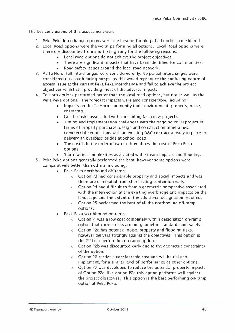
Peka Peka Connectivity SSBC
NZ Transport Agency October 2018 46
The key conclusions of this assessment were:
1. Peka Peka interchange options were the best performing of all options considered.
2. Local Road options were the worst performing all options. Local Road options were
therefore discounted from shortlisting early for the following reasons:
• Local road options do not achieve the project objectives.
• There are significant impacts that have been identified for communities.
• Road safety issues around the local road network.
3. At Te Horo, full interchanges were considered only. No partial interchanges were
considered (i.e. south facing ramps) as this would reproduce the confusing nature of
access issue at the current Peka Peka interchange and fail to achieve the project
objectives whilst still providing most of the adverse impact.
4. Te Horo options performed better than the local road options, but not as well as the
Peka Peka options. The forecast impacts were also considerable, including:
• Impacts on the Te Horo community (built environment, property, noise,
character).
• Greater risks associated with consenting (as a new project).
• Timing and implementation challenges with the ongoing PP2O project in
terms of property purchase, design and construction timeframes,
commercial negotiations with an existing D&C contract already in place to
delivery an overpass bridge at School Road.
• The cost is in the order of two to three times the cost of Peka Peka
options.
• Storm water complexities associated with stream impacts and flooding.
5. Peka Peka options generally performed the best, however some options were
comparatively better than others, including;
• Peka Peka northbound off-ramp
o Option P3 had considerable property and social impacts and was
therefore eliminated from short listing contention early.
o Option P4 had difficulties from a geometric perspective associated
with the intersection at the existing overbridge and impacts on the
landscape and the extent of the additional designation required.
o Option P5 performed the best of all the northbound off-ramp
options.
• Peka Peka southbound on-ramp
o Option P1was a low cost completely within designation on-ramp
option that carries risks around geometric standards and safety.
o Option P2a has potential noise, property and flooding risks,
however delivers strongly against the objectives. This option is
the 2nd
best performing on-ramp option.
o Option P2b was discounted early due to the geometric constraints
of the option.
o Option P6 carries a considerable cost and will be risky to
implement, for a similar level of performance as other options.
o Option P7 was developed to reduce the potential property impacts
of Option P2a, like option P2a this option performs well against
the project objectives. This option is the best performing on-ramp
option at Peka Peka.
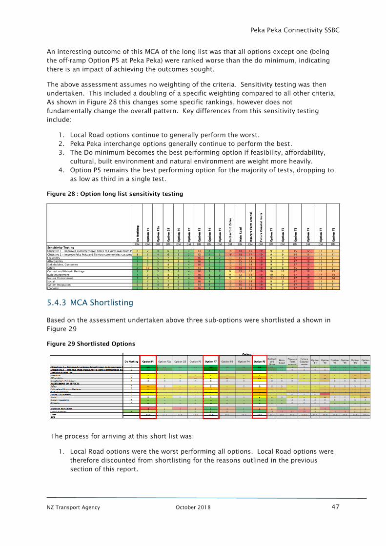
Peka Peka Connectivity SSBC
NZ Transport Agency October 2018 47
An interesting outcome of this MCA of the long list was that all options except one (being
the off-ramp Option P5 at Peka Peka) were ranked worse than the do minimum, indicating
there is an impact of achieving the outcomes sought.
The above assessment assumes no weighting of the criteria. Sensitivity testing was then
undertaken. This included a doubling of a specific weighting compared to all other criteria.
As shown in Figure 28 this changes some specific rankings, however does not
fundamentally change the overall pattern. Key differences from this sensitivity testing
include:
1. Local Road options continue to generally perform the worst.
2. Peka Peka interchange options generally continue to perform the best.
3. The Do minimum becomes the best performing option if feasibility, affordability,
cultural, built environment and natural environment are weight more heavily.
4. Option P5 remains the best performing option for the majority of tests, dropping to
as low as third in a single test.
Figure 28 : Option long list sensitivity testing
5.4.3 MCA Shortlisting
Based on the assessment undertaken above three sub-options were shortlisted a shown in
Figure 29
Figure 29 Shortlisted Options
The process for arriving at this short list was:
1. Local Road options were the worst performing all options. Local Road options were
therefore discounted from shortlisting for the reasons outlined in the previous
section of this report.
Do
No
thin
g
Op
tio
n P
1
Op
tio
n P
2a
Op
tio
n 2
B
Op
tio
n P
6
Op
tio
n P
7
Op
tio
n P
3
Op
tio
n P
4
Op
tio
n P
5
Ru
therf
ord
Dri
ve
Main
Ro
ad
Ng
ara
ra F
arm
art
eri
al
Fu
ture
Co
asta
l ro
ute
Op
tio
n T
1
Op
tio
n T
2
Op
tio
n T
3
Op
tio
n T
4
Op
tio
n T
5
Op
tio
n T
6
DM DM DM DM DM DM DM DM DM DM DM DM DM DM DM DM DM DM DM
Sensitivity Testing
Objective 1 - Improved customer travel times to Expressway from Peka Peka and Te Horo communities by X% by 20XX8 7 4 6 5 3 13 2 1 14 18 16 19 9 9 15 17 11 11
Objective 2 - Improve Peka Peka and Te Horo communities customer satisfaction of the Expressway X% by 20XX8 7 4 6 5 2 13 1 3 16 18 17 19 9 9 14 15 11 11
Feasibility 1 8 5 7 6 3 16 4 2 13 15 14 19 9 9 17 18 11 11
Affordability 1 6 5 7 8 4 16 3 2 13 15 14 19 9 9 17 18 11 11
Stakeholders/Customers 3 7 5 8 6 4 16 2 1 13 15 14 19 9 9 17 18 11 11
Safety 2 10 5 7 6 4 13 3 1 14 18 16 19 8 8 15 17 11 11
Cultural and Historic Heritage 1 7 5 7 6 4 16 3 2 9 15 12 19 10 10 17 18 13 13
Built Environment 1 7 5 8 6 4 16 3 2 9 12 13 19 10 10 17 18 14 14
Natural Environment 1 7 5 8 6 4 16 3 2 9 11 10 19 12 12 17 18 14 14
Social 2 7 5 7 6 3 16 4 1 13 15 14 19 9 9 17 18 11 11
System Integration 5 7 4 8 6 3 14 2 1 13 16 15 19 9 9 17 18 11 11
Economy 2 7 5 7 6 4 16 3 1 13 14 15 19 9 9 17 18 11 11

Peka Peka Connectivity SSBC
NZ Transport Agency October 2018 48
2. Te Horo were then discounted from shortlisting as they did not deliver the project
outcomes any better than the Peka Peka options and importantly are forecast to be
considerably more expensive and have a greater impact on the natural and built
environments.
3. Of the Peka Peka off-ramp options:
• Option P5 performed the best of the northbound on-ramp options and
was retained for shortlisting.
• Option P3 had considerable property and social impacts and was therefore
eliminated from short listing contention.
• Option P4 had difficulties from a geometric perspective associated with the
intersection with existing overbridge and with impacts on the landscape and
the extent of the additional designation required and was therefore
eliminated given the strong performance of Option P5.
4. Of the Peka Peka on-ramp options:
• Option P1 was a low cost completely within designation on-ramp option
that carries risks around geometric standards and safety and was
therefore retained for shortlisting.
• Option P6 carries a considerable cost and will be risky to implement, for a
similar level of performance as other options and was therefore discarded.
• Option P2b was discounted early due to the geometric constraints of the
option.
• Option P2a This option is the 2nd best performing on-ramp option however
was discarded at this stage as Option P7 is a refinement of this option and
offers less impact.
• Option P7 was the best performing on-ramp option at Peka Peka and was
therefore retained for shortlisting.
The on-ramp and off-ramp options were then combined to form the best performing two full
options for shortlisting, being:
• Option 1 – Includes off-ramp option P5 and on-ramp option P7
• Option 2 - Includes off-ramp option P5 and on-ramp option P1
These are shown in Figure 30 and Figure 31 below.
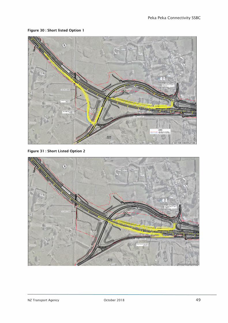
Peka Peka Connectivity SSBC
NZ Transport Agency October 2018 49
Figure 30 : Short listed Option 1
Figure 31 : Short Listed Option 2
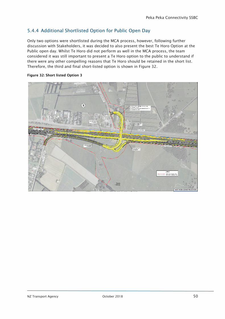
Peka Peka Connectivity SSBC
NZ Transport Agency October 2018 50
5.4.4 Additional Shortlisted Option for Public Open Day
Only two options were shortlisted during the MCA process, however, following further
discussion with Stakeholders, it was decided to also present the best Te Horo Option at the
Public open day. Whilst Te Horo did not perform as well in the MCA process, the team
considered it was still important to present a Te Horo option to the public to understand if
there were any other compelling reasons that Te Horo should be retained in the short list.
Therefore, the third and final short-listed option is shown in Figure 32.
Figure 32: Short listed Option 3
Peka Peka Connectivity SSBC
NZ Transport Agency October 2018 51
5.5 Community Response
5.5.1 General feedback
The Connecting Peka Peka project joined with the Peka Peka to Otaki Expressway (PP2O)
team to hold two public open days:
• Saturday 28th October at the Maoriland film Hub in Otaki Main Street
• Sunday 29th
October at the Te Horo Hall
The two projects are considering transport improvements for the same section of the
community, so it was considered sensible to run the sessions concurrently and reduce the
potential for stakeholder fatigue.
The open days were very well attended with 700 attendances on Saturday and 500 on
Sunday.
Representatives from the Transport Agency and key experts from the team were at both
sessions to man the information stations and run a series of presentations. In addition to
the individual discussions with stakeholders, 78 written feedback forms were also
completed.
The full feedback report is included in Appendix K and a summary of the feedback includes:
• Most people who responded were from Peka Peka and Te Horo and a smaller
proportion from Waikanae.
• Overwhelming support to improve connectivity to the Te Horo and Peka Peka
communities.
• The most common concerns related to limited connectivity and access issues.
Secondary issues included ramp configuration, distance and time to the expressway
and noise.
• Of the people who identified an option preference, the Peka Peka location was
significantly preferred in comparison with Te Horo. There was very little concern at
there not being improved connectivity to the Expressway at Te Horo.
• Support for Option 1 was based on the intuitive layout and safety of the design
solution.
• Support for Option 2 was based on ease of implementation, less impact on
neighbouring properties and lesser cost.
Overall Option 1 had stronger support as outlined in
Figure 33 below, however the overriding response was to do something (i.e. Option 1 was
preferred but very few respondents were against Option 2).
Figure 33 shows the response from members of the public during the open days6
. This is
based on formal response forms. This aligns well with information records of discussions
held by the project team across both days.
6
Extracted from Feedback summary from Connection Peka Peka Information open day document
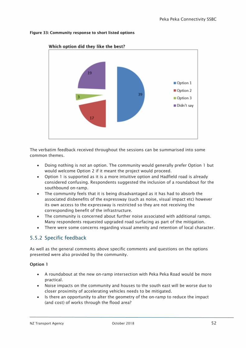
Peka Peka Connectivity SSBC
NZ Transport Agency October 2018 52
Figure 33: Community response to short listed options
The verbatim feedback received throughout the sessions can be summarised into some
common themes.
• Doing nothing is not an option. The community would generally prefer Option 1 but
would welcome Option 2 if it meant the project would proceed.
• Option 1 is supported as it is a more intuitive option and Hadfield road is already
considered confusing. Respondents suggested the inclusion of a roundabout for the
southbound on-ramp.
• The community feels that it is being disadvantaged as it has had to absorb the
associated disbenefits of the expressway (such as noise, visual impact etc) however
its own access to the expressway is restricted so they are not receiving the
corresponding benefit of the infrastructure.
• The community is concerned about further noise associated with additional ramps.
Many respondents requested upgraded road surfacing as part of the mitigation.
• There were some concerns regarding visual amenity and retention of local character.
5.5.2 Specific feedback
As well as the general comments above specific comments and questions on the options
presented were also provided by the community.
Option 1
• A roundabout at the new on-ramp intersection with Peka Peka Road would be more
practical.
• Noise impacts on the community and houses to the south east will be worse due to
closer proximity of accelerating vehicles needs to be mitigated.
• Is there an opportunity to alter the geometry of the on-ramp to reduce the impact
(and cost) of works through the flood area?
Peka Peka Connectivity SSBC
NZ Transport Agency October 2018 53
Option 2
• On-ramp geometry is very tight, what sized vehicles can make this movement?
• Will the merge on-ramp be safe, it seems short?
• There will be less impact on residents with this option due to prevailing winds (noise)
and proximity to existing infrastructure.
• This is not a very intuitive option as drivers are required to head north to go south.
Other
• There was general acceptance that an interchange was not needed at Te Horo given
the impact and cost.
• There were multiple questions on the implementation timeframe and the need to
ensure improved connectivity is in place prior to the opening of the Peka Peka to
Otaki section.
These comments have been considered in the refinement of options post the community
engagement.
5.6 Revision of Shortlisted options
Following the open days, it was clear that the community preferred the Peka Peka location
compared with Te Horo.
The technical assessment of the Te Horo option supported this view with:
• Complex land issues identified as the roading layout was outside Transport Agency
designation and within Kiwirail designation.
• The road layout would require major revisions for the current PP20 design at School
Road which is consented and currently undergoing detailed design.
• Two main streams cross the transport corridor and would be affected by a Te Horo
option.
• Estimated costs are at least double that at Peka Peka as there would need to be four
ramps to ensure the connectivity aims of this project are achieved.
The full technical assessment on Te Horo is included in Appendix D.
Therefore, with limited community support, significant technical challenges and a high cost
it was decided to remove the Te Horo options from further option refinement. As such
Option 1 and Option 2 at Peka Peka were confirmed as the final shortlisted options.
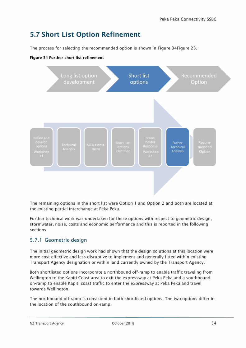
Peka Peka Connectivity SSBC
NZ Transport Agency October 2018 54
5.7 Short List Option Refinement
The process for selecting the recommended option is shown in Figure 34Figure 23.
Figure 34 Further short list refinement
The remaining options in the short list were Option 1 and Option 2 and both are located at
the existing partial interchange at Peka Peka.
Further technical work was undertaken for these options with respect to geometric design,
stormwater, noise, costs and economic performance and this is reported in the following
sections.
5.7.1 Geometric design
The initial geometric design work had shown that the design solutions at this location were
more cost effective and less disruptive to implement and generally fitted within existing
Transport Agency designation or within land currently owned by the Transport Agency.
Both shortlisted options incorporate a northbound off-ramp to enable traffic traveling from
Wellington to the Kapiti Coast area to exit the expressway at Peka Peka and a southbound
on-ramp to enable Kapiti coast traffic to enter the expressway at Peka Peka and travel
towards Wellington.
The northbound off-ramp is consistent in both shortlisted options. The two options differ in
the location of the southbound on-ramp.
Long list option development
Short list options
Recommended Option
Refine and develop options
Workshop #1
Technical Analysis
MCA assess-ment
Short List options
identified
Stake-holder
Response
Workshop #2
Futher Technical Analysis
Recom-mended Option
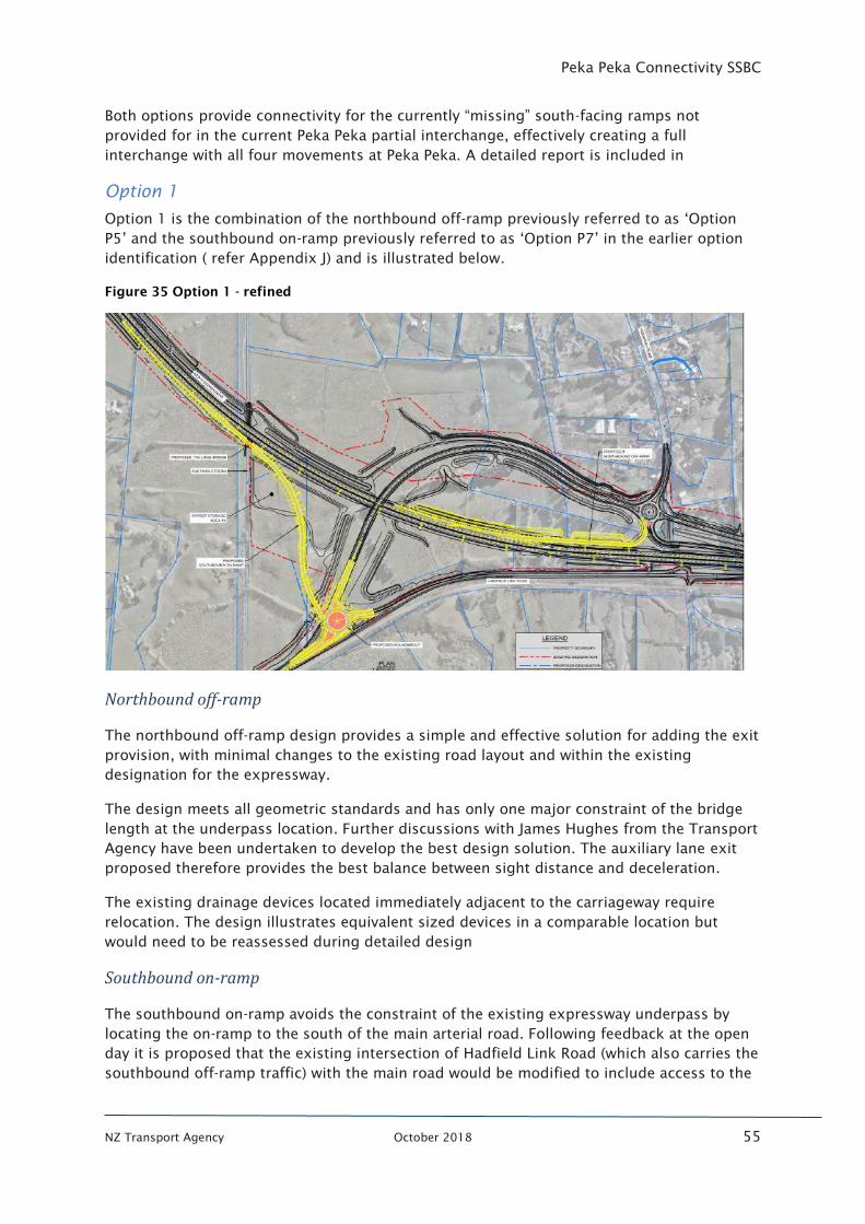
Peka Peka Connectivity SSBC
NZ Transport Agency October 2018 55
Both options provide connectivity for the currently “missing” south-facing ramps not
provided for in the current Peka Peka partial interchange, effectively creating a full
interchange with all four movements at Peka Peka. A detailed report is included in
Option 1
Option 1 is the combination of the northbound off-ramp previously referred to as ‘Option
P5’ and the southbound on-ramp previously referred to as ‘Option P7’ in the earlier option
identification ( refer Appendix J) and is illustrated below.
Figure 35 Option 1 - refined
Northbound off-ramp
The northbound off-ramp design provides a simple and effective solution for adding the exit
provision, with minimal changes to the existing road layout and within the existing
designation for the expressway.
The design meets all geometric standards and has only one major constraint of the bridge
length at the underpass location. Further discussions with James Hughes from the Transport
Agency have been undertaken to develop the best design solution. The auxiliary lane exit
proposed therefore provides the best balance between sight distance and deceleration.
The existing drainage devices located immediately adjacent to the carriageway require
relocation. The design illustrates equivalent sized devices in a comparable location but
would need to be reassessed during detailed design
Southbound on-ramp
The southbound on-ramp avoids the constraint of the existing expressway underpass by
locating the on-ramp to the south of the main arterial road. Following feedback at the open
day it is proposed that the existing intersection of Hadfield Link Road (which also carries the
southbound off-ramp traffic) with the main road would be modified to include access to the
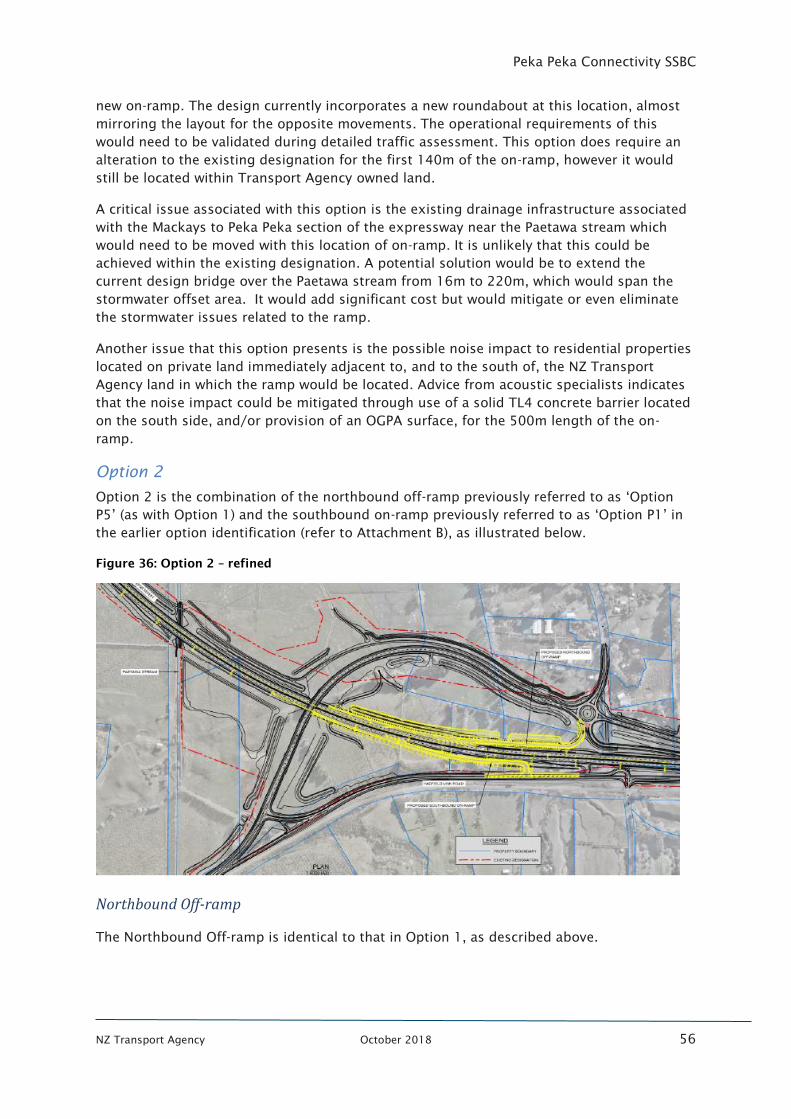
Peka Peka Connectivity SSBC
NZ Transport Agency October 2018 56
new on-ramp. The design currently incorporates a new roundabout at this location, almost
mirroring the layout for the opposite movements. The operational requirements of this
would need to be validated during detailed traffic assessment. This option does require an
alteration to the existing designation for the first 140m of the on-ramp, however it would
still be located within Transport Agency owned land.
A critical issue associated with this option is the existing drainage infrastructure associated
with the Mackays to Peka Peka section of the expressway near the Paetawa stream which
would need to be moved with this location of on-ramp. It is unlikely that this could be
achieved within the existing designation. A potential solution would be to extend the
current design bridge over the Paetawa stream from 16m to 220m, which would span the
stormwater offset area. It would add significant cost but would mitigate or even eliminate
the stormwater issues related to the ramp.
Another issue that this option presents is the possible noise impact to residential properties
located on private land immediately adjacent to, and to the south of, the NZ Transport
Agency land in which the ramp would be located. Advice from acoustic specialists indicates
that the noise impact could be mitigated through use of a solid TL4 concrete barrier located
on the south side, and/or provision of an OGPA surface, for the 500m length of the on-
ramp.
Option 2
Option 2 is the combination of the northbound off-ramp previously referred to as ‘Option
P5’ (as with Option 1) and the southbound on-ramp previously referred to as ‘Option P1’ in
the earlier option identification (refer to Attachment B), as illustrated below.
Figure 36: Option 2 – refined
Northbound Off-ramp
The Northbound Off-ramp is identical to that in Option 1, as described above.
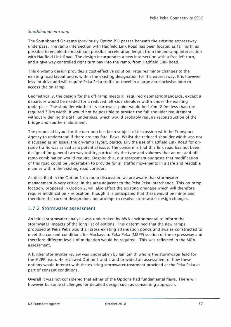
Peka Peka Connectivity SSBC
NZ Transport Agency October 2018 57
Southbound on-ramp
The Southbound On-ramp (previously Option P1) passes beneath the existing expressway
underpass. The ramp intersection with Hadfield Link Road has been located as far north as
possible to enable the maximum possible acceleration length from the on-ramp intersection
with Hadfield Link Road. The design incorporates a new intersection with a free left turn,
and a give way controlled right turn bay into the ramp, from Hadfield Link Road.
This on-ramp design provides a cost-effective solution, requires minor changes to the
existing road layout and is within the existing designation for the expressway. It is however
less intuitive and will require Peka Peka traffic to travel in a large anticlockwise loop to
access the on-ramp.
Geometrically, the design for the off-ramp meets all required geometric standards, except a
departure would be needed for a reduced left-side shoulder width under the existing
underpass. The shoulder width at its narrowest point would be 1.0m, 2.0m less than the
required 3.0m width. It would not be possible to provide the full shoulder requirement
without widening the SH1 underpass, which would probably require reconstruction of the
bridge and southern abutment.
The proposed layout for the on-ramp has been subject of discussion with the Transport
Agency to understand if there are any fatal flaws. Whilst the reduced shoulder width was not
discussed as an issue, the on-ramp layout, particularly the use of Hadfield Link Road for on-
ramp traffic was raised as a potential issue. The concern is that this link road has not been
designed for general two-way traffic, particularly the type and volumes that an on- and off-
ramp combination would require. Despite this, our assessment suggests that modification
of this road could be undertaken to provide for all traffic movements in a safe and readable
manner within the existing road corridor.
As described in the Option 1 on-ramp discussion, we are aware that stormwater
management is very critical in the area adjacent to the Peka Peka Interchange. This on-ramp
location, proposed in Option 2, will also affect the existing drainage which will therefore
require modification / relocation, though it is anticipated that these would be minor and
therefore the current design does not attempt to resolve stormwater design changes.
5.7.2 Stormwater assessment
An initial stormwater analysis was undertaken by AWA environmental to inform the
stormwater impacts of the long list of options. This determined that the new ramps
proposed at Peka Peka would all cross existing attenuation ponds and swales constructed to
meet the consent conditions for Mackays to Peka Peka (M2PP) section of the expressway and
therefore different levels of mitigation would be required. This was reflected in the MCA
assessment.
A further stormwater review was undertaken by Iain Smith who is the stormwater lead for
the M2PP team. He reviewed Option 1 and 2 and provided an assessment of how these
options would interact with the existing stormwater treatment provided at the Peka Peka as
part of consent conditions.
Overall it was not considered that either of the Options had fundamental flaws. There will
however be some challenges for detailed design such as consenting approach,
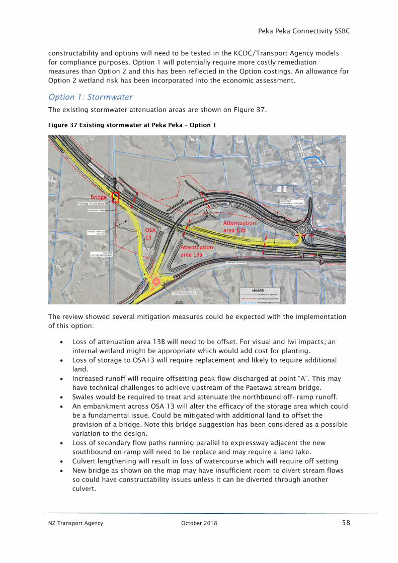
Peka Peka Connectivity SSBC
NZ Transport Agency October 2018 58
constructability and options will need to be tested in the KCDC/Transport Agency models
for compliance purposes. Option 1 will potentially require more costly remediation
measures than Option 2 and this has been reflected in the Option costings. An allowance for
Option 2 wetland risk has been incorporated into the economic assessment.
Option 1: Stormwater
The existing stormwater attenuation areas are shown on Figure 37.
Figure 37 Existing stormwater at Peka Peka – Option 1
The review showed several mitigation measures could be expected with the implementation
of this option:
• Loss of attenuation area 13B will need to be offset. For visual and Iwi impacts, an
internal wetland might be appropriate which would add cost for planting.
• Loss of storage to OSA13 will require replacement and likely to require additional
land.
• Increased runoff will require offsetting peak flow discharged at point “A”. This may
have technical challenges to achieve upstream of the Paetawa stream bridge.
• Swales would be required to treat and attenuate the northbound off- ramp runoff.
• An embankment across OSA 13 will alter the efficacy of the storage area which could
be a fundamental issue. Could be mitigated with additional land to offset the
provision of a bridge. Note this bridge suggestion has been considered as a possible
variation to the design.
• Loss of secondary flow paths running parallel to expressway adjacent the new
southbound on-ramp will need to be replace and may require a land take.
• Culvert lengthening will result in loss of watercourse which will require off setting
• New bridge as shown on the map may have insufficient room to divert stream flows
so could have constructability issues unless it can be diverted through another
culvert.
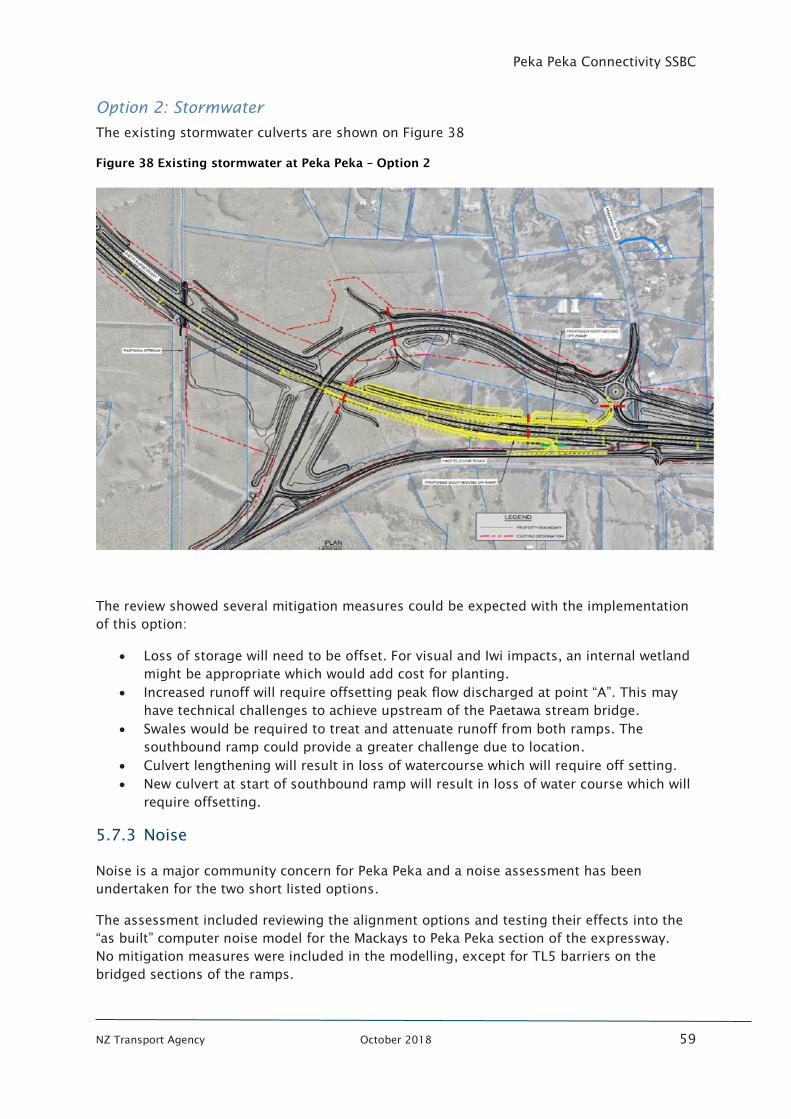
Peka Peka Connectivity SSBC
NZ Transport Agency October 2018 59
Option 2: Stormwater
The existing stormwater culverts are shown on Figure 38
Figure 38 Existing stormwater at Peka Peka – Option 2
The review showed several mitigation measures could be expected with the implementation
of this option:
• Loss of storage will need to be offset. For visual and Iwi impacts, an internal wetland
might be appropriate which would add cost for planting.
• Increased runoff will require offsetting peak flow discharged at point “A”. This may
have technical challenges to achieve upstream of the Paetawa stream bridge.
• Swales would be required to treat and attenuate runoff from both ramps. The
southbound ramp could provide a greater challenge due to location.
• Culvert lengthening will result in loss of watercourse which will require off setting.
• New culvert at start of southbound ramp will result in loss of water course which will
require offsetting.
5.7.3 Noise
Noise is a major community concern for Peka Peka and a noise assessment has been
undertaken for the two short listed options.
The assessment included reviewing the alignment options and testing their effects into the
“as built” computer noise model for the Mackays to Peka Peka section of the expressway.
No mitigation measures were included in the modelling, except for TL5 barriers on the
bridged sections of the ramps.
Peka Peka Connectivity SSBC
NZ Transport Agency October 2018 60
The full results of this assessment are included in Appendix L, but the results can be
summarised as:
• Overall, both ramp options cause equally indiscernible noise level changes when
compared against the “as built” option. This is due to the traffic volume on the
ramps being very small compared with the main expressway traffic.
• There is generally no difference between Option 1 and Option 2.
• One dwelling at Greenhill road is predicted to have noise in within Category B of
NSZ6806 criteria for the as built, but this will be mitigated by the provision of OGPA
in that area and noise will reduce to be within Category A.
Therefore, no further mitigation measures are required for noise.
5.7.4 Consenting strategy
The consenting pathway for the shortlisted options has been assessed. The full report is
included in Appendix M but in summary:
• Both options would follow a similar consenting pathway strategy.
• This pathway would require an extension of the M2PP designation footprint and an
alteration to designation would be required.
• Either option would require changes to the M2PP site specific management plans
(SSMP), in particular SSMP11, which addresses a range of both designation and
resource consent conditions in an integrated manner. Amendments to the
Stormwater compliance report would also be expected.
• Compliance would be achieved by re-certification of the amended management
plans.
• The current level of assessment suggests that with the implementation of
appropriate mitigation measures both options would likely not result in significant
adverse effects
It is noted that a “stand alone” suite of resource consents was considered as an alternative
pathway. However, it was considered that as this Project is located within the M2PP
designation, there would still need to be alterations to the M2PP management plans as well
as developing new consents and therefore be a less desirable approach.
5.7.5 Cost assessment
Bond CM prepared initial costings for the long list of options to inform the MCA Process.
Following option refinement more detailed costings have been estimated for Option 1 and
Option 2. The pricing estimates use indicative market rates as at November 2017 and do not
include for escalation or GST.
The main assumptions for the options are shown in Figure 39.
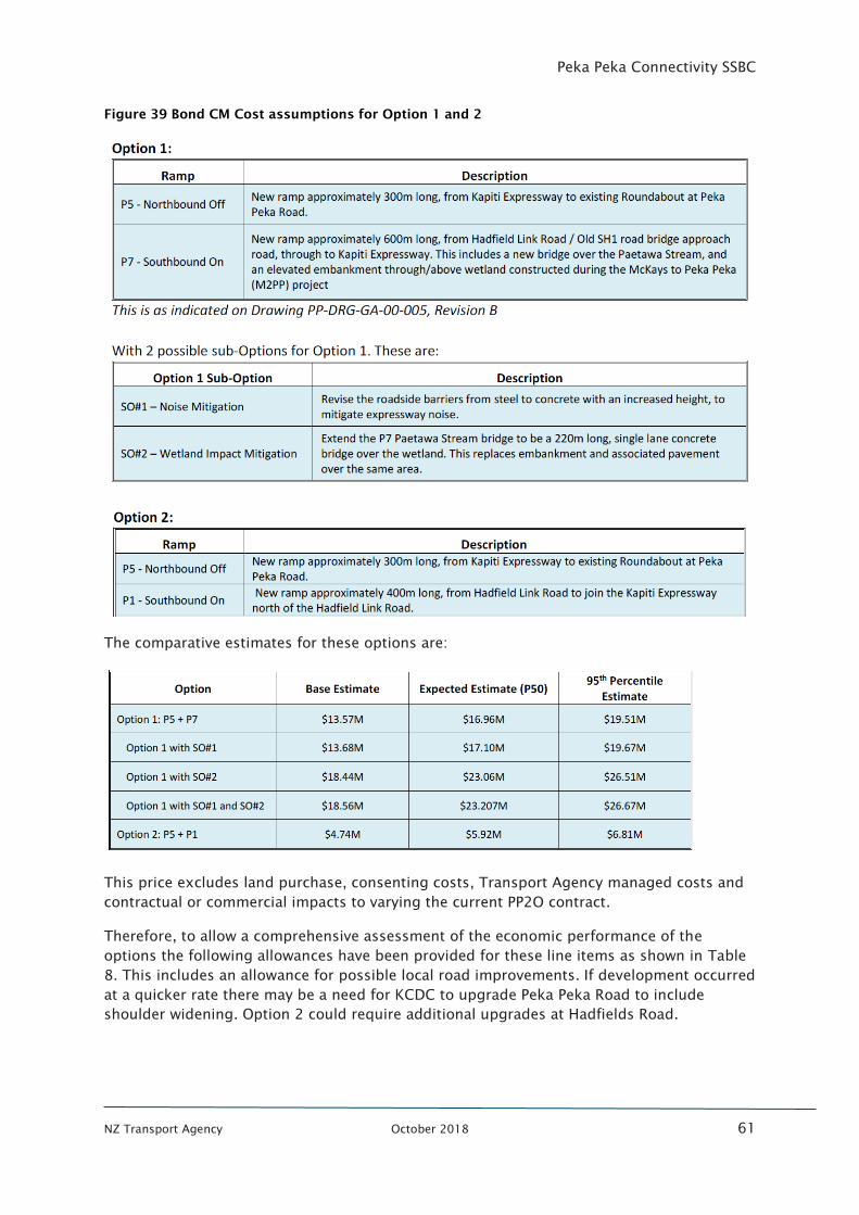
Peka Peka Connectivity SSBC
NZ Transport Agency October 2018 61
Figure 39 Bond CM Cost assumptions for Option 1 and 2
The comparative estimates for these options are:
This price excludes land purchase, consenting costs, Transport Agency managed costs and
contractual or commercial impacts to varying the current PP2O contract.
Therefore, to allow a comprehensive assessment of the economic performance of the
options the following allowances have been provided for these line items as shown in Table
8. This includes an allowance for possible local road improvements. If development occurred
at a quicker rate there may be a need for KCDC to upgrade Peka Peka Road to include
shoulder widening. Option 2 could require additional upgrades at Hadfields Road.
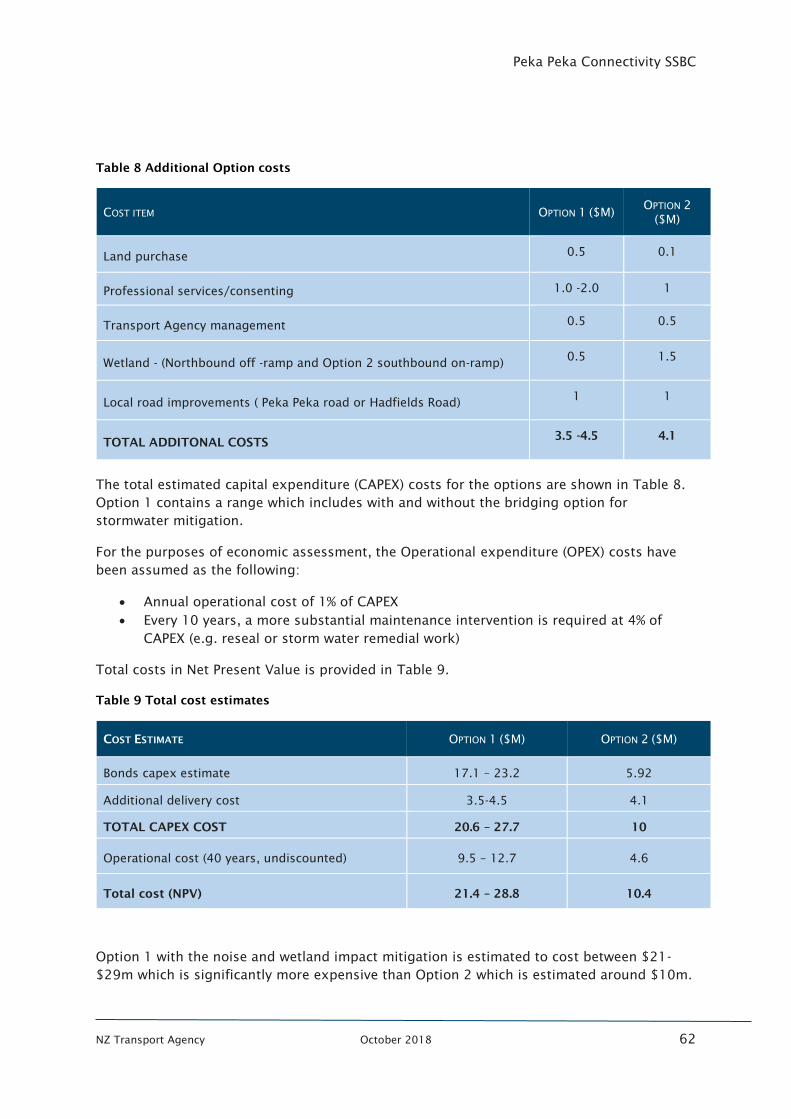
Peka Peka Connectivity SSBC
NZ Transport Agency October 2018 62
Table 8 Additional Option costs
COST ITEM OPTION 1 ($M) OPTION 2
($M)
Land purchase 0.5 0.1
Professional services/consenting 1.0 -2.0 1
Transport Agency management 0.5 0.5
Wetland - (Northbound off -ramp and Option 2 southbound on-ramp) 0.5 1.5
Local road improvements ( Peka Peka road or Hadfields Road) 1 1
TOTAL ADDITONAL COSTS 3.5 -4.5 4.1
The total estimated capital expenditure (CAPEX) costs for the options are shown in Table 8.
Option 1 contains a range which includes with and without the bridging option for
stormwater mitigation.
For the purposes of economic assessment, the Operational expenditure (OPEX) costs have
been assumed as the following:
• Annual operational cost of 1% of CAPEX
• Every 10 years, a more substantial maintenance intervention is required at 4% of
CAPEX (e.g. reseal or storm water remedial work)
Total costs in Net Present Value is provided in Table 9.
Table 9 Total cost estimates
COST ESTIMATE OPTION 1 ($M) OPTION 2 ($M)
Bonds capex estimate 17.1 – 23.2 5.92
Additional delivery cost 3.5-4.5 4.1
TOTAL CAPEX COST 20.6 – 27.7 10
Operational cost (40 years, undiscounted) 9.5 – 12.7 4.6
Total cost (NPV) 21.4 – 28.8 10.4
Option 1 with the noise and wetland impact mitigation is estimated to cost between $21-
$29m which is significantly more expensive than Option 2 which is estimated around $10m.
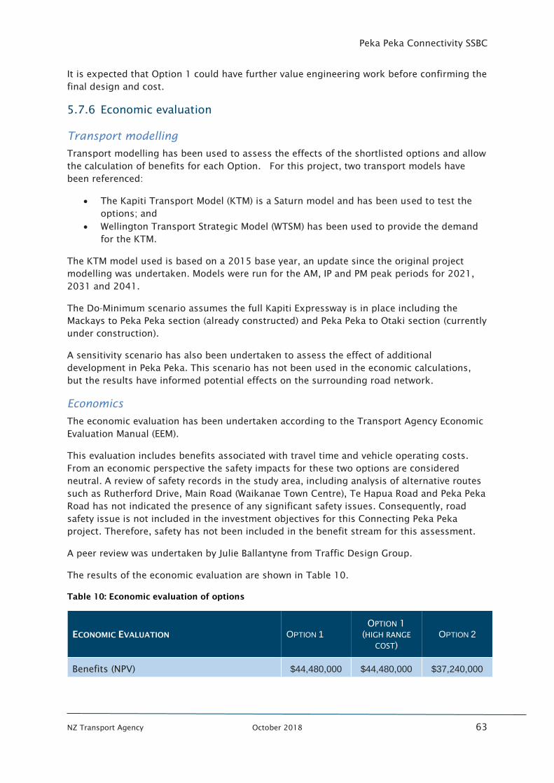
Peka Peka Connectivity SSBC
NZ Transport Agency October 2018 63
It is expected that Option 1 could have further value engineering work before confirming the
final design and cost.
5.7.6 Economic evaluation
Transport modelling
Transport modelling has been used to assess the effects of the shortlisted options and allow
the calculation of benefits for each Option. For this project, two transport models have
been referenced:
• The Kapiti Transport Model (KTM) is a Saturn model and has been used to test the
options; and
• Wellington Transport Strategic Model (WTSM) has been used to provide the demand
for the KTM.
The KTM model used is based on a 2015 base year, an update since the original project
modelling was undertaken. Models were run for the AM, IP and PM peak periods for 2021,
2031 and 2041.
The Do-Minimum scenario assumes the full Kapiti Expressway is in place including the
Mackays to Peka Peka section (already constructed) and Peka Peka to Otaki section (currently
under construction).
A sensitivity scenario has also been undertaken to assess the effect of additional
development in Peka Peka. This scenario has not been used in the economic calculations,
but the results have informed potential effects on the surrounding road network.
Economics
The economic evaluation has been undertaken according to the Transport Agency Economic
Evaluation Manual (EEM).
This evaluation includes benefits associated with travel time and vehicle operating costs.
From an economic perspective the safety impacts for these two options are considered
neutral. A review of safety records in the study area, including analysis of alternative routes
such as Rutherford Drive, Main Road (Waikanae Town Centre), Te Hapua Road and Peka Peka
Road has not indicated the presence of any significant safety issues. Consequently, road
safety issue is not included in the investment objectives for this Connecting Peka Peka
project. Therefore, safety has not been included in the benefit stream for this assessment.
A peer review was undertaken by Julie Ballantyne from Traffic Design Group.
The results of the economic evaluation are shown in Table 10.
Table 10: Economic evaluation of options
ECONOMIC EVALUATION OPTION 1
OPTION 1
(HIGH RANGE
COST)
OPTION 2
Benefits (NPV) $44,480,000 $44,480,000 $37,240,000
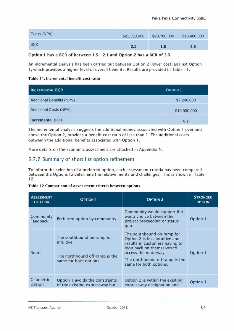
Peka Peka Connectivity SSBC
NZ Transport Agency October 2018 64
Costs (NPV) $21,390,000 $28,760,000 $10,400,000
BCR 2.1 1.5 3.6
Option 1 has a BCR of between 1.5 – 2.1 and Option 2 has a BCR of 3.6.
An incremental analysis has been carried out between Option 2 (lower cost) against Option
1, which provides a higher level of overall benefits. Results are provided in Table 11.
Table 11: Incremental benefit cost ratio
INCREMENTAL BCR OPTION 1
Additional Benefits (NPV) $7,240,000
Additional Costs (NPV) $10,990,000
Incremental BCR 0.7
The incremental analysis suggests the additional money associated with Option 1 over and
above the Option 2, provides a benefit cost ratio of less than 1. The additional costs
outweigh the additional benefits associated with Option 1.
More details on the economic assessment are attached in Appendix N.
5.7.7 Summary of short list option refinement
To inform the selection of a preferred option, each assessment criteria has been compared
between the Options to determine the relative merits and challenges. This is shown in Table
12 .
Table 12 Comparison of assessment criteria between options
ASSESSMENT
CRITERIA OPTION 1 OPTION 2
STRONGER
OPTION
Community
Feedback Preferred option by community
Community would support if it
was a choice between the
project proceeding or status
quo.
Option 1
Route
The southbound on-ramp is
intuitive.
The northbound off-ramp is the
same for both options.
The southbound on-ramp for
Option 2 is less intuitive and
results in customers having to
loop back on themselves to
access the motorway
The northbound off-ramp is the
same for both options.
Option 1
Geometric
Design
Option 1 avoids the constraints
of the existing expressway but
Option 2 is within the existing
expressway designation and
Option 1
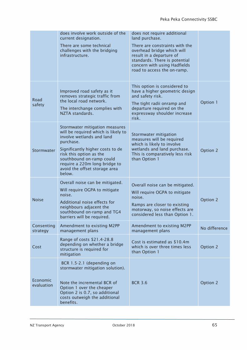
Peka Peka Connectivity SSBC
NZ Transport Agency October 2018 65
does involve work outside of the
current designation.
There are some technical
challenges with the bridging
infrastructure.
does not require additional
land purchase.
There are constraints with the
overhead bridge which will
result in a departure of
standards. There is potential
concern with using Hadfields
road to access the on-ramp.
Road
safety
Improved road safety as it
removes strategic traffic from
the local road network.
The interchange complies with
NZTA standards.
This option is considered to
have a higher geometric design
and safety risk.
The tight radii onramp and
departure required on the
expressway shoulder increase
risk.
Option 1
Stormwater
Stormwater mitigation measures
will be required which is likely to
involve wetlands and land
purchase.
Significantly higher costs to de
risk this option as the
southbound on-ramp could
require a 220m long bridge to
avoid the offset storage area
below.
Stormwater mitigation
measures will be required
which is likely to involve
wetlands and land purchase.
This is comparatively less risk
than Option 1
Option 2
Noise
Overall noise can be mitigated.
Will require OGPA to mitigate
noise.
Additional noise effects for
neighbours adjacent the
southbound on-ramp and TG4
barriers will be required.
Overall noise can be mitigated.
Will require OGPA to mitigate
noise.
Ramps are closer to existing
motorway, so noise effects are
considered less than Option 1.
Option 2
Consenting
strategy
Amendment to existing M2PP
management plans
Amendment to existing M2PP
management plans No difference
Cost
Range of costs $21.4-28.8
depending on whether a bridge
structure is required for
mitigation
Cost is estimated as $10.4m
which is over three times less
than Option 1
Option 2
Economic
evaluation
BCR 1.5-2.1 (depending on
stormwater mitigation solution).
Note the incremental BCR of
Option 1 over the cheaper
Option 2 is 0.7, so additional
costs outweigh the additional
benefits.
BCR 3.6 Option 2
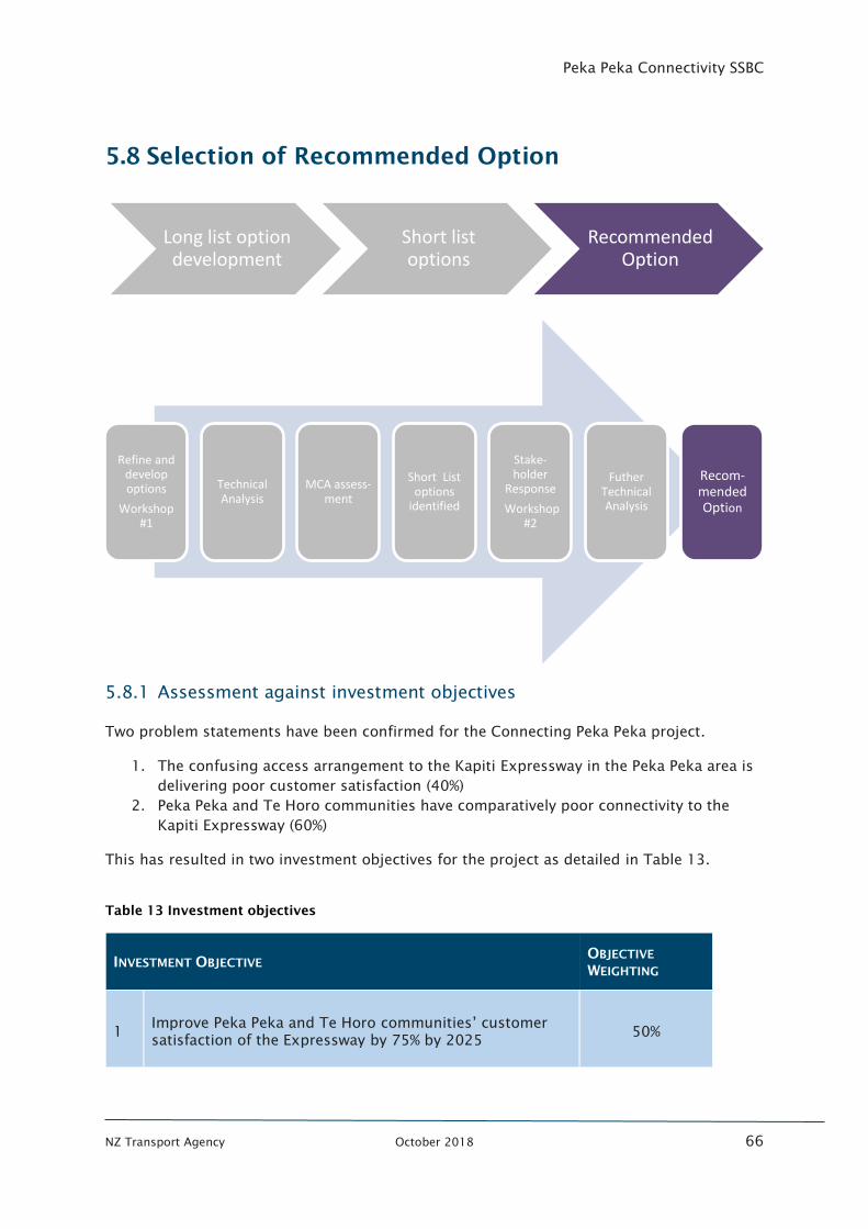
Peka Peka Connectivity SSBC
NZ Transport Agency October 2018 66
5.8 Selection of Recommended Option
5.8.1 Assessment against investment objectives
Two problem statements have been confirmed for the Connecting Peka Peka project.
1. The confusing access arrangement to the Kapiti Expressway in the Peka Peka area is
delivering poor customer satisfaction (40%)
2. Peka Peka and Te Horo communities have comparatively poor connectivity to the
Kapiti Expressway (60%)
This has resulted in two investment objectives for the project as detailed in Table 13.
Table 13 Investment objectives
INVESTMENT OBJECTIVE OBJECTIVE
WEIGHTING
1 Improve Peka Peka and Te Horo communities’ customer
satisfaction of the Expressway by 75% by 2025 50%
Long list option development
Short list options
Recommended Option
Refine and develop options
Workshop #1
Technical Analysis
MCA assess-ment
Short List options
identified
Stake-holder
Response
Workshop #2
Futher Technical Analysis
Recom-mended Option
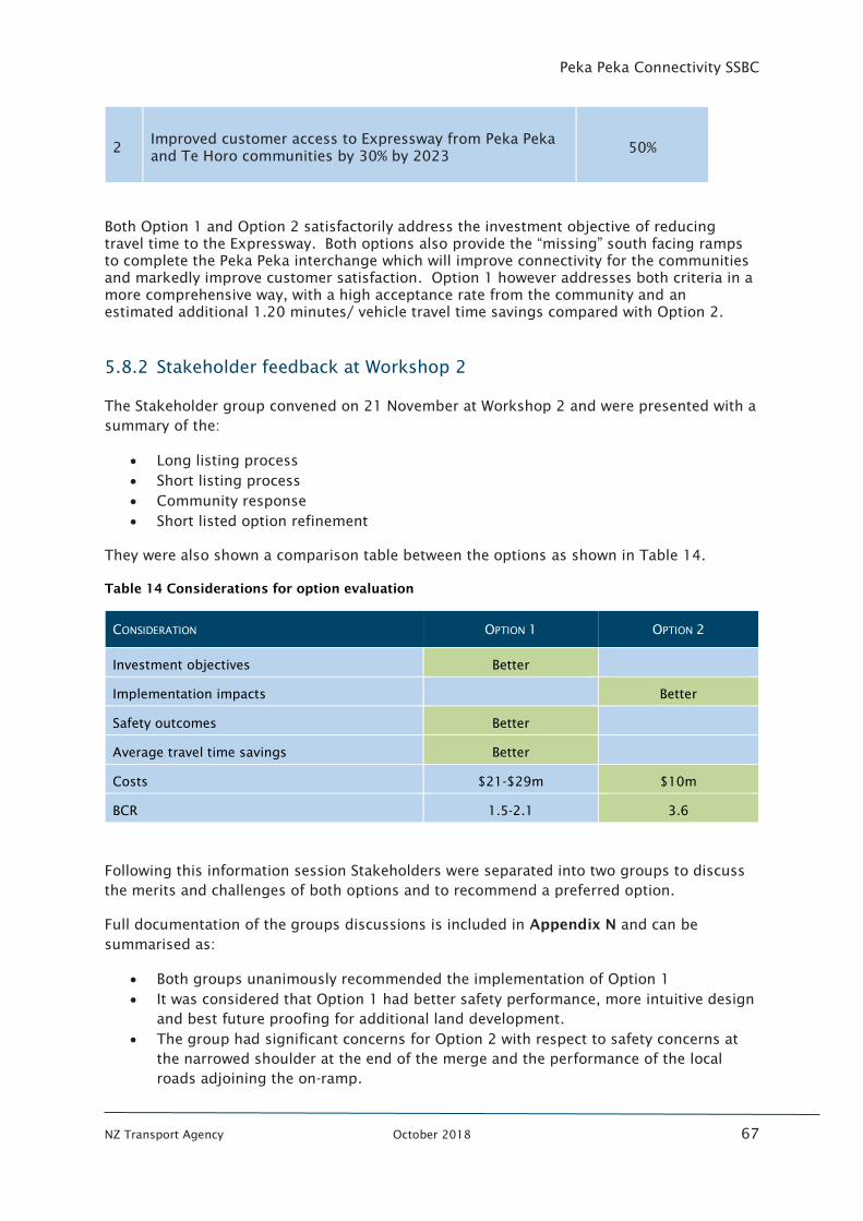
Peka Peka Connectivity SSBC
NZ Transport Agency October 2018 67
2 Improved customer access to Expressway from Peka Peka
and Te Horo communities by 30% by 2023 50%
Both Option 1 and Option 2 satisfactorily address the investment objective of reducing
travel time to the Expressway. Both options also provide the “missing” south facing ramps
to complete the Peka Peka interchange which will improve connectivity for the communities
and markedly improve customer satisfaction. Option 1 however addresses both criteria in a
more comprehensive way, with a high acceptance rate from the community and an
estimated additional 1.20 minutes/ vehicle travel time savings compared with Option 2.
5.8.2 Stakeholder feedback at Workshop 2
The Stakeholder group convened on 21 November at Workshop 2 and were presented with a
summary of the:
• Long listing process
• Short listing process
• Community response
• Short listed option refinement
They were also shown a comparison table between the options as shown in Table 14.
Table 14 Considerations for option evaluation
CONSIDERATION OPTION 1 OPTION 2
Investment objectives Better
Implementation impacts Better
Safety outcomes Better
Average travel time savings Better
Costs $21-$29m $10m
BCR 1.5-2.1 3.6
Following this information session Stakeholders were separated into two groups to discuss
the merits and challenges of both options and to recommend a preferred option.
Full documentation of the groups discussions is included in Appendix N and can be
summarised as:
• Both groups unanimously recommended the implementation of Option 1
• It was considered that Option 1 had better safety performance, more intuitive design
and best future proofing for additional land development.
• The group had significant concerns for Option 2 with respect to safety concerns at
the narrowed shoulder at the end of the merge and the performance of the local
roads adjoining the on-ramp.
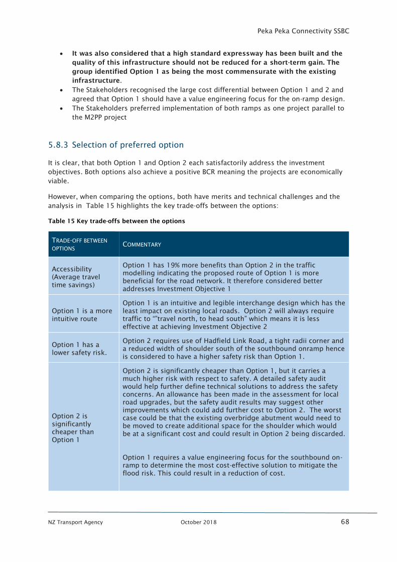
Peka Peka Connectivity SSBC
NZ Transport Agency October 2018 68
• It was also considered that a high standard expressway has been built and the
quality of this infrastructure should not be reduced for a short-term gain. The
group identified Option 1 as being the most commensurate with the existing
infrastructure.
• The Stakeholders recognised the large cost differential between Option 1 and 2 and
agreed that Option 1 should have a value engineering focus for the on-ramp design.
• The Stakeholders preferred implementation of both ramps as one project parallel to
the M2PP project
5.8.3 Selection of preferred option
It is clear, that both Option 1 and Option 2 each satisfactorily address the investment
objectives. Both options also achieve a positive BCR meaning the projects are economically
viable.
However, when comparing the options, both have merits and technical challenges and the
analysis in Table 15 highlights the key trade-offs between the options:
Table 15 Key trade-offs between the options
TRADE-OFF BETWEEN
OPTIONS COMMENTARY
Accessibility
(Average travel
time savings)
Option 1 has 19% more benefits than Option 2 in the traffic
modelling indicating the proposed route of Option 1 is more
beneficial for the road network. It therefore considered better
addresses Investment Objective 1
Option 1 is a more
intuitive route
Option 1 is an intuitive and legible interchange design which has the
least impact on existing local roads. Option 2 will always require
traffic to “”travel north, to head south” which means it is less
effective at achieving Investment Objective 2
Option 1 has a
lower safety risk.
Option 2 requires use of Hadfield Link Road, a tight radii corner and
a reduced width of shoulder south of the southbound onramp hence
is considered to have a higher safety risk than Option 1.
Option 2 is
significantly
cheaper than
Option 1
Option 2 is significantly cheaper than Option 1, but it carries a
much higher risk with respect to safety. A detailed safety audit
would help further define technical solutions to address the safety
concerns. An allowance has been made in the assessment for local
road upgrades, but the safety audit results may suggest other
improvements which could add further cost to Option 2. The worst
case could be that the existing overbridge abutment would need to
be moved to create additional space for the shoulder which would
be at a significant cost and could result in Option 2 being discarded.
Option 1 requires a value engineering focus for the southbound on-
ramp to determine the most cost-effective solution to mitigate the
flood risk. This could result in a reduction of cost.
Peka Peka Connectivity SSBC
NZ Transport Agency October 2018 69
It is likely that even with value engineering there could still be a
substantial cost difference between the options. However, there is
potential for the economic performance of Option 1 to further
improve
Option 1 requires
more mitigation of
impacts
Both options can satisfactorily mitigate the noise impacts.
Both options also require mitigation for stormwater, however Option
1 requires more mitigation that Option 2 for the southbound on-
ramp.
Therefore, taking all the information into account, due to its intuitive route with maximum
travel time savings potential and higher safety performance, the following is recommended;
1. Option 1 is implemented to improve the Peka Peka connectivity; and
2. As part of the pre-implementation phase a value engineering exercise should be
completed for the southbound on-ramp with a focus on reducing the costs of its
implementation.
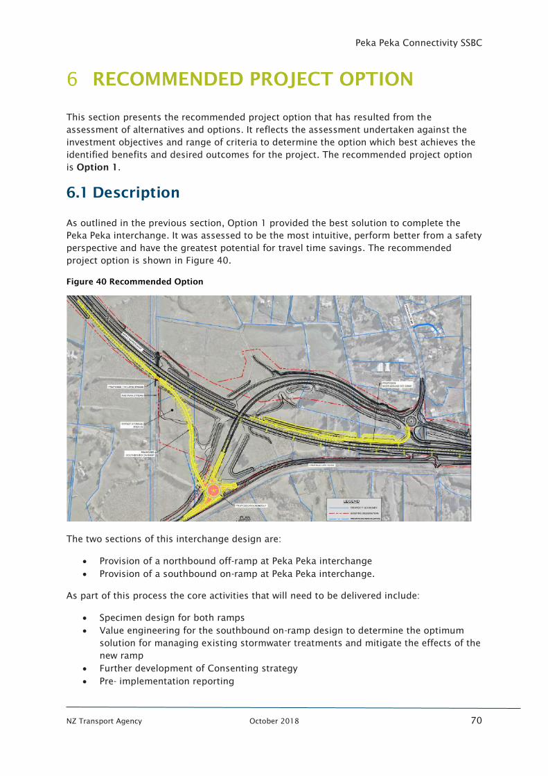
Peka Peka Connectivity SSBC
NZ Transport Agency October 2018 70
RECOMMENDED PROJECT OPTION
This section presents the recommended project option that has resulted from the
assessment of alternatives and options. It reflects the assessment undertaken against the
investment objectives and range of criteria to determine the option which best achieves the
identified benefits and desired outcomes for the project. The recommended project option
is Option 1.
6.1 Description
As outlined in the previous section, Option 1 provided the best solution to complete the
Peka Peka interchange. It was assessed to be the most intuitive, perform better from a safety
perspective and have the greatest potential for travel time savings. The recommended
project option is shown in Figure 40.
Figure 40 Recommended Option
The two sections of this interchange design are:
• Provision of a northbound off-ramp at Peka Peka interchange
• Provision of a southbound on-ramp at Peka Peka interchange.
As part of this process the core activities that will need to be delivered include:
• Specimen design for both ramps
• Value engineering for the southbound on-ramp design to determine the optimum
solution for managing existing stormwater treatments and mitigate the effects of the
new ramp
• Further development of Consenting strategy
• Pre- implementation reporting
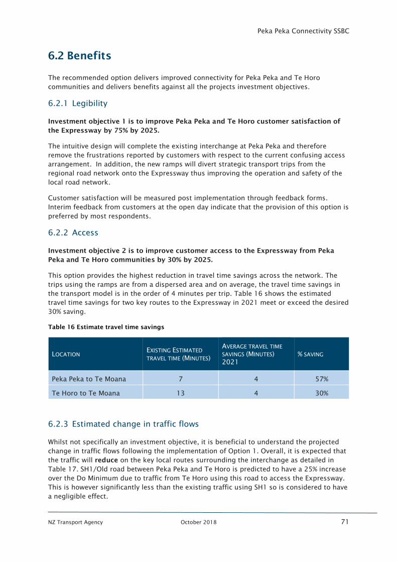
Peka Peka Connectivity SSBC
NZ Transport Agency October 2018 71
6.2 Benefits
The recommended option delivers improved connectivity for Peka Peka and Te Horo
communities and delivers benefits against all the projects investment objectives.
6.2.1 Legibility
Investment objective 1 is to improve Peka Peka and Te Horo customer satisfaction of
the Expressway by 75% by 2025.
The intuitive design will complete the existing interchange at Peka Peka and therefore
remove the frustrations reported by customers with respect to the current confusing access
arrangement. In addition, the new ramps will divert strategic transport trips from the
regional road network onto the Expressway thus improving the operation and safety of the
local road network.
Customer satisfaction will be measured post implementation through feedback forms.
Interim feedback from customers at the open day indicate that the provision of this option is
preferred by most respondents.
6.2.2 Access
Investment objective 2 is to improve customer access to the Expressway from Peka
Peka and Te Horo communities by 30% by 2025.
This option provides the highest reduction in travel time savings across the network. The
trips using the ramps are from a dispersed area and on average, the travel time savings in
the transport model is in the order of 4 minutes per trip. Table 16 shows the estimated
travel time savings for two key routes to the Expressway in 2021 meet or exceed the desired
30% saving.
Table 16 Estimate travel time savings
LOCATION EXISTING ESTIMATED
TRAVEL TIME (MINUTES)
AVERAGE TRAVEL TIME
SAVINGS (MINUTES)
2021
% SAVING
Peka Peka to Te Moana 7 4 57%
Te Horo to Te Moana 13 4 30%
6.2.3 Estimated change in traffic flows
Whilst not specifically an investment objective, it is beneficial to understand the projected
change in traffic flows following the implementation of Option 1. Overall, it is expected that
the traffic will reduce on the key local routes surrounding the interchange as detailed in
Table 17. SH1/Old road between Peka Peka and Te Horo is predicted to have a 25% increase
over the Do Minimum due to traffic from Te Horo using this road to access the Expressway.
This is however significantly less than the existing traffic using SH1 so is considered to have
a negligible effect.
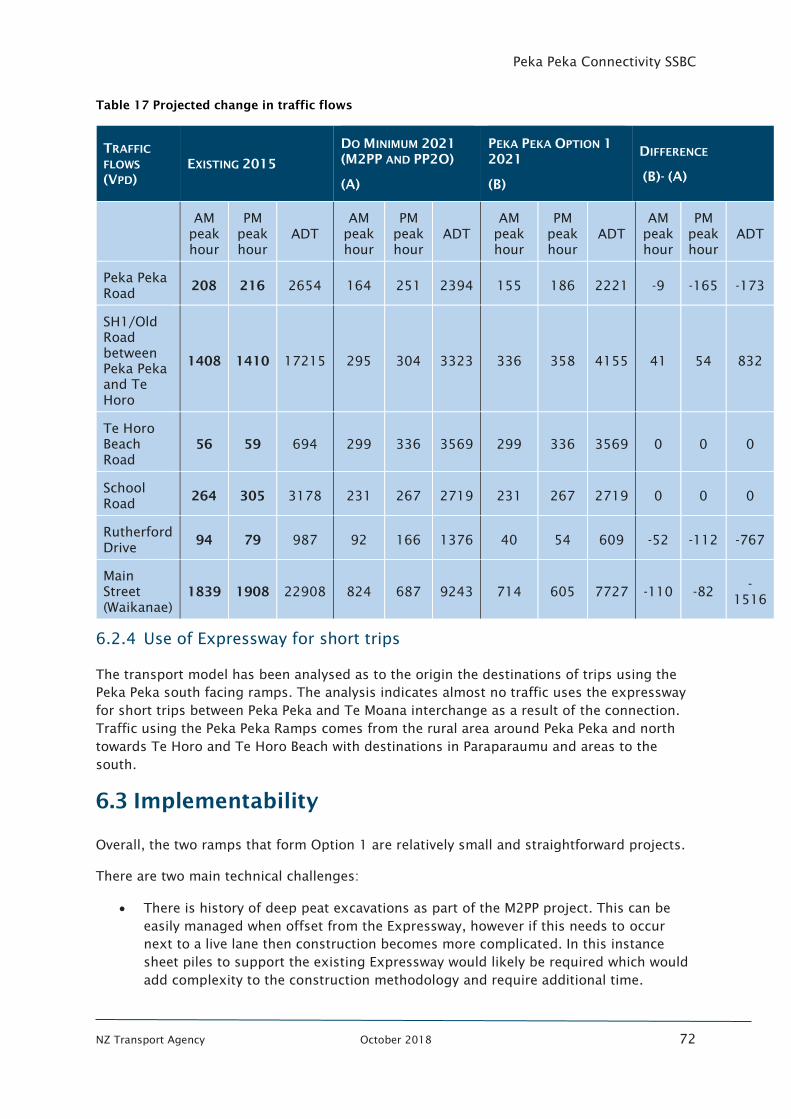
Peka Peka Connectivity SSBC
NZ Transport Agency October 2018 72
Table 17 Projected change in traffic flows
TRAFFIC
FLOWS
(VPD)
EXISTING 2015
DO MINIMUM 2021
(M2PP AND PP2O)
(A)
PEKA PEKA OPTION 1
2021
(B)
DIFFERENCE
(B)- (A)
AM
peak
hour
PM
peak
hour
ADT
AM
peak
hour
PM
peak
hour
ADT
AM
peak
hour
PM
peak
hour
ADT
AM
peak
hour
PM
peak
hour
ADT
Peka Peka
Road 208 216 2654 164 251 2394 155 186 2221 -9 -165 -173
SH1/Old
Road
between
Peka Peka
and Te
Horo
1408 1410 17215 295 304 3323 336 358 4155 41 54 832
Te Horo
Beach
Road
56 59 694 299 336 3569 299 336 3569 0 0 0
School
Road 264 305 3178 231 267 2719 231 267 2719 0 0 0
Rutherford
Drive 94 79 987 92 166 1376 40 54 609 -52 -112 -767
Main
Street
(Waikanae)
1839 1908 22908 824 687 9243 714 605 7727 -110 -82 -
1516
6.2.4 Use of Expressway for short trips
The transport model has been analysed as to the origin the destinations of trips using the
Peka Peka south facing ramps. The analysis indicates almost no traffic uses the expressway
for short trips between Peka Peka and Te Moana interchange as a result of the connection.
Traffic using the Peka Peka Ramps comes from the rural area around Peka Peka and north
towards Te Horo and Te Horo Beach with destinations in Paraparaumu and areas to the
south.
6.3 Implementability
Overall, the two ramps that form Option 1 are relatively small and straightforward projects.
There are two main technical challenges:
• There is history of deep peat excavations as part of the M2PP project. This can be
easily managed when offset from the Expressway, however if this needs to occur
next to a live lane then construction becomes more complicated. In this instance
sheet piles to support the existing Expressway would likely be required which would
add complexity to the construction methodology and require additional time.

Peka Peka Connectivity SSBC
NZ Transport Agency October 2018 73
• Replacement of existing stormwater management devices for the new ramps could
be complex in the constrained environment as new stormwater systems need to be
operational before the existing ones can be decommissioned.
Peka Peka Connectivity SSBC
NZ Transport Agency October 2018 74
6.3.1 Constructability
There are many considerations with respect to constructability:
Southbound on-ramp
• Most of the construction will be offline so it is expected to only cause minor traffic
impacts during construction
• The offline nature of this ramp will aid the technical challenges associated with deep
peat excavations
• The location of the new bridge of Paetawa Stream is in close proximity to the
Expressway so will require temporary traffic management which may cause some
disruptions
• Piling for this option may have some associated noise but as traffic volumes are low
it is likely this could be undertaken during the day rather than at night
• The proposed roundabout at the start of the on-ramp might cause some disruption
to local traffic movements, however this might not be immediately required which
will be determined at the value engineering stage.
Northbound off-ramp
• This will probably require a shoulder closure for the duration of the construction of
this ramp. It is likely that interim full lane closures could be required depending on
the stage of construction. However, as traffic volumes on this part of the network are
relatively low, this might be able to be undertaken during the day to avoid night
working and help reduce costs of working.
• There is an existing northbound emergency access off the motorway at Peka Peka
which may be difficult to keep operational in its current form during construction.
This would need to be assessed as part of the tender process.
• The offramp construction is in a small “island” area only accessible of the
expressway or the main road. Therefore all truck movements will be required directly
from these roads. This traffic management will need to be evaluated as part of the
contractors tender.
6.4 Assessment of Effects
The assessment of effects takes an RMA lens over the recommended option assessing
against Safety, Cultural and Heritage, Built Environment, Natural Environment, Social, System
Integration and Economy.
6.4.1 Safety
The surrounding area at Peka Peka does not have a reported existing safety issue. As
detailed in section 6.2, the recommended option will reduce traffic on most locations of the
local road network which will be of benefit for local road users. The design of both ramps
meets accepted road design standards and the southbound on-ramp was considered to have
the least safety risk when compared with other options.
Peka Peka Connectivity SSBC
NZ Transport Agency October 2018 75
6.4.2 Cultural and historic heritage
The option has been assessed against impact on cultural and Iwi values and is identified as
having a very high likelihood of uncovering archaeological matters. The option is however
generally located in areas that have already been disturbed by M2P earthworks and
drainage/wetland works and therefore the effect is considered to be minor.
Lovat House (Historic Place Category 2) is located approximately 1km to the north east of
the location (29 Hadfield Road) and will not be affected by this option.
6.4.3 Built environment
The partial Peka Peka interchange has already been constructed as part of M2PP and thus
has already significantly altered the character of the surrounding land. The recommended
option is providing additional road but overall it is not considered that this will further affect
the character of the area.
The location of the southbound on-ramp is closer to properties to the south east of the
interchange and may have minor visual amenity impacts. Noise modelling shows there will
be an indiscernible difference to noise due to the low traffic volumes on the ramps.
The location of the additional ramps at this location are considered to potentially lead to an
increase in the rate of development of the Peka Peka and Hadfield Road areas over what has
been envisaged by the District Plan.
The option is generally located within existing roading designation or on additional
Transport Agency owned land. Depending on the final design solution for the southbound
on-ramp there could be some modest land purchase required to facilitate additional
stormwater facilities or wetlands. In addition, the expansion of the stormwater treatment
area for the northbound off-ramp may require land currently under lease to iwi in terms of
an arrangement made for the M2PP project. This may have to be renegotiated to achieve
access to this land.
6.4.4 Natural environment
There are likely to be some minor adverse environmental impacts as a result of this project.
This relates to the need to widen the road in some sections, and potentially some new land
required for stormwater mitigation. The project is however located on land that has already
been modified as part of the M2PP project. Therefore, it is considered these effects can be
mitigated with replacement planting, preservation of wetlands and adherence to M2PP
conditions and agreed strategies.
6.4.5 Social
Overall the recommended option has been assessed as providing social benefits through
enhanced accessibility for residents and businesses. The option will provide full movement
accessibility from the Kapiti Expressway to the local road network and improved access for
emergency vehicles. As it is located adjacent the existing expressway alignment it will not
have any cumulative effects on community severance.
Peka Peka Connectivity SSBC
NZ Transport Agency October 2018 76
6.4.6 System integration
The recommended option has improved legibility and provides more efficient access to the
Expressway for local communities. It will benefit the wider transport network through the
reduction of traffic on some of the surrounding local roads. It was considered to best cater
for the forecast transport demand due to growth anticipated in the Peka Peka, Hadfield Road
and northern Waikanae areas.
6.4.7 Economy
It is considered that the recommended option will contribute to economic growth in the
region through improved accessibility to both the Expressway and local business areas. It is
expected to have a negligible economic impact on the Waikanae Town Centre.
6.5 Statutory requirements
It is assumed that the project will follow the conventional path through the statutory
approvals process. Accordingly, the approval pathway will require alterations to existing
M2PP designations and resource consents.
The M2PP Project is the subject of an extensive suite of designation conditions and resource
consents. The approvals mechanism employed for the M2PP project was to subdivide the
project into geographic “sectors” with SSMPs developed for each sector. The Project is
largely within the footprint of SSMP11. The SSMP illustrates the key built elements of the
project and the various mitigations proposed with respect to ecological, stormwater and
other environmental effects within the SSMP. The SSMP integrates both designation and
consent conditions and provides a mechanism by which compliance with the various
conditions may be confirmed. This certification process involves both the territorial and
consent authorities.
The approvals pathway is expected to include:
• Notice of Requirement (NOR) to Kapiti District Council to alter the M2PP designation.
• No additional resource consents in addition to those granted for the M2PP project.
• Modifications to the elements of the M2PP project that require on-going compliance
for the treatment and mitigation of stormwater and possibly M2PP conditions that
address ecological and cultural matters.
6.6 Asset management
There will be increased maintenance and operations for the increased pavement area and
increased road barriers. This will be a small addition to the existing maintenance operation
of the state highway. No special maintenance is required. The existing NOC contract will be
responsible for this maintenance.
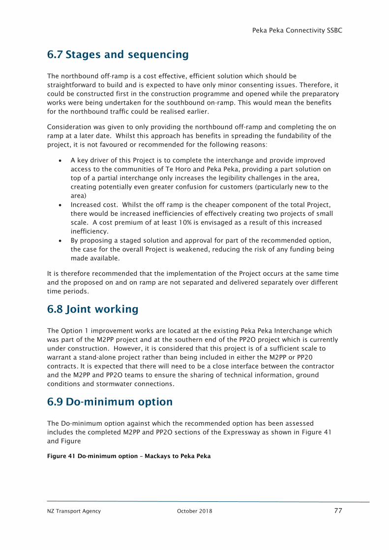
Peka Peka Connectivity SSBC
NZ Transport Agency October 2018 77
6.7 Stages and sequencing
The northbound off-ramp is a cost effective, efficient solution which should be
straightforward to build and is expected to have only minor consenting issues. Therefore, it
could be constructed first in the construction programme and opened while the preparatory
works were being undertaken for the southbound on-ramp. This would mean the benefits
for the northbound traffic could be realised earlier.
Consideration was given to only providing the northbound off-ramp and completing the on
ramp at a later date. Whilst this approach has benefits in spreading the fundability of the
project, it is not favoured or recommended for the following reasons:
• A key driver of this Project is to complete the interchange and provide improved
access to the communities of Te Horo and Peka Peka, providing a part solution on
top of a partial interchange only increases the legibility challenges in the area,
creating potentially even greater confusion for customers (particularly new to the
area)
• Increased cost. Whilst the off ramp is the cheaper component of the total Project,
there would be increased inefficiencies of effectively creating two projects of small
scale. A cost premium of at least 10% is envisaged as a result of this increased
inefficiency.
• By proposing a staged solution and approval for part of the recommended option,
the case for the overall Project is weakened, reducing the risk of any funding being
made available.
It is therefore recommended that the implementation of the Project occurs at the same time
and the proposed on and on ramp are not separated and delivered separately over different
time periods.
6.8 Joint working
The Option 1 improvement works are located at the existing Peka Peka Interchange which
was part of the M2PP project and at the southern end of the PP2O project which is currently
under construction. However, it is considered that this project is of a sufficient scale to
warrant a stand-alone project rather than being included in either the M2PP or PP20
contracts. It is expected that there will need to be a close interface between the contractor
and the M2PP and PP2O teams to ensure the sharing of technical information, ground
conditions and stormwater connections.
6.9 Do-minimum option
The Do-minimum option against which the recommended option has been assessed
includes the completed M2PP and PP2O sections of the Expressway as shown in Figure 41
and Figure
Figure 41 Do-minimum option – Mackays to Peka Peka
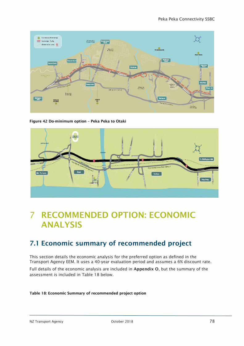
Peka Peka Connectivity SSBC
NZ Transport Agency October 2018 78
Figure 42 Do-minimum option – Peka Peka to Otaki
RECOMMENDED OPTION: ECONOMIC
ANALYSIS
7.1 Economic summary of recommended project
This section details the economic analysis for the preferred option as defined in the
Transport Agency EEM. It uses a 40-year evaluation period and assumes a 6% discount rate.
Full details of the economic analysis are included in Appendix O, but the summary of the
assessment is included in Table 18 below.
Table 18: Economic Summary of recommended project option
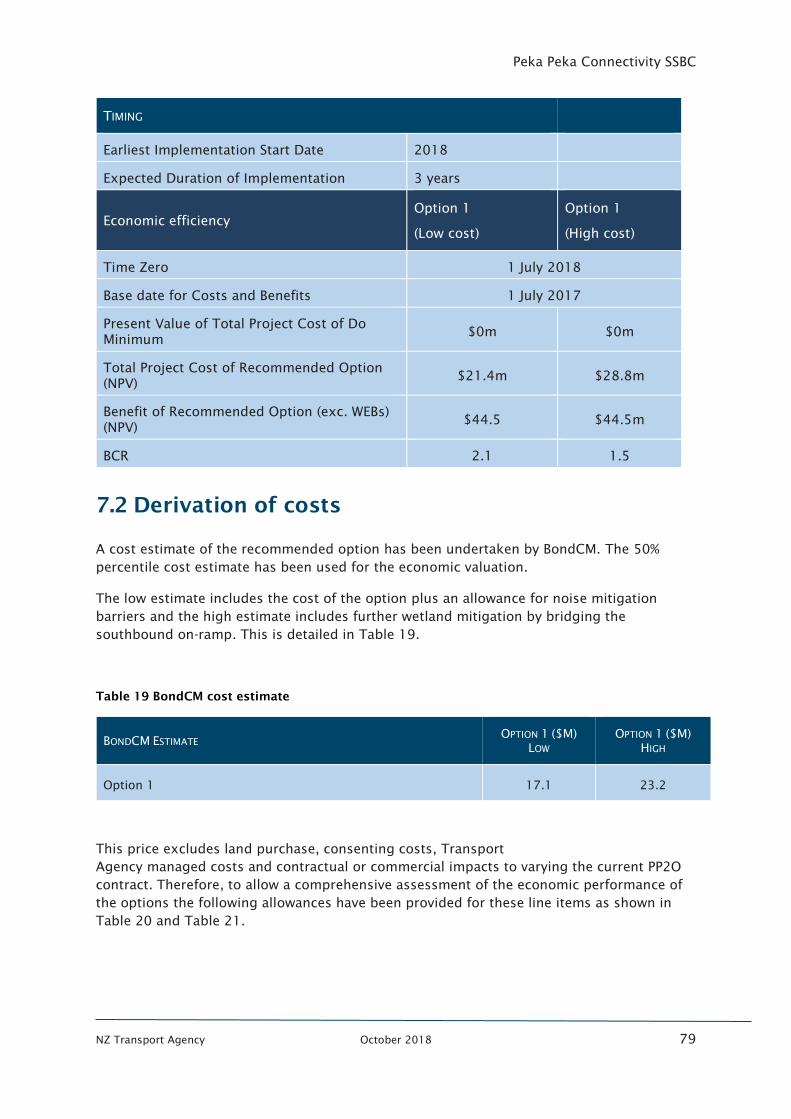
Peka Peka Connectivity SSBC
NZ Transport Agency October 2018 79
TIMING
Earliest Implementation Start Date 2018
Expected Duration of Implementation 3 years
Economic efficiency
Option 1
(Low cost)
Option 1
(High cost)
Time Zero 1 July 2018
Base date for Costs and Benefits 1 July 2017
Present Value of Total Project Cost of Do
Minimum $0m $0m
Total Project Cost of Recommended Option
(NPV) $21.4m $28.8m
Benefit of Recommended Option (exc. WEBs)
(NPV) $44.5 $44.5m
BCR 2.1 1.5
7.2 Derivation of costs
A cost estimate of the recommended option has been undertaken by BondCM. The 50%
percentile cost estimate has been used for the economic valuation.
The low estimate includes the cost of the option plus an allowance for noise mitigation
barriers and the high estimate includes further wetland mitigation by bridging the
southbound on-ramp. This is detailed in Table 19.
Table 19 BondCM cost estimate
BONDCM ESTIMATE OPTION 1 ($M)
LOW
OPTION 1 ($M)
HIGH
Option 1 17.1 23.2
This price excludes land purchase, consenting costs, Transport
Agency managed costs and contractual or commercial impacts to varying the current PP2O
contract. Therefore, to allow a comprehensive assessment of the economic performance of
the options the following allowances have been provided for these line items as shown in
Table 20 and Table 21.
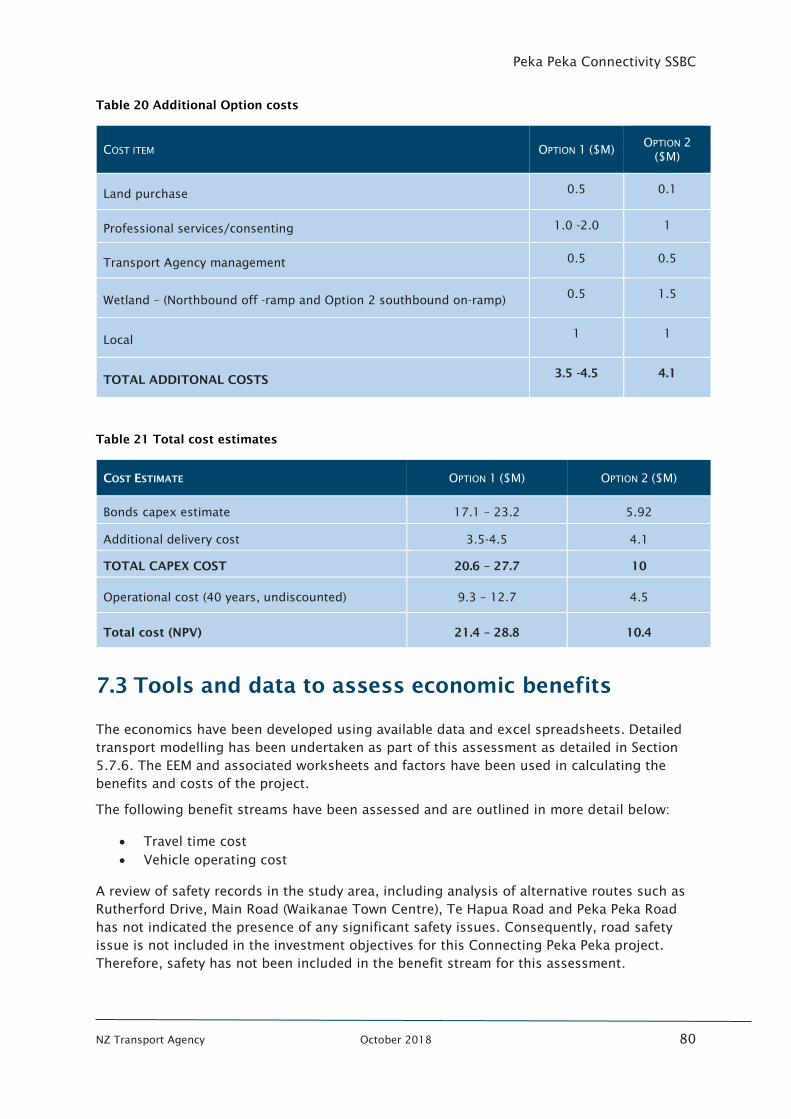
Peka Peka Connectivity SSBC
NZ Transport Agency October 2018 80
Table 20 Additional Option costs
COST ITEM OPTION 1 ($M) OPTION 2
($M)
Land purchase 0.5 0.1
Professional services/consenting 1.0 -2.0 1
Transport Agency management 0.5 0.5
Wetland – (Northbound off -ramp and Option 2 southbound on-ramp) 0.5 1.5
Local 1 1
TOTAL ADDITONAL COSTS 3.5 -4.5 4.1
Table 21 Total cost estimates
COST ESTIMATE OPTION 1 ($M) OPTION 2 ($M)
Bonds capex estimate 17.1 – 23.2 5.92
Additional delivery cost 3.5-4.5 4.1
TOTAL CAPEX COST 20.6 – 27.7 10
Operational cost (40 years, undiscounted) 9.3 – 12.7 4.5
Total cost (NPV) 21.4 – 28.8 10.4
7.3 Tools and data to assess economic benefits
The economics have been developed using available data and excel spreadsheets. Detailed
transport modelling has been undertaken as part of this assessment as detailed in Section
5.7.6. The EEM and associated worksheets and factors have been used in calculating the
benefits and costs of the project.
The following benefit streams have been assessed and are outlined in more detail below:
• Travel time cost
• Vehicle operating cost
A review of safety records in the study area, including analysis of alternative routes such as
Rutherford Drive, Main Road (Waikanae Town Centre), Te Hapua Road and Peka Peka Road
has not indicated the presence of any significant safety issues. Consequently, road safety
issue is not included in the investment objectives for this Connecting Peka Peka project.
Therefore, safety has not been included in the benefit stream for this assessment.
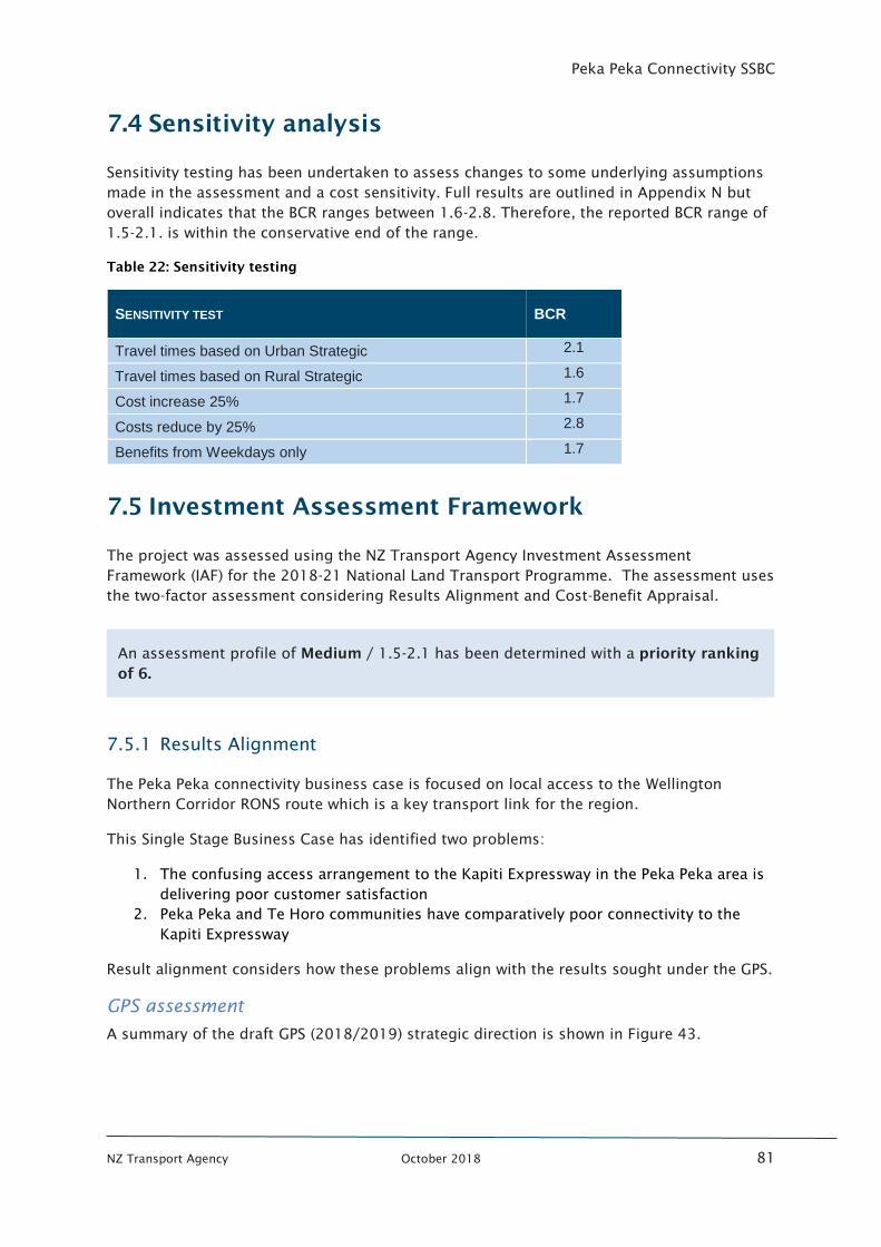
Peka Peka Connectivity SSBC
NZ Transport Agency October 2018 81
7.4 Sensitivity analysis
Sensitivity testing has been undertaken to assess changes to some underlying assumptions
made in the assessment and a cost sensitivity. Full results are outlined in Appendix N but
overall indicates that the BCR ranges between 1.6-2.8. Therefore, the reported BCR range of
1.5-2.1. is within the conservative end of the range.
Table 22: Sensitivity testing
SENSITIVITY TEST BCR
Travel times based on Urban Strategic 2.1
Travel times based on Rural Strategic 1.6
Cost increase 25% 1.7
Costs reduce by 25% 2.8
Benefits from Weekdays only 1.7
7.5 Investment Assessment Framework
The project was assessed using the NZ Transport Agency Investment Assessment
Framework (IAF) for the 2018-21 National Land Transport Programme. The assessment uses
the two-factor assessment considering Results Alignment and Cost-Benefit Appraisal.
7.5.1 Results Alignment
The Peka Peka connectivity business case is focused on local access to the Wellington
Northern Corridor RONS route which is a key transport link for the region.
This Single Stage Business Case has identified two problems:
1. The confusing access arrangement to the Kapiti Expressway in the Peka Peka area is
delivering poor customer satisfaction
2. Peka Peka and Te Horo communities have comparatively poor connectivity to the
Kapiti Expressway
Result alignment considers how these problems align with the results sought under the GPS.
GPS assessment
A summary of the draft GPS (2018/2019) strategic direction is shown in Figure 43.
An assessment profile of Medium / 1.5-2.1 has been determined with a priority ranking
of 6.
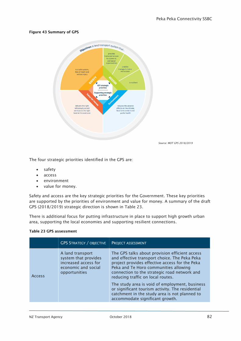
Peka Peka Connectivity SSBC
NZ Transport Agency October 2018 82
Figure 43 Summary of GPS
Source: MOT GPS 2018/2019
The four strategic priorities identified in the GPS are:
• safety
• access
• environment
• value for money.
Safety and access are the key strategic priorities for the Government. These key priorities
are supported by the priorities of environment and value for money. A summary of the draft
GPS (2018/2019) strategic direction is shown in Table 23.
There is additional focus for putting infrastructure in place to support high growth urban
area, supporting the local economies and supporting resilient connections.
Table 23 GPS assessment
GPS STRATEGY / OBJECTIVE PROJECT ASSESSMENT
Access
A land transport
system that provides
increased access for
economic and social
opportunities
The GPS talks about provision efficient access
and effective transport choice. The Peka Peka
project provides effective access for the Peka
Peka and Te Horo communities allowing
connection to the strategic road network and
reducing traffic on local routes.
The study area is void of employment, business
or significant tourism activity. The residential
catchment in the study area is not planned to
accommodate significant growth.
Peka Peka Connectivity SSBC
NZ Transport Agency October 2018 83
The GPS outlines a focus on sustainable
economic development of the regions. Tourism
and primary industries are the focus of this
economic development. The Peka Peka project
does not serve any significant areas contributing
to economic growth or tourism.
A land transport
system that enables
transport choice and
access
The Peka Peka project provides a choice of
routes to the communities of Peka Peka and Te
Horo and provides the ability of these people to
make use of the Kapiti Expressway. However,
the intention within the GPS is on transport
mode choice rather than route choice. Due to
the location and lack of public transport in the
area, the project only effects access for vehicles,
therefore not providing additional transport
choice.
A land transport
system that is resilient
The Peka Peka Project provides an additional
route to and from the Peka Peka and Te Horo
communities improving resilience. However,
given the current availability of multiple routes
and lack of evidence suggesting a current
resilience problem, the project is not considered
to contribute to this objective.
Road safety
Reduction in DSI The Peka Peka connectivity Business Case is not
intended to address a problem with regards to
Road Safety. Evidence does not suggest a
problem with regards to crashes on the local
road network on routes used by the Te Horo and
Peka Peka communities.
The options considered for connectivity provide
some benefit for road safety through shifting
traffic from the local road network onto the
strategic road network.
Environment
A land transport
system that reduces
the adverse effects on
the climate, local
environment and
public health
The Peka Peka project has positive effects
through reduction of traffic through the
Waikanae Town Centre and on Rutherford Drive.
Shifting of strategic traffic onto the expressway
has positive noise, air quality and amenity
outcomes for these areas.
The effects of the project are mitigated through
noise walls, and appropriate storm water
mitigation.
Value for
money
A land transport
system that delivers
the right infrastructure
and services to the
right level at the best
cost
The Peka Peka project achieves a BCR of over 2
indicating value for money is achieved.
Environmental benefits from removal of traffic
from local road are unable to be quantified but
contribute to the overall value of the project.
Peka Peka Connectivity SSBC
NZ Transport Agency October 2018 84
Overall the Peka Peka project provides a contribution to the first of the three ‘Access’
objectives. Whilst the project provides increased access for economic and social
opportunities, the scale of the contribution is limited.
Safety did not form an investment objective for the project but was a key differentiating
factor when selecting between short list options as some of the shortlist options
compromised on safety elements to reduce construction cost. Environment and value for
money were key considerations during the assessment and design of each option.
Customer Levels of Service assessment
As defined in the ONRC, a National route like the Expressway, makes the largest
contribution to the social and economic wellbeing of New Zealand by connecting major
population centres, airports and facilitating freight. The Expressway is a high-quality facility
which generally achieves the desired ONRC outcomes.
This project however is not related to the Expressway facility itself, but rather addresses
access to this strategic road network infrastructure. Therefore, the problems are related to
how this strategic traffic is required to use regional road networks rather than specific ONRC
criteria.
The main source of customer level of service has come directly from the customers through
stakeholders and open days and has clearly identified an access problem for the local
communities. This is supported through additional evidence as detailed in Table 24.
Table 24 Customer level of service
CLOS PROJECT ASSESSMENT
Mobility
(travel time
reliability,
resilience of
the route)
Section 2.3.2 details the discrepancies between the Peka Peka and Te Horo
communities travel time to access the expressway when compared with
neighbouring communities. This shows there is a significant gap in the system
performance for local access to the Expressway.
As detailed in Section 2.3.1, with the existing M2PP and PP2O designs, there
will be approximately 15km distance between Te Moana and Otaki
interchanges. Should a northbound driver miss the turn off or be unable to exit
at Te Moana interchange, then significant re-routing is required to access Peka
Peka and Te Horo.
This is considered an identified gap in the system. There are two existing
potential routes to access the communities from the Expressway which offers
some resilience, however neither are direct access and both require extensive
use of the local road and incur additional travel time. Addressing the problem
of connectivity at Peka Peka will improve access to the Expressway, add
resilience to the local communities’ journeys and redirect strategic traffic onto
the strategic road network.
Accessibility
(land access
and road
network
connectivity)
The location of interchanges along the expressway accords with this CLoS
outcome of less interchanges in rural environments. However, as it is a partial
interchange the effectiveness of this interchange is reduced. The effects of this
is shown in Figure 18 which demonstrates the reduction in accessibility for the
Te Horo and Peka Peka communities. This shows there is an identified gap in
the system which would benefit from improvement
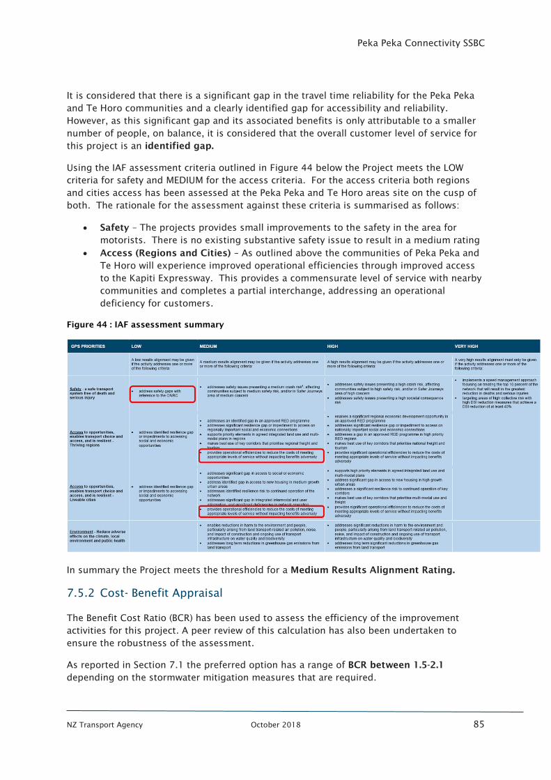
Peka Peka Connectivity SSBC
NZ Transport Agency October 2018 85
It is considered that there is a significant gap in the travel time reliability for the Peka Peka
and Te Horo communities and a clearly identified gap for accessibility and reliability.
However, as this significant gap and its associated benefits is only attributable to a smaller
number of people, on balance, it is considered that the overall customer level of service for
this project is an identified gap.
Using the IAF assessment criteria outlined in Figure 44 below the Project meets the LOW
criteria for safety and MEDIUM for the access criteria. For the access criteria both regions
and cities access has been assessed at the Peka Peka and Te Horo areas site on the cusp of
both. The rationale for the assessment against these criteria is summarised as follows:
• Safety – The projects provides small improvements to the safety in the area for
motorists. There is no existing substantive safety issue to result in a medium rating
• Access (Regions and Cities) – As outlined above the communities of Peka Peka and
Te Horo will experience improved operational efficiencies through improved access
to the Kapiti Expressway. This provides a commensurate level of service with nearby
communities and completes a partial interchange, addressing an operational
deficiency for customers.
Figure 44 : IAF assessment summary
In summary the Project meets the threshold for a Medium Results Alignment Rating.
7.5.2 Cost- Benefit Appraisal
The Benefit Cost Ratio (BCR) has been used to assess the efficiency of the improvement
activities for this project. A peer review of this calculation has also been undertaken to
ensure the robustness of the assessment.
As reported in Section 7.1 the preferred option has a range of BCR between 1.5-2.1
depending on the stormwater mitigation measures that are required.
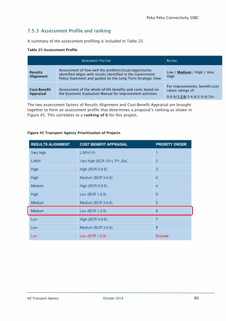
Peka Peka Connectivity SSBC
NZ Transport Agency October 2018 86
7.5.3 Assessment Profile and ranking
A summary of the assessment profiling is included in Table 25
Table 25 Assessment Profile
ASSESSMENT FACTOR RATING
Results
Alignment
Assessment of how well the problem/issue/opportunity
identified aligns with results identified in the Government
Policy Statement and guided by the Long Term Strategic View
Low / Medium / High / Very
High
Cost-Benefit
Appraisal
Assessment of the whole-of-life benefits and costs based on
the Economic Evaluation Manual for improvement activities
For Improvements, benefit-cost
ration ratings of:
0-0.9/1-2.9/3-4.9/5-9.9/10+
The two assessment factors of Results Alignment and Cost-Benefit Appraisal are brought
together to form an assessment profile that determines a proposal’s ranking as shown in
Figure 45. This correlates to a ranking of 6 for this project.
Figure 45 Transport Agency Prioritisation of Projects
Peka Peka Connectivity SSBC
NZ Transport Agency October 2018 87
FINANCIAL CASE
8.1 Project delivery costs
As outlined previously in this report a cost estimate of the preferred option has been
undertaken by BondCM.
Property costs of approximately $0.5M are also considered possible should the stormwater
mitigation require additional land for wetlands or flood storage.Value engineering will need
to be undertaken as part of future stages of the project with an emphasis on the
southbound on-ramp to determine the best way to mitigate the stormwater effects.
8.2 Ongoing operations and maintenance costs
Operations and maintenance costs for the preferred option have been considered in the
project’s development.
For the purposes of economic assessment, the Operational expenditure (OPEX) costs have
been assumed as the following:
• Annual operational cost of 1% of CAPEX
• Every 10 years, a more substantial maintenance intervention is required at 4% of
CAPEX (e.g. reseal or storm water remedial work)
All maintenance costs will be attributed to the Transport Agency.
8.3 Project revenues
There are no project revenue streams considered from a funding perspective for this
project. The works provided are generally travel time reliability and connectivity
improvements which do not easily support any additional revenue mechanisms such as
tolling and therefore no consideration has been given at this time to additional revenue
sources for the roading component of the option.
8.4 Funding options
This project is categorised as a road improvement and would be eligible for consideration of
funding under the NLTF process. No third-party funding is required. It is considered
beneficial for this work to be undertaken parallel to the PP2O contract which is currently
under construction.
8.5 Financial risk
The substantive financial risk are shown in Figure 46.
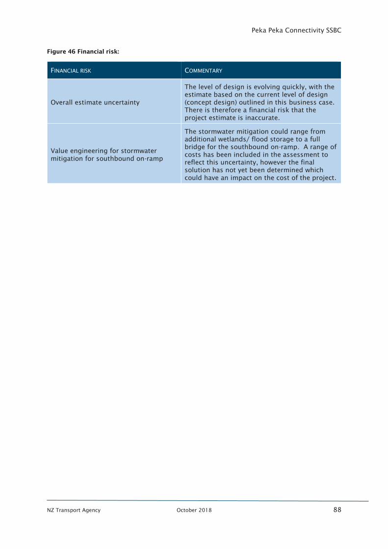
Peka Peka Connectivity SSBC
NZ Transport Agency October 2018 88
Figure 46 Financial risk:
FINANCIAL RISK COMMENTARY
Overall estimate uncertainty
The level of design is evolving quickly, with the
estimate based on the current level of design
(concept design) outlined in this business case.
There is therefore a financial risk that the
project estimate is inaccurate.
Value engineering for stormwater
mitigation for southbound on-ramp
The stormwater mitigation could range from
additional wetlands/ flood storage to a full
bridge for the southbound on-ramp. A range of
costs has been included in the assessment to
reflect this uncertainty, however the final
solution has not yet been determined which
could have an impact on the cost of the project.

Peka Peka Connectivity SSBC
NZ Transport Agency October 2018 89
PART B: READINESS
AND ASSURANCE
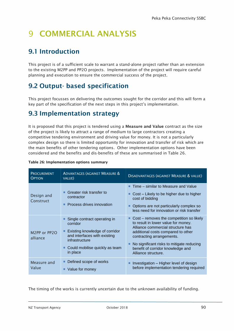
Peka Peka Connectivity SSBC
NZ Transport Agency October 2018 90
COMMERCIAL ANALYSIS
9.1 Introduction
This project is of a sufficient scale to warrant a stand-alone project rather than an extension
to the existing M2PP and PP2O projects. Implementation of the project will require careful
planning and execution to ensure the commercial success of the project.
9.2 Output- based specification
This project focusses on delivering the outcomes sought for the corridor and this will form a
key part of the specification of the next steps in this project’s implementation.
9.3 Implementation strategy
It is proposed that this project is tendered using a Measure and Value contract as the size
of the project is likely to attract a range of medium to large contractors creating a
competitive tendering environment and driving value for money. It is not a particularly
complex design so there is limited opportunity for innovation and transfer of risk which are
the main benefits of other tendering options. Other implementation options have been
considered and the benefits and dis-benefits of these are summarised in Table 26.
Table 26: Implementation options summary
PROCUREMENT
OPTION
ADVANTAGES (AGAINST MEASURE &
VALUE) DISADVANTAGES (AGAINST MEASURE & VALUE)
Design and
Construct
▪ Greater risk transfer to contractor
▪ Process drives innovation
▪ Time – similar to Measure and Value
▪ Cost – Likely to be higher due to higher cost of bidding
▪ Options are not particularly complex so less need for innovation or risk transfer
M2PP or PP2O
alliance
▪ Single contract operating in corridor
▪ Existing knowledge of corridor and interfaces with existing infrastructure
▪ Could mobilise quickly as team in place
▪ Cost – removes the competition so likely to result in lower value for money. Alliance commercial structure has additional costs compared to other contracting arrangements.
▪ No significant risks to mitigate reducing benefit of corridor knowledge and Alliance structure.
Measure and
Value
▪ Defined scope of works
▪ Value for money
▪ Investigation – Higher level of design before implementation tendering required
The timing of the works is currently uncertain due to the unknown availability of funding.
Peka Peka Connectivity SSBC
NZ Transport Agency October 2018 91
9.4 Risk allocation and transfer
The recommended procurement model of Measure and Value retains most of the risk with
the Transport Agency. Any design changes or changes due to typical exclusions such as soil
or ground conditions would be the Transport Agencies responsibility. However, it is
expected that during the design process these risks can be adequately assessed and
subsequently mitigated through good design.
9.5 Payment mechanisms
Payment is expected to be as per the standard agreed conditions of contract with Transport
Agency.
9.6 Contract length
Option 1 is estimated to have in the order of a 6-month design period and 12-18 month
construction period.
9.7 Contract management
Contract management would be by the nominated project lead for the Transport Agency.
9.8 Schedule
Given the IAF priority of 6 it is likely that funding through the NLTF will need to be secured.
This could take 12-24 months depending on other priorities. If funding was secured a three
year period to implementation is forecast as shown in Figure 47.
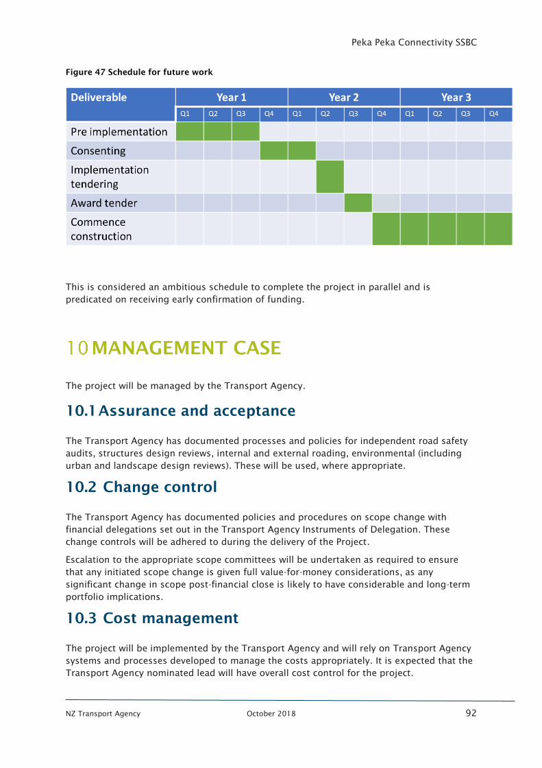
Peka Peka Connectivity SSBC
NZ Transport Agency October 2018 92
Figure 47 Schedule for future work
This is considered an ambitious schedule to complete the project in parallel and is
predicated on receiving early confirmation of funding.
MANAGEMENT CASE
The project will be managed by the Transport Agency.
10.1 Assurance and acceptance
The Transport Agency has documented processes and policies for independent road safety
audits, structures design reviews, internal and external roading, environmental (including
urban and landscape design reviews). These will be used, where appropriate.
10.2 Change control
The Transport Agency has documented policies and procedures on scope change with
financial delegations set out in the Transport Agency Instruments of Delegation. These
change controls will be adhered to during the delivery of the Project.
Escalation to the appropriate scope committees will be undertaken as required to ensure
that any initiated scope change is given full value-for-money considerations, as any
significant change in scope post-financial close is likely to have considerable and long-term
portfolio implications.
10.3 Cost management
The project will be implemented by the Transport Agency and will rely on Transport Agency
systems and processes developed to manage the costs appropriately. It is expected that the
Transport Agency nominated lead will have overall cost control for the project.
Peka Peka Connectivity SSBC
NZ Transport Agency October 2018 93
LESSONS LEARNED AND POST-
IMPLEMENTATION MONITORING
11.1 Lessons learned
Lessons learnt from this project will be fed back into the Transport Agency’s project
development and delivery lifecycle through several different mechanisms and levels of
project and Transport Agency management. These include a Lessons Learnt Review (LLR)
and Contract Management Review processes.
The contractor will lead and drive this process on all its activities and will report to the
nominated Transport Agency Project Lead.
11.2 Post-implementation monitoring: approach and
schedule
The IO’s are presented in section 3.3 above. Monitoring the achievement of these objectives
will be a continuous process as the project progresses through detailed design, construction
and operation. This will be undertaken annually.
A detailed post construction monitoring regime will be developed for the project at the
appropriate time to assess whether the outcomes envisaged have been delivered. This
benefits realisation assessment will then allow lessons learnt and mitigation plans to be
developed and fed back into the Transport Agency. A customer satisfaction survey will
form part of this assessment to assess how the project has performed against the customer
satisfaction objective of reducing confusion and improving connectivity.
This monitoring will be the responsibility of the Project Lead.
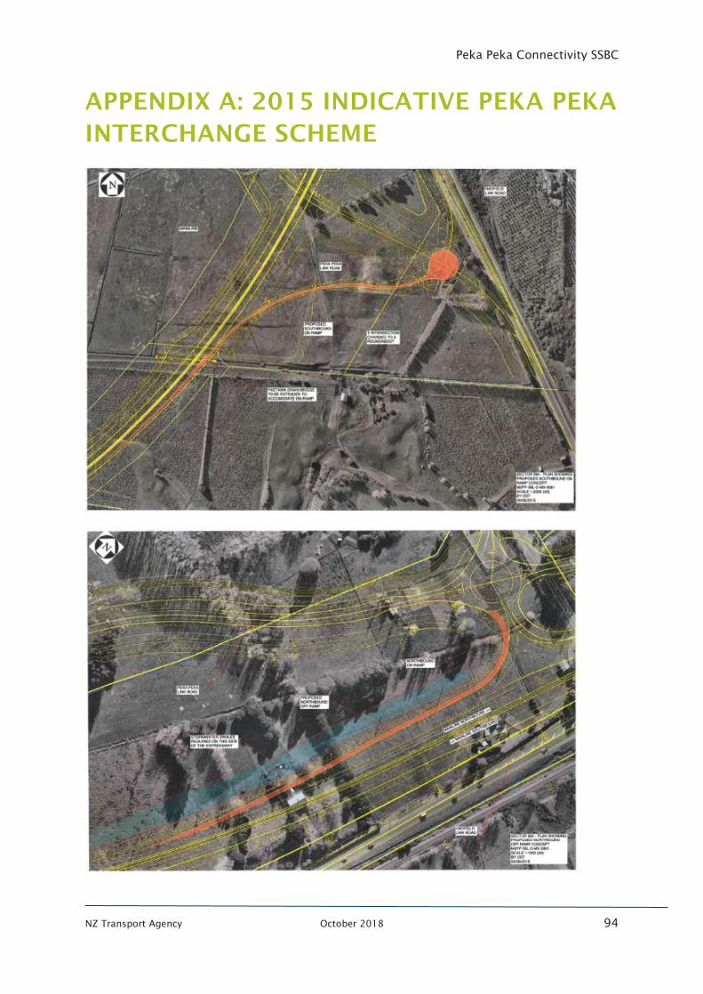
Peka Peka Connectivity SSBC
NZ Transport Agency October 2018 94
APPENDIX A: 2015 INDICATIVE PEKA PEKA
INTERCHANGE SCHEME

Peka Peka Connectivity SSBC
NZ Transport Agency October 2018 95
APPENDIX B : ASSESSMENT CRITERIA
Peka Peka Connectivity SSBC
NZ Transport Agency October 2018 96
APPENDIX C : ENGAGEMENT AND
COMMUNICATIONS PLAN

Peka Peka Connectivity SSBC
NZ Transport Agency October 2018 97
APPENDIX D: LONG LIST OPTIONS

Peka Peka Connectivity SSBC
NZ Transport Agency October 2018 98
APPENDIX E : ESR SCREENS

Peka Peka Connectivity SSBC
NZ Transport Agency October 2018 99
APPENDIX F : STORMWATER ANALYSIS

Peka Peka Connectivity SSBC
NZ Transport Agency October 2018 100
APPENDIX G : LANDUSE ANALYSIS
Peka Peka Connectivity SSBC
NZ Transport Agency October 2018 101
APPENDIX H : WAIKANAE ECONOMIC
STUDY
Peka Peka Connectivity SSBC
NZ Transport Agency October 2018 102
APPENDIX I: COST ESTIMATES
Peka Peka Connectivity SSBC
NZ Transport Agency October 2018 103
APPENDIX J : SHORTLISTED OPTION
REFINEMENT

Peka Peka Connectivity SSBC
NZ Transport Agency October 2018 104
APPENDIX K: STAKEHOLDER FEEDBACK
Peka Peka Connectivity SSBC
NZ Transport Agency October 2018 105
APPENDIX L : SHORLISTED OPTION NOISE
ASSESSMENT

Peka Peka Connectivity SSBC
NZ Transport Agency October 2018 106
APPENDIX M: CONSENTING STRATEGY

Peka Peka Connectivity SSBC
NZ Transport Agency October 2018 107
APPENDIX N: NOTES FROM WORKSHOP 2

Peka Peka Connectivity SSBC
NZ Transport Agency October 2018 108
APPENDIX O: ECONOMIC EVALUATION