Embed Size (px)
Citation preview

Environmental Assessment
Village of Patchogue Out-of-District Sewer Extension, Patchogue, NY
APPENDIX G: CULTURAL RESOURCES SURVEYS
Phase IA Architectural Reconnaissance Survey,
Village Of Patchogue Out-Of-District Sewer District Extension
PART 2

Phase IA Architectural Reconnaissance Survey Village of Patchogue Village of Patchogue Out-of-District Sewer District Extension Suffolk County, New York
10
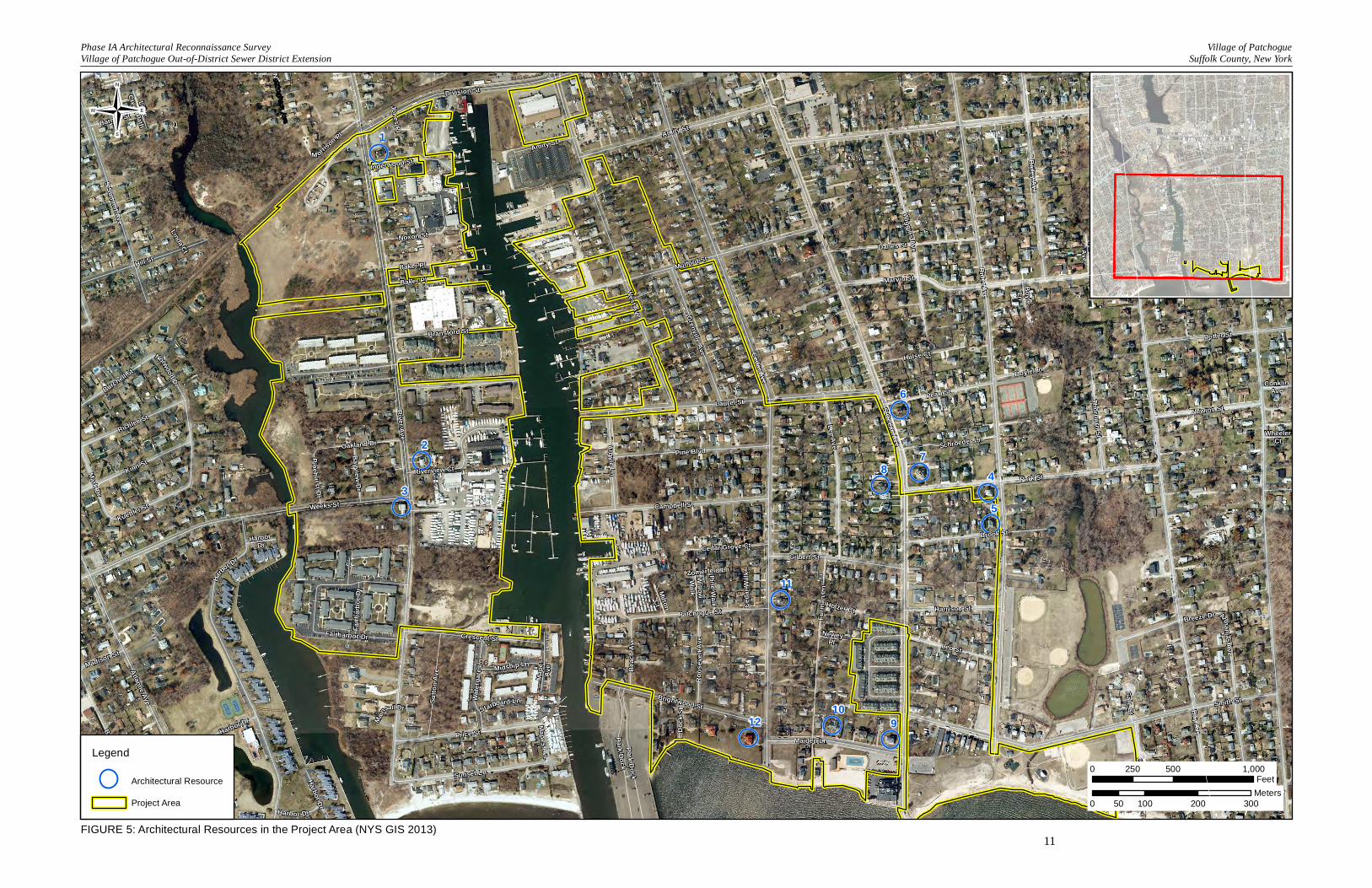
IV. Results of the Architectural Reconnaissance Survey Large portions of the project area are modern commercial and residential development, particularly in areas west of the Patchogue River. As noted in Chapter I., the majority of the project area is characterized by mid- and late twentieth-century and early twenty-first-century residential development. Many residential areas are a mixture of vernacular forms and architectural styles, such as Queen Anne, Colonial Revival, and Craftsman. Most of the historic-period residential properties have been altered with vinyl siding, replacement windows, and porch enclosures. Many buildings were elevated after Superstorm Sandy. No historic-period road or paving surfaces were encountered during the reconnaissance survey. Twelve potentially eligible properties wereidentified in the APE (Figures 5a-f; Table 2; Photographs 1-12). These properties are all residential and are located on Rider, Cedar, and Ocean avenues and Maiden Lane. None of these properties has been previously surveyed.Additional potentially eligible resources may be located in in the APE (once established). Many residences were obscured by trees and othervegetation. No properties in the project area are designated as NHLs. One previously surveyed property located at 7 Oakland Avenue has been determined eligible for the NRHP, and 33 properties have been previously documented on New York State survey forms, including the house at 7 Oakland Avenue (see Table 1). Documentation for two of the properties did not include NRHP eligibility opinions.
Most of the changes proposed for the project involve installation of connections and grinder stations underground. The project has the potential to adversely affect architectural resources directly, if grinder stations are installed in the basement of a structure, or indirectly, if ground disturbance associated with service laterals or on-site grinder stations diminishes the integrity of significant landscape features associated with historic properties, such as such as fences, walls, foundation plantings, and flower beds. The APE established for indirect impacts should coincide with the APE for direct impacts.
TABLE 2
RESULTS OF THE ARCHITECTURAL RECONNAISSANCE SURVEY
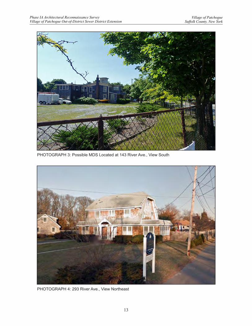
RESOURCE No. ADDRESS PHOTOGRAPH No. 1 143 River Ave. 3
2 293 River Ave. 4
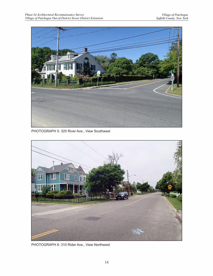
3 320 River Ave. 5
4 310 Rider Ave. 6
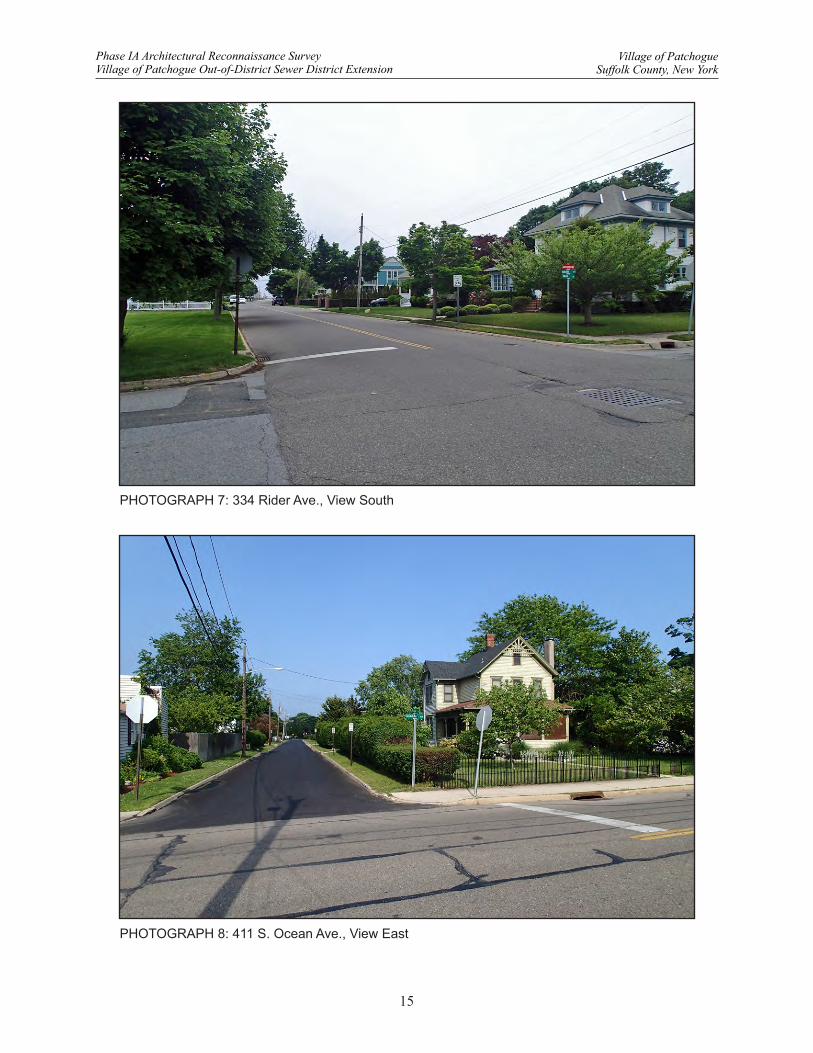
5 334 Rider Ave. 7
6 411 S. Ocean Ave. 8
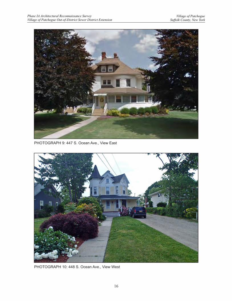
7 447 S. Ocean Avenue 9
8 448 S. Ocean Ave. 10
9 576 S. Ocean Ave. 1
10 23 Maiden Ln. 2
11 259 Cedar Ave. 11
12 310 Cedar Ave. 12
LittleCreek PathBarnes St«
Grov
e Ave
RobinsonAve
SwanRiver St
Elizabeth St
Carman St
Park Dock
Harbo
r Dr
Will owWal k
Weeks St
Crescent St
Linda Ct
River Ave
Gilbert St
Harbor Dr
Zomerfeld Ln
Jones Pl
Kinn St
Brightwood St
RiderAve
HarborDr
Bayview Rd
West Ave
Mainsail Dr
Mape
sAv
e
Water
gate
Ln
Patchogue St
S Ocean Ave
Atlantic Ave
NeweyPl
BoyleLn
WheelerCt
MiltonCt
HarborDr
ConklinAve
Wiggins Ave
CoreyAve Middle
Rd
Dock
St
Potter St
Campbell St
Bay AveMapes Ave
Mark Dr
Holzer Ct
Oakland Dr
Gale Ct
Ceda
r Walk
Breeze Dr
S Summit Ave
Pine Walk
Bransford St
Norwood Dr
Smith St
Brook St
Starboard Ln
Maiden Ln
Madison St
Marvin St
Argyle Ln
Bailey Ave
Cedar Ave
Underwood St
Harbor Dr
Mulford St
Fairharbor Dr
Fairh
arbor
Dr
ottingham Ave
Riverview Ct
Laurel St
Pineh urst Dr
Baker PlHill St
Bayview Dr
Price St
Baker Pl
Amity St
Midship Ln
Noxon St
Beac
h Ave
Boyle Ln
DeWitt Ave
M orrison Pl
Kuebler St
Cedar Grove Ct
Danes St
ParkDock
Burchell St
AnnaniasAve
Roos
e velt
Ave
Harrison St
Park St
Leo St
Hulse Ct
Harbor Dr
Schroeder Ln
Amity St
Furm
an Ln
Sutto
n Ave
Thorburn St
Newins StPearl St
Richlee St
Clif ton Dr
Barteau Ave
Grenville Ave
Sunset Ln
Pine Blvd
Lee Ave
Division St
12
11
109
87
6
5
4
2
3
1
0 500 1,000250Feet
0 100 200 30050Meters
Legend
Architectural Resource
Project Area
N
FIGURE 5: Architectural Resources in the Project Area (NYS GIS 2013)11
Phase IA Architectural Reconnaissance SurveyVillage of Patchogue Out-of-District Sewer District Extension
Village of PatchogueSuffolk County, New York
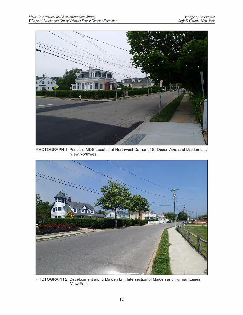
PHOTOGRAPH 1: Possible MDS Located at Northwest Corner of S. Ocean Ave. and Maiden Ln., View Northwest
PHOTOGRAPH 2: Development along Maiden Ln., Intersection of Maiden and Furman Lanes, View East
12
Village of PatchogueSuffolk County, New York
Phase IA Architectural Reconnaissance SurveyVillage of Patchogue Out-of-District Sewer District Extension
PHOTOGRAPH 3: Possible MDS Located at 143 River Ave., View South
PHOTOGRAPH 4: 293 River Ave., View Northeast
13
Village of PatchogueSuffolk County, New York
Phase IA Architectural Reconnaissance SurveyVillage of Patchogue Out-of-District Sewer District Extension
PHOTOGRAPH 5: 320 River Ave., View Southwest
PHOTOGRAPH 6: 310 Rider Ave., View Northwest
14
Village of PatchogueSuffolk County, New York
Phase IA Architectural Reconnaissance SurveyVillage of Patchogue Out-of-District Sewer District Extension
PHOTOGRAPH 7: 334 Rider Ave., View South
PHOTOGRAPH 8: 411 S. Ocean Ave., View East
15
Village of PatchogueSuffolk County, New York
Phase IA Architectural Reconnaissance SurveyVillage of Patchogue Out-of-District Sewer District Extension
PHOTOGRAPH 9: 447 S. Ocean Ave., View East
PHOTOGRAPH 10: 448 S. Ocean Ave., View West
16
Village of PatchogueSuffolk County, New York
Phase IA Architectural Reconnaissance SurveyVillage of Patchogue Out-of-District Sewer District Extension
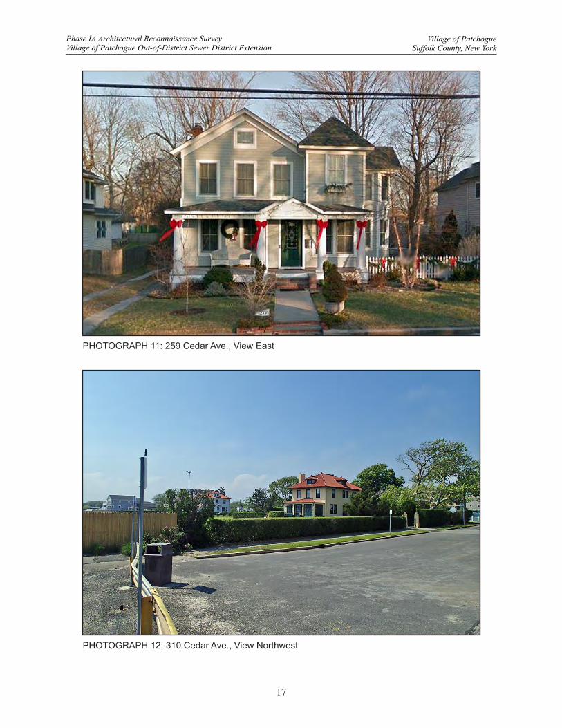
PHOTOGRAPH 11: 259 Cedar Ave., View East
PHOTOGRAPH 12: 310 Cedar Ave., View Northwest
17
Village of PatchogueSuffolk County, New York
Phase IA Architectural Reconnaissance SurveyVillage of Patchogue Out-of-District Sewer District Extension
Phase IA Architectural Reconnaissance Survey Village of Patchogue Village of Patchogue Out-of-District Sewer District Extension Suffolk County, New York
18
V. Conclusions
Louis Berger completed a Phase IA architectural reconnaissance survey for the Village of Patchogue Out-of-District Sewer District Extension in the Village of Patchogue, Suffolk County, New York. The New York State Governor’s Office of Storm Recovery is proposing to fund the expansion of the Patchogue Sewer District as part of the New York State Sandy Recovery efforts funded through the CDBG-Disaster Recovery program.
The proposed sewer expansion area is composed of 648 parcels that encompass approximately 109 hectares (270 acres) outside the existing Village of Patchogue Sewer District boundary. Expansion efforts will include re-routing existing sewer mains and installing new bypass mains where existing capacity is limited; installing 5,692 meters (18,672 feet) of low pressure sewer mains, new service laterals, and individual on-site grinder stations to connect the unsewered parcels to the system; upgrading the West Avenue Pump Station to accommodate the additional flow generated by the sewer district expansion; and abandoning the on-site septic systems. The construction area for this system will include the ROW and connections from the main sewer to each dwelling, as well as grinder stations to be installed in the basement of the structure or buried underground. Most of the ground-disturbing impacts for this project will be limited to the existing sewer ROW; however, installation of service laterals, house connections, and grinder stations will require ground disturbance outside the ROW. At the time of this architectural assessment, project plans were still in the final planning stages and the APE for ground-disturbing impacts to occur outside the existing ROW had not been defined. Therefore Louis Berger took a broader approach to assessing the general project area.
The architectural survey for the project consisted of an inventory file review, limited background research, and a reconnaissance survey. Twelve potentially eligible properties were identified in the APE. Thirty-three properties have been previously surveyed. One previously surveyed property located at 7 Oakland Avenue has been determined eligible for the NRHP. As final plans for project activities have not yet been completed, a full reconnaissance survey of the APE is not recommended. The project has the potential to adversely affect architectural resources directly, if grinder stations are installed in the basement of a structure, or indirectly if ground disturbance associated with service laterals or on-site grinder stations diminishes the integrity of significant landscape features associated with historic properties. There do not appear to be historic-period road surfaces that would be potentially impacted by project activities within the ROW. Given these facts, Louis Berger recommends that a Phase I architectural survey be conducted for only those parcels that will have new service laterals and/or grinder stations installed.
Phase IA Architectural Reconnaissance Survey Village of Patchogue Village of Patchogue Out-of-District Sewer District Extension Suffolk County, New York
19
VI. References Cited and Bibliography Bailey, Paul 1962 Early Long Island, Its Indians, Whaling and Folklore Rhymes. Long Island Forum, Westhampton Beach,
New York. Bayles, Richard M. 1874 Historical and Descriptive Sketches of Suffolk County. Published by the author, Port Jefferson, New York. Beers, F.W. 1873 Atlas of Long Island, New York. F.W. Beers, New York. Bernstein, David J., and Daria E. Merwin 2003a Stage I Archaeological Survey for the Patchogue River Maritime Center and Riverwalk, Village of
Patchogue, Town of Brookhaven, Suffolk County, New York. Institute for Long Island Archaeology, Department of Anthropology, SUNY Stony Brook, New York. On file, Office of Parks, Recreation and Historic Preservation, Waterford, New York.
Crofts, Alice Walpole 1984 Index to the History of Suffolk County, New York; with illustrations, portraits, and sketches of prominent
families and individuals. Compiled by Alice W. Kappenberg, Suffolk County Historical Society, Riverhead, New York.
Dade, George C. 1989 Picture History of Aviation on Long Island, 1908-1938. Dover Publications, New York. Gramly, Richard M. 1977 Archaeological Investigations at Pipshave Hollow, Mt. Sinai Harbor, Long Island: a preliminary report.
Anthropology 1:20-32. Greater Patchogue Historical Society 2015 The History of Patchogue. Accessed at <http://www.patchogue.com/visitors/patchogue_history.html>. Hughes and Bailey 1906 Bird’s-eye view of Patchogue, Long Island, New York. Library of Congress, Catalogue Number 75694829.
Accessed June 2015 at <http://www.loc.gov/item/75694829/>. Mazeau, Daniel E. 2010 Cultural Resources Reconnaissance Survey Report, PIN 0059.08, NYS Route 27 from NYS Route 112 to
Wading River Road, Suffolk County, New York. Cultural Resources Program, New York State Museum. On file, Office of Parks, Recreation and Historic Preservation, Waterford, New York.
Molle, Robert 1982 Remarks of Robert Molle: Republic Airport Commission Meeting, October 28, 1982. Munsell, W.W. 1882 History of Suffolk County, New York. George MacNamara, New York. New York State Geographic Information Systems [NYS GIS] 2013 Orthoimagery. New York State Geographic Information Systems Clearinghouse, Albany, New York.
Accessed online July 2015 at <http://www.nysgis.state.ny.us/>.
Phase IA Architectural Reconnaissance Survey Village of Patchogue Village of Patchogue Out-of-District Sewer District Extension Suffolk County, New York
20
New York State Education Department [NYSED] 2004 Work Scope Specifications for Cultural Resource Investigations on New York State Department of
Transportation Projects. New York State Education Department Cultural Resources Survey Program. New York State Education Department and New York State Museum, Albany.
Ross, Peter 1902 The History of Long Island, from its earliest settlement to the present time. Lewis Publications Company,
New York. United States Department of Agriculture [USDA] 1975 Soil Survey of Suffolk County, New York. Prepared by John W. Warner, Jr., W.E. Hanna, R.J. Landry, J.P.
Wulforst, J.A. Neeley, R.L. Holmes, and C.E. Rice for the United States Department of Agriculture, Soil Conservation Service, Washington, D.C.
United States Department of Agriculture-Natural Resource Conservation Service [USDA-NRCS] 2013 Suffolk County, New York. Soil Survey Geographic (SSURGO) Database. United States Department of
Agriculture-Natural Resources Conservation Service, Washington, D.C. Accessed online July 2015 at <http://websoilsurvey.sc.egov.usda.gov>.
United States [U.S.] Department of the Interior 1983 Archaeology and Historic Preservation: Secretary of the Interior’s Standards and Guidelines. Federal
Register, Part IV, 48(2):44716-44742. Annotated version showing later technical and officially adopted revisions available from the National Park Service’s preservation laws, regulations, and standards webpage at <http://www.cr.nps.gov/local-law/arch_stnds_0.htm>.
United States Geological Survey [USGS] 1904a Islip, NY. 15-Minute Series Topographic Quadrangle. Surveyed 1903, Reprinted 1930. United States
Geological Survey, Washington, D.C. 1904b Moriches, New York. 15-Minute Series Topographic Quadrangle. Surveyed 1903, Reprinted 1918. United
States Geological Society, Washington, D.C. 1947a Bellport, New York. 7.5-Minute Series Topographic Quadrangle. United States Geological Survey, Reston,
Virginia. 1947b Howells Point, New York. 7.5-Minute Series Topographic Quadrangle. United States Geological Survey,
Reston, Virginia. 1947c Patchogue, New York. 7.5-Minute Series Topographic Quadrangle. United States Geological Survey, Reston,
Virginia. 1947d Sayville, New York. 7.5-Minute Series Topographic Quadrangle. United States Geological Survey, Reston,
Virginia. 2013a Bellport, New York. 7.5-Minute Series Topographic Quadrangle. United States Geological Survey, Reston,
Virginia. 2013b Howells Point, New York. 7.5-Minute Series Topographic Quadrangle. United States Geological Survey,
Reston, Virginia. 2013c Patchogue, New York. 7.5-Minute Series Topographic Quadrangle. United States Geological Survey, Reston,
Virginia.

Phase IA Architectural Reconnaissance Survey Village of Patchogue Village of Patchogue Out-of-District Sewer District Extension Suffolk County, New York
21
2013d Sayville, New York. 7.5-Minute Series Topographic Quadrangle. United States Geological Survey, Reston, Virginia.
Weeks, George Lewis 1955 Some of the Town of Islip’s Early History. Consolidated Press, Bay Shore, New York.