Embed Size (px)
Citation preview
CHAPTER 1
INTRODUCTION
1.1 SCOPE OF THE STUDY
Physiography is the description of the physical
features of the geography of an area which includes the
natural phenomena of that region. Mountain barriers,
altitude, latitude, land and water masses, are major factors
of climatic control. To understand the weather and climate of
a region, an adequate knowledge of the physiography is very
important. Barriers, depending on their orientation and
elevation cause forced ascent of air and thereby provide
mechanism for condensation and precipitation. 'Orographic
precipitation
Kerala. The
is responsible for most of the heavy rains
greatest amount of precipitation falls on
in
the
windward side, and the leeward side often has very little
precipitation. Orographic barriers tend to increase both
cyclonic and orographic precipitation because of increased
lifting involved. The precipitation is composed of showers
and steady rainfall. The variation of precipitation with
elevation is aftected by fluctuation of wind, orientation of
the hill, slope, etc.
Although Kerala has got a large coverage under
hilly terrain and forest, only very few scientific studies
have been conducted in these regions. The need tor the
development of hilly region has been strongly felt by the
Government of India and, theretore, more emphasi~ has been
2
given in the Five Year Plans for hill area development. The
economy and prosperity of Kerala region mainly depend on the
seasonal rainfalls. In the form of rnonsoon rains or
thundershowers, Kerala experiences rainfall for nearly nine
months in a year. The fluctuations in annual rainfall of the
State are much less than tor other parts of Indian sub
continent. The mean annual rainfall for Kerala State as a
whole is nearly 3500 mm which is more than that tor any other
States in India. The major part of the rainfall is received
during the southwest monsoon months (June-September). The
hills and mountains of the Western Ghats at the eastern
boundary of the State, which have an average elevation of 1
km, provide orographic lifting for the southwest rnonsoon
winds, resulting in heavy precipitation over their slopes and
very good rainfall over the mid-lands and low lands. The
northeast monsoon season and the hot weather period also
contribute to the annual rainfall, especially in the southern
parts of the State.
An understanding of rainfall and physiography
permits an evaluation of the inter - relationship of hydro
meteorological factors and the limitations of the empirical
methods developed for the solution of hydrological problems.
The decisive factor determining the quantity and character of
stream flows of the State is climate, which is not only
through precipitation and evaporation, but also through
physiography, soil, vegetation, etc. Systematic studies
3
correlating the precipitation pattern to the phy~iographic
and other parameters have not been well documented in this
region. Detailed analyses on the effect ot mountain barriers
and orography on raintall distribution, latitudinal and
altitudinal variation in seasonal and annual rainfall,
variability and trends in rainfall pattern, rainfall in the
forest region, etc., have been carried out in the present
study. The results of the study may considerably help in
various hydrologic analysis needed for assessing the water
potential of Kerala as well as judicious planning of the
water resources of the State.
1.2 KERALA - A GENERAL PICTURE
When India became free, Kerala was made up of two
princely states, Travancore and Cochin. Malabar was under the
direct administration of the British. One of the first steps
taken by independent India was to amalgamate small states so
as to make them viable administrative units. In pursuance of
this policy the Travancore and Cochin states were integrated
to form Travancore - Cochin State on July 1, 1949. But
Malabar remained as part of the Madras Province. Under the
States Re-organization Act of 1956, Travancore - Cochin State
and Malabar were united to form the State of Kerala on
November 1, 1956.
4
Kerala is a small coastal State, situated in the
southwest peninsular part of India (Fig.l.l). It lies between
latitudes 8° 15'N and 12° 50'N and between longitudes 71°
50'E and 77° 30'E. It ha~ an area of 38863 sq.km which
represents only 1.18 per cent of the total area ot India
(Table 1.1). But it supports a population of 29011237 which
is 3.43 per cent of the total population of the Country
(Census 1991). The disproportion between its area and
population is reflected in the density which in 1991 was 747
persons to the sq. km. This is the second highest density
among the States of the Union, higher density being
registered only by the State of West Bengal which is 766.
Table 1.1 '- Kerala at a glance (as per the Census of 1991)
Area 38863 sq.km
Capital Trivandrum
Language Malayalam
Population 29011237
Males 14218167
Females 14793070
For administration purpose the State is divided in
to 14 districts. District-wise area are given in Table 1.2.
5
r·-· . KARNATAKA
{' , , ~ u ,· .... , ~ . . . .
. ' t /" . ', r -...........f' -. f 'i ,.,,. ~
V\ ../ .=.:..::. , • 0 ..... ....
~, .. ,. ' ~
+ LEGENQ ~ ZONE' ONNATTUI(ARA ""0 D
[J []]JJ
lONE" CO AS TAL SANDY ~ ZONe Ut SOUTHERN MIOlt-NO ~
•
ZONE 1" CENTRAL MIDl AteD
ZONE Y N ORTHERN /III IOlAND
ZONE YI N"ORT HERN MIDLAMD
MALolPPURAM ","YPE
lOfllE YU HIOH lA,.OS
l ON E VIII PAL(JHAT
ZONE I X RE D lOAM
Z 'JNE X CHITTUR 8lACK SOil
ZONE XI KUTTAt4AD a KOl E lANDS
ZONE XII HIOH RANOES
___ COASTAL l l liE
STATE 80UNDAAY
DISTRICT a DUIiDARl'
CALE ~ .. 20 0 fO
=
T AMIL NADU
FigJ . lAGRO _CLIMA TIC ZONES OF KERALA STATE
( FI RST APPRQ)(IMATION)
(.,",,,. : . ~ [".L. '"~ " . ~'I ' ''' '' !U' OF [C nC" 'C1 15 .. .. ,·.f ,t'J
6
Table l.:! District-wise area
District Area(sq.km)
l. Thiruvananthapuram (Trivandrum) 2192
2. Kollam (Quilon) 2579
3. Alappuzha (Alleppey) 1256
4. Pathanamthitta 2731
5. Kottayam 2204
6. Idukki 4998
7. Ernakulam 2408
8. Thrissur (TrichurJ 3032
9. Palakkad (Palghat) 4480
10. Malappuram 3548
1l. Kozhikode (Calicut) 2345
12. Wynad 2132
13. Kannur (Cannanore) 2997
14. Kasaragod 1961
1.3 PHYSIOGRAPHIC FEATURES OF KERALA
Kerala is an elongated coastal State lies along a
590 kilometer sun-drenched coastline of the Arabian sea,
banked inland by the mountain-rimmed border of the craggy
Western Ghats. In between the high Western Ghats on the east
and the Arabian sea on the west, this narrow green patch of
7
land lies in the north - south direction. The width of the
State varies from 35 to 120 km; with an average of about 65
km. Even within this small width, the topography and physical
characteristics change distinctly from the east to west.
Kerala State is surrounded by Dakshin Kannad (South Canara),
Mercara and Mysore District of Karnutaka State in the north,
Nilgiri, Coimbatore, Madurai, Ramanadhapuram, Tirunelveli and
Kanyakumari District of Tarnil Nadu in the east and south, and
by the Arabian sea in the west.
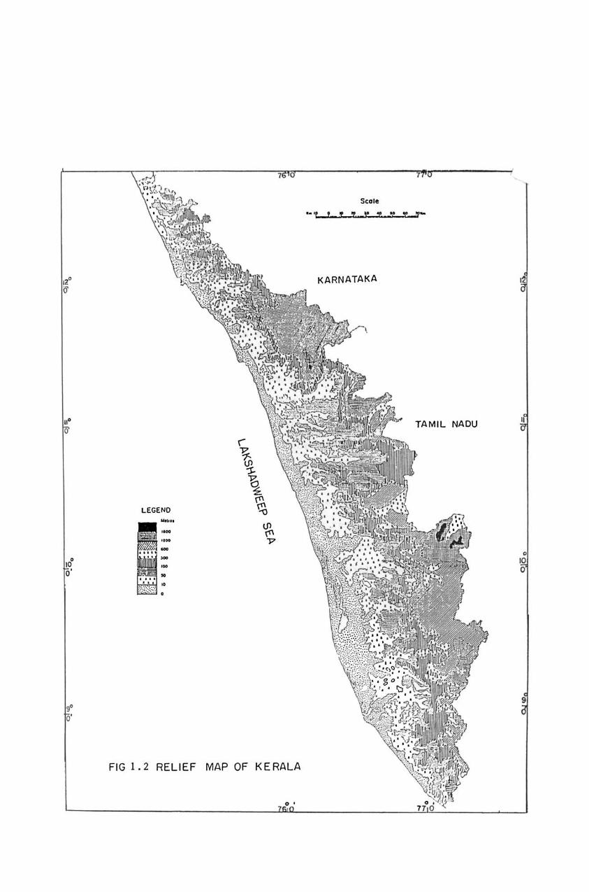
The meteorology of Keralu is profoundly influenced
by its orographical features (Fig.l.2). From the low-lands
adjoining the western sea-board, the landscape ascends
steadily towards the east to the mid-lands and further on to
the high-lands sloping down from the Western Ghats. The
mountain ranges which form a natural wall separating Kerala
from the udjoining States, have an average elevation of about
I km with peaks rising to over 2 km. The highest of these
peaks is Anai Mudi (2695 m) at the crest of Anamalai
(Elephant Hill) in Devikulam area of Idukki District.
Eastwards from Anamalui, run the Palani Hills (in the Madurai
District of Tamil Nadu) on which the well known hill station
of Koduikanal (2506 m) is located. A southern off-shoot trom
anamalai is the Cardamom Hills of south Kerala, on which is
located the hill station of Pirmed (l06? m) which experiences
very heavy rainfall during the southwest monsoon. To the
8
"
LEGEND
---• • •
FIG I. 2 RELIEF MAP OF KERALA
Stole
"'L) -
KARNATAKA
TAMIL NADU
north ot Anamalai are the Nilgiris, whose highest peak is
Doda Bctta (2640 m) in the Ootacamund area. The Nilgiris
merge with the Coorg mountains which divide the northern
parts of Kerala from Karnataka. The Anamalai and Nilgiris are
the tallest mountains in the Western Ghats skirting the west
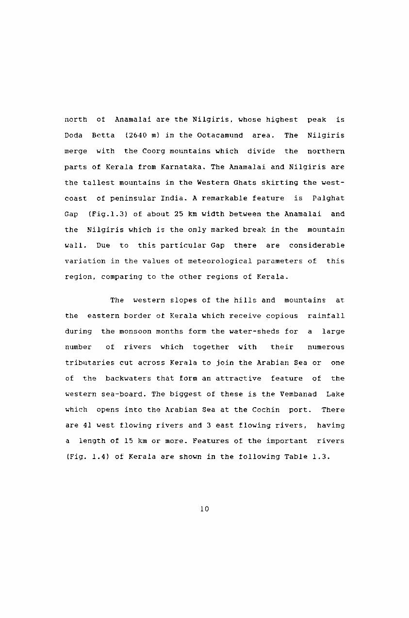
coast of peninsular India. A remarkable feature is Palghat
Gap (Fig.!.3) of about 25 km width between the Anamalai and
the Nilgiris which is the only marked break in the mountain
wall. Due to this particular Gap there are considerable
variation in the values ot meteorological parameters of this
region, comparing to the other regions ot Kerala.
The western slopes of the hills and mountains at
the eastern border ot Kerala which receive copious rainfall
during the monsoon months form the water-sheds for a large
number of rivers which together with their numerous
tributaries cut across Kerala to join the Arabian Sea or one
of the backwaters that torm an attractive feature of the
western sea-board. The biggest of these is the Vembanad Lake
which opens into the Arabian Sea at the Cochin port. There
are 41 west flowing rivers and 3 east flowing rivers, having
a length of 15 km or more. Features of the important rivers
(Fig. 1.4) of Kerala are shown in the following Table 1.3.
10
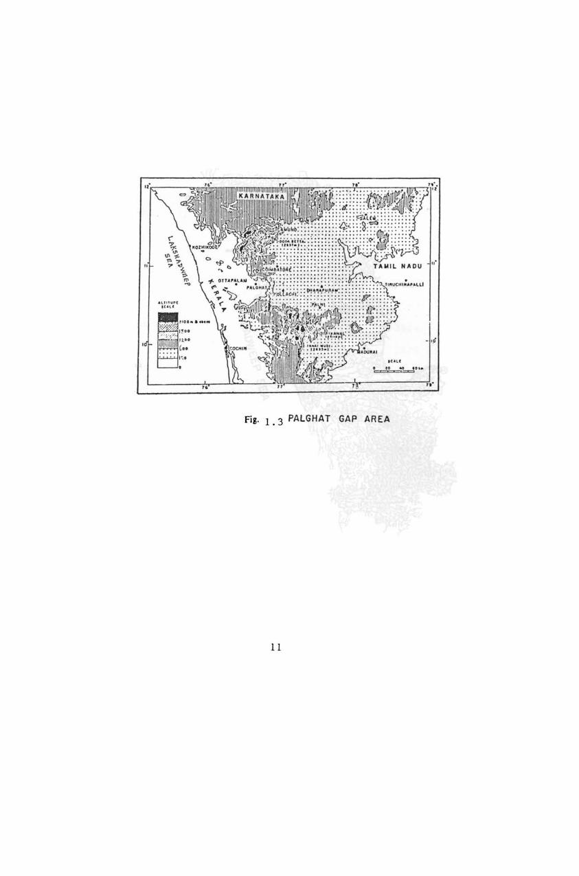
Fig.!. 3 PALGHAT GAP AREA
II
KAll ~ ....... .. b . .... _ .. .. .. , ... ,
0 "A'U"'1U
0 VPPU.
(9 ' " UIlIA
(i) II"~AL
0 C"ANO~A"~I
0 '"!fIUI K AIIII ... TAK ...
0 IIIU •• "
(9 •• IUII OO rE
0 u nnl
€I 'U~y .....
® ~AVA'\InA II
® l\l'~l"
® ¥AI,AUUH A"
® AltJUIoIANOt
® TlUIIIIUAY
li~ "o"t @ 1\lf1IlUI r-~
'}. -!!J KOftA 'UUC A
@ ULLAI 'cl ® C"ALIY.o.~
~ I[!I U P.LUHOI ~
@ TlRU' t<' @ IJI.U TlIUUJ II~ "0 8 U(C HUi
\Jl e ' UJIIAKI(,AL t<' ® UIIUYAHHUII 17
® C HA LA~UOI
e ,u,,· ~
8 IIUVATTU ' UJ II A
8 ,,((MACIIIL
® " .... '''.L ...
@ ,<"u i]l "'H( IICOIL
@ '.LUCII"L
® uu •••
@ ." ... ". @) Ul lloon
® V.IIA t'"rU AAt"
® WAIIO"
8 .......... E9 nnA~
'"' I .. IONI
(i) ."nA"I
El ,.,,'.0.11
FIG I. 40RA IN AG E MAP OF KERALA
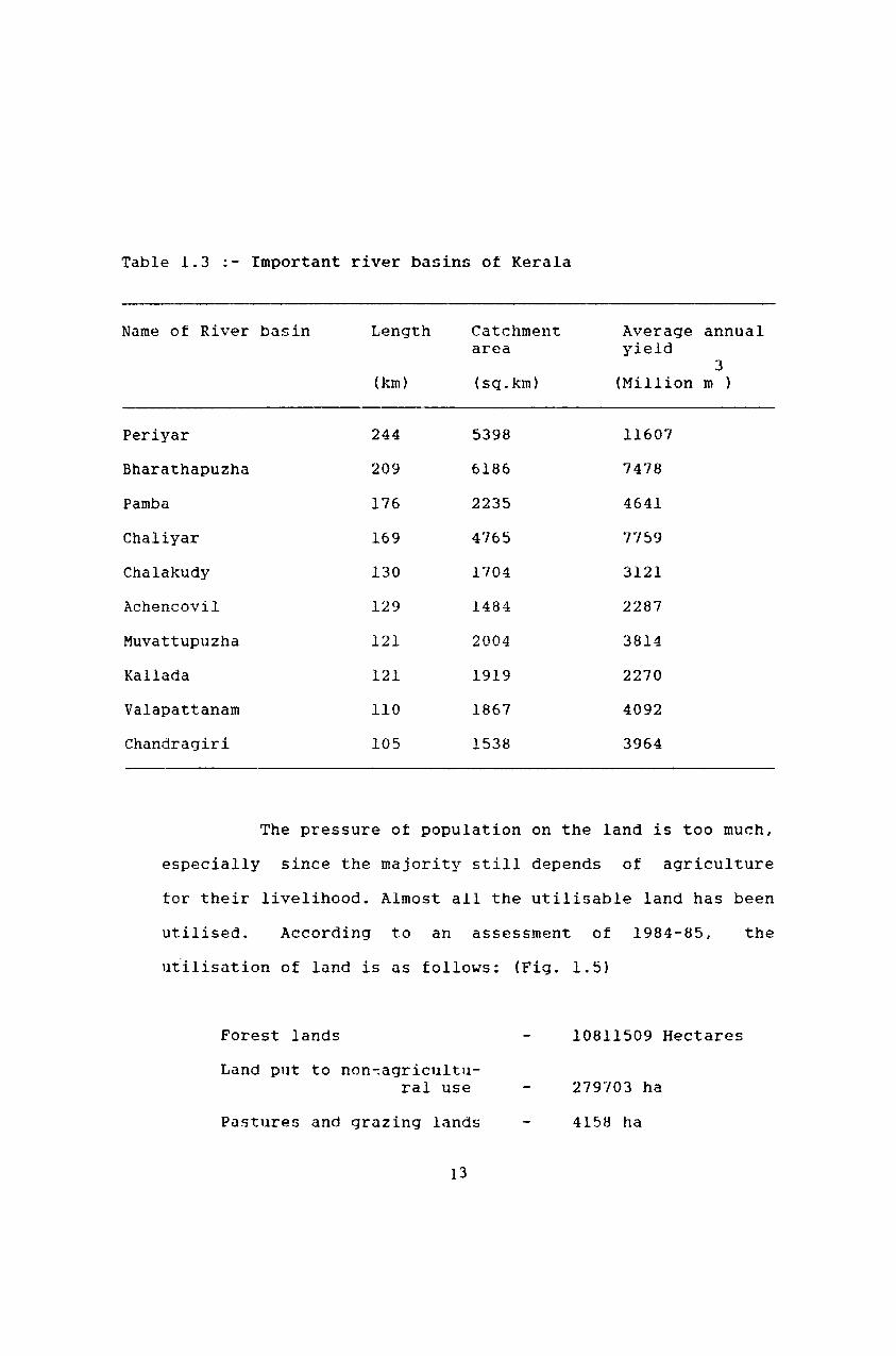
Table 1.3 '- Important river basins of Kerala
Name of River basin Length Catchment Average annual area yield
3 (km) (sq.km) (Million m )
Periyar 244 5398 11607
Bharathapuzha 209 6186 7478
Pamba 176 2235 4641
Chaliyar 169 4765 7759
Chalakudy 130 1704 3121
Achencovil 129 1484 2287
Muvattupuzha 121 2004 3814
Kallada 121 1919 2270
Valapattanam 110 1867 4092
Chandragiri 105 1538 3964
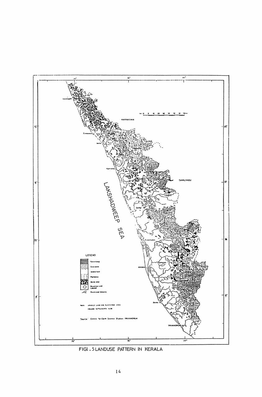
The pressure ot population on the land is too much,
especially since the majority still depends of agriculture
tor their livelihood. Almost all the utilisable land has been
utilised. According to an assessment of 1984-85,
uiilisation of land is as follows: (Fig. 1.5)
Forest lands
Land put to non-:agricultural use
Pastures and grazing lands
13
10811509 Hectares
279'103 ha
415B ha
the
_ l' . ... ... . ..
-, ,."", "., ....... " ...... ,. -, ... " .... ,.,~ .....
FIG1 • 5 LANDUSE PATTERN IN KERALA
14

Miscellan00us tree crops
Cultivable, Waste, fallow land, etc.
Barren and noncultivable land
Net area sown
1.4 GEOLOGY AND SOIL OF KERALA
1.4.1 Geology
~l039 ha
199077 ha
8~688 ha
2184423 ha
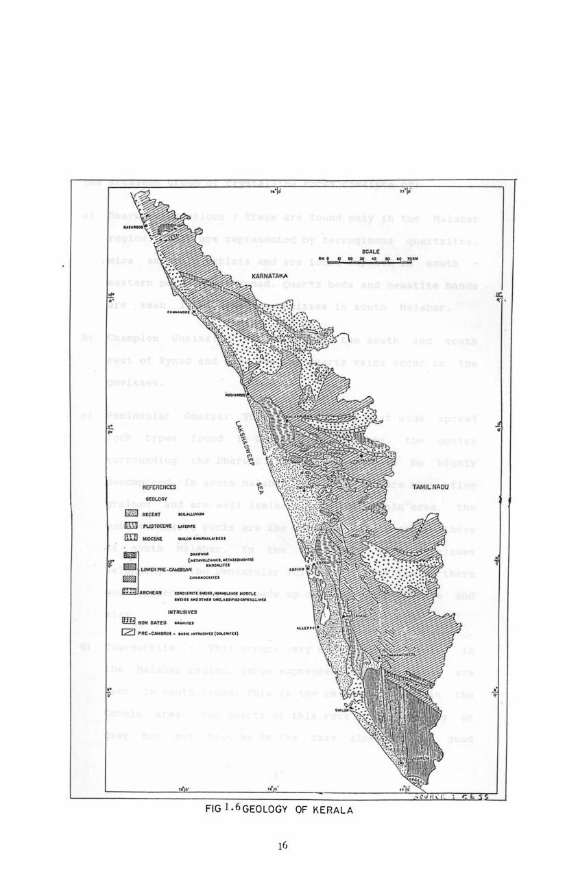
Geologically, the State can be divided into 4 major
distinct zones, each zone having a more or less north-south
alignment (Pig.l.6).
The classifications are
1. Crystalline rock consisting of representative of the
Archaean group (oldest rock group).
2. Residual laterite tormed by the decomposition in situ of
the Archaean crystallines.
3. The Warkalli tormations - lignite bearing sedimentary
beds with a laterite capping.
4. Recent tormations consisting of alluvial, marine and
lacustrine deposits. The backwater tracts come in this
zone.
15
.tOlOGY
~~[~'" -&ID PU$tQCUIt .. '(.lOll' Ill] ~ _ . ............ , :I ,=;:-< .• ,,--, Il!!!IJl] lCMVIPlll!:~ .---.. .. ,
~ <A"-'''U
••• ARCHe...... _ ..... " ...... ,_ .. _"""',,, ...... _., ... -.. ..................... .... JllfllUQVU
rn3 _ GATCD • ••• " ..
[Z] '~(_t .... __ ......... _ .. c ....... ., .)
... t ! •
FIG I. 6 GEOLOGY OF KERAlA
SCALC
" . •
TAMJLNAOU
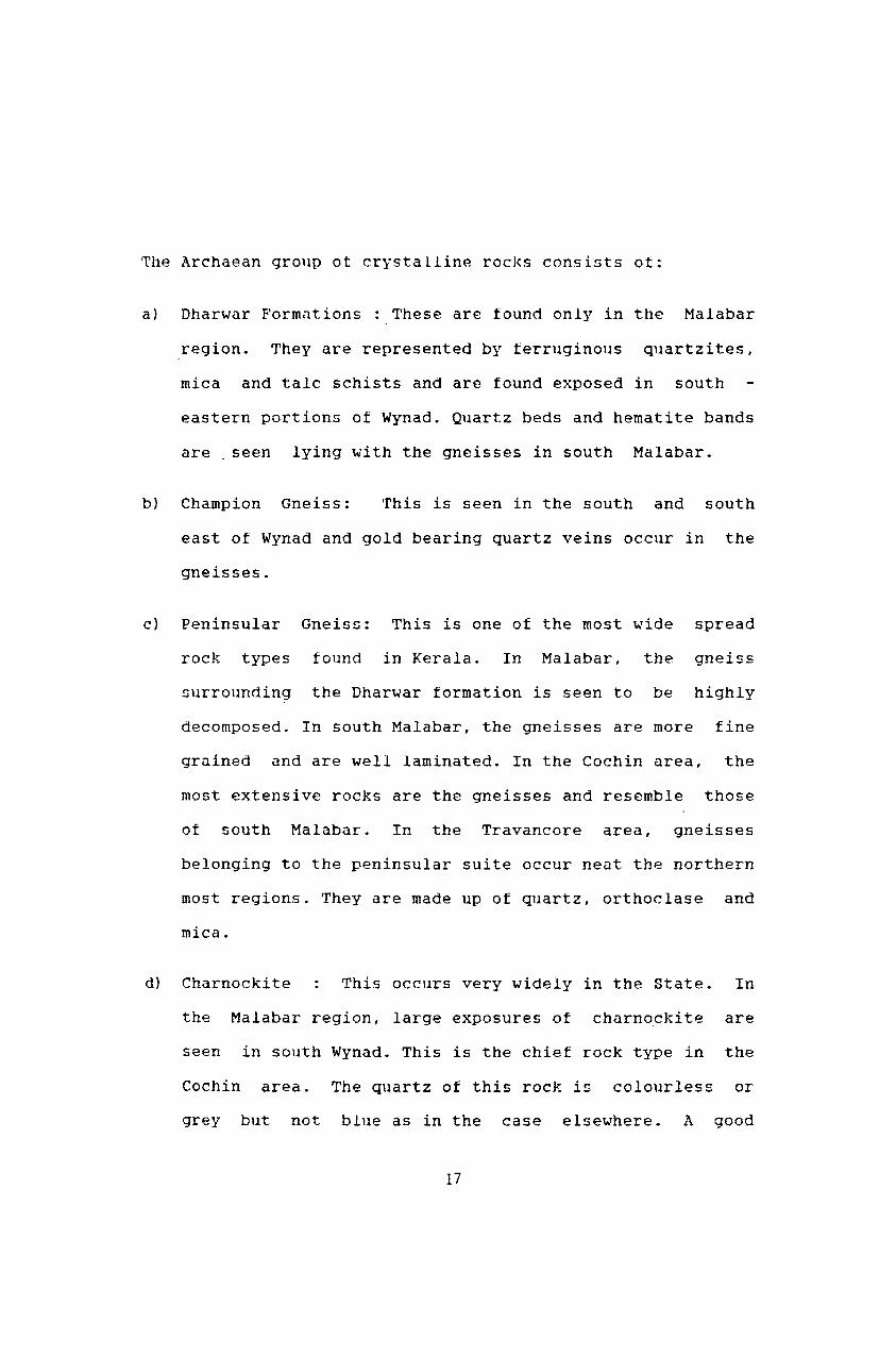
~he Archaean grol1p ot crystalline rocks consists ot:
a) Dharwar Formations : These are found only in the Malabar
region. They are represented by ferruginous quartzites,
mica and talc schists and are found exposed in south
eastern portions of Wynad. Quartz beds and hematite bands
are seen lying with the gneisses in south Malabar.
b) Champion Gneiss: This is seen in the south and south
east of Wynad and gold bearing quartz veins occur in the
gneisses.
c} Peninsular Gneiss: This is one of the most wide spread
rock types found in Kerala. In Malabar, the gneiss
surrounding the Dharwar formation is seen to be highly
decomposed. In south Malabar, the gneisses are more fine
grained and are well laminated. In the Cochin area, the
most extensive rocks are the gneisses and resemble those
ot south Malabar. In the Travancore area, gneisses
belonging to the peninsular suite occur neat the northern
most regions. They are made up of quartz, orthoclase and
mica.
d) Charnockite This occurs very widely in the State. In
the Malabar region, large exposures of charnockite are
seen in south Wynad. This is the chief rock type in the
Cochin area. The quartz of this rock is colourless or
grey but not blue as in the case elsewhere. A good
17
portion ot the Western Ghats is made up ot Charnockite.
The charnockites of the Travancore area are mostly well
foliated and show typical gneisses structure.
e) Closepet Granite Archaean intrusives ot post
charnockite age are found in two places in the Kalpetta
hills and Sultanbathery. These are younger in age than
the gneisses.
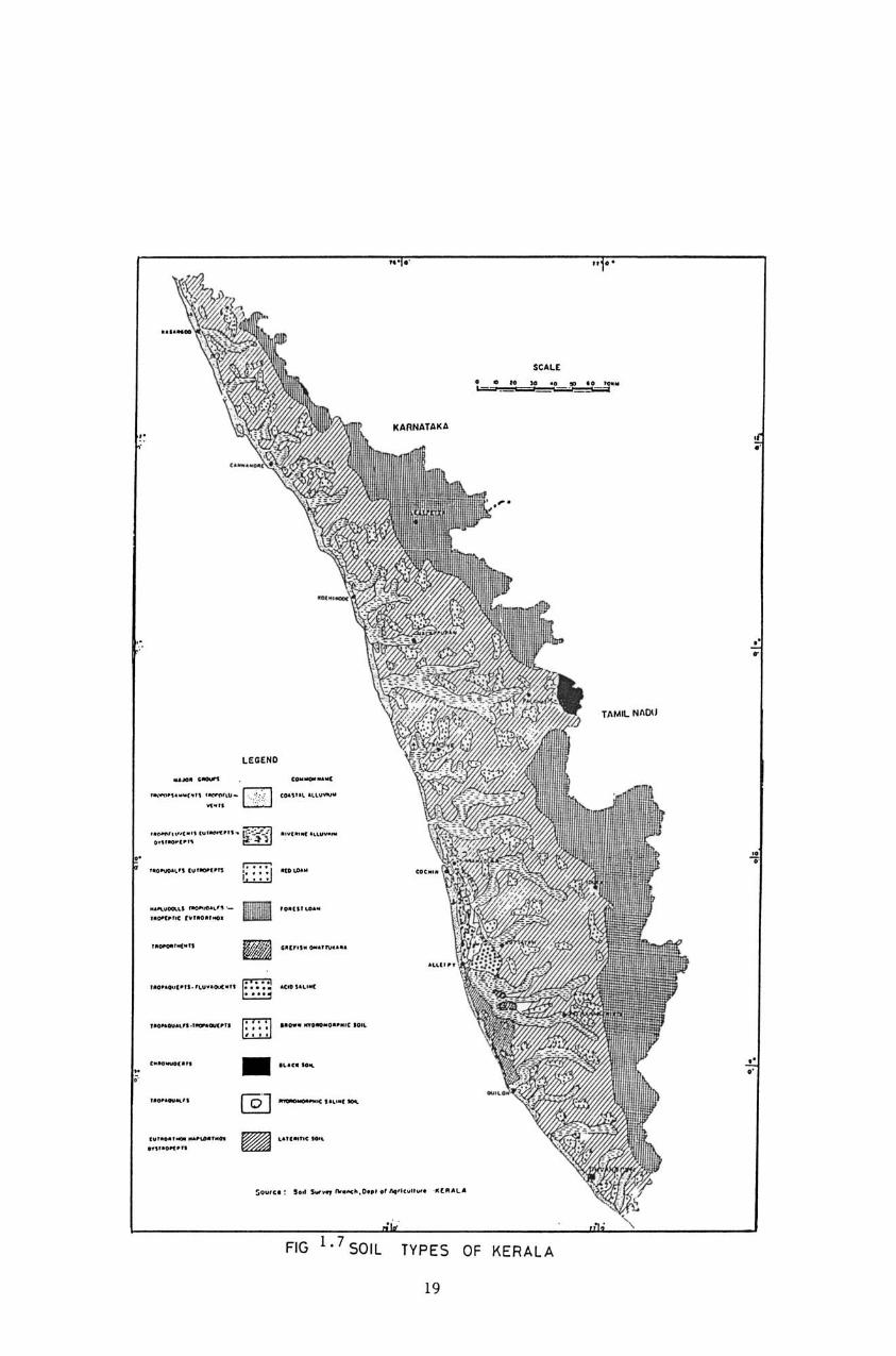
1. 4.2 Soils
The
into sandy,
forest-hill
soils of the State can broadly be classified
alluvial, laterite, red, black, peaty, and
soils (Fig. 1.7). The sandy soils occur as a
narrow belt all along the coast. Varying in texture trom
sandy loans to pure sand, they are highly porous with low
retentive capacity. The alluvial soils are transported soils
and cover almost the entire tract of Kuttanad and the Kole
lands ot Trichur and Mukundapuram taluks. Heavy in textures
they are generally well supplied with organic matter,
nitrogen and potash but are deficient in phosphate and lime.
Laterite soils are, by far, the most important group tound in
Kerala and cover the largest area. They are formed by the
weathering of acidic rocks under alternate wet and dry
tropical conditions. These are generally developed in regions
of heavy raintall and high temperature. Porous and well
18
.............. -, .. -" ................ .
. _ ......... " ••• 0.(."
....... _ ... _............
StAll . . ...... '" .. ... ~ loA: . === -----------=:::
KARNATAKA
TJlMJl NflO\J
lEGEND
'::"'j ,": :
,."''', ...
..""._ ........
G·· ..... . ... ...... " ..
D·· .. .. ... . ..... _ ..... " .... ,
• ..... -_ ...... -
~ "" ..... -~o ... <o : , •• SOO · • ., ........ 0 ..... "".".tt ... ·.(R"L"
FIG SOIL TYPES OF KERALA
[9
drained, their capacity tor retaining water and fertilizers
is somewhat poor. Laterite soils are usually ot low
tertility. Those found in the hills are gritty and shallow,
but in the plains it is deeper, finer texture containing fair
quantity of organic matter and deticient in phosphate, potash
and lime. Though laterite soils are ot low natural fertility
they respond well to cultivation and judicious application of . fertilizers.
In some parts ot Kerala where raintall is only less
than 2000 mm, the soils have not developed into true
laterites. There is an accuml11ation ot iron and aluminium in
these soils and they show many ot the properties of
laterites. Peaty or Kari soils occur in the taluks of
Ponnani, Kanayannur, Vaikam, Chertala, A..lllbalapuzha and
Kuttanad. These are clayey soils with poor aeration and
drainage. They are characterized by a deep black colour, high
content of organic matter and very strong acidity. The
failure of crops in Kari lands is largely due to the
production of free sulphuric acid. Due to annual inundation
with salt water, there is considerable accumulation of
soluble alkali salts in these soils which further complicate
their fertility problems. On the whole, these soils are noted
tor their poor fertility and low yields of crops.
Forest - hill soils are tormed in about 26% of the
area of the State. They are characterised by a surface layer
20
ot organic matter derived trom forest growths. These soils
are rich in nitrogen but extremely poor in bases due to heavy
leaching. When the forest are cleared, these soils gradually
undergo laterisation. Plantation crops such as tea, cardamom,
and rubber are extensively grown on cleared forest soils. In
Chittur and Palakkad taluks, black soils are also found
covering a small area. These soils are neutral or slightly
alkaline in reaction. Cotton is the main crop grown in these
soils.
1.5 FORESTS OF KERALA
A number of definitions exist tor the term
'forest', each catering to a specified objective. A general
definition is 'an area primarily set aside for the production
of timber and other forest-produce or maintained under woody
vegetation for certain indirect benefits which it provides'.
The term forest is believed to have originated from the Latin
word 'foris' meaning outside, referring to the village fence
or boundary covering the entire uncultivated and untended
land. An ecological definition ot forest is 'a plant
community predominantly ot trees and other woody vegetation
usually with a closed canopy'. More often a legal detinition
is used according to which a forest is 'an area ot land
proclaimed to be a forest reserved, protected under a forest
law' (KFRI, 1981).
21
The exact intormation on the extent ot forests in
Kerala is not available, as the values differ from reports to
reports. As per the report ot the task force on Forest
Resources of Kerala State, published by Government of Kerala
in 1973, the figure was 9400 sq. km. The administration report
of the Forest Department for the year 1977-78 gives the total
area ot the forests as 11320 sq. km, ot which 9161 sq.km are
reserve forests and the rest as private forests. Considering
the fact that ~croachments and diversion of torest land for
other purposes have been continued, the actual forest area
would be far less than 9400 sq.km. (KFRI, 1981). Percentage
of forest area to geographical area according to Kerala
Forest Department (Kerala Forest Statistics, 1982) is 29.34
per cent. Centre for Earth Science Studies (1984) reported
that the area under forest in Kerala in 1905 was 17120.82
sq.km (44.07% of the geographical area), in 196~ it was
10726.56 sq.km (27.71%} and in 1973, 6627.72 sq.km (17.06%}.
Department of Public Relations, Government of Kerala (1988),
in their publication, A Handbook on Kerala, it is mentioned
that the total area under forest in Kerala is 10815.09 sq. km,
about 28 per cent of the total area of the State. There is
also an area of 1122 sq.km of vested forests. One principal
reason tor the discrepancy seems to be that the Forest
Department includes all areas which are legally categorised
as reserves, although some ot these are not under its de
tacto control (KFRI, 1981).
22
l.~.l. Forest Types:
The forests in the State come under the broad
category of tropical forests and form the western extremity
ot the Indo-Malayan rain rorest formation. On account of the
variation in precipitation, temperature, altitude, etc., the
forests in Kerala are characterised by extreme floristic
diversity. The major types of forests in Kerala are:
(i)
(ii)
(iii)
(iv)
evergreen and semi-evergreen forests,
moist deciduous forests,
dry deciduous forests and
Montane sub-tropical and temperate forests.
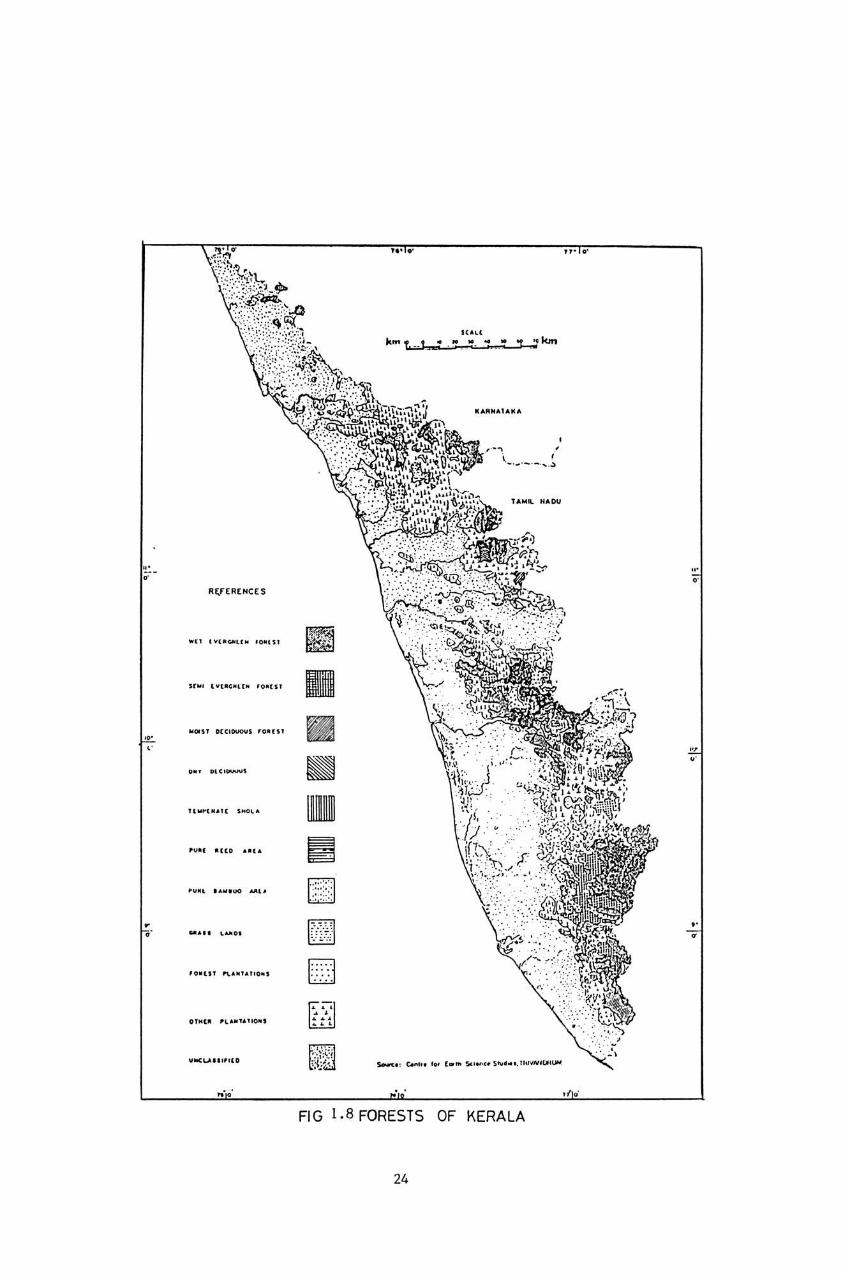
In addition to these natural types, extensive areas
have been converted into man-made forests. Fig. 1.8 gives a
general idea of the forests of Kerala.
1.5.1.(a) Evergreen and semi-evergreen forests:
The tropical evergreen and semi-evergreen forests
are chiefly found in Thcnmala, Achencoil-Kakki belt, Periyar,
Sholayar, Attappady, Silent Valley, New Amarambalam and
Wynad. The total area of the evergreen forests has been
estimated as 4750 sq.km. (KFRI, 1981). As pointed out
earlier, the present area would be far less than the above,
as large tracts have been utilised for hydro-electric
projects, settlements and even to raise man-made forests.
23
Al;,fEAENC($
.... , ~ •• ",u. ,.,. .. ,
•• , .. C' ....... _
,,, •• ono ....
.... " , .... ,
~ ...... ''' .. u
~ U
Fl o ... , . .. , ...
ICHt
k ... ~ 'l...J1cm
, ,
FI G I. 8 FORESTS OF KERALA
24
Typically an evergreen and semi-evergreen forest
has a multi-storeyed structure with the dominants reaching a
height of 40 metres or even higher. Important species that
occur in the top canopy are Acrocarpus fraxinifolius,
Antiaris toxicaria, Calophyllum spp, Cullenia exarillata,
Dichopsi~ ellipticum, Dipterocarpus indicus, Hopea
parvitlora, Mesua terrea, etc. Evergreen forests are grouped
under sub types primarily based on the dominant associations.
Some ot the associations found in the evergreen forests of
Kerala are:
1. The Cullenia Palaquium association
2. The Palaquium - Mesua association
3. The Poeciloneuron -- Palaquium association
4. The Mesua -- Calophyllum association
s. The Vateria -- Culllenia association
6. The Mesua -- Culenia association
7.
8.
The Reed
The Reed
Calophyllum association
Poeciloneuron association
The important species in the second storey are
Actinodaphne hookeri, Baccaurea courtallensis, Canarium
strictum, Cinnamomum zeylanicum, Elaeocarpus spp., Holigarna
spp, Nephelium longane, etc. The third storey consists mostly
ot shruby species sllch as Euonymus anqulatus, Lea sumbucina,
Clerodendrom infortunatum, Vernonia spp., etc. On account of
the heavy shade, the forest floor is devoid ot undergrowth
25
and is usually covered with a thick layer ot leaf litter at
various stages ot decomposition. By improving the physical
qualities, particularly the porosity of the soil, the leaf
litter plays an important role in regulating the sllrface run
off. The semi-evergreen forests occur as a transitional zone
between the moist decidlloUS and the evergreen forests. Micro
climatic factors, especially the availability of moisture
during summer has led to the existence of semi-evergreen
patches along stream banks and protected valleys.
1. 5 .1. (b). Moist dec iduous forests:
As in the case of other forest types, no estimate
is available on the exact area under moist deciduolls forests.
It has been estimated the area as 3140 sq.km (KFRI, 1981).
This, however has undergone considerable changes over the
last decade primarily due to the diversion of land for non
forestry purposes, and the extension of plantations. Moist
deciduous forests are less inaccessible, and their proximity
to habitations makes them extremely vulnerable to the various
anthropic disturbances. Moist deciduous forests form a closed
high forest in which the dominant species are deciduous. From
the point of view of wood production, these forests play an
important role. Important timber species are Tectona grandis,
Dnlbergia latifolia, Pterocaropus marsupium, Artocarpus
hirsuta, Adina corditolia, Xylia xylocarpa, Lagerstroemia
26
lanceolatea, Grewia tilitolia, Bombax ceiba. etc. Another
economically important constituent in the moist deciduous
torest is Bamboos. On account ot the unsystematic
exploitation coupled with the luke warm approach to extending
the area by artificial regeneration, the bamboo resources in
the State is getting depleted at a very rapid rate.
1.5.1. (c). Dry deciduous torests:
The dry deciduous forests are seen in the rain
shadow region of the Western Ghats and extend over an area of
about 170 sq.km. As far as floristic diversity is concerned
this is an interior type. Important species found are
Santalum album, Anogeisslls spp. and Bamboos.
l.5.1.(d). Montane temperate torests:
The climatic conditions at higher elevation in the
Western Ghats have helped the formation of montane wet
temperate forests or what are popularly known as Sholas. They
usually occur in protected valleys of the hills and form a
thick mass of tangled growth. Although they are not
commercially valuable, especially from the point ot timber
production, ecologically they play an important role, more
specifically in the hydrological cycle. Between the Shola
patches there are extensive grass lands. Vast stretches ot
these grasslands have been converted into plantations.
27
1.5.1.(e) Man-made forests:
Kerala is a pioneer in raising man-made forests. By
1918 the total area of plantations under the control of the
Forest Department was about l3S0 ,sq. km. In addition, the
Kerala Forest Development Corporation has
extensive areas with Eucalyptus. Although
have been raised, teak continues to be the
also planted
several species
most important
species. At the beginning of 1978, teak covered
about 68,500 ha or more than half of the
an area of
area under
plantations.' Other species raised in mixture with teak are
Bombax ceiba, Ailanthus triphysa, Euodia lunaankenda, etc.
Due to the poor performance of these species, in effect most
of these plantations contain only teak.
1.6 GENERAL CLIMATE OF KERALA
From the standpoint of weather and climate, the
year in Kerala can be divided into the following four
seasons :
(i)
(ii)
(iii)
(i v)
Winter (January - February)
Hot weather Period (March - May)
Southwest Monsoon (June - September)
Northeast Monsoon (October - December)
28
\Hnter season is characterised by minimum
cloudiness and raintall. Hot weather period, March to May
is uncomfortable due to high temperature and humidity.
Thunderstorm activity is quite high during this season. The
southwest monsoon months constitute the principal rainy
season, while the northeast monsoon, which as a matter of
tact, is the retreating phase of the southwest monsoon, is
the secondary rainfall season. The climate is pleasant from
September to February.
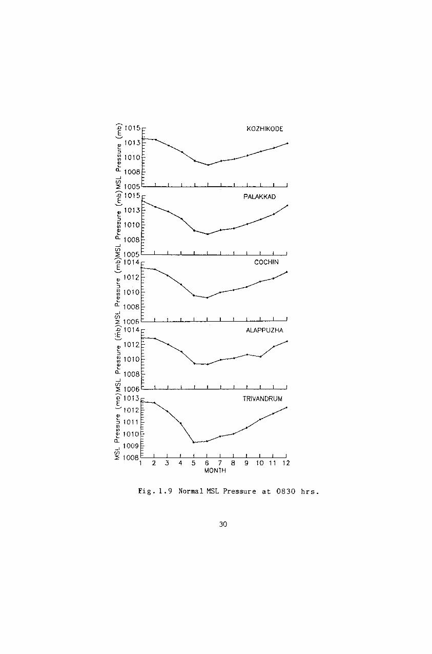
1.6.1 Sea Level Pressure:
The normal MSL pressure at 0830 hrs at five
selected stations of Kerala are shown in Fig. 1.9. The
seasonal variation of atmospheric pressure over the State
takes place in a systematic manner with maximum pressures
during January and minimum pressures during May -June. The
pressure gradient over the State generally remains weak
except during late summer and in the monsoon season. The
annual range of pressure is less than 5 mb. The total dillrnal
range of pressure increases from the coast to the inland
regions and this is also within about 5 mb. The maximum in
the diurnal range ot pressure is seen in the month of
February when clouding is almost minimum. June and July with
maximum clouding have the minimum diurnal range. In all the
seasons, the pressur~ gradients over the State is in the
east-west direction. The preSSllre decreases trom W8St to east
29
'D'1015 E '-'
Q.l 1013 L..
:J
:g 1010 Cl) L..
CL 1008
...J en ~ 1005 f 1014 '-'"
Cl) 1 012 L..
:J
:g 1010 Q.l L..
CL 1008 ...J en ~ 1006 Dl014 :E ...........
Q.l 1012 L..
:J
:g 1010 Q.l L..
CL 1008 ...J
~ 1006 ~'1 013
"-'1012 Cl)
~ 1011 U) Ul _ e 101{)-
CL ...J 1009 (f)
~ 1008 1
KOZHIKODE
COCHIN
ALAPPUZHA
TRIVANDRUM
2 3 4 5 6 7 8 9 10 11 12 MONTH
Fig. 1.9 Normal MSL Pressure at 0830 hrs.
30
except during the period trom about middle ot October to
beginning of March, when reverse gradient prevails.
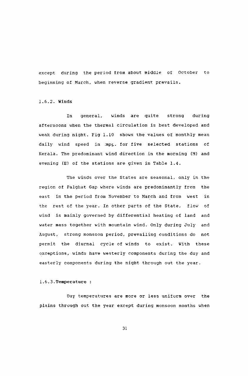
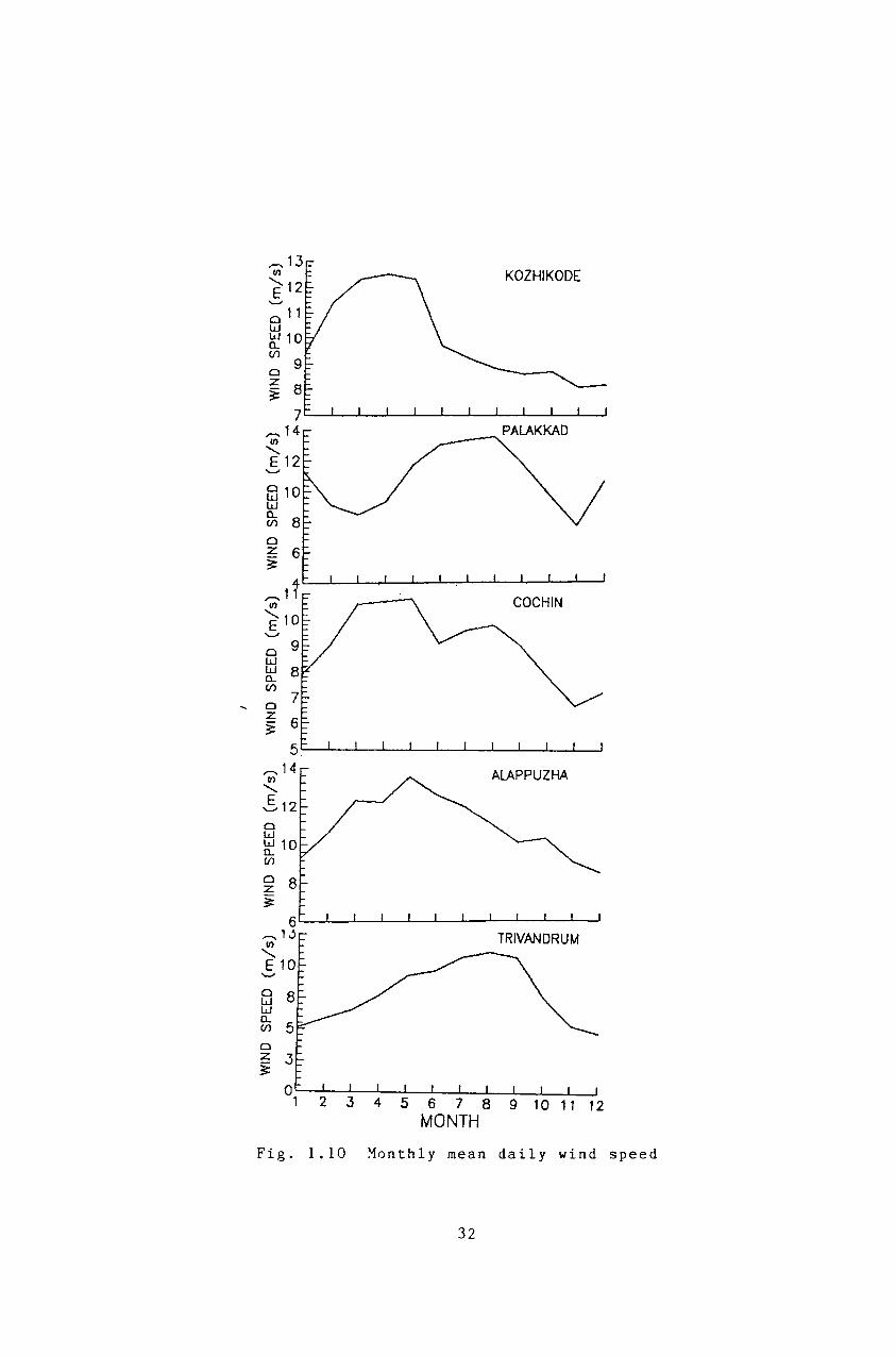
1. 6 . 2. Winds
In general, winds are quite strong during
afternoons when the thermal circulation is best developed and
weak during night. Fig 1.10 shows the values ot monthly mean
daily wind speed in :mp~. for five selected stations of
Kerala. The predominant wind direction in the morning (M) and
evening (E) of the stations are given in Table 1.4.
The winds over the States are seasonal, only in the
region of Palghat Gap where winds are predominantly from the
east in the period from November to March and from west in
th8 rest of the year. In other parts of the State, flow of
wind is mainly governed by differential heating of land and
water mass together with mountain wind. Only during July and
August, strong monsoon period, prevailing conditions do not
permit the diurnal cycle of winds to exist. With these
exceptions, winds have westerly components during the day and
easterly components during the night through out the year.
l.6.3.Temperature
Day temperatures are more or less unitorm over the
plains through out the year except during monsoon months when
31
KOZHIKODE
COCHIN
0 W W 0.... (f)
..... 0 z ~
,....... 14 ALAPPUZHA III
"'-512 0 W WlO 0.... (f)
0 8 z ~
TRIVANDRUM
-....;
0 W W 0.... (f)
0 z ~
0 1 9 10 11 12
Fig. 1.10 Monthly mean daily wind speed
32
Table 1. 4:
Station
Kozhikode(M)
(E)
Predominant wind direction in the Morning (M) and Evening (E) at the tive stations ot Kerala.
J F M A M J J A S 0 N D
E E E/ NE/ NE/ NE/ VAR NW NW E E E NE E NW E
W W W/ W/ W/ W/ NW/ NW NW/ W/ W W NW NW NW NW W W NW
----------------------------------------------------------------
Paighat (M) E E E W W W W W W W E E
(E) E E W/E W W W W W W W E E
----------------------------------------------------------------
Cochin (M) NE/ NE/ NE NE NE/ E/ VAR VAR NE/ NE/ E/ NE/ E E E NE E E NE E
(E) W W W w W/ W/ NW/ NW/ NW W W W NW NW W W
----------------------------------------------------------------
Alleppy (B) E E E/ E/ E NW NW NW NE/ E/ E E NE NE NW NE
(E) W/ W W NW/ NW NW NW NW NW W/ W NW/ NW W NW W
----------------------------------------------------------------Trivand-
rum (M) NE NE NE/ N N/ NW/ NW NW/ NW/ N/ C/ NE N NW N N N NW NE
(E) SW SW SW W NW/ NW NW NW NW NW/ SW/ S\aJ W W W
----------------------------------------------------------------E - Easterly, NE - Northeasterly, SE - Southeasterly W - Westerly, NW - Northwesterly, SW - Southwesterly N - Northerly, S - Southerly, C - Calm
VAR - Variable ---
33
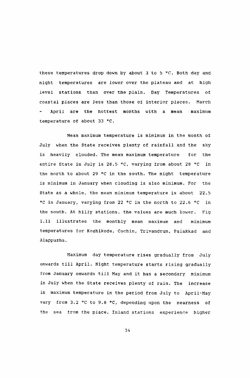
these temperatures drop down by about 3 to 5°C. Both day and
night temperatures are lower over the plateau and at high
level stations than over the plain. Day Temperatures ot
coastal places are less than those ot interior places. March
April are the hottest months with a mean . maximum
temperature ot about 33°C.
Mean maximum temperature is minimum in the month of
July when the State receives plenty of rainfall and the sky
is heavily clouded. The mean maximum temperature for the
entire State in July is 28.5 QC, varying from about 28°C in
the north to about 29 °C in the south. The night temperature
is minimum in January when clouding is also minimum. For the
State as a whole, the mean minimum temperature is about 22.5
°C in January, varying from 22°C in the north to 22.6 °C in
the south. At hilly stations, the values are much lower. Fig
1.11 illustrates the monthly mean maximum and minimum
temperatures tor Kozhikode, Cochin, Trivandrum, Palakkad and
Alappuzha.
Maximum day temperature rises gradually from July
onwards till April. Night temperature starts rising gradually
from January onwards till May and it has a secondary minimum
in July when the State receives plenty ot rain. The increase
in maximum temperature in the period trom July to April-May
vary from 3.2 °C to 9.8 °C, depending upon the nearness of
the sea trom the place. Inland stations experience higher
34
'""" u 35.0 "-/32.5 =-__ KOZHIKODE
~ 30.0
~ ~~:~ ~b- ... _. p.... ' .........
,," O" ... -_ • .,. __ .-o-- ... __ • __ .,.~ __ ..... ,,4 · ..• CI g: 22.5
220.0 W t- 1 7 .5~-.J---L_-'--......L..---I_...J.---'-_L--.J---L-----l U·
o 40.0
~35.0 et: ::::> 30.0
~ 0:: 25.0 w ~ 20.0
PALAKKAD
.",.0",-..
_,0-"- ••••••• -0 •• ,0--..... ---0- .-••••• -c
~ 1 5.0 '---L----L_...L--L--..:L-....1.-----L_L----L.----1---.J
oU·32.5
w 30.0 et: ::::> 27.5
~ 0:: 25.0 w 0.. 225 2 .
COCHIN
~ 20.0 L-....1.--.J.._L-....l.---L._"---....l.---L._.1....--.J----J oU 35.0 ALAPPUZHA "-/ 32.5 ____ W et: 30.0 ::::> ~ 27.5
8S 25.0 0.. 2 22.5
..o---.~.- ..... _ .,J7'" -""'-0-"'.'" -0-.- ..... - ....... -0
W r-.2 0.0 l...-....l---L._.1....-....l----1._-'--....l---L_-'---'-~
oU 35.0 "-/32.5 _____ ~-....
~ 30.0
~ 27.5
&. 25.0 g: 22.5 220.0 W t- 17.5
1 2 345 6 7 MONTH
TRIVANDRUM
Fig. 1.11 Monthly mean maximum and minimum
temperature
35
maximum temperatures than the coastol statjons. From May
onwards, both the moximum and maximum temperatures start
falling, the latter vary rapidly while the former slowly.
From the beginning ot May to end of July the maximum
temperatures tall by about 5.5 °c to 2.5 °C whereas the
minimum temperature falls by about 2 .. 5 °C to 3.6 °C from t-1ay
to January. July and August have the smallest diurnal range
of temperature (about 5.3 °C) in the State. The diurnal range
increases rapidly after the withdrawal of S.W.Monsoon. During
the period trom December to March, the diurnal range is of
the order of 8.5 °C to 9.5 °C, being the greatest in January.
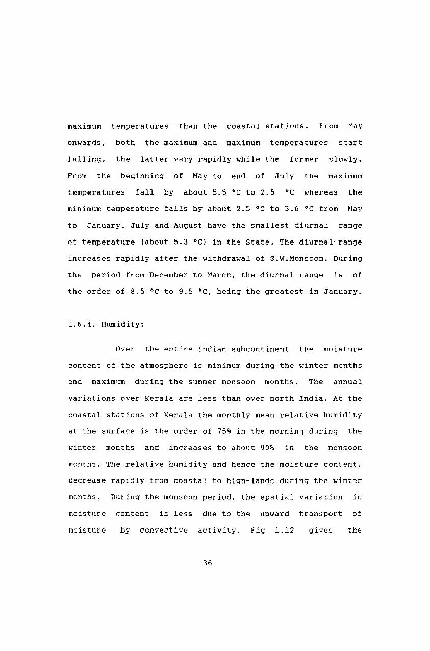
1.6.4. Humidity:
Over the entire Indian subcontinent the moisture
content of the atmosphere is minimum during the winter months
and maximum during the summer monsoon months. The annual
variations over Kerala are less than over north India. At the
coastal stations ot Kerala the monthly mean relative humidity
at the surface is the order of 75% in the morning during the
winter months and increases to about 90% in the monsoon
months. The relative humidity and hence the moisture content,
decrease rapidly from coastal to high-lands during the winter
months. During the monsoon period, the spatial variation in
moisture content is less due to the upward transport of
moisture by convective activity. Fig 1.12 gives the
36
100
~ a ~ ::> I
w > ~ w a::
~_.-.....;KOZHIKODE .... ~-...... ..
ALAPPUZHA
TRIVANDRUM
, , \ •
'0
2 3 4 5 6 7 8 9 10 11 12 MONTH
Fig. 1.12 Mean monthly relative humidity (%)
at 0830 hrs.(continuous) and at
1730 hrs (dashed)
37
variations in relative humidity in the morning and evening
tor the selected stations ot Kerala. During the period
January to March atternoon humidities reduce to 60-63%,
varying from 35% in the interior to 71% in the coastal area.
The diurnal variation in relative humidity during this period
is maximum and ranges from 4 to 16% depending upon the
proximity of the sea. The humidity in the monsoon period
rises to about 90!'(i for the State as a whole and diurnal
variation in this period is minimum and ranges from 2 to 12%.
Maritime influence playing most important role in governing
this variation.
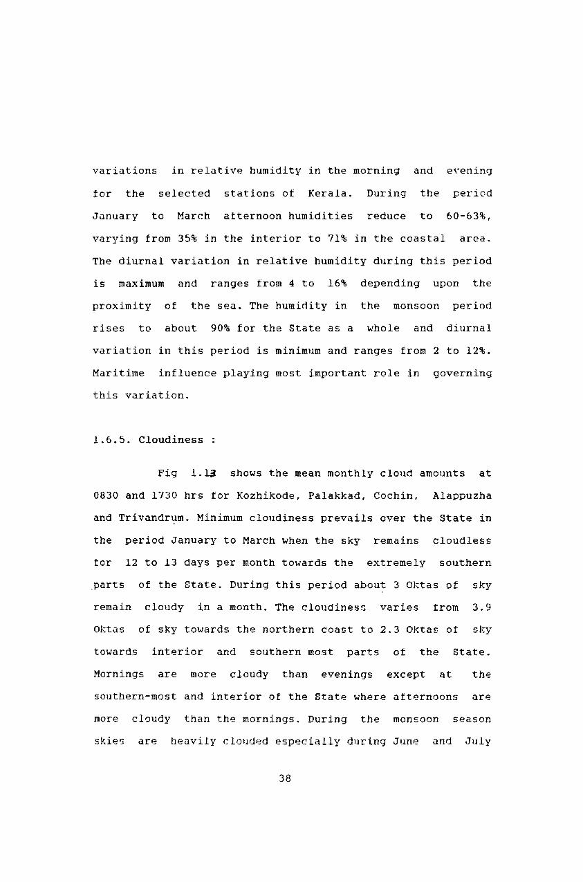
1.6.5. Cloudiness
Fig 1.1~ shows the mean monthly cloud amounts at
0830 and 1730 hrs tor Kozhikode, Palakkad, Cochin, Alappuzha
and Trivandn~m. Minimum cloudiness prevails over the State in
the period January to March when the sky remains cloudless
for 12 to 13 days per month towards the extremely southern
parts of the State. During this period about 3 Oktas of sky
remain cloudy in a month. The cloudines~ varies trom 3.9
Oktas of sky towards the northern coast to 2.3 Oktas of sky
towards interior and southern most parts of the State.
Mornings are more cloudy than evenings except at the
southern-most and interior of the State where afternoons are
more cloudy than the mornings. During the monsoon season
skies are heavily clOlld~d especially during June and July
38
, I
KOZHIKODE
, , ,. a .3r--=*-..;.'-.J8
=> 9 2 u 1 c-'-..I...-.l...--'-_~---l._-L--1_-'----''--L-----' ~ t3 PALAK KAD
o ::-6 z => 0 4 ~
- ..
2 3 4 5 6 7 8 MONTH
"-
"
COCHIN
:w--a.. "
--11.
"
" ~
"'" , \ ,
Fig. 1.13 Mean monthly cloud amounts at
0830 hrs (continuous) and 1730 hrs
(dashed line)
39
when about ~ Oktas ot zky remain covered with cloud in a
month. On and average, in each of these two months the sky
remains overcast for more than 16 days per month and is not
generally found clear even tor a single day. In this season,
mornings and evenings are equally cloudy. Cloudiness starts
decreasing from August and continues till September. A
secondary maximum of cloudiness is observed in the State in
October - November during the northeast monsoon period. Again
it decreases from November till January - February when the
cloudiness in the State is minimum.
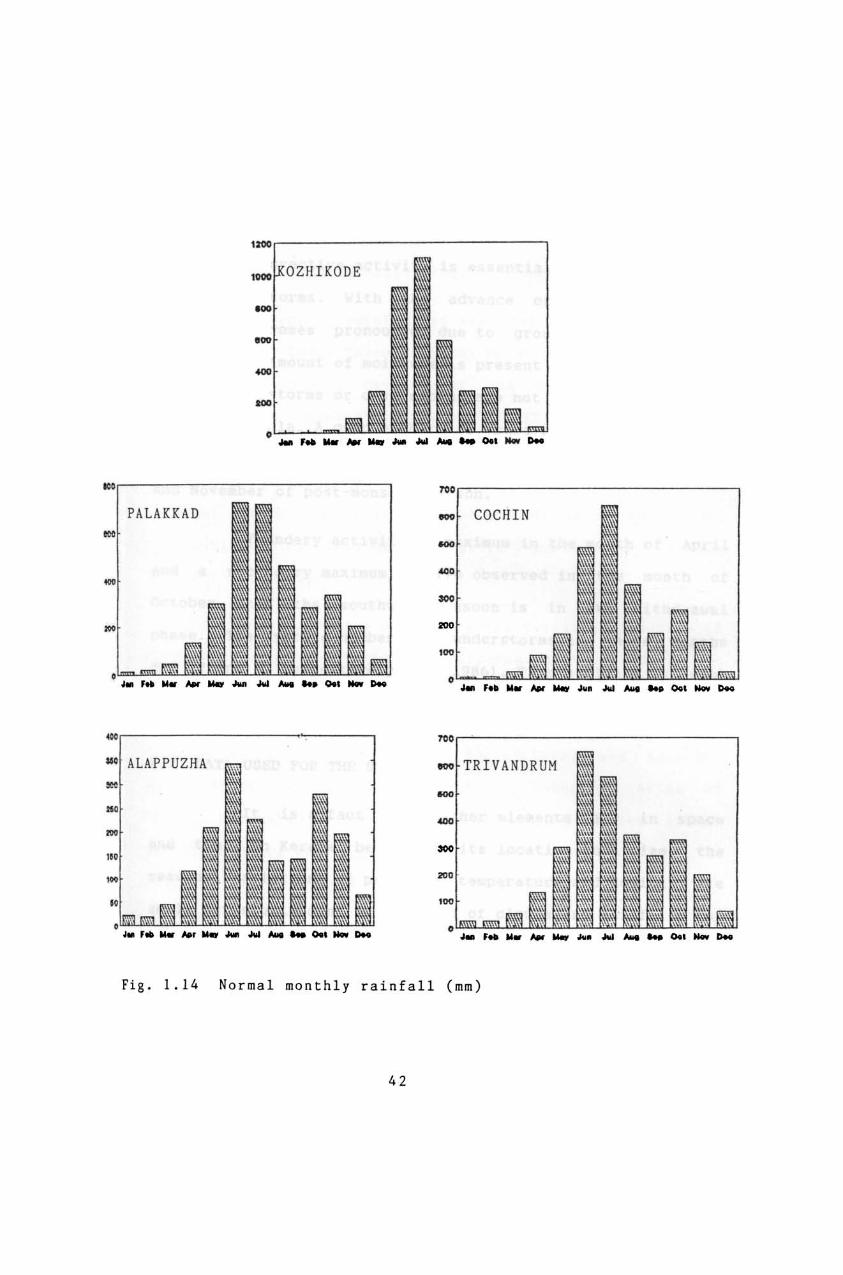
1.6.6. Rainfall
The total annual raintall in the State varies from
about 4500 mm over the northern parts to about 2000 mm in the
southern parts. The southwest monsoon, locally known as
'Edavapathi', {June September} is the principal rainy
season. During this season the State receives about 73% of
its annual rainfall. Southwest monsoon rainfall decreases
from north to south and varies from 85% in the northern
Districts to 54% in southern District. Rainfall in the
northeast monsoon, locally known as 'Thulavarsham', (October
- December) and hot weather season (March to May) constitute
7-25% and 10-20%, respectively. Northeast monsoon rainfall
increases trom north to south and varies from 7% of the
annual raintall in northern districts to 25% in southern most
40
district. In Fig. 1.14, the normal monthly rainfall over the
tive selected stations in the State are given. Detailed
studies on the season-wise and annual variations in raintall
and their spatial and temporal variabilities have been
carried out and are presented in this thesis.
1.6.7.Cyclonic Storms and Depressions
The geographical position of the State is such that
it mainly experiences the influences of storms and
depressions during the months ot November and December.
Chances of storms and depressions affecting the State during
the month of May are very les5. During the period from 1891
to 1970, only three storms atfected the State in May (IMD
1986). Out of them the two originated in the Lakshadweep Sea
in the years 1932 and 1941 crossed the coast near about 11
ON, and moved in eastward direction. The other one originated
in the Bay of Bengal in the year 1932 crossed the east coast,
south of Madras, weakened into a depression and moved in the
westward direction. After passing over Kerala it again
entered into the La)~shadweep Sea near Mangalore. Most of the
Bay storms originate in the area bounded by 10° 15° N
latitudes and 82° - 95° E longitudes, move initially in a
northwestward or northward direction and then recurve towards
the northeast. In the Lakshadweep Sea, storms of this month
generally move towards northwest.
41
, ... ;!"u,," I KODE
PALAKKAD COCHIN
"" ...
ALAPPUZHA TRIVANDRUM
Fi g . 1.14 Normal monthly rainfall (mm)
42
1.6.S.Thunderstorms
Convective activity is essential tor the occurrence
ot thunderstorms. With the advance ot summer, thundery
activity becomes pronounced due to ground heating. Since
sutticient amount of moisture is present in the atmosphere,
dry thllnderstorms or dust storms are not normally tound to
occur in Kerala. A good number ot thunderstorms occur in the
pre-monsoon months (March - May) and in the months October
and November of post-monsoon season.
Thundery activity is maximum in the month ot April
and a secondary maximum is also observed in the month of
October when the southwest monsoon is in its withdrawal
phase. The average number of thunderstorms in these months
are 12 and 8, respectively (IMD 1986). This activity is least
in the months of December, January and February.
1.7 DATA USED FOR THE STUDY
It is a tact that weather elements vary in space
and time. In Kerala, because of its location and size, the
seasonal variations of pressure, temperature and humidity are
small but significant in the case of clouds and rainfall. For
micro-level
important.
help tor
studies all meteorological parameters are
The information pertaining to these parameters
planning and execllting various developmental
43
projects in the State with a view to have the maximum
advantage ot tavorable meteorological conditions.
In Kerala, raintall is measured at several stations
maintained by India Meteorological Department (IMD), Centre
for Water Resources Development and Management (CWRDM),
Kerala State Electricity Board (KSEB), Public Works
Department (PWD), Agriculture Department, Revenue Department,
Private Estates, etc. Meteorological. data of different
agencies which have been compiled and stored at CWRDM and
data published by India Meteorological Department are mainly
used for the analyses.
In connection with different research projects of
CWRDM, 43 raingauge stations in different parts of the State
have been installed and maintained by this student since
1980. Data from these stations are also used for the study.
In order to prepare physiographic map of Kerala and identify
exact locations of raingauge stations, Resources Atlas of
Kerala, published by Centre for Earth Science Studies (1984)
and GTS maps of Survey of India have been used.
44