Embed Size (px)
Citation preview
Planning Future Cornwall
Cornwall Local Development FrameworkFramweyth Omblegya Teythyek Kernow
Growth Factors:West Penwith Community Network Area
February 2013
Version 2
Growth Factors – West Penwith Community Network Area
Version 2: February 2013
This ‘Profile’ brings together a range of key facts about the West Penwith Community Network Area that will act as an evidence base to help determine how much growth the area should accommodate over the next twenty years to maintain to enhance its viability and resilience. Each ‘Profile’ is split into three sections: Policy Objectives, Infrastructure & Environmental Considerations and Socio-Economic Considerations. Summaries have been provided to indicate what the key facts might mean in terms of the need for growth – and symbols have been used as follows to give a quick overview:
Supports the case for future growth
No conclusion reached/ neutral factor/further
evidence required
Suggests concern over future growth
West Penwith Overview: The West Penwith Community Network Area is at the far south west of Cornwall and includes the Lands End peninsula. The Community Network Area contains 14 parishes and a range of settlements. Penzance (including Newlyn) is the main settlement within this area, and acts as the local service centre to the many smaller surrounding settlements. Smaller towns in the area include St. Just and Marazion, whilst larger villages in the area include Goldsithney, Gulval, Heamoor, Long Rock, Ludgvan / Crowlas, Madron, Mousehole, Pendeen, St. Buryan and Sennen. Smaller villages include Perranuthnoe, Porthcurno, Rosudgeon, St. Levan and Sancreed. This remotest end of Cornwall has had since prehistoric times some of Cornwall’s richest fishing grounds, richest agricultural lands, richest mining ground, important trade and service ports and has not been as remote in the Cornish, national and international context as its geographical position might suggest1. The southern coast is indented by relatively densely settled valleys, communities of fishermen and quarry workers and remnant potato and flower plots. The northern coast bears all along it the scars of centuries of industrial activity, interspersed with smaller, more remote fishing coves. Mount's Bay views are dominated not just by St Michael's Mount, but by the church towers of Penzance and the surrounding church-towns, by the almost continuous man-made interface of land and sea - sea defences, railway, piers and harbours1. The central uplands: despite their apparent wild and 'natural' appearance, these are man-made landscapes, full of remnant field systems, prehistoric settlements and monuments; even the unenclosed open moor only exists in its current form through millennia of grazing and management. It is interspersed all along with mining and quarrying remains. The settlements that exploited this upland are on the lower valleys and slopes1. The deep wooded valleys, such as those along the coasts and in the slopes behind Gulval and Ludgvan, are again only semi-natural; they have been exploited for centuries for tin streaming and mining (Cot, Kenidjack), for quarrying (Trevaylor Woods), for milling (Rose Valley/Portheras) and settlement1. This is an area of high quality urban environments – post-medieval urban coastal settlements such as Mousehole, Newlyn, Penzance, Marazion, St Michaels' Mount and St Just. Goldsithney, St Buryan, Madron and Perranuthnoe are all large nucleated villages in the Cornish context. Penzance in particular has an elegance and urbanity, with historic facilities and functions normally found in much larger towns (port, rail, road, air, market, 1 Cornwall Council (2011) West Penwith Historic Environment Data Sheet - http://www.cornwall.gov.uk/default.aspx?page=32830
Growth Factors – West Penwith Community Network Area
Version 2: February 2013
governance, education, tourism, art and culture), drawn here by its 'end of the line' character. The town is backed by a ring of villas and small country houses and ornamented landscapes which are a crucial part of its own character and its setting. Transport and communication is a major theme giving an underlying structure to the historic landscape – Marazion was the focus of very ancient pilgrimage routes leading to St Michael’s Mount; Penzance is the focus of strategic routes (sea, road and rail), and also the hub of the local distribution network. St Buryan and St Just are also important route foci - particularly for the radiating networks of church paths and roads; and Porthcurno is internationally significant because of its communications history. The following section outlines key facts about the West Penwith area, and provides the background information that has been used to produce the overall conclusions on what factors could promote or inhibit additional growth in the area.
Policy Objectives: this section identifies how the West Penwith area can contribute towards achieving the key strategic ambitions for Cornwall as set out in Future Cornwall2. In terms of the spatial strategy required to accomplish this, development is necessary to meet the needs of Cornwall’s communities for homes, jobs and access to our daily needs in a way that can improve our health. The role of the Cornwall Local Plan: Strategic Policies3 document is to manage change and development pressures to enable and facilitate Cornwall’s wider objectives.
Housing Need: Key Facts There were 20,623 dwellings in the West Penwith area in 20114 and of these – 18,027
(87.4%) had at least one resident compared to the Cornwall average of 89%. The number of additional households5 created by population growth could be around
2,800 in the next twenty years if trends up to 2008 continue as they have done. Many of these additional households will require new homes to be delivered.
906 people on the Home Choice Housing Register6 (waiting list) that are classed as in housing need (Bands A-D) have identified the West Penwith as their preferred location (about 7.9% of the total). Another 1,228 people (Band E) have expressed a desire to live in the area and are also recorded in the Register.
103 affordable homes7 are required each year to meet need – 0.54% of households compared to 0.65% of households across Cornwall
Growth Factor
The number of new households in the area is forecast to grow by almost 3,000 over the next twenty years, and many of these household will require additional homes to be built. In addition there is a need for over 1,000 additional affordable homes to be provided over the next ten years to accommodate those already in housing need, although the Housing register suggests this figure should be higher.
Housing Supply: Key Facts 20,6238 dwellings in 2011 – 8% of Cornwall’s dwellings
2 Future Cornwall (2010) Community Strategy - http://www.futurecornwall.org.uk/Default.aspx?page=5 3 Cornwall Council (2013) Cornwall Local Plan: Strategic Policies Proposed Submission Version - http://www.cornwall.gov.uk/default.aspx?page=22887 4 Office for National Statistics (2013) Census 2011 January 2013 release - http://www.ons.gov.uk/ons/guide-method/census/2011/index.html 5 Cornwall Council (2010) PopGroup population and household projections 6 Cornwall Council (2012) Home Choice Housing Register 7 Peter Smith Research & Consulting (2010) Cornwall Housing Market Strategic Evidence Base 2010 Update - http://www.cornwall.gov.uk/default.aspx?page=17559 8 Office for National Statistics (2013) Census 2011 January 2013 release - http://www.ons.gov.uk/ons/guide-method/census/2011/index.html
Growth Factors – West Penwith Community Network Area
Version 2: February 2013
There has been a 16% increase in dwelling numbers9 (1991-2010 – average of 22.4% across Cornwall) equating to some 150 new dwellings per annum in the area.
Work undertaken in the Town proposes that the Penzance & Newlyn urban area could grow by 1,700 dwellings between 2010 and 203010 (although this was revised down to 1,400 at a recent Full Council11 meeting). There is enough land identified in and around the urban area for up to 4,000 dwellings. Past development rates of 75 new dwellings per annum would suggest that these levels of growth are achievable with a slight increase in the rate of delivery.
The remaining area should accommodate up to 850 new dwellings in order to meet local needs for housing and to support existing communities and facilities (although this was revised up to 1,100 at a recent Full Council12 meeting). Information is provisionally available on land availability13 in the remaining settlements, and this would suggest that there are enough identified sites to accommodate these levels of growth. Past development rates of 64 new dwellings per annum would suggest that these levels of growth can be accommodated.
As at 31st March 2012 there were 204 dwellings under construction and 555 unimplemented planning permissions14. 191 dwellings have been completed between 2010 and 2012. If the figure of 2,550 dwellings for the area is chosen, almost two fifths (37%) of this figure is already accounted for in the first two years of the plan period. If the figure of 2,500 dwellings for the area is chosen, almost two fifths (38%) of this figure is already accounted for.
About 1.6% of dwellings were registered as empty properties15 - Cornwall average 1.6% (2012) and 6.5% of properties were registered as second homes – Cornwall average 5.4%. These figures indicate that an average proportion of dwellings remain vacant, but that there is a higher level than on average of competition between permanent and temporary residents.
35.9% of dwellings paying Council Tax in 2012 were occupied by one person in the West Penwith area compared to the Cornwall average of 30.7%.
Average household size in the area was estimated to be 2.12 in 201116 compared to a Cornwall average of 2.27 indicating that there were less people per house than on average across Cornwall.
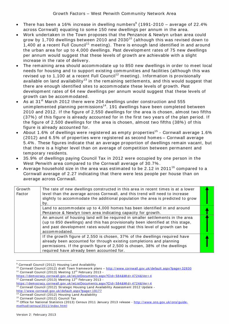
The rate of new dwellings constructed in this area in recent times is at a lower level than the average across Cornwall, and this trend will need to increase slightly to accommodate the additional population the area is predicted to grow by.
Land to accommodate up to 4,000 homes has been identified in and around Penzance & Newlyn town area indicating capacity for growth.
An amount of housing land will be required in smaller settlements in the area (up to 850 dwellings) and this has provisionally been identified at this stage, and past development rates would suggest that this level of growth can be accommodated.
Growth Factor
If the growth figure of 2,550 is chosen, 37% of the dwellings required have already been accounted for through existing completions and planning permissions. If the growth figure of 2,500 is chosen, 38% of the dwellings required have already been accounted for.
9 Cornwall Council (2012) Housing Land Availability 10 Cornwall Council (2012) draft Town framework plans – http://www.cornwall.gov.uk/default.aspx?page=32830 11 Cornwall Council (2013) Meeting 12th February 2013 - https://democracy.cornwall.gov.uk/ieListDocuments.aspx?CId=584&MId=4724&Ver=4 12 Cornwall Council (2013) Meeting 12th February 2013 - https://democracy.cornwall.gov.uk/ieListDocuments.aspx?CId=584&MId=4724&Ver=4 13 Cornwall Council (2012) Strategic Housing Land Availability Assessment 2012 Update - http://www.cornwall.gov.uk/default.aspx?page=19177 14 Cornwall Council (2012) Housing Land Availability 15 Cornwall Council (2012) Council Tax 16 Office for National Statistics (2013) Census 2011 January 2013 release - http://www.ons.gov.uk/ons/guide-method/census/2011/index.html
Growth Factors – West Penwith Community Network Area
Version 2: February 2013
Economy and Regeneration17: Key Facts The West Penwith area falls within the Penzance Travel to Work Area (TTWA) and as a
result is in competition with other urban centres such as St Ives and Hayle in terms of attracting employment opportunities and employees.
The West Penwith area produces about 7%18 of Cornwall’s Gross Value Added figures. Penzance is an important service centre for this part of Cornwall and is the main access
point to the Isles of Scilly. Penzance has a mixed economy of retailing, tourism and light industry including the
marine sector. The main employment site is the Long Rock Industrial Estate (13 ha), within which there is a small amount of undeveloped land available.
There is a shortfall of office land identified and the most sensible place for this is at Penzance close to the town centre with good access on to the A30.
Penzance town and industrial estates are situated on the A30 and as a result have very good transport links within and out of Cornwall, although there are bottlenecks in places along this route. Penzance is in the far west of Cornwall and some distance from the Cornwall Devon border and the rest of the UK.
Several regeneration schemes are proposed including Newlyn Fish Market, Newlyn Harbour, the Dairy, a work hub and Penzance Harbour Masterplan19.
In 201120, 22.9% of those aged 16 plus in the West Penwith area had no qualification compared to the Cornwall average of 22.4%. Of the remainder, 26.8% had level 4 and above qualifications in the area compared to 25% on average across Cornwall.
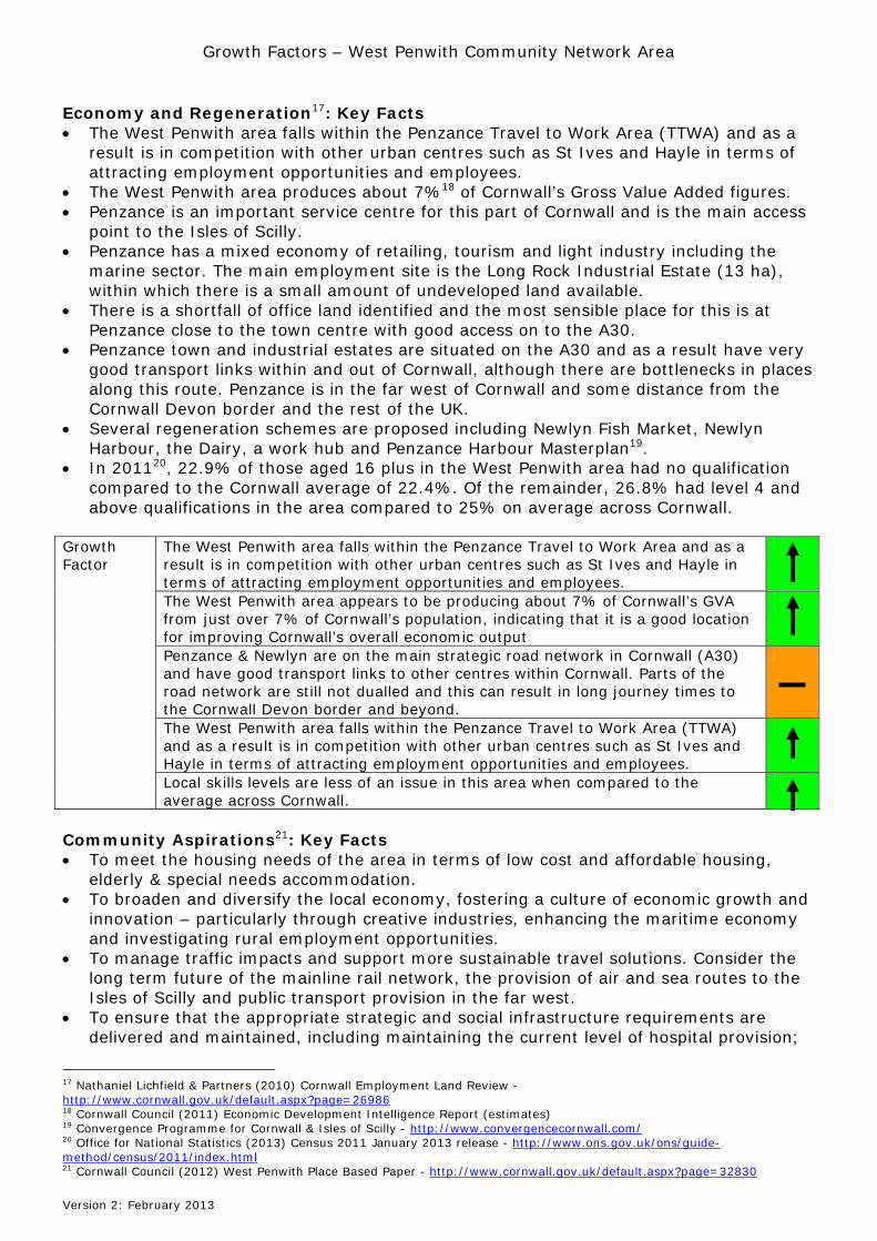
The West Penwith area falls within the Penzance Travel to Work Area and as a result is in competition with other urban centres such as St Ives and Hayle in terms of attracting employment opportunities and employees.
The West Penwith area appears to be producing about 7% of Cornwall’s GVA from just over 7% of Cornwall’s population, indicating that it is a good location for improving Cornwall’s overall economic output
Penzance & Newlyn are on the main strategic road network in Cornwall (A30) and have good transport links to other centres within Cornwall. Parts of the road network are still not dualled and this can result in long journey times to the Cornwall Devon border and beyond.
The West Penwith area falls within the Penzance Travel to Work Area (TTWA) and as a result is in competition with other urban centres such as St Ives and Hayle in terms of attracting employment opportunities and employees.
Growth Factor
Local skills levels are less of an issue in this area when compared to the average across Cornwall.
Community Aspirations21: Key Facts To meet the housing needs of the area in terms of low cost and affordable housing,
elderly & special needs accommodation. To broaden and diversify the local economy, fostering a culture of economic growth and
innovation – particularly through creative industries, enhancing the maritime economy and investigating rural employment opportunities.
To manage traffic impacts and support more sustainable travel solutions. Consider the long term future of the mainline rail network, the provision of air and sea routes to the Isles of Scilly and public transport provision in the far west.
To ensure that the appropriate strategic and social infrastructure requirements are delivered and maintained, including maintaining the current level of hospital provision;
17 Nathaniel Lichfield & Partners (2010) Cornwall Employment Land Review - http://www.cornwall.gov.uk/default.aspx?page=26986 18 Cornwall Council (2011) Economic Development Intelligence Report (estimates) 19 Convergence Programme for Cornwall & Isles of Scilly - http://www.convergencecornwall.com/ 20 Office for National Statistics (2013) Census 2011 January 2013 release - http://www.ons.gov.uk/ons/guide-method/census/2011/index.html 21 Cornwall Council (2012) West Penwith Place Based Paper - http://www.cornwall.gov.uk/default.aspx?page=32830
Growth Factors – West Penwith Community Network Area
Version 2: February 2013
and consideration of the needs of the rural communities in respect of health care and community services.
To ensure development is sensitive to the outstanding natural, built and historic environment of the area giving careful consideration to the location, scale and design of new development and responding to climate change to create a more sustainable future.
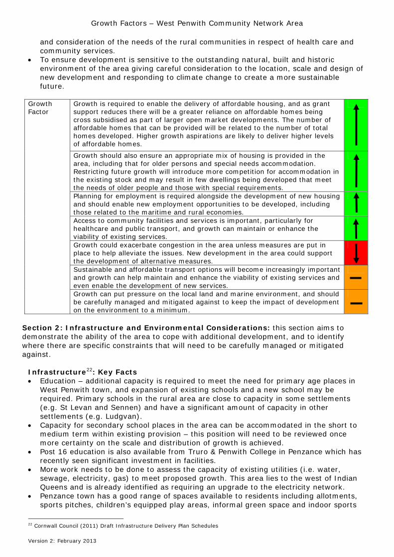
Growth is required to enable the delivery of affordable housing, and as grant support reduces there will be a greater reliance on affordable homes being cross subsidised as part of larger open market developments. The number of affordable homes that can be provided will be related to the number of total homes developed. Higher growth aspirations are likely to deliver higher levels of affordable homes.
Growth should also ensure an appropriate mix of housing is provided in the area, including that for older persons and special needs accommodation. Restricting future growth will introduce more competition for accommodation in the existing stock and may result in few dwellings being developed that meet the needs of older people and those with special requirements.
Planning for employment is required alongside the development of new housing and should enable new employment opportunities to be developed, including those related to the maritime and rural economies.
Access to community facilities and services is important, particularly for healthcare and public transport, and growth can maintain or enhance the viability of existing services.
Growth could exacerbate congestion in the area unless measures are put in place to help alleviate the issues. New development in the area could support the development of alternative measures.
Sustainable and affordable transport options will become increasingly important and growth can help maintain and enhance the viability of existing services and even enable the development of new services.
Growth Factor
Growth can put pressure on the local land and marine environment, and should be carefully managed and mitigated against to keep the impact of development on the environment to a minimum.
Section 2: Infrastructure and Environmental Considerations: this section aims to demonstrate the ability of the area to cope with additional development, and to identify where there are specific constraints that will need to be carefully managed or mitigated against.
Infrastructure22: Key Facts Education – additional capacity is required to meet the need for primary age places in
West Penwith town, and expansion of existing schools and a new school may be required. Primary schools in the rural area are close to capacity in some settlements (e.g. St Levan and Sennen) and have a significant amount of capacity in other settlements (e.g. Ludgvan).
Capacity for secondary school places in the area can be accommodated in the short to medium term within existing provision – this position will need to be reviewed once more certainty on the scale and distribution of growth is achieved.
Post 16 education is also available from Truro & Penwith College in Penzance which has recently seen significant investment in facilities.
More work needs to be done to assess the capacity of existing utilities (i.e. water, sewage, electricity, gas) to meet proposed growth. This area lies to the west of Indian Queens and is already identified as requiring an upgrade to the electricity network.
Penzance town has a good range of spaces available to residents including allotments, sports pitches, children’s equipped play areas, informal green space and indoor sports
22 Cornwall Council (2011) Draft Infrastructure Delivery Plan Schedules
Growth Factors – West Penwith Community Network Area
Version 2: February 2013
facilities. Many of the settlements in the rural area include some small equipped play areas, informal green space and sports pitches. Work23 has been undertaken to assess the capacity of existing sports, green and open space, and the requirement for additional space to meet the levels of growth proposed, and up to an additional 45 sq m per dwelling may be required.
Healthcare – residents can access their main healthcare providers in West Penwith town (doctors, dentists, opticians, chemists and the West Cornwall Hospital). There is a doctors’ surgery in Marazion, Mousehole, Pendeen, Newlyn, St Buryan and St Just, a chemist in Newlyn, Marazion and St Just and Poltair Hospital at Madron. It is estimated that up to three additional doctors may be required in the West Penwith area depending on the level of growth proposed.
Crematoria and Cemeteries – crematoria capacity is sufficient to meet demand over the next twenty years whichever level of growth is proposed. There is concern locally about the capacity of burial space, particularly at Penzance, and work in being undertaken to assess need24.
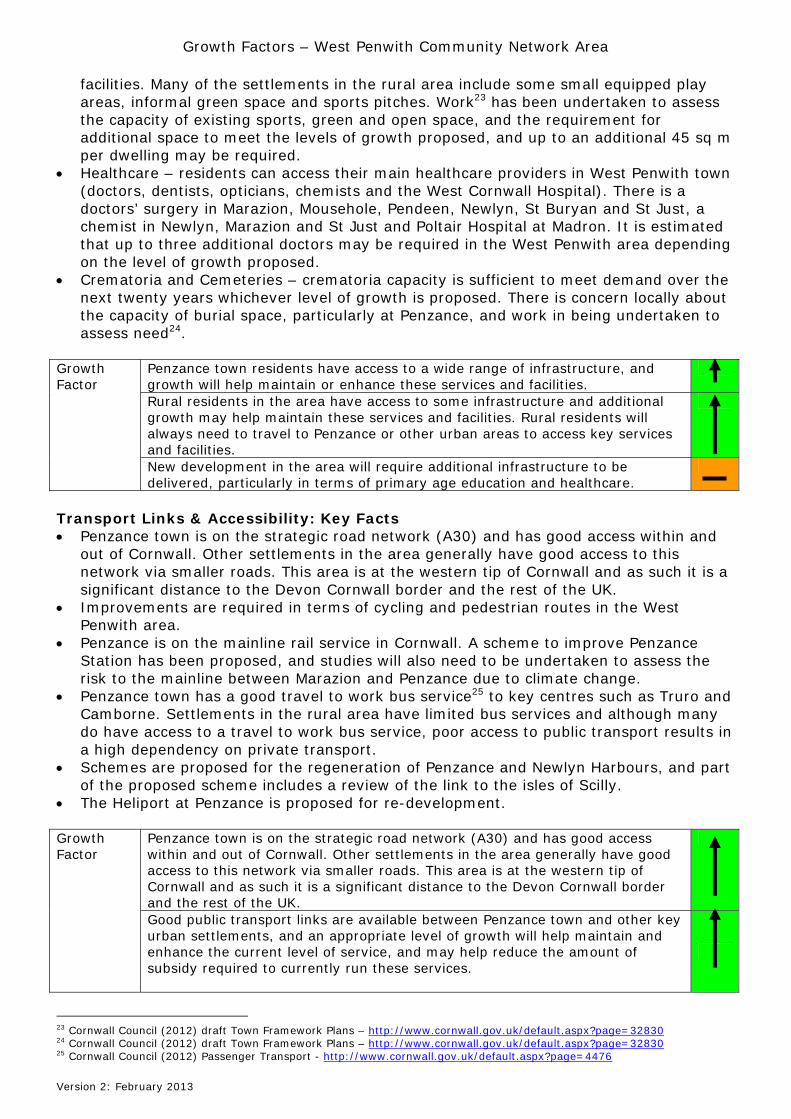
Penzance town residents have access to a wide range of infrastructure, and growth will help maintain or enhance these services and facilities.
Rural residents in the area have access to some infrastructure and additional growth may help maintain these services and facilities. Rural residents will always need to travel to Penzance or other urban areas to access key services and facilities.
Growth Factor
New development in the area will require additional infrastructure to be delivered, particularly in terms of primary age education and healthcare.
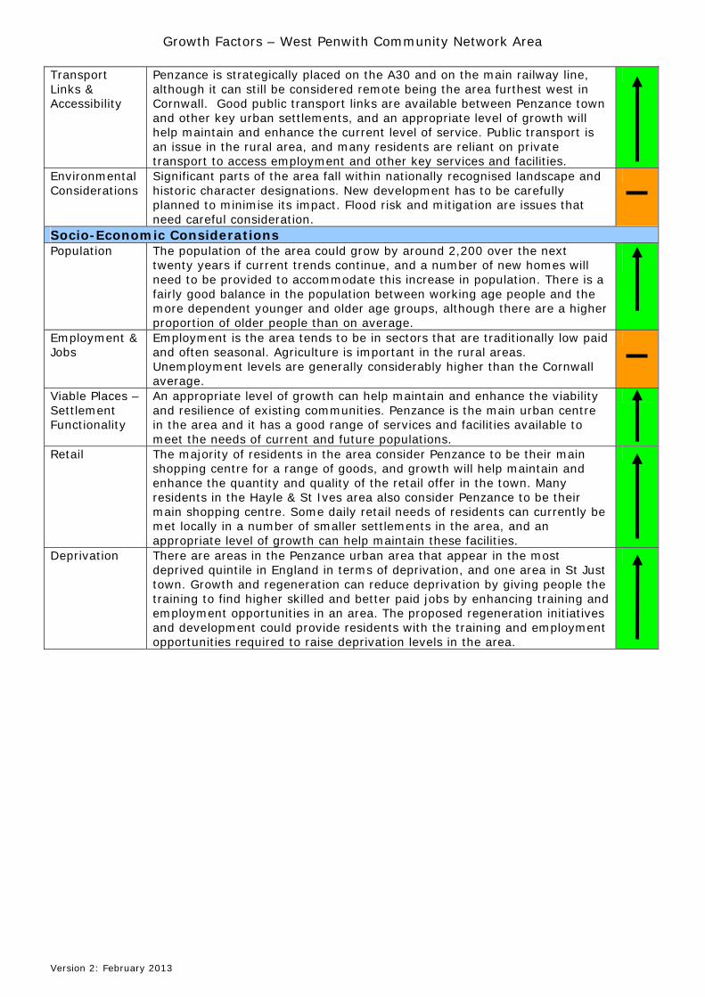
Transport Links & Accessibility: Key Facts Penzance town is on the strategic road network (A30) and has good access within and
out of Cornwall. Other settlements in the area generally have good access to this network via smaller roads. This area is at the western tip of Cornwall and as such it is a significant distance to the Devon Cornwall border and the rest of the UK.
Improvements are required in terms of cycling and pedestrian routes in the West Penwith area.
Penzance is on the mainline rail service in Cornwall. A scheme to improve Penzance Station has been proposed, and studies will also need to be undertaken to assess the risk to the mainline between Marazion and Penzance due to climate change.
Penzance town has a good travel to work bus service25 to key centres such as Truro and Camborne. Settlements in the rural area have limited bus services and although many do have access to a travel to work bus service, poor access to public transport results in a high dependency on private transport.
Schemes are proposed for the regeneration of Penzance and Newlyn Harbours, and part of the proposed scheme includes a review of the link to the isles of Scilly.
The Heliport at Penzance is proposed for re-development.
Penzance town is on the strategic road network (A30) and has good access within and out of Cornwall. Other settlements in the area generally have good access to this network via smaller roads. This area is at the western tip of Cornwall and as such it is a significant distance to the Devon Cornwall border and the rest of the UK.
Growth Factor
Good public transport links are available between Penzance town and other key urban settlements, and an appropriate level of growth will help maintain and enhance the current level of service, and may help reduce the amount of subsidy required to currently run these services.
23 Cornwall Council (2012) draft Town Framework Plans – http://www.cornwall.gov.uk/default.aspx?page=32830 24 Cornwall Council (2012) draft Town Framework Plans – http://www.cornwall.gov.uk/default.aspx?page=32830 25 Cornwall Council (2012) Passenger Transport - http://www.cornwall.gov.uk/default.aspx?page=4476
Growth Factors – West Penwith Community Network Area
Version 2: February 2013
Penzance is the main access point to the Isles of Scilly
Public transport is an issue in the rural area, and many residents are reliant on private transport to access employment and other key services and facilities. Growth may exacerbate this problem and increase the use made of private transport, or it could improve the viability of public transport options and facilitate the provision of additional or more frequent bus services.
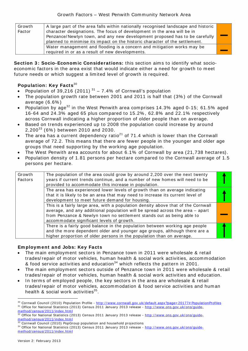
Environment: Key Facts More than 50% of the West Penwith area is designated as Areas of Outstanding Natural
Beauty and parts of Cornwall’s World Heritage Site falls within the area26. Important landscape designations in the area are identified on the map below:
The West Penwith area is divided into five landscape type areas27. Flood Risk & Mitigation – work needs to be undertaken to understand these issues in the
West Penwith area. Proposed are schemes at Newlyn, Penzance, Wherrytown Penzance, Penzance Harbour, Penzance Promenade and Long Rock28.
Historic Environment – major heritage at risk has been identified as Lamorna Quay, St John’s Hall Penzance, Jubilee Pool, St Clare, Penzance Promenade, Registry Office, Library, Newlyn Trinity, St Paul’s and Richmond Chapel in West Penwith. Studies are required on the conservation areas, historic landscape character reviews, highway heritage assets and Cornish character29.
26 Cornwall Council (2011) Geographic Information System 27 Cornwall Council (2007) Cornwall & Isles of Scilly Landscape Character Study - http://www.cornwall.gov.uk/default.aspx?page=24874 28 Cornwall Council (2012) Draft Infrastructure Needs Assessment Schedules - http://www.futurecornwall.org.uk/default.aspx?page=354 29 Cornwall Council (2011) Historic Environment Data Sheets - http://www.cornwall.gov.uk/default.aspx?page=32830
Growth Factors – West Penwith Community Network Area
Version 2: February 2013
A large part of the area falls within nationally recognised landscape and historic character designations. The focus of development in the area will be in Penzance/Newlyn town, and any new development proposed has to be carefully planned to minimise its impact on the historic character of the settlement.
Growth Factor
Water management and flooding is a concern and mitigation works may be required in or as a result of new developments.
Section 3: Socio-Economic Considerations: this section aims to identify what socio-economic factors in the area exist that would indicate either a need for growth to meet future needs or which suggest a limited level of growth is required.
Population: Key Facts30 Population of 39,216 (2011) 31 – 7.4% of Cornwall’s population The population growth rate between 2001 and 2011 is half that (3%) of the Cornwall
average (6.6%) Population by age32 in the West Penwith area comprises 14.3% aged 0-15; 61.5% aged
16-64 and 24.3% aged 65 plus compared to 15.2%, 62.8% and 22.1% respectively across Cornwall indicating a higher proportion of older people than on average.
Based on trends experienced up to 2008 the population could increase by around 2,20033 (6%) between 2010 and 2030.
The area has a current dependency ratio21 of 71.4 which is lower than the Cornwall average of 72.2. This means that there are fewer people in the younger and older age groups that need supporting by the working age population.
The West Penwith area accounts for about 6.1% of Cornwall by area (21,738 hectares). Population density of 1.81 persons per hectare compared to the Cornwall average of 1.5
persons per hectare.
The population of the area could grow by around 2,200 over the next twenty years if current trends continue, and a number of new homes will need to be provided to accommodate this increase in population.
The area has experienced lower levels of growth than on average indicating that it is likely to be an area that may need to increase its current level of development to meet future demand for housing.
This is a fairly large area, with a population density above that of the Cornwall average, and any additional population will be spread across the area – apart from Penzance & Newlyn town no settlement stands out as being able to accommodate significant levels of growth.
Growth Factors
There is a fairly good balance in the population between working age people and the more dependent older and younger age groups, although there are a higher proportion of older persons in the population than on average.
Employment and Jobs: Key Facts The main employment sectors in Penzance town in 2011 were wholesale & retail
trades/repair of motor vehicles, human health & social work activities, accommodation & food service activities and education34 which reflects the pattern in 2001.
The main employment sectors outside of Penzance town in 2011 were wholesale & retail trades/repair of motor vehicles, human health & social work activities and education.
In terms of employed people, the key sectors in the area are wholesale & retail trades/repair of motor vehicles, accommodation & food service activities and human health & social work activities35.
30 Cornwall Council (2010) Population Profile - http://www.cornwall.gov.uk/default.aspx?page=20177#PopulationProfiles 31 Office for National Statistics (2013) Census 2011 January 2013 release - http://www.ons.gov.uk/ons/guide-method/census/2011/index.html 32 Office for National Statistics (2013) Census 2011 January 2013 release - http://www.ons.gov.uk/ons/guide-method/census/2011/index.html 33 Cornwall Council (2010) PopGroup population and household projections 34 Office for National Statistics (2013) Census 2011 January 2013 release - http://www.ons.gov.uk/ons/guide-method/census/2011/index.html
Growth Factors – West Penwith Community Network Area
Version 2: February 2013
Social care is a sector that is predicted to grow by 25% to meet the needs of an increasing number of older age people36.
62% of those in employment37 in the West Penwith area worked full time (31 hours per week plus) and 38% were part time (less than 31 hours) compared to the Cornwall average of 66.1% and 33.9% respectively.
In 201138, 22.9% of those aged 16 plus in the West Penwith area had no qualification compared to the Cornwall average of 22.4%. Of the remainder, 26.8% had level 4 and above qualifications in the area compared to 25% on average across Cornwall.
The Job Seekers Allowance39 claimant rate for the area has increased from 3.2% of the working age population in January 2007 to 4.3% in January 2012 (low season – Cornwall average 2% and 3.3% respectively). The rate changed from 2% in July 2007 to 3.3% in July 2012 (high season – Cornwall 1.3% and 2.6% respectively). The current rate (December 2012) stands at 3.6% of the working age population in the West Penwith area compared to 3% on average across Cornwall.
In 201140 41.9% of households in the West Penwith area contained no-one in employment and of these households 8.7% had dependent children compared to the Cornwall averages of 37.8% and 8.3% respectively.
In 201141 32.1% of households in the area contained at least one person with a long term health problem or disability, and of these households 14% contained dependent children compared to the Cornwall averages of 28.8% and 15.6% respectively.
There is a good mix of employment sectors in the area, although some of them can be low paid and may be seasonal.
Growth Factor
The proportion of people claiming Job Seekers Allowance in the West Penwith area is generally higher than on average across Cornwall.
Viable Places - Settlement Functionality42: Key Facts The main settlement is Penzance/Newlyn – categorised as Category A settlement.
Category A settlements are classified as the strategically significant towns in Cornwall, and are the main employment and service centres for Cornwall.
Category C settlements are identified as small towns and larger villages that meet local needs for a range of services and facilities – Marazion, Pendeen and St Just.
Category D settlements are smaller settlements that perform an important role in their local areas, i.e. ‘rural service centres’ – Crowlas with Lower Ludgvan, Goldsithney with St Hilary, Madron, Mousehole, Porthcurno with St Levan, St Buryan and Sennen.
Other settlements do contain some key facilities such as a travel to work bus service and a meeting place – Paul with Sheffield.
Work is underway to understand how some settlements could work together to provide services and facilities to local residents - a ‘cluster’ – and in this area there are some potential clusters already identified – Penzance with Newlyn, Heamoor, Long Rock, Gulval, Trevarrack and Eastern Green; Crowlas with Lower Ludgvan; Goldsithney with St Hilary; and Paul with Sheffield.
35 NOMIS (2012) Business Register and Employment Service - http://www.nomisweb.co.uk/ 36 Cornwall Council (2011) Economic Development – Sector analysis 37 Office for National Statistics (2013) Census 2011 January 2013 release - http://www.ons.gov.uk/ons/guide-method/census/2011/index.html 38 Office for National Statistics (2013) Census 2011 January 2013 release - http://www.ons.gov.uk/ons/guide-method/census/2011/index.html 39 NOMIS (2012) Claimant Count data - http://www.nomisweb.co.uk/ 40 Office for National Statistics (2013) Census 2011 January 2013 release - http://www.ons.gov.uk/ons/guide-method/census/2011/index.html 41 Office for National Statistics (2013) Census 2011 January 2013 release - http://www.ons.gov.uk/ons/guide-method/census/2011/index.html 42 Cornwall Council (2012) Settlements: Hierarchy and Settlement Categories 2012 Update - http://www.cornwall.gov.uk/default.aspx?page=22887
Growth Factors – West Penwith Community Network Area
Version 2: February 2013
There is a good mix of settlements in the area and an appropriate level of growth can help maintain and enhance the viability and resilience of existing communities.
Penzance town is the main urban centre in the area and it has a good range of services and facilities available to meet the needs of the current and future populations and can accommodate a significant proportion of the growth allocated to the area.
Growth Factor
There is the potential to ensure better access to services and facilities through the identification of ‘clusters’ – and Penzance with Newlyn, Heamoor, Long Rock, Gulval, Trevarrack and Eastern Green; Crowlas with Lower Ludgvan; Goldsithney with St Hilary; and Paul with Sheffield are identified as potential clusters.
Retail43 44: Key Facts Just over three-quarters of residents in the area do their main food shopping in
Penzance. Stores in the town include three Co-op, Tesco and Lidl. Penzance town contains a number of multiple retailers, the remainder being
independent retailers. Penzance is the shopping centre that most people use for clothes and other personal
goods and DIY and other household goods in this area, and the town also attracts shoppers from the Hayle and St Ives areas.
97% of residents in the area considered Penzance to be their main shopping centre, as did 30% from the St Ives area and 39% from the Hayle area.
45% liked Penzance because it was near and/or convenient – 48% did not dislike anything about the centre although 22% didn’t like the selection of shops available.
Penzance is accessible by private car (A30) although traffic through the town centre can be an issue. The main bus terminus is close to the town centre.
A large number of villages45 in the area include retail outlets such as general stores and post offices – these can provide many of the services residents require on a daily basis.
The majority of residents (97%) in the area consider Penzance to be their main shopping centre for a range of goods, and growth will help maintain and enhance the quantity and quality of the retail offer in the Town. 30% of residents in the St Ives area and 39% of residents in the Hayle area also considered Penzance to be their main shopping centre.
Penzance town is performing relatively well, with a range of multiple and independent retail outlets.
Growth Factor
Some daily retail needs of residents can currently be met locally in a number of smaller settlements in the area, and an appropriate level of growth can help maintain these facilities.
Deprivation: Census 201146 has identified that 34.9% of households in the West Penwith area do not
experience any form of deprivation compared to 40.2% on average across Cornwall. Of the remainder, 35.8% are deprived in one dimension, 22% in two dimensions, 6.6% in three dimensions and 0.8% in all four dimensions compared to 34.6%, 19.9%, 4.8% and 0.5% respectively across Cornwall.
43 Cornwall Council/GVA Grimley (2009) Cornwall Household Retail Telephone Survey 44 GVA Grimley (2010) Cornwall Retail Study - http://www.cornwall.gov.uk/default.aspx?page=26564 45 Cornwall Council (2012) Settlement Profiles - http://www.cornwall.gov.uk/default.aspx?page=32830 46 Office for National Statistics (2013) Census 2011 January 2013 release - http://www.ons.gov.uk/ons/guide-method/census/2011/index.html The dimensions of deprivation used to classify households are indicators based on the four selected household characteristics: Employment (any member of a household not a full-time student is either unemployed or long-term sick); Education (no person in the household has at least level 2 education, and no person aged 16-18 is a full-time student); Health and disability (any person in the household has general health ‘bad or very bad’ or has a long term health problem), and Housing (Household's accommodation is ether overcrowded, with an occupancy rating -1 or less, or is in a shared dwelling, or has no central heating). A household is classified as being deprived in none, or one to four of these dimensions in any combination.
Growth Factors – West Penwith Community Network Area
Version 2: February 2013
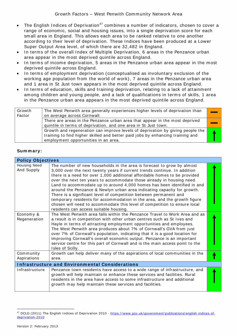
The English Indices of Deprivation47 combines a number of indicators, chosen to cover a range of economic, social and housing issues, into a single deprivation score for each small area in England. This allows each area to be ranked relative to one another according to their level of deprivation. These Indices have been produced at a Lower Super Output Area level, of which there are 32,482 in England.
In terms of the overall Index of Multiple Deprivation, 6 areas in the Penzance urban area appear in the most deprived quintile across England.
In terms of income deprivation, 5 areas in the Penzance urban area appear in the most deprived quintile across England.
In terms of employment deprivation (conceptualised as involuntary exclusion of the working age population from the world of work), 7 areas in the Penzance urban area and 1 area in St Just town appears in the most deprived quintile across England.
In terms of education, skills and training deprivation, relating to a lack of attainment among children and young people, and a lack of qualifications in terms of skills, 1 area in the Penzance urban area appears in the most deprived quintile across England.
The West Penwith area generally experiences higher levels of deprivation than on average across Cornwall.
There are areas in the Penzance urban area that appear in the most deprived quintile in terms of deprivation, and one area in St Just town.
Growth Factor
Growth and regeneration can improve levels of deprivation by giving people the training to find higher skilled and better paid jobs by enhancing training and employment opportunities in an area.
Summary:
Policy Objectives Housing Need And Supply
The number of new households in the area is forecast to grow by almost 3,000 over the next twenty years if current trends continue. In addition there is a need for over 1,000 additional affordable homes to be provided over the next ten years to accommodate those already in housing need. Land to accommodate up to around 4,000 homes has been identified in and around the Penzance & Newlyn urban area indicating capacity for growth. There is a significant level of competition between permanent and temporary residents for accommodation in the area, and the growth figure chosen will need to accommodate this level of competition to ensure local residents can access suitable housing.
Economy & Regeneration
The West Penwith area falls within the Penzance Travel to Work Area and as a result is in competition with other urban centres such as St Ives and Hayle in terms of attracting employment opportunities and employees. The West Penwith area produces about 7% of Cornwall’s GVA from just over 7% of Cornwall’s population, indicating that it is a good location for improving Cornwall’s overall economic output. Penzance is an important service centre for this part of Cornwall and is the main access point to the Isles of Scilly.
Community Aspirations
Growth can help deliver many of the aspirations of local communities in the area.
Infrastructure and Environmental Considerations Infrastructure Penzance town residents have access to a wide range of infrastructure, and
growth will help maintain or enhance these services and facilities. Rural residents in the area have access to some infrastructure and additional growth may help maintain these services and facilities.
47 DCLG (2011) The English Indices of Deprivation 2010 - https://www.gov.uk/government/publications/english-indices-of-deprivation-2010
Growth Factors – West Penwith Community Network Area
Version 2: February 2013
Transport Links & Accessibility
Penzance is strategically placed on the A30 and on the main railway line, although it can still be considered remote being the area furthest west in Cornwall. Good public transport links are available between Penzance town and other key urban settlements, and an appropriate level of growth will help maintain and enhance the current level of service. Public transport is an issue in the rural area, and many residents are reliant on private transport to access employment and other key services and facilities.
Environmental Considerations
Significant parts of the area fall within nationally recognised landscape and historic character designations. New development has to be carefully planned to minimise its impact. Flood risk and mitigation are issues that need careful consideration.
Socio-Economic Considerations Population The population of the area could grow by around 2,200 over the next
twenty years if current trends continue, and a number of new homes will need to be provided to accommodate this increase in population. There is a fairly good balance in the population between working age people and the more dependent younger and older age groups, although there are a higher proportion of older people than on average.
Employment & Jobs
Employment is the area tends to be in sectors that are traditionally low paid and often seasonal. Agriculture is important in the rural areas. Unemployment levels are generally considerably higher than the Cornwall average.
Viable Places – Settlement Functionality
An appropriate level of growth can help maintain and enhance the viability and resilience of existing communities. Penzance is the main urban centre in the area and it has a good range of services and facilities available to meet the needs of current and future populations.
Retail The majority of residents in the area consider Penzance to be their main shopping centre for a range of goods, and growth will help maintain and enhance the quantity and quality of the retail offer in the town. Many residents in the Hayle & St Ives area also consider Penzance to be their main shopping centre. Some daily retail needs of residents can currently be met locally in a number of smaller settlements in the area, and an appropriate level of growth can help maintain these facilities.
Deprivation There are areas in the Penzance urban area that appear in the most deprived quintile in England in terms of deprivation, and one area in St Just town. Growth and regeneration can reduce deprivation by giving people the training to find higher skilled and better paid jobs by enhancing training and employment opportunities in an area. The proposed regeneration initiatives and development could provide residents with the training and employment opportunities required to raise deprivation levels in the area.