Embed Size (px)
Citation preview
PostGIS 1.5.1 Manuali
PostGIS 1.5.1 Manual
PostGIS 1.5.1 Manualii
Contents
1 Introduction 1
1.1 Project Steering Committee . . . . . . . . . . . . . . . . . . . . . . . . . . . . . . . . . . . . . . . . . . . . . . 1
1.2 Contributors Past and Present . . . . . . . . . . . . . . . . . . . . . . . . . . . . . . . . . . . . . . . . . . . . . 1
1.3 More Information . . . . . . . . . . . . . . . . . . . . . . . . . . . . . . . . . . . . . . . . . . . . . . . . . . . 2
2 Installation 3
2.1 Short Version . . . . . . . . . . . . . . . . . . . . . . . . . . . . . . . . . . . . . . . . . . . . . . . . . . . . . 3
2.2 Requirements . . . . . . . . . . . . . . . . . . . . . . . . . . . . . . . . . . . . . . . . . . . . . . . . . . . . . 3
2.3 Getting the Source . . . . . . . . . . . . . . . . . . . . . . . . . . . . . . . . . . . . . . . . . . . . . . . . . . 4
2.4 Installation . . . . . . . . . . . . . . . . . . . . . . . . . . . . . . . . . . . . . . . . . . . . . . . . . . . . . . 4
2.4.1 Configuration . . . . . . . . . . . . . . . . . . . . . . . . . . . . . . . . . . . . . . . . . . . . . . . . . 5
2.4.2 Building . . . . . . . . . . . . . . . . . . . . . . . . . . . . . . . . . . . . . . . . . . . . . . . . . . . 5
2.4.3 Testing . . . . . . . . . . . . . . . . . . . . . . . . . . . . . . . . . . . . . . . . . . . . . . . . . . . . 6
2.4.4 Installation . . . . . . . . . . . . . . . . . . . . . . . . . . . . . . . . . . . . . . . . . . . . . . . . . . 7
2.5 Create a spatially-enabled database . . . . . . . . . . . . . . . . . . . . . . . . . . . . . . . . . . . . . . . . . . 8
2.6 Create a spatially-enabled database from a template . . . . . . . . . . . . . . . . . . . . . . . . . . . . . . . . . 8
2.7 Upgrading . . . . . . . . . . . . . . . . . . . . . . . . . . . . . . . . . . . . . . . . . . . . . . . . . . . . . . . 8
2.7.1 Soft upgrade . . . . . . . . . . . . . . . . . . . . . . . . . . . . . . . . . . . . . . . . . . . . . . . . . 9
2.7.2 Hard upgrade . . . . . . . . . . . . . . . . . . . . . . . . . . . . . . . . . . . . . . . . . . . . . . . . . 9
2.8 Common Problems . . . . . . . . . . . . . . . . . . . . . . . . . . . . . . . . . . . . . . . . . . . . . . . . . . 10
2.9 JDBC . . . . . . . . . . . . . . . . . . . . . . . . . . . . . . . . . . . . . . . . . . . . . . . . . . . . . . . . . 10
2.10 Loader/Dumper . . . . . . . . . . . . . . . . . . . . . . . . . . . . . . . . . . . . . . . . . . . . . . . . . . . . 10
3 Frequently Asked Questions 11
4 Using PostGIS: Data Management and Queries 14
4.1 GIS Objects . . . . . . . . . . . . . . . . . . . . . . . . . . . . . . . . . . . . . . . . . . . . . . . . . . . . . . 14
4.1.1 OpenGIS WKB and WKT . . . . . . . . . . . . . . . . . . . . . . . . . . . . . . . . . . . . . . . . . . 14
4.1.2 PostGIS EWKB, EWKT and Canonical Forms . . . . . . . . . . . . . . . . . . . . . . . . . . . . . . . 15
4.1.3 SQL-MM Part 3 . . . . . . . . . . . . . . . . . . . . . . . . . . . . . . . . . . . . . . . . . . . . . . . 16
4.2 PostGIS Geography Type . . . . . . . . . . . . . . . . . . . . . . . . . . . . . . . . . . . . . . . . . . . . . . . 16
PostGIS 1.5.1 Manualiii
4.2.1 Geography Basics . . . . . . . . . . . . . . . . . . . . . . . . . . . . . . . . . . . . . . . . . . . . . . 17
4.2.2 When to use Geography Data type over Geometry data type . . . . . . . . . . . . . . . . . . . . . . . . 18
4.2.3 Geography Advanced FAQ . . . . . . . . . . . . . . . . . . . . . . . . . . . . . . . . . . . . . . . . . . 19
4.3 Using OpenGIS Standards . . . . . . . . . . . . . . . . . . . . . . . . . . . . . . . . . . . . . . . . . . . . . . 19
4.3.1 The SPATIAL_REF_SYS Table and Spatial Reference Systems . . . . . . . . . . . . . . . . . . . . . . 20
4.3.2 The GEOMETRY_COLUMNS Table . . . . . . . . . . . . . . . . . . . . . . . . . . . . . . . . . . . . 21
4.3.3 Creating a Spatial Table . . . . . . . . . . . . . . . . . . . . . . . . . . . . . . . . . . . . . . . . . . . 21
4.3.4 Manually Registering Geometry Columns in geometry_columns . . . . . . . . . . . . . . . . . . . . . . 22
4.3.5 Ensuring OpenGIS compliancy of geometries . . . . . . . . . . . . . . . . . . . . . . . . . . . . . . . . 23
4.3.6 Dimensionally Extended 9 Intersection Model (DE-9IM) . . . . . . . . . . . . . . . . . . . . . . . . . . 27
4.3.6.1 Theory . . . . . . . . . . . . . . . . . . . . . . . . . . . . . . . . . . . . . . . . . . . . . . . 29
4.4 Loading GIS Data . . . . . . . . . . . . . . . . . . . . . . . . . . . . . . . . . . . . . . . . . . . . . . . . . . . 32
4.4.1 Using SQL . . . . . . . . . . . . . . . . . . . . . . . . . . . . . . . . . . . . . . . . . . . . . . . . . . 32
4.4.2 Using the Loader . . . . . . . . . . . . . . . . . . . . . . . . . . . . . . . . . . . . . . . . . . . . . . . 32
4.5 Retrieving GIS Data . . . . . . . . . . . . . . . . . . . . . . . . . . . . . . . . . . . . . . . . . . . . . . . . . . 33
4.5.1 Using SQL . . . . . . . . . . . . . . . . . . . . . . . . . . . . . . . . . . . . . . . . . . . . . . . . . . 33
4.5.2 Using the Dumper . . . . . . . . . . . . . . . . . . . . . . . . . . . . . . . . . . . . . . . . . . . . . . 34
4.6 Building Indexes . . . . . . . . . . . . . . . . . . . . . . . . . . . . . . . . . . . . . . . . . . . . . . . . . . . 35
4.6.1 GiST Indexes . . . . . . . . . . . . . . . . . . . . . . . . . . . . . . . . . . . . . . . . . . . . . . . . . 35
4.6.2 Using Indexes . . . . . . . . . . . . . . . . . . . . . . . . . . . . . . . . . . . . . . . . . . . . . . . . . 36
4.7 Complex Queries . . . . . . . . . . . . . . . . . . . . . . . . . . . . . . . . . . . . . . . . . . . . . . . . . . . 36
4.7.1 Taking Advantage of Indexes . . . . . . . . . . . . . . . . . . . . . . . . . . . . . . . . . . . . . . . . . 36
4.7.2 Examples of Spatial SQL . . . . . . . . . . . . . . . . . . . . . . . . . . . . . . . . . . . . . . . . . . . 37
5 Using PostGIS: Building Applications 40
5.1 Using MapServer . . . . . . . . . . . . . . . . . . . . . . . . . . . . . . . . . . . . . . . . . . . . . . . . . . . 40
5.1.1 Basic Usage . . . . . . . . . . . . . . . . . . . . . . . . . . . . . . . . . . . . . . . . . . . . . . . . . . 40
5.1.2 Frequently Asked Questions . . . . . . . . . . . . . . . . . . . . . . . . . . . . . . . . . . . . . . . . . 41
5.1.3 Advanced Usage . . . . . . . . . . . . . . . . . . . . . . . . . . . . . . . . . . . . . . . . . . . . . . . 42
5.1.4 Examples . . . . . . . . . . . . . . . . . . . . . . . . . . . . . . . . . . . . . . . . . . . . . . . . . . . 43
5.2 Java Clients (JDBC) . . . . . . . . . . . . . . . . . . . . . . . . . . . . . . . . . . . . . . . . . . . . . . . . . . 44
5.3 C Clients (libpq) . . . . . . . . . . . . . . . . . . . . . . . . . . . . . . . . . . . . . . . . . . . . . . . . . . . 45
5.3.1 Text Cursors . . . . . . . . . . . . . . . . . . . . . . . . . . . . . . . . . . . . . . . . . . . . . . . . . 45
5.3.2 Binary Cursors . . . . . . . . . . . . . . . . . . . . . . . . . . . . . . . . . . . . . . . . . . . . . . . . 45
PostGIS 1.5.1 Manualiv
6 Performance tips 46
6.1 Small tables of large geometries . . . . . . . . . . . . . . . . . . . . . . . . . . . . . . . . . . . . . . . . . . . 46
6.1.1 Problem description . . . . . . . . . . . . . . . . . . . . . . . . . . . . . . . . . . . . . . . . . . . . . 46
6.1.2 Workarounds . . . . . . . . . . . . . . . . . . . . . . . . . . . . . . . . . . . . . . . . . . . . . . . . . 46
6.2 CLUSTERing on geometry indices . . . . . . . . . . . . . . . . . . . . . . . . . . . . . . . . . . . . . . . . . . 47
6.3 Avoiding dimension conversion . . . . . . . . . . . . . . . . . . . . . . . . . . . . . . . . . . . . . . . . . . . . 47
6.4 Tuning your configuration . . . . . . . . . . . . . . . . . . . . . . . . . . . . . . . . . . . . . . . . . . . . . . 48
6.4.1 Startup . . . . . . . . . . . . . . . . . . . . . . . . . . . . . . . . . . . . . . . . . . . . . . . . . . . . 48
6.4.2 Runtime . . . . . . . . . . . . . . . . . . . . . . . . . . . . . . . . . . . . . . . . . . . . . . . . . . . . 48
7 PostGIS Reference 49
7.1 PostgreSQL PostGIS Types . . . . . . . . . . . . . . . . . . . . . . . . . . . . . . . . . . . . . . . . . . . . . . 49
7.1.1 box2d . . . . . . . . . . . . . . . . . . . . . . . . . . . . . . . . . . . . . . . . . . . . . . . . . . . . . 49
7.1.2 box3d . . . . . . . . . . . . . . . . . . . . . . . . . . . . . . . . . . . . . . . . . . . . . . . . . . . . . 49
7.1.3 box3d_extent . . . . . . . . . . . . . . . . . . . . . . . . . . . . . . . . . . . . . . . . . . . . . . . . . 50
7.1.4 geometry . . . . . . . . . . . . . . . . . . . . . . . . . . . . . . . . . . . . . . . . . . . . . . . . . . . 50
7.1.5 geometry_dump . . . . . . . . . . . . . . . . . . . . . . . . . . . . . . . . . . . . . . . . . . . . . . . 51
7.1.6 geography . . . . . . . . . . . . . . . . . . . . . . . . . . . . . . . . . . . . . . . . . . . . . . . . . . . 51
7.2 Management Functions . . . . . . . . . . . . . . . . . . . . . . . . . . . . . . . . . . . . . . . . . . . . . . . . 52
7.2.1 AddGeometryColumn . . . . . . . . . . . . . . . . . . . . . . . . . . . . . . . . . . . . . . . . . . . . 52
7.2.2 DropGeometryColumn . . . . . . . . . . . . . . . . . . . . . . . . . . . . . . . . . . . . . . . . . . . . 53
7.2.3 DropGeometryTable . . . . . . . . . . . . . . . . . . . . . . . . . . . . . . . . . . . . . . . . . . . . . 54
7.2.4 PostGIS_Full_Version . . . . . . . . . . . . . . . . . . . . . . . . . . . . . . . . . . . . . . . . . . . . 54
7.2.5 PostGIS_GEOS_Version . . . . . . . . . . . . . . . . . . . . . . . . . . . . . . . . . . . . . . . . . . . 55
7.2.6 PostGIS_LibXML_Version . . . . . . . . . . . . . . . . . . . . . . . . . . . . . . . . . . . . . . . . . 55
7.2.7 PostGIS_Lib_Build_Date . . . . . . . . . . . . . . . . . . . . . . . . . . . . . . . . . . . . . . . . . . 56
7.2.8 PostGIS_Lib_Version . . . . . . . . . . . . . . . . . . . . . . . . . . . . . . . . . . . . . . . . . . . . 56
7.2.9 PostGIS_PROJ_Version . . . . . . . . . . . . . . . . . . . . . . . . . . . . . . . . . . . . . . . . . . . 57
7.2.10 PostGIS_Scripts_Build_Date . . . . . . . . . . . . . . . . . . . . . . . . . . . . . . . . . . . . . . . . . 58
7.2.11 PostGIS_Scripts_Installed . . . . . . . . . . . . . . . . . . . . . . . . . . . . . . . . . . . . . . . . . . 58
7.2.12 PostGIS_Scripts_Released . . . . . . . . . . . . . . . . . . . . . . . . . . . . . . . . . . . . . . . . . . 59
7.2.13 PostGIS_Uses_Stats . . . . . . . . . . . . . . . . . . . . . . . . . . . . . . . . . . . . . . . . . . . . . 59
7.2.14 PostGIS_Version . . . . . . . . . . . . . . . . . . . . . . . . . . . . . . . . . . . . . . . . . . . . . . . 60
7.2.15 Populate_Geometry_Columns . . . . . . . . . . . . . . . . . . . . . . . . . . . . . . . . . . . . . . . . 61
7.2.16 Probe_Geometry_Columns . . . . . . . . . . . . . . . . . . . . . . . . . . . . . . . . . . . . . . . . . . 61
7.2.17 UpdateGeometrySRID . . . . . . . . . . . . . . . . . . . . . . . . . . . . . . . . . . . . . . . . . . . . 62
7.3 Geometry Constructors . . . . . . . . . . . . . . . . . . . . . . . . . . . . . . . . . . . . . . . . . . . . . . . . 63
7.3.1 ST_BdPolyFromText . . . . . . . . . . . . . . . . . . . . . . . . . . . . . . . . . . . . . . . . . . . . . 63
7.3.2 ST_BdMPolyFromText . . . . . . . . . . . . . . . . . . . . . . . . . . . . . . . . . . . . . . . . . . . . 63
PostGIS 1.5.1 Manualv
7.3.3 ST_GeogFromText . . . . . . . . . . . . . . . . . . . . . . . . . . . . . . . . . . . . . . . . . . . . . . 64
7.3.4 ST_GeographyFromText . . . . . . . . . . . . . . . . . . . . . . . . . . . . . . . . . . . . . . . . . . . 64
7.3.5 ST_GeogFromWKB . . . . . . . . . . . . . . . . . . . . . . . . . . . . . . . . . . . . . . . . . . . . . 65
7.3.6 ST_GeomCollFromText . . . . . . . . . . . . . . . . . . . . . . . . . . . . . . . . . . . . . . . . . . . 66
7.3.7 ST_GeomFromEWKB . . . . . . . . . . . . . . . . . . . . . . . . . . . . . . . . . . . . . . . . . . . . 66
7.3.8 ST_GeomFromEWKT . . . . . . . . . . . . . . . . . . . . . . . . . . . . . . . . . . . . . . . . . . . . 67
7.3.9 ST_GeometryFromText . . . . . . . . . . . . . . . . . . . . . . . . . . . . . . . . . . . . . . . . . . . 69
7.3.10 ST_GeomFromGML . . . . . . . . . . . . . . . . . . . . . . . . . . . . . . . . . . . . . . . . . . . . . 69
7.3.11 ST_GeomFromKML . . . . . . . . . . . . . . . . . . . . . . . . . . . . . . . . . . . . . . . . . . . . . 70
7.3.12 ST_GMLToSQL . . . . . . . . . . . . . . . . . . . . . . . . . . . . . . . . . . . . . . . . . . . . . . . 71
7.3.13 ST_GeomFromText . . . . . . . . . . . . . . . . . . . . . . . . . . . . . . . . . . . . . . . . . . . . . 72
7.3.14 ST_GeomFromWKB . . . . . . . . . . . . . . . . . . . . . . . . . . . . . . . . . . . . . . . . . . . . . 73
7.3.15 ST_LineFromMultiPoint . . . . . . . . . . . . . . . . . . . . . . . . . . . . . . . . . . . . . . . . . . . 74
7.3.16 ST_LineFromText . . . . . . . . . . . . . . . . . . . . . . . . . . . . . . . . . . . . . . . . . . . . . . 75
7.3.17 ST_LineFromWKB . . . . . . . . . . . . . . . . . . . . . . . . . . . . . . . . . . . . . . . . . . . . . 76
7.3.18 ST_LinestringFromWKB . . . . . . . . . . . . . . . . . . . . . . . . . . . . . . . . . . . . . . . . . . 76
7.3.19 ST_MakeBox2D . . . . . . . . . . . . . . . . . . . . . . . . . . . . . . . . . . . . . . . . . . . . . . . 77
7.3.20 ST_MakeBox3D . . . . . . . . . . . . . . . . . . . . . . . . . . . . . . . . . . . . . . . . . . . . . . . 78
7.3.21 ST_MakeLine . . . . . . . . . . . . . . . . . . . . . . . . . . . . . . . . . . . . . . . . . . . . . . . . 79
7.3.22 ST_MakeEnvelope . . . . . . . . . . . . . . . . . . . . . . . . . . . . . . . . . . . . . . . . . . . . . . 80
7.3.23 ST_MakePolygon . . . . . . . . . . . . . . . . . . . . . . . . . . . . . . . . . . . . . . . . . . . . . . 80
7.3.24 ST_MakePoint . . . . . . . . . . . . . . . . . . . . . . . . . . . . . . . . . . . . . . . . . . . . . . . . 82
7.3.25 ST_MakePointM . . . . . . . . . . . . . . . . . . . . . . . . . . . . . . . . . . . . . . . . . . . . . . . 83
7.3.26 ST_MLineFromText . . . . . . . . . . . . . . . . . . . . . . . . . . . . . . . . . . . . . . . . . . . . . 84
7.3.27 ST_MPointFromText . . . . . . . . . . . . . . . . . . . . . . . . . . . . . . . . . . . . . . . . . . . . . 85
7.3.28 ST_MPolyFromText . . . . . . . . . . . . . . . . . . . . . . . . . . . . . . . . . . . . . . . . . . . . . 86
7.3.29 ST_Point . . . . . . . . . . . . . . . . . . . . . . . . . . . . . . . . . . . . . . . . . . . . . . . . . . . 87
7.3.30 ST_PointFromText . . . . . . . . . . . . . . . . . . . . . . . . . . . . . . . . . . . . . . . . . . . . . . 87
7.3.31 ST_PointFromWKB . . . . . . . . . . . . . . . . . . . . . . . . . . . . . . . . . . . . . . . . . . . . . 88
7.3.32 ST_Polygon . . . . . . . . . . . . . . . . . . . . . . . . . . . . . . . . . . . . . . . . . . . . . . . . . 89
7.3.33 ST_PolygonFromText . . . . . . . . . . . . . . . . . . . . . . . . . . . . . . . . . . . . . . . . . . . . 90
7.3.34 ST_WKBToSQL . . . . . . . . . . . . . . . . . . . . . . . . . . . . . . . . . . . . . . . . . . . . . . . 91
7.3.35 ST_WKTToSQL . . . . . . . . . . . . . . . . . . . . . . . . . . . . . . . . . . . . . . . . . . . . . . . 91
7.4 Geometry Accessors . . . . . . . . . . . . . . . . . . . . . . . . . . . . . . . . . . . . . . . . . . . . . . . . . 92
7.4.1 GeometryType . . . . . . . . . . . . . . . . . . . . . . . . . . . . . . . . . . . . . . . . . . . . . . . . 92
7.4.2 ST_Boundary . . . . . . . . . . . . . . . . . . . . . . . . . . . . . . . . . . . . . . . . . . . . . . . . . 93
7.4.3 ST_CoordDim . . . . . . . . . . . . . . . . . . . . . . . . . . . . . . . . . . . . . . . . . . . . . . . . 94
7.4.4 ST_Dimension . . . . . . . . . . . . . . . . . . . . . . . . . . . . . . . . . . . . . . . . . . . . . . . . 94
7.4.5 ST_EndPoint . . . . . . . . . . . . . . . . . . . . . . . . . . . . . . . . . . . . . . . . . . . . . . . . . 95
PostGIS 1.5.1 Manualvi
7.4.6 ST_Envelope . . . . . . . . . . . . . . . . . . . . . . . . . . . . . . . . . . . . . . . . . . . . . . . . . 96
7.4.7 ST_ExteriorRing . . . . . . . . . . . . . . . . . . . . . . . . . . . . . . . . . . . . . . . . . . . . . . . 97
7.4.8 ST_GeometryN . . . . . . . . . . . . . . . . . . . . . . . . . . . . . . . . . . . . . . . . . . . . . . . . 98
7.4.9 ST_GeometryType . . . . . . . . . . . . . . . . . . . . . . . . . . . . . . . . . . . . . . . . . . . . . . 99
7.4.10 ST_InteriorRingN . . . . . . . . . . . . . . . . . . . . . . . . . . . . . . . . . . . . . . . . . . . . . . 100
7.4.11 ST_IsClosed . . . . . . . . . . . . . . . . . . . . . . . . . . . . . . . . . . . . . . . . . . . . . . . . . 101
7.4.12 ST_IsEmpty . . . . . . . . . . . . . . . . . . . . . . . . . . . . . . . . . . . . . . . . . . . . . . . . . 102
7.4.13 ST_IsRing . . . . . . . . . . . . . . . . . . . . . . . . . . . . . . . . . . . . . . . . . . . . . . . . . . 103
7.4.14 ST_IsSimple . . . . . . . . . . . . . . . . . . . . . . . . . . . . . . . . . . . . . . . . . . . . . . . . . 104
7.4.15 ST_IsValid . . . . . . . . . . . . . . . . . . . . . . . . . . . . . . . . . . . . . . . . . . . . . . . . . . 105
7.4.16 ST_IsValidReason . . . . . . . . . . . . . . . . . . . . . . . . . . . . . . . . . . . . . . . . . . . . . . 106
7.4.17 ST_M . . . . . . . . . . . . . . . . . . . . . . . . . . . . . . . . . . . . . . . . . . . . . . . . . . . . . 107
7.4.18 ST_NDims . . . . . . . . . . . . . . . . . . . . . . . . . . . . . . . . . . . . . . . . . . . . . . . . . . 107
7.4.19 ST_NPoints . . . . . . . . . . . . . . . . . . . . . . . . . . . . . . . . . . . . . . . . . . . . . . . . . . 108
7.4.20 ST_NRings . . . . . . . . . . . . . . . . . . . . . . . . . . . . . . . . . . . . . . . . . . . . . . . . . . 109
7.4.21 ST_NumGeometries . . . . . . . . . . . . . . . . . . . . . . . . . . . . . . . . . . . . . . . . . . . . . 110
7.4.22 ST_NumInteriorRings . . . . . . . . . . . . . . . . . . . . . . . . . . . . . . . . . . . . . . . . . . . . 110
7.4.23 ST_NumInteriorRing . . . . . . . . . . . . . . . . . . . . . . . . . . . . . . . . . . . . . . . . . . . . . 111
7.4.24 ST_NumPoints . . . . . . . . . . . . . . . . . . . . . . . . . . . . . . . . . . . . . . . . . . . . . . . . 111
7.4.25 ST_PointN . . . . . . . . . . . . . . . . . . . . . . . . . . . . . . . . . . . . . . . . . . . . . . . . . . 112
7.4.26 ST_SRID . . . . . . . . . . . . . . . . . . . . . . . . . . . . . . . . . . . . . . . . . . . . . . . . . . . 113
7.4.27 ST_StartPoint . . . . . . . . . . . . . . . . . . . . . . . . . . . . . . . . . . . . . . . . . . . . . . . . . 114
7.4.28 ST_Summary . . . . . . . . . . . . . . . . . . . . . . . . . . . . . . . . . . . . . . . . . . . . . . . . . 115
7.4.29 ST_X . . . . . . . . . . . . . . . . . . . . . . . . . . . . . . . . . . . . . . . . . . . . . . . . . . . . . 116
7.4.30 ST_Y . . . . . . . . . . . . . . . . . . . . . . . . . . . . . . . . . . . . . . . . . . . . . . . . . . . . . 117
7.4.31 ST_Z . . . . . . . . . . . . . . . . . . . . . . . . . . . . . . . . . . . . . . . . . . . . . . . . . . . . . 117
7.4.32 ST_Zmflag . . . . . . . . . . . . . . . . . . . . . . . . . . . . . . . . . . . . . . . . . . . . . . . . . . 118
7.5 Geometry Editors . . . . . . . . . . . . . . . . . . . . . . . . . . . . . . . . . . . . . . . . . . . . . . . . . . . 119
7.5.1 ST_AddPoint . . . . . . . . . . . . . . . . . . . . . . . . . . . . . . . . . . . . . . . . . . . . . . . . . 119
7.5.2 ST_Affine . . . . . . . . . . . . . . . . . . . . . . . . . . . . . . . . . . . . . . . . . . . . . . . . . . . 120
7.5.3 ST_Force_2D . . . . . . . . . . . . . . . . . . . . . . . . . . . . . . . . . . . . . . . . . . . . . . . . . 121
7.5.4 ST_Force_3D . . . . . . . . . . . . . . . . . . . . . . . . . . . . . . . . . . . . . . . . . . . . . . . . . 122
7.5.5 ST_Force_3DZ . . . . . . . . . . . . . . . . . . . . . . . . . . . . . . . . . . . . . . . . . . . . . . . . 123
7.5.6 ST_Force_3DM . . . . . . . . . . . . . . . . . . . . . . . . . . . . . . . . . . . . . . . . . . . . . . . 123
7.5.7 ST_Force_4D . . . . . . . . . . . . . . . . . . . . . . . . . . . . . . . . . . . . . . . . . . . . . . . . . 124
7.5.8 ST_Force_Collection . . . . . . . . . . . . . . . . . . . . . . . . . . . . . . . . . . . . . . . . . . . . . 125
7.5.9 ST_ForceRHR . . . . . . . . . . . . . . . . . . . . . . . . . . . . . . . . . . . . . . . . . . . . . . . . 126
7.5.10 ST_LineMerge . . . . . . . . . . . . . . . . . . . . . . . . . . . . . . . . . . . . . . . . . . . . . . . . 126
7.5.11 ST_CollectionExtract . . . . . . . . . . . . . . . . . . . . . . . . . . . . . . . . . . . . . . . . . . . . . 127
PostGIS 1.5.1 Manualvii
7.5.12 ST_Multi . . . . . . . . . . . . . . . . . . . . . . . . . . . . . . . . . . . . . . . . . . . . . . . . . . . 128
7.5.13 ST_RemovePoint . . . . . . . . . . . . . . . . . . . . . . . . . . . . . . . . . . . . . . . . . . . . . . . 129
7.5.14 ST_Reverse . . . . . . . . . . . . . . . . . . . . . . . . . . . . . . . . . . . . . . . . . . . . . . . . . . 129
7.5.15 ST_Rotate . . . . . . . . . . . . . . . . . . . . . . . . . . . . . . . . . . . . . . . . . . . . . . . . . . 130
7.5.16 ST_RotateX . . . . . . . . . . . . . . . . . . . . . . . . . . . . . . . . . . . . . . . . . . . . . . . . . 130
7.5.17 ST_RotateY . . . . . . . . . . . . . . . . . . . . . . . . . . . . . . . . . . . . . . . . . . . . . . . . . 131
7.5.18 ST_RotateZ . . . . . . . . . . . . . . . . . . . . . . . . . . . . . . . . . . . . . . . . . . . . . . . . . . 132
7.5.19 ST_Scale . . . . . . . . . . . . . . . . . . . . . . . . . . . . . . . . . . . . . . . . . . . . . . . . . . . 133
7.5.20 ST_Segmentize . . . . . . . . . . . . . . . . . . . . . . . . . . . . . . . . . . . . . . . . . . . . . . . . 134
7.5.21 ST_SetPoint . . . . . . . . . . . . . . . . . . . . . . . . . . . . . . . . . . . . . . . . . . . . . . . . . 135
7.5.22 ST_SetSRID . . . . . . . . . . . . . . . . . . . . . . . . . . . . . . . . . . . . . . . . . . . . . . . . . 136
7.5.23 ST_SnapToGrid . . . . . . . . . . . . . . . . . . . . . . . . . . . . . . . . . . . . . . . . . . . . . . . 136
7.5.24 ST_Transform . . . . . . . . . . . . . . . . . . . . . . . . . . . . . . . . . . . . . . . . . . . . . . . . 138
7.5.25 ST_Translate . . . . . . . . . . . . . . . . . . . . . . . . . . . . . . . . . . . . . . . . . . . . . . . . . 140
7.5.26 ST_TransScale . . . . . . . . . . . . . . . . . . . . . . . . . . . . . . . . . . . . . . . . . . . . . . . . 141
7.6 Geometry Outputs . . . . . . . . . . . . . . . . . . . . . . . . . . . . . . . . . . . . . . . . . . . . . . . . . . . 142
7.6.1 ST_AsBinary . . . . . . . . . . . . . . . . . . . . . . . . . . . . . . . . . . . . . . . . . . . . . . . . . 142
7.6.2 ST_AsEWKB . . . . . . . . . . . . . . . . . . . . . . . . . . . . . . . . . . . . . . . . . . . . . . . . . 143
7.6.3 ST_AsEWKT . . . . . . . . . . . . . . . . . . . . . . . . . . . . . . . . . . . . . . . . . . . . . . . . . 145
7.6.4 ST_AsGeoJSON . . . . . . . . . . . . . . . . . . . . . . . . . . . . . . . . . . . . . . . . . . . . . . . 146
7.6.5 ST_AsGML . . . . . . . . . . . . . . . . . . . . . . . . . . . . . . . . . . . . . . . . . . . . . . . . . 147
7.6.6 ST_AsHEXEWKB . . . . . . . . . . . . . . . . . . . . . . . . . . . . . . . . . . . . . . . . . . . . . . 148
7.6.7 ST_AsKML . . . . . . . . . . . . . . . . . . . . . . . . . . . . . . . . . . . . . . . . . . . . . . . . . 149
7.6.8 ST_AsSVG . . . . . . . . . . . . . . . . . . . . . . . . . . . . . . . . . . . . . . . . . . . . . . . . . . 150
7.6.9 ST_GeoHash . . . . . . . . . . . . . . . . . . . . . . . . . . . . . . . . . . . . . . . . . . . . . . . . . 151
7.6.10 ST_AsText . . . . . . . . . . . . . . . . . . . . . . . . . . . . . . . . . . . . . . . . . . . . . . . . . . 152
7.7 Operators . . . . . . . . . . . . . . . . . . . . . . . . . . . . . . . . . . . . . . . . . . . . . . . . . . . . . . . 153
7.7.1 && . . . . . . . . . . . . . . . . . . . . . . . . . . . . . . . . . . . . . . . . . . . . . . . . . . . . . . 153
7.7.2 &< . . . . . . . . . . . . . . . . . . . . . . . . . . . . . . . . . . . . . . . . . . . . . . . . . . . . . . 154
7.7.3 &<| . . . . . . . . . . . . . . . . . . . . . . . . . . . . . . . . . . . . . . . . . . . . . . . . . . . . . . 155
7.7.4 &> . . . . . . . . . . . . . . . . . . . . . . . . . . . . . . . . . . . . . . . . . . . . . . . . . . . . . . 155
7.7.5 « . . . . . . . . . . . . . . . . . . . . . . . . . . . . . . . . . . . . . . . . . . . . . . . . . . . . . . . 156
7.7.6 «| . . . . . . . . . . . . . . . . . . . . . . . . . . . . . . . . . . . . . . . . . . . . . . . . . . . . . . . 157
7.7.7 = . . . . . . . . . . . . . . . . . . . . . . . . . . . . . . . . . . . . . . . . . . . . . . . . . . . . . . . 158
7.7.8 » . . . . . . . . . . . . . . . . . . . . . . . . . . . . . . . . . . . . . . . . . . . . . . . . . . . . . . . 159
7.7.9 @ . . . . . . . . . . . . . . . . . . . . . . . . . . . . . . . . . . . . . . . . . . . . . . . . . . . . . . . 160
7.7.10 |&> . . . . . . . . . . . . . . . . . . . . . . . . . . . . . . . . . . . . . . . . . . . . . . . . . . . . . . 161
7.7.11 |» . . . . . . . . . . . . . . . . . . . . . . . . . . . . . . . . . . . . . . . . . . . . . . . . . . . . . . . 161
7.7.12 ~ . . . . . . . . . . . . . . . . . . . . . . . . . . . . . . . . . . . . . . . . . . . . . . . . . . . . . . . 162
PostGIS 1.5.1 Manualviii
7.7.13 ~= . . . . . . . . . . . . . . . . . . . . . . . . . . . . . . . . . . . . . . . . . . . . . . . . . . . . . . . 163
7.8 Spatial Relationships and Measurements . . . . . . . . . . . . . . . . . . . . . . . . . . . . . . . . . . . . . . . 164
7.8.1 ST_Area . . . . . . . . . . . . . . . . . . . . . . . . . . . . . . . . . . . . . . . . . . . . . . . . . . . 164
7.8.2 ST_Azimuth . . . . . . . . . . . . . . . . . . . . . . . . . . . . . . . . . . . . . . . . . . . . . . . . . 165
7.8.3 ST_Centroid . . . . . . . . . . . . . . . . . . . . . . . . . . . . . . . . . . . . . . . . . . . . . . . . . 166
7.8.4 ST_ClosestPoint . . . . . . . . . . . . . . . . . . . . . . . . . . . . . . . . . . . . . . . . . . . . . . . 168
7.8.5 ST_Contains . . . . . . . . . . . . . . . . . . . . . . . . . . . . . . . . . . . . . . . . . . . . . . . . . 169
7.8.6 ST_ContainsProperly . . . . . . . . . . . . . . . . . . . . . . . . . . . . . . . . . . . . . . . . . . . . . 173
7.8.7 ST_Covers . . . . . . . . . . . . . . . . . . . . . . . . . . . . . . . . . . . . . . . . . . . . . . . . . . 174
7.8.8 ST_CoveredBy . . . . . . . . . . . . . . . . . . . . . . . . . . . . . . . . . . . . . . . . . . . . . . . . 176
7.8.9 ST_Crosses . . . . . . . . . . . . . . . . . . . . . . . . . . . . . . . . . . . . . . . . . . . . . . . . . . 177
7.8.10 ST_LineCrossingDirection . . . . . . . . . . . . . . . . . . . . . . . . . . . . . . . . . . . . . . . . . . 180
7.8.11 ST_Disjoint . . . . . . . . . . . . . . . . . . . . . . . . . . . . . . . . . . . . . . . . . . . . . . . . . . 182
7.8.12 ST_Distance . . . . . . . . . . . . . . . . . . . . . . . . . . . . . . . . . . . . . . . . . . . . . . . . . 184
7.8.13 ST_HausdorffDistance . . . . . . . . . . . . . . . . . . . . . . . . . . . . . . . . . . . . . . . . . . . . 185
7.8.14 ST_MaxDistance . . . . . . . . . . . . . . . . . . . . . . . . . . . . . . . . . . . . . . . . . . . . . . . 186
7.8.15 ST_Distance_Sphere . . . . . . . . . . . . . . . . . . . . . . . . . . . . . . . . . . . . . . . . . . . . . 187
7.8.16 ST_Distance_Spheroid . . . . . . . . . . . . . . . . . . . . . . . . . . . . . . . . . . . . . . . . . . . . 188
7.8.17 ST_DFullyWithin . . . . . . . . . . . . . . . . . . . . . . . . . . . . . . . . . . . . . . . . . . . . . . . 188
7.8.18 ST_DWithin . . . . . . . . . . . . . . . . . . . . . . . . . . . . . . . . . . . . . . . . . . . . . . . . . 189
7.8.19 ST_Equals . . . . . . . . . . . . . . . . . . . . . . . . . . . . . . . . . . . . . . . . . . . . . . . . . . 190
7.8.20 ST_HasArc . . . . . . . . . . . . . . . . . . . . . . . . . . . . . . . . . . . . . . . . . . . . . . . . . . 191
7.8.21 ST_Intersects . . . . . . . . . . . . . . . . . . . . . . . . . . . . . . . . . . . . . . . . . . . . . . . . . 192
7.8.22 ST_Length . . . . . . . . . . . . . . . . . . . . . . . . . . . . . . . . . . . . . . . . . . . . . . . . . . 193
7.8.23 ST_Length2D . . . . . . . . . . . . . . . . . . . . . . . . . . . . . . . . . . . . . . . . . . . . . . . . . 195
7.8.24 ST_Length3D . . . . . . . . . . . . . . . . . . . . . . . . . . . . . . . . . . . . . . . . . . . . . . . . . 195
7.8.25 ST_Length_Spheroid . . . . . . . . . . . . . . . . . . . . . . . . . . . . . . . . . . . . . . . . . . . . . 196
7.8.26 ST_Length2D_Spheroid . . . . . . . . . . . . . . . . . . . . . . . . . . . . . . . . . . . . . . . . . . . 197
7.8.27 ST_Length3D_Spheroid . . . . . . . . . . . . . . . . . . . . . . . . . . . . . . . . . . . . . . . . . . . 198
7.8.28 ST_LongestLine . . . . . . . . . . . . . . . . . . . . . . . . . . . . . . . . . . . . . . . . . . . . . . . 199
7.8.29 ST_OrderingEquals . . . . . . . . . . . . . . . . . . . . . . . . . . . . . . . . . . . . . . . . . . . . . . 201
7.8.30 ST_Overlaps . . . . . . . . . . . . . . . . . . . . . . . . . . . . . . . . . . . . . . . . . . . . . . . . . 202
7.8.31 ST_Perimeter . . . . . . . . . . . . . . . . . . . . . . . . . . . . . . . . . . . . . . . . . . . . . . . . . 204
7.8.32 ST_Perimeter2D . . . . . . . . . . . . . . . . . . . . . . . . . . . . . . . . . . . . . . . . . . . . . . . 205
7.8.33 ST_Perimeter3D . . . . . . . . . . . . . . . . . . . . . . . . . . . . . . . . . . . . . . . . . . . . . . . 205
7.8.34 ST_PointOnSurface . . . . . . . . . . . . . . . . . . . . . . . . . . . . . . . . . . . . . . . . . . . . . 206
7.8.35 ST_Relate . . . . . . . . . . . . . . . . . . . . . . . . . . . . . . . . . . . . . . . . . . . . . . . . . . . 207
7.8.36 ST_ShortestLine . . . . . . . . . . . . . . . . . . . . . . . . . . . . . . . . . . . . . . . . . . . . . . . 209
7.8.37 ST_Touches . . . . . . . . . . . . . . . . . . . . . . . . . . . . . . . . . . . . . . . . . . . . . . . . . . 210
PostGIS 1.5.1 Manualix
7.8.38 ST_Within . . . . . . . . . . . . . . . . . . . . . . . . . . . . . . . . . . . . . . . . . . . . . . . . . . 212
7.9 Geometry Processing Functions . . . . . . . . . . . . . . . . . . . . . . . . . . . . . . . . . . . . . . . . . . . 214
7.9.1 ST_Buffer . . . . . . . . . . . . . . . . . . . . . . . . . . . . . . . . . . . . . . . . . . . . . . . . . . 214
7.9.2 ST_BuildArea . . . . . . . . . . . . . . . . . . . . . . . . . . . . . . . . . . . . . . . . . . . . . . . . 218
7.9.3 ST_Collect . . . . . . . . . . . . . . . . . . . . . . . . . . . . . . . . . . . . . . . . . . . . . . . . . . 219
7.9.4 ST_ConvexHull . . . . . . . . . . . . . . . . . . . . . . . . . . . . . . . . . . . . . . . . . . . . . . . . 221
7.9.5 ST_CurveToLine . . . . . . . . . . . . . . . . . . . . . . . . . . . . . . . . . . . . . . . . . . . . . . . 222
7.9.6 ST_Difference . . . . . . . . . . . . . . . . . . . . . . . . . . . . . . . . . . . . . . . . . . . . . . . . 225
7.9.7 ST_Dump . . . . . . . . . . . . . . . . . . . . . . . . . . . . . . . . . . . . . . . . . . . . . . . . . . . 226
7.9.8 ST_DumpPoints . . . . . . . . . . . . . . . . . . . . . . . . . . . . . . . . . . . . . . . . . . . . . . . 227
7.9.9 ST_DumpRings . . . . . . . . . . . . . . . . . . . . . . . . . . . . . . . . . . . . . . . . . . . . . . . 229
7.9.10 ST_Intersection . . . . . . . . . . . . . . . . . . . . . . . . . . . . . . . . . . . . . . . . . . . . . . . . 230
7.9.11 ST_LineToCurve . . . . . . . . . . . . . . . . . . . . . . . . . . . . . . . . . . . . . . . . . . . . . . . 232
7.9.12 ST_MemUnion . . . . . . . . . . . . . . . . . . . . . . . . . . . . . . . . . . . . . . . . . . . . . . . . 233
7.9.13 ST_MinimumBoundingCircle . . . . . . . . . . . . . . . . . . . . . . . . . . . . . . . . . . . . . . . . 234
7.9.14 ST_Polygonize . . . . . . . . . . . . . . . . . . . . . . . . . . . . . . . . . . . . . . . . . . . . . . . . 235
7.9.15 ST_Shift_Longitude . . . . . . . . . . . . . . . . . . . . . . . . . . . . . . . . . . . . . . . . . . . . . 236
7.9.16 ST_Simplify . . . . . . . . . . . . . . . . . . . . . . . . . . . . . . . . . . . . . . . . . . . . . . . . . 237
7.9.17 ST_SimplifyPreserveTopology . . . . . . . . . . . . . . . . . . . . . . . . . . . . . . . . . . . . . . . . 238
7.9.18 ST_SymDifference . . . . . . . . . . . . . . . . . . . . . . . . . . . . . . . . . . . . . . . . . . . . . . 239
7.9.19 ST_Union . . . . . . . . . . . . . . . . . . . . . . . . . . . . . . . . . . . . . . . . . . . . . . . . . . . 241
7.10 Linear Referencing . . . . . . . . . . . . . . . . . . . . . . . . . . . . . . . . . . . . . . . . . . . . . . . . . . 243
7.10.1 ST_Line_Interpolate_Point . . . . . . . . . . . . . . . . . . . . . . . . . . . . . . . . . . . . . . . . . . 243
7.10.2 ST_Line_Locate_Point . . . . . . . . . . . . . . . . . . . . . . . . . . . . . . . . . . . . . . . . . . . . 245
7.10.3 ST_Line_Substring . . . . . . . . . . . . . . . . . . . . . . . . . . . . . . . . . . . . . . . . . . . . . . 246
7.10.4 ST_Locate_Along_Measure . . . . . . . . . . . . . . . . . . . . . . . . . . . . . . . . . . . . . . . . . 247
7.10.5 ST_Locate_Between_Measures . . . . . . . . . . . . . . . . . . . . . . . . . . . . . . . . . . . . . . . 248
7.10.6 ST_LocateBetweenElevations . . . . . . . . . . . . . . . . . . . . . . . . . . . . . . . . . . . . . . . . 249
7.10.7 ST_AddMeasure . . . . . . . . . . . . . . . . . . . . . . . . . . . . . . . . . . . . . . . . . . . . . . . 250
7.11 Long Transactions Support . . . . . . . . . . . . . . . . . . . . . . . . . . . . . . . . . . . . . . . . . . . . . . 251
7.11.1 AddAuth . . . . . . . . . . . . . . . . . . . . . . . . . . . . . . . . . . . . . . . . . . . . . . . . . . . 251
7.11.2 CheckAuth . . . . . . . . . . . . . . . . . . . . . . . . . . . . . . . . . . . . . . . . . . . . . . . . . . 252
7.11.3 DisableLongTransactions . . . . . . . . . . . . . . . . . . . . . . . . . . . . . . . . . . . . . . . . . . . 253
7.11.4 EnableLongTransactions . . . . . . . . . . . . . . . . . . . . . . . . . . . . . . . . . . . . . . . . . . . 253
7.11.5 LockRow . . . . . . . . . . . . . . . . . . . . . . . . . . . . . . . . . . . . . . . . . . . . . . . . . . . 254
7.11.6 UnlockRows . . . . . . . . . . . . . . . . . . . . . . . . . . . . . . . . . . . . . . . . . . . . . . . . . 254
7.12 Miscellaneous Functions . . . . . . . . . . . . . . . . . . . . . . . . . . . . . . . . . . . . . . . . . . . . . . . 255
7.12.1 ST_Accum . . . . . . . . . . . . . . . . . . . . . . . . . . . . . . . . . . . . . . . . . . . . . . . . . . 255
7.12.2 Box2D . . . . . . . . . . . . . . . . . . . . . . . . . . . . . . . . . . . . . . . . . . . . . . . . . . . . 256
PostGIS 1.5.1 Manualx
7.12.3 Box3D . . . . . . . . . . . . . . . . . . . . . . . . . . . . . . . . . . . . . . . . . . . . . . . . . . . . 257
7.12.4 ST_Estimated_Extent . . . . . . . . . . . . . . . . . . . . . . . . . . . . . . . . . . . . . . . . . . . . 257
7.12.5 ST_Expand . . . . . . . . . . . . . . . . . . . . . . . . . . . . . . . . . . . . . . . . . . . . . . . . . . 258
7.12.6 ST_Extent . . . . . . . . . . . . . . . . . . . . . . . . . . . . . . . . . . . . . . . . . . . . . . . . . . 259
7.12.7 ST_Extent3D . . . . . . . . . . . . . . . . . . . . . . . . . . . . . . . . . . . . . . . . . . . . . . . . . 261
7.12.8 Find_SRID . . . . . . . . . . . . . . . . . . . . . . . . . . . . . . . . . . . . . . . . . . . . . . . . . . 262
7.12.9 ST_Mem_Size . . . . . . . . . . . . . . . . . . . . . . . . . . . . . . . . . . . . . . . . . . . . . . . . 262
7.12.10 ST_Point_Inside_Circle . . . . . . . . . . . . . . . . . . . . . . . . . . . . . . . . . . . . . . . . . . . 264
7.12.11 ST_XMax . . . . . . . . . . . . . . . . . . . . . . . . . . . . . . . . . . . . . . . . . . . . . . . . . . . 264
7.12.12 ST_XMin . . . . . . . . . . . . . . . . . . . . . . . . . . . . . . . . . . . . . . . . . . . . . . . . . . . 265
7.12.13 ST_YMax . . . . . . . . . . . . . . . . . . . . . . . . . . . . . . . . . . . . . . . . . . . . . . . . . . . 266
7.12.14 ST_YMin . . . . . . . . . . . . . . . . . . . . . . . . . . . . . . . . . . . . . . . . . . . . . . . . . . . 267
7.12.15 ST_ZMax . . . . . . . . . . . . . . . . . . . . . . . . . . . . . . . . . . . . . . . . . . . . . . . . . . . 268
7.12.16 ST_ZMin . . . . . . . . . . . . . . . . . . . . . . . . . . . . . . . . . . . . . . . . . . . . . . . . . . . 269
7.13 Exceptional Functions . . . . . . . . . . . . . . . . . . . . . . . . . . . . . . . . . . . . . . . . . . . . . . . . 270
7.13.1 PostGIS_AddBBox . . . . . . . . . . . . . . . . . . . . . . . . . . . . . . . . . . . . . . . . . . . . . . 271
7.13.2 PostGIS_DropBBox . . . . . . . . . . . . . . . . . . . . . . . . . . . . . . . . . . . . . . . . . . . . . 271
7.13.3 PostGIS_HasBBox . . . . . . . . . . . . . . . . . . . . . . . . . . . . . . . . . . . . . . . . . . . . . . 272
8 PostGIS Special Functions Index 274
8.1 PostGIS Aggregate Functions . . . . . . . . . . . . . . . . . . . . . . . . . . . . . . . . . . . . . . . . . . . . . 274
8.2 PostGIS SQL-MM Compliant Functions . . . . . . . . . . . . . . . . . . . . . . . . . . . . . . . . . . . . . . . 274
8.3 PostGIS Geography Support Functions . . . . . . . . . . . . . . . . . . . . . . . . . . . . . . . . . . . . . . . . 278
8.4 PostGIS Geometry Dump Functions . . . . . . . . . . . . . . . . . . . . . . . . . . . . . . . . . . . . . . . . . 279
8.5 PostGIS Box Functions . . . . . . . . . . . . . . . . . . . . . . . . . . . . . . . . . . . . . . . . . . . . . . . . 279
8.6 PostGIS Functions that support 3D . . . . . . . . . . . . . . . . . . . . . . . . . . . . . . . . . . . . . . . . . . 280
8.7 PostGIS Curved Geometry Support Functions . . . . . . . . . . . . . . . . . . . . . . . . . . . . . . . . . . . . 283
8.8 PostGIS Function Support Matrix . . . . . . . . . . . . . . . . . . . . . . . . . . . . . . . . . . . . . . . . . . 285
8.9 New PostGIS Functions . . . . . . . . . . . . . . . . . . . . . . . . . . . . . . . . . . . . . . . . . . . . . . . . 291
8.9.1 PostGIS Functions new, behavior changed, or enhanced in 1.5 . . . . . . . . . . . . . . . . . . . . . . . 291
8.9.2 PostGIS Functions new, behavior changed, or enhanced in 1.4 . . . . . . . . . . . . . . . . . . . . . . . 293
8.9.3 PostGIS Functions new in 1.3 . . . . . . . . . . . . . . . . . . . . . . . . . . . . . . . . . . . . . . . . 293
9 Reporting Problems 294
9.1 Reporting Software Bugs . . . . . . . . . . . . . . . . . . . . . . . . . . . . . . . . . . . . . . . . . . . . . . . 294
9.2 Reporting Documentation Issues . . . . . . . . . . . . . . . . . . . . . . . . . . . . . . . . . . . . . . . . . . . 294
PostGIS 1.5.1 Manualxi
A Appendix 295
A.1 Release 1.5.1 . . . . . . . . . . . . . . . . . . . . . . . . . . . . . . . . . . . . . . . . . . . . . . . . . . . . . 295
A.1.1 Bug Fixes . . . . . . . . . . . . . . . . . . . . . . . . . . . . . . . . . . . . . . . . . . . . . . . . . . . 295
A.2 Release 1.5.0 . . . . . . . . . . . . . . . . . . . . . . . . . . . . . . . . . . . . . . . . . . . . . . . . . . . . . 295
A.2.1 API Stability . . . . . . . . . . . . . . . . . . . . . . . . . . . . . . . . . . . . . . . . . . . . . . . . . 295
A.2.2 Compatibility . . . . . . . . . . . . . . . . . . . . . . . . . . . . . . . . . . . . . . . . . . . . . . . . . 296
A.2.3 New Features . . . . . . . . . . . . . . . . . . . . . . . . . . . . . . . . . . . . . . . . . . . . . . . . . 296
A.2.4 Enhancements . . . . . . . . . . . . . . . . . . . . . . . . . . . . . . . . . . . . . . . . . . . . . . . . 296
A.2.5 Bug fixes . . . . . . . . . . . . . . . . . . . . . . . . . . . . . . . . . . . . . . . . . . . . . . . . . . . 297
A.3 Release 1.4.0 . . . . . . . . . . . . . . . . . . . . . . . . . . . . . . . . . . . . . . . . . . . . . . . . . . . . . 297
A.3.1 API Stability . . . . . . . . . . . . . . . . . . . . . . . . . . . . . . . . . . . . . . . . . . . . . . . . . 297
A.3.2 Compatibility . . . . . . . . . . . . . . . . . . . . . . . . . . . . . . . . . . . . . . . . . . . . . . . . . 297
A.3.3 New Features . . . . . . . . . . . . . . . . . . . . . . . . . . . . . . . . . . . . . . . . . . . . . . . . . 297
A.3.4 Enhancements . . . . . . . . . . . . . . . . . . . . . . . . . . . . . . . . . . . . . . . . . . . . . . . . 298
A.3.5 Bug fixes . . . . . . . . . . . . . . . . . . . . . . . . . . . . . . . . . . . . . . . . . . . . . . . . . . . 298
A.4 Release 1.3.6 . . . . . . . . . . . . . . . . . . . . . . . . . . . . . . . . . . . . . . . . . . . . . . . . . . . . . 298
A.5 Release 1.3.5 . . . . . . . . . . . . . . . . . . . . . . . . . . . . . . . . . . . . . . . . . . . . . . . . . . . . . 298
A.6 Release 1.3.4 . . . . . . . . . . . . . . . . . . . . . . . . . . . . . . . . . . . . . . . . . . . . . . . . . . . . . 299
A.7 Release 1.3.3 . . . . . . . . . . . . . . . . . . . . . . . . . . . . . . . . . . . . . . . . . . . . . . . . . . . . . 299
A.8 Release 1.3.2 . . . . . . . . . . . . . . . . . . . . . . . . . . . . . . . . . . . . . . . . . . . . . . . . . . . . . 299
A.9 Release 1.3.1 . . . . . . . . . . . . . . . . . . . . . . . . . . . . . . . . . . . . . . . . . . . . . . . . . . . . . 299
A.10 Release 1.3.0 . . . . . . . . . . . . . . . . . . . . . . . . . . . . . . . . . . . . . . . . . . . . . . . . . . . . . 299
A.10.1 Added Functionality . . . . . . . . . . . . . . . . . . . . . . . . . . . . . . . . . . . . . . . . . . . . . 299
A.10.2 Performance Enhancements . . . . . . . . . . . . . . . . . . . . . . . . . . . . . . . . . . . . . . . . . 299
A.10.3 Other Changes . . . . . . . . . . . . . . . . . . . . . . . . . . . . . . . . . . . . . . . . . . . . . . . . 300
A.11 Release 1.2.1 . . . . . . . . . . . . . . . . . . . . . . . . . . . . . . . . . . . . . . . . . . . . . . . . . . . . . 300
A.11.1 Changes . . . . . . . . . . . . . . . . . . . . . . . . . . . . . . . . . . . . . . . . . . . . . . . . . . . . 300
A.12 Release 1.2.0 . . . . . . . . . . . . . . . . . . . . . . . . . . . . . . . . . . . . . . . . . . . . . . . . . . . . . 300
A.12.1 Changes . . . . . . . . . . . . . . . . . . . . . . . . . . . . . . . . . . . . . . . . . . . . . . . . . . . . 300
A.13 Release 1.1.6 . . . . . . . . . . . . . . . . . . . . . . . . . . . . . . . . . . . . . . . . . . . . . . . . . . . . . 300
A.13.1 Upgrading . . . . . . . . . . . . . . . . . . . . . . . . . . . . . . . . . . . . . . . . . . . . . . . . . . 300
A.13.2 Bug fixes . . . . . . . . . . . . . . . . . . . . . . . . . . . . . . . . . . . . . . . . . . . . . . . . . . . 301
A.13.3 Other changes . . . . . . . . . . . . . . . . . . . . . . . . . . . . . . . . . . . . . . . . . . . . . . . . . 301
A.14 Release 1.1.5 . . . . . . . . . . . . . . . . . . . . . . . . . . . . . . . . . . . . . . . . . . . . . . . . . . . . . 301
A.14.1 Upgrading . . . . . . . . . . . . . . . . . . . . . . . . . . . . . . . . . . . . . . . . . . . . . . . . . . 301
A.14.2 Bug fixes . . . . . . . . . . . . . . . . . . . . . . . . . . . . . . . . . . . . . . . . . . . . . . . . . . . 301
A.14.3 New Features . . . . . . . . . . . . . . . . . . . . . . . . . . . . . . . . . . . . . . . . . . . . . . . . . 301
A.15 Release 1.1.4 . . . . . . . . . . . . . . . . . . . . . . . . . . . . . . . . . . . . . . . . . . . . . . . . . . . . . 301
A.15.1 Upgrading . . . . . . . . . . . . . . . . . . . . . . . . . . . . . . . . . . . . . . . . . . . . . . . . . . 302
PostGIS 1.5.1 Manualxii
A.15.2 Bug fixes . . . . . . . . . . . . . . . . . . . . . . . . . . . . . . . . . . . . . . . . . . . . . . . . . . . 302
A.15.3 Java changes . . . . . . . . . . . . . . . . . . . . . . . . . . . . . . . . . . . . . . . . . . . . . . . . . 302
A.16 Release 1.1.3 . . . . . . . . . . . . . . . . . . . . . . . . . . . . . . . . . . . . . . . . . . . . . . . . . . . . . 302
A.16.1 Upgrading . . . . . . . . . . . . . . . . . . . . . . . . . . . . . . . . . . . . . . . . . . . . . . . . . . 302
A.16.2 Bug fixes / correctness . . . . . . . . . . . . . . . . . . . . . . . . . . . . . . . . . . . . . . . . . . . . 302
A.16.3 New functionalities . . . . . . . . . . . . . . . . . . . . . . . . . . . . . . . . . . . . . . . . . . . . . . 303
A.16.4 JDBC changes . . . . . . . . . . . . . . . . . . . . . . . . . . . . . . . . . . . . . . . . . . . . . . . . 303
A.16.5 Other changes . . . . . . . . . . . . . . . . . . . . . . . . . . . . . . . . . . . . . . . . . . . . . . . . . 303
A.17 Release 1.1.2 . . . . . . . . . . . . . . . . . . . . . . . . . . . . . . . . . . . . . . . . . . . . . . . . . . . . . 303
A.17.1 Upgrading . . . . . . . . . . . . . . . . . . . . . . . . . . . . . . . . . . . . . . . . . . . . . . . . . . 303
A.17.2 Bug fixes . . . . . . . . . . . . . . . . . . . . . . . . . . . . . . . . . . . . . . . . . . . . . . . . . . . 303
A.17.3 New functionalities . . . . . . . . . . . . . . . . . . . . . . . . . . . . . . . . . . . . . . . . . . . . . . 304
A.17.4 Other changes . . . . . . . . . . . . . . . . . . . . . . . . . . . . . . . . . . . . . . . . . . . . . . . . . 304
A.18 Release 1.1.1 . . . . . . . . . . . . . . . . . . . . . . . . . . . . . . . . . . . . . . . . . . . . . . . . . . . . . 304
A.18.1 Upgrading . . . . . . . . . . . . . . . . . . . . . . . . . . . . . . . . . . . . . . . . . . . . . . . . . . 304
A.18.2 Bug fixes . . . . . . . . . . . . . . . . . . . . . . . . . . . . . . . . . . . . . . . . . . . . . . . . . . . 304
A.18.3 New functionalities . . . . . . . . . . . . . . . . . . . . . . . . . . . . . . . . . . . . . . . . . . . . . . 304
A.19 Release 1.1.0 . . . . . . . . . . . . . . . . . . . . . . . . . . . . . . . . . . . . . . . . . . . . . . . . . . . . . 305
A.19.1 Credits . . . . . . . . . . . . . . . . . . . . . . . . . . . . . . . . . . . . . . . . . . . . . . . . . . . . 305
A.19.2 Upgrading . . . . . . . . . . . . . . . . . . . . . . . . . . . . . . . . . . . . . . . . . . . . . . . . . . 305
A.19.3 New functions . . . . . . . . . . . . . . . . . . . . . . . . . . . . . . . . . . . . . . . . . . . . . . . . 305
A.19.4 Bug fixes . . . . . . . . . . . . . . . . . . . . . . . . . . . . . . . . . . . . . . . . . . . . . . . . . . . 306
A.19.5 Function semantic changes . . . . . . . . . . . . . . . . . . . . . . . . . . . . . . . . . . . . . . . . . . 306
A.19.6 Performance improvements . . . . . . . . . . . . . . . . . . . . . . . . . . . . . . . . . . . . . . . . . 306
A.19.7 JDBC2 works . . . . . . . . . . . . . . . . . . . . . . . . . . . . . . . . . . . . . . . . . . . . . . . . . 306
A.19.8 Other new things . . . . . . . . . . . . . . . . . . . . . . . . . . . . . . . . . . . . . . . . . . . . . . . 306
A.19.9 Other changes . . . . . . . . . . . . . . . . . . . . . . . . . . . . . . . . . . . . . . . . . . . . . . . . . 306
A.20 Release 1.0.6 . . . . . . . . . . . . . . . . . . . . . . . . . . . . . . . . . . . . . . . . . . . . . . . . . . . . . 307
A.20.1 Upgrading . . . . . . . . . . . . . . . . . . . . . . . . . . . . . . . . . . . . . . . . . . . . . . . . . . 307
A.20.2 Bug fixes . . . . . . . . . . . . . . . . . . . . . . . . . . . . . . . . . . . . . . . . . . . . . . . . . . . 307
A.20.3 Improvements . . . . . . . . . . . . . . . . . . . . . . . . . . . . . . . . . . . . . . . . . . . . . . . . . 307
A.21 Release 1.0.5 . . . . . . . . . . . . . . . . . . . . . . . . . . . . . . . . . . . . . . . . . . . . . . . . . . . . . 307
A.21.1 Upgrading . . . . . . . . . . . . . . . . . . . . . . . . . . . . . . . . . . . . . . . . . . . . . . . . . . 307
A.21.2 Library changes . . . . . . . . . . . . . . . . . . . . . . . . . . . . . . . . . . . . . . . . . . . . . . . . 308
A.21.3 Loader changes . . . . . . . . . . . . . . . . . . . . . . . . . . . . . . . . . . . . . . . . . . . . . . . . 308
A.21.4 Other changes . . . . . . . . . . . . . . . . . . . . . . . . . . . . . . . . . . . . . . . . . . . . . . . . . 308
A.22 Release 1.0.4 . . . . . . . . . . . . . . . . . . . . . . . . . . . . . . . . . . . . . . . . . . . . . . . . . . . . . 308
A.22.1 Upgrading . . . . . . . . . . . . . . . . . . . . . . . . . . . . . . . . . . . . . . . . . . . . . . . . . . 308
A.22.2 Bug fixes . . . . . . . . . . . . . . . . . . . . . . . . . . . . . . . . . . . . . . . . . . . . . . . . . . . 308
PostGIS 1.5.1 Manualxiii
A.22.3 Improvements . . . . . . . . . . . . . . . . . . . . . . . . . . . . . . . . . . . . . . . . . . . . . . . . . 309
A.23 Release 1.0.3 . . . . . . . . . . . . . . . . . . . . . . . . . . . . . . . . . . . . . . . . . . . . . . . . . . . . . 309
A.23.1 Upgrading . . . . . . . . . . . . . . . . . . . . . . . . . . . . . . . . . . . . . . . . . . . . . . . . . . 309
A.23.2 Bug fixes . . . . . . . . . . . . . . . . . . . . . . . . . . . . . . . . . . . . . . . . . . . . . . . . . . . 309
A.23.3 Improvements . . . . . . . . . . . . . . . . . . . . . . . . . . . . . . . . . . . . . . . . . . . . . . . . . 309
A.24 Release 1.0.2 . . . . . . . . . . . . . . . . . . . . . . . . . . . . . . . . . . . . . . . . . . . . . . . . . . . . . 309
A.24.1 Upgrading . . . . . . . . . . . . . . . . . . . . . . . . . . . . . . . . . . . . . . . . . . . . . . . . . . 310
A.24.2 Bug fixes . . . . . . . . . . . . . . . . . . . . . . . . . . . . . . . . . . . . . . . . . . . . . . . . . . . 310
A.24.3 Improvements . . . . . . . . . . . . . . . . . . . . . . . . . . . . . . . . . . . . . . . . . . . . . . . . . 310
A.25 Release 1.0.1 . . . . . . . . . . . . . . . . . . . . . . . . . . . . . . . . . . . . . . . . . . . . . . . . . . . . . 310
A.25.1 Upgrading . . . . . . . . . . . . . . . . . . . . . . . . . . . . . . . . . . . . . . . . . . . . . . . . . . 310
A.25.2 Library changes . . . . . . . . . . . . . . . . . . . . . . . . . . . . . . . . . . . . . . . . . . . . . . . . 310
A.25.3 Other changes/additions . . . . . . . . . . . . . . . . . . . . . . . . . . . . . . . . . . . . . . . . . . . 310
A.26 Release 1.0.0 . . . . . . . . . . . . . . . . . . . . . . . . . . . . . . . . . . . . . . . . . . . . . . . . . . . . . 311
A.26.1 Upgrading . . . . . . . . . . . . . . . . . . . . . . . . . . . . . . . . . . . . . . . . . . . . . . . . . . 311
A.26.2 Library changes . . . . . . . . . . . . . . . . . . . . . . . . . . . . . . . . . . . . . . . . . . . . . . . . 311
A.26.3 Other changes/additions . . . . . . . . . . . . . . . . . . . . . . . . . . . . . . . . . . . . . . . . . . . 311
A.27 Release 1.0.0RC6 . . . . . . . . . . . . . . . . . . . . . . . . . . . . . . . . . . . . . . . . . . . . . . . . . . . 311
A.27.1 Upgrading . . . . . . . . . . . . . . . . . . . . . . . . . . . . . . . . . . . . . . . . . . . . . . . . . . 311
A.27.2 Library changes . . . . . . . . . . . . . . . . . . . . . . . . . . . . . . . . . . . . . . . . . . . . . . . . 311
A.27.3 Scripts changes . . . . . . . . . . . . . . . . . . . . . . . . . . . . . . . . . . . . . . . . . . . . . . . . 311
A.27.4 Other changes . . . . . . . . . . . . . . . . . . . . . . . . . . . . . . . . . . . . . . . . . . . . . . . . . 312
A.28 Release 1.0.0RC5 . . . . . . . . . . . . . . . . . . . . . . . . . . . . . . . . . . . . . . . . . . . . . . . . . . . 312
A.28.1 Upgrading . . . . . . . . . . . . . . . . . . . . . . . . . . . . . . . . . . . . . . . . . . . . . . . . . . 312
A.28.2 Library changes . . . . . . . . . . . . . . . . . . . . . . . . . . . . . . . . . . . . . . . . . . . . . . . . 312
A.28.3 Other changes . . . . . . . . . . . . . . . . . . . . . . . . . . . . . . . . . . . . . . . . . . . . . . . . . 312
A.29 Release 1.0.0RC4 . . . . . . . . . . . . . . . . . . . . . . . . . . . . . . . . . . . . . . . . . . . . . . . . . . . 312
A.29.1 Upgrading . . . . . . . . . . . . . . . . . . . . . . . . . . . . . . . . . . . . . . . . . . . . . . . . . . 312
A.29.2 Library changes . . . . . . . . . . . . . . . . . . . . . . . . . . . . . . . . . . . . . . . . . . . . . . . . 312
A.29.3 Scripts changes . . . . . . . . . . . . . . . . . . . . . . . . . . . . . . . . . . . . . . . . . . . . . . . . 313
A.29.4 Other changes . . . . . . . . . . . . . . . . . . . . . . . . . . . . . . . . . . . . . . . . . . . . . . . . . 313
A.30 Release 1.0.0RC3 . . . . . . . . . . . . . . . . . . . . . . . . . . . . . . . . . . . . . . . . . . . . . . . . . . . 313
A.30.1 Upgrading . . . . . . . . . . . . . . . . . . . . . . . . . . . . . . . . . . . . . . . . . . . . . . . . . . 313
A.30.2 Library changes . . . . . . . . . . . . . . . . . . . . . . . . . . . . . . . . . . . . . . . . . . . . . . . . 313
A.30.3 Scripts changes . . . . . . . . . . . . . . . . . . . . . . . . . . . . . . . . . . . . . . . . . . . . . . . . 313
A.30.4 JDBC changes . . . . . . . . . . . . . . . . . . . . . . . . . . . . . . . . . . . . . . . . . . . . . . . . 314
A.30.5 Other changes . . . . . . . . . . . . . . . . . . . . . . . . . . . . . . . . . . . . . . . . . . . . . . . . . 314
A.31 Release 1.0.0RC2 . . . . . . . . . . . . . . . . . . . . . . . . . . . . . . . . . . . . . . . . . . . . . . . . . . . 314
A.31.1 Upgrading . . . . . . . . . . . . . . . . . . . . . . . . . . . . . . . . . . . . . . . . . . . . . . . . . . 314

PostGIS 1.5.1 Manualxiv
A.31.2 Library changes . . . . . . . . . . . . . . . . . . . . . . . . . . . . . . . . . . . . . . . . . . . . . . . . 314
A.31.3 Scripts changes . . . . . . . . . . . . . . . . . . . . . . . . . . . . . . . . . . . . . . . . . . . . . . . . 314
A.31.4 Other changes . . . . . . . . . . . . . . . . . . . . . . . . . . . . . . . . . . . . . . . . . . . . . . . . . 315
A.32 Release 1.0.0RC1 . . . . . . . . . . . . . . . . . . . . . . . . . . . . . . . . . . . . . . . . . . . . . . . . . . . 315
A.32.1 Upgrading . . . . . . . . . . . . . . . . . . . . . . . . . . . . . . . . . . . . . . . . . . . . . . . . . . 315
A.32.2 Changes . . . . . . . . . . . . . . . . . . . . . . . . . . . . . . . . . . . . . . . . . . . . . . . . . . . . 315

Abstract
PostGIS is an extension to the PostgreSQL object-relational database system which allows GIS (Geographic Information Sys-tems) objects to be stored in the database. PostGIS includes support for GiST-based R-Tree spatial indexes, and functions foranalysis and processing of GIS objects.
This is the manual for version 1.5.1

PostGIS 1.5.1 Manual1 / 315
Chapter 1
Introduction
PostGIS is developed by Refractions Research Inc, as a spatial database technology research project. Refractions is a GISand database consulting company in Victoria, British Columbia, Canada, specializing in data integration and custom softwaredevelopment. We plan on supporting and developing PostGIS to support a range of important GIS functionality, including fullOpenGIS support, advanced topological constructs (coverages, surfaces, networks), desktop user interface tools for viewing andediting GIS data, and web-based access tools.
1.1 Project Steering Committee
The PostGIS Project Steering Committee (PSC) coordinates the general direction, release cycles, documentation, and outreachefforts for the PostGIS project. In addition the PSC provides general user support, accepts and approves patches from the generalPostGIS community and votes on miscellaneous issues involving PostGIS such as developer commit access, new PSC membersor significant API changes.
Mark Cave-Ayland Coordinates bug fixing and maintenance effort, alignment of PostGIS with PostgreSQL releases, spatialindex selectivity and binding, windows production builds, integration of new GEOS functionality, and new function en-hancements.
Paul Ramsey Co-founder of PostGIS project. General bug fixing, geography support, GEOS functionality integration andalignment with GEOS releases.
Kevin Neufeld Documentation, Hudson automated build, advanced user support on PostGIS newsgroup, and postgis mainte-nance function enhancements.
Regina Obe Documentation, general user support on PostGIS newsgroup, windows production and experimental builds, andsmoke testing new functionality or major code changes.
1.2 Contributors Past and Present
Sandro Santilli Bug fixes and maintenance and integration of new GEOS functionality. WKT Raster support.
Dave Blasby The original developer/Co-founder of PostGIS. Dave wrote the server side objects, index bindings, and many ofthe server side analytical functions.
Jeff Lounsbury Original development of the Shape file loader/dumper. Current PostGIS Project Owner representative.
Mark Leslie Ongoing maintenance and development of core functions. Enhanced curve support.
Olivier Courtin Input output XML (KML,GML)/GeoJSON functions and bug fixes.
PostGIS 1.5.1 Manual2 / 315
Pierre Racine WKT Raster overall architecture and programming support
Mateusz Loskot WKT Raster support
Chris Hodgson General development
Nicklas Avén Distance function enhancements and additions, Windows testing, and general user support
Jorge Arevalo WKT Raster development
Stephen Frost Tiger geocoder development
Other contributors In alphabetical order: Alex Bodnaru, Alex Mayrhofer, Barbara Phillipot, Ben Jubb, Bernhard Reiter, BruceRindahl, Bruno Wolff III, Carl Anderson, Charlie Savage, Dane Springmeyer, David Skea, David Techer, Eduin Carrillo,IIDA Tetsushi, George Silva, Geographic Data BC, Gerald Fenoy, Gino Lucrezi, Guillaume Lelarge, Klaus Foerster,Kris Jurka, Mark Sondheim, Markus Schaber, Michael Fuhr, Nikita Shulga, Norman Vine, Ralph Mason, Steffen Macke,Vincent Picavet
Important Support Libraries The GEOS geometry operations library, and the algorithmic work of Martin Davis in making itall work, ongoing maintenance and support of Mateusz Loskot, Paul Ramsey and others.
The Proj4 cartographic projection library, and the work of Gerald Evenden and Frank Warmerdam in creating and main-taining it.
1.3 More Information
• The latest software, documentation and news items are available at the PostGIS web site, http://postgis.refractions.net.
• More information about the GEOS geometry operations library is available athttp://trac.osgeo.org/geos/.
• More information about the Proj4 reprojection library is available at http://trac.osgeo.org/proj/.
• More information about the PostgreSQL database server is available at the PostgreSQL main site http://www.postgresql.org.
• More information about GiST indexing is available at the PostgreSQL GiST development site, http://www.sai.msu.su/~megera/-postgres/gist/.
• More information about MapServer internet map server is available at http://mapserver.gis.umn.edu.
• The "Simple Features for Specification for SQL" is available at the OpenGIS Consortium web site: http://www.opengeospatial.org/-.
PostGIS 1.5.1 Manual3 / 315
Chapter 2
Installation
This chapter details the steps required to install PostGIS.
2.1 Short Version
tar xvfz postgis-1.5.1.tar.gzcd postgis-1.5.1./configuremakemake installcreatedb yourdatabasecreatelang plpgsql yourdatabasepsql -d yourdatabase -f postgis.sqlpsql -d yourdatabase -f postgis_comments.sqlpsql -d yourdatabase -f spatial_ref_sys.sql
The rest of this chapter goes into detail each of the above installation steps.
2.2 Requirements
PostGIS has the following requirements for building and usage:
Required
• PostgreSQL 8.3 or higher. A complete installation of PostgreSQL (including server headers) is required. PostgreSQL isavailable from http://www.postgresql.org .
For a full PostgreSQL / PostGIS support matrix and PostGIS/GEOS support matrix refer to http://trac.osgeo.org/postgis/wiki/-UsersWikiPostgreSQLPostGIS
• GNU C compiler (gcc). Some other ANSI C compilers can be used to compile PostGIS, but we find far fewer problems whencompiling with gcc.
• GNU Make (gmake or make). For many systems, GNU make is the default version of make. Check the version by invokingmake-v. Other versions of make may not process the PostGIS Makefile properly.
• Proj4 reprojection library, version 4.6.0 or greater. The Proj4 library is used to provide coordinate reprojection support withinPostGIS. Proj4 is available for download from http://trac.osgeo.org/proj/ .
PostGIS 1.5.1 Manual4 / 315
• GEOS geometry library, version 3.1.1 or greater, but GEOS 3.2 is recommended. Without GEOS 3.2, you will be missing somemajor enhancements with handling of topological exceptions and improvements to ST_Buffer that allow beveling and mitre andmuch faster buffering. The GEOS library is used to provide geometry tests (ST_Touches(), ST_Contains(), ST_Intersects())and operations (ST_Buffer(), ST_Union(),ST_Intersection() ST_Difference()) within PostGIS. GEOS is available for downloadfrom http://trac.osgeo.org/geos/ .
Optional
• Apache Ant (ant) is required for building any of the drivers under the java directory. Ant is available from http://ant.apache.org.
• DocBook (xsltproc) is required for building the documentation. Docbook is available from http://www.docbook.org/ .
• DBLatex (dblatex) is required for building the documentation in PDF format. DBLatex is available from http://dblatex.sourceforge.net/-.
• ImageMagick (convert) is required to generate the images used in the documentation. ImageMagick is available fromhttp://www.imagemagick.org/ .
2.3 Getting the Source
Retrieve the PostGIS source archive from the downloads website http://postgis.refractions.net/download/postgis-1.5.1.tar.gz
wget http://postgis.refractions.net/download/postgis-1.5.1.tar.gztar -xvzf postgis-1.5.1.tar.gz
This will create a directory called postgis-1.5.1 in the current working directory.
Alternatively, checkout the source from the svn repository http://svn.osgeo.org/postgis/trunk/ .
svn checkout http://svn.osgeo.org/postgis/trunk/ postgis-1.5.1
Change into the newly created postgis-1.5.1 directory to continue the installation.
2.4 Installation
NoteMany OS systems now include pre-built packages for PostgreSQL/PostGIS. In many cases compilation is only neces-sary if you want the most bleeding edge versions or you are a package maintainer.
The PostGIS module is an extension to the PostgreSQL backend server. As such, PostGIS 1.5.1 requires full PostgreSQL serverheaders access in order to compile. It can be built against PostgreSQL versions 8.3 or higher. Earlier versions of PostgreSQL arenot supported.
Refer to the PostgreSQL installation guides if you haven’t already installed PostgreSQL. http://www.postgresql.org .
NoteFor GEOS functionality, when you install PostgresSQL you may need to explicitly link PostgreSQL against the standardC++ library:
LDFLAGS=-lstdc++ ./configure [YOUR OPTIONS HERE]
This is a workaround for bogus C++ exceptions interaction with older development tools. If you experience weirdproblems (backend unexpectedly closed or similar things) try this trick. This will require recompiling your PostgreSQLfrom scratch, of course.
PostGIS 1.5.1 Manual5 / 315
The following steps outline the configuration and compilation of the PostGIS source. They are written for Linux users and willnot work on Windows or Mac.
2.4.1 Configuration
As with most linux installations, the first step is to generate the Makefile that will be used to build the source code. This is doneby running the shell script
./configure
With no additional parameters, this command will attempt to automatically locate the required components and libraries neededto build the PostGIS source code on your system. Although this is the most common usage of ./configure, the script acceptsseveral parameters for those who have the required libraries and programs in non-standard locations.
The following list shows only the most commonly used parameters. For a complete list, use the --help or --help=short parame-ters.
--prefix=PREFIX This is the location the PostGIS libraries and SQL scripts will be installed to. By default, this location is thesame as the detected PostgreSQL installation.
CautionThis paramater is currently broken, as the package will only install into the PostgreSQL installation directory. Visithttp://trac.osgeo.org/postgis/ticket/160 to track this bug.
--with-pgconfig=FILE PostgreSQL provides a utility called pg_config to enable extensions like PostGIS to locate the Post-greSQL installation directory. Use this parameter (--with-pgconfig=/path/to/pg_config) to manually specify a particularPostgreSQL installation that PostGIS will build against.
--with-geosconfig=FILE GEOS, a required geometry library, provides a utility called geos-config to enable software installa-tions to locate the GEOS installation directory. Use this parameter (--with-geosconfig=/path/to/geos-config) to manuallyspecify a particular GEOS installation that PostGIS will build against.
--with-projdir=DIR Proj4 is a reprojection library required by PostGIS. Use this parameter (--with-projdir=/path/to/projdir)to manually specify a particular Proj4 installation directory that PostGIS will build against.
--with-gui Compile the data import GUI (requires GTK+2.0). This will create shp2pgsql-gui graphical interface to shp2pgsql.
NoteIf you obtained PostGIS from the SVN repository , the first step is really to run the script./autogen.shThis script will generate the configure script that in turn is used to customize the intallation of PostGIS.If you instead obtained PostGIS as a tarball, running ./autogen.sh is not necessary as configure has already beengenerated.
2.4.2 Building
Once the Makefile has been generated, building PostGIS is as simple as running
make
The last line of the output should be "PostGIS was built successfully. Ready to install."
As of PostGIS v1.4.0, all the functions have comments generated from the documentation. If you wish to install these commentsinto your spatial databases later, run the command which requires docbook. The postgis_comments.sql is also packaged in thetar.gz distribution in the doc folder so no need to make comments if installing from the tar ball.
make comments
PostGIS 1.5.1 Manual6 / 315
2.4.3 Testing
If you wish to test the PostGIS build, run
make check
The above command will run through various checks and regression tests using the generated library against an actual Post-greSQL database.
NoteIf you configured PostGIS using non-standard PostgreSQL, GEOS, or Proj4 locations, you may need to add their librarylocations to the LD_LIBRARY_PATH environment variable.
CautionCurrently, the make check relies on the PATH and PGPORT environment variables when performing the checks - itdoes not use the PostgreSQL version that may have been specified using the configuration paramter --with-pgconfig.So make sure to modify your PATH to match the detected PostgreSQL installation during configuration or be preparedto deal with the impending headaches. Visit http://trac.osgeo.org/postgis/ticket/186 to track this bug.
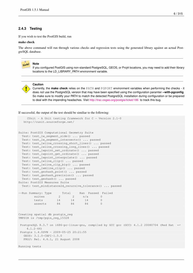
If successful, the output of the test should be similiar to the following:
CUnit - A Unit testing framework for C - Version 2.1-0http://cunit.sourceforge.net/
Suite: PostGIS Computational Geometry SuiteTest: test_lw_segment_side() ... passedTest: test_lw_segment_intersects() ... passedTest: test_lwline_crossing_short_lines() ... passedTest: test_lwline_crossing_long_lines() ... passedTest: test_lwpoint_set_ordinate() ... passedTest: test_lwpoint_get_ordinate() ... passedTest: test_lwpoint_interpolate() ... passedTest: test_lwline_clip() ... passedTest: test_lwline_clip_big() ... passedTest: test_lwmline_clip() ... passedTest: test_geohash_point() ... passedTest: test_geohash_precision() ... passedTest: test_geohash() ... passed
Suite: PostGIS Measures SuiteTest: test_mindistance2d_recursive_tolerance() ... passed
--Run Summary: Type Total Ran Passed Failedsuites 2 2 n/a 0tests 14 14 14 0asserts 84 84 84 0
Creating spatial db postgis_regTMPDIR is /tmp/pgis_reg_15328
PostgreSQL 8.3.7 on i686-pc-linux-gnu, compiled by GCC gcc (GCC) 4.1.2 20080704 (Red Hat ←↩4.1.2-44)
Postgis 1.4.0SVN - 2009-05-25 20:21:55GEOS: 3.1.0-CAPI-1.5.0PROJ: Rel. 4.6.1, 21 August 2008
Running tests
PostGIS 1.5.1 Manual7 / 315
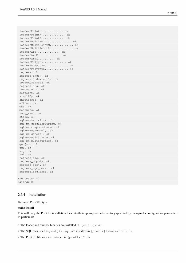
loader/Point.............. okloader/PointM.............. okloader/PointZ.............. okloader/MultiPoint.............. okloader/MultiPointM.............. okloader/MultiPointZ.............. okloader/Arc.............. okloader/ArcM.............. okloader/ArcZ.......... okloader/Polygon.............. okloader/PolygonM.............. okloader/PolygonZ.............. okregress. okregress_index. okregress_index_nulls. oklwgeom_regress. okregress_lrs. okremovepoint. oksetpoint. oksimplify. oksnaptogrid. okaffine. okwkt. okmeasures. oklong_xact. okctors. oksql-mm-serialize. oksql-mm-circularstring. oksql-mm-compoundcurve. oksql-mm-curvepoly. oksql-mm-general. oksql-mm-multicurve. oksql-mm-multisurface. okgeojson. okgml. oksvg. okkml. okregress_ogc. okregress_bdpoly. okregress_proj. okregress_ogc_cover. okregress_ogc_prep. ok
Run tests: 42Failed: 0
2.4.4 Installation
To install PostGIS, type
make install
This will copy the PostGIS installation files into their appropriate subdirectory specified by the --prefix configuration parameter.In particular:
• The loader and dumper binaries are installed in [prefix]/bin.
• The SQL files, such as postgis.sql, are installed in [prefix]/share/contrib.
• The PostGIS libraries are installed in [prefix]/lib.
PostGIS 1.5.1 Manual8 / 315
If you previously ran the make comments command to generate the postgis_comments.sql file, install the sql file byrunning
make comments-install
Notepostgis_comments.sql was separated from the typical build and installation targets since with it comes the extradependency of xsltproc.
2.5 Create a spatially-enabled database
The first step in creating a PostGIS database is to create a simple PostgreSQL database.
createdb [yourdatabase]
Many of the PostGIS functions are written in the PL/pgSQL procedural language. As such, the next step to create a PostGISdatabase is to enable the PL/pgSQL language in your new database. This is accomplish by the command
createlang plpgsql [yourdatabase]
Now load the PostGIS object and function definitions into your database by loading the postgis.sql definitions file (locatedin [prefix]/share/contrib as specified during the configuration step).
psql -d [yourdatabase] -f postgis.sql
For a complete set of EPSG coordinate system definition identifiers, you can also load the spatial_ref_sys.sql definitionsfile and populate the spatial_ref_sys table. This will permit you to perform ST_Transform() operations on geometries.
psql -d [yourdatabase] -f spatial_ref_sys.sql
If you wish to add comments to the PostGIS functions, the final step is to load the postgis_comments.sql into your spatialdatabase. The comments can be viewed by simply typing \dd [function_name] from a psql terminal window.
psql -d [yourdatabase] -f postgis_comments.sql
2.6 Create a spatially-enabled database from a template
Some packaged distributions of PostGIS (in particular the Win32 installers for PostGIS >= 1.1.5) load the PostGIS functionsinto a template database called template_postgis. If the template_postgis database exists in your PostgreSQLinstallation then it is possible for users and/or applications to create spatially-enabled databases using a single command. Notethat in both cases, the database user must have been granted the privilege to create new databases.
From the shell:
# createdb -T template_postgis my_spatial_db
From SQL:
postgres=# CREATE DATABASE my_spatial_db TEMPLATE=template_postgis
2.7 Upgrading
Upgrading existing spatial databases can be tricky as it requires replacement or introduction of new PostGIS object definitions.
Unfortunately not all definitions can be easily replaced in a live database, so sometimes your best bet is a dump/reload process.
PostGIS provides a SOFT UPGRADE procedure for minor or bugfix releases, and an HARD UPGRADE procedure for majorreleases.
Before attempting to upgrade postgis, it is always worth to backup your data. If you use the -Fc flag to pg_dump you will alwaysbe able to restore the dump with an HARD UPGRADE.
PostGIS 1.5.1 Manual9 / 315
2.7.1 Soft upgrade
After compiling you should find several postgis_upgrade*.sql files. Install the one for your version of PostGIS. Forexample postgis_upgrade_13_to_15.sql should be used if you are upgrading from postgis 1.3 to 1.5.
$ psql -f postgis_upgrade_13_to_15.sql -d your_spatial_database
If a soft upgrade is not possible the script will abort and you will be warned about HARD UPGRADE being required, so do nothesitate to try a soft upgrade first.
NoteIf you can’t find the postgis_upgrade*.sql files you are probably using a version prior to 1.1 and must generatethat file by yourself. This is done with the following command:
$ utils/postgis_proc_upgrade.pl postgis.sql > postgis_upgrade.sql
2.7.2 Hard upgrade
By HARD UPGRADE we intend full dump/reload of postgis-enabled databases. You need an HARD UPGRADE when postgisobjects’ internal storage changes or when SOFT UPGRADE is not possible. The Release Notes appendix reports for each versionwhether you need a dump/reload (HARD UPGRADE) to upgrade.
PostGIS provides an utility script to restore a dump produced with the pg_dump -Fc command. It is experimental so redirectingits output to a file will help in case of problems. The procedure is as follow:
Create a "custom-format" dump of the database you want to upgrade (let’s call it "olddb")
$ pg_dump -Fc olddb > olddb.dump
Restore the dump contextually upgrading postgis into a new database. The new database doesn’t have to exist. postgis_restoreaccepts createdb parameters after the dump file name, and that can for instance be used if you are using a non-default characterencoding for your database. Let’s call it "newdb", with UNICODE as the character encoding:
$ sh utils/postgis_restore.pl postgis.sql newdb olddb.dump -E=UNICODE > restore.log
Check that all restored dump objects really had to be restored from dump and do not conflict with the ones defined in postgis.sql
$ grep ^KEEPING restore.log | less
If upgrading from PostgreSQL < 8.0 to >= 8.0 you might want to drop the attrelid, varattnum and stats columns in the geom-etry_columns table, which are no-more needed. Keeping them won’t hurt. DROPPING THEM WHEN REALLY NEEDEDWILL DO HURT !
$ psql newdb -c "ALTER TABLE geometry_columns DROP attrelid"$ psql newdb -c "ALTER TABLE geometry_columns DROP varattnum"$ psql newdb -c "ALTER TABLE geometry_columns DROP stats"
spatial_ref_sys table is restore from the dump, to ensure your custom additions are kept, but the distributed one might containmodification so you should backup your entries, drop the table and source the new one. If you did make additions we assumeyou know how to backup them before upgrading the table. Replace of it with the new one is done like this:
$ psql newdbnewdb=> truncate spatial_ref_sys;TRUNCATEnewdb=> \i spatial_ref_sys.sql
PostGIS 1.5.1 Manual10 / 315
2.8 Common Problems
There are several things to check when your installation or upgrade doesn’t go as you expected.
1. Check that you you have installed PostgreSQL 8.1 or newer, and that you are compiling against the same version of thePostgreSQL source as the version of PostgreSQL that is running. Mix-ups can occur when your (Linux) distribution hasalready installed PostgreSQL, or you have otherwise installed PostgreSQL before and forgotten about it. PostGIS will onlywork with PostgreSQL 8.1 or newer, and strange, unexpected error messages will result if you use an older version. Tocheck the version of PostgreSQL which is running, connect to the database using psql and run this query:
SELECT version();
If you are running an RPM based distribution, you can check for the existence of pre-installed packages using the rpmcommand as follows: rpm -qa | grep postgresql
Also check that configure has correctly detected the location and version of PostgreSQL, the Proj4 library and the GEOS library.
1. The output from configure is used to generate the postgis_config.h file. Check that the POSTGIS_PGSQL_VER-SION, POSTGIS_PROJ_VERSION and POSTGIS_GEOS_VERSION variables have been set correctly.
2.9 JDBC
The JDBC extensions provide Java objects corresponding to the internal PostGIS types. These objects can be used to write Javaclients which query the PostGIS database and draw or do calculations on the GIS data in PostGIS.
1. Enter the java/jdbc sub-directory of the PostGIS distribution.
2. Run the ant command. Copy the postgis.jar file to wherever you keep your java libraries.
The JDBC extensions require a PostgreSQL JDBC driver to be present in the current CLASSPATH during the build process. Ifthe PostgreSQL JDBC driver is located elsewhere, you may pass the location of the JDBC driver JAR separately using the -Dparameter like this:
# ant -Dclasspath=/path/to/postgresql-jdbc.jar
PostgreSQL JDBC drivers can be downloaded from http://jdbc.postgresql.org .
2.10 Loader/Dumper
The data loader and dumper are built and installed automatically as part of the PostGIS build. To build and install them manually:
# cd postgis-1.5.1/loader# make# make install
The loader is called shp2pgsql and converts ESRI Shape files into SQL suitable for loading in PostGIS/PostgreSQL. Thedumper is called pgsql2shp and converts PostGIS tables (or queries) into ESRI Shape files. For more verbose documentation,see the online help, and the manual pages.
PostGIS 1.5.1 Manual11 / 315
Chapter 3
Frequently Asked Questions
1. What kind of geometric objects can I store?
You can store point, line, polygon, multipoint, multiline, multipolygon, and geometrycollections. These are specified in theOpen GIS Well Known Text Format (with XYZ,XYM,XYZM extensions). There are two data types currently supported.The standard OGC geometry data type which uses a planar coordinate system for measurement and the geography datatype which uses a geodetic coordinate system. Only WGS 84 long lat (SRID:4326) is supported by the geography datatype.
2. I’m all confused. Which data store should I use geometry or geography?
Short Answer: geography is a new data type that supports long range distances measurements. If you use geography -- youdon’t need to learn much about planar coordinate systems. Geography is generally best if all you care about is measuringdistances and lengths and you have data from all over the world. Geometry datatype is an older data type that has manyfunctions supporting it and enjoys great support from third party tools. Its best if you are pretty comfortable with spatialreference systems or you are dealing with localized data where all your data fits in a single spatial reference system (SRID),or you need to do a lot of spatial processing. Refer to Section 8.8 to see what is currently supported and what is not. LongAnswer: Refer to our more lengthy discussion in the Section 4.2.2 and function type matrix.
3. I have more intense questions about geography, such as how big of a geographic region can I stuff in a geography columnand still get reasonable answers. Are there limitations such as poles, everything in the field must fit in a hemisphere (likeSQL Server 2008 has), speed etc?
Your questions are too deep and complex to be adequately answered in this section. Please refer to our Section 4.2.3 .
4. How do I insert a GIS object into the database?
First, you need to create a table with a column of type "geometry" or "geography" to hold your GIS data. Storing geographytype data is a little different than storing geometry. Refer to Section 4.2.1 for details on storing geography. For geometry:Connect to your database with psql and try the following SQL:
CREATE TABLE gtest ( ID int4, NAME varchar(20) );SELECT AddGeometryColumn(’’, ’gtest’,’geom’,-1,’LINESTRING’,2);
If the geometry column addition fails, you probably have not loaded the PostGIS functions and objects into this database.See the Section 2.4.Then, you can insert a geometry into the table using a SQL insert statement. The GIS object itself isformatted using the OpenGIS Consortium "well-known text" format:
INSERT INTO gtest (ID, NAME, GEOM)VALUES (1,’First Geometry’,ST_GeomFromText(’LINESTRING(2 3,4 5,6 5,7 8)’, -1)
);
For more information about other GIS objects, see the object reference.To view your GIS data in the table:
PostGIS 1.5.1 Manual12 / 315
SELECT id, name, ST_AsText(geom) AS geom FROM gtest;
The return value should look something like this:
id | name | geom----+----------------+-----------------------------1 | First Geometry | LINESTRING(2 3,4 5,6 5,7 8)
(1 row)
5. How do I construct a spatial query?
The same way you construct any other database query, as an SQL combination of return values, functions, and booleantests.For spatial queries, there are two issues that are important to keep in mind while constructing your query: is there aspatial index you can make use of; and, are you doing expensive calculations on a large number of geometries.In general,you will want to use the "intersects operator" (&&) which tests whether the bounding boxes of features intersect. Thereason the && operator is useful is because if a spatial index is available to speed up the test, the && operator will makeuse of this. This can make queries much much faster.You will also make use of spatial functions, such as Distance(),ST_Intersects(), ST_Contains() and ST_Within(), among others, to narrow down the results of your search. Most spatialqueries include both an indexed test and a spatial function test. The index test serves to limit the number of return tuplesto only tuples that might meet the condition of interest. The spatial functions are then use to test the condition exactly.
SELECT id, the_geomFROM thetableWHEREST_Contains(the_geom,’POLYGON((0 0, 0 10, 10 10, 10 0, 0 0))’);
6. How do I speed up spatial queries on large tables?
Fast queries on large tables is the raison d’etre of spatial databases (along with transaction support) so having a good indexis important.To build a spatial index on a table with a geometry column, use the "CREATE INDEX" function as follows:
CREATE INDEX [indexname] ON [tablename] USING GIST ( [geometrycolumn] );
The "USING GIST" option tells the server to use a GiST (Generalized Search Tree) index.
NoteGiST indexes are assumed to be lossy. Lossy indexes uses a proxy object (in the spatial case, a bounding box)for building the index.
You should also ensure that the PostgreSQL query planner has enough information about your index to make rationaldecisions about when to use it. To do this, you have to "gather statistics" on your geometry tables.For PostgreSQL8.0.x and greater, just run the VACUUM ANALYZE command.For PostgreSQL 7.4.x and below, run the SELECT UP-DATE_GEOMETRY_STATS() command.
7. Why aren’t PostgreSQL R-Tree indexes supported?
Early versions of PostGIS used the PostgreSQL R-Tree indexes. However, PostgreSQL R-Trees have been completelydiscarded since version 0.6, and spatial indexing is provided with an R-Tree-over-GiST scheme.Our tests have shownsearch speed for native R-Tree and GiST to be comparable. Native PostgreSQL R-Trees have two limitations which makethem undesirable for use with GIS features (note that these limitations are due to the current PostgreSQL native R-Treeimplementation, not the R-Tree concept in general):
• R-Tree indexes in PostgreSQL cannot handle features which are larger than 8K in size. GiST indexes can, using the"lossy" trick of substituting the bounding box for the feature itself.
• R-Tree indexes in PostgreSQL are not "null safe", so building an index on a geometry column which contains nullgeometries will fail.

PostGIS 1.5.1 Manual13 / 315
8. Why should I use the AddGeometryColumn() function and all the other OpenGIS stuff?
If you do not want to use the OpenGIS support functions, you do not have to. Simply create tables as in older versions,defining your geometry columns in the CREATE statement. All your geometries will have SRIDs of -1, and the OpenGISmeta-data tables will not be filled in properly. However, this will cause most applications based on PostGIS to fail, and itis generally suggested that you do use AddGeometryColumn() to create geometry tables.MapServer is one applicationwhich makes use of the geometry_columns meta-data. Specifically, MapServer can use the SRID of the geometrycolumn to do on-the-fly reprojection of features into the correct map projection.
9. What is the best way to find all objects within a radius of another object?
To use the database most efficiently, it is best to do radius queries which combine the radius test with a bounding box test:the bounding box test uses the spatial index, giving fast access to a subset of data which the radius test is then applied to.TheST_DWithin(geometry, geometry, distance) function is a handy way of performing an indexed distancesearch. It works by creating a search rectangle large enough to enclose the distance radius, then performing an exactdistance search on the indexed subset of results.For example, to find all objects with 100 meters of POINT(1000 1000) thefollowing query would work well:
SELECT * FROM geotableWHERE ST_DWithin(geocolumn, ’POINT(1000 1000)’, 100.0);
10. How do I perform a coordinate reprojection as part of a query?
To perform a reprojection, both the source and destination coordinate systems must be defined in the SPATIAL_REF_SYStable, and the geometries being reprojected must already have an SRID set on them. Once that is done, a reprojection isas simple as referring to the desired destination SRID. The below projects a geometry to NAD 83 long lat. The below willonly work if the srid of the_geom is not -1 (not undefined spatial ref)
SELECT ST_Transform(the_geom,4269) FROM geotable;
11. I did an ST_AsEWKT and ST_AsText on my rather large geometry and it returned blank field. What gives?
You are probably using PgAdmin or some other tool that doesn’t output large text. If your geometry is big enough, it willappear blank in these tools. Use PSQL if you really need to see it or output it in WKT.
--To check number of geometries are really blankSELECT count(gid) FROM geotable WHERE the_geom IS NULL;
12. When I do an ST_Intersects, it says my two geometries don’t intersect when I KNOW THEY DO. What gives?
This generally happens in two common cases. Your geometry is invalid -- check ST_IsValid or you are assuming theyintersect because ST_AsText truncates the numbers and you have lots of decimals after it is not showing you.
PostGIS 1.5.1 Manual14 / 315
Chapter 4
Using PostGIS: Data Management and Queries
4.1 GIS Objects
The GIS objects supported by PostGIS are a superset of the "Simple Features" defined by the OpenGIS Consortium (OGC). Asof version 0.9, PostGIS supports all the objects and functions specified in the OGC "Simple Features for SQL" specification.
PostGIS extends the standard with support for 3DZ,3DM and 4D coordinates.
4.1.1 OpenGIS WKB and WKT
The OpenGIS specification defines two standard ways of expressing spatial objects: the Well-Known Text (WKT) form and theWell-Known Binary (WKB) form. Both WKT and WKB include information about the type of the object and the coordinateswhich form the object.
Examples of the text representations (WKT) of the spatial objects of the features are as follows:
• POINT(0 0)
• LINESTRING(0 0,1 1,1 2)
• POLYGON((0 0,4 0,4 4,0 4,0 0),(1 1, 2 1, 2 2, 1 2,1 1))
• MULTIPOINT(0 0,1 2)
• MULTILINESTRING((0 0,1 1,1 2),(2 3,3 2,5 4))
• MULTIPOLYGON(((0 0,4 0,4 4,0 4,0 0),(1 1,2 1,2 2,1 2,1 1)), ((-1 -1,-1 -2,-2 -2,-2 -1,-1 -1)))
• GEOMETRYCOLLECTION(POINT(2 3),LINESTRING(2 3,3 4))
The OpenGIS specification also requires that the internal storage format of spatial objects include a spatial referencing systemidentifier (SRID). The SRID is required when creating spatial objects for insertion into the database.
Input/Output of these formats are available using the following interfaces:
bytea WKB = ST_AsBinary(geometry);text WKT = ST_AsText(geometry);geometry = ST_GeomFromWKB(bytea WKB, SRID);geometry = ST_GeometryFromText(text WKT, SRID);
For example, a valid insert statement to create and insert an OGC spatial object would be:
INSERT INTO geotable ( the_geom, the_name )VALUES ( ST_GeomFromText(’POINT(-126.4 45.32)’, 312), ’A Place’);
PostGIS 1.5.1 Manual15 / 315
4.1.2 PostGIS EWKB, EWKT and Canonical Forms
OGC formats only support 2d geometries, and the associated SRID is *never* embedded in the input/output representations.
PostGIS extended formats are currently superset of OGC one (every valid WKB/WKT is a valid EWKB/EWKT) but this mightvary in the future, specifically if OGC comes out with a new format conflicting with our extensions. Thus you SHOULD NOTrely on this feature!
PostGIS EWKB/EWKT add 3dm,3dz,4d coordinates support and embedded SRID information.
Examples of the text representations (EWKT) of the extended spatial objects of the features are as follows:
• POINT(0 0 0) -- XYZ
• SRID=32632;POINT(0 0) -- XY with SRID
• POINTM(0 0 0) -- XYM
• POINT(0 0 0 0) -- XYZM
• SRID=4326;MULTIPOINTM(0 0 0,1 2 1) -- XYM with SRID
• MULTILINESTRING((0 0 0,1 1 0,1 2 1),(2 3 1,3 2 1,5 4 1))
• POLYGON((0 0 0,4 0 0,4 4 0,0 4 0,0 0 0),(1 1 0,2 1 0,2 2 0,1 2 0,1 1 0))
• MULTIPOLYGON(((0 0 0,4 0 0,4 4 0,0 4 0,0 0 0),(1 1 0,2 1 0,2 2 0,1 2 0,1 1 0)),((-1 -1 0,-1 -2 0,-2 -2 0,-2 -1 0,-1 -1 0)))
• GEOMETRYCOLLECTIONM(POINTM(2 3 9), LINESTRINGM(2 3 4, 3 4 5))
Input/Output of these formats are available using the following interfaces:
bytea EWKB = ST_AsEWKB(geometry);text EWKT = ST_AsEWKT(geometry);geometry = ST_GeomFromEWKB(bytea EWKB);geometry = ST_GeomFromEWKT(text EWKT);
For example, a valid insert statement to create and insert a PostGIS spatial object would be:
INSERT INTO geotable ( the_geom, the_name )VALUES ( ST_GeomFromEWKT(’SRID=312;POINTM(-126.4 45.32 15)’), ’A Place’ )
The "canonical forms" of a PostgreSQL type are the representations you get with a simple query (without any function call) andthe one which is guaranteed to be accepted with a simple insert, update or copy. For the postgis ’geometry’ type these are:
- Output- binary: EWKBascii: HEXEWKB (EWKB in hex form)
- Input- binary: EWKBascii: HEXEWKB|EWKT
For example this statement reads EWKT and returns HEXEWKB in the process of canonical ascii input/output:
=# SELECT ’SRID=4;POINT(0 0)’::geometry;
geometry----------------------------------------------------01010000200400000000000000000000000000000000000000(1 row)
PostGIS 1.5.1 Manual16 / 315
4.1.3 SQL-MM Part 3
The SQL Multimedia Applications Spatial specification extends the simple features for SQL spec by defining a number ofcircularly interpolated curves.
The SQL-MM definitions include 3dm, 3dz and 4d coordinates, but do not allow the embedding of SRID information.
The well-known text extensions are not yet fully supported. Examples of some simple curved geometries are shown below:
• CIRCULARSTRING(0 0, 1 1, 1 0)
CIRCULARSTRING(0 0, 4 0, 4 4, 0 4, 0 0)
The CIRCULARSTRING is the basic curve type, similar to a LINESTRING in the linear world. A single segment requiredthree points, the start and end points (first and third) and any other point on the arc. The exception to this is for a closed circle,where the start and end points are the same. In this case the second point MUST be the center of the arc, ie the oppositeside of the circle. To chain arcs together, the last point of the previous arc becomes the first point of the next arc, just like inLINESTRING. This means that a valid circular string must have an odd number of points greated than 1.
• COMPOUNDCURVE(CIRCULARSTRING(0 0, 1 1, 1 0),(1 0, 0 1))
A compound curve is a single, continuous curve that has both curved (circular) segments and linear segments. That means thatin addition to having well-formed components, the end point of every component (except the last) must be coincident with thestart point of the following component.
• CURVEPOLYGON(CIRCULARSTRING(0 0, 4 0, 4 4, 0 4, 0 0),(1 1, 3 3, 3 1, 1 1))
Example compound curve in a curve polygon: CURVEPOLYGON(COMPOUNDCURVE(CIRCULARSTRING(0 0,2 0, 2 1,2 3, 4 3),(4 3, 4 5, 1 4, 0 0)), CIRCULARSTRING(1.7 1, 1.4 0.4, 1.6 0.4, 1.6 0.5, 1.7 1) )
A CURVEPOLYGON is just like a polygon, with an outer ring and zero or more inner rings. The difference is that a ring cantake the form of a circular string, linear string or compound string.
As of PostGIS 1.4 PostGIS supports compound curves in a curve polygon.
• MULTICURVE((0 0, 5 5),CIRCULARSTRING(4 0, 4 4, 8 4))
The MULTICURVE is a collection of curves, which can include linear strings, circular strings or compound strings.
• MULTISURFACE(CURVEPOLYGON(CIRCULARSTRING(0 0, 4 0, 4 4, 0 4, 0 0),(1 1, 3 3, 3 1, 1 1)),((10 10, 14 12, 11 10,10 10),(11 11, 11.5 11, 11 11.5, 11 11)))
This is a collection of surfaces, which can be (linear) polygons or curve polygons.
NotePostGIS prior to 1.4 does not support compound curves in a curve polygon, but PostGIS 1.4 and above do support theuse of Compound Curves in a Curve Polygon.
NoteAll floating point comparisons within the SQL-MM implementation are performed to a specified tolerance, currently1E-8.
4.2 PostGIS Geography Type
The geography type provides native support for spatial features represented on "geographic" coordinates (sometimes called"geodetic" coordinates, or "lat/lon", or "lon/lat"). Geographic coordinates are spherical coordinates expressed in angular units(degrees).
PostGIS 1.5.1 Manual17 / 315
The basis for the PostGIS geometry type is a plane. The shortest path between two points on the plane is a straight line. Thatmeans calculations on geometries (areas, distances, lengths, intersections, etc) can be calculated using cartesian mathematics andstraight line vectors.
The basis for the PostGIS geographic type is a sphere. The shortest path between two points on the sphere is a great circle arc.That means that calculations on geographies (areas, distances, lengths, intersections, etc) must be calculated on the sphere, usingmore complicated mathematics. For more accurate measurements, the calculations must take the actual spheroidal shape of theworld into account, and the mathematics becomes very complicated indeed.
Because the underlying mathematics is much more complicated, there are fewer functions defined for the geography type thanfor the geometry type. Over time, as new algorithms are added, the capabilities of the geography type will expand.
One restriction is that it only supports WGS 84 long lat (SRID:4326). It uses a new data type called geography. I None of theGEOS functions support this new type. As a workaround one can convert back and forth between geometry and geography types.
The new geography type uses the PostgreSQL 8.3+ typmod definition format so that a table with a geography field can be addedin a single step. All the standard OGC formats except for curves are supported.
4.2.1 Geography Basics
The geography type only supports the simplest of simple features. Standard geometry type data will autocast to geography if itis of SRID 4326. You can also use the EWKT and EWKB conventions to insert data.
• POINT: Creating a table with 2d point geometry:
CREATE TABLE testgeog(gid serial PRIMARY KEY, the_geog geography(POINT,4326) );
Creating a table with z coordinate point
CREATE TABLE testgeog(gid serial PRIMARY KEY, the_geog geography(POINTZ,4326) );
• LINESTRING
• POLYGON
• MULTIPOINT
• MULTILINESTRING
• MULTIPOLYGON
• GEOMETRYCOLLECTION
The new geography fields don’t get registered in the geometry_columns. They get registered in a new view called geogra-phy_columns which is a view against the system catalogs so is always automatically kept up to date without need for an Ad-dGeom... like function.
Now, check the "geography_columns" view and see that your table is listed.
You can create a new table with a GEOGRAPHY column using the CREATE TABLE syntax. Unlike GEOMETRY, there is noneed to run a separate AddGeometryColumns() process to register the column in metadata.
CREATE TABLE global_points (id SERIAL PRIMARY KEY,name VARCHAR(64),location GEOGRAPHY(POINT,4326)
);
Note that the location column has type GEOGRAPHY and that geography type supports two optional modifier: a type modifierthat restricts the kind of shapes and dimensions allowed in the column; an SRID modifier that restricts the coordinate referenceidentifier to a particular number.
PostGIS 1.5.1 Manual18 / 315
Allowable values for the type modifier are: POINT, LINESTRING, POLYGON, MULTIPOINT, MULTILINESTRING, MUL-TIPOLYGON. The modifier also supports dimensionality restrictions through suffixes: Z, M and ZM. So, for example a modifierof ’LINESTRINGM’ would only allow line strings with three dimensions in, and would treat the third dimension as a measure.Similarly, ’POINTZM’ would expect four dimensional data.
The SRID modifier is currently of limited use: only 4326 (WGS84) is allowed as a value. If you do not specify an SRID, the avalue 0 (undefined spheroid) will be used, and all calculations will proceed using WGS84 anyways.
In the future, alternate SRIDs will allow calculations on spheroids other than WGS84.
Once you have created your table, you can see it in the GEOGRAPHY_COLUMNS table:
-- See the contents of the metadata viewSELECT * FROM geography_columns;
You can insert data into the table the same as you would if it was using a GEOMETRY column:
-- Add some data into the test tableINSERT INTO global_points (name, location) VALUES (’Town’, ST_GeographyFromText(’SRID=4326; ←↩
POINT(-110 30)’) );INSERT INTO global_points (name, location) VALUES (’Forest’, ST_GeographyFromText(’SRID ←↩
=4326;POINT(-109 29)’) );INSERT INTO global_points (name, location) VALUES (’London’, ST_GeographyFromText(’SRID ←↩
=4326;POINT(0 49)’) );
Creating an index works the same as GEOMETRY. PostGIS will note that the column type is GEOGRAPHY and create anappropriate sphere-based index instead of the usual planar index used for GEOMETRY.
-- Index the test table with a spherical indexCREATE INDEX global_points_gix ON global_points USING GIST ( location );
Query and measurement functions use units of meters. So distance parameters should be expressed in meters, and return valuesshould be expected in meters (or square meters for areas).
-- Show a distance query and note, London is outside the 1000km toleranceSELECT name FROM global_points WHERE ST_DWithin(location, ST_GeographyFromText(’SRID ←↩
=4326;POINT(-110 29)’), 1000000);
You can see the power of GEOGRAPHY in action by calculating the how close a plane flying from Seattle to London (LINESTRING(-122.33 47.606, 0.0 51.5)) comes to Reykjavik (POINT(-21.96 64.15)).
-- Distance calculation using GEOGRAPHY (122.2km)SELECT ST_Distance(’LINESTRING(-122.33 47.606, 0.0 51.5)’::geography, ’POINT(-21.96 ←↩
64.15)’:: geography);
-- Distance calculation using GEOMETRY (13.3 "degrees")SELECT ST_Distance(’LINESTRING(-122.33 47.606, 0.0 51.5)’::geometry, ’POINT(-21.96 64.15) ←↩
’:: geometry);
The GEOGRAPHY type calculates the true shortest distance over the sphere between Reykjavik and the great circle flight pathbetween Seattle and London.
Great Circle mapper The GEOMETRY type calculates a meaningless cartesian distance between Reykjavik and the straight linepath from Seattle to London plotted on a flat map of the world. The nominal units of the result might be called "degrees", but theresult doesn’t correspond to any true angular difference between the points, so even calling them "degrees" is inaccurate.
4.2.2 When to use Geography Data type over Geometry data type
The new GEOGRAPHY type allows you to store data in longitude/latitude coordinates, but at a cost: there are fewer functionsdefined on GEOGRAPHY than there are on GEOMETRY; those functions that are defined take more CPU time to execute.
The type you choose should be conditioned on the expected working area of the application you are building. Will your dataspan the globe or a large continental area, or is it local to a state, county or municipality?
PostGIS 1.5.1 Manual19 / 315
• If your data is contained in a small area, you might find that choosing an appropriate projection and using GEOMETRY is thebest solution, in terms of performance and functionality available.
• If your data is global or covers a continental region, you may find that GEOGRAPHY allows you to build a system withouthaving to worry about projection details. You store your data in longitude/latitude, and use the functions that have been definedon GEOGRAPHY.
• If you don’t understand projections, and you don’t want to learn about them, and you’re prepared to accept the limitations infunctionality available in GEOGRAPHY, then it might be easier for you to use GEOGRAPHY than GEOMETRY. Simply loadyour data up as longitude/latitude and go from there.
Refer to Section 8.8 for compare between what is supported for Geography vs. Geometry. For a brief listing and description ofGeography functions, refer to Section 8.3
4.2.3 Geography Advanced FAQ
1. Do you calculate on the sphere or the spheroid?
By default, all distance and area calculations are done on the spheroid. You should find that the results of calculations inlocal areas match up will with local planar results in good local projections. Over larger areas, the spheroidal calculationswill be more accurate than any calculation done on a projected plane. All the geography functions have the option ofusing a sphere calculation, by setting a final boolean parameter to ’FALSE’. This will somewhat speed up calculations,particularly for cases where the geometries are very simple.
2. What about the date-line and the poles?
All the calculations have no conception of date-line or poles, the coordinates are spherical (longitude/latitude) so a shapethat crosses the dateline is, from a calculation point of view, no different from any other shape.
3. What is the longest arc you can process?
We use great circle arcs as the "interpolation line" between two points. That means any two points are actually joined uptwo ways, depending on which direction you travel along the great circle. All our code assumes that the points are joinedby the *shorter* of the two paths along the great circle. As a consequence, shapes that have arcs of more than 180 degreeswill not be correctly modelled.
4. Why is it so slow to calculate the area of Europe / Russia / insert big geographic region here ?
Because the polygon is so darned huge! Big areas are bad for two reasons: their bounds are huge, so the index tends to pullthe feature no matter what query you run; the number of vertices is huge, and tests (distance, containment) have to traversethe vertex list at least once and sometimes N times (with N being the number of vertices in the other candidate feature).As with GEOMETRY, we recommend that when you have very large polygons, but are doing queries in small areas, you"denormalize" your geometric data into smaller chunks so that the index can effectively subquery parts of the object andso queries don’t have to pull out the whole object every time. Just because you *can* store all of Europe in one polygondoesn’t mean you *should*.
4.3 Using OpenGIS Standards
The OpenGIS "Simple Features Specification for SQL" defines standard GIS object types, the functions required to manipulatethem, and a set of meta-data tables. In order to ensure that meta-data remain consistent, operations such as creating and removinga spatial column are carried out through special procedures defined by OpenGIS.
There are two OpenGIS meta-data tables: SPATIAL_REF_SYS and GEOMETRY_COLUMNS. The SPATIAL_REF_SYS tableholds the numeric IDs and textual descriptions of coordinate systems used in the spatial database.
PostGIS 1.5.1 Manual20 / 315
4.3.1 The SPATIAL_REF_SYS Table and Spatial Reference Systems
The spatial_ref_sys table is a PostGIS included and OGC compliant database table that lists over 3000 known spatial referencesystems and details needed to transform/reproject between them.
Although the PostGIS spatial_ref_sys table contains over 3000 of the more commonly used spatial reference system definitionsthat can be handled by the proj library, it does not contain all known to man and you can even define your own custom projectionif you are familiar with proj4 constructs. Keep in mind that most spatial reference systems are regional and have no meaningwhen used outside of the bounds they were intended for.
An excellent resource for finding spatial reference systems not defined in the core set is http://spatialreference.org/
Some of the more commonly used spatial reference systems are: 4326 - WGS 84 Long Lat, 4269 - NAD 83 Long Lat, 3395 -WGS 84 World Mercator, 2163 - US National Atlas Equal Area, Spatial reference systems for each NAD 83, WGS 84 UTMzone - UTM zones are one of the most ideal for measurement, but only cover 6-degree regions.
Various US state plane spatial reference systems (meter or feet based) - usually one or 2 exists per US state. Most of the meterones are in the core set, but many of the feet based ones or ESRI created ones you will need to pull from spatialreference.org.
For details on determining which UTM zone to use for your area of interest, check out the utmzone PostGIS plpgsql helperfunction.
The SPATIAL_REF_SYS table definition is as follows:
CREATE TABLE spatial_ref_sys (srid INTEGER NOT NULL PRIMARY KEY,auth_name VARCHAR(256),auth_srid INTEGER,srtext VARCHAR(2048),proj4text VARCHAR(2048)
)
The SPATIAL_REF_SYS columns are as follows:
SRID An integer value that uniquely identifies the Spatial Referencing System (SRS) within the database.
AUTH_NAME The name of the standard or standards body that is being cited for this reference system. For example, "EPSG"would be a valid AUTH_NAME.
AUTH_SRID The ID of the Spatial Reference System as defined by the Authority cited in the AUTH_NAME. In the case ofEPSG, this is where the EPSG projection code would go.
SRTEXT The Well-Known Text representation of the Spatial Reference System. An example of a WKT SRS representation is:
PROJCS["NAD83 / UTM Zone 10N",GEOGCS["NAD83",DATUM["North_American_Datum_1983",SPHEROID["GRS 1980",6378137,298.257222101]
],PRIMEM["Greenwich",0],UNIT["degree",0.0174532925199433]],PROJECTION["Transverse_Mercator"],PARAMETER["latitude_of_origin",0],PARAMETER["central_meridian",-123],PARAMETER["scale_factor",0.9996],PARAMETER["false_easting",500000],PARAMETER["false_northing",0],UNIT["metre",1]
]
For a listing of EPSG projection codes and their corresponding WKT representations, see http://www.opengeospatial.org/.For a discussion of WKT in general, see the OpenGIS "Coordinate Transformation Services Implementation Specification"at http://www.opengeospatial.org/standards. For information on the European Petroleum Survey Group (EPSG) and theirdatabase of spatial reference systems, see http://www.epsg.org.
PostGIS 1.5.1 Manual21 / 315
PROJ4TEXT PostGIS uses the Proj4 library to provide coordinate transformation capabilities. The PROJ4TEXT columncontains the Proj4 coordinate definition string for a particular SRID. For example:
+proj=utm +zone=10 +ellps=clrk66 +datum=NAD27 +units=m
For more information about, see the Proj4 web site at http://trac.osgeo.org/proj/. The spatial_ref_sys.sql filecontains both SRTEXT and PROJ4TEXT definitions for all EPSG projections.
4.3.2 The GEOMETRY_COLUMNS Table
The GEOMETRY_COLUMNS table definition is as follows:
CREATE TABLE geometry_columns (f_table_catalog VARRCHAR(256) NOT NULL,f_table_schema VARCHAR(256) NOT NULL,f_table_nam VARCHAR(256) NOT NULL,f_geometry_column VARCHAR(256) NOT NULL,coord_dimension INTEGER NOT NULL,srid INTEGER NOT NULL,type VARCHAR(30) NOT NULL
)
The columns are as follows:
F_TABLE_CATALOG, F_TABLE_SCHEMA, F_TABLE_NAME The fully qualified name of the feature table containingthe geometry column. Note that the terms "catalog" and "schema" are Oracle-ish. There is not PostgreSQL analogue of"catalog" so that column is left blank -- for "schema" the PostgreSQL schema name is used (public is the default).
F_GEOMETRY_COLUMN The name of the geometry column in the feature table.
COORD_DIMENSION The spatial dimension (2, 3 or 4 dimensional) of the column.
SRID The ID of the spatial reference system used for the coordinate geometry in this table. It is a foreign key reference to theSPATIAL_REF_SYS.
TYPE The type of the spatial object. To restrict the spatial column to a single type, use one of: POINT, LINESTRING, POLY-GON, MULTIPOINT, MULTILINESTRING, MULTIPOLYGON, GEOMETRYCOLLECTION or corresponding XYMversions POINTM, LINESTRINGM, POLYGONM, MULTIPOINTM, MULTILINESTRINGM, MULTIPOLYGONM,GEOMETRYCOLLECTIONM. For heterogeneous (mixed-type) collections, you can use "GEOMETRY" as the type.
NoteThis attribute is (probably) not part of the OpenGIS specification, but is required for ensuring type homogeneity.
4.3.3 Creating a Spatial Table
Creating a table with spatial data is done in two stages:
• Create a normal non-spatial table.
For example: CREATE TABLE ROADS_GEOM ( ID int4, NAME varchar(25) )
• Add a spatial column to the table using the OpenGIS "AddGeometryColumn" function.
The syntax is:
PostGIS 1.5.1 Manual22 / 315
AddGeometryColumn(<schema_name>,<table_name>,<column_name>,<srid>,<type>,<dimension>
)
Or, using current schema:
AddGeometryColumn(<table_name>,<column_name>,<srid>,<type>,<dimension>
)
Example1: SELECT AddGeometryColumn(’public’, ’roads_geom’, ’geom’, 423, ’LINESTRING’, 2)Example2: SELECT AddGeometryColumn( ’roads_geom’, ’geom’, 423, ’LINESTRING’, 2)
Here is an example of SQL used to create a table and add a spatial column (assuming that an SRID of 128 exists already):
CREATE TABLE parks (park_id INTEGER,park_name VARCHAR,park_date DATE,park_type VARCHAR
);SELECT AddGeometryColumn(’parks’, ’park_geom’, 128, ’MULTIPOLYGON’, 2 );
Here is another example, using the generic "geometry" type and the undefined SRID value of -1:
CREATE TABLE roads (road_id INTEGER,road_name VARCHAR
);SELECT AddGeometryColumn( ’roads’, ’roads_geom’, -1, ’GEOMETRY’, 3 );
4.3.4 Manually Registering Geometry Columns in geometry_columns
The AddGeometryColumn() approach creates a geometry column and also registers the new column in the geometry_columnstable. If your software utilizes geometry_columns, then any geometry columns you need to query by must be registered inthis table. Two of the cases where you want a geometry column to be registered in the geometry_columns table, but you can’tuse AddGeometryColumn, is in the case of SQL Views and bulk inserts. For these cases, you must register the column in thegeometry_columns table manually. Below is a simple script to do that.
--Lets say you have a view created like thisCREATE VIEW public.vwmytablemercator ASSELECT gid, ST_Transform(the_geom,3395) As the_geom, f_nameFROM public.mytable;
--To register this table in AddGeometry columns - do the followingINSERT INTO geometry_columns(f_table_catalog, f_table_schema, f_table_name, ←↩
f_geometry_column, coord_dimension, srid, "type")SELECT ’’, ’public’, ’vwmytablemercator’, ’the_geom’, ST_CoordDim(the_geom), ST_SRID( ←↩
the_geom), GeometryType(the_geom)FROM public.vwmytablemercator LIMIT 1;
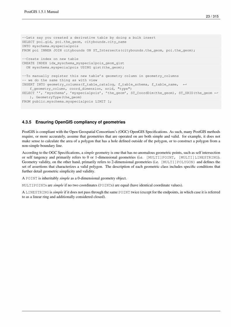
PostGIS 1.5.1 Manual23 / 315
--Lets say you created a derivative table by doing a bulk insertSELECT poi.gid, poi.the_geom, citybounds.city_nameINTO myschema.myspecialpoisFROM poi INNER JOIN citybounds ON ST_Intersects(citybounds.the_geom, poi.the_geom);
--Create index on new tableCREATE INDEX idx_myschema_myspecialpois_geom_gistON myschema.myspecialpois USING gist(the_geom);
--To manually register this new table’s geometry column in geometry_columns-- we do the same thing as with viewINSERT INTO geometry_columns(f_table_catalog, f_table_schema, f_table_name, ←↩
f_geometry_column, coord_dimension, srid, "type")SELECT ’’, ’myschema’, ’myspecialpois’, ’the_geom’, ST_CoordDim(the_geom), ST_SRID(the_geom ←↩
), GeometryType(the_geom)FROM public.myschema.myspecialpois LIMIT 1;
4.3.5 Ensuring OpenGIS compliancy of geometries
PostGIS is compliant with the Open Geospatial Consortium’s (OGC) OpenGIS Specifications. As such, many PostGIS methodsrequire, or more accurately, assume that geometries that are operated on are both simple and valid. for example, it does notmake sense to calculate the area of a polygon that has a hole defined outside of the polygon, or to construct a polygon from anon-simple boundary line.
According to the OGC Specifications, a simple geometry is one that has no anomalous geometric points, such as self intersectionor self tangency and primarily refers to 0 or 1-dimensional geometries (i.e. [MULTI]POINT, [MULTI]LINESTRING).Geometry validity, on the other hand, primarily refers to 2-dimensional geometries (i.e. [MULTI]POLYGON) and defines theset of assertions that characterizes a valid polygon. The description of each geometric class includes specific conditions thatfurther detail geometric simplicity and validity.
A POINT is inheritably simple as a 0-dimensional geometry object.
MULTIPOINTs are simple if no two coordinates (POINTs) are equal (have identical coordinate values).
A LINESTRING is simple if it does not pass through the same POINT twice (except for the endpoints, in which case it is referredto as a linear ring and additionally considered closed).
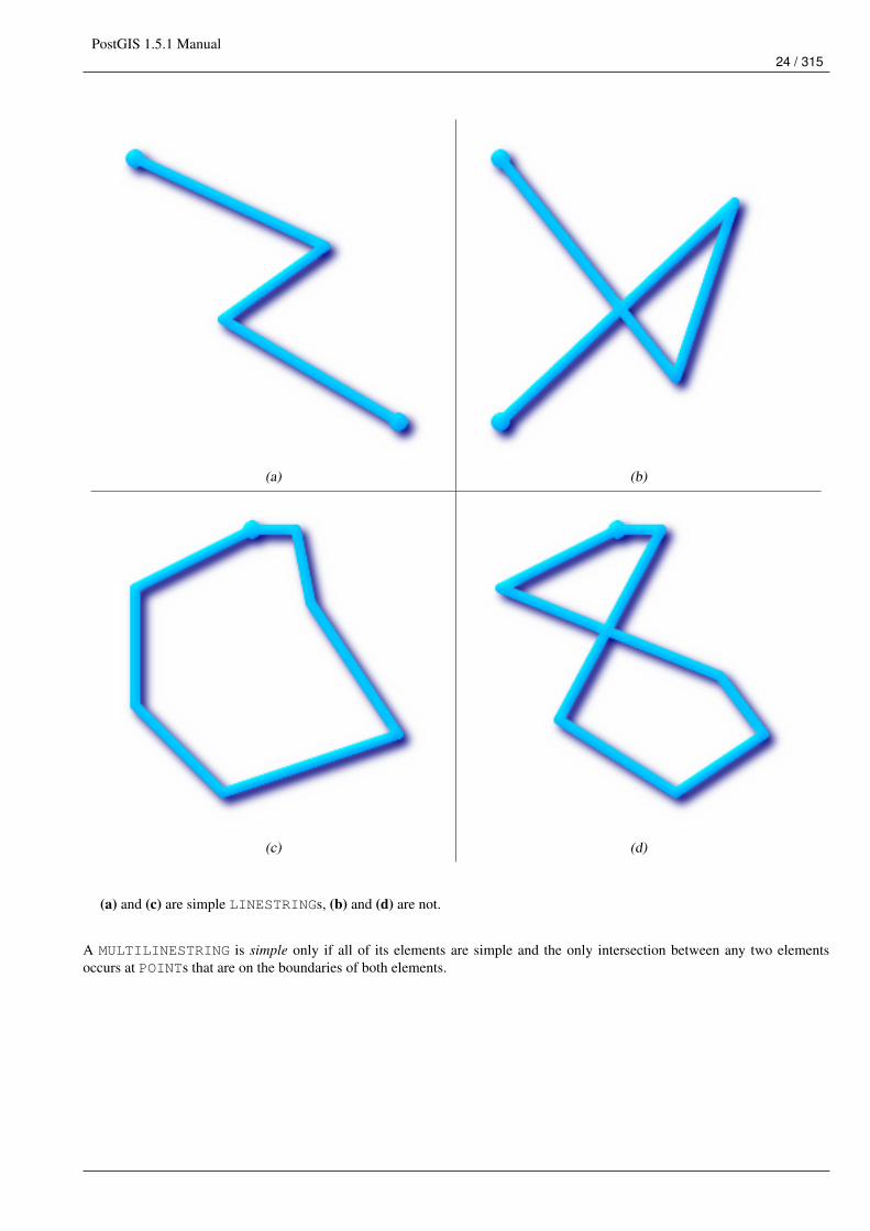
PostGIS 1.5.1 Manual24 / 315
(a) (b)
(c) (d)
(a) and (c) are simple LINESTRINGs, (b) and (d) are not.
A MULTILINESTRING is simple only if all of its elements are simple and the only intersection between any two elementsoccurs at POINTs that are on the boundaries of both elements.
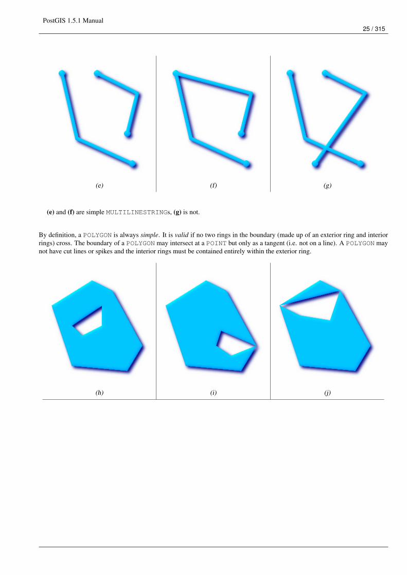
PostGIS 1.5.1 Manual25 / 315
(e) (f) (g)
(e) and (f) are simple MULTILINESTRINGs, (g) is not.
By definition, a POLYGON is always simple. It is valid if no two rings in the boundary (made up of an exterior ring and interiorrings) cross. The boundary of a POLYGON may intersect at a POINT but only as a tangent (i.e. not on a line). A POLYGON maynot have cut lines or spikes and the interior rings must be contained entirely within the exterior ring.
(h) (i) (j)
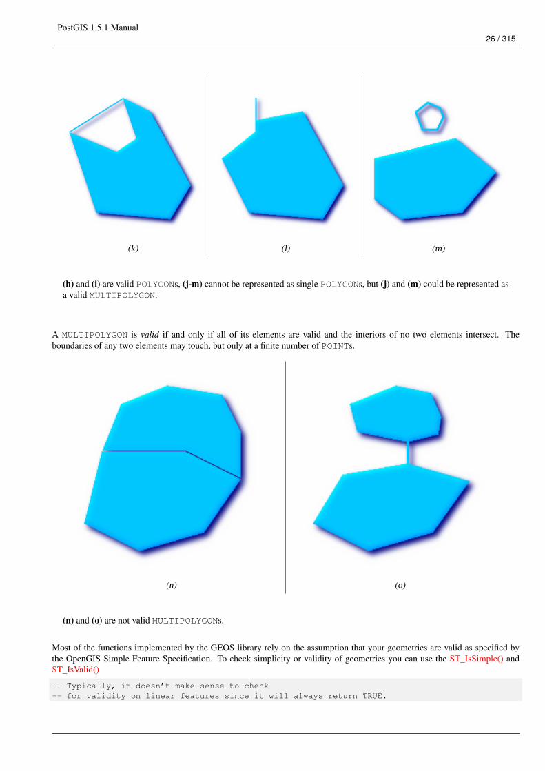
PostGIS 1.5.1 Manual26 / 315
(k) (l) (m)
(h) and (i) are valid POLYGONs, (j-m) cannot be represented as single POLYGONs, but (j) and (m) could be represented asa valid MULTIPOLYGON.
A MULTIPOLYGON is valid if and only if all of its elements are valid and the interiors of no two elements intersect. Theboundaries of any two elements may touch, but only at a finite number of POINTs.
(n) (o)
(n) and (o) are not valid MULTIPOLYGONs.
Most of the functions implemented by the GEOS library rely on the assumption that your geometries are valid as specified bythe OpenGIS Simple Feature Specification. To check simplicity or validity of geometries you can use the ST_IsSimple() andST_IsValid()
-- Typically, it doesn’t make sense to check-- for validity on linear features since it will always return TRUE.
PostGIS 1.5.1 Manual27 / 315
-- But in this example, PostGIS extends the definition of the OGC IsValid-- by returning false if a LinearRing (start and end points are the same)-- has less than 2 vertices.gisdb=# SELECT
ST_IsValid(’LINESTRING(0 0, 1 1)’),ST_IsValid(’LINESTRING(0 0, 0 0)’);
st_isvalid | st_isvalid------------+-----------
t | f
By default, PostGIS does not apply this validity check on geometry input, because testing for validity needs lots of CPU time forcomplex geometries, especially polygons. If you do not trust your data sources, you can manually enforce such a check to yourtables by adding a check constraint:
ALTER TABLE mytableADD CONSTRAINT geometry_valid_checkCHECK (ST_IsValid(the_geom));
If you encounter any strange error messages such as "GEOS Intersection() threw an error!" or "JTS Intersection() threw an error!"when calling PostGIS functions with valid input geometries, you likely found an error in either PostGIS or one of the librariesit uses, and you should contact the PostGIS developers. The same is true if a PostGIS function returns an invalid geometry forvalid input.
NoteStrictly compliant OGC geometries cannot have Z or M values. The ST_IsValid() function won’t consider higher dimen-sioned geometries invalid! Invocations of AddGeometryColumn() will add a constraint checking geometry dimensions,so it is enough to specify 2 there.
4.3.6 Dimensionally Extended 9 Intersection Model (DE-9IM)
It is sometimes the case that the typical spatial predicates (ST_Contains, ST_Crosses, ST_Intersects, ST_Touches, ...) areinsufficient in and of themselves to adequately provide that desired spatial filter.

PostGIS 1.5.1 Manual28 / 315
For example, consider a linear dataset representing a road network. It may be the task of a GIS analyst to identify all roadsegments that cross each other, not at a point, but on a line, perhaps invalidating some business rule. In this case,ST_Crosses does not adequately provide the necessary spatial filter since, for linear features, it returns true only wherethey cross at a point.One two-step solution might be to first perform the actual intersection (ST_Intersection) of pairs of road segments thatspatially intersect (ST_Intersects), and then compare the intersection’s ST_GeometryType with ’LINESTRING’ (properlydealing with cases that return GEOMETRYCOLLECTIONs of [MULTI]POINTs, [MULTI]LINESTRINGs, etc.).A more elegant / faster solution may indeed be desirable.
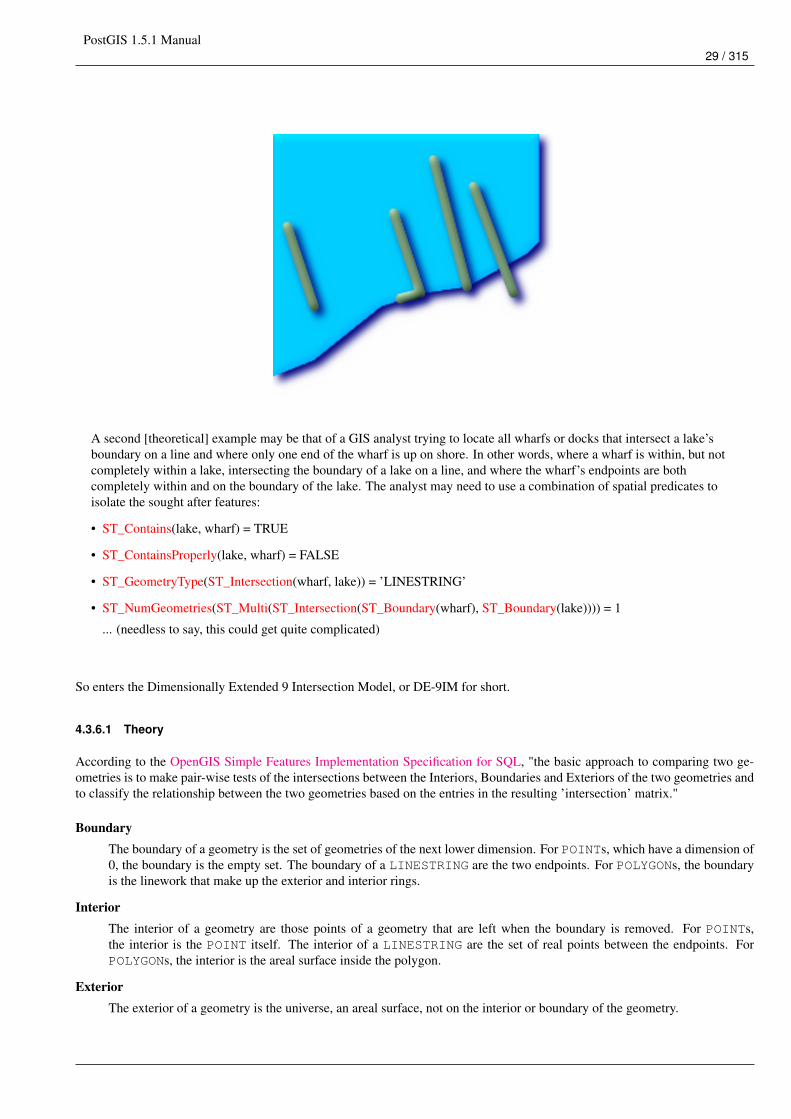
PostGIS 1.5.1 Manual29 / 315
A second [theoretical] example may be that of a GIS analyst trying to locate all wharfs or docks that intersect a lake’sboundary on a line and where only one end of the wharf is up on shore. In other words, where a wharf is within, but notcompletely within a lake, intersecting the boundary of a lake on a line, and where the wharf’s endpoints are bothcompletely within and on the boundary of the lake. The analyst may need to use a combination of spatial predicates toisolate the sought after features:
• ST_Contains(lake, wharf) = TRUE
• ST_ContainsProperly(lake, wharf) = FALSE
• ST_GeometryType(ST_Intersection(wharf, lake)) = ’LINESTRING’
• ST_NumGeometries(ST_Multi(ST_Intersection(ST_Boundary(wharf), ST_Boundary(lake)))) = 1
... (needless to say, this could get quite complicated)
So enters the Dimensionally Extended 9 Intersection Model, or DE-9IM for short.
4.3.6.1 Theory
According to the OpenGIS Simple Features Implementation Specification for SQL, "the basic approach to comparing two ge-ometries is to make pair-wise tests of the intersections between the Interiors, Boundaries and Exteriors of the two geometries andto classify the relationship between the two geometries based on the entries in the resulting ’intersection’ matrix."
BoundaryThe boundary of a geometry is the set of geometries of the next lower dimension. For POINTs, which have a dimension of0, the boundary is the empty set. The boundary of a LINESTRING are the two endpoints. For POLYGONs, the boundaryis the linework that make up the exterior and interior rings.
InteriorThe interior of a geometry are those points of a geometry that are left when the boundary is removed. For POINTs,the interior is the POINT itself. The interior of a LINESTRING are the set of real points between the endpoints. ForPOLYGONs, the interior is the areal surface inside the polygon.
ExteriorThe exterior of a geometry is the universe, an areal surface, not on the interior or boundary of the geometry.
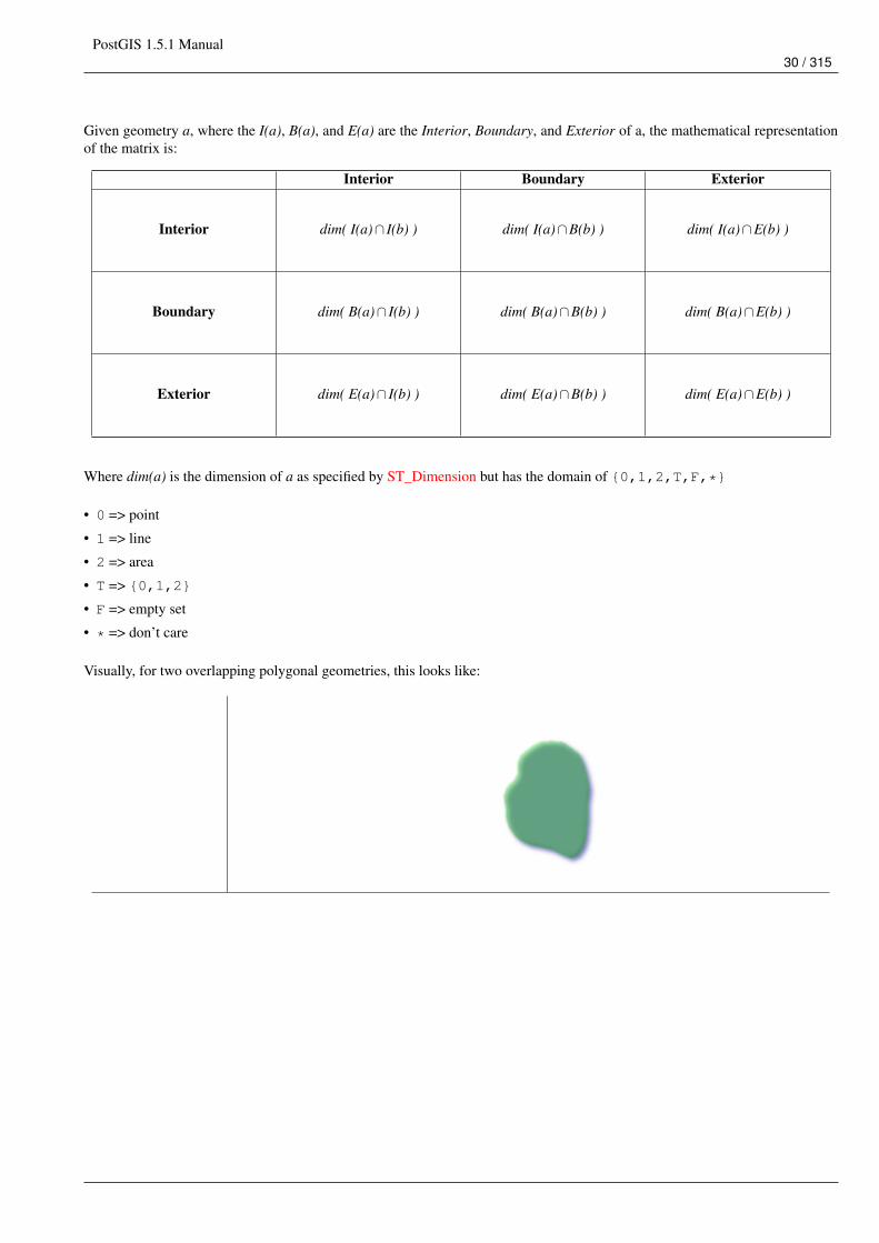
PostGIS 1.5.1 Manual30 / 315
Given geometry a, where the I(a), B(a), and E(a) are the Interior, Boundary, and Exterior of a, the mathematical representationof the matrix is:
Interior Boundary Exterior
Interior dim( I(a)∩ I(b) ) dim( I(a)∩B(b) ) dim( I(a)∩E(b) )
Boundary dim( B(a)∩ I(b) ) dim( B(a)∩B(b) ) dim( B(a)∩E(b) )
Exterior dim( E(a)∩ I(b) ) dim( E(a)∩B(b) ) dim( E(a)∩E(b) )
Where dim(a) is the dimension of a as specified by ST_Dimension but has the domain of {0,1,2,T,F,*}
• 0 => point
• 1 => line
• 2 => area
• T => {0,1,2}
• F => empty set
• * => don’t care
Visually, for two overlapping polygonal geometries, this looks like:
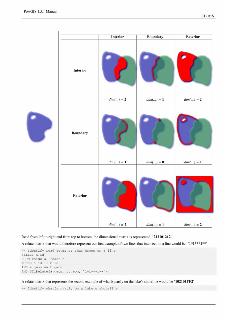
PostGIS 1.5.1 Manual31 / 315
Interior Boundary Exterior
Interior
dim(...) = 2 dim(...) = 1 dim(...) = 2
Boundary
dim(...) = 1 dim(...) = 0 dim(...) = 1
Exterior
dim(...) = 2 dim(...) = 1 dim(...) = 2
Read from left to right and from top to bottom, the dimensional matrix is represented, ’212101212’.
A relate matrix that would therefore represent our first example of two lines that intersect on a line would be: ’1*1***1**’
-- Identify road segments that cross on a lineSELECT a.idFROM roads a, roads bWHERE a.id != b.idAND a.geom && b.geomAND ST_Relate(a.geom, b.geom, ’1*1***1**’);
A relate matrix that represents the second example of wharfs partly on the lake’s shoreline would be ’102101FF2’
-- Identify wharfs partly on a lake’s shoreline
PostGIS 1.5.1 Manual32 / 315
SELECT a.lake_id, b.wharf_idFROM lakes a, wharfs bWHERE a.geom && b.geomAND ST_Relate(a.geom, b.geom, ’102101FF2’);
For more information or reading, see:
• OpenGIS Simple Features Implementation Specification for SQL (version 1.1, section 2.1.13.2)
• Dimensionally Extended Nine-Intersection Model (DE-9IM) by Christian Strobl
• Encyclopedia of GIS By Hui Xiong
4.4 Loading GIS Data
Once you have created a spatial table, you are ready to upload GIS data to the database. Currently, there are two ways to get datainto a PostGIS/PostgreSQL database: using formatted SQL statements or using the Shape file loader/dumper.
4.4.1 Using SQL
If you can convert your data to a text representation, then using formatted SQL might be the easiest way to get your data intoPostGIS. As with Oracle and other SQL databases, data can be bulk loaded by piping a large text file full of SQL "INSERT"statements into the SQL terminal monitor.
A data upload file (roads.sql for example) might look like this:
BEGIN;INSERT INTO roads (road_id, roads_geom, road_name)VALUES (1,ST_GeomFromText(’LINESTRING(191232 243118,191108 243242)’,-1),’Jeff Rd’);
INSERT INTO roads (road_id, roads_geom, road_name)VALUES (2,ST_GeomFromText(’LINESTRING(189141 244158,189265 244817)’,-1),’Geordie Rd’);
INSERT INTO roads (road_id, roads_geom, road_name)VALUES (3,ST_GeomFromText(’LINESTRING(192783 228138,192612 229814)’,-1),’Paul St’);
INSERT INTO roads (road_id, roads_geom, road_name)VALUES (4,ST_GeomFromText(’LINESTRING(189412 252431,189631 259122)’,-1),’Graeme Ave’);
INSERT INTO roads (road_id, roads_geom, road_name)VALUES (5,ST_GeomFromText(’LINESTRING(190131 224148,190871 228134)’,-1),’Phil Tce’);
INSERT INTO roads (road_id, roads_geom, road_name)VALUES (6,ST_GeomFromText(’LINESTRING(198231 263418,198213 268322)’,-1),’Dave Cres’);
COMMIT;
The data file can be piped into PostgreSQL very easily using the "psql" SQL terminal monitor:
psql -d [database] -f roads.sql
4.4.2 Using the Loader
The shp2pgsql data loader converts ESRI Shape files into SQL suitable for insertion into a PostGIS/PostgreSQL databaseeither in geometry or geography format. The loader has several operating modes distinguished by command line flags:
In addition to the shp2pgsql command-line loader, there is an shp2pgsql-gui graphical interface with most of the options asthe command-line loader, but may be easier to use for one-off non-scripted loading or if you are new to PostGIS. It can also beconfigured as a plugin to PgAdminIII.
(c|a|d|p) These are mutually exclusive options:
-c Creates a new table and populates it from the shapefile. This is the default mode.
PostGIS 1.5.1 Manual33 / 315
-a Appends data from the Shape file into the database table. Note that to use this option to load multiple files, the filesmust have the same attributes and same data types.
-d Drops the database table before creating a new table with the data in the Shape file.
-p Only produces the table creation SQL code, without adding any actual data. This can be used if you need to completelyseparate the table creation and data loading steps.
-? Display help screen.
-D Use the PostgreSQL "dump" format for the output data. This can be combined with -a, -c and -d. It is much faster to loadthan the default "insert" SQL format. Use this for very large data sets.
-s <SRID> Creates and populates the geometry tables with the specified SRID.
-k Keep identifiers’ case (column, schema and attributes). Note that attributes in Shapefile are all UPPERCASE.
-i Coerce all integers to standard 32-bit integers, do not create 64-bit bigints, even if the DBF header signature appears to warrantit.
-I Create a GiST index on the geometry column.
-w Output WKT format, for use with older (0.x) versions of PostGIS. Note that this will introduce coordinate drifts and willdrop M values from shapefiles.
-W <encoding> Specify encoding of the input data (dbf file). When used, all attributes of the dbf are converted from thespecified encoding to UTF8. The resulting SQL output will contain a SET CLIENT_ENCODING to UTF8 command,so that the backend will be able to reconvert from UTF8 to whatever encoding the database is configured to use internally.
-N <policy> NULL geometries handling policy (insert*,skip,abort)
-n -n Only import DBF file. If your data has no corresponding shapefile, it will automatically switch to this mode and load justthe dbf. So setting this flag is only needed if you have a full shapefile set, and you only want the attribute data and nogeometry.
-G Use geography type instead of geometry (requires lon/lat data) in WGS84 long lat (SRID=4326)
An example session using the loader to create an input file and uploading it might look like this:
# shp2pgsql -c -D -s 4269 -i -I shaperoads.shp myschema.roadstable > roads.sql# psql -d roadsdb -f roads.sql
A conversion and upload can be done all in one step using UNIX pipes:
# shp2pgsql shaperoads.shp myschema.roadstable | psql -d roadsdb
4.5 Retrieving GIS Data
Data can be extracted from the database using either SQL or the Shape file loader/dumper. In the section on SQL we will discusssome of the operators available to do comparisons and queries on spatial tables.
4.5.1 Using SQL
The most straightforward means of pulling data out of the database is to use a SQL select query and dump the resulting columnsinto a parsable text file:
PostGIS 1.5.1 Manual34 / 315
db=# SELECT road_id, ST_AsText(road_geom) AS geom, road_name FROM roads;
road_id | geom | road_name--------+-----------------------------------------+-----------
1 | LINESTRING(191232 243118,191108 243242) | Jeff Rd2 | LINESTRING(189141 244158,189265 244817) | Geordie Rd3 | LINESTRING(192783 228138,192612 229814) | Paul St4 | LINESTRING(189412 252431,189631 259122) | Graeme Ave5 | LINESTRING(190131 224148,190871 228134) | Phil Tce6 | LINESTRING(198231 263418,198213 268322) | Dave Cres7 | LINESTRING(218421 284121,224123 241231) | Chris Way
(6 rows)
However, there will be times when some kind of restriction is necessary to cut down the number of fields returned. In the case ofattribute-based restrictions, just use the same SQL syntax as normal with a non-spatial table. In the case of spatial restrictions,the following operators are available/useful:
&& This operator tells whether the bounding box of one geometry intersects the bounding box of another.
~= This operators tests whether two geometries are geometrically identical. For example, if ’POLYGON((0 0,1 1,1 0,0 0))’ isthe same as ’POLYGON((0 0,1 1,1 0,0 0))’ (it is).
= This operator is a little more naive, it only tests whether the bounding boxes of two geometries are the same.
Next, you can use these operators in queries. Note that when specifying geometries and boxes on the SQL command line, youmust explicitly turn the string representations into geometries by using the "GeomFromText()" function. So, for example:
SELECT road_id, road_nameFROM roadsWHERE roads_geom ~= ST_GeomFromText(’LINESTRING(191232 243118,191108 243242)’,-1);
The above query would return the single record from the "ROADS_GEOM" table in which the geometry was equal to that value.
When using the "&&" operator, you can specify either a BOX3D as the comparison feature or a GEOMETRY. When you specifya GEOMETRY, however, its bounding box will be used for the comparison.
SELECT road_id, road_nameFROM roadsWHERE roads_geom && ST_GeomFromText(’POLYGON((...))’,-1);
The above query will use the bounding box of the polygon for comparison purposes.
The most common spatial query will probably be a "frame-based" query, used by client software, like data browsers and webmappers, to grab a "map frame" worth of data for display. Using a "BOX3D" object for the frame, such a query looks like this:
SELECT ST_AsText(roads_geom) AS geomFROM roadsWHEREroads_geom && SetSRID(’BOX3D(191232 243117,191232 243119)’::box3d,-1);
Note the use of the SRID, to specify the projection of the BOX3D. The value -1 is used to indicate no specified SRID.
4.5.2 Using the Dumper
The pgsql2shp table dumper connects directly to the database and converts a table (possibly defined by a query) into a shapefile. The basic syntax is:
pgsql2shp [<options>] <database> [<schema>.]<table>
PostGIS 1.5.1 Manual35 / 315
pgsql2shp [<options>] <database> <query>
The commandline options are:
-f <filename> Write the output to a particular filename.
-h <host> The database host to connect to.
-p <port> The port to connect to on the database host.
-P <password> The password to use when connecting to the database.
-u <user> The username to use when connecting to the database.
-g <geometry column> In the case of tables with multiple geometry columns, the geometry column to use when writing theshape file.
-b Use a binary cursor. This will make the operation faster, but will not work if any NON-geometry attribute in the table lacks acast to text.
-r Raw mode. Do not drop the gid field, or escape column names.
-d For backward compatibility: write a 3-dimensional shape file when dumping from old (pre-1.0.0) postgis databases (thedefault is to write a 2-dimensional shape file in that case). Starting from postgis-1.0.0+, dimensions are fully encoded.
4.6 Building Indexes
Indexes are what make using a spatial database for large data sets possible. Without indexing, any search for a feature wouldrequire a "sequential scan" of every record in the database. Indexing speeds up searching by organizing the data into a searchtree which can be quickly traversed to find a particular record. PostgreSQL supports three kinds of indexes by default: B-Treeindexes, R-Tree indexes, and GiST indexes.
• B-Trees are used for data which can be sorted along one axis; for example, numbers, letters, dates. GIS data cannot be rationallysorted along one axis (which is greater, (0,0) or (0,1) or (1,0)?) so B-Tree indexing is of no use for us.
• R-Trees break up data into rectangles, and sub-rectangles, and sub-sub rectangles, etc. R-Trees are used by some spatialdatabases to index GIS data, but the PostgreSQL R-Tree implementation is not as robust as the GiST implementation.
• GiST (Generalized Search Trees) indexes break up data into "things to one side", "things which overlap", "things which areinside" and can be used on a wide range of data-types, including GIS data. PostGIS uses an R-Tree index implemented on topof GiST to index GIS data.
4.6.1 GiST Indexes
GiST stands for "Generalized Search Tree" and is a generic form of indexing. In addition to GIS indexing, GiST is used to speedup searches on all kinds of irregular data structures (integer arrays, spectral data, etc) which are not amenable to normal B-Treeindexing.
Once a GIS data table exceeds a few thousand rows, you will want to build an index to speed up spatial searches of the data(unless all your searches are based on attributes, in which case you’ll want to build a normal index on the attribute fields).
The syntax for building a GiST index on a "geometry" column is as follows:
CREATE INDEX [indexname] ON [tablename] USING GIST ( [geometryfield] );
Building a spatial index is a computationally intensive exercise: on tables of around 1 million rows, on a 300MHz Solarismachine, we have found building a GiST index takes about 1 hour. After building an index, it is important to force PostgreSQLto collect table statistics, which are used to optimize query plans:
PostGIS 1.5.1 Manual36 / 315
VACUUM ANALYZE [table_name] [column_name];-- This is only needed for PostgreSQL 7.4 installations and belowSELECT UPDATE_GEOMETRY_STATS([table_name], [column_name]);
GiST indexes have two advantages over R-Tree indexes in PostgreSQL. Firstly, GiST indexes are "null safe", meaning they canindex columns which include null values. Secondly, GiST indexes support the concept of "lossiness" which is important whendealing with GIS objects larger than the PostgreSQL 8K page size. Lossiness allows PostgreSQL to store only the "important"part of an object in an index -- in the case of GIS objects, just the bounding box. GIS objects larger than 8K will cause R-Treeindexes to fail in the process of being built.
4.6.2 Using Indexes
Ordinarily, indexes invisibly speed up data access: once the index is built, the query planner transparently decides when to useindex information to speed up a query plan. Unfortunately, the PostgreSQL query planner does not optimize the use of GiSTindexes well, so sometimes searches which should use a spatial index instead default to a sequence scan of the whole table.
If you find your spatial indexes are not being used (or your attribute indexes, for that matter) there are a couple things you cando:
• Firstly, make sure statistics are gathered about the number and distributions of values in a table, to provide the query plan-ner with better information to make decisions around index usage. For PostgreSQL 7.4 installations and below this is doneby running update_geometry_stats([table_name, column_name]) (compute distribution) and VACUUM ANALYZE [ta-ble_name] [column_name] (compute number of values). Starting with PostgreSQL 8.0 running VACUUM ANALYZE willdo both operations. You should regularly vacuum your databases anyways -- many PostgreSQL DBAs have VACUUM run asan off-peak cron job on a regular basis.
• If vacuuming does not work, you can force the planner to use the index information by using the SET ENABLE_SEQSCAN=OFFcommand. You should only use this command sparingly, and only on spatially indexed queries: generally speaking, the plannerknows better than you do about when to use normal B-Tree indexes. Once you have run your query, you should consider settingENABLE_SEQSCAN back on, so that other queries will utilize the planner as normal.
NoteAs of version 0.6, it should not be necessary to force the planner to use the index with ENABLE_SEQSCAN.
• If you find the planner wrong about the cost of sequential vs index scans try reducing the value of random_page_cost inpostgresql.conf or using SET random_page_cost=#. Default value for the parameter is 4, try setting it to 1 or 2. Decrementingthe value makes the planner more inclined of using Index scans.
4.7 Complex Queries
The raison d’etre of spatial database functionality is performing queries inside the database which would ordinarily requiredesktop GIS functionality. Using PostGIS effectively requires knowing what spatial functions are available, and ensuring thatappropriate indexes are in place to provide good performance.
4.7.1 Taking Advantage of Indexes
When constructing a query it is important to remember that only the bounding-box-based operators such as && can take advan-tage of the GiST spatial index. Functions such as distance() cannot use the index to optimize their operation. For example,the following query would be quite slow on a large table:
PostGIS 1.5.1 Manual37 / 315
SELECT the_geomFROM geom_tableWHERE ST_Distance(the_geom, ST_GeomFromText(’POINT(100000 200000)’, -1)) < 100
This query is selecting all the geometries in geom_table which are within 100 units of the point (100000, 200000). It will beslow because it is calculating the distance between each point in the table and our specified point, ie. one ST_Distance()calculation for each row in the table. We can avoid this by using the && operator to reduce the number of distance calculationsrequired:
SELECT the_geomFROM geom_tableWHERE the_geom && ’BOX3D(90900 190900, 100100 200100)’::box3dAND
ST_Distance(the_geom, ST_GeomFromText(’POINT(100000 200000)’, -1)) < 100
This query selects the same geometries, but it does it in a more efficient way. Assuming there is a GiST index on the_geom,the query planner will recognize that it can use the index to reduce the number of rows before calculating the result of the d-istance() function. Notice that the BOX3D geometry which is used in the && operation is a 200 unit square box centeredon the original point - this is our "query box". The && operator uses the index to quickly reduce the result set down to onlythose geometries which have bounding boxes that overlap the "query box". Assuming that our query box is much smaller thanthe extents of the entire geometry table, this will drastically reduce the number of distance calculations that need to be done.
Change in BehaviorAs of PostGIS 1.3.0, most of the Geometry Relationship Functions, with the notable exceptions of ST_Disjoint andST_Relate, include implicit bounding box overlap operators.
4.7.2 Examples of Spatial SQL
The examples in this section will make use of two tables, a table of linear roads, and a table of polygonal municipality boundaries.The table definitions for the bc_roads table is:
Column | Type | Description------------+-------------------+-------------------gid | integer | Unique IDname | character varying | Road Namethe_geom | geometry | Location Geometry (Linestring)
The table definition for the bc_municipality table is:
Column | Type | Description-----------+-------------------+-------------------gid | integer | Unique IDcode | integer | Unique IDname | character varying | City / Town Namethe_geom | geometry | Location Geometry (Polygon)
1. What is the total length of all roads, expressed in kilometers?
You can answer this question with a very simple piece of SQL:
SELECT sum(ST_Length(the_geom))/1000 AS km_roads FROM bc_roads;
km_roads------------------70842.1243039643(1 row)
PostGIS 1.5.1 Manual38 / 315
2. How large is the city of Prince George, in hectares?
This query combines an attribute condition (on the municipality name) with a spatial calculation (of the area):
SELECTST_Area(the_geom)/10000 AS hectares
FROM bc_municipalityWHERE name = ’PRINCE GEORGE’;
hectares------------------32657.9103824927(1 row)
3. What is the largest municipality in the province, by area?
This query brings a spatial measurement into the query condition. There are several ways of approaching this problem, butthe most efficient is below:
SELECTname,ST_Area(the_geom)/10000 AS hectares
FROMbc_municipality
ORDER BY hectares DESCLIMIT 1;
name | hectares---------------+-----------------TUMBLER RIDGE | 155020.02556131(1 row)
Note that in order to answer this query we have to calculate the area of every polygon. If we were doing this a lot it wouldmake sense to add an area column to the table that we could separately index for performance. By ordering the results in adescending direction, and them using the PostgreSQL "LIMIT" command we can easily pick off the largest value withoutusing an aggregate function like max().
4. What is the length of roads fully contained within each municipality?
This is an example of a "spatial join", because we are bringing together data from two tables (doing a join) but using aspatial interaction condition ("contained") as the join condition rather than the usual relational approach of joining on acommon key:
SELECTm.name,sum(ST_Length(r.the_geom))/1000 as roads_km
FROMbc_roads AS r,bc_municipality AS m
WHEREST_Contains(m.the_geom,r.the_geom)
GROUP BY m.nameORDER BY roads_km;
name | roads_km----------------------------+------------------SURREY | 1539.47553551242VANCOUVER | 1450.33093486576LANGLEY DISTRICT | 833.793392535662BURNABY | 773.769091404338PRINCE GEORGE | 694.37554369147...
PostGIS 1.5.1 Manual39 / 315
This query takes a while, because every road in the table is summarized into the final result (about 250K roads for ourparticular example table). For smaller overlays (several thousand records on several hundred) the response can be veryfast.
5. Create a new table with all the roads within the city of Prince George.
This is an example of an "overlay", which takes in two tables and outputs a new table that consists of spatially clipped orcut resultants. Unlike the "spatial join" demonstrated above, this query actually creates new geometries. An overlay is likea turbo-charged spatial join, and is useful for more exact analysis work:
CREATE TABLE pg_roads asSELECTST_Intersection(r.the_geom, m.the_geom) AS intersection_geom,ST_Length(r.the_geom) AS rd_orig_length,r.*
FROMbc_roads AS r,bc_municipality AS m
WHERE m.name = ’PRINCE GEORGE’ AND ST_Intersects(r.the_geom, m.the_geom);
6. What is the length in kilometers of "Douglas St" in Victoria?
SELECTsum(ST_Length(r.the_geom))/1000 AS kilometers
FROMbc_roads r,bc_municipality m
WHERE r.name = ’Douglas St’ AND m.name = ’VICTORIA’AND ST_Contains(m.the_geom, r.the_geom) ;
kilometers------------------4.89151904172838(1 row)
7. What is the largest municipality polygon that has a hole?
SELECT gid, name, ST_Area(the_geom) AS areaFROM bc_municipalityWHERE ST_NRings(the_geom) > 1ORDER BY area DESC LIMIT 1;
gid | name | area-----+--------------+------------------12 | SPALLUMCHEEN | 257374619.430216(1 row)
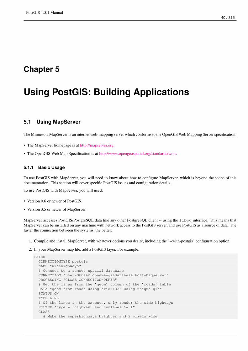
PostGIS 1.5.1 Manual40 / 315
Chapter 5
Using PostGIS: Building Applications
5.1 Using MapServer
The Minnesota MapServer is an internet web-mapping server which conforms to the OpenGIS Web Mapping Server specification.
• The MapServer homepage is at http://mapserver.org.
• The OpenGIS Web Map Specification is at http://www.opengeospatial.org/standards/wms.
5.1.1 Basic Usage
To use PostGIS with MapServer, you will need to know about how to configure MapServer, which is beyond the scope of thisdocumentation. This section will cover specific PostGIS issues and configuration details.
To use PostGIS with MapServer, you will need:
• Version 0.6 or newer of PostGIS.
• Version 3.5 or newer of MapServer.
MapServer accesses PostGIS/PostgreSQL data like any other PostgreSQL client -- using the libpq interface. This means thatMapServer can be installed on any machine with network access to the PostGIS server, and use PostGIS as a source of data. Thefaster the connection between the systems, the better.
1. Compile and install MapServer, with whatever options you desire, including the "--with-postgis" configuration option.
2. In your MapServer map file, add a PostGIS layer. For example:
LAYERCONNECTIONTYPE postgisNAME "widehighways"# Connect to a remote spatial databaseCONNECTION "user=dbuser dbname=gisdatabase host=bigserver"PROCESSING "CLOSE_CONNECTION=DEFER"# Get the lines from the ’geom’ column of the ’roads’ tableDATA "geom from roads using srid=4326 using unique gid"STATUS ONTYPE LINE# Of the lines in the extents, only render the wide highwaysFILTER "type = ’highway’ and numlanes >= 4"CLASS# Make the superhighways brighter and 2 pixels wide
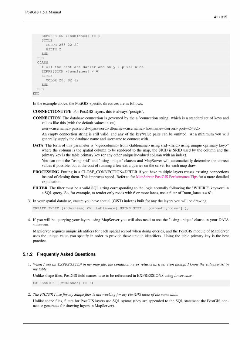
PostGIS 1.5.1 Manual41 / 315
EXPRESSION ([numlanes] >= 6)STYLECOLOR 255 22 22WIDTH 2
ENDENDCLASS# All the rest are darker and only 1 pixel wideEXPRESSION ([numlanes] < 6)STYLECOLOR 205 92 82
ENDEND
END
In the example above, the PostGIS-specific directives are as follows:
CONNECTIONTYPE For PostGIS layers, this is always "postgis".
CONNECTION The database connection is governed by the a ’connection string’ which is a standard set of keys andvalues like this (with the default values in <>):user=<username> password=<password> dbname=<username> hostname=<server> port=<5432>An empty connection string is still valid, and any of the key/value pairs can be omitted. At a minimum you willgenerally supply the database name and username to connect with.
DATA The form of this parameter is "<geocolumn> from <tablename> using srid=<srid> using unique <primary key>"where the column is the spatial column to be rendered to the map, the SRID is SRID used by the column and theprimary key is the table primary key (or any other uniquely-valued column with an index).You can omit the "using srid" and "using unique" clauses and MapServer will automatically determine the correctvalues if possible, but at the cost of running a few extra queries on the server for each map draw.
PROCESSING Putting in a CLOSE_CONNECTION=DEFER if you have multiple layers reuses existing connectionsinstead of closing them. This improves speed. Refer to for MapServer PostGIS Performance Tips for a more detailedexplanation.
FILTER The filter must be a valid SQL string corresponding to the logic normally following the "WHERE" keyword ina SQL query. So, for example, to render only roads with 6 or more lanes, use a filter of "num_lanes >= 6".
3. In your spatial database, ensure you have spatial (GiST) indexes built for any the layers you will be drawing.
CREATE INDEX [indexname] ON [tablename] USING GIST ( [geometrycolumn] );
4. If you will be querying your layers using MapServer you will also need to use the "using unique" clause in your DATAstatement.
MapServer requires unique identifiers for each spatial record when doing queries, and the PostGIS module of MapServeruses the unique value you specify in order to provide these unique identifiers. Using the table primary key is the bestpractice.
5.1.2 Frequently Asked Questions
1. When I use an EXPRESSION in my map file, the condition never returns as true, even though I know the values exist inmy table.
Unlike shape files, PostGIS field names have to be referenced in EXPRESSIONS using lower case.
EXPRESSION ([numlanes] >= 6)
2. The FILTER I use for my Shape files is not working for my PostGIS table of the same data.
Unlike shape files, filters for PostGIS layers use SQL syntax (they are appended to the SQL statement the PostGIS con-nector generates for drawing layers in MapServer).
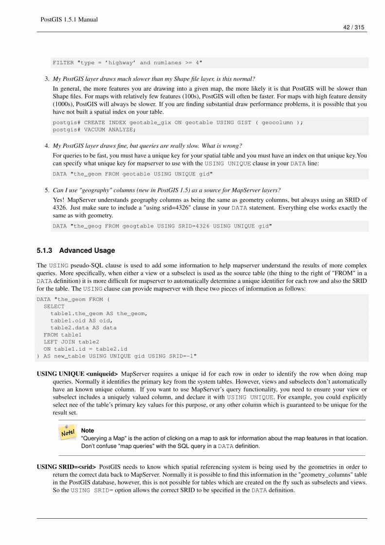
PostGIS 1.5.1 Manual42 / 315
FILTER "type = ’highway’ and numlanes >= 4"
3. My PostGIS layer draws much slower than my Shape file layer, is this normal?
In general, the more features you are drawing into a given map, the more likely it is that PostGIS will be slower thanShape files. For maps with relatively few features (100s), PostGIS will often be faster. For maps with high feature density(1000s), PostGIS will always be slower. If you are finding substantial draw performance problems, it is possible that youhave not built a spatial index on your table.
postgis# CREATE INDEX geotable_gix ON geotable USING GIST ( geocolumn );postgis# VACUUM ANALYZE;
4. My PostGIS layer draws fine, but queries are really slow. What is wrong?
For queries to be fast, you must have a unique key for your spatial table and you must have an index on that unique key.Youcan specify what unique key for mapserver to use with the USING UNIQUE clause in your DATA line:
DATA "the_geom FROM geotable USING UNIQUE gid"
5. Can I use "geography" columns (new in PostGIS 1.5) as a source for MapServer layers?
Yes! MapServer understands geography columns as being the same as geometry columns, but always using an SRID of4326. Just make sure to include a "using srid=4326" clause in your DATA statement. Everything else works exactly thesame as with geometry.
DATA "the_geog FROM geogtable USING SRID=4326 USING UNIQUE gid"
5.1.3 Advanced Usage
The USING pseudo-SQL clause is used to add some information to help mapserver understand the results of more complexqueries. More specifically, when either a view or a subselect is used as the source table (the thing to the right of "FROM" in aDATA definition) it is more difficult for mapserver to automatically determine a unique identifier for each row and also the SRIDfor the table. The USING clause can provide mapserver with these two pieces of information as follows:
DATA "the_geom FROM (SELECTtable1.the_geom AS the_geom,table1.oid AS oid,table2.data AS data
FROM table1LEFT JOIN table2ON table1.id = table2.id
) AS new_table USING UNIQUE gid USING SRID=-1"
USING UNIQUE <uniqueid> MapServer requires a unique id for each row in order to identify the row when doing mapqueries. Normally it identifies the primary key from the system tables. However, views and subselects don’t automaticallyhave an known unique column. If you want to use MapServer’s query functionality, you need to ensure your view orsubselect includes a uniquely valued column, and declare it with USING UNIQUE. For example, you could explicitlyselect nee of the table’s primary key values for this purpose, or any other column which is guaranteed to be unique for theresult set.
Note"Querying a Map" is the action of clicking on a map to ask for information about the map features in that location.Don’t confuse "map queries" with the SQL query in a DATA definition.
USING SRID=<srid> PostGIS needs to know which spatial referencing system is being used by the geometries in order toreturn the correct data back to MapServer. Normally it is possible to find this information in the "geometry_columns" tablein the PostGIS database, however, this is not possible for tables which are created on the fly such as subselects and views.So the USING SRID= option allows the correct SRID to be specified in the DATA definition.
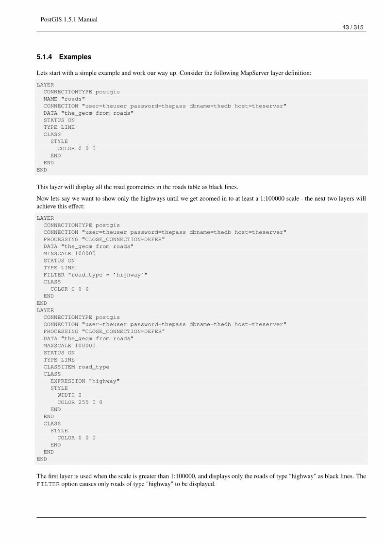
PostGIS 1.5.1 Manual43 / 315
5.1.4 Examples
Lets start with a simple example and work our way up. Consider the following MapServer layer definition:
LAYERCONNECTIONTYPE postgisNAME "roads"CONNECTION "user=theuser password=thepass dbname=thedb host=theserver"DATA "the_geom from roads"STATUS ONTYPE LINECLASSSTYLECOLOR 0 0 0
ENDEND
END
This layer will display all the road geometries in the roads table as black lines.
Now lets say we want to show only the highways until we get zoomed in to at least a 1:100000 scale - the next two layers willachieve this effect:
LAYERCONNECTIONTYPE postgisCONNECTION "user=theuser password=thepass dbname=thedb host=theserver"PROCESSING "CLOSE_CONNECTION=DEFER"DATA "the_geom from roads"MINSCALE 100000STATUS ONTYPE LINEFILTER "road_type = ’highway’"CLASSCOLOR 0 0 0
ENDENDLAYERCONNECTIONTYPE postgisCONNECTION "user=theuser password=thepass dbname=thedb host=theserver"PROCESSING "CLOSE_CONNECTION=DEFER"DATA "the_geom from roads"MAXSCALE 100000STATUS ONTYPE LINECLASSITEM road_typeCLASSEXPRESSION "highway"STYLEWIDTH 2COLOR 255 0 0
ENDENDCLASSSTYLECOLOR 0 0 0
ENDEND
END
The first layer is used when the scale is greater than 1:100000, and displays only the roads of type "highway" as black lines. TheFILTER option causes only roads of type "highway" to be displayed.
PostGIS 1.5.1 Manual44 / 315
The second layer is used when the scale is less than 1:100000, and will display highways as double-thick red lines, and otherroads as regular black lines.
So, we have done a couple of interesting things using only MapServer functionality, but our DATA SQL statement has remainedsimple. Suppose that the name of the road is stored in another table (for whatever reason) and we need to do a join to get it andlabel our roads.
LAYERCONNECTIONTYPE postgisCONNECTION "user=theuser password=thepass dbname=thedb host=theserver"DATA "the_geom FROM (SELECT roads.oid AS oid, roads.the_geom AS the_geom,
road_names.name as name FROM roads LEFT JOIN road_names ONroads.road_name_id = road_names.road_name_id)AS named_roads USING UNIQUE oid USING SRID=-1"
MAXSCALE 20000STATUS ONTYPE ANNOTATIONLABELITEM nameCLASSLABELANGLE autoSIZE 8COLOR 0 192 0TYPE truetypeFONT arial
ENDEND
END
This annotation layer adds green labels to all the roads when the scale gets down to 1:20000 or less. It also demonstrates how touse an SQL join in a DATA definition.
5.2 Java Clients (JDBC)
Java clients can access PostGIS "geometry" objects in the PostgreSQL database either directly as text representations or usingthe JDBC extension objects bundled with PostGIS. In order to use the extension objects, the "postgis.jar" file must be in yourCLASSPATH along with the "postgresql.jar" JDBC driver package.
import java.sql.*;import java.util.*;import java.lang.*;import org.postgis.*;
public class JavaGIS {
public static void main(String[] args) {
java.sql.Connection conn;
try {/** Load the JDBC driver and establish a connection.
*/Class.forName("org.postgresql.Driver");String url = "jdbc:postgresql://localhost:5432/database";conn = DriverManager.getConnection(url, "postgres", "");/** Add the geometry types to the connection. Note that you
* must cast the connection to the pgsql-specific connection
* implementation before calling the addDataType() method.
PostGIS 1.5.1 Manual45 / 315
*/((org.postgresql.Connection)conn).addDataType("geometry","org.postgis.PGgeometry")
;((org.postgresql.Connection)conn).addDataType("box3d","org.postgis.PGbox3d");/** Create a statement and execute a select query.
*/Statement s = conn.createStatement();ResultSet r = s.executeQuery("select ST_AsText(geom) as geom,id from geomtable");while( r.next() ) {/** Retrieve the geometry as an object then cast it to the geometry type.
* Print things out.
*/PGgeometry geom = (PGgeometry)r.getObject(1);int id = r.getInt(2);System.out.println("Row " + id + ":");System.out.println(geom.toString());
}s.close();conn.close();
}catch( Exception e ) {e.printStackTrace();}
}}
The "PGgeometry" object is a wrapper object which contains a specific topological geometry object (subclasses of the abstractclass "Geometry") depending on the type: Point, LineString, Polygon, MultiPoint, MultiLineString, MultiPolygon.
PGgeometry geom = (PGgeometry)r.getObject(1);if( geom.getType() = Geometry.POLYGON ) {Polygon pl = (Polygon)geom.getGeometry();for( int r = 0; r < pl.numRings(); r++) {LinearRing rng = pl.getRing(r);System.out.println("Ring: " + r);for( int p = 0; p < rng.numPoints(); p++ ) {Point pt = rng.getPoint(p);System.out.println("Point: " + p);System.out.println(pt.toString());
}}
}
The JavaDoc for the extension objects provides a reference for the various data accessor functions in the geometric objects.
5.3 C Clients (libpq)
...
5.3.1 Text Cursors
...
5.3.2 Binary Cursors
...
PostGIS 1.5.1 Manual46 / 315
Chapter 6
Performance tips
6.1 Small tables of large geometries
6.1.1 Problem description
Current PostgreSQL versions (including 8.0) suffer from a query optimizer weakness regarding TOAST tables. TOAST tablesare a kind of "extension room" used to store large (in the sense of data size) values that do not fit into normal data pages (likelong texts, images or complex geometries with lots of vertices), see http://www.postgresql.org/docs/current/interactive/storage-toast.html for more information).
The problem appears if you happen to have a table with rather large geometries, but not too much rows of them (like a tablecontaining the boundaries of all European countries in high resolution). Then the table itself is small, but it uses lots of TOASTspace. In our example case, the table itself had about 80 rows and used only 3 data pages, but the TOAST table used 8225 pages.
Now issue a query where you use the geometry operator && to search for a bounding box that matches only very few of thoserows. Now the query optimizer sees that the table has only 3 pages and 80 rows. He estimates that a sequential scan on such asmall table is much faster than using an index. And so he decides to ignore the GIST index. Usually, this estimation is correct.But in our case, the && operator has to fetch every geometry from disk to compare the bounding boxes, thus reading all TOASTpages, too.
To see whether your suffer from this bug, use the "EXPLAIN ANALYZE" postgresql command. For more information andthe technical details, you can read the thread on the postgres performance mailing list: http://archives.postgresql.org/pgsql-performance/2005-02/msg00030.php
6.1.2 Workarounds
The PostgreSQL people are trying to solve this issue by making the query estimation TOAST-aware. For now, here are twoworkarounds:
The first workaround is to force the query planner to use the index. Send "SET enable_seqscan TO off;" to the server beforeissuing the query. This basically forces the query planner to avoid sequential scans whenever possible. So it uses the GIST indexas usual. But this flag has to be set on every connection, and it causes the query planner to make misestimations in other cases,so you should "SET enable_seqscan TO on;" after the query.
The second workaround is to make the sequential scan as fast as the query planner thinks. This can be achieved by creating anadditional column that "caches" the bbox, and matching against this. In our example, the commands are like:
SELECT AddGeometryColumn(’myschema’,’mytable’,’bbox’,’4326’,’GEOMETRY’,’2’);UPDATE mytable SET bbox = ST_Envelope(ST_Force_2d(the_geom));
Now change your query to use the && operator against bbox instead of geom_column, like:
PostGIS 1.5.1 Manual47 / 315
SELECT geom_columnFROM mytableWHERE bbox && ST_SetSRID(’BOX3D(0 0,1 1)’::box3d,4326);
Of course, if you change or add rows to mytable, you have to keep the bbox "in sync". The most transparent way to do this wouldbe triggers, but you also can modify your application to keep the bbox column current or run the UPDATE query above afterevery modification.
6.2 CLUSTERing on geometry indices
For tables that are mostly read-only, and where a single index is used for the majority of queries, PostgreSQL offers the CLUS-TER command. This command physically reorders all the data rows in the same order as the index criteria, yielding twoperformance advantages: First, for index range scans, the number of seeks on the data table is drastically reduced. Second, ifyour working set concentrates to some small intervals on the indices, you have a more efficient caching because the data rowsare spread along fewer data pages. (Feel invited to read the CLUSTER command documentation from the PostgreSQL manualat this point.)
However, currently PostgreSQL does not allow clustering on PostGIS GIST indices because GIST indices simply ignores NULLvalues, you get an error message like:
lwgeom=# CLUSTER my_geom_index ON my_table;ERROR: cannot cluster when index access method does not handle null valuesHINT: You may be able to work around this by marking column "the_geom" NOT NULL.
As the HINT message tells you, one can work around this deficiency by adding a "not null" constraint to the table:
lwgeom=# ALTER TABLE my_table ALTER COLUMN the_geom SET not null;ALTER TABLE
Of course, this will not work if you in fact need NULL values in your geometry column. Additionally, you must use the abovemethod to add the constraint, using a CHECK constraint like "ALTER TABLE blubb ADD CHECK (geometry is not null);" willnot work.
6.3 Avoiding dimension conversion
Sometimes, you happen to have 3D or 4D data in your table, but always access it using OpenGIS compliant ST_AsText() orST_AsBinary() functions that only output 2D geometries. They do this by internally calling the ST_Force_2d() function, whichintroduces a significant overhead for large geometries. To avoid this overhead, it may be feasible to pre-drop those additionaldimensions once and forever:
UPDATE mytable SET the_geom = ST_Force_2d(the_geom);VACUUM FULL ANALYZE mytable;
Note that if you added your geometry column using AddGeometryColumn() there’ll be a constraint on geometry dimension. Tobypass it you will need to drop the constraint. Remember to update the entry in the geometry_columns table and recreate theconstraint afterwards.
In case of large tables, it may be wise to divide this UPDATE into smaller portions by constraining the UPDATE to a part of thetable via a WHERE clause and your primary key or another feasible criteria, and running a simple "VACUUM;" between yourUPDATEs. This drastically reduces the need for temporary disk space. Additionally, if you have mixed dimension geometries,restricting the UPDATE by "WHERE dimension(the_geom)>2" skips re-writing of geometries that already are in 2D.
PostGIS 1.5.1 Manual48 / 315
6.4 Tuning your configuration
These tips are taken from Kevin Neufeld’s presentation "Tips for the PostGIS Power User" at the FOSS4G 2007 conference.Depending on your use of PostGIS (for example, static data and complex analysis vs frequently updated data and lots of users)these changes can provide significant speedups to your queries.
For a more tips (and better formatting), the original presentation is at http://2007.foss4g.org/presentations/view.php?abstract_id=117.
6.4.1 Startup
These settings are configured in postgresql.conf:
checkpoint_segment_size (this setting is obsolete in newer versions of PostgreSQL) got replaced with many configurations withnames starting with checkpoint and WAL.
• # of WAL files = 16MB each; default is 3
• Set to at least 10 or 30 for databases with heavy write activity, or more for large database loads. Another article on the topicworth reading Greg Smith: Checkpoint and Background writer
• Possibly store the xlog on a separate disk device
constraint_exclusion
• Default: off (prior to PostgreSQL 8.4 and for PostgreSQL 8.4+ is set to partition)
• This is generally used for table partitioning. If you are running PostgreSQL versions below 8.4, set to "on" to ensure the queryplanner will optimize as desired. As of PostgreSQL 8.4, the default for this is set to "partition" which is ideal for PostgreSQL8.4 and above since it will force the planner to only analyze tables for constraint consideration if they are in an inheritedhierarchy and not pay the planner penalty otherwise.
shared_buffers
• Default: ~32MB
• Set to about 1/3 to 3/4 of available RAM
6.4.2 Runtime
work_mem (the memory used for sort operations and complex queries)
• Default: 1MB
• Adjust up for large dbs, complex queries, lots of RAM
• Adjust down for many concurrent users or low RAM.
• If you have lots of RAM and few developers:
SET work_mem TO 1200000;
maintenance_work_mem (used for VACUUM, CREATE INDEX, etc.)
• Default: 16MB
• Generally too low - ties up I/O, locks objects while swapping memory
• Recommend 32MB to 256MB on production servers w/lots of RAM, but depends on the # of concurrent users. If you havelots of RAM and few developers:
SET maintainence_work_mem TO 1200000;
PostGIS 1.5.1 Manual49 / 315
Chapter 7
PostGIS Reference
The functions given below are the ones which a user of PostGIS is likely to need. There are other functions which are requiredsupport functions to the PostGIS objects which are not of use to a general user.
NotePostGIS has begun a transition from the existing naming convention to an SQL-MM-centric convention. As a result,most of the functions that you know and love have been renamed using the standard spatial type (ST) prefix. Previousfunctions are still available, though are not listed in this document where updated functions are equivalent. The nonST_ functions not listed in this documentation are deprecated and will be removed in a future release so STOP USINGTHEM.
7.1 PostgreSQL PostGIS Types
7.1.1 box2d
Name
box2d – A box composed of x min, ymin, xmax, ymax. Often used to return the 2d enclosing box of a geometry.
Description
box2d is a spatial data type used to represent the enclosing box of a geometry or set of geometries. ST_Extent in earlier versionsprior to PostGIS 1.4 would return a box2d.
7.1.2 box3d
Name
box3d – A box composed of x min, ymin, zmin, xmax, ymax, zmax. Often used to return the 3d extent of a geometry or collectionof geometries.
Description
box3d is a postgis spatial data type used to represent the enclosing box of a geometry or set of geometries. ST_Extent3D returnsa box3d object.
PostGIS 1.5.1 Manual50 / 315
Casting Behavor
This section lists the automatic as well as explicit casts allowed for this data type
Cast To Behaviorbox automaticbox2d automaticgeometry automatic
7.1.3 box3d_extent
Name
box3d_extent – A box composed of x min, ymin, zmin, xmax, ymax, zmax. Often used to return the extent of a geometry.
Description
box3d_extent is a data type returned by ST_Extent. In versions prior to PostGIS 1.4, ST_Extent would return a box2d.
Casting Behavor
This section lists the automatic as well as explicit casts allowed for this data type
Cast To Behaviorbox2d automaticbox3d automaticgeometry automatic
See Also
Section 8.5
7.1.4 geometry
Name
geometry – Planar spatial data type.
Description
geometry is a fundamental postgis spatial data type used to represent a feature in the Euclidean coordinate system.
Casting Behavor
This section lists the automatic as well as explicit casts allowed for this data type
Cast To Behaviorbox automaticbox2d automaticbox3d automatic
PostGIS 1.5.1 Manual51 / 315
bytea automaticgeography automatictext automatic
See Also
Section 4.1
7.1.5 geometry_dump
Name
geometry_dump – A spatial datatype with two fields - geom (holding a geometry object) and path[] (a 1-d array holding theposition of the geometry within the dumped object.)
Description
geometry_dump is a compound data type consisting of a geometry object referenced by the .geom field and path[] a 1-dimensionalinteger array (starting at 1 e.g. path[1] to get first element) array that defines the navigation path within the dumped geometry tofind this element. It is used by the ST_Dump* family of functions as an output type to explode a more complex geometry intoits constituent parts and location of parts.
See Also
Section 8.4
7.1.6 geography
Name
geography – Ellipsoidal spatial data type.
Description
geography is a spatial data type used to represent a feature in the round-earth coordinate system.
Casting Behavor
This section lists the automatic as well as explicit casts allowed for this data type
Cast To Behaviorgeometry explicit
See Also
Section 8.3,Section 4.2
PostGIS 1.5.1 Manual52 / 315
7.2 Management Functions
7.2.1 AddGeometryColumn
Name
AddGeometryColumn – Adds a geometry column to an existing table of attributes.
Synopsis
text AddGeometryColumn(varchar table_name, varchar column_name, integer srid, varchar type, integer dimension);text AddGeometryColumn(varchar schema_name, varchar table_name, varchar column_name, integer srid, varchar type, inte-ger dimension);text AddGeometryColumn(varchar catalog_name, varchar schema_name, varchar table_name, varchar column_name, integersrid, varchar type, integer dimension);
Description
Adds a geometry column to an existing table of attributes. The schema_name is the name of the table schema (unused forpre-schema PostgreSQL installations). The srid must be an integer value reference to an entry in the SPATIAL_REF_SYStable. The type must be an uppercase string corresponding to the geometry type, eg, ’POLYGON’ or ’MULTILINESTRING’.An error is thrown if the schemaname doesn’t exist (or not visible in the current search_path) or the specified SRID, geometrytype, or dimension is invalid.
NoteViews and derivatively created spatial tables will need to be registered in geometry_columns manually, since AddGe-ometryColumn also adds a spatial column which is not needed when you already have a spatial column. Refer toSection 4.3.4.
This method implements the OpenGIS Simple Features Implementation Specification for SQL 1.1.
This function supports 3d and will not drop the z-index.
This method supports Circular Strings and Curves
Examples
-- Create a new simple PostgreSQL tablepostgis=# CREATE TABLE my_schema.my_spatial_table (id serial);
-- Describing the table shows a simple table with a single "id" column.postgis=# \d my_schema.my_spatial_table
Table "my_schema.my_spatial_table"Column | Type | Modifiers--------+---------+------------------------------------------------------------------------- ←↩
id | integer | not null default nextval(’my_schema.my_spatial_table_id_seq’::regclass)
-- Add a spatial column to the tablepostgis=# SELECT AddGeometryColumn (’my_schema’,’my_spatial_table’,’the_geom’,4326,’POINT ←↩
’,2);
PostGIS 1.5.1 Manual53 / 315
--Add a curvepolygonSELECT AddGeometryColumn (’my_schema’,’my_spatial_table’,’the_geomcp’,4326,’CURVEPOLYGON ←↩
’,2);
-- Describe the table again reveals the addition of a new "the_geom" column.postgis=# \d my_schema.my_spatial_table
Column | Type | Modifiers
------------+----------+------------------------------------------------------------------------- ←↩
id | integer | not null default nextval(’my_schema.my_spatial_table_id_seq’:: ←↩regclass)
the_geom | geometry |the_geomcp | geometry |
Check constraints:"enforce_dims_the_geom" CHECK (ndims(the_geom) = 2)"enforce_dims_the_geomcp" CHECK (ndims(the_geomcp) = 2)"enforce_geotype_the_geom" CHECK (geometrytype(the_geom) = ’POINT’::text OR
the_geom IS NULL)"enforce_geotype_the_geomcp" CHECK (geometrytype(the_geomcp) = ’CURVEPOLYGON
’::text OR the_geomcp IS NULL)"enforce_srid_the_geom" CHECK (srid(the_geom) = 4326)"enforce_srid_the_geomcp" CHECK (srid(the_geomcp) = 4326)
See Also
DropGeometryColumn, DropGeometryTable, Section 4.3.4
7.2.2 DropGeometryColumn
Name
DropGeometryColumn – Removes a geometry column from a spatial table.
Synopsis
text DropGeometryColumn(varchar table_name, varchar column_name);text DropGeometryColumn(varchar schema_name, varchar table_name, varchar column_name);text DropGeometryColumn(varchar catalog_name, varchar schema_name, varchar table_name, varchar column_name);
Description
Removes a geometry column from a spatial table. Note that schema_name will need to match the f_table_schema field of thetable’s row in the geometry_columns table.
This method implements the OpenGIS Simple Features Implementation Specification for SQL 1.1.
This function supports 3d and will not drop the z-index.
This method supports Circular Strings and Curves
PostGIS 1.5.1 Manual54 / 315
Examples
SELECT DropGeometryColumn (’my_schema’,’my_spatial_table’,’the_geomcp’);----RESULT output ---my_schema.my_spatial_table.the_geomcp effectively removed.
See Also
AddGeometryColumn, DropGeometryTable
7.2.3 DropGeometryTable
Name
DropGeometryTable – Drops a table and all its references in geometry_columns.
Synopsis
boolean DropGeometryTable(varchar table_name);boolean DropGeometryTable(varchar schema_name, varchar table_name);boolean DropGeometryTable(varchar catalog_name, varchar schema_name, varchar table_name);
Description
Drops a table and all its references in geometry_columns. Note: uses current_schema() on schema-aware pgsql installations ifschema is not provided.
Examples
SELECT DropGeometryTable (’my_schema’,’my_spatial_table’);----RESULT output ---my_schema.my_spatial_table dropped.
See Also
AddGeometryColumn, DropGeometryColumn
7.2.4 PostGIS_Full_Version
Name
PostGIS_Full_Version – Reports full postgis version and build configuration infos.
Synopsis
text PostGIS_Full_Version();
PostGIS 1.5.1 Manual55 / 315
Description
Reports full postgis version and build configuration infos.
Examples
SELECT PostGIS_Full_Version();postgis_full_version
----------------------------------------------------------------------------------POSTGIS="1.3.3" GEOS="3.1.0-CAPI-1.5.0" PROJ="Rel. 4.4.9, 29 Oct 2004" USE_STATS
(1 row)
See Also
PostGIS_GEOS_Version, PostGIS_Lib_Version, PostGIS_LibXML_Version, PostGIS_PROJ_Version, PostGIS_Version
7.2.5 PostGIS_GEOS_Version
Name
PostGIS_GEOS_Version – Returns the version number of the GEOS library.
Synopsis
text PostGIS_GEOS_Version();
Description
Returns the version number of the GEOS library, or NULL if GEOS support is not enabled.
Examples
SELECT PostGIS_GEOS_Version();postgis_geos_version
----------------------3.1.0-CAPI-1.5.0
(1 row)
See Also
PostGIS_Full_Version, PostGIS_Lib_Version, PostGIS_LibXML_Version, PostGIS_PROJ_Version, PostGIS_Version
7.2.6 PostGIS_LibXML_Version
Name
PostGIS_LibXML_Version – Returns the version number of the libxml2 library.
PostGIS 1.5.1 Manual56 / 315
Synopsis
text PostGIS_LibXML_Version();
Description
Returns the version number of the LibXML2 library.
Availability: 1.5
Examples
SELECT PostGIS_LibXML_Version();postgis_libxml_version
----------------------2.7.6
(1 row)
See Also
PostGIS_Full_Version, PostGIS_Lib_Version, PostGIS_PROJ_Version, PostGIS_GEOS_Version, PostGIS_Version
7.2.7 PostGIS_Lib_Build_Date
Name
PostGIS_Lib_Build_Date – Returns build date of the PostGIS library.
Synopsis
text PostGIS_Lib_Build_Date();
Description
Returns build date of the PostGIS library.
Examples
SELECT PostGIS_Lib_Build_Date();postgis_lib_build_date
------------------------2008-06-21 17:53:21
(1 row)
7.2.8 PostGIS_Lib_Version
Name
PostGIS_Lib_Version – Returns the version number of the PostGIS library.
PostGIS 1.5.1 Manual57 / 315
Synopsis
text PostGIS_Lib_Version();
Description
Returns the version number of the PostGIS library.
Examples
SELECT PostGIS_Lib_Version();postgis_lib_version
---------------------1.3.3
(1 row)
See Also
PostGIS_Full_Version, PostGIS_GEOS_Version, PostGIS_LibXML_Version, PostGIS_PROJ_Version, PostGIS_Version
7.2.9 PostGIS_PROJ_Version
Name
PostGIS_PROJ_Version – Returns the version number of the PROJ4 library.
Synopsis
text PostGIS_PROJ_Version();
Description
Returns the version number of the PROJ4 library, or NULL if PROJ4 support is not enabled.
Examples
SELECT PostGIS_PROJ_Version();postgis_proj_version
-------------------------Rel. 4.4.9, 29 Oct 2004
(1 row)
See Also
PostGIS_Full_Version, PostGIS_GEOS_Version, PostGIS_Lib_Version, PostGIS_LibXML_Version, PostGIS_Version
PostGIS 1.5.1 Manual58 / 315
7.2.10 PostGIS_Scripts_Build_Date
Name
PostGIS_Scripts_Build_Date – Returns build date of the PostGIS scripts.
Synopsis
text PostGIS_Scripts_Build_Date();
Description
Returns build date of the PostGIS scripts.
Availability: 1.0.0RC1
Examples
SELECT PostGIS_Scripts_Build_Date();postgis_scripts_build_date
-------------------------2007-08-18 09:09:26
(1 row)
See Also
PostGIS_Full_Version, PostGIS_GEOS_Version, PostGIS_Lib_Version, PostGIS_LibXML_Version, PostGIS_Version
7.2.11 PostGIS_Scripts_Installed
Name
PostGIS_Scripts_Installed – Returns version of the postgis scripts installed in this database.
Synopsis
text PostGIS_Scripts_Installed();
Description
Returns version of the postgis scripts installed in this database.
NoteIf the output of this function doesn’t match the output of PostGIS_Scripts_Released you probably missed to properlyupgrade an existing database. See the Upgrading section for more info.
Availability: 0.9.0

PostGIS 1.5.1 Manual59 / 315
Examples
SELECT PostGIS_Scripts_Installed();postgis_scripts_installed
-------------------------1.5.0SVN
(1 row)
See Also
PostGIS_Full_Version, PostGIS_Scripts_Released, PostGIS_Version
7.2.12 PostGIS_Scripts_Released
Name
PostGIS_Scripts_Released – Returns the version number of the postgis.sql script released with the installed postgis lib.
Synopsis
text PostGIS_Scripts_Released();
Description
Returns the version number of the postgis.sql script released with the installed postgis lib.
NoteStarting with version 1.1.0 this function returns the same value of PostGIS_Lib_Version. Kept for backward compatibil-ity.
Availability: 0.9.0
Examples
SELECT PostGIS_Scripts_Released();postgis_scripts_released
-------------------------1.3.4SVN
(1 row)
See Also
PostGIS_Full_Version, PostGIS_Scripts_Installed, PostGIS_Lib_Version
7.2.13 PostGIS_Uses_Stats
Name
PostGIS_Uses_Stats – Returns TRUE if STATS usage has been enabled.
PostGIS 1.5.1 Manual60 / 315
Synopsis
text PostGIS_Uses_Stats();
Description
Returns TRUE if STATS usage has been enabled, FALSE otherwise.
Examples
SELECT PostGIS_Uses_Stats();postgis_uses_stats
--------------------t
(1 row)
See Also
PostGIS_Version
7.2.14 PostGIS_Version
Name
PostGIS_Version – Returns PostGIS version number and compile-time options.
Synopsis
text PostGIS_Version();
Description
Returns PostGIS version number and compile-time options.
Examples
SELECT PostGIS_Version();postgis_version
---------------------------------------1.3 USE_GEOS=1 USE_PROJ=1 USE_STATS=1
(1 row)
See Also
PostGIS_Full_Version, PostGIS_GEOS_Version,PostGIS_Lib_Version, PostGIS_LibXML_Version, PostGIS_PROJ_Version
PostGIS 1.5.1 Manual61 / 315
7.2.15 Populate_Geometry_Columns
Name
Populate_Geometry_Columns – Ensures geometry columns have appropriate spatial constraints and exist in the geometry_-columns table.
Synopsis
text Populate_Geometry_Columns();int Populate_Geometry_Columns(oid relation_oid);
Description
Ensures geometry columns have appropriate spatial constraints and exist in the geometry_columns table. In particular, thismeans that every geometry column belonging to a table has at least three constraints:
• enforce_dims_the_geom - ensures every geometry has the same dimension (see ST_NDims)
• enforce_geotype_the_geom - ensures every geometry is of the same type (see GeometryType)
• enforce_srid_the_geom - ensures every geometry is in the same projection (see ST_SRID)
If a table oid is provided, this function tries to determine the srid, dimension, and geometry type of all geometry columns in thetable, adding contraints as necessary. If successful, an appropriate row is inserted into the geometry_columns table, otherwise,the exception is caught and an error notice is raised describing the problem.
If the oid of a view is provided, as with a table oid, this function tries to determine the srid, dimension, and type of allthe geometries in the view, inserting appropriate entries into the geometry_columns table, but nothing is done to enforcecontraints.
The parameterless variant is a simple wrapper for the parameterized variant that first truncates and repopulates the geome-try_columns table for every spatial table and view in the database, adding spatial contraints to tables where appropriate. It returnsa summary of the number of geometry columns detected in the database and the number that were inserted into the geome-try_columns table. The parameterized version simply returns the number of rows inserted into the geometry_columnstable.
Availability: 1.4.0
Examples
SELECT Populate_Geometry_Columns(’public.myspatial_table’::regclass);
See Also
Probe_Geometry_Columns
7.2.16 Probe_Geometry_Columns
Name
Probe_Geometry_Columns – Scans all tables with PostGIS geometry constraints and adds them to the geometry_columnstable if they are not there.
PostGIS 1.5.1 Manual62 / 315
Synopsis
text Probe_Geometry_Columns();
Description
Scans all tables with PostGIS geometry constraints and adds them to the geometry_columns table if they are not there. Alsogive stats on number of inserts and already present or possibly obsolete.
NoteThis will usually only pick up records added by AddGeometryColumn() function. It will not scan views so views will needto be manually added to geometry_columns table.
Examples
SELECT Probe_Geometry_Columns();probe_geometry_columns
---------------------------------------probed:6 inserted:0 conflicts:6 stale:0(1 row)
See Also
AddGeometryColumn
7.2.17 UpdateGeometrySRID
Name
UpdateGeometrySRID – Updates the SRID of all features in a geometry column, geometry_columns metadata and srid tableconstraint
Synopsis
text UpdateGeometrySRID(varchar table_name, varchar column_name, integer srid);text UpdateGeometrySRID(varchar schema_name, varchar table_name, varchar column_name, integer srid);text UpdateGeometrySRID(varchar catalog_name, varchar schema_name, varchar table_name, varchar column_name, integersrid);
Description
Updates the SRID of all features in a geometry column, updating constraints and reference in geometry_columns. Note: usescurrent_schema() on schema-aware pgsql installations if schema is not provided.
This function supports 3d and will not drop the z-index.
This method supports Circular Strings and Curves
PostGIS 1.5.1 Manual63 / 315
See Also
ST_SetSRID
7.3 Geometry Constructors
7.3.1 ST_BdPolyFromText
Name
ST_BdPolyFromText – Construct a Polygon given an arbitrary collection of closed linestrings as a MultiLineString Well-Knowntext representation.
Synopsis
geometry ST_BdPolyFromText(text WKT, integer srid);
Description
Construct a Polygon given an arbitrary collection of closed linestrings as a MultiLineString Well-Known text representation.
NoteThrows an error if WKT is not a MULTILINESTRING. Throws an error if output is a MULTIPOLYGON; useST_BdMPolyFromText in that case, or see ST_BuildArea() for a postgis-specific approach.
This method implements the OpenGIS Simple Features Implementation Specification for SQL 1.1. s3.2.6.2
Availability: 1.1.0 - requires GEOS >= 2.1.0.
Examples
Forthcoming
See Also
ST_BuildArea, ST_BdMPolyFromText
7.3.2 ST_BdMPolyFromText
Name
ST_BdMPolyFromText – Construct a MultiPolygon given an arbitrary collection of closed linestrings as a MultiLineString textrepresentation Well-Known text representation.
Synopsis
geometry ST_BdMPolyFromText(text WKT, integer srid);
PostGIS 1.5.1 Manual64 / 315
Description
Construct a Polygon given an arbitrary collection of closed linestrings, polygons, MultiLineStrings as Well-Known text repre-sentation.
NoteThrows an error if WKT is not a MULTILINESTRING. Forces MULTIPOLYGON output even when result is really onlycomposed by a single POLYGON; use ST_BdPolyFromText if you’re sure a single POLYGON will result from operation,or see ST_BuildArea() for a postgis-specific approach.
This method implements the OpenGIS Simple Features Implementation Specification for SQL 1.1. s3.2.6.2
Availability: 1.1.0 - requires GEOS >= 2.1.0.
Examples
Forthcoming
See Also
ST_BuildArea, ST_BdPolyFromText
7.3.3 ST_GeogFromText
Name
ST_GeogFromText – Return a specified geography value from Well-Known Text representation or extended (WKT).
Synopsis
geography ST_GeogFromText(text EWKT);
Description
Returns a geography object from the well-known text or extended well-known representation. SRID 4326 is assumed. This is analias for ST_GeographyFromText
See Also
ST_AsText,ST_GeographyFromText
7.3.4 ST_GeographyFromText
Name
ST_GeographyFromText – Return a specified geography value from Well-Known Text representation or extended (WKT).
PostGIS 1.5.1 Manual65 / 315
Synopsis
geography ST_GeographyFromText(text EWKT);
Description
Returns a geography object from the well-known text representation. SRID 4326 is assumed.
See Also
ST_AsText
7.3.5 ST_GeogFromWKB
Name
ST_GeogFromWKB – Creates a geography instance from a Well-Known Binary geometry representation (WKB) or extendedWell Known Binary (EWKB).
Synopsis
geography ST_GeogFromWKB(bytea geom);
Description
The ST_GeogFromWKB function, takes a well-known binary representation (WKB) of a geometry or PostGIS Extended WKBand creates an instance of the appropriate geography type. This function plays the role of the Geometry Factory in SQL.
If SRID is not specified, it defaults to 4326 (WGS 84 long lat).
This method supports Circular Strings and Curves
Examples
--Although bytea rep contains single \, these need to be escaped when inserting into a ←↩table
SELECT ST_AsText(ST_GeogFromWKB(E’\\001\\002\\000\\000\\000\\002\\000\\000\\000\\037\\205\\353Q ←↩
\\270~\\\\\\300\\323Mb\\020X\\231C@\\020X9\\264\\310~\\\\\\300)\\\\\\217\\302\\365\\230 ←↩C@’)
);st_astext
------------------------------------------------------LINESTRING(-113.98 39.198,-113.981 39.195)
(1 row)
See Also
ST_GeogFromText, ST_AsBinary
PostGIS 1.5.1 Manual66 / 315
7.3.6 ST_GeomCollFromText
Name
ST_GeomCollFromText – Makes a collection Geometry from collection WKT with the given SRID. If SRID is not give, itdefaults to -1.
Synopsis
geometry ST_GeomCollFromText(text WKT, integer srid);geometry ST_GeomCollFromText(text WKT);
Description
Makes a collection Geometry from the Well-Known-Text (WKT) representation with the given SRID. If SRID is not give, itdefaults to -1.
OGC SPEC 3.2.6.2 - option SRID is from the conformance suite
Returns null if the WKT is not a GEOMETRYCOLLECTION
NoteIf you are absolutely sure all your WKT geometries are collections, don’t use this function. It is slower thanST_GeomFromText since it adds an additional validation step.
This method implements the OpenGIS Simple Features Implementation Specification for SQL 1.1. s3.2.6.2
This method implements the SQL/MM specification.
Examples
SELECT ST_GeomCollFromText(’GEOMETRYCOLLECTION(POINT(1 2),LINESTRING(1 2, 3 4))’);
See Also
ST_GeomFromText, ST_SRID
7.3.7 ST_GeomFromEWKB
Name
ST_GeomFromEWKB – Return a specified ST_Geometry value from Extended Well-Known Binary representation (EWKB).
Synopsis
geometry ST_GeomFromEWKB(bytea EWKB);
PostGIS 1.5.1 Manual67 / 315
Description
Constructs a PostGIS ST_Geometry object from the OGC Extended Well-Known binary (EWKT) representation.
NoteThe EWKB format is not an OGC standard, but a PostGIS specific format that includes the spatial reference system(SRID) identifier
This function supports 3d and will not drop the z-index.
This method supports Circular Strings and Curves
Examples
line string binary rep 0f LINESTRING(-71.160281 42.258729,-71.160837 42.259113,-71.161144 42.25932) in NAD 83 long lat(4269).
NoteNOTE: Even though byte arrays are delimited with \ and may have ’, we need to escape both out with \ and ”. So it doesnot look exactly like its AsEWKB representation.
SELECT ST_GeomFromEWKB(E’\\001\\002\\000\\000 \\255\\020\\000\\000\\003\\000\\000\\000\\344 ←↩J=
\\013B\\312Q\\300n\\303(\\010\\036!E@’’\\277E’’K\\312Q\\300\\366{b\\235*!E@\\225|\\354.P\\312Q\\300p\\231\\323e1!E@’);
See Also
ST_AsBinary, ST_AsEWKB, ST_GeomFromWKB
7.3.8 ST_GeomFromEWKT
Name
ST_GeomFromEWKT – Return a specified ST_Geometry value from Extended Well-Known Text representation (EWKT).
Synopsis
geometry ST_GeomFromEWKT(text EWKT);
PostGIS 1.5.1 Manual68 / 315
Description
Constructs a PostGIS ST_Geometry object from the OGC Extended Well-Known text (EWKT) representation.
NoteThe EWKT format is not an OGC standard, but an PostGIS specific format that includes the spatial reference system(SRID) identifier
This function supports 3d and will not drop the z-index.
This method supports Circular Strings and Curves
Examples
SELECT ST_GeomFromEWKT(’SRID=4269;LINESTRING(-71.160281 42.258729,-71.160837 ←↩42.259113,-71.161144 42.25932)’);
SELECT ST_GeomFromEWKT(’SRID=4269;MULTILINESTRING((-71.160281 42.258729,-71.160837 ←↩42.259113,-71.161144 42.25932))’);
SELECT ST_GeomFromEWKT(’SRID=4269;POINT(-71.064544 42.28787)’);
SELECT ST_GeomFromEWKT(’SRID=4269;POLYGON((-71.1776585052917 ←↩42.3902909739571,-71.1776820268866 42.3903701743239,
-71.1776063012595 42.3903825660754,-71.1775826583081 42.3903033653531,-71.1776585052917 ←↩42.3902909739571))’);
SELECT ST_GeomFromEWKT(’SRID=4269;MULTIPOLYGON(((-71.1031880899493 42.3152774590236,-71.1031627617667 42.3152960829043,-71.102923838298 42.3149156848307,-71.1023097974109 42.3151969047397,-71.1019285062273 42.3147384934248,-71.102505233663 42.3144722937587,-71.10277487471 42.3141658254797,-71.103113945163 42.3142739188902,-71.10324876416 42.31402489987,-71.1033002961013 42.3140393340215,-71.1033488797549 42.3139495090772,-71.103396240451 42.3138632439557,-71.1041521907712 42.3141153348029,-71.1041411411543 42.3141545014533,-71.1041287795912 42.3142114839058,-71.1041188134329 42.3142693656241,-71.1041112482575 42.3143272556118,-71.1041072845732 42.3143851580048,-71.1041057218871 42.3144430686681,-71.1041065602059 42.3145009876017,-71.1041097995362 42.3145589148055,-71.1041166403905 42.3146168544148,-71.1041258822717 42.3146748022936,-71.1041375307579 42.3147318674446,-71.1041492906949 42.3147711126569,-71.1041598612795 42.314808571739,-71.1042515013869 42.3151287620809,-71.1041173835118 42.3150739481917,-71.1040809891419 42.3151344119048,-71.1040438678912 42.3151191367447,-71.1040194562988 42.3151832057859,-71.1038734225584 42.3151140942995,-71.1038446938243 42.3151006300338,-71.1038315271889 42.315094347535,-71.1037393329282 42.315054824985,-71.1035447555574 42.3152608696313,-71.1033436658644 42.3151648370544,-71.1032580383161 42.3152269126061,-71.103223066939 42.3152517403219,-71.1031880899493 42.3152774590236)),((-71.1043632495873 42.315113108546,-71.1043583974082 42.3151211109857,-71.1043443253471 42.3150676015829,-71.1043850704575 42.3150793250568,-71.1043632495873 ←↩
42.315113108546)))’);
--3d circular stringSELECT ST_GeomFromEWKT(’CIRCULARSTRING(220268 150415 1,220227 150505 2,220227 150406 3)’);
PostGIS 1.5.1 Manual69 / 315
See Also
ST_AsEWKT, ST_GeomFromText, ST_GeomFromEWKT
7.3.9 ST_GeometryFromText
Name
ST_GeometryFromText – Return a specified ST_Geometry value from Well-Known Text representation (WKT). This is an aliasname for ST_GeomFromText
Synopsis
geometry ST_GeometryFromText(text WKT);geometry ST_GeometryFromText(text WKT, integer srid);
Description
This method implements the OpenGIS Simple Features Implementation Specification for SQL 1.1.
This method implements the SQL/MM specification. SQL-MM 3: 5.1.40
See Also
ST_GeomFromText
7.3.10 ST_GeomFromGML
Name
ST_GeomFromGML – Takes as input GML representation of geometry and outputs a PostGIS geometry object
Synopsis
geometry ST_GeomFromGML(text geomgml);
Description
Constructs a PostGIS ST_Geometry object from the OGC GML representation.
ST_GeomFromGML works only for GML Geometry fragments. It throws an error if you try to use it on a whole GML document.
OGC GML versions supported:
• GML 3.2.1 Namespace
• GML 3.1.1 Simple Features profile SF-2 (with GML 3.1.0 and 3.0.0 backward compatibility)
• GML 2.1.2
PostGIS 1.5.1 Manual70 / 315
OGC GML standards, cf: http://www.opengeospatial.org/standards/gml:
Availability: 1.5
This function supports 3d and will not drop the z-index.
GML allow mixed dimensions (2D and 3D inside the same MultiGeometry for instance). As PostGIS geometries don’t,ST_GeomFromGML convert the whole geometry to 2D if a missing Z dimension is found once.
GML support mixed SRS inside the same MultiGeometry. As PostGIS geometries don’t, ST_GeomFromGML, in this case,reproject all subgeometries to the SRS root node. If no srsName attribute available for the GML root node, the function throw anerror.
ST_GeomFromGML function is not pedantic about an explicit GML namespace. You could avoid to mention it explicitly forcommon usages. But you need it if you want to use XLink feature inside GML.
NoteST_GeomFromGML function not support SQL/MM curves geometries.
Examples - A single geometry with srsName
SELECT ST_GeomFromGML(’<gml:LineString srsName="EPSG:4269"><gml:coordinates>-71.16028,42.258729 -71.160837,42.259112 -71.161143,42.25932
</gml:coordinates></gml:LineString>’);
Examples - XLink usage
ST_GeomFromGML(’<gml:LineString xmlns:gml="http://www.opengis.net/gml"
xmlns:xlink="http://www.w3.org/1999/xlink"srsName="urn:ogc:def:crs:EPSG::4269">
<gml:pointProperty><gml:Point gml:id="p1"><gml:pos>42.258729 -71.16028</gml:pos></gml:Point>
</gml:pointProperty><gml:pos>42.259112 -71.160837</gml:pos><gml:pointProperty><gml:Point xlink:type="simple" xlink:href="#p1"/>
</gml:pointProperty></gml:LineString>’););
See Also
ST_AsGML
ST_GMLToSQL
7.3.11 ST_GeomFromKML
Name
ST_GeomFromKML – Takes as input KML representation of geometry and outputs a PostGIS geometry object
PostGIS 1.5.1 Manual71 / 315
Synopsis
geometry ST_GeomFromKML(text geomkml);
Description
Constructs a PostGIS ST_Geometry object from the OGC KML representation.
ST_GeomFromKML works only for KML Geometry fragments. It throws an error if you try to use it on a whole KML document.
OGC KML versions supported:
• KML 2.2.0 Namespace
OGC KML standards, cf: http://www.opengeospatial.org/standards/kml:
Availability: 1.5
This function supports 3d and will not drop the z-index.
NoteST_GeomFromKML function not support SQL/MM curves geometries.
Examples - A single geometry with srsName
SELECT ST_GeomFromKML(’<LineString><coordinates>-71.1663,42.2614-71.1667,42.2616</coordinates>
</LineString>’);
See Also
ST_AsKML
7.3.12 ST_GMLToSQL
Name
ST_GMLToSQL – Return a specified ST_Geometry value from GML representation. This is an alias name for ST_GeomFromGML
Synopsis
geometry ST_GMLToSQL(text geomgml);
Description
This method implements the SQL/MM specification. SQL-MM 3: 5.1.50 (except for curves support).
Availability: 1.5
PostGIS 1.5.1 Manual72 / 315
See Also
ST_GeomFromGML
ST_AsGML
7.3.13 ST_GeomFromText
Name
ST_GeomFromText – Return a specified ST_Geometry value from Well-Known Text representation (WKT).
Synopsis
geometry ST_GeomFromText(text WKT);geometry ST_GeomFromText(text WKT, integer srid);
Description
Constructs a PostGIS ST_Geometry object from the OGC Well-Known text representation.
NoteThere are 2 variants of ST_GeomFromText function, the first takes no SRID and returns a geometry with no definedspatial reference system. The second takes a spatial reference id as the second argument and returns an ST_Geometrythat includes this srid as part of its meta-data. The srid must be defined in the spatial_ref_sys table.
This method implements the OpenGIS Simple Features Implementation Specification for SQL 1.1. s3.2.6.2 - option SRIDis from the conformance suite.
This method implements the SQL/MM specification. SQL-MM 3: 5.1.40
This method supports Circular Strings and Curves
Examples
SELECT ST_GeomFromText(’LINESTRING(-71.160281 42.258729,-71.160837 42.259113,-71.161144 ←↩42.25932)’);
SELECT ST_GeomFromText(’LINESTRING(-71.160281 42.258729,-71.160837 42.259113,-71.161144 ←↩42.25932)’,4269);
SELECT ST_GeomFromText(’MULTILINESTRING((-71.160281 42.258729,-71.160837 ←↩42.259113,-71.161144 42.25932))’);
SELECT ST_GeomFromText(’POINT(-71.064544 42.28787)’);
SELECT ST_GeomFromText(’POLYGON((-71.1776585052917 42.3902909739571,-71.1776820268866 ←↩42.3903701743239,
-71.1776063012595 42.3903825660754,-71.1775826583081 42.3903033653531,-71.1776585052917 ←↩42.3902909739571))’);
SELECT ST_GeomFromText(’MULTIPOLYGON(((-71.1031880899493 42.3152774590236,-71.1031627617667 42.3152960829043,-71.102923838298 42.3149156848307,
PostGIS 1.5.1 Manual73 / 315
-71.1023097974109 42.3151969047397,-71.1019285062273 42.3147384934248,-71.102505233663 42.3144722937587,-71.10277487471 42.3141658254797,-71.103113945163 42.3142739188902,-71.10324876416 42.31402489987,-71.1033002961013 42.3140393340215,-71.1033488797549 42.3139495090772,-71.103396240451 42.3138632439557,-71.1041521907712 42.3141153348029,-71.1041411411543 42.3141545014533,-71.1041287795912 42.3142114839058,-71.1041188134329 42.3142693656241,-71.1041112482575 42.3143272556118,-71.1041072845732 42.3143851580048,-71.1041057218871 42.3144430686681,-71.1041065602059 42.3145009876017,-71.1041097995362 42.3145589148055,-71.1041166403905 42.3146168544148,-71.1041258822717 42.3146748022936,-71.1041375307579 42.3147318674446,-71.1041492906949 42.3147711126569,-71.1041598612795 42.314808571739,-71.1042515013869 42.3151287620809,-71.1041173835118 42.3150739481917,-71.1040809891419 42.3151344119048,-71.1040438678912 42.3151191367447,-71.1040194562988 42.3151832057859,-71.1038734225584 42.3151140942995,-71.1038446938243 42.3151006300338,-71.1038315271889 42.315094347535,-71.1037393329282 42.315054824985,-71.1035447555574 42.3152608696313,-71.1033436658644 42.3151648370544,-71.1032580383161 42.3152269126061,-71.103223066939 42.3152517403219,-71.1031880899493 42.3152774590236)),((-71.1043632495873 42.315113108546,-71.1043583974082 42.3151211109857,-71.1043443253471 42.3150676015829,-71.1043850704575 42.3150793250568,-71.1043632495873 ←↩
42.315113108546)))’,4326);
SELECT ST_GeomFromText(’CIRCULARSTRING(220268 150415,220227 150505,220227 150406)’);
See Also
ST_GeomFromEWKT, ST_GeomFromWKB, ST_SRID
7.3.14 ST_GeomFromWKB
Name
ST_GeomFromWKB – Creates a geometry instance from a Well-Known Binary geometry representation (WKB) and optionalSRID.
Synopsis
geometry ST_GeomFromWKB(bytea geom);geometry ST_GeomFromWKB(bytea geom, integer srid);
Description
The ST_GeomFromWKB function, takes a well-known binary representation of a geometry and a Spatial Reference System ID(SRID) and creates an instance of the appropriate geometry type. This function plays the role of the Geometry Factory in SQL.This is an alternate name for ST_WKBToSQL.
If SRID is not specified, it defaults to -1 (Unknown).
This method implements the OpenGIS Simple Features Implementation Specification for SQL 1.1. s3.2.7.2 - the optionalSRID is from the conformance suite
This method implements the SQL/MM specification. SQL-MM 3: 5.1.41
This method supports Circular Strings and Curves
PostGIS 1.5.1 Manual74 / 315
Examples
--Although bytea rep contains single \, these need to be escaped when inserting into a ←↩table
SELECT ST_AsEWKT(ST_GeomFromWKB(E’\\001\\002\\000\\000\\000\\002\\000\\000\\000\\037\\205\\353Q ←↩
\\270~\\\\\\300\\323Mb\\020X\\231C@\\020X9\\264\\310~\\\\\\300)\\\\\\217\\302\\365\\230 ←↩C@’,4326)
);st_asewkt
------------------------------------------------------SRID=4326;LINESTRING(-113.98 39.198,-113.981 39.195)
(1 row)
SELECTST_AsText(ST_GeomFromWKB(ST_AsEWKB(’POINT(2 5)’::geometry)
));st_astext
------------POINT(2 5)
(1 row)
See Also
ST_WKBToSQL, ST_AsBinary, ST_GeomFromEWKB
7.3.15 ST_LineFromMultiPoint
Name
ST_LineFromMultiPoint – Creates a LineString from a MultiPoint geometry.
Synopsis
geometry ST_LineFromMultiPoint(geometry aMultiPoint);
Description
Creates a LineString from a MultiPoint geometry.
This function supports 3d and will not drop the z-index.
Examples
--Create a 3d line string from a 3d multipointSELECT ST_AsEWKT(ST_LineFromMultiPoint(ST_GeomFromEWKT(’MULTIPOINT(1 2 3, 4 5 6, 7 8 9)’))) ←↩
;--result--LINESTRING(1 2 3,4 5 6,7 8 9)
PostGIS 1.5.1 Manual75 / 315
See Also
ST_AsEWKT, ST_Collect,ST_MakeLine
7.3.16 ST_LineFromText
Name
ST_LineFromText – Makes a Geometry from WKT representation with the given SRID. If SRID is not given, it defaults to -1.
Synopsis
geometry ST_LineFromText(text WKT);geometry ST_LineFromText(text WKT, integer srid);
Description
Makes a Geometry from WKT with the given SRID. If SRID is not give, it defaults to -1. If WKT passed in is not a LINESTRING,then null is returned.
NoteOGC SPEC 3.2.6.2 - option SRID is from the conformance suite.
NoteIf you know all your geometries are LINESTRINGS, its more efficient to just use ST_GeomFromText. This just callsST_GeomFromText and adds additional validation that it returns a linestring.
This method implements the OpenGIS Simple Features Implementation Specification for SQL 1.1. s3.2.6.2
This method implements the SQL/MM specification. SQL-MM 3: 7.2.8
Examples
SELECT ST_LineFromText(’LINESTRING(1 2, 3 4)’) AS aline, ST_LineFromText(’POINT(1 2)’) AS ←↩null_return;
aline | null_return------------------------------------------------010200000002000000000000000000F ... | t
See Also
ST_GeomFromText
PostGIS 1.5.1 Manual76 / 315
7.3.17 ST_LineFromWKB
Name
ST_LineFromWKB – Makes a LINESTRING from WKB with the given SRID
Synopsis
geometry ST_LineFromWKB(bytea WKB);geometry ST_LineFromWKB(bytea WKB, integer srid);
Description
The ST_LineFromWKB function, takes a well-known binary representation of geometry and a Spatial Reference System ID(SRID) and creates an instance of the appropriate geometry type - in this case, a LINESTRING geometry. This function playsthe role of the Geometry Factory in SQL.
If an SRID is not specified, it defaults to -1. NULL is returned if the input bytea does not represent a LINESTRING.
NoteOGC SPEC 3.2.6.2 - option SRID is from the conformance suite.
NoteIf you know all your geometries are LINESTRINGs, its more efficient to just use ST_GeomFromWKB. This functionjust calls ST_GeomFromWKB and adds additional validation that it returns a linestring.
This method implements the OpenGIS Simple Features Implementation Specification for SQL 1.1. s3.2.6.2
This method implements the SQL/MM specification. SQL-MM 3: 7.2.9
Examples
SELECT ST_LineFromWKB(ST_AsBinary(ST_GeomFromText(’LINESTRING(1 2, 3 4)’))) AS aline,ST_LineFromWKB(ST_AsBinary(ST_GeomFromText(’POINT(1 2)’))) IS NULL AS null_return;
aline | null_return------------------------------------------------010200000002000000000000000000F ... | t
See Also
ST_GeomFromWKB, ST_LinestringFromWKB
7.3.18 ST_LinestringFromWKB
Name
ST_LinestringFromWKB – Makes a geometry from WKB with the given SRID.
PostGIS 1.5.1 Manual77 / 315
Synopsis
geometry ST_LinestringFromWKB(bytea WKB);geometry ST_LinestringFromWKB(bytea WKB, integer srid);
Description
The ST_LinestringFromWKB function, takes a well-known binary representation of geometry and a Spatial Reference Sys-tem ID (SRID) and creates an instance of the appropriate geometry type - in this case, a LINESTRING geometry. This functionplays the role of the Geometry Factory in SQL.
If an SRID is not specified, it defaults to -1. NULL is returned if the input bytea does not represent a LINESTRING geometry.This an alias for ST_LineFromWKB.
NoteOGC SPEC 3.2.6.2 - optional SRID is from the conformance suite.
NoteIf you know all your geometries are LINESTRINGs, it’s more efficient to just use ST_GeomFromWKB. This functionjust calls ST_GeomFromWKB and adds additional validation that it returns a LINESTRING.
This method implements the OpenGIS Simple Features Implementation Specification for SQL 1.1. s3.2.6.2
This method implements the SQL/MM specification. SQL-MM 3: 7.2.9
Examples
SELECTST_LineStringFromWKB(ST_AsBinary(ST_GeomFromText(’LINESTRING(1 2, 3 4)’))) AS aline,ST_LinestringFromWKB(ST_AsBinary(ST_GeomFromText(’POINT(1 2)’))) IS NULL AS null_return;aline | null_return
------------------------------------------------010200000002000000000000000000F ... | t
See Also
ST_GeomFromWKB, ST_LineFromWKB
7.3.19 ST_MakeBox2D
Name
ST_MakeBox2D – Creates a BOX2D defined by the given point geometries.
PostGIS 1.5.1 Manual78 / 315
Synopsis
box2d ST_MakeBox2D(geometry pointLowLeft, geometry pointUpRight);
Description
Creates a BOX2D defined by the given point geometries. This is useful for doing range queries
Examples
--Return all features that fall reside or partly reside in a US national atlas coordinate ←↩bounding box
--It is assumed here that the geometries are stored with SRID = 2163 (US National atlas ←↩equal area)
SELECT feature_id, feature_name, the_geomFROM featuresWHERE the_geom && ST_SetSRID(ST_MakeBox2D(ST_Point(-989502.1875, 528439.5625),ST_Point(-987121.375 ,529933.1875)),2163)
See Also
ST_MakePoint, ST_Point, ST_SetSRID, ST_SRID
7.3.20 ST_MakeBox3D
Name
ST_MakeBox3D – Creates a BOX3D defined by the given 3d point geometries.
Synopsis
box3d ST_MakeBox3D(geometry point3DLowLeftBottom, geometry point3DUpRightTop);
Description
Creates a BOX3D defined by the given 2 3D point geometries.
This function supports 3d and will not drop the z-index.
Examples
SELECT ST_MakeBox3D(ST_MakePoint(-989502.1875, 528439.5625, 10),ST_MakePoint(-987121.375 ,529933.1875, 10)) As abb3d
--bb3d----------BOX3D(-989502.1875 528439.5625 10,-987121.375 529933.1875 10)
PostGIS 1.5.1 Manual79 / 315
See Also
ST_MakePoint, ST_SetSRID, ST_SRID
7.3.21 ST_MakeLine
Name
ST_MakeLine – Creates a Linestring from point geometries.
Synopsis
geometry ST_MakeLine(geometry set pointfield);geometry ST_MakeLine(geometry point1, geometry point2);geometry ST_MakeLine(geometry[] point_array);
Description
ST_MakeLine comes in 3 forms: a spatial aggregate that takes rows of point geometries and returns a line string, a function thattakes an array of points, and a regular function that takes two point geometries. You might want to use a subselect to order pointsbefore feeding them to the aggregate version of this function.
This function supports 3d and will not drop the z-index.
Availability: 1.4.0 - ST_MakeLine(geomarray) was introduced. ST_MakeLine aggregate functions was enhanced to handle morepoints faster.
Examples: Spatial Aggregate version
This example takes a sequence of GPS points and creates one record for each gps travel where the geometry field is a line stringcomposed of the gps points in the order of the travel.
SELECT gps.gps_track, ST_MakeLine(gps.the_geom) As newgeomFROM (SELECT gps_track,gps_time, the_geom
FROM gps_points ORDER BY gps_track, gps_time) As gpsGROUP BY gps.gps_track
Examples: Non-Spatial Aggregate version
First example is a simple one off line string composed of 2 points. The second formulates line strings from 2 points a user draws.The third is a one-off that joins 2 3d points to create a line in 3d space.
SELECT ST_AsText(ST_MakeLine(ST_MakePoint(1,2), ST_MakePoint(3,4)));st_astext
---------------------LINESTRING(1 2,3 4)
SELECT userpoints.id, ST_MakeLine(startpoint, endpoint) As drawn_lineFROM userpoints ;
SELECT ST_AsEWKT(ST_MakeLine(ST_MakePoint(1,2,3), ST_MakePoint(3,4,5)));st_asewkt
-------------------------LINESTRING(1 2 3,3 4 5)
PostGIS 1.5.1 Manual80 / 315
Examples: Using Array version
SELECT ST_MakeLine(ARRAY(SELECT ST_Centroid(the_geom) FROM visit_locations ORDER BY ←↩visit_time));
--Making a 3d line with 3 3-d pointsSELECT ST_AsEWKT(ST_MakeLine(ARRAY[ST_MakePoint(1,2,3),
ST_MakePoint(3,4,5), ST_MakePoint(6,6,6)]));st_asewkt
-------------------------LINESTRING(1 2 3,3 4 5,6 6 6)
See Also
ST_AsEWKT, ST_AsText, ST_GeomFromText, ST_MakePoint
7.3.22 ST_MakeEnvelope
Name
ST_MakeEnvelope – Creates a rectangular Polygon formed from the given minimums and maximums. Input values must be inSRS specified by the SRID.
Synopsis
geometry ST_MakeEnvelope(double precision xmin, double precision ymin, double precision xmax, double precision ymax,integer srid);
Description
Creates a rectangular Polygon formed from the minima and maxima. by the given shell. Input values must be in SRS specifiedby the SRID.
Availability: 1.5
Example: Building a bounding box polygon
SELECT ST_AsText(ST_MakeEnvelope(10, 10, 11, 11, 4326));
st_asewkt-----------POLYGON((10 10, 10 11, 11 11, 11 10, 10 10))
See Also
ST_MakePoint, ST_MakeLine, ST_MakePolygon
7.3.23 ST_MakePolygon
Name
ST_MakePolygon – Creates a Polygon formed by the given shell. Input geometries must be closed LINESTRINGS.
PostGIS 1.5.1 Manual81 / 315
Synopsis
geometry ST_MakePolygon(geometry linestring);
geometry ST_MakePolygon(geometry outerlinestring, geometry[] interiorlinestrings);
Description
Creates a Polygon formed by the given shell. Input geometries must be closed LINESTRINGS. Comes in 2 variants.
Variant 1: takes one closed linestring.
Variant 2: Creates a Polygon formed by the given shell and array of holes. You can construct a geometry array using ST_Accumor the PostgreSQL ARRAY[] and ARRAY() constructs. Input geometries must be closed LINESTRINGS.
NoteThis function will not accept a MULTILINESTRING. Use ST_LineMerge or ST_Dump to generate line strings.
This function supports 3d and will not drop the z-index.
Examples: Single closed LINESTRING
--2d lineSELECT ST_MakePolygon(ST_GeomFromText(’LINESTRING(75.15 29.53,77 29,77.6 29.5, 75.15 29.53) ←↩
’));--If linestring is not closed--you can add the start point to close itSELECT ST_MakePolygon(ST_AddPoint(foo.open_line, ST_StartPoint(foo.open_line)))FROM (SELECT ST_GeomFromText(’LINESTRING(75.15 29.53,77 29,77.6 29.5)’) As open_line) As foo;
--3d closed lineSELECT ST_MakePolygon(ST_GeomFromText(’LINESTRING(75.15 29.53 1,77 29 1,77.6 29.5 1, 75.15 ←↩
29.53 1)’));
st_asewkt-----------POLYGON((75.15 29.53 1,77 29 1,77.6 29.5 1,75.15 29.53 1))
--measured line --SELECT ST_MakePolygon(ST_GeomFromText(’LINESTRINGM(75.15 29.53 1,77 29 1,77.6 29.5 2, 75.15 ←↩
29.53 2)’));
st_asewkt----------POLYGONM((75.15 29.53 1,77 29 1,77.6 29.5 2,75.15 29.53 2))
Examples: Outter shell with inner shells
Build a donut with an ant hole
SELECT ST_MakePolygon(ST_ExteriorRing(ST_Buffer(foo.line,10)),
ARRAY[ST_Translate(foo.line,1,1),
PostGIS 1.5.1 Manual82 / 315
ST_ExteriorRing(ST_Buffer(ST_MakePoint(20,20),1)) ])
FROM(SELECT ST_ExteriorRing(ST_Buffer(ST_MakePoint(10,10),10,10))As line )As foo;
Build province boundaries with holes representing lakes in the province from a set of province polygons/multipolygons and waterline strings this is an example of using PostGIS ST_Accum
NoteThe use of CASE because feeding a null array into ST_MakePolygon results in NULL
Notethe use of left join to guarantee we get all provinces back even if they have no lakes
SELECT p.gid, p.province_name,CASE WHENST_Accum(w.the_geom) IS NULL THEN p.the_geom
ELSE ST_MakePolygon(ST_LineMerge(ST_Boundary(p.the_geom)), ST_Accum(w.the_geom)) ENDFROMprovinces p LEFT JOIN waterlines wON (ST_Within(w.the_geom, p.the_geom) AND ST_IsClosed(w.the_geom))
GROUP BY p.gid, p.province_name, p.the_geom;
--Same example above but utilizing a correlated subquery--and PostgreSQL built-in ARRAY() function that converts a row set to an array
SELECT p.gid, p.province_name, CASE WHENEXISTS(SELECT w.the_geomFROM waterlines wWHERE ST_Within(w.the_geom, p.the_geom)AND ST_IsClosed(w.the_geom))
THENST_MakePolygon(ST_LineMerge(ST_Boundary(p.the_geom)),ARRAY(SELECT w.the_geomFROM waterlines wWHERE ST_Within(w.the_geom, p.the_geom)AND ST_IsClosed(w.the_geom)))
ELSE p.the_geom END As the_geomFROMprovinces p;
See Also
ST_Accum, ST_AddPoint, ST_GeometryType, ST_IsClosed, ST_LineMerge
7.3.24 ST_MakePoint
Name
ST_MakePoint – Creates a 2D,3DZ or 4D point geometry.
PostGIS 1.5.1 Manual83 / 315
Synopsis
geometry ST_MakePoint(double precision x, double precision y);
geometry ST_MakePoint(double precision x, double precision y, double precision z);
geometry ST_MakePoint(double precision x, double precision y, double precision z, double precision m);
Description
Creates a 2D,3DZ or 4D point geometry (geometry with measure). ST_MakePointwhile not being OGC compliant is generallyfaster and more precise than ST_GeomFromText and ST_PointFromText. It is also easier to use if you have raw coordinates ratherthan WKT.
NoteNote x is longitude and y is latitude
This function supports 3d and will not drop the z-index.
Examples
--Return point with unknown SRIDSELECT ST_MakePoint(-71.1043443253471, 42.3150676015829);
--Return point marked as WGS 84 long latSELECT ST_SetSRID(ST_MakePoint(-71.1043443253471, 42.3150676015829),4326);
--Return a 3D point (e.g. has altitude)SELECT ST_MakePoint(1, 2,1.5);
--Get z of pointSELECT ST_Z(ST_MakePoint(1, 2,1.5));result-------1.5
See Also
ST_GeomFromText, ST_PointFromText, ST_SetSRID
7.3.25 ST_MakePointM
Name
ST_MakePointM – Creates a point geometry with an x y and m coordinate.
Synopsis
geometry ST_MakePointM(float x, float y, float m);
PostGIS 1.5.1 Manual84 / 315
Description
Creates a point with x, y and measure coordinates.
NoteNote x is longitude and y is latitude.
Examples
We use ST_AsEWKT in these examples to show the text representation instead of ST_AsText because ST_AsText does notsupport returning M.
--Return EWKT representation of point with unknown SRIDSELECT ST_AsEWKT(ST_MakePointM(-71.1043443253471, 42.3150676015829, 10));
--resultst_asewkt
-----------------------------------------------POINTM(-71.1043443253471 42.3150676015829 10)
--Return EWKT representation of point with measure marked as WGS 84 long latSELECT ST_AsEWKT(ST_SetSRID(ST_MakePointM(-71.1043443253471, 42.3150676015829,10),4326));
st_asewkt---------------------------------------------------------SRID=4326;POINTM(-71.1043443253471 42.3150676015829 10)
--Return a 3d point (e.g. has altitude)SELECT ST_MakePoint(1, 2,1.5);
--Get m of pointSELECT ST_M(ST_MakePointM(-71.1043443253471, 42.3150676015829,10));result-------10
See Also
ST_AsEWKT, ST_MakePoint, ST_SetSRID
7.3.26 ST_MLineFromText
Name
ST_MLineFromText – Return a specified ST_MultiLineString value from WKT representation.
Synopsis
geometry ST_MLineFromText(text WKT, integer srid);geometry ST_MLineFromText(text WKT);
PostGIS 1.5.1 Manual85 / 315
Description
Makes a Geometry from Well-Known-Text (WKT) with the given SRID. If SRID is not give, it defaults to -1.
OGC SPEC 3.2.6.2 - option SRID is from the conformance suite
Returns null if the WKT is not a MULTILINESTRING
NoteIf you are absolutely sure all your WKT geometries are points, don’t use this function. It is slower thanST_GeomFromText since it adds an additional validation step.
This method implements the OpenGIS Simple Features Implementation Specification for SQL 1.1. s3.2.6.2
This method implements the SQL/MM specification.SQL-MM 3: 9.4.4
Examples
SELECT ST_MLineFromText(’MULTILINESTRING((1 2, 3 4), (4 5, 6 7))’);
See Also
ST_GeomFromText
7.3.27 ST_MPointFromText
Name
ST_MPointFromText – Makes a Geometry from WKT with the given SRID. If SRID is not give, it defaults to -1.
Synopsis
geometry ST_MPointFromText(text WKT, integer srid);geometry ST_MPointFromText(text WKT);
Description
Makes a Geometry from WKT with the given SRID. If SRID is not give, it defaults to -1.
OGC SPEC 3.2.6.2 - option SRID is from the conformance suite
Returns null if the WKT is not a MULTIPOINT
NoteIf you are absolutely sure all your WKT geometries are points, don’t use this function. It is slower thanST_GeomFromText since it adds an additional validation step.
This method implements the OpenGIS Simple Features Implementation Specification for SQL 1.1. 3.2.6.2
This method implements the SQL/MM specification. SQL-MM 3: 9.2.4
PostGIS 1.5.1 Manual86 / 315
Examples
SELECT ST_MPointFromText(’MULTIPOINT(1 2, 3 4)’);SELECT ST_MPointFromText(’MULTIPOINT(-70.9590 42.1180, -70.9611 42.1223)’, 4326);
See Also
ST_GeomFromText
7.3.28 ST_MPolyFromText
Name
ST_MPolyFromText – Makes a MultiPolygon Geometry from WKT with the given SRID. If SRID is not give, it defaults to -1.
Synopsis
geometry ST_MPolyFromText(text WKT, integer srid);geometry ST_MPolyFromText(text WKT);
Description
Makes a MultiPolygon from WKT with the given SRID. If SRID is not give, it defaults to -1.
OGC SPEC 3.2.6.2 - option SRID is from the conformance suite
Throws an error if the WKT is not a MULTIPOLYGON
NoteIf you are absolutely sure all your WKT geometries are multipolygons, don’t use this function. It is slower thanST_GeomFromText since it adds an additional validation step.
This method implements the OpenGIS Simple Features Implementation Specification for SQL 1.1. s3.2.6.2
This method implements the SQL/MM specification. SQL-MM 3: 9.6.4
Examples
SELECT ST_MPolyFromText(’MULTIPOLYGON(((0 0 1,20 0 1,20 20 1,0 20 1,0 0 1),(5 5 3,5 7 3,7 7 ←↩3,7 5 3,5 5 3)))’);
SELECt ST_MPolyFromText(’MULTIPOLYGON(((-70.916 42.1002,-70.9468 42.0946,-70.9765 ←↩42.0872,-70.9754 42.0875,-70.9749 42.0879,-70.9752 42.0881,-70.9754 42.0891,-70.9758 ←↩42.0894,-70.9759 42.0897,-70.9759 42.0899,-70.9754 42.0902,-70.9756 42.0906,-70.9753 ←↩42.0907,-70.9753 42.0917,-70.9757 42.0924,-70.9755 42.0928,-70.9755 42.0942,-70.9751 ←↩42.0948,-70.9755 42.0953,-70.9751 42.0958,-70.9751 42.0962,-70.9759 42.0983,-70.9767 ←↩42.0987,-70.9768 42.0991,-70.9771 42.0997,-70.9771 42.1003,-70.9768 42.1005,-70.977 ←↩42.1011,-70.9766 42.1019,-70.9768 42.1026,-70.9769 42.1033,-70.9775 42.1042,-70.9773 ←↩42.1043,-70.9776 42.1043,-70.9778 42.1048,-70.9773 42.1058,-70.9774 42.1061,-70.9779 ←↩42.1065,-70.9782 42.1078,-70.9788 42.1085,-70.9798 42.1087,-70.9806 42.109,-70.9807 ←↩42.1093,-70.9806 42.1099,-70.9809 42.1109,-70.9808 42.1112,-70.9798 42.1116,-70.9792 ←↩42.1127,-70.979 42.1129,-70.9787 42.1134,-70.979 42.1139,-70.9791 42.1141,-70.9987 ←↩42.1116,-71.0022 42.1273,
-70.9408 42.1513,-70.9315 42.1165,-70.916 42.1002)))’,4326);
PostGIS 1.5.1 Manual87 / 315
See Also
ST_GeomFromText, ST_SRID
7.3.29 ST_Point
Name
ST_Point – Returns an ST_Point with the given coordinate values. OGC alias for ST_MakePoint.
Synopsis
geometry ST_Point(float x_lon, float y_lat);
Description
Returns an ST_Point with the given coordinate values. MM compliant alias for ST_MakePoint that takes just an x and y.
This method implements the SQL/MM specification. SQL-MM 3: 6.1.2
Examples
SELECT ST_SetSRID(ST_Point(-71.1043443253471, 42.3150676015829),4326)
See Also
ST_MakePoint, ST_SetSRID
7.3.30 ST_PointFromText
Name
ST_PointFromText – Makes a point Geometry from WKT with the given SRID. If SRID is not given, it defaults to unknown.
Synopsis
geometry ST_PointFromText(text WKT);geometry ST_PointFromText(text WKT, integer srid);
Description
Constructs a PostGIS ST_Geometry point object from the OGC Well-Known text representation. If SRID is not give, it defaultsto unknown (currently -1). If geometry is not a WKT point representation, returns null. If completely invalid WKT, then throwsan error.
NoteThere are 2 variants of ST_PointFromText function, the first takes no SRID and returns a geometry with no definedspatial reference system. The second takes a spatial reference id as the second argument and returns an ST_Geometrythat includes this srid as part of its meta-data. The srid must be defined in the spatial_ref_sys table.
PostGIS 1.5.1 Manual88 / 315
NoteIf you are absolutely sure all your WKT geometries are points, don’t use this function. It is slower thanST_GeomFromText since it adds an additional validation step. If you are building points from long lat coordinatesand care more about performance and accuracy than OGC compliance, use ST_MakePoint or OGC compliant aliasST_Point.
This method implements the OpenGIS Simple Features Implementation Specification for SQL 1.1. s3.2.6.2 - option SRIDis from the conformance suite.
This method implements the SQL/MM specification. SQL-MM 3: 6.1.8
Examples
SELECT ST_PointFromText(’POINT(-71.064544 42.28787)’);SELECT ST_PointFromText(’POINT(-71.064544 42.28787)’, 4326);
See Also
ST_GeomFromText, ST_MakePoint, ST_Point, ST_SRID
7.3.31 ST_PointFromWKB
Name
ST_PointFromWKB – Makes a geometry from WKB with the given SRID
Synopsis
geometry ST_GeomFromWKB(bytea geom);geometry ST_GeomFromWKB(bytea geom, integer srid);
Description
The ST_PointFromWKB function, takes a well-known binary representation of geometry and a Spatial Reference System ID(SRID) and creates an instance of the appropriate geometry type - in this case, a POINT geometry. This function plays the roleof the Geometry Factory in SQL.
If an SRID is not specified, it defaults to -1. NULL is returned if the input bytea does not represent a POINT geometry.
This method implements the OpenGIS Simple Features Implementation Specification for SQL 1.1. s3.2.7.2
This method implements the SQL/MM specification. SQL-MM 3: 6.1.9
This function supports 3d and will not drop the z-index.
This method supports Circular Strings and Curves
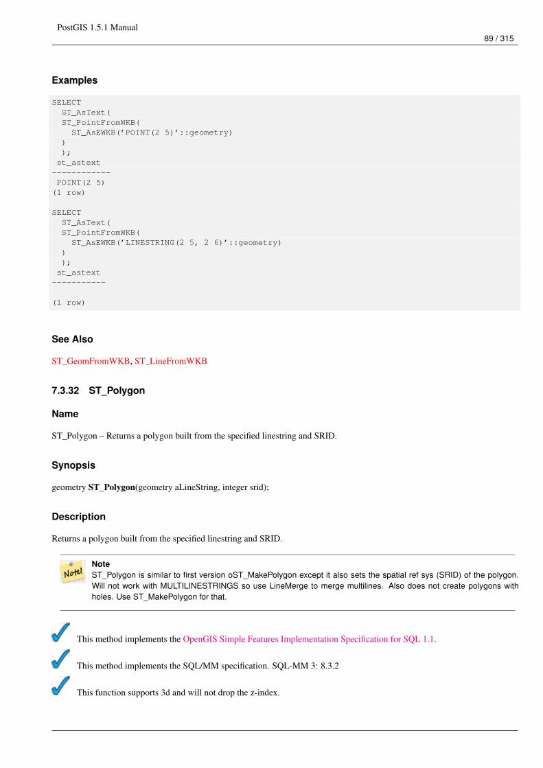
PostGIS 1.5.1 Manual89 / 315
Examples
SELECTST_AsText(ST_PointFromWKB(ST_AsEWKB(’POINT(2 5)’::geometry)
));st_astext
------------POINT(2 5)
(1 row)
SELECTST_AsText(ST_PointFromWKB(ST_AsEWKB(’LINESTRING(2 5, 2 6)’::geometry)
));st_astext
-----------
(1 row)
See Also
ST_GeomFromWKB, ST_LineFromWKB
7.3.32 ST_Polygon
Name
ST_Polygon – Returns a polygon built from the specified linestring and SRID.
Synopsis
geometry ST_Polygon(geometry aLineString, integer srid);
Description
Returns a polygon built from the specified linestring and SRID.
NoteST_Polygon is similar to first version oST_MakePolygon except it also sets the spatial ref sys (SRID) of the polygon.Will not work with MULTILINESTRINGS so use LineMerge to merge multilines. Also does not create polygons withholes. Use ST_MakePolygon for that.
This method implements the OpenGIS Simple Features Implementation Specification for SQL 1.1.
This method implements the SQL/MM specification. SQL-MM 3: 8.3.2
This function supports 3d and will not drop the z-index.
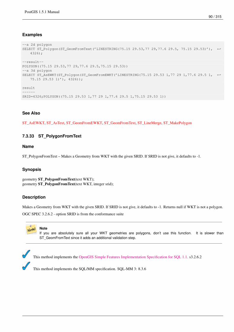
PostGIS 1.5.1 Manual90 / 315
Examples
--a 2d polygonSELECT ST_Polygon(ST_GeomFromText(’LINESTRING(75.15 29.53,77 29,77.6 29.5, 75.15 29.53)’), ←↩
4326);
--result--POLYGON((75.15 29.53,77 29,77.6 29.5,75.15 29.53))--a 3d polygonSELECT ST_AsEWKT(ST_Polygon(ST_GeomFromEWKT(’LINESTRING(75.15 29.53 1,77 29 1,77.6 29.5 1, ←↩
75.15 29.53 1)’), 4326));
result------SRID=4326;POLYGON((75.15 29.53 1,77 29 1,77.6 29.5 1,75.15 29.53 1))
See Also
ST_AsEWKT, ST_AsText, ST_GeomFromEWKT, ST_GeomFromText, ST_LineMerge, ST_MakePolygon
7.3.33 ST_PolygonFromText
Name
ST_PolygonFromText – Makes a Geometry from WKT with the given SRID. If SRID is not give, it defaults to -1.
Synopsis
geometry ST_PolygonFromText(text WKT);geometry ST_PolygonFromText(text WKT, integer srid);
Description
Makes a Geometry from WKT with the given SRID. If SRID is not give, it defaults to -1. Returns null if WKT is not a polygon.
OGC SPEC 3.2.6.2 - option SRID is from the conformance suite
NoteIf you are absolutely sure all your WKT geometries are polygons, don’t use this function. It is slower thanST_GeomFromText since it adds an additional validation step.
This method implements the OpenGIS Simple Features Implementation Specification for SQL 1.1. s3.2.6.2
This method implements the SQL/MM specification. SQL-MM 3: 8.3.6
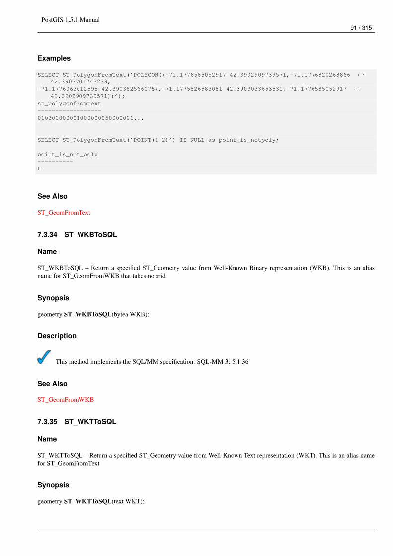
PostGIS 1.5.1 Manual91 / 315
Examples
SELECT ST_PolygonFromText(’POLYGON((-71.1776585052917 42.3902909739571,-71.1776820268866 ←↩42.3903701743239,
-71.1776063012595 42.3903825660754,-71.1775826583081 42.3903033653531,-71.1776585052917 ←↩42.3902909739571))’);
st_polygonfromtext------------------010300000001000000050000006...
SELECT ST_PolygonFromText(’POINT(1 2)’) IS NULL as point_is_notpoly;
point_is_not_poly----------t
See Also
ST_GeomFromText
7.3.34 ST_WKBToSQL
Name
ST_WKBToSQL – Return a specified ST_Geometry value from Well-Known Binary representation (WKB). This is an aliasname for ST_GeomFromWKB that takes no srid
Synopsis
geometry ST_WKBToSQL(bytea WKB);
Description
This method implements the SQL/MM specification. SQL-MM 3: 5.1.36
See Also
ST_GeomFromWKB
7.3.35 ST_WKTToSQL
Name
ST_WKTToSQL – Return a specified ST_Geometry value from Well-Known Text representation (WKT). This is an alias namefor ST_GeomFromText
Synopsis
geometry ST_WKTToSQL(text WKT);
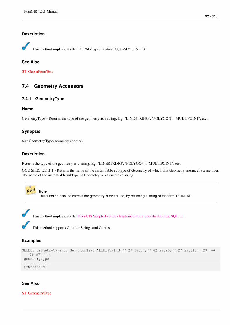
PostGIS 1.5.1 Manual92 / 315
Description
This method implements the SQL/MM specification. SQL-MM 3: 5.1.34
See Also
ST_GeomFromText
7.4 Geometry Accessors
7.4.1 GeometryType
Name
GeometryType – Returns the type of the geometry as a string. Eg: ’LINESTRING’, ’POLYGON’, ’MULTIPOINT’, etc.
Synopsis
text GeometryType(geometry geomA);
Description
Returns the type of the geometry as a string. Eg: ’LINESTRING’, ’POLYGON’, ’MULTIPOINT’, etc.
OGC SPEC s2.1.1.1 - Returns the name of the instantiable subtype of Geometry of which this Geometry instance is a member.The name of the instantiable subtype of Geometry is returned as a string.
NoteThis function also indicates if the geometry is measured, by returning a string of the form ’POINTM’.
This method implements the OpenGIS Simple Features Implementation Specification for SQL 1.1.
This method supports Circular Strings and Curves
Examples
SELECT GeometryType(ST_GeomFromText(’LINESTRING(77.29 29.07,77.42 29.26,77.27 29.31,77.29 ←↩29.07)’));
geometrytype--------------LINESTRING
See Also
ST_GeometryType
PostGIS 1.5.1 Manual93 / 315
7.4.2 ST_Boundary
Name
ST_Boundary – Returns the closure of the combinatorial boundary of this Geometry.
Synopsis
geometry ST_Boundary(geometry geomA);
Description
Returns the closure of the combinatorial boundary of this Geometry. The combinatorial boundary is defined as described insection 3.12.3.2 of the OGC SPEC. Because the result of this function is a closure, and hence topologically closed, the resultingboundary can be represented using representational geometry primitives as discussed in the OGC SPEC, section 3.12.2.
Performed by the GEOS module
ImportantDo not call with a GEOMETRYCOLLECTION as an argument
This method implements the OpenGIS Simple Features Implementation Specification for SQL 1.1. OGC SPEC s2.1.1.1
This method implements the SQL/MM specification. SQL-MM 3: 5.1.14
This function supports 3d and will not drop the z-index.
Examples
SELECT ST_AsText(ST_Boundary(ST_GeomFromText(’LINESTRING(1 1,0 0, -1 1)’)));st_astext-----------MULTIPOINT(1 1,-1 1)
SELECT ST_AsText(ST_Boundary(ST_GeomFromText(’POLYGON((1 1,0 0, -1 1, 1 1))’)));st_astext----------LINESTRING(1 1,0 0,-1 1,1 1)
--Using a 3d polygonSELECT ST_AsEWKT(ST_Boundary(ST_GeomFromEWKT(’POLYGON((1 1 1,0 0 1, -1 1 1, 1 1 1))’)));
st_asewkt-----------------------------------LINESTRING(1 1 1,0 0 1,-1 1 1,1 1 1)
--Using a 3d multilinestringSELECT ST_AsEWKT(ST_Boundary(ST_GeomFromEWKT(’MULTILINESTRING((1 1 1,0 0 0.5, -1 1 1),(1 1 ←↩
0.5,0 0 0.5, -1 1 0.5, 1 1 0.5) )’)));
st_asewkt----------MULTIPOINT(-1 1 1,1 1 0.75)
PostGIS 1.5.1 Manual94 / 315
See Also
ST_ExteriorRing, ST_MakePolygon
7.4.3 ST_CoordDim
Name
ST_CoordDim – Return the coordinate dimension of the ST_Geometry value.
Synopsis
integer ST_CoordDim(geometry geomA);
Description
Return the coordinate dimension of the ST_Geometry value.
This is the MM compliant alias name for ST_NDims
This method implements the OpenGIS Simple Features Implementation Specification for SQL 1.1.
This method implements the SQL/MM specification. SQL-MM 3: 5.1.3
This method supports Circular Strings and Curves
This function supports 3d and will not drop the z-index.
Examples
SELECT ST_CoordDim(’CIRCULARSTRING(1 2 3, 1 3 4, 5 6 7, 8 9 10, 11 12 13)’);---result--3
SELECT ST_CoordDim(ST_Point(1,2));--result--2
See Also
ST_NDims
7.4.4 ST_Dimension
Name
ST_Dimension – The inherent dimension of this Geometry object, which must be less than or equal to the coordinate dimension.
PostGIS 1.5.1 Manual95 / 315
Synopsis
integer ST_Dimension(geometry g);
Description
The inherent dimension of this Geometry object, which must be less than or equal to the coordinate dimension. OGC SPECs2.1.1.1 - returns 0 for POINT, 1 for LINESTRING, 2 for POLYGON, and the largest dimension of the components of a GEOM-ETRYCOLLECTION.
This method implements the SQL/MM specification. SQL-MM 3: 5.1.2
Examples
SELECT ST_Dimension(’GEOMETRYCOLLECTION(LINESTRING(1 1,0 0),POINT(0 0))’);ST_Dimension-----------1
See Also
ST_NDims
7.4.5 ST_EndPoint
Name
ST_EndPoint – Returns the last point of a LINESTRING geometry as a POINT.
Synopsis
boolean ST_EndPoint(geometry g);
Description
Returns the last point of a LINESTRING geometry as a POINT or NULL if the input parameter is not a LINESTRING.
This method implements the SQL/MM specification. SQL-MM 3: 7.1.4
This function supports 3d and will not drop the z-index.
Examples
postgis=# SELECT ST_AsText(ST_EndPoint(’LINESTRING(1 1, 2 2, 3 3)’::geometry));st_astext
------------POINT(3 3)
(1 row)
postgis=# SELECT ST_EndPoint(’POINT(1 1)’::geometry) IS NULL AS is_null;
PostGIS 1.5.1 Manual96 / 315
is_null----------t
(1 row)
--3d endpointSELECT ST_AsEWKT(ST_EndPoint(’LINESTRING(1 1 2, 1 2 3, 0 0 5)’));st_asewkt
--------------POINT(0 0 5)
(1 row)
See Also
ST_PointN, ST_StartPoint
7.4.6 ST_Envelope
Name
ST_Envelope – Returns a geometry representing the double precision (float8) bounding box of the supplied geometry.
Synopsis
geometry ST_Envelope(geometry g1);
Description
Returns the float8 minimum bounding box for the supplied geometry, as a geometry. The polygon is defined by the cornerpoints of the bounding box ((MINX, MINY), (MINX, MAXY), (MAXX, MAXY), (MAXX, MINY), (MINX, MINY)). (PostGIS will adda ZMIN/ZMAX coordinate as well).
Degenerate cases (vertical lines, points) will return a geometry of lower dimension than POLYGON, ie. POINT or LINESTRING.
Availability: 1.5.0 behavior changed to output double precision instead of float4
This method implements the OpenGIS Simple Features Implementation Specification for SQL 1.1. s2.1.1.1
This method implements the SQL/MM specification. SQL-MM 3: 5.1.15
Examples
SELECT ST_AsText(ST_Envelope(’POINT(1 3)’::geometry));st_astext
------------POINT(1 3)
(1 row)
SELECT ST_AsText(ST_Envelope(’LINESTRING(0 0, 1 3)’::geometry));st_astext
--------------------------------POLYGON((0 0,0 3,1 3,1 0,0 0))
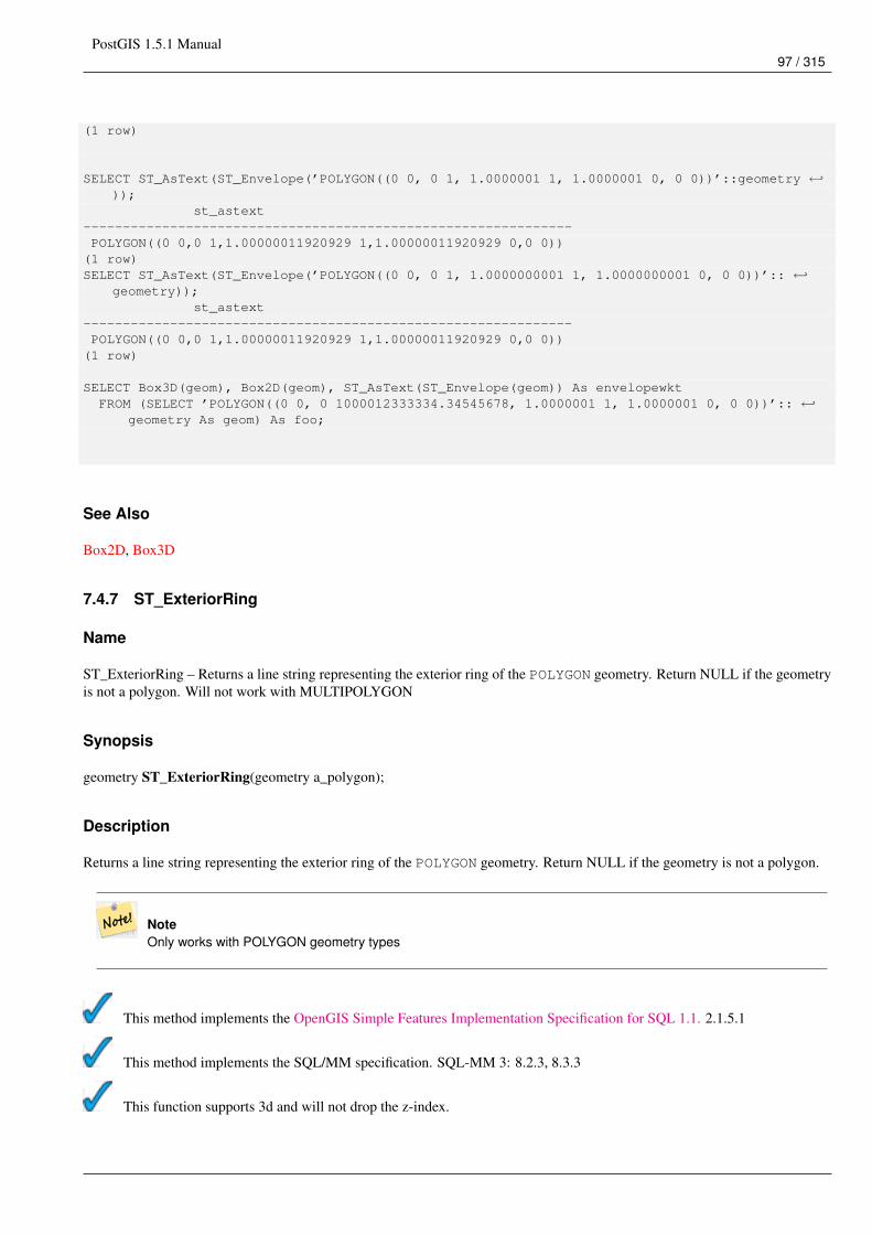
PostGIS 1.5.1 Manual97 / 315
(1 row)
SELECT ST_AsText(ST_Envelope(’POLYGON((0 0, 0 1, 1.0000001 1, 1.0000001 0, 0 0))’::geometry ←↩));
st_astext--------------------------------------------------------------POLYGON((0 0,0 1,1.00000011920929 1,1.00000011920929 0,0 0))
(1 row)SELECT ST_AsText(ST_Envelope(’POLYGON((0 0, 0 1, 1.0000000001 1, 1.0000000001 0, 0 0))’:: ←↩
geometry));st_astext
--------------------------------------------------------------POLYGON((0 0,0 1,1.00000011920929 1,1.00000011920929 0,0 0))
(1 row)
SELECT Box3D(geom), Box2D(geom), ST_AsText(ST_Envelope(geom)) As envelopewktFROM (SELECT ’POLYGON((0 0, 0 1000012333334.34545678, 1.0000001 1, 1.0000001 0, 0 0))’:: ←↩
geometry As geom) As foo;
See Also
Box2D, Box3D
7.4.7 ST_ExteriorRing
Name
ST_ExteriorRing – Returns a line string representing the exterior ring of the POLYGON geometry. Return NULL if the geometryis not a polygon. Will not work with MULTIPOLYGON
Synopsis
geometry ST_ExteriorRing(geometry a_polygon);
Description
Returns a line string representing the exterior ring of the POLYGON geometry. Return NULL if the geometry is not a polygon.
NoteOnly works with POLYGON geometry types
This method implements the OpenGIS Simple Features Implementation Specification for SQL 1.1. 2.1.5.1
This method implements the SQL/MM specification. SQL-MM 3: 8.2.3, 8.3.3
This function supports 3d and will not drop the z-index.
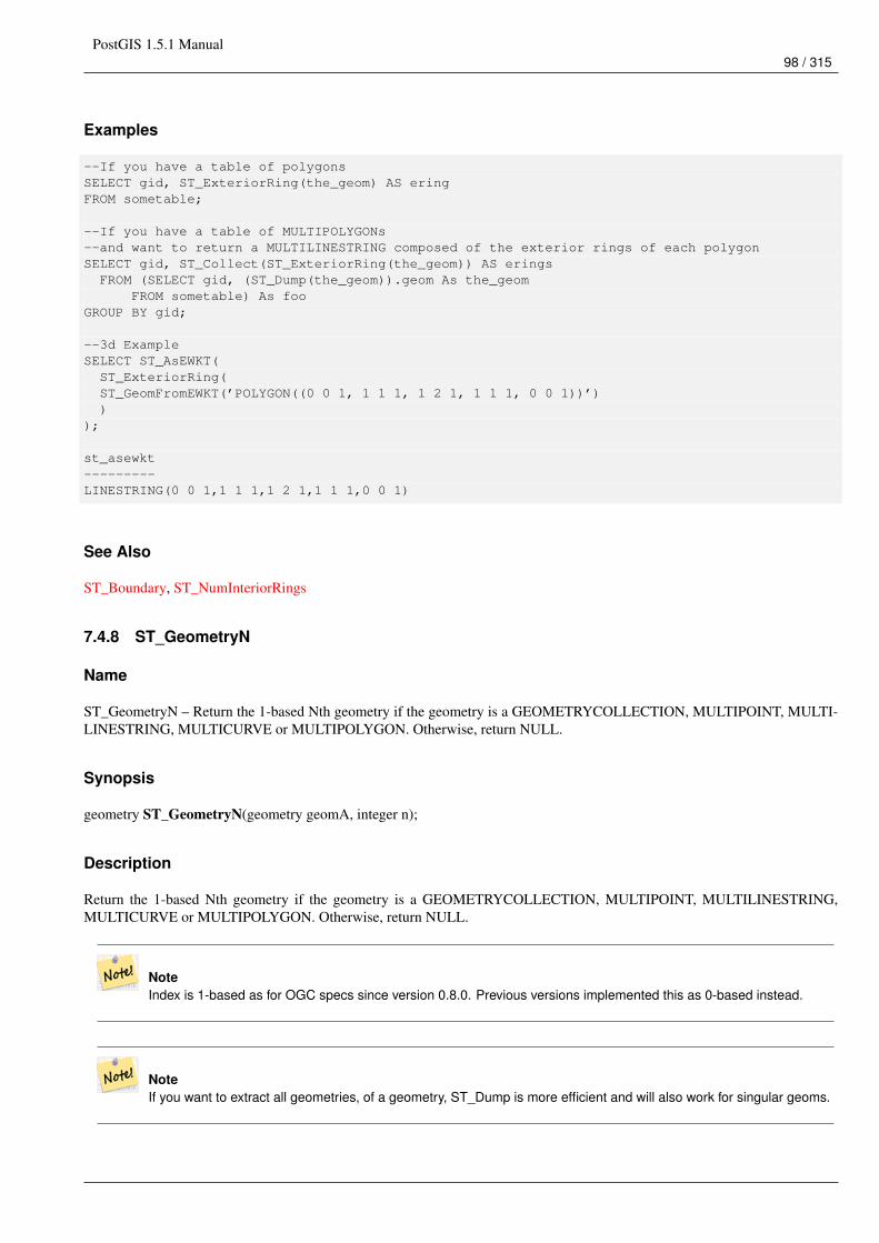
PostGIS 1.5.1 Manual98 / 315
Examples
--If you have a table of polygonsSELECT gid, ST_ExteriorRing(the_geom) AS eringFROM sometable;
--If you have a table of MULTIPOLYGONs--and want to return a MULTILINESTRING composed of the exterior rings of each polygonSELECT gid, ST_Collect(ST_ExteriorRing(the_geom)) AS eringsFROM (SELECT gid, (ST_Dump(the_geom)).geom As the_geom
FROM sometable) As fooGROUP BY gid;
--3d ExampleSELECT ST_AsEWKT(ST_ExteriorRing(ST_GeomFromEWKT(’POLYGON((0 0 1, 1 1 1, 1 2 1, 1 1 1, 0 0 1))’))
);
st_asewkt---------LINESTRING(0 0 1,1 1 1,1 2 1,1 1 1,0 0 1)
See Also
ST_Boundary, ST_NumInteriorRings
7.4.8 ST_GeometryN
Name
ST_GeometryN – Return the 1-based Nth geometry if the geometry is a GEOMETRYCOLLECTION, MULTIPOINT, MULTI-LINESTRING, MULTICURVE or MULTIPOLYGON. Otherwise, return NULL.
Synopsis
geometry ST_GeometryN(geometry geomA, integer n);
Description
Return the 1-based Nth geometry if the geometry is a GEOMETRYCOLLECTION, MULTIPOINT, MULTILINESTRING,MULTICURVE or MULTIPOLYGON. Otherwise, return NULL.
NoteIndex is 1-based as for OGC specs since version 0.8.0. Previous versions implemented this as 0-based instead.
NoteIf you want to extract all geometries, of a geometry, ST_Dump is more efficient and will also work for singular geoms.
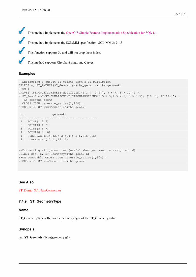
PostGIS 1.5.1 Manual99 / 315
This method implements the OpenGIS Simple Features Implementation Specification for SQL 1.1.
This method implements the SQL/MM specification. SQL-MM 3: 9.1.5
This function supports 3d and will not drop the z-index.
This method supports Circular Strings and Curves
Examples
--Extracting a subset of points from a 3d multipointSELECT n, ST_AsEWKT(ST_GeometryN(the_geom, n)) As geomewktFROM (VALUES (ST_GeomFromEWKT(’MULTIPOINT(1 2 7, 3 4 7, 5 6 7, 8 9 10)’) ),( ST_GeomFromEWKT(’MULTICURVE(CIRCULARSTRING(2.5 2.5,4.5 2.5, 3.5 3.5), (10 11, 12 11))’) ))As foo(the_geom)CROSS JOIN generate_series(1,100) n
WHERE n <= ST_NumGeometries(the_geom);
n | geomewkt---+-----------------------------------------1 | POINT(1 2 7)2 | POINT(3 4 7)3 | POINT(5 6 7)4 | POINT(8 9 10)1 | CIRCULARSTRING(2.5 2.5,4.5 2.5,3.5 3.5)2 | LINESTRING(10 11,12 11)
--Extracting all geometries (useful when you want to assign an id)SELECT gid, n, ST_GeometryN(the_geom, n)FROM sometable CROSS JOIN generate_series(1,100) nWHERE n <= ST_NumGeometries(the_geom);
See Also
ST_Dump, ST_NumGeometries
7.4.9 ST_GeometryType
Name
ST_GeometryType – Return the geometry type of the ST_Geometry value.
Synopsis
text ST_GeometryType(geometry g1);
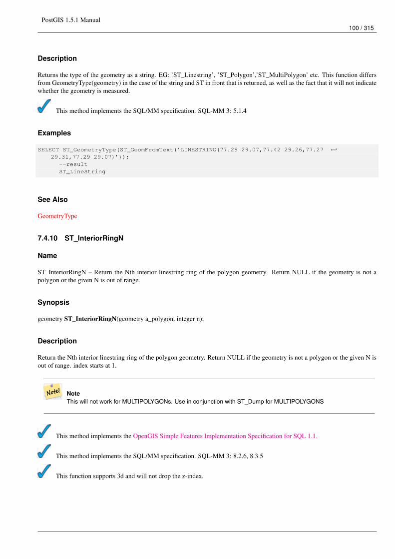
PostGIS 1.5.1 Manual100 / 315
Description
Returns the type of the geometry as a string. EG: ’ST_Linestring’, ’ST_Polygon’,’ST_MultiPolygon’ etc. This function differsfrom GeometryType(geometry) in the case of the string and ST in front that is returned, as well as the fact that it will not indicatewhether the geometry is measured.
This method implements the SQL/MM specification. SQL-MM 3: 5.1.4
Examples
SELECT ST_GeometryType(ST_GeomFromText(’LINESTRING(77.29 29.07,77.42 29.26,77.27 ←↩29.31,77.29 29.07)’));
--resultST_LineString
See Also
GeometryType
7.4.10 ST_InteriorRingN
Name
ST_InteriorRingN – Return the Nth interior linestring ring of the polygon geometry. Return NULL if the geometry is not apolygon or the given N is out of range.
Synopsis
geometry ST_InteriorRingN(geometry a_polygon, integer n);
Description
Return the Nth interior linestring ring of the polygon geometry. Return NULL if the geometry is not a polygon or the given N isout of range. index starts at 1.
NoteThis will not work for MULTIPOLYGONs. Use in conjunction with ST_Dump for MULTIPOLYGONS
This method implements the OpenGIS Simple Features Implementation Specification for SQL 1.1.
This method implements the SQL/MM specification. SQL-MM 3: 8.2.6, 8.3.5
This function supports 3d and will not drop the z-index.
PostGIS 1.5.1 Manual101 / 315
Examples
SELECT ST_AsText(ST_InteriorRingN(the_geom, 1)) As the_geomFROM (SELECT ST_BuildArea(
ST_Collect(ST_Buffer(ST_Point(1,2), 20,3),ST_Buffer(ST_Point(1, 2), 10,3))) As the_geom
) as foo
See Also
ST_BuildArea, ST_Collect, ST_Dump, ST_NumInteriorRing, ST_NumInteriorRings
7.4.11 ST_IsClosed
Name
ST_IsClosed – Returns TRUE if the LINESTRING’s start and end points are coincident.
Synopsis
boolean ST_IsClosed(geometry g);
Description
Returns TRUE if the LINESTRING’s start and end points are coincident.
This method implements the OpenGIS Simple Features Implementation Specification for SQL 1.1.
This method implements the SQL/MM specification. SQL-MM 3: 7.1.5, 9.3.3
NoteSQL-MM defines the result of ST_IsClosed(NULL) to be 0, while PostGIS returns NULL.
This function supports 3d and will not drop the z-index.
This method supports Circular Strings and Curves
Examples
postgis=# SELECT ST_IsClosed(’LINESTRING(0 0, 1 1)’::geometry);st_isclosed
-------------f
(1 row)
postgis=# SELECT ST_IsClosed(’LINESTRING(0 0, 0 1, 1 1, 0 0)’::geometry);st_isclosed
PostGIS 1.5.1 Manual102 / 315
-------------t
(1 row)
postgis=# SELECT ST_IsClosed(’MULTILINESTRING((0 0, 0 1, 1 1, 0 0),(0 0, 1 1))’::geometry);st_isclosed
-------------f
(1 row)
postgis=# SELECT ST_IsClosed(’POINT(0 0)’::geometry);st_isclosed
-------------t
(1 row)
postgis=# SELECT ST_IsClosed(’MULTIPOINT((0 0), (1 1))’::geometry);st_isclosed
-------------t
(1 row)
See Also
ST_IsRing
7.4.12 ST_IsEmpty
Name
ST_IsEmpty – Returns true if this Geometry is an empty geometry . If true, then this Geometry represents the empty point set -i.e. GEOMETRYCOLLECTION(EMPTY).
Synopsis
boolean ST_IsEmpty(geometry geomA);
Description
Returns true if this Geometry is an empty geometry . If true, then this Geometry represents an empty geometry collection,polygon, point etc.
NoteSQL-MM defines the result of ST_IsEmpty(NULL) to be 0, while PostGIS returns NULL.
This method implements the OpenGIS Simple Features Implementation Specification for SQL 1.1. s2.1.1.1
This method implements the SQL/MM specification. SQL-MM 3: 5.1.7
This method supports Circular Strings and Curves
PostGIS 1.5.1 Manual103 / 315
Examples
SELECT ST_IsEmpty(’GEOMETRYCOLLECTION(EMPTY)’);st_isempty
------------t
(1 row)
SELECT ST_IsEmpty(ST_GeomFromText(’POLYGON EMPTY’));st_isempty
------------t
(1 row)
SELECT ST_IsEmpty(ST_GeomFromText(’POLYGON((1 2, 3 4, 5 6, 1 2))’));
st_isempty------------f
(1 row)
SELECT ST_IsEmpty(ST_GeomFromText(’POLYGON((1 2, 3 4, 5 6, 1 2))’)) = false;?column?----------t
(1 row)
SELECT ST_IsEmpty(ST_GeomFromText(’CIRCULARSTRING EMPTY’));st_isempty
------------t
(1 row)
7.4.13 ST_IsRing
Name
ST_IsRing – Returns TRUE if this LINESTRING is both closed and simple.
Synopsis
boolean ST_IsRing(geometry g);
Description
Returns TRUE if this LINESTRING is both ST_IsClosed (ST_StartPoint((g)) ~= ST_Endpoint((g))) and ST_IsSimple(does not self intersect).
This method implements the OpenGIS Simple Features Implementation Specification for SQL 1.1. 2.1.5.1
This method implements the SQL/MM specification. SQL-MM 3: 7.1.6
PostGIS 1.5.1 Manual104 / 315
NoteSQL-MM defines the result of ST_IsRing(NULL) to be 0, while PostGIS returns NULL.
Examples
SELECT ST_IsRing(the_geom), ST_IsClosed(the_geom), ST_IsSimple(the_geom)FROM (SELECT ’LINESTRING(0 0, 0 1, 1 1, 1 0, 0 0)’::geometry AS the_geom) AS foo;st_isring | st_isclosed | st_issimple
-----------+-------------+-------------t | t | t
(1 row)
SELECT ST_IsRing(the_geom), ST_IsClosed(the_geom), ST_IsSimple(the_geom)FROM (SELECT ’LINESTRING(0 0, 0 1, 1 0, 1 1, 0 0)’::geometry AS the_geom) AS foo;st_isring | st_isclosed | st_issimple
-----------+-------------+-------------f | t | f
(1 row)
See Also
ST_IsClosed, ST_IsSimple, ST_StartPoint, ST_EndPoint
7.4.14 ST_IsSimple
Name
ST_IsSimple – Returns (TRUE) if this Geometry has no anomalous geometric points, such as self intersection or self tangency.
Synopsis
boolean ST_IsSimple(geometry geomA);
Description
Returns true if this Geometry has no anomalous geometric points, such as self intersection or self tangency. For more informationon the OGC’s definition of geometry simplicity and validity, refer to "Ensuring OpenGIS compliancy of geometries"
NoteSQL-MM defines the result of ST_IsSimple(NULL) to be 0, while PostGIS returns NULL.
This method implements the OpenGIS Simple Features Implementation Specification for SQL 1.1. s2.1.1.1
This method implements the SQL/MM specification. SQL-MM 3: 5.1.8
This function supports 3d and will not drop the z-index.
PostGIS 1.5.1 Manual105 / 315
Examples
SELECT ST_IsSimple(ST_GeomFromText(’POLYGON((1 2, 3 4, 5 6, 1 2))’));st_issimple
-------------t
(1 row)
SELECT ST_IsSimple(ST_GeomFromText(’LINESTRING(1 1,2 2,2 3.5,1 3,1 2,2 1)’));st_issimple
-------------f
(1 row)
See Also
ST_IsValid
7.4.15 ST_IsValid
Name
ST_IsValid – Returns true if the ST_Geometry is well formed.
Synopsis
boolean ST_IsValid(geometry g);
Description
Test if an ST_Geometry value is well formed. For geometries that are invalid, the PostgreSQL NOTICE will provide detailsof why it is not valid. For more information on the OGC’s definition of geometry simplicity and validity, refer to "EnsuringOpenGIS compliancy of geometries"
NoteSQL-MM defines the result of ST_IsValid(NULL) to be 0, while PostGIS returns NULL.
This method implements the OpenGIS Simple Features Implementation Specification for SQL 1.1.
This method implements the SQL/MM specification. SQL-MM 3: 5.1.9
Examples
SELECT ST_IsValid(ST_GeomFromText(’LINESTRING(0 0, 1 1)’)) As good_line,ST_IsValid(ST_GeomFromText(’POLYGON((0 0, 1 1, 1 2, 1 1, 0 0))’)) As bad_poly
--resultsNOTICE: Self-intersection at or near point 0 0good_line | bad_poly
-----------+----------t | f
PostGIS 1.5.1 Manual106 / 315
See Also
ST_IsSimple, ST_IsValidReason, ST_Summary
7.4.16 ST_IsValidReason
Name
ST_IsValidReason – Returns text stating if a geometry is valid or not and if not valid, a reason why.
Synopsis
text ST_IsValidReason(geometry geomA);
Description
Returns text stating if a geometry is valid or not an if not valid, a reason why.
Useful in combination with ST_IsValid to generate a detailed report of invalid geometries and reasons.
Availability: 1.4 - requires GEOS >= 3.1.0.
Examples
--First 3 Rejects from a successful quintuplet experimentSELECT gid, ST_IsValidReason(the_geom) as validity_infoFROM(SELECT ST_MakePolygon(ST_ExteriorRing(e.buff), ST_Accum(f.line)) As the_geom, gidFROM (SELECT ST_Buffer(ST_MakePoint(x1*10,y1), z1) As buff, x1*10 + y1*100 + z1*1000 As gidFROM generate_series(-4,6) x1CROSS JOIN generate_series(2,5) y1CROSS JOIN generate_series(1,8) z1WHERE x1 > y1*0.5 AND z1 < x1*y1) As eINNER JOIN (SELECT ST_Translate(ST_ExteriorRing(ST_Buffer(ST_MakePoint(x1*10,y1), z1)),y1 ←↩
*1, z1*2) As lineFROM generate_series(-3,6) x1CROSS JOIN generate_series(2,5) y1CROSS JOIN generate_series(1,10) z1WHERE x1 > y1*0.75 AND z1 < x1*y1) As f
ON (ST_Area(e.buff) > 78 AND ST_Contains(e.buff, f.line))GROUP BY gid, e.buff) As quintuplet_experimentWHERE ST_IsValid(the_geom) = falseORDER BY gidLIMIT 3;
gid | validity_info------+--------------------------5330 | Self-intersection [32 5]5340 | Self-intersection [42 5]5350 | Self-intersection [52 5]
--simple exampleSELECT ST_IsValidReason(’LINESTRING(220227 150406,2220227 150407,222020 150410)’);
st_isvalidreason------------------Valid Geometry

PostGIS 1.5.1 Manual107 / 315
See Also
ST_IsValid, ST_Summary
7.4.17 ST_M
Name
ST_M – Return the M coordinate of the point, or NULL if not available. Input must be a point.
Synopsis
float ST_M(geometry a_point);
Description
Return the M coordinate of the point, or NULL if not available. Input must be a point.
NoteThis is not (yet) part of the OGC spec, but is listed here to complete the point coordinate extractor function list.
This method implements the OpenGIS Simple Features Implementation Specification for SQL 1.1.
This method implements the SQL/MM specification.
This function supports 3d and will not drop the z-index.
Examples
SELECT ST_M(ST_GeomFromEWKT(’POINT(1 2 3 4)’));st_m------4
(1 row)
See Also
ST_GeomFromEWKT, ST_X, ST_Y, ST_Z
7.4.18 ST_NDims
Name
ST_NDims – Returns coordinate dimension of the geometry as a small int. Values are: 2,3 or 4.
PostGIS 1.5.1 Manual108 / 315
Synopsis
integer ST_NDims(geometry g1);
Description
Returns the coordinate dimension of the geometry. PostGIS supports 2 - (x,y) , 3 - (x,y,z) or 2D with measure - x,y,m, and 4 - 3Dwith measure space x,y,z,m
This function supports 3d and will not drop the z-index.
Examples
SELECT ST_NDims(ST_GeomFromText(’POINT(1 1)’)) As d2point,ST_NDims(ST_GeomFromEWKT(’POINT(1 1 2)’)) As d3point,ST_NDims(ST_GeomFromEWKT(’POINTM(1 1 0.5)’)) As d2pointm;
d2point | d3point | d2pointm---------+---------+----------
2 | 3 | 3
See Also
ST_CoordDim, ST_Dimension, ST_GeomFromEWKT
7.4.19 ST_NPoints
Name
ST_NPoints – Return the number of points (vertexes) in a geometry.
Synopsis
integer ST_NPoints(geometry g1);
Description
Return the number of points in a geometry. Works for all geometries.
NotePrior to 1.3.4, this function crashes if used with geometries that contain CURVES. This is fixed in 1.3.4+
This function supports 3d and will not drop the z-index.
This method supports Circular Strings and Curves
PostGIS 1.5.1 Manual109 / 315
Examples
SELECT ST_NPoints(ST_GeomFromText(’LINESTRING(77.29 29.07,77.42 29.26,77.27 29.31,77.29 ←↩29.07)’));
--result4
--Polygon in 3D spaceSELECT ST_NPoints(ST_GeomFromEWKT(’LINESTRING(77.29 29.07 1,77.42 29.26 0,77.27 29.31 ←↩
-1,77.29 29.07 3)’))--result4
See Also
ST_NumPoints
7.4.20 ST_NRings
Name
ST_NRings – If the geometry is a polygon or multi-polygon returns the number of rings.
Synopsis
integer ST_NRings(geometry geomA);
Description
If the geometry is a polygon or multi-polygon returns the number of rings. Unlike NumInteriorRings, it counts the outer rings aswell.
This function supports 3d and will not drop the z-index.
This method supports Circular Strings and Curves
Examples
SELECT ST_NRings(the_geom) As Nrings, ST_NumInteriorRings(the_geom) As ninterringsFROM (SELECT ST_GeomFromText(’POLYGON((1 2, 3 4, 5 6, 1 2))’) As the_geom) As foo ←↩
;nrings | ninterrings
--------+-------------1 | 0
(1 row)
See Also
ST_NumInteriorRings
PostGIS 1.5.1 Manual110 / 315
7.4.21 ST_NumGeometries
Name
ST_NumGeometries – If geometry is a GEOMETRYCOLLECTION (or MULTI*) return the number of geometries, otherwisereturn NULL.
Synopsis
integer ST_NumGeometries(geometry a_multi_or_geomcollection);
Description
Returns the number of Geometries. If geometry is a GEOMETRYCOLLECTION (or MULTI*) return the number of geometries,otherwise return NULL.
This method implements the SQL/MM specification. SQL-MM 3: 9.1.4
Examples
--Although ST_NumGeometries will return null when passed a single, you can wrap in ST_Multi ←↩to force 1 or more for all geoms
SELECT ST_NumGeometries(ST_Multi(ST_GeomFromText(’LINESTRING(77.29 29.07,77.42 29.26,77.27 ←↩29.31,77.29 29.07)’)));
--result1
--Geometry Collection Example - multis count as one geom in a collectionSELECT ST_NumGeometries(ST_GeomFromEWKT(’GEOMETRYCOLLECTION(MULTIPOINT(-2 3 , -2 2),LINESTRING(5 5 ,10 10),POLYGON((-7 4.2,-7.1 5,-7.1 4.3,-7 4.2)))’));--result3
See Also
ST_GeometryN, ST_Multi
7.4.22 ST_NumInteriorRings
Name
ST_NumInteriorRings – Return the number of interior rings of the first polygon in the geometry. This will work with bothPOLYGON and MULTIPOLYGON types but only looks at the first polygon. Return NULL if there is no polygon in the geometry.
Synopsis
integer ST_NumInteriorRings(geometry a_polygon);
PostGIS 1.5.1 Manual111 / 315
Description
Return the number of interior rings of the first polygon in the geometry. This will work with both POLYGON and MULTIPOLY-GON types but only looks at the first polygon. Return NULL if there is no polygon in the geometry.
This method implements the SQL/MM specification. SQL-MM 3: 8.2.5
Examples
--If you have a regular polygonSELECT gid, field1, field2, ST_NumInteriorRings(the_geom) AS numholesFROM sometable;
--If you have multipolygons--And you want to know the total number of interior rings in the MULTIPOLYGONSELECT gid, field1, field2, SUM(ST_NumInteriorRings(the_geom)) AS numholesFROM (SELECT gid, field1, field2, (ST_Dump(the_geom)).geom As the_geomFROM sometable) As foo
GROUP BY gid, field1,field2;
See Also
ST_NumInteriorRing
7.4.23 ST_NumInteriorRing
Name
ST_NumInteriorRing – Return the number of interior rings of the first polygon in the geometry. Synonym to ST_NumInteriorRings.
Synopsis
integer ST_NumInteriorRing(geometry a_polygon);
Description
Return the number of interior rings of the first polygon in the geometry. Synonym to ST_NumInteriorRings. The OpenGIS specsare ambiguous about the exact function naming, so we provide both spellings.
This method implements the SQL/MM specification. SQL-MM 3: 8.2.5
See Also
ST_NumInteriorRings
7.4.24 ST_NumPoints
Name
ST_NumPoints – Return the number of points in an ST_LineString or ST_CircularString value.
PostGIS 1.5.1 Manual112 / 315
Synopsis
integer ST_NumPoints(geometry g1);
Description
Return the number of points in an ST_LineString or ST_CircularString value. Prior to 1.4 only works with Linestrings as thespecs state. From 1.4 forward this is an alias for ST_NPoints which returns number of vertexes for not just line strings. Considerusing ST_NPoints instead which is multi-purpose and works with many geometry types.
This method implements the OpenGIS Simple Features Implementation Specification for SQL 1.1.
This method implements the SQL/MM specification. SQL-MM 3: 7.2.4
Examples
SELECT ST_NumPoints(ST_GeomFromText(’LINESTRING(77.29 29.07,77.42 29.26,77.27 29.31,77.29 ←↩29.07)’));--result4
See Also
ST_NPoints
7.4.25 ST_PointN
Name
ST_PointN – Return the Nth point in the first linestring or circular linestring in the geometry. Return NULL if there is nolinestring in the geometry.
Synopsis
geometry ST_PointN(geometry a_linestring, integer n);
Description
Return the Nth point in the first linestring or circular linestring in the geometry. Return NULL if there is no linestring in thegeometry.
NoteIndex is 1-based as for OGC specs since version 0.8.0. Previous versions implemented this as 0-based instead.
NoteIf you want to get the nth point of each line string in a multilinestring, use in conjunction with ST_Dump
PostGIS 1.5.1 Manual113 / 315
This method implements the OpenGIS Simple Features Implementation Specification for SQL 1.1.
This method implements the SQL/MM specification. SQL-MM 3: 7.2.5, 7.3.5
This function supports 3d and will not drop the z-index.
This method supports Circular Strings and Curves
Examples
-- Extract all POINTs from a LINESTRINGSELECT ST_AsText(
ST_PointN(column1,generate_series(1, ST_NPoints(column1))
))FROM ( VALUES (’LINESTRING(0 0, 1 1, 2 2)’::geometry) ) AS foo;
st_astext------------POINT(0 0)POINT(1 1)POINT(2 2)
(3 rows)
--Example circular stringSELECT ST_AsText(ST_PointN(ST_GeomFromText(’CIRCULARSTRING(1 2, 3 2, 1 2)’),2));
st_astext----------POINT(3 2)
See Also
ST_NPoints
7.4.26 ST_SRID
Name
ST_SRID – Returns the spatial reference identifier for the ST_Geometry as defined in spatial_ref_sys table.
Synopsis
integer ST_SRID(geometry g1);
Description
Returns the spatial reference identifier for the ST_Geometry as defined in Section 4.3.1 table.
PostGIS 1.5.1 Manual114 / 315
Notespatial_ref_sys table is a table that catalogs all spatial reference systems known to PostGIS and is used for transforma-tions from one spatial reference system to another. So verifying you have the right spatial reference system identifier isimportant if you plan to ever transform your geometries.
This method implements the OpenGIS Simple Features Implementation Specification for SQL 1.1. s2.1.1.1
This method implements the SQL/MM specification. SQL-MM 3: 5.1.5
This method supports Circular Strings and Curves
Examples
SELECT ST_SRID(ST_GeomFromText(’POINT(-71.1043 42.315)’,4326));--result4326
See Also
Section 4.3.1,ST_GeomFromText, ST_SetSRID, ST_Transform
7.4.27 ST_StartPoint
Name
ST_StartPoint – Returns the first point of a LINESTRING geometry as a POINT.
Synopsis
geometry ST_StartPoint(geometry geomA);
Description
Returns the first point of a LINESTRING geometry as a POINT or NULL if the input parameter is not a LINESTRING.
This method implements the SQL/MM specification. SQL-MM 3: 7.1.3
This function supports 3d and will not drop the z-index.
Examples
SELECT ST_AsText(ST_StartPoint(’LINESTRING(0 1, 0 2)’::geometry));st_astext
------------POINT(0 1)
(1 row)
PostGIS 1.5.1 Manual115 / 315
SELECT ST_StartPoint(’POINT(0 1)’::geometry) IS NULL AS is_null;is_null
----------t
(1 row)
--3d lineSELECT ST_AsEWKT(ST_StartPoint(’LINESTRING(0 1 1, 0 2 2)’::geometry));st_asewkt
------------POINT(0 1 1)
(1 row)
See Also
ST_EndPoint, ST_PointN
7.4.28 ST_Summary
Name
ST_Summary – Returns a text summary of the contents of the ST_Geometry.
Synopsis
text ST_Summary(geometry g);
Description
Returns a text summary of the contents of the geometry.
This function supports 3d and will not drop the z-index.
Examples
SELECT ST_Summary(ST_GeomFromText(’LINESTRING(0 0, 1 1)’)) As good_line,ST_Summary(ST_GeomFromText(’POLYGON((0 0, 1 1, 1 2, 1 1, 0 0))’)) As bad_poly
--resultsgood_line | bad_poly
----------------------+-------------------------|
Line[B] with 2 points : Polygon[B] with 1 rings: ring 0 has 5 points:
--3d polygonSELECT ST_Summary(ST_GeomFromEWKT(’LINESTRING(0 0 1, 1 1 1)’)) As good_line,ST_Summary(ST_GeomFromEWKT(’POLYGON((0 0 1, 1 1 2, 1 2 3, 1 1 1, 0 0 1))’)) As poly
--resultsgood_line | poly
----------------------+-------------------------|
PostGIS 1.5.1 Manual116 / 315
Line[ZB] with 2 points : Polygon[ZB] with 1 rings: ring 0 has 5 points:
See Also
ST_IsValid, ST_IsValidReason
7.4.29 ST_X
Name
ST_X – Return the X coordinate of the point, or NULL if not available. Input must be a point.
Synopsis
float ST_X(geometry a_point);
Description
Return the X coordinate of the point, or NULL if not available. Input must be a point.
NoteIf you want to get the max min x values of any geometry look at ST_XMin, ST_XMax functions.
This method implements the SQL/MM specification. SQL-MM 3: 6.1.3
This function supports 3d and will not drop the z-index.
Examples
SELECT ST_X(ST_GeomFromEWKT(’POINT(1 2 3 4)’));st_x------1
(1 row)
SELECT ST_Y(ST_Centroid(ST_GeomFromEWKT(’LINESTRING(1 2 3 4, 1 1 1 1)’)));st_y------1.5
(1 row)
See Also
ST_Centroid, ST_GeomFromEWKT, ST_M, ST_XMax, ST_XMin, ST_Y, ST_Z
PostGIS 1.5.1 Manual117 / 315
7.4.30 ST_Y
Name
ST_Y – Return the Y coordinate of the point, or NULL if not available. Input must be a point.
Synopsis
float ST_Y(geometry a_point);
Description
Return the Y coordinate of the point, or NULL if not available. Input must be a point.
This method implements the OpenGIS Simple Features Implementation Specification for SQL 1.1.
This method implements the SQL/MM specification. SQL-MM 3: 6.1.4
This function supports 3d and will not drop the z-index.
Examples
SELECT ST_Y(ST_GeomFromEWKT(’POINT(1 2 3 4)’));st_y------2
(1 row)
SELECT ST_Y(ST_Centroid(ST_GeomFromEWKT(’LINESTRING(1 2 3 4, 1 1 1 1)’)));st_y------1.5
(1 row)
See Also
ST_Centroid, ST_GeomFromEWKT, ST_M, ST_X, ST_YMax, ST_YMin, ST_Z
7.4.31 ST_Z
Name
ST_Z – Return the Z coordinate of the point, or NULL if not available. Input must be a point.
Synopsis
float ST_Z(geometry a_point);
PostGIS 1.5.1 Manual118 / 315
Description
Return the Z coordinate of the point, or NULL if not available. Input must be a point.
This method implements the SQL/MM specification.
This function supports 3d and will not drop the z-index.
Examples
SELECT ST_Z(ST_GeomFromEWKT(’POINT(1 2 3 4)’));st_z------3
(1 row)
See Also
ST_GeomFromEWKT, ST_M, ST_X, ST_Y, ST_ZMax, ST_ZMin
7.4.32 ST_Zmflag
Name
ST_Zmflag – Returns ZM (dimension semantic) flag of the geometries as a small int. Values are: 0=2d, 1=3dm, 2=3dz, 3=4d.
Synopsis
smallint ST_Zmflag(geometry geomA);
Description
Returns ZM (dimension semantic) flag of the geometries as a small int. Values are: 0=2d, 1=3dm, 2=3dz, 3=4d.
This function supports 3d and will not drop the z-index.
This method supports Circular Strings and Curves
Examples
SELECT ST_Zmflag(ST_GeomFromEWKT(’LINESTRING(1 2, 3 4)’));st_zmflag
-----------0
SELECT ST_Zmflag(ST_GeomFromEWKT(’LINESTRINGM(1 2 3, 3 4 3)’));st_zmflag
-----------1
PostGIS 1.5.1 Manual119 / 315
SELECT ST_Zmflag(ST_GeomFromEWKT(’CIRCULARSTRING(1 2 3, 3 4 3, 5 6 3)’));st_zmflag
-----------2
SELECT ST_Zmflag(ST_GeomFromEWKT(’POINT(1 2 3 4)’));st_zmflag
-----------3
See Also
ST_CoordDim, ST_NDims, ST_Dimension
7.5 Geometry Editors
7.5.1 ST_AddPoint
Name
ST_AddPoint – Adds a point to a LineString before point <position> (0-based index).
Synopsis
geometry ST_AddPoint(geometry linestring, geometry point);
geometry ST_AddPoint(geometry linestring, geometry point, integer position);
Description
Adds a point to a LineString before point <position> (0-based index). Third parameter can be omitted or set to -1 for appending.
Availability: 1.1.0
This function supports 3d and will not drop the z-index.
Examples
--guarantee all linestrings in a table are closed--by adding the start point of each linestring to the end of the line string--only for those that are not closedUPDATE sometableSET the_geom = ST_AddPoint(the_geom, ST_StartPoint(the_geom))FROM sometableWHERE ST_IsClosed(the_geom) = false;
--Adding point to a 3-d lineSELECT ST_AsEWKT(ST_AddPoint(ST_GeomFromEWKT(’LINESTRING(0 0 1, 1 1 1)’), ST_MakePoint ←↩
(1, 2, 3)));
--resultst_asewkt----------LINESTRING(0 0 1,1 1 1,1 2 3)
PostGIS 1.5.1 Manual120 / 315
See Also
ST_RemovePoint, ST_SetPoint
7.5.2 ST_Affine
Name
ST_Affine – Applies a 3d affine transformation to the geometry to do things like translate, rotate, scale in one step.
Synopsis
geometry ST_Affine(geometry geomA, float a, float b, float c, float d, float e, float f, float g, float h, float i, float xoff, float yoff,float zoff);geometry ST_Affine(geometry geomA, float a, float b, float d, float e, > float xoff, float yoff);
Description
Applies a 3d affine transformation to the geometry to do things like translate, rotate, scale in one step.
Version 1: The call
ST_Affine(geom, a, b, c, d, e, f, g, h, i, xoff, yoff, zoff)
represents the transformation matrix
/ a b c xoff \| d e f yoff || g h i zoff |\ 0 0 0 1 /
and the vertices are transformed as follows:
x’ = a*x + b*y + c*z + xoffy’ = d*x + e*y + f*z + yoffz’ = g*x + h*y + i*z + zoff
All of the translate / scale functions below are expressed via such an affine transformation.
Version 2: Applies a 2d affine transformation to the geometry. The call
ST_Affine(geom, a, b, d, e, xoff, yoff)
represents the transformation matrix
/ a b 0 xoff \ / a b xoff \| d e 0 yoff | rsp. | d e yoff || 0 0 1 0 | \ 0 0 1 /\ 0 0 0 1 /
and the vertices are transformed as follows:
x’ = a*x + b*y + xoffy’ = d*x + e*y + yoffz’ = z
This method is a subcase of the 3D method above.
Availability: 1.1.2. Name changed from Affine to ST_Affine in 1.2.2
PostGIS 1.5.1 Manual121 / 315
NotePrior to 1.3.4, this function crashes if used with geometries that contain CURVES. This is fixed in 1.3.4+
This function supports 3d and will not drop the z-index.
This method supports Circular Strings and Curves
Examples
--Rotate a 3d line 180 degrees about the z axis. Note this is long-hand for doing ←↩ST_RotateZ();
SELECT ST_AsEWKT(ST_Affine(the_geom, cos(pi()), -sin(pi()), 0, sin(pi()), cos(pi()), 0, ←↩0, 0, 1, 0, 0, 0)) As using_affine,
ST_AsEWKT(ST_RotateZ(the_geom, pi())) As using_rotatezFROM (SELECT ST_GeomFromEWKT(’LINESTRING(1 2 3, 1 4 3)’) As the_geom) As foo;using_affine | using_rotatez
-----------------------------+-----------------------------LINESTRING(-1 -2 3,-1 -4 3) | LINESTRING(-1 -2 3,-1 -4 3)
(1 row)
--Rotate a 3d line 180 degrees in both the x and z axisSELECT ST_AsEWKT(ST_Affine(the_geom, cos(pi()), -sin(pi()), 0, sin(pi()), cos(pi()), -sin( ←↩
pi()), 0, sin(pi()), cos(pi()), 0, 0, 0))FROM (SELECT ST_GeomFromEWKT(’LINESTRING(1 2 3, 1 4 3)’) As the_geom) As foo;
st_asewkt-------------------------------LINESTRING(-1 -2 -3,-1 -4 -3)
(1 row)
See Also
ST_Rotate, ST_Scale, ST_Translate, ST_TransScale
7.5.3 ST_Force_2D
Name
ST_Force_2D – Forces the geometries into a "2-dimensional mode" so that all output representations will only have the X and Ycoordinates.
Synopsis
geometry ST_Force_2D(geometry geomA);
Description
Forces the geometries into a "2-dimensional mode" so that all output representations will only have the X and Y coordinates.This is useful for force OGC-compliant output (since OGC only specifies 2-D geometries).
This method supports Circular Strings and Curves
PostGIS 1.5.1 Manual122 / 315
Examples
SELECT ST_AsEWKT(ST_Force_2D(ST_GeomFromEWKT(’CIRCULARSTRING(1 1 2, 2 3 2, 4 5 2, 6 7 2, 5 ←↩6 2)’)));st_asewkt
-------------------------------------CIRCULARSTRING(1 1,2 3,4 5,6 7,5 6)
SELECT ST_AsEWKT(ST_Force_2D(’POLYGON((0 0 2,0 5 2,5 0 2,0 0 2),(1 1 2,3 1 2,1 3 2,1 1 2)) ←↩’));
st_asewkt----------------------------------------------POLYGON((0 0,0 5,5 0,0 0),(1 1,3 1,1 3,1 1))
See Also
ST_Force_3D
7.5.4 ST_Force_3D
Name
ST_Force_3D – Forces the geometries into XYZ mode. This is an alias for ST_Force_3DZ.
Synopsis
geometry ST_Force_3D(geometry geomA);
Description
Forces the geometries into XYZ mode. This is an alias for ST_Force_3DZ. If a geometry has no Z component, then a 0 Zcoordinate is tacked on.
This function supports 3d and will not drop the z-index.
This method supports Circular Strings and Curves
Examples
--Nothing happens to an already 3D geometrySELECT ST_AsEWKT(ST_Force_3D(ST_GeomFromEWKT(’CIRCULARSTRING(1 1 2, 2 3 2, 4 5 2, 6 7 ←↩
2, 5 6 2)’)));st_asewkt
-----------------------------------------------CIRCULARSTRING(1 1 2,2 3 2,4 5 2,6 7 2,5 6 2)
SELECT ST_AsEWKT(ST_Force_3D(’POLYGON((0 0,0 5,5 0,0 0),(1 1,3 1,1 3,1 1))’));
st_asewkt--------------------------------------------------------------POLYGON((0 0 0,0 5 0,5 0 0,0 0 0),(1 1 0,3 1 0,1 3 0,1 1 0))
PostGIS 1.5.1 Manual123 / 315
See Also
ST_AsEWKT, ST_Force_2D, ST_Force_3DM, ST_Force_3DZ
7.5.5 ST_Force_3DZ
Name
ST_Force_3DZ – Forces the geometries into XYZ mode. This is a synonym for ST_Force_3D.
Synopsis
geometry ST_Force_3DZ(geometry geomA);
Description
Forces the geometries into XYZ mode. This is a synonym for ST_Force_3DZ. If a geometry has no Z component, then a 0 Zcoordinate is tacked on.
This function supports 3d and will not drop the z-index.
This method supports Circular Strings and Curves
Examples
--Nothing happens to an already 3D geometrySELECT ST_AsEWKT(ST_Force_3DZ(ST_GeomFromEWKT(’CIRCULARSTRING(1 1 2, 2 3 2, 4 5 2, 6 7 2, 5 ←↩
6 2)’)));st_asewkt
-----------------------------------------------CIRCULARSTRING(1 1 2,2 3 2,4 5 2,6 7 2,5 6 2)
SELECT ST_AsEWKT(ST_Force_3DZ(’POLYGON((0 0,0 5,5 0,0 0),(1 1,3 1,1 3,1 1))’));
st_asewkt--------------------------------------------------------------POLYGON((0 0 0,0 5 0,5 0 0,0 0 0),(1 1 0,3 1 0,1 3 0,1 1 0))
See Also
ST_AsEWKT, ST_Force_2D, ST_Force_3DM, ST_Force_3D
7.5.6 ST_Force_3DM
Name
ST_Force_3DM – Forces the geometries into XYM mode.
PostGIS 1.5.1 Manual124 / 315
Synopsis
geometry ST_Force_3DM(geometry geomA);
Description
Forces the geometries into XYM mode. If a geometry has no M component, then a 0 M coordinate is tacked on. If it has a Zcomponent, then Z is removed
This method supports Circular Strings and Curves
Examples
--Nothing happens to an already 3D geometrySELECT ST_AsEWKT(ST_Force_3DM(ST_GeomFromEWKT(’CIRCULARSTRING(1 1 2, 2 3 2, 4 5 2, 6 7 2, 5 ←↩
6 2)’)));st_asewkt
------------------------------------------------CIRCULARSTRINGM(1 1 0,2 3 0,4 5 0,6 7 0,5 6 0)
SELECT ST_AsEWKT(ST_Force_3DM(’POLYGON((0 0 1,0 5 1,5 0 1,0 0 1),(1 1 1,3 1 1,1 3 1,1 1 1) ←↩)’));
st_asewkt---------------------------------------------------------------POLYGONM((0 0 0,0 5 0,5 0 0,0 0 0),(1 1 0,3 1 0,1 3 0,1 1 0))
See Also
ST_AsEWKT, ST_Force_2D, ST_Force_3DM, ST_Force_3D, ST_GeomFromEWKT
7.5.7 ST_Force_4D
Name
ST_Force_4D – Forces the geometries into XYZM mode.
Synopsis
geometry ST_Force_4D(geometry geomA);
Description
Forces the geometries into XYZM mode. 0 is tacked on for missing Z and M dimensions.
This function supports 3d and will not drop the z-index.
This method supports Circular Strings and Curves
PostGIS 1.5.1 Manual125 / 315
Examples
--Nothing happens to an already 3D geometrySELECT ST_AsEWKT(ST_Force_4D(ST_GeomFromEWKT(’CIRCULARSTRING(1 1 2, 2 3 2, 4 5 2, 6 7 2, 5 ←↩
6 2)’)));st_asewkt
---------------------------------------------------------CIRCULARSTRING(1 1 2 0,2 3 2 0,4 5 2 0,6 7 2 0,5 6 2 0)
SELECT ST_AsEWKT(ST_Force_4D(’MULTILINESTRINGM((0 0 1,0 5 2,5 0 3,0 0 4),(1 1 1,3 1 1,1 3 ←↩1,1 1 1))’));
st_asewkt--------------------------------------------------------------------------------------MULTILINESTRING((0 0 0 1,0 5 0 2,5 0 0 3,0 0 0 4),(1 1 0 1,3 1 0 1,1 3 0 1,1 1 0 1))
See Also
ST_AsEWKT, ST_Force_2D, ST_Force_3DM, ST_Force_3D
7.5.8 ST_Force_Collection
Name
ST_Force_Collection – Converts the geometry into a GEOMETRYCOLLECTION.
Synopsis
geometry ST_Force_Collection(geometry geomA);
Description
Converts the geometry into a GEOMETRYCOLLECTION. This is useful for simplifying the WKB representation.
Availability: 1.2.2, prior to 1.3.4 this function will crash with Curves. This is fixed in 1.3.4+
This function supports 3d and will not drop the z-index.
This method supports Circular Strings and Curves
Examples
SELECT ST_AsEWKT(ST_Force_Collection(’POLYGON((0 0 1,0 5 1,5 0 1,0 0 1),(1 1 1,3 1 1,1 3 ←↩1,1 1 1))’));
st_asewkt----------------------------------------------------------------------------------GEOMETRYCOLLECTION(POLYGON((0 0 1,0 5 1,5 0 1,0 0 1),(1 1 1,3 1 1,1 3 1,1 1 1)))
PostGIS 1.5.1 Manual126 / 315
SELECT ST_AsText(ST_Force_Collection(’CIRCULARSTRING(220227 150406,2220227 150407,220227 ←↩150406)’));
st_astext--------------------------------------------------------------------------------GEOMETRYCOLLECTION(CIRCULARSTRING(220227 150406,2220227 150407,220227 150406))
(1 row)
See Also
ST_AsEWKT, ST_Force_2D, ST_Force_3DM, ST_Force_3D, ST_GeomFromEWKT
7.5.9 ST_ForceRHR
Name
ST_ForceRHR – Forces the orientation of the vertices in a polygon to follow the Right-Hand-Rule.
Synopsis
boolean ST_ForceRHR(geometry g);
Description
Forces the orientation of the vertices in a polygon to follow the Right-Hand-Rule. In GIS terminology, this means that the areathat is bounded by the polygon is to the right of the boundary. In particular, the exterior ring is orientated in a clockwise directionand the interior rings in a counter-clockwise direction.
This function supports 3d and will not drop the z-index.
Examples
SELECT ST_AsEWKT(ST_ForceRHR(’POLYGON((0 0 2, 5 0 2, 0 5 2, 0 0 2),(1 1 2, 1 3 2, 3 1 2, 1 1 2))’)
);st_asewkt
--------------------------------------------------------------POLYGON((0 0 2,0 5 2,5 0 2,0 0 2),(1 1 2,3 1 2,1 3 2,1 1 2))
(1 row)
See Also
ST_BuildArea, ST_Polygonize, ST_Reverse
7.5.10 ST_LineMerge
Name
ST_LineMerge – Returns a (set of) LineString(s) formed by sewing together a MULTILINESTRING.
PostGIS 1.5.1 Manual127 / 315
Synopsis
geometry ST_LineMerge(geometry amultilinestring);
Description
Returns a (set of) LineString(s) formed by sewing together the constituent line work of a MULTILINESTRING.
NoteOnly use with MULTILINESTRING/LINESTRINGs. If you feed a polygon or geometry collection into this function, it willreturn an empty GEOMETRYCOLLECTION
Availability: 1.1.0
Noterequires GEOS >= 2.1.0
Examples
SELECT ST_AsText(ST_LineMerge(ST_GeomFromText(’MULTILINESTRING((-29 -27,-30 -29.7,-36 -31,-45 -33),(-45 -33,-46 -32))’)
));st_astext-------------------------------------------------------------------------------------------------- ←↩
LINESTRING(-29 -27,-30 -29.7,-36 -31,-45 -33,-46 -32)(1 row)
--If can’t be merged - original MULTILINESTRING is returnedSELECT ST_AsText(ST_LineMerge(ST_GeomFromText(’MULTILINESTRING((-29 -27,-30 -29.7,-36 -31,-45 -33),(-45.2 -33.2,-46 -32)) ←↩
’)));st_astext----------------MULTILINESTRING((-45.2 -33.2,-46 -32),(-29 -27,-30 -29.7,-36 -31,-45 -33))
See Also
ST_Segmentize, ST_Line_Substring
7.5.11 ST_CollectionExtract
Name
ST_CollectionExtract – Given a GEOMETRYCOLLECTION, returns a MULTI* geometry consisting only of the specified type.Sub-geometries that are not the specified type are ignored. If there are no sub-geometries of the right type, an EMPTY collectionwill be returned. Only points, lines and polygons are supported. Type numbers are 1 == POINT, 2 == LINESTRING, 3 ==POLYGON.
PostGIS 1.5.1 Manual128 / 315
Synopsis
geometry ST_CollectionExtract(geometry collection, integer type);
Description
Given a GEOMETRYCOLLECTION, returns a MULTI* geometry consisting only of the specified type. Sub-geometries thatare not the specified type are ignored. If there are no sub-geometries of the right type, an EMPTY collection will be returned.Only points, lines and polygons are supported. Type numbers are 1 == POINT, 2 == LINESTRING, 3 == POLYGON.
Availability: 1.5.0
Examples
-- Constants: 1 == POINT, 2 == LINESTRING, 3 == POLYGONSELECT ST_AsText(ST_CollectionExtract(ST_GeomFromText(’GEOMETRYCOLLECTION( ←↩
GEOMETRYCOLLECTION(POINT(0 0)))’),1));st_astext---------------MULTIPOINT(0 0)(1 row)
SELECT ST_AsText(ST_CollectionExtract(ST_GeomFromText(’GEOMETRYCOLLECTION( ←↩GEOMETRYCOLLECTION(LINESTRING(0 0, 1 1)),LINESTRING(2 2, 3 3))’),2));
st_astext---------------MULTILINESTRING((0 0, 1 1), (2 2, 3 3))(1 row)
See Also
ST_Multi
7.5.12 ST_Multi
Name
ST_Multi – Returns the geometry as a MULTI* geometry. If the geometry is already a MULTI*, it is returned unchanged.
Synopsis
geometry ST_Multi(geometry g1);
Description
Returns the geometry as a MULTI* geometry. If the geometry is already a MULTI*, it is returned unchanged.
PostGIS 1.5.1 Manual129 / 315
Examples
SELECT ST_AsText(ST_Multi(ST_GeomFromText(’POLYGON((743238 2967416,743238 2967450,743265 2967450,743265.625 2967416,743238 2967416))’)));st_astext-------------------------------------------------------------------------------------------------- ←↩
MULTIPOLYGON(((743238 2967416,743238 2967450,743265 2967450,743265.625 2967416,743238 2967416)))(1 row)
See Also
ST_AsText
7.5.13 ST_RemovePoint
Name
ST_RemovePoint – Removes point from a linestring. Offset is 0-based.
Synopsis
geometry ST_RemovePoint(geometry linestring, integer offset);
Description
Removes point from a linestring. Useful for turning a closed ring into an open line string
Availability: 1.1.0
This function supports 3d and will not drop the z-index.
Examples
--guarantee no LINESTRINGS are closed--by removing the end point. The below assumes the_geom is of type LINESTRINGUPDATE sometableSET the_geom = ST_RemovePoint(the_geom, ST_NPoints(the_geom) - 1)FROM sometableWHERE ST_IsClosed(the_geom) = true;
See Also
ST_AddPoint, ST_NPoints, ST_NumPoints
7.5.14 ST_Reverse
Name
ST_Reverse – Returns the geometry with vertex order reversed.
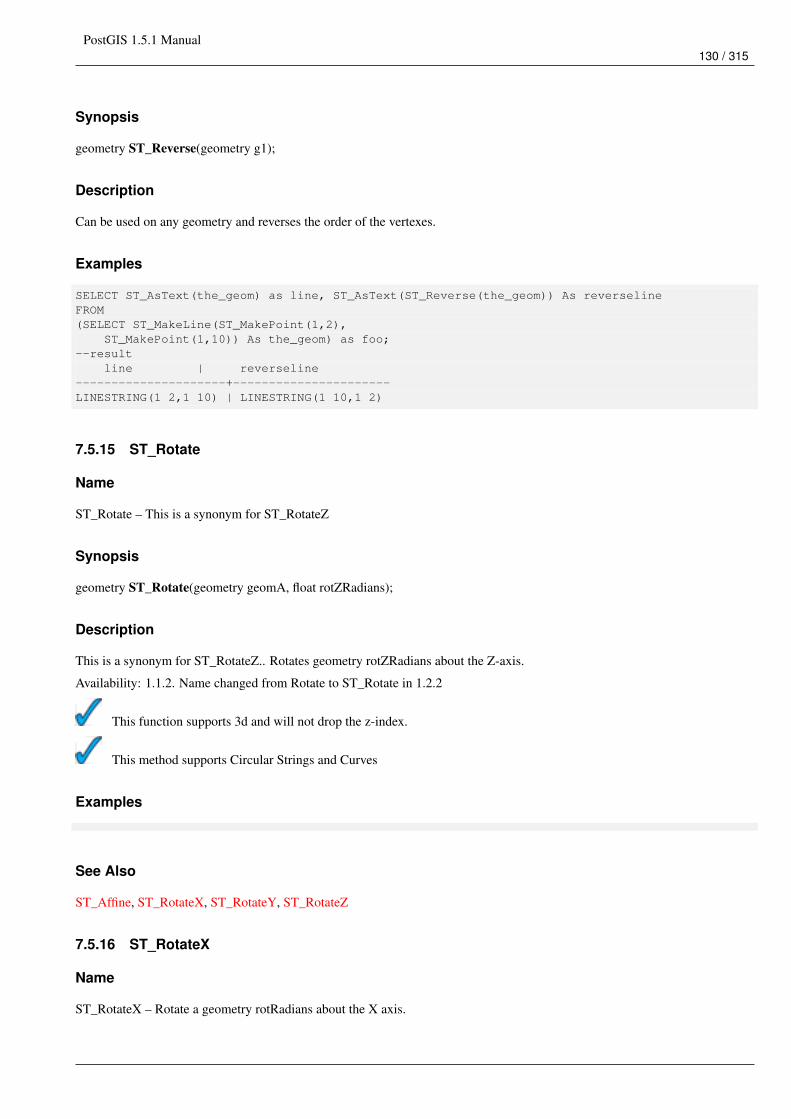
PostGIS 1.5.1 Manual130 / 315
Synopsis
geometry ST_Reverse(geometry g1);
Description
Can be used on any geometry and reverses the order of the vertexes.
Examples
SELECT ST_AsText(the_geom) as line, ST_AsText(ST_Reverse(the_geom)) As reverselineFROM(SELECT ST_MakeLine(ST_MakePoint(1,2),
ST_MakePoint(1,10)) As the_geom) as foo;--result
line | reverseline---------------------+----------------------LINESTRING(1 2,1 10) | LINESTRING(1 10,1 2)
7.5.15 ST_Rotate
Name
ST_Rotate – This is a synonym for ST_RotateZ
Synopsis
geometry ST_Rotate(geometry geomA, float rotZRadians);
Description
This is a synonym for ST_RotateZ.. Rotates geometry rotZRadians about the Z-axis.
Availability: 1.1.2. Name changed from Rotate to ST_Rotate in 1.2.2
This function supports 3d and will not drop the z-index.
This method supports Circular Strings and Curves
Examples
See Also
ST_Affine, ST_RotateX, ST_RotateY, ST_RotateZ
7.5.16 ST_RotateX
Name
ST_RotateX – Rotate a geometry rotRadians about the X axis.
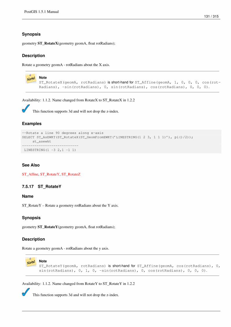
PostGIS 1.5.1 Manual131 / 315
Synopsis
geometry ST_RotateX(geometry geomA, float rotRadians);
Description
Rotate a geometry geomA - rotRadians about the X axis.
NoteST_RotateX(geomA, rotRadians) is short-hand for ST_Affine(geomA, 1, 0, 0, 0, cos(rot-Radians), -sin(rotRadians), 0, sin(rotRadians), cos(rotRadians), 0, 0, 0).
Availability: 1.1.2. Name changed from RotateX to ST_RotateX in 1.2.2
This function supports 3d and will not drop the z-index.
Examples
--Rotate a line 90 degrees along x-axisSELECT ST_AsEWKT(ST_RotateX(ST_GeomFromEWKT(’LINESTRING(1 2 3, 1 1 1)’), pi()/2));
st_asewkt---------------------------LINESTRING(1 -3 2,1 -1 1)
See Also
ST_Affine, ST_RotateY, ST_RotateZ
7.5.17 ST_RotateY
Name
ST_RotateY – Rotate a geometry rotRadians about the Y axis.
Synopsis
geometry ST_RotateY(geometry geomA, float rotRadians);
Description
Rotate a geometry geomA - rotRadians about the y axis.
NoteST_RotateY(geomA, rotRadians) is short-hand for ST_Affine(geomA, cos(rotRadians), 0,sin(rotRadians), 0, 1, 0, -sin(rotRadians), 0, cos(rotRadians), 0, 0, 0).
Availability: 1.1.2. Name changed from RotateY to ST_RotateY in 1.2.2
This function supports 3d and will not drop the z-index.
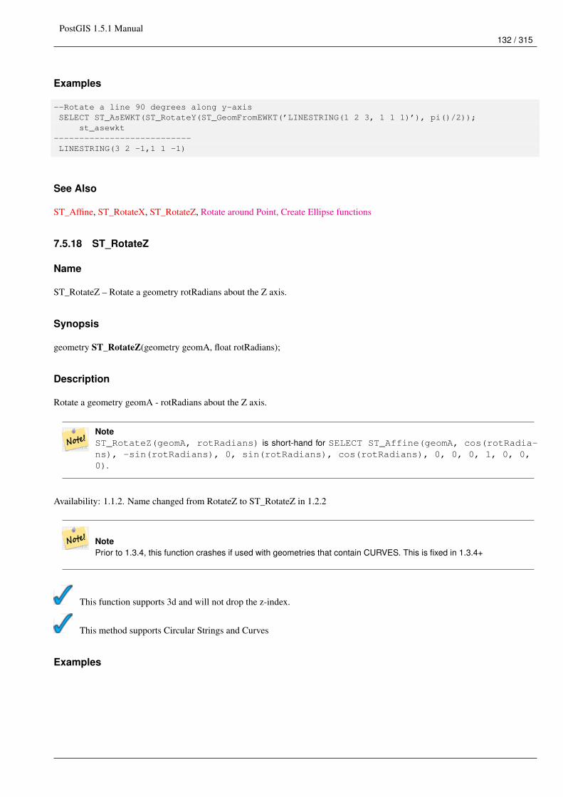
PostGIS 1.5.1 Manual132 / 315
Examples
--Rotate a line 90 degrees along y-axisSELECT ST_AsEWKT(ST_RotateY(ST_GeomFromEWKT(’LINESTRING(1 2 3, 1 1 1)’), pi()/2));
st_asewkt---------------------------LINESTRING(3 2 -1,1 1 -1)
See Also
ST_Affine, ST_RotateX, ST_RotateZ, Rotate around Point, Create Ellipse functions
7.5.18 ST_RotateZ
Name
ST_RotateZ – Rotate a geometry rotRadians about the Z axis.
Synopsis
geometry ST_RotateZ(geometry geomA, float rotRadians);
Description
Rotate a geometry geomA - rotRadians about the Z axis.
NoteST_RotateZ(geomA, rotRadians) is short-hand for SELECT ST_Affine(geomA, cos(rotRadia-ns), -sin(rotRadians), 0, sin(rotRadians), cos(rotRadians), 0, 0, 0, 1, 0, 0,0).
Availability: 1.1.2. Name changed from RotateZ to ST_RotateZ in 1.2.2
NotePrior to 1.3.4, this function crashes if used with geometries that contain CURVES. This is fixed in 1.3.4+
This function supports 3d and will not drop the z-index.
This method supports Circular Strings and Curves
Examples
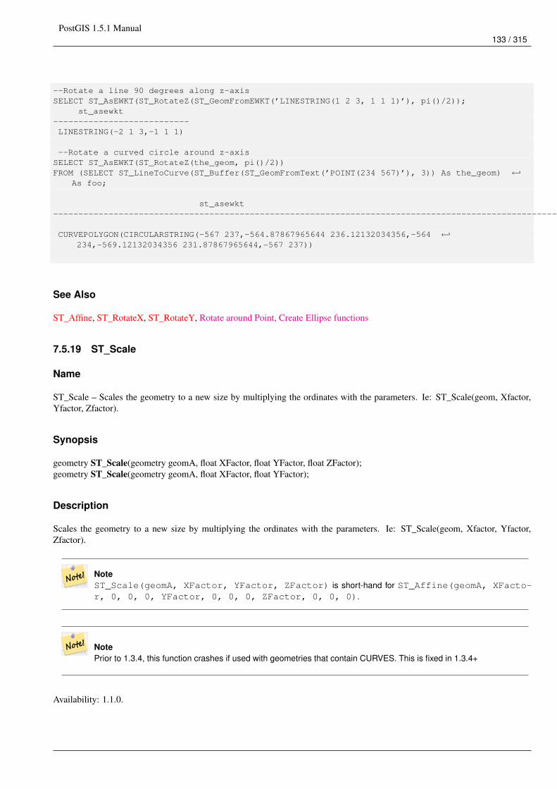
PostGIS 1.5.1 Manual133 / 315
--Rotate a line 90 degrees along z-axisSELECT ST_AsEWKT(ST_RotateZ(ST_GeomFromEWKT(’LINESTRING(1 2 3, 1 1 1)’), pi()/2));
st_asewkt---------------------------LINESTRING(-2 1 3,-1 1 1)
--Rotate a curved circle around z-axisSELECT ST_AsEWKT(ST_RotateZ(the_geom, pi()/2))FROM (SELECT ST_LineToCurve(ST_Buffer(ST_GeomFromText(’POINT(234 567)’), 3)) As the_geom) ←↩
As foo;
st_asewkt---------------------------------------------------------------------------------------------------------------------------- ←↩
CURVEPOLYGON(CIRCULARSTRING(-567 237,-564.87867965644 236.12132034356,-564 ←↩234,-569.12132034356 231.87867965644,-567 237))
See Also
ST_Affine, ST_RotateX, ST_RotateY, Rotate around Point, Create Ellipse functions
7.5.19 ST_Scale
Name
ST_Scale – Scales the geometry to a new size by multiplying the ordinates with the parameters. Ie: ST_Scale(geom, Xfactor,Yfactor, Zfactor).
Synopsis
geometry ST_Scale(geometry geomA, float XFactor, float YFactor, float ZFactor);geometry ST_Scale(geometry geomA, float XFactor, float YFactor);
Description
Scales the geometry to a new size by multiplying the ordinates with the parameters. Ie: ST_Scale(geom, Xfactor, Yfactor,Zfactor).
NoteST_Scale(geomA, XFactor, YFactor, ZFactor) is short-hand for ST_Affine(geomA, XFacto-r, 0, 0, 0, YFactor, 0, 0, 0, ZFactor, 0, 0, 0).
NotePrior to 1.3.4, this function crashes if used with geometries that contain CURVES. This is fixed in 1.3.4+
Availability: 1.1.0.
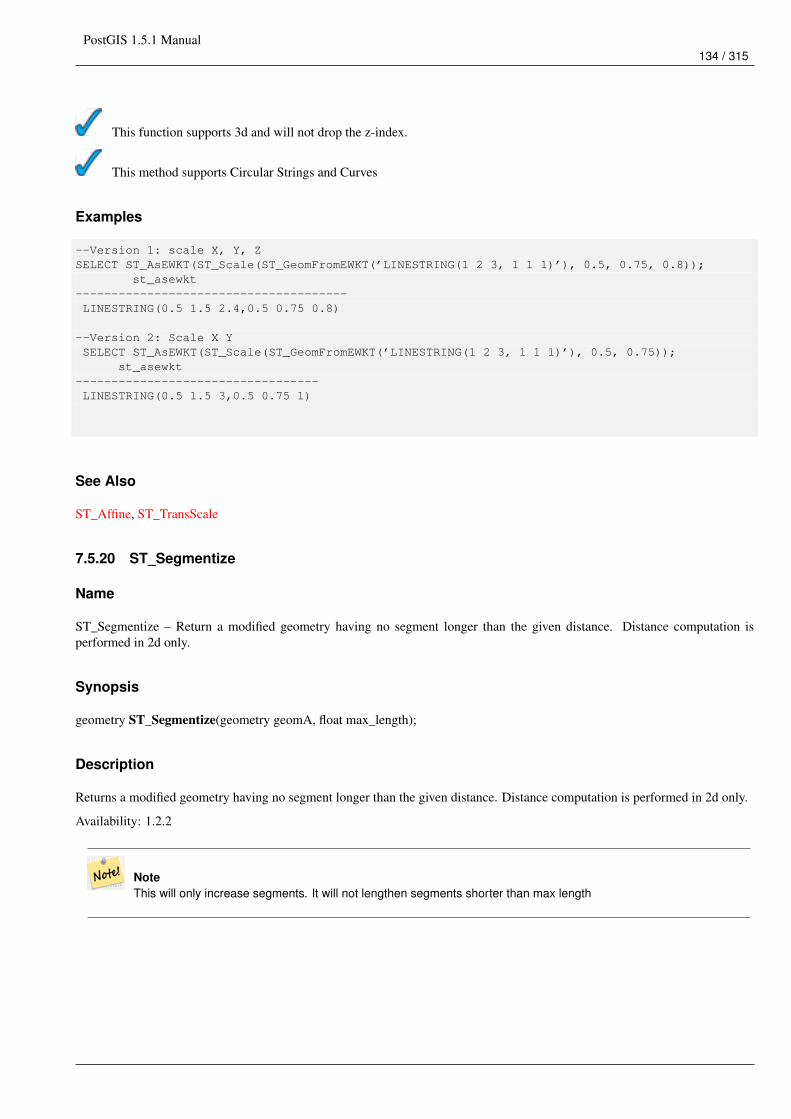
PostGIS 1.5.1 Manual134 / 315
This function supports 3d and will not drop the z-index.
This method supports Circular Strings and Curves
Examples
--Version 1: scale X, Y, ZSELECT ST_AsEWKT(ST_Scale(ST_GeomFromEWKT(’LINESTRING(1 2 3, 1 1 1)’), 0.5, 0.75, 0.8));
st_asewkt--------------------------------------LINESTRING(0.5 1.5 2.4,0.5 0.75 0.8)
--Version 2: Scale X YSELECT ST_AsEWKT(ST_Scale(ST_GeomFromEWKT(’LINESTRING(1 2 3, 1 1 1)’), 0.5, 0.75));
st_asewkt----------------------------------LINESTRING(0.5 1.5 3,0.5 0.75 1)
See Also
ST_Affine, ST_TransScale
7.5.20 ST_Segmentize
Name
ST_Segmentize – Return a modified geometry having no segment longer than the given distance. Distance computation isperformed in 2d only.
Synopsis
geometry ST_Segmentize(geometry geomA, float max_length);
Description
Returns a modified geometry having no segment longer than the given distance. Distance computation is performed in 2d only.
Availability: 1.2.2
NoteThis will only increase segments. It will not lengthen segments shorter than max length
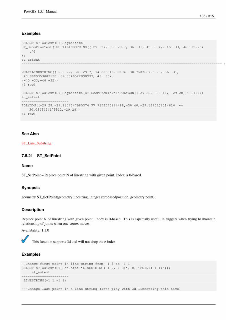
PostGIS 1.5.1 Manual135 / 315
Examples
SELECT ST_AsText(ST_Segmentize(ST_GeomFromText(’MULTILINESTRING((-29 -27,-30 -29.7,-36 -31,-45 -33),(-45 -33,-46 -32))’)
,5));st_astext-------------------------------------------------------------------------------------------------- ←↩
MULTILINESTRING((-29 -27,-30 -29.7,-34.886615700134 -30.758766735029,-36 -31,-40.8809353009198 -32.0846522890933,-45 -33),(-45 -33,-46 -32))(1 row)
SELECT ST_AsText(ST_Segmentize(ST_GeomFromText(’POLYGON((-29 28, -30 40, -29 28))’),10));st_astext-----------------------POLYGON((-29 28,-29.8304547985374 37.9654575824488,-30 40,-29.1695452014626 ←↩
30.0345424175512,-29 28))(1 row)
See Also
ST_Line_Substring
7.5.21 ST_SetPoint
Name
ST_SetPoint – Replace point N of linestring with given point. Index is 0-based.
Synopsis
geometry ST_SetPoint(geometry linestring, integer zerobasedposition, geometry point);
Description
Replace point N of linestring with given point. Index is 0-based. This is especially useful in triggers when trying to maintainrelationship of joints when one vertex moves.
Availability: 1.1.0
This function supports 3d and will not drop the z-index.
Examples
--Change first point in line string from -1 3 to -1 1SELECT ST_AsText(ST_SetPoint(’LINESTRING(-1 2,-1 3)’, 0, ’POINT(-1 1)’));
st_astext-----------------------LINESTRING(-1 1,-1 3)
---Change last point in a line string (lets play with 3d linestring this time)
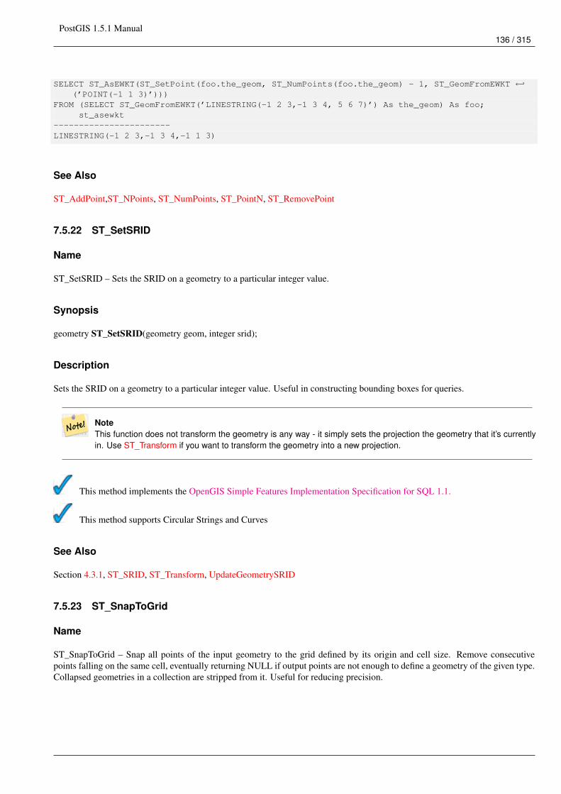
PostGIS 1.5.1 Manual136 / 315
SELECT ST_AsEWKT(ST_SetPoint(foo.the_geom, ST_NumPoints(foo.the_geom) - 1, ST_GeomFromEWKT ←↩(’POINT(-1 1 3)’)))
FROM (SELECT ST_GeomFromEWKT(’LINESTRING(-1 2 3,-1 3 4, 5 6 7)’) As the_geom) As foo;st_asewkt
-----------------------LINESTRING(-1 2 3,-1 3 4,-1 1 3)
See Also
ST_AddPoint,ST_NPoints, ST_NumPoints, ST_PointN, ST_RemovePoint
7.5.22 ST_SetSRID
Name
ST_SetSRID – Sets the SRID on a geometry to a particular integer value.
Synopsis
geometry ST_SetSRID(geometry geom, integer srid);
Description
Sets the SRID on a geometry to a particular integer value. Useful in constructing bounding boxes for queries.
NoteThis function does not transform the geometry is any way - it simply sets the projection the geometry that it’s currentlyin. Use ST_Transform if you want to transform the geometry into a new projection.
This method implements the OpenGIS Simple Features Implementation Specification for SQL 1.1.
This method supports Circular Strings and Curves
See Also
Section 4.3.1, ST_SRID, ST_Transform, UpdateGeometrySRID
7.5.23 ST_SnapToGrid
Name
ST_SnapToGrid – Snap all points of the input geometry to the grid defined by its origin and cell size. Remove consecutivepoints falling on the same cell, eventually returning NULL if output points are not enough to define a geometry of the given type.Collapsed geometries in a collection are stripped from it. Useful for reducing precision.
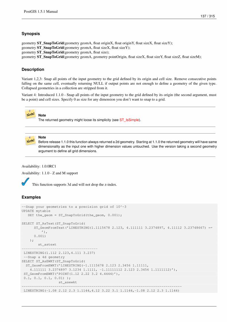
PostGIS 1.5.1 Manual137 / 315
Synopsis
geometry ST_SnapToGrid(geometry geomA, float originX, float originY, float sizeX, float sizeY);geometry ST_SnapToGrid(geometry geomA, float sizeX, float sizeY);geometry ST_SnapToGrid(geometry geomA, float size);geometry ST_SnapToGrid(geometry geomA, geometry pointOrigin, float sizeX, float sizeY, float sizeZ, float sizeM);
Description
Variant 1,2,3: Snap all points of the input geometry to the grid defined by its origin and cell size. Remove consecutive pointsfalling on the same cell, eventually returning NULL if output points are not enough to define a geometry of the given type.Collapsed geometries in a collection are stripped from it.
Variant 4: Introduced 1.1.0 - Snap all points of the input geometry to the grid defined by its origin (the second argument, mustbe a point) and cell sizes. Specify 0 as size for any dimension you don’t want to snap to a grid.
NoteThe returned geometry might loose its simplicity (see ST_IsSimple).
NoteBefore release 1.1.0 this function always returned a 2d geometry. Starting at 1.1.0 the returned geometry will have samedimensionality as the input one with higher dimension values untouched. Use the version taking a second geometryargument to define all grid dimensions.
Availability: 1.0.0RC1
Availability: 1.1.0 - Z and M support
This function supports 3d and will not drop the z-index.
Examples
--Snap your geometries to a precision grid of 10^-3UPDATE mytable
SET the_geom = ST_SnapToGrid(the_geom, 0.001);
SELECT ST_AsText(ST_SnapToGrid(ST_GeomFromText(’LINESTRING(1.1115678 2.123, 4.111111 3.2374897, 4.11112 3.23748667) ←↩
’),0.001)
);st_astext
-------------------------------------LINESTRING(1.112 2.123,4.111 3.237)--Snap a 4d geometry
SELECT ST_AsEWKT(ST_SnapToGrid(ST_GeomFromEWKT(’LINESTRING(-1.1115678 2.123 2.3456 1.11111,4.111111 3.2374897 3.1234 1.1111, -1.11111112 2.123 2.3456 1.1111112)’),
ST_GeomFromEWKT(’POINT(1.12 2.22 3.2 4.4444)’),0.1, 0.1, 0.1, 0.01) );
st_asewkt------------------------------------------------------------------------------LINESTRING(-1.08 2.12 2.3 1.1144,4.12 3.22 3.1 1.1144,-1.08 2.12 2.3 1.1144)
PostGIS 1.5.1 Manual138 / 315
--With a 4d geometry - the ST_SnapToGrid(geom,size) only touches x and y coords but keeps m ←↩and z the same
SELECT ST_AsEWKT(ST_SnapToGrid(ST_GeomFromEWKT(’LINESTRING(-1.1115678 2.123 3 2.3456,4.111111 3.2374897 3.1234 1.1111)’),0.01) );
st_asewkt---------------------------------------------------------LINESTRING(-1.11 2.12 3 2.3456,4.11 3.24 3.1234 1.1111)
See Also
ST_AsEWKT, ST_AsText, ST_GeomFromText, ST_GeomFromEWKT, ST_Simplify
7.5.24 ST_Transform
Name
ST_Transform – Returns a new geometry with its coordinates transformed to the SRID referenced by the integer parameter.
Synopsis
geometry ST_Transform(geometry g1, integer srid);
Description
Returns a new geometry with its coordinates transformed to spatial reference system referenced by the SRID integer parameter.The destination SRID must exist in the SPATIAL_REF_SYS table.
ST_Transform is often confused with ST_SetSRID(). ST_Transform actually changes the coordinates of a geometry from onespatial reference system to another, while ST_SetSRID() simply changes the SRID identifier of the geometry
NoteRequires PostGIS be compiled with Proj support. Use PostGIS_Full_Version to confirm you have proj support compiledin.
NoteIf using more than one transformation, it is useful to have a functional index on the commonly used transformations totake advantage of index usage.
NotePrior to 1.3.4, this function crashes if used with geometries that contain CURVES. This is fixed in 1.3.4+
PostGIS 1.5.1 Manual139 / 315
This method implements the OpenGIS Simple Features Implementation Specification for SQL 1.1.
This method implements the SQL/MM specification. SQL-MM 3: 5.1.6
This method supports Circular Strings and Curves
Examples
Change Mass state plane US feet geometry to WGS 84 long lat
SELECT ST_AsText(ST_Transform(ST_GeomFromText(’POLYGON((743238 2967416,743238 2967450,743265 2967450,743265.625 2967416,743238 2967416))’,2249),4326)) As wgs_geom;
wgs_geom---------------------------POLYGON((-71.1776848522251 42.3902896512902,-71.1776843766326 42.3903829478009,
-71.1775844305465 42.3903826677917,-71.1775825927231 42.3902893647987,-71.1776848522251 42.3902896512902));(1 row)
--3D Circular String exampleSELECT ST_AsEWKT(ST_Transform(ST_GeomFromEWKT(’SRID=2249;CIRCULARSTRING(743238 2967416 ←↩
1,743238 2967450 2,743265 2967450 3,743265.625 2967416 3,743238 2967416 4)’),4326));
st_asewkt--------------------------------------------------------------------------------------SRID=4326;CIRCULARSTRING(-71.1776848522251 42.3902896512902 1,-71.1776843766326 ←↩
42.3903829478009 2,-71.1775844305465 42.3903826677917 3,-71.1775825927231 42.3902893647987 3,-71.1776848522251 42.3902896512902 4)
Example of creating a partial functional index. For tables where you are not sure all the geometries will be filled in, its best to usea partial index that leaves out null geometries which will both conserve space and make your index smaller and more efficient.
CREATE INDEX idx_the_geom_26986_parcelsON parcelsUSING gist(ST_Transform(the_geom, 26986))WHERE the_geom IS NOT NULL;
Configuring transformation behaviour
Sometimes coordinate transformation involving a grid-shift can fail, for example if PROJ.4 has not been built with grid-shift filesor the coordinate does not lie within the range for which the grid shift is defined. By default, PostGIS will throw an error if agrid shift file is not present, but this behaviour can be configured on a per-SRID basis by altering the proj4text value within thespatial_ref_sys table.
For example, the proj4text parameter +datum=NAD87 is a shorthand form for the following +nadgrids parameter:
+nadgrids=@conus,@alaska,@ntv2_0.gsb,@ntv1_can.dat
The @ prefix means no error is reported if the files are not present, but if the end of the list is reached with no file having beenappropriate (ie. found and overlapping) then an error is issued.
If, conversely, you wanted to ensure that at least the standard files were present, but that if all files were scanned without a hit anull transformation is applied you could use:
PostGIS 1.5.1 Manual140 / 315
+nadgrids=@conus,@alaska,@ntv2_0.gsb,@ntv1_can.dat,null
The null grid shift file is a valid grid shift file covering the whole world and applying no shift. So for a complete example, if youwanted to alter PostGIS so that transformations to SRID 4267 that didn’t lie within the correct range did not throw an ERROR,you would use the following:
UPDATE spatial_ref_sys SET proj4text = ’+proj=longlat +ellps=clrk66 +nadgrids=@conus, ←↩@alaska,@ntv2_0.gsb,@ntv1_can.dat,null +no_defs’ WHERE srid = 4267;
See Also
PostGIS_Full_Version, ST_AsText, ST_SetSRID, UpdateGeometrySRID
7.5.25 ST_Translate
Name
ST_Translate – Translates the geometry to a new location using the numeric parameters as offsets. Ie: ST_Translate(geom, X,Y) or ST_Translate(geom, X, Y,Z).
Synopsis
geometry ST_Translate(geometry g1, float deltax, float deltay);geometry ST_Translate(geometry g1, float deltax, float deltay, float deltaz);
Description
Returns a new geometry whose coordinates are translated delta x,delta y,delta z units. Units are based on the units defined inspatial reference (SRID) for this geometry.
NotePrior to 1.3.4, this function crashes if used with geometries that contain CURVES. This is fixed in 1.3.4+
Availability: 1.2.2
This function supports 3d and will not drop the z-index.
This method supports Circular Strings and Curves
Examples
Move a point 1 degree longitude
SELECT ST_AsText(ST_Translate(ST_GeomFromText(’POINT(-71.01 42.37)’,4326),1,0)) As ←↩wgs_transgeomtxt;
wgs_transgeomtxt---------------------POINT(-70.01 42.37)
PostGIS 1.5.1 Manual141 / 315
Move a linestring 1 degree longitude and 1/2 degree latitude
SELECT ST_AsText(ST_Translate(ST_GeomFromText(’LINESTRING(-71.01 42.37,-71.11 42.38)’,4326) ←↩,1,0.5)) As wgs_transgeomtxt;
wgs_transgeomtxt---------------------------------------LINESTRING(-70.01 42.87,-70.11 42.88)
Move a 3d point
SELECT ST_AsEWKT(ST_Translate(CAST(’POINT(0 0 0)’ As geometry), 5, 12,3));st_asewkt---------POINT(5 12 3)
Move a curve and a point
SELECT ST_AsText(ST_Translate(ST_Collect(’CURVEPOLYGON(CIRCULARSTRING(4 3,3.12 0.878,1 ←↩0,-1.121 5.1213,6 7, 8 9,4 3))’,’POINT(1 3)’),1,2));
st_astext------------------------------------------------------------------------------------------------------------ ←↩
GEOMETRYCOLLECTION(CURVEPOLYGON(CIRCULARSTRING(5 5,4.12 2.878,2 2,-0.121 7.1213,7 9,9 11,5 ←↩5)),POINT(2 5))
See Also
ST_Affine, ST_AsText, ST_GeomFromText
7.5.26 ST_TransScale
Name
ST_TransScale – Translates the geometry using the deltaX and deltaY args, then scales it using the XFactor, YFactor args,working in 2D only.
Synopsis
geometry ST_TransScale(geometry geomA, float deltaX, float deltaY, float XFactor, float YFactor);
Description
Translates the geometry using the deltaX and deltaY args, then scales it using the XFactor, YFactor args, working in 2D only.
NoteST_TransScale(geomA, deltaX, deltaY, XFactor, YFactor) is short-hand for ST_Affine(g-eomA, XFactor, 0, 0, 0, YFactor, 0, 0, 0, 1, deltaX*XFactor, deltaY*YFactor,0).
NotePrior to 1.3.4, this function crashes if used with geometries that contain CURVES. This is fixed in 1.3.4+
PostGIS 1.5.1 Manual142 / 315
Availability: 1.1.0.
This function supports 3d and will not drop the z-index.
This method supports Circular Strings and Curves
Examples
SELECT ST_AsEWKT(ST_TransScale(ST_GeomFromEWKT(’LINESTRING(1 2 3, 1 1 1)’), 0.5, 1, 1, 2));st_asewkt
-----------------------------LINESTRING(1.5 6 3,1.5 4 1)
--Buffer a point to get an approximation of a circle, convert to curve and then translate ←↩1,2 and scale it 3,4
SELECT ST_AsText(ST_Transscale(ST_LineToCurve(ST_Buffer(’POINT(234 567)’, 3)),1,2,3,4));st_astext
------------------------------------------------------------------------------------------------------------------------------ ←↩
CURVEPOLYGON(CIRCULARSTRING(714 2276,711.363961030679 2267.51471862576,705 ←↩2264,698.636038969321 2284.48528137424,714 2276))
See Also
ST_Affine, ST_Translate
7.6 Geometry Outputs
7.6.1 ST_AsBinary
Name
ST_AsBinary – Return the Well-Known Binary (WKB) representation of the geometry/geography without SRID meta data.
Synopsis
bytea ST_AsBinary(geometry g1);bytea ST_AsBinary(geography g1);bytea ST_AsBinary(geometry g1, text NDR_or_XDR);
Description
Returns the Well-Known Binary representation of the geometry. There are 2 variants of the function. The first variant takes noendian encoding paramater and defaults to little endian. The second variant takes a second argument denoting the encoding -using little-endian (’NDR’) or big-endian (’XDR’) encoding.
This is useful in binary cursors to pull data out of the database without converting it to a string representation.
PostGIS 1.5.1 Manual143 / 315
NoteThe WKB spec does not include the SRID. To get the OGC WKB with SRID format use ST_AsEWKB
NoteST_AsBinary is the reverse of ST_GeomFromWKB for geometry. Use ST_GeomFromWKB to convert to a postgisgeometry from ST_AsBinary representation.
Availability: 1.5.0 geography support was introduced.
This method implements the OpenGIS Simple Features Implementation Specification for SQL 1.1. s2.1.1.1
This method implements the SQL/MM specification. SQL-MM 3: 5.1.37
This method supports Circular Strings and Curves
Examples
SELECT ST_AsBinary(ST_GeomFromText(’POLYGON((0 0,0 1,1 1,1 0,0 0))’,4326));
st_asbinary--------------------------------\001\003\000\000\000\001\000\000\000\005\000\000\000\000\000\000\000\000\000\000\000\000\000\000\000\000\000\000\000\000\000\000\000\000\000\000\000\000\000\000\000\000\000\360?\000\000\000\000\000\000\360?\000\000\000\000\000\000\360?\000\000\000\000\000\000\360?\000\000\000\000\000\000\000\000\000\000\000\000\000\000\000\000\000\000\000\000\000\000\000\000(1 row)
SELECT ST_AsBinary(ST_GeomFromText(’POLYGON((0 0,0 1,1 1,1 0,0 0))’,4326), ’XDR’);st_asbinary
--------------------------------\000\000\000\000\003\000\000\000\001\000\000\000\005\000\000\000\000\000\000\000\000\000\000\000\000\000\000\000\000\000\000\000\000\000\000\000\000?\360\000\000\000\000\000\000?\360\000\000\000\000\000\000?\360\000\000\000\000\000\000?\360\000\000\000\000\000\000\000\000\000\000\000\000\000\000\000\000\000\000\000\000\000\000\000\000\000\000\000\000\000\000(1 row)
See Also
ST_AsEWKB, ST_AsEWKT, ST_AsText, ST_GeomFromEWKB
7.6.2 ST_AsEWKB
Name
ST_AsEWKB – Return the Well-Known Binary (WKB) representation of the geometry with SRID meta data.
PostGIS 1.5.1 Manual144 / 315
Synopsis
bytea ST_AsEWKB(geometry g1);bytea ST_AsEWKB(geometry g1, text NDR_or_XDR);
Description
Returns the Well-Known Binary representation of the geometry with SRID metadata. There are 2 variants of the function.The first variant takes no endian encoding paramater and defaults to little endian. The second variant takes a second argumentdenoting the encoding - using little-endian (’NDR’) or big-endian (’XDR’) encoding.
This is useful in binary cursors to pull data out of the database without converting it to a string representation.
NoteThe WKB spec does not include the SRID. To get the OGC WKB format use ST_AsBinary
NoteST_AsEWKB is the reverse of ST_GeomFromEWKB. Use ST_GeomFromEWKB to convert to a postgis geometry fromST_AsEWKB representation.
This function supports 3d and will not drop the z-index.
This method supports Circular Strings and Curves
Examples
SELECT ST_AsEWKB(ST_GeomFromText(’POLYGON((0 0,0 1,1 1,1 0,0 0))’,4326));
st_asewkb--------------------------------\001\003\000\000 \346\020\000\000\001\000\000\000\005\000\000\000\000\000\000\000\000\000\000\000\000\000\000\000\000\000\000\000\000\000\000\000\000\000\000\000\000\000\000\000\000\000\360?\000\000\000\000\000\000\360?\000\000\000\000\000\000\360?\000\000\000\000\000\000\360?\000\000\000\000\000\000\000\000\000\000\000\000\000\000\000\000\000\000\000\000\000\000\000\000(1 row)
SELECT ST_AsEWKB(ST_GeomFromText(’POLYGON((0 0,0 1,1 1,1 0,0 0))’,4326), ’XDR’);st_asewkb
--------------------------------\000 \000\000\003\000\000\020\346\000\000\000\001\000\000\000\005\000\000\000\000\000\000\000\000\000\000\000\000\000\000\000\000\000\000\000\000\000\000\000\000?\360\000\000\000\000\000\000?\360\000\000\000\000\000\000?\360\000\000\000\000\000\000?\360\000\000\000\000\000\000\000\000\000\000\000\000\000\000\000\000\000\000\000\000\000\000\000\000\000\000\000\000\000\000

PostGIS 1.5.1 Manual145 / 315
See Also
ST_AsBinary, ST_AsEWKT, ST_AsText, ST_GeomFromEWKT, ST_SRID
7.6.3 ST_AsEWKT
Name
ST_AsEWKT – Return the Well-Known Text (WKT) representation of the geometry with SRID meta data.
Synopsis
text ST_AsEWKT(geometry g1);
Description
Returns the Well-Known Text representation of the geometry prefixed with the SRID.
NoteThe WKT spec does not include the SRID. To get the OGC WKT format use ST_AsText
WKT format does not maintain precision so to prevent floating truncation, use ST_AsBinary or ST_AsEWKB format fortransport.
NoteST_AsEWKT is the reverse of ST_GeomFromEWKT. Use ST_GeomFromEWKT to convert to a postgis geometry fromST_AsEWKT representation.
This function supports 3d and will not drop the z-index.
This method supports Circular Strings and Curves
Examples
SELECT ST_AsEWKT(’0103000020E61000000100000005000000000000000000000000000000000000000000000000000000000000000000F03F000000000000F03F000000000000F03F000000000000F03F000000000000000000000000000000000000000000000000’::geometry);
st_asewkt--------------------------------SRID=4326;POLYGON((0 0,0 1,1 1,1 0,0 0))(1 row)
SELECT ST_AsEWKT(’0108000080030000000000000060 ←↩E30A4100000000785C0241000000000000F03F0000000018
E20A4100000000485F024100000000000000400000000018
PostGIS 1.5.1 Manual146 / 315
E20A4100000000305C02410000000000000840’)
--st_asewkt---CIRCULARSTRING(220268 150415 1,220227 150505 2,220227 150406 3)
See Also
ST_AsBinaryST_AsEWKBST_AsText, ST_GeomFromEWKT
7.6.4 ST_AsGeoJSON
Name
ST_AsGeoJSON – Return the geometry as a GeoJSON element.
Synopsis
text ST_AsGeoJSON(geometry g1);text ST_AsGeoJSON(geography g1);text ST_AsGeoJSON(geometry g1, integer max_decimal_digits);text ST_AsGeoJSON(geography g1, integer max_decimal_digits);text ST_AsGeoJSON(geometry g1, integer max_decimal_digits, integer options);text ST_AsGeoJSON(geography g1, integer max_decimal_digits, integer options);text ST_AsGeoJSON(integer version, geometry g1);text ST_AsGeoJSON(integer version, geography g1);text ST_AsGeoJSON(integer version, geometry g1, integer max_decimal_digits);text ST_AsGeoJSON(integer version, geography g1, integer max_decimal_digits);text ST_AsGeoJSON(integer version, geometry g1, integer max_decimal_digits, integer options);text ST_AsGeoJSON(integer version, geography g1, integer max_decimal_digits, integer options);
Description
Return the geometry as a Geometry Javascript Object Notation (GeoJSON) element. (Cf GeoJSON specifications 1.0). 2D and3D Geometries are both supported. GeoJSON only support SFS 1.1 geometry type (no curve support for example).
The version parameter, if specified, must be 1.
The third argument may be used to reduce the maximum number of decimal places used in output (defaults to 15).
The last ’options’ argument could be used to add Bbox or Crs in GeoJSON output:
• 0: means no option (default value)
• 1: GeoJSON Bbox
• 2: GeoJSON Short CRS (e.g EPSG:4326)
• 4: GeoJSON Long CRS (e.g urn:ogc:def:crs:EPSG:4326)
Version 1: ST_AsGeoJSON(geom) / precision=15 version=1 options=0
Version 2: ST_AsGeoJSON(geom, precision) / version=1 options=0
Version 3: ST_AsGeoJSON(geom, precision, options) / version=1
Version 4: ST_AsGeoJSON(version, geom) / precision=15 options=0
PostGIS 1.5.1 Manual147 / 315
Version 5: ST_AsGeoJSON(version, geom, precision) /options=0
Version 6: ST_AsGeoJSON(version, geom, precision,options)
Availability: 1.3.4
Availability: 1.5.0 geography support was introduced.
This function supports 3d and will not drop the z-index.
Examples
GeoJSON format is generally more efficient than other formats for use in ajax mapping. One popular javascript client thatsupports this is Open Layers. Example of its use is OpenLayers GeoJSON Example
SELECT ST_AsGeoJSON(the_geom) from fe_edges limit 1;st_asgeojson
----------------------------------------------------------------------------------------------------------- ←↩
{"type":"MultiLineString","coordinates":[[[-89.734634999999997,31.492072000000000],[-89.734955999999997,31.492237999999997]]]}(1 row)--3d pointSELECT ST_AsGeoJSON(’LINESTRING(1 2 3, 4 5 6)’);
st_asgeojson-----------------------------------------------------------------------------------------{"type":"LineString","coordinates":[[1,2,3],[4,5,6]]}
7.6.5 ST_AsGML
Name
ST_AsGML – Return the geometry as a GML version 2 or 3 element.
Synopsis
text ST_AsGML(geometry g1);text ST_AsGML(geography g1);text ST_AsGML(geometry g1, integer precision);text ST_AsGML(geography g1, integer precision);text ST_AsGML(integer version, geometry g1);text ST_AsGML(integer version, geography g1);text ST_AsGML(integer version, geometry g1, integer precision);text ST_AsGML(integer version, geography g1, integer precision);text ST_AsGML(integer version, geometry g1, integer precision, integer options);text ST_AsGML(integer version, geography g1, integer precision, integer options);
Description
Return the geometry as a Geography Markup Language (GML) element. The version parameter, if specified, may be either 2or 3. If no version parameter is specified then the default is assumed to be 2. The third argument may be used to reduce themaximum number of decimal places used in output (defaults to 15).
PostGIS 1.5.1 Manual148 / 315
GML 2 refer to 2.1.2 version, GML 3 to 3.1.1 version
The last ’options’ argument is a bitfield. It could be used to define CRS output type in GML output, and to declare data as lat/lon:
• 0: GML Short CRS (e.g EPSG:4326), default value
• 1: GML Long CRS (e.g urn:ogc:def:crs:EPSG:4326)
• 16: Declare that datas are lat/lon (e.g srid=4326). Default is to assume that data are planars. This option is usefull for GML3.1.1 output only, related to axis order.
NoteAvailability: 1.3.2Availability: 1.5.0 geography support was introduced.
This function supports 3d and will not drop the z-index.
Examples
SELECT ST_AsGML(ST_GeomFromText(’POLYGON((0 0,0 1,1 1,1 0,0 0))’,4326));st_asgml--------<gml:Polygon srsName="EPSG:4326"><gml:outerBoundaryIs><gml:LinearRing><gml:coordinates ←↩
>0,0 0,1 1,1 1,0 0,0</gml:coordinates></gml:LinearRing></gml:outerBoundaryIs></gml: ←↩Polygon>
SELECT ST_AsGML(3, ST_GeomFromText(’POINT(5.234234233242 6.34534534534)’,4326), 5, 17);st_asgml--------
<gml:Point srsName="urn:ogc:def:crs:EPSG:4326"><gml:pos>6.34535 5.23423</gml:pos></gml: ←↩Point>
See Also
ST_GeomFromGML
7.6.6 ST_AsHEXEWKB
Name
ST_AsHEXEWKB – Returns a Geometry in HEXEWKB format (as text) using either little-endian (NDR) or big-endian (XDR)encoding.
Synopsis
text ST_AsHEXEWKB(geometry g1, text NDRorXDR);text ST_AsHEXEWKB(geometry g1);
PostGIS 1.5.1 Manual149 / 315
Description
Returns a Geometry in HEXEWKB format (as text) using either little-endian (NDR) or big-endian (XDR) encoding. If noencoding is specified, then NDR is used.
NoteAvailability: 1.2.2
This function supports 3d and will not drop the z-index.
This method supports Circular Strings and Curves
Examples
SELECT ST_AsHEXEWKB(ST_GeomFromText(’POLYGON((0 0,0 1,1 1,1 0,0 0))’,4326));which gives same answer as
SELECT ST_GeomFromText(’POLYGON((0 0,0 1,1 1,1 0,0 0))’,4326)::text;
st_ashexewkb--------0103000020E61000000100000005000000000000000000000000000000000000000000000000000000000000000000F03F000000000000F03F000000000000F03F000000000000F03F000000000000000000000000000000000000000000000000
7.6.7 ST_AsKML
Name
ST_AsKML – Return the geometry as a KML element. Several variants. Default version=2, default precision=15
Synopsis
text ST_AsKML(geometry g1);text ST_AsKML(geography g1);text ST_AsKML(geometry g1, integer precision);text ST_AsKML(geography g1, integer precision);text ST_AsKML(integer version, geometry geom1);text ST_AsKML(integer version, geography geom1);text ST_AsKML(integer version, geometry geom1, integer precision);text ST_AsKML(integer version, geography geom1, integer precision);
Description
Return the geometry as a Keyhole Markup Language (KML) element. There are several variants of this function. maximumnumber of decimal places used in output (defaults to 15) and version default to 2.
Version 1: ST_AsKML(geom) / version=2 precision=15
PostGIS 1.5.1 Manual150 / 315
Version 2: ST_AsKML(geom, max_sig_digits) / version=2
Version 3: ST_AsKML(version, geom) / precision=15
Version 4: ST_AsKML(version, geom, precision)
NoteRequires PostGIS be compiled with Proj support. Use PostGIS_Full_Version to confirm you have proj support compiledin.
NoteAvailability: 1.2.2 - later variants that include version param came in 1.3.2
NoteAsKML output will not work with geometries that do not have an SRID
This function supports 3d and will not drop the z-index.
Examples
SELECT ST_AsKML(ST_GeomFromText(’POLYGON((0 0,0 1,1 1,1 0,0 0))’,4326));
st_askml--------<Polygon><outerBoundaryIs><LinearRing><coordinates>0,0 0,1 1,1 1,0 0,0</coordinates></ ←↩
LinearRing></outerBoundaryIs></Polygon>
--3d linestringSELECT ST_AsKML(’SRID=4326;LINESTRING(1 2 3, 4 5 6)’);<LineString><coordinates>1,2,3 4,5,6</coordinates></LineString>
See Also
ST_AsSVG, ST_AsGML
7.6.8 ST_AsSVG
Name
ST_AsSVG – Returns a Geometry in SVG path data given a geometry or geography object.
Synopsis
text ST_AsSVG(geometry g1);text ST_AsSVG(geography g1);text ST_AsSVG(geometry g1, integer rel);text ST_AsSVG(geography g1, integer rel);text ST_AsSVG(geometry g1, integer rel, integer maxdecimaldigits);text ST_AsSVG(geography g1, integer rel, integer maxdecimaldigits);
PostGIS 1.5.1 Manual151 / 315
Description
Return the geometry as Scalar Vector Graphics (SVG) path data. Use 1 as second argument to have the path data implementedin terms of relative moves, the default (or 0) uses absolute moves. Third argument may be used to reduce the maximum numberof decimal digits used in output (defaults to 15). Point geometries will be rendered as cx/cy when ’rel’ arg is 0, x/y when ’rel’ is1. Multipoint geometries are delimited by commas (","), GeometryCollection geometries are delimited by semicolons (";").
NoteAvailability: 1.2.2 . Availability: 1.4.0 Changed in PostGIS 1.4.0 to include L command in absolute path to conform tohttp://www.w3.org/TR/SVG/paths.html#PathDataBNF
Examples
SELECT ST_AsSVG(ST_GeomFromText(’POLYGON((0 0,0 1,1 1,1 0,0 0))’,4326));
st_assvg--------M 0 0 L 0 -1 1 -1 1 0 Z
7.6.9 ST_GeoHash
Name
ST_GeoHash – Return a GeoHash representation (geohash.org) of the geometry.
Synopsis
text ST_GeoHash(geometry g1);text ST_GeoHash(geometry g1, integer precision);
Description
Return a GeoHash representation (geohash.org) of the geometry. A GeoHash encodes a point into a text form that is sortable andsearchable based on prefixing. A shorter GeoHash is a less precise representation of a point. It can also be thought of as a box,that contains the actual point.
The one-parameter variant of ST_GeoHash returns a GeoHash based on the input geometry type. Points return a GeoHash with20 characters of precision (about enough to hold the full double precision of the input). Other types return a GeoHash with avariable amount of precision, based on the size of the feature. Larger features are represented with less precision, smaller featureswith more precision. The idea is that the box implied by the GeoHash will always contain the input feature.
The two-parameter variant of ST_GeoHash returns a GeoHash with a requested precision. For non-points, the starting point ofthe calculation is the center of the bounding box of the geometry.
Availability: 1.4.0
NoteST_GeoHash will not work with geometries that are not in geographic (lon/lat) coordinates.
This method supports Circular Strings and Curves
PostGIS 1.5.1 Manual152 / 315
Examples
SELECT ST_GeoHash(ST_SetSRID(ST_MakePoint(-126,48),4326));
st_geohash----------------------c0w3hf1s70w3hf1s70w3
SELECT ST_GeoHash(ST_SetSRID(ST_MakePoint(-126,48),4326),5);
st_geohash------------c0w3h
See Also
7.6.10 ST_AsText
Name
ST_AsText – Return the Well-Known Text (WKT) representation of the geometry/geography without SRID metadata.
Synopsis
text ST_AsText(geometry g1);text ST_AsText(geography g1);
Description
Returns the Well-Known Text representation of the geometry/geography.
NoteThe WKT spec does not include the SRID. To get the SRID as part of the data, use the non-standard PostGISST_AsEWKT
WKT format does not maintain precision so to prevent floating truncation, use ST_AsBinary or ST_AsEWKB format fortransport.
NoteST_AsText is the reverse of ST_GeomFromText. Use ST_GeomFromText to convert to a postgis geometry fromST_AsText representation.
Availability: 1.5 - support for geography was introduced.
This method implements the OpenGIS Simple Features Implementation Specification for SQL 1.1. s2.1.1.1
This method implements the SQL/MM specification. SQL-MM 3: 5.1.25
This method supports Circular Strings and Curves
PostGIS 1.5.1 Manual153 / 315
Examples
SELECT ST_AsText(’01030000000100000005000000000000000000000000000000000000000000000000000000000000000000F03F000000000000F03F000000000000F03F000000000000F03F000000000000000000000000000000000000000000000000’);
st_astext--------------------------------POLYGON((0 0,0 1,1 1,1 0,0 0))
(1 row)
See Also
ST_AsBinary, ST_AsEWKB, ST_AsEWKT, ST_GeomFromText
7.7 Operators
7.7.1 &&
Name
&& – Returns TRUE if A’s bounding box overlaps B’s.
Synopsis
boolean &&( geometry A , geometry B );boolean &&( geography A , geography B );
Description
The && operator returns TRUE if the bounding box of geometry A overlaps the bounding box of geometry B.
NoteThis operand will make use of any indexes that may be available on the geometries.
Availability: 1.5.0 support for geography was introduced.
This method supports Circular Strings and Curves
Examples
SELECT tbl1.column1, tbl2.column1, tbl1.column2 && tbl2.column2 AS overlapsFROM ( VALUES(1, ’LINESTRING(0 0, 3 3)’::geometry),(2, ’LINESTRING(0 1, 0 5)’::geometry)) AS tbl1,
( VALUES(3, ’LINESTRING(1 2, 4 6)’::geometry)) AS tbl2;
PostGIS 1.5.1 Manual154 / 315
column1 | column1 | overlaps---------+---------+----------
1 | 3 | t2 | 3 | f
(2 rows)
See Also
|&>, &>, &<|, &<, ~, @
7.7.2 &<
Name
&< – Returns TRUE if A’s bounding box overlaps or is to the left of B’s.
Synopsis
boolean &<( geometry A , geometry B );
Description
The &< operator returns TRUE if the bounding box of geometry A overlaps or is to the left of the bounding box of geometry B,or more accurately, overlaps or is NOT to the right of the bounding box of geometry B.
NoteThis operand will make use of any indexes that may be available on the geometries.
Examples
SELECT tbl1.column1, tbl2.column1, tbl1.column2 &< tbl2.column2 AS overleftFROM( VALUES(1, ’LINESTRING(1 2, 4 6)’::geometry)) AS tbl1,( VALUES(2, ’LINESTRING(0 0, 3 3)’::geometry),(3, ’LINESTRING(0 1, 0 5)’::geometry),(4, ’LINESTRING(6 0, 6 1)’::geometry)) AS tbl2;
column1 | column1 | overleft---------+---------+----------
1 | 2 | f1 | 3 | f1 | 4 | t
(3 rows)
See Also
&&, |&>, &>, &<|
PostGIS 1.5.1 Manual155 / 315
7.7.3 &<|
Name
&<| – Returns TRUE if A’s bounding box overlaps or is below B’s.
Synopsis
boolean &<|( geometry A , geometry B );
Description
The &<| operator returns TRUE if the bounding box of geometry A overlaps or is below of the bounding box of geometry B, ormore accurately, overlaps or is NOT above the bounding box of geometry B.
This method supports Circular Strings and Curves
NoteThis operand will make use of any indexes that may be available on the geometries.
Examples
SELECT tbl1.column1, tbl2.column1, tbl1.column2 &<| tbl2.column2 AS overbelowFROM( VALUES(1, ’LINESTRING(6 0, 6 4)’::geometry)) AS tbl1,( VALUES(2, ’LINESTRING(0 0, 3 3)’::geometry),(3, ’LINESTRING(0 1, 0 5)’::geometry),(4, ’LINESTRING(1 2, 4 6)’::geometry)) AS tbl2;
column1 | column1 | overbelow---------+---------+-----------
1 | 2 | f1 | 3 | t1 | 4 | t
(3 rows)
See Also
&&, |&>, &>, &<
7.7.4 &>
Name
&> – Returns TRUE if A’ bounding box overlaps or is to the right of B’s.
PostGIS 1.5.1 Manual156 / 315
Synopsis
boolean &>( geometry A , geometry B );
Description
The &> operator returns TRUE if the bounding box of geometry A overlaps or is to the right of the bounding box of geometry B,or more accurately, overlaps or is NOT to the left of the bounding box of geometry B.
NoteThis operand will make use of any indexes that may be available on the geometries.
Examples
SELECT tbl1.column1, tbl2.column1, tbl1.column2 &> tbl2.column2 AS overrightFROM( VALUES(1, ’LINESTRING(1 2, 4 6)’::geometry)) AS tbl1,( VALUES(2, ’LINESTRING(0 0, 3 3)’::geometry),(3, ’LINESTRING(0 1, 0 5)’::geometry),(4, ’LINESTRING(6 0, 6 1)’::geometry)) AS tbl2;
column1 | column1 | overright---------+---------+-----------
1 | 2 | t1 | 3 | t1 | 4 | f
(3 rows)
See Also
&&, |&>, &<|, &<
7.7.5 «
Name
« – Returns TRUE if A’s bounding box is strictly to the left of B’s.
Synopsis
boolean «( geometry A , geometry B );
Description
The << operator returns TRUE if the bounding box of geometry A is strictly to the left of the bounding box of geometry B.
NoteThis operand will make use of any indexes that may be available on the geometries.
PostGIS 1.5.1 Manual157 / 315
Examples
SELECT tbl1.column1, tbl2.column1, tbl1.column2 << tbl2.column2 AS leftFROM( VALUES(1, ’LINESTRING (1 2, 1 5)’::geometry)) AS tbl1,( VALUES(2, ’LINESTRING (0 0, 4 3)’::geometry),(3, ’LINESTRING (6 0, 6 5)’::geometry),(4, ’LINESTRING (2 2, 5 6)’::geometry)) AS tbl2;
column1 | column1 | left---------+---------+------
1 | 2 | f1 | 3 | t1 | 4 | t
(3 rows)
See Also
», |», «|
7.7.6 «|
Name
«| – Returns TRUE if A’s bounding box is strictly below B’s.
Synopsis
boolean «|( geometry A , geometry B );
Description
The <<| operator returns TRUE if the bounding box of geometry A is strictly below the bounding box of geometry B.
NoteThis operand will make use of any indexes that may be available on the geometries.
Examples
SELECT tbl1.column1, tbl2.column1, tbl1.column2 <<| tbl2.column2 AS belowFROM( VALUES(1, ’LINESTRING (0 0, 4 3)’::geometry)) AS tbl1,( VALUES(2, ’LINESTRING (1 4, 1 7)’::geometry),(3, ’LINESTRING (6 1, 6 5)’::geometry),(4, ’LINESTRING (2 3, 5 6)’::geometry)) AS tbl2;
column1 | column1 | below
PostGIS 1.5.1 Manual158 / 315
---------+---------+-------1 | 2 | t1 | 3 | f1 | 4 | f
(3 rows)
See Also
«, », |»
7.7.7 =
Name
= – Returns TRUE if A’s bounding box is the same as B’s.
Synopsis
boolean =( geometry A , geometry B );boolean =( geography A , geography B );
Description
The = operator returns TRUE if the bounding box of geometry/geography A is the same as the bounding box of geometry/geog-raphy B. PostgreSQL uses the =, <, and > operators defined for geometries to perform internal orderings and comparison ofgeometries (ie. in a GROUP BY or ORDER BY clause).
WarningThis is cause for a lot of confusion. When you compare geometryA = geometryB it will return true even when thegeometries are clearly different IF their bounding boxes are the same. To check for true equality use ST_OrderingEqualsor ST_Equals
CautionThis operand will NOT make use of any indexes that may be available on the geometries.
This method supports Circular Strings and Curves
Examples
SELECT ’LINESTRING(0 0, 0 1, 1 0)’::geometry = ’LINESTRING(1 1, 0 0)’::geometry;?column?----------t
(1 row)
SELECT ST_AsText(column1)FROM ( VALUES
PostGIS 1.5.1 Manual159 / 315
(’LINESTRING(0 0, 1 1)’::geometry),(’LINESTRING(1 1, 0 0)’::geometry)) AS foo;st_astext
---------------------LINESTRING(0 0,1 1)LINESTRING(1 1,0 0)
(2 rows)
-- Note: the GROUP BY uses the "=" to compare for geometry equivalency.SELECT ST_AsText(column1)FROM ( VALUES(’LINESTRING(0 0, 1 1)’::geometry),(’LINESTRING(1 1, 0 0)’::geometry)) AS foo
GROUP BY column1;st_astext
---------------------LINESTRING(0 0,1 1)
(1 row)
See Also
ST_Equals, ST_OrderingEquals, ~=
7.7.8 »
Name
» – Returns TRUE if A’s bounding box is strictly to the right of B’s.
Synopsis
boolean »( geometry A , geometry B );
Description
The >> operator returns TRUE if the bounding box of geometry A is strictly to the right of the bounding box of geometry B.
NoteThis operand will make use of any indexes that may be available on the geometries.
Examples
SELECT tbl1.column1, tbl2.column1, tbl1.column2 >> tbl2.column2 AS rightFROM( VALUES(1, ’LINESTRING (2 3, 5 6)’::geometry)) AS tbl1,( VALUES(2, ’LINESTRING (1 4, 1 7)’::geometry),(3, ’LINESTRING (6 1, 6 5)’::geometry),(4, ’LINESTRING (0 0, 4 3)’::geometry)) AS tbl2;
PostGIS 1.5.1 Manual160 / 315
column1 | column1 | right---------+---------+-------
1 | 2 | t1 | 3 | f1 | 4 | f
(3 rows)
See Also
«, |», «|
7.7.9 @
Name
@ – Returns TRUE if A’s bounding box is contained by B’s.
Synopsis
boolean ~=( geometry A , geometry B );
Description
The @ operator returns TRUE if the bounding box of geometry A is completely contained by the bounding box of geometry B.
NoteThis operand will make use of any indexes that may be available on the geometries.
Examples
SELECT tbl1.column1, tbl2.column1, tbl1.column2 @ tbl2.column2 AS containedFROM( VALUES(1, ’LINESTRING (1 1, 3 3)’::geometry)) AS tbl1,( VALUES(2, ’LINESTRING (0 0, 4 4)’::geometry),(3, ’LINESTRING (2 2, 4 4)’::geometry),(4, ’LINESTRING (1 1, 3 3)’::geometry)) AS tbl2;
column1 | column1 | contained---------+---------+-----------
1 | 2 | t1 | 3 | f1 | 4 | t
(3 rows)
See Also
~, &&
PostGIS 1.5.1 Manual161 / 315
7.7.10 |&>
Name
|&> – Returns TRUE if A’s bounding box overlaps or is above B’s.
Synopsis
boolean |&>( geometry A , geometry B );
Description
The |&> operator returns TRUE if the bounding box of geometry A overlaps or is above the bounding box of geometry B, ormore accurately, overlaps or is NOT below the bounding box of geometry B.
NoteThis operand will make use of any indexes that may be available on the geometries.
Examples
SELECT tbl1.column1, tbl2.column1, tbl1.column2 |&> tbl2.column2 AS overaboveFROM( VALUES(1, ’LINESTRING(6 0, 6 4)’::geometry)) AS tbl1,( VALUES(2, ’LINESTRING(0 0, 3 3)’::geometry),(3, ’LINESTRING(0 1, 0 5)’::geometry),(4, ’LINESTRING(1 2, 4 6)’::geometry)) AS tbl2;
column1 | column1 | overabove---------+---------+-----------
1 | 2 | t1 | 3 | f1 | 4 | f
(3 rows)
See Also
&&, &>, &<|, &<
7.7.11 |»
Name
|» – Returns TRUE if A’s bounding box is strictly above B’s.
Synopsis
boolean |»( geometry A , geometry B );
PostGIS 1.5.1 Manual162 / 315
Description
The |>> operator returns TRUE if the bounding box of geometry A is strictly to the right of the bounding box of geometry B.
NoteThis operand will make use of any indexes that may be available on the geometries.
Examples
SELECT tbl1.column1, tbl2.column1, tbl1.column2 |>> tbl2.column2 AS aboveFROM( VALUES(1, ’LINESTRING (1 4, 1 7)’::geometry)) AS tbl1,( VALUES(2, ’LINESTRING (0 0, 4 2)’::geometry),(3, ’LINESTRING (6 1, 6 5)’::geometry),(4, ’LINESTRING (2 3, 5 6)’::geometry)) AS tbl2;
column1 | column1 | above---------+---------+-------
1 | 2 | t1 | 3 | f1 | 4 | f
(3 rows)
See Also
«, », «|
7.7.12 ~
Name
~ – Returns TRUE if A’s bounding box contains B’s.
Synopsis
boolean ~( geometry A , geometry B );
Description
The ~ operator returns TRUE if the bounding box of geometry A completely contains the bounding box of geometry B.
NoteThis operand will make use of any indexes that may be available on the geometries.
PostGIS 1.5.1 Manual163 / 315
Examples
SELECT tbl1.column1, tbl2.column1, tbl1.column2 ~ tbl2.column2 AS containsFROM( VALUES(1, ’LINESTRING (0 0, 3 3)’::geometry)) AS tbl1,( VALUES(2, ’LINESTRING (0 0, 4 4)’::geometry),(3, ’LINESTRING (1 1, 2 2)’::geometry),(4, ’LINESTRING (0 0, 3 3)’::geometry)) AS tbl2;
column1 | column1 | contains---------+---------+----------
1 | 2 | f1 | 3 | t1 | 4 | t
(3 rows)
See Also
@, &&
7.7.13 ~=
Name
~= – Returns TRUE if A’s bounding box is the same as B’s.
Synopsis
boolean ~=( geometry A , geometry B );boolean ~=( geography A , geography B );
Description
The ~= operator returns TRUE if the bounding box of geometry/geography A is the same as the bounding box of geometry/geog-raphy B.
NoteThis operand will make use of any indexes that may be available on the geometries.
Availability: 1.5.0 changed behavior
WarningThis operator has changed behavior in PostGIS 1.5 from testing for actual geometric equality to only checking forbounding box equality. To complicate things it also depends on if you have done a hard or soft upgrade which behavioryour database has. To find out which behavior your database has you can run the query below. To check for trueequality use ST_OrderingEquals or ST_Equals and to check for bounding box equality =; operator is a safer option.
PostGIS 1.5.1 Manual164 / 315
Examples
select ’LINESTRING(0 0, 1 1)’::geometry ~= ’LINESTRING(0 1, 1 0)’::geometry as equality;equality |
-----------------+t |
The above can be used to test if you have the new or old behavior of ~= operator.
See Also
ST_Equals, ST_OrderingEquals, =
7.8 Spatial Relationships and Measurements
7.8.1 ST_Area
Name
ST_Area – Returns the area of the surface if it is a polygon or multi-polygon. For "geometry" type area is in SRID units. For"geography" area is in square meters.
Synopsis
float ST_Area(geometry g1);float ST_Area(geography g1);float ST_Area(geography g1, boolean use_spheroid);
Description
Returns the area of the geometry if it is a polygon or multi-polygon. Return the area measurement of an ST_Surface orST_MultiSurface value. For geometry Area is in the units of the srid. For geography area is in square meters and defaultsto measuring about the spheroid of the geography (currently only WGS84). To measure around the faster but less accurate sphere-- ST_Area(geog,false).
This method implements the OpenGIS Simple Features Implementation Specification for SQL 1.1.
This method implements the SQL/MM specification. SQL-MM 3: 8.1.2, 9.5.3
Examples
Return area in square feet for a plot of Massachusetts land and multiply by conversion to get square meters. Note this is in squarefeet because 2249 is Mass State Plane Feet
SELECT ST_Area(the_geom) As sqft, ST_Area(the_geom)*POWER(0.3048,2) As sqmFROM (SELECTST_GeomFromText(’POLYGON((743238 2967416,743238 2967450,743265 2967450,743265.625 2967416,743238 2967416))’,2249) ) As foo(the_geom);
sqft | sqm---------+-------------928.625 | 86.27208552
PostGIS 1.5.1 Manual165 / 315
Return area square feet and transform to Massachusetts state plane meters (26986) to get square meters. Note this is in squarefeet because 2249 is Mass State Plane Feet and transformed area is in square meters since 26986 is state plane mass meters
SELECT ST_Area(the_geom) As sqft, ST_Area(ST_Transform(the_geom,26986)) As sqmFROM (SELECTST_GeomFromText(’POLYGON((743238 2967416,743238 2967450,743265 2967450,743265.625 2967416,743238 2967416))’,2249) ) As foo(the_geom);
sqft | sqm---------+------------------928.625 | 86.2724304199219
Return area square feet and square meters using Geography data type. Note that we transform to our geometry to geography(before you can do that make sure your geometry is in WGS 84 long lat 4326). Geography always measures in meters. This isjust for demonstration to compare. Normally your table will be stored in geography data type already.
SELECT ST_Area(the_geog)/POWER(0.3048,2) As sqft_spheroid, ST_Area(the_geog,false)/POWER ←↩(0.3048,2) As sqft_sphere, ST_Area(the_geog) As sqm_spheroidFROM (SELECTgeography(ST_Transform(ST_GeomFromText(’POLYGON((743238 2967416,743238 2967450,743265 2967450,743265.625 ←↩
2967416,743238 2967416))’,2249) ,4326
))
) As foo(the_geog);sqft_spheroid | sqft_sphere | sqm_spheroid
-----------------+------------------+------------------928.684405217197 | 927.186481558724 | 86.2776044452694
--if your data is in geography alreadySELECT ST_Area(the_geog)/POWER(0.3048,2) As sqft, ST_Area(the_geog) As sqmFROM somegeogtable;
See Also
ST_GeomFromText, ST_GeographyFromText, ST_SetSRID,ST_Transform
7.8.2 ST_Azimuth
Name
ST_Azimuth – Returns the angle in radians from the horizontal of the vector defined by pointA and pointB
Synopsis
float ST_Azimuth(geometry pointA, geometry pointB);
Description
Returns the azimuth of the segment defined by the given Point geometries, or NULL if the two points are coincident. Returnvalue is in radians.
PostGIS 1.5.1 Manual166 / 315
The Azimuth is mathematical concept defined as the angle, in this case measured in radian, between a reference plane and a point
Availability: 1.1.0
Azimuth is especially useful in conjunction with ST_Translate for shifting an object along its perpendicular axis. See up-gis_lineshift Plpgsqlfunctions PostGIS wiki section for example of this.
Examples
--Azimuth in degrees
SELECT ST_Azimuth(ST_MakePoint(1,2), ST_MakePoint(3,4))/(2*pi())*360 as degAz,ST_Azimuth(ST_MakePoint(3,4), ST_MakePoint(1,2))/(2*pi())*360 As degAzrev
degaz degazrev------ ---------45 225
See Also
ST_MakePoint, ST_Translate
7.8.3 ST_Centroid
Name
ST_Centroid – Returns the geometric center of a geometry.
Synopsis
geometry ST_Centroid(geometry g1);
Description
Computes the geometric center of a geometry, or equivalently, the center of mass of the geometry as a POINT. For [MULTI]P-OINTs, this is computed as the arithmetric mean of the input coordinates. For [MULTI]LINESTRINGs, this is computed as theweighted length of each line segment. For [MULTI]POLYGONs, "weight" is thought in terms of area. If an empty geometry issupplied, an empty GEOMETRYCOLLECTION is returned. If NULL is supplied, NULL is returned.
The centroid is equal to the centroid of the set of component Geometries of highest dimension (since the lower-dimensiongeometries contribute zero "weight" to the centroid).
NoteComputation will be more accurate if performed by the GEOS module (enabled at compile time).
This method implements the OpenGIS Simple Features Implementation Specification for SQL 1.1.
This method implements the SQL/MM specification. SQL-MM 3: 8.1.4, 9.5.5
Examples
In each of the following illustrations, the blue dot represents the centroid of the source geometry.
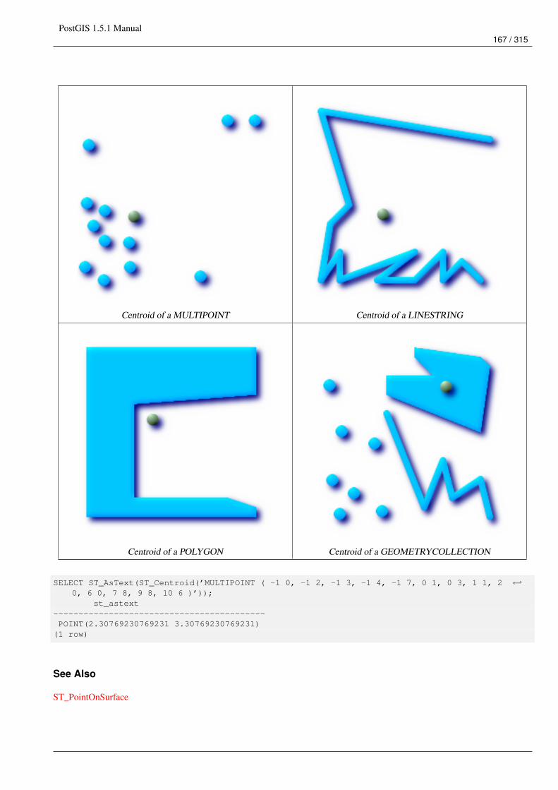
PostGIS 1.5.1 Manual167 / 315
Centroid of a MULTIPOINT Centroid of a LINESTRING
Centroid of a POLYGON Centroid of a GEOMETRYCOLLECTION
SELECT ST_AsText(ST_Centroid(’MULTIPOINT ( -1 0, -1 2, -1 3, -1 4, -1 7, 0 1, 0 3, 1 1, 2 ←↩0, 6 0, 7 8, 9 8, 10 6 )’));
st_astext------------------------------------------POINT(2.30769230769231 3.30769230769231)
(1 row)
See Also
ST_PointOnSurface
PostGIS 1.5.1 Manual168 / 315
7.8.4 ST_ClosestPoint
Name
ST_ClosestPoint – Returns the 2-dimensional point on g1 that is closest to g2. This is the first point of the shortest line.
Synopsis
geometry ST_ClosestPoint(geometry g1, geometry g2);
Description
Returns the 2-dimensional point on g1 that is closest to g2. This is the first point of the shortest line.
Availability: 1.5.0
Examples
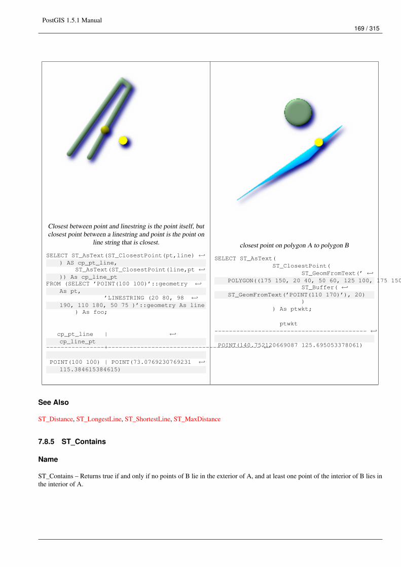
PostGIS 1.5.1 Manual169 / 315
Closest between point and linestring is the point itself, butclosest point between a linestring and point is the point on
line string that is closest.
SELECT ST_AsText(ST_ClosestPoint(pt,line) ←↩) AS cp_pt_line,
ST_AsText(ST_ClosestPoint(line,pt ←↩)) As cp_line_pt
FROM (SELECT ’POINT(100 100)’::geometry ←↩As pt,
’LINESTRING (20 80, 98 ←↩190, 110 180, 50 75 )’::geometry As line
) As foo;
cp_pt_line | ←↩cp_line_pt
----------------+------------------------------------------ ←↩
POINT(100 100) | POINT(73.0769230769231 ←↩115.384615384615)
closest point on polygon A to polygon B
SELECT ST_AsText(ST_ClosestPoint(
ST_GeomFromText(’ ←↩POLYGON((175 150, 20 40, 50 60, 125 100, 175 150))’),
ST_Buffer( ←↩ST_GeomFromText(’POINT(110 170)’), 20)
)) As ptwkt;
ptwkt------------------------------------------ ←↩
POINT(140.752120669087 125.695053378061)
See Also
ST_Distance, ST_LongestLine, ST_ShortestLine, ST_MaxDistance
7.8.5 ST_Contains
Name
ST_Contains – Returns true if and only if no points of B lie in the exterior of A, and at least one point of the interior of B lies inthe interior of A.
PostGIS 1.5.1 Manual170 / 315
Synopsis
boolean ST_Contains(geometry geomA, geometry geomB);
Description
Geometry A contains Geometry B if and only if no points of B lie in the exterior of A, and at least one point of the interior of Blies in the interior of A. An important subtlety of this definition is that A does not contain its boundary, but A does contain itself.Contrast that to ST_ContainsProperly where geometry A does not Contain Properly itself.
Returns TRUE if geometry B is completely inside geometry A. For this function to make sense, the source geometries must bothbe of the same coordinate projection, having the same SRID. ST_Contains is the inverse of ST_Within. So ST_Contains(A,B)implies ST_Within(B,A) except in the case of invalid geometries where the result is always false regardless or not defined.
Performed by the GEOS module
ImportantDo not call with a GEOMETRYCOLLECTION as an argument
ImportantDo not use this function with invalid geometries. You will get unexpected results.
This function call will automatically include a bounding box comparison that will make use of any indexes that are available onthe geometries. To avoid index use, use the function _ST_Contains.
NOTE: this is the "allowable" version that returns a boolean, not an integer.
This method implements the OpenGIS Simple Features Implementation Specification for SQL 1.1. s2.1.1.2 // s2.1.13.3 -same as within(geometry B, geometry A)
This method implements the SQL/MM specification. SQL-MM 3: 5.1.31
There are certain subtleties to ST_Contains and ST_Within that are not intuitively obvious. For details check out Subtleties ofOGC Covers, Contains, Within
Examples
The ST_Contains predicate returns TRUE in all the following illustrations.
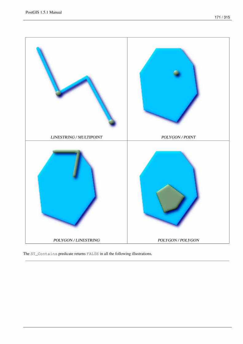
PostGIS 1.5.1 Manual171 / 315
LINESTRING / MULTIPOINT POLYGON / POINT
POLYGON / LINESTRING POLYGON / POLYGON
The ST_Contains predicate returns FALSE in all the following illustrations.
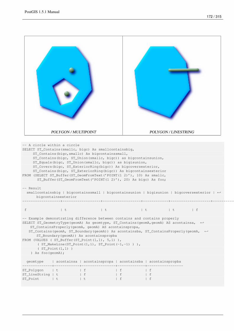
PostGIS 1.5.1 Manual172 / 315
POLYGON / MULTIPOINT POLYGON / LINESTRING
-- A circle within a circleSELECT ST_Contains(smallc, bigc) As smallcontainsbig,
ST_Contains(bigc,smallc) As bigcontainssmall,ST_Contains(bigc, ST_Union(smallc, bigc)) as bigcontainsunion,ST_Equals(bigc, ST_Union(smallc, bigc)) as bigisunion,ST_Covers(bigc, ST_ExteriorRing(bigc)) As bigcoversexterior,ST_Contains(bigc, ST_ExteriorRing(bigc)) As bigcontainsexterior
FROM (SELECT ST_Buffer(ST_GeomFromText(’POINT(1 2)’), 10) As smallc,ST_Buffer(ST_GeomFromText(’POINT(1 2)’), 20) As bigc) As foo;
-- Resultsmallcontainsbig | bigcontainssmall | bigcontainsunion | bigisunion | bigcoversexterior | ←↩
bigcontainsexterior------------------+------------------+------------------+------------+-------------------+--------------------- ←↩
f | t | t | t | t | f
-- Example demonstrating difference between contains and contains properlySELECT ST_GeometryType(geomA) As geomtype, ST_Contains(geomA,geomA) AS acontainsa, ←↩
ST_ContainsProperly(geomA, geomA) AS acontainspropa,ST_Contains(geomA, ST_Boundary(geomA)) As acontainsba, ST_ContainsProperly(geomA, ←↩
ST_Boundary(geomA)) As acontainspropbaFROM (VALUES ( ST_Buffer(ST_Point(1,1), 5,1) ),
( ST_MakeLine(ST_Point(1,1), ST_Point(-1,-1) ) ),( ST_Point(1,1) )
) As foo(geomA);
geomtype | acontainsa | acontainspropa | acontainsba | acontainspropba--------------+------------+----------------+-------------+-----------------ST_Polygon | t | f | f | fST_LineString | t | f | f | fST_Point | t | t | f | f
PostGIS 1.5.1 Manual173 / 315
See Also
ST_Boundary, ST_ContainsProperly, ST_Covers,ST_CoveredBy, ST_Equals,ST_Within
7.8.6 ST_ContainsProperly
Name
ST_ContainsProperly – Returns true if B intersects the interior of A but not the boundary (or exterior). A does not containproperly itself, but does contain itself.
Synopsis
boolean ST_ContainsProperly(geometry geomA, geometry geomB);
Description
Returns true if B intersects the interior of A but not the boundary (or exterior).
A does not contain properly itself, but does contain itself.
Every point of the other geometry is a point of this geometry’s interior. The DE-9IM Intersection Matrix for the two geometriesmatches [T**FF*FF*] used in ST_Relate
NoteFrom JTS docs slightly reworded: The advantage to using this predicate over ST_Contains and ST_Intersects is that itcan be computed efficiently, with no need to compute topology at individual points.An example use case for this predicate is computing the intersections of a set of geometries with a large polygonalgeometry. Since intersection is a fairly slow operation, it can be more efficient to use containsProperly to filter out testgeometries which lie wholly inside the area. In these cases the intersection is known a priori to be exactly the originaltest geometry.
Availability: 1.4.0 - requires GEOS >= 3.1.0.
ImportantDo not call with a GEOMETRYCOLLECTION as an argument
ImportantDo not use this function with invalid geometries. You will get unexpected results.
This function call will automatically include a bounding box comparison that will make use of any indexes that are available onthe geometries. To avoid index use, use the function _ST_ContainsProperly.
PostGIS 1.5.1 Manual174 / 315
Examples
--a circle within a circleSELECT ST_ContainsProperly(smallc, bigc) As smallcontainspropbig,ST_ContainsProperly(bigc,smallc) As bigcontainspropsmall,ST_ContainsProperly(bigc, ST_Union(smallc, bigc)) as bigcontainspropunion,ST_Equals(bigc, ST_Union(smallc, bigc)) as bigisunion,ST_Covers(bigc, ST_ExteriorRing(bigc)) As bigcoversexterior,ST_ContainsProperly(bigc, ST_ExteriorRing(bigc)) As bigcontainsexteriorFROM (SELECT ST_Buffer(ST_GeomFromText(’POINT(1 2)’), 10) As smallc,ST_Buffer(ST_GeomFromText(’POINT(1 2)’), 20) As bigc) As foo;--Resultsmallcontainspropbig | bigcontainspropsmall | bigcontainspropunion | bigisunion | ←↩
bigcoversexterior | bigcontainsexterior------------------+------------------+------------------+------------+-------------------+--------------------- ←↩
f | t | f | t | t ←↩| f
--example demonstrating difference between contains and contains properlySELECT ST_GeometryType(geomA) As geomtype, ST_Contains(geomA,geomA) AS acontainsa, ←↩
ST_ContainsProperly(geomA, geomA) AS acontainspropa,ST_Contains(geomA, ST_Boundary(geomA)) As acontainsba, ST_ContainsProperly(geomA, ←↩
ST_Boundary(geomA)) As acontainspropbaFROM (VALUES ( ST_Buffer(ST_Point(1,1), 5,1) ),
( ST_MakeLine(ST_Point(1,1), ST_Point(-1,-1) ) ),( ST_Point(1,1) )
) As foo(geomA);
geomtype | acontainsa | acontainspropa | acontainsba | acontainspropba--------------+------------+----------------+-------------+-----------------ST_Polygon | t | f | f | fST_LineString | t | f | f | fST_Point | t | t | f | f
See Also
ST_GeometryType, ST_Boundary, ST_Contains, ST_Covers,ST_CoveredBy, ST_Equals,ST_Relate,ST_Within
7.8.7 ST_Covers
Name
ST_Covers – Returns 1 (TRUE) if no point in Geometry B is outside Geometry A
Synopsis
boolean ST_Covers(geometry geomA, geometry geomB);boolean ST_Covers(geography geogpolyA, geography geogpointB);
Description
Returns 1 (TRUE) if no point in Geometry/Geography B is outside Geometry/Geography A
Performed by the GEOS module
PostGIS 1.5.1 Manual175 / 315
ImportantDo not call with a GEOMETRYCOLLECTION as an argument
ImportantFor geography only Polygon covers point is supported.
ImportantDo not use this function with invalid geometries. You will get unexpected results.
This function call will automatically include a bounding box comparison that will make use of any indexes that are available onthe geometries. To avoid index use, use the function _ST_Covers.
Availability: 1.2.2 - requires GEOS >= 3.0
Availability: 1.5 - support for geography was introduced.
NOTE: this is the "allowable" version that returns a boolean, not an integer.
Not an OGC standard, but Oracle has it too.
There are certain subtleties to ST_Contains and ST_Within that are not intuitively obvious. For details check out Subtleties ofOGC Covers, Contains, Within
Examples
Geometry example
--a circle covering a circleSELECT ST_Covers(smallc,smallc) As smallinsmall,ST_Covers(smallc, bigc) As smallcoversbig,ST_Covers(bigc, ST_ExteriorRing(bigc)) As bigcoversexterior,ST_Contains(bigc, ST_ExteriorRing(bigc)) As bigcontainsexterior
FROM (SELECT ST_Buffer(ST_GeomFromText(’POINT(1 2)’), 10) As smallc,ST_Buffer(ST_GeomFromText(’POINT(1 2)’), 20) As bigc) As foo;--Resultsmallinsmall | smallcoversbig | bigcoversexterior | bigcontainsexterior
--------------+----------------+-------------------+---------------------t | f | t | f
(1 row)
Geeography Example
See Also
ST_Contains, ST_CoveredBy, ST_Within
PostGIS 1.5.1 Manual176 / 315
7.8.8 ST_CoveredBy
Name
ST_CoveredBy – Returns 1 (TRUE) if no point in Geometry/Geography A is outside Geometry/Geography B
Synopsis
boolean ST_CoveredBy(geometry geomA, geometry geomB);boolean ST_CoveredBy(geography geogA, geography geogB);
Description
Returns 1 (TRUE) if no point in Geometry/Geography A is outside Geometry/Geography B
Performed by the GEOS module
ImportantDo not call with a GEOMETRYCOLLECTION as an argument
ImportantDo not use this function with invalid geometries. You will get unexpected results.
Availability: 1.2.2 - requires GEOS >= 3.0
This function call will automatically include a bounding box comparison that will make use of any indexes that are available onthe geometries. To avoid index use, use the function _ST_CoveredBy.
NOTE: this is the "allowable" version that returns a boolean, not an integer.
Not an OGC standard, but Oracle has it too.
There are certain subtleties to ST_Contains and ST_Within that are not intuitively obvious. For details check out Subtleties ofOGC Covers, Contains, Within
Examples
--a circle coveredby a circleSELECT ST_CoveredBy(smallc,smallc) As smallinsmall,ST_CoveredBy(smallc, bigc) As smallcoveredbybig,ST_CoveredBy(ST_ExteriorRing(bigc), bigc) As exteriorcoveredbybig,ST_Within(ST_ExteriorRing(bigc),bigc) As exeriorwithinbig
FROM (SELECT ST_Buffer(ST_GeomFromText(’POINT(1 2)’), 10) As smallc,ST_Buffer(ST_GeomFromText(’POINT(1 2)’), 20) As bigc) As foo;--Resultsmallinsmall | smallcoveredbybig | exteriorcoveredbybig | exeriorwithinbig
--------------+-------------------+----------------------+------------------t | t | t | f
(1 row)
PostGIS 1.5.1 Manual177 / 315
See Also
ST_Contains, ST_Covers, ST_ExteriorRing, ST_Within
7.8.9 ST_Crosses
Name
ST_Crosses – Returns TRUE if the supplied geometries have some, but not all, interior points in common.
Synopsis
boolean ST_Crosses(geometry g1, geometry g2);
Description
ST_Crosses takes two geometry objects and returns TRUE if their intersection "spatially cross", that is, the geometries havesome, but not all interior points in common. The intersection of the interiors of the geometries must not be the empty set andmust have a dimensionality less than the the maximum dimension of the two input geometries. Additionally, the intersection ofthe two geometries must not equal either of the source geometries. Otherwise, it returns FALSE.
In mathematical terms, this is expressed as:
The DE-9IM Intersection Matrix for the two geometries is:
• T*T****** (for Point/Line, Point/Area, and Line/Area situations)
• T*****T** (for Line/Point, Area/Point, and Area/Line situations)
• 0******** (for Line/Line situations)
For any other combination of dimensions this predicate returns false.
The OpenGIS Simple Features Specification defines this predicate only for Point/Line, Point/Area, Line/Line, and Line/Areasituations. JTS / GEOS extends the definition to apply to Line/Point, Area/Point and Area/Line situations as well. This makesthe relation symmetric.
ImportantDo not call with a GEOMETRYCOLLECTION as an argument
NoteThis function call will automatically include a bounding box comparison that will make use of any indexes that areavailable on the geometries.
This method implements the OpenGIS Simple Features Implementation Specification for SQL 1.1. s2.1.13.3
This method implements the SQL/MM specification. SQL-MM 3: 5.1.29

PostGIS 1.5.1 Manual178 / 315
Examples
The following illustrations all return TRUE.
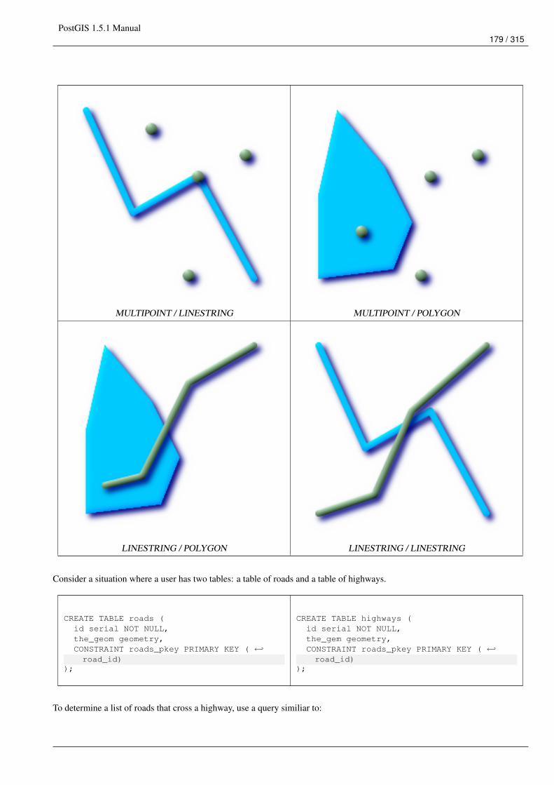
PostGIS 1.5.1 Manual179 / 315
MULTIPOINT / LINESTRING MULTIPOINT / POLYGON
LINESTRING / POLYGON LINESTRING / LINESTRING
Consider a situation where a user has two tables: a table of roads and a table of highways.
CREATE TABLE roads (id serial NOT NULL,the_geom geometry,CONSTRAINT roads_pkey PRIMARY KEY ( ←↩road_id)
);
CREATE TABLE highways (id serial NOT NULL,the_gem geometry,CONSTRAINT roads_pkey PRIMARY KEY ( ←↩road_id)
);
To determine a list of roads that cross a highway, use a query similiar to:
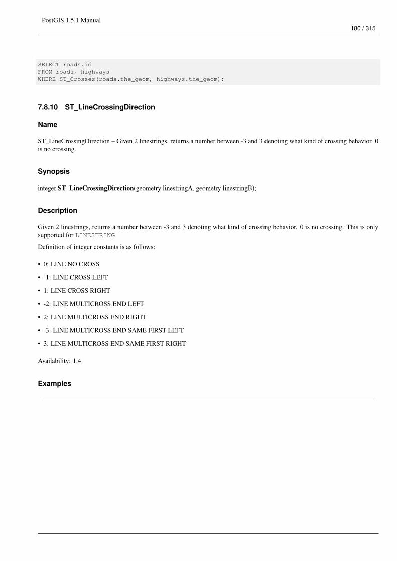
PostGIS 1.5.1 Manual180 / 315
SELECT roads.idFROM roads, highwaysWHERE ST_Crosses(roads.the_geom, highways.the_geom);
7.8.10 ST_LineCrossingDirection
Name
ST_LineCrossingDirection – Given 2 linestrings, returns a number between -3 and 3 denoting what kind of crossing behavior. 0is no crossing.
Synopsis
integer ST_LineCrossingDirection(geometry linestringA, geometry linestringB);
Description
Given 2 linestrings, returns a number between -3 and 3 denoting what kind of crossing behavior. 0 is no crossing. This is onlysupported for LINESTRING
Definition of integer constants is as follows:
• 0: LINE NO CROSS
• -1: LINE CROSS LEFT
• 1: LINE CROSS RIGHT
• -2: LINE MULTICROSS END LEFT
• 2: LINE MULTICROSS END RIGHT
• -3: LINE MULTICROSS END SAME FIRST LEFT
• 3: LINE MULTICROSS END SAME FIRST RIGHT
Availability: 1.4
Examples
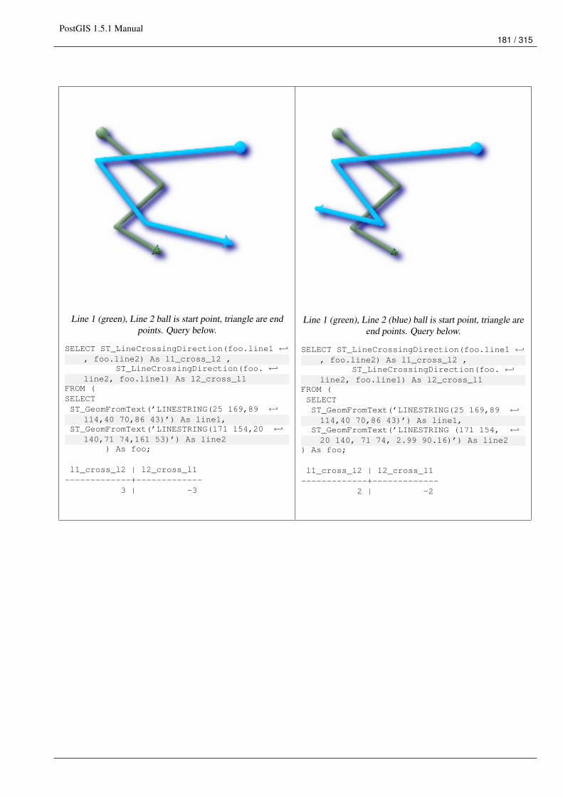
PostGIS 1.5.1 Manual181 / 315
Line 1 (green), Line 2 ball is start point, triangle are endpoints. Query below.
SELECT ST_LineCrossingDirection(foo.line1 ←↩, foo.line2) As l1_cross_l2 ,
ST_LineCrossingDirection(foo. ←↩line2, foo.line1) As l2_cross_l1
FROM (SELECTST_GeomFromText(’LINESTRING(25 169,89 ←↩
114,40 70,86 43)’) As line1,ST_GeomFromText(’LINESTRING(171 154,20 ←↩
140,71 74,161 53)’) As line2) As foo;
l1_cross_l2 | l2_cross_l1-------------+-------------
3 | -3
Line 1 (green), Line 2 (blue) ball is start point, triangle areend points. Query below.
SELECT ST_LineCrossingDirection(foo.line1 ←↩, foo.line2) As l1_cross_l2 ,
ST_LineCrossingDirection(foo. ←↩line2, foo.line1) As l2_cross_l1
FROM (SELECTST_GeomFromText(’LINESTRING(25 169,89 ←↩114,40 70,86 43)’) As line1,
ST_GeomFromText(’LINESTRING (171 154, ←↩20 140, 71 74, 2.99 90.16)’) As line2
) As foo;
l1_cross_l2 | l2_cross_l1-------------+-------------
2 | -2
PostGIS 1.5.1 Manual182 / 315
Line 1 (green), Line 2 (blue) ball is start point, triangle areend points. Query below.
SELECTST_LineCrossingDirection(foo. ←↩
line1, foo.line2) As l1_cross_l2 ,ST_LineCrossingDirection(foo. ←↩
line2, foo.line1) As l2_cross_l1FROM (SELECTST_GeomFromText(’LINESTRING(25 169,89 ←↩114,40 70,86 43)’) As line1,
ST_GeomFromText(’LINESTRING (20 140, 71 ←↩74, 161 53)’) As line2
) As foo;
l1_cross_l2 | l2_cross_l1-------------+-------------
-1 | 1
Line 1 (green), Line 2 (blue) ball is start point, triangle areend points. Query below.
SELECT ST_LineCrossingDirection(foo.line1 ←↩, foo.line2) As l1_cross_l2 ,
ST_LineCrossingDirection(foo. ←↩line2, foo.line1) As l2_cross_l1
FROM (SELECTST_GeomFromText(’LINESTRING(25 ←↩
169,89 114,40 70,86 43)’) As line1,ST_GeomFromText(’LINESTRING(2.99 ←↩
90.16,71 74,20 140,171 154)’) As line2) As foo;
l1_cross_l2 | l2_cross_l1-------------+-------------
-2 | 2
SELECT s1.gid, s2.gid, ST_LineCrossingDirection(s1.the_geom, s2.the_geom)FROM streets s1 CROSS JOIN streets s2 ON (s1.gid != s2.gid AND s1.the_geom && s2.the_geom ←↩
)WHERE ST_CrossingDirection(s1.the_geom, s2.the_geom) > 0;
See Also
ST_Crosses
7.8.11 ST_Disjoint
Name
ST_Disjoint – Returns TRUE if the Geometries do not "spatially intersect" - if they do not share any space together.
PostGIS 1.5.1 Manual183 / 315
Synopsis
boolean ST_Disjoint( geometry A , geometry B );
Description
Overlaps, Touches, Within all imply geometries are not spatially disjoint. If any of the aforementioned returns true, then thegeometries are not spatially disjoint. Disjoint implies false for spatial intersection.
ImportantDo not call with a GEOMETRYCOLLECTION as an argument
Performed by the GEOS module
NoteThis function call does not use indexes
NoteNOTE: this is the "allowable" version that returns a boolean, not an integer.
This method implements the OpenGIS Simple Features Implementation Specification for SQL 1.1. s2.1.1.2 //s2.1.13.3 -a.Relate(b, ’FF*FF****’)
This method implements the SQL/MM specification. SQL-MM 3: 5.1.26
Examples
SELECT ST_Disjoint(’POINT(0 0)’::geometry, ’LINESTRING ( 2 0, 0 2 )’::geometry);st_disjoint
---------------t
(1 row)SELECT ST_Disjoint(’POINT(0 0)’::geometry, ’LINESTRING ( 0 0, 0 2 )’::geometry);st_disjoint
---------------f
(1 row)
See Also
ST_IntersectsST_Intersects
PostGIS 1.5.1 Manual184 / 315
7.8.12 ST_Distance
Name
ST_Distance – For geometry type Returns the 2-dimensional cartesian minimum distance (based on spatial ref) between twogeometries in projected units. For geography type defaults to return spheroidal minimum distance between two geographies inmeters.
Synopsis
float ST_Distance(geometry g1, geometry g2);float ST_Distance(geography gg1, geography gg2);float ST_Distance(geography gg1, geography gg2, boolean use_spheroid);
Description
For geometry type returns the 2-dimensional minimum cartesian distance between two geometries in projected units (spatial refunits). For geography type defaults to return the minimum distance around WGS 84 spheroid between two geographies in meters.Pass in false to return answer in sphere instead of spheroid.
This method implements the OpenGIS Simple Features Implementation Specification for SQL 1.1.
This method implements the SQL/MM specification. SQL-MM 3: 5.1.23
Availability: 1.5.0 geography support was introduced in 1.5. Speed improvements for planar to better handle large or many vertexgeometries
Examples
--Geometry example - units in planar degrees 4326 is WGS 84 long lat unit=degreesSELECT ST_Distance(
ST_GeomFromText(’POINT(-72.1235 42.3521)’,4326),ST_GeomFromText(’LINESTRING(-72.1260 42.45, -72.123 42.1546)’, 4326)
);st_distance-----------------0.00150567726382282
-- Geometry example - units in meters (SRID: 26986 Massachusetts state plane meters) (most ←↩accurate for Massachusetts)
SELECT ST_Distance(ST_Transform(ST_GeomFromText(’POINT(-72.1235 42.3521)’,4326),26986),ST_Transform(ST_GeomFromText(’LINESTRING(-72.1260 42.45, -72.123 42.1546)’, 4326) ←↩
,26986));
st_distance-----------------123.797937878454
-- Geometry example - units in meters (SRID: 2163 US National Atlas Equal area) (least ←↩accurate)
SELECT ST_Distance(ST_Transform(ST_GeomFromText(’POINT(-72.1235 42.3521)’,4326),2163),ST_Transform(ST_GeomFromText(’LINESTRING(-72.1260 42.45, -72.123 42.1546)’, 4326) ←↩
,2163));
PostGIS 1.5.1 Manual185 / 315
st_distance------------------126.664256056812
-- Geography example -- same but note units in meters - use sphere for slightly faster less ←↩accurate
SELECT ST_Distance(gg1, gg2) As spheroid_dist, ST_Distance(gg1, gg2, false) As sphere_distFROM (SELECTST_GeographyFromText(’SRID=4326;POINT(-72.1235 42.3521)’) As gg1,ST_GeographyFromText(’SRID=4326;LINESTRING(-72.1260 42.45, -72.123 42.1546)’) As gg2) As foo ;
spheroid_dist | sphere_dist------------------+------------------123.802076746848 | 123.475736916397
See Also
ST_DWithin, ST_Distance_Sphere, ST_Distance_Spheroid, ST_MaxDistance, ST_Transform
7.8.13 ST_HausdorffDistance
Name
ST_HausdorffDistance – Returns the Hausdorff distance between two geometries. Basically a measure of how similar or dissim-ilar 2 geometries are. Units are in the units of the spatial reference system of the geometries.
Synopsis
float ST_HausdorffDistance(geometry g1, geometry g2);float ST_HausdorffDistance(geometry g1, geometry g2, float densifyFrac);
Description
Implements algorithm for computing a distance metric which can be thought of as the "Discrete Hausdorff Distance". This is theHausdorff distance restricted to discrete points for one of the geometries. Wikipedia article on Hausdorff distance Martin Davisnote on how Hausdorff Distance calculation was used to prove correctness of the CascadePolygonUnion approach.
When densifyFrac is specified, this function performs a segment densification before computing the discrete hausdorff distance.The densifyFrac parameter sets the fraction by which to densify each segment. Each segment will be split into a number ofequal-length subsegments, whose fraction of the total length is closest to the given fraction.
NoteThe current implementation supports only vertices as the discrete locations. This could be extended to allow an arbitrarydensity of points to be used.
NoteThis algorithm is NOT equivalent to the standard Hausdorff distance. However, it computes an approximation that iscorrect for a large subset of useful cases. One important part of this subset is Linestrings that are roughly parallel toeach other, and roughly equal in length. This is a useful metric for line matching.
Availability: 1.5.0 - requires GEOS >= 3.2.0
PostGIS 1.5.1 Manual186 / 315
Examples
postgis=# SELECT st_HausdorffDistance(’LINESTRING (0 0, 2 0)’::geometry,’MULTIPOINT (0 1, 1 0, 2 1)’::geometry);
st_hausdorffdistance----------------------
1(1 row)
postgis=# SELECT st_hausdorffdistance(’LINESTRING (130 0, 0 0, 0 150)’::geometry, ’ ←↩LINESTRING (10 10, 10 150, 130 10)’::geometry, 0.5);
st_hausdorffdistance----------------------
70(1 row)
7.8.14 ST_MaxDistance
Name
ST_MaxDistance – Returns the 2-dimensional largest distance between two geometries in projected units.
Synopsis
float ST_MaxDistance(geometry g1, geometry g2);
Description
Some useful description here.
NoteReturns the 2-dimensional maximum distance between two linestrings in projected units. If g1 and g2 is the samegeometry the function will return the distance between the two vertices most far from each other in that geometry.
Availability: 1.5.0
Examples
postgis=# SELECT ST_MaxDistance(’POINT(0 0)’::geometry, ’LINESTRING ( 2 0, 0 2 )’::geometry ←↩);st_maxdistance
-----------------2
(1 row)
postgis=# SELECT ST_MaxDistance(’POINT(0 0)’::geometry, ’LINESTRING ( 2 2, 2 2 )’::geometry ←↩);
st_maxdistance------------------2.82842712474619
(1 row)
PostGIS 1.5.1 Manual187 / 315
See Also
ST_Distance, ST_LongestLine
7.8.15 ST_Distance_Sphere
Name
ST_Distance_Sphere – Returns minimum distance in meters between two lon/lat geometries. Uses a spherical earth and radiusof 6370986 meters. Faster than ST_Distance_Spheroid, but less accurate. PostGIS versions prior to 1.5 only implemented forpoints.
Synopsis
float ST_Distance_Sphere(geometry geomlonlatA, geometry geomlonlatB);
Description
Returns minimum distance in meters between two lon/lat points. Uses a spherical earth and radius of 6370986 meters. Fasterthan ST_Distance_Spheroid, but less accurate. PostGIS Versions prior to 1.5 only implemented for points.
NoteThis function currently does not look at the SRID of a geometry and will always assume its in WGS 84 long lat. Priorversions of this function only support points.
Availability: 1.5 - support for other geometry types besides points was introduced. Prior versions only work with points.
Examples
SELECT round(CAST(ST_Distance_Sphere(ST_Centroid(the_geom), ST_GeomFromText(’POINT(-118 38) ←↩’,4326)) As numeric),2) As dist_meters,
round(CAST(ST_Distance(ST_Transform(ST_Centroid(the_geom),32611),ST_Transform(ST_GeomFromText(’POINT(-118 38)’, 4326),32611)) As numeric),2) As ←↩
dist_utm11_meters,round(CAST(ST_Distance(ST_Centroid(the_geom), ST_GeomFromText(’POINT(-118 38)’, 4326)) As ←↩
numeric),5) As dist_degrees,round(CAST(ST_Distance(ST_Transform(the_geom,32611),
ST_Transform(ST_GeomFromText(’POINT(-118 38)’, 4326),32611)) As numeric),2) As ←↩min_dist_line_point_meters
FROM(SELECT ST_GeomFromText(’LINESTRING(-118.584 38.374,-118.583 38.5)’, 4326) As the_geom) ←↩
as foo;dist_meters | dist_utm11_meters | dist_degrees | min_dist_line_point_meters
-------------+-------------------+--------------+----------------------------70424.47 | 70438.00 | 0.72900 | 65871.18
See Also
ST_Distance, ST_Distance_Spheroid
PostGIS 1.5.1 Manual188 / 315
7.8.16 ST_Distance_Spheroid
Name
ST_Distance_Spheroid – Returns the minimum distance between two lon/lat geometries given a particular spheroid. PostGISversions prior to 1.5 only support points.
Synopsis
float ST_Distance_Spheroid(geometry geomlonlatA, geometry geomlonlatB, spheroid measurement_spheroid);
Description
Returns minimum distance in meters between two lon/lat geometries given a particular spheroid. See the explanation of spheroidsgiven for ST_Length_Spheroid. PostGIS version prior to 1.5 only support points.
NoteThis function currently does not look at the SRID of a geometry and will always assume its in WGS 80 long lat. Priorversions of this function only support points.
Availability: 1.5 - support for other geometry types besides points was introduced. Prior versions only work with points.
Examples
SELECT round(CAST(ST_Distance_Spheroid(ST_Centroid(the_geom), ST_GeomFromText(’POINT(-118 38)’,4326), ’ ←↩
SPHEROID["WGS 84",6378137,298.257223563]’)As numeric),2) As dist_meters_spheroid,
round(CAST(ST_Distance_Sphere(ST_Centroid(the_geom), ST_GeomFromText(’POINT(-118 38) ←↩’,4326)) As numeric),2) As dist_meters_sphere,
round(CAST(ST_Distance(ST_Transform(ST_Centroid(the_geom),32611),ST_Transform(ST_GeomFromText(’POINT(-118 38)’, 4326),32611)) As numeric),2) As ←↩
dist_utm11_metersFROM(SELECT ST_GeomFromText(’LINESTRING(-118.584 38.374,-118.583 38.5)’, 4326) As the_geom) ←↩
as foo;dist_meters_spheroid | dist_meters_sphere | dist_utm11_meters
----------------------+--------------------+-------------------70454.92 | 70424.47 | 70438.00
See Also
ST_Distance, ST_Distance_Sphere
7.8.17 ST_DFullyWithin
Name
ST_DFullyWithin – Returns true if all of the geometries are within the specified distance of one another
PostGIS 1.5.1 Manual189 / 315
Synopsis
boolean ST_DFullyWithin(geometry g1, geometry g2, double precision distance);
Description
Returns true if the geometries is fully within the specified distance of one another. The distance is specified in units defined bythe spatial reference system of the geometries. For this function to make sense, the source geometries must both be of the samecoordinate projection, having the same SRID.
NoteThis function call will automatically include a bounding box comparison that will make use of any indexes that areavailable on the geometries.
Availability: 1.5.0
Examples
postgis=# SELECT ST_DFullyWithin(geom_a, geom_b, 10) as DFullyWithin10, ST_DWithin(geom_a, ←↩geom_b, 10) as DWithin10, ST_DFullyWithin(geom_a, geom_b, 20) as DFullyWithin20 from(select ST_GeomFromText(’POINT(1 1)’) as geom_a,ST_GeomFromText(’LINESTRING(1 5, 2 7, 1 ←↩
9, 14 12)’) as geom_b) t1;
-----------------DFullyWithin10 | DWithin10 | DFullyWithin20 |
---------------+----------+---------------+f | t | t |
See Also
ST_MaxDistance, ST_DWithin
7.8.18 ST_DWithin
Name
ST_DWithin – Returns true if the geometries are within the specified distance of one another. For geometry units are in thoseof spatial reference and For geography units are in meters and measurement is defaulted to use_spheroid=true (measure aroundspheroid), for faster check, use_spheroid=false to measure along sphere.
Synopsis
boolean ST_DWithin(geometry g1, geometry g2, double precision distance_of_srid);boolean ST_DWithin(geography gg1, geography gg2, double precision distance_meters);boolean ST_DWithin(geography gg1, geography gg2, double precision distance_meters, boolean use_spheroid);
PostGIS 1.5.1 Manual190 / 315
Description
Returns true if the geometries are within the specified distance of one another.
For Geometries: The distance is specified in units defined by the spatial reference system of the geometries. For this function tomake sense, the source geometries must both be of the same coorindate projection, having the same SRID.
For geography units are in meters and measurement is defaulted to use_spheroid=true (measure around WGS 84 spheroid), forfaster check, use_spheroid=false to measure along sphere.
NoteThis function call will automatically include a bounding box comparison that will make use of any indexes that areavailable on the geometries.
NotePrior to 1.3, ST_Expand was commonly used in conjunction with && and ST_Distance to achieve the same effect andin pre-1.3.4 this function was basically short-hand for that construct. From 1.3.4, ST_DWithin uses a more short-circuitdistance function which should make it more efficient than prior versions for larger buffer regions.
This method implements the OpenGIS Simple Features Implementation Specification for SQL 1.1.
Availability: 1.5.0 support for geography was introduced
Examples
--Find the nearest hospital to each school--that is within 3000 units of the school.-- We do an ST_DWithin search to utilize indexes to limit our search list-- that the non-indexable ST_Distance needs to process--If the units of the spatial reference is meters then units would be metersSELECT DISTINCT ON (s.gid) s.gid, s.school_name, s.the_geom, h.hospital_nameFROM schools sLEFT JOIN hospitals h ON ST_DWithin(s.the_geom, h.the_geom, 3000)
ORDER BY s.gid, ST_Distance(s.the_geom, h.the_geom);
--The schools with no close hospitals--Find all schools with no hospital within 3000 units--away from the school. Units is in units of spatial ref (e.g. meters, feet, degrees)SELECT s.gid, s.school_nameFROM schools sLEFT JOIN hospitals h ON ST_DWithin(s.the_geom, h.the_geom, 3000)
WHERE h.gid IS NULL;
See Also
ST_Distance, ST_Expand
7.8.19 ST_Equals
Name
ST_Equals – Returns true if the given geometries represent the same geometry. Directionality is ignored.
PostGIS 1.5.1 Manual191 / 315
Synopsis
boolean ST_Equals(geometry A, geometry B);
Description
Returns TRUE if the given Geometries are "spatially equal". Use this for a ’better’ answer than ’=’. Note by spatially equal wemean ST_Within(A,B) = true and ST_Within(B,A) = true and also mean ordering of points can be different but represent the samegeometry structure. To verify the order of points is consistent, use ST_OrderingEquals (it must be noted ST_OrderingEquals isa little more stringent than simply verifying order of points are the same).
ImportantThis function will return false if either geometry is invalid even if they are binary equal.
This method implements the OpenGIS Simple Features Implementation Specification for SQL 1.1. s2.1.1.2
This method implements the SQL/MM specification. SQL-MM 3: 5.1.24
Examples
SELECT ST_Equals(ST_GeomFromText(’LINESTRING(0 0, 10 10)’),ST_GeomFromText(’LINESTRING(0 0, 5 5, 10 10)’));
st_equals-----------t
(1 row)
SELECT ST_Equals(ST_Reverse(ST_GeomFromText(’LINESTRING(0 0, 10 10)’)),ST_GeomFromText(’LINESTRING(0 0, 5 5, 10 10)’));
st_equals-----------t
(1 row)
See Also
ST_IsValid, ST_OrderingEquals, ST_Reverse, ST_Within
7.8.20 ST_HasArc
Name
ST_HasArc – Returns true if a geometry or geometry collection contains a circular string
Synopsis
boolean ST_HasArc(geometry geomA);
PostGIS 1.5.1 Manual192 / 315
Description
Returns true if a geometry or geometry collection contains a circular string
Availability: 1.2.3?
This function supports 3d and will not drop the z-index.
This method supports Circular Strings and Curves
Examples
SELECT ST_HasArc(ST_Collect(’LINESTRING(1 2, 3 4, 5 6)’, ’CIRCULARSTRING(1 1, 2 3, 4 5, 6 ←↩7, 5 6)’));st_hasarc--------t
See Also
ST_CurveToLine,ST_LineToCurve
7.8.21 ST_Intersects
Name
ST_Intersects – Returns TRUE if the Geometries/Geography "spatially intersect" - (share any portion of space) and FALSE ifthey don’t (they are Disjoint). For geography -- tolerance is 0.00001 meters (so any points that close are considered to intersect)
Synopsis
boolean ST_Intersects( geometry geomA , geometry geomB );boolean ST_Intersects( geography geogA , geography geogB );
Description
Overlaps, Touches, Within all imply spatial intersection. If any of the aforementioned returns true, then the geometries alsospatially intersect. Disjoint implies false for spatial intersection.
ImportantDo not call with a GEOMETRYCOLLECTION as an argument for geometry version. The geography version supportsGEOMETRYCOLLECTION since its a thin wrapper around distance implementation.
Performed by the GEOS module (for geometry), geography is native
Availability: 1.5 support for geography was introduced.
NoteThis function call will automatically include a bounding box comparison that will make use of any indexes that areavailable on the geometries.
PostGIS 1.5.1 Manual193 / 315
NoteFor geography, this function has a distance tolerance of about 0.00001 meters and uses the sphere rather than spheroidcalculation.
NoteNOTE: this is the "allowable" version that returns a boolean, not an integer.
This method implements the OpenGIS Simple Features Implementation Specification for SQL 1.1. s2.1.1.2 //s2.1.13.3 -ST_Intersects(g1, g2 ) --> Not (ST_Disjoint(g1, g2 ))
This method implements the SQL/MM specification. SQL-MM 3: 5.1.27
Geometry Examples
SELECT ST_Intersects(’POINT(0 0)’::geometry, ’LINESTRING ( 2 0, 0 2 )’::geometry);st_intersects
---------------f
(1 row)SELECT ST_Intersects(’POINT(0 0)’::geometry, ’LINESTRING ( 0 0, 0 2 )’::geometry);st_intersects
---------------t
(1 row)
Geography Examples
SELECT ST_Intersects(ST_GeographyFromText(’SRID=4326;LINESTRING(-43.23456 72.4567,-43.23456 72.4568)’),ST_GeographyFromText(’SRID=4326;POINT(-43.23456 72.4567772)’));
st_intersects---------------t
See Also
ST_Disjoint
7.8.22 ST_Length
Name
ST_Length – Returns the 2d length of the geometry if it is a linestring or multilinestring. geometry are in units of spatial referenceand geography are in meters (default spheroid)
PostGIS 1.5.1 Manual194 / 315
Synopsis
float ST_Length(geometry a_2dlinestring);float ST_Length(geography gg);float ST_Length(geography gg, boolean use_spheroid);
Description
For geometry: Returns the cartesian 2D length of the geometry if it is a linestring, multilinestring, ST_Curve, ST_MultiCurve. 0is returned for areal geometries. For areal geometries use ST_Perimeter. Geometry: Measurements are in the units of the spatialreference system of the geometry. Geography: Units are in meters and also acts as a Perimeter function for areal geogs.
Currently for geometry this is an alias for ST_Length2D, but this may change to support higher dimensions.
NoteCurrently applying this to a MULTI/POLYGON of type geography will give you the perimeter of the POLYGON/MULTI-POLYGON. This is not the case with the geometry implementation.
NoteFor geography measurement defaults spheroid measurement. To use the faster less accurate sphere useST_Length(gg,false);
This method implements the OpenGIS Simple Features Implementation Specification for SQL 1.1. s2.1.5.1
This method implements the SQL/MM specification. SQL-MM 3: 7.1.2, 9.3.4
Availability: 1.5.0 geography support was introduced in 1.5.
Geometry Examples
Return length in feet for line string. Note this is in feet because 2249 is Mass State Plane Feet
SELECT ST_Length(ST_GeomFromText(’LINESTRING(743238 2967416,743238 2967450,743265 2967450,743265.625 2967416,743238 2967416)’,2249));st_length---------122.630744000095
--Transforming WGS 84 linestring to Massachusetts state plane metersSELECT ST_Length(ST_Transform(ST_GeomFromEWKT(’SRID=4326;LINESTRING(-72.1260 42.45, -72.1240 42.45666, -72.123 ←↩
42.1546)’),26986
));st_length---------34309.4563576191
PostGIS 1.5.1 Manual195 / 315
Geography Examples
Return length of WGS 84 geography line
-- default calculation is using a sphere rather than spheroidSELECT ST_Length(the_geog) As length_spheroid, ST_Length(the_geog,false) As length_sphereFROM (SELECT ST_GeographyFromText(’SRID=4326;LINESTRING(-72.1260 42.45, -72.1240 42.45666, -72.123 42.1546)’) As the_geog)As foo;length_spheroid | length_sphere
------------------+------------------34310.5703627305 | 34346.2060960742
(1 row)
See Also
ST_GeographyFromText, ST_GeomFromEWKT, ST_Length_Spheroid, ST_Perimeter, ST_Transform
7.8.23 ST_Length2D
Name
ST_Length2D – Returns the 2-dimensional length of the geometry if it is a linestring or multi-linestring. This is an alias forST_Length
Synopsis
float ST_Length2D(geometry a_2dlinestring);
Description
Returns the 2-dimensional length of the geometry if it is a linestring or multi-linestring. This is an alias for ST_Length
See Also
ST_Length, ST_Length3D
7.8.24 ST_Length3D
Name
ST_Length3D – Returns the 3-dimensional or 2-dimensional length of the geometry if it is a linestring or multi-linestring.
Synopsis
float ST_Length3D(geometry a_3dlinestring);
PostGIS 1.5.1 Manual196 / 315
Description
Returns the 3-dimensional or 2-dimensional length of the geometry if it is a linestring or multi-linestring. For 2-d lines it willjust return the 2-d length (same as ST_Length and ST_Length2D)
This function supports 3d and will not drop the z-index.
Examples
Return length in feet for a 3D cable. Note this is in feet because 2249 is Mass State Plane Feet
SELECT ST_Length3D(ST_GeomFromText(’LINESTRING(743238 2967416 1,743238 2967450 1,743265 ←↩2967450 3,
743265.625 2967416 3,743238 2967416 3)’,2249));st_length3d-----------122.704716741457
See Also
ST_Length, ST_Length2D
7.8.25 ST_Length_Spheroid
Name
ST_Length_Spheroid – Calculates the 2D or 3D length of a linestring/multilinestring on an ellipsoid. This is useful if thecoordinates of the geometry are in longitude/latitude and a length is desired without reprojection.
Synopsis
float ST_Length_Spheroid(geometry a_linestring, spheroid a_spheroid);
Description
Calculates the length of a geometry on an ellipsoid. This is useful if the coordinates of the geometry are in longitude/latitude anda length is desired without reprojection. The ellipsoid is a separate database type and can be constructed as follows:
SPHEROID[<NAME>,<SEMI-MAJORAXIS>,<INVERSE FLATTENING>]
SPHEROID["GRS_1980",6378137,298.257222101]
NoteWill return 0 for anything that is not a MULTILINESTRING or LINESTRING
This function supports 3d and will not drop the z-index.
PostGIS 1.5.1 Manual197 / 315
Examples
SELECT ST_Length_Spheroid( geometry_column,’SPHEROID["GRS_1980",6378137,298.257222101]’ )FROM geometry_table;
SELECT ST_Length_Spheroid( the_geom, sph_m ) As tot_len,ST_Length_Spheroid(ST_GeometryN(the_geom,1), sph_m) As len_line1,ST_Length_Spheroid(ST_GeometryN(the_geom,2), sph_m) As len_line2
FROM (SELECT ST_GeomFromText(’MULTILINESTRING((-118.584 38.374,-118.583 38.5),(-71.05957 42.3589 , -71.061 43))’) As the_geom,
CAST(’SPHEROID["GRS_1980",6378137,298.257222101]’ As spheroid) As sph_m) as foo;tot_len | len_line1 | len_line2
------------------+------------------+------------------85204.5207562955 | 13986.8725229309 | 71217.6482333646
--3DSELECT ST_Length_Spheroid( the_geom, sph_m ) As tot_len,ST_Length_Spheroid(ST_GeometryN(the_geom,1), sph_m) As len_line1,ST_Length_Spheroid(ST_GeometryN(the_geom,2), sph_m) As len_line2
FROM (SELECT ST_GeomFromEWKT(’MULTILINESTRING((-118.584 38.374 20,-118.583 38.5 30) ←↩,
(-71.05957 42.3589 75, -71.061 43 90))’) As the_geom,CAST(’SPHEROID["GRS_1980",6378137,298.257222101]’ As spheroid) As sph_m) as foo;
tot_len | len_line1 | len_line2------------------+-----------------+------------------85204.5259107402 | 13986.876097711 | 71217.6498130292
See Also
ST_GeometryN, ST_Length, ST_Length3D_Spheroid
7.8.26 ST_Length2D_Spheroid
Name
ST_Length2D_Spheroid – Calculates the 2D length of a linestring/multilinestring on an ellipsoid. This is useful if the coordinatesof the geometry are in longitude/latitude and a length is desired without reprojection.
Synopsis
float ST_Length2D_Spheroid(geometry a_linestring, spheroid a_spheroid);
Description
Calculates the 2D length of a geometry on an ellipsoid. This is useful if the coordinates of the geometry are in longitude/latitudeand a length is desired without reprojection. The ellipsoid is a separate database type and can be constructed as follows:
SPHEROID[<NAME>,<SEMI-MAJORAXIS>,<INVERSE FLATTENING>]
SPHEROID["GRS_1980",6378137,298.257222101]
PostGIS 1.5.1 Manual198 / 315
NoteWill return 0 for anything that is not a MULTILINESTRING or LINESTRING
NoteThis is much like ST_Length_Spheroid and ST_Length3D_Spheroid except it will throw away the Z coordinate in calcu-lations.
Examples
SELECT ST_Length2D_Spheroid( geometry_column,’SPHEROID["GRS_1980",6378137,298.257222101]’ )FROM geometry_table;
SELECT ST_Length2D_Spheroid( the_geom, sph_m ) As tot_len,ST_Length2D_Spheroid(ST_GeometryN(the_geom,1), sph_m) As len_line1,ST_Length2D_Spheroid(ST_GeometryN(the_geom,2), sph_m) As len_line2
FROM (SELECT ST_GeomFromText(’MULTILINESTRING((-118.584 38.374,-118.583 38.5),(-71.05957 42.3589 , -71.061 43))’) As the_geom,
CAST(’SPHEROID["GRS_1980",6378137,298.257222101]’ As spheroid) As sph_m) as foo;tot_len | len_line1 | len_line2
------------------+------------------+------------------85204.5207562955 | 13986.8725229309 | 71217.6482333646
--3D Observe same answerSELECT ST_Length2D_Spheroid( the_geom, sph_m ) As tot_len,ST_Length2D_Spheroid(ST_GeometryN(the_geom,1), sph_m) As len_line1,ST_Length2D_Spheroid(ST_GeometryN(the_geom,2), sph_m) As len_line2
FROM (SELECT ST_GeomFromEWKT(’MULTILINESTRING((-118.584 38.374 20,-118.583 38.5 30) ←↩,
(-71.05957 42.3589 75, -71.061 43 90))’) As the_geom,CAST(’SPHEROID["GRS_1980",6378137,298.257222101]’ As spheroid) As sph_m) as foo;
tot_len | len_line1 | len_line2------------------+------------------+------------------85204.5207562955 | 13986.8725229309 | 71217.6482333646
See Also
ST_GeometryN, ST_Length_Spheroid, ST_Length3D_Spheroid
7.8.27 ST_Length3D_Spheroid
Name
ST_Length3D_Spheroid – Calculates the length of a geometry on an ellipsoid, taking the elevation into account. This is just analias for ST_Length_Spheroid.
Synopsis
float ST_Length3D_Spheroid(geometry a_linestring, spheroid a_spheroid);
PostGIS 1.5.1 Manual199 / 315
Description
Calculates the length of a geometry on an ellipsoid, taking the elevation into account. This is just an alias for ST_Length_Spheroid.
NoteWill return 0 for anything that is not a MULTILINESTRING or LINESTRING
NoteThis functionis just an alias for ST_Length_Spheroid.
This function supports 3d and will not drop the z-index.
Examples
See ST_Length_Spheroid
See Also
ST_GeometryN, ST_Length, ST_Length_Spheroid
7.8.28 ST_LongestLine
Name
ST_LongestLine – Returns the 2-dimensional longest line points of two geometries. The function will only return the first longestline if more than one, that the function finds. The line returned will always start in g1 and end in g2. The length of the line thisfunction returns will always be the same as st_maxdistance returns for g1 and g2.
Synopsis
geometry ST_LongestLine(geometry g1, geometry g2);
Description
Returns the 2-dimensional longest line between the points of two geometries.
Availability: 1.5.0
Examples
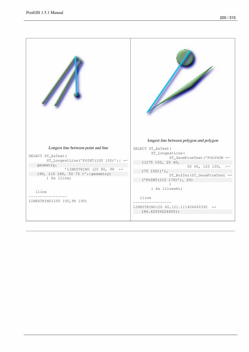
PostGIS 1.5.1 Manual200 / 315
Longest line between point and line
SELECT ST_AsText(ST_LongestLine(’POINT(100 100)’:: ←↩
geometry,’LINESTRING (20 80, 98 ←↩
190, 110 180, 50 75 )’::geometry)) As lline;
lline-----------------LINESTRING(100 100,98 190)
longest line between polygon and polygon
SELECT ST_AsText(ST_LongestLine(
ST_GeomFromText(’POLYGON ←↩((175 150, 20 40,
50 60, 125 100, ←↩175 150))’),
ST_Buffer(ST_GeomFromText ←↩(’POINT(110 170)’), 20)
)) As llinewkt;
lline-----------------LINESTRING(20 40,121.111404660392 ←↩
186.629392246051)
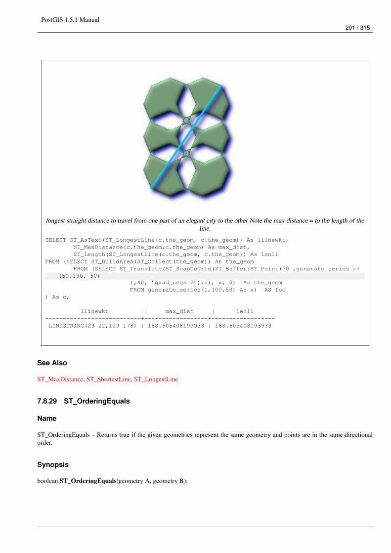
PostGIS 1.5.1 Manual201 / 315
longest straight distance to travel from one part of an elegant city to the other Note the max distance = to the length of theline.
SELECT ST_AsText(ST_LongestLine(c.the_geom, c.the_geom)) As llinewkt,ST_MaxDistance(c.the_geom,c.the_geom) As max_dist,ST_Length(ST_LongestLine(c.the_geom, c.the_geom)) As lenll
FROM (SELECT ST_BuildArea(ST_Collect(the_geom)) As the_geomFROM (SELECT ST_Translate(ST_SnapToGrid(ST_Buffer(ST_Point(50 ,generate_series ←↩
(50,190, 50)),40, ’quad_segs=2’),1), x, 0) As the_geomFROM generate_series(1,100,50) As x) AS foo
) As c;
llinewkt | max_dist | lenll---------------------------+------------------+------------------LINESTRING(23 22,129 178) | 188.605408193933 | 188.605408193933
See Also
ST_MaxDistance, ST_ShortestLine, ST_LongestLine
7.8.29 ST_OrderingEquals
Name
ST_OrderingEquals – Returns true if the given geometries represent the same geometry and points are in the same directionalorder.
Synopsis
boolean ST_OrderingEquals(geometry A, geometry B);
PostGIS 1.5.1 Manual202 / 315
Description
ST_OrderingEquals compares two geometries and t (TRUE) if the geometries are equal and the coordinates are in the same order;otherwise it returns f (FALSE).
NoteThis function is implemented as per the ArcSDE SQL specification rather than SQL-MM.http://edndoc.esri.com/arcsde/9.1/sql_api/sqlapi3.htm#ST_OrderingEquals
This method implements the SQL/MM specification. SQL-MM 3: 5.1.43
Examples
SELECT ST_OrderingEquals(ST_GeomFromText(’LINESTRING(0 0, 10 10)’),ST_GeomFromText(’LINESTRING(0 0, 5 5, 10 10)’));
st_orderingequals-----------f
(1 row)
SELECT ST_OrderingEquals(ST_GeomFromText(’LINESTRING(0 0, 10 10)’),ST_GeomFromText(’LINESTRING(0 0, 0 0, 10 10)’));
st_orderingequals-----------t
(1 row)
SELECT ST_OrderingEquals(ST_Reverse(ST_GeomFromText(’LINESTRING(0 0, 10 10)’)),ST_GeomFromText(’LINESTRING(0 0, 0 0, 10 10)’));
st_orderingequals-----------f
(1 row)
See Also
ST_Equals, ST_Reverse
7.8.30 ST_Overlaps
Name
ST_Overlaps – Returns TRUE if the Geometries share space, are of the same dimension, but are not completely contained byeach other.
Synopsis
boolean ST_Overlaps(geometry A, geometry B);
PostGIS 1.5.1 Manual203 / 315
Description
Returns TRUE if the Geometries "spatially overlap". By that we mean they intersect, but one does not completely contain another.
Performed by the GEOS module
NoteDo not call with a GeometryCollection as an argument
This function call will automatically include a bounding box comparison that will make use of any indexes that are available onthe geometries. To avoid index use, use the function _ST_Overlaps.
NOTE: this is the "allowable" version that returns a boolean, not an integer.
This method implements the OpenGIS Simple Features Implementation Specification for SQL 1.1. s2.1.1.2 // s2.1.13.3
This method implements the SQL/MM specification. SQL-MM 3: 5.1.32
Examples
--a point on a line is contained by the line and is of a lower dimension, and therefore ←↩does not overlap the line
nor crosses
SELECT ST_Overlaps(a,b) As a_overlap_b,ST_Crosses(a,b) As a_crosses_b,ST_Intersects(a, b) As a_intersects_b, ST_Contains(b,a) As b_contains_a
FROM (SELECT ST_GeomFromText(’POINT(1 0.5)’) As a, ST_GeomFromText(’LINESTRING(1 0, 1 1, 3 ←↩5)’) As b)
As foo
a_overlap_b | a_crosses_b | a_intersects_b | b_contains_a------------+-------------+----------------+--------------f | f | t | t
--a line that is partly contained by circle, but not fully is defined as intersecting and ←↩crossing,
-- but since of different dimension it does not overlapSELECT ST_Overlaps(a,b) As a_overlap_b, ST_Crosses(a,b) As a_crosses_b,ST_Intersects(a, b) As a_intersects_b,ST_Contains(a,b) As a_contains_b
FROM (SELECT ST_Buffer(ST_GeomFromText(’POINT(1 0.5)’), 3) As a, ST_GeomFromText(’ ←↩LINESTRING(1 0, 1 1, 3 5)’) As b)
As foo;
a_overlap_b | a_crosses_b | a_intersects_b | a_contains_b-------------+-------------+----------------+--------------f | t | t | f
-- a 2-dimensional bent hot dog (aka puffered line string) that intersects a circle,-- but is not fully contained by the circle is defined as overlapping since they are of ←↩
the same dimension,-- but it does not cross, because the intersection of the 2 is of the same dimension-- as the maximum dimension of the 2
SELECT ST_Overlaps(a,b) As a_overlap_b, ST_Crosses(a,b) As a_crosses_b, ST_Intersects(a, b) ←↩As a_intersects_b,
PostGIS 1.5.1 Manual204 / 315
ST_Contains(b,a) As b_contains_a,ST_Dimension(a) As dim_a, ST_Dimension(b) as dim_b, ST_Dimension(ST_Intersection(a,b)) As ←↩
dima_intersection_bFROM (SELECT ST_Buffer(ST_GeomFromText(’POINT(1 0.5)’), 3) As a,ST_Buffer(ST_GeomFromText(’LINESTRING(1 0, 1 1, 3 5)’),0.5) As b)As foo;
a_overlap_b | a_crosses_b | a_intersects_b | b_contains_a | dim_a | dim_b | ←↩dima_intersection_b
-------------+-------------+----------------+--------------+-------+-------+--------------------- ←↩
t | f | t | f | 2 | 2 | 2
See Also
ST_Contains, ST_Crosses, ST_Dimension, ST_Intersects
7.8.31 ST_Perimeter
Name
ST_Perimeter – Return the length measurement of the boundary of an ST_Surface or ST_MultiSurface value. (Polygon, Multi-polygon)
Synopsis
float ST_Perimeter(geometry g1);
Description
Returns the 2D perimeter of the geometry if it is a ST_Surface, ST_MultiSurface (Polygon, Multipolygon). 0 is returned fornon-areal geometries. For linestrings use ST_Length. Measurements are in the units of the spatial reference system of thegeometry.
Currently this is an alias for ST_Perimeter2D, but this may change to support higher dimensions.
This method implements the OpenGIS Simple Features Implementation Specification for SQL 1.1. s2.1.5.1
This method implements the SQL/MM specification. SQL-MM 3: 8.1.3, 9.5.4
Examples
Return perimeter in feet for polygon and multipolygon. Note this is in feet because 2249 is Mass State Plane Feet
SELECT ST_Perimeter(ST_GeomFromText(’POLYGON((743238 2967416,743238 2967450,743265 2967450,743265.625 2967416,743238 2967416))’, 2249));st_perimeter---------122.630744000095
(1 row)
SELECT ST_Perimeter(ST_GeomFromText(’MULTIPOLYGON(((763104.471273676 2949418.44119003,763104.477769673 2949418.42538203,
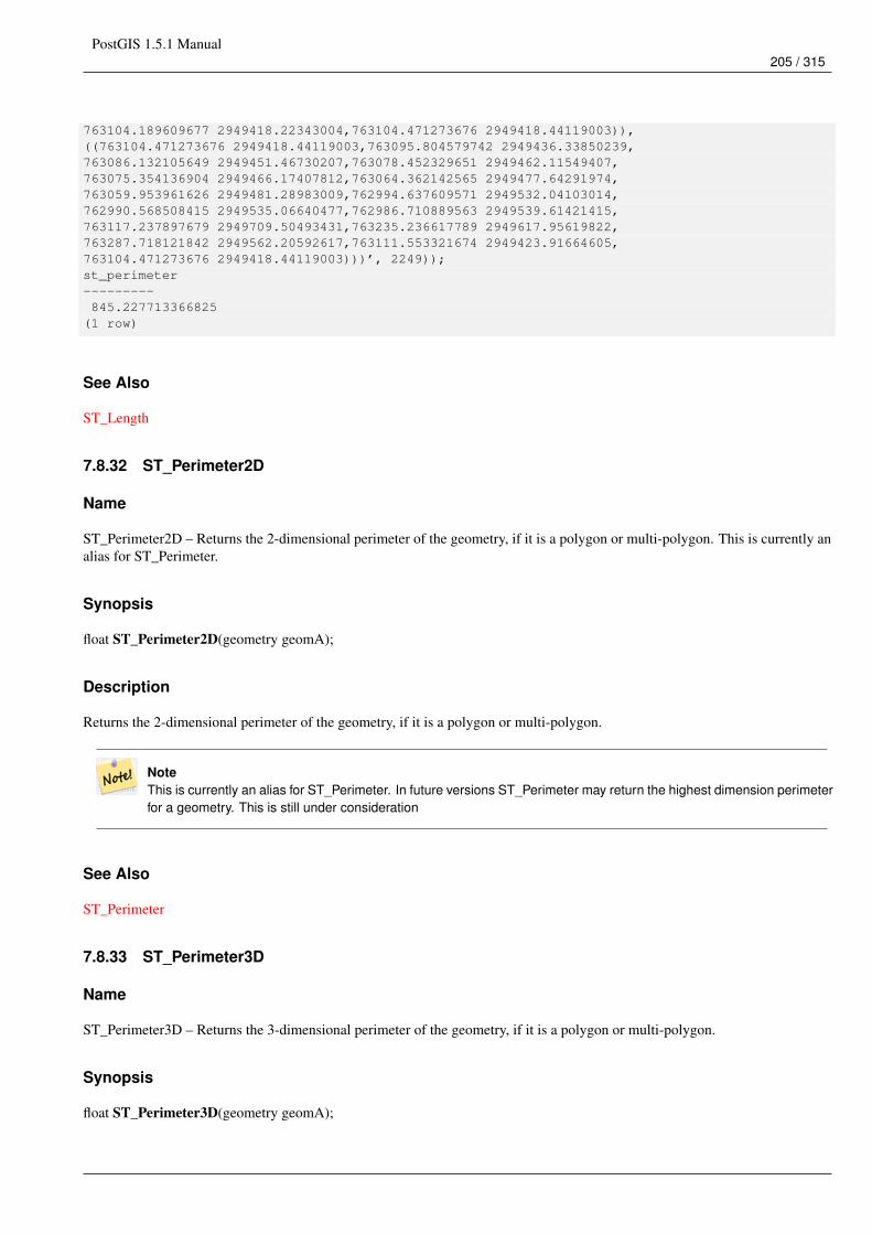
PostGIS 1.5.1 Manual205 / 315
763104.189609677 2949418.22343004,763104.471273676 2949418.44119003)),((763104.471273676 2949418.44119003,763095.804579742 2949436.33850239,763086.132105649 2949451.46730207,763078.452329651 2949462.11549407,763075.354136904 2949466.17407812,763064.362142565 2949477.64291974,763059.953961626 2949481.28983009,762994.637609571 2949532.04103014,762990.568508415 2949535.06640477,762986.710889563 2949539.61421415,763117.237897679 2949709.50493431,763235.236617789 2949617.95619822,763287.718121842 2949562.20592617,763111.553321674 2949423.91664605,763104.471273676 2949418.44119003)))’, 2249));st_perimeter---------845.227713366825
(1 row)
See Also
ST_Length
7.8.32 ST_Perimeter2D
Name
ST_Perimeter2D – Returns the 2-dimensional perimeter of the geometry, if it is a polygon or multi-polygon. This is currently analias for ST_Perimeter.
Synopsis
float ST_Perimeter2D(geometry geomA);
Description
Returns the 2-dimensional perimeter of the geometry, if it is a polygon or multi-polygon.
NoteThis is currently an alias for ST_Perimeter. In future versions ST_Perimeter may return the highest dimension perimeterfor a geometry. This is still under consideration
See Also
ST_Perimeter
7.8.33 ST_Perimeter3D
Name
ST_Perimeter3D – Returns the 3-dimensional perimeter of the geometry, if it is a polygon or multi-polygon.
Synopsis
float ST_Perimeter3D(geometry geomA);
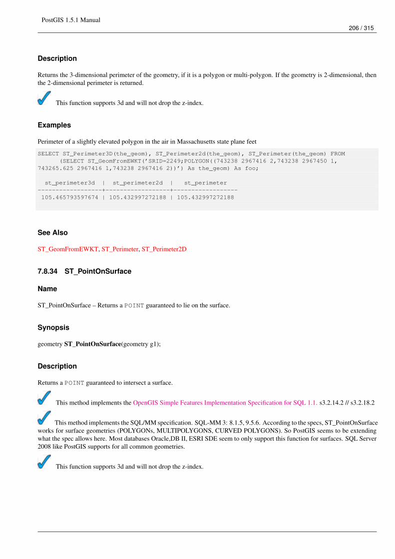
PostGIS 1.5.1 Manual206 / 315
Description
Returns the 3-dimensional perimeter of the geometry, if it is a polygon or multi-polygon. If the geometry is 2-dimensional, thenthe 2-dimensional perimeter is returned.
This function supports 3d and will not drop the z-index.
Examples
Perimeter of a slightly elevated polygon in the air in Massachusetts state plane feet
SELECT ST_Perimeter3D(the_geom), ST_Perimeter2d(the_geom), ST_Perimeter(the_geom) FROM(SELECT ST_GeomFromEWKT(’SRID=2249;POLYGON((743238 2967416 2,743238 2967450 1,
743265.625 2967416 1,743238 2967416 2))’) As the_geom) As foo;
st_perimeter3d | st_perimeter2d | st_perimeter------------------+------------------+------------------105.465793597674 | 105.432997272188 | 105.432997272188
See Also
ST_GeomFromEWKT, ST_Perimeter, ST_Perimeter2D
7.8.34 ST_PointOnSurface
Name
ST_PointOnSurface – Returns a POINT guaranteed to lie on the surface.
Synopsis
geometry ST_PointOnSurface(geometry g1);
Description
Returns a POINT guaranteed to intersect a surface.
This method implements the OpenGIS Simple Features Implementation Specification for SQL 1.1. s3.2.14.2 // s3.2.18.2
This method implements the SQL/MM specification. SQL-MM 3: 8.1.5, 9.5.6. According to the specs, ST_PointOnSurfaceworks for surface geometries (POLYGONs, MULTIPOLYGONS, CURVED POLYGONS). So PostGIS seems to be extendingwhat the spec allows here. Most databases Oracle,DB II, ESRI SDE seem to only support this function for surfaces. SQL Server2008 like PostGIS supports for all common geometries.
This function supports 3d and will not drop the z-index.
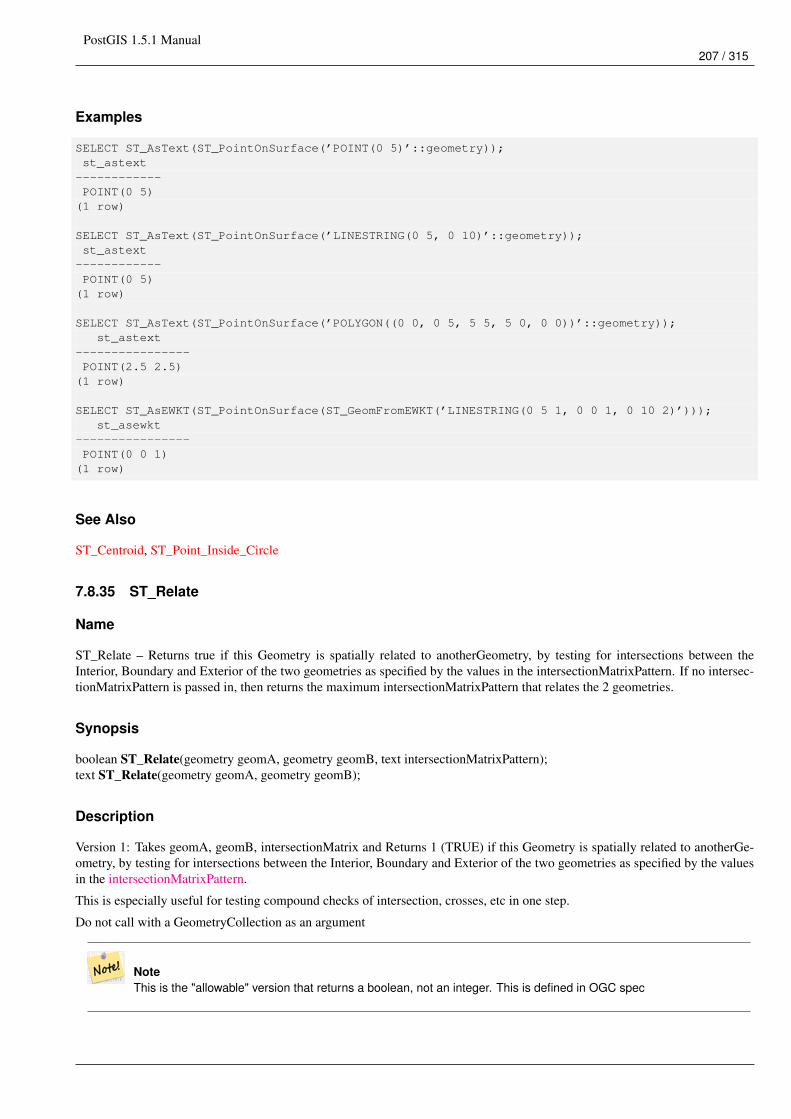
PostGIS 1.5.1 Manual207 / 315
Examples
SELECT ST_AsText(ST_PointOnSurface(’POINT(0 5)’::geometry));st_astext
------------POINT(0 5)
(1 row)
SELECT ST_AsText(ST_PointOnSurface(’LINESTRING(0 5, 0 10)’::geometry));st_astext
------------POINT(0 5)
(1 row)
SELECT ST_AsText(ST_PointOnSurface(’POLYGON((0 0, 0 5, 5 5, 5 0, 0 0))’::geometry));st_astext
----------------POINT(2.5 2.5)
(1 row)
SELECT ST_AsEWKT(ST_PointOnSurface(ST_GeomFromEWKT(’LINESTRING(0 5 1, 0 0 1, 0 10 2)’)));st_asewkt
----------------POINT(0 0 1)
(1 row)
See Also
ST_Centroid, ST_Point_Inside_Circle
7.8.35 ST_Relate
Name
ST_Relate – Returns true if this Geometry is spatially related to anotherGeometry, by testing for intersections between theInterior, Boundary and Exterior of the two geometries as specified by the values in the intersectionMatrixPattern. If no intersec-tionMatrixPattern is passed in, then returns the maximum intersectionMatrixPattern that relates the 2 geometries.
Synopsis
boolean ST_Relate(geometry geomA, geometry geomB, text intersectionMatrixPattern);text ST_Relate(geometry geomA, geometry geomB);
Description
Version 1: Takes geomA, geomB, intersectionMatrix and Returns 1 (TRUE) if this Geometry is spatially related to anotherGe-ometry, by testing for intersections between the Interior, Boundary and Exterior of the two geometries as specified by the valuesin the intersectionMatrixPattern.
This is especially useful for testing compound checks of intersection, crosses, etc in one step.
Do not call with a GeometryCollection as an argument
NoteThis is the "allowable" version that returns a boolean, not an integer. This is defined in OGC spec
PostGIS 1.5.1 Manual208 / 315
NoteThis DOES NOT automagically include an index call. The reason for that is some relationships are anti e.g. Disjoint. Ifyou are using a relationship pattern that requires intersection, then include the && index call.
Version 2: Takes geomA and geomB and returns the DE-9IM (dimensionally extended nine-intersection matrix)
NoteDo not call with a GeometryCollection as an argument
not in OGC spec, but implied. see s2.1.13.2
Both Performed by the GEOS module
This method implements the OpenGIS Simple Features Implementation Specification for SQL 1.1. s2.1.1.2 // s2.1.13.3
This method implements the SQL/MM specification. SQL-MM 3: 5.1.25
Examples
--Find all compounds that intersect and not touch a poly (interior intersects)SELECT l.* , b.name As poly_nameFROM polys As bINNER JOIN compounds As lON (p.the_geom && b.the_geomAND ST_Relate(l.the_geom, b.the_geom,’T********’));
SELECT ST_Relate(ST_GeometryFromText(’POINT(1 2)’), ST_Buffer(ST_GeometryFromText(’POINT(1 ←↩2)’),2));
st_relate-----------0FFFFF212
SELECT ST_Relate(ST_GeometryFromText(’LINESTRING(1 2, 3 4)’), ST_GeometryFromText(’ ←↩LINESTRING(5 6, 7 8)’));
st_relate-----------FF1FF0102
SELECT ST_Relate(ST_GeometryFromText(’POINT(1 2)’), ST_Buffer(ST_GeometryFromText(’POINT(1 ←↩2)’),2), ’0FFFFF212’);
st_relate-----------t
SELECT ST_Relate(ST_GeometryFromText(’POINT(1 2)’), ST_Buffer(ST_GeometryFromText(’POINT(1 ←↩2)’),2), ’*FF*FF212’);
st_relate-----------t
PostGIS 1.5.1 Manual209 / 315
See Also
ST_Crosses, ST_Disjoint, ST_Intersects, ST_Touches
7.8.36 ST_ShortestLine
Name
ST_ShortestLine – Returns the 2-dimensional shortest line between two geometries
Synopsis
geometry ST_ShortestLine(geometry g1, geometry g2);
Description
Returns the 2-dimensional shortest line between two geometries. The function will only return the first shortest line if more thanone, that the function finds. If g1 and g2 intersects in just one point the function will return a line with both start and end in thatintersection-point. If g1 and g2 are intersecting with more than one point the function will return a line with start and end in thesame point but it can be any of the intersecting points. The line returned will always start in g1 and end in g2. The length of theline this function returns will always be the same as st_distance returns for g1 and g2.
Availability: 1.5.0
Examples
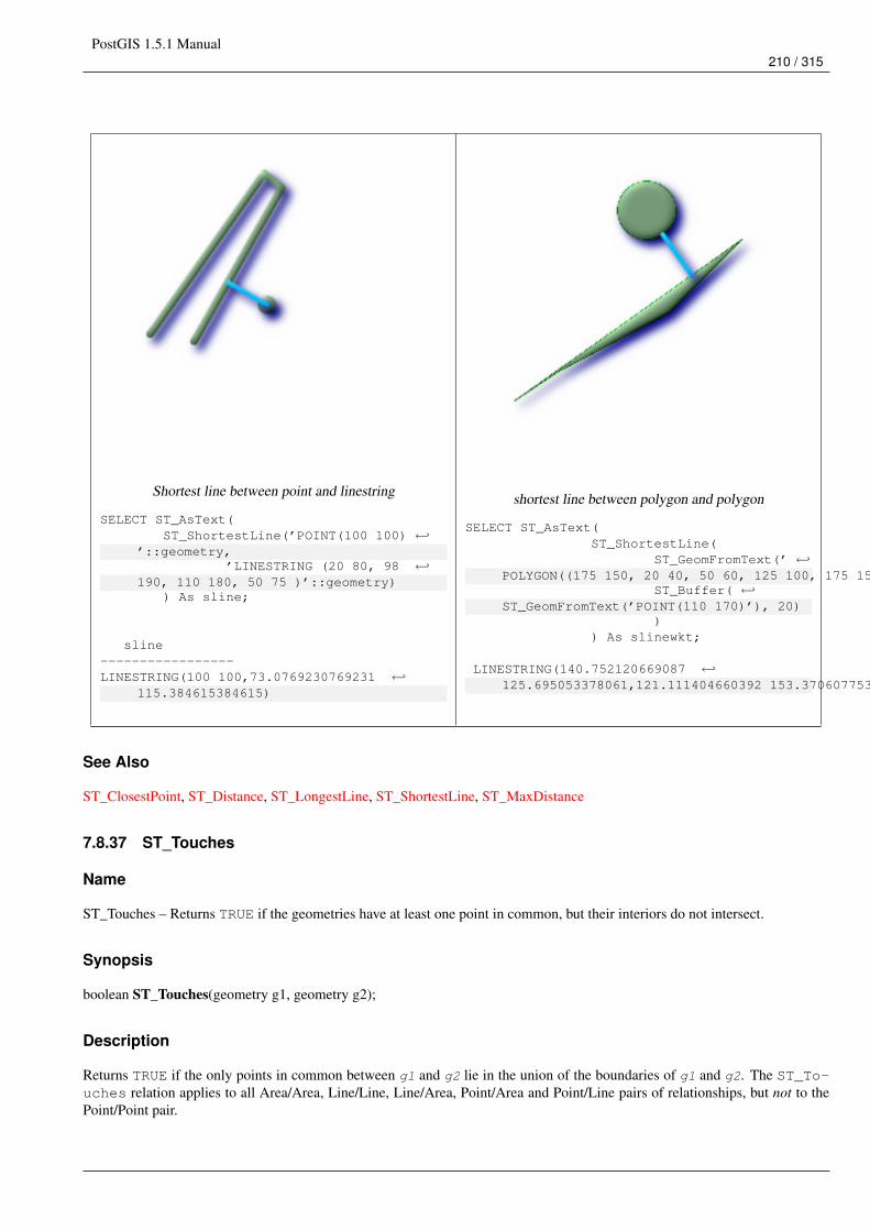
PostGIS 1.5.1 Manual210 / 315
Shortest line between point and linestring
SELECT ST_AsText(ST_ShortestLine(’POINT(100 100) ←↩
’::geometry,’LINESTRING (20 80, 98 ←↩
190, 110 180, 50 75 )’::geometry)) As sline;
sline-----------------LINESTRING(100 100,73.0769230769231 ←↩
115.384615384615)
shortest line between polygon and polygon
SELECT ST_AsText(ST_ShortestLine(
ST_GeomFromText(’ ←↩POLYGON((175 150, 20 40, 50 60, 125 100, 175 150))’),
ST_Buffer( ←↩ST_GeomFromText(’POINT(110 170)’), 20)
)) As slinewkt;
LINESTRING(140.752120669087 ←↩125.695053378061,121.111404660392 153.370607753949)
See Also
ST_ClosestPoint, ST_Distance, ST_LongestLine, ST_ShortestLine, ST_MaxDistance
7.8.37 ST_Touches
Name
ST_Touches – Returns TRUE if the geometries have at least one point in common, but their interiors do not intersect.
Synopsis
boolean ST_Touches(geometry g1, geometry g2);
Description
Returns TRUE if the only points in common between g1 and g2 lie in the union of the boundaries of g1 and g2. The ST_To-uches relation applies to all Area/Area, Line/Line, Line/Area, Point/Area and Point/Line pairs of relationships, but not to thePoint/Point pair.
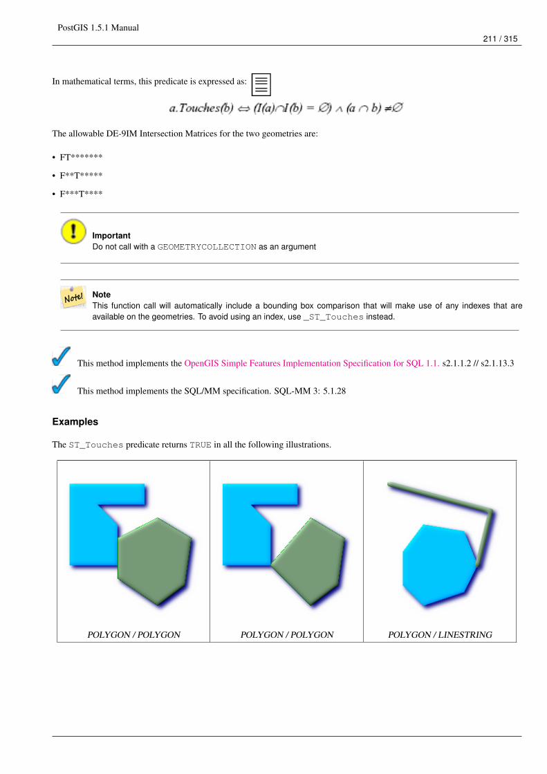
PostGIS 1.5.1 Manual211 / 315
In mathematical terms, this predicate is expressed as:
The allowable DE-9IM Intersection Matrices for the two geometries are:
• FT*******
• F**T*****
• F***T****
ImportantDo not call with a GEOMETRYCOLLECTION as an argument
NoteThis function call will automatically include a bounding box comparison that will make use of any indexes that areavailable on the geometries. To avoid using an index, use _ST_Touches instead.
This method implements the OpenGIS Simple Features Implementation Specification for SQL 1.1. s2.1.1.2 // s2.1.13.3
This method implements the SQL/MM specification. SQL-MM 3: 5.1.28
Examples
The ST_Touches predicate returns TRUE in all the following illustrations.
POLYGON / POLYGON POLYGON / POLYGON POLYGON / LINESTRING
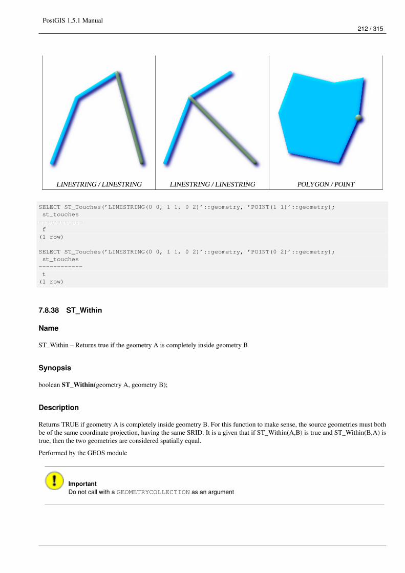
PostGIS 1.5.1 Manual212 / 315
LINESTRING / LINESTRING LINESTRING / LINESTRING POLYGON / POINT
SELECT ST_Touches(’LINESTRING(0 0, 1 1, 0 2)’::geometry, ’POINT(1 1)’::geometry);st_touches
------------f
(1 row)
SELECT ST_Touches(’LINESTRING(0 0, 1 1, 0 2)’::geometry, ’POINT(0 2)’::geometry);st_touches
------------t
(1 row)
7.8.38 ST_Within
Name
ST_Within – Returns true if the geometry A is completely inside geometry B
Synopsis
boolean ST_Within(geometry A, geometry B);
Description
Returns TRUE if geometry A is completely inside geometry B. For this function to make sense, the source geometries must bothbe of the same coordinate projection, having the same SRID. It is a given that if ST_Within(A,B) is true and ST_Within(B,A) istrue, then the two geometries are considered spatially equal.
Performed by the GEOS module
ImportantDo not call with a GEOMETRYCOLLECTION as an argument
PostGIS 1.5.1 Manual213 / 315
ImportantDo not use this function with invalid geometries. You will get unexpected results.
This function call will automatically include a bounding box comparison that will make use of any indexes that are available onthe geometries. To avoid index use, use the function _ST_Within.
NOTE: this is the "allowable" version that returns a boolean, not an integer.
This method implements the OpenGIS Simple Features Implementation Specification for SQL 1.1. s2.1.1.2 // s2.1.13.3 -a.Relate(b, ’T*F**F***’)
This method implements the SQL/MM specification. SQL-MM 3: 5.1.30
Examples
--a circle within a circleSELECT ST_Within(smallc,smallc) As smallinsmall,ST_Within(smallc, bigc) As smallinbig,ST_Within(bigc,smallc) As biginsmall,ST_Within(ST_Union(smallc, bigc), bigc) as unioninbig,ST_Within(bigc, ST_Union(smallc, bigc)) as biginunion,ST_Equals(bigc, ST_Union(smallc, bigc)) as bigisunion
FROM(SELECT ST_Buffer(ST_GeomFromText(’POINT(50 50)’), 20) As smallc,ST_Buffer(ST_GeomFromText(’POINT(50 50)’), 40) As bigc) As foo;
--Resultsmallinsmall | smallinbig | biginsmall | unioninbig | biginunion | bigisunion
--------------+------------+------------+------------+------------+------------t | t | f | t | t | t
(1 row)
See Also
ST_Contains, ST_Equals,ST_IsValid
PostGIS 1.5.1 Manual214 / 315
7.9 Geometry Processing Functions
7.9.1 ST_Buffer
Name
ST_Buffer – (T) For geometry: Returns a geometry that represents all points whose distance from this Geometry is less thanor equal to distance. Calculations are in the Spatial Reference System of this Geometry. For geography: Uses a planartransform wrapper. Introduced in 1.5 support for different end cap and mitre settings to control shape. buffer_style options:quad_segs=#,endcap=round|flat|square,join=round|mitre|bevel,mitre_limit=#.#
Synopsis
geometry ST_Buffer(geometry g1, float radius_of_buffer);geometry ST_Buffer(geometry g1, float radius_of_buffer, integer num_seg_quarter_circle);geometry ST_Buffer(geometry g1, float radius_of_buffer, text buffer_style_parameters);geography ST_Buffer(geography g1, float radius_of_buffer_in_meters);
Description
Returns a geometry/geography that represents all points whose distance from this Geometry/geography is less than or equal todistance.
Geometry: Calculations are in the Spatial Reference System of the geometry. Introduced in 1.5 support for different end cap andmitre settings to control shape.
NoteGeography: For geography this is really a thin wrapper around the geometry implementation. It first determines thebest SRID that fits the bounding box of the geography object (favoring UTM, Lambert Azimuthal Equal Area (LAEA)north/south pole, and falling back on mercator in worst case scenario) and then buffers in that planar spatial ref andretransforms back to WGS84 geography.
For geography this may not behave as expected if object is sufficiently large that it falls between two UTM zones orcrosses the dateline
Availability: 1.5 - ST_Buffer was enhanced to support different endcaps and join types. These are useful for example to convertroad linestrings into polygon roads with flat or square edges instead of rounded edges. Thin wrapper for geography was added. -requires GEOS >= 3.2 to take advantage of advanced geometry functionality.
The optional third parameter (currently only applies to geometry) can either specify number of segments used to approximate aquarter circle (integer case, defaults to 8) or a list of blank-separated key=value pairs (string case) to tweak operations as follows:
• ’quad_segs=#’ : number of segments used to approximate a quarter circle (defaults to 8).
• ’endcap=round|flat|square’ : endcap style (defaults to "round", needs GEOS-3.2 or higher for a different value). ’butt’ is alsoaccepted as a synonym for ’flat’.
• ’join=round|mitre|bevel’ : join style (defaults to "round", needs GEOS-3.2 or higher for a different value). ’miter’ is alsoaccepted as a synonym for ’mitre’.
• ’mitre_limit=#.#’ : mitre ratio limit (only affects mitred join style). ’miter_limit’ is also accepted as a synonym for ’mitre_limit’.
Units of radius are measured in units of the spatial reference system.
The inputs can be POINTS, MULTIPOINTS, LINESTRINGS, MULTILINESTRINGS, POLYGONS, MULTIPOLYGONS, andGeometryCollections.
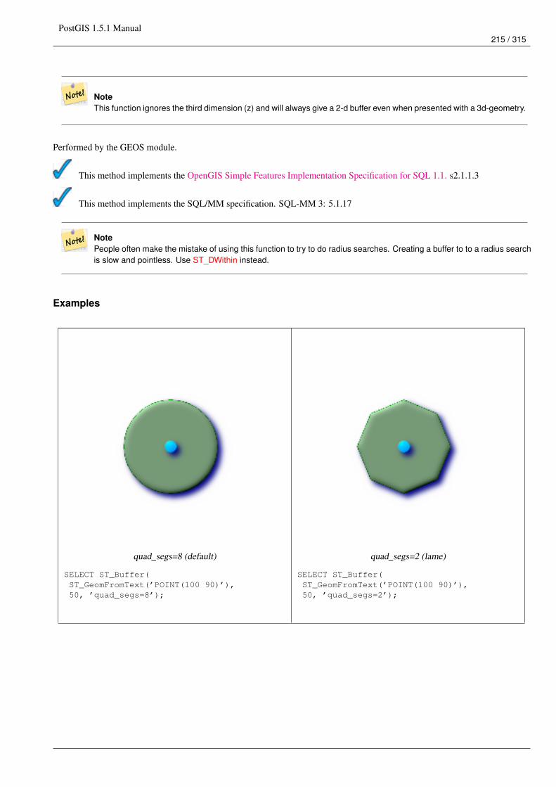
PostGIS 1.5.1 Manual215 / 315
NoteThis function ignores the third dimension (z) and will always give a 2-d buffer even when presented with a 3d-geometry.
Performed by the GEOS module.
This method implements the OpenGIS Simple Features Implementation Specification for SQL 1.1. s2.1.1.3
This method implements the SQL/MM specification. SQL-MM 3: 5.1.17
NotePeople often make the mistake of using this function to try to do radius searches. Creating a buffer to to a radius searchis slow and pointless. Use ST_DWithin instead.
Examples
quad_segs=8 (default)
SELECT ST_Buffer(ST_GeomFromText(’POINT(100 90)’),50, ’quad_segs=8’);
quad_segs=2 (lame)
SELECT ST_Buffer(ST_GeomFromText(’POINT(100 90)’),50, ’quad_segs=2’);
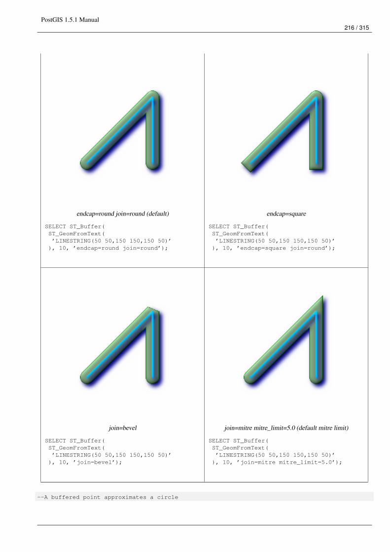
PostGIS 1.5.1 Manual216 / 315
endcap=round join=round (default)
SELECT ST_Buffer(ST_GeomFromText(’LINESTRING(50 50,150 150,150 50)’
), 10, ’endcap=round join=round’);
endcap=square
SELECT ST_Buffer(ST_GeomFromText(’LINESTRING(50 50,150 150,150 50)’
), 10, ’endcap=square join=round’);
join=bevel
SELECT ST_Buffer(ST_GeomFromText(’LINESTRING(50 50,150 150,150 50)’
), 10, ’join=bevel’);
join=mitre mitre_limit=5.0 (default mitre limit)
SELECT ST_Buffer(ST_GeomFromText(’LINESTRING(50 50,150 150,150 50)’
), 10, ’join=mitre mitre_limit=5.0’);
--A buffered point approximates a circle
PostGIS 1.5.1 Manual217 / 315
-- A buffered point forcing approximation of (see diagram)-- 2 points per circle is poly with 8 sides (see diagram)SELECT ST_NPoints(ST_Buffer(ST_GeomFromText(’POINT(100 90)’), 50)) As ←↩
promisingcircle_pcount,ST_NPoints(ST_Buffer(ST_GeomFromText(’POINT(100 90)’), 50, 2)) As lamecircle_pcount;
promisingcircle_pcount | lamecircle_pcount------------------------+-------------------
33 | 9
--A lighter but lamer circle-- only 2 points per quarter circle is an octagon--Below is a 100 meter octagon-- Note coordinates are in NAD 83 long lat which we transformto Mass state plane meter and then buffer to get measurements in meters;SELECT ST_AsText(ST_Buffer(ST_Transform(ST_SetSRID(ST_MakePoint(-71.063526, 42.35785),4269), 26986),100,2)) As octagon;----------------------POLYGON((236057.59057465 900908.759918696,236028.301252769 900838.049240578,235957.59057465 900808.759918696,235886.879896532 900838.049240578,235857.59057465900908.759918696,235886.879896532 900979.470596815,235957.59057465 901008.759918696,236028.301252769 900979.470596815,236057.59057465 900908.759918696))
--Buffer is often also used as a poor man’s polygon fixer or a sometimes speedier unioner--Sometimes able to fix invalid polygons - using below-- using below on anything but a polygon will result in empty geometry-- and for geometry collections kill anything in the collection that is not a polygon--Poor man’s bad poly fixerSELECT ST_IsValid(foo.invalidpoly) as isvalid, ST_IsValid(ST_Buffer(foo.invalidpoly,0.0)) ←↩
as bufferisvalid,ST_AsText(ST_Buffer(foo.invalidpoly,0.0)) As newpolytextrepFROM (SELECT ST_GeomFromText(’POLYGON((-1 2, 3 4, 5 6, -1 2, 5 6, -1 2))’) as invalidpoly) ←↩
As fooNOTICE: Self-intersection at or near point -1 2isvalid | bufferisvalid | newpolytextrep---------+---------------+------------------------------f | t | POLYGON((-1 2,5 6,3 4,-1 2))
--Poor man’s polygon unionerSELECT ST_AsText(the_geom) as textorig, ST_AsText(ST_Buffer(foo.the_geom,0.0)) As ←↩
textbufferFROM (SELECT ST_Collect(’POLYGON((-1 2, 3 4, 5 6, -1 2))’, ’POLYGON((-1 2, 2 3, 5 6, -1 2)) ←↩
’) As the_geom) as foo;textorig | textbuffer
-----------------------------------------------------------+--------------------MULTIPOLYGON(((-1 2,3 4,5 6,-1 2)),((-1 2,2 3,5 6,-1 2))) | POLYGON((-1 2,5 6,3 4,2 3,-1 2) ←↩
)
See Also
ST_Collect, ST_DWithin, ST_SetSRID, ST_Transform, ST_Union
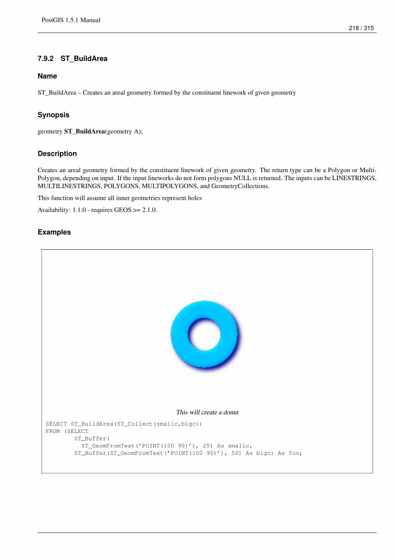
PostGIS 1.5.1 Manual218 / 315
7.9.2 ST_BuildArea
Name
ST_BuildArea – Creates an areal geometry formed by the constituent linework of given geometry
Synopsis
geometry ST_BuildArea(geometry A);
Description
Creates an areal geometry formed by the constituent linework of given geometry. The return type can be a Polygon or Multi-Polygon, depending on input. If the input lineworks do not form polygons NULL is returned. The inputs can be LINESTRINGS,MULTILINESTRINGS, POLYGONS, MULTIPOLYGONS, and GeometryCollections.
This function will assume all inner geometries represent holes
Availability: 1.1.0 - requires GEOS >= 2.1.0.
Examples
This will create a donut
SELECT ST_BuildArea(ST_Collect(smallc,bigc))FROM (SELECT
ST_Buffer(ST_GeomFromText(’POINT(100 90)’), 25) As smallc,
ST_Buffer(ST_GeomFromText(’POINT(100 90)’), 50) As bigc) As foo;
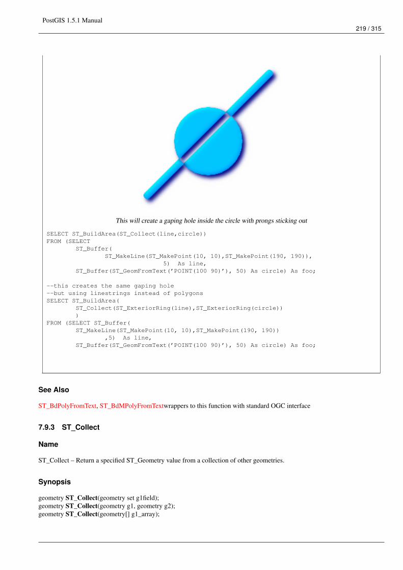
PostGIS 1.5.1 Manual219 / 315
This will create a gaping hole inside the circle with prongs sticking out
SELECT ST_BuildArea(ST_Collect(line,circle))FROM (SELECT
ST_Buffer(ST_MakeLine(ST_MakePoint(10, 10),ST_MakePoint(190, 190)),
5) As line,ST_Buffer(ST_GeomFromText(’POINT(100 90)’), 50) As circle) As foo;
--this creates the same gaping hole--but using linestrings instead of polygonsSELECT ST_BuildArea(
ST_Collect(ST_ExteriorRing(line),ST_ExteriorRing(circle)))
FROM (SELECT ST_Buffer(ST_MakeLine(ST_MakePoint(10, 10),ST_MakePoint(190, 190))
,5) As line,ST_Buffer(ST_GeomFromText(’POINT(100 90)’), 50) As circle) As foo;
See Also
ST_BdPolyFromText, ST_BdMPolyFromTextwrappers to this function with standard OGC interface
7.9.3 ST_Collect
Name
ST_Collect – Return a specified ST_Geometry value from a collection of other geometries.
Synopsis
geometry ST_Collect(geometry set g1field);geometry ST_Collect(geometry g1, geometry g2);geometry ST_Collect(geometry[] g1_array);
PostGIS 1.5.1 Manual220 / 315
Description
Output type can be a MULTI* or a GEOMETRYCOLLECTION. Comes in 2 variants. Variant 1 collects 2 geometries. Variant2 is an aggregate function that takes a set of geometries and collects them into a single ST_Geometry.
Aggregate version: This function returns a GEOMETRYCOLLECTION or a MULTI object from a set of geometries. TheST_Collect() function is an "aggregate" function in the terminology of PostgreSQL. That means that it operates on rows ofdata, in the same way the SUM() and AVG() functions do. For example, "SELECT ST_Collect(GEOM) FROM GEOMTABLEGROUP BY ATTRCOLUMN" will return a separate GEOMETRYCOLLECTION for each distinct value of ATTRCOLUMN.
Non-Aggregate version: This function returns a geometry being a collection of two input geometries. Output type can be aMULTI* or a GEOMETRYCOLLECTION.
NoteST_Collect and ST_Union are often interchangeable. ST_Collect is in general orders of magnitude faster thanST_Union because it does not try to dissolve boundaries or validate that a constructed MultiPolgon doesn’t have over-lapping regions. It merely rolls up single geometries into MULTI and MULTI or mixed geometry types into GeometryCollections. Unfortunately geometry collections are not well-supported by GIS tools. To prevent ST_Collect from re-turning a Geometry Collection when collecting MULTI geometries, one can use the below trick that utilizes ST_Dumpto expand the MULTIs out to singles and then regroup them.
Availability: 1.4.0 - ST_Collect(geomarray) was introduced. ST_Collect was enhanced to handle more geometries faster.
This function supports 3d and will not drop the z-index.
This method supports Circular Strings and Curves This method supports Circular Strings and Curves, but will never returna MULTICURVE or MULTI as one would expect and PostGIS does not currently support those.
Examples
Aggregate example
Thread ref: http://postgis.refractions.net/pipermail/postgis-users/2008-June/020331.htmlSELECT stusps,
ST_Multi(ST_Collect(f.the_geom)) as singlegeomFROM (SELECT stusps, (ST_Dump(the_geom)).geom As the_geom
FROMsomestatetable ) As f
GROUP BY stusps
Non-Aggregate example
Thread ref: http://postgis.refractions.net/pipermail/postgis-users/2008-June/020331.htmlSELECT ST_AsText(ST_Collect(ST_GeomFromText(’POINT(1 2)’),ST_GeomFromText(’POINT(-2 3)’) ));
st_astext----------MULTIPOINT(1 2,-2 3)
--Collect 2 d pointsSELECT ST_AsText(ST_Collect(ST_GeomFromText(’POINT(1 2)’),
ST_GeomFromText(’POINT(1 2)’) ) );
st_astext----------MULTIPOINT(1 2,1 2)
PostGIS 1.5.1 Manual221 / 315
--Collect 3d pointsSELECT ST_AsEWKT(ST_Collect(ST_GeomFromEWKT(’POINT(1 2 3)’),
ST_GeomFromEWKT(’POINT(1 2 4)’) ) );
st_asewkt-------------------------MULTIPOINT(1 2 3,1 2 4)
--Example with curvesSELECT ST_AsText(ST_Collect(ST_GeomFromText(’CIRCULARSTRING(220268 150415,220227 ←↩
150505,220227 150406)’),ST_GeomFromText(’CIRCULARSTRING(220227 150406,2220227 150407,220227 150406)’)));
st_astext------------------------------------------------------------------------------------GEOMETRYCOLLECTION(CIRCULARSTRING(220268 150415,220227 150505,220227 150406),CIRCULARSTRING(220227 150406,2220227 150407,220227 150406))
--New ST_Collect array constructSELECT ST_Collect(ARRAY(SELECT the_geom FROM sometable));
SELECT ST_AsText(ST_Collect(ARRAY[ST_GeomFromText(’LINESTRING(1 2, 3 4)’),ST_GeomFromText(’LINESTRING(3 4, 4 5)’)])) As wktcollect;
--wkt collect --MULTILINESTRING((1 2,3 4),(3 4,4 5))
See Also
ST_Dump, ST_Union
7.9.4 ST_ConvexHull
Name
ST_ConvexHull – The convex hull of a geometry represents the minimum convex geometry that encloses all geometries withinthe set.
Synopsis
geometry ST_ConvexHull(geometry geomA);
Description
The convex hull of a geometry represents the minimum convex geometry that encloses all geometries within the set.
One can think of the convex hull as the geometry you get by wrapping an elastic band around a set of geometries. This is differentfrom a concave hull (not currently supported) which is analogous to shrink-wrapping your geometries.
It is usually used with MULTI and Geometry Collections. Although it is not an aggregate - you can use it in conjunction withST_Collect to get the convex hull of a set of points. ST_ConvexHull(ST_Collect(somepointfield)).
It is often used to determine an affected area based on a set of point observations.
Performed by the GEOS module
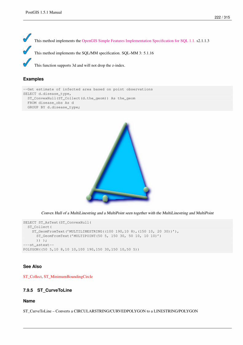
PostGIS 1.5.1 Manual222 / 315
This method implements the OpenGIS Simple Features Implementation Specification for SQL 1.1. s2.1.1.3
This method implements the SQL/MM specification. SQL-MM 3: 5.1.16
This function supports 3d and will not drop the z-index.
Examples
--Get estimate of infected area based on point observationsSELECT d.disease_type,ST_ConvexHull(ST_Collect(d.the_geom)) As the_geomFROM disease_obs As dGROUP BY d.disease_type;
Convex Hull of a MultiLinestring and a MultiPoint seen together with the MultiLinestring and MultiPoint
SELECT ST_AsText(ST_ConvexHull(ST_Collect(ST_GeomFromText(’MULTILINESTRING((100 190,10 8),(150 10, 20 30))’),ST_GeomFromText(’MULTIPOINT(50 5, 150 30, 50 10, 10 10)’))) );
---st_astext--POLYGON((50 5,10 8,10 10,100 190,150 30,150 10,50 5))
See Also
ST_Collect, ST_MinimumBoundingCircle
7.9.5 ST_CurveToLine
Name
ST_CurveToLine – Converts a CIRCULARSTRING/CURVEDPOLYGON to a LINESTRING/POLYGON
PostGIS 1.5.1 Manual223 / 315
Synopsis
geometry ST_CurveToLine(geometry curveGeom);geometry ST_CurveToLine(geometry curveGeom, integer segments_per_qtr_circle);
Description
Converst a CIRCULAR STRING to regular LINESTRING or CURVEPOLYGON to POLYGON. Useful for outputting to de-vices that can’t support CIRCULARSTRING geometry types
Converts a given geometry to a linear geometry. Each curved geometry or segment is converted into a linear approximation usingthe default value of 32 segments per quarter circle
Availability: 1.2.2?
This method implements the OpenGIS Simple Features Implementation Specification for SQL 1.1.
This method implements the SQL/MM specification. SQL-MM 3: 7.1.7
This function supports 3d and will not drop the z-index.
This method supports Circular Strings and Curves
Examples
SELECT ST_AsText(ST_CurveToLine(ST_GeomFromText(’CIRCULARSTRING(220268 150415,220227 ←↩150505,220227 150406)’)));
--Result --LINESTRING(220268 150415,220269.95064912 150416.539364228,220271.823415575 ←↩
150418.17258804,220273.613787707 150419.895736857,220275.317452352 150421.704659462,220276.930305234 150423.594998003,220278.448460847 ←↩
150425.562198489,220279.868261823 150427.60152176,220281.186287736 150429.708054909,220282.399363347 ←↩
150431.876723113,220283.50456625 150434.10230186,220284.499233914 150436.379429536,220285.380970099 ←↩
150438.702620341,220286.147650624 150441.066277505,220286.797428488 150443.464706771,220287.328738321 150445.892130112,220287.740300149 ←↩
150448.342699654,220288.031122486 150450.810511759,220288.200504713 150453.289621251,220288.248038775 ←↩
150455.77405574,220288.173610157 150458.257830005,220287.977398166 150460.734960415,220287.659875492 ←↩
150463.199479347,220287.221807076 150465.64544956,220286.664248262 150468.066978495,220285.988542259 ←↩
150470.458232479,220285.196316903 150472.81345077,220284.289480732 150475.126959442,220283.270218395 150477.39318505,220282.140985384 ←↩
150479.606668057,220280.90450212 150481.762075989,220279.5637474 150483.85421628,220278.12195122 ←↩
150485.87804878,220276.582586992 150487.828697901,220274.949363179 150489.701464356,220273.226214362 ←↩
150491.491836488,220271.417291757 150493.195501133,220269.526953216 150494.808354014,220267.559752731 ←↩
150496.326509628,220265.520429459 150497.746310603,220263.41389631 150499.064336517,220261.245228106 ←↩
150500.277412127,220259.019649359 150501.38261503,220256.742521683 150502.377282695,220254.419330878 ←↩
150503.259018879,
PostGIS 1.5.1 Manual224 / 315
220252.055673714 150504.025699404,220249.657244448 150504.675477269,220247.229821107 ←↩150505.206787101,
220244.779251566 150505.61834893,220242.311439461 150505.909171266,220239.832329968 ←↩150506.078553494,
220237.347895479 150506.126087555,220234.864121215 150506.051658938,220232.386990804 ←↩150505.855446946,
220229.922471872 150505.537924272,220227.47650166 150505.099855856,220225.054972724 ←↩150504.542297043,
220222.663718741 150503.86659104,220220.308500449 150503.074365683,220217.994991777 150502.167529512,220215.72876617 150501.148267175,220213.515283163 150500.019034164,220211.35987523 150498.7825509,220209.267734939 150497.441796181,220207.243902439 150496,220205.293253319 150494.460635772,220203.420486864 150492.82741196,220201.630114732 ←↩
150491.104263143,220199.926450087 150489.295340538,220198.313597205 150487.405001997,220196.795441592 ←↩
150485.437801511,220195.375640616 150483.39847824,220194.057614703 150481.291945091,220192.844539092 ←↩
150479.123276887,220191.739336189 150476.89769814,220190.744668525 150474.620570464,220189.86293234 150472.297379659,220189.096251815 ←↩
150469.933722495,220188.446473951 150467.535293229,220187.915164118 150465.107869888,220187.50360229 ←↩
150462.657300346,220187.212779953 150460.189488241,220187.043397726 150457.710378749,220186.995863664 ←↩
150455.22594426,220187.070292282 150452.742169995,220187.266504273 150450.265039585,220187.584026947 ←↩
150447.800520653,220188.022095363 150445.35455044,220188.579654177 150442.933021505,220189.25536018 ←↩
150440.541767521,220190.047585536 150438.18654923,220190.954421707 150435.873040558,220191.973684044 ←↩
150433.60681495,220193.102917055 150431.393331943,220194.339400319 150429.237924011,220195.680155039 ←↩
150427.14578372,220197.12195122 150425.12195122,220198.661315447 150423.171302099,220200.29453926 150421.298535644,220202.017688077 ←↩
150419.508163512,220203.826610682 150417.804498867,220205.716949223 150416.191645986,220207.684149708 150414.673490372,220209.72347298 ←↩
150413.253689397,220211.830006129 150411.935663483,220213.998674333 150410.722587873,220216.22425308 150409.61738497,220218.501380756 ←↩
150408.622717305,220220.824571561 150407.740981121,220223.188228725 150406.974300596,220225.586657991 150406.324522731,220227 150406)
--3d exampleSELECT ST_AsEWKT(ST_CurveToLine(ST_GeomFromEWKT(’CIRCULARSTRING(220268 150415 1,220227 ←↩
150505 2,220227 150406 3)’)));Output------LINESTRING(220268 150415 1,220269.95064912 150416.539364228 1.0181172856673,220271.823415575 150418.17258804 1.03623457133459,220273.613787707 150419.895736857 ←↩
1.05435185700189,....AD INFINITUM ....220225.586657991 150406.324522731 1.32611114201132,220227 150406 3)
--use only 2 segments to approximate quarter circleSELECT ST_AsText(ST_CurveToLine(ST_GeomFromText(’CIRCULARSTRING(220268 150415,220227 ←↩
150505,220227 150406)’),2));st_astext------------------------------LINESTRING(220268 150415,220287.740300149 150448.342699654,220278.12195122 ←↩
150485.87804878,220244.779251566 150505.61834893,220207.243902439 150496,220187.50360229 150462.657300346,220197.12195122 150425.12195122,220227 150406)
PostGIS 1.5.1 Manual225 / 315
See Also
ST_LineToCurve
7.9.6 ST_Difference
Name
ST_Difference – Returns a geometry that represents that part of geometry A that does not intersect with geometry B.
Synopsis
geometry ST_Difference(geometry geomA, geometry geomB);
Description
Returns a geometry that represents that part of geometry A that does not intersect with geometry B. One can think of this asGeometryA - ST_Intersection(A,B). If A is completely contained in B then an empty geometry collection is returned.
NoteNote - order matters. B - A will always return a portion of B
Performed by the GEOS module
NoteDo not call with a GeometryCollection as an argument
This method implements the OpenGIS Simple Features Implementation Specification for SQL 1.1. s2.1.1.3
This method implements the SQL/MM specification. SQL-MM 3: 5.1.20
This function supports 3d and will not drop the z-index. However it seems to only consider x y when doing the differenceand tacks back on the Z-Index
Examples
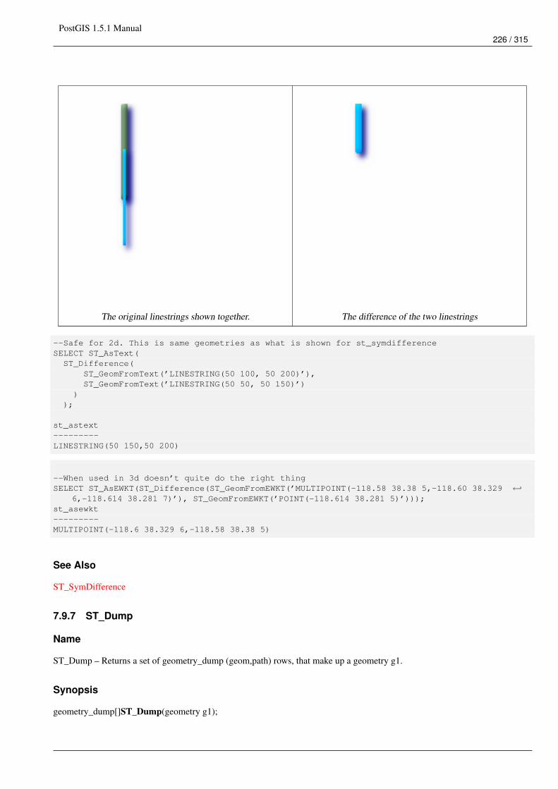
PostGIS 1.5.1 Manual226 / 315
The original linestrings shown together. The difference of the two linestrings
--Safe for 2d. This is same geometries as what is shown for st_symdifferenceSELECT ST_AsText(ST_Difference(
ST_GeomFromText(’LINESTRING(50 100, 50 200)’),ST_GeomFromText(’LINESTRING(50 50, 50 150)’)
));
st_astext---------LINESTRING(50 150,50 200)
--When used in 3d doesn’t quite do the right thingSELECT ST_AsEWKT(ST_Difference(ST_GeomFromEWKT(’MULTIPOINT(-118.58 38.38 5,-118.60 38.329 ←↩
6,-118.614 38.281 7)’), ST_GeomFromEWKT(’POINT(-118.614 38.281 5)’)));st_asewkt---------MULTIPOINT(-118.6 38.329 6,-118.58 38.38 5)
See Also
ST_SymDifference
7.9.7 ST_Dump
Name
ST_Dump – Returns a set of geometry_dump (geom,path) rows, that make up a geometry g1.
Synopsis
geometry_dump[]ST_Dump(geometry g1);
PostGIS 1.5.1 Manual227 / 315
Description
This is a set-returning function (SRF). It returns a set of geometry_dump rows, formed by a geometry (geom) and an array ofintegers (path). When the input geometry is a simple type (POINT,LINESTRING,POLYGON) a single record will be returnedwith an empty path array and the input geometry as geom. When the input geometry is a collection or multi it will return a recordfor each of the collection components, and the path will express the position of the component inside the collection.
ST_Dump is useful for expanding geometries. It is the reverse of a GROUP BY in that it creates new rows. For example it canbe use to expand MULTIPOLYGONS into POLYGONS.
Availability: PostGIS 1.0.0RC1. Requires PostgreSQL 7.3 or higher.
NotePrior to 1.3.4, this function crashes if used with geometries that contain CURVES. This is fixed in 1.3.4+
This function supports 3d and will not drop the z-index.
This method supports Circular Strings and Curves
Examples
SELECT sometable.field1, sometable.field1,(ST_Dump(sometable.the_geom)).geom AS the_geom
FROM sometable;
--Break a compound curve into its constituent linestrings and circularstringsSELECT ST_AsEWKT(a.geom), ST_HasArc(a.geom)FROM ( SELECT (ST_Dump(p_geom)).geom AS geom
FROM (SELECT ST_GeomFromEWKT(’COMPOUNDCURVE(CIRCULARSTRING(0 0, 1 1, 1 0),(1 0, 0 ←↩1))’) AS p_geom) AS b
) AS a;st_asewkt | st_hasarc
-----------------------------+----------CIRCULARSTRING(0 0,1 1,1 0) | tLINESTRING(1 0,0 1) | f
(2 rows)
See Also
geometry_dump, Section 8.4, ST_Collect, ST_Collect, ST_GeometryN
7.9.8 ST_DumpPoints
Name
ST_DumpPoints – Returns a set of geometry_dump (geom,path) rows of all points that make up a geometry.
Synopsis
geometry_dump[]ST_DumpPoints(geometry geom);
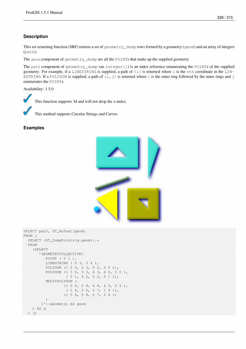
PostGIS 1.5.1 Manual228 / 315
Description
This set-returning function (SRF) returns a set of geometry_dump rows formed by a geometry (geom) and an array of integers(path).
The geom component of geometry_dump are all the POINTs that make up the supplied geometry
The path component of geometry_dump (an integer[]) is an index reference enumerating the POINTs of the suppliedgeometry. For example, if a LINESTRING is supplied, a path of {i} is returned where i is the nth coordinate in the LIN-ESTRING. If a POLYGON is supplied, a path of {i,j} is returned where i is the outer ring followed by the inner rings and jenumerates the POINTs.
Availability: 1.5.0
This function supports 3d and will not drop the z-index.
This method supports Circular Strings and Curves
Examples
SELECT path, ST_AsText(geom)FROM (SELECT (ST_DumpPoints(g.geom)).*FROM(SELECT
’GEOMETRYCOLLECTION(POINT ( 0 1 ),LINESTRING ( 0 3, 3 4 ),POLYGON (( 2 0, 2 3, 0 2, 2 0 )),POLYGON (( 3 0, 3 3, 6 3, 6 0, 3 0 ),
( 5 1, 4 2, 5 2, 5 1 )),MULTIPOLYGON (
(( 0 5, 0 8, 4 8, 4 5, 0 5 ),( 1 6, 3 6, 2 7, 1 6 )),
(( 5 4, 5 8, 6 7, 5 4 )))
)’::geometry AS geom) AS g
) j;
PostGIS 1.5.1 Manual229 / 315
path | st_astext-----------+------------{1,1} | POINT(0 1){2,1} | POINT(0 3){2,2} | POINT(3 4){3,1,1} | POINT(2 0){3,1,2} | POINT(2 3){3,1,3} | POINT(0 2){3,1,4} | POINT(2 0){4,1,1} | POINT(3 0){4,1,2} | POINT(3 3){4,1,3} | POINT(6 3){4,1,4} | POINT(6 0){4,1,5} | POINT(3 0){4,2,1} | POINT(5 1){4,2,2} | POINT(4 2){4,2,3} | POINT(5 2){4,2,4} | POINT(5 1){5,1,1,1} | POINT(0 5){5,1,1,2} | POINT(0 8){5,1,1,3} | POINT(4 8){5,1,1,4} | POINT(4 5){5,1,1,5} | POINT(0 5){5,1,2,1} | POINT(1 6){5,1,2,2} | POINT(3 6){5,1,2,3} | POINT(2 7){5,1,2,4} | POINT(1 6){5,2,1,1} | POINT(5 4){5,2,1,2} | POINT(5 8){5,2,1,3} | POINT(6 7){5,2,1,4} | POINT(5 4)
(29 rows)
See Also
geometry_dump, Section 8.4, ST_Dump, ST_DumpRings
7.9.9 ST_DumpRings
Name
ST_DumpRings – Returns a set of geometry_dump rows, representing the exterior and interior rings of a polygon.
Synopsis
geometry_dump[] ST_DumpRings(geometry a_polygon);
Description
This is a set-returning function (SRF). It returns a set of geometry_dump rows, defined as an integer[] and a geometry,aliased "path" and "geom" respectively. The "path" field holds the polygon ring index containing a single integer: 0 for the shell,>0 for holes. The "geom" field contains the corresponding ring as a polygon.
Availability: PostGIS 1.1.3. Requires PostgreSQL 7.3 or higher.
PostGIS 1.5.1 Manual230 / 315
NoteThis only works for POLYGON geometries. It will not work for MULTIPOLYGONS
This function supports 3d and will not drop the z-index.
Examples
SELECT sometable.field1, sometable.field1,(ST_DumpRings(sometable.the_geom)).geom As the_geom
FROM sometableOfpolys;
SELECT ST_AsEWKT(geom) As the_geom, pathFROM ST_DumpRings(ST_GeomFromEWKT(’POLYGON((-8149064 5133092 1,-8149064 5132986 1,-8148996 5132839 ←↩
1,-8148972 5132767 1,-8148958 5132508 1,-8148941 5132466 1,-8148924 5132394 1,-8148903 5132210 1,-8148930 5131967 1,-8148992 5131978 1,-8149237 5132093 1,-8149404 ←↩
5132211 1,-8149647 5132310 1,-8149757 5132394 1,-8150305 5132788 1,-8149064 5133092 1),(-8149362 5132394 1,-8149446 5132501 1,-8149548 5132597 1,-8149695 5132675 1,-8149362 ←↩
5132394 1))’)) as foo;
path | the_geom---------------------------------------------------------------------------------------------------------------- ←↩
{0} | POLYGON((-8149064 5133092 1,-8149064 5132986 1,-8148996 5132839 1,-8148972 5132767 ←↩1,-8148958 5132508 1,
| -8148941 5132466 1,-8148924 5132394 1,| -8148903 5132210 1,-8148930 5131967 1,| -8148992 5131978 1,-8149237 5132093 1,| -8149404 5132211 1,-8149647 5132310 1,-8149757 5132394 1,-8150305 5132788 ←↩
1,-8149064 5133092 1)){1} | POLYGON((-8149362 5132394 1,-8149446 5132501 1,| -8149548 5132597 1,-8149695 5132675 1,-8149362 5132394 1))
See Also
geometry_dump, Section 8.4, ST_Dump, ST_ExteriorRing, ST_InteriorRingN
7.9.10 ST_Intersection
Name
ST_Intersection – (T) Returns a geometry that represents the shared portion of geomA and geomB. The geography implementa-tion does a transform to geometry to do the intersection and then transform back to WGS84.
Synopsis
geometry ST_Intersection( geometry geomA , geometry geomB );geography ST_Intersection( geography geogA , geography geogB );
PostGIS 1.5.1 Manual231 / 315
Description
Returns a geometry that represents the point set intersection of the Geometries.
In other words - that portion of geometry A and geometry B that is shared between the two geometries.
If the geometries do not share any space (are disjoint), then an empty geometry collection is returned.
ST_Intersection in conjunction with ST_Intersects is very useful for clipping geometries such as in bounding box, buffer, regionqueries where you only want to return that portion of a geometry that sits in a country or region of interest.
NoteGeography: For geography this is really a thin wrapper around the geometry implementation. It first determines thebest SRID that fits the bounding box of the 2 geography objects (if geography objects are within one half zone UTM butnot same UTM will pick one of those) (favoring UTM or Lambert Azimuthal Equal Area (LAEA) north/south pole, andfalling back on mercator in worst case scenario) and then intersection in that best fit planar spatial ref and retransformsback to WGS84 geography.
ImportantDo not call with a GEOMETRYCOLLECTION as an argument
Performed by the GEOS module
Availability: 1.5 support for geography data type was introduced.
This method implements the OpenGIS Simple Features Implementation Specification for SQL 1.1. s2.1.1.3
This method implements the SQL/MM specification. SQL-MM 3: 5.1.18
Examples
SELECT ST_AsText(ST_Intersection(’POINT(0 0)’::geometry, ’LINESTRING ( 2 0, 0 2 )’:: ←↩geometry));
st_astext---------------GEOMETRYCOLLECTION EMPTY(1 row)SELECT ST_AsText(ST_Intersection(’POINT(0 0)’::geometry, ’LINESTRING ( 0 0, 0 2 )’:: ←↩
geometry));st_astext
---------------POINT(0 0)(1 row)
---Clip all lines (trails) by country (here we assume country geom are POLYGON or ←↩MULTIPOLYGONS)
-- NOTE: we are only keeping intersections that result in a LINESTRING or MULTILINESTRING ←↩because we don’t
-- care about trails that just share a point-- the dump is needed to expand a geometry collection into individual single MULT* parts-- the below is fairly generic and will work for polys, etc. by just changing the where ←↩
clauseSELECT clipped.gid, clipped.f_name, clipped_geomFROM (SELECT trails.gid, trails.f_name, (ST_Dump(ST_Intersection(country.the_geom, trails. ←↩
the_geom))).geom As clipped_geom
PostGIS 1.5.1 Manual232 / 315
FROM countryINNER JOIN trailsON ST_Intersects(country.the_geom, trails.the_geom)) As clippedWHERE ST_Dimension(clipped.clipped_geom) = 1 ;
--For polys e.g. polygon landmarks, you can also use the sometimes faster hack that ←↩buffering anything by 0.0
-- except a polygon results in an empty geometry collection--(so a geometry collection containing polys, lines and points)-- buffered by 0.0 would only leave the polygons and dissolve the collection shellSELECT poly.gid, ST_Multi(ST_Buffer(
ST_Intersection(country.the_geom, poly.the_geom),0.0)) As clipped_geom
FROM countryINNER JOIN polyON ST_Intersects(country.the_geom, poly.the_geom)WHERE Not ST_IsEmpty(ST_Buffer(ST_Intersection(country.the_geom, poly.the_geom),0.0));
See Also
ST_Dimension, ST_Dump, ST_Intersects, ST_Multi
7.9.11 ST_LineToCurve
Name
ST_LineToCurve – Converts a LINESTRING/POLYGON to a CIRCULARSTRING, CURVED POLYGON
Synopsis
geometry ST_LineToCurve(geometry geomANoncircular);
Description
Converts plain LINESTRING/POLYGONS to CIRCULAR STRINGs and Curved Polygons. Note much fewer points are neededto describe the curved equivalent.
Availability: 1.2.2?
This function supports 3d and will not drop the z-index.
This method supports Circular Strings and Curves
Examples
SELECT ST_AsText(ST_LineToCurve(foo.the_geom)) As curvedastext,ST_AsText(foo.the_geom) As ←↩non_curvedastext
FROM (SELECT ST_Buffer(’POINT(1 3)’::geometry, 3) As the_geom) As foo;
curvedatext non_curvedastext------------------------------------------------------------------| ←↩
-----------------------------------------------------------------
PostGIS 1.5.1 Manual233 / 315
CURVEPOLYGON(CIRCULARSTRING(4 3,3.12132034355964 0.878679656440359, | POLYGON((4 ←↩3,3.94235584120969 2.41472903395162,3.77163859753386 1.85194970290473
1 0,-1.12132034355965 5.12132034355963,4 3)) | ,3.49440883690764 ←↩1.33328930094119,3.12132034355964 0.878679656440359,
| 2.66671069905881 ←↩0.505591163092366,2.14805029709527 0.228361402466141,
| 1.58527096604839 0.0576441587903094,1 0,| 0.414729033951621 ←↩
0.0576441587903077,-0.148050297095264 ←↩0.228361402466137,
| -0.666710699058802 ←↩0.505591163092361,-1.12132034355964 0.878679656440353,
| -1.49440883690763 ←↩1.33328930094119,-1.77163859753386 1.85194970290472
| --ETC-- ,3.94235584120969 3.58527096604839,4 3))--3D exampleSELECT ST_AsEWKT(ST_LineToCurve(ST_GeomFromEWKT(’LINESTRING(1 2 3, 3 4 8, 5 6 4, 7 8 4, 9 ←↩
10 4)’)));
st_asewkt------------------------------------CIRCULARSTRING(1 2 3,5 6 4,9 10 4)
See Also
ST_CurveToLine
7.9.12 ST_MemUnion
Name
ST_MemUnion – Same as ST_Union, only memory-friendly (uses less memory and more processor time).
Synopsis
geometry ST_MemUnion(geometry set geomfield);
Description
Some useful description here.
NoteSame as ST_Union, only memory-friendly (uses less memory and more processor time). This aggregate function worksby unioning the geometries one at a time to previous result as opposed to ST_Union aggregate which first creates anarray and then unions
This function supports 3d and will not drop the z-index.
Examples
See ST_Union
PostGIS 1.5.1 Manual234 / 315
See Also
ST_Union
7.9.13 ST_MinimumBoundingCircle
Name
ST_MinimumBoundingCircle – Returns the smallest circle polygon that can fully contain a geometry. Default uses 48 segmentsper quarter circle.
Synopsis
geometry ST_MinimumBoundingCircle(geometry geomA);geometry ST_MinimumBoundingCircle(geometry geomA, integer num_segs_per_qt_circ);
Description
Returns the smallest circle polygon that can fully contain a geometry.
NoteThe circle is approximated by a polygon with a default of 48 segments per quarter circle. This number can be increasedwith little performance penalty to obtain a more accurate result.
It is often used with MULTI and Geometry Collections. Although it is not an aggregate - you can use it in conjunction withST_Collect to get the minimum bounding cirlce of a set of geometries. ST_MinimumBoundingCircle(ST_Collect(somepointfield)).
The ratio of the area of a polygon divided by the area of its Minimum Bounding Circle is often referred to as the Roeck test.
Availability: 1.4.0 - requires GEOS
Examples
SELECT d.disease_type,ST_MinimumBoundingCircle(ST_Collect(d.the_geom)) As the_geomFROM disease_obs As dGROUP BY d.disease_type;
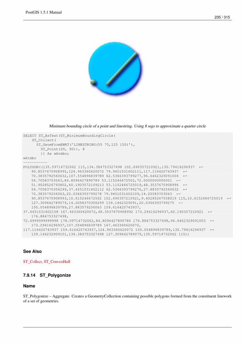
PostGIS 1.5.1 Manual235 / 315
Minimum bounding circle of a point and linestring. Using 8 segs to approximate a quarter circle
SELECT ST_AsText(ST_MinimumBoundingCircle(ST_Collect(ST_GeomFromEWKT(’LINESTRING(55 75,125 150)’),ST_Point(20, 80)), 8)) As wktmbc;
wktmbc-----------POLYGON((135.59714732062 115,134.384753327498 102.690357210921,130.79416296937 ←↩
90.8537670908995,124.963360620072 79.9451031602111,117.116420743937 ←↩70.3835792560632,107.554896839789 62.5366393799277,96.6462329091006 ←↩56.70583703063,84.8096427890789 53.115246672502,72.5000000000001 ←↩51.9028526793802,60.1903572109213 53.1152466725019,48.3537670908996 ←↩56.7058370306299,37.4451031602112 62.5366393799276,27.8835792560632 ←↩70.383579256063,20.0366393799278 79.9451031602109,14.20583703063 ←↩90.8537670908993,10.615246672502 102.690357210921,9.40285267938019 115,10.6152466725019 ←↩127.309642789079,14.2058370306299 139.1462329091,20.0366393799275 ←↩150.054896839789,27.883579256063 159.616420743937,
37.4451031602108 167.463360620072,48.3537670908992 173.29416296937,60.190357210921 ←↩176.884753327498,
72.4999999999998 178.09714732062,84.8096427890786 176.884753327498,96.6462329091003 ←↩173.29416296937,107.554896839789 167.463360620072,
117.116420743937 159.616420743937,124.963360620072 150.054896839789,130.79416296937 ←↩139.146232909101,134.384753327498 127.309642789079,135.59714732062 115))
See Also
ST_Collect, ST_ConvexHull
7.9.14 ST_Polygonize
Name
ST_Polygonize – Aggregate. Creates a GeometryCollection containing possible polygons formed from the constituent lineworkof a set of geometries.
PostGIS 1.5.1 Manual236 / 315
Synopsis
geometry ST_Polygonize(geometry set geomfield);geometry ST_Polygonize(geometry[] geom_array);
Description
Creates a GeometryCollection containing possible polygons formed from the constituent linework of a set of geometries.
NoteGeometry Collections are often difficult to deal with with third party tools, so use ST_Polygonize in conjunction withST_Dump to dump the polygons out into individual polygons.
Availability: 1.0.0RC1 - requires GEOS >= 2.1.0.
Examples: Polygonizing single linestrings
SELECT ST_AsEWKT(ST_Polygonize(the_geom_4269)) As geomtextrepFROM (SELECT the_geom_4269 FROM ma.suffolk_edges ORDER BY tlid LIMIT 45) As foo;
geomtextrep-------------------------------------SRID=4269;GEOMETRYCOLLECTION(POLYGON((-71.040878 42.285678,-71.040943 42.2856,-71.04096 ←↩
42.285752,-71.040878 42.285678)),POLYGON((-71.17166 42.353675,-71.172026 42.354044,-71.17239 42.354358,-71.171794 ←↩
42.354971,-71.170511 42.354855,-71.17112 42.354238,-71.17166 42.353675)))
(1 row)
--Use ST_Dump to dump out the polygonize geoms into individual polygonsSELECT ST_AsEWKT((ST_Dump(foofoo.polycoll)).geom) As geomtextrepFROM (SELECT ST_Polygonize(the_geom_4269) As polycollFROM (SELECT the_geom_4269 FROM ma.suffolk_edgesORDER BY tlid LIMIT 45) As foo) As foofoo;
geomtextrep------------------------SRID=4269;POLYGON((-71.040878 42.285678,-71.040943 42.2856,-71.04096 42.285752,-71.040878 42.285678))SRID=4269;POLYGON((-71.17166 42.353675,-71.172026 42.354044,-71.17239 42.354358,-71.171794 42.354971,-71.170511 42.354855,-71.17112 42.354238,-71.17166 42.353675))(2 rows)
See Also
ST_Dump
7.9.15 ST_Shift_Longitude
Name
ST_Shift_Longitude – Reads every point/vertex in every component of every feature in a geometry, and if the longitude coordi-nate is <0, adds 360 to it. The result would be a 0-360 version of the data to be plotted in a 180 centric map

PostGIS 1.5.1 Manual237 / 315
Synopsis
geometry ST_Shift_Longitude(geometry geomA);
Description
Reads every point/vertex in every component of every feature in a geometry, and if the longitude coordinate is <0, adds 360 to it.The result would be a 0-360 version of the data to be plotted in a 180 centric map
NoteThis is only useful for data in long lat e.g. 4326 (WGS 84 long lat)
Pre-1.3.4 bug prevented this from working for MULTIPOINT. 1.3.4+ works with MULTIPOINT as well.
This function supports 3d and will not drop the z-index.
Examples
--3d pointsSELECT ST_AsEWKT(ST_Shift_Longitude(ST_GeomFromEWKT(’SRID=4326;POINT(-118.58 38.38 10)’))) ←↩
As geomA,ST_AsEWKT(ST_Shift_Longitude(ST_GeomFromEWKT(’SRID=4326;POINT(241.42 38.38 10)’))) As ←↩
geombgeomA geomB---------- -----------SRID=4326;POINT(241.42 38.38 10) SRID=4326;POINT(-118.58 38.38 10)
--regular line stringSELECT ST_AsText(ST_Shift_Longitude(ST_GeomFromText(’LINESTRING(-118.58 38.38, -118.20 ←↩
38.45)’)))
st_astext----------LINESTRING(241.42 38.38,241.8 38.45)
See Also
ST_GeomFromEWKT, ST_GeomFromText, ST_AsEWKT
7.9.16 ST_Simplify
Name
ST_Simplify – Returns a "simplified" version of the given geometry using the Douglas-Peuker algorithm.
Synopsis
geometry ST_Simplify(geometry geomA, float tolerance);
PostGIS 1.5.1 Manual238 / 315
Description
Returns a "simplified" version of the given geometry using the Douglas-Peuker algorithm. Will actually do something onlywith (multi)lines and (multi)polygons but you can safely call it with any kind of geometry. Since simplification occurs on aobject-by-object basis you can also feed a GeometryCollection to this function.
NoteNote that returned geometry might loose its simplicity (see ST_IsSimple)
NoteNote topology may not be preserved and may result in invalid geometries. Use (see ST_SimplifyPreserveTopology) topreserve topology.
Performed by the GEOS module.
Availability: 1.2.2
Examples
A circle simplified too much becomes a triangle, medium an octagon,
SELECT ST_Npoints(the_geom) As np_before, ST_NPoints(ST_Simplify(the_geom,0.1)) As ←↩np01_notbadcircle, ST_NPoints(ST_Simplify(the_geom,0.5)) As np05_notquitecircle,
ST_NPoints(ST_Simplify(the_geom,1)) As np1_octagon, ST_NPoints(ST_Simplify(the_geom,10)) As ←↩np10_triangle,
(ST_Simplify(the_geom,100) is null) As np100_geometrygoesawayFROM (SELECT ST_Buffer(’POINT(1 3)’, 10,12) As the_geom) As foo;-resultnp_before | np01_notbadcircle | np05_notquitecircle | np1_octagon | np10_triangle | ←↩
np100_geometrygoesaway-----------+-------------------+---------------------+-------------+---------------+------------------------ ←↩
49 | 33 | 17 | 9 | 4 | t
See Also
ST_IsSimple, ST_SimplifyPreserveTopology
7.9.17 ST_SimplifyPreserveTopology
Name
ST_SimplifyPreserveTopology – Returns a "simplified" version of the given geometry using the Douglas-Peuker algorithm. Willavoid creating derived geometries (polygons in particular) that are invalid.
Synopsis
geometry ST_SimplifyPreserveTopology(geometry geomA, float tolerance);
PostGIS 1.5.1 Manual239 / 315
Description
Returns a "simplified" version of the given geometry using the Douglas-Peuker algorithm. Will avoid creating derived geometries(polygons in particular) that are invalid. Will actually do something only with (multi)lines and (multi)polygons but you can safelycall it with any kind of geometry. Since simplification occurs on a object-by-object basis you can also feed a GeometryCollectionto this function.
Performed by the GEOS module.
NoteRequires GEOS 3.0.0+
Availability: 1.3.3
Examples
Same example as Simplify, but we see Preserve Topology prevents oversimplification. The circle can at most become a square.
SELECT ST_Npoints(the_geom) As np_before, ST_NPoints(ST_SimplifyPreserveTopology(the_geom ←↩,0.1)) As np01_notbadcircle, ST_NPoints(ST_SimplifyPreserveTopology(the_geom,0.5)) As ←↩np05_notquitecircle,
ST_NPoints(ST_SimplifyPreserveTopology(the_geom,1)) As np1_octagon, ST_NPoints( ←↩ST_SimplifyPreserveTopology(the_geom,10)) As np10_square,
ST_NPoints(ST_SimplifyPreserveTopology(the_geom,100)) As np100_stillsquareFROM (SELECT ST_Buffer(’POINT(1 3)’, 10,12) As the_geom) As foo;
--result--np_before | np01_notbadcircle | np05_notquitecircle | np1_octagon | np10_square | ←↩
np100_stillsquare-----------+-------------------+---------------------+-------------+---------------+------------------- ←↩
49 | 33 | 17 | 9 | 5 | ←↩5
See Also
ST_Simplify
7.9.18 ST_SymDifference
Name
ST_SymDifference – Returns a geometry that represents the portions of A and B that do not intersect. It is called a symmetricdifference because ST_SymDifference(A,B) = ST_SymDifference(B,A).
Synopsis
geometry ST_SymDifference(geometry geomA, geometry geomB);
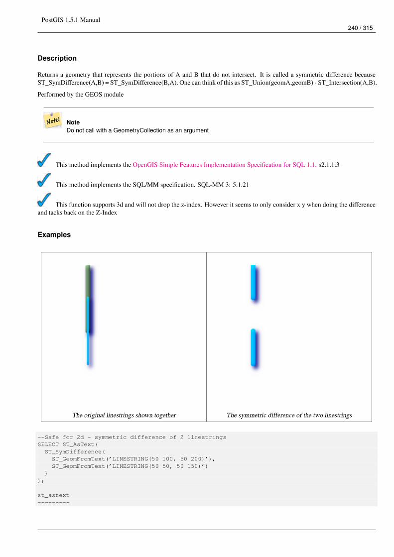
PostGIS 1.5.1 Manual240 / 315
Description
Returns a geometry that represents the portions of A and B that do not intersect. It is called a symmetric difference becauseST_SymDifference(A,B) = ST_SymDifference(B,A). One can think of this as ST_Union(geomA,geomB) - ST_Intersection(A,B).
Performed by the GEOS module
NoteDo not call with a GeometryCollection as an argument
This method implements the OpenGIS Simple Features Implementation Specification for SQL 1.1. s2.1.1.3
This method implements the SQL/MM specification. SQL-MM 3: 5.1.21
This function supports 3d and will not drop the z-index. However it seems to only consider x y when doing the differenceand tacks back on the Z-Index
Examples
The original linestrings shown together The symmetric difference of the two linestrings
--Safe for 2d - symmetric difference of 2 linestringsSELECT ST_AsText(ST_SymDifference(ST_GeomFromText(’LINESTRING(50 100, 50 200)’),ST_GeomFromText(’LINESTRING(50 50, 50 150)’)
));
st_astext---------
PostGIS 1.5.1 Manual241 / 315
MULTILINESTRING((50 150,50 200),(50 50,50 100))
--When used in 3d doesn’t quite do the right thingSELECT ST_AsEWKT(ST_SymDifference(ST_GeomFromEWKT(’LINESTRING(1 2 1, 1 4 2)’),ST_GeomFromEWKT(’LINESTRING(1 1 3, 1 3 4)’)))
st_astext------------MULTILINESTRING((1 3 2.75,1 4 2),(1 1 3,1 2 2.25))
See Also
ST_Difference, ST_Intersection, ST_Union
7.9.19 ST_Union
Name
ST_Union – Returns a geometry that represents the point set union of the Geometries.
Synopsis
geometry ST_Union(geometry set g1field);geometry ST_Union(geometry g1, geometry g2);geometry ST_Union(geometry[] g1_array);
Description
Output type can be a MULTI* , single geometry, or Geometry Collection. Comes in 2 variants. Variant 1 unions 2 geometriesresulting in a new geomety with no intersecting regions. Variant 2 is an aggregate function that takes a set of geometries andunions them into a single ST_Geometry resulting in no intersecting regions.
Aggregate version: This function returns a MULTI geometry or NON-MULTI geometry from a set of geometries. The ST_Union()function is an "aggregate" function in the terminology of PostgreSQL. That means that it operates on rows of data, in the sameway the SUM() and AVG() functions do.
Non-Aggregate version: This function returns a geometry being a union of two input geometries. Output type can be a MULTI*,NON-MULTI or GEOMETRYCOLLECTION.
NoteST_Collect and ST_Union are often interchangeable. ST_Union is in general orders of magnitude slower thanST_Collect because it tries to dissolve boundaries and reorder geometries to ensure that a constructed Multi* doesn’thave intersecting regions.
Performed by the GEOS module.
NOTE: this function was formerly called GeomUnion(), which was renamed from "Union" because UNION is an SQL reservedword.
Availability: 1.4.0 - ST_Union was enhanced. ST_Union(geomarray) was introduced and also faster aggregate collection in Post-greSQL. If you are using GEOS 3.1.0+ ST_Union will use the faster Cascaded Union algorithm described in http://blog.cleverelephant.ca/-2009/01/must-faster-unions-in-postgis-14.html
This method implements the OpenGIS Simple Features Implementation Specification for SQL 1.1. s2.1.1.3
PostGIS 1.5.1 Manual242 / 315
NoteAggregate version is not explicitly defined in OGC SPEC.
This method implements the SQL/MM specification. SQL-MM 3: 5.1.19 the z-index (elevation) when polygons areinvolved.
Examples
Aggregate example
SELECT stusps,ST_Multi(ST_Union(f.the_geom)) as singlegeom
FROM sometable As fGROUP BY stusps
Non-Aggregate example
SELECT ST_AsText(ST_Union(ST_GeomFromText(’POINT(1 2)’),ST_GeomFromText(’POINT(-2 3)’) ) )
st_astext----------MULTIPOINT(-2 3,1 2)
SELECT ST_AsText(ST_Union(ST_GeomFromText(’POINT(1 2)’),ST_GeomFromText(’POINT(1 2)’) ) );
st_astext----------POINT(1 2)
--3d example - sort of supports 3d (and with mixed dimensions!)SELECT ST_AsEWKT(st_union(the_geom))FROM(SELECT ST_GeomFromEWKT(’POLYGON((-7 4.2,-7.1 4.2,-7.1 4.3,-7 4.2))’) as the_geomUNION ALLSELECT ST_GeomFromEWKT(’POINT(5 5 5)’) as the_geomUNION ALLSELECT ST_GeomFromEWKT(’POINT(-2 3 1)’) as the_geom
UNION ALLSELECT ST_GeomFromEWKT(’LINESTRING(5 5 5, 10 10 10)’) as the_geom ) as foo;
st_asewkt---------GEOMETRYCOLLECTION(POINT(-2 3 1),LINESTRING(5 5 5,10 10 10),POLYGON((-7 4.2 5,-7.1 4.2 ←↩
5,-7.1 4.3 5,-7 4.2 5)));
--3d example not mixing dimensionsSELECT ST_AsEWKT(st_union(the_geom))FROM(SELECT ST_GeomFromEWKT(’POLYGON((-7 4.2 2,-7.1 4.2 3,-7.1 4.3 2,-7 4.2 2))’) as the_geomUNION ALLSELECT ST_GeomFromEWKT(’POINT(5 5 5)’) as the_geomUNION ALLSELECT ST_GeomFromEWKT(’POINT(-2 3 1)’) as the_geom
PostGIS 1.5.1 Manual243 / 315
UNION ALLSELECT ST_GeomFromEWKT(’LINESTRING(5 5 5, 10 10 10)’) as the_geom ) as foo;
st_asewkt---------GEOMETRYCOLLECTION(POINT(-2 3 1),LINESTRING(5 5 5,10 10 10),POLYGON((-7 4.2 2,-7.1 4.2 ←↩
3,-7.1 4.3 2,-7 4.2 2)))
--Examples using new Array constructSELECT ST_Union(ARRAY(SELECT the_geom FROM sometable));
SELECT ST_AsText(ST_Union(ARRAY[ST_GeomFromText(’LINESTRING(1 2, 3 4)’),ST_GeomFromText(’LINESTRING(3 4, 4 5)’)])) As wktunion;
--wktunion---MULTILINESTRING((3 4,4 5),(1 2,3 4))
See Also
ST_Collect
7.10 Linear Referencing
7.10.1 ST_Line_Interpolate_Point
Name
ST_Line_Interpolate_Point – Returns a point interpolated along a line. Second argument is a float8 between 0 and 1 representingfraction of total length of linestring the point has to be located.
Synopsis
geometry ST_Line_Interpolate_Point(geometry a_linestring, float a_fraction);
Description
Returns a point interpolated along a line. First argument must be a LINESTRING. Second argument is a float8 between 0 and 1representing fraction of total linestring length the point has to be located.
See ST_Line_Locate_Point for computing the line location nearest to a Point.
NoteSince release 1.1.1 this function also interpolates M and Z values (when present), while prior releases set them to 0.0.
Availability: 0.8.2, Z and M supported added in 1.1.1
This function supports 3d and will not drop the z-index.
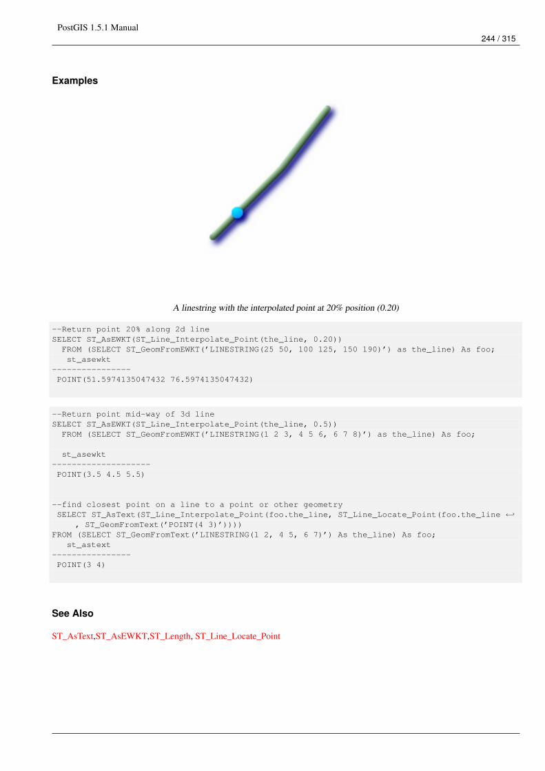
PostGIS 1.5.1 Manual244 / 315
Examples
A linestring with the interpolated point at 20% position (0.20)
--Return point 20% along 2d lineSELECT ST_AsEWKT(ST_Line_Interpolate_Point(the_line, 0.20))FROM (SELECT ST_GeomFromEWKT(’LINESTRING(25 50, 100 125, 150 190)’) as the_line) As foo;st_asewkt
----------------POINT(51.5974135047432 76.5974135047432)
--Return point mid-way of 3d lineSELECT ST_AsEWKT(ST_Line_Interpolate_Point(the_line, 0.5))FROM (SELECT ST_GeomFromEWKT(’LINESTRING(1 2 3, 4 5 6, 6 7 8)’) as the_line) As foo;
st_asewkt--------------------POINT(3.5 4.5 5.5)
--find closest point on a line to a point or other geometrySELECT ST_AsText(ST_Line_Interpolate_Point(foo.the_line, ST_Line_Locate_Point(foo.the_line ←↩
, ST_GeomFromText(’POINT(4 3)’))))FROM (SELECT ST_GeomFromText(’LINESTRING(1 2, 4 5, 6 7)’) As the_line) As foo;
st_astext----------------POINT(3 4)
See Also
ST_AsText,ST_AsEWKT,ST_Length, ST_Line_Locate_Point
PostGIS 1.5.1 Manual245 / 315
7.10.2 ST_Line_Locate_Point
Name
ST_Line_Locate_Point – Returns a float between 0 and 1 representing the location of the closest point on LineString to the givenPoint, as a fraction of total 2d line length.
Synopsis
float ST_Line_Locate_Point(geometry a_linestring, geometry a_point);
Description
Returns a float between 0 and 1 representing the location of the closest point on LineString to the given Point, as a fraction oftotal 2d line length.
You can use the returned location to extract a Point (ST_Line_Interpolate_Point) or a substring (ST_Line_Substring).
This is useful for approximating numbers of addresses
Availability: 1.1.0
Examples
--Rough approximation of finding the street number of a point along the street--Note the whole foo thing is just to generate dummy data that looks--like house centroids and street--We use ST_DWithin to exclude--houses too far away from the street to be considered on the streetSELECT ST_AsText(house_loc) As as_text_house_loc,startstreet_num +CAST( (endstreet_num - startstreet_num)
* ST_Line_Locate_Point(street_line, house_loc) As integer) As street_numFROM(SELECT ST_GeomFromText(’LINESTRING(1 2, 3 4)’) As street_line,ST_MakePoint(x*1.01,y*1.03) As house_loc, 10 As startstreet_num,20 As endstreet_num
FROM generate_series(1,3) x CROSS JOIN generate_series(2,4) As y)As fooWHERE ST_DWithin(street_line, house_loc, 0.2);
as_text_house_loc | street_num-------------------+------------POINT(1.01 2.06) | 10POINT(2.02 3.09) | 15POINT(3.03 4.12) | 20
--find closest point on a line to a point or other geometrySELECT ST_AsText(ST_Line_Interpolate_Point(foo.the_line, ST_Line_Locate_Point(foo.the_line ←↩
, ST_GeomFromText(’POINT(4 3)’))))FROM (SELECT ST_GeomFromText(’LINESTRING(1 2, 4 5, 6 7)’) As the_line) As foo;
st_astext----------------POINT(3 4)
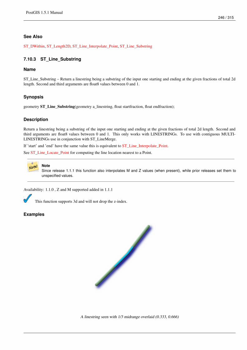
PostGIS 1.5.1 Manual246 / 315
See Also
ST_DWithin, ST_Length2D, ST_Line_Interpolate_Point, ST_Line_Substring
7.10.3 ST_Line_Substring
Name
ST_Line_Substring – Return a linestring being a substring of the input one starting and ending at the given fractions of total 2dlength. Second and third arguments are float8 values between 0 and 1.
Synopsis
geometry ST_Line_Substring(geometry a_linestring, float startfraction, float endfraction);
Description
Return a linestring being a substring of the input one starting and ending at the given fractions of total 2d length. Second andthird arguments are float8 values between 0 and 1. This only works with LINESTRINGs. To use with contiguous MULTI-LINESTRINGs use in conjunction with ST_LineMerge.
If ’start’ and ’end’ have the same value this is equivalent to ST_Line_Interpolate_Point.
See ST_Line_Locate_Point for computing the line location nearest to a Point.
NoteSince release 1.1.1 this function also interpolates M and Z values (when present), while prior releases set them tounspecified values.
Availability: 1.1.0 , Z and M supported added in 1.1.1
This function supports 3d and will not drop the z-index.
Examples
A linestring seen with 1/3 midrange overlaid (0.333, 0.666)
PostGIS 1.5.1 Manual247 / 315
--Return the approximate 1/3 mid-range part of a linestringSELECT ST_AsText(ST_Line_SubString(ST_GeomFromText(’LINESTRING(25 50, 100 125, 150 190)’), ←↩
0.333, 0.666));
st_astext------------------------------------------------------------------------------------------------ ←↩
LINESTRING(69.2846934853974 94.2846934853974,100 125,111.700356260683 140.210463138888)
--The below example simulates a while loop in--SQL using PostgreSQL generate_series() to cut all--linestrings in a table to 100 unit segments-- of which no segment is longer than 100 units-- units are measured in the SRID units of measurement-- It also assumes all geometries are LINESTRING or contiguous MULTILINESTRING--and no geometry is longer than 100 units*10000--for better performance you can reduce the 10000--to match max number of segments you expect
SELECT field1, field2, ST_Line_Substring(the_geom, 100.00*n/length,CASEWHEN 100.00*(n+1) < length THEN 100.00*(n+1)/lengthELSE 1END) As the_geom
FROM(SELECT sometable.field1, sometable.field2,ST_LineMerge(sometable.the_geom) AS the_geom,ST_Length(sometable.the_geom) As lengthFROM sometable) AS t
CROSS JOIN generate_series(0,10000) AS nWHERE n*100.00/length < 1;
See Also
ST_Length, ST_Line_Interpolate_Point, ST_LineMerge
7.10.4 ST_Locate_Along_Measure
Name
ST_Locate_Along_Measure – Return a derived geometry collection value with elements that match the specified measure. Polyg-onal elements are not supported.
Synopsis
geometry ST_Locate_Along_Measure(geometry ageom_with_measure, float a_measure);
Description
Return a derived geometry collection value with elements that match the specified measure. Polygonal elements are not sup-ported.
Semantic is specified by: ISO/IEC CD 13249-3:200x(E) - Text for Continuation CD Editing Meeting
Availability: 1.1.0
PostGIS 1.5.1 Manual248 / 315
NoteUse this function only for geometries with an M component
This function supports M coordinates.
Examples
SELECT ST_AsEWKT(the_geom)FROM(SELECT ST_Locate_Along_Measure(ST_GeomFromEWKT(’MULTILINESTRINGM((1 2 3, 3 4 2, 9 4 3),
(1 2 3, 5 4 5))’),3) As the_geom) As foo;
st_asewkt-----------------------------------------------------------GEOMETRYCOLLECTIONM(MULTIPOINT(1 2 3,9 4 3),POINT(1 2 3))
--Geometry collections are difficult animals so dump them--to make them more digestableSELECT ST_AsEWKT((ST_Dump(the_geom)).geom)FROM(SELECT ST_Locate_Along_Measure(
ST_GeomFromEWKT(’MULTILINESTRINGM((1 2 3, 3 4 2, 9 4 3),(1 2 3, 5 4 5))’),3) As the_geom) As foo;
st_asewkt---------------POINTM(1 2 3)POINTM(9 4 3)POINTM(1 2 3)
See Also
ST_Dump, ST_Locate_Between_Measures
7.10.5 ST_Locate_Between_Measures
Name
ST_Locate_Between_Measures – Return a derived geometry collection value with elements that match the specified range ofmeasures inclusively. Polygonal elements are not supported.
Synopsis
geometry ST_Locate_Between_Measures(geometry geomA, float measure_start, float measure_end);
Description
Return a derived geometry collection value with elements that match the specified range of measures inclusively. Polygonalelements are not supported.
PostGIS 1.5.1 Manual249 / 315
Semantic is specified by: ISO/IEC CD 13249-3:200x(E) - Text for Continuation CD Editing Meeting
Availability: 1.1.0
This function supports M coordinates.
Examples
SELECT ST_AsEWKT(the_geom)FROM(SELECT ST_Locate_Between_Measures(ST_GeomFromEWKT(’MULTILINESTRINGM((1 2 3, 3 4 2, 9 4 3),
(1 2 3, 5 4 5))’),1.5, 3) As the_geom) As foo;
st_asewkt-----------------------------------------------------------------GEOMETRYCOLLECTIONM(LINESTRING(1 2 3,3 4 2,9 4 3),POINT(1 2 3))
--Geometry collections are difficult animals so dump them--to make them more digestableSELECT ST_AsEWKT((ST_Dump(the_geom)).geom)
FROM(SELECT ST_Locate_Between_Measures(ST_GeomFromEWKT(’MULTILINESTRINGM((1 2 3, 3 4 2, 9 4 3),
(1 2 3, 5 4 5))’),1.5, 3) As the_geom) As foo;
st_asewkt--------------------------------LINESTRINGM(1 2 3,3 4 2,9 4 3)POINTM(1 2 3)
See Also
ST_Dump, ST_Locate_Along_Measure
7.10.6 ST_LocateBetweenElevations
Name
ST_LocateBetweenElevations – Return a derived geometry (collection) value with elements that intersect the specified range ofelevations inclusively. Only 3D, 4D LINESTRINGS and MULTILINESTRINGS are supported.
Synopsis
geometry ST_LocateBetweenElevations(geometry geom_mline, float elevation_start, float elevation_end);
Description
Return a derived geometry (collection) value with elements that intersect the specified range of elevations inclusively. Only 3D,3DM LINESTRINGS and MULTILINESTRINGS are supported.
Availability: 1.4.0
This function supports 3d and will not drop the z-index.
PostGIS 1.5.1 Manual250 / 315
Examples
SELECT ST_AsEWKT(ST_LocateBetweenElevations(ST_GeomFromEWKT(’LINESTRING(1 2 3, 4 5 6)’),2,4)) As ewelev;
ewelev----------------------------------------------------------------MULTILINESTRING((1 2 3,2 3 4))
SELECT ST_AsEWKT(ST_LocateBetweenElevations(ST_GeomFromEWKT(’LINESTRING(1 2 6, 4 5 -1, 7 8 9)’),6,9)) As ewelev;
ewelev----------------------------------------------------------------GEOMETRYCOLLECTION(POINT(1 2 6),LINESTRING(6.1 7.1 6,7 8 9))
--Geometry collections are difficult animals so dump them--to make them more digestableSELECT ST_AsEWKT((ST_Dump(the_geom)).geom)
FROM(SELECT ST_LocateBetweenElevations(ST_GeomFromEWKT(’LINESTRING(1 2 6, 4 5 -1, 7 8 9)’),6,9) As the_geom) As foo;
st_asewkt--------------------------------POINT(1 2 6)LINESTRING(6.1 7.1 6,7 8 9)
See Also
ST_Dump
7.10.7 ST_AddMeasure
Name
ST_AddMeasure – Return a derived geometry with measure elements linearly interpolated between the start and end points. Ifthe geometry has no measure dimension, one is added. If the geometry has a measure dimension, it is over-written with newvalues. Only LINESTRINGS and MULTILINESTRINGS are supported.
Synopsis
geometry ST_AddMeasure(geometry geom_mline, float measure_start, float measure_end);
Description
Return a derived geometry with measure elements linearly interpolated between the start and end points. If the geometry hasno measure dimension, one is added. If the geometry has a measure dimension, it is over-written with new values. OnlyLINESTRINGS and MULTILINESTRINGS are supported.
Availability: 1.5.0
This function supports 3d and will not drop the z-index.
PostGIS 1.5.1 Manual251 / 315
Examples
SELECT ST_AsEWKT(ST_AddMeasure(ST_GeomFromEWKT(’LINESTRING(1 0, 2 0, 4 0)’),1,4)) As ewelev;
ewelev--------------------------------LINESTRINGM(1 0 1,2 0 2,4 0 4)
SELECT ST_AsEWKT(ST_AddMeasure(ST_GeomFromEWKT(’LINESTRING(1 0 4, 2 0 4, 4 0 4)’),10,40)) As ewelev;
ewelev----------------------------------------LINESTRING(1 0 4 10,2 0 4 20,4 0 4 40)
SELECT ST_AsEWKT(ST_AddMeasure(ST_GeomFromEWKT(’LINESTRINGM(1 0 4, 2 0 4, 4 0 4)’),10,40)) As ewelev;
ewelev----------------------------------------LINESTRINGM(1 0 10,2 0 20,4 0 40)
SELECT ST_AsEWKT(ST_AddMeasure(ST_GeomFromEWKT(’MULTILINESTRINGM((1 0 4, 2 0 4, 4 0 4),(1 0 4, 2 0 4, 4 0 4))’),10,70)) As ←↩
ewelev;ewelev
-----------------------------------------------------------------MULTILINESTRINGM((1 0 10,2 0 20,4 0 40),(1 0 40,2 0 50,4 0 70))
7.11 Long Transactions Support
This module and associated pl/pgsql functions have been implemented to provide long locking support required by Web FeatureService specification.
NoteUsers must use serializable transaction level otherwise locking mechanism would break.
7.11.1 AddAuth
Name
AddAuth – Add an authorization token to be used in current transaction.
Synopsis
boolean AddAuth(text auth_token);
Description
Add an authorization token to be used in current transaction.
Creates/adds to a temp table called temp_lock_have_table the current transaction identifier and authorization token key.
Availability: 1.1.3
PostGIS 1.5.1 Manual252 / 315
Examples
SELECT LockRow(’towns’, ’353’, ’priscilla’);BEGIN TRANSACTION;SELECT AddAuth(’joey’);UPDATE towns SET the_geom = ST_Translate(the_geom,2,2) WHERE gid = 353;
COMMIT;
---Error--ERROR: UPDATE where "gid" = ’353’ requires authorization ’priscilla’
See Also
LockRow
7.11.2 CheckAuth
Name
CheckAuth – Creates trigger on a table to prevent/allow updates and deletes of rows based on authorization token.
Synopsis
integer CheckAuth(text a_schema_name, text a_table_name, text a_key_column_name);integer CheckAuth(text a_table_name, text a_key_column_name);
Description
Creates trigger on a table to prevent/allow updates and deletes of rows based on authorization token. Identify rows using<rowid_col> column.
If a_schema_name is not passed in, then searches for table in current schema.
NoteIf an authorization trigger already exists on this table function errors.If Transaction support is not enabled, function throws an exception.
Availability: 1.1.3
Examples
SELECT CheckAuth(’public’, ’towns’, ’gid’);result------0
See Also
EnableLongTransactions
PostGIS 1.5.1 Manual253 / 315
7.11.3 DisableLongTransactions
Name
DisableLongTransactions – Disable long transaction support. This function removes the long transaction support metadata tables,and drops all triggers attached to lock-checked tables.
Synopsis
text DisableLongTransactions
Description
Disable long transaction support. This function removes the long transaction support metadata tables, and drops all triggersattached to lock-checked tables.
Drops meta table called authorization_table and a view called authorized_tables and all triggers called chec-kauthtrigger
Availability: 1.1.3
Examples
SELECT DisableLongTransactions();--result--Long transactions support disabled
See Also
EnableLongTransactions
7.11.4 EnableLongTransactions
Name
EnableLongTransactions – Enable long transaction support. This function creates the required metadata tables, needs to be calledonce before using the other functions in this section. Calling it twice is harmless.
Synopsis
text EnableLongTransactions
Description
Enable long transaction support. This function creates the required metadata tables, needs to be called once before using theother functions in this section. Calling it twice is harmless.
Creates a meta table called authorization_table and a view called authorized_tables
Availability: 1.1.3
PostGIS 1.5.1 Manual254 / 315
Examples
SELECT EnableLongTransactions();--result--Long transactions support enabled
See Also
DisableLongTransactions
7.11.5 LockRow
Name
LockRow – Set lock/authorization for specific row in table
Synopsis
integer LockRow(text a_schema_name, text a_table_name, text a_row_key, text an_auth_token, timestamp expire_dt);integer LockRow(text a_table_name, text a_row_key, text an_auth_token, timestamp expire_dt);integer LockRow(text a_table_name, text a_row_key, text an_auth_token);
Description
Set lock/authorization for specific row in table <authid> is a text value, <expires> is a timestamp defaulting to now()+1hour.Returns 1 if lock has been assigned, 0 otherwise (already locked by other auth)
Availability: 1.1.3
Examples
SELECT LockRow(’public’, ’towns’, ’2’, ’joey’);LockRow-------1
--Joey has already locked the record and Priscilla is out of luckSELECT LockRow(’public’, ’towns’, ’2’, ’priscilla’);LockRow-------0
See Also
UnlockRows
7.11.6 UnlockRows
Name
UnlockRows – Remove all locks held by specified authorization id. Returns the number of locks released.
PostGIS 1.5.1 Manual255 / 315
Synopsis
integer UnlockRows(text auth_token);
Description
Remove all locks held by specified authorization id. Returns the number of locks released.
Availability: 1.1.3
Examples
SELECT LockRow(’towns’, ’353’, ’priscilla’);SELECT LockRow(’towns’, ’2’, ’priscilla’);SELECT UnLockRows(’priscilla’);UnLockRows------------2
See Also
LockRow
7.12 Miscellaneous Functions
7.12.1 ST_Accum
Name
ST_Accum – Aggregate. Constructs an array of geometries.
Synopsis
geometry[] ST_Accum(geometry set geomfield);
Description
Aggregate. Constructs an array of geometries.
This function supports 3d and will not drop the z-index.
This method supports Circular Strings and Curves
PostGIS 1.5.1 Manual256 / 315
Examples
SELECT (ST_Accum(the_geom)) As all_em, ST_AsText((ST_Accum(the_geom))[1]) As grabone,(ST_Accum(the_geom))[2:4] as grab_rest
FROM (SELECT ST_MakePoint(a*CAST(random()*10 As integer), a*CAST(random()*10 As ←↩integer), a*CAST(random()*10 As integer)) As the_geom
FROM generate_series(1,4) a) As foo;
all_em|grabone | grab_rest
-------------------------------------------------------------------------------+
{0101000080000000000000144000000000000024400000000000001040:010100008000000000000018400000000000002C400000000000003040:0101000080000000000000354000000000000038400000000000001840:010100008000000000000040400000000000003C400000000000003040} |POINT(5 10) | {010100008000000000000018400000000000002C400000000000003040:0101000080000000000000354000000000000038400000000000001840:010100008000000000000040400000000000003C400000000000003040}
(1 row)
See Also
ST_Collect
7.12.2 Box2D
Name
Box2D – Returns a BOX2D representing the maximum extents of the geometry.
Synopsis
box2d Box2D(geometry geomA);
Description
Returns a BOX2D representing the maximum extents of the geometry.
This method supports Circular Strings and Curves
Examples
SELECT Box2D(ST_GeomFromText(’LINESTRING(1 2, 3 4, 5 6)’));box2d---------BOX(1 2,5 6)
SELECT Box2D(ST_GeomFromText(’CIRCULARSTRING(220268 150415,220227 150505,220227 150406)’) ←↩);
box2d--------BOX(220186.984375 150406,220288.25 150506.140625)
PostGIS 1.5.1 Manual257 / 315
See Also
Box3D, ST_GeomFromText
7.12.3 Box3D
Name
Box3D – Returns a BOX3D representing the maximum extents of the geometry.
Synopsis
box3d Box3D(geometry geomA);
Description
Returns a BOX3D representing the maximum extents of the geometry.
This function supports 3d and will not drop the z-index.
This method supports Circular Strings and Curves
Examples
SELECT Box3D(ST_GeomFromEWKT(’LINESTRING(1 2 3, 3 4 5, 5 6 5)’));Box3d---------BOX3D(1 2 3,5 6 5)
SELECT Box3D(ST_GeomFromEWKT(’CIRCULARSTRING(220268 150415 1,220227 150505 1,220227 ←↩150406 1)’));
Box3d--------BOX3D(220227 150406 1,220268 150415 1)
See Also
Box2D, ST_GeomFromEWKT
7.12.4 ST_Estimated_Extent
Name
ST_Estimated_Extent – Return the ’estimated’ extent of the given spatial table. The estimated is taken from the geometrycolumn’s statistics. The current schema will be used if not specified.
Synopsis
box2d ST_Estimated_Extent(text schema_name, text table_name, text geocolumn_name);box2d ST_Estimated_Extent(text table_name, text geocolumn_name);
PostGIS 1.5.1 Manual258 / 315
Description
Return the ’estimated’ extent of the given spatial table. The estimated is taken from the geometry column’s statistics. The currentschema will be used if not specified.
For PostgreSQL>=8.0.0 statistics are gathered by VACUUM ANALYZE and resulting extent will be about 95% of the real one.
For PostgreSQL<8.0.0 statistics are gathered by update_geometry_stats() and resulting extent will be exact.
This method supports Circular Strings and Curves
Examples
SELECT ST_Estimated_extent(’ny’, ’edges’, ’the_geom’);--result--BOX(-8877653 4912316,-8010225.5 5589284)
SELECT ST_Estimated_Extent(’feature_poly’, ’the_geom’);--result--BOX(-124.659652709961 24.6830825805664,-67.7798080444336 49.0012092590332)
See Also
ST_Extent
7.12.5 ST_Expand
Name
ST_Expand – Returns bounding box expanded in all directions from the bounding box of the input geometry. Uses double-precision
Synopsis
geometry ST_Expand(geometry g1, float units_to_expand);box2d ST_Expand(box2d g1, float units_to_expand);box3d ST_Expand(box3d g1, float units_to_expand);
Description
This function returns a bounding box expanded in all directions from the bounding box of the input geometry, by an amountspecified in the second argument. Uses double-precision. Very useful for distance() queries, or bounding box queries to add anindex filter to the query.
There are 3 variants of this. The one that takes a geometry will return a POLYGON geometry representation of the bounding boxand is the most commonly used variant.
ST_Expand is similar in concept to ST_Buffer except while buffer expands the geometry in all directions, ST_Expand expandsthe bounding box an x,y,z unit amount.
Units are in the units of the spatial reference system in use denoted by the SRID
PostGIS 1.5.1 Manual259 / 315
NotePre 1.3, ST_Expand was used in conjunction with distance to do indexable queries. Something ofthe form the_geom && ST_Expand(’POINT(10 20)’, 10) AND ST_Distance(the_geom, ’PO-INT(10 20)’) < 10 Post 1.2, this was replaced with the easier ST_DWithin construct.
NoteBounding boxes of all geometries are currently 2-d even if they are 3-dimensional geometries.
NoteAvailability: 1.5.0 behavior changed to output double precision instead of float4 coordinates.
Examples
NoteExamples below use US National Atlas Equal Area (SRID=2163) which is a meter projection
--10 meter expanded box around bbox of a linestringSELECT CAST(ST_Expand(ST_GeomFromText(’LINESTRING(2312980 110676,2312923 110701,2312892 ←↩
110714)’, 2163),10) As box2d);st_expand
------------------------------------BOX(2312882 110666,2312990 110724)
--10 meter expanded 3d box of a 3d boxSELECT ST_Expand(CAST(’BOX3D(778783 2951741 1,794875 2970042.61545891 10)’ As box3d),10)
st_expand-----------------------------------------------------BOX3D(778773 2951731 -9,794885 2970052.61545891 20)
--10 meter geometry astext rep of a expand box around a point geometrySELECT ST_AsEWKT(ST_Expand(ST_GeomFromEWKT(’SRID=2163;POINT(2312980 110676)’),10));
st_asewkt------------------------------------------------------------------------------------------------- ←↩
SRID=2163;POLYGON((2312970 110666,2312970 110686,2312990 110686,2312990 110666,2312970 ←↩110666))
See Also
ST_AsEWKT, ST_Buffer, ST_DWithin, ST_GeomFromEWKT,ST_GeomFromText, ST_SRID
7.12.6 ST_Extent
Name
ST_Extent – an aggregate function that returns the bounding box that bounds rows of geometries.
PostGIS 1.5.1 Manual260 / 315
Synopsis
box3d_extent ST_Extent(geometry set geomfield);
Description
ST_Extent returns a bounding box that encloses a set of geometries. The ST_Extent function is an "aggregate" function in theterminology of SQL. That means that it operates on lists of data, in the same way the SUM() and AVG() functions do.
Since it returns a bounding box, the spatial Units are in the units of the spatial reference system in use denoted by the SRID
ST_Extent is similar in concept to Oracle Spatial/Locator’s SDO_AGGR_MBR
NoteSince ST_Extent returns a bounding box, the SRID meta-data is lost. Use ST_SetSRID to force it back into a geometrywith SRID meta data. The coordinates are in the units of the spatial ref of the orginal geometries.
NoteST_Extent will return boxes with only an x and y component even with (x,y,z) coordinate geometries. To maintain x,y,zuse ST_Extent3D instead.
NoteAvailability: 1.4.0 As of 1.4.0 now returns a box3d_extent instead of box2d object.
Examples
NoteExamples below use Massachusetts State Plane ft (SRID=2249)
SELECT ST_Extent(the_geom) as bextent FROM sometable;st_bextent
------------------------------------BOX(739651.875 2908247.25,794875.8125 2970042.75)
--Return extent of each category of geometriesSELECT ST_Extent(the_geom) as bextentFROM sometableGROUP BY category ORDER BY category;
bextent | name----------------------------------------------------+----------------BOX(778783.5625 2951741.25,794875.8125 2970042.75) | ABOX(751315.8125 2919164.75,765202.6875 2935417.25) | BBOX(739651.875 2917394.75,756688.375 2935866) | C
--Force back into a geometry
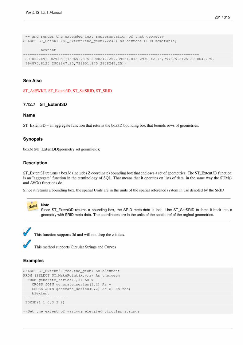
PostGIS 1.5.1 Manual261 / 315
-- and render the extended text representation of that geometrySELECT ST_SetSRID(ST_Extent(the_geom),2249) as bextent FROM sometable;
bextent--------------------------------------------------------------------------------SRID=2249;POLYGON((739651.875 2908247.25,739651.875 2970042.75,794875.8125 2970042.75,794875.8125 2908247.25,739651.875 2908247.25))
See Also
ST_AsEWKT, ST_Extent3D, ST_SetSRID, ST_SRID
7.12.7 ST_Extent3D
Name
ST_Extent3D – an aggregate function that returns the box3D bounding box that bounds rows of geometries.
Synopsis
box3d ST_Extent3D(geometry set geomfield);
Description
ST_Extent3D returns a box3d (includes Z coordinate) bounding box that encloses a set of geometries. The ST_Extent3D functionis an "aggregate" function in the terminology of SQL. That means that it operates on lists of data, in the same way the SUM()and AVG() functions do.
Since it returns a bounding box, the spatial Units are in the units of the spatial reference system in use denoted by the SRID
NoteSince ST_Extent3D returns a bounding box, the SRID meta-data is lost. Use ST_SetSRID to force it back into ageometry with SRID meta data. The coordinates are in the units of the spatial ref of the orginal geometries.
This function supports 3d and will not drop the z-index.
This method supports Circular Strings and Curves
Examples
SELECT ST_Extent3D(foo.the_geom) As b3extentFROM (SELECT ST_MakePoint(x,y,z) As the_geomFROM generate_series(1,3) As xCROSS JOIN generate_series(1,2) As yCROSS JOIN generate_series(0,2) As Z) As foo;b3extent
--------------------BOX3D(1 1 0,3 2 2)
--Get the extent of various elevated circular strings
PostGIS 1.5.1 Manual262 / 315
SELECT ST_Extent3D(foo.the_geom) As b3extentFROM (SELECT ST_Translate(ST_Force_3DZ(ST_LineToCurve(ST_Buffer(ST_MakePoint(x,y),1))),0,0, ←↩
z) As the_geomFROM generate_series(1,3) As xCROSS JOIN generate_series(1,2) As yCROSS JOIN generate_series(0,2) As Z) As foo;
b3extent--------------------BOX3D(1 0 0,4 2 2)
See Also
ST_Extent, ST_Force_3DZ
7.12.8 Find_SRID
Name
Find_SRID – The syntax is find_srid(<db/schema>, <table>, <column>) and the function returns the integer SRID of the specifiedcolumn by searching through the GEOMETRY_COLUMNS table.
Synopsis
integer Find_SRID(varchar a_schema_name, varchar a_table_name, varchar a_geomfield_name);
Description
The syntax is find_srid(<db/schema>, <table>, <column>) and the function returns the integer SRID of the specified column bysearching through the GEOMETRY_COLUMNS table. If the geometry column has not been properly added with the AddGe-ometryColumns() function, this function will not work either.
Examples
SELECT Find_SRID(’public’, ’tiger_us_state_2007’, ’the_geom_4269’);find_srid----------4269
See Also
ST_SRID
7.12.9 ST_Mem_Size
Name
ST_Mem_Size – Returns the amount of space (in bytes) the geometry takes.
PostGIS 1.5.1 Manual263 / 315
Synopsis
integer ST_Mem_Size(geometry geomA);
Description
Returns the amount of space (in bytes) the geometry takes.
This is a nice compliment to PostgreSQL built in functions pg_size_pretty, pg_relation_size, pg_total_relation_size.
Notepg_relation_size which gives the byte size of a table may return byte size lower than ST_Mem_Size. This is becausepg_relation_size does not add toasted table contribution and large geometries are stored in TOAST tables.pg_total_relation_size - includes, the table, the toasted tables, and the indexes.
This function supports 3d and will not drop the z-index.
This method supports Circular Strings and Curves
Examples
--Return how much byte space Boston takes up in our Mass data setSELECT pg_size_pretty(SUM(ST_Mem_Size(the_geom))) as totgeomsum,pg_size_pretty(SUM(CASE WHEN town = ’BOSTON’ THEN st_mem_size(the_geom) ELSE 0 END)) As ←↩
bossum,CAST(SUM(CASE WHEN town = ’BOSTON’ THEN st_mem_size(the_geom) ELSE 0 END)*1.00 /
SUM(st_mem_size(the_geom))*100 As numeric(10,2)) As perbosFROM towns;
totgeomsum bossum perbos---------- ------ ------1522 kB 30 kB 1.99
SELECT ST_Mem_Size(ST_GeomFromText(’CIRCULARSTRING(220268 150415,220227 150505,220227 ←↩150406)’));
---73
--What percentage of our table is taken up by just the geometrySELECT pg_total_relation_size(’public.neighborhoods’) As fulltable_size, sum(ST_Mem_Size( ←↩
the_geom)) As geomsize,sum(ST_Mem_Size(the_geom))*1.00/pg_total_relation_size(’public.neighborhoods’)*100 As ←↩
pergeomFROM neighborhoods;fulltable_size geomsize pergeom------------------------------------------------262144 96238 36.71188354492187500000
PostGIS 1.5.1 Manual264 / 315
See Also
7.12.10 ST_Point_Inside_Circle
Name
ST_Point_Inside_Circle – Is the point geometry insert circle defined by center_x, center_y , radius
Synopsis
boolean ST_Point_Inside_Circle(geometry a_point, float center_x, float center_y, float radius);
Description
The syntax for this functions is point_inside_circle(<geometry>,<circle_center_x>,<circle_center_y>,<radius>). Returns thetrue if the geometry is a point and is inside the circle. Returns false otherwise.
Note This only works for points as the name suggests
Examples
SELECT ST_Point_Inside_Circle(ST_Point(1,2), 0.5, 2, 3);st_point_inside_circle
------------------------t
See Also
ST_DWithin
7.12.11 ST_XMax
Name
ST_XMax – Returns X maxima of a bounding box 2d or 3d or a geometry.
Synopsis
float ST_XMax(box3d aGeomorBox2DorBox3D);
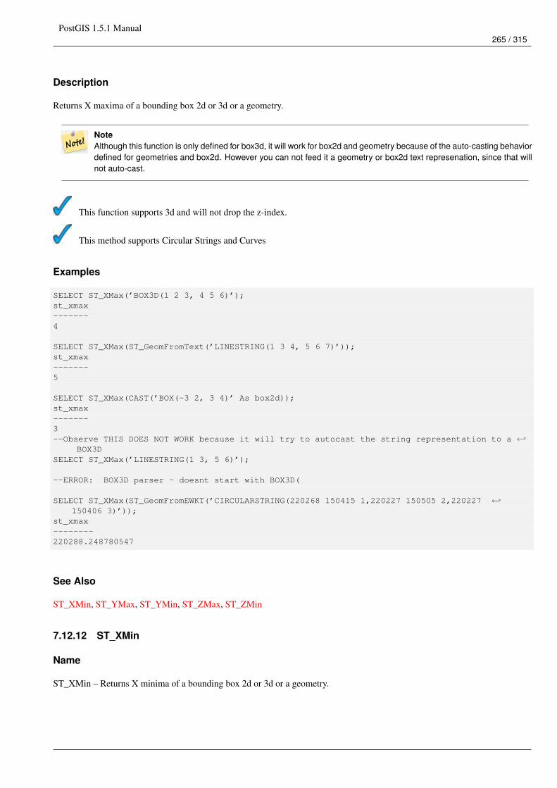
PostGIS 1.5.1 Manual265 / 315
Description
Returns X maxima of a bounding box 2d or 3d or a geometry.
NoteAlthough this function is only defined for box3d, it will work for box2d and geometry because of the auto-casting behaviordefined for geometries and box2d. However you can not feed it a geometry or box2d text represenation, since that willnot auto-cast.
This function supports 3d and will not drop the z-index.
This method supports Circular Strings and Curves
Examples
SELECT ST_XMax(’BOX3D(1 2 3, 4 5 6)’);st_xmax-------4
SELECT ST_XMax(ST_GeomFromText(’LINESTRING(1 3 4, 5 6 7)’));st_xmax-------5
SELECT ST_XMax(CAST(’BOX(-3 2, 3 4)’ As box2d));st_xmax-------3--Observe THIS DOES NOT WORK because it will try to autocast the string representation to a ←↩
BOX3DSELECT ST_XMax(’LINESTRING(1 3, 5 6)’);
--ERROR: BOX3D parser - doesnt start with BOX3D(
SELECT ST_XMax(ST_GeomFromEWKT(’CIRCULARSTRING(220268 150415 1,220227 150505 2,220227 ←↩150406 3)’));
st_xmax--------220288.248780547
See Also
ST_XMin, ST_YMax, ST_YMin, ST_ZMax, ST_ZMin
7.12.12 ST_XMin
Name
ST_XMin – Returns X minima of a bounding box 2d or 3d or a geometry.

PostGIS 1.5.1 Manual266 / 315
Synopsis
float ST_XMin(box3d aGeomorBox2DorBox3D);
Description
Returns X minima of a bounding box 2d or 3d or a geometry.
NoteAlthough this function is only defined for box3d, it will work for box2d and geometry because of the auto-casting behaviordefined for geometries and box2d. However you can not feed it a geometry or box2d text represenation, since that willnot auto-cast.
This function supports 3d and will not drop the z-index.
This method supports Circular Strings and Curves
Examples
SELECT ST_XMin(’BOX3D(1 2 3, 4 5 6)’);st_xmin-------1
SELECT ST_XMin(ST_GeomFromText(’LINESTRING(1 3 4, 5 6 7)’));st_xmin-------1
SELECT ST_XMin(CAST(’BOX(-3 2, 3 4)’ As box2d));st_xmin--------3--Observe THIS DOES NOT WORK because it will try to autocast the string representation to a ←↩
BOX3DSELECT ST_XMin(’LINESTRING(1 3, 5 6)’);
--ERROR: BOX3D parser - doesnt start with BOX3D(
SELECT ST_XMin(ST_GeomFromEWKT(’CIRCULARSTRING(220268 150415 1,220227 150505 2,220227 ←↩150406 3)’));
st_xmin--------220186.995121892
See Also
ST_XMax, ST_YMax, ST_YMin, ST_ZMax, ST_ZMin
7.12.13 ST_YMax
Name
ST_YMax – Returns Y maxima of a bounding box 2d or 3d or a geometry.
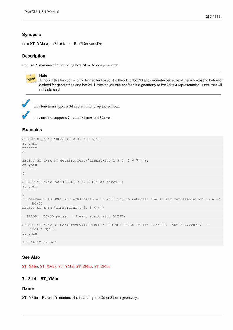
PostGIS 1.5.1 Manual267 / 315
Synopsis
float ST_YMax(box3d aGeomorBox2DorBox3D);
Description
Returns Y maxima of a bounding box 2d or 3d or a geometry.
NoteAlthough this function is only defined for box3d, it will work for box2d and geometry because of the auto-casting behaviordefined for geometries and box2d. However you can not feed it a geometry or box2d text represenation, since that willnot auto-cast.
This function supports 3d and will not drop the z-index.
This method supports Circular Strings and Curves
Examples
SELECT ST_YMax(’BOX3D(1 2 3, 4 5 6)’);st_ymax-------5
SELECT ST_YMax(ST_GeomFromText(’LINESTRING(1 3 4, 5 6 7)’));st_ymax-------6
SELECT ST_YMax(CAST(’BOX(-3 2, 3 4)’ As box2d));st_ymax-------4--Observe THIS DOES NOT WORK because it will try to autocast the string representation to a ←↩
BOX3DSELECT ST_YMax(’LINESTRING(1 3, 5 6)’);
--ERROR: BOX3D parser - doesnt start with BOX3D(
SELECT ST_YMax(ST_GeomFromEWKT(’CIRCULARSTRING(220268 150415 1,220227 150505 2,220227 ←↩150406 3)’));
st_ymax--------150506.126829327
See Also
ST_XMin, ST_XMax, ST_YMin, ST_ZMax, ST_ZMin
7.12.14 ST_YMin
Name
ST_YMin – Returns Y minima of a bounding box 2d or 3d or a geometry.

PostGIS 1.5.1 Manual268 / 315
Synopsis
float ST_YMin(box3d aGeomorBox2DorBox3D);
Description
Returns Y minima of a bounding box 2d or 3d or a geometry.
NoteAlthough this function is only defined for box3d, it will work for box2d and geometry because of the auto-casting behaviordefined for geometries and box2d. However you can not feed it a geometry or box2d text represenation, since that willnot auto-cast.
This function supports 3d and will not drop the z-index.
This method supports Circular Strings and Curves
Examples
SELECT ST_YMin(’BOX3D(1 2 3, 4 5 6)’);st_ymin-------2
SELECT ST_YMin(ST_GeomFromText(’LINESTRING(1 3 4, 5 6 7)’));st_ymin-------3
SELECT ST_YMin(CAST(’BOX(-3 2, 3 4)’ As box2d));st_ymin-------2--Observe THIS DOES NOT WORK because it will try to autocast the string representation to a ←↩
BOX3DSELECT ST_YMin(’LINESTRING(1 3, 5 6)’);
--ERROR: BOX3D parser - doesnt start with BOX3D(
SELECT ST_YMin(ST_GeomFromEWKT(’CIRCULARSTRING(220268 150415 1,220227 150505 2,220227 ←↩150406 3)’));
st_ymin--------150406
See Also
ST_GeomFromEWKT, ST_XMin, ST_XMax, ST_YMax, ST_ZMax, ST_ZMin
7.12.15 ST_ZMax
Name
ST_ZMax – Returns Z minima of a bounding box 2d or 3d or a geometry.
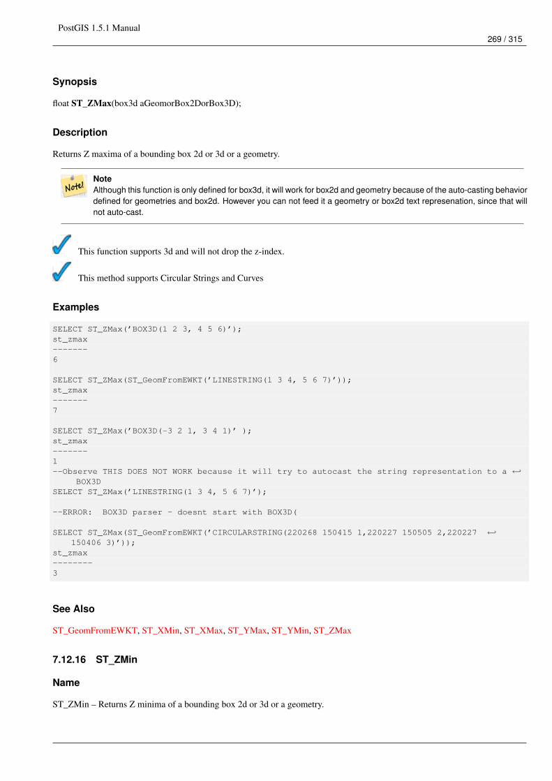
PostGIS 1.5.1 Manual269 / 315
Synopsis
float ST_ZMax(box3d aGeomorBox2DorBox3D);
Description
Returns Z maxima of a bounding box 2d or 3d or a geometry.
NoteAlthough this function is only defined for box3d, it will work for box2d and geometry because of the auto-casting behaviordefined for geometries and box2d. However you can not feed it a geometry or box2d text represenation, since that willnot auto-cast.
This function supports 3d and will not drop the z-index.
This method supports Circular Strings and Curves
Examples
SELECT ST_ZMax(’BOX3D(1 2 3, 4 5 6)’);st_zmax-------6
SELECT ST_ZMax(ST_GeomFromEWKT(’LINESTRING(1 3 4, 5 6 7)’));st_zmax-------7
SELECT ST_ZMax(’BOX3D(-3 2 1, 3 4 1)’ );st_zmax-------1--Observe THIS DOES NOT WORK because it will try to autocast the string representation to a ←↩
BOX3DSELECT ST_ZMax(’LINESTRING(1 3 4, 5 6 7)’);
--ERROR: BOX3D parser - doesnt start with BOX3D(
SELECT ST_ZMax(ST_GeomFromEWKT(’CIRCULARSTRING(220268 150415 1,220227 150505 2,220227 ←↩150406 3)’));
st_zmax--------3
See Also
ST_GeomFromEWKT, ST_XMin, ST_XMax, ST_YMax, ST_YMin, ST_ZMax
7.12.16 ST_ZMin
Name
ST_ZMin – Returns Z minima of a bounding box 2d or 3d or a geometry.
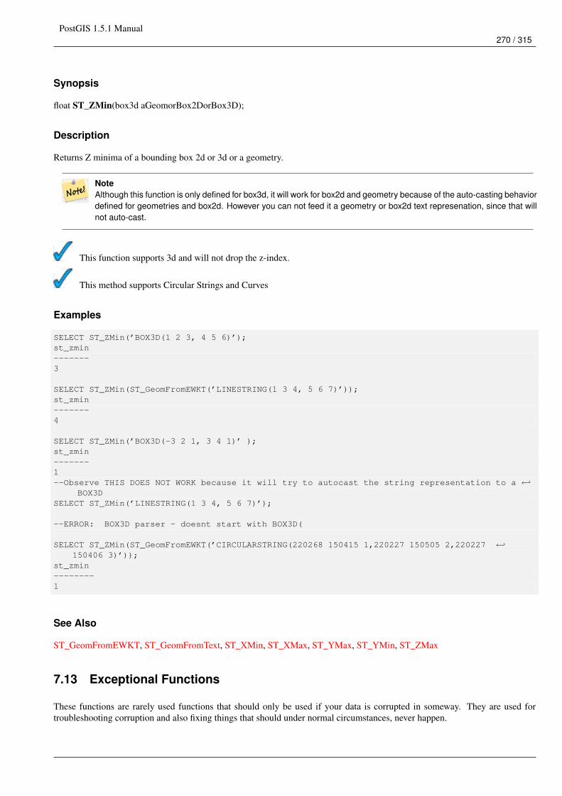
PostGIS 1.5.1 Manual270 / 315
Synopsis
float ST_ZMin(box3d aGeomorBox2DorBox3D);
Description
Returns Z minima of a bounding box 2d or 3d or a geometry.
NoteAlthough this function is only defined for box3d, it will work for box2d and geometry because of the auto-casting behaviordefined for geometries and box2d. However you can not feed it a geometry or box2d text represenation, since that willnot auto-cast.
This function supports 3d and will not drop the z-index.
This method supports Circular Strings and Curves
Examples
SELECT ST_ZMin(’BOX3D(1 2 3, 4 5 6)’);st_zmin-------3
SELECT ST_ZMin(ST_GeomFromEWKT(’LINESTRING(1 3 4, 5 6 7)’));st_zmin-------4
SELECT ST_ZMin(’BOX3D(-3 2 1, 3 4 1)’ );st_zmin-------1--Observe THIS DOES NOT WORK because it will try to autocast the string representation to a ←↩
BOX3DSELECT ST_ZMin(’LINESTRING(1 3 4, 5 6 7)’);
--ERROR: BOX3D parser - doesnt start with BOX3D(
SELECT ST_ZMin(ST_GeomFromEWKT(’CIRCULARSTRING(220268 150415 1,220227 150505 2,220227 ←↩150406 3)’));
st_zmin--------1
See Also
ST_GeomFromEWKT, ST_GeomFromText, ST_XMin, ST_XMax, ST_YMax, ST_YMin, ST_ZMax
7.13 Exceptional Functions
These functions are rarely used functions that should only be used if your data is corrupted in someway. They are used fortroubleshooting corruption and also fixing things that should under normal circumstances, never happen.
PostGIS 1.5.1 Manual271 / 315
7.13.1 PostGIS_AddBBox
Name
PostGIS_AddBBox – Add bounding box to the geometry.
Synopsis
geometry PostGIS_AddBBox(geometry geomA);
Description
Add bounding box to the geometry. This would make bounding box based queries faster, but will increase the size of thegeometry.
NoteBounding boxes are automatically added to geometries so in general this is not needed unless the generated boundingbox somehow becomes corrupted or you have an old install that is lacking bounding boxes. Then you need to drop theold and readd.
This method supports Circular Strings and Curves
Examples
UPDATE sometableSET the_geom = PostGIS_AddBBox(the_geom)WHERE PostGIS_HasBBox(the_geom) = false;
See Also
PostGIS_DropBBox, PostGIS_HasBBox
7.13.2 PostGIS_DropBBox
Name
PostGIS_DropBBox – Drop the bounding box cache from the geometry.
Synopsis
geometry PostGIS_DropBBox(geometry geomA);
PostGIS 1.5.1 Manual272 / 315
Description
Drop the bounding box cache from the geometry. This reduces geometry size, but makes bounding-box based queries slower. Itis also used to drop a corrupt bounding box. A tale-tell sign of a corrupt cached bounding box is when your ST_Intersects andother relation queries leave out geometries that rightfully should return true.
NoteBounding boxes are automatically added to geometries and improve speed of queries so in general this is not neededunless the generated bounding box somehow becomes corrupted or you have an old install that is lacking boundingboxes. Then you need to drop the old and readd. This kind of corruption has been observed in 8.3-8.3.6 series wherebycached bboxes were not always recalculated when a geometry changed and upgrading to a newer version without adump reload will not correct already corrupted boxes. So one can manually correct using below and readd the bbox ordo a dump reload.
This method supports Circular Strings and Curves
Examples
--This example drops bounding boxes where the cached box is not correct--The force to ST_AsBinary before applying Box2D forces a recalculation of the box, ←↩
and Box2D applied to the table geometry always-- returns the cached bounding box.UPDATE sometable
SET the_geom = PostGIS_DropBBox(the_geom)WHERE Not (Box2D(ST_AsBinary(the_geom)) = Box2D(the_geom));
UPDATE sometableSET the_geom = PostGIS_AddBBox(the_geom)WHERE Not PostGIS_HasBBOX(the_geom);
See Also
PostGIS_AddBBox, PostGIS_HasBBox, Box2D
7.13.3 PostGIS_HasBBox
Name
PostGIS_HasBBox – Returns TRUE if the bbox of this geometry is cached, FALSE otherwise.
Synopsis
boolean PostGIS_HasBBox(geometry geomA);
Description
Returns TRUE if the bbox of this geometry is cached, FALSE otherwise. Use PostGIS_AddBBox and PostGIS_DropBBox tocontrol caching.
This method supports Circular Strings and Curves

PostGIS 1.5.1 Manual273 / 315
Examples
SELECT the_geomFROM sometable WHERE PostGIS_HasBBox(the_geom) = false;
See Also
PostGIS_AddBBox, PostGIS_DropBBox
PostGIS 1.5.1 Manual274 / 315
Chapter 8
PostGIS Special Functions Index
8.1 PostGIS Aggregate Functions
The functions given below are spatial aggregate functions provided with PostGIS that can be used just like any other sql aggregatefunction such as sum, average.
• ST_Accum - Aggregate. Constructs an array of geometries.
• ST_Collect - Return a specified ST_Geometry value from a collection of other geometries.
• ST_Extent - an aggregate function that returns the bounding box that bounds rows of geometries.
• ST_Extent3D - an aggregate function that returns the box3D bounding box that bounds rows of geometries.
• ST_MakeLine - Creates a Linestring from point geometries.
• ST_MemUnion - Same as ST_Union, only memory-friendly (uses less memory and more processor time).
• ST_Polygonize - Aggregate. Creates a GeometryCollection containing possible polygons formed from the constituent lineworkof a set of geometries.
• ST_Union - Returns a geometry that represents the point set union of the Geometries.
8.2 PostGIS SQL-MM Compliant Functions
The functions given below are PostGIS functions that conform to the SQL/MM 3 standard
NoteSQL-MM defines the default SRID of all geometry constructors as 0. PostGIS uses a default SRID of -1.
• ST_Area - Returns the area of the surface if it is a polygon or multi-polygon. For "geometry" type area is in SRID units. For"geography" area is in square meters. This method implements the SQL/MM specification. SQL-MM 3: 8.1.2, 9.5.3
• ST_AsBinary - Return the Well-Known Binary (WKB) representation of the geometry/geography without SRID meta data.This method implements the SQL/MM specification. SQL-MM 3: 5.1.37
• ST_AsText - Return the Well-Known Text (WKT) representation of the geometry/geography without SRID metadata. Thismethod implements the SQL/MM specification. SQL-MM 3: 5.1.25
PostGIS 1.5.1 Manual275 / 315
• ST_Boundary - Returns the closure of the combinatorial boundary of this Geometry. This method implements the SQL/MMspecification. SQL-MM 3: 5.1.14
• ST_Buffer - (T) For geometry: Returns a geometry that represents all points whose distance from this Geometry is less thanor equal to distance. Calculations are in the Spatial Reference System of this Geometry. For geography: Uses a planartransform wrapper. Introduced in 1.5 support for different end cap and mitre settings to control shape. buffer_style options:quad_segs=#,endcap=round|flat|square,join=round|mitre|bevel,mitre_limit=#.# This method implements the SQL/MM specifi-cation. SQL-MM 3: 5.1.17
• ST_Centroid - Returns the geometric center of a geometry. This method implements the SQL/MM specification. SQL-MM 3:8.1.4, 9.5.5
• ST_Contains - Returns true if and only if no points of B lie in the exterior of A, and at least one point of the interior of B liesin the interior of A. This method implements the SQL/MM specification. SQL-MM 3: 5.1.31
• ST_ConvexHull - The convex hull of a geometry represents the minimum convex geometry that encloses all geometries withinthe set. This method implements the SQL/MM specification. SQL-MM 3: 5.1.16
• ST_CoordDim - Return the coordinate dimension of the ST_Geometry value. This method implements the SQL/MM specifi-cation. SQL-MM 3: 5.1.3
• ST_Crosses - Returns TRUE if the supplied geometries have some, but not all, interior points in common. This methodimplements the SQL/MM specification. SQL-MM 3: 5.1.29
• ST_CurveToLine - Converts a CIRCULARSTRING/CURVEDPOLYGON to a LINESTRING/POLYGON This method im-plements the SQL/MM specification. SQL-MM 3: 7.1.7
• ST_Difference - Returns a geometry that represents that part of geometry A that does not intersect with geometry B. Thismethod implements the SQL/MM specification. SQL-MM 3: 5.1.20
• ST_Dimension - The inherent dimension of this Geometry object, which must be less than or equal to the coordinate dimension.This method implements the SQL/MM specification. SQL-MM 3: 5.1.2
• ST_Disjoint - Returns TRUE if the Geometries do not "spatially intersect" - if they do not share any space together. Thismethod implements the SQL/MM specification. SQL-MM 3: 5.1.26
• ST_Distance - For geometry type Returns the 2-dimensional cartesian minimum distance (based on spatial ref) between twogeometries in projected units. For geography type defaults to return spheroidal minimum distance between two geographies inmeters. This method implements the SQL/MM specification. SQL-MM 3: 5.1.23
• ST_EndPoint - Returns the last point of a LINESTRING geometry as a POINT. This method implements the SQL/MM speci-fication. SQL-MM 3: 7.1.4
• ST_Envelope - Returns a geometry representing the double precision (float8) bounding box of the supplied geometry. Thismethod implements the SQL/MM specification. SQL-MM 3: 5.1.15
• ST_Equals - Returns true if the given geometries represent the same geometry. Directionality is ignored. This method imple-ments the SQL/MM specification. SQL-MM 3: 5.1.24
• ST_ExteriorRing - Returns a line string representing the exterior ring of the POLYGON geometry. Return NULL if thegeometry is not a polygon. Will not work with MULTIPOLYGON This method implements the SQL/MM specification. SQL-MM 3: 8.2.3, 8.3.3
• ST_GMLToSQL - Return a specified ST_Geometry value from GML representation. This is an alias name for ST_GeomFromGMLThis method implements the SQL/MM specification. SQL-MM 3: 5.1.50 (except for curves support).
• ST_GeomCollFromText - Makes a collection Geometry from collection WKT with the given SRID. If SRID is not give, itdefaults to -1. This method implements the SQL/MM specification.
• ST_GeomFromText - Return a specified ST_Geometry value from Well-Known Text representation (WKT). This methodimplements the SQL/MM specification. SQL-MM 3: 5.1.40
• ST_GeomFromWKB - Creates a geometry instance from a Well-Known Binary geometry representation (WKB) and optionalSRID. This method implements the SQL/MM specification. SQL-MM 3: 5.1.41
PostGIS 1.5.1 Manual276 / 315
• ST_GeometryFromText - Return a specified ST_Geometry value from Well-Known Text representation (WKT). This is analias name for ST_GeomFromText This method implements the SQL/MM specification. SQL-MM 3: 5.1.40
• ST_GeometryN - Return the 1-based Nth geometry if the geometry is a GEOMETRYCOLLECTION, MULTIPOINT, MUL-TILINESTRING, MULTICURVE or MULTIPOLYGON. Otherwise, return NULL. This method implements the SQL/MMspecification. SQL-MM 3: 9.1.5
• ST_GeometryType - Return the geometry type of the ST_Geometry value. This method implements the SQL/MM specifica-tion. SQL-MM 3: 5.1.4
• ST_InteriorRingN - Return the Nth interior linestring ring of the polygon geometry. Return NULL if the geometry is not apolygon or the given N is out of range. This method implements the SQL/MM specification. SQL-MM 3: 8.2.6, 8.3.5
• ST_Intersection - (T) Returns a geometry that represents the shared portion of geomA and geomB. The geography implemen-tation does a transform to geometry to do the intersection and then transform back to WGS84. This method implements theSQL/MM specification. SQL-MM 3: 5.1.18
• ST_Intersects - Returns TRUE if the Geometries/Geography "spatially intersect" - (share any portion of space) and FALSE ifthey don’t (they are Disjoint). For geography -- tolerance is 0.00001 meters (so any points that close are considered to intersect)This method implements the SQL/MM specification. SQL-MM 3: 5.1.27
• ST_IsClosed - Returns TRUE if the LINESTRING’s start and end points are coincident. This method implements the SQL/MMspecification. SQL-MM 3: 7.1.5, 9.3.3
• ST_IsEmpty - Returns true if this Geometry is an empty geometry . If true, then this Geometry represents the empty point set- i.e. GEOMETRYCOLLECTION(EMPTY). This method implements the SQL/MM specification. SQL-MM 3: 5.1.7
• ST_IsRing - Returns TRUE if this LINESTRING is both closed and simple. This method implements the SQL/MM specifica-tion. SQL-MM 3: 7.1.6
• ST_IsSimple - Returns (TRUE) if this Geometry has no anomalous geometric points, such as self intersection or self tangency.This method implements the SQL/MM specification. SQL-MM 3: 5.1.8
• ST_IsValid - Returns true if the ST_Geometry is well formed. This method implements the SQL/MM specification. SQL-MM3: 5.1.9
• ST_Length - Returns the 2d length of the geometry if it is a linestring or multilinestring. geometry are in units of spatialreference and geography are in meters (default spheroid) This method implements the SQL/MM specification. SQL-MM 3:7.1.2, 9.3.4
• ST_LineFromText - Makes a Geometry from WKT representation with the given SRID. If SRID is not given, it defaults to -1.This method implements the SQL/MM specification. SQL-MM 3: 7.2.8
• ST_LineFromWKB - Makes a LINESTRING from WKB with the given SRID This method implements the SQL/MM speci-fication. SQL-MM 3: 7.2.9
• ST_LinestringFromWKB - Makes a geometry from WKB with the given SRID. This method implements the SQL/MM speci-fication. SQL-MM 3: 7.2.9
• ST_M - Return the M coordinate of the point, or NULL if not available. Input must be a point. This method implements theSQL/MM specification.
• ST_MLineFromText - Return a specified ST_MultiLineString value from WKT representation. This method implements theSQL/MM specification.SQL-MM 3: 9.4.4
• ST_MPointFromText - Makes a Geometry from WKT with the given SRID. If SRID is not give, it defaults to -1. This methodimplements the SQL/MM specification. SQL-MM 3: 9.2.4
• ST_MPolyFromText - Makes a MultiPolygon Geometry from WKT with the given SRID. If SRID is not give, it defaults to -1.This method implements the SQL/MM specification. SQL-MM 3: 9.6.4
• ST_NumGeometries - If geometry is a GEOMETRYCOLLECTION (or MULTI*) return the number of geometries, otherwisereturn NULL. This method implements the SQL/MM specification. SQL-MM 3: 9.1.4
PostGIS 1.5.1 Manual277 / 315
• ST_NumInteriorRing - Return the number of interior rings of the first polygon in the geometry. Synonym to ST_NumInteriorRings.This method implements the SQL/MM specification. SQL-MM 3: 8.2.5
• ST_NumInteriorRings - Return the number of interior rings of the first polygon in the geometry. This will work with bothPOLYGON and MULTIPOLYGON types but only looks at the first polygon. Return NULL if there is no polygon in thegeometry. This method implements the SQL/MM specification. SQL-MM 3: 8.2.5
• ST_NumPoints - Return the number of points in an ST_LineString or ST_CircularString value. This method implements theSQL/MM specification. SQL-MM 3: 7.2.4
• ST_OrderingEquals - Returns true if the given geometries represent the same geometry and points are in the same directionalorder. This method implements the SQL/MM specification. SQL-MM 3: 5.1.43
• ST_Overlaps - Returns TRUE if the Geometries share space, are of the same dimension, but are not completely contained byeach other. This method implements the SQL/MM specification. SQL-MM 3: 5.1.32
• ST_Perimeter - Return the length measurement of the boundary of an ST_Surface or ST_MultiSurface value. (Polygon,Multipolygon) This method implements the SQL/MM specification. SQL-MM 3: 8.1.3, 9.5.4
• ST_Point - Returns an ST_Point with the given coordinate values. OGC alias for ST_MakePoint. This method implements theSQL/MM specification. SQL-MM 3: 6.1.2
• ST_PointFromText - Makes a point Geometry from WKT with the given SRID. If SRID is not given, it defaults to unknown.This method implements the SQL/MM specification. SQL-MM 3: 6.1.8
• ST_PointFromWKB - Makes a geometry from WKB with the given SRID This method implements the SQL/MM specification.SQL-MM 3: 6.1.9
• ST_PointN - Return the Nth point in the first linestring or circular linestring in the geometry. Return NULL if there is nolinestring in the geometry. This method implements the SQL/MM specification. SQL-MM 3: 7.2.5, 7.3.5
• ST_PointOnSurface - Returns a POINT guaranteed to lie on the surface. This method implements the SQL/MM specifica-tion. SQL-MM 3: 8.1.5, 9.5.6. According to the specs, ST_PointOnSurface works for surface geometries (POLYGONs,MULTIPOLYGONS, CURVED POLYGONS). So PostGIS seems to be extending what the spec allows here. Most databasesOracle,DB II, ESRI SDE seem to only support this function for surfaces. SQL Server 2008 like PostGIS supports for allcommon geometries.
• ST_Polygon - Returns a polygon built from the specified linestring and SRID. This method implements the SQL/MM specifi-cation. SQL-MM 3: 8.3.2
• ST_PolygonFromText - Makes a Geometry from WKT with the given SRID. If SRID is not give, it defaults to -1. This methodimplements the SQL/MM specification. SQL-MM 3: 8.3.6
• ST_Relate - Returns true if this Geometry is spatially related to anotherGeometry, by testing for intersections between theInterior, Boundary and Exterior of the two geometries as specified by the values in the intersectionMatrixPattern. If no in-tersectionMatrixPattern is passed in, then returns the maximum intersectionMatrixPattern that relates the 2 geometries. Thismethod implements the SQL/MM specification. SQL-MM 3: 5.1.25
• ST_SRID - Returns the spatial reference identifier for the ST_Geometry as defined in spatial_ref_sys table. This methodimplements the SQL/MM specification. SQL-MM 3: 5.1.5
• ST_StartPoint - Returns the first point of a LINESTRING geometry as a POINT. This method implements the SQL/MMspecification. SQL-MM 3: 7.1.3
• ST_SymDifference - Returns a geometry that represents the portions of A and B that do not intersect. It is called a symmetricdifference because ST_SymDifference(A,B) = ST_SymDifference(B,A). This method implements the SQL/MM specification.SQL-MM 3: 5.1.21
• ST_Touches - Returns TRUE if the geometries have at least one point in common, but their interiors do not intersect. Thismethod implements the SQL/MM specification. SQL-MM 3: 5.1.28
• ST_Transform - Returns a new geometry with its coordinates transformed to the SRID referenced by the integer parameter.This method implements the SQL/MM specification. SQL-MM 3: 5.1.6
PostGIS 1.5.1 Manual278 / 315
• ST_Union - Returns a geometry that represents the point set union of the Geometries. This method implements the SQL/MMspecification. SQL-MM 3: 5.1.19 the z-index (elevation) when polygons are involved.
• ST_WKBToSQL - Return a specified ST_Geometry value from Well-Known Binary representation (WKB). This is an aliasname for ST_GeomFromWKB that takes no srid This method implements the SQL/MM specification. SQL-MM 3: 5.1.36
• ST_WKTToSQL - Return a specified ST_Geometry value from Well-Known Text representation (WKT). This is an alias namefor ST_GeomFromText This method implements the SQL/MM specification. SQL-MM 3: 5.1.34
• ST_Within - Returns true if the geometry A is completely inside geometry B This method implements the SQL/MM specifica-tion. SQL-MM 3: 5.1.30
• ST_X - Return the X coordinate of the point, or NULL if not available. Input must be a point. This method implements theSQL/MM specification. SQL-MM 3: 6.1.3
• ST_Y - Return the Y coordinate of the point, or NULL if not available. Input must be a point. This method implements theSQL/MM specification. SQL-MM 3: 6.1.4
• ST_Z - Return the Z coordinate of the point, or NULL if not available. Input must be a point. This method implements theSQL/MM specification.
8.3 PostGIS Geography Support Functions
The functions and operators given below are PostGIS functions/operators that take as input or return as output a geography datatype object.
NoteFunctions with a (T) are not native geodetic functions, and use a ST_Transform call to and from geometry to do theoperation. As a result, they may not behave as expected when going over dateline, poles, and for large geometries orgeometry pairs that cover more than one UTM zone. Basic tranform - (favoring UTM, Lambert Azimuthal (North/South),and falling back on mercator in worst case scenario)
• ST_Area - Returns the area of the surface if it is a polygon or multi-polygon. For "geometry" type area is in SRID units. For"geography" area is in square meters.
• ST_AsBinary - Return the Well-Known Binary (WKB) representation of the geometry/geography without SRID meta data.
• ST_AsGML - Return the geometry as a GML version 2 or 3 element.
• ST_AsGeoJSON - Return the geometry as a GeoJSON element.
• ST_AsKML - Return the geometry as a KML element. Several variants. Default version=2, default precision=15
• ST_AsSVG - Returns a Geometry in SVG path data given a geometry or geography object.
• ST_AsText - Return the Well-Known Text (WKT) representation of the geometry/geography without SRID metadata.
• ST_Buffer - (T) For geometry: Returns a geometry that represents all points whose distance from this Geometry is less thanor equal to distance. Calculations are in the Spatial Reference System of this Geometry. For geography: Uses a planartransform wrapper. Introduced in 1.5 support for different end cap and mitre settings to control shape. buffer_style options:quad_segs=#,endcap=round|flat|square,join=round|mitre|bevel,mitre_limit=#.#
• ST_CoveredBy - Returns 1 (TRUE) if no point in Geometry/Geography A is outside Geometry/Geography B
• ST_Covers - Returns 1 (TRUE) if no point in Geometry B is outside Geometry A
• ST_DWithin - Returns true if the geometries are within the specified distance of one another. For geometry units are in thoseof spatial reference and For geography units are in meters and measurement is defaulted to use_spheroid=true (measure aroundspheroid), for faster check, use_spheroid=false to measure along sphere.
PostGIS 1.5.1 Manual279 / 315
• ST_Distance - For geometry type Returns the 2-dimensional cartesian minimum distance (based on spatial ref) between twogeometries in projected units. For geography type defaults to return spheroidal minimum distance between two geographies inmeters.
• ST_GeogFromText - Return a specified geography value from Well-Known Text representation or extended (WKT).
• ST_GeogFromWKB - Creates a geography instance from a Well-Known Binary geometry representation (WKB) or extendedWell Known Binary (EWKB).
• ST_GeographyFromText - Return a specified geography value from Well-Known Text representation or extended (WKT).
• = - Returns TRUE if A’s bounding box is the same as B’s.
• && - Returns TRUE if A’s bounding box overlaps B’s.
• ~= - Returns TRUE if A’s bounding box is the same as B’s.
• ST_Intersection - (T) Returns a geometry that represents the shared portion of geomA and geomB. The geography implemen-tation does a transform to geometry to do the intersection and then transform back to WGS84.
• ST_Intersects - Returns TRUE if the Geometries/Geography "spatially intersect" - (share any portion of space) and FALSE ifthey don’t (they are Disjoint). For geography -- tolerance is 0.00001 meters (so any points that close are considered to intersect)
• ST_Length - Returns the 2d length of the geometry if it is a linestring or multilinestring. geometry are in units of spatialreference and geography are in meters (default spheroid)
8.4 PostGIS Geometry Dump Functions
The functions given below are PostGIS functions that take as input or return as output a set of or single geometry_dump datatype object.
• ST_Dump - Returns a set of geometry_dump (geom,path) rows, that make up a geometry g1.
• ST_DumpPoints - Returns a set of geometry_dump (geom,path) rows of all points that make up a geometry.
• ST_DumpRings - Returns a set of geometry_dump rows, representing the exterior and interior rings of a polygon.
8.5 PostGIS Box Functions
The functions given below are PostGIS functions that take as input or return as output the box* family of PostGIS spatial types.The box family of types consists of box2d, box3d, box3d_extent
• Box2D - Returns a BOX2D representing the maximum extents of the geometry.
• Box3D - Returns a BOX3D representing the maximum extents of the geometry.
• ST_Estimated_Extent - Return the ’estimated’ extent of the given spatial table. The estimated is taken from the geometrycolumn’s statistics. The current schema will be used if not specified.
• ST_Expand - Returns bounding box expanded in all directions from the bounding box of the input geometry. Uses double-precision
• ST_Extent - an aggregate function that returns the bounding box that bounds rows of geometries.
• ST_Extent3D - an aggregate function that returns the box3D bounding box that bounds rows of geometries.
• ST_MakeBox2D - Creates a BOX2D defined by the given point geometries.
• ST_MakeBox3D - Creates a BOX3D defined by the given 3d point geometries.
PostGIS 1.5.1 Manual280 / 315
• ST_XMax - Returns X maxima of a bounding box 2d or 3d or a geometry.
• ST_XMin - Returns X minima of a bounding box 2d or 3d or a geometry.
• ST_YMax - Returns Y maxima of a bounding box 2d or 3d or a geometry.
• ST_YMin - Returns Y minima of a bounding box 2d or 3d or a geometry.
• ST_ZMax - Returns Z minima of a bounding box 2d or 3d or a geometry.
• ST_ZMin - Returns Z minima of a bounding box 2d or 3d or a geometry.
8.6 PostGIS Functions that support 3D
The functions given below are PostGIS functions that do not throw away the Z-Index.
• AddGeometryColumn - Adds a geometry column to an existing table of attributes.
• Box3D - Returns a BOX3D representing the maximum extents of the geometry.
• DropGeometryColumn - Removes a geometry column from a spatial table.
• ST_Accum - Aggregate. Constructs an array of geometries.
• ST_AddMeasure - Return a derived geometry with measure elements linearly interpolated between the start and end points. Ifthe geometry has no measure dimension, one is added. If the geometry has a measure dimension, it is over-written with newvalues. Only LINESTRINGS and MULTILINESTRINGS are supported.
• ST_AddPoint - Adds a point to a LineString before point <position> (0-based index).
• ST_Affine - Applies a 3d affine transformation to the geometry to do things like translate, rotate, scale in one step.
• ST_AsEWKB - Return the Well-Known Binary (WKB) representation of the geometry with SRID meta data.
• ST_AsEWKT - Return the Well-Known Text (WKT) representation of the geometry with SRID meta data.
• ST_AsGML - Return the geometry as a GML version 2 or 3 element.
• ST_AsGeoJSON - Return the geometry as a GeoJSON element.
• ST_AsHEXEWKB - Returns a Geometry in HEXEWKB format (as text) using either little-endian (NDR) or big-endian (XDR)encoding.
• ST_AsKML - Return the geometry as a KML element. Several variants. Default version=2, default precision=15
• ST_Boundary - Returns the closure of the combinatorial boundary of this Geometry.
• ST_Collect - Return a specified ST_Geometry value from a collection of other geometries.
• ST_ConvexHull - The convex hull of a geometry represents the minimum convex geometry that encloses all geometries withinthe set.
• ST_CoordDim - Return the coordinate dimension of the ST_Geometry value.
• ST_CurveToLine - Converts a CIRCULARSTRING/CURVEDPOLYGON to a LINESTRING/POLYGON
• ST_Difference - Returns a geometry that represents that part of geometry A that does not intersect with geometry B.
• ST_Dump - Returns a set of geometry_dump (geom,path) rows, that make up a geometry g1.
• ST_DumpPoints - Returns a set of geometry_dump (geom,path) rows of all points that make up a geometry.
• ST_DumpRings - Returns a set of geometry_dump rows, representing the exterior and interior rings of a polygon.
• ST_EndPoint - Returns the last point of a LINESTRING geometry as a POINT.
PostGIS 1.5.1 Manual281 / 315
• ST_Extent3D - an aggregate function that returns the box3D bounding box that bounds rows of geometries.
• ST_ExteriorRing - Returns a line string representing the exterior ring of the POLYGON geometry. Return NULL if thegeometry is not a polygon. Will not work with MULTIPOLYGON
• ST_ForceRHR - Forces the orientation of the vertices in a polygon to follow the Right-Hand-Rule.
• ST_Force_3D - Forces the geometries into XYZ mode. This is an alias for ST_Force_3DZ.
• ST_Force_3DZ - Forces the geometries into XYZ mode. This is a synonym for ST_Force_3D.
• ST_Force_4D - Forces the geometries into XYZM mode.
• ST_Force_Collection - Converts the geometry into a GEOMETRYCOLLECTION.
• ST_GeomFromEWKB - Return a specified ST_Geometry value from Extended Well-Known Binary representation (EWKB).
• ST_GeomFromEWKT - Return a specified ST_Geometry value from Extended Well-Known Text representation (EWKT).
• ST_GeomFromGML - Takes as input GML representation of geometry and outputs a PostGIS geometry object
• ST_GeomFromKML - Takes as input KML representation of geometry and outputs a PostGIS geometry object
• ST_GeometryN - Return the 1-based Nth geometry if the geometry is a GEOMETRYCOLLECTION, MULTIPOINT, MUL-TILINESTRING, MULTICURVE or MULTIPOLYGON. Otherwise, return NULL.
• ST_HasArc - Returns true if a geometry or geometry collection contains a circular string
• ST_InteriorRingN - Return the Nth interior linestring ring of the polygon geometry. Return NULL if the geometry is not apolygon or the given N is out of range.
• ST_IsClosed - Returns TRUE if the LINESTRING’s start and end points are coincident.
• ST_IsSimple - Returns (TRUE) if this Geometry has no anomalous geometric points, such as self intersection or self tangency.
• ST_Length3D - Returns the 3-dimensional or 2-dimensional length of the geometry if it is a linestring or multi-linestring.
• ST_Length3D_Spheroid - Calculates the length of a geometry on an ellipsoid, taking the elevation into account. This is just analias for ST_Length_Spheroid.
• ST_Length_Spheroid - Calculates the 2D or 3D length of a linestring/multilinestring on an ellipsoid. This is useful if thecoordinates of the geometry are in longitude/latitude and a length is desired without reprojection.
• ST_LineFromMultiPoint - Creates a LineString from a MultiPoint geometry.
• ST_LineToCurve - Converts a LINESTRING/POLYGON to a CIRCULARSTRING, CURVED POLYGON
• ST_Line_Interpolate_Point - Returns a point interpolated along a line. Second argument is a float8 between 0 and 1 represent-ing fraction of total length of linestring the point has to be located.
• ST_Line_Substring - Return a linestring being a substring of the input one starting and ending at the given fractions of total 2dlength. Second and third arguments are float8 values between 0 and 1.
• ST_LocateBetweenElevations - Return a derived geometry (collection) value with elements that intersect the specified rangeof elevations inclusively. Only 3D, 4D LINESTRINGS and MULTILINESTRINGS are supported.
• ST_M - Return the M coordinate of the point, or NULL if not available. Input must be a point.
• ST_MakeBox3D - Creates a BOX3D defined by the given 3d point geometries.
• ST_MakeLine - Creates a Linestring from point geometries.
• ST_MakePoint - Creates a 2D,3DZ or 4D point geometry.
• ST_MakePolygon - Creates a Polygon formed by the given shell. Input geometries must be closed LINESTRINGS.
• ST_MemUnion - Same as ST_Union, only memory-friendly (uses less memory and more processor time).
PostGIS 1.5.1 Manual282 / 315
• ST_Mem_Size - Returns the amount of space (in bytes) the geometry takes.
• ST_NDims - Returns coordinate dimension of the geometry as a small int. Values are: 2,3 or 4.
• ST_NPoints - Return the number of points (vertexes) in a geometry.
• ST_NRings - If the geometry is a polygon or multi-polygon returns the number of rings.
• ST_Perimeter3D - Returns the 3-dimensional perimeter of the geometry, if it is a polygon or multi-polygon.
• ST_PointFromWKB - Makes a geometry from WKB with the given SRID
• ST_PointN - Return the Nth point in the first linestring or circular linestring in the geometry. Return NULL if there is nolinestring in the geometry.
• ST_PointOnSurface - Returns a POINT guaranteed to lie on the surface.
• ST_Polygon - Returns a polygon built from the specified linestring and SRID.
• ST_RemovePoint - Removes point from a linestring. Offset is 0-based.
• ST_Rotate - This is a synonym for ST_RotateZ
• ST_RotateX - Rotate a geometry rotRadians about the X axis.
• ST_RotateY - Rotate a geometry rotRadians about the Y axis.
• ST_RotateZ - Rotate a geometry rotRadians about the Z axis.
• ST_Scale - Scales the geometry to a new size by multiplying the ordinates with the parameters. Ie: ST_Scale(geom, Xfactor,Yfactor, Zfactor).
• ST_SetPoint - Replace point N of linestring with given point. Index is 0-based.
• ST_Shift_Longitude - Reads every point/vertex in every component of every feature in a geometry, and if the longitude coor-dinate is <0, adds 360 to it. The result would be a 0-360 version of the data to be plotted in a 180 centric map
• ST_SnapToGrid - Snap all points of the input geometry to the grid defined by its origin and cell size. Remove consecutivepoints falling on the same cell, eventually returning NULL if output points are not enough to define a geometry of the giventype. Collapsed geometries in a collection are stripped from it. Useful for reducing precision.
• ST_StartPoint - Returns the first point of a LINESTRING geometry as a POINT.
• ST_Summary - Returns a text summary of the contents of the ST_Geometry.
• ST_SymDifference - Returns a geometry that represents the portions of A and B that do not intersect. It is called a symmetricdifference because ST_SymDifference(A,B) = ST_SymDifference(B,A).
• ST_TransScale - Translates the geometry using the deltaX and deltaY args, then scales it using the XFactor, YFactor args,working in 2D only.
• ST_Translate - Translates the geometry to a new location using the numeric parameters as offsets. Ie: ST_Translate(geom, X,Y) or ST_Translate(geom, X, Y,Z).
• ST_X - Return the X coordinate of the point, or NULL if not available. Input must be a point.
• ST_XMax - Returns X maxima of a bounding box 2d or 3d or a geometry.
• ST_XMin - Returns X minima of a bounding box 2d or 3d or a geometry.
• ST_Y - Return the Y coordinate of the point, or NULL if not available. Input must be a point.
• ST_YMax - Returns Y maxima of a bounding box 2d or 3d or a geometry.
• ST_YMin - Returns Y minima of a bounding box 2d or 3d or a geometry.
• ST_Z - Return the Z coordinate of the point, or NULL if not available. Input must be a point.
PostGIS 1.5.1 Manual283 / 315
• ST_ZMax - Returns Z minima of a bounding box 2d or 3d or a geometry.
• ST_ZMin - Returns Z minima of a bounding box 2d or 3d or a geometry.
• ST_Zmflag - Returns ZM (dimension semantic) flag of the geometries as a small int. Values are: 0=2d, 1=3dm, 2=3dz, 3=4d.
• UpdateGeometrySRID - Updates the SRID of all features in a geometry column, geometry_columns metadata and srid tableconstraint
8.7 PostGIS Curved Geometry Support Functions
The functions given below are PostGIS functions that can use CIRCULARSTRING, CURVEDPOLYGON, and other curvedgeometry types
• AddGeometryColumn - Adds a geometry column to an existing table of attributes.
• Box2D - Returns a BOX2D representing the maximum extents of the geometry.
• Box3D - Returns a BOX3D representing the maximum extents of the geometry.
• DropGeometryColumn - Removes a geometry column from a spatial table.
• GeometryType - Returns the type of the geometry as a string. Eg: ’LINESTRING’, ’POLYGON’, ’MULTIPOINT’, etc.
• PostGIS_AddBBox - Add bounding box to the geometry.
• PostGIS_DropBBox - Drop the bounding box cache from the geometry.
• PostGIS_HasBBox - Returns TRUE if the bbox of this geometry is cached, FALSE otherwise.
• ST_Accum - Aggregate. Constructs an array of geometries.
• ST_Affine - Applies a 3d affine transformation to the geometry to do things like translate, rotate, scale in one step.
• ST_AsBinary - Return the Well-Known Binary (WKB) representation of the geometry/geography without SRID meta data.
• ST_AsEWKB - Return the Well-Known Binary (WKB) representation of the geometry with SRID meta data.
• ST_AsEWKT - Return the Well-Known Text (WKT) representation of the geometry with SRID meta data.
• ST_AsHEXEWKB - Returns a Geometry in HEXEWKB format (as text) using either little-endian (NDR) or big-endian (XDR)encoding.
• ST_AsText - Return the Well-Known Text (WKT) representation of the geometry/geography without SRID metadata.
• ST_Collect - Return a specified ST_Geometry value from a collection of other geometries.
• ST_CoordDim - Return the coordinate dimension of the ST_Geometry value.
• ST_CurveToLine - Converts a CIRCULARSTRING/CURVEDPOLYGON to a LINESTRING/POLYGON
• ST_Dump - Returns a set of geometry_dump (geom,path) rows, that make up a geometry g1.
• ST_DumpPoints - Returns a set of geometry_dump (geom,path) rows of all points that make up a geometry.
• ST_Estimated_Extent - Return the ’estimated’ extent of the given spatial table. The estimated is taken from the geometrycolumn’s statistics. The current schema will be used if not specified.
• ST_Extent3D - an aggregate function that returns the box3D bounding box that bounds rows of geometries.
• ST_Force_2D - Forces the geometries into a "2-dimensional mode" so that all output representations will only have the X andY coordinates.
• ST_Force_3D - Forces the geometries into XYZ mode. This is an alias for ST_Force_3DZ.
PostGIS 1.5.1 Manual284 / 315
• ST_Force_3DM - Forces the geometries into XYM mode.
• ST_Force_3DZ - Forces the geometries into XYZ mode. This is a synonym for ST_Force_3D.
• ST_Force_4D - Forces the geometries into XYZM mode.
• ST_Force_Collection - Converts the geometry into a GEOMETRYCOLLECTION.
• ST_GeoHash - Return a GeoHash representation (geohash.org) of the geometry.
• ST_GeogFromWKB - Creates a geography instance from a Well-Known Binary geometry representation (WKB) or extendedWell Known Binary (EWKB).
• ST_GeomFromEWKB - Return a specified ST_Geometry value from Extended Well-Known Binary representation (EWKB).
• ST_GeomFromEWKT - Return a specified ST_Geometry value from Extended Well-Known Text representation (EWKT).
• ST_GeomFromText - Return a specified ST_Geometry value from Well-Known Text representation (WKT).
• ST_GeomFromWKB - Creates a geometry instance from a Well-Known Binary geometry representation (WKB) and optionalSRID.
• ST_GeometryN - Return the 1-based Nth geometry if the geometry is a GEOMETRYCOLLECTION, MULTIPOINT, MUL-TILINESTRING, MULTICURVE or MULTIPOLYGON. Otherwise, return NULL.
• = - Returns TRUE if A’s bounding box is the same as B’s.
• &<| - Returns TRUE if A’s bounding box overlaps or is below B’s.
• && - Returns TRUE if A’s bounding box overlaps B’s.
• ST_HasArc - Returns true if a geometry or geometry collection contains a circular string
• ST_IsClosed - Returns TRUE if the LINESTRING’s start and end points are coincident.
• ST_IsEmpty - Returns true if this Geometry is an empty geometry . If true, then this Geometry represents the empty point set- i.e. GEOMETRYCOLLECTION(EMPTY).
• ST_LineToCurve - Converts a LINESTRING/POLYGON to a CIRCULARSTRING, CURVED POLYGON
• ST_Mem_Size - Returns the amount of space (in bytes) the geometry takes.
• ST_NPoints - Return the number of points (vertexes) in a geometry.
• ST_NRings - If the geometry is a polygon or multi-polygon returns the number of rings.
• ST_PointFromWKB - Makes a geometry from WKB with the given SRID
• ST_PointN - Return the Nth point in the first linestring or circular linestring in the geometry. Return NULL if there is nolinestring in the geometry.
• ST_Rotate - This is a synonym for ST_RotateZ
• ST_RotateZ - Rotate a geometry rotRadians about the Z axis.
• ST_SRID - Returns the spatial reference identifier for the ST_Geometry as defined in spatial_ref_sys table.
• ST_Scale - Scales the geometry to a new size by multiplying the ordinates with the parameters. Ie: ST_Scale(geom, Xfactor,Yfactor, Zfactor).
• ST_SetSRID - Sets the SRID on a geometry to a particular integer value.
• ST_TransScale - Translates the geometry using the deltaX and deltaY args, then scales it using the XFactor, YFactor args,working in 2D only.
• ST_Transform - Returns a new geometry with its coordinates transformed to the SRID referenced by the integer parameter.

PostGIS 1.5.1 Manual285 / 315
• ST_Translate - Translates the geometry to a new location using the numeric parameters as offsets. Ie: ST_Translate(geom, X,Y) or ST_Translate(geom, X, Y,Z).
• ST_XMax - Returns X maxima of a bounding box 2d or 3d or a geometry.
• ST_XMin - Returns X minima of a bounding box 2d or 3d or a geometry.
• ST_YMax - Returns Y maxima of a bounding box 2d or 3d or a geometry.
• ST_YMin - Returns Y minima of a bounding box 2d or 3d or a geometry.
• ST_ZMax - Returns Z minima of a bounding box 2d or 3d or a geometry.
• ST_ZMin - Returns Z minima of a bounding box 2d or 3d or a geometry.
• ST_Zmflag - Returns ZM (dimension semantic) flag of the geometries as a small int. Values are: 0=2d, 1=3dm, 2=3dz, 3=4d.
• UpdateGeometrySRID - Updates the SRID of all features in a geometry column, geometry_columns metadata and srid tableconstraint
8.8 PostGIS Function Support Matrix
Below is an alphabetical listing of spatial specific functions in PostGIS and the kinds of spatial types they work with or OGC/SQLcompliance they try to conform to.
• A means the function works with the type or subtype natively.
• A means it works but with a transform cast built-in using cast to geometry, transform to a "best srid" spatial ref andthen cast back. Results may not be as expected for large areas or areas at poles and may accumulate floating point junk.
• A means the function works with the type because of a auto-cast to another such as to box3d rather than direct typesupport.
Function geometry geography 3D (2.5D) Curves SQL MMBox2D
Box3D
Find_SRID
GeometryType
ST_Accum
ST_AddMeasure
ST_AddPoint
ST_Affine
ST_Area
ST_AsBinary
ST_AsEWKB
ST_AsEWKT
ST_AsGML

PostGIS 1.5.1 Manual286 / 315
Function geometry geography 3D (2.5D) Curves SQL MMST_AsGeoJSON
ST_AsHEXEWKB
ST_AsKML
ST_AsSVG
ST_AsText
ST_Azimuth
ST_BdMPolyFromText
ST_BdPolyFromText
ST_Boundary
ST_Buffer
ST_BuildArea
ST_Centroid
ST_ClosestPoint
ST_Collect
ST_CollectionExtract
ST_Contains
ST_ContainsProperly
ST_ConvexHull
ST_CoordDim
ST_CoveredBy
ST_Covers
ST_Crosses
ST_CurveToLine
ST_DFullyWithin
ST_DWithin
ST_Difference
ST_Dimension
ST_Disjoint
ST_Distance
ST_Distance_Sphere
ST_Distance_Spheroid
ST_Dump
ST_DumpPoints
ST_DumpRings

PostGIS 1.5.1 Manual287 / 315
Function geometry geography 3D (2.5D) Curves SQL MMST_EndPoint
ST_Envelope
ST_Equals
ST_Estimated_Extent
ST_Expand
ST_Extent
ST_Extent3D
ST_ExteriorRing
ST_ForceRHR
ST_Force_2D
ST_Force_3D
ST_Force_3DM
ST_Force_3DZ
ST_Force_4D
ST_Force_Collection
ST_GMLToSQL
ST_GeoHash
ST_GeogFromText
ST_GeogFromWKB
ST_GeographyFromText
ST_GeomCollFromText
ST_GeomFromEWKB
ST_GeomFromEWKT
ST_GeomFromGML
ST_GeomFromKML
ST_GeomFromText
ST_GeomFromWKB
ST_GeometryFromText
ST_GeometryN
ST_GeometryType
|»
«|
~
@

PostGIS 1.5.1 Manual288 / 315
Function geometry geography 3D (2.5D) Curves SQL MM=
«
|&>
&<|
&&
&<
&>
»
~=
ST_HasArc
ST_HausdorffDistance
ST_InteriorRingN
ST_Intersection
ST_Intersects
ST_IsClosed
ST_IsEmpty
ST_IsRing
ST_IsSimple
ST_IsValid
ST_IsValidReason
ST_Length
ST_Length2D
ST_Length2D_Spheroid
ST_Length3D
ST_Length3D_Spheroid
ST_Length_Spheroid
ST_LineCrossingDirection
ST_LineFromMultiPoint
ST_LineFromText
ST_LineFromWKB
ST_LineMerge
ST_LineToCurve
ST_Line_Interpolate_Point
ST_Line_Locate_Point

PostGIS 1.5.1 Manual289 / 315
Function geometry geography 3D (2.5D) Curves SQL MMST_Line_Substring
ST_LinestringFromWKB
ST_LocateBetweenElevations
ST_Locate_Along_Measure
ST_Locate_Between_Measures
ST_LongestLine
ST_M
ST_MLineFromText
ST_MPointFromText
ST_MPolyFromText
ST_MakeBox2D
ST_MakeBox3D
ST_MakeEnvelope
ST_MakeLine
ST_MakePoint
ST_MakePointM
ST_MakePolygon
ST_MaxDistance
ST_MemUnion
ST_Mem_Size
ST_MinimumBoundingCircle
ST_Multi
ST_NDims
ST_NPoints
ST_NRings
ST_NumGeometries
ST_NumInteriorRing
ST_NumInteriorRings
ST_NumPoints
ST_OrderingEquals
ST_Overlaps
ST_Perimeter
ST_Perimeter2D
ST_Perimeter3D

PostGIS 1.5.1 Manual290 / 315
Function geometry geography 3D (2.5D) Curves SQL MMST_Point
ST_PointFromText
ST_PointFromWKB
ST_PointN
ST_PointOnSurface
ST_Point_Inside_Circle
ST_Polygon
ST_PolygonFromText
ST_Polygonize
ST_Relate
ST_RemovePoint
ST_Reverse
ST_Rotate
ST_RotateX
ST_RotateY
ST_RotateZ
ST_SRID
ST_Scale
ST_Segmentize
ST_SetPoint
ST_SetSRID
ST_Shift_Longitude
ST_ShortestLine
ST_Simplify
ST_SimplifyPreserveTopology
ST_SnapToGrid
ST_StartPoint
ST_Summary
ST_SymDifference
ST_Touches
ST_TransScale
ST_Transform
ST_Translate
ST_Union
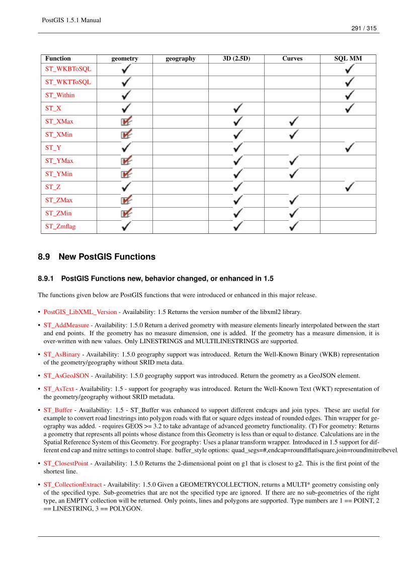
PostGIS 1.5.1 Manual291 / 315
Function geometry geography 3D (2.5D) Curves SQL MMST_WKBToSQL
ST_WKTToSQL
ST_Within
ST_X
ST_XMax
ST_XMin
ST_Y
ST_YMax
ST_YMin
ST_Z
ST_ZMax
ST_ZMin
ST_Zmflag
8.9 New PostGIS Functions
8.9.1 PostGIS Functions new, behavior changed, or enhanced in 1.5
The functions given below are PostGIS functions that were introduced or enhanced in this major release.
• PostGIS_LibXML_Version - Availability: 1.5 Returns the version number of the libxml2 library.
• ST_AddMeasure - Availability: 1.5.0 Return a derived geometry with measure elements linearly interpolated between the startand end points. If the geometry has no measure dimension, one is added. If the geometry has a measure dimension, it isover-written with new values. Only LINESTRINGS and MULTILINESTRINGS are supported.
• ST_AsBinary - Availability: 1.5.0 geography support was introduced. Return the Well-Known Binary (WKB) representationof the geometry/geography without SRID meta data.
• ST_AsGeoJSON - Availability: 1.5.0 geography support was introduced. Return the geometry as a GeoJSON element.
• ST_AsText - Availability: 1.5 - support for geography was introduced. Return the Well-Known Text (WKT) representation ofthe geometry/geography without SRID metadata.
• ST_Buffer - Availability: 1.5 - ST_Buffer was enhanced to support different endcaps and join types. These are useful forexample to convert road linestrings into polygon roads with flat or square edges instead of rounded edges. Thin wrapper for ge-ography was added. - requires GEOS >= 3.2 to take advantage of advanced geometry functionality. (T) For geometry: Returnsa geometry that represents all points whose distance from this Geometry is less than or equal to distance. Calculations are in theSpatial Reference System of this Geometry. For geography: Uses a planar transform wrapper. Introduced in 1.5 support for dif-ferent end cap and mitre settings to control shape. buffer_style options: quad_segs=#,endcap=round|flat|square,join=round|mitre|bevel,mitre_limit=#.#
• ST_ClosestPoint - Availability: 1.5.0 Returns the 2-dimensional point on g1 that is closest to g2. This is the first point of theshortest line.
• ST_CollectionExtract - Availability: 1.5.0 Given a GEOMETRYCOLLECTION, returns a MULTI* geometry consisting onlyof the specified type. Sub-geometries that are not the specified type are ignored. If there are no sub-geometries of the righttype, an EMPTY collection will be returned. Only points, lines and polygons are supported. Type numbers are 1 == POINT, 2== LINESTRING, 3 == POLYGON.
PostGIS 1.5.1 Manual292 / 315
• ST_Covers - Availability: 1.5 - support for geography was introduced. Returns 1 (TRUE) if no point in Geometry B is outsideGeometry A
• ST_DFullyWithin - Availability: 1.5.0 Returns true if all of the geometries are within the specified distance of one another
• ST_DWithin - Availability: 1.5.0 support for geography was introduced Returns true if the geometries are within the specifieddistance of one another. For geometry units are in those of spatial reference and For geography units are in meters andmeasurement is defaulted to use_spheroid=true (measure around spheroid), for faster check, use_spheroid=false to measurealong sphere.
• ST_Distance - Availability: 1.5.0 geography support was introduced in 1.5. Speed improvements for planar to better handlelarge or many vertex geometries For geometry type Returns the 2-dimensional cartesian minimum distance (based on spatialref) between two geometries in projected units. For geography type defaults to return spheroidal minimum distance betweentwo geographies in meters.
• ST_Distance_Sphere - Availability: 1.5 - support for other geometry types besides points was introduced. Prior versions onlywork with points. Returns minimum distance in meters between two lon/lat geometries. Uses a spherical earth and radius of6370986 meters. Faster than ST_Distance_Spheroid, but less accurate. PostGIS versions prior to 1.5 only implemented forpoints.
• ST_Distance_Spheroid - Availability: 1.5 - support for other geometry types besides points was introduced. Prior versionsonly work with points. Returns the minimum distance between two lon/lat geometries given a particular spheroid. PostGISversions prior to 1.5 only support points.
• ST_DumpPoints - Availability: 1.5.0 Returns a set of geometry_dump (geom,path) rows of all points that make up a geometry.
• ST_Envelope - Availability: 1.5.0 behavior changed to output double precision instead of float4 Returns a geometry represent-ing the double precision (float8) bounding box of the supplied geometry.
• ST_GMLToSQL - Availability: 1.5 Return a specified ST_Geometry value from GML representation. This is an alias namefor ST_GeomFromGML
• ST_GeomFromGML - Availability: 1.5 Takes as input GML representation of geometry and outputs a PostGIS geometryobject
• ST_GeomFromKML - Availability: 1.5 Takes as input KML representation of geometry and outputs a PostGIS geometryobject
• && - Availability: 1.5.0 support for geography was introduced. Returns TRUE if A’s bounding box overlaps B’s.
• ~= - Availability: 1.5.0 changed behavior Returns TRUE if A’s bounding box is the same as B’s.
• ST_HausdorffDistance - Availability: 1.5.0 - requires GEOS >= 3.2.0 Returns the Hausdorff distance between two geometries.Basically a measure of how similar or dissimilar 2 geometries are. Units are in the units of the spatial reference system of thegeometries.
• ST_Intersection - Availability: 1.5 support for geography data type was introduced. (T) Returns a geometry that represents theshared portion of geomA and geomB. The geography implementation does a transform to geometry to do the intersection andthen transform back to WGS84.
• ST_Intersects - Availability: 1.5 support for geography was introduced. Returns TRUE if the Geometries/Geography "spatiallyintersect" - (share any portion of space) and FALSE if they don’t (they are Disjoint). For geography -- tolerance is 0.00001meters (so any points that close are considered to intersect)
• ST_Length - Availability: 1.5.0 geography support was introduced in 1.5. Returns the 2d length of the geometry if it is alinestring or multilinestring. geometry are in units of spatial reference and geography are in meters (default spheroid)
• ST_LongestLine - Availability: 1.5.0 Returns the 2-dimensional longest line points of two geometries. The function will onlyreturn the first longest line if more than one, that the function finds. The line returned will always start in g1 and end in g2.The length of the line this function returns will always be the same as st_maxdistance returns for g1 and g2.
• ST_MakeEnvelope - Availability: 1.5 Creates a rectangular Polygon formed from the given minimums and maximums. Inputvalues must be in SRS specified by the SRID.
PostGIS 1.5.1 Manual293 / 315
• ST_MaxDistance - Availability: 1.5.0 Returns the 2-dimensional largest distance between two geometries in projected units.
• ST_ShortestLine - Availability: 1.5.0 Returns the 2-dimensional shortest line between two geometries
8.9.2 PostGIS Functions new, behavior changed, or enhanced in 1.4
The functions given below are PostGIS functions that were introduced or enhanced in the 1.4 release.
• Populate_Geometry_Columns - Ensures geometry columns have appropriate spatial constraints and exist in the geometry_columnstable. Availability: 1.4.0
• ST_AsSVG - Returns a Geometry in SVG path data given a geometry or geography object. Availability: 1.2.2 . Availability:1.4.0 Changed in PostGIS 1.4.0 to include L command in absolute path to conform to http://www.w3.org/TR/SVG/paths.html#PathDataBNF
• ST_Collect - Return a specified ST_Geometry value from a collection of other geometries. Availability: 1.4.0 - ST_Collect(geomarray)was introduced. ST_Collect was enhanced to handle more geometries faster.
• ST_ContainsProperly - Returns true if B intersects the interior of A but not the boundary (or exterior). A does not containproperly itself, but does contain itself. Availability: 1.4.0 - requires GEOS >= 3.1.0.
• ST_Extent - an aggregate function that returns the bounding box that bounds rows of geometries. Availability: 1.4.0 As of1.4.0 now returns a box3d_extent instead of box2d object.
• ST_GeoHash - Return a GeoHash representation (geohash.org) of the geometry. Availability: 1.4.0
• ST_IsValidReason - Returns text stating if a geometry is valid or not and if not valid, a reason why. Availability: 1.4 - requiresGEOS >= 3.1.0.
• ST_LineCrossingDirection - Given 2 linestrings, returns a number between -3 and 3 denoting what kind of crossing behavior.0 is no crossing. Availability: 1.4
• ST_LocateBetweenElevations - Return a derived geometry (collection) value with elements that intersect the specified rangeof elevations inclusively. Only 3D, 4D LINESTRINGS and MULTILINESTRINGS are supported. Availability: 1.4.0
• ST_MakeLine - Creates a Linestring from point geometries. Availability: 1.4.0 - ST_MakeLine(geomarray) was introduced.ST_MakeLine aggregate functions was enhanced to handle more points faster.
• ST_MinimumBoundingCircle - Returns the smallest circle polygon that can fully contain a geometry. Default uses 48 segmentsper quarter circle. Availability: 1.4.0 - requires GEOS
• ST_Union - Returns a geometry that represents the point set union of the Geometries. Availability: 1.4.0 - ST_Union wasenhanced. ST_Union(geomarray) was introduced and also faster aggregate collection in PostgreSQL. If you are using GEOS3.1.0+ ST_Union will use the faster Cascaded Union algorithm described in http://blog.cleverelephant.ca/2009/01/must-faster-unions-in-postgis-14.html
8.9.3 PostGIS Functions new in 1.3
The functions given below are PostGIS functions that were introduced in the 1.3 release.
• ST_AsGeoJSON - Return the geometry as a GeoJSON element. Availability: 1.3.4
• ST_SimplifyPreserveTopology - Returns a "simplified" version of the given geometry using the Douglas-Peuker algorithm.Will avoid creating derived geometries (polygons in particular) that are invalid. Availability: 1.3.3

PostGIS 1.5.1 Manual294 / 315
Chapter 9
Reporting Problems
9.1 Reporting Software Bugs
Reporting bugs effectively is a fundamental way to help PostGIS development. The most effective bug report is that enablingPostGIS developers to reproduce it, so it would ideally contain a script triggering it and every information regarding the envi-ronment in which it was detected. Good enough info can be extracted running SELECT postgis_full_version() [forpostgis] and SELECT version() [for postgresql].
If you aren’t using the latest release, it’s worth taking a look at its release changelog first, to find out if your bug has already beenfixed.
Using the PostGIS bug tracker will ensure your reports are not discarded, and will keep you informed on its handling process.Before reporting a new bug please query the database to see if it is a known one, and if it is please add any new information youhave about it.
You might want to read Simon Tatham’s paper about How to Report Bugs Effectively before filing a new report.
9.2 Reporting Documentation Issues
The documentation should accurately reflect the features and behavior of the software. If it doesn’t, it could be because of asoftware bug or because the documentation is in error or deficient.
Documentation issues can also be reported to the PostGIS bug tracker.
If your revision is trivial, just describe it in a new bug tracker issue, being specific about its location in the documentation.
If your changes are more extensive, a Subversion patch is definitely preferred. This is a four step process on Unix (assuming youalready have Subversion installed):
1. Check out a copy of PostGIS’ Subversion trunk. On Unix, type:
svn checkout http://svn.osgeo.org/postgis/trunk/This will be stored in the directory ./trunk
2. Make your changes to the documentation with your favorite text editor. On Unix, type (for example):
vim trunk/doc/postgis.xmlNote that the documentation is written in SGML rather than HTML, so if you are not familiar with it please follow theexample of the rest of the documentation.
3. Make a patch file containing the differences from the master copy of the documentation. On Unix, type:
svn diff trunk/doc/postgis.xml > doc.patch
4. Attach the patch to a new issue in bug tracker.
PostGIS 1.5.1 Manual295 / 315
Appendix A
Appendix
A.1 Release 1.5.1
Release date: 2010/03/11
This is a bug fix release, addressing issues that have been filed since the 1.4.1 release.
A.1.1 Bug Fixes
#410, update embedded bbox when applying ST_SetPoint, ST_AddPoint ST_RemovePoint to a linestring (Paul Ramsey)
#411, allow dumping tables with invalid geometries (Sandro Santilli, for Regione Toscana-SIGTA)
#414, include geography_columns view when running upgrade scripts (Paul Ramsey)
#419, allow support for multilinestring in ST_Line_Substring (Paul Ramsey, for Lidwala Consulting Engineers)
#421, fix computed string length in ST_AsGML() (Olivier Courtin)
#441, fix GML generation with heterogeneous collections (Olivier Courtin)
#443, incorrect coordinate reversal in GML 3 generation (Olivier Courtin)
#450, #451, wrong area calculation for geography features that cross the date line (Paul Ramsey)
Ensure support for upcoming 9.0 PgSQL release (Paul Ramsey)
A.2 Release 1.5.0
Release date: 2010/02/04
This release provides support for geographic coordinates (lat/lon) via a new GEOGRAPHY type. Also performance enhance-ments, new input format support (GML,KML) and general upkeep.
A.2.1 API Stability
The public API of PostGIS will not change during minor (0.0.X) releases.
The definition of the =~ operator has changed from an exact geometric equality check to a bounding box equality check.
PostGIS 1.5.1 Manual296 / 315
A.2.2 Compatibility
GEOS, Proj4, and LibXML2 are now mandatory dependencies
The library versions below are the minimum requirements for PostGIS 1.5
PostgreSQL 8.3 and higher on all platforms
GEOS 3.1 and higher only (GEOS 3.2+ to take advantage of all features)
LibXML2 2.5+ related to new ST_GeomFromGML/KML functionality
Proj4 4.5 and higher only
A.2.3 New Features
Section 8.9.1
Added Hausdorff distance calculations (#209) (Vincent Picavet)
Added parameters argument to ST_Buffer operation to support one-sided buffering and other buffering styles (Sandro Santilli)
Addition of other Distance related visualization and analysis functions (Nicklas Aven)
• ST_ClosestPoint
• ST_DFullyWithin
• ST_LongestLine
• ST_MaxDistance
• ST_ShortestLine
KML, GML input via ST_GeomFromGML and ST_GeomFromKML (Olivier Courtin)
Extract homogeneous collection with ST_CollectionExtract (Paul Ramsey)
Add measure values to an existing linestring with ST_AddMeasure (Paul Ramsey)
History table implementation in utils (George Silva)
Geography type and supporting functions
• Spherical algorithms (Dave Skea)
• Object/index implementation (Paul Ramsey)
• Selectivity implementation (Mark Cave-Ayland)
• Serializations to KML, GML and JSON (Olivier Courtin)
• ST_Area, ST_Distance, ST_DWithin, ST_GeogFromText, ST_GeogFromWKB, ST_Intersects, ST_Covers, ST_Buffer (PaulRamsey)
A.2.4 Enhancements
Performance improvements to ST_Distance (Nicklas Aven)
Documentation updates and improvements (Regina Obe, Kevin Neufeld)
Testing and quality control (Regina Obe)
PostGIS 1.5 support PostgreSQL 8.5 trunk (Guillaume Lelarge)
Win32 support and improvement of core shp2pgsql-gui (Mark Cave-Ayland)
In place ’make check’ support (Paul Ramsey)
PostGIS 1.5.1 Manual297 / 315
A.2.5 Bug fixes
http://trac.osgeo.org/postgis/query?status=closed&milestone=postgis+1.5.0&order=priority
A.3 Release 1.4.0
Release date: 2009/07/24
This release provides performance enhancements, improved internal structures and testing, new features, and upgraded docu-mentation.
A.3.1 API Stability
As of the 1.4 release series, the public API of PostGIS will not change during minor releases.
A.3.2 Compatibility
The versions below are the *minimum* requirements for PostGIS 1.4
PostgreSQL 8.2 and higher on all platforms
GEOS 3.0 and higher only
PROJ4 4.5 and higher only
A.3.3 New Features
ST_Union() uses high-speed cascaded union when compiled against GEOS 3.1+ (Paul Ramsey)
ST_ContainsProperly() requires GEOS 3.1+
ST_Intersects(), ST_Contains(), ST_Within() use high-speed cached prepared geometry against GEOS 3.1+ (Paul Ramsey)
Vastly improved documentation and reference manual (Regina Obe & Kevin Neufeld)
Figures and diagram examples in the reference manual (Kevin Neufeld)
ST_IsValidReason() returns readable explanations for validity failures (Paul Ramsey)
ST_GeoHash() returns a geohash.org signature for geometries (Paul Ramsey)
GTK+ multi-platform GUI for shape file loading (Paul Ramsey)
ST_LineCrossingDirection() returns crossing directions (Paul Ramsey)
ST_LocateBetweenElevations() returns sub-string based on Z-ordinate. (Paul Ramsey)
Geometry parser returns explicit error message about location of syntax errors (Mark Cave-Ayland)
ST_AsGeoJSON() return JSON formatted geometry (Olivier Courtin)
Populate_Geometry_Columns() -- automatically add records to geometry_columns for TABLES and VIEWS (Kevin Neufeld)
ST_MinimumBoundingCircle() -- returns the smallest circle polygon that can encompass a geometry (Bruce Rindahl)
PostGIS 1.5.1 Manual298 / 315
A.3.4 Enhancements
Core geometry system moved into independent library, liblwgeom. (Mark Cave-Ayland)
New build system uses PostgreSQL "pgxs" build bootstrapper. (Mark Cave-Ayland)
Debugging framework formalized and simplified. (Mark Cave-Ayland)
All build-time #defines generated at configure time and placed in headers for easier cross-platform support (Mark Cave-Ayland)
Logging framework formalized and simplified (Mark Cave-Ayland)
Expanded and more stable support for CIRCULARSTRING, COMPOUNDCURVE and CURVEPOLYGON, better parsing,wider support in functions (Mark Leslie & Mark Cave-Ayland)
Improved support for OpenSolaris builds (Paul Ramsey)
Improved support for MSVC builds (Mateusz Loskot)
Updated KML support (Olivier Courtin)
Unit testing framework for liblwgeom (Paul Ramsey)
New testing framework to comprehensively exercise every PostGIS function (Regine Obe)
Performance improvements to all geometry aggregate functions (Paul Ramsey)
Support for the upcoming PostgreSQL 8.4 (Mark Cave-Ayland, Talha Bin Rizwan)
Shp2pgsql and pgsql2shp re-worked to depend on the common parsing/unparsing code in liblwgeom (Mark Cave-Ayland)
Use of PDF DbLatex to build PDF docs and preliminary instructions for build (Jean David Techer)
Automated User documentation build (PDF and HTML) and Developer Doxygen Documentation (Kevin Neufeld)
Automated build of document images using ImageMagick from WKT geometry text files (Kevin Neufeld)
More attractive CSS for HTML documentation (Dane Springmeyer)
A.3.5 Bug fixes
http://trac.osgeo.org/postgis/query?status=closed&milestone=postgis+1.4.0&order=priority
A.4 Release 1.3.6
Release date: 2009/05/04
This release adds support for PostgreSQL 8.4, exporting prj files from the database with shape data, some crash fixes forshp2pgsql, and several small bug fixes in the handling of "curve" types, logical error importing dbf only files, improved er-ror handling of AddGeometryColumns.
A.5 Release 1.3.5
Release date: 2008/12/15
This release is a bug fix release to address a failure in ST_Force_Collection and related functions that critically affects usingMapserver with LINE layers.
PostGIS 1.5.1 Manual299 / 315
A.6 Release 1.3.4
Release date: 2008/11/24
This release adds support for GeoJSON output, building with PostgreSQL 8.4, improves documentation quality and outputaesthetics, adds function-level SQL documentation, and improves performance for some spatial predicates (point-in-polygontests).
Bug fixes include removal of crashers in handling circular strings for many functions, some memory leaks removed, a linearreferencing failure for measures on vertices, and more. See the NEWS file for details.
A.7 Release 1.3.3
Release date: 2008/04/12
This release fixes bugs shp2pgsql, adds enhancements to SVG and KML support, adds a ST_SimplifyPreserveTopology function,makes the build more sensitive to GEOS versions, and fixes a handful of severe but rare failure cases.
A.8 Release 1.3.2
Release date: 2007/12/01
This release fixes bugs in ST_EndPoint() and ST_Envelope, improves support for JDBC building and OS/X, and adds bettersupport for GML output with ST_AsGML(), including GML3 output.
A.9 Release 1.3.1
Release date: 2007/08/13
This release fixes some oversights in the previous release around version numbering, documentation, and tagging.
A.10 Release 1.3.0
Release date: 2007/08/09
This release provides performance enhancements to the relational functions, adds new relational functions and begins the migra-tion of our function names to the SQL-MM convention, using the spatial type (SP) prefix.
A.10.1 Added Functionality
JDBC: Added Hibernate Dialect (thanks to Norman Barker)
Added ST_Covers and ST_CoveredBy relational functions. Description and justification of these functions can be found athttp://lin-ear-th-inking.blogspot.com/2007/06/subtleties-of-ogc-covers-spatial.html
Added ST_DWithin relational function.
A.10.2 Performance Enhancements
Added cached and indexed point-in-polygon short-circuits for the functions ST_Contains, ST_Intersects, ST_Within and ST_Disjoint
Added inline index support for relational functions (except ST_Disjoint)
PostGIS 1.5.1 Manual300 / 315
A.10.3 Other Changes
Extended curved geometry support into the geometry accessor and some processing functions
Began migration of functions to the SQL-MM naming convention; using a spatial type (ST) prefix.
Added initial support for PostgreSQL 8.3
A.11 Release 1.2.1
Release date: 2007/01/11
This release provides bug fixes in PostgreSQL 8.2 support and some small performance enhancements.
A.11.1 Changes
Fixed point-in-polygon shortcut bug in Within().
Fixed PostgreSQL 8.2 NULL handling for indexes.
Updated RPM spec files.
Added short-circuit for Transform() in no-op case.
JDBC: Fixed JTS handling for multi-dimensional geometries (thanks to Thomas Marti for hint and partial patch). Additionally,now JavaDoc is compiled and packaged. Fixed classpath problems with GCJ. Fixed pgjdbc 8.2 compatibility, losing support forjdk 1.3 and older.
A.12 Release 1.2.0
Release date: 2006/12/08
This release provides type definitions along with serialization/deserialization capabilities for SQL-MM defined curved geome-tries, as well as performance enhancements.
A.12.1 Changes
Added curved geometry type support for serialization/deserialization
Added point-in-polygon shortcircuit to the Contains and Within functions to improve performance for these cases.
A.13 Release 1.1.6
Release date: 2006/11/02
This is a bugfix release, in particular fixing a critical error with GEOS interface in 64bit systems. Includes an updated of the SRSparameters and an improvement in reprojections (take Z in consideration). Upgrade is encouraged.
A.13.1 Upgrading
If you are upgrading from release 1.0.3 or later follow the soft upgrade procedure.
If you are upgrading from a release between 1.0.0RC6 and 1.0.2 (inclusive) and really want a live upgrade read the upgradesection of the 1.0.3 release notes chapter.
Upgrade from any release prior to 1.0.0RC6 requires an hard upgrade.
PostGIS 1.5.1 Manual301 / 315
A.13.2 Bug fixes
fixed CAPI change that broke 64-bit platforms
loader/dumper: fixed regression tests and usage output
Fixed setSRID() bug in JDBC, thanks to Thomas Marti
A.13.3 Other changes
use Z ordinate in reprojections
spatial_ref_sys.sql updated to EPSG 6.11.1
Simplified Version.config infrastructure to use a single pack of version variables for everything.
Include the Version.config in loader/dumper USAGE messages
Replace hand-made, fragile JDBC version parser with Properties
A.14 Release 1.1.5
Release date: 2006/10/13
This is an bugfix release, including a critical segfault on win32. Upgrade is encouraged.
A.14.1 Upgrading
If you are upgrading from release 1.0.3 or later follow the soft upgrade procedure.
If you are upgrading from a release between 1.0.0RC6 and 1.0.2 (inclusive) and really want a live upgrade read the upgradesection of the 1.0.3 release notes chapter.
Upgrade from any release prior to 1.0.0RC6 requires an hard upgrade.
A.14.2 Bug fixes
Fixed MingW link error that was causing pgsql2shp to segfault on Win32 when compiled for PostgreSQL 8.2
fixed nullpointer Exception in Geometry.equals() method in Java
Added EJB3Spatial.odt to fulfill the GPL requirement of distributing the "preferred form of modification"
Removed obsolete synchronization from JDBC Jts code.
Updated heavily outdated README files for shp2pgsql/pgsql2shp by merging them with the manpages.
Fixed version tag in jdbc code that still said "1.1.3" in the "1.1.4" release.
A.14.3 New Features
Added -S option for non-multi geometries to shp2pgsql
A.15 Release 1.1.4
Release date: 2006/09/27
This is an bugfix release including some improvements in the Java interface. Upgrade is encouraged.
PostGIS 1.5.1 Manual302 / 315
A.15.1 Upgrading
If you are upgrading from release 1.0.3 or later follow the soft upgrade procedure.
If you are upgrading from a release between 1.0.0RC6 and 1.0.2 (inclusive) and really want a live upgrade read the upgradesection of the 1.0.3 release notes chapter.
Upgrade from any release prior to 1.0.0RC6 requires an hard upgrade.
A.15.2 Bug fixes
Fixed support for PostgreSQL 8.2
Fixed bug in collect() function discarding SRID of input
Added SRID match check in MakeBox2d and MakeBox3d
Fixed regress tests to pass with GEOS-3.0.0
Improved pgsql2shp run concurrency.
A.15.3 Java changes
reworked JTS support to reflect new upstream JTS developers’ attitude to SRID handling. Simplifies code and drops build dependon GNU trove.
Added EJB2 support generously donated by the "Geodetix s.r.l. Company" http://www.geodetix.it/
Added EJB3 tutorial / examples donated by Norman Barker <[email protected]>
Reorganized java directory layout a little.
A.16 Release 1.1.3
Release date: 2006/06/30
This is an bugfix release including also some new functionalities (most notably long transaction support) and portability enhance-ments. Upgrade is encouraged.
A.16.1 Upgrading
If you are upgrading from release 1.0.3 or later follow the soft upgrade procedure.
If you are upgrading from a release between 1.0.0RC6 and 1.0.2 (inclusive) and really want a live upgrade read the upgradesection of the 1.0.3 release notes chapter.
Upgrade from any release prior to 1.0.0RC6 requires an hard upgrade.
A.16.2 Bug fixes / correctness
BUGFIX in distance(poly,poly) giving wrong results.
BUGFIX in pgsql2shp successful return code.
BUGFIX in shp2pgsql handling of MultiLine WKT.
BUGFIX in affine() failing to update bounding box.
WKT parser: forbidden construction of multigeometries with EMPTY elements (still supported for GEOMETRYCOLLEC-TION).
PostGIS 1.5.1 Manual303 / 315
A.16.3 New functionalities
NEW Long Transactions support.
NEW DumpRings() function.
NEW AsHEXEWKB(geom, XDR|NDR) function.
A.16.4 JDBC changes
Improved regression tests: MultiPoint and scientific ordinates
Fixed some minor bugs in jdbc code
Added proper accessor functions for all fields in preparation of making those fields private later
A.16.5 Other changes
NEW regress test support for loader/dumper.
Added --with-proj-libdir and --with-geos-libdir configure switches.
Support for build Tru64 build.
Use Jade for generating documentation.
Don’t link pgsql2shp to more libs then required.
Initial support for PostgreSQL 8.2.
A.17 Release 1.1.2
Release date: 2006/03/30
This is an bugfix release including some new functions and portability enhancements. Upgrade is encouraged.
A.17.1 Upgrading
If you are upgrading from release 1.0.3 or later follow the soft upgrade procedure.
If you are upgrading from a release between 1.0.0RC6 and 1.0.2 (inclusive) and really want a live upgrade read the upgradesection of the 1.0.3 release notes chapter.
Upgrade from any release prior to 1.0.0RC6 requires an hard upgrade.
A.17.2 Bug fixes
BUGFIX in SnapToGrid() computation of output bounding box
BUGFIX in EnforceRHR()
jdbc2 SRID handling fixes in JTS code
Fixed support for 64bit archs
PostGIS 1.5.1 Manual304 / 315
A.17.3 New functionalities
Regress tests can now be run *before* postgis installation
New affine() matrix transformation functions
New rotate{,X,Y,Z}() function
Old translating and scaling functions now use affine() internally
Embedded access control in estimated_extent() for builds against pgsql >= 8.0.0
A.17.4 Other changes
More portable ./configure script
Changed ./run_test script to have more sane default behaviour
A.18 Release 1.1.1
Release date: 2006/01/23
This is an important Bugfix release, upgrade is highly recommended. Previous version contained a bug in postgis_restore.plpreventing hard upgrade procedure to complete and a bug in GEOS-2.2+ connector preventing GeometryCollection objects to beused in topological operations.
A.18.1 Upgrading
If you are upgrading from release 1.0.3 or later follow the soft upgrade procedure.
If you are upgrading from a release between 1.0.0RC6 and 1.0.2 (inclusive) and really want a live upgrade read the upgradesection of the 1.0.3 release notes chapter.
Upgrade from any release prior to 1.0.0RC6 requires an hard upgrade.
A.18.2 Bug fixes
Fixed a premature exit in postgis_restore.pl
BUGFIX in geometrycollection handling of GEOS-CAPI connector
Solaris 2.7 and MingW support improvements
BUGFIX in line_locate_point()
Fixed handling of postgresql paths
BUGFIX in line_substring()
Added support for localized cluster in regress tester
A.18.3 New functionalities
New Z and M interpolation in line_substring()
New Z and M interpolation in line_interpolate_point()
added NumInteriorRing() alias due to OpenGIS ambiguity
PostGIS 1.5.1 Manual305 / 315
A.19 Release 1.1.0
Release date: 2005/12/21
This is a Minor release, containing many improvements and new things. Most notably: build procedure greatly simplified;transform() performance drastically improved; more stable GEOS connectivity (CAPI support); lots of new functions; drafttopology support.
It is highly recommended that you upgrade to GEOS-2.2.x before installing PostGIS, this will ensure future GEOS upgradeswon’t require a rebuild of the PostGIS library.
A.19.1 Credits
This release includes code from Mark Cave Ayland for caching of proj4 objects. Markus Schaber added many improvements inhis JDBC2 code. Alex Bodnaru helped with PostgreSQL source dependency relief and provided Debian specfiles. Michael Fuhrtested new things on Solaris arch. David Techer and Gerald Fenoy helped testing GEOS C-API connector. Hartmut Tschaunerprovided code for the azimuth() function. Devrim GUNDUZ provided RPM specfiles. Carl Anderson helped with the new areabuilding functions. See the credits section for more names.
A.19.2 Upgrading
If you are upgrading from release 1.0.3 or later you DO NOT need a dump/reload. Simply sourcing the new lwpostgis_upgrade.sqlscript in all your existing databases will work. See the soft upgrade chapter for more information.
If you are upgrading from a release between 1.0.0RC6 and 1.0.2 (inclusive) and really want a live upgrade read the upgradesection of the 1.0.3 release notes chapter.
Upgrade from any release prior to 1.0.0RC6 requires an hard upgrade.
A.19.3 New functions
scale() and transscale() companion methods to translate()
line_substring()
line_locate_point()
M(point)
LineMerge(geometry)
shift_longitude(geometry)
azimuth(geometry)
locate_along_measure(geometry, float8)
locate_between_measures(geometry, float8, float8)
SnapToGrid by point offset (up to 4d support)
BuildArea(any_geometry)
OGC BdPolyFromText(linestring_wkt, srid)
OGC BdMPolyFromText(linestring_wkt, srid)
RemovePoint(linestring, offset)
ReplacePoint(linestring, offset, point)
PostGIS 1.5.1 Manual306 / 315
A.19.4 Bug fixes
Fixed memory leak in polygonize()
Fixed bug in lwgeom_as_anytype cast functions
Fixed USE_GEOS, USE_PROJ and USE_STATS elements of postgis_version() output to always reflect library state.
A.19.5 Function semantic changes
SnapToGrid doesn’t discard higher dimensions
Changed Z() function to return NULL if requested dimension is not available
A.19.6 Performance improvements
Much faster transform() function, caching proj4 objects
Removed automatic call to fix_geometry_columns() in AddGeometryColumns() and update_geometry_stats()
A.19.7 JDBC2 works
Makefile improvements
JTS support improvements
Improved regression test system
Basic consistency check method for geometry collections
Support for (Hex)(E)wkb
Autoprobing DriverWrapper for HexWKB / EWKT switching
fix compile problems in ValueSetter for ancient jdk releases.
fix EWKT constructors to accept SRID=4711; representation
added preliminary read-only support for java2d geometries
A.19.8 Other new things
Full autoconf-based configuration, with PostgreSQL source dependency relief
GEOS C-API support (2.2.0 and higher)
Initial support for topology modelling
Debian and RPM specfiles
New lwpostgis_upgrade.sql script
A.19.9 Other changes
JTS support improvements
Stricter mapping between DBF and SQL integer and string attributes
Wider and cleaner regression test suite
old jdbc code removed from release
obsoleted direct use of postgis_proc_upgrade.pl
scripts version unified with release version
PostGIS 1.5.1 Manual307 / 315
A.20 Release 1.0.6
Release date: 2005/12/06
Contains a few bug fixes and improvements.
A.20.1 Upgrading
If you are upgrading from release 1.0.3 or later you DO NOT need a dump/reload.
If you are upgrading from a release between 1.0.0RC6 and 1.0.2 (inclusive) and really want a live upgrade read the upgradesection of the 1.0.3 release notes chapter.
Upgrade from any release prior to 1.0.0RC6 requires an hard upgrade.
A.20.2 Bug fixes
Fixed palloc(0) call in collection deserializer (only gives problem with --enable-cassert)
Fixed bbox cache handling bugs
Fixed geom_accum(NULL, NULL) segfault
Fixed segfault in addPoint()
Fixed short-allocation in lwcollection_clone()
Fixed bug in segmentize()
Fixed bbox computation of SnapToGrid output
A.20.3 Improvements
Initial support for postgresql 8.2
Added missing SRID mismatch checks in GEOS ops
A.21 Release 1.0.5
Release date: 2005/11/25
Contains memory-alignment fixes in the library, a segfault fix in loader’s handling of UTF8 attributes and a few improvementsand cleanups.
NoteReturn code of shp2pgsql changed from previous releases to conform to unix standards (return 0 on success).
A.21.1 Upgrading
If you are upgrading from release 1.0.3 or later you DO NOT need a dump/reload.
If you are upgrading from a release between 1.0.0RC6 and 1.0.2 (inclusive) and really want a live upgrade read the upgradesection of the 1.0.3 release notes chapter.
Upgrade from any release prior to 1.0.0RC6 requires an hard upgrade.
PostGIS 1.5.1 Manual308 / 315
A.21.2 Library changes
Fixed memory alignment problems
Fixed computation of null values fraction in analyzer
Fixed a small bug in the getPoint4d_p() low-level function
Speedup of serializer functions
Fixed a bug in force_3dm(), force_3dz() and force_4d()
A.21.3 Loader changes
Fixed return code of shp2pgsql
Fixed back-compatibility issue in loader (load of null shapefiles)
Fixed handling of trailing dots in dbf numerical attributes
Segfault fix in shp2pgsql (utf8 encoding)
A.21.4 Other changes
Schema aware postgis_proc_upgrade.pl, support for pgsql 7.2+
New "Reporting Bugs" chapter in manual
A.22 Release 1.0.4
Release date: 2005/09/09
Contains important bug fixes and a few improvements. In particular, it fixes a memory leak preventing successful build of GiSTindexes for large spatial tables.
A.22.1 Upgrading
If you are upgrading from release 1.0.3 you DO NOT need a dump/reload.
If you are upgrading from a release between 1.0.0RC6 and 1.0.2 (inclusive) and really want a live upgrade read the upgradesection of the 1.0.3 release notes chapter.
Upgrade from any release prior to 1.0.0RC6 requires an hard upgrade.
A.22.2 Bug fixes
Memory leak plugged in GiST indexing
Segfault fix in transform() handling of proj4 errors
Fixed some proj4 texts in spatial_ref_sys (missing +proj)
Loader: fixed string functions usage, reworked NULL objects check, fixed segfault on MULTILINESTRING input.
Fixed bug in MakeLine dimension handling
Fixed bug in translate() corrupting output bounding box
PostGIS 1.5.1 Manual309 / 315
A.22.3 Improvements
Documentation improvements
More robust selectivity estimator
Minor speedup in distance()
Minor cleanups
GiST indexing cleanup
Looser syntax acceptance in box3d parser
A.23 Release 1.0.3
Release date: 2005/08/08
Contains some bug fixes - including a severe one affecting correctness of stored geometries - and a few improvements.
A.23.1 Upgrading
Due to a bug in a bounding box computation routine, the upgrade procedure requires special attention, as bounding boxes cachedin the database could be incorrect.
An hard upgrade procedure (dump/reload) will force recomputation of all bounding boxes (not included in dumps). This isrequired if upgrading from releases prior to 1.0.0RC6.
If you are upgrading from versions 1.0.0RC6 or up, this release includes a perl script (utils/rebuild_bbox_caches.pl) to forcerecomputation of geometries’ bounding boxes and invoke all operations required to propagate eventual changes in them (ge-ometry statistics update, reindexing). Invoke the script after a make install (run with no args for syntax help). Optionally runutils/postgis_proc_upgrade.pl to refresh postgis procedures and functions signatures (see Soft upgrade).
A.23.2 Bug fixes
Severe bugfix in lwgeom’s 2d bounding box computation
Bugfix in WKT (-w) POINT handling in loader
Bugfix in dumper on 64bit machines
Bugfix in dumper handling of user-defined queries
Bugfix in create_undef.pl script
A.23.3 Improvements
Small performance improvement in canonical input function
Minor cleanups in loader
Support for multibyte field names in loader
Improvement in the postgis_restore.pl script
New rebuild_bbox_caches.pl util script
A.24 Release 1.0.2
Release date: 2005/07/04
Contains a few bug fixes and improvements.
PostGIS 1.5.1 Manual310 / 315
A.24.1 Upgrading
If you are upgrading from release 1.0.0RC6 or up you DO NOT need a dump/reload.
Upgrading from older releases requires a dump/reload. See the upgrading chapter for more informations.
A.24.2 Bug fixes
Fault tolerant btree ops
Memory leak plugged in pg_error
Rtree index fix
Cleaner build scripts (avoided mix of CFLAGS and CXXFLAGS)
A.24.3 Improvements
New index creation capabilities in loader (-I switch)
Initial support for postgresql 8.1dev
A.25 Release 1.0.1
Release date: 2005/05/24
Contains a few bug fixes and some improvements.
A.25.1 Upgrading
If you are upgrading from release 1.0.0RC6 or up you DO NOT need a dump/reload.
Upgrading from older releases requires a dump/reload. See the upgrading chapter for more informations.
A.25.2 Library changes
BUGFIX in 3d computation of length_spheroid()
BUGFIX in join selectivity estimator
A.25.3 Other changes/additions
BUGFIX in shp2pgsql escape functions
better support for concurrent postgis in multiple schemas
documentation fixes
jdbc2: compile with "-target 1.2 -source 1.2" by default
NEW -k switch for pgsql2shp
NEW support for custom createdb options in postgis_restore.pl
BUGFIX in pgsql2shp attribute names unicity enforcement
BUGFIX in Paris projections definitions
postgis_restore.pl cleanups

PostGIS 1.5.1 Manual311 / 315
A.26 Release 1.0.0
Release date: 2005/04/19
Final 1.0.0 release. Contains a few bug fixes, some improvements in the loader (most notably support for older postgis versions),and more docs.
A.26.1 Upgrading
If you are upgrading from release 1.0.0RC6 you DO NOT need a dump/reload.
Upgrading from any other precedent release requires a dump/reload. See the upgrading chapter for more informations.
A.26.2 Library changes
BUGFIX in transform() releasing random memory address
BUGFIX in force_3dm() allocating less memory then required
BUGFIX in join selectivity estimator (defaults, leaks, tuplecount, sd)
A.26.3 Other changes/additions
BUGFIX in shp2pgsql escape of values starting with tab or single-quote
NEW manual pages for loader/dumper
NEW shp2pgsql support for old (HWGEOM) postgis versions
NEW -p (prepare) flag for shp2pgsql
NEW manual chapter about OGC compliancy enforcement
NEW autoconf support for JTS lib
BUGFIX in estimator testers (support for LWGEOM and schema parsing)
A.27 Release 1.0.0RC6
Release date: 2005/03/30
Sixth release candidate for 1.0.0. Contains a few bug fixes and cleanups.
A.27.1 Upgrading
You need a dump/reload to upgrade from precedent releases. See the upgrading chapter for more informations.
A.27.2 Library changes
BUGFIX in multi()
early return [when noop] from multi()
A.27.3 Scripts changes
dropped {x,y}{min,max}(box2d) functions
PostGIS 1.5.1 Manual312 / 315
A.27.4 Other changes
BUGFIX in postgis_restore.pl scrip
BUGFIX in dumper’s 64bit support
A.28 Release 1.0.0RC5
Release date: 2005/03/25
Fifth release candidate for 1.0.0. Contains a few bug fixes and a improvements.
A.28.1 Upgrading
If you are upgrading from release 1.0.0RC4 you DO NOT need a dump/reload.
Upgrading from any other precedent release requires a dump/reload. See the upgrading chapter for more informations.
A.28.2 Library changes
BUGFIX (segfaulting) in box3d computation (yes, another!).
BUGFIX (segfaulting) in estimated_extent().
A.28.3 Other changes
Small build scripts and utilities refinements.
Additional performance tips documented.
A.29 Release 1.0.0RC4
Release date: 2005/03/18
Fourth release candidate for 1.0.0. Contains bug fixes and a few improvements.
A.29.1 Upgrading
You need a dump/reload to upgrade from precedent releases. See the upgrading chapter for more informations.
A.29.2 Library changes
BUGFIX (segfaulting) in geom_accum().
BUGFIX in 64bit architectures support.
BUGFIX in box3d computation function with collections.
NEW subselects support in selectivity estimator.
Early return from force_collection.
Consistency check fix in SnapToGrid().
Box2d output changed back to 15 significant digits.
PostGIS 1.5.1 Manual313 / 315
A.29.3 Scripts changes
NEW distance_sphere() function.
Changed get_proj4_from_srid implementation to use PL/PGSQL instead of SQL.
A.29.4 Other changes
BUGFIX in loader and dumper handling of MultiLine shapes
BUGFIX in loader, skipping all but first hole of polygons.
jdbc2: code cleanups, Makefile improvements
FLEX and YACC variables set *after* pgsql Makefile.global is included and only if the pgsql *stripped* version evaluates to theempty string
Added already generated parser in release
Build scripts refinements
improved version handling, central Version.config
improvements in postgis_restore.pl
A.30 Release 1.0.0RC3
Release date: 2005/02/24
Third release candidate for 1.0.0. Contains many bug fixes and improvements.
A.30.1 Upgrading
You need a dump/reload to upgrade from precedent releases. See the upgrading chapter for more informations.
A.30.2 Library changes
BUGFIX in transform(): missing SRID, better error handling.
BUGFIX in memory alignment handling
BUGFIX in force_collection() causing mapserver connector failures on simple (single) geometry types.
BUGFIX in GeometryFromText() missing to add a bbox cache.
reduced precision of box2d output.
prefixed DEBUG macros with PGIS_ to avoid clash with pgsql one
plugged a leak in GEOS2POSTGIS converter
Reduced memory usage by early releasing query-context palloced one.
A.30.3 Scripts changes
BUGFIX in 72 index bindings.
BUGFIX in probe_geometry_columns() to work with PG72 and support multiple geometry columns in a single table
NEW bool::text cast
Some functions made IMMUTABLE from STABLE, for performance improvement.
PostGIS 1.5.1 Manual314 / 315
A.30.4 JDBC changes
jdbc2: small patches, box2d/3d tests, revised docs and license.
jdbc2: bug fix and testcase in for pgjdbc 8.0 type autoregistration
jdbc2: Removed use of jdk1.4 only features to enable build with older jdk releases.
jdbc2: Added support for building against pg72jdbc2.jar
jdbc2: updated and cleaned makefile
jdbc2: added BETA support for jts geometry classes
jdbc2: Skip known-to-fail tests against older PostGIS servers.
jdbc2: Fixed handling of measured geometries in EWKT.
A.30.5 Other changes
new performance tips chapter in manual
documentation updates: pgsql72 requirement, lwpostgis.sql
few changes in autoconf
BUILDDATE extraction made more portable
fixed spatial_ref_sys.sql to avoid vacuuming the whole database.
spatial_ref_sys: changed Paris entries to match the ones distributed with 0.x.
A.31 Release 1.0.0RC2
Release date: 2005/01/26
Second release candidate for 1.0.0 containing bug fixes and a few improvements.
A.31.1 Upgrading
You need a dump/reload to upgrade from precedent releases. See the upgrading chapter for more informations.
A.31.2 Library changes
BUGFIX in pointarray box3d computation
BUGFIX in distance_spheroid definition
BUGFIX in transform() missing to update bbox cache
NEW jdbc driver (jdbc2)
GEOMETRYCOLLECTION(EMPTY) syntax support for backward compatibility
Faster binary outputs
Stricter OGC WKB/WKT constructors
A.31.3 Scripts changes
More correct STABLE, IMMUTABLE, STRICT uses in lwpostgis.sql
stricter OGC WKB/WKT constructors
PostGIS 1.5.1 Manual315 / 315
A.31.4 Other changes
Faster and more robust loader (both i18n and not)
Initial autoconf script
A.32 Release 1.0.0RC1
Release date: 2005/01/13
This is the first candidate of a major postgis release, with internal storage of postgis types redesigned to be smaller and faster onindexed queries.
A.32.1 Upgrading
You need a dump/reload to upgrade from precedent releases. See the upgrading chapter for more informations.
A.32.2 Changes
Faster canonical input parsing.
Lossless canonical output.
EWKB Canonical binary IO with PG>73.
Support for up to 4d coordinates, providing lossless shapefile->postgis->shapefile conversion.
New function: UpdateGeometrySRID(), AsGML(), SnapToGrid(), ForceRHR(), estimated_extent(), accum().
Vertical positioning indexed operators.
JOIN selectivity function.
More geometry constructors / editors.
PostGIS extension API.
UTF8 support in loader.