Embed Size (px)
Citation preview
POTENTIAL IMPACT OF PROPOSED DEVELOPMENT ON DOSTHILL WILDLIFE SITE
ADDENDUM TO EXTENDED PHASE I SURVEY REPORT 2013
DOSTHILL, STAFFORDSHIRE
July 2015
Project Name Dosthill, StaffordshireProject Number C047Document Name Impact of Proposals on Dosthill LWS
Author Eleanor WeirVersion 2
Date of issue 08/07/15
_______________________________________________________________________________________ 2 Dosthill, Staffordshire
1. INTRODUCTION
1.1 Background & Objectives
Absolute Ecology undertook an Extended Phase I Habitat Survey of land off Wigford Road, Dosthill,
Tamworth, Staffordshire B77 1LZ (SK210003) in January 2013.
This is an addendum to the Phase I report to address the presence of Dosthill Local Wildlife Site
(LWS) which would be affected by the proposed development.
This report aims to assess the impacts of the proposals on the Dosthill Local Wildlife Site (which are
also known as Sites of Biological Interest) , and to outline some general mitigation and compensation
measures to ensure no overall loss of biodiversity.
1.2 Site Description
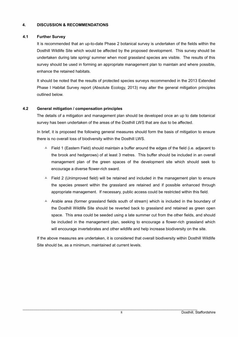
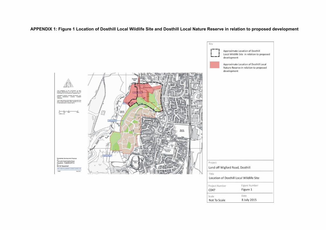
The part of the proposed development site which includes an area of the Dosthill Local Wildlife Site
comprised semi-improved grassland fields with scattered trees and hedgerows. Figure 1 (Appendix
1) shows the location of the LWS in relation to the proposed development. Figure 2 (Appendix 2)
shows the Extended Phase I Habitat Survey map undertaken in 2013 with target notes, noting the
location of the fields within the LWS.
1.3 Protected Sites
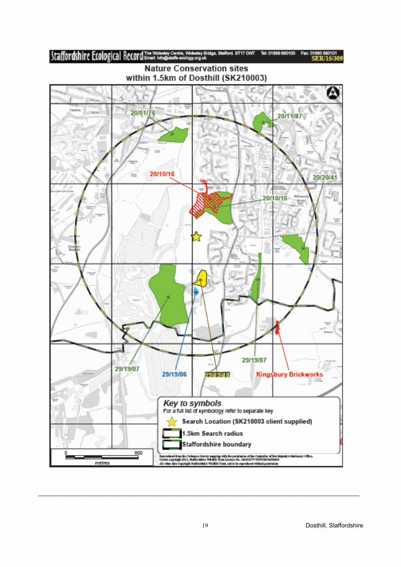
Dosthill Local Wildlife Site is a non-statutory conservation site which has the reference code
20/10/16, and which was surveyed and designated by Staffordshire Wildlife Trust. Local Wildlife
Sites were formally known as Sites of Biological Interest (SBI's) until 2006 when the generic term of
Local Wildlife Site (LWS) was applied to SBI's in Staffordshire.
Local Wildlife Sites are selected as local sites which are particularly rich or valuable to wildlife and
worthy of conservation efforts; they are however, non-statutory so do not have any legal protection
although their presence should still be considered within the planning system.
Dosthill Local Nature Reserve (LNR) is present adjacent to the site (also with the code 20/10/16),
and part of the Dosthill LWS falls into part of the LNR (see Figure 1).
Local Nature Reserves are statutorily designated which gives a degree of protection to such sites
within the planning system.
Dosthill LNR, although bordering the development site, will not be directly impacted by the
development as the footprint of the development does not fall into the LNR.
There may be additional human presence within the LNR from future residents enjoying the Nature
Reserve; however, this is unlikely to be significantly detrimental to the LNR, as most people use
footpaths and would be unlikely to enter areas which are difficult to traverse (e.g. the wetland area
nearer the river) which are likely to be the more sensitive and wildlife-rich areas of the LNR.
No further consideration is given to Dosthill LNR in this report; the following chapter focuses on the
_______________________________________________________________________________________ 3 Dosthill, Staffordshire

Dosthill LWS which does partly fall within the area proposed for development.
_______________________________________________________________________________________ 4 Dosthill, Staffordshire
2. PREVIOUS SURVEYS
2.1 Wildlife Trust
Staffordshire Ecological Records (SER) Ltd was requested to supply the citation details of the
Dosthill LWS. The LWS was surveyed in 1998 and again in June 2006 - the full details of the citation
are included in Appendix 3. A summary of the 2006 survey of relevant areas is as follows.
The unimproved field (marked as Field 2 on Figure 1 (Extended Phase I Map 2013) in the centre of
the LWS was the richest area of the site. A large part of this field is unimproved neutral grassland,
with a sward composed mainly of Sweet Vernal-grass, with Crested Dog's-tail, Red Fescue, Meadow
Foxtail and Yorkshire Fog. Within the grass sward are several species which normally only occur in
old, unimproved grassland, most notably Yellow Rattle, which is frequent throughout this area and abundant in places. Pignut, another indicator of old grassland is also abundant, as is Field
Woodrush. Other species present, which are less sensitive to agricultural improvement include
Common Cat's-ear, Black Knapweed, Common Mouse-ear, Lesser Stitchwort, Autumn Hawkbit and
Ribwort Plantain. This field was grazed by horses at the time of the survey and the grass sward was
closely cropped, although there were none of the large bare patches which occur in adjacent fields.
It also appears that some areas of this field (see habitat map) have had fertiliser applied in the past,
resulting in the lush growth of species such as Meadow Foxtail.
The remaining grassland at the site is semi-improved and generally poorer than the field described
above. However, there are still botanically rich areas within this, usually marked by patches of Pignut
or Field Woodrush. The frequency and extent of these richer areas depend upon the degree of
agricultural improvement and their management.
The eastern field (marked as Field 1 on Figure 1 (Extended Phase I Map 2013) was not grazed at
the time of the survey and contained a tall grass sward of Meadow Foxtail, Sweet Vernal Grass,
Crested Dog's-tail, Cock's-foot and Perennial Rye-grass. Pignut is frequent throughout the field, with
small patches of Field Woodrush, Bird's-foot Trefoil and several clumps of Greater Burnet. Three
mature Oak trees are also present in this field.
The two fields on the southern edge of the site, south of the stream are heavily grazed by horses
and contain large areas of bare ground. The eastern field is the richer of the two and contains very
well defined ridge and furrow features, suggesting it has never been ploughed.
This grassland is very rich in places, with patches of Pignut, Field Woodrush, Bird's-foot trefoil
Common Cat's-ear and a range of other species. Scattered Hawthorn scrub is also present and
where it is densest (by the hedge) it provides some protection from grazing. The western field is
much poorer and species such as Pignut and Field Woodrush are mainly restricted to the fenced
bank above the stream.
_______________________________________________________________________________________ 5 Dosthill, Staffordshire
2.2 Extended Phase I Habitat Survey
An Extended Phase I survey was undertaken on 7 January 2013. Weather conditions during the
survey were cloudy and dry.
Fields 1 and 2 were limited in botanical survey due to being undertaken in winter when many species
are not visible. The surveyor found that the fields were of short sward length, suggesting recent
cutting (no evidence of grazing at the time of the survey). The edges of the fields were less
frequently managed, giving a denser, more tussocky sward. The grassland appeared damp in
places, indicating poor drainage. Species included Yorkshire fog Holcus lanatus, red fescue Festuca
rubra, tufted hair-grass Deschampsia cespitosa, rough-stemmed meadow-grass Poa trivialis and
soft-rush Juncus effusus. Herbs were infrequent, and included occasional common sorrel Rumex
acestosa and ribwort plantain Plantago lanceolata.
The horse grazed fields south of the stream noted by the Wildlife Trust (and shown on aerial maps)
had been incorporated into the arable field at the time of the survey and were ploughed.
_______________________________________________________________________________________ 6 Dosthill, Staffordshire
3. IMPACT ASSESSMENT
3.1 Field 1 (eastern field)
The footprint of the proposed development includes Field 1, and therefore most of the grassland in
this field would be lost to housing.
The 2006 Wildlife Trust survey noted this grassland had a number of floral species within the sward
which are generally found in less intensively managed grasslands
During the 2013 survey, the edges around the field appeared to be less managed than the rest of the
field which appeared recently mown. It was not possible to make a full botanical assessment as the
survey was undertaken in winter.
Loss of the grassland habitat would result in a lowering of biodiversity on the site through permanent
loss of a diversity of grasses and herbs as well as invertebrates and other species which use this
type of habitat.
3.2 Field 2 (unimproved field)
The 2013 survey did not detect the diversity of grasses and herbs noted in the 2006 survey, but this
is likely to be partly due to the Phase I survey being undertaken in winter when many grassland
species are not visible. In addition, it is possible that this field has degraded in the last seven years
through a change in management.
This field will not be directly affected by the development, as it is due to be retained under the
current proposals.
If the field continues to be publicly accessible (as it was during 2013) there may be additional
pressure of human disturbance / amenity use in future from inhabitants of the adjacent housing.
3.3 Arable field (southern fields)
The fields to the south of the stream had been ploughed in 2013, drastically reducing biodiversity
value.
It is proposed that this area will be retained as green space within the proposals, so there is scope
for creating and managing a species-rich habitat such as a wild flower meadow. This would be a
positive impact from the proposed development.
_______________________________________________________________________________________ 7 Dosthill, Staffordshire
4. DISCUSSION & RECOMMENDATIONS
4.1 Further Survey
It is recommended that an up-to-date Phase 2 botanical survey is undertaken of the fields within the
Dosthill Wildlife Site which would be affected by the proposed development. This survey should be
undertaken during late spring/ summer when most grassland species are visible. The results of this
survey should be used in forming an appropriate management plan to maintain and where possible,
enhance the retained habitats.
It should be noted that the results of protected species surveys recommended in the 2013 Extended
Phase I Habitat Survey report (Absolute Ecology, 2013) may alter the general mitigation principles
outlined below.
4.2 General mitigation / compensation principles
The details of a mitigation and management plan should be developed once an up to date botanical
survey has been undertaken of the areas of the Dosthill LWS that are due to be affected.
In brief, it is proposed the following general measures should form the basis of mitigation to ensure
there is no overall loss of biodiversity within the Dosthill LWS.
Field 1 (Eastern Field) should maintain a buffer around the edges of the field (i.e. adjacent to
the brook and hedgerows) of at least 3 metres. This buffer should be included in an overall
management plan of the green spaces of the development site which should seek to
encourage a diverse flower-rich sward.
Field 2 (Unimproved field) will be retained and included in the management plan to ensure
the species present within the grassland are retained and if possible enhanced through
appropriate management. If necessary, public access could be restricted within this field.
Arable area (former grassland fields south of stream) which is included in the boundary of
the Dosthill Wildlife Site should be reverted back to grassland and retained as green open
space. This area could be seeded using a late summer cut from the other fields, and should
be included in the management plan, seeking to encourage a flower-rich grassland which
will encourage invertebrates and other wildlife and help increase biodiversity on the site.
If the above measures are undertaken, it is considered that overall biodiversity within Dosthill Wildlife
Site should be, as a minimum, maintained at current levels.
_______________________________________________________________________________________ 8 Dosthill, Staffordshire
APPENDIX 1: Figure 1 Location of Dosthill Local Wildlife Site and Dosthill Local Nature Reserve in relation to proposed development
APPENDIX 2: Figure 2 Extended Phase I Habitat Survey showing field locations
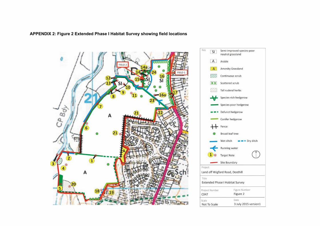
APPENDIX 2: Target Notes
Table 2: Target Notes (shown on Figure 2)
Number Target Note1 Defunct hedge which becomes a species-poor hedge - with small field margin providing
potential though limited reptile habitat
2 Wet ditch lined with hard rush and tufted hair grass. Some aquatic vegetation. Slight flow and shallow water. Connects into river. Water appeared contaminated with oil - potential water vole habitat.
3 River borders site at base of field.. Potential for otter, kingfishers, water vole, white-clawed crayfish and nesting/wading birds. Banks covered in tall ruderals and scrub.
4 Former area of grassland/ scrub from aerial photos is now mostly ploughed soil and dead grass (probably treated with herbicide).
5 Small block of trees bordering site- including poplar and willow species. Woodpecker holes and other crevices observed in some of the trees - potential for roosting bats.
6 Small rough grassland field margins - 0.5 - 1 m wide with low to moderate potential for reptiles.
7 Species-poor hedge dominated by hawthorn with occasional elder Wet ditch on west side (outside survey boundary).
8 Small copse of trees including willow and oak next to wet ditch.
9 Field margin widens up to 3 m wide, comprising tussocky semi-improved grassland dominated by Yorkshire fog. Very damp, potential for foraging grass snake.
10 Log / vegetation pile - potential for reptiles and nesting birds.
11 Former field boundary removed and area of grassland has been disturbed / removed (probably by herbicide and ploughing)
12 Ditch along site boundary - potential for water vole but ground too wet to access for close inspection.
13 Area of wet grassland with Yorkshire fog, tufted hairgrass, soft rush, creeping buttercup, rosebay willow herb, ribwort plantain - potential for foraging grass snake.
14 Damp grassland including Yorkshire fog, red fescue, tufted hair-grass, soft rush, common sorrel, ribwort plantain. The grassland has a short sward and as it is open for public access, is likely to be cut for amenity purposes.
14a Edges of grassland have moderate potential for reptiles as the grass has not been cut and has become tussocky.
15 Newly planted hedge up to 2 metres high includes dog rose, hawthorn, hazel and field maple.
16 Semi improved grassland with short sward also appears to be regularly cut for amenity purposes. Species include Yorkshire fog, red fescue, rough-stemmed meadow-grass.
16a Grassland edges are uncut and tussocky, and have moderate potential for reptiles.
17 Oak trees in hedge have cracked branches etc. - potential for roosting bats.
18 Dry ditch (damp at time of survey) which contained willowherbs and grasses
19 Garden pond approximately 10 metres outside site boundary, estimated 25 x 20 m with signs of aquatic vegetation. Potentially suitable for amphibians including great crested newt.
20 Area of tall ruderals including hogweed, cow parsley, broadleaved dock, nettle and creeping thistle.
21 Residential garden boundaries and grassy field margins including common bent, white dead _______________________________________________________________________________________________
11 Dosthill, Staffordshire
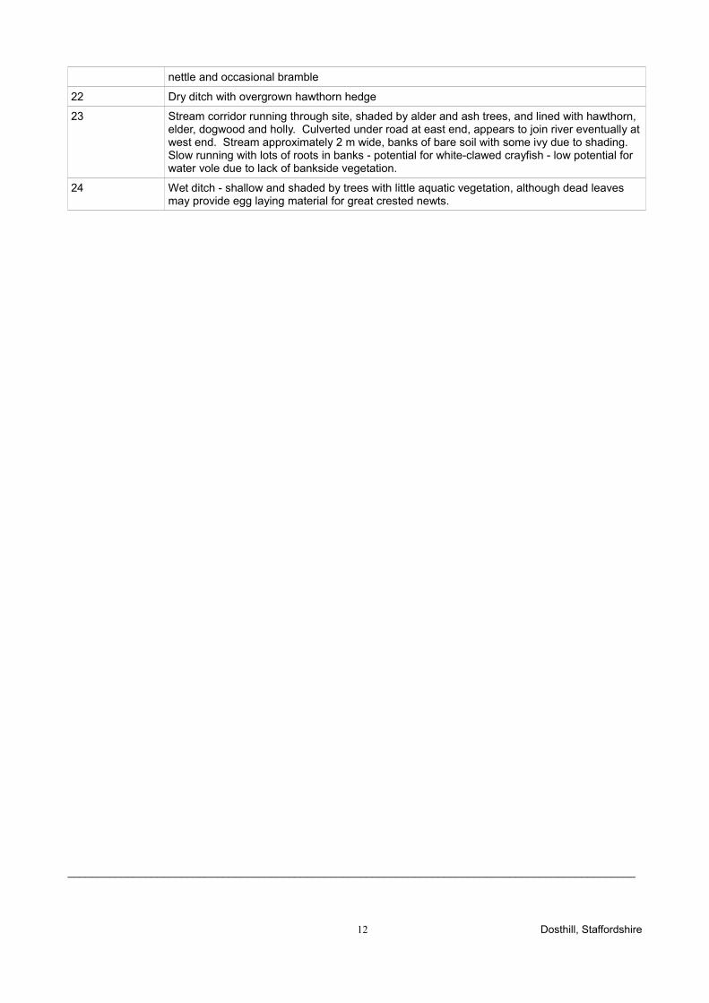
nettle and occasional bramble
22 Dry ditch with overgrown hawthorn hedge
23 Stream corridor running through site, shaded by alder and ash trees, and lined with hawthorn, elder, dogwood and holly. Culverted under road at east end, appears to join river eventually at west end. Stream approximately 2 m wide, banks of bare soil with some ivy due to shading. Slow running with lots of roots in banks - potential for white-clawed crayfish - low potential for water vole due to lack of bankside vegetation.
24 Wet ditch - shallow and shaded by trees with little aquatic vegetation, although dead leaves may provide egg laying material for great crested newts.
_______________________________________________________________________________________________
12 Dosthill, Staffordshire
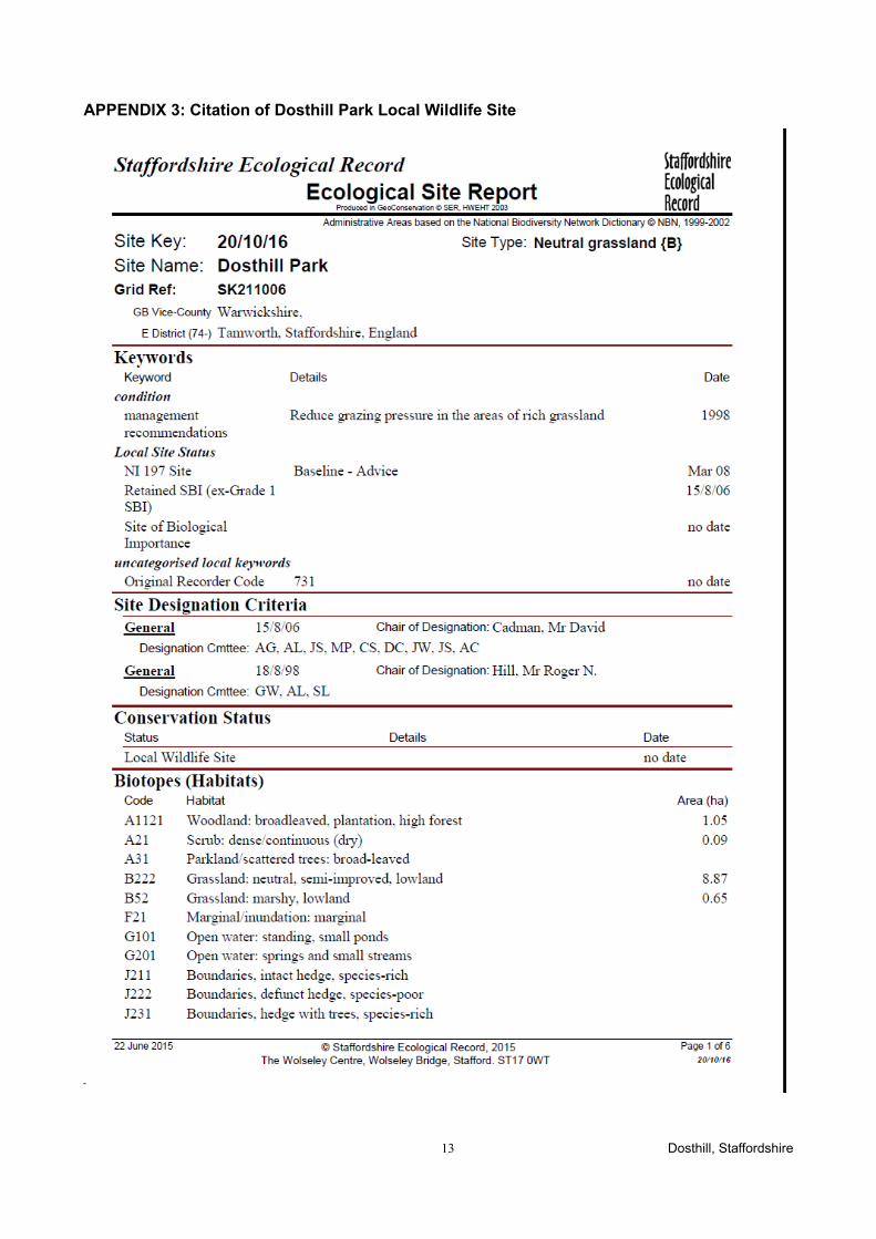
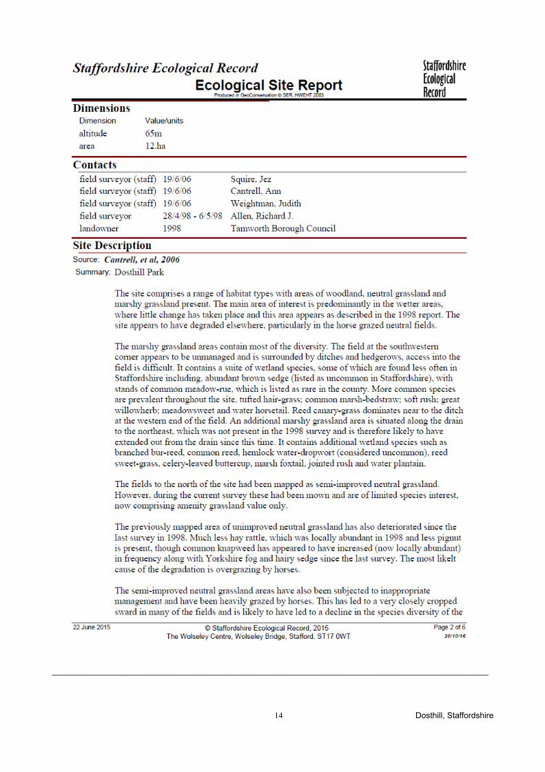
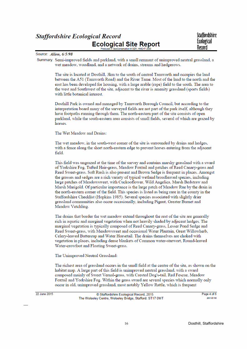
APPENDIX 3: Citation of Dosthill Park Local Wildlife Site
_______________________________________________________________________________________________
13 Dosthill, Staffordshire
_______________________________________________________________________________________________
14 Dosthill, Staffordshire

_______________________________________________________________________________________________
15 Dosthill, Staffordshire
_______________________________________________________________________________________________
16 Dosthill, Staffordshire
_______________________________________________________________________________________________
17 Dosthill, Staffordshire
_______________________________________________________________________________________________
18 Dosthill, Staffordshire
_______________________________________________________________________________________________
19 Dosthill, Staffordshire

_______________________________________________________________________________________________
20 Dosthill, Staffordshire