Embed Size (px)
Citation preview
NUKA Research & Planning Group, LLC.
Pot
enti
al P
lace
s of
Ref
uge
for
Coo
k In
let S
uba
rea
Cook Inlet SCP: PPOR, Part One June 2008
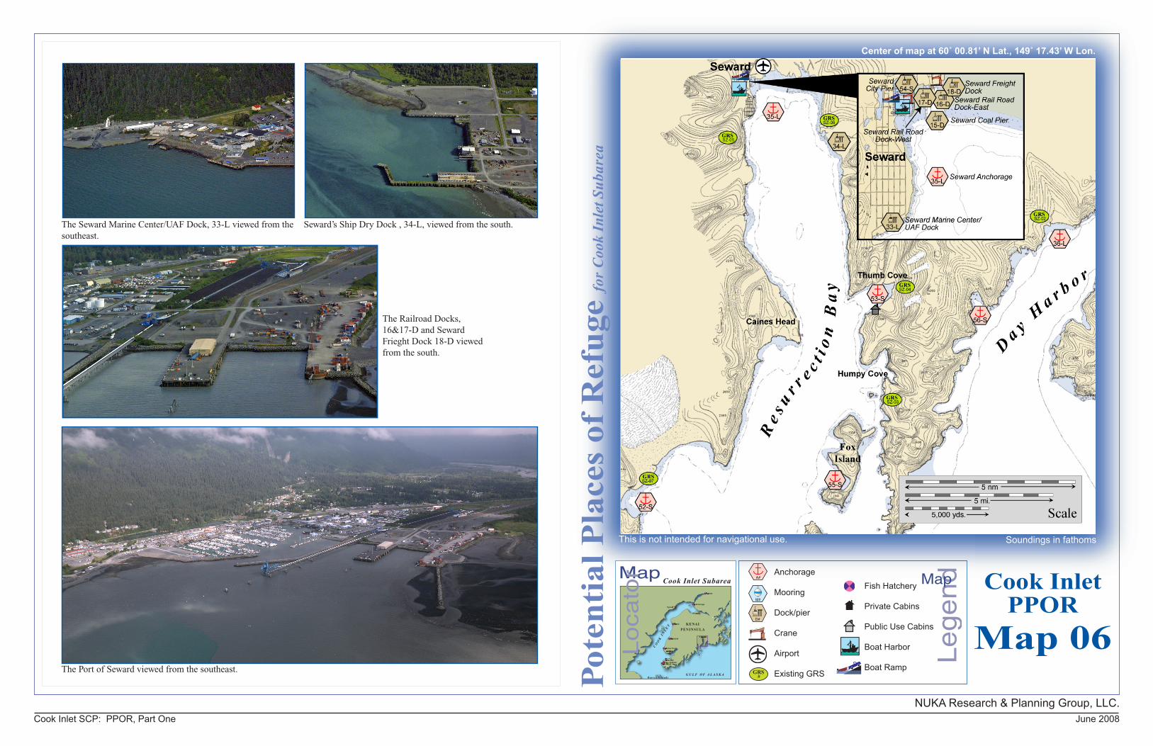
Soundings in fathoms
The Port of Seward viewed from the southeast.
Cook InletPPOR
Map 06
Center of map at 60˚ 00.81’ N Lat., 149˚ 17.43’ W Lon.
This is not intended for navigational use.
The Railroad Docks, 16&17-D and Seward Frieght Dock 18-D viewed from the south.
The Seward Marine Center/UAF Dock, 33-L viewed from the southeast.
Seward’s Ship Dry Dock , 34-L, viewed from the south.
Le
ge
ndMap
Anchorage
Mooring
Dock/pier
Crane
Airport
Existing GRSGRS#
A#
Fish Hatchery
Private Cabins
Public Use Cabins
Boat Harbor
Boat Ramp
D#
M#
Cook Inlet Subarea
NUKA Research & Planning Group, LLC.NOTE: Sensitive resource information can be found on other maps which can be accessed through the sensitive area section of the Cook Inlet Subarea Contingency Plan: http://www.akrrt.org/cookinletplan/cookinletplantoc.shtml
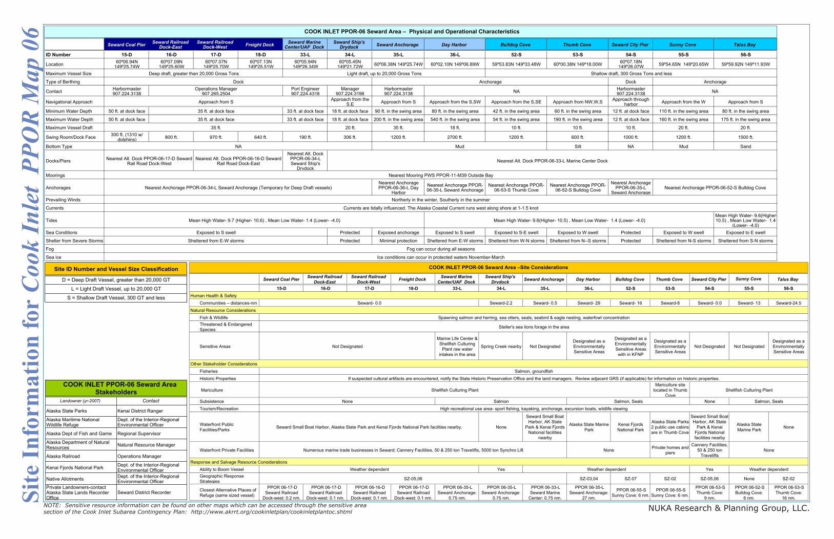
Site
Inf
orm
atio
n fo
r C
ook
Inle
t P
PO
R M
ap 0
6
Site ID Number and Vessel Size Classification
D = Deep Draft Vessel, greater than 20,000 GT
L = Light Draft Vessel, up to 20,000 GT
S = Shallow Draft Vessel, 300 GT and less
Landowner (yr-2007) Contact
Alaska State Parks Kenai District Ranger
Alaska Maritime National Wildlife Refuge
Dept. of the Interior-Regional Environmental Officer
Alaska Dept of Fish and Game Regional Supervisor
Alaska Department of Natural Resources
Natural Resource Manager
Alaska Railroad Operations Manager
Kenai Fjords National ParkDept. of the Interior-Regional Environmental Officer
Native AllotmentsDept. of the Interior-Regional Environmental Officer
Private Landowners-contact Alaska State Lands Recorder Office
Seward District Recorder
COOK INLET PPOR-06 Seward Area
Stakeholders
Seward Coal PierSeward Railroad
Dock-EastSeward Railroad
Dock-WestFreight Dock
Seward Marine Center/UAF Dock
Seward Ship's Drydock
Seward Anchorage Day Harbor Bulldog Cove Thumb Cove Seward City Pier Sunny Cove Talus Bay
ID Number 15-D 16-D 17-D 18-D 33-L 34-L 35-L 36-L 52-S 53-S 54-S 55-S 56-S
Location60º06.94N
149º25.74W60º07.09N
149º25.60W60º07.07N
149º25.70W60º07.13N
149º25.51W60º05.94N
149º26.34W60º05.45N
149º21.72W60º06.38N 149º25.74W 60º02.10N 149º06.89W 59º53.83N 149º33.48W 60º00.38N 149º18.00W
60º07.18N 149º26.07W
59º54.65N 149º20.65W 59º59.92N 149º11.93W
Maximum Vessel Size
Type of Berthing Dock
ContactHarbormaster 907.224.3138
Port Engineer 907.224.4318
Manager907.224.3198
Harbormaster 907.224.3138
Harbormaster 907.224.3138
Navigational ApproachApproach from the
S,EApproach from S Approach from the S,SW Approach from the S,SE Approach from NW,W,S
Approach through harbor
Approach from the W Approach from S
Minimum Water Depth 50 ft. at dock face 33 ft. at dock face 18 ft. at dock face 90 ft. in the swing area 80 ft. in the swing area 42 ft. in the swing area 60 ft. in the swing area 12 ft. at dock face 110 ft. in the swing area 80 ft. in the swing area
Maximum Water Depth 50 ft. at dock face 33 ft. at dock face 18 ft. at dock face 200 ft. in the swing area 540 ft. in the swing area 54 ft. in the swing area 190 ft. in the swing area 12 ft. at dock face 160 ft. in the swing area 175 ft. in the swing area
Maximum Vessel Draft 20 ft. 35 ft. 18 ft. 10 ft. 10 ft. 10 ft. 20 ft. 20 ft.
Swing Room/Dock Face300 ft. (1310 w/
dolphins)800 ft. 970 ft. 640 ft. 190 ft. 306 ft. 1200 ft. 2700 ft. 1200 ft. 600 ft. 1000 ft. 1200 ft. 1500 ft.
Bottom Type Silt NA Mud Sand
Docks/Piers
Nearest Alt. Dock PPOR-06-34-L Seward Ship's
Drydock
Moorings
AnchoragesNearest Anchorage PPOR-06-36-L Day
Harbor
Nearest Anchorage PPOR-06-35-L Seward Anchorage
Nearest Anchorage PPOR-06-53-S Thumb Cove
Nearest Anchorage PPOR-06-52-S Bulldog Cove
Nearest Anchorage PPOR-06-35-L
Seward Anchorage
Prevailing Winds
Currents
TidesMean High Water- 9.6(Higher- 10.5) , Mean Low Water- 1.4
(Lower- -4.0)
Sea Conditions Protected Exposed anchorage Exposed to S swell Exposed to S-E swell Exposed to W swell Protected Exposed to W swell Exposed to E swell
Shelter from Severe Storms Protected Minimal protection Sheltered from E-W storms Sheltered from W-N storms Sheltered from N--S storms Protected Sheltered from N-S storms Sheltered from S-N storms
Fog
Sea ice
Sheltered from E-W storms
Fog can occur during all seasons
Approach from S
35 ft.
NA Mud
Currents are tidally influenced. The Alaska Coastal Current runs west along shore at 1-1.5 knot
Nearest Alt. Dock PPOR-06-17-D Seward Rail Road Dock-West
Mean High Water- 9.7 (Higher- 10.6) , Mean Low Water- 1.4 (Lower- -4.0)
Exposed to S swell
Nearest Anchorage PPOR-06-34-L Seward Anchorage (Temporary for Deep Draft vessels) Nearest Anchorage PPOR-06-52-S Bulldog Cove
Ice conditions can occur in protected waters November-March
Operations Manager907.265.2504
NA NA
Mean High Water- 9.6(Higher- 10.5) , Mean Low Water- 1.4 (Lower- -4.0)
35 ft. at dock face
35 ft. at dock face
Northerly in the winter, Southerly in the summer
COOK INLET PPOR-06 Seward Area – Physical and Operational Characteristics
Nearest Alt. Dock PPOR-06-16-D Seward Rail Road Dock-East
Nearest Alt. Dock PPOR-06-33-L Marine Center Dock
Nearest Mooring PWS PPOR-11-M39 Outside Bay
Deep draft, greater than 20,000 Gross Tons Light draft, up to 20,000 Gross Tons Shallow draft, 300 Gross Tons and less
Dock Anchorage Anchorage
Seward Coal PierSeward Railroad
Dock-East
Seward Railroad
Dock-WestFreight Dock
Seward Marine
Center/UAF Dock
Seward Ship's
DrydockSeward Anchorage Day Harbor Bulldog Cove Thumb Cove Seward City Pier Sunny Cove Talus Bay
15-D 16-D 17-D 18-D 33-L 34-L 35-L 36-L 52-S 53-S 54-S 55-S 56-S
Human Health & Safety
Communities – distances-nm Seward-2.2 Seward- 0.5 Seward- 29 Seward- 16 Seward-8 Seward- 0.0 Seward- 13 Seward-24.5
Fish & Wildlife
Threatened & Endangered
Species
Sensitive Areas
Marine Life Center &
Shellfish Culturing
Plant raw water
intakes in the area
Spring Creek nearby Not Designated
Designated as a
Environmentally
Sensitive Areas
Designated as a
Environmentally
Sensitive Areas
with in KFNP
Designated as a
Environmentally
Sensitive Areas
Not Designated Not Designated
Designated as a
Environmentally
Sensitive Areas
Fisheries
Historic Properties
Mariculture
Mariculture site
located in Thumb
Cove
Subsistence None
Tourism/Recreation
Waterfront Public
Facilities/ParksNone
Seward Small Boat
Harbor, AK State
Park & Kenai Fjords
National facilities
nearby
Alaska State Marine
Park
Kenai Fjords
National Park
Alaska State Parks
2 public use cabins
are in Thumb Cove
Seward Small Boat
Harbor, AK State
Park & Kenai
Fjords National
facilities nearby
Alaska State
Marine ParkNone
Waterfront Private FacilitiesPrivate homes and
piers
Cannery Facilities,
50 & 250 ton
Travelifts
Ability to Boom Vessel Yes Yes
Geographic Response
StrategiesSZ-03,04 SZ-07 SZ-02 SZ-05,06 None SZ-02
Closest Alternative Places of
Refuge (same sized vessel)
PPOR 06-17-D
Seward Railroad
Dock-west: 0.2 nm.
PPOR 06-17-D
Seward Railroad
Dock-west: 0.1 nm.
PPOR 06-16-D
Seward Railroad
Dock-east: 0.1 nm.
PPOR 06-17-D
Seward Railroad
Dock-west: 0.1 nm.
PPOR 06-35-L
Seward Anchorage:
0.75 nm.
PPOR 06-35-L
Seward Anchorage:
0.75 nm.
PPOR 06-33-L
Seward Marine
Center: 0.75 nm.
PPOR 06-35-L
Seward Anchorage:
27 nm.
PPOR 06-55-S
Sunny Cove: 6 nm.
PPOR 06-55-S
Sunny Cove: 6 nm.
PPOR 06-53-S
Thumb Cove:
9 nm.
PPOR 06-52-S
Bulldog Cove:
6 nm.
PPOR 06-53-S
Thumb Cove:
16 nm.
Response and Salvage Resource Considerations
Not Designated
COOK INLET PPOR-06 Seward Area –Site Considerations
High recreational use area- sport fishing, kayaking, anchorage, excursion boats, wildlife viewing
Seward Small Boat Harbor, Alaska State Park and Kenai Fjords National Park facilities nearby.
NoneNoneNumerous marine trade businesses in Seward; Cannery Facilities, 50 & 250 ton Travelifts, 5000 ton Synchro Lift
Shellfish Culturing Plant
Salmon, Seals
Seward- 0.0
Spawning salmon and herring, sea otters, seals, seabird & eagle nesting, waterfowl concentration
Steller's sea lions forage in the area
Salmon, groundfish
Natural Resource Considerations
Other Stakeholder Considerations
SZ-05,06
Weather dependentWeather dependentWeather dependent
None Salmon Salmon, Seals
If suspected cultural artifacts are encountered, notify the State Historic Preservation Office and the land managers. Review adjacent GRS (if applicable) for information on historic properties.
Shellfish Culturing Plant