Embed Size (px)
Citation preview
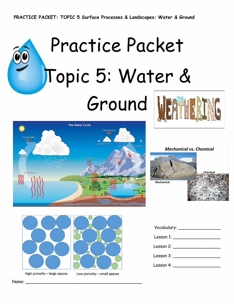
PRACTICE PACKET: TOPIC 5 Surface Processes & Landscapes: Water & Ground
Practice Packet
Topic 5: Water &
Ground
Vocabulary: ________________
Lesson 1: __________________
Lesson 2: __________________
Lesson 3: __________________
Lesson 4: __________________
Name: ____________________________________________
PRACTICE PACKET: TOPIC 5 Surface Processes & Landscapes: Water & Ground
VOCABULARY
For each word, provide a short but specific definition from YOUR OWN BRAIN! No boring textbook
definitions. Write something to help you remember the word. Explain the word as if you were explaining
it to an elementary school student. Give an example if you can. Don’t use the words given in your
definition!
Water Cycle:____________________________________________________________________
Evaporation: ____________________________________________________________________
Condensation: ___________________________________________________________________
Transpiration: ___________________________________________________________________
Precipitation: ___________________________________________________________________
Infiltration: ____________________________________________________________________
Runoff: ________________________________________________________________________
Water Retention: ________________________________________________________________
Ground water discharge: ___________________________________________________________
Zone of Aeration: ________________________________________________________________
Zone of Saturation: _______________________________________________________________
Water Table: ___________________________________________________________________
Saturated: _____________________________________________________________________
Porosity: _______________________________________________________________________
Permeable: _____________________________________________________________________
Impermeable: ___________________________________________________________________
Capillarity: _____________________________________________________________________
Weathering: ____________________________________________________________________
Chemical Weathering: _____________________________________________________________
Physical Weathering: ______________________________________________________________
Oxidation: _____________________________________________________________________
PRACTICE PACKET: TOPIC 5 Surface Processes & Landscapes: Water & Ground
3
Frost action: ____________________________________________________________________
Abrasion:_______________________________________________________________________
Exposure: ______________________________________________________________________
Soil: __________________________________________________________________________
Erosion: _______________________________________________________________________
Deposition: _____________________________________________________________________
Dynamic Equilibrium: ______________________________________________________________
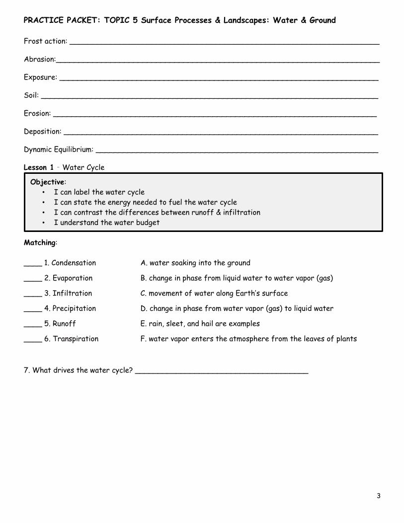
Lesson 1 – Water Cycle
Matching:
____ 1. Condensation
____ 2. Evaporation
____ 3. Infiltration
____ 4. Precipitation
____ 5. Runoff
____ 6. Transpiration
A. water soaking into the ground
B. change in phase from liquid water to water vapor (gas)
C. movement of water along Earth’s surface
D. change in phase from water vapor (gas) to liquid water
E. rain, sleet, and hail are examples
F. water vapor enters the atmosphere from the leaves of plants
7. What drives the water cycle? ______________________________________
Objective:
• I can label the water cycle
• I can state the energy needed to fuel the water cycle
• I can contrast the differences between runoff & infiltration
• I understand the water budget
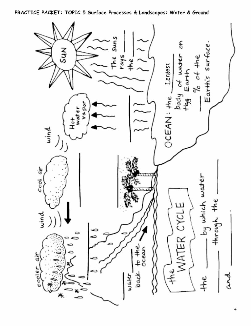
PRACTICE PACKET: TOPIC 5 Surface Processes & Landscapes: Water & Ground
4
Lar
gest
75
PRACTICE PACKET: TOPIC 5 Surface Processes & Landscapes: Water & Ground
5
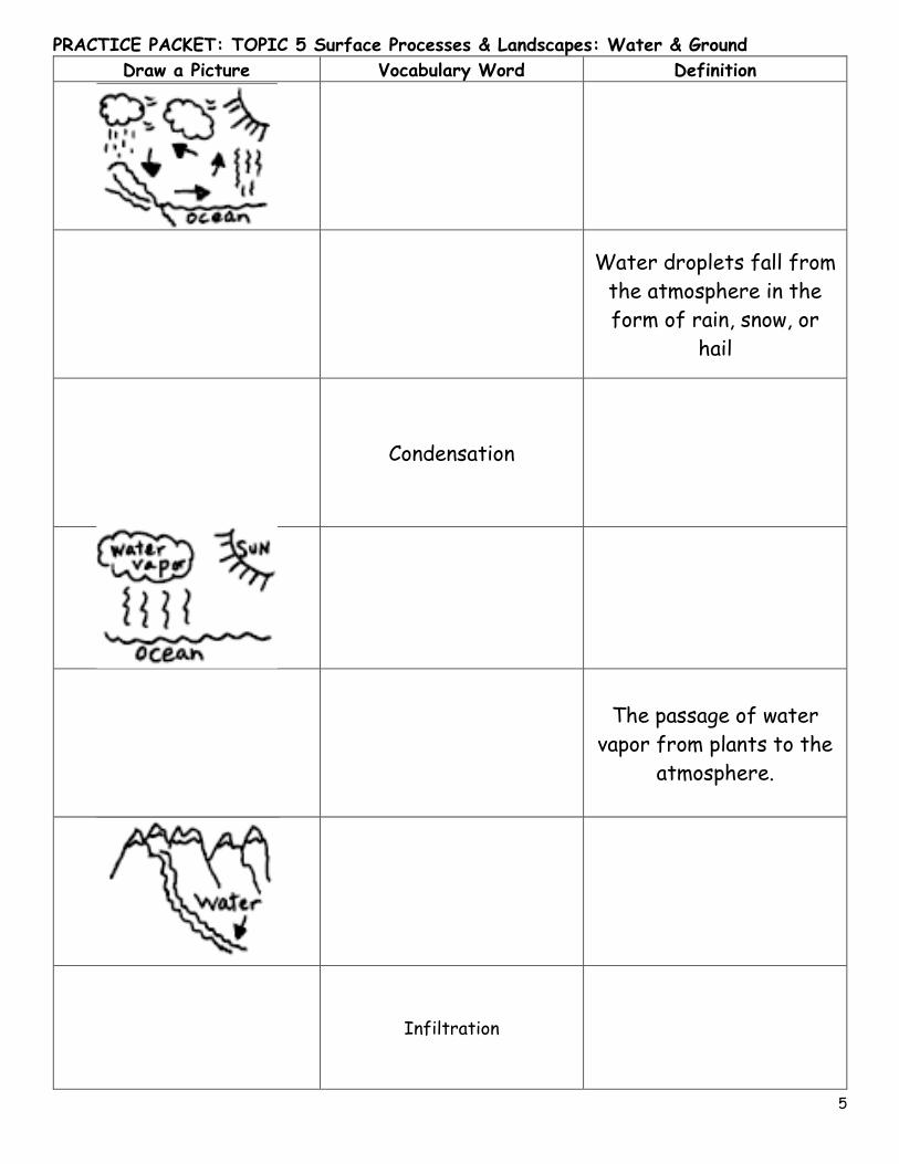
Draw a Picture Vocabulary Word Definition
Water droplets fall from
the atmosphere in the
form of rain, snow, or
hail
Condensation
The passage of water
vapor from plants to the
atmosphere.
Infiltration
PRACTICE PACKET: TOPIC 5 Surface Processes & Landscapes: Water & Ground
6
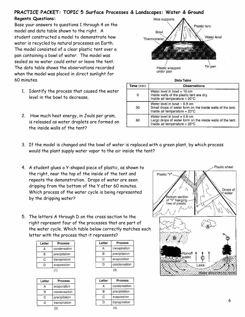
Regents Questions:
Base your answers to questions 1 through 4 on the
model and data table shown to the right. A
student constructed a model to demonstrate how
water is recycled by natural processes on Earth.
The model consisted of a clear plastic tent over a
pan containing a bowl of water. The model was
sealed so no water could enter or leave the tent.
The data table shows the observations recorded
when the model was placed in direct sunlight for
60 minutes.
1. Identify the process that caused the water
level in the bowl to decrease.
2. How much heat energy, in Jouls per gram,
is released as water droplets are formed on
the inside walls of the tent?
3. If the model is changed and the bowl of water is replaced with a green plant, by which process
would the plant supply water vapor to the air inside the tent?
4. A student glues a Y-shaped piece of plastic, as shown to
the right, near the top of the inside of the tent and
repeats the demonstration. Drops of water are seen
dripping from the bottom of the Y after 60 minutes.
Which process of the water cycle is being represented
by the dripping water?
5. The letters A through D on the cross section to the
right represent four of the processes that are part of
the water cycle. Which table below correctly matches each
letter with the process that it represents?
PRACTICE PACKET: TOPIC 5 Surface Processes & Landscapes: Water & Ground
7
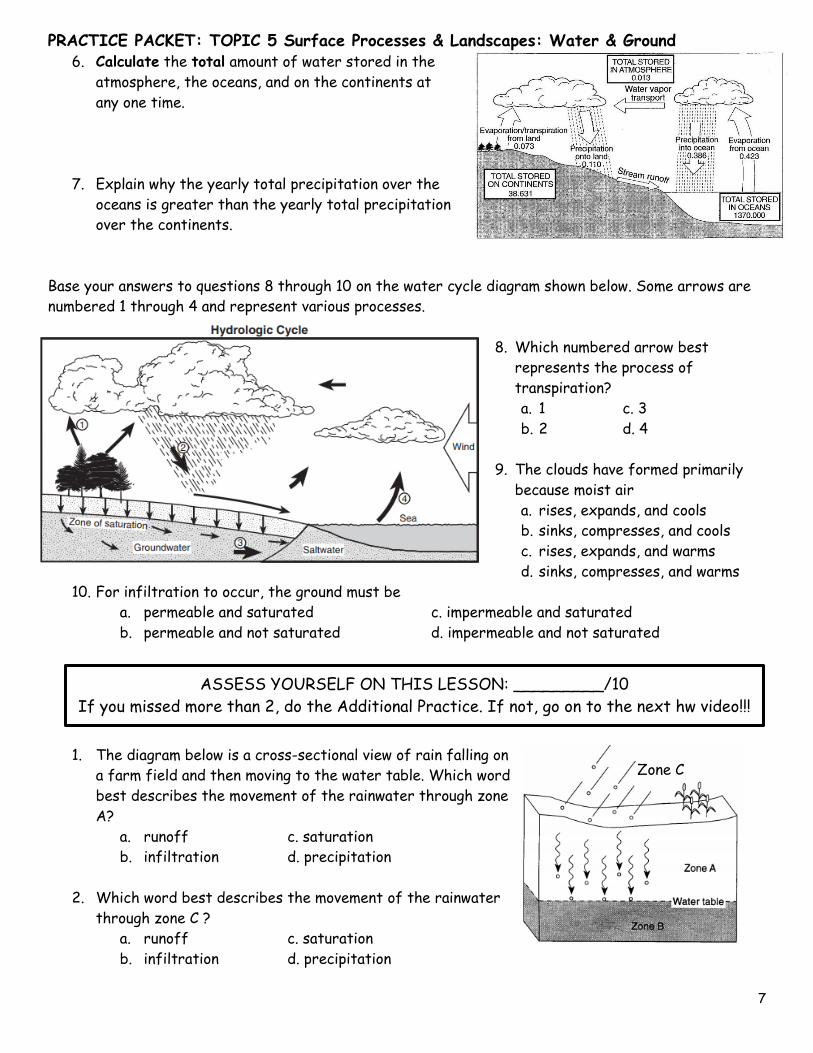
6. Calculate the total amount of water stored in the
atmosphere, the oceans, and on the continents at
any one time.
7. Explain why the yearly total precipitation over the
oceans is greater than the yearly total precipitation
over the continents.
Base your answers to questions 8 through 10 on the water cycle diagram shown below. Some arrows are
numbered 1 through 4 and represent various processes.
8. Which numbered arrow best
represents the process of
transpiration?
a. 1 c. 3
b. 2 d. 4
9. The clouds have formed primarily
because moist air
a. rises, expands, and cools
b. sinks, compresses, and cools
c. rises, expands, and warms
d. sinks, compresses, and warms
10. For infiltration to occur, the ground must be
a. permeable and saturated c. impermeable and saturated
b. permeable and not saturated d. impermeable and not saturated
1. The diagram below is a cross-sectional view of rain falling on
a farm field and then moving to the water table. Which word
best describes the movement of the rainwater through zone
A?
a. runoff c. saturation
b. infiltration d. precipitation
2. Which word best describes the movement of the rainwater
through zone C ?
a. runoff c. saturation
b. infiltration d. precipitation
ASSESS YOURSELF ON THIS LESSON: _________/10
If you missed more than 2, do the Additional Practice. If not, go on to the next hw video!!!
Zone C
PRACTICE PACKET: TOPIC 5 Surface Processes & Landscapes: Water & Ground
8
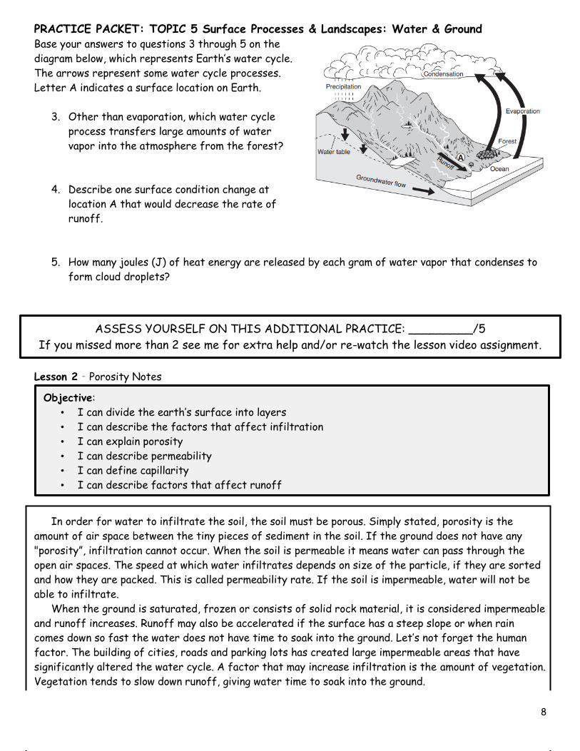
Base your answers to questions 3 through 5 on the
diagram below, which represents Earth’s water cycle.
The arrows represent some water cycle processes.
Letter A indicates a surface location on Earth.
3. Other than evaporation, which water cycle
process transfers large amounts of water
vapor into the atmosphere from the forest?
4. Describe one surface condition change at
location A that would decrease the rate of
runoff.
5. How many joules (J) of heat energy are released by each gram of water vapor that condenses to
form cloud droplets?
Lesson 2 – Porosity Notes
In order for water to infiltrate the soil, the soil must be porous. Simply stated, porosity is the
amount of air space between the tiny pieces of sediment in the soil. If the ground does not have any
"porosity”, infiltration cannot occur. When the soil is permeable it means water can pass through the
open air spaces. The speed at which water infiltrates depends on size of the particle, if they are sorted
and how they are packed. This is called permeability rate. If the soil is impermeable, water will not be
able to infiltrate.
When the ground is saturated, frozen or consists of solid rock material, it is considered impermeable
and runoff increases. Runoff may also be accelerated if the surface has a steep slope or when rain
comes down so fast the water does not have time to soak into the ground. Let’s not forget the human
factor. The building of cities, roads and parking lots has created large impermeable areas that have
significantly altered the water cycle. A factor that may increase infiltration is the amount of vegetation.
Vegetation tends to slow down runoff, giving water time to soak into the ground.
Objective:
• I can divide the earth’s surface into layers
• I can describe the factors that affect infiltration
• I can explain porosity
• I can describe permeability
• I can define capillarity
• I can describe factors that affect runoff
ASSESS YOURSELF ON THIS ADDITIONAL PRACTICE: _________/5
If you missed more than 2 see me for extra help and/or re-watch the lesson video assignment.
PRACTICE PACKET: TOPIC 5 Surface Processes & Landscapes: Water & Ground
9
Within the soil, the area at the surface where water can pass through is called the zone of aeration.
Where the soil that is filled with water is called the zone of saturation. At the top of the zone of
saturation, where the water is at its highest, is called the water table. The water table generally will
move higher toward the surface in spring because rain water replenishes the water, however during a
hot summer it will begin to move downward. If the water moves down through the soil to the water table,
how do plants get the water they need to flourish? Capillarity within the soil is the upward movement of
water. The smaller the pore space the greater the rate of capillarity.
1. What is porosity? ___________________________________________________________
How does it affect infiltration? _________________________________________________
2. List the four factors that will increase permeability rate. _____________________________,
_____________________________, _____________________________, and
_____________________________
3. What five factors increase runoff? ____________________________________________
_________________________________________________________________________
_________________________________________________________________________
________________________________________________________________________
4. Where does the water go in the city when it rains? ________________________________
_________________________________________________________________________
5. How does vegetation help water soak into the ground? ______________________________
_______________________________________________________________________
6. How does slope affect runoff and infiltration rate? _________________________________
________________________________________________________________________
7. How does particle size affect capillarity? _________________________________________
_________________________________________________________________________
Matching: Place the letter of the statement that best describes the process listed.
____ 1. Permeability rate
____ 2. Porosity
____ 3. Capillarity
____ 4. Water table
____ 5. Zone of Aeration
____ 6. Zone of Saturation
A. The amount of “air” space within the soil
B. Located at the top of the zone of saturation
C. How fast water infiltrates into the soil
D. The area within the soil that is not filled with water
E. When water is drawn upward through the soil
F. The area within the soil that is filled with water
PRACTICE PACKET: TOPIC 5 Surface Processes & Landscapes: Water & Ground
10
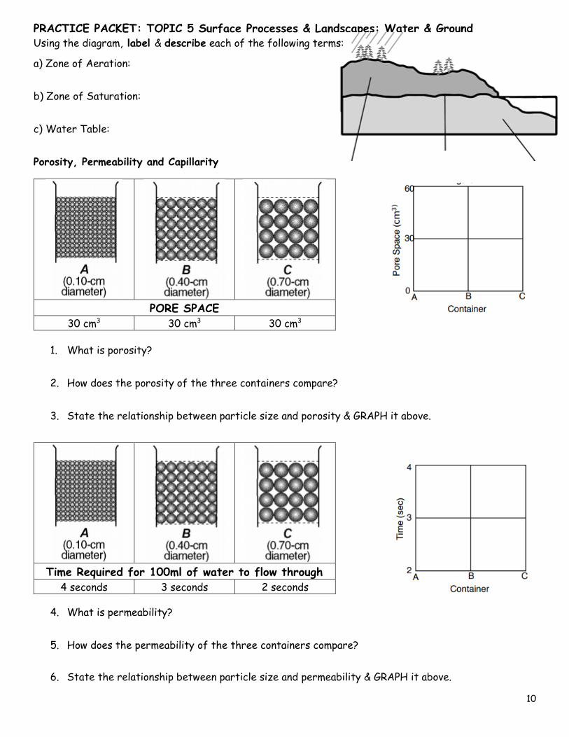
Using the diagram, label & describe each of the following terms:
a) Zone of Aeration:
b) Zone of Saturation:
c) Water Table:
Porosity, Permeability and Capillarity
PORE SPACE
30 cm3 30 cm3 30 cm3
1. What is porosity?
2. How does the porosity of the three containers compare?
3. State the relationship between particle size and porosity & GRAPH it above.
Time Required for 100ml of water to flow through
4 seconds 3 seconds 2 seconds
4. What is permeability?
5. How does the permeability of the three containers compare?
6. State the relationship between particle size and permeability & GRAPH it above.
PRACTICE PACKET: TOPIC 5 Surface Processes & Landscapes: Water & Ground
11
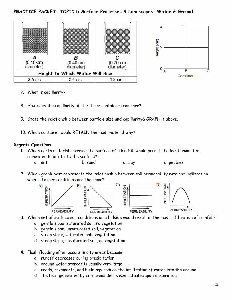
Height to Which Water Will Rise
3.6 cm 2.4 cm 1.2 cm
7. What is capillarity?
8. How does the capillarity of the three containers compare?
9. State the relationship between particle size and capillarity& GRAPH it above.
10. Which container would RETAIN the most water & why?
Regents Questions:
1. Which earth material covering the surface of a landfill would permit the least amount of
rainwater to infiltrate the surface?
a. silt b. sand c. clay d. pebbles
2. Which graph best represents the relationship between soil permeability rate and infiltration
when all other conditions are the same?
3. Which set of surface soil conditions on a hillside would result in the most infiltration of rainfall?
a. gentle slope, saturated soil, no vegetation
b. gentle slope, unsaturated soil, vegetation
c. steep slope, saturated soil, vegetation
d. steep slope, unsaturated soil, no vegetation
4. Flash flooding often occurs in city areas because
a. runoff decreases during precipitation
b. ground water storage is usually very large
c. roads, pavements, and buildings reduce the infiltration of water into the ground
d. the heat generated by city areas decreases actual evapotranspiration
PRACTICE PACKET: TOPIC 5 Surface Processes & Landscapes: Water & Ground
12
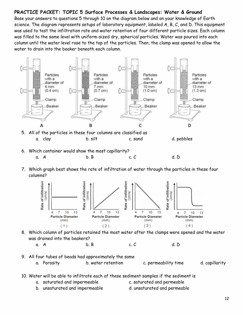
Base your answers to questions 5 through 10 on the diagram below and on your knowledge of Earth
science. The diagram represents setups of laboratory equipment, labeled A, B, C, and D. This equipment
was used to test the infiltration rate and water retention of four different particle sizes. Each column
was filled to the same level with uniform-sized dry, spherical particles. Water was poured into each
column until the water level rose to the top of the particles. Then, the clamp was opened to allow the
water to drain into the beaker beneath each column.
5. All of the particles in these four columns are classified as
a. clay b. silt c. sand d. pebbles
6. Which container would show the most capillarity?
a. A b. B c. C d. D
7. Which graph best shows the rate of infiltration of water through the particles in these four
columns?
8. Which column of particles retained the most water after the clamps were opened and the water
was drained into the beakers?
a. A b. B c. C d. D
9. All four tubes of beads had approximately the same
a. Porosity b. water retention c. permeability time d. capillarity
10. Water will be able to infiltrate each of these sediment samples if the sediment is
a. saturated and impermeable c. saturated and permeable
b. unsaturated and impermeable d. unsaturated and permeable
PRACTICE PACKET: TOPIC 5 Surface Processes & Landscapes: Water & Ground
13
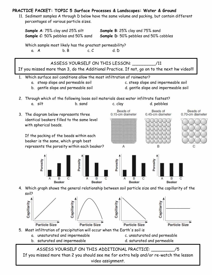
11. Sediment samples A through D below have the same volume and packing, but contain different
percentages of various particle sizes.
Sample A: 75% clay and 25% silt Sample B: 25% clay and 75% sand
Sample C: 50% pebbles and 50% sand Sample D: 50% pebbles and 50% cobbles
Which sample most likely has the greatest permeability?
a. A b. B c. C d. D
1. Which surface soil conditions allow the most infiltration of rainwater?
a. steep slope and permeable soil c. steep slope and impermeable soil
b. gentle slope and permeable soil d. gentle slope and impermeable soil
2. Through which of the following loose soil materials does water infiltrate fastest?
a. silt b. sand c. clay d. pebbles
3. The diagram below represents three
identical beakers filled to the same level
with spherical beads.
If the packing of the beads within each
beaker is the same, which graph best
represents the porosity within each beaker?
4. Which graph shows the general relationship between soil particle size and the capillarity of the
soil?
5. Most infiltration of precipitation will occur when the Earth's soil is
a. unsaturated and impermeable c. unsaturated and permeable
b. saturated and impermeable d. saturated and permeable
ASSESS YOURSELF ON THIS LESSON: _________/11
If you missed more than 3, do the Additional Practice. If not, go on to the next hw video!!!
ASSESS YOURSELF ON THIS ADDITIONAL PRACTICE: _________/5
If you missed more than 2 you should see me for extra help and/or re-watch the lesson
video assignment.
PRACTICE PACKET: TOPIC 5 Surface Processes & Landscapes: Water & Ground
14
Lesson 3 – Weathering
Weathering is the breakdown of rock material. The first type we will investigate is physical (mechanical)
weathering. During physical weathering the rocks are simply broken up into fragments. It does not
change the composition of the rock but it does create more surface area. The dominant climate condition
for physical weathering is cold and moist. Chemical weathering occurs on the surface of rocks and
changes the composition of the material. This causes the rocks to weaken and makes it easier for them
to break apart. Chemical weathering dominates in warm moist climates and occurs on the surface of the
rocks. Usually both types of weathering work together but the dominant type depends on the climate of
the area.
1. What is weathering? _________________________________________________________
2. What is another name for physical weathering? _____________________________________
3. What does physical weathering do? ______________________________________________
4. Does physical weathering change the composition of the rock? __________________________
5. What does physical weathering create? __________________________________________
6. What are the dominant climate conditions for physical weathering? ______________________
7. What does chemical weathering do? _____________________________________________
8. What does chemical weathering cause? ___________________________________________
9. Where on the rock does chemical weathering occur? _________________________________
10. What are the dominant climate conditions for chemical weathering? ______________________
11. Explain how physical weathering helps chemical weathering occur. ** Use a complete sentence.**
_________________________________________________________________________
_________________________________________________________________________
12. Explain how chemical weathering helps physical weathering occur. ** Use a complete sentence.
_________________________________________________________________________
_________________________________________________________________________
13. What climate factor aids in both chemical and physical weathering? ____________________
14. What are the four basic factors that the rate of weathering is dependent on? (use notes)
Objective:
• I can define weathering
• I can differentiate between chemical & physical weathering
• I can state examples of chemical weathering
• I can state examples of physical weathering
• I can describe the factors that affect the rate & type of weathering
• I can explain soil formation
PRACTICE PACKET: TOPIC 5 Surface Processes & Landscapes: Water & Ground
15
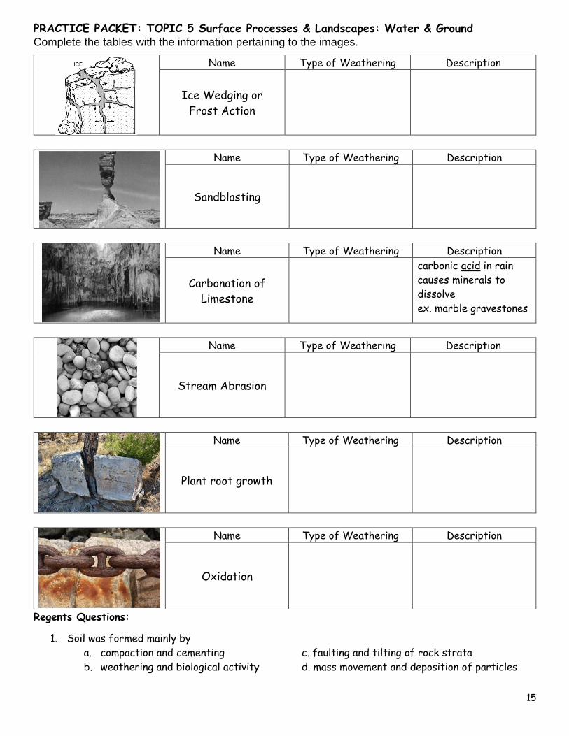
Complete the tables with the information pertaining to the images.
Name Type of Weathering Description
Ice Wedging or
Frost Action
Name Type of Weathering Description
Sandblasting
Name Type of Weathering Description
Carbonation of
Limestone
carbonic acid in rain
causes minerals to
dissolve
ex. marble gravestones
Name Type of Weathering Description
Stream Abrasion
Name Type of Weathering Description
Plant root growth
Name Type of Weathering Description
Oxidation
Regents Questions:
1. Soil was formed mainly by
a. compaction and cementing c. faulting and tilting of rock strata
b. weathering and biological activity d. mass movement and deposition of particles
PRACTICE PACKET: TOPIC 5 Surface Processes & Landscapes: Water & Ground
16
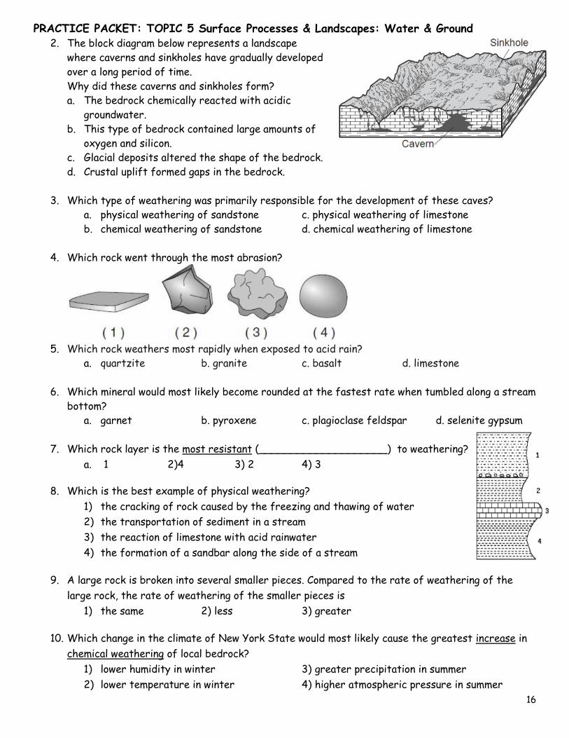
2. The block diagram below represents a landscape
where caverns and sinkholes have gradually developed
over a long period of time.
Why did these caverns and sinkholes form?
a. The bedrock chemically reacted with acidic
groundwater.
b. This type of bedrock contained large amounts of
oxygen and silicon.
c. Glacial deposits altered the shape of the bedrock.
d. Crustal uplift formed gaps in the bedrock.
3. Which type of weathering was primarily responsible for the development of these caves?
a. physical weathering of sandstone c. physical weathering of limestone
b. chemical weathering of sandstone d. chemical weathering of limestone
4. Which rock went through the most abrasion?
5. Which rock weathers most rapidly when exposed to acid rain?
a. quartzite b. granite c. basalt d. limestone
6. Which mineral would most likely become rounded at the fastest rate when tumbled along a stream
bottom?
a. garnet b. pyroxene c. plagioclase feldspar d. selenite gypsum
7. Which rock layer is the most resistant (____________________) to weathering?
a. 1 2)4 3) 2 4) 3
8. Which is the best example of physical weathering?
1) the cracking of rock caused by the freezing and thawing of water
2) the transportation of sediment in a stream
3) the reaction of limestone with acid rainwater
4) the formation of a sandbar along the side of a stream
9. A large rock is broken into several smaller pieces. Compared to the rate of weathering of the
large rock, the rate of weathering of the smaller pieces is
1) the same 2) less 3) greater
10. Which change in the climate of New York State would most likely cause the greatest increase in
chemical weathering of local bedrock?
1) lower humidity in winter 3) greater precipitation in summer
2) lower temperature in winter 4) higher atmospheric pressure in summer
PRACTICE PACKET: TOPIC 5 Surface Processes & Landscapes: Water & Ground
17
Base your answers to questions 11 through 13 on the
diagram below, which represents the dominant type of
weathering for various climatic conditions.
11. Which climate conditions would produce very
slight weathering?
a. a mean annual temperature of 25 °C & a
mean annual precipitation of 100 cm
b. a mean annual temperature of 15°C and a
mean annual precipitation of 25 cm
c. a mean annual temperature of 5 °C and a
mean annual precipitation of 50 cm
d. a mean annual temperature of -5°C and a
mean annual precipitation of 50 cm
12. What type of weathering dominates when the
mean annual temperature of -5 °C and a mean
annual precipitation of 60 mm?
a. moderate frost action c. slight frost action
b. moderate chemical weathering d . very slight weathering
13. Why is no frost action shown for locations with a mean annual temperature greater than 13 °C?
a. Very little freezing takes place at these locations.
b. Large amounts of evaporation take place at these locations.
c. Very little precipitation falls at these locations.
d. Large amounts of precipitation fall at these locations.
Base your answers to questions 14 to 17 on the experiment
described. Each rock sample was placed in a separate beaker
containing 500 milliliters of a dilute acid for 10 minutes.
Bubbling was observed in some of the beakers. The data
table below shows the mass of each sample, in grams, before
placement in the acid and after removal from the acid.
14. Which Earth process is being modeled in this experiment?
a. physical weathering in the hydrosphere c. chemical weathering in the hydrosphere
b. physical weathering in the mesosphere d. chemical weathering in the mesosphere
15. Which table correctly shows the classification of the rock samples based on the amount of
weathering during this experiment?
16. Approximately what percentage of the marble sample remained after the experiment?
a. 0.4% b. 8.0% c. 20.7% d. 99.6%
PRACTICE PACKET: TOPIC 5 Surface Processes & Landscapes: Water & Ground
18
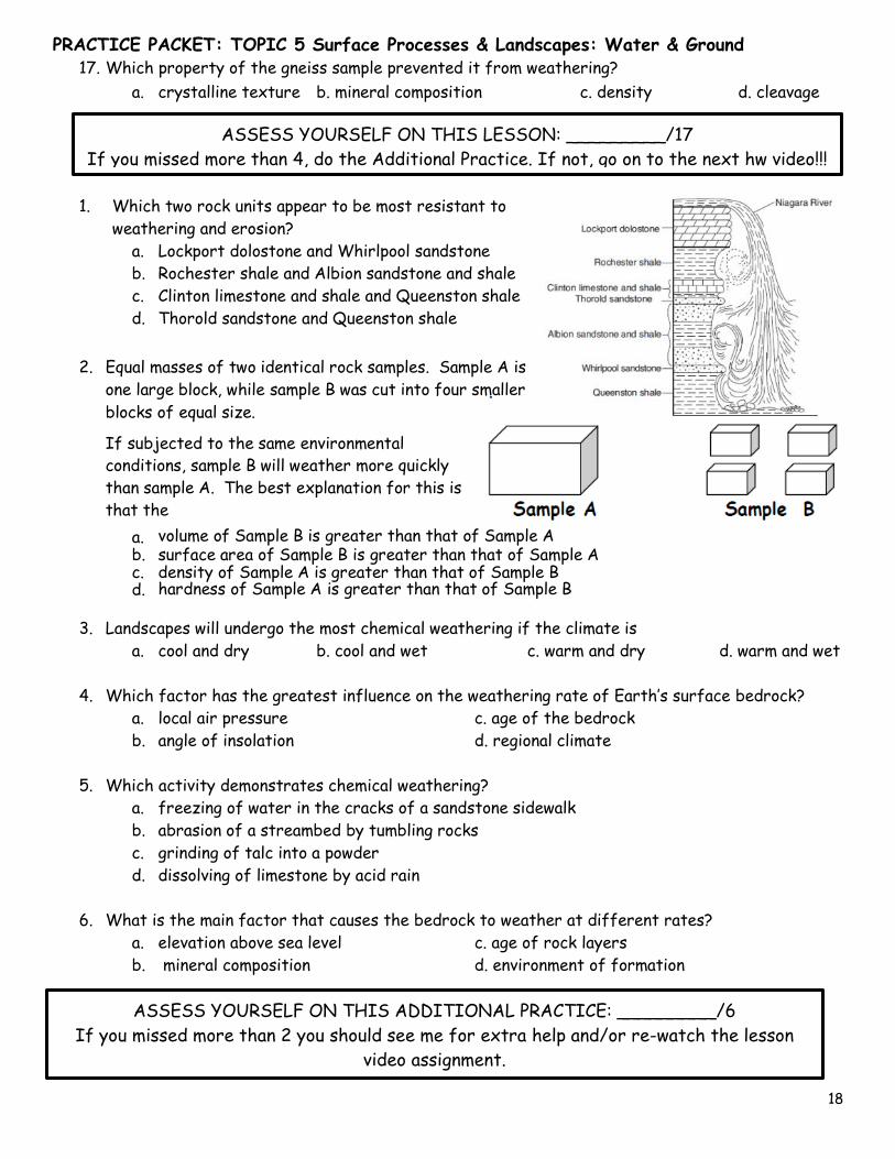
17. Which property of the gneiss sample prevented it from weathering?
a. crystalline texture b. mineral composition c. density d. cleavage
1. Which two rock units appear to be most resistant to
weathering and erosion?
a. Lockport dolostone and Whirlpool sandstone
b. Rochester shale and Albion sandstone and shale
c. Clinton limestone and shale and Queenston shale
d. Thorold sandstone and Queenston shale
2. Equal masses of two identical rock samples. Sample A is
one large block, while sample B was cut into four smaller
blocks of equal size.
If subjected to the same environmental
conditions, sample B will weather more quickly
than sample A. The best explanation for this is
that the
a. volume of Sample B is greater than that of Sample A b. surface area of Sample B is greater than that of Sample A c. density of Sample A is greater than that of Sample B d. hardness of Sample A is greater than that of Sample B
3. Landscapes will undergo the most chemical weathering if the climate is
a. cool and dry b. cool and wet c. warm and dry d. warm and wet
4. Which factor has the greatest influence on the weathering rate of Earth’s surface bedrock?
a. local air pressure c. age of the bedrock
b. angle of insolation d. regional climate
5. Which activity demonstrates chemical weathering?
a. freezing of water in the cracks of a sandstone sidewalk
b. abrasion of a streambed by tumbling rocks
c. grinding of talc into a powder
d. dissolving of limestone by acid rain
6. What is the main factor that causes the bedrock to weather at different rates?
a. elevation above sea level c. age of rock layers
b. mineral composition d. environment of formation
ASSESS YOURSELF ON THIS LESSON: _________/17
If you missed more than 4, do the Additional Practice. If not, go on to the next hw video!!!
ASSESS YOURSELF ON THIS ADDITIONAL PRACTICE: _________/6
If you missed more than 2 you should see me for extra help and/or re-watch the lesson
video assignment.
PRACTICE PACKET: TOPIC 5 Surface Processes & Landscapes: Water & Ground
19
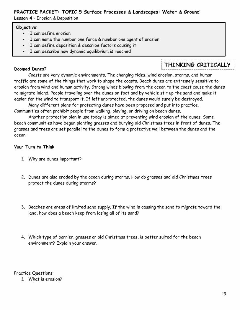
Lesson 4 – Erosion & Deposition
Doomed Dunes?
Coasts are very dynamic environments. The changing tides, wind erosion, storms, and human
traffic are some of the things that work to shape the coasts. Beach dunes are extremely sensitive to
erosion from wind and human activity. Strong winds blowing from the ocean to the coast cause the dunes
to migrate inland. People traveling over the dunes on foot and by vehicle stir up the sand and make it
easier for the wind to transport it. If left unprotected, the dunes would surely be destroyed.
Many different plans for protecting dunes have been proposed and put into practice.
Communities often prohibit people from walking, playing, or driving on beach dunes.
Another protection plan in use today is aimed at preventing wind erosion of the dunes. Some
beach communities have begun planting grasses and burying old Christmas trees in front of dunes. The
grasses and trees are set parallel to the dunes to form a protective wall between the dunes and the
ocean.
Your Turn to Think
1. Why are dunes important?
2. Dunes are also eroded by the ocean during storms. How do grasses and old Christmas trees
protect the dunes during storms?
3. Beaches are areas of limited sand supply. If the wind is causing the sand to migrate toward the
land, how does a beach keep from losing all of its sand?
4. Which type of barrier, grasses or old Christmas trees, is better suited for the beach
environment? Explain your answer.
Practice Questions:
1. What is erosion?
Objective:
• I can define erosion
• I can name the number one force & number one agent of erosion
• I can define deposition & describe factors causing it
• I can describe how dynamic equilibrium is reached
THINKING CRITICALLY
PRACTICE PACKET: TOPIC 5 Surface Processes & Landscapes: Water & Ground
20
2. Number 1 agent of erosion is _____________________ Number 1 force of erosion is
____________________
3. What is deposition?
4. What five factors affect the rate of deposition? ___________________________________,
___________________________________, ___________________________________,
___________________________________, & ___________________________________
5. _______________ shape & _______________ density of a particle would usually result in the
longest settling time.
6. Is it possible to have erosion without deposition? Explain your answer.
7. What does dynamic equilibrium mean?
Circle the correct choice that describes how the factors affect erosion and deposition.
8. The faster the velocity of the medium the [ more or less ] sediment it can carry.
9. As the velocity of the medium slows down [ more or less ] sediment is deposited.
10. The larger the particle size the [ easier or more difficult ] it is moved.
11. The larger the particle size the [ faster or slower ] it is deposited.
12. The rounder the shape the [ easier or more difficult ] it is moved.
13. The rounder the shape the [ faster or slower ] it is deposited.
14. The more dense the particle size the [ easier or more difficult ] it is moved.
15. The more dense the particle size the [ faster or slower ] it is deposited.
PRACTICE PACKET: TOPIC 5 Surface Processes & Landscapes: Water & Ground
21
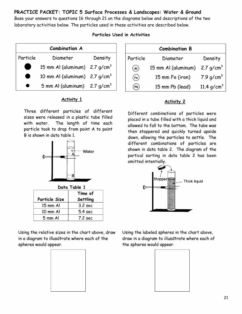
Base your answers to questions 16 through 21 on the diagrams below and descriptions of the two
laboratory activities below. The particles used in these activities are described below.
Particles Used in Activities
PRACTICE PACKET: TOPIC 5 Surface Processes & Landscapes: Water & Ground
22
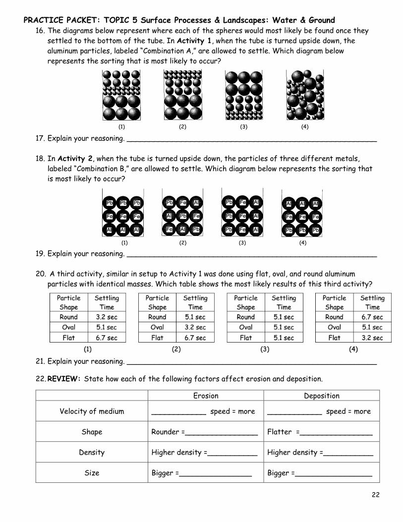
16. The diagrams below represent where each of the spheres would most likely be found once they
settled to the bottom of the tube. In Activity 1, when the tube is turned upside down, the
aluminum particles, labeled “Combination A,” are allowed to settle. Which diagram below
represents the sorting that is most likely to occur?
17. Explain your reasoning. _______________________________________________________
18. In Activity 2, when the tube is turned upside down, the particles of three different metals,
labeled “Combination B,” are allowed to settle. Which diagram below represents the sorting that
is most likely to occur?
19. Explain your reasoning. _______________________________________________________
20. A third activity, similar in setup to Activity 1 was done using flat, oval, and round aluminum
particles with identical masses. Which table shows the most likely results of this third activity?
21. Explain your reasoning. _______________________________________________________
22. REVIEW: State how each of the following factors affect erosion and deposition.
Erosion Deposition
Velocity of medium ____________ speed = more ____________ speed = more
Shape Rounder =________________ Flatter =________________
Density Higher density =___________ Higher density =___________
Size Bigger =________________ Bigger =_________________
PRACTICE PACKET: TOPIC 5 Surface Processes & Landscapes: Water & Ground
23
Directions: For each of the situations below, state whether it describes Erosion, Weathering, or
Deposition or possibly more than one.
23. Over the course of two years, the top layer of soil at a Michigan farm is blown away. _______
24. A very large storm occurs along the coast. The powerful waves wash away sand and move some
larger rocks on the shore. _______
25. Rainfall collects in a crack in a rock. When the temperature drops, this water freezes and
expands. This causes the crack to become slightly larger. _______
26. This rock is at the top of a cliff. After several years, the crack is large enough that a piece
breaks off and tumbles to the bottom. _______
27. A tree in your front yard spreads its roots beneath a sidewalk, pushing the sidewalk up and
causing it to crack. As the tree grows, these cracks are expanded as the roots grow into and
between them. _______
28. A glacier scrapes pieces of rock from underneath it and carries these pieces down the side of a
mountain and into the valley. _______
29. A river flowing through soft rock dissolves some of the rock and carries this material
downstream. _______
30. As a fire rages through a forest, a large boulder is heated quickly. This rapid change in
temperature causes the outer layer of the boulder to crack. _______
Regents Questions:
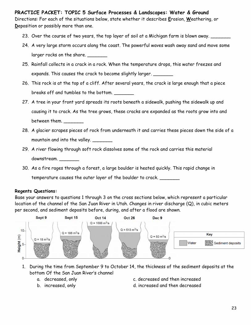
Base your answers to questions 1 through 3 on the cross sections below, which represent a particular
location of the channel of the San Juan River in Utah. Changes in river discharge (Q), in cubic meters
per second, and sediment deposits before, during, and after a flood are shown.
1. During the time from September 9 to October 14, the thickness of the sediment deposits at the
bottom Of the San Juan River’s channel
a. decreased, only c. decreased and then increased
b. increased, only d. increased and then decreased
PRACTICE PACKET: TOPIC 5 Surface Processes & Landscapes: Water & Ground
24
2. On October 14, during the flood, the discharge (_____________________) of the San Juan
River changed dramatically. The change in the river’s discharge at this location was related to an
increase in the river’s
a. velocity b. gradient c. channel length d. sediment deposits
3. A river’s current carries sediments into the ocean. Which sediment size will most likely be
deposited in deeper water farthest from the shore?
a. pebble b. sand c. silt d. clay
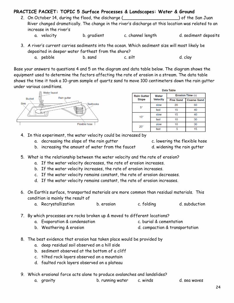
Base your answers to questions 4 and 5 on the diagram and data table below. The diagram shows the
equipment used to determine the factors affecting the rate of erosion in a stream. The data table
shows the time it took a 10-gram sample of quartz sand to move 100 centimeters down the rain gutter
under various conditions.
4. In this experiment, the water velocity could be increased by
a. decreasing the slope of the rain gutter c. lowering the flexible hose
b. increasing the amount of water from the faucet d. widening the rain gutter
5. What is the relationship between the water velocity and the rate of erosion?
a. If the water velocity decreases, the rate of erosion increases.
b. If the water velocity increases, the rate of erosion increases.
c. If the water velocity remains constant, the rate of erosion decreases.
d. If the water velocity remains constant, the rate of erosion increases.
6. On Earth’s surface, transported materials are more common than residual materials. This
condition is mainly the result of
a. Recrystallization b. erosion c. folding d. subduction
7. By which processes are rocks broken up & moved to different locations?
a. Evaporation & condensation c. burial & cementation
b. Weathering & erosion d. compaction & transportation
8. The best evidence that erosion has taken place would be provided by
a. deep residual soil observed on a hill side
b. sediment observed at the bottom of a cliff
c. tilted rock layers observed on a mountain
d. faulted rock layers observed on a plateau
9. Which erosional force acts alone to produce avalanches and landslides?
a. gravity b. running water c. winds d. sea waves
PRACTICE PACKET: TOPIC 5 Surface Processes & Landscapes: Water & Ground
25
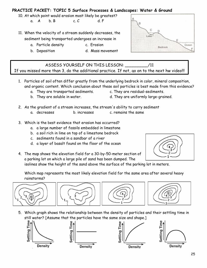
10. At which point would erosion most likely be greatest?
a. A b. B c. C d. F
11. When the velocity of a stream suddenly decreases, the
sediment being transported undergoes an increase in
a. Particle density c. Erosion
b. Deposition d. Mass movement
1. Particles of soil often differ greatly from the underlying bedrock in color, mineral composition,
and organic content. Which conclusion about these soil particles is best made from this evidence?
a. They are transported sediments. c. They are residual-sediments.
b. They are soluble in water. d. They are uniformly large-grained.
2. As the gradient of a stream increases, the stream's ability to carry sediment
a. decreases b. increases c. remains the same
3. Which is the best evidence that erosion has occurred?
a. a large number of fossils embedded in limestone
b. a soil rich in lime on top of a limestone bedrock
c. sediments found in a sandbar of a river
d. a layer of basalt found on the floor of the ocean
4. The map shows the elevation field for a 30-by-50-meter section of
a parking lot on which a large pile of sand has been dumped. The
isolines show the height of the sand above the surface of the parking lot in meters.
Which map represents the most likely elevation field for the same area after several heavy
rainstorms?
5. Which graph shows the relationship between the density of particles and their settling time in
still water? [Assume that the particles have the same size and shape.]
ASSESS YOURSELF ON THIS LESSON: _________/11
If you missed more than 3, do the additional practice. If not, go on to the next hw video!!!