Embed Size (px)
Citation preview
Attachment A13
Preliminary Floor and WSUD Study
460
Taylor Thomson Whitting (NSW) Pty Ltd, Consulting Engineers | ABN 81 113 578 37748 Chandos Street, St Leonards NSW 2065 | +612 9439 7288 | ttw.com.au
55 Pitt Street, SydneyFlood Study and Options Review
Prepared for Mirvac / 17 December 2019
161751 CAAF
461
Mirvac 17 December 201955 Pitt Street Flood Study and Options Review 161751
Taylor Thomson Whitting (NSW) Pty Ltd 2© Taylor Thomson Whitting
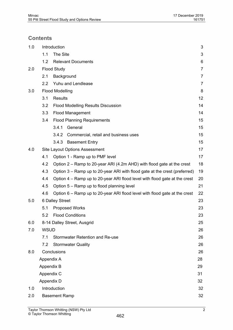
Contents1.0 Introduction 3
1.1 The Site 31.2 Relevant Documents 6
2.0 Flood Study 72.1 Background 72.2 Yuhu and Lendlease 7
3.0 Flood Modelling 83.1 Results 123.2 Flood Modelling Results Discussion 143.3 Flood Management 143.4 Flood Planning Requirements 15
3.4.1 General 153.4.2 Commercial, retail and business uses 153.4.3 Basement Entry 15
4.0 Site Layout Options Assessment 174.1 Option 1 - Ramp up to PMF level 174.2 Option 2 – Ramp to 20-year ARI (4.2m AHD) with flood gate at the crest 184.3 Option 3 – Ramp up to 20-year ARI with flood gate at the crest (preferred) 194.4 Option 4 – Ramp up to 20-year ARI flood level with flood gate at the crest 204.5 Option 5 – Ramp up to flood planning level 214.6 Option 6 – Ramp up to 20-year ARI flood level with flood gate at the crest 22
5.0 6 Dalley Street 235.1 Proposed Works 235.2 Flood Conditions 23
6.0 8-14 Dalley Street, Ausgrid 257.0 WSUD 26
7.1 Stormwater Retention and Re-use 267.2 Stormwater Quality 26
8.0 Conclusions 26Appendix A 28Appendix B 29Appendix C 31Appendix D 32
1.0 Introduction 322.0 Basement Ramp 32
462
Mirvac 17 December 201955 Pitt Street Flood Study and Options Review 161751
Taylor Thomson Whitting (NSW) Pty Ltd 3© Taylor Thomson Whitting
3.0 Underwood Street 333.1 Concept Grading 333.2 Underwood Street Regrading Results 34
4.0 Other Flood Management Controls in the Public Domain 354.1 Dalley and Pitt Streets 364.2 Dalley and Underwood Streets 364.3 Dalley and George Streets 374.4 Results 37
Appendix E 40
1.0 IntroductionThis Flood Study report has been prepared by TTW for Mirvac to address the flooding issues at 55 Pitt Street. The proposed development site is located between Pitt, Underwood, and Dalley Streets, and Queens Court at Circular Quay, Sydney. The report provides information to support a planning proposal and inform future detail design.The report reviews options presented by FJMT for the basement entry.
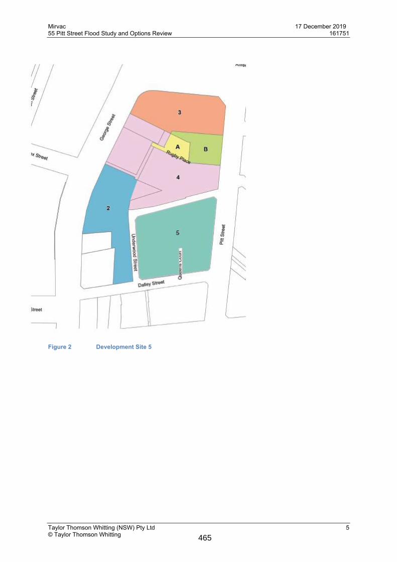
1.1 The SiteThe site comprises 6-8 Underwood Street, 37 Pitt Street, 57 Pitt Street, and 6 & 14 Dalley Street. The proposed development will consist of a Commercial Tower and a public through site link.
463

Mirvac 17 December 201955 Pitt Street Flood Study and Options Review 161751
Taylor Thomson Whitting (NSW) Pty Ltd 4© Taylor Thomson Whitting
Figure 1 Existing Site
464
Mirvac 17 December 201955 Pitt Street Flood Study and Options Review 161751
Taylor Thomson Whitting (NSW) Pty Ltd 5© Taylor Thomson Whitting
Figure 2 Development Site 5
465
Mirvac 17 December 201955 Pitt Street Flood Study and Options Review 161751
Taylor Thomson Whitting (NSW) Pty Ltd 6© Taylor Thomson Whitting
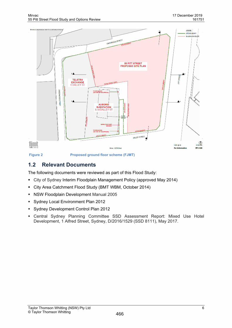
Figure 2 Proposed ground floor scheme (FJMT)
1.2 Relevant DocumentsThe following documents were reviewed as part of this Flood Study: City of Sydney Interim Floodplain Management Policy (approved May 2014) City Area Catchment Flood Study (BMT WBM, October 2014) NSW Floodplain Development Manual 2005 Sydney Local Environment Plan 2012 Sydney Development Control Plan 2012 Central Sydney Planning Committee SSD Assessment Report: Mixed Use Hotel
Development, 1 Alfred Street, Sydney, D/2016/1529 (SSD 8111), May 2017.
466
Mirvac 17 December 201955 Pitt Street Flood Study and Options Review 161751
Taylor Thomson Whitting (NSW) Pty Ltd 7© Taylor Thomson Whitting
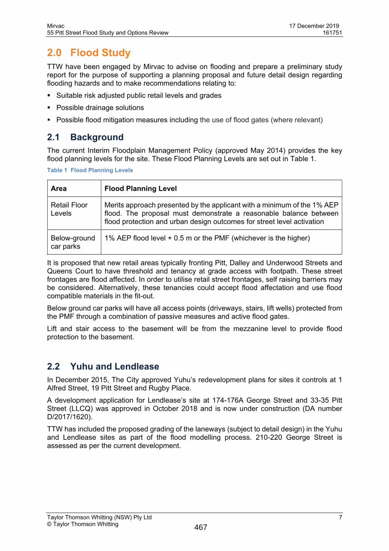
2.0 Flood StudyTTW have been engaged by Mirvac to advise on flooding and prepare a preliminary study report for the purpose of supporting a planning proposal and future detail design regarding flooding hazards and to make recommendations relating to: Suitable risk adjusted public retail levels and grades Possible drainage solutions Possible flood mitigation measures including the use of flood gates (where relevant)
2.1 BackgroundThe current Interim Floodplain Management Policy (approved May 2014) provides the key flood planning levels for the site. These Flood Planning Levels are set out in Table 1.Table 1 Flood Planning Levels
Area Flood Planning Level
Retail Floor Levels
Merits approach presented by the applicant with a minimum of the 1% AEP flood. The proposal must demonstrate a reasonable balance between flood protection and urban design outcomes for street level activation
Below-ground car parks
1% AEP flood level + 0.5 m or the PMF (whichever is the higher)
It is proposed that new retail areas typically fronting Pitt, Dalley and Underwood Streets and Queens Court to have threshold and tenancy at grade access with footpath. These street frontages are flood affected. In order to utilise retail street frontages, self raising barriers may be considered. Alternatively, these tenancies could accept flood affectation and use flood compatible materials in the fit-out.Below ground car parks will have all access points (driveways, stairs, lift wells) protected from the PMF through a combination of passive measures and active flood gates.Lift and stair access to the basement will be from the mezzanine level to provide flood protection to the basement.
2.2 Yuhu and LendleaseIn December 2015, The City approved Yuhu’s redevelopment plans for sites it controls at 1 Alfred Street, 19 Pitt Street and Rugby Place. A development application for Lendlease’s site at 174-176A George Street and 33-35 Pitt Street (LLCQ) was approved in October 2018 and is now under construction (DA number D/2017/1620).TTW has included the proposed grading of the laneways (subject to detail design) in the Yuhu and Lendlease sites as part of the flood modelling process. 210-220 George Street is assessed as per the current development.
467
Mirvac 17 December 201955 Pitt Street Flood Study and Options Review 161751
Taylor Thomson Whitting (NSW) Pty Ltd 8© Taylor Thomson Whitting
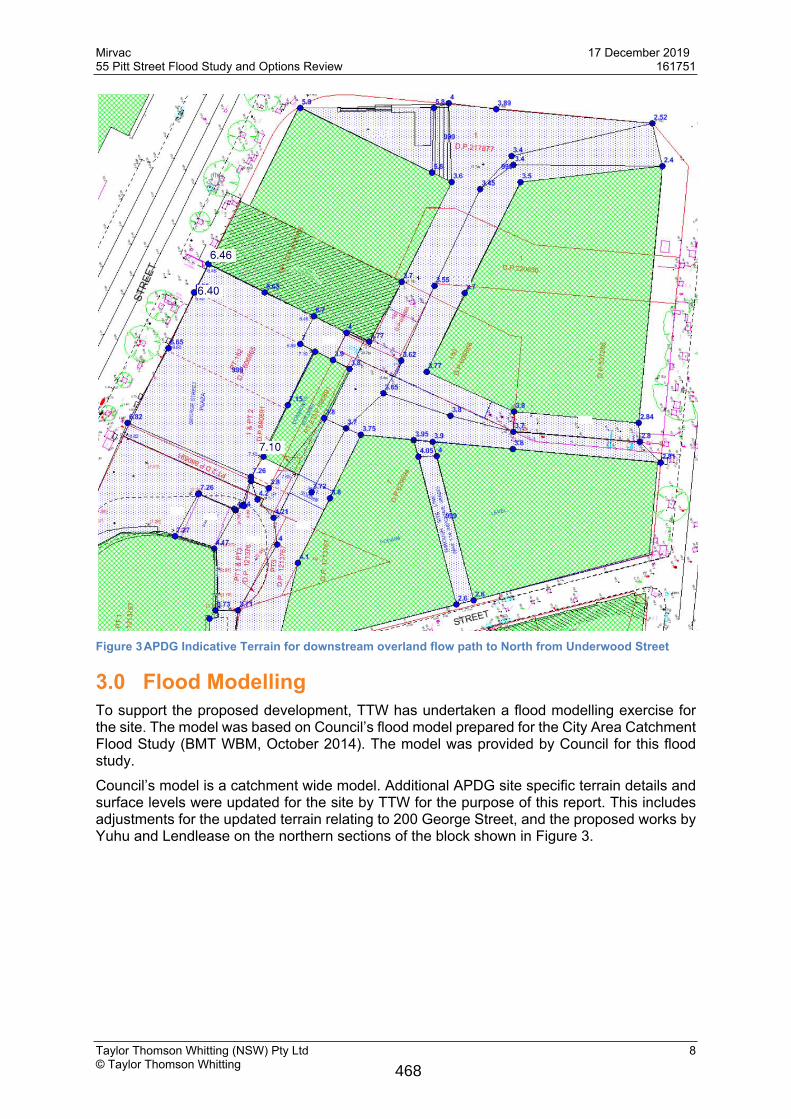
Figure 3APDG Indicative Terrain for downstream overland flow path to North from Underwood Street
3.0 Flood ModellingTo support the proposed development, TTW has undertaken a flood modelling exercise for the site. The model was based on Council’s flood model prepared for the City Area Catchment Flood Study (BMT WBM, October 2014). The model was provided by Council for this flood study.Council’s model is a catchment wide model. Additional APDG site specific terrain details and surface levels were updated for the site by TTW for the purpose of this report. This includes adjustments for the updated terrain relating to 200 George Street, and the proposed works by Yuhu and Lendlease on the northern sections of the block shown in Figure 3.
468
Mirvac 17 December 201955 Pitt Street Flood Study and Options Review 161751
Taylor Thomson Whitting (NSW) Pty Ltd 9© Taylor Thomson Whitting
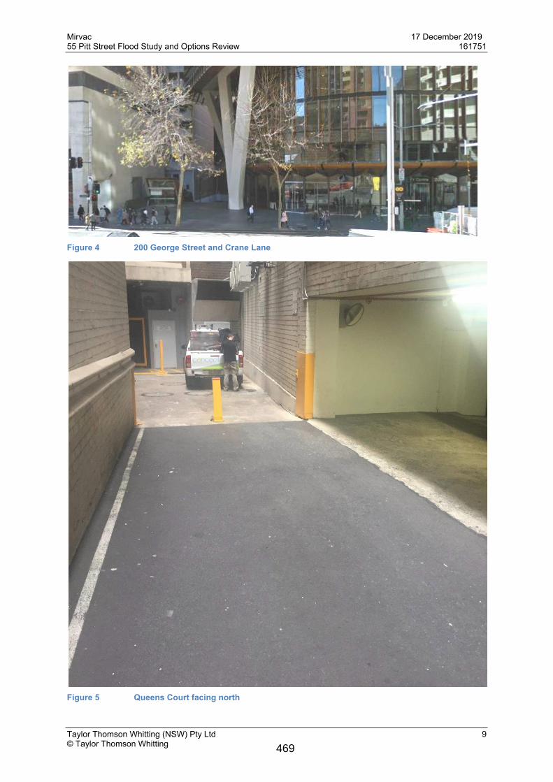
Figure 4 200 George Street and Crane Lane
Figure 5 Queens Court facing north
469
Mirvac 17 December 201955 Pitt Street Flood Study and Options Review 161751
Taylor Thomson Whitting (NSW) Pty Ltd 10© Taylor Thomson Whitting
The 210-220 George Street development does not affect our site as it doesn’t direct additional flow to Underwood Street based on the flow information we have as per the following WMA flood report on 210-220 George Street.
Flood levels on George Street are RL 9 – RL 8 following the road profile. The diversion of the George Street flow occurs at Darley Street.The 210-220 George Street development doesn’t worsen the flood condition based on the WMA Flood Report.
470
Mirvac 17 December 201955 Pitt Street Flood Study and Options Review 161751
Taylor Thomson Whitting (NSW) Pty Ltd 11© Taylor Thomson Whitting
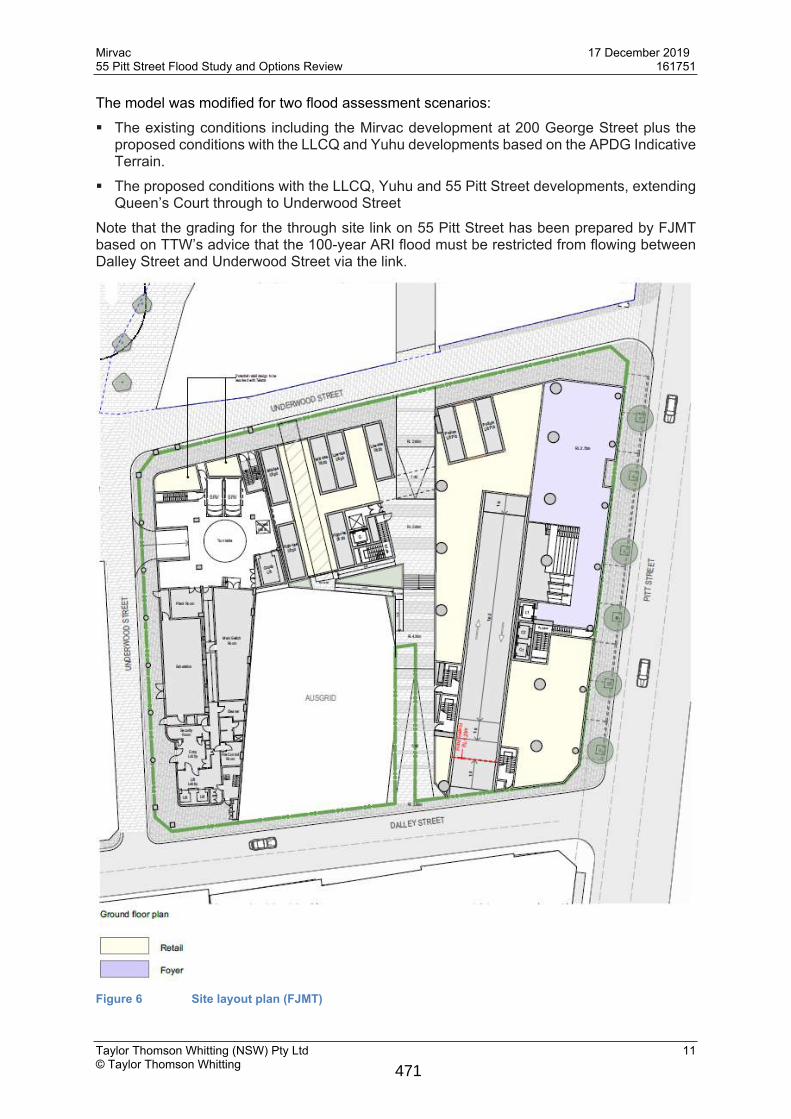
The model was modified for two flood assessment scenarios: The existing conditions including the Mirvac development at 200 George Street plus the
proposed conditions with the LLCQ and Yuhu developments based on the APDG Indicative Terrain.
The proposed conditions with the LLCQ, Yuhu and 55 Pitt Street developments, extending Queen’s Court through to Underwood Street
Note that the grading for the through site link on 55 Pitt Street has been prepared by FJMT based on TTW’s advice that the 100-year ARI flood must be restricted from flowing between Dalley Street and Underwood Street via the link.
Figure 6 Site layout plan (FJMT)
471
Mirvac 17 December 201955 Pitt Street Flood Study and Options Review 161751
Taylor Thomson Whitting (NSW) Pty Ltd 12© Taylor Thomson Whitting
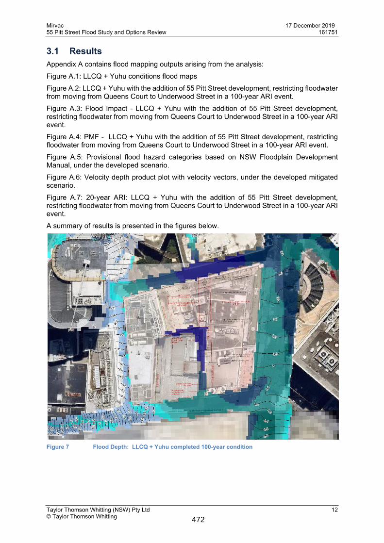
3.1 ResultsAppendix A contains flood mapping outputs arising from the analysis:Figure A.1: LLCQ + Yuhu conditions flood mapsFigure A.2: LLCQ + Yuhu with the addition of 55 Pitt Street development, restricting floodwater from moving from Queens Court to Underwood Street in a 100-year ARI event.Figure A.3: Flood Impact - LLCQ + Yuhu with the addition of 55 Pitt Street development, restricting floodwater from moving from Queens Court to Underwood Street in a 100-year ARI event.Figure A.4: PMF - LLCQ + Yuhu with the addition of 55 Pitt Street development, restricting floodwater from moving from Queens Court to Underwood Street in a 100-year ARI event.Figure A.5: Provisional flood hazard categories based on NSW Floodplain Development Manual, under the developed scenario.Figure A.6: Velocity depth product plot with velocity vectors, under the developed mitigated scenario.Figure A.7: 20-year ARI: LLCQ + Yuhu with the addition of 55 Pitt Street development, restricting floodwater from moving from Queens Court to Underwood Street in a 100-year ARI event.A summary of results is presented in the figures below.
Figure 7 Flood Depth: LLCQ + Yuhu completed 100-year condition
472
Mirvac 17 December 201955 Pitt Street Flood Study and Options Review 161751
Taylor Thomson Whitting (NSW) Pty Ltd 13© Taylor Thomson Whitting
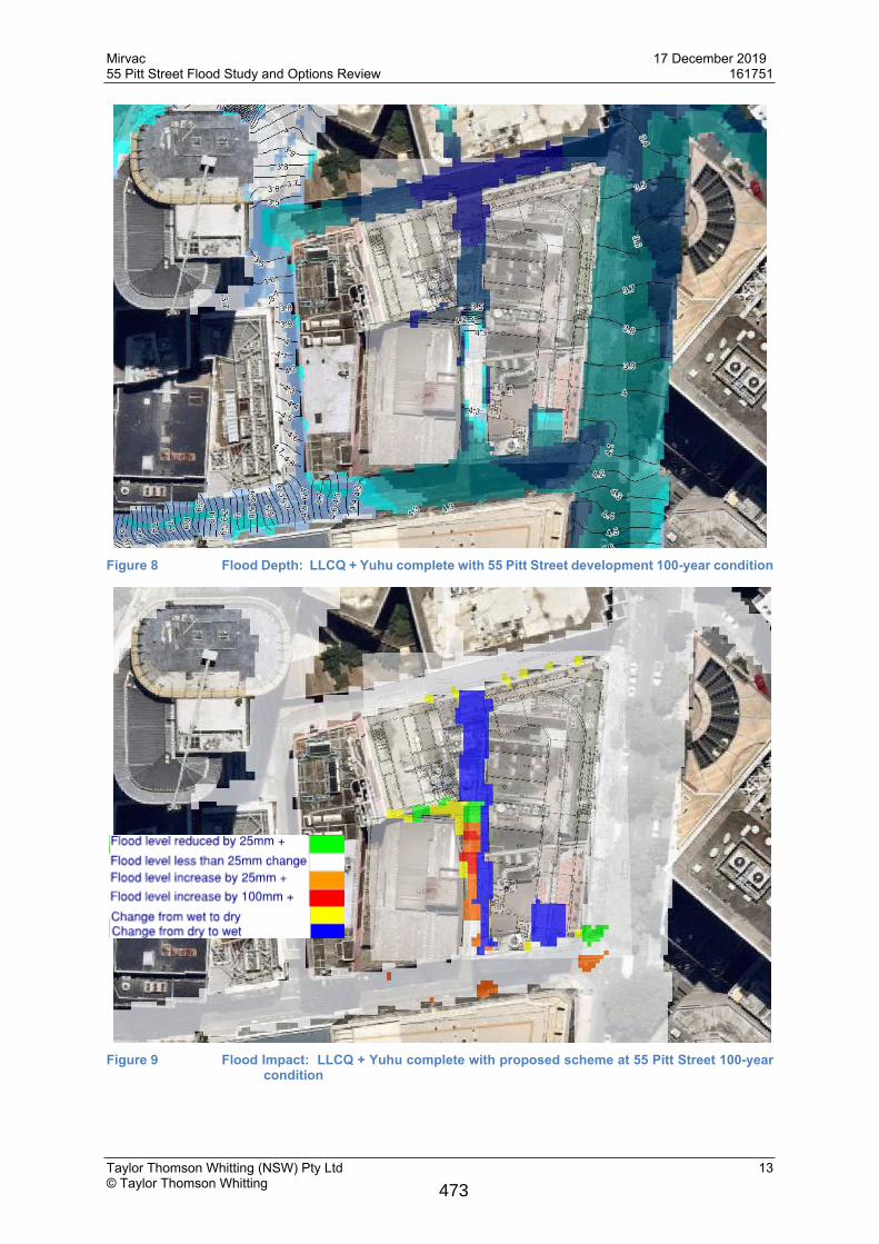
Figure 8 Flood Depth: LLCQ + Yuhu complete with 55 Pitt Street development 100-year condition
Figure 9 Flood Impact: LLCQ + Yuhu complete with proposed scheme at 55 Pitt Street 100-year
condition
473
Mirvac 17 December 201955 Pitt Street Flood Study and Options Review 161751
Taylor Thomson Whitting (NSW) Pty Ltd 14© Taylor Thomson Whitting
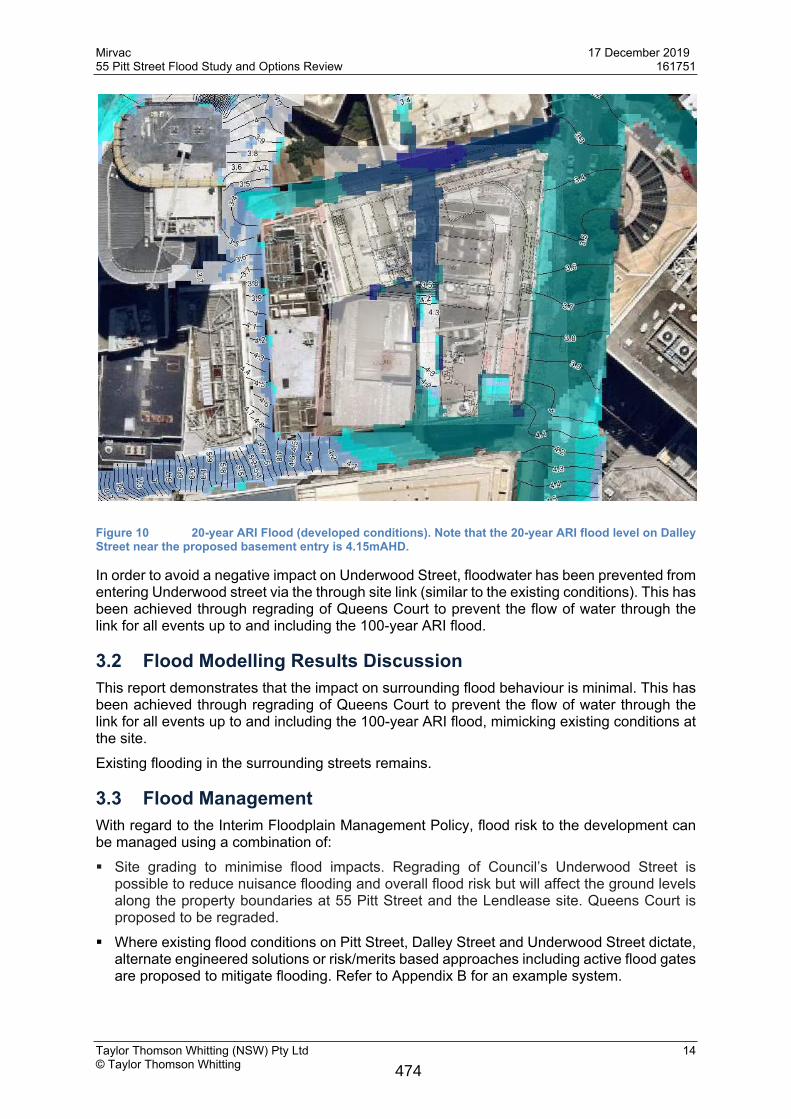
Figure 10 20-year ARI Flood (developed conditions). Note that the 20-year ARI flood level on Dalley Street near the proposed basement entry is 4.15mAHD.
In order to avoid a negative impact on Underwood Street, floodwater has been prevented from entering Underwood street via the through site link (similar to the existing conditions). This has been achieved through regrading of Queens Court to prevent the flow of water through the link for all events up to and including the 100-year ARI flood.
3.2 Flood Modelling Results DiscussionThis report demonstrates that the impact on surrounding flood behaviour is minimal. This has been achieved through regrading of Queens Court to prevent the flow of water through the link for all events up to and including the 100-year ARI flood, mimicking existing conditions at the site.Existing flooding in the surrounding streets remains.
3.3 Flood ManagementWith regard to the Interim Floodplain Management Policy, flood risk to the development can be managed using a combination of: Site grading to minimise flood impacts. Regrading of Council’s Underwood Street is
possible to reduce nuisance flooding and overall flood risk but will affect the ground levels along the property boundaries at 55 Pitt Street and the Lendlease site. Queens Court is proposed to be regraded.
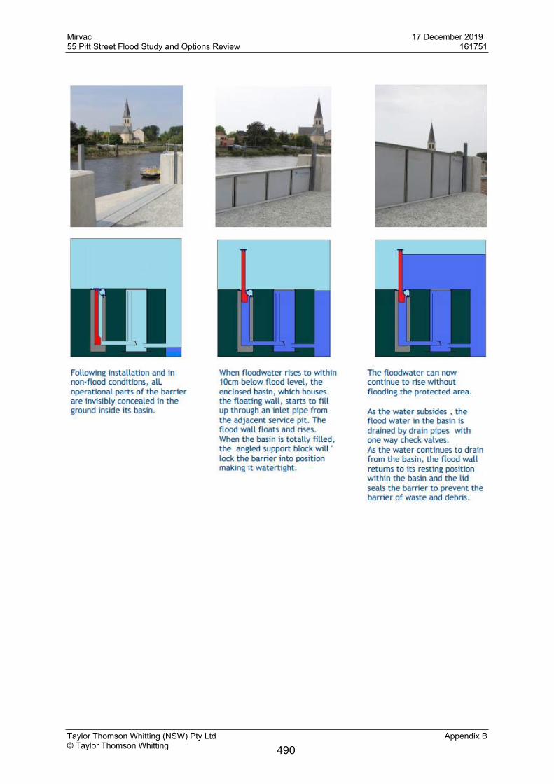
Where existing flood conditions on Pitt Street, Dalley Street and Underwood Street dictate, alternate engineered solutions or risk/merits based approaches including active flood gates are proposed to mitigate flooding. Refer to Appendix B for an example system.
474
Mirvac 17 December 201955 Pitt Street Flood Study and Options Review 161751
Taylor Thomson Whitting (NSW) Pty Ltd 15© Taylor Thomson Whitting
3.4 Flood Planning Requirements
3.4.1 General
Flood Planning Levels (FPLs) are generally to comply with the City of Sydney’s Interim Floodplain Management Policy (Policy):
Area Flood Planning Level
Retail Floor Levels
Merits approach presented by the applicant with a minimum of the 1% AEP flood. The proposal must demonstrate a reasonable balance between flood protection and urban design outcomes for street level activation
Below-ground car parks
1% AEP flood level + 0.5 m or the PMF (whichever is the higher)
3.4.2 Commercial, retail and business uses
Commercial/Business/Retail uses to be provided with:Internal to retail space, FPL’s are proposed to comply with the Policy (1 in 100 year ARI flood level) where possible or an alternate ARI coupled with alternate engineered solution and/or risk/merits based approach acceptable to Mirvac and Council. All mechanical, electrical and plumbing fixtures need to be located at or above the FPL where practicable. Where not practicable, it is recommended that such elements be protected by alternate engineered solutions and/or risk/merits based approaches.
3.4.3 Basement Entry
Due to existing flood conditions within the surrounding road reserves, TTW recommends to afford protection of the building up to the PMF level of 5.2mAHD at the basement entry in line with the City of Sydney’s Interim Floodplain Management Policy. Where this cannot be achieved through grading, an alternate solution such as self raising flood gates is required.Fire stairs and all other ingress points to the basement such as ventilation ducts, windows, light wells, lift shaft openings, risers, to be designed to flood planning levels to comply with the Policy where practicable. Where not practicable, TTW recommend that such elements be protected by alternate engineered solutions and/or risk/merits based approaches.An initial assessment in basement entries showed that to meet the PMF level, the design of the basement car park ramp would require a significant length that would extend beyond the site boundary and impact the design of the building and adjoining public domain. Therefore, giving protection in a PMF event without the use of flood gates would reduce the active street usage and ground floor usability to include almost all the site footprint.We note the approach taken at 1 Alfred Street (D/2016/1529) is to provide passive protection up to the 20-year ARI event for the basement car park entry, with flood gates giving protection above this level.
The Central Sydney Planning Committee’s Assessment Report on the site notes:While flood gates are generally discouraged City staff recommended consideration be given to granting development consent to the automated flood gates for the following reasons:
475
Mirvac 17 December 201955 Pitt Street Flood Study and Options Review 161751
Taylor Thomson Whitting (NSW) Pty Ltd 16© Taylor Thomson Whitting
The site is situated in a natural flood basin, situated where the historical Tank Stream met Sydney Harbour, resulting in particularly onerous flooding conditions along Pitt Street and adjacent to this site in particular. To meet the FPL the design of the basement car park would be cumbersome and inefficient, requiring a significant ramp at the entry which would have a significant knock-on effect for the design of the tower and public domain. The Pitt Street hotel lobby entrance and Alfred Street entrance for Tower B are sufficiently high enough to achieve flood resilience in all flood events up to and including the 100 year ARI flood event. The Pitt Street basement car park entry is sufficiently high to achieve resilience in flood events up to and including the 20 year ARI event.
While the use of flood gates is rightly unsupportable on the majority of sites, it is considered that the circumstances outlined above are exceptional, and their use is warranted in this instance.
55 Pitt Street faces the same issues – located in the natural flood basin where meeting the FPL would be cumbersome and inefficient.Several solutions have been investigated and are presented in the following section.
476
Mirvac 17 December 201955 Pitt Street Flood Study and Options Review 161751
Taylor Thomson Whitting (NSW) Pty Ltd 17© Taylor Thomson Whitting
4.0 Site Layout Options AssessmentOptions for the site layout prepared by FJMT are presented in Appendix C. Discussion on each option is presented below.Table 2 Key flood levels at proposed basement entry
Flood Event Flood level at proposed basement entry
20-year ARI 4.15 mAHD
100-year ARI 4.30 mAHD
PMF 5.20 mAHD
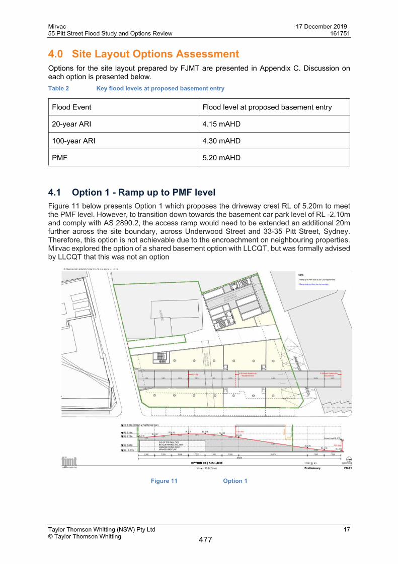
4.1 Option 1 - Ramp up to PMF levelFigure 11 below presents Option 1 which proposes the driveway crest RL of 5.20m to meet the PMF level. However, to transition down towards the basement car park level of RL -2.10m and comply with AS 2890.2, the access ramp would need to be extended an additional 20m further across the site boundary, across Underwood Street and 33-35 Pitt Street, Sydney. Therefore, this option is not achievable due to the encroachment on neighbouring properties. Mirvac explored the option of a shared basement option with LLCQT, but was formally advised by LLCQT that this was not an option
Figure 11 Option 1
477
Mirvac 17 December 201955 Pitt Street Flood Study and Options Review 161751
Taylor Thomson Whitting (NSW) Pty Ltd 18© Taylor Thomson Whitting
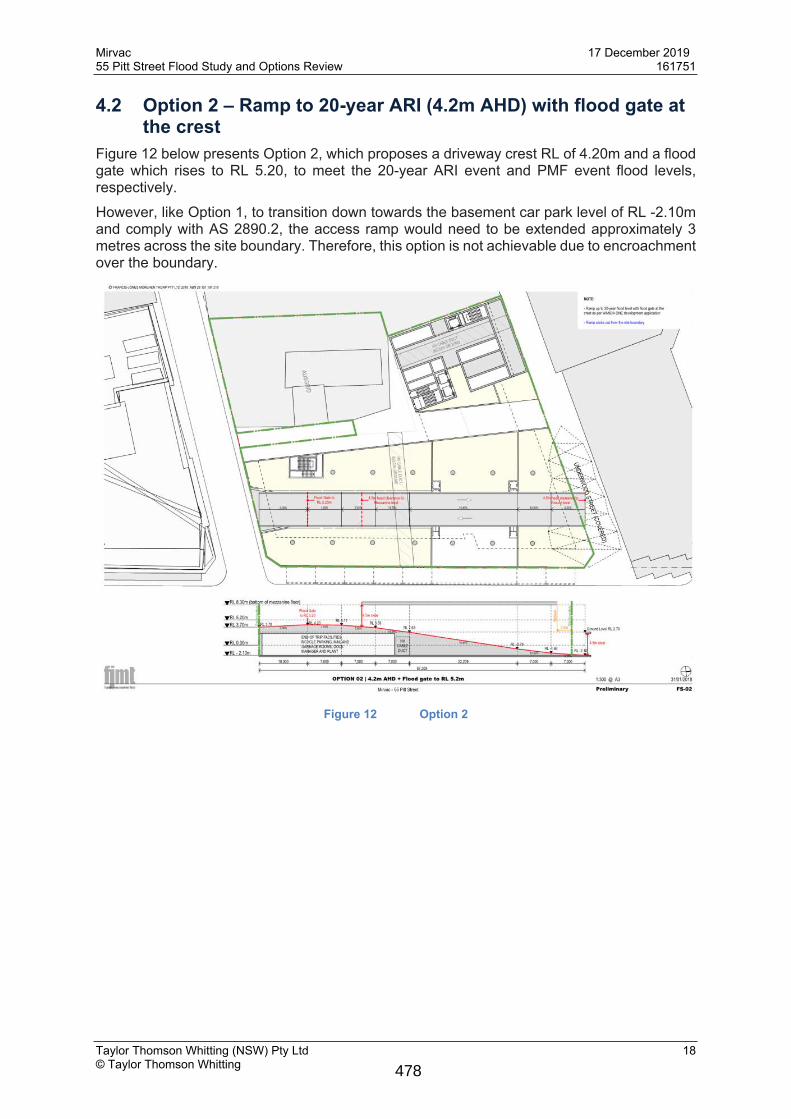
4.2 Option 2 – Ramp to 20-year ARI (4.2m AHD) with flood gate at the crest
Figure 12 below presents Option 2, which proposes a driveway crest RL of 4.20m and a flood gate which rises to RL 5.20, to meet the 20-year ARI event and PMF event flood levels, respectively. However, like Option 1, to transition down towards the basement car park level of RL -2.10m and comply with AS 2890.2, the access ramp would need to be extended approximately 3 metres across the site boundary. Therefore, this option is not achievable due to encroachment over the boundary.
Figure 12 Option 2
478
Mirvac 17 December 201955 Pitt Street Flood Study and Options Review 161751
Taylor Thomson Whitting (NSW) Pty Ltd 19© Taylor Thomson Whitting
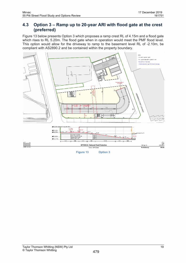
4.3 Option 3 – Ramp up to 20-year ARI with flood gate at the crest (preferred)
Figure 13 below presents Option 3 which proposes a ramp crest RL of 4.15m and a flood gate which rises to RL 5.20m. The flood gate when in operation would meet the PMF flood level. This option would allow for the driveway to ramp to the basement level RL of -2.10m, be compliant with AS2890.2 and be contained within the property boundary.
Figure 13 Option 3
479
Mirvac 17 December 201955 Pitt Street Flood Study and Options Review 161751
Taylor Thomson Whitting (NSW) Pty Ltd 20© Taylor Thomson Whitting
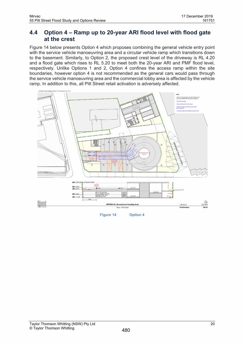
4.4 Option 4 – Ramp up to 20-year ARI flood level with flood gate at the crest
Figure 14 below presents Option 4 which proposes combining the general vehicle entry point with the service vehicle manoeuvring area and a circular vehicle ramp which transitions down to the basement. Similarly, to Option 2, the proposed crest level of the driveway is RL 4.20 and a flood gate which rises to RL 5.20 to meet both the 20-year ARI and PMF flood level, respectively. Unlike Options 1 and 2, Option 4 confines the access ramp within the site boundaries, however option 4 is not recommended as the general cars would pass through the service vehicle manoeuvring area and the commercial lobby area is affected by the vehicle ramp. In addition to this, all Pitt Street retail activation is adversely affected.
Figure 14 Option 4
480
Mirvac 17 December 201955 Pitt Street Flood Study and Options Review 161751
Taylor Thomson Whitting (NSW) Pty Ltd 21© Taylor Thomson Whitting
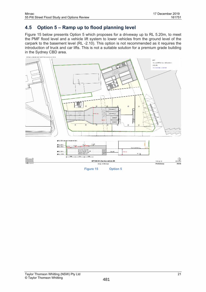
4.5 Option 5 – Ramp up to flood planning levelFigure 15 below presents Option 5 which proposes for a driveway up to RL 5.20m, to meet the PMF flood level and a vehicle lift system to lower vehicles from the ground level of the carpark to the basement level (RL -2.10). This option is not recommended as it requires the introduction of truck and car lifts. This is not a suitable solution for a premium grade building in the Sydney CBD area.
Figure 15 Option 5
481
Mirvac 17 December 201955 Pitt Street Flood Study and Options Review 161751
Taylor Thomson Whitting (NSW) Pty Ltd 22© Taylor Thomson Whitting
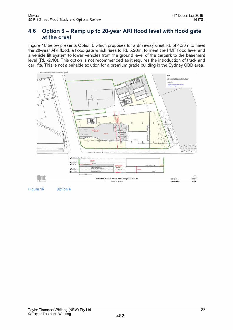
4.6 Option 6 – Ramp up to 20-year ARI flood level with flood gate at the crest
Figure 16 below presents Option 6 which proposes for a driveway crest RL of 4.20m to meet the 20-year ARI flood, a flood gate which rises to RL 5.20m, to meet the PMF flood level and a vehicle lift system to lower vehicles from the ground level of the carpark to the basement level (RL -2.10). This option is not recommended as it requires the introduction of truck and car lifts. This is not a suitable solution for a premium grade building in the Sydney CBD area.
Figure 16 Option 6
482
Mirvac 17 December 201955 Pitt Street Flood Study and Options Review 161751
Taylor Thomson Whitting (NSW) Pty Ltd 23© Taylor Thomson Whitting
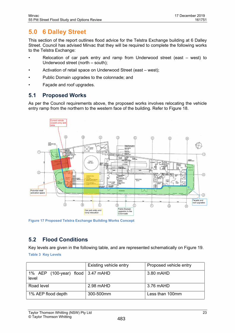
5.0 6 Dalley StreetThis section of the report outlines flood advice for the Telstra Exchange building at 6 Dalley Street. Council has advised Mirvac that they will be required to complete the following works to the Telstra Exchange:• Relocation of car park entry and ramp from Underwood street (east – west) to
Underwood street (north – south);• Activation of retail space on Underwood Street (east – west);• Public Domain upgrades to the colonnade; and • Façade and roof upgrades.
5.1 Proposed WorksAs per the Council requirements above, the proposed works involves relocating the vehicle entry ramp from the northern to the western face of the building. Refer to Figure 18.
Figure 17 Proposed Telstra Exchange Building Works Concept
5.2 Flood ConditionsKey levels are given in the following table, and are represented schematically on Figure 19.Table 3 Key Levels
Existing vehicle entry Proposed vehicle entry
1% AEP (100-year) flood level
3.47 mAHD 3.80 mAHD
Road level 2.98 mAHD 3.76 mAHD
1% AEP flood depth 300-500mm Less than 100mm
483
Mirvac 17 December 201955 Pitt Street Flood Study and Options Review 161751
Taylor Thomson Whitting (NSW) Pty Ltd 24© Taylor Thomson Whitting
Figure 18 Schematic section through the Telstra Exchange Building
Council’s Interim Floodplain Management Policy outlines the requirements for car parks with respect to flooding. The following extract gives requirements for the existing condition of the car park.
484
Mirvac 17 December 201955 Pitt Street Flood Study and Options Review 161751
Taylor Thomson Whitting (NSW) Pty Ltd 25© Taylor Thomson Whitting
At present, the car park complies with Council’s interim Floodplain Management Policy. The car park is defined as an above ground and enclosed car park. The floor level of the car park is above the 1% AEP flood level.Under the proposed conditions, the car park is re-defined as a below ground car park in the policy:
The flood planning level requirement for below ground car parks is more strict in the policy:
Under this requirement, the entry to the car park needs to rise up to 4.30mAHD to achieve 500mm freeboard. This is approximately 750mm above the existing car park which would not be feasible. Raising the internal level by 750mm to remove the below ground classification is not feasible, as the impact on headroom clearance, the existing turntable, and good lift servicing would have operational implications for Telstra. If the entrance has to be relocated then a food gate would be required to meet the requirements of City of Sydney Interim Floodplain Management Policy.
6.0 8-14 Dalley Street, Ausgrid The Ausgrid substation at 8-14 Dalley Street has an existing vehicular entry off Dalley Street. This is above ground and does not form part of the proposed works. It will be retained in it’s current configuration.
485
Mirvac 17 December 201955 Pitt Street Flood Study and Options Review 161751
Taylor Thomson Whitting (NSW) Pty Ltd 26© Taylor Thomson Whitting
Figure 19 - Existing Ausgrid vehicular entry
7.0 WSUDIn accordance with the Sydney DCP 2012, the development will require water sensitive urban design (WSUD) measures as part of the site stormwater management scheme.
7.1 Stormwater Retention and Re-useThe DCP requires a reduction in the runoff volume of 30% in an average year. For the subject site, this equates to approximately 900 kl/year to be used on site. Rainwater could be used for toilet flushing, in a car-wash bay, landscape irrigation, or other situations where non-potable water is suitable.A 20 kl stormwater retention tank will provide one week’s supply based on a re-use demand of 900 kl/year. Details of rainwater re-use demand and retention tank sizes are to be completed by a hydraulic engineer as the design progresses.
7.2 Stormwater QualityThe DCP sets out stormwater pollutant reduction targets: Litter and vegetation: 90% Total suspended solids: 85% Total phosphorus: 65% Total nitrogen:45%The stormwater quality targets can be achieved through the use of a propriety stormwater treatment device such as a Humes Jellyfish JF1200-2-1 or a Spel Hydrosystem HS1500.
8.0 Conclusions
486
Mirvac 17 December 201955 Pitt Street Flood Study and Options Review 161751
Taylor Thomson Whitting (NSW) Pty Ltd 27© Taylor Thomson Whitting
55 Pitt Street is located in the natural flood basin where meeting the FPL would be cumbersome and inefficient. The approach taken to overcome this, is to provide passive protection up the 20-year ARI flood, with a self raising flood gate giving protection to the basement in larger events.The site has been designed to have no impact on flooding on surrounding properties during a 100-year ARI event. This has been demonstrated with flood modelling.Relocating the car park entry for 6 Dalley Street from the east-west section of Underwood Street to the north-south section of the street has a significant impact from a flood compliance perspective. A flood gate would be required to ensure the relocated entry is compliant with the Interim Floodplain Management Policy..
Authorised byTAYLOR THOMSON WHITTING (NSW) PTY LTD
STEPHEN BRAINTechnical Director
P:\2016\1617\161751\Reports\TTW\191216 TTW flood report - revised.docx
487
Mirvac 17 December 201955 Pitt Street Flood Study and Options Review 161751
Taylor Thomson Whitting (NSW) Pty Ltd Appendix A© Taylor Thomson Whitting
Appendix A
Flood Maps
488

Mirvac 17 December 201955 Pitt Street Flood Study and Options Review 161751
Taylor Thomson Whitting (NSW) Pty Ltd Appendix B© Taylor Thomson Whitting
Appendix B
Flood Gates Information
489
Mirvac 17 December 201955 Pitt Street Flood Study and Options Review 161751
Taylor Thomson Whitting (NSW) Pty Ltd Appendix B© Taylor Thomson Whitting 490

Mirvac 17 December 201955 Pitt Street Flood Study and Options Review 161751
Taylor Thomson Whitting (NSW) Pty Ltd Appendix C© Taylor Thomson Whitting
Appendix C
FJMT Design Options
491
Mirvac 17 December 201955 Pitt Street Flood Study and Options Review 161751
Taylor Thomson Whitting (NSW) Pty Ltd Appendix D© Taylor Thomson Whitting
Appendix D
Mirvac Response To CoS Flooding Due Diligence Meeting Dated 6th April 2018
1.0 IntroductionMirvac and TTW met with the City of Sydney on 6th April 2018 to discuss flooding and flood management at 55 Pitt Street, Sydney. Key out-takes from the meeting listed below: The design of the basement ramp should consider passive flood protection up to the 100-
year ARI flood level of 4.30mAHD, which is 150mm higher than the submitted ramp up the to the 20-year ARI flood level of 4.15mAHD.
TTW to investigate the impact of raising ground levels in Underwood Street. This should take into account smaller flood events (5-year ARI) where the greatest benefit is expected.
Investigate and consider alternate flood controls in the public domain, (not in the immediate vicinity of the site) that may alleviate flood risk for 55 Pitt Street.
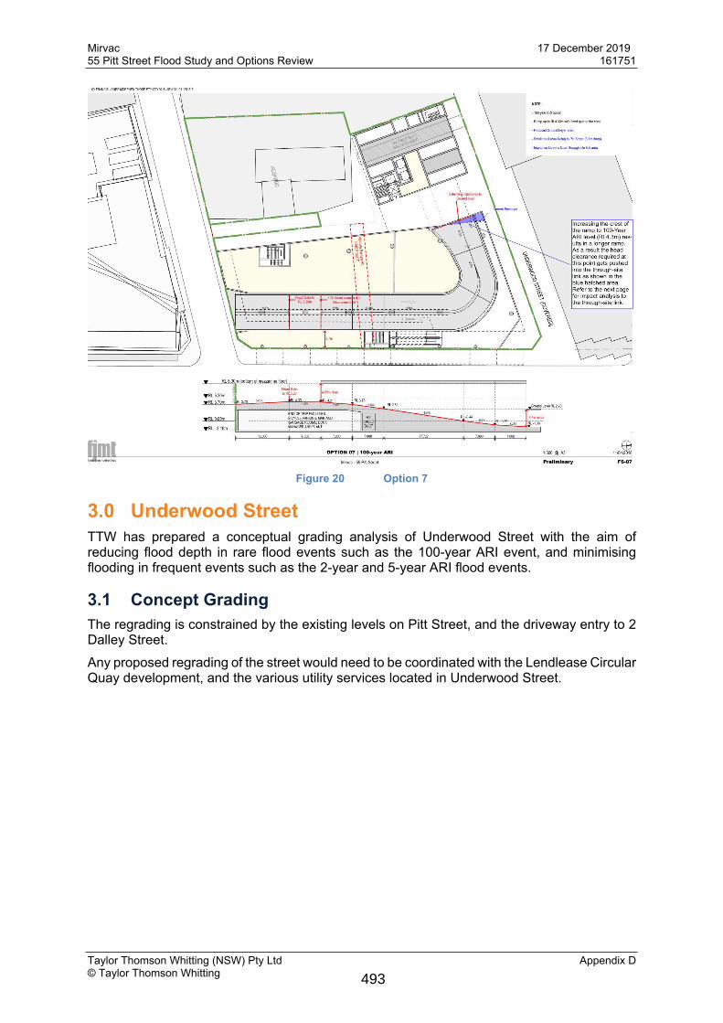
2.0 Basement RampThe preferred basement ramp Option 3 proposes a ramp crest RL of 4.15m and a flood gate which rises to RL 5.20m. The flood gate when in operation would meet the PMF flood level. This option would allow for the driveway to ramp to the basement level RL of -2.10m, be compliant with AS2890.2 and be contained within the property boundary.Following the meeting, FJMT prepared ramp Option 7, where the ramp crest is at the 100-year ARI level of RL 4.30m (Figure 20)When compared to Option 3, the ramp is required to be longer to make up for the increased height. This change has a negative impact on the public domain as an alternate alignment of the through site link is required to achieve adequate clearance height (3800mm) for vehicles entering the ramp and driving under the through site link.
492
Mirvac 17 December 201955 Pitt Street Flood Study and Options Review 161751
Taylor Thomson Whitting (NSW) Pty Ltd Appendix D© Taylor Thomson Whitting
Figure 20 Option 7
3.0 Underwood StreetTTW has prepared a conceptual grading analysis of Underwood Street with the aim of reducing flood depth in rare flood events such as the 100-year ARI event, and minimising flooding in frequent events such as the 2-year and 5-year ARI flood events.
3.1 Concept GradingThe regrading is constrained by the existing levels on Pitt Street, and the driveway entry to 2 Dalley Street.Any proposed regrading of the street would need to be coordinated with the Lendlease Circular Quay development, and the various utility services located in Underwood Street.
493
Mirvac 17 December 201955 Pitt Street Flood Study and Options Review 161751
Taylor Thomson Whitting (NSW) Pty Ltd Appendix D© Taylor Thomson Whitting
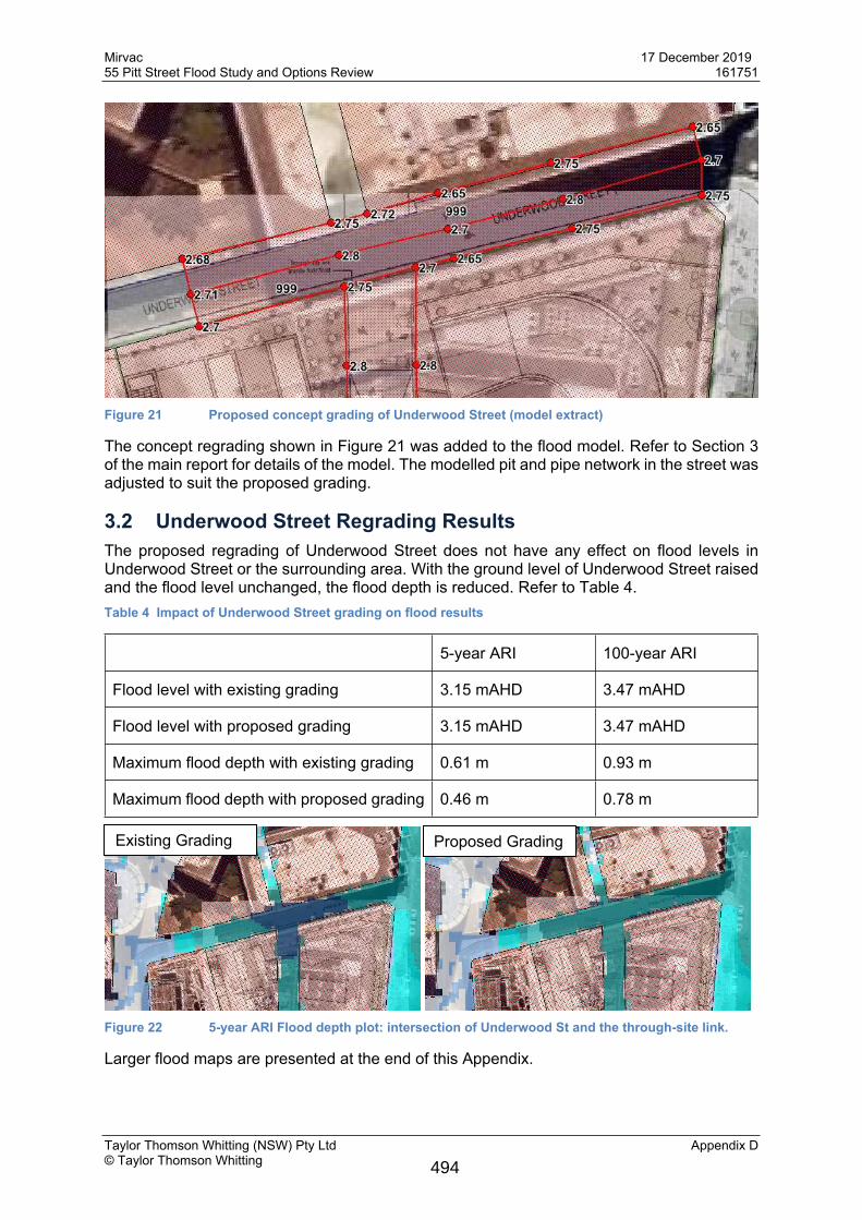
Figure 21 Proposed concept grading of Underwood Street (model extract)
The concept regrading shown in Figure 21 was added to the flood model. Refer to Section 3 of the main report for details of the model. The modelled pit and pipe network in the street was adjusted to suit the proposed grading.
3.2 Underwood Street Regrading ResultsThe proposed regrading of Underwood Street does not have any effect on flood levels in Underwood Street or the surrounding area. With the ground level of Underwood Street raised and the flood level unchanged, the flood depth is reduced. Refer to Table 4.Table 4 Impact of Underwood Street grading on flood results
5-year ARI 100-year ARI
Flood level with existing grading 3.15 mAHD 3.47 mAHD
Flood level with proposed grading 3.15 mAHD 3.47 mAHD
Maximum flood depth with existing grading 0.61 m 0.93 m
Maximum flood depth with proposed grading 0.46 m 0.78 m
Figure 22 5-year ARI Flood depth plot: intersection of Underwood St and the through-site link.
Larger flood maps are presented at the end of this Appendix.
Existing Grading Proposed Grading
494
Mirvac 17 December 201955 Pitt Street Flood Study and Options Review 161751
Taylor Thomson Whitting (NSW) Pty Ltd Appendix D© Taylor Thomson Whitting
4.0 Other Flood Management Controls in the Public Domain
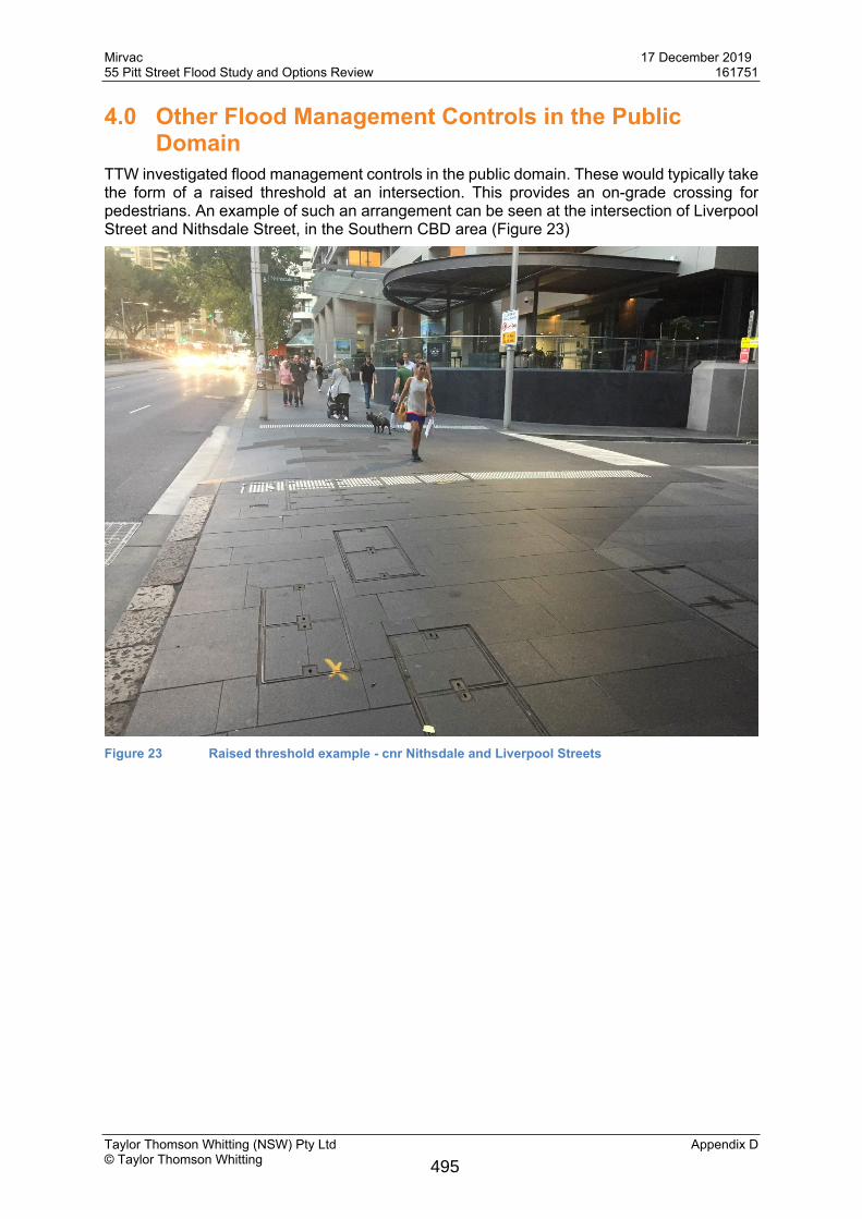
TTW investigated flood management controls in the public domain. These would typically take the form of a raised threshold at an intersection. This provides an on-grade crossing for pedestrians. An example of such an arrangement can be seen at the intersection of Liverpool Street and Nithsdale Street, in the Southern CBD area (Figure 23)
Figure 23 Raised threshold example - cnr Nithsdale and Liverpool Streets
495

Mirvac 17 December 201955 Pitt Street Flood Study and Options Review 161751
Taylor Thomson Whitting (NSW) Pty Ltd Appendix D© Taylor Thomson Whitting
4.1 Dalley and Pitt Streets
Figure 24 Pitt and Dalley Streets (Google Maps)
A review of flood levels at the intersection of Pitt and Dalley shows that the flood depth at this intersection is up to 600mm in a 100-year event, and 350mm in a 5-year event. Providing a 150mm high threshold here will not provide any benefit in terms of flood behaviour and could create additional ponding on Dalley Street.A review of the intersection of Pitt and Underwood Streets gives a similar outcome.
4.2 Dalley and Underwood Streets
Figure 25 Intersection of Underwood and Dalley Streets (Google Maps)
Flood modelling shows there is minimal stormwater flowing from Dalley Street to Underwood Street. Furthermore, there is limited space to install a threshold in this location. The width from
496
Mirvac 17 December 201955 Pitt Street Flood Study and Options Review 161751
Taylor Thomson Whitting (NSW) Pty Ltd Appendix D© Taylor Thomson Whitting
the building to the kerb on Dalley Street is approximately 1.2m. The site geometry dictates that this is not an appropriate position for a threshold.
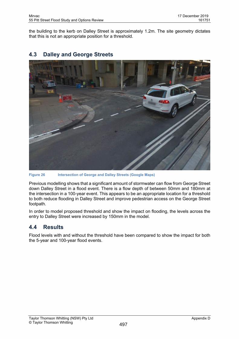
4.3 Dalley and George Streets
Figure 26 Intersection of George and Dalley Streets (Google Maps)
Previous modelling shows that a significant amount of stormwater can flow from George Street down Dalley Street in a flood event. There is a flow depth of between 50mm and 180mm at the intersection in a 100-year event. This appears to be an appropriate location for a threshold to both reduce flooding in Dalley Street and improve pedestrian access on the George Street footpath.In order to model proposed threshold and show the impact on flooding, the levels across the entry to Dalley Street were increased by 150mm in the model.
4.4 ResultsFlood levels with and without the threshold have been compared to show the impact for both the 5-year and 100-year flood events.
497
Mirvac 17 December 201955 Pitt Street Flood Study and Options Review 161751
Taylor Thomson Whitting (NSW) Pty Ltd Appendix D© Taylor Thomson Whitting
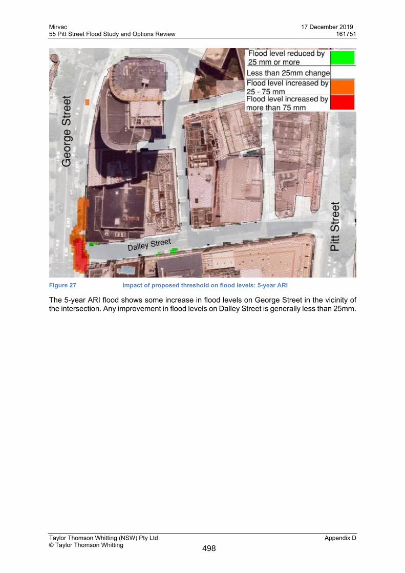
Figure 27 Impact of proposed threshold on flood levels: 5-year ARI
The 5-year ARI flood shows some increase in flood levels on George Street in the vicinity of the intersection. Any improvement in flood levels on Dalley Street is generally less than 25mm.
498
Mirvac 17 December 201955 Pitt Street Flood Study and Options Review 161751
Taylor Thomson Whitting (NSW) Pty Ltd Appendix D© Taylor Thomson Whitting
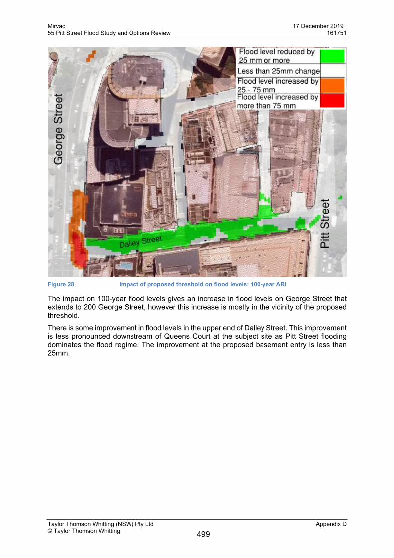
Figure 28 Impact of proposed threshold on flood levels: 100-year ARI
The impact on 100-year flood levels gives an increase in flood levels on George Street that extends to 200 George Street, however this increase is mostly in the vicinity of the proposed threshold.There is some improvement in flood levels in the upper end of Dalley Street. This improvement is less pronounced downstream of Queens Court at the subject site as Pitt Street flooding dominates the flood regime. The improvement at the proposed basement entry is less than 25mm.
499
Mirvac 17 December 201955 Pitt Street Flood Study and Options Review 161751
Taylor Thomson Whitting (NSW) Pty Ltd Appendix E© Taylor Thomson Whitting
Appendix E
Site plan and survey
500