Embed Size (px)
Citation preview
Polvadera Peak
Vallecitos
Canones
Cerro del Grant
Valle Toledo
AbiquiuYoungsville
Guaje MountainValle San Antonio
3985000 3985000
3986000 3986000
3987000 3987000
3988000 3988000
3989000 3989000
3990000 3990000
3991000 3991000
3992000 3992000
3993000 3993000
3994000 3994000
3995000 3995000
3996000 3996000
3997000 3997000
3998000 3998000
106°30'0"W
106°30'0"W
106°27'30"W
106°27'30"W
106°25'0"W
106°25'0"W
106°22'30"W
106°22'30"W
36°0'0"N
36°0'0"N
36°2'30"N
36°2'30"N
36°5'0"N
36°5'0"N
36°7'30"N
36°7'30"N
365000
365000
366000
366000
367000
367000
368000
368000
369000
369000
370000
370000
371000
371000
372000
372000
373000
373000
374000
374000
375000
375000
376000
376000
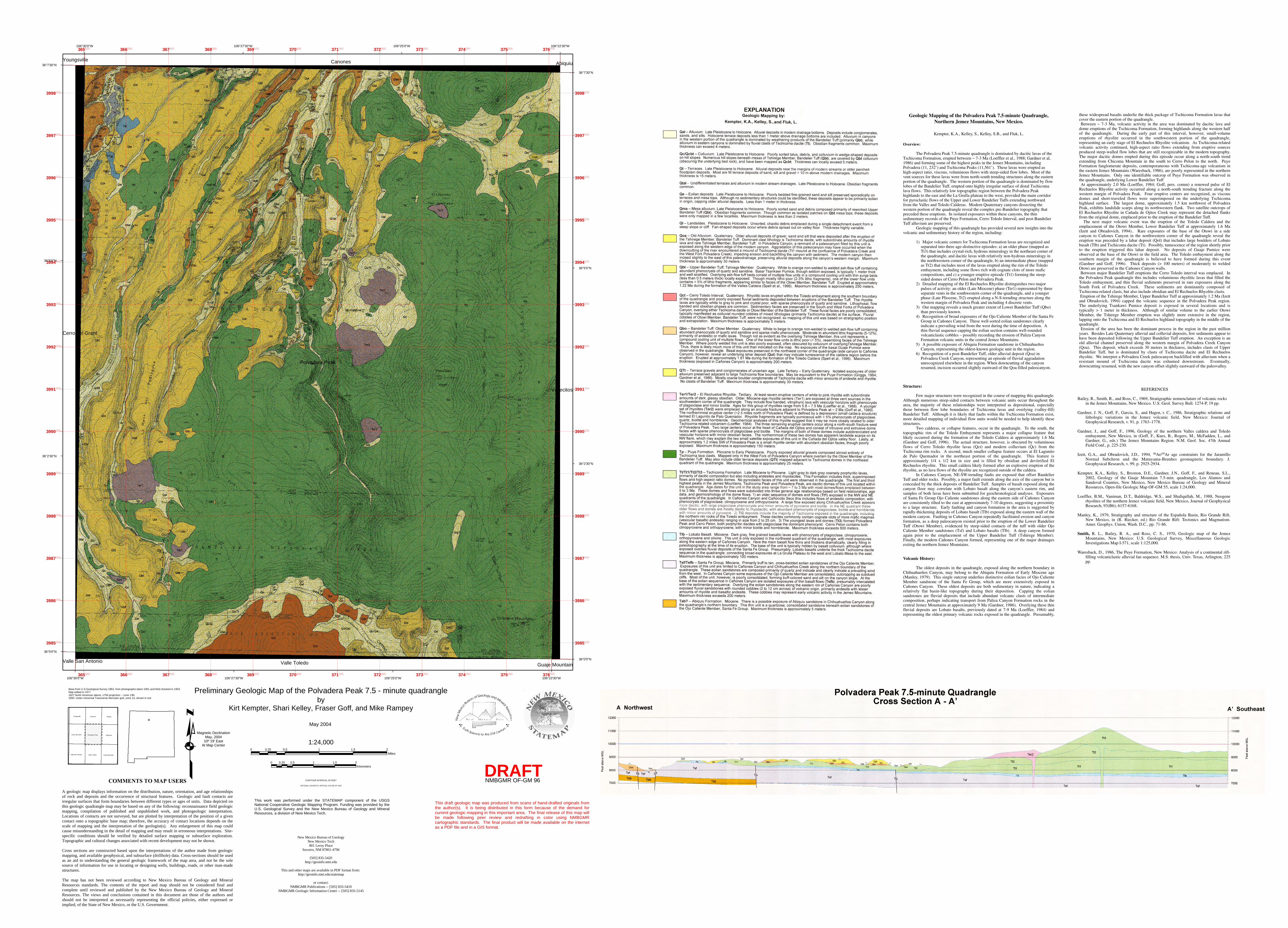
Preliminary Geologic Map of the Polvadera Peak 7.5 - minute quadrangle
0 0.5 1 1.5 20.25Miles
0 0.5 1 1.5 20.25Kilometers
1:24,000
Base from U.S.Geological Survey 1953, from photographs taken 1951 and field checked in 1953.Map edited in 1977 1927 North American datum, UTM projection -- zone 13N1000- meter Universal Transverse Mercator grid, zone 13, shown in red
CONTOUR INTERVAL 20 FEET
NATIONAL GEODETIC VERTICAL DATUM OF 1929
AbiquiuAbiquiu
VallecitosVallecitos
CanonesCanones
Valle ToledoValle Toledo
YoungsvilleYoungsville
Cerro del GrantCerro del Grant
Guaje MountainGuaje Mountain
Polvadera PeakPolvadera Peak
Valle San AntonioValle San Antonio
DRAFT
byKirt Kempter, Shari Kelley, Fraser Goff, and Mike Rampey
May 2004
Magnetic DeclinationMay, 2004
10º 19' EastAt Map Center
NMBGMR OF-GM 96
New Mexico Bureau of GeologyNew Mexico Tech801 Leroy Place
Socorro, NM 87801-4796
[505] 835-5420http://geoinfo.nmt.edu
This and other maps are available in PDF format from: http://geoinfo.nmt.edu/statemap
or contact:NMBGMR Publications -- [505] 835-5410
NMBGMR Geologic Information Center -- [505] 835-5145
COMMENTS TO MAP USERS A geologic map displays information on the distribution, nature, orientation, and age relationships of rock and deposits and the occurrence of structural features. Geologic and fault contacts are irregular surfaces that form boundaries between different types or ages of units. Data depicted on this geologic quadrangle map may be based on any of the following: reconnaissance field geologic mapping, compilation of published and unpublished work, and photogeologic interpretation. Locations of contacts are not surveyed, but are plotted by interpretation of the position of a given contact onto a topographic base map; therefore, the accuracy of contact locations depends on the scale of mapping and the interpretation of the geologist(s). Any enlargement of this map could cause misunderstanding in the detail of mapping and may result in erroneous interpretations. Site-specific conditions should be verified by detailed surface mapping or subsurface exploration. Topographic and cultural changes associated with recent development may not be shown. Cross sections are constructed based upon the interpretations of the author made from geologic mapping, and available geophysical, and subsurface (drillhole) data. Cross-sections should be used as an aid to understanding the general geologic framework of the map area, and not be the sole source of information for use in locating or designing wells, buildings, roads, or other man-made structures. The map has not been reviewed according to New Mexico Bureau of Geology and Mineral Resources standards. The contents of the report and map should not be considered final and complete until reviewed and published by the New Mexico Bureau of Geology and Mineral Resources. The views and conclusions contained in this document are those of the authors and should not be interpreted as necessarily representing the official policies, either expressed or implied, of the State of New Mexico, or the U.S. Government.
This draft geologic map was produced from scans of hand-drafted originals from the author(s). It is being distributed in this form because of the demand for current geologic mapping in this important area. The final release of this map will be made following peer review and redrafting in color using NMBGMR cartographic standards. The final product will be made available on the internet as a PDF file and in a GIS format.
This work was performed under the STATEMAP component of the USGS National Cooperative Geologic Mapping Program. Funding was provided by the U.S. Geological Survey and the New Mexico Bureau of Geology and Mineral Resources, a division of New Mexico Tech.
Geologic Mapping of the Polvadera Peak 7.5-minute Quadrangle, Northern Jemez Mountains, New Mexico.
Kempter, K.A., Kelley, S., Kelley, S.B., and Fluk, L.
Overview:
The Polvadera Peak 7.5-minute quadrangle is dominated by dacitic lavas of the Tschicoma Formation, erupted between ~ 7-3 Ma (Loeffler et al., 1988; Gardner et al, 1986) and forming some of the highest peaks in the Jemez Mountains, including Polvadera (11, 232’) and Tschicoma Peaks (11,561’). These lavas were erupted as high-aspect ratio, viscous, voluminous flows with steep-sided flow lobes. Most of the vent sources for these lavas were from north-south trending structures along the eastern portion of the quadrangle. The western portion of the quadrangle is dominated by flow lobes of the Bandelier Tuff, erupted onto highly irregular surface of distal Tschicoma lava flows. This relatively low topographic region between the Polvadera Peak highlands to the east and the La Grulla plateau to the west, provided the main corridor for pyroclastic flows of the Upper and Lower Bandelier Tuffs extending northward from the Valles and Toledo Calderas. Modern Quaternary canyons dissecting the western portion of the quadrangle reveal the complex pre-Bandelier topography that preceded these eruptions. In isolated exposures within these canyons, the thin sedimentary records of the Puye Formation, Cerro Toledo Interval, and post-Bandelier Tuff alluvium are preserved. Geologic mapping of this quadrangle has provided several new insights into the volcanic and sedimentary history of the region, including:
1) Major volcanic centers for Tschicoma Formation lavas are recognized and separated into three age-distinctive episodes: a) an older phase (mapped as Tt3) that includes crystal-rich, hydrous mineralogy in the northeast corner of the quadrangle, and dacitic lavas with relatively non-hydrous mineralogy in the northwestern corner of the quadrangle, b) an intermediate phase (mapped as Tt2) that includes most of the lavas erupted along the rim of the Toledo embayment, including some flows rich with cognate clots of more mafic compositions, and c) a younger eruptive episode (Tt1) forming the steep-sided domes of Cerro Pelon and Polvadera Peak.
2) Detailed mapping of the El Rechuelos Rhyolite distinguishes two major pulses of activity: an older (Late Miocene) phase (Ter1) represented by three separate vents in the southwestern corner of the quadrangle, and a younger phase (Late Pliocene, Tt2) erupted along a N-S-trending structure along the western margin of Polvadera Peak and including 4 discrete vents.
3) Our mapping reveals a much greater extent of Lower Bandelier Tuff (Qbo) than previously known.
4) Recognition of broad exposures of the Ojo Caliente Member of the Santa Fe Group in Cañones Canyon. These well-sorted eolian sandstones clearly indicate a prevailing wind from the west during the time of deposition. A thin fluvial sequence capping the eolian section contains well-rounded volcaniclastic cobbles – possibly recording the erosion of Paliza Canyon Formation volcanic units in the central Jemez Mountains.
5) A possible exposure of Abiquiu Formation sandstone in Chihuahueños Canyon, representing the oldest-known geologic unit in the region.
6) Recognition of a post-Bandelier Tuff, older alluvial deposit (Qoa) in Polvadera Creek Canyon, representing an episode of fluvial aggradation unrecognized elsewhere in the region. When downcutting of the canyon resumed, incision occurred slightly eastward of the Qoa-filled paleocanyon.
Structure:
Few major structures were recognized in the course of mapping this quadrangle. Although numerous steep-sided contacts between volcanic units occur throughout the area, the majority of these relationships were interpreted as depositional, especially those between flow lobe boundaries of Tschicoma lavas and overlying (valley-fill) Bandelier Tuff. Although it is likely that faults within the Tschicoma Formation exist, more detailed mapping of individual flow units would be needed to help identify these structures.
Two calderas, or collapse features, occur in the quadrangle. To the south, the topographic rim of the Toledo Embayment represents a major collapse feature that likely occurred during the formation of the Toledo Caldera at approximately 1.6 Ma (Gardner and Goff, 1996). The actual structure, however, is obscured by voluminous flows of Cerro Toledo rhyolite lavas (Qct) and modern colluvium (Qc) from the Tschicoma rim rocks. A second, much smaller collapse feature occurs at El Lagunito de Palo Quemador in the northeast portion of the quadrangle. This feature is approximately 1/4 x 1/2 km in size and is filled by obsidian and devitrified El Rechuelos rhyolite. This small caldera likely formed after an explosive eruption of the rhyolite, as no lava flows of the rhyolite are recognized outside of the caldera.
In Cañones Canyon, NE-SW-trending faults are exposed that offset Bandelier Tuff and older rocks. Possibly, a major fault extends along the axis of the canyon but is concealed by the thick deposits of Bandelier Tuff. Samples of basalt exposed along the canyon floor may correlate with Lobato basalt along the canyon’s eastern rim, and samples of both lavas have been submitted for geochronological analyses. Exposures of Santa Fe Group Ojo Caliente sandstones along the eastern side of Cañones Canyon are consistently tilted to the east at approximately 7-10 degrees, suggesting a proximity to a large structure. Early faulting and canyon formation in the area is suggested by rapidly-thickening deposits of Lobato basalt (Tlb) exposed along the eastern wall of the modern canyon. Faulting in Cañones Canyon repeatedly facilitated erosion and canyon formation, as a deep paleocanyon existed prior to the eruption of the Lower Bandelier Tuff (Otowi Member), evidenced by steep-sided contacts of the tuff with older Ojo Caliente Member sandstones (Tsf) and Lobato basalts (Tlb). A deep canyon formed again prior to the emplacement of the Upper Bandelier Tuff (Tshirege Member). Finally, the modern Cañones Canyon formed, representing one of the major drainages exiting the northern Jemez Mountains.
Volcanic History:
The oldest deposits in the quadrangle, exposed along the northern boundary in Chihuahueños Canyon, may belong to the Abiquiu Formation of Early Miocene age (Manley, 1979). This single outcrop underlies distinctive eolian facies of Ojo Caliente Member sandstone of the Santa Fe Group, which are more extensively exposed in Cañones Canyon. These oldest deposits are both sedimentary in nature, indicating a relatively flat basin-like topography during their deposition. Capping the eolian sandstones are fluvial deposits that include abundant volcanic clasts of intermediate composition, perhaps indicating transport from Paliza Canyon Formation rocks in the central Jemez Mountains at approximately 9 Ma (Gardner, 1986). Overlying these thin fluvial deposits are Lobato basalts, previously dated at 7-9 Ma (Loeffler, 1984) and representing the oldest primary volcanic rocks exposed in the quadrangle. Presumably,
these widespread basalts underlie the thick package of Tschicoma Formation lavas that cover the eastern portion of the quadrangle. Between ~ 7-3 Ma, volcanic activity in the area was dominated by dacitic lava and dome eruptions of the Tschicoma Formation, forming highlands along the western half of the quadrangle. During the early part of this interval, however, small-volume eruptions of rhyolite occurred in the southwestern portion of the quadrangle, representing an early stage of El Rechuelos Rhyolite volcanism. As Tschicoma-related volcanic activity continued, high-aspect ratio flows extending from eruptive sources produced steep-walled flow lobes that are still recognizable in the modern topography. The major dacitic domes erupted during this episode occur along a north-south trend extending from Chicoma Mountain in the south to Cerro Pelon to the north. Puye Formation fanglomerate deposits, contemporaneous with Tschicoma-age volcanism in the eastern Jemez Mountains (Waresback, 1986), are poorly represented in the northern Jemez Mountains. Only one identifiable outcrop of Puye Formation was observed in the quadrangle, underlying Lower Bandelier Tuff At approximately 2.0 Ma (Loeffler, 1984; Goff, pers. comm) a renewed pulse of El Rechuelos Rhyolite activity occurred along a north-south trending fracture along the western margin of Polvadera Peak. Four eruptive centers are recognized, as viscous domes and short-traveled flows were superimposed on the underlying Tschicoma highland surface. The largest dome, approximately 1.5 km northwest of Polvadera Peak, exhibits landslide scarps along its northwestern flank. Two satellite outcrops of El Rechuelos Rhyolite in Cañada de Ojitos Creek may represent the detached flanks from the original dome, emplaced prior to the eruption of the Bandelier Tuff. The next major volcanic event was the eruption of the Toledo Caldera and the emplacement of the Otowi Member, Lower Bandelier Tuff at approximately 1.6 Ma (Izett and Obradovich, 1994).. Rare exposures of the base of the Otowi in a side canyon to Cañones Canyon in the northwestern corner of the quadrangle reveal the eruption was preceded by a lahar deposit (Qol) that includes large boulders of Lobato basalt (Tlb) and Tschicoma dacite (Tt). Possibly, tumescence of the region shortly prior to the eruption triggered this lahar deposit. No deposits of Guaje Pumice were observed at the base of the Otowi in the field area. The Toledo embayment along the southern margin of the quadrangle is believed to have formed during this event (Gardner and Goff, 1996). Thick deposits (> 100 meters) of moderately to welded Otowi are preserved in the Cañones Canyon walls.Between major Bandelier Tuff eruptions the Cerro Toledo interval was emplaced. In the Polvadera Peak quadrangle this includes voluminous rhyolitic lavas that filled the Toledo embayment, and thin fluvial sediments preserved in rare exposures along the South Fork of Polvadera Creek. These sediments are dominantly composed of Tschicoma-related clasts, but also include obsidian and El Rechuelos Rhyolite clasts.Eruption of the Tshirege Member, Upper Bandelier Tuff at approximately 1.2 Ma (Izett and Obradovich, 1994) capped the volcanic sequence in the Polvadera Peak region. The underlying Tsankawi Pumice deposit is exposed in several locations and is typically > 1 meter in thickness. Although of similar volume to the earlier Otowi Member, the Tshirege Member eruption was slightly more extensive in the region, lapping onto the Tschicoma and El Rechuelos highland topography in the middle of the quadrangle. Erosion of the area has been the dominant process in the region in the past million years. Besides Late Quaternary alluvial and colluvial deposits, few sediments appear to have been deposited following the Upper Bandelier Tuff eruption. An exception is an old alluvial channel preserved along the western margin of Polvadera Creek Canyon (Qoa). This deposit, which exceeds 30 meters in thickness, includes clasts of Upper Bandelier Tuff, but is dominated by clasts of Tschicoma dacite and El Rechuelos rhyolite. We interpret a Polvadera Creek paleocanyon backfilled with alluvium when a resistant mound of Tschicoma dacite was exhumed downstream. Eventually, downcutting resumed, with the new canyon offset slightly eastward of the paleovalley.
REFERENCES
Bailey, R., Smith, R., and Ross, C., 1969, Stratigraphic nomenclature of volcanic rocks in the Jemez Mountains, New Mexico. U.S. Geol. Survey Bull. 1274-P, 19 pp.
Gardner, J. N., Goff, F., Garcia, S., and Hagen, r. C., 1986, Stratigraphic relations and lithologic variations in the Jemez volcanic field, New Mexico: Journal of Geophysical Research, v. 91, p. 1763–1778.
Gardner, J., and Goff, F., 1996, Geology of the northern Valles caldera and Toledo embayment, New Mexico, in (Goff, F., Kues, B., Rogers, M., McFadden, L., and Gardner, G., eds.) The Jemez Mountains Region. N.M. Geol. Soc. 47th Annual Field Conf., p. 225-230.
Izett, G.A., and Obradovich, J.D., 1994, 40Ar/39Ar age constraints for the Jaramillo Normal Subchron and the Matuyama-Brunhes geomagnetic boundary. J. Geophysical Research, v. 99, p. 2925-2934.
Kempter, K.A., Kelley, S., Broxton, D.E., Gardner, J.N., Goff, F., and Reneau, S.L., 2002, Geology of the Guaje Mountain 7.5-min. quadrangle, Los Alamos and Sandoval Counties, New Mexico, New Mexico Bureau of Geology and Mineral Resources, Open-file Geologic Map OF-GM 55, scale 1:24,000.
Loeffler, B.M., Vaniman, D.T., Baldridge, W.S., and Shafiqullah, M., 1988, Neogene rhyolites of the northern Jemez volcanic field, New Mexico, Journal of Geophysical Research, 93(B6); 6157-6168.
Manley, K., 1979, Stratigraphy and structure of the Española Basin, Rio Grande Rift, New Mexico, in (R. Riecker, ed.) Rio Grande Rift: Tectonics and Magmatism. Amer. Geophys. Union, Wash. D.C., pp. 71-86.
Smith, R. L., Bailey, R. A., and Ross, C. S., 1970, Geologic map of the Jemez Mountains, New Mexico: U.S. Geological Survey, Miscellaneous Geologic Investigations Map I-571, scale 1:125,000.
Waresback, D., 1986, The Puye Formation, New Mexico: Analysis of a continental rift-filling volcaniclastic alluvial fan sequence. M.S. thesis, Univ. Texas, Arlington, 225 pp.