Embed Size (px)
Citation preview
Development Contributions Guidelines
Preparing a full cost apportionment DCP Introduction This section provides information and examples on how to prepare a full cost apportionment development contributions plan (FCA DCP). An FCA DCP is a DCP prepared using the full cost apportionment method of calculating levies. The outcome of this process is an FCA DCP that is ready to be incorporated into the planning scheme through a planning scheme amendment. The section describes: • The [key concepts for calculating infrastructure levies] • The [5 phases of preparing an FCA DCP] • [Overview of the 16 stages for preparing an FCA DCP] • [Links to the 16 stages of preparing an FCA DCP]
Key concepts for calculating infrastructure levies Before you begin you will need to be familiar with some key concepts associated with the calculation process: • [the DCP area] • [the DCP timeframe] • [analysis areas] • [quantifying development] • [demand units] • [equivalence ratios] • [main catchment area] • [external usage and future usage] • [basic calculation of infrastructure levy per demand unit] • [simple formula for calculating infrastructure levies] • [charge areas]
The DCP area
This is the area where the DCP will apply. A DCP may cover all or part of a municipality, or multiple municipalities.
The DCP timeframe
You will need to select a timeframe for the DCP, such as 5, 10, 15 or 20 years. A DCP has a start and an end date. The start date is the day when the amendment incorporating the DCP into the planning scheme is gazetted. The end date will be 5, 10, 15 or 20 years after the date of gazettal, depending on the timeframe specified in the DCP.
V5.9 March 2007 Page 26 of 123
Development Contributions Guidelines
The DCP timeframe is required for: • making estimates about the amount of development likely to occur • calculating infrastructure levies • collecting levies • managing funds, and • determining the delivery of infrastructure.
In setting the timeframe, it is important to consider the: • time horizon for strategic planning, infrastructure provision and funding • expected rate of new development, and • degree of certainty in projecting growth.
Analysis areas
To calculate infrastructure levies, the DCP Area should be divided into analysis areas. An analysis area is a small geographic unit that is used as the basis for collecting and quantifying information about existing and future development. The number of analysis areas will depend on the size of the DCP area, the size and types of infrastructure projects likely to be included and their catchments, and the availability of detailed information about existing and new development.
Division of the DCP area into analysis areas
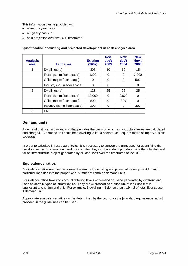
Quantifying development
For each analysis area, it will be necessary to quantify the amount of development that exists and the amount of future development expected to occur over the timeframe of the DCP. These projections should reflect the strategic planning directions set for the DCP area in the planning scheme. The amount of existing and future development should be quantified for all land uses that are likely to use the infrastructure projects included in the DCP. These might include residential, retail, office, industrial, institutional and other uses. In quantifying the amount of development, different units of measurement will be used depending on the land use (for example number of residential dwellings, square metres of retail floor space, hectares of industrial site area).
V5.9 March 2007 Page 27 of 123
Development Contributions Guidelines
This information can be provided on: • a year by year basis • a 5 yearly basis, or • as a projection over the DCP timeframe.
Quantification of existing and projected development in each analysis area
Analysis area Land uses
Existing (2002)
New dev’t 2003
New dev’t 2004
New dev’t 2005
1 Dwellings (#) 306 10 10 15 Retail (sq. m floor space) 1200 0 0 2,000 Office (sq. m floor space) 0 0 0 500
Industry (sq. m floor space) 0 0 0 0
2 Dwellings (#) 123 25 25 25 Retail (sq. m floor space) 12,000 0 2,000 0 Office (sq. m floor space) 500 0 300 0 Industry (sq. m floor space) 200 0 0 300
3 Etc.
Demand units
A demand unit is an individual unit that provides the basis on which infrastructure levies are calculated and charged. A demand unit could be a dwelling, a lot, a hectare, or 1 square metre of impervious site coverage. In order to calculate infrastructure levies, it is necessary to convert the units used for quantifying the development into common demand units, so that they can be added up to determine the total demand for an infrastructure project generated by all land uses over the timeframe of the DCP.
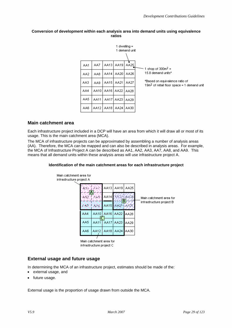
Equivalence ratios Equivalence ratios are used to convert the amount of existing and projected development for each particular land use into the proportional number of common demand units. Equivalence ratios take into account differing levels of demand or usage generated by different land uses on certain types of infrastructure. They are expressed as a quantum of land use that is equivalent to one demand unit. For example, 1 dwelling = 1 demand unit, 19 m2 of retail floor space = 1 demand unit. Appropriate equivalence ratios can be determined by the council or the [standard equivalence ratios] provided in the guidelines can be used.
V5.9 March 2007 Page 28 of 123
Development Contributions Guidelines
Conversion of development within each analysis area into demand units using equivalence ratios
Main catchment area
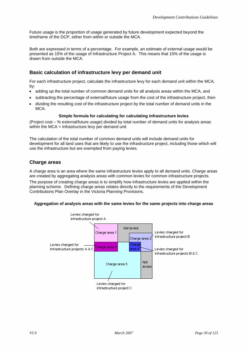
Each infrastructure project included in a DCP will have an area from which it will draw all or most of its usage. This is the main catchment area (MCA). The MCA of infrastructure projects can be approximated by assembling a number of analysis areas (AA). Therefore, the MCA can be mapped and can also be described in analysis areas. For example, the MCA of Infrastructure Project A can be described as AA1, AA2, AA3, AA7, AA8, and AA9. This means that all demand units within these analysis areas will use infrastructure project A.
Identification of the main catchment areas for each infrastructure project
External usage and future usage
In determining the MCA of an infrastructure project, estimates should be made of the: • external usage, and • future usage.
External usage is the proportion of usage drawn from outside the MCA.
V5.9 March 2007 Page 29 of 123
Development Contributions Guidelines
Future usage is the proportion of usage generated by future development expected beyond the timeframe of the DCP, either from within or outside the MCA. Both are expressed in terms of a percentage. For example, an estimate of external usage would be presented as 15% of the usage of Infrastructure Project A. This means that 15% of the usage is drawn from outside the MCA.
Basic calculation of infrastructure levy per demand unit
For each infrastructure project, calculate the infrastructure levy for each demand unit within the MCA, by: • adding up the total number of common demand units for all analysis areas within the MCA, and • subtracting the percentage of external/future usage from the cost of the infrastructure project, then • dividing the resulting cost of the infrastructure project by the total number of demand units in the
MCA.
Simple formula for calculating for calculating infrastructure levies (Project cost – % external/future usage) divided by total number of demand units for analysis areas within the MCA = Infrastructure levy per demand unit The calculation of the total number of common demand units will include demand units for development for all land uses that are likely to use the infrastructure project, including those which will use the infrastructure but are exempted from paying levies.
Charge areas
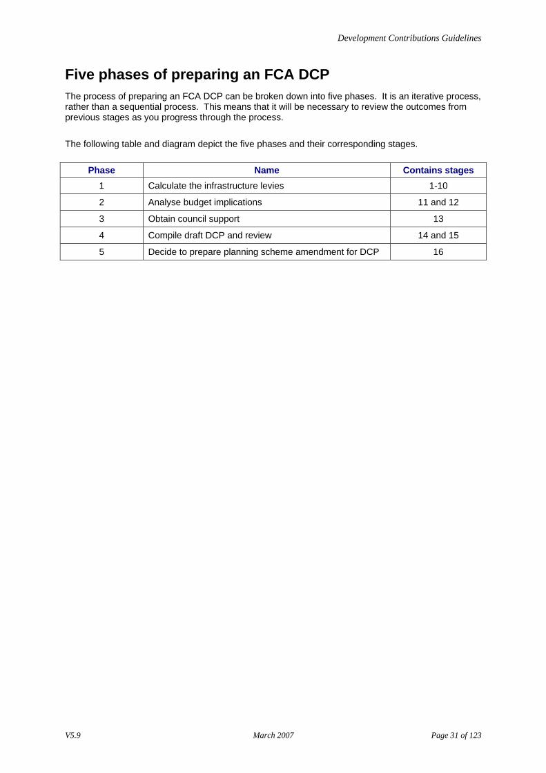
A charge area is an area where the same infrastructure levies apply to all demand units. Charge areas are created by aggregating analysis areas with common levies for common infrastructure projects. The purpose of creating charge areas is to simplify how infrastructure levies are applied within the planning scheme. Defining charge areas relates directly to the requirements of the Development Contributions Plan Overlay in the Victoria Planning Provisions.
Aggregation of analysis areas with the same levies for the same projects into charge areas
V5.9 March 2007 Page 30 of 123
Development Contributions Guidelines
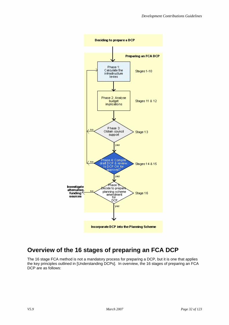
Five phases of preparing an FCA DCP The process of preparing an FCA DCP can be broken down into five phases. It is an iterative process, rather than a sequential process. This means that it will be necessary to review the outcomes from previous stages as you progress through the process. The following table and diagram depict the five phases and their corresponding stages.
Phase Name Contains stages 1 Calculate the infrastructure levies 1-10
2 Analyse budget implications 11 and 12
3 Obtain council support 13
4 Compile draft DCP and review 14 and 15
5 Decide to prepare planning scheme amendment for DCP 16
V5.9 March 2007 Page 31 of 123
Development Contributions Guidelines
Overview of the 16 stages of preparing an FCA DCP The 16 stage FCA method is not a mandatory process for preparing a DCP, but it is one that applies the key principles outlined in [Understanding DCPs]. In overview, the 16 stages of preparing an FCA DCP are as follows:
V5.9 March 2007 Page 32 of 123
Development Contributions Guidelines
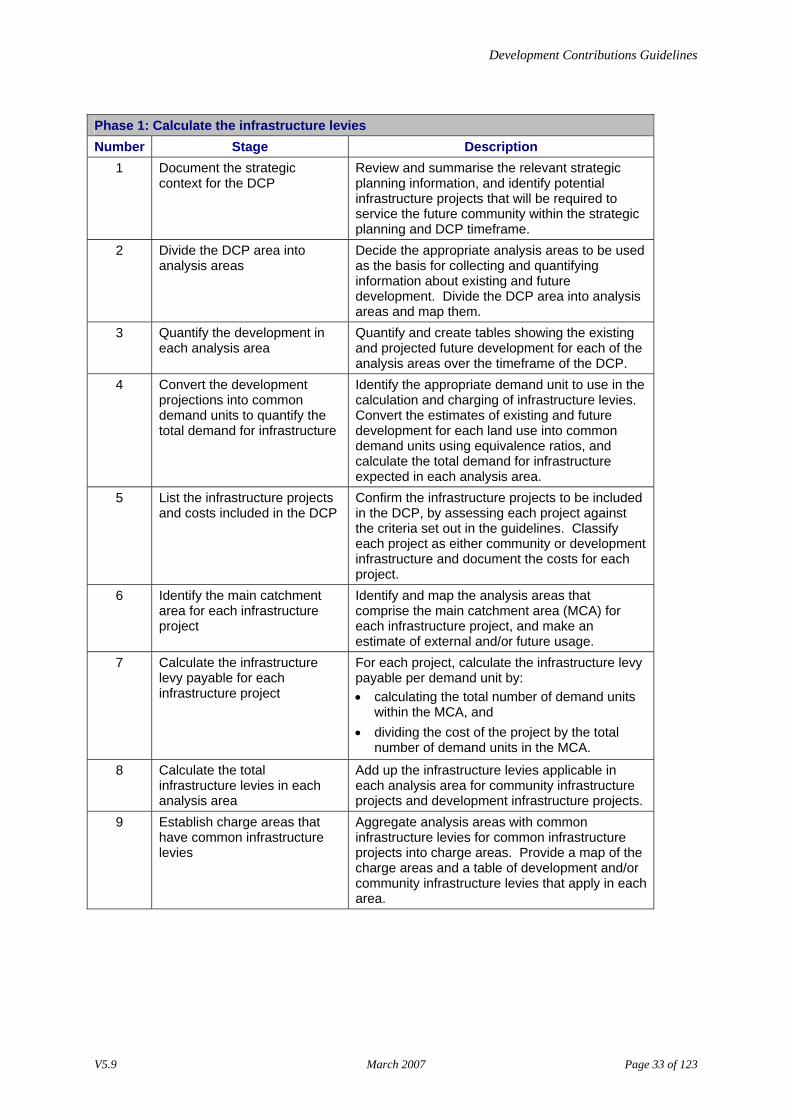
Phase 1: Calculate the infrastructure levies Number Stage Description
1 Document the strategic context for the DCP
Review and summarise the relevant strategic planning information, and identify potential infrastructure projects that will be required to service the future community within the strategic planning and DCP timeframe.
2 Divide the DCP area into analysis areas
Decide the appropriate analysis areas to be used as the basis for collecting and quantifying information about existing and future development. Divide the DCP area into analysis areas and map them.
3 Quantify the development in each analysis area
Quantify and create tables showing the existing and projected future development for each of the analysis areas over the timeframe of the DCP.
4 Convert the development projections into common demand units to quantify the total demand for infrastructure
Identify the appropriate demand unit to use in the calculation and charging of infrastructure levies. Convert the estimates of existing and future development for each land use into common demand units using equivalence ratios, and calculate the total demand for infrastructure expected in each analysis area.
5 List the infrastructure projects and costs included in the DCP
Confirm the infrastructure projects to be included in the DCP, by assessing each project against the criteria set out in the guidelines. Classify each project as either community or development infrastructure and document the costs for each project.
6 Identify the main catchment area for each infrastructure project
Identify and map the analysis areas that comprise the main catchment area (MCA) for each infrastructure project, and make an estimate of external and/or future usage.
7 Calculate the infrastructure levy payable for each infrastructure project
For each project, calculate the infrastructure levy payable per demand unit by: • calculating the total number of demand units
within the MCA, and • dividing the cost of the project by the total
number of demand units in the MCA.
8 Calculate the total infrastructure levies in each analysis area
Add up the infrastructure levies applicable in each analysis area for community infrastructure projects and development infrastructure projects.
9 Establish charge areas that have common infrastructure levies
Aggregate analysis areas with common infrastructure levies for common infrastructure projects into charge areas. Provide a map of the charge areas and a table of development and/or community infrastructure levies that apply in each area.
V5.9 March 2007 Page 33 of 123
Development Contributions Guidelines
10 Describe how infrastructure
levies will be collected For each charge area, assess whether the set procedures for collecting development and community infrastructure levies capture all the types of development that should be charged. If necessary, decide on and document the method for collecting development infrastructure levies from development that does not require a planning permit.
Phase 2: Analyse the budget implications Number Stage Description
11 Estimate the amount the council will need to fund for each infrastructure project (optional)
Calculate the amount that the council can expect to collect through the DCP for each infrastructure project, and estimate the amount the council will need to fund to make up the shortfall associated with existing development and exempted uses or land.
12 Prepare a cash flow analysis (optional)
Prepare a cash flow analysis table for each infrastructure project documenting the expected timing for collection of levies and expenditure. Assess the budget implications of each infrastructure project.
Phase 3: Obtain council support Number Stage Description
13 Obtain council support Obtain council agreement on key issues such as the amount of levies, infrastructure costs, timeframes for delivery of projects and the list of projects that will be included in the DCP, given the budget implications.
Phase 4: Compile draft DCP and review Number Stage Description
14 Compile the draft DCP Compile information prepared in previous stages into a draft DCP.
15 Review draft DCP and finalise Seek comments on the draft DCP from stakeholders within the organisation and external stakeholders such as developers, State Government agencies and adjoining municipalities. Consider all comments and change the draft DCP, if required. Prepare final version of DCP for exhibition.
Phase 5: Decide to prepare planning scheme amendment for DCP Number Stage Description
16 Decide to prepare an amendment to the planning scheme to incorporate the DCP
Obtain council decision to prepare an amendment to incorporate the DCP into the planning scheme.
V5.9 March 2007 Page 34 of 123
Development Contributions Guidelines
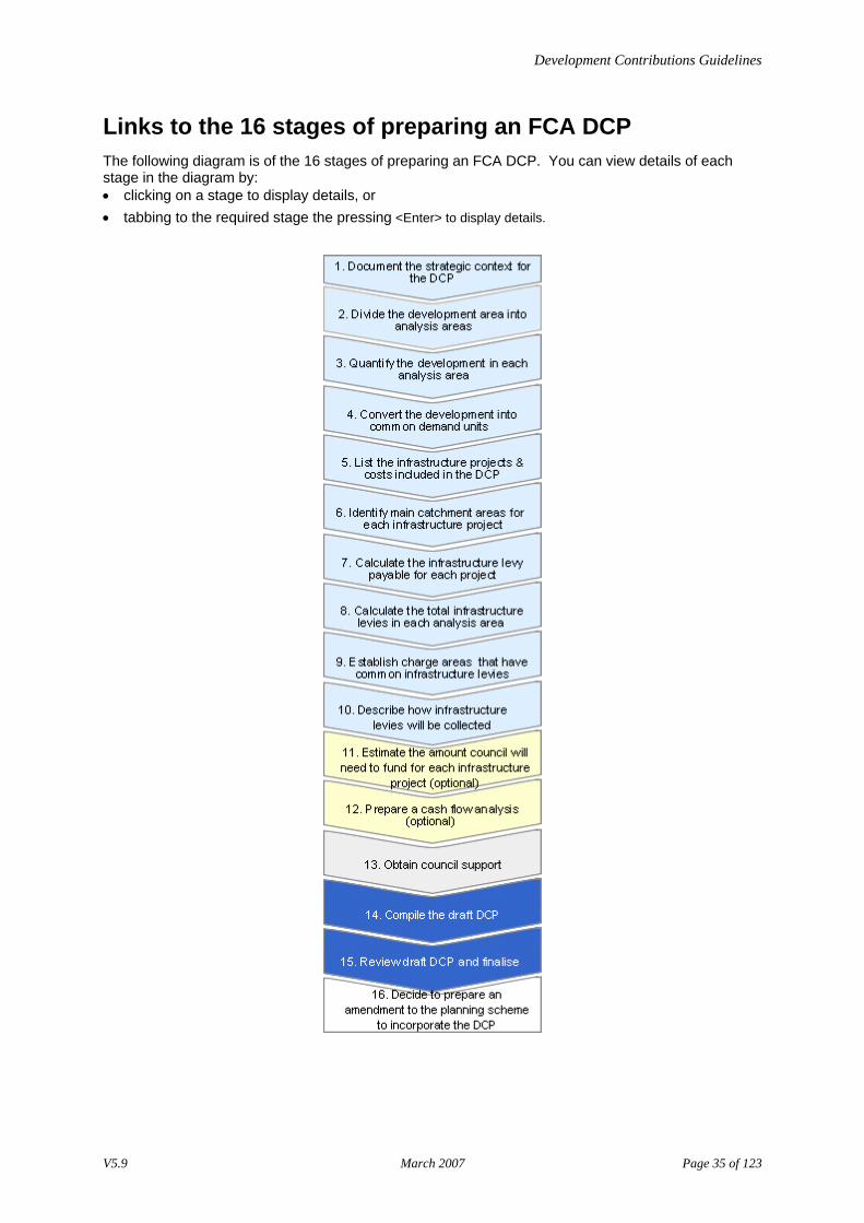
Links to the 16 stages of preparing an FCA DCP The following diagram is of the 16 stages of preparing an FCA DCP. You can view details of each stage in the diagram by: • clicking on a stage to display details, or • tabbing to the required stage the pressing <Enter> to display details.
V5.9 March 2007 Page 35 of 123
Development Contributions Guidelines
Stage 1–Document the strategic context for the DCP Before you begin
Before you begin this process, complete the [Deciding to Prepare a DCP] process.
Outcome
The outcome of this stage is a summary of the strategic context and basis for the DCP.
Process
Complete the following tasks. Task Description
1 Identify the broad strategic framework for the DCP by referring to all relevant supporting documentation including: • the State and Local Planning Policy Frameworks in the planning scheme • regional strategies • the capital works programs • infrastructure plans • the corporate plan • needs analysis documents • zoning maps • amendment requests, and • relevant strategic studies.
2 Document a summary of the: • existing development • new development expected as a result of the strategic planning framework over the
timeframe of the DCP • type and characteristics of the development projected to occur over the timeframe
of the DCP, for example: − profile of the expected population, such as number and age groups over time − estimates of the anticipated growth for residential areas, and − estimates for growth of commercial, retail and industrial floor space for non-
residential areas. • existing infrastructure including:
− capacity and economic life − probable use by development, and − any upgrading or replacement required.
• proposed new infrastructure that is required to service the whole community in the future, including type and capacity.
Note: In determining the new infrastructure needed, take into account the demand generated by both existing and projected development.
3 Prepare a list of possible infrastructure projects to be included in the DCP.
V5.9 March 2007 Page 36 of 123
Development Contributions Guidelines
Stage 2–Divide the DCP area into analysis areas An analysis area is a small geographic unit that is used as the basis for collecting and quantifying information about existing and future development.
Outcome
The outcome of this stage is a map of the DCP area showing the analysis areas.
Process
Complete the following tasks. Task Description
1 Divide the DCP area into individual analysis areas. For more information about defining analysis areas, go to: • [How to define analysis areas], and • [Sources of information for defining analysis areas].
2 Document the analysis areas on a map of the DCP area. For an example, go to [Example of map of analysis areas].
How to define analysis areas • Use the smallest practical unit that you have data for or have used for other planning tasks. • Ensure that the analysis areas are:
− small enough to avoid cross-subsidies (this is when a development will pay for infrastructure it will not use), and
− can be aggregated to accurately depict the main catchment area for each infrastructure project. • Census collectors districts (CCDs) are usually suitable to use for developments in established
urban areas. • CCDs are not appropriate for greenfield, industrial and rural areas because they are based on
population statistics. These areas need to be divided into smaller areas to avoid cross-subsidies that are likely to occur due to future development.
• The size of analysis areas should reflect the relative size of the infrastructure projects that are to be included in the DCP. For example, if the smallest project in the DCP is a local park with a small neighbourhood catchment you would use small analysis areas. If the smallest project is an aquatic centre used by a whole municipality, you would use larger analysis areas.
• Wherever possible, use existing, easily recognisable boundaries such as roads, watercourses or property lines to define analysis areas. This will ensure that the analysis areas are relatively intuitive to the wider community.
• Individual analysis areas should cover areas likely to be developed at approximately the same time. This makes the process of estimating when development is likely to occur in each analysis area easier.
• Council zoning maps can provide a guide for defining analysis areas. Zoning maps identify areas of different land use types, and as a result, may reflect an existing and intuitive method of dividing up the DCP study area so that the analysis areas correlate with ‘what is on the ground’. Like CCDs, some zones will need to be subdivided while some may be amalgamated depending on the characteristics of the DCP area.
V5.9 March 2007 Page 37 of 123
Development Contributions Guidelines
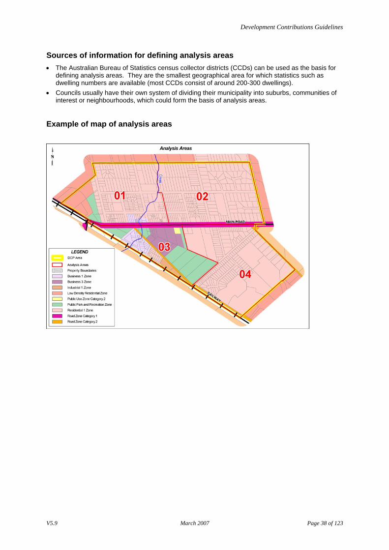
Sources of information for defining analysis areas • The Australian Bureau of Statistics census collector districts (CCDs) can be used as the basis for
defining analysis areas. They are the smallest geographical area for which statistics such as dwelling numbers are available (most CCDs consist of around 200-300 dwellings).
• Councils usually have their own system of dividing their municipality into suburbs, communities of interest or neighbourhoods, which could form the basis of analysis areas.
Example of map of analysis areas
V5.9 March 2007 Page 38 of 123
Development Contributions Guidelines
Stage 3–Quantify the development in each analysis area The total development in each analysis area is determined by considering any development that generates the demand for infrastructure, including: • existing development, and • projected future development.
Outcome
The outcome of this stage is a series of tables that display the existing and projected development for each analysis area over the timeframe of the DCP.
Process
Complete the following tasks. Task Description
1 For each individual analysis area, quantify the amount of existing and projected development in relation to the following types of land uses over the timeframe of the DCP: • residential • retail • commercial • industrial • institutional, and • any other non-standard land uses. For more information, go to: • [Guidelines for sources of information about existing and projected development],
and • [Guidelines for documenting development information].
2 Document the information from Step 1. Create a separate table for each analysis area. For an example, go to [Example of tables showing existing and projected development].
3 Document the assumptions made relating to projected development.
Guidelines for sources of information about existing and projected development • The Australian Bureau of Statistics (ABS). • The Department of Infrastructure (DOI) for information about population projections. • Council’s strategic planning framework for information about projected development. • Available data such as building approvals and land use surveys.
Guidelines for documenting development information Use local knowledge and professional judgement to adjust growth projections for each of the analysis areas.
V5.9 March 2007 Page 39 of 123
Development Contributions Guidelines
The existing and projected development information may be expressed as: • number of dwellings • amount of floor space • amount of site area • number of hospital beds, or • number of students.
Essentially, decisions about how to quantify existing and projected development should be informed by the format of existing information (for example ABS/DOI statistics) and the demand generating characteristics of each type of development. For example, if the DCP will include items of road infrastructure, it will be necessary to prepare development projections that enable you to estimate the level of demand for these items – the floor area of different types of land uses is a commonly accepted indicator of demand for road infrastructure, as are the number of hospital beds or students. By contrast, demand for drainage infrastructure is usually a function of the site coverage of different forms of development. It will therefore be necessary to prepare estimates of existing and projected site area if drainage items are to be included in the DCP. If a DCP is to include several different types of infrastructure, it may necessary to prepare development projections for each land use in multiple formats. For example, floor area and site area projections for each land use will need to be prepared if the DCP is to include both drainage and road infrastructure.
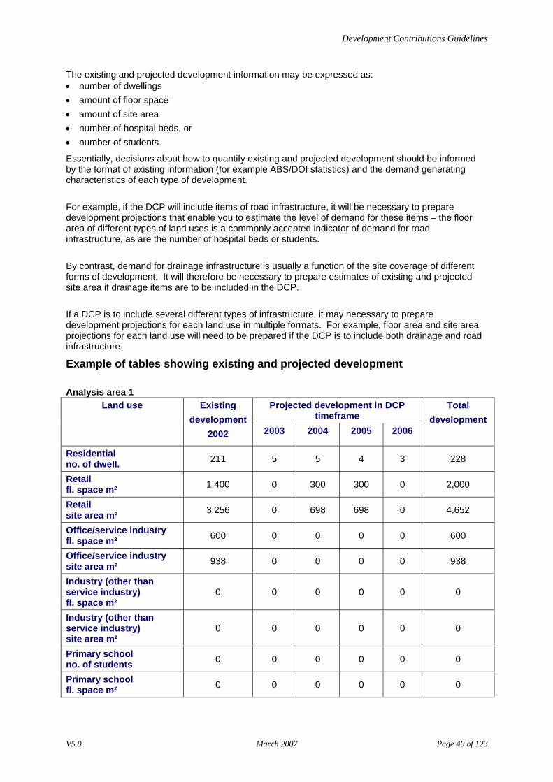
Example of tables showing existing and projected development
Analysis area 1 Projected development in DCP
timeframe Land use Existing
development 2002 2003 2004 2005 2006
Total development
Residential no. of dwell. 211 5 5 4 3 228
Retail fl. space m² 1,400 0 300 300 0 2,000
Retail site area m² 3,256 0 698 698 0 4,652
Office/service industry fl. space m² 600 0 0 0 0 600
Office/service industry site area m² 938 0 0 0 0 938
Industry (other than service industry) fl. space m²
0 0 0 0 0 0
Industry (other than service industry) site area m²
0 0 0 0 0 0
Primary school no. of students 0 0 0 0 0 0
Primary school fl. space m² 0 0 0 0 0 0
V5.9 March 2007 Page 40 of 123
Development Contributions Guidelines
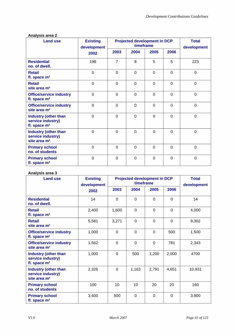
Analysis area 2 Projected development in DCP
timeframe Land use Existing
development 2002 2003 2004 2005 2006
Total development
Residential no. of dwell.
198 7 8 5 5 223
Retail fl. space m²
0 0 0 0 0 0
Retail site area m²
0 0 0 0 0 0
Office/service industry fl. space m²
0 0 0 0 0 0
Office/service industry site area m²
0 0 0 0 0 0
Industry (other than service industry) fl. space m²
0 0 0 0 0 0
Industry (other than service industry) site area m²
0 0 0 0 0 0
Primary school no. of students
0 0 0 0 0 0
Primary school fl. space m²
0 0 0 0 0 0
Analysis area 3 Projected development in DCP
timeframe Land use Existing
development 2002 2003 2004 2005 2006
Total development
Residential no. of dwell.
14 0 0 0 0 14
Retail fl. space m²
2,400 1,600 0 0 0 4,000
Retail site area m²
5,581 3,271 0 0 0 9,302
Office/service industry fl. space m²
1,000 0 0 0 500 1,500
Office/service industry site area m²
1,562 0 0 0 781 2,343
Industry (other than service industry) fl. space m²
1,000 0 500 1,200 2,000 4700
Industry (other than service industry) site area m²
2,326 0 1,163 2,791 4,651 10,931
Primary school no. of students
100 10 10 20 20 160
Primary school fl. space m²
3,400 500 0 0 0 3,900
V5.9 March 2007 Page 41 of 123

Development Contributions Guidelines
Analysis area 4 Projected development in DCP
timeframe Land use Existing
development 2002 2003 2004 2005 2006
Total development
Residential no. of dwell.
157 15 23 35 40 270
Retail fl. space m²
0 0 0 0 0 0
Retail site area m²
0 0 0 0 0 0
Office/service industry fl. space m²
0 0 0 0 0 0
Office/service industry site area m²
0 0 0 0 0 0
Industry (other than service industry) fl. space m²
0 0 0 0 0 0
Industry (other than service industry) site area m²
0 0 0 0 0 0
Primary school no. of students
0 0 0 0 0 0
Primary school fl. space m²
0 0 0 0 0 0
V5.9 March 2007 Page 42 of 123
Development Contributions Guidelines
Stage 4–Convert the development projections into common demand units to quantify the total demand for infrastructure The development projections prepared in Stage 3 will usually be expressed in different units of measurement (for example, number of residential dwellings, square metres of retail floor space, hectares of industrial site area). Each of these land uses places differing levels of demand on the various types of infrastructure (such as roads, drainage, community facilities and parks). To make DCP calculations easier, it is necessary to convert the development projections into common demand units, for each infrastructure item. This process of conversion is undertaken using equivalence ratios, which allow you to calculate the: • total demand for any infrastructure project, and • appropriate infrastructure levy for development proposals to be calculated, once the DCP has been
incorporated into the planning scheme.
Outcome
The outcome of this stage is a series of tables that display the existing and projected demand for infrastructure in each analysis area converted into common demand units.
Process
Complete the following tasks. Task Description
1 Select a common demand unit type. For more information, go to [Guidelines for selecting the appropriate common demand unit].
2 Use equivalence ratios to convert the existing and projected development totals for each analysis area into common demand units. Use the tables for each analysis area created in Stage 3. For more information, go to: • [standard equivalence ratios], and • [Formula to convert development projections into demand units].
3 Convert any non-standard land uses into common demand units: • on a case-by-case basis, or • by creating alternative equivalence ratios specific to that type of land use. For more information, go to: • [Guidelines for changing the standard equivalence ratios] • [Calculating road infrastructure equivalence ratios for residential, retail, office and
industrial land uses] • [Calculating road infrastructure equivalence ratios for educational land uses] • [Calculating road infrastructure equivalence ratios for hospitals], and • [Calculating drainage infrastructure equivalence ratios for all land uses].
4 If alternative equivalence ratios are used, document your assumptions. 5 Document the information from Tasks 2 and 3. Create a separate table for each
analysis area. For an example, go to [Example of tables showing existing and projected development converted to common demand units].
V5.9 March 2007 Page 43 of 123

Development Contributions Guidelines
Guidelines for selecting the appropriate common demand unit
There are choices for selecting the appropriate common demand unit. In making the selection, consider the following: • the dominant type of land use in the study area • which land uses are expected to grow in the area and will therefore be charged • the format of your development projections • the types of infrastructure to be included in the DCP, and • on what basis you will calculate and charge levies.
The decision about which demand unit is the most appropriate will usually require you to weigh up these considerations to determine which is the most significant to the DCP you are preparing. Basically, your choice of demand unit will be between: • an area based unit (for example floor area, site area, site coverage, or hectare of developable
land), and • a residential dwelling and its equivalents (i.e. equivalent dwellings).
The appropriate unit of measurement will vary according to the development scenario. For example, area based demand units may be more suitable in greenfields situations and those DCPs that deal exclusively with drainage infrastructure. By contrast, equivalent dwellings are likely to be the most appropriate demand unit in established urban areas and for those DCPs that deal with many types of infrastructure. The following table provides some examples of appropriate demand units in various different scenarios. If the development is in… then the common demand unit
might be a… an established urban area dwelling or equivalent a large scale greenfield area dwelling, lot or hectare of
developable land an industrial site hectare of developable land*
and/or If the DCP deals with… then the common demand unit
might be a… many types of infrastructure dwelling or equivalent drainage infrastructure only hectare of developable land* or per
m2 of site coverage
* Developable land is land that can be converted to ‘urban purposes’. Urban purposes are those uses that are associated with the establishment of an urban community and will usually include all aspects of residential, commercial and public use. All developable land should be included in the calculation of levies even if not all of these uses will ultimately be levied. When using ‘hectares of developable land’ as a demand unit, it is necessary to recognise that some land cannot be converted to urban purposes (for example land subject to some form of development control such as an easement or a Environmental Significance Overlay). This land should not be treated as developable land and included in the calculation of levies as it does not generate demand for infrastructure.
V5.9 March 2007 Page 44 of 123
Development Contributions Guidelines
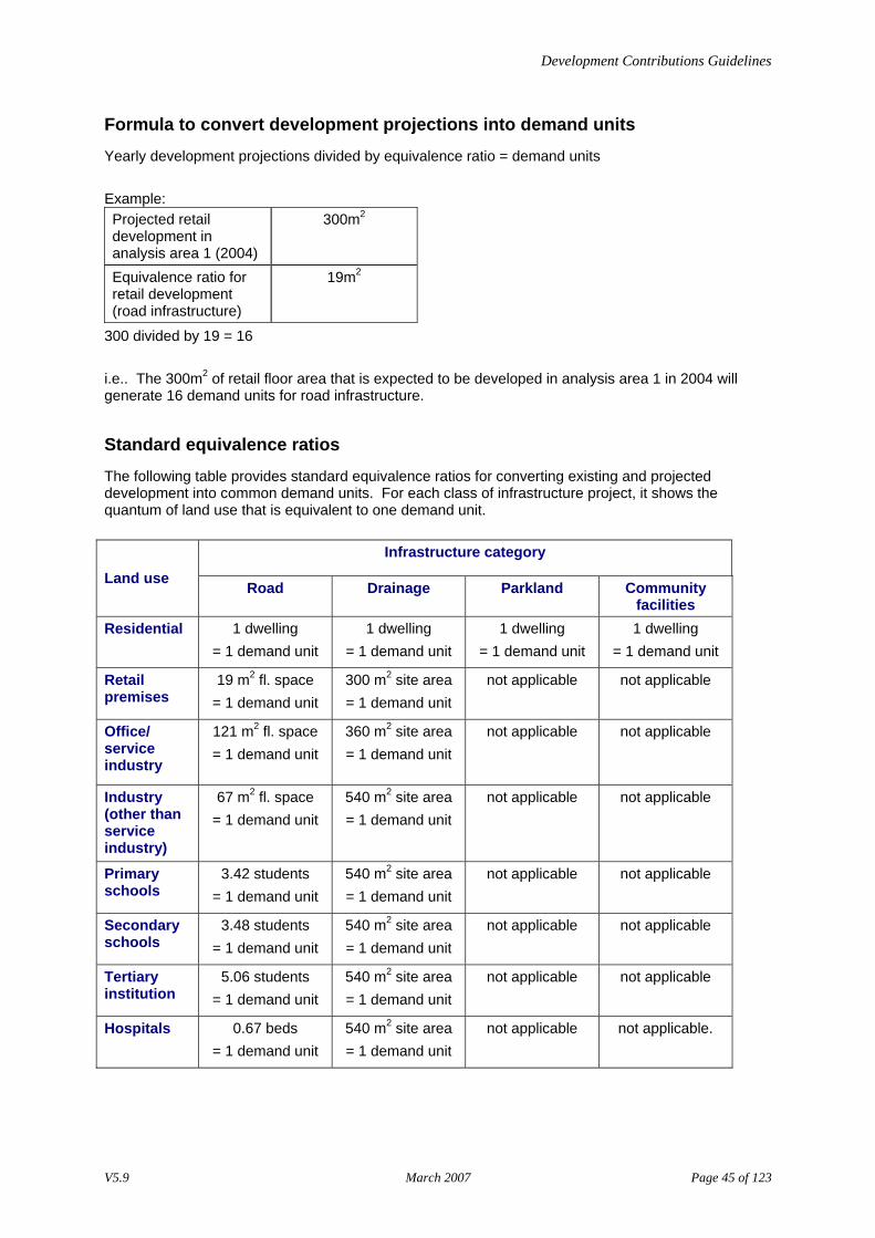
Formula to convert development projections into demand units
Yearly development projections divided by equivalence ratio = demand units Example: Projected retail development in analysis area 1 (2004)
300m2
Equivalence ratio for retail development (road infrastructure)
19m2
300 divided by 19 = 16 i.e.. The 300m2 of retail floor area that is expected to be developed in analysis area 1 in 2004 will generate 16 demand units for road infrastructure.
Standard equivalence ratios
The following table provides standard equivalence ratios for converting existing and projected development into common demand units. For each class of infrastructure project, it shows the quantum of land use that is equivalent to one demand unit.
Infrastructure category
Land use Road Drainage Parkland Community facilities
Residential
1 dwelling = 1 demand unit
1 dwelling = 1 demand unit
1 dwelling = 1 demand unit
1 dwelling = 1 demand unit
Retail premises
19 m2 fl. space = 1 demand unit
300 m2 site area = 1 demand unit
not applicable not applicable
Office/ service industry
121 m2 fl. space = 1 demand unit
360 m2 site area = 1 demand unit
not applicable not applicable
Industry (other than service industry)
67 m2 fl. space = 1 demand unit
540 m2 site area = 1 demand unit
not applicable not applicable
Primary schools
3.42 students = 1 demand unit
540 m2 site area = 1 demand unit
not applicable not applicable
Secondary schools
3.48 students = 1 demand unit
540 m2 site area = 1 demand unit
not applicable not applicable
Tertiary institution
5.06 students = 1 demand unit
540 m2 site area = 1 demand unit
not applicable not applicable
Hospitals 0.67 beds = 1 demand unit
540 m2 site area = 1 demand unit
not applicable not applicable.
V5.9 March 2007 Page 45 of 123
Development Contributions Guidelines
Guidelines for changing the standard equivalence ratios
It may be necessary to alter the standard equivalence ratios to suit local conditions. Factors that should be considered when deciding whether to change the standard equivalence ratios include: • Are the main development types in the study area residential, retail, office and industrial? Are
there any other types of land use included in the DCP? If so, there may be a need to develop customised equivalence ratios for these land uses.
• Do all the items of infrastructure to be included in the DCP comfortably fall into the categories of roads, drainage, community facilities and parks and gardens? Are there other infrastructure ‘portfolios’ for which customised equivalence ratios need to be prepared?
• The standard equivalence ratios assume that non-residential land uses generate very little demand for parks and gardens and community infrastructure and hence, do not list conversion factors for these items. Councils can choose to charge non-residential development for parks and gardens and community facilities, but will need to develop customised equivalence ratios for these land uses.
• Are there any local policies or engineering standards that show different land uses generating varying levels of demand for infrastructure (for example local parking polices, drainage plans etc.)? Should these policies or standards be used to modify the standard equivalence ratios?
• Are there any existing studies of infrastructure demand in the area? Do these studies suggest the area has unique characteristics that affect demand for infrastructure? For example, demographic profiles of the study area may show car ownership is higher than average, which will in turn affect the equivalence ratios for road infrastructure. Similarly, steep terrain is likely to result in higher levels of stormwater run off and therefore, generates higher demand for drainage infrastructure.
• Standard equivalence ratios are based on indices of traffic generation, stormwater run off etc. These indices assume certain characteristics about different types of land use such as the average number of car parks per dwelling, the number of trips generated per car parking space and the site coverage of different land uses. While these assumptions are based on generally accepted engineering standards, it may be that councils need to modify these underlying assumptions to reflect local conditions and/or policy frameworks.
• The assumptions behind the standard equivalence ratios are set out in the tables contained in the following sections: − [Calculating road infrastructure equivalence ratios for residential, retail, office and industrial land
uses] − [Calculating road infrastructure equivalence ratios for educational land uses] − [Calculating road infrastructure equivalence ratios for hospitals], and − [Calculating drainage infrastructure equivalence ratios for all land uses].
V5.9 March 2007 Page 46 of 123
Development Contributions Guidelines
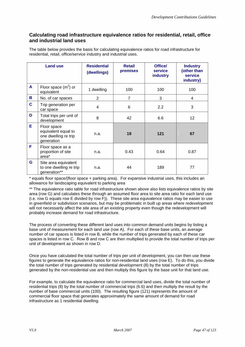
Calculating road infrastructure equivalence ratios for residential, retail, office and industrial land uses
The table below provides the basis for calculating equivalence ratios for road infrastructure for residential, retail, office/service industry and industrial uses.
Land use Residential (dwellings)
Retail premises
Office/ service industry
Industry (other than
service industry)
A Floor space (m2) or equivalent 1 dwelling 100 100 100
B No. of car spaces 2 7 3 4 C Trip generation per
car space 4 6 2.2 3
D Total trips per unit of development 8 42 6.6 12
E Floor space equivalent equal to one dwelling re trip generation
n.a. 19 121 67
F Floor space as a proportion of site area*
n.a. 0.43 0.64 0.87
G Site area equivalent to one dwelling re trip generation**
n.a. 44 189 77
* equals floor space/(floor space + parking area). For expansive industrial uses, this includes an allowance for landscaping equivalent to parking area ** The equivalence ratio table for road infrastructure shown above also lists equivalence ratios by site area (row G) and calculates these through an assumed floor area to site area ratio for each land use (i.e. row G equals row E divided by row F)). These site area equivalence ratios may be easier to use in greenfield or subdivision scenarios, but may be problematic in built up areas where redevelopment will not necessarily affect the site area of an existing property even though the redevelopment will probably increase demand for road infrastructure. The process of converting these different land uses into common demand units begins by listing a base unit of measurement for each land use (row A). For each of these base units, an average number of car spaces is listed in row B, while the number of trips generated by each of these car spaces is listed in row C. Row B and row C are then multiplied to provide the total number of trips per unit of development as shown in row D. Once you have calculated the total number of trips per unit of development, you can then use these figures to generate the equivalence ratios for non-residential land uses (row E). To do this, you divide the total number of trips generated by residential development (8) by the total number of trips generated by the non-residential use and then multiply this figure by the base unit for that land use. For example, to calculate the equivalence ratio for commercial land uses, divide the total number of residential trips (8) by the total number of commercial trips (6.6) and then multiply the result by the number of base commercial units (100). The resulting figure (121) represents the amount of commercial floor space that generates approximately the same amount of demand for road infrastructure as 1 residential dwelling.
V5.9 March 2007 Page 47 of 123
Development Contributions Guidelines
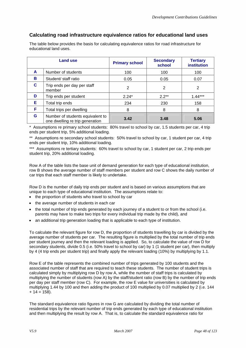
Calculating road infrastructure equivalence ratios for educational land uses
The table below provides the basis for calculating equivalence ratios for road infrastructure for educational land uses.
Land use Primary school Secondary school
Tertiary institution
A Number of students 100 100 100 B Student/ staff ratio 0.05 0.05 0.07 C Trip ends per day per staff
member 2 2 2
D Trip ends per student 2.24* 2.2** 1.44*** E Total trip ends 234 230 158 F Total trips per dwelling 8 8 8 G Number of students equivalent to
one dwelling re trip generation 3.42 3.48 5.06
* Assumptions re primary school students: 80% travel to school by car, 1.5 students per car, 4 trip ends per student trip, 5% additional loading. ** Assumptions re secondary school students: 50% travel to school by car, 1 student per car, 4 trip ends per student trip, 10% additional loading. *** Assumptions re tertiary students: 60% travel to school by car, 1 student per car, 2 trip ends per student trip, 20% additional loading. Row A of the table lists the base unit of demand generation for each type of educational institution, row B shows the average number of staff members per student and row C shows the daily number of car trips that each staff member is likely to undertake. Row D is the number of daily trip ends per student and is based on various assumptions that are unique to each type of educational institution. The assumptions relate to: • the proportion of students who travel to school by car • the average number of students in each car • the total number of trip ends generated by each journey of a student to or from the school (i.e.
parents may have to make two trips for every individual trip made by the child), and • an additional trip generation loading that is applicable to each type of institution. To calculate the relevant figure for row D, the proportion of students travelling by car is divided by the average number of students per car. The resulting figure is multiplied by the total number of trip ends per student journey and then the relevant loading is applied. So, to calculate the value of row D for secondary students, divide 0.5 (i.e. 50% travel to school by car) by 1 (1 student per car), then multiply by 4 (4 trip ends per student trip) and finally apply the relevant loading (10%) by multiplying by 1.1. Row E of the table represents the combined number of trips generated by 100 students and the associated number of staff that are required to teach these students. The number of student trips is calculated simply by multiplying row D by row A, while the number of staff trips is calculated by multiplying the number of students (row A) by the staff/student ratio (row B) by the number of trip ends per day per staff member (row C). For example, the row E value for universities is calculated by multiplying 1.44 by 100 and then adding the product of 100 multiplied by 0.07 multiplied by 2 (i.e. 144 + 14 = 158). The standard equivalence ratio figures in row G are calculated by dividing the total number of residential trips by the relevant number of trip ends generated by each type of educational institution and then multiplying the result by row A. That is, to calculate the standard equivalence ratio for
V5.9 March 2007 Page 48 of 123
Development Contributions Guidelines
primary schools you divide 8 by 234 and then multiply by 100. The resulting figure (3.42) represents the number of primary school students that generate the equivalent demand for road infrastructure as one residential dwelling.
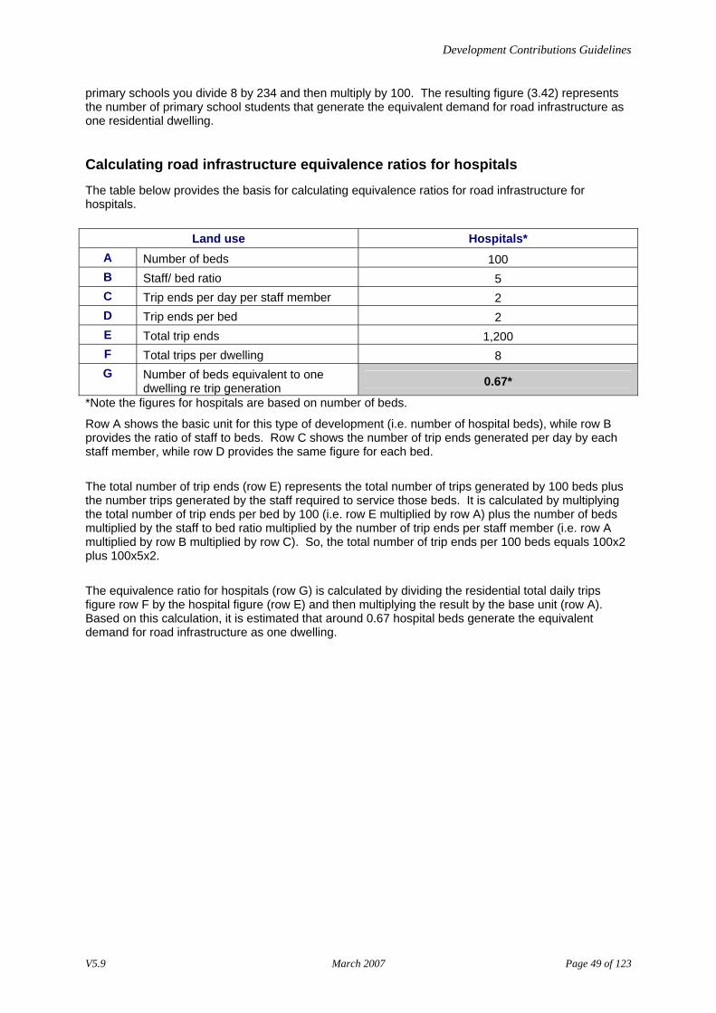
Calculating road infrastructure equivalence ratios for hospitals
The table below provides the basis for calculating equivalence ratios for road infrastructure for hospitals.
Land use Hospitals* A Number of beds 100 B Staff/ bed ratio 5 C Trip ends per day per staff member 2 D Trip ends per bed 2 E Total trip ends 1,200 F Total trips per dwelling 8 G Number of beds equivalent to one
dwelling re trip generation 0.67*
*Note the figures for hospitals are based on number of beds.
Row A shows the basic unit for this type of development (i.e. number of hospital beds), while row B provides the ratio of staff to beds. Row C shows the number of trip ends generated per day by each staff member, while row D provides the same figure for each bed. The total number of trip ends (row E) represents the total number of trips generated by 100 beds plus the number trips generated by the staff required to service those beds. It is calculated by multiplying the total number of trip ends per bed by 100 (i.e. row E multiplied by row A) plus the number of beds multiplied by the staff to bed ratio multiplied by the number of trip ends per staff member (i.e. row A multiplied by row B multiplied by row C). So, the total number of trip ends per 100 beds equals 100x2 plus 100x5x2. The equivalence ratio for hospitals (row G) is calculated by dividing the residential total daily trips figure row F by the hospital figure (row E) and then multiplying the result by the base unit (row A). Based on this calculation, it is estimated that around 0.67 hospital beds generate the equivalent demand for road infrastructure as one dwelling.
V5.9 March 2007 Page 49 of 123
Development Contributions Guidelines
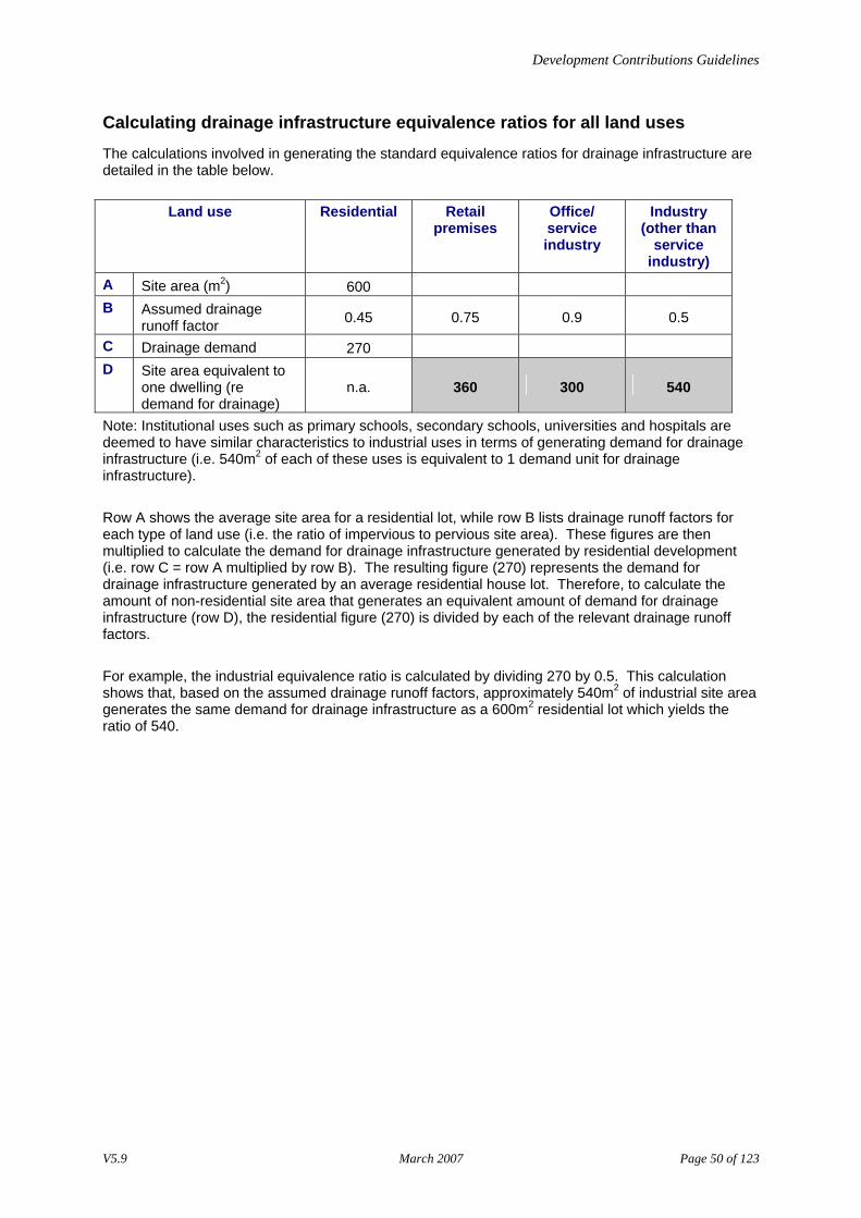
Calculating drainage infrastructure equivalence ratios for all land uses
The calculations involved in generating the standard equivalence ratios for drainage infrastructure are detailed in the table below.
Land use Residential
Retail premises
Office/ service industry
Industry (other than
service industry)
A Site area (m2) 600 B Assumed drainage
runoff factor 0.45 0.75 0.9 0.5
C Drainage demand 270 D Site area equivalent to
one dwelling (re demand for drainage)
n.a. 360 300 540
Note: Institutional uses such as primary schools, secondary schools, universities and hospitals are deemed to have similar characteristics to industrial uses in terms of generating demand for drainage infrastructure (i.e. 540m2 of each of these uses is equivalent to 1 demand unit for drainage infrastructure). Row A shows the average site area for a residential lot, while row B lists drainage runoff factors for each type of land use (i.e. the ratio of impervious to pervious site area). These figures are then multiplied to calculate the demand for drainage infrastructure generated by residential development (i.e. row C = row A multiplied by row B). The resulting figure (270) represents the demand for drainage infrastructure generated by an average residential house lot. Therefore, to calculate the amount of non-residential site area that generates an equivalent amount of demand for drainage infrastructure (row D), the residential figure (270) is divided by each of the relevant drainage runoff factors. For example, the industrial equivalence ratio is calculated by dividing 270 by 0.5. This calculation shows that, based on the assumed drainage runoff factors, approximately 540m2 of industrial site area generates the same demand for drainage infrastructure as a 600m2 residential lot which yields the ratio of 540.
V5.9 March 2007 Page 50 of 123
Development Contributions Guidelines
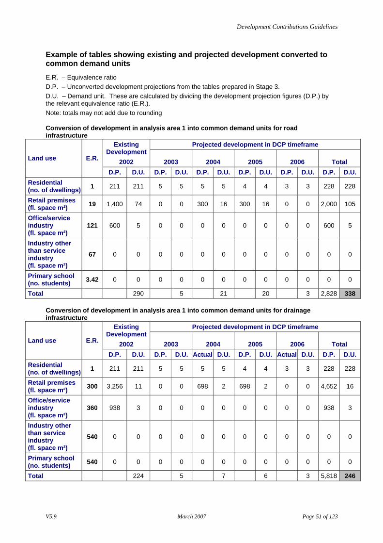
Example of tables showing existing and projected development converted to common demand units
E.R. – Equivalence ratio D.P. – Unconverted development projections from the tables prepared in Stage 3. D.U. – Demand unit. These are calculated by dividing the development projection figures (D.P.) by the relevant equivalence ratio (E.R.). Note: totals may not add due to rounding
Conversion of development in analysis area 1 into common demand units for road infrastructure
Projected development in DCP timeframe Existing Development
2002 2003 2004 2005 2006 Total Land use E.R.
D.P. D.U. D.P. D.U. D.P. D.U. D.P. D.U. D.P. D.U. D.P. D.U. Residential (no. of dwellings) 1 211 211 5 5 5 5 4 4 3 3 228 228
Retail premises (fl. space m²) 19 1,400 74 0 0 300 16 300 16 0 0 2,000 105
Office/service industry (fl. space m²)
121 600 5 0 0 0 0 0 0 0 0 600 5
Industry other than service industry (fl. space m²)
67 0 0 0 0 0 0 0 0 0 0 0 0
Primary school (no. students) 3.42 0 0 0 0 0 0 0 0 0 0 0 0
Total 290 5 21 20 3 2,828 338
Conversion of development in analysis area 1 into common demand units for drainage infrastructure
Projected development in DCP timeframe Existing Development
2002 2003 2004 2005 2006 Total Land use E.R.
D.P. D.U. D.P. D.U. Actual D.U. D.P. D.U. Actual D.U. D.P. D.U. Residential (no. of dwellings) 1 211 211 5 5 5 5 4 4 3 3 228 228
Retail premises (fl. space m²) 300 3,256 11 0 0 698 2 698 2 0 0 4,652 16
Office/service industry (fl. space m²)
360 938 3 0 0 0 0 0 0 0 0 938 3
Industry other than service industry (fl. space m²)
540 0 0 0 0 0 0 0 0 0 0 0 0
Primary school (no. students) 540 0 0 0 0 0 0 0 0 0 0 0 0
Total 224 5 7 6 3 5,818 246
V5.9 March 2007 Page 51 of 123
Development Contributions Guidelines
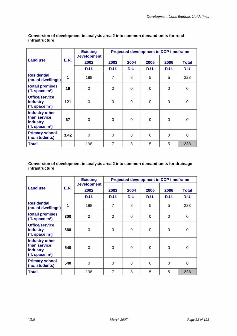
Conversion of development in analysis area 2 into common demand units for road infrastructure
Projected development in DCP timeframe Existing Development
2002 2003 2004 2005 2006 Total Land use E.R.
D.U. D.U. D.U. D.U. D.U. D.U. Residential (no. of dwellings) 1 198 7 8 5 5 223
Retail premises (fl. space m²) 19 0 0 0 0 0 0
Office/service industry (fl. space m²)
121 0 0 0 0 0 0
Industry other than service industry (fl. space m²)
67 0 0 0 0 0 0
Primary school (no. students) 3.42 0 0 0 0 0 0
Total 198 7 8 5 5 223
Conversion of development in analysis area 2 into common demand units for drainage infrastructure
Projected development in DCP timeframe Existing Development
2002 2003 2004 2005 2006 Total Land use E.R.
D.U. D.U. D.U. D.U. D.U. D.U. Residential (no. of dwellings) 1 198 7 8 5 5 223
Retail premises (fl. space m²) 300 0 0 0 0 0 0
Office/service industry (fl. space m²)
360 0 0 0 0 0 0
Industry other than service industry (fl. space m²)
540 0 0 0 0 0 0
Primary school (no. students) 540 0 0 0 0 0 0
Total 198 7 8 5 5 223
V5.9 March 2007 Page 52 of 123
Development Contributions Guidelines
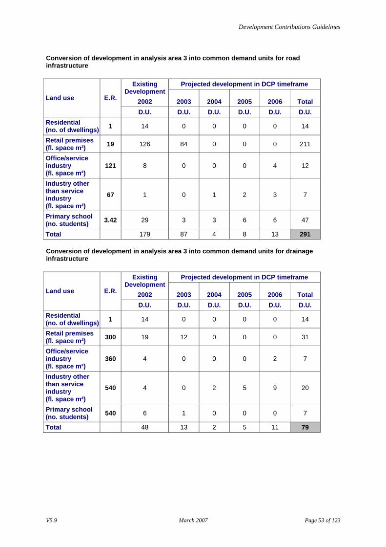
Conversion of development in analysis area 3 into common demand units for road infrastructure
Projected development in DCP timeframe Existing Development
2002 2003 2004 2005 2006 Total Land use E.R.
D.U. D.U. D.U. D.U. D.U. D.U. Residential (no. of dwellings) 1 14 0 0 0 0 14
Retail premises (fl. space m²) 19 126 84 0 0 0 211
Office/service industry (fl. space m²)
121 8 0 0 0 4 12
Industry other than service industry (fl. space m²)
67 1 0 1 2 3 7
Primary school (no. students) 3.42 29 3 3 6 6 47
Total 179 87 4 8 13 291
Conversion of development in analysis area 3 into common demand units for drainage infrastructure
Projected development in DCP timeframe Existing Development
2002 2003 2004 2005 2006 Total Land use E.R.
D.U. D.U. D.U. D.U. D.U. D.U. Residential (no. of dwellings) 1 14 0 0 0 0 14
Retail premises (fl. space m²) 300 19 12 0 0 0 31
Office/service industry (fl. space m²)
360 4 0 0 0 2 7
Industry other than service industry (fl. space m²)
540 4 0 2 5 9 20
Primary school (no. students) 540 6 1 0 0 0 7
Total 48 13 2 5 11 79
V5.9 March 2007 Page 53 of 123
Development Contributions Guidelines
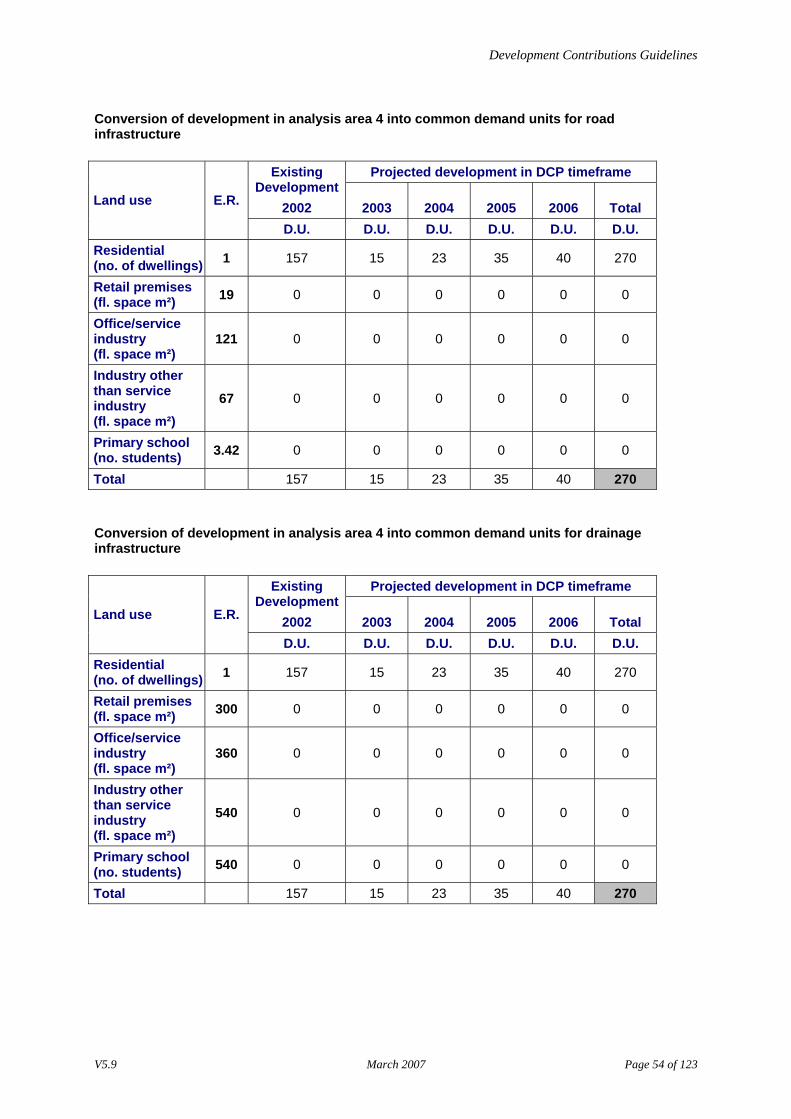
Conversion of development in analysis area 4 into common demand units for road infrastructure
Projected development in DCP timeframe Existing Development
2002 2003 2004 2005 2006 Total Land use E.R.
D.U. D.U. D.U. D.U. D.U. D.U. Residential (no. of dwellings) 1 157 15 23 35 40 270
Retail premises (fl. space m²) 19 0 0 0 0 0 0
Office/service industry (fl. space m²)
121 0 0 0 0 0 0
Industry other than service industry (fl. space m²)
67 0 0 0 0 0 0
Primary school (no. students) 3.42 0 0 0 0 0 0
Total 157 15 23 35 40 270
Conversion of development in analysis area 4 into common demand units for drainage infrastructure
Projected development in DCP timeframe Existing Development
2002 2003 2004 2005 2006 Total Land use E.R.
D.U. D.U. D.U. D.U. D.U. D.U. Residential (no. of dwellings) 1 157 15 23 35 40 270
Retail premises (fl. space m²) 300 0 0 0 0 0 0
Office/service industry (fl. space m²)
360 0 0 0 0 0 0
Industry other than service industry (fl. space m²)
540 0 0 0 0 0 0
Primary school (no. students) 540 0 0 0 0 0 0
Total 157 15 23 35 40 270
V5.9 March 2007 Page 54 of 123
Development Contributions Guidelines
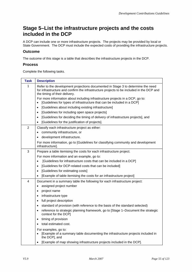
Stage 5–List the infrastructure projects and the costs included in the DCP A DCP can include one or more infrastructure projects. The projects may be provided by local or State Government. The DCP must include the expected costs of providing the infrastructure projects.
Outcome
The outcome of this stage is a table that describes the infrastructure projects in the DCP.
Process
Complete the following tasks. Task Description
1 Refer to the development projections documented in Stage 3 to determine the need for infrastructure and confirm the infrastructure projects to be included in the DCP and the timing of their delivery. For more information about including infrastructure projects in a DCP, go to: • [Guidelines for types of infrastructure that can be included in a DCP] • [Guidelines about including existing infrastructure] • [Guidelines for including open space projects] • [Guidelines for deciding the timing of delivery of infrastructure projects], and • [Guidelines for the justification of projects].
2 Classify each infrastructure project as either: • community infrastructure, or • development infrastructure. For more information, go to [Guidelines for classifying community and development infrastructure].
3 Prepare a table itemising the costs for each infrastructure project. For more information and an example, go to: • [Guidelines for infrastructure costs that can be included in a DCP] • [Guidelines for DCP-related costs that can be included] • [Guidelines for estimating costs] • [Example of table itemising the costs for an infrastructure project]
4 Document in a summary table the following for each infrastructure project: • assigned project number • project name • infrastructure type • full project description • standard of provision (with reference to the basis of the standard selected) • reference to strategic planning framework, go to [Stage 1–Document the strategic
context for the DCP] • timing of provision • total estimated cost.
For examples, go to: • [Example of a summary table documenting the infrastructure projects included in
the DCP], and • [Example of map showing infrastructure projects included in the DCP].
V5.9 March 2007 Page 55 of 123
Development Contributions Guidelines
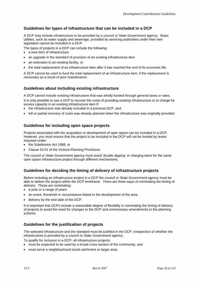
Guidelines for types of infrastructure that can be included in a DCP
A DCP may include infrastructure to be provided by a council or State Government agency. Basic utilities, such as water supply and sewerage, provided by servicing authorities under their own legislation cannot be included in a DCP. The types of projects in a DCP can include the following: • a new item of infrastructure • an upgrade in the standard of provision of an existing infrastructure item • an extension to an existing facility, or • the total replacement of an infrastructure item after it has reached the end of its economic life.
A DCP cannot be used to fund the total replacement of an infrastructure item, if the replacement is necessary as a result of poor maintenance.
Guidelines about including existing infrastructure
A DCP cannot include existing infrastructure that was wholly funded through general taxes or rates. It is only possible to use a DCP to recover the costs of providing existing infrastructure or to charge for excess capacity in an existing infrastructure item if: • the infrastructure was already included in a previous DCP, and • full or partial recovery of costs was already planned when the infrastructure was originally provided.
Guidelines for including open space projects
Projects associated with the acquisition or development of open space can be included in a DCP. However, you must ensure that the project to be included in the DCP will not be funded by levies imposed under: • the Subdivision Act 1988, or • Clause 52.01 of the Victoria Planning Provisions.
The council or State Government agency must avoid ‘double dipping’ or charging twice for the same open space infrastructure project through different mechanisms.
Guidelines for deciding the timing of delivery of infrastructure projects
Before including an infrastructure project in a DCP the council or State Government agency must be able to deliver the project within the DCP timeframe. There are three ways of nominating the timing of delivery. These are nominating: • a year or a range of years • an event, threshold or circumstance linked to the development of the area • delivery by the end date of the DCP.
It is important that DCPs include a reasonable degree of flexibility in nominating the timing of delivery of projects to avoid the need for changes to the DCP and unnecessary amendments to the planning scheme.
Guidelines for the justification of projects
The selected infrastructure and the standard must be justified in the DCP, irrespective of whether the infrastructure is provided by a council or State Government agency. To qualify for inclusion in a DCP, all infrastructure projects: • must be expected to be used by a broad cross-section of the community, and • must serve a neighbourhood-sized catchment or larger area.
V5.9 March 2007 Page 56 of 123
Development Contributions Guidelines
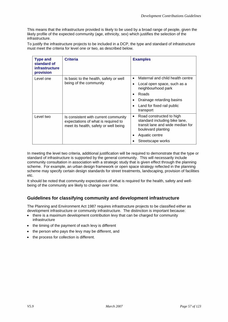
This means that the infrastructure provided is likely to be used by a broad range of people, given the likely profile of the expected community (age, ethnicity, sex) which justifies the selection of the infrastructure. To justify the infrastructure projects to be included in a DCP, the type and standard of infrastructure must meet the criteria for level one or two, as described below.
Type and standard of infrastructure provision
Criteria Examples
Level one Is basic to the health, safety or well being of the community
• Maternal and child health centre • Local open space, such as a
neighbourhood park • Roads • Drainage retarding basins • Land for fixed rail public
transport
Level two Is consistent with current community expectations of what is required to meet its health, safety or well being
• Road constructed to high standard including bike lane, transit lane and wide median for boulevard planting
• Aquatic centre • Streetscape works
In meeting the level two criteria, additional justification will be required to demonstrate that the type or standard of infrastructure is supported by the general community. This will necessarily include community consultation in association with a strategic study that is given effect through the planning scheme. For example, an urban design framework or open space strategy reflected in the planning scheme may specify certain design standards for street treatments, landscaping, provision of facilities etc. It should be noted that community expectations of what is required for the health, safety and well-being of the community are likely to change over time.
Guidelines for classifying community and development infrastructure
The Planning and Environment Act 1987 requires infrastructure projects to be classified either as development infrastructure or community infrastructure. The distinction is important because: • there is a maximum development contribution levy that can be charged for community
infrastructure • the timing of the payment of each levy is different • the person who pays the levy may be different, and • the process for collection is different.
V5.9 March 2007 Page 57 of 123
Development Contributions Guidelines
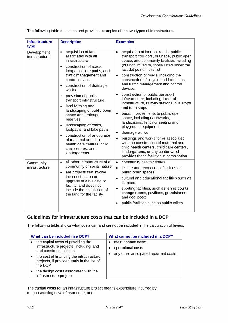
The following table describes and provides examples of the two types of infrastructure. Infrastructure type
Description Examples
Development infrastructure
• acquisition of land associated with all infrastructure
• construction of roads, footpaths, bike paths, and traffic management and control devices
• construction of drainage works
• provision of public transport infrastructure
• land forming and landscaping of public open space and drainage reserves
• landscaping of roads, footpaths, and bike paths
• construction of or upgrade of maternal and child health care centres, child care centres, and kindergartens
• acquisition of land for roads, public transport corridors, drainage, public open space, and community facilities including (but not limited to) those listed under the last dot point in this list
• construction of roads, including the construction of bicycle and foot paths, and traffic management and control devices
• construction of public transport infrastructure, including fixed rail infrastructure, railway stations, bus stops and tram stops
• basic improvements to public open space, including earthworks, landscaping, fencing, seating and playground equipment
• drainage works • buildings and works for or associated
with the construction of maternal and child health centers, child care centers, kindergartens, or any center which provides these facilities in combination
Community infrastructure
• all other infrastructure of a community or social nature
• are projects that involve the construction or upgrade of a building or facility, and does not include the acquisition of the land for the facility
• community health centres • leisure and recreational facilities on
public open spaces • cultural and educational facilities such as
libraries • sporting facilities, such as tennis courts,
change rooms, pavilions, grandstands and goal posts
• public facilities such as public toilets
Guidelines for infrastructure costs that can be included in a DCP
The following table shows what costs can and cannot be included in the calculation of levies:
What can be included in a DCP? What cannot be included in a DCP? • the capital costs of providing the
infrastructure projects, including land and construction costs
• the cost of financing the infrastructure projects, if provided early in the life of the DCP
• the design costs associated with the infrastructure projects
• maintenance costs • operational costs • any other anticipated recurrent costs
The capital costs for an infrastructure project means expenditure incurred by: • constructing new infrastructure, and
V5.9 March 2007 Page 58 of 123
Development Contributions Guidelines
• extending the economic life of an existing asset, where the cost required would be equal to or greater than the cost of providing the asset in the first instance.
Guidelines for DCP-related costs that can be included
The following table describes the costs that can and cannot be included in a DCP.
What can be included in a DCP What cannot be included in a DCP • preparation costs of the DCP
document, including the costs associated with structure planning for new urban development in a greenfield location
• costs associated with processing the amendment
• consultant fees incurred in preparing the DCP document
• general strategic planning costs • costs of undertaking infrastructure
needs analysis studies • administration and set up costs for
DCP accounting systems
Guidelines for estimating costs
The calculation of the levy is based on the estimated cost of the infrastructure. The DCP must provide clear documentation itemising the costs associated with projects. It is likely to be challenged and reviewed through the planning scheme amendment process. In itemising costs, it is necessary to: • separate land acquisition and construction costs, and • express the costs in present day dollars.
It should be noted that land acquisition costs will escalate over time, however the estimated cost for land acquisition must be based on present day values. To counter the effects of increasing land acquisition costs, you can: • purchase the land early in the life of the approved DCP • index the development infrastructure levy for land using the Valuer-General’s Land Monitor Index.
V5.9 March 2007 Page 59 of 123
Development Contributions Guidelines
The following describes the information required to itemise the costs for infrastructure projects.
Cost Component Information Required Land acquisition for any type of infrastructure project
• area in hectares • estimate of the cost per hectare of land
Building construction • cost per square metre of floor area • amount of floor space/ size of building OR • short description of type of building • cost for the building
Landscaping construction • cost per hectare or square metre • short description of type landscaping
proposed
Road construction • standard of road • length of road • unit cost per km
Construction of traffic management works
• cost of providing traffic management treatment
• description of traffic management treatment (for example deceleration lane, signalized intersection, roundabout etc)
Drain construction • standard of drain • length of drain • unit cost per km
Construction of associated drainage works
• cost of providing drainage works • description of drainage works (for example
on-site retention system, gross pollutant trap, macrophyte plantings etc.)
Earthworks • cost per cubic metre
V5.9 March 2007 Page 60 of 123
Development Contributions Guidelines
Example of table itemising the costs for an infrastructure project Infrastructure project D001 - Retarding Basin Land acquisition costs
Description Area Cost per ha Cost 20 ML retarding basin 3 ha $120,000 $360,000 Construction costs
Description Area/ volume of works
Unit Cost Cost
Earthworks: (1.2 m x 140 m x 140 m), including clay lining and mounds
23,520 cubic metres $10 per cubic metres
$235,200
Landscaping: • grass swales • wetland vegetation • tree planting around
perimeter
1.4 hectares
$100,000 per hectare
$140,000
Building and equipment: • Inlet and outlet works • 2 gross pollutant traps • Brick shed for flow
recording equipment
$214,800 $50,000 $100,000
$364,800
Total cost of project $1,100,000
V5.9 March 2007 Page 61 of 123
Development Contributions Guidelines
Example of a summary table documenting the infrastructure projects included in the DCP
Development infrastructure Proj. no.
Project name
Type Description Standard of provision
Strategic justification references
Timing of provision
Estimated cost – land
and/or construction
D001 Retarding Basin
Drain Construct retarding basin in creek watercourse to control intermittent flooding
20 ML retarding basin including excavation, clay lining and inlet and outlet works
Storm water management plan
2004 $1,100,000
R001 Roundabout Road Upgrade existing intersection to cater for extra traffic generated by projected residential development
Council Engineering Standard 2503
Municipal traffic management plan. Existing traffic counts in local area. (See Jones Consulting, 2001)
2005 $210,000
Community infrastructure Proj. no.
Project name
Type Description Standard of provision
Strategic justification references
Timing of provision
Estimated cost of
construction C001 Upgrade of
branch library
Community Facilities
Renovate and extend of existing facility.
Works as detailed in Request for Tender T3509
As identified in Community Needs Study (2001). Surveys of users of the existing facility
2005 $150,000
P001 Pavilion Parks & Gardens
Provision of a pavilion with BBQs and seating in existing park.
1 timber pavilion with seating, tables and 2 coin-operated BBQs
Municipal Open space Strategy
2003 $30,000
V5.9 March 2007 Page 62 of 123
Development Contributions Guidelines
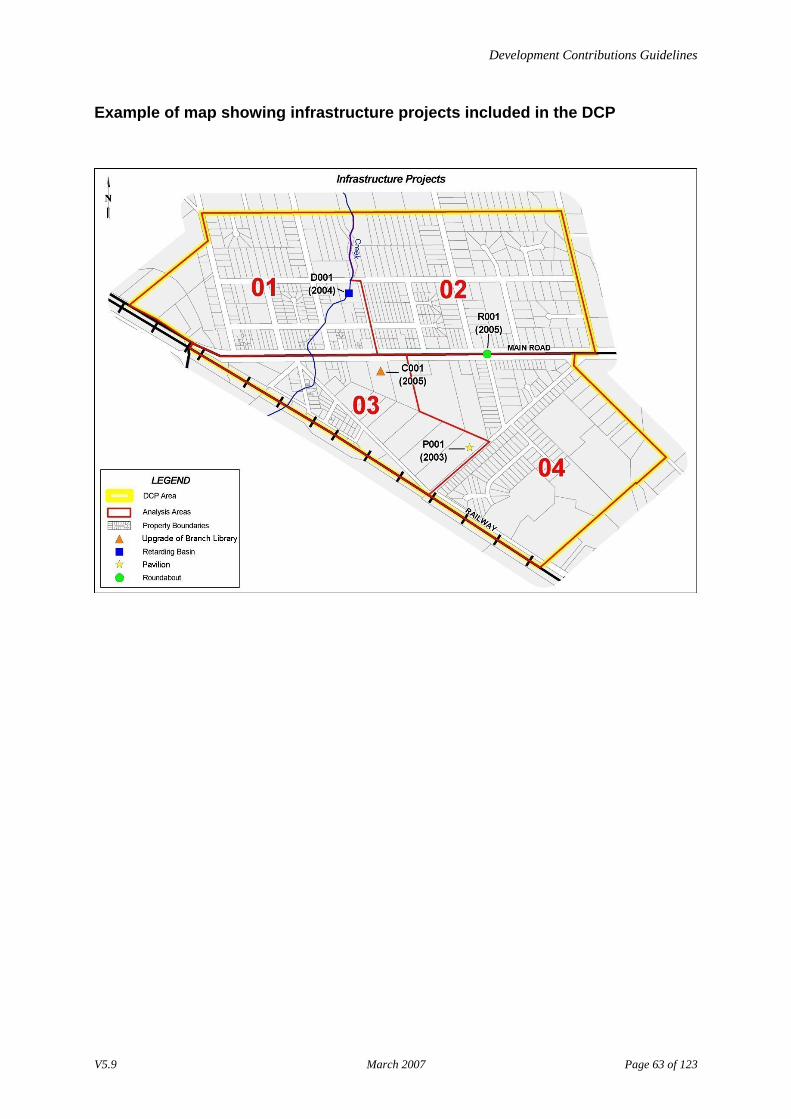
Example of map showing infrastructure projects included in the DCP
V5.9 March 2007 Page 63 of 123
Development Contributions Guidelines
Stage 6–Identify the main catchment area for each infrastructure project For infrastructure projects with closed catchments, for example drainage, the boundary for this catchment area can be precisely defined but for most infrastructure items, usage tends to drop with increasing distance, with no obvious boundary evident.
Outcome
The outcome of this stage is a: • map of the MCA, and • a table documenting key information about the MCA:
− analysis areas that make up the MCA − estimate of external and/or future usage, and − assumptions.
Process
Complete the following tasks. Task Description
1 Define and map the MCA for each infrastructure project. For more information, go to: • [Guidelines for defining the MCA], and • [Sources of information that will help in defining the MCA].
2 Using the map of the analysis areas prepared in Stage 2, identify which analysis areas fall within the MCA of each infrastructure project.
3 Document any assumptions used to determine the MCA. 4 Estimate the proportion of external usage i.e. usage drawn from outside the MCA.
For more information, go to [Guidelines for estimating external usage]. 5 Estimate usage generated by future development expected beyond the timeframe of
the DCP. For more information, go to [Guidelines for estimating future usage].
6 Determine which types of development within each analysis area will: • use the infrastructure project • not use the infrastructure project, or • use the infrastructure, but will not be charged for it. For more information, go to [Guidelines for defining non-chargeable development]
7 Document information from Tasks 2-6 for each infrastructure project. For an example, go to [Example of tables and maps showing the MCA, usage and assumptions for each infrastructure project in the DCP].
Guidelines for defining the MCA • Individual properties can fall into several MCAs for different infrastructure projects. • Patterns of usage, particularly for roads and community infrastructure, can be very complex. As a
result, expert judgement is required to define the MCA.
V5.9 March 2007 Page 64 of 123
Development Contributions Guidelines
• It is recommended that MCAs are defined in a simplified way taking into account: − communities of interest, and − logical natural boundaries that might affect usage, for example large roads and creeks.
• Care should be taken in defining the MCA, to demonstrate that substantial cross-subsidies have not occurred.
Sources of information that will help in defining the MCA
Sources of information that will help define the MCA include: • expert assessment and professional advice • standards of provision for drainage, roads and community infrastructure • needs assessments and analyses • topographic maps showing drainage catchments • traffic counts and modeling for roads • strategic planning documents, and • public open space or recreation strategies.
Guidelines for estimating external usage
External usage represents the proportion of the infrastructure project costs that will not be charged through the DCP. This proportion may be quite significant, for example, in the case of a main road carrying a large amount of through traffic. This proportion of the cost must be funded by another source such as general rates, taxes or grants. If a project does not have a closed catchment you must make an allowance for the percentage of usage coming from outside the MCA. To estimate external usage, use: • expert assessment and professional advice relevant to the type of infrastructure, for example
consult a traffic engineer for road infrastructure, and • local knowledge of the development patterns in the area.
Guidelines for estimating future usage
Future usage is usage generated by future development expected beyond the timeframe of the DCP either within or external to the MCA. Like external usage, you need to estimate the proportion of the infrastructure project costs that will not be charged through the DCP, due to expected usage beyond the timeframe of the DCP. This proportion of the cost must be funded by another source such as general rates, taxes or grants. However, it is possible to include the infrastructure project within subsequent DCPs to recover this proportion at a later date, where the future usage is from within the MCA. To estimate future usage use: • expert assessment and professional advice relevant to the type of infrastructure, for example
consult a traffic engineer for road infrastructure, and • local knowledge of the development patterns in the area.
V5.9 March 2007 Page 65 of 123

Development Contributions Guidelines
Guidelines for defining non-chargeable development
Non-chargeable development is any new development that will be exempted from the infrastructure levies. This includes: • new development on Commonwealth land, as it is not subject to the planning scheme • new development that is being undertaken by or on behalf of the Ministers for Conservation,
Forests and Lands, Health and Education or their current equivalents, which is exempted from the planning scheme (refer to Page 266, Victoria Government Gazette, 10 February 1988). This means that public schools and hospitals are exempt.
A council also has discretion to exempt any new types of land use or development from the development contribution levies. For example, a council may decide to exempt private schools and hospitals, churches, or community facilities provided by non-profit organisations because these uses provide community services. Similarly, councils may decide to exempt particular developments in circumstances of hardship or for economic development purposes.
V5.9 March 2007 Page 66 of 123
Development Contributions Guidelines
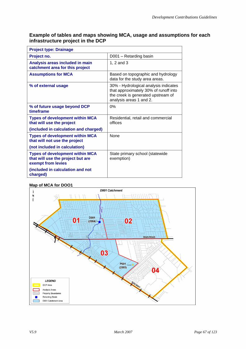
Example of tables and maps showing MCA, usage and assumptions for each infrastructure project in the DCP Project type: Drainage Project no. D001 – Retarding basin Analysis areas included in main catchment area for this project
1, 2 and 3
Assumptions for MCA Based on topographic and hydrology data for the study area areas.
% of external usage 30% - Hydrological analysis indicates that approximately 30% of runoff into the creek is generated upstream of analysis areas 1 and 2.
% of future usage beyond DCP timeframe
0%
Types of development within MCA that will use the project (included in calculation and charged)
Residential, retail and commercial offices
Types of development within MCA that will not use the project (not included in calculation)
None
Types of development within MCA that will use the project but are exempt from levies (included in calculation and not charged)
State primary school (statewide exemption)
Map of MCA for DOO1
V5.9 March 2007 Page 67 of 123
Development Contributions Guidelines
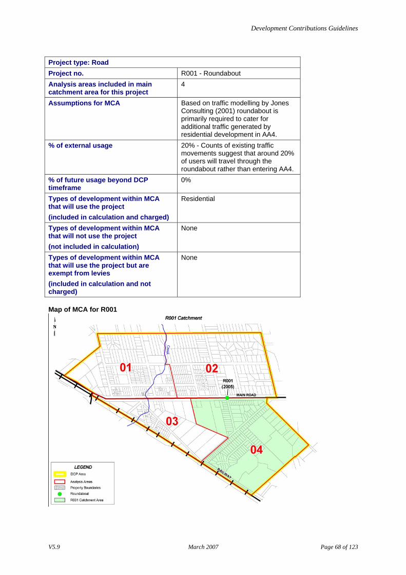
Project type: Road Project no. R001 - Roundabout Analysis areas included in main catchment area for this project
4
Assumptions for MCA Based on traffic modelling by Jones Consulting (2001) roundabout is primarily required to cater for additional traffic generated by residential development in AA4.
% of external usage 20% - Counts of existing traffic movements suggest that around 20% of users will travel through the roundabout rather than entering AA4.
% of future usage beyond DCP timeframe
0%
Types of development within MCA that will use the project (included in calculation and charged)
Residential
Types of development within MCA that will not use the project (not included in calculation)
None
Types of development within MCA that will use the project but are exempt from levies (included in calculation and not charged)
None
Map of MCA for R001
V5.9 March 2007 Page 68 of 123
Development Contributions Guidelines
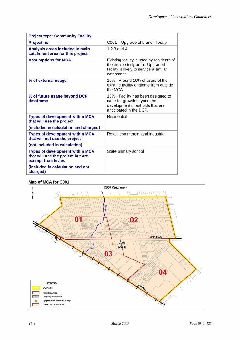
Project type: Community Facility Project no. C001 – Upgrade of branch library Analysis areas included in main catchment area for this project
1,2,3 and 4
Assumptions for MCA Existing facility is used by residents of the entire study area. Upgraded facility is likely to service a similar catchment.
% of external usage 10% - Around 10% of users of the existing facility originate from outside the MCA.
% of future usage beyond DCP timeframe
10% - Facility has been designed to cater for growth beyond the development thresholds that are anticipated in the DCP.
Types of development within MCA that will use the project (included in calculation and charged)
Residential
Types of development within MCA that will not use the project (not included in calculation)
Retail, commercial and industrial
Types of development within MCA that will use the project but are exempt from levies (included in calculation and not charged)
State primary school
Map of MCA for C001
V5.9 March 2007 Page 69 of 123
Development Contributions Guidelines
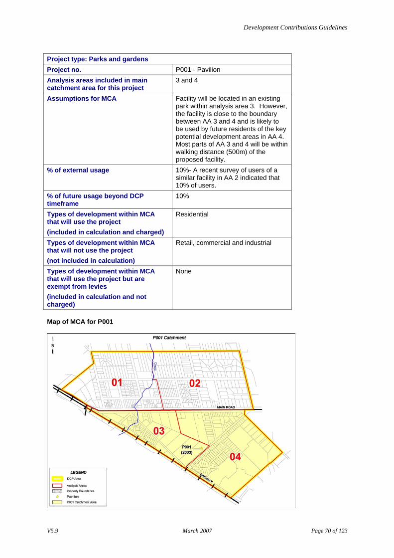
Project type: Parks and gardens Project no. P001 - Pavilion Analysis areas included in main catchment area for this project
3 and 4
Assumptions for MCA Facility will be located in an existing park within analysis area 3. However, the facility is close to the boundary between AA 3 and 4 and is likely to be used by future residents of the key potential development areas in AA 4. Most parts of AA 3 and 4 will be within walking distance (500m) of the proposed facility.
% of external usage 10%- A recent survey of users of a similar facility in AA 2 indicated that 10% of users.
% of future usage beyond DCP timeframe
10%
Types of development within MCA that will use the project (included in calculation and charged)
Residential
Types of development within MCA that will not use the project (not included in calculation)
Retail, commercial and industrial
Types of development within MCA that will use the project but are exempt from levies (included in calculation and not charged)
None
Map of MCA for P001
V5.9 March 2007 Page 70 of 123
Development Contributions Guidelines
Stage 7–Calculate the infrastructure levy payable for each infrastructure project Outcome
The outcome of this stage is the determination of the infrastructure levy payable by each demand unit for each infrastructure project.
Process
Complete the following tasks. Task Description
1 Using the demand unit information documented in Stage 4, create a table for each infrastructure project that shows: • each of the analysis areas that make up the MCA • the types of development that are expected to use the infrastructure project in each
analysis area • for each type of development, the number of existing and projected demand units
expected over the timeframe of the DCP. For an example, go to [Example of a table showing total project demand in the MCA].
2 Calculate the project cost that can be attributed to the MCA by applying the [Formula to calculate infrastructure project cost for MCA]. To complete this task, you will need the: • estimated infrastructure project costs from Stage 5, and • estimate of external usage from Stage 6.
3 Calculate the infrastructure levy payable per demand unit by applying the [Formula to calculate infrastructure levy per demand unit]. To complete this task, you will need: • total number of demand units from Task 1, and • project cost for MCA from Task 2.
4 Repeat tasks 1-3 for each infrastructure project in the DCP. Note: There is an alternative method for calculating infrastructure levies. For more information and examples, go to: • [Guidelines on present value discounting (PVD)], and • [Examples of the application of the PVD method].
V5.9 March 2007 Page 71 of 123
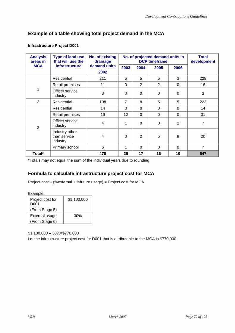
Development Contributions Guidelines
Example of a table showing total project demand in the MCA
Infrastructure Project D001
No. of projected demand units in DCP timeframe
Analysis areas in
MCA
Type of land use that will use the infrastructure
No. of existing drainage
demand units 2002
2003 2004 2005 2006
Total development
Residential 211 5 5 5 3 228 Retail premises 11 0 2 2 0 16
1 Office/ service industry 3 0 0 0 0 3
2 Residential 198 7 8 5 5 223 Residential 14 0 0 0 0 14 Retail premises 19 12 0 0 0 31 Office/ service industry 4 1 0 0 2 7
Industry other than service industry
4 0 2 5 9 20
3
Primary school 6 1 0 0 0 7 Total* 470 25 17 16 19 547
*Totals may not equal the sum of the individual years due to rounding
Formula to calculate infrastructure project cost for MCA
Project cost – (%external + %future usage) = Project cost for MCA Example: Project cost for D001 (From Stage 5)
$1,100,000
External usage (From Stage 6)
30%
$1,100,000 – 30%=$770,000 i.e. the infrastructure project cost for D001 that is attributable to the MCA is $770,000
V5.9 March 2007 Page 72 of 123
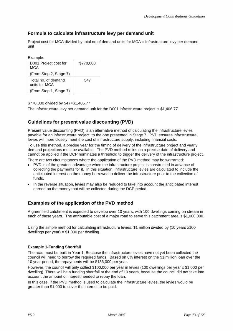
Development Contributions Guidelines
Formula to calculate infrastructure levy per demand unit
Project cost for MCA divided by total no of demand units for MCA = Infrastructure levy per demand unit Example: D001 Project cost for MCA (From Step 2, Stage 7)
$770,000
Total no. of demand units for MCA (From Step 1, Stage 7)
547
$770,000 divided by 547=$1,406.77 The infrastructure levy per demand unit for the D001 infrastructure project is $1,406.77
Guidelines for present value discounting (PVD)
Present value discounting (PVD) is an alternative method of calculating the infrastructure levies payable for an infrastructure project, to the one presented in Stage 7. PVD ensures infrastructure levies will more closely meet the cost of infrastructure supply, including financial costs. To use this method, a precise year for the timing of delivery of the infrastructure project and yearly demand projections must be available. The PVD method relies on a precise date of delivery and cannot be applied if the DCP nominates a threshold to trigger the delivery of the infrastructure project. There are two circumstances where the application of the PVD method may be warranted: • PVD is of the greatest advantage when the infrastructure project is constructed in advance of
collecting the payments for it. In this situation, infrastructure levies are calculated to include the anticipated interest on the money borrowed to deliver the infrastructure prior to the collection of funds.
• In the reverse situation, levies may also be reduced to take into account the anticipated interest earned on the money that will be collected during the DCP period.
Examples of the application of the PVD method
A greenfield catchment is expected to develop over 10 years, with 100 dwellings coming on stream in each of these years. The attributable cost of a major road to serve this catchment area is $1,000,000. Using the simple method for calculating infrastructure levies, $1 million divided by (10 years x100 dwellings per year) = $1,000 per dwelling.
Example 1-Funding Shortfall The road must be built in Year 1. Because the infrastructure levies have not yet been collected the council will need to borrow the required funds. Based on 6% interest on the $1 million loan over the 10 year period, the repayments will be $136,000 per year. However, the council will only collect $100,000 per year in levies (100 dwellings per year x $1,000 per dwelling). There will be a funding shortfall at the end of 10 years, because the council did not take into account the amount of interest needed to repay the loan. In this case, if the PVD method is used to calculate the infrastructure levies, the levies would be greater than $1,000 to cover the interest to be paid.
V5.9 March 2007 Page 73 of 123

Development Contributions Guidelines
Example 2-Funding Surplus The road does not need to be built until Year 10. The council earns 6% interest on the infrastructure levies collected over the 10 years. The council will accumulate funds of $1.3 million by the time it is required to pay for the road, which is $300,000 more than the council requires to build the road. In this case, if the PVD method is used to calculate the infrastructure levies, the levies would be lower than $1,000 to take account of the interest to be earned.
V5.9 March 2007 Page 74 of 123
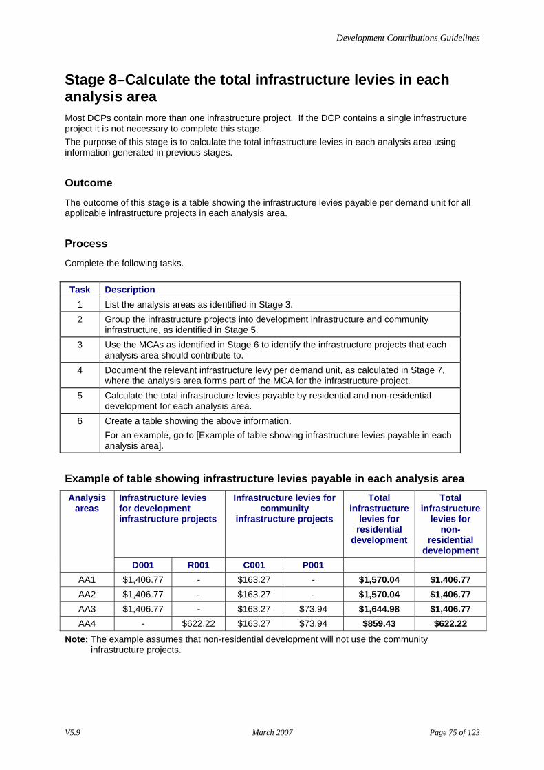
Development Contributions Guidelines
Stage 8–Calculate the total infrastructure levies in each analysis area Most DCPs contain more than one infrastructure project. If the DCP contains a single infrastructure project it is not necessary to complete this stage. The purpose of this stage is to calculate the total infrastructure levies in each analysis area using information generated in previous stages.
Outcome
The outcome of this stage is a table showing the infrastructure levies payable per demand unit for all applicable infrastructure projects in each analysis area.
Process
Complete the following tasks. Task Description
1 List the analysis areas as identified in Stage 3. 2 Group the infrastructure projects into development infrastructure and community
infrastructure, as identified in Stage 5. 3 Use the MCAs as identified in Stage 6 to identify the infrastructure projects that each
analysis area should contribute to. 4 Document the relevant infrastructure levy per demand unit, as calculated in Stage 7,
where the analysis area forms part of the MCA for the infrastructure project. 5 Calculate the total infrastructure levies payable by residential and non-residential
development for each analysis area. 6 Create a table showing the above information.
For an example, go to [Example of table showing infrastructure levies payable in each analysis area].
Example of table showing infrastructure levies payable in each analysis area Infrastructure levies for development infrastructure projects
Infrastructure levies for community
infrastructure projects
Total infrastructure
levies for residential
development
Total infrastructure
levies for non-
residential development
Analysis areas
D001 R001 C001 P001 AA1 $1,406.77 - $163.27 - $1,570.04 $1,406.77 AA2 $1,406.77 - $163.27 - $1,570.04 $1,406.77 AA3 $1,406.77 - $163.27 $73.94 $1,644.98 $1,406.77 AA4 - $622.22 $163.27 $73.94 $859.43 $622.22
Note: The example assumes that non-residential development will not use the community infrastructure projects.
V5.9 March 2007 Page 75 of 123
Development Contributions Guidelines
Stage 9–Establish charge areas which have common infrastructure levies A charge area is an area where the same infrastructure levies apply to all demand units. Charge areas are created by aggregating analysis areas with common levies for common infrastructure projects. The purpose of creating charge areas is to simplify the application of infrastructure levies within the planning scheme. Each charge area created will become a schedule to the Development Contributions Plan Overlay (DCPO) as set out in the Victoria Planning Provisions.
Outcome
The outcomes of this process are: • a map of the DCP area showing the charge areas • a table showing charge areas, the infrastructure levies and projects, and • a list of the types of development that will be exempt from paying infrastructure levies.
Process
Complete the following tasks. Task Description
1 Analyse the table of infrastructure levies payable in each analysis area (developed in Stage 8) and identify any groups of analysis areas which contribute to the same infrastructure projects and have the same infrastructure levies. These groups become the DCP charge areas. For more information, go to [Guidelines for establishing charge areas].
2 Refer to the map of the analysis areas to ensure that the groups of analysis areas relate to one another and form a logical geographical unit.
3 Map the charge areas. 4 Create a table that shows:
• the charge areas and the groups of analysis areas • total infrastructure levies that relate to demand units in those charge areas • the community and development infrastructure levies, and • a list of projects that relate to the charge areas. For examples, go to: • [Example of a table showing details of charge areas in the DCP], and • [Example of map showing charge areas].
5 Examine each charge area and list the developments that will be exempt from paying infrastructure levies. Refer to the table developed in Stage 6 for each infrastructure project showing the types of development that are exempt from the levies.
Guidelines for establishing charge areas
A charge area • may align with the boundaries of an MCA or a smaller area such as an individual analysis area,
and • should be free of major cross-subsidies.
V5.9 March 2007 Page 76 of 123
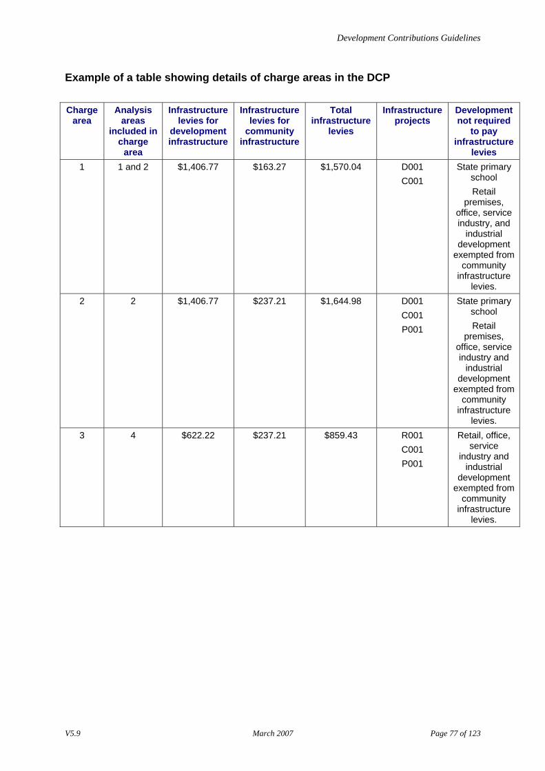
Development Contributions Guidelines
Example of a table showing details of charge areas in the DCP
Charge
area Analysis
areas included in
charge area
Infrastructure levies for
development infrastructure
Infrastructure levies for
community infrastructure
Total infrastructure
levies
Infrastructure projects
Development not required
to pay infrastructure
levies 1 1 and 2 $1,406.77 $163.27 $1,570.04 D001
C001 State primary
school Retail
premises, office, service industry, and
industrial development
exempted from community
infrastructure levies.
2 2 $1,406.77 $237.21 $1,644.98 D001 C001 P001
State primary school Retail
premises, office, service industry and
industrial development
exempted from community
infrastructure levies.
3 4 $622.22 $237.21 $859.43 R001 C001 P001
Retail, office, service
industry and industrial
development exempted from
community infrastructure
levies.
V5.9 March 2007 Page 77 of 123
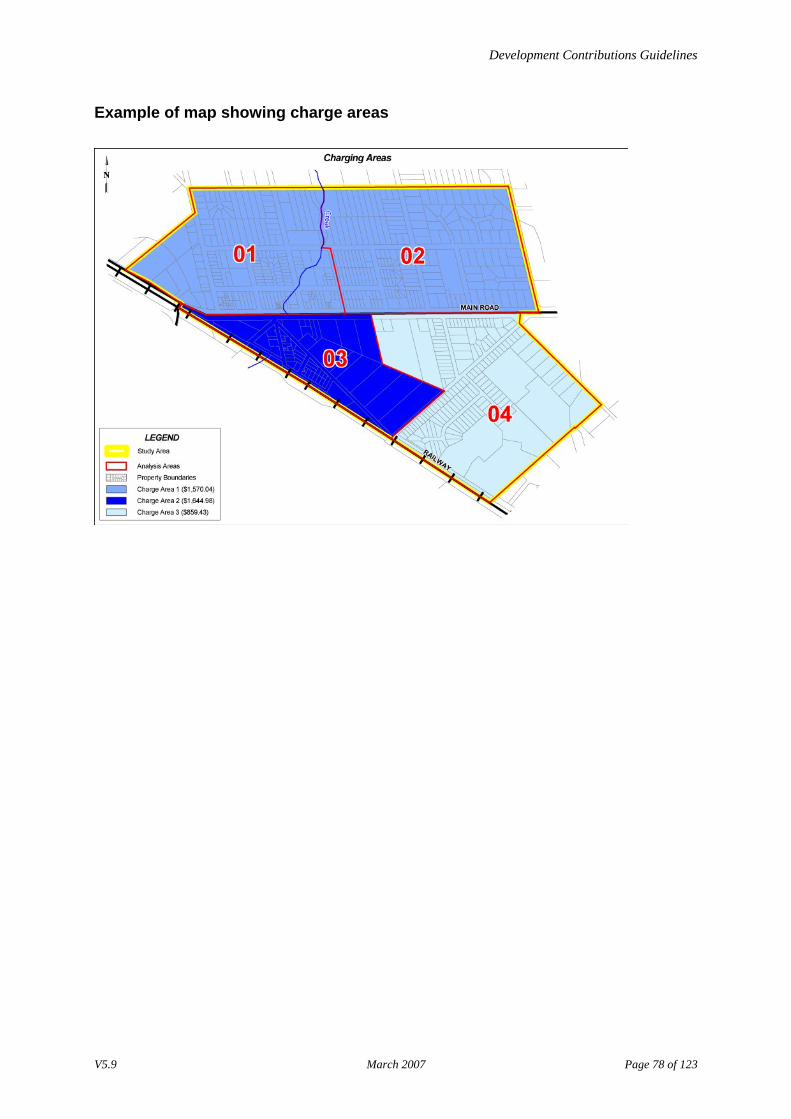
Development Contributions Guidelines
Example of map showing charge areas
V5.9 March 2007 Page 78 of 123
Development Contributions Guidelines
Stage 10–Describe how infrastructure levies will be collected The final step in the calculations phase is deciding how to collect the levies from new development. You need to assess whether the procedures provided in the Planning and Environment Act 1987 for collecting development and community infrastructure levies capture all the types of development to be charged. For more information, go to [Guidelines for the collection of infrastructure levies]. If the collection procedures in the Act do not capture all the types of development to be charged, the DCP must include procedures to collect development infrastructure levies where no planning permit is required.
Outcomes The outcomes of this stage are: • a description of how infrastructure levies for both community and development infrastructure
projects will be collected, and • documentation of the method for collecting infrastructure levies from development types or areas
that do not require a planning permit.
Process Complete the following tasks. Task Description
1 For each charge area, list the infrastructure projects that were classified as development infrastructure using the table created in Stage 9.
2 For the development infrastructure projects, list the types of new development that will use the infrastructure and be charged. Use the table created in Stage 6 to identify the types of development in this category.
3 Check the planning scheme to determine if the identified types of new development require a planning permit.
4 For each development type not requiring a planning permit, identify and document an alternative procedure to use to collect development infrastructure levies. For information and an example, go to: • [Guidelines for establishing an alternative collection procedure] • [Example of an alternative collection procedure]
Guidelines for the collection of infrastructure levies The Planning and Environment Act 1987 states that the requirement to pay a development infrastructure levy in accordance with a DCP must be specified in a condition on the planning permit. The planning permit condition may require the applicant to either: • pay by a certain date • pay prior to being issued a building permit under the Building Act 1993 or Statement of Compliance
under the Subdivision Act 1988, or • enter into an agreement regarding the timing and staging of payments, or provide works-in-kind to
meet requirements.
The Planning and Environment Act 1987 requires the building permit applicant to pay the community infrastructure levy prior to the building permit being issued. Before issuing a building permit, the building surveyor must check whether the building permit applicant has: • paid the community infrastructure levy, or • entered into an agreement with the council to pay the levy at a later date.
V5.9 March 2007 Page 79 of 123
Development Contributions Guidelines
A developer may, by agreement with the council, either pay or provide works-in-lieu to meet the community infrastructure levy at the planning permit stage.
Guidelines for establishing an alternative collection procedure
If a planning permit is not required for particular types of development, the council must document an alternative procedure for collecting development infrastructure levies in the approved DCP. One alternative is to collect the development infrastructure levy through the building permit process. There may be other options. When selecting an option, ensure that there is a: • mechanism in the development process that triggers the requirement to pay the levy, and • specified point in time for payment of the levy.
Example of an alternative collection procedure
A council in an established urban area wants to charge a development infrastructure levy for drainage projects. This levy will apply to all new development resulting in increased site coverage, including extensions to houses. The charge is calculated according to square metres of new site coverage. In this municipality, planning permits are not required for extensions to houses on lots that are larger than 300 square metres. In order to charge this levy for extensions that do not require a planning permit, council must include a development infrastructure levy collection procedure in its DCP. In this case the DCP provides for the levy to be collected at the building permit stage.
V5.9 March 2007 Page 80 of 123
Development Contributions Guidelines
Stage 11–Estimate the amount the council will need to fund for each infrastructure project The estimates prepared in this stage take into account development that will not pay infrastructure levies, such as: • existing development • future usage within the MCA • external usage • development exempted from the requirements of the planning scheme, and • any other types of development that council has chosen to exempt, for example community service
providers, churches or private schools.
This stage is optional.
Outcome
The outcome of this stage is an estimate for each project of the amount the council: • can expect to collect through the DCP, and • will need to fund to make up the shortfall.
Process
Complete the following tasks. Task Description
1 Calculate the percentage of the total demand units for the MCA that are chargeable using the [Formula to determine percentage of MCA that is chargeable].
2 Calculate how much money the council can expect to collect in infrastructure levies over the DCP timeframe using the [Formula to determine the amount that council will collect from the DCP].
3 Calculate how much the council will have to contribute to deliver the infrastructure project using the [Formula to calculate the council’s contribution to the infrastructure project].
Formula to determine percentage of MCA that is chargeable
(No. of demand units of existing development in the MCA + the no. of demand units of new development in the MCA exempted from charges) divided by the total no. of demand units for the MCA x 100 = % of the MCA that is non-chargeable
V5.9 March 2007 Page 81 of 123
Development Contributions Guidelines
Example: Total no. of demand units for MCA for infrastructure project D001 (From Stage 7)
547
Total no. of demand units for existing development for D001 (From Stage 7)
470
Total no. of demand units for new development that is exempt from paying levies for D001 (From Stage 6 and 7)
1
(470+1) divided by 547x100 = 86.1% of MCA that is existing development or exempt from levies (non-chargeable) This means that 14.9% of the MCA can be charged. Note: Infrastructure levies can only be collected from new development.
Formula to determine the amount that council will collect from the DCP
% of the MCA that is chargeable x project cost for the MCA = Amount to be collected in levies over DCP timeframe Example: Percentage of the MCA that is chargeable new development 14.9%
Project cost for the MCA (From Stage 7)
$770,000
14.9% of $770,000 = $106,984 The amount that the council will collect from the MCA is $106,984
Formula to calculate the council’s contribution to the infrastructure project
Total project cost – the amount that council will collect from the MCA = council’s contribution to the infrastructure project Example: Estimated total project cost for D001 (Stage 5)
$1,100,000
Total amount collected from chargeable new development in the MCA
$106,984
$1,100,000 - $106,984= $993,016 The council must contribute $993,016 to the cost of the D001 infrastructure project.
V5.9 March 2007 Page 82 of 123
Development Contributions Guidelines
Stage 12–Prepare a cash flow analysis In this stage you will prepare information that will enable the council to consider and assess the budget implications of each infrastructure project. This information is not necessarily included in the final DCP. This stage is optional.
Outcome
The outcome of this stage is a cash flow analysis table documenting timing of collection and expenditure.
Process
Complete the following tasks. Task Description
1 Calculate the income for each project in each year of the DCP using the [Formula to calculate yearly income for each project]. You will need the: • total number of projected demand units per year from Stage 7, and • infrastructure levy per demand unit from Stage 7.
2 Create a table showing the information from Task 1. For an example, go to [Example of table showing the cash flow analysis for infrastructure project].
3 Calculate the funding shortfall associated with the demand units that are exempted from paying infrastructure levies using the [Formula to calculate the council funding shortfall associated with exempted new development]. You will need the: • total number of demand units associated with new development exempt from
paying levies, and • infrastructure levy per demand unit.
4 Complete Tasks 1-3 for each project included in the DCP.
Formula to calculate yearly income for each project
No. of demand units in nominated year x infrastructure levy per demand unit = Income for nominated year Note: Do not include the totals for existing demand units in the calculation. Example: No. of demand units in year 2003 for infrastructure project D001 (From Stage 7)
25
Infrastructure levy per demand unit for infrastructure project D001 (From Stage 7)
$1,406.77
V5.9 March 2007 Page 83 of 123
Development Contributions Guidelines
25 x $1,406.77 = $35,169 The year 2003 income for infrastructure project D001 is $35,169
Example of table showing the cash flow analysis for infrastructure project Existing
develop. 2002
2003 2004 2005 2006 Total
No. of demand units in MCA
470 25* 17 16 19 547
Project annual income from infrastructure levies
$0 $33,762.59* $23,915.17 $22,508.40 $26,728.72 $106,914.88
Cumulative income 0 $33,762.59 $57,677.77 $80,186.16 $106,914.88 -
Total project expenditure 0 0 $1,100,000 0 $1,100,000
*One of the demand units that is projected in 2003 is exempt from paying DCP charges and hence the cash flow for this year equals the total number of demand units (25) minus the number of exempt demand units (1) multiplied by the charge for D001 ($1,407.95)
Formula to calculate the council funding shortfall associated with exempted new development
Total no. of demand units associated with new development that is exempt from paying levies x infrastructure levy per demand unit = council funding shortfall associated with exempted new development Example: Total no. of demand units for new development that is exempt from paying levies (i.e. added State primary school site area = 500 m2) (Calculate from tables in Stages 6 and 7)
1
Infrastructure levy per demand unit (Stage 7)
$1,406.77
1 x $1,4076.77 = $1,406.77
The council funding shortfall from new development exempt from paying infrastructure levies is $1,406.77
V5.9 March 2007 Page 84 of 123
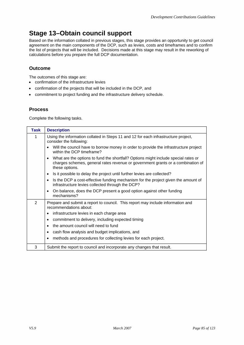
Development Contributions Guidelines
Stage 13–Obtain council support Based on the information collated in previous stages, this stage provides an opportunity to get council agreement on the main components of the DCP, such as levies, costs and timeframes and to confirm the list of projects that will be included. Decisions made at this stage may result in the reworking of calculations before you prepare the full DCP documentation.
Outcome
The outcomes of this stage are: • confirmation of the infrastructure levies • confirmation of the projects that will be included in the DCP, and • commitment to project funding and the infrastructure delivery schedule.
Process
Complete the following tasks. Task Description
1 Using the information collated in Steps 11 and 12 for each infrastructure project, consider the following: • Will the council have to borrow money in order to provide the infrastructure project
within the DCP timeframe? • What are the options to fund the shortfall? Options might include special rates or
charges schemes, general rates revenue or government grants or a combination of these options.
• Is it possible to delay the project until further levies are collected? • Is the DCP a cost-effective funding mechanism for the project given the amount of
infrastructure levies collected through the DCP? • On balance, does the DCP present a good option against other funding
mechanisms?
2 Prepare and submit a report to council. This report may include information and recommendations about: • infrastructure levies in each charge area • commitment to delivery, including expected timing • the amount council will need to fund • cash flow analysis and budget implications, and • methods and procedures for collecting levies for each project.
3 Submit the report to council and incorporate any changes that result.
V5.9 March 2007 Page 85 of 123
Development Contributions Guidelines
Stage 14–Compile the draft DCP This stage involves collating all the information prepared from previous stages into a draft DCP in a format suitable for incorporation into the planning scheme. You may choose to compile the documentation either: • progressively as you work through the stages, or • once council support has been obtained.
The DCP document can be presented for review as a stand-alone document or as part of a related strategic planning document to be incorporated in the planning scheme, such as a structure plan, growth area plan or open space strategy. In this case, you should ensure that the DCP component of this documentation is clearly identifiable.
Outcome
The outcome of this process is a draft DCP ready for internal and external review.
Process
Complete the following task. Task Description
1 Assemble the full DCP documentation and prepare all maps as required. For more information, go to: • [Guidelines about the content of a DCP] • [Guidelines about the level of detail required in a DCP], and • [Guidelines about referencing other documents in a DCP].
Guidelines about the content of a DCP
It is important that the content of the DCP: • meets the requirements of section 46K of the Planning and Environment Act 1987, and • is capable of meeting the Strategic assessment guidelines for planning scheme amendments.
A DCP should include the following information: • details of the geographical DCP area • strategic context • DCP timeframe • overview of infrastructure projects included in the DCP • detailed summary sheets for each individual infrastructure project • method of calculating infrastructure levies • details of the amount and application of the development infrastructure levies and community
infrastructure levies, and • procedures for collection and administration of levies.
V5.9 March 2007 Page 86 of 123
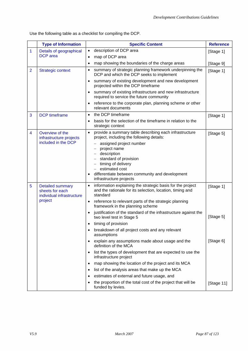
Development Contributions Guidelines
Use the following table as a checklist for compiling the DCP.
Type of Information Specific Content Reference 1 Details of geographical
DCP area • description of DCP area • map of DCP area • map showing the boundaries of the charge areas
[Stage 1] [Stage 9]
2 Strategic context • summary of strategic planning framework underpinning the DCP and which the DCP seeks to implement
• summary of existing development and new development projected within the DCP timeframe
• summary of existing infrastructure and new infrastructure required to service the future community
• reference to the corporate plan, planning scheme or other relevant documents
[Stage 1]
3 DCP timeframe • the DCP timeframe • basis for the selection of the timeframe in relation to the
strategic context
[Stage 1]
4 Overview of the infrastructure projects included in the DCP
• provide a summary table describing each infrastructure project, including the following details: − assigned project number − project name − description − standard of provision − timing of delivery − estimated cost
• differentiate between community and development infrastructure projects
[Stage 5]
5 Detailed summary sheets for each individual infrastructure project
• information explaining the strategic basis for the project and the rationale for its selection, location, timing and standard
• reference to relevant parts of the strategic planning framework in the planning scheme
• justification of the standard of the infrastructure against the two level test in Stage 5
• timing of provision • breakdown of all project costs and any relevant
assumptions • explain any assumptions made about usage and the
definition of the MCA • list the types of development that are expected to use the
infrastructure project • map showing the location of the project and its MCA • list of the analysis areas that make up the MCA • estimates of external and future usage, and • the proportion of the total cost of the project that will be
funded by levies.
[Stage 1] [Stage 5] [Stage 6] [Stage 11]
V5.9 March 2007 Page 87 of 123
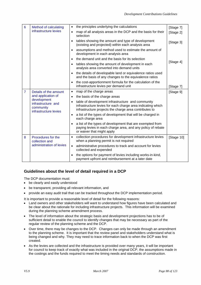
Development Contributions Guidelines
6 Method of calculating infrastructure levies
• the principles underlying the calculations • map of all analysis areas in the DCP and the basis for their
selection • tables showing the amount and type of development
(existing and projected) within each analysis area • assumptions and method used to estimate the amount of
development in each analysis area • the demand unit and the basis for its selection • tables showing the amount of development in each
analysis area converted into demand units • the details of developable land or equivalence ratios used
and the basis of any changes to the equivalence ratios • the cost-apportionment formula for the calculation of the
infrastructure levies per demand unit
[Stage 7] [Stage 2] [Stage 3] [Stage 4] [Stage 7]
7 Details of the amount and application of development infrastructure and community infrastructure levies
• map of the charge areas • the basis of the charge areas • table of development infrastructure and community
infrastructure levies for each charge area indicating which infrastructure projects the charge area contributes to
• a list of the types of development that will be charged in each charge area
• a list of the types of development that are exempted from paying levies in each charge area, and any policy of rebate or waiver that might apply
[Stage 9]
8 Procedures for the collection and administration of levies
• collection procedures for development infrastructure levies when a planning permit is not required
• administrative procedures to track and account for levies collected and expended
• the options for payment of levies including works-in-kind, payment upfront and reimbursement at a later date
[Stage 10]
Guidelines about the level of detail required in a DCP
The DCP documentation must: • be clearly and easily understood • be transparent, providing all relevant information, and • provide an easy audit trail that can be tracked throughout the DCP implementation period.
It is important to provide a reasonable level of detail for the following reasons: • Land owners and other stakeholders will want to understand how figures have been calculated and
be clear about the rationale for including infrastructure projects. This information will be examined during the planning scheme amendment process.
• The level of information about the strategic basis and development projections has to be of sufficient detail to enable the council to identify changes that may be necessary as part of the regular review of the planning scheme and the DCP.
• Over time, there may be changes to the DCP. Changes can only be made through an amendment to the planning scheme. It is important that the review panel and stakeholders understand what is being changed and why. They may need to trace information back to when the DCP was first created.
• As the levies are collected and the infrastructure is provided over many years, it will be important for council to keep track of exactly what was included in the original DCP, the assumptions made in the costings and the funds required to meet the timing needs and standards of construction.
V5.9 March 2007 Page 88 of 123
Development Contributions Guidelines
Guidelines about referencing other documents in a DCP
The strategic justification for the DCP and the individual infrastructure projects may make reference to documents that form part of the planning scheme. It is important not to rely on referencing documents that do no have any statutory status. Documents that do not form part of the planning scheme may change over time and cannot be relied upon to form the strategic basis for the DCP. The [planning practice note] on incorporated and reference documents provides further guidance on document referencing.
V5.9 March 2007 Page 89 of 123
Development Contributions Guidelines
Stage 15–Review draft DCP and finalise Once the draft is completed it is good practice to seek comments on the DCP from: • stakeholders within council, and • other stakeholders such as developers and State Government agencies, who may have an
interest.
The development industry is likely to be particularly interested in the following content of the DCP: • estimates of infrastructure project costs • selection of infrastructure projects and the standard of provision • the MCAs for infrastructure projects • estimates of external use • projections of new development, and • equivalence ratios used to define demand.
The purpose of this review stage is to give stakeholders an opportunity to provide feedback and to identify: • whether the assumptions are reasonable • any mistakes which need to be corrected • areas of contention that may require further justification, and • areas within the DCP document that can be adjusted through negotiation.
Outcome
The outcome of this stage is the final version of the DCP ready for exhibition as part of a planning scheme amendment.
Process
Complete the following tasks. Task Description
1 Ask the following stakeholders to review the draft DCP: • councillors • relevant internal staff • adjoining municipalities • State Government agencies (if the DCP includes State infrastructure), and • developers affected by the DCP.
2 Meet with stakeholders to discuss any issues that arise from their review. 3 Consider all comments and change the DCP, if required. This may involve adjusting
the calculations. 4 Prepare the final version of the DCP ready for exhibition.
V5.9 March 2007 Page 90 of 123
Development Contributions Guidelines
Stage 16–Decide to prepare an amendment to the planning scheme to incorporate the DCP
Outcome The outcome of this stage is a decision of council to prepare an amendment to incorporate the DCP into the planning scheme.
Process Complete the following tasks. Task Description
1 Prepare a report to council recommending a decision to prepare and exhibit an amendment to incorporate the DCP into the planning scheme. The report may include the: • strategic context and the infrastructure projects included in the DCP • levies for each charge area • funds expected to be collected over the timeframe of the DCP • budget implications resulting from a commitment to deliver the infrastructure
projects, and • process involved in preparing the DCP, including stakeholder consultation.
2 Submit the report to council for consideration and decision.
For more information, go to [Incorporating the DCP into the planning scheme].
V5.9 March 2007 Page 91 of 123