Embed Size (px)
Citation preview
1
PRESCRIBED FIRE PLAN Elderberry North Naches Ranger District PROJECT NAME DISTRICT
NACHES RANGER DISTRICT
Okanogan and Wenatchee National Forest 10237 Highway 12 Naches, WA 98937
(509)653-1400
Prepared By: Jim Bailey, Rx Fire Planning Specalist/RXB1/RXM1 Date: February 16, 2007
(Name & Qualification) Silviculture Review By: Date:
(Name & Position) Technical Review By: Date:
(Name & Qualification) FMO Review By: Date:
(Name – District FMO) The approved Prescribed Fire Plan constitutes the authority to burn. No one has the authority to burn without an approved plan or in a manner not in compliance with the approved plan. Actions taken in compliance with the approved Prescribed Fire Plan will be fully supported. Personnel will be held accountable for actions taken which are not in compliance with elements of the approved plan regarding execution of the objectives in a safe and cost-effective manner. Pursuant to prescribed fire guidelines, the complexity of this project is rated:
COMPLEXITY RATING
X High Moderate Low Type of Burn: Natural and Activity Fuels Underburn Estimated Cost Per Acre: $134/acre in Natural Fuels, $184.26/acre in Activity Fuels Benefiting Activity(s): Fire/Fuels/Forest Heath/Wildlife Habitat Burn Completed by: Contractor Purchaser Assist Agency X Contractor Name:
Approved By: Date: Line Officer
2
We the undersigned approve on behalf of the agencies that we represent, this Prescribed Fire Plan for the Elderberry North Prescribed Burn. By approval of this plan, we state that we understand the ecological, social, and economic objectives, as well as the risks inherent in conducting prescribed fire activities. We agree not to hold the U.S. Forest Service or any individuals assigned to manage, oversee, or conduct this project liable for ecological, social, or economic damage caused by prescribed fire activities while said individuals are acting within the scope of their responsibility as outlined by this burn plan, by their individual job Position Description, or by policies and procedures outlined by Forest Service Manual or Handbooks. We give the U.S. Forest Service full authority to conduct this project as outlined within this plan and to be the lead agency in conducting this project on lands under our jurisdiction as outlined. We agree that any questions, concerns, or changes in objectives, prescription, or procedures must be directed to the U.S. Forest Service Line Officer approving this plan.
Approved By:
Date:
Washington State Department of Natural Resources Resource Protection
Approved By: Date: Washington State Department of Fish and Wildlife
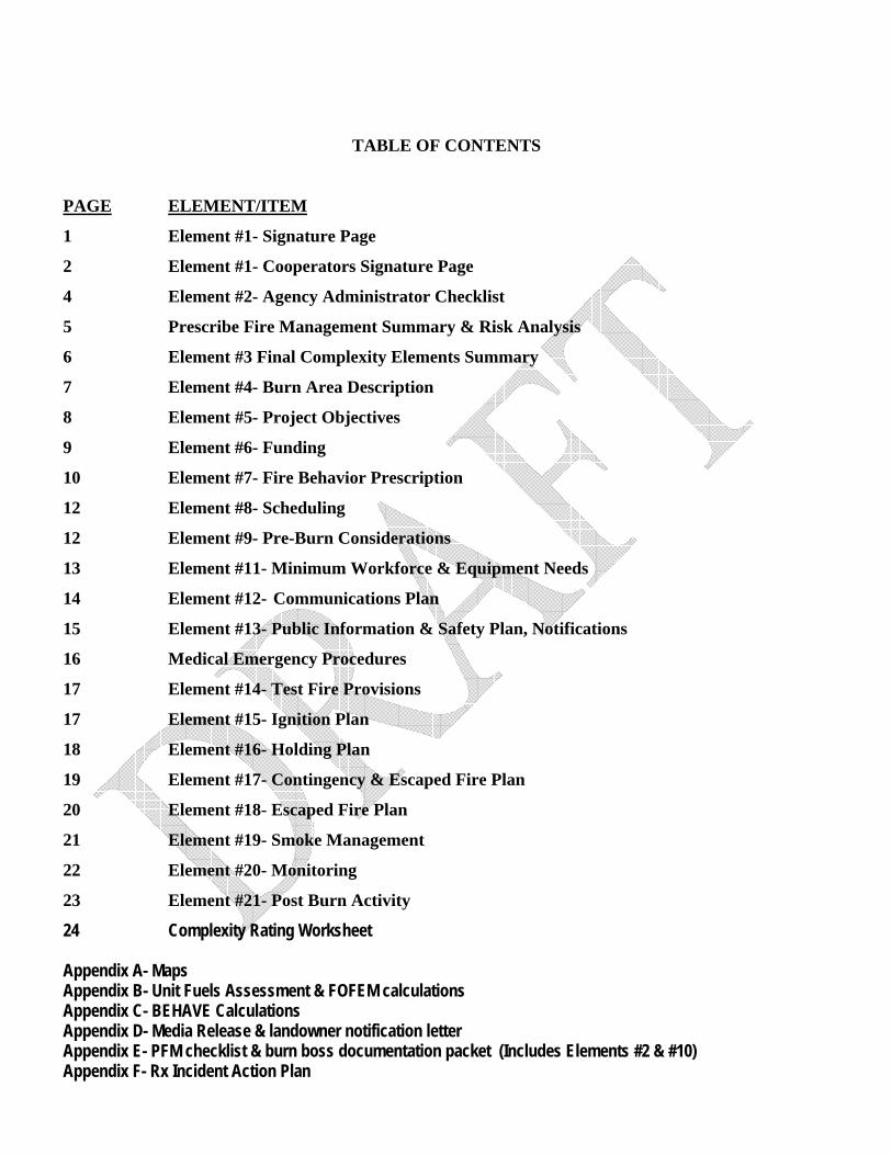
TABLE OF CONTENTS
PAGE ELEMENT/ITEM
1 Element #1- Signature Page
2 Element #1- Cooperators Signature Page
4 Element #2- Agency Administrator Checklist
5 Prescribe Fire Management Summary & Risk Analysis
6 Element #3 Final Complexity Elements Summary
7 Element #4- Burn Area Description
8 Element #5- Project Objectives
9 Element #6- Funding
10 Element #7- Fire Behavior Prescription
12 Element #8- Scheduling
12 Element #9- Pre-Burn Considerations
13 Element #11- Minimum Workforce & Equipment Needs
14 Element #12- Communications Plan
15 Element #13- Public Information & Safety Plan, Notifications
16 Medical Emergency Procedures
17 Element #14- Test Fire Provisions
17 Element #15- Ignition Plan
18 Element #16- Holding Plan
19 Element #17- Contingency & Escaped Fire Plan
20 Element #18- Escaped Fire Plan
21 Element #19- Smoke Management
22 Element #20- Monitoring
23 Element #21- Post Burn Activity 24 Complexity Rating Worksheet Appendix A- Maps Appendix B- Unit Fuels Assessment & FOFEM calculations Appendix C- BEHAVE Calculations Appendix D- Media Release & landowner notification letter Appendix E- PFM checklist & burn boss documentation packet (Includes Elements #2 & #10) Appendix F- Rx Incident Action Plan
4
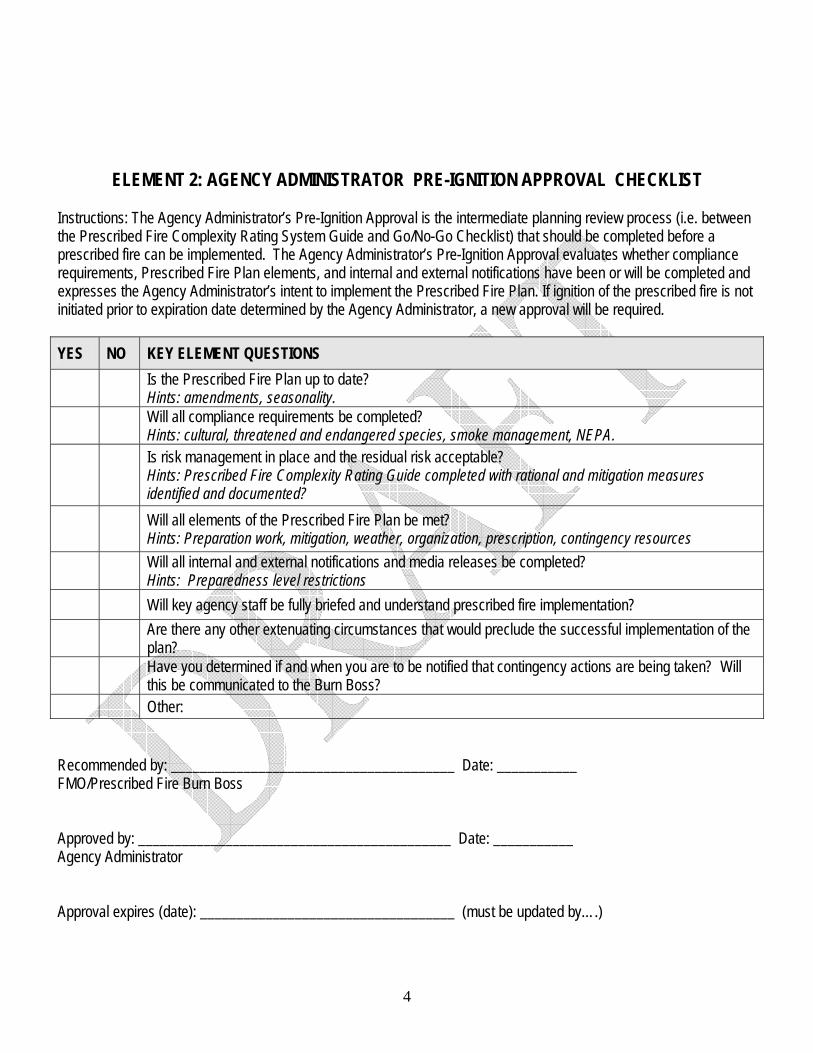
ELEMENT 2: AGENCY ADMINISTRATOR PRE-IGNITION APPROVAL CHECKLIST Instructions: The Agency Administrator’s Pre-Ignition Approval is the intermediate planning review process (i.e. between the Prescribed Fire Complexity Rating System Guide and Go/No-Go Checklist) that should be completed before a prescribed fire can be implemented. The Agency Administrator’s Pre-Ignition Approval evaluates whether compliance requirements, Prescribed Fire Plan elements, and internal and external notifications have been or will be completed and expresses the Agency Administrator’s intent to implement the Prescribed Fire Plan. If ignition of the prescribed fire is not initiated prior to expiration date determined by the Agency Administrator, a new approval will be required. YES NO KEY ELEMENT QUESTIONS Is the Prescribed Fire Plan up to date?
Hints: amendments, seasonality. Will all compliance requirements be completed?
Hints: cultural, threatened and endangered species, smoke management, NEPA. Is risk management in place and the residual risk acceptable?
Hints: Prescribed Fire Complexity Rating Guide completed with rational and mitigation measures identified and documented?
Will all elements of the Prescribed Fire Plan be met? Hints: Preparation work, mitigation, weather, organization, prescription, contingency resources
Will all internal and external notifications and media releases be completed? Hints: Preparedness level restrictions
Will key agency staff be fully briefed and understand prescribed fire implementation? Are there any other extenuating circumstances that would preclude the successful implementation of the
plan? Have you determined if and when you are to be notified that contingency actions are being taken? Will
this be communicated to the Burn Boss? Other: Recommended by: _______________________________________ Date: ___________ FMO/Prescribed Fire Burn Boss Approved by: ___________________________________________ Date: ___________ Agency Administrator Approval expires (date): ___________________________________ (must be updated by….)

5
PRESCRIBED FIRE MANAGEMENT SUMMARY AND RISK ANALYSIS: (Forest Template only, not required element)
Management Summary: As stated by the Elderberry Project Environmental Assessment (August 1999), the Purpose and Need for Action is to “reduce the risk of wildland crown fires, reduce fuel loadings, promote long-term ecosystem sustainability, prevent and control noxious weeds, [and] improve wildlife habitat (primarily forage and big game browse)…” Under Ecosystem Sustainability and Fire Risk, the EA states “In order to reduce the risk of tree crown fires, reduce fuel loads and promote long-term ecosystem sustainability, there is a need to 1) treat overstocked, dry and mesic, multiple layered vegetative communities in a way that encourages the growth of single-layered fire resilient, drought tolerant, and insect and disease resistant plant communities; 2) return the influence of fire to more natural historic levels; 3) reduce tree shade and stimulate shrub growth to reduce the adverse effects of repeated browsing, shading, and fire exclusion; and 4)improve the health and vigor of native shrubs, grasses, and forbs to reduce the spread of noxious weeds such as diffuse knapweed, St.Johns wart and thistle.” Values at Risk: Values at risk within and immediately adjacent to the project area include the main channel of Oak Creek and the functioning riparian area, commodities (timber, small products), State (Washington State Department of Natural Resources) protected lands to the north and Perpetual Timber Rights on those lands, State (Washington State Department of Fish and Wildlife) administered lands to the west, south, and east, private land to the south (The Nature Conservancy), recreation opportunities, visual quality, and air quality. Risk to Public Safety: A primary concern for public safety is the degradation of air quality inevitable with prescribed fire. This project is at the extreme east side of the District, and has tremendous opportunity to degrade air quality in Cowiche, Tieton, Naches, Yakima, and surrounding communities. Yakima has been identified by the EPA as a community that potentially could be designated as a PM2.5 nonattainment area. This indicates that air quality in Yakima is already at marginal levels. Smoke could also impact U.S. Highway 12, located approximately 4 miles east and down-drainage from the project area. Risk to Firefighter Safety: Risks to firefighter safety are from those factors inherent to prescribed burning, smoke exposure, working in a forested environment, and road travel to and from the project. See the Job Hazard Analysis for specific hazards and mitigations. An intended benefit of this project is to reduce fuel loadings, thus giving firefighters a safer area from which to attack a wildfire when one occurs.
Other Identified Risks: Key Issue 4. Effect on the Spread of Noxious Weed Species identifies ground and associated vegetation disturbance from prescribed burning as an agent that opens a site to noxious weeds establishment through changing the seral condition of the vegetation. Burning eliminates what other vegetation exists on the site and removes competition with desirable vegetation giving the competitive advantage to the noxious weed species. There is one Heritage Resource site within the project area boundary that could be potentially damaged or destroyed by prescribed fire if not identified and protected. Normal avoidance of riparian areas will protect this site.
6
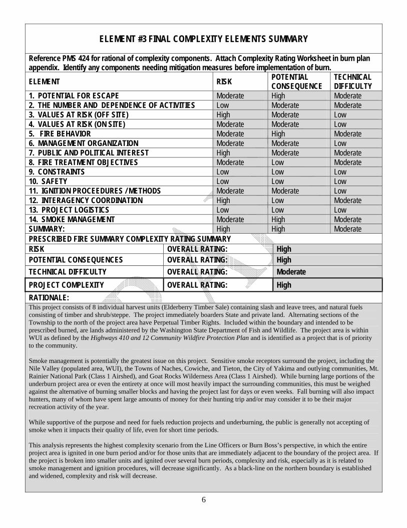
ELEMENT #3 FINAL COMPLEXITY ELEMENTS SUMMARY
Reference PMS 424 for rational of complexity components. Attach Complexity Rating Worksheet in burn plan appendix. Identify any components needing mitigation measures before implementation of burn. ELEMENT RISK POTENTIAL
CONSEQUENCE TECHNICAL DIFFICULTY
1. POTENTIAL FOR ESCAPE Moderate High Moderate 2. THE NUMBER AND DEPENDENCE OF ACTIVITIES Low Moderate Moderate 3. VALUES AT RISK (OFF SITE) High Moderate Low 4. VALUES AT RISK (ON SITE) Moderate Moderate Low 5. FIRE BEHAVIOR Moderate High Moderate 6. MANAGEMENT ORGANIZATION Moderate Moderate Low 7. PUBLIC AND POLITICAL INTEREST High Moderate Moderate 8. FIRE TREATMENT OBJECTIVES Moderate Low Moderate 9. CONSTRAINTS Low Low Low 10. SAFETY Low Low Low 11. IGNITION PROCEEDURES / METHODS Moderate Moderate Low 12. INTERAGENCY COORDINATION High Low Moderate 13. PROJECT LOGISTICS Low Low Low 14. SMOKE MANAGEMENT Moderate High Moderate SUMMARY: High High Moderate PRESCRIBED FIRE SUMMARY COMPLEXITY RATING SUMMARY RISK OVERALL RATING: High POTENTIAL CONSEQUENCES OVERALL RATING: High TECHNICAL DIFFICULTY OVERALL RATING: Moderate PROJECT COMPLEXITY OVERALL RATING: High RATIONALE: This project consists of 8 individual harvest units (Elderberry Timber Sale) containing slash and leave trees, and natural fuels consisting of timber and shrub/steppe. The project immediately boarders State and private land. Alternating sections of the Township to the north of the project area have Perpetual Timber Rights. Included within the boundary and intended to be prescribed burned, are lands administered by the Washington State Department of Fish and Wildlife. The project area is within WUI as defined by the Highways 410 and 12 Community Wildfire Protection Plan and is identified as a project that is of priority to the community. Smoke management is potentially the greatest issue on this project. Sensitive smoke receptors surround the project, including the Nile Valley (populated area, WUI), the Towns of Naches, Cowiche, and Tieton, the City of Yakima and outlying communities, Mt. Rainier National Park (Class 1 Airshed), and Goat Rocks Wilderness Area (Class 1 Airshed). While burning large portions of the underburn project area or even the entirety at once will most heavily impact the surrounding communities, this must be weighed against the alternative of burning smaller blocks and having the project last for days or even weeks. Fall burning will also impact hunters, many of whom have spent large amounts of money for their hunting trip and/or may consider it to be their major recreation activity of the year. While supportive of the purpose and need for fuels reduction projects and underburning, the public is generally not accepting of smoke when it impacts their quality of life, even for short time periods. This analysis represents the highest complexity scenario from the Line Officers or Burn Boss’s perspective, in which the entire project area is ignited in one burn period and/or for those units that are immediately adjacent to the boundary of the project area. If the project is broken into smaller units and ignited over several burn periods, complexity and risk, especially as it is related to smoke management and ignition procedures, will decrease significantly. As a black-line on the northern boundary is established and widened, complexity and risk will decrease.
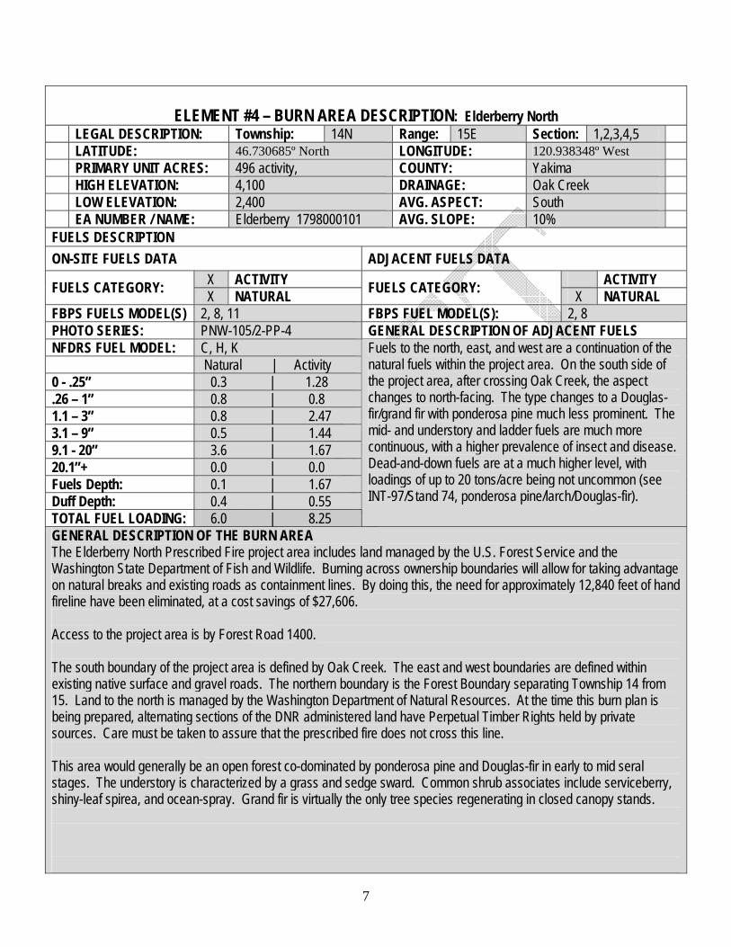
ELEMENT #4 – BURN AREA DESCRIPTION: Elderberry North
LEGAL DESCRIPTION: Township: 14N Range: 15E Section: 1,2,3,4,5 LATITUDE: 46.730685º North LONGITUDE: 120.938348º West PRIMARY UNIT ACRES: 496 activity, COUNTY: Yakima HIGH ELEVATION: 4,100 DRAINAGE: Oak Creek LOW ELEVATION: 2,400 AVG. ASPECT: South EA NUMBER / NAME: Elderberry 1798000101 AVG. SLOPE: 10% FUELS DESCRIPTION ON-SITE FUELS DATA ADJACENT FUELS DATA
X ACTIVITY ACTIVITY FUELS CATEGORY: X NATURAL FUELS CATEGORY: X NATURAL FBPS FUELS MODEL(S) 2, 8, 11 FBPS FUEL MODEL(S): 2, 8 PHOTO SERIES: PNW-105/2-PP-4 GENERAL DESCRIPTION OF ADJACENT FUELS NFDRS FUEL MODEL: C, H, K Natural | Activity 0 - .25” 0.3 | 1.28 .26 – 1” 0.8 | 0.8 1.1 – 3” 0.8 | 2.47 3.1 – 9” 0.5 | 1.44 9.1 - 20” 3.6 | 1.67 20.1”+ 0.0 | 0.0 Fuels Depth: 0.1 | 1.67 Duff Depth: 0.4 | 0.55 TOTAL FUEL LOADING: 6.0 | 8.25
Fuels to the north, east, and west are a continuation of the natural fuels within the project area. On the south side of the project area, after crossing Oak Creek, the aspect changes to north-facing. The type changes to a Douglas-fir/grand fir with ponderosa pine much less prominent. The mid- and understory and ladder fuels are much more continuous, with a higher prevalence of insect and disease. Dead-and-down fuels are at a much higher level, with loadings of up to 20 tons/acre being not uncommon (see INT-97/Stand 74, ponderosa pine/larch/Douglas-fir).
GENERAL DESCRIPTION OF THE BURN AREA The Elderberry North Prescribed Fire project area includes land managed by the U.S. Forest Service and the Washington State Department of Fish and Wildlife. Burning across ownership boundaries will allow for taking advantage on natural breaks and existing roads as containment lines. By doing this, the need for approximately 12,840 feet of hand fireline have been eliminated, at a cost savings of $27,606. Access to the project area is by Forest Road 1400. The south boundary of the project area is defined by Oak Creek. The east and west boundaries are defined within existing native surface and gravel roads. The northern boundary is the Forest Boundary separating Township 14 from 15. Land to the north is managed by the Washington Department of Natural Resources. At the time this burn plan is being prepared, alternating sections of the DNR administered land have Perpetual Timber Rights held by private sources. Care must be taken to assure that the prescribed fire does not cross this line. This area would generally be an open forest co-dominated by ponderosa pine and Douglas-fir in early to mid seral stages. The understory is characterized by a grass and sedge sward. Common shrub associates include serviceberry, shiny-leaf spirea, and ocean-spray. Grand fir is virtually the only tree species regenerating in closed canopy stands.
7
8
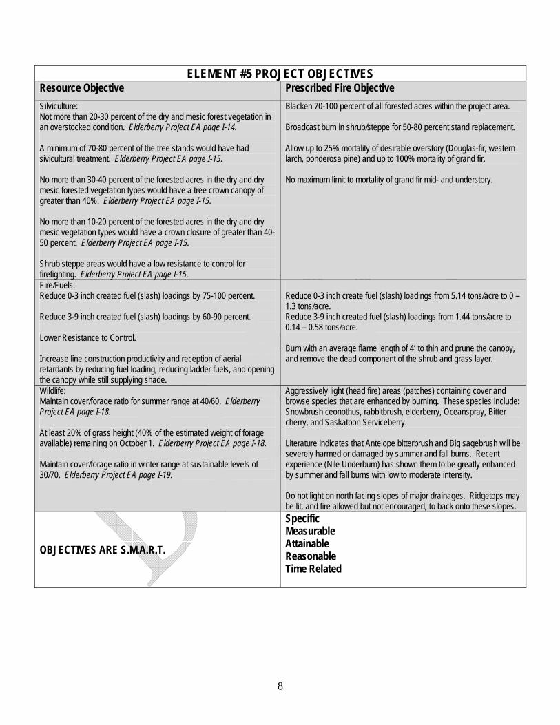
ELEMENT #5 PROJECT OBJECTIVES Resource Objective Prescribed Fire Objective Silviculture: Not more than 20-30 percent of the dry and mesic forest vegetation in an overstocked condition. Elderberry Project EA page I-14. A minimum of 70-80 percent of the tree stands would have had sivicultural treatment. Elderberry Project EA page I-15. No more than 30-40 percent of the forested acres in the dry and dry mesic forested vegetation types would have a tree crown canopy of greater than 40%. Elderberry Project EA page I-15. No more than 10-20 percent of the forested acres in the dry and dry mesic vegetation types would have a crown closure of greater than 40-50 percent. Elderberry Project EA page I-15. Shrub steppe areas would have a low resistance to control for firefighting. Elderberry Project EA page I-15.
Blacken 70-100 percent of all forested acres within the project area. Broadcast burn in shrub/steppe for 50-80 percent stand replacement. Allow up to 25% mortality of desirable overstory (Douglas-fir, western larch, ponderosa pine) and up to 100% mortality of grand fir. No maximum limit to mortality of grand fir mid- and understory.
Fire/Fuels: Reduce 0-3 inch created fuel (slash) loadings by 75-100 percent. Reduce 3-9 inch created fuel (slash) loadings by 60-90 percent. Lower Resistance to Control. Increase line construction productivity and reception of aerial retardants by reducing fuel loading, reducing ladder fuels, and opening the canopy while still supplying shade.
Reduce 0-3 inch create fuel (slash) loadings from 5.14 tons/acre to 0 – 1.3 tons/acre. Reduce 3-9 inch created fuel (slash) loadings from 1.44 tons/acre to 0.14 – 0.58 tons/acre. Burn with an average flame length of 4’ to thin and prune the canopy, and remove the dead component of the shrub and grass layer.
Wildlife: Maintain cover/forage ratio for summer range at 40/60. Elderberry Project EA page I-18. At least 20% of grass height (40% of the estimated weight of forage available) remaining on October 1. Elderberry Project EA page I-18. Maintain cover/forage ratio in winter range at sustainable levels of 30/70. Elderberry Project EA page I-19.
Aggressively light (head fire) areas (patches) containing cover and browse species that are enhanced by burning. These species include: Snowbrush ceonothus, rabbitbrush, elderberry, Oceanspray, Bitter cherry, and Saskatoon Serviceberry. Literature indicates that Antelope bitterbrush and Big sagebrush will be severely harmed or damaged by summer and fall burns. Recent experience (Nile Underburn) has shown them to be greatly enhanced by summer and fall burns with low to moderate intensity. Do not light on north facing slopes of major drainages. Ridgetops may be lit, and fire allowed but not encouraged, to back onto these slopes.
OBJECTIVES ARE S.M.A.R.T.
Specific Measurable Attainable Reasonable Time Related
9
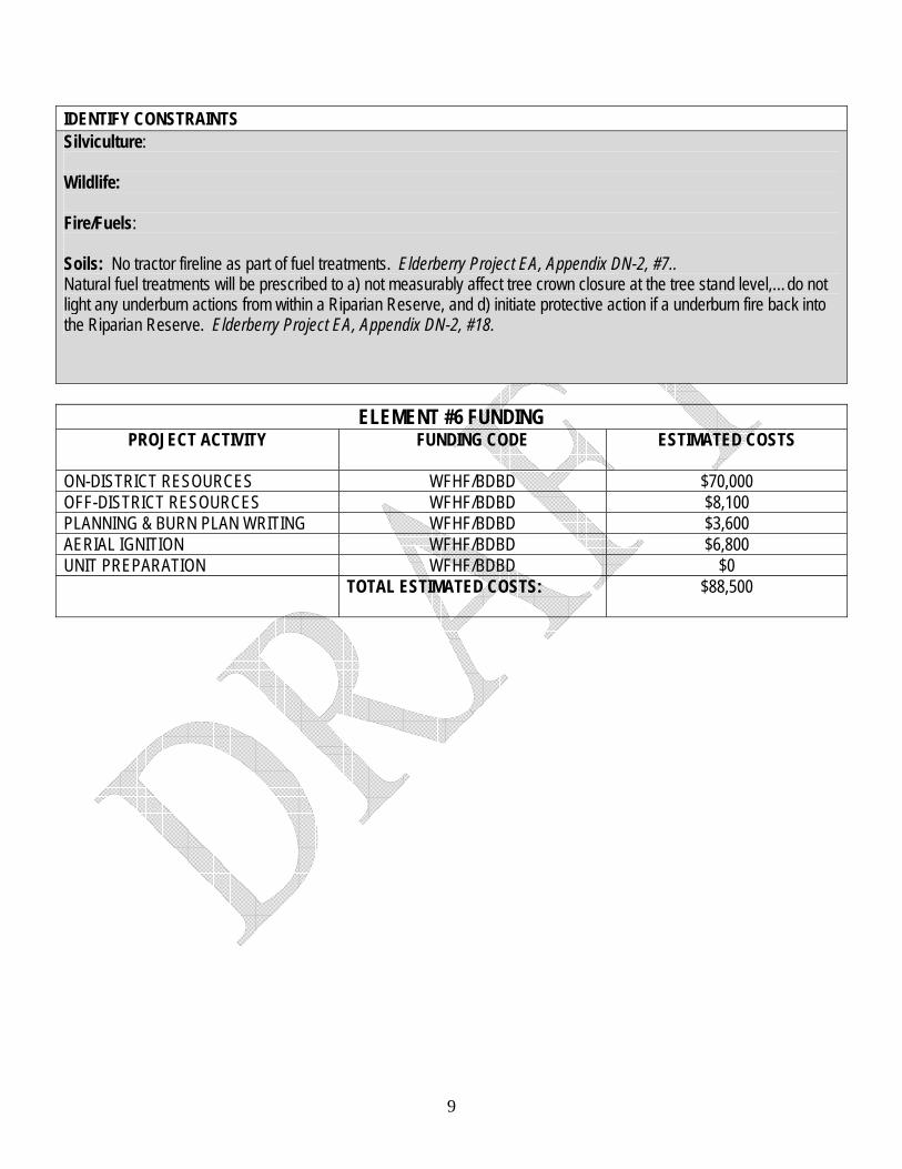
IDENTIFY CONSTRAINTS Silviculture: Wildlife: Fire/Fuels: Soils: No tractor fireline as part of fuel treatments. Elderberry Project EA, Appendix DN-2, #7.. Natural fuel treatments will be prescribed to a) not measurably affect tree crown closure at the tree stand level,…do not light any underburn actions from within a Riparian Reserve, and d) initiate protective action if a underburn fire back into the Riparian Reserve. Elderberry Project EA, Appendix DN-2, #18.
ELEMENT #6 FUNDING
PROJECT ACTIVITY
FUNDING CODE ESTIMATED COSTS
ON-DISTRICT RESOURCES WFHF/BDBD $70,000 OFF-DISTRICT RESOURCES WFHF/BDBD $8,100 PLANNING & BURN PLAN WRITING WFHF/BDBD $3,600 AERIAL IGNITION WFHF/BDBD $6,800 UNIT PREPARATION WFHF/BDBD $0 TOTAL ESTIMATED COSTS:
$88,500
10
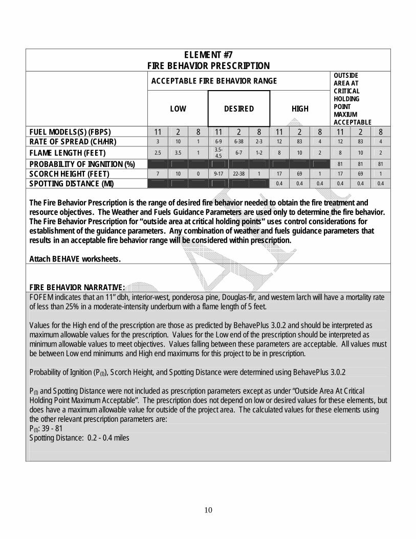
ELEMENT #7 FIRE BEHAVIOR PRESCRIPTION
ACCEPTABLE FIRE BEHAVIOR RANGE
LOW DESIRED HIGH
OUTSIDE AREA AT CRITICAL HOLDING POINT MAXIUM ACCEPTABLE
FUEL MODELS(S) (FBPS) 11 2 8 11 2 8 11 2 8 11 2 8 RATE OF SPREAD (CH/HR) 3 10 1 6-9 6-38 2-3 12 83 4 12 83 4
FLAME LENGTH (FEET) 2.5 3.5 1 3.5-4.5 6-7 1-2 8 10 2 8 10 2
PROBABILITY OF INGNITION (%) 81 81 81
SCORCH HEIGHT (FEET) 7 10 0 9-17 22-38 1 17 69 1 17 69 1
SPOTTING DISTANCE (MI) 0.4 0.4 0.4 0.4 0.4 0.4
The Fire Behavior Prescription is the range of desired fire behavior needed to obtain the fire treatment and resource objectives. The Weather and Fuels Guidance Parameters are used only to determine the fire behavior. The Fire Behavior Prescription for “outside area at critical holding points” uses control considerations for establishment of the guidance parameters. Any combination of weather and fuels guidance parameters that results in an acceptable fire behavior range will be considered within prescription. Attach BEHAVE worksheets. FIRE BEHAVIOR NARRATIVE: FOFEM indicates that an 11” dbh, interior-west, ponderosa pine, Douglas-fir, and western larch will have a mortality rate of less than 25% in a moderate-intensity underburn with a flame length of 5 feet. Values for the High end of the prescription are those as predicted by BehavePlus 3.0.2 and should be interpreted as maximum allowable values for the prescription. Values for the Low end of the prescription should be interpreted as minimum allowable values to meet objectives. Values falling between these parameters are acceptable. All values must be between Low end minimums and High end maximums for this project to be in prescription. Probability of Ignition (P(I)), Scorch Height, and Spotting Distance were determined using BehavePlus 3.0.2 P(I) and Spotting Distance were not included as prescription parameters except as under “Outside Area At Critical Holding Point Maximum Acceptable”. The prescription does not depend on low or desired values for these elements, but does have a maximum allowable value for outside of the project area. The calculated values for these elements using the other relevant prescription parameters are: P(I): 39 - 81 Spotting Distance: 0.2 - 0.4 miles
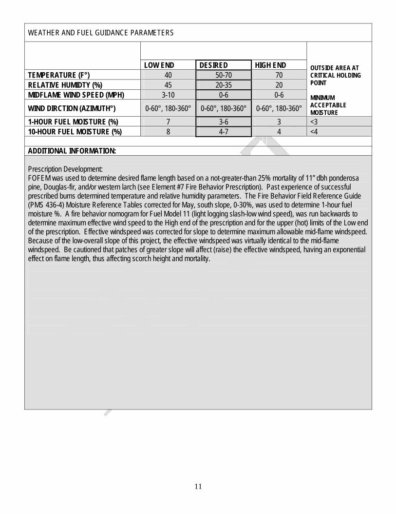
WEATHER AND FUEL GUIDANCE PARAMETERS
LOW END DESIRED HIGH END TEMPERATURE (F°) 40 50-70 70 RELATIVE HUMIDTY (%) 45 20-35 20 MIDFLAME WIND SPEED (MPH) 3-10 0-6 0-6 WIND DIRCTION (AZIMUTH°) 0-60°, 180-360° 0-60°, 180-360° 0-60°, 180-360°
OUTSIDE AREA AT CRITICAL HOLDING POINT MINIMUM ACCEPTABLE MOISTURE
1-HOUR FUEL MOISTURE (%) 7 3-6 3 <3 10-HOUR FUEL MOISTURE (%) 8 4-7 4 <4 ADDITIONAL INFORMATION: Prescription Development: FOFEM was used to determine desired flame length based on a not-greater-than 25% mortality of 11” dbh ponderosa pine, Douglas-fir, and/or western larch (see Element #7 Fire Behavior Prescription). Past experience of successful prescribed burns determined temperature and relative humidity parameters. The Fire Behavior Field Reference Guide (PMS 436-4) Moisture Reference Tables corrected for May, south slope, 0-30%, was used to determine 1-hour fuel moisture %. A fire behavior nomogram for Fuel Model 11 (light logging slash-low wind speed), was run backwards to determine maximum effective wind speed to the High end of the prescription and for the upper (hot) limits of the Low end of the prescription. Effective windspeed was corrected for slope to determine maximum allowable mid-flame windspeed. Because of the low-overall slope of this project, the effective windspeed was virtually identical to the mid-flame windspeed. Be cautioned that patches of greater slope will affect (raise) the effective windspeed, having an exponential effect on flame length, thus affecting scorch height and mortality.
11
12
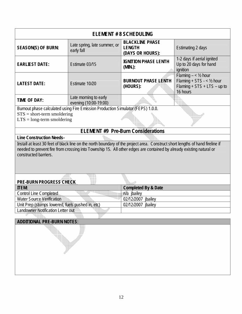
ELEMENT # 8 SCHEDULING
SEASON(S) OF BURN: Late spring, late summer, or early fall
BLACKLINE PHASE LENGTH (DAYS OR HOURS):
Estimating 2 days
EARLIEST DATE: Estimate 03/15 IGNITION PHASE LENTH (MIN.):
1-2 days if aerial ignited Up to 20 days for hand ignition
LATEST DATE: Estimate 10/20 BURNOUT PHASE LENTH (HOURS):
Flaming – < ½ hour Flaming + STS - < ½ hour Flaming + STS + LTS – up to 16 hours
TIME OF DAY: Late morning to early evening (10:00-19:00)
Burnout phase calculated using Fire Emission Production Simulator (FEPS) 1.0.0. STS = short-term smoldering LTS = long-term smoldering
ELEMENT #9 Pre-Burn Considerations Line Construction Needs- Install at least 30 feet of black line on the north boundary of the project area. Construct short lengths of hand fireline if needed to prevent fire from crossing into Township 15. All other edges are contained by already existing natural or constructed barriers.
PRE-BURN PROGRESS CHECK ITEM: Completed By & Date Control Line Completed n/a jbailey Water Source Verification 02/12/2007 jbailey Unit Prep (stumps lowered, fuels pushed in, etc) 02/12/2007 jbailey Landowner Notification Letter out ADDITIONAL PRE-BURN NOTES:
13
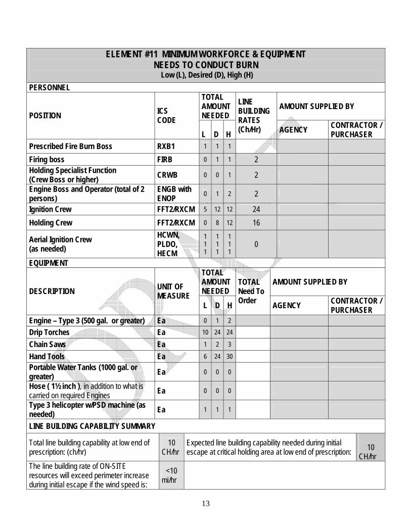
ELEMENT #11 MINIMUM WORKFORCE & EQUIPMENT NEEDS TO CONDUCT BURN
Low (L), Desired (D), High (H) PERSONNEL
TOTAL AMOUNT NEEDED
AMOUNT SUPPLIED BY POSITION ICS
CODE L
D
H
LINE BUILDING RATES (Ch/Hr) AGENCY CONTRACTOR /
PURCHASER Prescribed Fire Burn Boss RXB1 1 1 1 Firing boss FIRB 0 1 1 2 Holding Specialist Function (Crew Boss or higher) CRWB 0 0 1 2
Engine Boss and Operator (total of 2 persons)
ENGB with ENOP 0 1 2 2
Ignition Crew FFT2/RXCM 5 12 12 24 Holding Crew FFT2/RXCM 0 8 12 16
Aerial Ignition Crew (as needed)
HCWN, PLDO, HECM
1 1 1
1 1 1
1 1 1
0
EQUIPMENT TOTAL AMOUNT NEEDED
AMOUNT SUPPLIED BY DESCRIPTION UNIT OF
MEASURE L D H
TOTAL Need To Order AGENCY CONTRACTOR /
PURCHASER Engine – Type 3 (500 gal. or greater) Ea 0 1 2 Drip Torches Ea 10 24 24 Chain Saws Ea 1 2 3 Hand Tools Ea 6 24 30 Portable Water Tanks (1000 gal. or greater) Ea 0 0 0 Hose ( 1½ inch ), in addition to what is carried on required Engines Ea 0 0 0 Type 3 helicopter w/PSD machine (as needed) Ea 1 1 1
LINE BUILDING CAPABILITY SUMMARY
Total line building capability at low end of prescription: (ch/hr)
10 CH/hr
Expected line building capability needed during initial escape at critical holding area at low end of prescription:
10
CH/hr The line building rate of ON-SITE resources will exceed perimeter increase during initial escape if the wind speed is:
<10 mi/hr
14
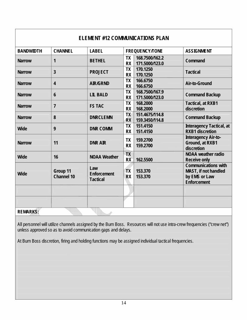
ELEMENT #12 COMMUNICATIONS PLAN
BANDWIDTH CHANNEL LABEL FREQUENCY/TONE ASSIGNMENT
Narrow 1 BETHEL TX RX
168.7500/162.2 171.5000/123.0 Command
Narrow 3 PROJECT TX RX
170.1250 170.1250 Tactical
Narrow 4 AIR/GRND TX RX
166.6750 166.6750 Air-to-Ground
Narrow 6 LIL BALD TX RX
168.7500/167.9 171.5000/123.0 Command Backup
Narrow 7 FS TAC TX RX
168.2000 168.2000
Tactical, at RXB1 discretion
Narrow 8 DNRCLEMN TX RX
151.4675/114.8 159.3450/114.8 Command Backup
Wide 9 DNR COMM TX RX
151.4150 151.4150
Interagency Tactical, at RXB1 discretion
Narrow 11 DNR AIR TX RX
159.2700 159.2700
Interagency Air-to- Ground, at RXB1 discretion
Wide 16 NOAA Weather TX RX
162.5500
NOAA weather radio Receive only
Wide Group 11 Channel 10
Law Enforcement Tactical
TX RX
153.370 153.370
Communications with MAST, if not handled by EMS or Law Enforcement
REMARKS: All personnel will utilize channels assigned by the Burn Boss. Resources will not use intra-crew frequencies (“crew net”) unless approved so as to avoid communication gaps and delays. At Burn Boss discretion, firing and holding functions may be assigned individual tactical frequencies.
15
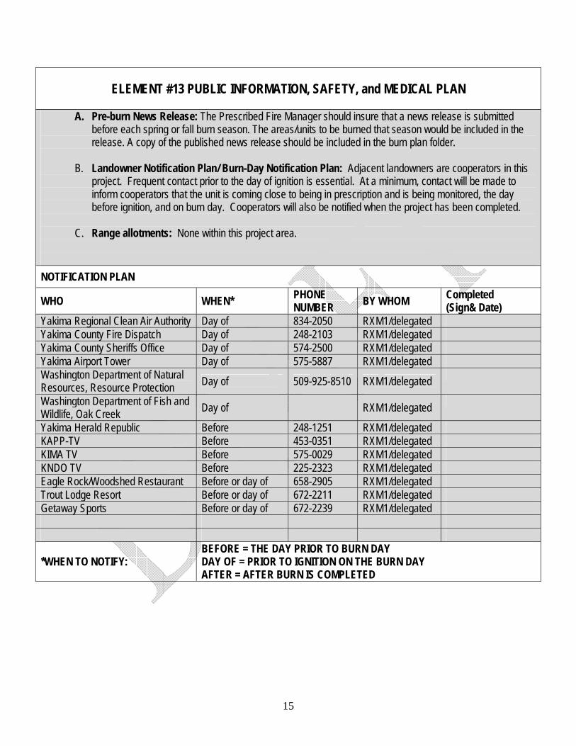
ELEMENT #13 PUBLIC INFORMATION, SAFETY, and MEDICAL PLAN
A. Pre-burn News Release: The Prescribed Fire Manager should insure that a news release is submitted
before each spring or fall burn season. The areas/units to be burned that season would be included in the release. A copy of the published news release should be included in the burn plan folder.
B. Landowner Notification Plan/ Burn-Day Notification Plan: Adjacent landowners are cooperators in this
project. Frequent contact prior to the day of ignition is essential. At a minimum, contact will be made to inform cooperators that the unit is coming close to being in prescription and is being monitored, the day before ignition, and on burn day. Cooperators will also be notified when the project has been completed.
C. Range allotments: None within this project area.
NOTIFICATION PLAN
WHO WHEN* PHONE NUMBER BY WHOM Completed
(Sign& Date) Yakima Regional Clean Air Authority Day of 834-2050 RXM1/delegated Yakima County Fire Dispatch Day of 248-2103 RXM1/delegated Yakima County Sheriffs Office Day of 574-2500 RXM1/delegated Yakima Airport Tower Day of 575-5887 RXM1/delegated Washington Department of Natural Resources, Resource Protection Day of 509-925-8510 RXM1/delegated
Washington Department of Fish and Wildlife, Oak Creek Day of RXM1/delegated
Yakima Herald Republic Before 248-1251 RXM1/delegated KAPP-TV Before 453-0351 RXM1/delegated KIMA TV Before 575-0029 RXM1/delegated KNDO TV Before 225-2323 RXM1/delegated Eagle Rock/Woodshed Restaurant Before or day of 658-2905 RXM1/delegated Trout Lodge Resort Before or day of 672-2211 RXM1/delegated Getaway Sports Before or day of 672-2239 RXM1/delegated
*WHEN TO NOTIFY: BEFORE = THE DAY PRIOR TO BURN DAY DAY OF = PRIOR TO IGNITION ON THE BURN DAY AFTER = AFTER BURN IS COMPLETED
16
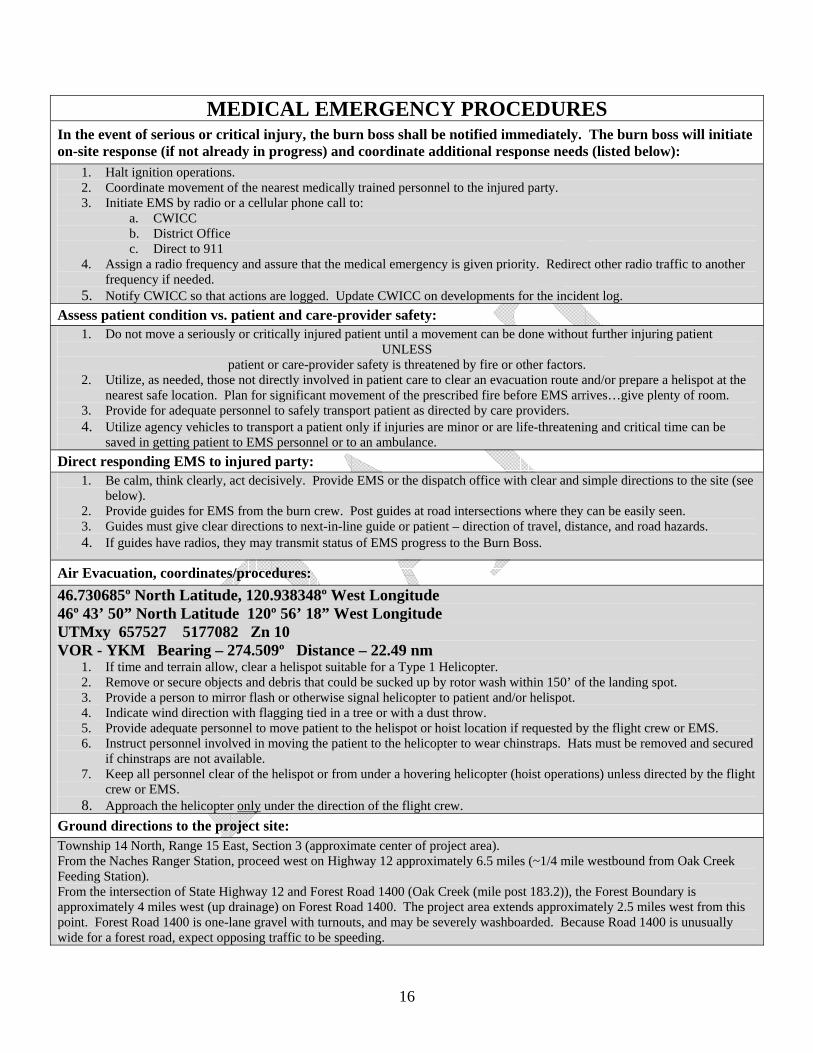
MEDICAL EMERGENCY PROCEDURES In the event of serious or critical injury, the burn boss shall be notified immediately. The burn boss will initiate on-site response (if not already in progress) and coordinate additional response needs (listed below):
1. Halt ignition operations. 2. Coordinate movement of the nearest medically trained personnel to the injured party. 3. Initiate EMS by radio or a cellular phone call to:
a. CWICC b. District Office c. Direct to 911
4. Assign a radio frequency and assure that the medical emergency is given priority. Redirect other radio traffic to another frequency if needed.
5. Notify CWICC so that actions are logged. Update CWICC on developments for the incident log. Assess patient condition vs. patient and care-provider safety:
1. Do not move a seriously or critically injured patient until a movement can be done without further injuring patient UNLESS
patient or care-provider safety is threatened by fire or other factors. 2. Utilize, as needed, those not directly involved in patient care to clear an evacuation route and/or prepare a helispot at the
nearest safe location. Plan for significant movement of the prescribed fire before EMS arrives…give plenty of room. 3. Provide for adequate personnel to safely transport patient as directed by care providers. 4. Utilize agency vehicles to transport a patient only if injuries are minor or are life-threatening and critical time can be
saved in getting patient to EMS personnel or to an ambulance. Direct responding EMS to injured party:
1. Be calm, think clearly, act decisively. Provide EMS or the dispatch office with clear and simple directions to the site (see below).
2. Provide guides for EMS from the burn crew. Post guides at road intersections where they can be easily seen. 3. Guides must give clear directions to next-in-line guide or patient – direction of travel, distance, and road hazards. 4. If guides have radios, they may transmit status of EMS progress to the Burn Boss.
Air Evacuation, coordinates/procedures: 46.730685º North Latitude, 120.938348º West Longitude 46º 43’ 50” North Latitude 120º 56’ 18” West Longitude UTMxy 657527 5177082 Zn 10 VOR - YKM Bearing – 274.509º Distance – 22.49 nm
1. If time and terrain allow, clear a helispot suitable for a Type 1 Helicopter. 2. Remove or secure objects and debris that could be sucked up by rotor wash within 150’ of the landing spot. 3. Provide a person to mirror flash or otherwise signal helicopter to patient and/or helispot. 4. Indicate wind direction with flagging tied in a tree or with a dust throw. 5. Provide adequate personnel to move patient to the helispot or hoist location if requested by the flight crew or EMS. 6. Instruct personnel involved in moving the patient to the helicopter to wear chinstraps. Hats must be removed and secured
if chinstraps are not available. 7. Keep all personnel clear of the helispot or from under a hovering helicopter (hoist operations) unless directed by the flight
crew or EMS. 8. Approach the helicopter only under the direction of the flight crew.
Ground directions to the project site: Township 14 North, Range 15 East, Section 3 (approximate center of project area). From the Naches Ranger Station, proceed west on Highway 12 approximately 6.5 miles (~1/4 mile westbound from Oak Creek Feeding Station). From the intersection of State Highway 12 and Forest Road 1400 (Oak Creek (mile post 183.2)), the Forest Boundary is approximately 4 miles west (up drainage) on Forest Road 1400. The project area extends approximately 2.5 miles west from this point. Forest Road 1400 is one-lane gravel with turnouts, and may be severely washboarded. Because Road 1400 is unusually wide for a forest road, expect opposing traffic to be speeding.
17
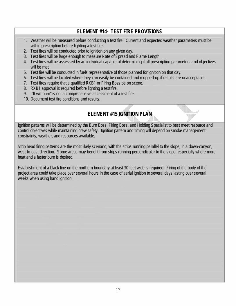
ELEMENT #14- TEST FIRE PROVISIONS 1. Weather will be measured before conducting a test fire. Current and expected weather parameters must be
within prescription before lighting a test fire. 2. Test fires will be conducted prior to ignition on any given day. 3. Test fires will be large enough to measure Rate of Spread and Flame Length. 4. Test fires will be assessed by an individual capable of determining if all prescription parameters and objectives
will be met. 5. Test fire will be conducted in fuels representative of those planned for ignition on that day. 6. Test fires will be located where they can easily be contained and mopped-up if results are unacceptable. 7. Test fires require that a qualified RXB1 or Firing Boss be on scene. 8. RXB1 approval is required before lighting a test fire. 9. “It will burn” is not a comprehensive assessment of a test fire. 10. Document test fire conditions and results.
ELEMENT #15 IGNITION PLAN
Ignition patterns will be determined by the Burn Boss, Firing Boss, and Holding Specialist to best meet resource and control objectives while maintaining crew safety. Ignition pattern and timing will depend on smoke management constraints, weather, and resources available. Strip head firing patterns are the most likely scenario, with the strips running parallel to the slope, in a down-canyon, west-to-east direction. Some areas may benefit from strips running perpendicular to the slope, especially where more heat and a faster burn is desired. Establishment of a black line on the northern boundary at least 30 feet wide is required. Firing of the body of the project area could take place over several hours in the case of aerial ignition to several days lasting over several weeks when using hand ignition.
18
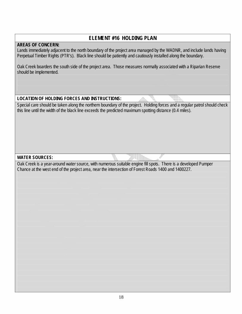
ELEMENT #16 HOLDING PLAN
AREAS OF CONCERN: Lands immediately adjacent to the north boundary of the project area managed by the WADNR, and include lands having Perpetual Timber Rights (PTR’s). Black line should be patiently and cautiously installed along the boundary. Oak Creek boarders the south side of the project area. Those measures normally associated with a Riparian Reserve should be implemented.
LOCATION OF HOLDING FORCES AND INSTRUCTIONS: Special care should be taken along the northern boundary of the project. Holding forces and a regular patrol should check this line until the width of the black line exceeds the predicted maximum spotting distance (0.4 miles).
WATER SOURCES: Oak Creek is a year-around water source, with numerous suitable engine fill spots. There is a developed Pumper Chance at the west end of the project area, near the intersection of Forest Roads 1400 and 1400227.
19
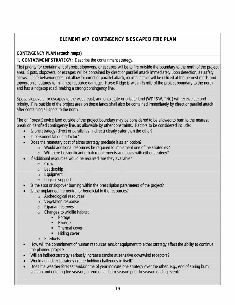
ELEMENT #17 CONTINGENCY & ESCAPED FIRE PLAN CONTINGENCY PLAN (attach maps) 1. CONTAINMENT STRATEGY: Describe the containment strategy. First priority for containment of spots, slopovers, or escapes will be to fire outside the boundary to the north of the project area. Spots, slopovers, or escapes will be contained by direct or parallel attack immediately upon detection, as safety allows. If fire behavior does not allow for direct or parallel attack, indirect attack will be utilized at the nearest roads and topographic features to minimize resource damage. Horse Ridge is within ½ mile of the project boundary to the north, and has a ridgetop road, making a strong contingency line. Spots, slopovers, or escapes to the west, east, and onto state or private land (WDF&W, TNC) will receive second priority. Fire outside of the project area on these lands shall also be contained immediately by direct or parallel attack after containing all spots to the north. Fire on Forest Service land outside of the project boundary may be considered to be allowed to burn to the nearest break or identified contingency line, as allowable by other constraints. Factors to be considered include:
• Is one strategy (direct or parallel vs. indirect) clearly safer than the other? • Is personnel fatigue a factor? • Does the monetary cost of either strategy preclude it as an option?
o Would additional resources be required to implement one of the strategies? o Will there be significant rehab requirements and costs with either strategy?
• If additional resources would be required, are they available? o Crew o Leadership o Equipment o Logistic support
• Is the spot or slopover burning within the prescription parameters of the project? • Is the unplanned fire neutral or beneficial to the resources?
o Archeological resources o Vegetation response o Riparian reserves o Changes to wildlife habitat
Forage Browse Thermal cover Hiding cover
o Fire/fuels • How will the commitment of human resources and/or equipment to either strategy affect the ability to continue
the planned project? • Will an indirect strategy seriously increase smoke at sensitive downwind receptors? • Would an indirect strategy create holding challenges in itself? • Does the weather forecast and/or time of year indicate one strategy over the other, e.g., end of spring burn
season and entering fire season, or end of fall burn season prior to season ending event?
20
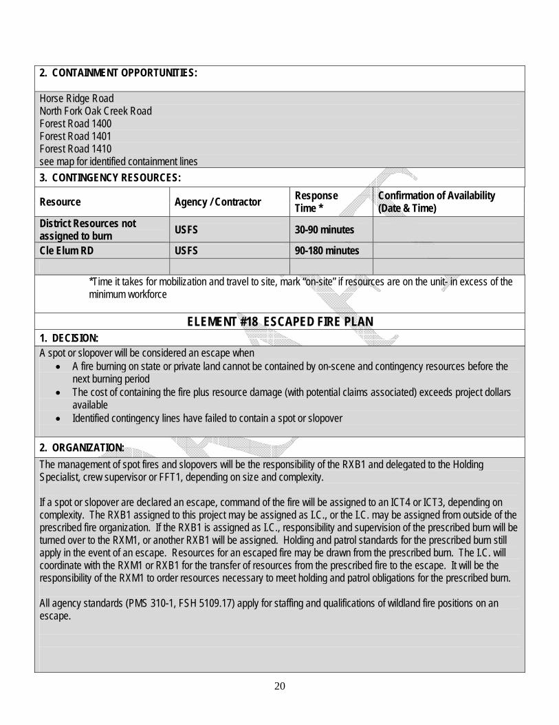
2. CONTAINMENT OPPORTUNITIES: Horse Ridge Road North Fork Oak Creek Road Forest Road 1400 Forest Road 1401 Forest Road 1410 see map for identified containment lines 3. CONTINGENCY RESOURCES:
Resource Agency / Contractor Response Time *
Confirmation of Availability (Date & Time)
District Resources not assigned to burn USFS 30-90 minutes
Cle Elum RD USFS 90-180 minutes
*Time it takes for mobilization and travel to site, mark “on-site” if resources are on the unit- in excess of the minimum workforce
ELEMENT #18 ESCAPED FIRE PLAN
1. DECISION: A spot or slopover will be considered an escape when
• A fire burning on state or private land cannot be contained by on-scene and contingency resources before the next burning period
• The cost of containing the fire plus resource damage (with potential claims associated) exceeds project dollars available
• Identified contingency lines have failed to contain a spot or slopover 2. ORGANIZATION: The management of spot fires and slopovers will be the responsibility of the RXB1 and delegated to the Holding Specialist, crew supervisor or FFT1, depending on size and complexity. If a spot or slopover are declared an escape, command of the fire will be assigned to an ICT4 or ICT3, depending on complexity. The RXB1 assigned to this project may be assigned as I.C., or the I.C. may be assigned from outside of the prescribed fire organization. If the RXB1 is assigned as I.C., responsibility and supervision of the prescribed burn will be turned over to the RXM1, or another RXB1 will be assigned. Holding and patrol standards for the prescribed burn still apply in the event of an escape. Resources for an escaped fire may be drawn from the prescribed burn. The I.C. will coordinate with the RXM1 or RXB1 for the transfer of resources from the prescribed fire to the escape. It will be the responsibility of the RXM1 to order resources necessary to meet holding and patrol obligations for the prescribed burn.
All agency standards (PMS 310-1, FSH 5109.17) apply for staffing and qualifications of wildland fire positions on an escape.
21
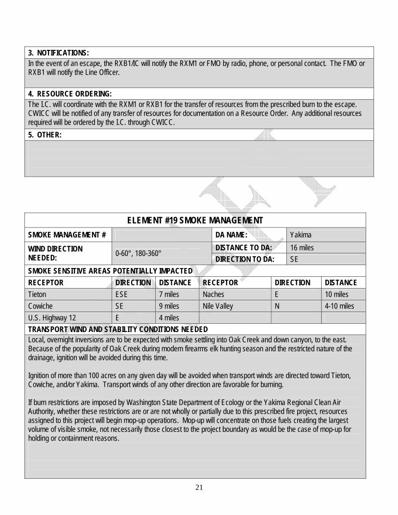
3. NOTIFICATIONS: In the event of an escape, the RXB1/IC will notify the RXM1 or FMO by radio, phone, or personal contact. The FMO or RXB1 will notify the Line Officer.
4. RESOURCE ORDERING: The I.C. will coordinate with the RXM1 or RXB1 for the transfer of resources from the prescribed burn to the escape. CWICC will be notified of any transfer of resources for documentation on a Resource Order. Any additional resources required will be ordered by the I.C. through CWICC. 5. OTHER:
ELEMENT #19 SMOKE MANAGEMENT SMOKE MANAGEMENT # DA NAME: Yakima
DISTANCE TO DA: 16 miles WIND DIRECTION NEEDED: 0-60°, 180-360°
DIRECTION TO DA: SE SMOKE SENSITIVE AREAS POTENTIALLY IMPACTED RECEPTOR DIRECTION DISTANCE RECEPTOR DIRECTION DISTANCE Tieton ESE 7 miles Naches E 10 miles Cowiche SE 9 miles Nile Valley N 4-10 miles U.S. Highway 12 E 4 miles TRANSPORT WIND AND STABILITY CONDITIONS NEEDED Local, overnight inversions are to be expected with smoke settling into Oak Creek and down canyon, to the east. Because of the popularity of Oak Creek during modern firearms elk hunting season and the restricted nature of the drainage, ignition will be avoided during this time. Ignition of more than 100 acres on any given day will be avoided when transport winds are directed toward Tieton, Cowiche, and/or Yakima. Transport winds of any other direction are favorable for burning. If burn restrictions are imposed by Washington State Department of Ecology or the Yakima Regional Clean Air Authority, whether these restrictions are or are not wholly or partially due to this prescribed fire project, resources assigned to this project will begin mop-up operations. Mop-up will concentrate on those fuels creating the largest volume of visible smoke, not necessarily those closest to the project boundary as would be the case of mop-up for holding or containment reasons.
22
VISIBILITY HAZARDS (ROADS, AIRPORTS, ETC.) AND ACTIONS TO REDUCE HAZARDS Cautionary signs will be posted for east- and west-bound lanes on U.S. Highway 12, warning of possible smoke related visibility hazards. These signs will be placed at points located prior to where degraded visibility may be a factor. Whenever more than 100 acres are ignited, the RXB1 will consider placing a road guard on duty overnight to monitor smoke on the highway, request help as needed, adjust sign placement as appropriate, and serve as a contact for passing traffic. RESIDUAL SMOKE ISSUES AND MITIGATION ACTIONS In general, the prescribed fire will be allowed to burn itself out. The Line Officer, FMO, or RXM1 may direct that long-term smoldering material be mopped-up whenever public health or comfort is threatened, or recreation opportunities are diminished or compromised.
SPECIAL CONSTRAINTS / CONSIDERATIONS Do not burn during modern firearms elk season. Burn only on days that Yakima Regional Clean Air Authority status as “Green” days. If a Stage 1 burn ban is called by Yakima Regional Clean Air Authority or the Washington State Department of Ecology, cease ignition. If a Stage 2 burn ban is called by Yakima Regional Clean Air Authority or the Washington State Department of Ecology, cease ignition and begin mop-up.
ELEMENT #20 MONITORING Minimum elements to be monitored will be those listed in OBJECTIVE #5 PROJECT OBJECTIVES. Specifically, monitoring should answer if the Prescribed Fire Objectives successfully achieved the associated Resource Objectives. Findings will be documented and placed in the Prescribed Fire Burn Plan and/or the associated Fuels Inventory folder. The RXM1 or RXB1 will assign an individual to collect weather data prior to and during the ignition phase. The RXB1 will also record flame lengths, plume height, smoke trajectory, estimated treated area (% of area or acres blackened), and ignition time (start time and total ignition time). The RXB1 will maintain cost records for all phases of the prescribed burn. Included in these costs will be personnel, vehicles, slash fuel, and any other costs associated with the project, including any rehab costs incurred. All monitoring data collected by the RXB1 or RXM1 will be attached as part of the Documentation section of this burn plan. Consolidation and interpretation of monitoring data will be the responsibility of the Fuels Planner.

23
ELEMENT #21 POST BURN ACTIVITY Any fireline constructed as part of this project shall be covered and water-barred if necessary. Any flagging or other markers will be removed. Prescribed Burn signs will be taken down. Any known hazard trees within reach of any road within the project area will be felled. Any areas or patches burned by high severity fire will be brought to the attention of the District Botanist/Ecologist, Silviculturist, and/or Hydrologist. Any necessary rehab will be completed. High severity is defined as:
High soil heating or deep ground char occurs where the duff is completely consumed and the top of the mineral soil is visibly reddish or orange on severely burned sites. Color of soil below one cm is darker or charred from organic material. The char layer can extend to a depth of 10 cm or more. Logs can be consumed or deeply charred and deep ground char can occur under slash concentrations or burned-out logs. Soil textures in the surface layers is changed and fusion evidenced by clinkers can be observed locally. Programmatic Biological Assessment Field Guide for Selected Forest Management Activities on the Okanogan and Wenatchee National Forests. December,2002.
There are no roads within the project area that are to be closed using BDBD or WFHF. There is no planting target dependant on the completion of this prescribed burn. The RXB1 will review the burn plan to assure that all assigned responsibilities have been completed. Documentation will be completed and organized in the burn plan, and the plan turned over to the Fuels Planner.
24
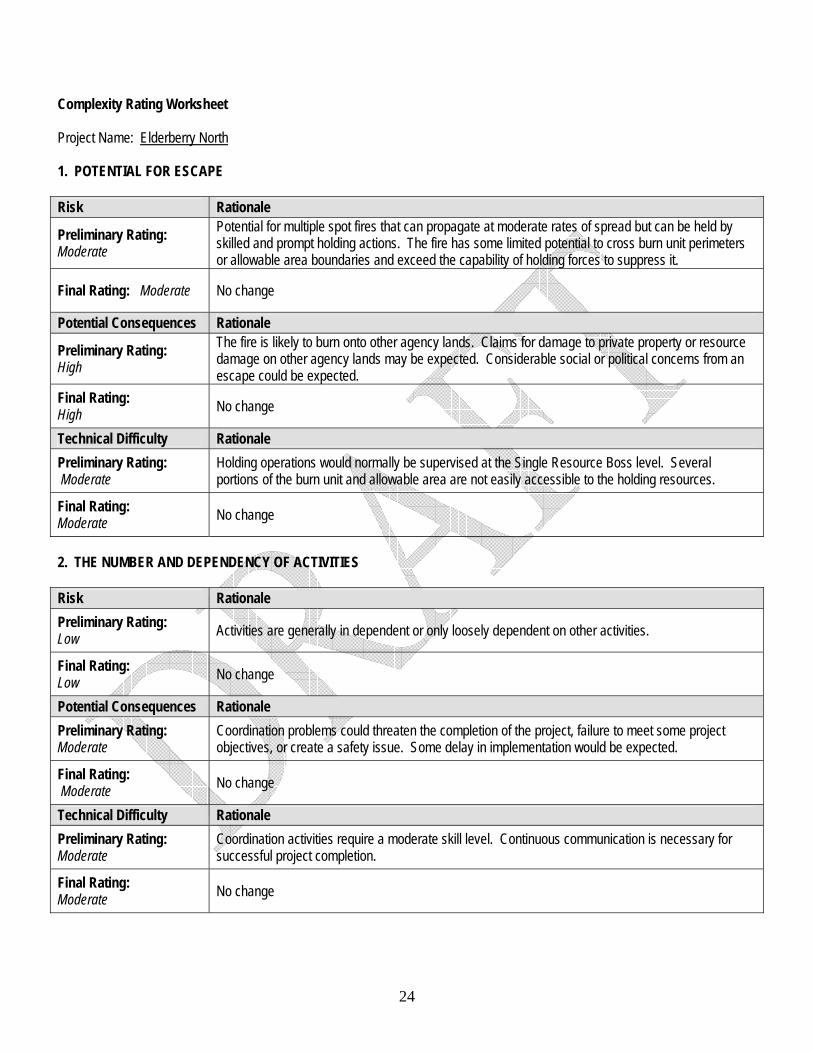
Complexity Rating Worksheet Project Name: Elderberry North 1. POTENTIAL FOR ESCAPE Risk Rationale
Preliminary Rating: Moderate
Potential for multiple spot fires that can propagate at moderate rates of spread but can be held by skilled and prompt holding actions. The fire has some limited potential to cross burn unit perimeters or allowable area boundaries and exceed the capability of holding forces to suppress it.
Final Rating: Moderate No change
Potential Consequences Rationale
Preliminary Rating: High
The fire is likely to burn onto other agency lands. Claims for damage to private property or resource damage on other agency lands may be expected. Considerable social or political concerns from an escape could be expected.
Final Rating: High No change
Technical Difficulty Rationale Preliminary Rating: Moderate
Holding operations would normally be supervised at the Single Resource Boss level. Several portions of the burn unit and allowable area are not easily accessible to the holding resources.
Final Rating: Moderate No change
2. THE NUMBER AND DEPENDENCY OF ACTIVITIES Risk Rationale Preliminary Rating: Low Activities are generally in dependent or only loosely dependent on other activities.
Final Rating: Low No change
Potential Consequences Rationale Preliminary Rating: Moderate
Coordination problems could threaten the completion of the project, failure to meet some project objectives, or create a safety issue. Some delay in implementation would be expected.
Final Rating: Moderate No change
Technical Difficulty Rationale Preliminary Rating: Moderate
Coordination activities require a moderate skill level. Continuous communication is necessary for successful project completion.
Final Rating: Moderate No change
25
3. OFF-SITE VALUES Risk Rationale Preliminary Rating: High
Several areas of high value are located adjacent or near the project area. Substantial risk to private or other agency lands.
Final Rating: High No change
Potential Consequences Rationale
Preliminary Rating: Moderate
Some negative impacts are expected in the event of spot fires, slopovers, and escapes. The vegetation potentially affected generally has moderate recovery rates or the expected fire behavior may cause limited damage or some other limited serious consequences to off-site values, private or other agency lands.
Final Rating: Moderate No change
Technical Difficulty Rationale Preliminary Rating: Low Protection of the off-site values requires no special management, equipment, or skills.
Final Rating: Low No change
4. ON-SITE VALUES Risk Rationale Preliminary Rating: Moderate
Special features are present within the unit that needs to be addressed in planning, strategies and briefings, and during project implementation.
Final Rating: Moderate No change
Potential Consequences Rationale Preliminary Rating: Moderate
Implementation problems or failures will result in moderate damage to special features and some reduction or loss of on-site values.
Final Rating: Moderate No change
Technical Difficulty Rationale Preliminary Rating: Low
No special skills or operating procedures are required. Resource values within the unit are easy to protect.
Final Rating: Low No change
26
5. FIRE BEHAVIOR Risk Rationale
Preliminary Rating: Moderate
Fuels vary moderately within the unit, both in loading and arrangement. Several fuel models are present on significant portions of the area. Local winds and burning conditions may vary enough to cause notable shifts in fire behavior. Periodic torching can be expected either as isolated points or limited areas at one time. Spotting is expected to be short-range.
Final Rating: Moderate No change
Potential Consequences Rationale
Preliminary Rating: High
Fire behavior outside of the primary unit boundary would be about the same as that experienced within the unit. An “allowable area” (MMA) has not been identified on the north side of the project area, or is limited in size.
Final Rating: High No change
Technical Difficulty Rationale
Preliminary Rating: Moderate
Standard fire safety precautions are adequate to ensure personnel safety. Fire behavior is such that holding resources may need to use indirect tactics to control some spot fires and slopovers. Occasional on-site fire behavior assessments or calculations are needed and can be performed as a collateral duty.
Final Rating: Moderate No change
6. MANAGEMENT ORGANIZATION Risk Rationale
Preliminary Rating: Moderate
May require staffing of a majority of the prescribed fire positions with qualified personnel. A single person may fill more than one position. Two levels of supervision are needed (i.e., Burn Boss, Ignitions Specialist and/or Holding Specialist plus lighters and holders).
Final Rating: Moderate No change
Potential Consequences Rationale Preliminary Rating: Moderate
Problems related to supervision or communication may cause failure to meet some objectives, an increased chance of escaped fire, or violation of safety standards.
Final Rating: Moderate No change
Technical Difficulty Rationale Preliminary Rating: Low
All team members are available within the local unit and are familiar with local factors affecting project implementation. Several qualified personnel are available. No special supervision required.
Final Rating: Low No change
27
7. PUBLIC AND POLITICAL INTEREST Risk Rationale
Preliminary Rating: High
Political interest is high in the project and the program causing high management interest in the day-to-day preparation necessary to carry out the project. Media are interested in the project and may desire to be present on-site during some phases of the project.
Final Rating: High No change
Potential Consequences Rationale Preliminary Rating: Moderate
Unexpected or adverse events would attract some public, political, or media attention and may delay implementation of other projects. News releases and local news briefings would be required.
Final Rating: Moderate No change
Technical Difficulty Rationale
Preliminary Rating: Moderate
Requires dedicated time from the unit public affairs officer and/or Agency Administrator(s). Public information stations or public meetings may be warranted. May require special media releases or field trips. Some specific members of the public or political entities may need to be notified.
Final Rating: Moderate No change
8. FIRE TREATMENT OBJECTIVES Risk Rationale
Preliminary Rating: Moderate
Objectives may include changes in two or more strata of vegetation for ecosystem restoration or maintenance. Objectives are judged to be moderately hard to achieve. Basic monitoring of fire behavior and weather is needed to determine if prescribed fire objectives are being met.
Final Rating: Moderate No change
Potential Consequences Rationale
Preliminary Rating: Low
Other opportunities to meet objectives will be available. Other management activities are not dependant on the completion of the project. Failure to meet objectives would have few or no adverse impacts on natural resources.
Final Rating: Low No change
Technical Difficulty Rationale
Preliminary Rating: Moderate
Measures to achieve the objectives are moderately difficult to complete but there are few or no restrictions on techniques. Moderately intense fire behavior is needed to meet the resource objectives. Pre-burn monitoring is needed to determine when the unit is in prescription. During-burn monitoring is necessary to determine if the prescribed fire objectives are being met.
Final Rating: Moderate No change
28
9. CONSTRAINTS Risk Rationale Preliminary Rating: Low
No constraints related to access, water sources, firelines, specific tactics, or equipment and aircraft use exist. There are few or no scheduling restrictions.
Final Rating: Low No change
Potential Consequences Rationale Preliminary Rating: Low Project can be implemented whenever it is in prescription. Tactics and burn activities are not limited.
Final Rating: Low No change
Technical Difficulty Rationale Preliminary Rating: Low Constraints do not increase the difficulty of completing the project.
Final Rating: Low No change
10. SAFETY Risk Rationale
Preliminary Rating: Low
Safety issues are easily identifiable and mitigated. Potential hazards are typical and easily addressed in briefings. There is little potential for adverse impacts to publick health and safety. Activities can be characterized as high frequency/low risk. Fatigue and exposure to safety risks are limited.
Final Rating: Low No change
Potential Consequences Rationale Preliminary Rating: Low Minimal potential for serious accidents/injuries to firefighters or the public.
Final Rating: Low No change
Technical Difficulty Rationale
Preliminary Rating: Low
Safety concerns can be easily mitigated through LCES. A standard safety briefing as part of the project briefing should be sufficient to cover the safety concerns. Special mitigation to protect public health and safety are not needed.
Final Rating: Low No change
29
11. IGNITION PROCEDURES/METHODS Risk Rationale Preliminary Rating: Moderate
Firing sequence and timing are somewhat critical to meet project objectives. Most of the project area is readily visible to the Ignition Specialist/Burn Boss.
Final Rating: Moderate No change
Potential Consequences Rationale
Preliminary Rating: Moderate
Firing methods and procedures must be coordinated to provide for adequate safety, meet project objectives, and reduce the risk of an unexpected or adverse event. Opportunities for remedial actions or corrections are available in the event of problems.
Final Rating: Moderate No change
Technical Difficulty Rationale
Preliminary Rating: Low
There is no need for special firing equipment, techniques, or patterns. Firing procedures are simple and ignition team is small. Use of only one type of ignition device is planned. The ignition pattern requires minimal supervision of the lighters to achieve project objectives and manage safety concerns.
Final Rating: Low No change
12. INTERAGENCY COORDINATION Risk Rationale
Preliminary Rating: High
The project involves other land management agencies or jurisdictions and project completion is dependent on coordinated implementation. Several interagency partners have interest or concerns with the project that may require additional attentions.
Final Rating: High No change
Potential Consequences Rationale Preliminary Rating: Low Project can be completed as planned.
Final Rating: Low No change
Technical Difficulty Rationale
Preliminary Rating: Moderate
Project requires use of one or two special agreements. Implementation may require special attention to certain interagency details, such as communications and standards for operations. Interagency resources are generally available but some restrictions on their use may be present.
Final Rating: Moderate No change
30
13. PROJECT LOGISTICS Risk Rationale
Preliminary Rating: Low
The project requires minimal logistical support with no specific logistic function assigned. Supplies needed to conduct the burn are readily available and no special transportation or storage needs have been identified. No special equipment or communications needs have been identified.
Final Rating: Low No change
Potential Consequences Rationale Preliminary Rating: Low
Problems related to logistics will not increase the risk of escape, affect the completion of the project or create a safety concern.
Final Rating: Low No change
Technical Difficulty Rationale Preliminary Rating: Low
No special logistical support issues. Supervisors normally handle their own support needs. Supplies and personnel are readily available and easy to obtain.
Final Rating: Low No change
14. SMOKE MANAGEMENT Risk Rationale
Preliminary Rating: Moderate
Smoke concerns are moderate and some concerns require special mitigation. The project will produce smoke visible to the public over several days. Smoke exposures or amounts may cause some health or safety concerns over a short period of time. Members of the public have expressed some concerns about smoke.
Final Rating: Moderate No change
Potential Consequences Rationale
Preliminary Rating: High
Vistas, roads, and residences may experience longer-term decreases in visibility or significant decreases in visibility over the short-term. Major smoke intrusions may occur into smoke sensitive areas, such as Class I airsheds, non-attainment areas, hospitals, and/or major airports, at levels that trigger regulatory concern.
Final Rating: High No change
Technical Difficulty Rationale
Preliminary Rating: Moderate
Some considerations are needed in the prescription or ignition portions of the plan. Burn window/opportunities are reduced by the required weather/dispersal conditions. Normal coordination with air quality officials is required. Some mitigation measures or additional smoke modeling may be needed to address potential concerns with smoke impacts. Specific smoke monitoring may be required to determine smoke plume heights and directions.
Final Rating: Moderate No change