Embed Size (px)
Citation preview

New Zealand Transport Agency SH1 Wellington Northern Corridor Peka Peka to North Ōtaki Expressway Urban Design Assessment
NZTA Contract 442PN
New Zealand Transport Agency SH1 Wellington Northern Corridor
Peka Peka to North Ōtaki Expressway Urban Design Assessment
Prepared By
Opus International Consultants Ltd
Bruce Curtain, B.BSc, B.Arch Principal Architect & Urban Designer
Opus Architecture Level P1, Majestic Centre, 100 Willis Street
PO Box 12 003, Wellington, 6144 New Zealand Reviewed By Telephone: +64 4 471 7000 Chris McDonald Facsimile: +64 4 471 7770 BBSc, BArch (Hons), MArch, MCP Calif Architect & Urban Designer Date: February 2013 Reference: 5-C1814.92 Status: Final
Approved for Release By
Tony Coulman Project Manager © Opus International Consultants Ltd 2013
NZTA 442PN: Peka Peka to North Ōtaki Expressway – Urban Design Assessment
Contents
1 EXECUTIVE SUMMARY ......................................................................................................... 1
2 INTRODUCTION ..................................................................................................................... 3 2.1 Purpose .......................................................................................................................... 3 2.2 Scope ............................................................................................................................. 5 2.3 Project Description ......................................................................................................... 6
3 RELEVANT STATUTORY AND NON-STATUTORY PROVISIONS ...................................... 8 3.1 Urban Design and the RMA ........................................................................................... 9 3.2 The NZ Urban Design Protocol (2005) ......................................................................... 11 3.3 KCDC District Plan ....................................................................................................... 12 3.4 Ōtaki Local Outcomes: Greater Ōtaki Vision (2007) .................................................... 13
4 PROJECT BACKGROUND & EXISTING ENVIRONMENT ................................................. 16 4.1 Objectives ..................................................................................................................... 16 4.2 Project Area and Urban Design .................................................................................... 16 4.3 Existing Land use Typologies ....................................................................................... 19
5 DESIGN PROCESS AND ALTERNATIVES ......................................................................... 21 5.1 Urban Form Analysis .................................................................................................... 21 5.2 Urban and Landscape Design Framework and Landscape Drawings ......................... 21 5.3 Assessment of Interchange and Connectivity Options ................................................. 22 5.4 East-West Connectivity ................................................................................................ 25 5.5 Urban Design scheme development from 2010 ........................................................... 31 5.6 Visual Simulations ........................................................................................................ 32
6 METHODOLOGY .................................................................................................................. 33 6.1 Assessment Criteria and Methodology ......................................................................... 33 6.2 Project Sectors ............................................................................................................. 35
7 ASSESSMENT OF URBAN DESIGN EFFECTS .................................................................. 36 7.1 Existing Environment (Baseline Assessment of Effects) .............................................. 36 7.2 Assessment of Residual Urban Design Effects ............................................................ 41 7.3 Urban Design effects relative to baseline condition...................................................... 54 7.4 Urban Design Benefits and Opportunities .................................................................... 54
8 SIGNIFICANCE OF EFFECTS .............................................................................................. 56
9 ABILITY TO AVOID/REMEDY/MITIGATE EFFECTS .......................................................... 58 9.1 Urban and Landscape Design Framework Mitigation Guidelines ................................. 58 9.2 Potential Additional Mitigation Measures ..................................................................... 58
5-C1814.72
FINAL - February 2013 i
NZTA 442PN: Peka Peka to North Ōtaki Expressway – Urban Design Assessment
5-C1814.72
FINAL - February 2013 ii
10 SUGGESTED CHANGES ..................................................................................................... 59
11 CONCLUSION ....................................................................................................................... 60
12 REFERENCES ...................................................................................................................... 61
13 Appendices .......................................................................................................................... 62 13.1 Appendix 1 - NZTA urban design Assessment guidelines ........................................... 62
NZTA 442PN: Peka Peka to North Õtaki Expressway – Urban Design Assessment
1 EXECUTIVE SUMMARY
From an urban design perspective the key issues for the Project are around amenity, community severance, connectivity (with and across the Expressway), the effect on underlying urban form and land use patterns, and the impact on the existing SH1.
As an overall assessment the urban design effects of the Expressway is rated as low (positive). This is due to the fact that the existing urban form (natural and built environment) and land use patterns are not significantly disrupted as the Expressway broadly follows the existing rail corridor on what is predominantly rural land.
The potentially negative effects of the Expressway in the Urban Design context have primarily been avoided, remedied or mitigated through an integrated design approach. Any residual urban design effects are acceptable in my expert opinion and can be further mitigated by good urban design principles and implementation of secondary connectivity and streetscape.
Within the specific project sectors along the full extent of the route these have had detailed assessments in the following report and the findings summarised as follows:
North Ōtaki - The form of the new North Ōtaki Interchange is positive as, in combination with the South Interchange, it bookends the township and provides clear legibility for Expressway users that in turn is important for the business viability of the current Ōtaki Railway Retail Area (covered by the Assessment of Economic Effects Report). Importantly the current cross-corridor connections are retained at The Ramp and Rahui Road, and in fact enhanced with improved pedestrian and cycleway provision. By removing the State highway traffic from the existing urban / residential street network there will be improved outcomes for local residents in connectivity across the urban grain – particularly from the Waitohu plateau residential area to Main Street, and other community, retail and community facilities in the west. This is a positive outcome on the potential for community severance with a new transport corridor.
Ōtaki Railway Retail Area - In urban design terms the underlying urban street pattern in Ōtaki is unchanged, with cross connections reinstated at the Ramp and at Rahui Road. While the railway station is rotated on its site to accommodate a realigned NIMT importantly it still forms the visual termination to Arthur Street, which in turn is the minor cross axis of the railway retail area. In addition the reduction in through traffic will change the nature of the existing SH1 retail area with a corresponding opportunity to enhance the ‘public realm’ streetscape as part of the future SH1 revocation process.
South Ōtaki – the location of the South Ōtaki Interchange provides excellent connectivity to the Expressway for the industrial / ‘Clean Tech’ area around Riverbank Road at the southern end of Ōtaki, and other future land use development and growth for Ōtaki Township and the wider region.
5-C1814.92
FINAL - February 2013 1
NZTA 442PN: Peka Peka to North Õtaki Expressway – Urban Design Assessment
Te Horo – The Expressway bypasses Te Horo and a new east/west link creates a safer grade separated interchange with reduced individual property effects on the local community. It does leave residual land areas but these are currently prone to flooding from the Mangone Stream and offer the opportunity for landscape mitigation. While this new link from School Road to Te Horo Beach Road does not support a conventional urban street pattern, this proved impractical as discussed in section 5.4. Overall the new east-west local bridge structure provides improved, safer access between the two halves of the Te Horo community, while limiting the potential for unwanted urban growth.
Mary Crest - This is essentially a rural section of the Expressway with no underlying urban condition and only local access requirements. By keeping the new alignments as tight to the existing topographical boundaries the impact of the new corridor on the underlying rural dunescape is minimised. This new alignment also does not affect the stand of native trees at Mary Crest, which is a positive outcome and residual land areas between the various corridor alignments are also minimised.
Additional opportunities along the full extent of the Project which sit outside the scope of this assessment are the quality of the urban design of the SH1 revocation process, and any additional opportunities for enhancement of the public realm which exist with the improved environment through Ōtaki with reduced through traffic volumes.
Overall the alignment and connectivity provided by the Expressway support good patterns of urban form, land use and amenity. The future successful implementation of the Project in urban design terms lies with a focus on the next phases of detailed design of structures, pedestrian and cycling provision along the full project route (particularly north-south movement) and connectivity and an emphasis on high-quality design outcomes for the revocation process and any ‘public realm’ enhancement, specifically with the Ōtaki Railway Retail Area.
5-C1814.92
FINAL - February 2013 2
NZTA 442PN: Peka Peka to North Õtaki Expressway – Urban Design Assessment
2 INTRODUCTION
The Urban Design Assessment has been prepared in accordance with the NZTA Urban Design Assessment Guidelines (Draft 2) document. The structure of this assessment is as follows:
• Relevant Statutory and Non-Statutory Provisions – summarises the various regional and local planning documents and NZTA standards, objectives, policies or similar that relate to this proposal as per Section 2 Policy Context of the ULDF.
• Project Background – setting out the underlying context for the project including wider Wellington RoNS and specific project objectives, and specific urban design objectives as per the ULDF document.
• Existing Environment – a description of the local area with a particular focus on the aspects which are relevant to urban design. This section looks at the existing urban context within the project area, and its existing land uses.
• Design Process – this section outlines the previous work undertaken relevant to the urban design outcomes to date.
• Methodology – this covers the criteria and methodology for the urban design assessment of effects.
• Assessments of Effects – the current site is assessed against the criteria of urban form and land use, amenity and connectivity as a baseline for the assessment. The Project is then assessed against the same criteria to determine the urban design effects of the Project.
The rest of the report summarises the significance of effects, and mitigation measures, which have either been integrated into the design or are proposed to be added to mitigate residual effects.
2.1 Purpose
The ‘purpose’ statement from the Project’s Assessment of Environmental Effects (“AEE”) Part A – Introduction outlines the key drivers for the Project.
The report and supporting documentation has been prepared in support of the Notices of Requirement for the designations and applications for resource consent which would authorise, under the Resource Management Act 1991 (RMA), the construction, operation and maintenance of the project. This relates to both the NoR by the NZTA for the designation of land in the Kāpiti Coast District Plan for the construction, operation and maintenance of the Peka Peka to North Ōtaki section of the Kāpiti Expressway, and the NoR by KiwiRail for the designation of land for the construction, operation and maintenance of a ‘re-aligned’ section of the NIMT railway through Ōtaki.
The report includes a comprehensive and integrated Assessment of Environmental Effects (AEE) which addresses all aspects relevant to the consideration and determination of the
5-C1814.92
FINAL - February 2013 3
NZTA 442PN: Peka Peka to North Õtaki Expressway – Urban Design Assessment
NoR and resource consent applications. These matters are being lodged with the EPA as a proposal of national significance under section 145(3) of the RMA.
This technical report covering the urban design assessment is one of the supporting documents to the AEE.
As outlined in NZTA’s Urban Design Assessment Guidelines (Draft 2), the purpose of this urban design assessment is:
‘To identify and assess the effects of the project on the built environment. It will feed into the wider Assessment of Environmental Effects (AEE) document in support of the RMA process.
The urban design effects to be assessed stem from Part II Section 5 of the RMA which defines the purpose of the Act as the promotion of the sustainable management of natural and physical resources and links sustainable management to the ability of communities to provide for their social, economic, and cultural well-being and for their health and safety. Part II Section 7 of the RMA specifies that in achieving the purpose of the Act, consideration must be given to a number of matters including –
(b) The efficient use and development of natural and physical resources;
(c) The maintenance and enhancement of amenity values; and
(f) The maintenance and enhancement of the quality of the environment.
In relation to the above considerations, the urban design effects can be defined as:
• Urban form and land use effects i.e. the effects of the Project on the efficient use and development of land;
• Amenity effects i.e. the effects of the Project on the qualities and characteristics of an area that contribute to people’s appreciation of its pleasantness, aesthetic coherence, and cultural and recreational attributes; and
• Connectivity effects i.e. the effects of the Project on pedestrian, cycle and local vehicular movement as well as the perceived severance effects associated with loss of visual connection to community facilities, neighbouring areas or the wider landscape.’
5-C1814.92
FINAL - February 2013 4
NZTA 442PN: Peka Peka to North Õtaki Expressway – Urban Design Assessment
2.2 Scope
The project development process for the Peka Peka to North Ōtaki Expressway (the Project or the Expressway) has been progressed in two phases. Both of these phases support the AEE for the Project.
Phase 1 considered various specialists' inputs to the overall scheme development, such as ecology, landscape and archaeology (among others) and focussed on the integration of potential mitigation measures. This consideration was then taken to public consultation.
Phase 2 considered the feedback from public consultation and completing specialists’ assessments of the Project, in the form of reports that will comprise the technical appendices to the AEE. This includes the urban design assessment.
This report addresses the potential urban design effects of the Project and the various measures that have been incorporated into the design of the Project. The report also addresses measures that have been proposed so as to align with the purpose and principles of the RMA that include ‘avoiding, remedying and mitigating’ any adverse effects. In particular this relates to secondary cross corridor connectivity which is addressed in more detail in section 5.4 of this report.
Alongside, and as a companion document to this urban design assessment, is the Urban and Landscape Framework (ULDF) for the Project.
The NZTA requires that the urban and landscape design considerations for its projects (Urban and Landscape Frameworks – Highways and Operations Guideline [2009]) are addressed within an ULDF. The ULDF is a technical document rather than an assessment of effects and is attached to the AEE. It contains a full description of the relevant contextual considerations for the urban and landscape design aspects of the proposed Expressway, identifies key design decisions made, and sets in place important design considerations to be applied in the more detailed later phases of the Project (i.e. it provides guidelines for the project development).
The ULDF is a companion document that may be a useful reference to the reader requiring this level of additional background information. Relevant content from the ULDF has been summarised within the AEE where practicable to maintain continuity and to enable the assessment to standalone.
More information regarding the ULDF is found in Section 5.1 of this assessment.
It is important to clarify that community severance effects are also covered in the Social Effects specialist assessment for the AEE. For the purposes of this urban design specialist assessment community severance is based on physical separation by infrastructure elements and the impact of urban form and networks, rather than social or community effects of the severance.
5-C1814.92
FINAL - February 2013 5
NZTA 442PN: Peka Peka to North Õtaki Expressway – Urban Design Assessment
The Future of Existing SH1
As stated, the Expressway would allow for the existing SH1 between Peka Peka and North Ōtaki to become a local arterial road that is safe and efficient for use by the local community that does not have to then contend with State highway traffic that is passing through. With appropriate linkages and crossings to enable connectivity between either side of the Expressway, the existing SH1 will provide a functional route for local traffic and will form part of an integrated network.
Although the Project includes linkages to the existing SH1 and local roads, and the construction of a new section of SH1 to replace that built over by the Expressway, any redevelopment of the existing SH1 itself does not form part of this application. Any development of this road will be undertaken in the future and any required approvals sought at that time.
Although the Project does not preclude the construction of parallel walking and cycling facilities along the existing SH1 corridor, they are not part of this application. These will be addressed through the SH1 revocation process, whereby the section of SH1 no longer required as State highway is transferred to KCDC. Final decisions on the form of SH1 and any re-development of this are not yet made, however high level principles have been agreed between NZTA and KCDC. These principles will be used, in conjunction with KCDC, to refine the re-development requirements for SH1.
The redevelopment of the former SH1 is therefore not covered by this assessment, however further opportunities identified through the Urban Design Assessment process have been summarised within this document.
2.3 Project Description
2.3.1 Expressway Alignment
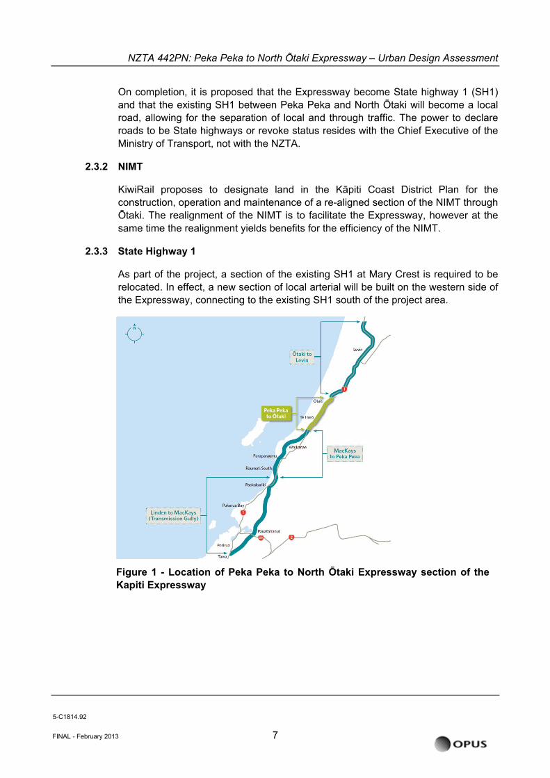
The Project is one of eight sections of the Wellington Northern Corridor which has been identified by the Government as a Road of National Significance (RoNS). The location of project in the overall scheme of this corridor is illustrated in Figure 1 below.
The Kāpiti Expressway currently comprises two sections within the Wellington Northern Corridor – namely MacKays to Peka Peka, and Peka Peka to North Ōtaki. The NZTA proposes in this application to designate land and obtain the resource consents to construct, operate and maintain the Expressway. The Project extends from Te Kowhai Road in the south to Taylors Road just north of Ōtaki, an approximate distance of 13km.
The Expressway will provide two lanes of traffic in each direction. Connections to existing local roads, new local roads and access points over the Expressway to maintain safe connectivity between the western and eastern sides of the Expressway are also proposed as part of the Project. There is an additional crossing of the Ōtaki River proposed as part of the Project, along with crossings of other watercourses throughout the Project length.
5-C1814.92
FINAL - February 2013 6
NZTA 442PN: Peka Peka to North Õtaki Expressway – Urban Design Assessment
On completion, it is proposed that the Expressway become State highway 1 (SH1) and that the existing SH1 between Peka Peka and North Ōtaki will become a local road, allowing for the separation of local and through traffic. The power to declare roads to be State highways or revoke status resides with the Chief Executive of the Ministry of Transport, not with the NZTA.
2.3.2 NIMT
KiwiRail proposes to designate land in the Kāpiti Coast District Plan for the construction, operation and maintenance of a re-aligned section of the NIMT through Ōtaki. The realignment of the NIMT is to facilitate the Expressway, however at the same time the realignment yields benefits for the efficiency of the NIMT.
2.3.3 State Highway 1
As part of the project, a section of the existing SH1 at Mary Crest is required to be relocated. In effect, a new section of local arterial will be built on the western side of the Expressway, connecting to the existing SH1 south of the project area.
FINAL - February 2013 7
Figure 1 - Location of Peka Peka to North Ōtaki Expressway section of theKapiti Expressway
5-C1814.92
NZTA 442PN: Peka Peka to North Õtaki Expressway – Urban Design Assessment
3 RELEVANT STATUTORY AND NON-STATUTORY PROVISIONS
The following standards have been used in the evaluation criteria for the potential Urban Design effects of the Expressway, including where the option may improve social and environmental outcomes as they relate to Urban Design.
Both a notice of requirement for a designation and an application for resource consent must, among other things, provide information as to the effects of the Project on the environment and the ways in which any adverse effects would be mitigated. For resource consent applications this assessment:
• Is required to be undertaken to a level of detail which corresponds with the scale and significance of the effects that the activity may have on the environment; and
• Includes consideration of landscape and visual effects and effects on both the immediate neighbourhood and, where relevant, the wider community.
When considering a notice of requirement for a designation or an application for resource consent a decision maker must, “subject to Part 2 of the RMA”, consider (among other things):
• The effects on the environment of allowing the requirement or activity.
• Any relevant provisions of an operative or proposed RMA plan or regional policy statement; and
• Any other matter they consider relevant.
Under Part 2 of the RMA a decision maker must, among other things:
• Have particular regard to:
The maintenance and enhancement of amenity values
The maintenance and enhancement of the quality of the environment, and
Any finite characteristics of natural and physical resources.
Section 2 Policy Context of the ULDF notes various regional and local planning documents and NZTA standards, objectives, policies or similar that relate to this proposal. For reference the key documents are listed below.
• RMA Part 2 • NZTA Urban Design Policy 2007 (NZTA) • The New Zealand Urban Design Protocol 2005 (MfE) • KCDC District Plan • Ōtaki Local Outcomes: Greater Ōtaki Vision Document 2007 (KCDC)
5-C1814.92
FINAL - February 2013 8
NZTA 442PN: Peka Peka to North Õtaki Expressway – Urban Design Assessment
Other policy context documents that have informed the process include: • Wellington Regional Strategy (Wellington region Local Authorities) • Recently-notified proposed District Plan 2012 (KCDC) • Development Management Strategy 2007 (KCDC) • Streetscape Strategy and Guideline 2008 (KCDC) • Environmental Guidelines for Rural Living: Kãpiti and Horowhenua 2001 (KCDC) • Cycleways, Walkways and Bridleways Strategy 2004 (KCDC)
3.1 Urban Design and the RMA
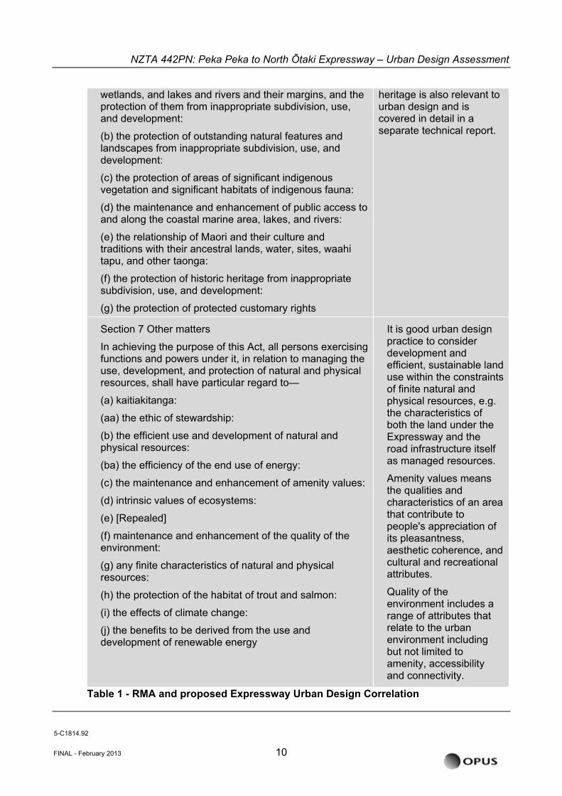
The term ‘urban design’ is not used in the RMA. However, there is a correlation between requirements of Part 2 of the RMA (Purpose and Principles) and urban design matters associated with the proposed Expressway. These are cross-referenced in the table below and will relate to the headings of the urban design matters to be addressed by this assessment. It is noted that only those provisions of the RMA that relate to urban planning and design are addressed in the table - there are many other RMA matters which will be addressed by other technical reports for the proposed Expressway.
Table 1 - RMA and proposed Expressway Urban Design Correlation
RMA Part 2 Urban Design
Section 5 Purpose
(1) The purpose of this Act is to promote the sustainable management of natural and physical resources.
(2) In this Act, sustainable management means managing the use, development, and protection of natural and physical resources in a way, or at a rate, which enables people and communities to provide for their social, economic, and cultural well-being and for their health and safety while—
(a) sustaining the potential of natural and physical resources (excluding minerals) to meet the reasonably foreseeable needs of future generations; and
(b) safeguarding the life-supporting capacity of air, water, soil, and ecosystems; and
(c) avoiding, remedying, or mitigating any adverse effects of activities on the environment.
The overarching consideration of people and communities providing for their social, economic, and cultural well-being and for their health and safety whilst sustaining resources, safeguarding life supporting elements, and avoiding, remedying or mitigating effects.
Section 6 Matters of national importance
In achieving the purpose of this Act, all persons exercising functions and powers under it, in relation to managing the use, development, and protection of natural and physical resources, shall recognise and provide for the following matters of national importance:
(a) the preservation of the natural character of the coastal environment (including the coastal marine area),
Access to and along rivers is an aspect of accessibility and connectivity that is relevant to urban planning.
The protection of built
5-C1814.92
FINAL - February 2013 9
NZTA 442PN: Peka Peka to North Õtaki Expressway – Urban Design Assessment
FINAL - February 2013 10
wetlands, and lakes and rivers and their margins, and the protection of them from inappropriate subdivision, use, and development:
(b) the protection of outstanding natural features and landscapes from inappropriate subdivision, use, and development:
(c) the protection of areas of significant indigenous vegetation and significant habitats of indigenous fauna:
(d) the maintenance and enhancement of public access to and along the coastal marine area, lakes, and rivers:
(e) the relationship of Maori and their culture and traditions with their ancestral lands, water, sites, waahi tapu, and other taonga:
(f) the protection of historic heritage from inappropriate subdivision, use, and development:
(g) the protection of protected customary rights
heritage is also relevant to urban design and is covered in detail in a separate technical report.
Section 7 Other matters
In achieving the purpose of this Act, all persons exercising functions and powers under it, in relation to managing the use, development, and protection of natural and physical resources, shall have particular regard to—
(a) kaitiakitanga:
(aa) the ethic of stewardship:
(b) the efficient use and development of natural and physical resources:
(ba) the efficiency of the end use of energy:
(c) the maintenance and enhancement of amenity values:
(d) intrinsic values of ecosystems:
(e) [Repealed]
(f) maintenance and enhancement of the quality of the environment:
(g) any finite characteristics of natural and physical resources:
(h) the protection of the habitat of trout and salmon:
(i) the effects of climate change:
(j) the benefits to be derived from the use and development of renewable energy
It is good urban design practice to consider development and efficient, sustainable land use within the constraints of finite natural and physical resources, e.g. the characteristics of both the land under the Expressway and the road infrastructure itself as managed resources.
Amenity values means the qualities and characteristics of an area that contribute to people's appreciation of its pleasantness, aesthetic coherence, and cultural and recreational attributes.
Quality of the environment includes a range of attributes that relate to the urban environment including but not limited to amenity, accessibility and connectivity.
Table 1 - RMA and proposed Expressway Urban Design Correlation
5-C1814.92
NZTA 442PN: Peka Peka to North Õtaki Expressway – Urban Design Assessment
The term urban design is frequently used in interrelated ways and there is often confusion as to what is meant by the term. In this assessment, which relates to the designations for the Expressway and realigned NIMT, ‘urban design’ is being used as a catch-all term to address the higher range of scales that the urban issues pertaining to the Project have been considered at this stage. Detailed urban design and landscape design will be undertaken for the proposed Expressway to proceed towards construction and, as noted in section 1.1 of this AEE, the ULDF provides a series of specific items that this design process will need to address.
It is noted that some of the policies relevant to the consideration of this Project under the RMA (at national, regional and local levels) seek certain urban design outcomes. These policies are a statutory consideration for this Project and specific policies are identified and considered in sections 3.4 and 4 of this assessment.
3.2 The NZ Urban Design Protocol (2005)
The NZ Urban Design Protocol (NZUDP) was prepared by the Ministry for the Environment in 2005 and NZTA is a founding signatory. The aim of the NZUDP is to make our towns and cities more successful through quality urban design.
Urban design seeks to ensure that the design of buildings, places, spaces and networks that make up our towns and cities, work for all of us, both now and in the future.
It is important that the NZUDP is considered during the design process, to ensure balanced decisions are reached which are to the benefit of the stakeholders and the local community.
The NZUDP identifies seven essential design qualities (‘The 7 C’s’) that together create quality urban design. It is these key design qualities that must be balanced with the engineered form of the Expressway to ensure a vibrant and sustainable built form emerges:
Choice
Fosters diversity and offers people choice in the urban form of our towns and cities, and choice in densities, building types, transport options and activities.
Connections
Good connections enhance choice, support social cohesion, make places lively and safe, and facilitate contact among people. Healthy towns are created where networks connect, and where physical layouts and activity patterns are easily understood. It is important that residents and visitors can navigate easily.
Context
Urban design has a strong spatial dimension and optimises relationships between buildings, spaces, places, activities, and networks. It also recognises that towns and cities are part of a constantly evolving relationship between people, land, culture and the wider environment.
5-C1814.92
FINAL - February 2013 11
NZTA 442PN: Peka Peka to North Õtaki Expressway – Urban Design Assessment
Character
Quality urban design reflects and enhances the distinctive character and culture of our urban environment and recognises that character is dynamic and evolving, not static. Fosters strong urban identities.
Creativity
Adds richness and diversity and turns a functional place into a memorable place.
Collaboration
Good communication and coordinated action from all decision-makers, involves communities, and supports best practice.
Custodianship
Reduces environmental impacts through environmentally sustainable, responsive design. It creates enjoyable safe public places and a quality environment that is cared for and a sense of ownership and responsibility in all guests and visitors.
3.3 KCDC District Plan
Land use is managed by KCDC under the Kapiti Coast District Plan. (See Appendix B of the ULDF).
Outstanding Landscape Features
A number of Outstanding Landscape Areas (OLAs) are identified in the Kapiti Coast District Plan: the Ōtaki River, and a number of remnant stands of totara and manuka in the Te Horo 'Straight' area. It should be noted that the OLA identified for the Ōtaki River relates to the upper reaches near Ōtaki Forks and not the section of River crossed by the Project.
The work to identify the OLAs was done a long time ago, and it is likely that the outstanding landscapes referred to in the District Plan would not stand up as Outstanding Natural Features and Landscapes (ONFLs) as now well defined via district-wide landscape studies in many current 'second generation' district plans. It is suggested in the Project Landscape and Visual Assessment that the OLAs in the District Plan would not be considered ONFLs.
As part of KCDC's recently completed Plan Review process, the district was recently reassessed by KCDC and no ONFLs were identified in the Expressway's designation corridor. The KCDC review has defined the Ōtaki River as a 'significant amenity landscape.' The 'Te Hapua sea cliff' north of Peka Peka Road is a geological feature that has been identified as a 'significant amenity feature', but this feature is to the east of the NIMT railway at the south end of the Project and well beyond any landscape influence the Project may have. The KCDC district-wide assessment has been completed and is enshrined in the District Plan change, which has recently been notified.
As it stands, the District Plan is operative and remains a relevant reference point.
5-C1814.92
FINAL - February 2013 12
NZTA 442PN: Peka Peka to North Õtaki Expressway – Urban Design Assessment
3.4 Ōtaki Local Outcomes: Greater Ōtaki Vision (2007)
Of particular relevance to the understanding and urban design assessment of this section of the Expressway is the Ōtaki Local Outcomes: Greater Ōtaki Vision (2007) document. The KCDC Ōtaki Vision document was developed through meetings and consultation with the community and stakeholder groups. The aim of the document is to provide a framework and a strategic picture of how Ōtaki should develop and shape in the years to come.
A summary of the Ōtaki Vision Objectives is as follows:
Ōtaki Railway Retail Area
• Ensure the area serves a sub-regional retail function with specialist shops and railway station;
• Celebrate local culture and design, using this to link this area with Main Street.
• Provide safe access to retail, and adequate long-term parking;
• Cater for cyclists and pedestrians; Enhance the overall appearance and nature of the area (planting, seating, lighting, signage, and traffic calming) to provide a safe, pleasant, stress-free shopping experience; and
• Encourage the development of local businesses facing the railway station to increase natural surveillance over the carpark.
Main Street Town Centre
• Maintain and enhance Main Street Town Centre as the civic heart with key services, local retail and historic attractions.
Industrial area: Riverbank Road
• Develop Riverbank Road into a major industrial development (‘CleanTech Business Park’) and employment area of Regional significance;
• Diversify the mix of industrial activity.
• Improve the overall image and appearance of the area;
• Connect the industrial area to the rest of the ‘Ōtaki Loop’ so that it is seen as part of the whole Ōtaki; Describe 'Ōtaki Loop'
• Ensure existing businesses are supported to remain while still attracting new businesses; and
• Utilise the proximity of the highway and the NIMT railway network.
5-C1814.92
FINAL - February 2013 13
NZTA 442PN: Peka Peka to North Õtaki Expressway – Urban Design Assessment
Transport networks
• Develop Ōtaki as a safe and easily accessible place to travel to, from and about: rail, cycle, walking, bus, and cars;
• Encourage pedestrian and cycle activities (including the Pipi Trail), and develop a cycleway network across the District; Describe Pipi
• Consider road safety in all future developments; and
• Ensure safe access to facilities (both educational and recreational) for young people.
Growth for local benefit
• Take a sustainable approach to development, and respect the character and identity of Ōtaki;
• Consolidate development within existing zoned residential areas. Discourage ribbon growth at Te Horo, and encourage clustered growth at Ōtaki;
• Realise the commercial and employment potential of Te Horo and the wider rural area; and
• Provide opportunities for local farmers’ markets.
Beaches and coastal areas
• Protect coast for future generations by restoring and protecting the dunes, estuaries and shellfish areas;
• Ensure accessibility to the coast for a range of activities; and
• Restrict new development at Te Horo and Ōtaki beaches.
Fresh water (including Ōtaki River)
• Maintain, protect and improve the waterways and water supply for future generations;
• Ensure the streams, lagoons and estuaries provide healthy habitats for birdlife and fish - especially inanga;
• Make Ōtaki River accessible by numerous transport modes; and
• Green the riverside of the industrial area to provide healthy ecologies, and provide cycleway and walkway networks through the industrial area to the riverside.
5-C1814.92
FINAL - February 2013 14
NZTA 442PN: Peka Peka to North Õtaki Expressway – Urban Design Assessment
Heritage and character elements
• Promote the heritage of Ōtaki by preserving and celebrating historic buildings, trees and sites;
• Promote the use of the Pipi Trail;
• Ensure valued elements and features of the community and the Greater Ōtaki area are protected; and
• Protect remaining native bush and coastal areas.
5-C1814.92
FINAL - February 2013 15
NZTA 442PN: Peka Peka to North Õtaki Expressway – Urban Design Assessment
4 PROJECT BACKGROUND & EXISTING ENVIRONMENT
4.1 Objectives
The objective of the Project is to provide a modern 4-lane Expressway that will support economic development by providing a strategic route to improve trip reliability and efficiency through the Wellington region. The Project will provide legible connections to Ōtaki Township, and provide for community connections across the corridor. The Expressway is to be integrated with the Ōtaki Vision and opportunities to enhanced urban and landscape outcomes, are to be explored.
Sitting above the Project objectives are a set of Wellington Northern Corridor RoNS-wide RMA objectives which are as follows:
• To enhance inter-regional and national economic growth and productivity;
• To improve access to Wellington’s CBD, key industrial and employment centres, port, airport and hospital;
• To provide relief from severe congestion on the State highway and local road networks, and to improve the journey time reliability of travel to the section of SH1 between Levin and the Wellington Airport; and
• To improve the safety of travel on State highways.
NZTA’s urban and landscape design related priorities for the Expressway include:
• Develop an integrated solution that achieves an appropriate balance between the functional performance requirements of local and State highway traffic; and
• Address social, land use and environmental impacts of the project in the context of the aspirations of territorial authorities.
4.2 Project Area and Urban Design
The context for the Expressway within the study area is predominantly to the east of the existing SH1 and rail corridors.
The existing route is well developed. It passes through the town of Ōtaki between Waitohu Valley Road and the Ōtaki River Bridge. The existing highway is the main through route in Ōtaki, and is intersected by many side roads.
South of the Ōtaki River, between Addington Road and the Old Hautere Road intersection, there are a range of (mainly) market garden businesses on the western side of the highway. The route is flanked on the western side by the town of Te Horo.
The Expressway creates the opportunity to generate better connections and networks and have a positive impact on the urban form of Ōtaki and Te Horo. However, failure to properly
5-C1814.92
FINAL - February 2013 16
NZTA 442PN: Peka Peka to North Õtaki Expressway – Urban Design Assessment
consider the way in which Ōtaki and Te Horo has, and could develop in future, may result in infrastructure that leads to poor urban form and negative community outcomes.
Urban design is therefore one of the primary considerations for the Project, particularly in the Ōtaki Township. Its importance is recognised by key stakeholders and local community.
Urban Design considerations relevant to the Project (expanded further in the ULDF) include:
• Severance and community connectivity:
The Expressway alignment, in combination with the NIMT and current state highway create a strong severance corridor, affecting east-west connectivity along the extents of the project area.
• Current and future land use
It is important to consider how Kāpiti Coast District Council (KCDC) envisages Ōtaki and the surrounding communities to develop in the future. The design and location of connections and the Expressway interchanges will affect future development, so it is important that KCDC’s vision is understood during the design process.
• Business sustainability
The Expressway will divert regional through-traffic away from the business areas of Te Horo and Ōtaki. It is important to consider the opportunity of developing business environments as a local destination, as well as creating easy, legible routes to and from these environments.
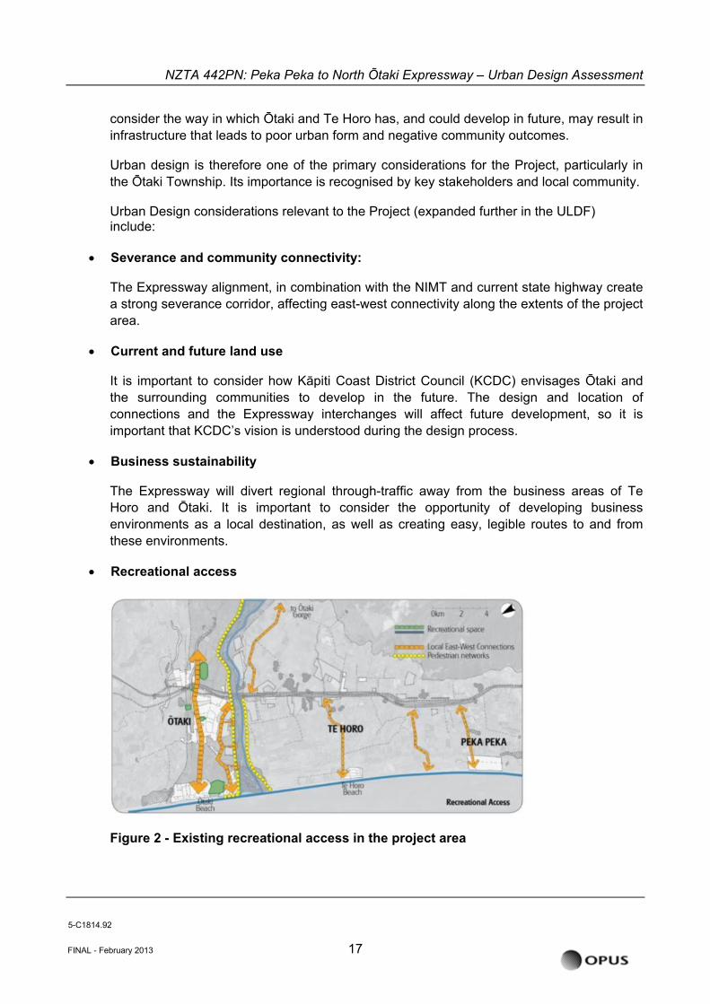
• Recreational access
Figure 2 - Existing recreational access in the project area
5-C1814.92
FINAL - February 2013 17
NZTA 442PN: Peka Peka to North Õtaki Expressway – Urban Design Assessment
KCDC puts great emphasis on access to recreational facilities. It is important the Expressway design maintains/enhances connections to water bodies (including Ōtaki River and the coast), and open spaces (such as Pare-o-Matangi Reserve).
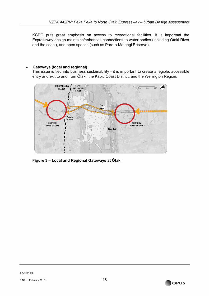
• Gateways (local and regional)
This issue is tied into business sustainability - it is important to create a legible, accessible entry and exit to and from Ōtaki, the Kāpiti Coast District, and the Wellington Region.
Figure 3 – Local and Regional Gateways at Ōtaki
5-C1814.92
FINAL - February 2013 18
NZTA 442PN: Peka Peka to North Õtaki Expressway – Urban Design Assessment
4.3 Existing Land use Typologies
A broad description of existing environment and its landscape and urban design context is provided in the ULDF, and more detail in the baseline assessment in Section 7.1 of this assessment.
There are six different land use types bordering the Project (Extract from the ULDF section 3.5 Charater Areas):
‘Rural
The majority of the Expressway corridor passes through rural land, with the resultant character being dominant from Taylors Road to Waitohu Stream and then from Ōtaki River to Peka Peka (the Hautere Plains).
North of the Project area is the distinctly undulating farmland of the Horowhenua Plains. Travelling south from Taylors Road, open farmland continues to Waitohu Valley Road on the east and beyond the Waitohu Stream and a localised ridge to the west. Rural landuse continues to the river terrace north of Rahui Road and then is visible again east of the highway and railway line within the Ōtaki River floodplain.
North of Te Horo and to the east of the highway and railway line the land flattens out to a localised area of broad plain that drains towards the Ōtaki River. This plain contains further pastoral farming and areas of horticultural production. The latter landuse has a regimented pattern of shelterbelts. There are also several small remnant stands of totara in the area.
The former marine terrace escarpment immediately east of Peka Peka Road intersection defines the southern end of the study area. To the west and northward extends the rolling contour of the local duneland topography. This area of pastoral farming is broken by an irregular pattern of conifer shelterbelts.
Lifestyle
Directly related to the rural land use and located within the rural character area are a number of smallholdings. These are more intensively subdivided, contain various houses and outbuildings and a variety of amenity and production tree and shrub plantings. Their intensity and diversity of development is what differentiates these ‘lifestyle blocks character from their immediate rural surroundings.
Residential
Within the Expressway corridor the areas of residential character are confined to the Ōtaki township area with a section of residential ribbon development on both sides of the existing highway immediately north of the northern river terrace and the local railway overbridge and on the west side of the highway just north of the Ōtaki River.
Many of the houses whose sections front onto the highway have relatively dense plantings of amenity trees and shrubs on their highway frontages. These have been planted as a buffer between the dwelling and the constant flow of highway traffic.
5-C1814.92
FINAL - February 2013 19
NZTA 442PN: Peka Peka to North Õtaki Expressway – Urban Design Assessment
Reserve/open space
While quite rural in aspect, the few reserve areas within the study area are focussed on Ōtaki, being Pare-o-Matangi Reserve, the land between Rahui Road and Ōtaki Railway Station and the rest area on the immediate southern bank of the Ōtaki River.
Pare-o-Matangi Reserve does not hold reserve status in the district plan, but is a green space of importance to the community.
Pare-o-Matangi Reserve is likely to change significantly as a result of the Expressway. This provides opportunity; firstly, if the reserve is extended, it can be developed to provide a buffer between the Expressway and Ōtaki. Secondly, the open space allows the proposed Rahui Road Underpass to be treated as a landscape element with longer ramps to ensure a high-quality pedestrian environment.
Industrial
Currently industrial land use within the Expressway corridor is confined to the immediate area of the northern bank of the Ōtaki River. Gravel extraction from the bed of the river for aggregate and concrete making is the main business. The industrial activity is not highly visible from the current state highway and Riverbank Road area as the bridge structure obscures the view.
Commercial/retail
Predominantly retail land use forms the focus of the Ōtaki Railway Retail Area. The visual diversity and 'main street' business activity within this retail area is one of the most memorable aspects when travelling through this overall section of highway.
While this retail area contains many conflicting activities and visual images and is further degraded by traffic congestion, it is the focus and a vibrant part of the local community.
Transportation
A subsidiary land use, but common to the whole of the study area is road paralleled by railway. While this is not actually a character area, it bisects or forms the edge of a variety of character areas. It is the conduit from which the travelling public observes the local landscape and in turn impacts upon those landscapes.’
This combined transportation corridor is the cause of the majority of east-west severance effects.
5-C1814.92
FINAL - February 2013 20
NZTA 442PN: Peka Peka to North Õtaki Expressway – Urban Design Assessment
5 DESIGN PROCESS AND ALTERNATIVES
The design process itself is an important consideration as good urban design is really the integration across a range of design and technical disciplines is key to delivering successful urban outcomes. Through this process the underlying urban form is understood, key principles for success developed and alternatives considered and either adopted, refined or rejected. It is important in the consideration of Urban Design Effects that the context provided by a summary of the design process that lead to the project’s route is outlined in this report.
5.1 Urban Form Analysis
Understanding the underlying urban form (natural and built environment) and land-use patterns is the critical first step in developing a coherent urban design strategy for any project. This is particularly important with large scale transport and infrastructure projects, such as the Expressway, as it can have a significant impact on the existing urban structure. This consideration of the urban form is developed from an analysis of the relationship of natural features, infrastructure, buildings and public spaces.
The work of the project team in analysing the current urban from and land-use patterns along the project route is detailed in the ULDF, and summarised in section 7 of this assessment.
5.2 Urban and Landscape Design Framework and Landscape Drawings
The purpose of the Project’s ULDF is to describe and set out urban and landscape design principles, objectives and high level concepts of the Project. The ULDF is a ‘live’ document and continues to evolve during the scheme and NOR phases and will inform the design development for the Project.
It is intended that the ULDF is used as a guiding tool for the Project consultants and engineers from concept through to detailed design. Principles from the ULDF should also guide any conditions set in the Project route designation. Importantly the ULDF will then continue as a live document with its inclusion within the detailed design package, so that the construction team is also aware of the objectives and guiding principles of the Project.
The ULDF is developed in accordance with NZTA guidance and supports the NoR application.
The ULDF seeks to establish a balance between RoNS network objectives, the desired future for Ōtaki as outlined in the Ōtaki Vision document 2007 (described in detail in Section 2.1 of the ULDF), and the specific urban and landscape context of the Project corridor. It follows from the SH1 Kāpiti Strategic Study, in July 2008, and the Transit NZ Scheme Assessment Report for North Ōtaki to Peka Peka Road, September 2002.
The ULDF document outlines the design intention for the project in particular the various built structures, road furniture elements and landscape.
5-C1814.92
FINAL - February 2013 21
NZTA 442PN: Peka Peka to North Õtaki Expressway – Urban Design Assessment
In general the bridge design to date has been developed with careful consideration of consistency, user experience and value. As the Project progresses, it will be important to continue to consider the visual experience for the various user types both on and under the bridge. Design consistencies are desirable for structures which are experienced by the Expressway user, as it is the Expressway user that will experience the route as a whole. Structures and elements which are experienced by the local community need to be considered, but do not need to be consistent, as these experiences are localised. Structures/elements which are experienced by the local community should respond to local context and reflect local themes.
Tables 4, 5 and 6 of the ULDF explain the design consistencies based on those who are experiencing the bridge.
Final selection of road furniture has not been made but the ULDF outlines principles to establish criteria for future section. It should also be noted that the noise mitigation strategy currently does not require built structures such as noise walls or earthwork / landscape bunds so the effects of such structures have not been considered in detail in this report.
The Landscape Drawings (LA01 – LA08) outline the landscape intent for the full corridor and are available in Appendix A of the ULDF. This is discussed in detail in the Landscape and Visual Assessment document.
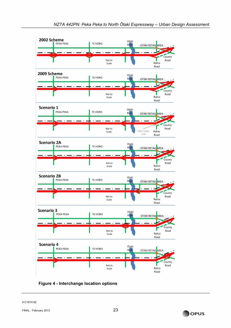
5.3 Assessment of Interchange and Connectivity Options
For the Expressway the primary connectivity is the north / south State highway and access to and from Ōtaki Township. Through a Multi-Criteria Assessment Tool (MCAT) process the design team assessed and established the key Expressway connectivity options to support the wider strategic objectives.
In terms of urban design, the access of the wider road network to and from the Project was assessed, and how the Project would affect current and future land use patterns. Different forms of interchange were evaluated using the MCAT methodology.
Ōtaki Township was the key consideration of the wider road network connectivity to the Expressway. Particular consideration was given to access from the north and south to facilitate the existing Railway Retail Area and the anticipated ‘Clean Tech’ growth in the existing Riverbank Road industrial area.
A range of interchange forms (see Figure 4 - Interchange location options), such as a single full-diamond, were considered in the interchange options. This provided full connectivity at a single location and is efficient from a transportation perspective but on balance did not support the wider urban access objectives of the Project and was rated below the final outcome.
5-C1814.92
FINAL - February 2013 22
NZTA 442PN: Peka Peka to North Õtaki Expressway – Urban Design Assessment
Figure 4 - Interchange location options
5-C1814.92
FINAL - February 2013 23
NZTA 442PN: Peka Peka to North Õtaki Expressway – Urban Design Assessment
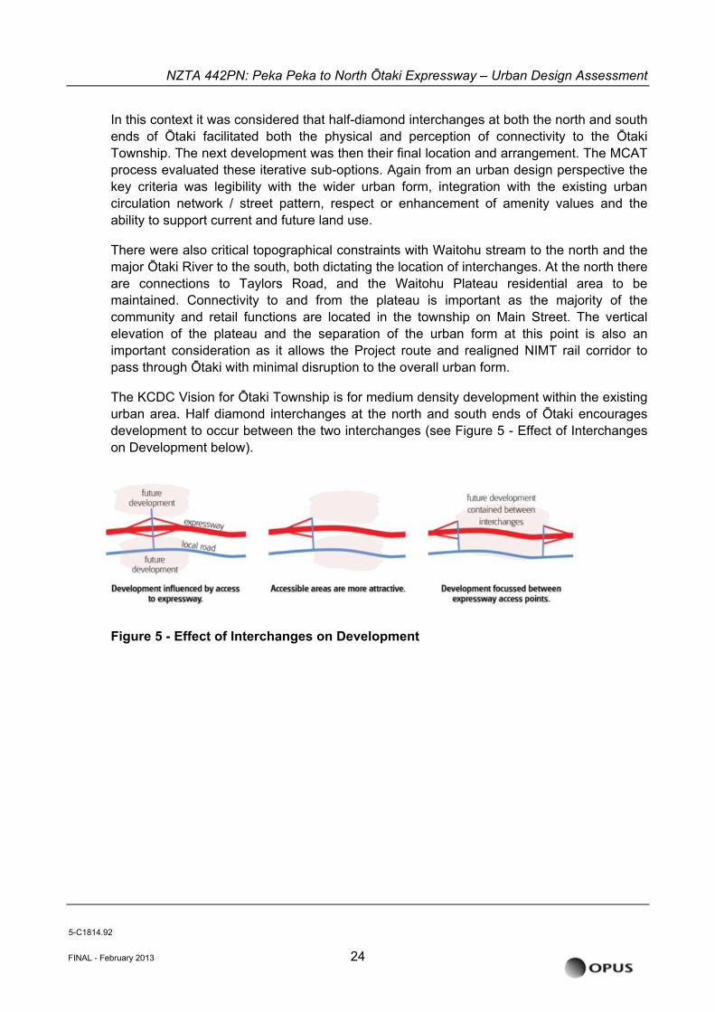
In this context it was considered that half-diamond interchanges at both the north and south ends of Ōtaki facilitated both the physical and perception of connectivity to the Ōtaki Township. The next development was then their final location and arrangement. The MCAT process evaluated these iterative sub-options. Again from an urban design perspective the key criteria was legibility with the wider urban form, integration with the existing urban circulation network / street pattern, respect or enhancement of amenity values and the ability to support current and future land use.
There were also critical topographical constraints with Waitohu stream to the north and the major Ōtaki River to the south, both dictating the location of interchanges. At the north there are connections to Taylors Road, and the Waitohu Plateau residential area to be maintained. Connectivity to and from the plateau is important as the majority of the community and retail functions are located in the township on Main Street. The vertical elevation of the plateau and the separation of the urban form at this point is also an important consideration as it allows the Project route and realigned NIMT rail corridor to pass through Ōtaki with minimal disruption to the overall urban form.
The KCDC Vision for Ōtaki Township is for medium density development within the existing urban area. Half diamond interchanges at the north and south ends of Ōtaki encourages development to occur between the two interchanges (see Figure 5 - Effect of Interchanges on Development below).
FINAL - February 2013 24
Figure 5 - Effect of Interchanges on Development
5-C1814.92
NZTA 442PN: Peka Peka to North Õtaki Expressway – Urban Design Assessment
5.4 East-West Connectivity
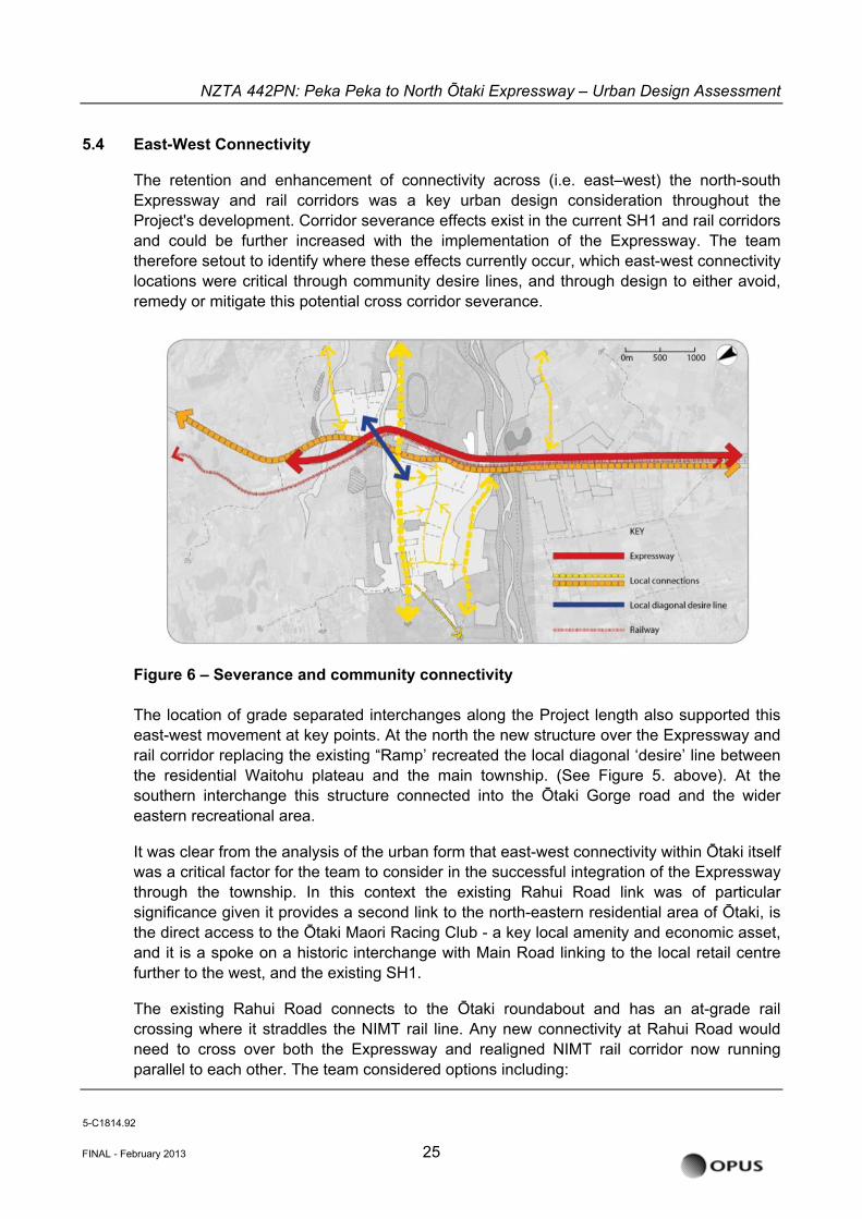
The retention and enhancement of connectivity across (i.e. east–west) the north-south Expressway and rail corridors was a key urban design consideration throughout the Project's development. Corridor severance effects exist in the current SH1 and rail corridors and could be further increased with the implementation of the Expressway. The team therefore setout to identify where these effects currently occur, which east-west connectivity locations were critical through community desire lines, and through design to either avoid, remedy or mitigate this potential cross corridor severance.
Figure 6 – Severance and community connectivity The location of grade separated interchanges along the Project length also supported this east-west movement at key points. At the north the new structure over the Expressway and rail corridor replacing the existing “Ramp’ recreated the local diagonal ‘desire’ line between the residential Waitohu plateau and the main township. (See Figure 5. above). At the southern interchange this structure connected into the Ōtaki Gorge road and the wider eastern recreational area.
It was clear from the analysis of the urban form that east-west connectivity within Ōtaki itself was a critical factor for the team to consider in the successful integration of the Expressway through the township. In this context the existing Rahui Road link was of particular significance given it provides a second link to the north-eastern residential area of Ōtaki, is the direct access to the Ōtaki Maori Racing Club - a key local amenity and economic asset, and it is a spoke on a historic interchange with Main Road linking to the local retail centre further to the west, and the existing SH1.
The existing Rahui Road connects to the Ōtaki roundabout and has an at-grade rail crossing where it straddles the NIMT rail line. Any new connectivity at Rahui Road would need to cross over both the Expressway and realigned NIMT rail corridor now running parallel to each other. The team considered options including:
5-C1814.92
FINAL - February 2013 25
NZTA 442PN: Peka Peka to North Õtaki Expressway – Urban Design Assessment
• not recreating a link and relying solely on the new northern interchange,
• a pedestrian only footbridge or underpass
• and a grade-separated structure allowing full vehicle movement.
The first round of public consultation feedback clearly highlighted a strong need for a full vehicle connection at Rahui Road.
A key consideration in the form and geometry of the new connection at Rahui Road was the flood plain of the Ōtaki River and the local Mangapouri Stream. This meant that at-grade or depressed underpass options were quickly discounted as this could potentially create increased flooding to the west. To gain sufficient clearance for a local underpass (local road at-grade) the Expressway would have to be raised about 8m above the existing ground level over a significant length and would therefore have a significant visual and noise impact on the adjacent township. The NIMT rail corridor could not be raised in vertical alignment with the Expressway due to the current location of the Ōtaki Railway Station and an at-grade crossing would therefore remain which was considered to be a poor safety outcome.
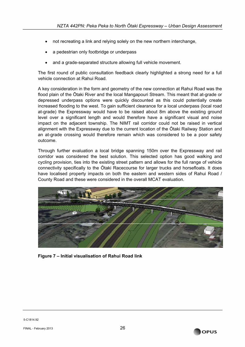
Through further evaluation a local bridge spanning 150m over the Expressway and rail corridor was considered the best solution. This selected option has good walking and cycling provision, ties into the existing street pattern and allows for the full range of vehicle connectivity specifically to the Ōtaki Racecourse for larger trucks and horsefloats. It does have localised property impacts on both the eastern and western sides of Rahui Road / County Road and these were considered in the overall MCAT evaluation.
Figure 7 – Initial visualisation of Rahui Road link
5-C1814.92
FINAL - February 2013 26

NZTA 442PN: Peka Peka to North Õtaki Expressway – Urban Design Assessment
5.4.1 Alternative East-West Connectivity Options at Ōtaki
The design team also considered alternative or additional east-west connectivity options, within Ōtaki, which were in turn evaluated through the MCAT process. The intention of these studies was to confirm the location of at least two east-west connections at Ōtaki and to enable a comparison of effects for these alternatives to an Expressway corridor crossing at Rahui Road.
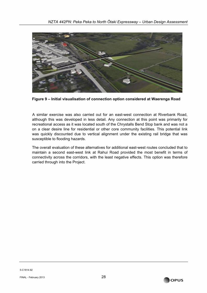
In developing these alternative or additional options the new connections needed to support a wider urban grid structure, potential land use growth patterns and recreational access at the southern end of the Ōtaki Township for KCDC’s proposed Ōtaki Lakes development. The new connectivity options from the east that meet this brief were specifically located around Waerenga Road and Riverbank Road. New eastern links to these existing roads would therefore be well connected to the existing overall street grid on the western residential and industrial areas, and lead to both the community facilities such as schools and also into the commercial / industrial land use for employment. West to east this would provide a second connection to the Ōtaki Maori Racing Club and the development of the eastern recreational area already noted.
Figure 8 - Plan view of connection option considered at Waerenga Road
To cross both the Expressway and NIMT rail corridor both overpass and underpass options were developed and evaluated by the team for the Waerenga Road connection. The local underpass option was ultimately discounted due to impact on flooding hazard for routes under the Expressway. It also had a poor outcome in terms of safety due to the creation of a new at-grade railway crossing.
A grade separated link over the Expressway also had a negative evaluation outcome. This was due to the large visual impact of a 150 m long structure on what is otherwise a low rise residential / commercial townscape and the difficult tie in to the western street pattern (see Figure 8. below).
5-C1814.92
FINAL - February 2013 27
NZTA 442PN: Peka Peka to North Õtaki Expressway – Urban Design Assessment
Figure 9 – Initial visualisation of connection option considered at Waerenga Road
A similar exercise was also carried out for an east-west connection at Riverbank Road, although this was developed in less detail. Any connection at this point was primarily for recreational access as it was located south of the Chrystalls Bend Stop bank and was not a on a clear desire line for residential or other core community facilities. This potential link was quickly discounted due to vertical alignment under the existing rail bridge that was susceptible to flooding hazards.
The overall evaluation of these alternatives for additional east-west routes concluded that to maintain a second east-west link at Rahui Road provided the most benefit in terms of connectivity across the corridors, with the least negative effects. This option was therefore carried through into the Project.
5-C1814.92
FINAL - February 2013 28
NZTA 442PN: Peka Peka to North Õtaki Expressway – Urban Design Assessment
5.4.2 East-West Connectivity at Old Hautere Road
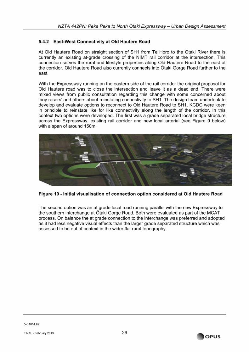
At Old Hautere Road on straight section of SH1 from Te Horo to the Ōtaki River there is currently an existing at-grade crossing of the NIMT rail corridor at the intersection. This connection serves the rural and lifestyle properties along Old Hautere Road to the east of the corridor. Old Hautere Road also currently connects into Ōtaki Gorge Road further to the east. With the Expressway running on the eastern side of the rail corridor the original proposal for Old Hautere road was to close the intersection and leave it as a dead end. There were mixed views from public consultation regarding this change with some concerned about ‘boy racers’ and others about reinstating connectivity to SH1. The design team undertook to develop and evaluate options to reconnect to Old Hautere Road to SH1. KCDC were keen in principle to reinstate like for like connectivity along the length of the corridor. In this context two options were developed. The first was a grade separated local bridge structure across the Expressway, existing rail corridor and new local arterial (see Figure 9 below) with a span of around 150m.
Figure 10 - Initial visualisation of connection option considered at Old Hautere Road
The second option was an at grade local road running parallel with the new Expressway to the southern interchange at Ōtaki Gorge Road. Both were evaluated as part of the MCAT process. On balance the at grade connection to the interchange was preferred and adopted as it had less negative visual effects than the larger grade separated structure which was assessed to be out of context in the wider flat rural topography.
5-C1814.92
FINAL - February 2013 29
NZTA 442PN: Peka Peka to North Õtaki Expressway – Urban Design Assessment
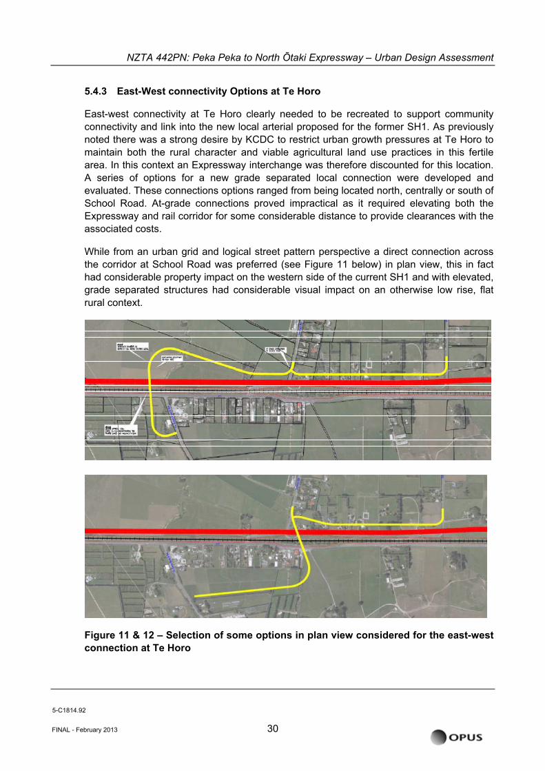
5.4.3 East-West connectivity Options at Te Horo
East-west connectivity at Te Horo clearly needed to be recreated to support community connectivity and link into the new local arterial proposed for the former SH1. As previously noted there was a strong desire by KCDC to restrict urban growth pressures at Te Horo to maintain both the rural character and viable agricultural land use practices in this fertile area. In this context an Expressway interchange was therefore discounted for this location. A series of options for a new grade separated local connection were developed and evaluated. These connections options ranged from being located north, centrally or south of School Road. At-grade connections proved impractical as it required elevating both the Expressway and rail corridor for some considerable distance to provide clearances with the associated costs.
While from an urban grid and logical street pattern perspective a direct connection across the corridor at School Road was preferred (see Figure 11 below) in plan view, this in fact had considerable property impact on the western side of the current SH1 and with elevated, grade separated structures had considerable visual impact on an otherwise low rise, flat rural context.
Figure 11 & 12 – Selection of some options in plan view considered for the east-west connection at Te Horo
5-C1814.92
FINAL - February 2013 30
NZTA 442PN: Peka Peka to North Õtaki Expressway – Urban Design Assessment
Through the MCAT evaluation process, incorporating feedback from both the public and key stakeholders a northern location for the connection was preferred due to reduced individual property impacts and visual effects.
5.5 Urban Design scheme development from 2010
The Urban Design development from 2010 onwards, including the MCAT alternatives assessment described above, covered the key issues from an urban design perspective for the preferred proposed alignment of the Expressway.
These issues were around amenity, community severance, connectivity with and across the Expressway, effect on underlying urban form and land use patterns, and the impact on the existing SH1.
Importantly the reporting process, described below, was the first attempt to formally assess effects of the Expressway on urban design. The effects assessment further addressed the degree of effects; any policies, protocols, objectives or principles that have informed the urban design requirements; how the preferred option alignment has addressed the effects and meets these requirements and any potential urban design mitigation costs.
The overall preferred proposal alignment developed by March 2012 led to the overall urban design outcome to be rated as low (positive). This was because:
• The existing cross corridor connections were retained, with one exception at Old Hautere Road. In the case of North Ōtaki the cross-corridor connections are actually enhanced with improved pedestrian and cycleway provision. This has a positive outcome on the potential for community severance caused by the Project and also maintains the current underlying urban form and street pattern.
• Land use patterns were not overly disrupted as the Expressway alignment broadly follows the existing rail corridor on what is predominantly rural land.
• The form of the new North Ōtaki and South Ōtaki Interchanges that bookend the township and their legibility by Expressway users will be important for the business viability of the current Ōtaki Railway Retail Area (covered by the Assessment of Economic Effects Report) but equally provide excellent connectivity to the Expressway for the industrial / ‘Clean Tech’ area around Riverbank Road at the southern end of Ōtaki, and other future land use development and growth for Ōtaki Township and the wider region.
The Urban Design assessment, as part of the Scheme Assessment Report Addendum (SARA) identified a number of issues that were important in moving forward with the Project. These were:
• The finer level of detailed design around the bridge and other structures;
• Resolution and integration of the network of walking and cycling routes; and
5-C1814.92
FINAL - February 2013 31
NZTA 442PN: Peka Peka to North Õtaki Expressway – Urban Design Assessment
• The interfaces with key public realm spaces including Pare-o-Matangi Reserve and the Ōtaki Railway Retail Area.
The report noted that the current SH1 would be reconfigured as a local arterial, but the specific details are yet to be resolved as part of the future SH1 revocation negotiations between NZTA and KCDC.
Importantly the SARA report, and in this case the urban design component of it, informed NZTA in its decision on the alignment of the Project.
5.6 Visual Simulations
A number of visual simulations or visualisations were prepared to assist in assessing the potential landscape and visual effects of the Project. These visual simulations have also assisted in understanding and portraying the urban design effects of the Project, and where appropriate have been included as Figures within this report.
An expanded description of the intention of these images, the methodology of creating these images, and how the viewpoints were selected is provided in the Landscape and Visual Assessment1 along with all of the ‘before’ and ‘after’ images.
1 Peka Peka to North Ōtaki Expressway Landscape and Visual Assessment
5-C1814.92
FINAL - February 2013 32
NZTA 442PN: Peka Peka to North Õtaki Expressway – Urban Design Assessment
6 METHODOLOGY
6.1 Assessment Criteria and Methodology
The methodology for this assessment is modelled on the draft NZTA Guideline on the Assessment of Urban Design Effects2, which requires the key areas for assessment of urban design effects to include:
• Urban form and land use effects
o The effects of the Project on the efficient use and development of land.
• Amenity effects
o The effects of the Project on the qualities and characteristics of an area that contribute to people’s appreciation of its pleasantness, aesthetic coherence, and cultural and recreational attributes.
• Connectivity effects
o The effects of the Project on pedestrian, cycle and local vehicular movement as well as the perceived severance effects associated with loss of visual connection to community facilities, neighbouring areas or the wider landscape.
• Establishing recognised urban design principles, policies and objectives;
• From these principles, providing a baseline evaluation of existing urban design environment;
• Assessing the effects of each option against the baseline evaluation; and
• Where applicable/practical recommend further mitigation measures avoid, remedy or mitigate undesirable effects.
For clarity it is important to note that the scope of this Urban Design report and the related Landscape and Visual Assessment (LVA). Amenity value including visual quality, tranquillity, perceived safety, sun exposure, aspects and views are all covered in the LVA and not repeated in this Urban Design Assessment.
2 NZTA Urban Design Assessment Guidelines; Draft 2 status; dated 26 August 2012
5-C1814.92
FINAL - February 2013 33
NZTA 442PN: Peka Peka to North Õtaki Expressway – Urban Design Assessment
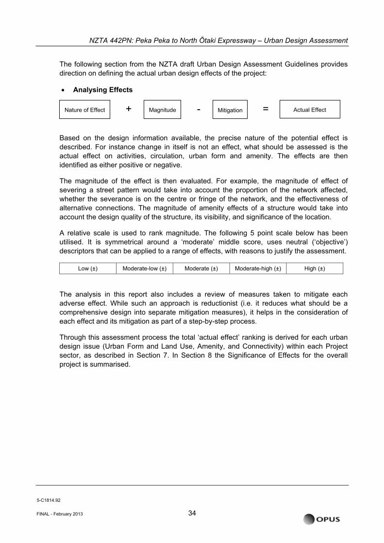
The following section from the NZTA draft Urban Design Assessment Guidelines provides direction on defining the actual urban design effects of the project:
• Analysing Effects
FINAL - February 2013 34
+ = - Actual Effect Nature of Effect Magnitude Mitigation
Based on the design information available, the precise nature of the potential effect is described. For instance change in itself is not an effect, what should be assessed is the actual effect on activities, circulation, urban form and amenity. The effects are then identified as either positive or negative.
The magnitude of the effect is then evaluated. For example, the magnitude of effect of severing a street pattern would take into account the proportion of the network affected, whether the severance is on the centre or fringe of the network, and the effectiveness of alternative connections. The magnitude of amenity effects of a structure would take into account the design quality of the structure, its visibility, and significance of the location.
A relative scale is used to rank magnitude. The following 5 point scale below has been utilised. It is symmetrical around a ‘moderate’ middle score, uses neutral (‘objective’) descriptors that can be applied to a range of effects, with reasons to justify the assessment.
Low (±) Moderate-low (±) Moderate (±) Moderate-high (±) High (±)
The analysis in this report also includes a review of measures taken to mitigate each adverse effect. While such an approach is reductionist (i.e. it reduces what should be a comprehensive design into separate mitigation measures), it helps in the consideration of each effect and its mitigation as part of a step-by-step process.
Through this assessment process the total ‘actual effect’ ranking is derived for each urban design issue (Urban Form and Land Use, Amenity, and Connectivity) within each Project sector, as described in Section 7. In Section 8 the Significance of Effects for the overall project is summarised.
5-C1814.92
NZTA 442PN: Peka Peka to North Õtaki Expressway – Urban Design Assessment
6.2 Project Sectors
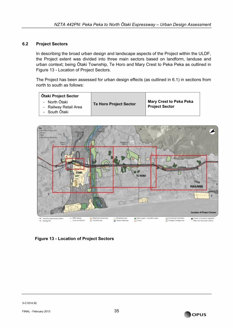
In describing the broad urban design and landscape aspects of the Project within the ULDF, the Project extent was divided into three main sectors based on landform, landuse and urban context; being Ōtaki Township, Te Horo and Mary Crest to Peka Peka as outlined in Figure 13 - Location of Project Sectors.
The Project has been assessed for urban design effects (as outlined in 6.1) in sections from north to south as follows:
Ōtaki Project Sector - North Ōtaki - Railway Retail Area - South Ōtaki
Te Horo Project Sector Mary Crest to Peka Peka Project Sector
FINAL - February 2013 35
Figure 13 - Location of Project Sectors
5-C1814.92
NZTA 442PN: Peka Peka to North Õtaki Expressway – Urban Design Assessment
7 ASSESSMENT OF URBAN DESIGN EFFECTS
7.1 Existing Environment (Baseline Assessment of Effects)
7.1.1 Project Wide Context
The overall land form of the Kāpiti region is characterised by the dominant Tararua Ranges to the east of the Kāpiti communities, and the coastal edge to the west. The existing State highway and NIMT rail corridor track between the two, crossing numerous streams and rivers on its journey south to Wellington. The specific Project area (Peka Peka to North Ōtaki) is located at the northern end of the Kāpiti Coast region, approximately 70km north of Wellington.
In this case the existing alignment of the State highway and NIMT rail corridor are the dominant linear elements. In particular where the NIMT rail corridor bisects the Ōtaki Township, and to a lesser extent at Te Horo, it typically defines the urban form and land-use boundaries through built edges. The existing split in the urban form at this location is an important consideration of the Expressway alignment.
In terms of urban form the SH1 and the adjacent NIMT railway corridor create connectivity severance effects to both Te Horo and Ōtaki. Therefore the character and quality of the key existing east-west links is important and are detailed below.
There are more minor connections on both the east and west of the existing SH1 which provide access to rural residential areas and recreational amenities along the coast to the west, and east towards the Tararua Ranges, notably at Ōtaki Gorge.
The majority of the Project area is currently zoned as rural, with urban activities mainly confined to Ōtaki (and to a much lesser extent, Te Horo). The economy of Ōtaki relies largely on the farming communities. However KCDC has expressed desire for future industrial and residential growth to be based around Ōtaki.
As mentioned previously, the Ōtaki Community Vision document outlines KCDC’s hopes for the future enhancement and development within the existing Ōtaki urban structure. KCDC’s future intent for medium density development in the area will be considered when assessing the effects.
The Ōtaki Community Vision document has also specifically described the enhancement of the Main Street Town Centre with an individual sense of place. The physical work to achieve is now completed.
7.1.2 Ōtaki Project Sector
Ōtaki Township is the northernmost urban centre of the three dominant settlements on the Kāpiti Coast and the Wellington Region. The wider district is a developing urban area, with a population increasing faster than the NZ average; however this is mostly to the south around Waikanae and Paraparaumu. The urban boundaries of Ōtaki are the Ōtaki River to the south and the Waitohu Stream to the north. The predominant population, including
5-C1814.92
FINAL - February 2013 36
NZTA 442PN: Peka Peka to North Õtaki Expressway – Urban Design Assessment
community amenities, is located west of the corridors, with a smaller residential population to the north east on the Waitohu Plateau. The key connectivity between the two areas is via the existing SH1 and Rahui Road.
There are two zoned retail/ commercial areas within Ōtaki; the Main Street Town Centre and the Railway Retail Area. The Main Street Town Centre serves the local Ōtaki community, while the Railway Retail Area serves both local residents and regional visitors.
North Ōtaki
Urban Form and Land Use
This northern sector is characterised as an elevated eastern block of suburban residential land use on the Waitohu Plateau surrounded by lifestyle and rural farms. To the west is the dune scape and the northern boundary is the Waitohu stream.
Amenity Values
All Amenity values are covered in more depth in the Landscape and visual assessment as already noted in section 6.1. Key points to note in the context of urban design are the underlying rural residential nature of the area but also the current SH1 and NIMT which run through the western edge of the residential area. The Pare-o-Matangi Reserve, developed by the local community group with support of KCDC is also a key recreational and amenity feature.
Connectivity
Taylors Road is the northern boundary for the Project area and currently connects directly into SH1. The State Highway runs through this section of Ōtaki running down to the Railway Retail area via ‘The Ramp’ which includes a bridge over the current NIMT corridor. Te Manuao Road acts as the key residential feeder road running perpendicular to SH1. County Road is a secondary connector and runs down to Rahui Road.
Ōtaki Railway Retail Area
Urban Form and Land Use
The Ōtaki Railway Retail Area is located along the existing SH1 in the form of a ‘high street retail strip’ between Waerenga Road and Mill Road/Rahui Road roundabout. There is also a New World supermarket at the southern end and a petrol station at the northern end that cater for the local community as well as passing traffic. The economic viability of the businesses in this area would be sensitive to the form and legibility of off/on ramps to Ōtaki from the Project.
The natural centre of the Ōtaki Railway Retail Area is the Arthur Street intersection which acts as a minor axis to the major axis of the SH1, and defines the ‘heart’ of an increasingly
5-C1814.92
FINAL - February 2013 37
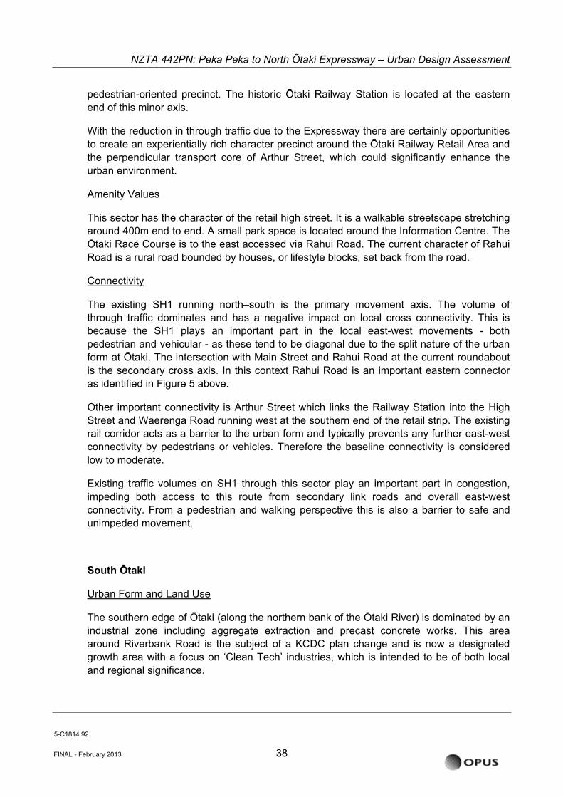
NZTA 442PN: Peka Peka to North Õtaki Expressway – Urban Design Assessment
pedestrian-oriented precinct. The historic Ōtaki Railway Station is located at the eastern end of this minor axis.
With the reduction in through traffic due to the Expressway there are certainly opportunities to create an experientially rich character precinct around the Ōtaki Railway Retail Area and the perpendicular transport core of Arthur Street, which could significantly enhance the urban environment.
Amenity Values
This sector has the character of the retail high street. It is a walkable streetscape stretching around 400m end to end. A small park space is located around the Information Centre. The Ōtaki Race Course is to the east accessed via Rahui Road. The current character of Rahui Road is a rural road bounded by houses, or lifestyle blocks, set back from the road.
Connectivity
The existing SH1 running north–south is the primary movement axis. The volume of through traffic dominates and has a negative impact on local cross connectivity. This is because the SH1 plays an important part in the local east-west movements - both pedestrian and vehicular - as these tend to be diagonal due to the split nature of the urban form at Ōtaki. The intersection with Main Street and Rahui Road at the current roundabout is the secondary cross axis. In this context Rahui Road is an important eastern connector as identified in Figure 5 above.
Other important connectivity is Arthur Street which links the Railway Station into the High Street and Waerenga Road running west at the southern end of the retail strip. The existing rail corridor acts as a barrier to the urban form and typically prevents any further east-west connectivity by pedestrians or vehicles. Therefore the baseline connectivity is considered low to moderate.
Existing traffic volumes on SH1 through this sector play an important part in congestion, impeding both access to this route from secondary link roads and overall east-west connectivity. From a pedestrian and walking perspective this is also a barrier to safe and unimpeded movement.
South Ōtaki
Urban Form and Land Use
The southern edge of Ōtaki (along the northern bank of the Ōtaki River) is dominated by an industrial zone including aggregate extraction and precast concrete works. This area around Riverbank Road is the subject of a KCDC plan change and is now a designated growth area with a focus on ‘Clean Tech’ industries, which is intended to be of both local and regional significance.
5-C1814.92
FINAL - February 2013 38
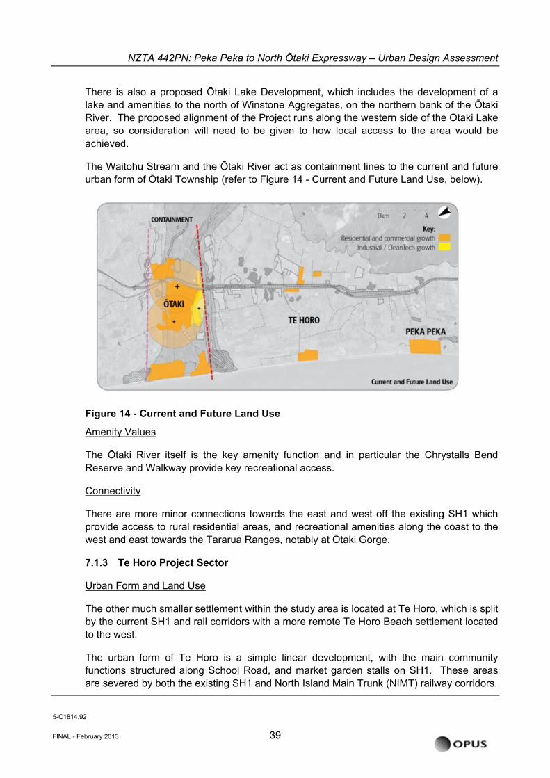
NZTA 442PN: Peka Peka to North Õtaki Expressway – Urban Design Assessment
There is also a proposed Ōtaki Lake Development, which includes the development of a lake and amenities to the north of Winstone Aggregates, on the northern bank of the Ōtaki River. The proposed alignment of the Project runs along the western side of the Ōtaki Lake area, so consideration will need to be given to how local access to the area would be achieved.
The Waitohu Stream and the Ōtaki River act as containment lines to the current and future urban form of Ōtaki Township (refer to Figure 14 - Current and Future Land Use, below).
Figure 14 - Current and Future Land Use
Amenity Values
The Ōtaki River itself is the key amenity function and in particular the Chrystalls Bend Reserve and Walkway provide key recreational access.
Connectivity
There are more minor connections towards the east and west off the existing SH1 which provide access to rural residential areas, and recreational amenities along the coast to the west and east towards the Tararua Ranges, notably at Ōtaki Gorge.
7.1.3 Te Horo Project Sector
Urban Form and Land Use
The other much smaller settlement within the study area is located at Te Horo, which is split by the current SH1 and rail corridors with a more remote Te Horo Beach settlement located to the west.
The urban form of Te Horo is a simple linear development, with the main community functions structured along School Road, and market garden stalls on SH1. These areas are severed by both the existing SH1 and North Island Main Trunk (NIMT) railway corridors.
5-C1814.92
FINAL - February 2013 39
NZTA 442PN: Peka Peka to North Õtaki Expressway – Urban Design Assessment
Although the severance effect is more acute at Te Horo than the other, the settlement is small and is likely to remain so as the KCDC District Plan seeks to restrict residential development in this area so as to retain rural character, and retention of high quality agricultural land use. In this case severance and the size of the settlement are not necessarily related, it is in fact the concentration of community facilities that increases the severance effects as described in the connectivity baseline assessment below.
Amenity Values
Amenity values for this sector are derived by the rural location as outlined in the Landscape and Visual Assessment. The current severance of the two halves of the built form by the two major corridors – road and rail - undoubtedly has a negative impact on the perception of a collective, cohesive settlements form and potentially community.
Connectivity
Many of Te Horo's community facilities (including Te Horo School) are located on the east side of SH1, while the main residential area is on the west side. Severance effects are created by an at-grade rail crossing of the NIMT corridor and the high traffic volumes on the SH1. Therefore, connectivity across the State highway is considered to have a low baseline assessment in relation to the functionality of the settlement.
7.1.4 Mary Crest to Peka Peka Project Sector
Urban Form and Land Use
The Mary Crest section of the SH1 corridor follows a gentle S curve broadly in line with the underlying topography. The landform to the east and west of the existing corridor are noticeably different, with the east being the fertile foothills and the west more typically described as undulating sand dunes. The NIMT rail corridor and SH1 continue to run parallel through this section and define a boundary between these landform typologies.
The Mary Crest section is fundamentally rural in character with only a handful of local property access points. The largest aggregation of buildings is at ‘Mary Crest’ itself, a former Catholic School, which sits prominently at the top of a small sand dune hill on the western side of the corridor. The eastern side of this section is a mix of pasture and horticultural land, the west is predominantly pasture with also some small remnants of native bush.
Amenity Values
There are no urban or peri-urban amenity values for this rural section of the Project.
Connectivity
The primary connectivity in this sector is the north-south movement along the existing State highway route. There are minor property access points along this section.
5-C1814.92
FINAL - February 2013 40
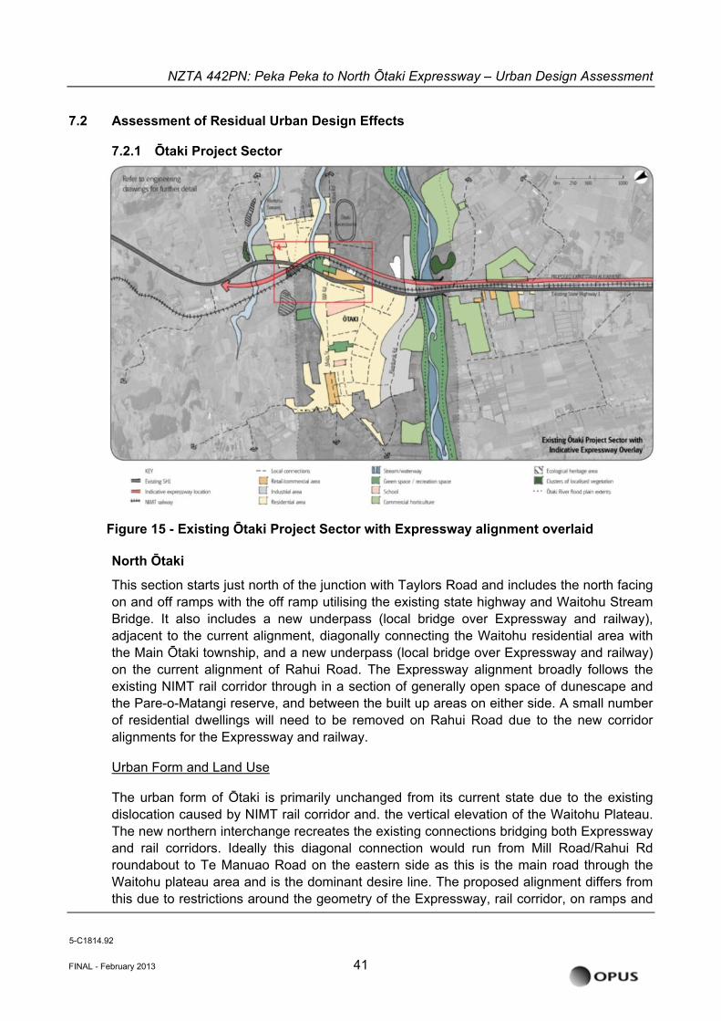
NZTA 442PN: Peka Peka to North Õtaki Expressway – Urban Design Assessment
7.2 Assessment of Residual Urban Design Effects
7.2.1 Ōtaki Project Sector
Figure 15 - Existing Ōtaki Project Sector with Expressway alignment overlaid
North Ōtaki
This section starts just north of the junction with Taylors Road and includes the north facing on and off ramps with the off ramp utilising the existing state highway and Waitohu Stream Bridge. It also includes a new underpass (local bridge over Expressway and railway), adjacent to the current alignment, diagonally connecting the Waitohu residential area with the Main Ōtaki township, and a new underpass (local bridge over Expressway and railway) on the current alignment of Rahui Road. The Expressway alignment broadly follows the existing NIMT rail corridor through in a section of generally open space of dunescape and the Pare-o-Matangi reserve, and between the built up areas on either side. A small number of residential dwellings will need to be removed on Rahui Road due to the new corridor alignments for the Expressway and railway.
Urban Form and Land Use
The urban form of Ōtaki is primarily unchanged from its current state due to the existing dislocation caused by NIMT rail corridor and. the vertical elevation of the Waitohu Plateau. The new northern interchange recreates the existing connections bridging both Expressway and rail corridors. Ideally this diagonal connection would run from Mill Road/Rahui Rd roundabout to Te Manuao Road on the eastern side as this is the main road through the Waitohu plateau area and is the dominant desire line. The proposed alignment differs from this due to restrictions around the geometry of the Expressway, rail corridor, on ramps and
5-C1814.92
FINAL - February 2013 41
NZTA 442PN: Peka Peka to North Õtaki Expressway – Urban Design Assessment
underpass (local road over the Expressway) at this location. Also a key factor in earlier options analysis of this area was limiting the number of residential properties that would be impacted in this location. The current alignment reflects the compromise with all these competing criteria.
The effect on current and future land-use is limited to the removal of a portion of the northern dunescape and Pare-o-Matangi Reserve. Connectivity is both maintained and enhanced thereby enabling the potential for future development/growth in the northwest of the Ōtaki Township on the Waitohu plateau area.
It should be noted that the current access proposed to Taylors Road does not support future growth nodes to the north of Waitohu stream. The KCDC growth vision is to the immediate north of the Ōtaki Township (i.e. south of Waitohu Stream), densification around the railway station/ transport hub and to the southern edge of the township along Riverbank road in a ‘clean tech’ industrial/commercial precinct3. Should the Taylors Road area be developed this may require a different local access strategy towards Ōtaki Township.
The North Ōtaki and South Ōtaki half diamond interchanges are placed in close proximity to the existing natural urban containment lines of the Waitohu Stream and the Ōtaki River (see Figure 14 - Current and Future Land Use, and Figure 5 - Effect of Interchanges on Development). This reinforces the KCDC Ōtaki Vision to encourage urban growth and development within the existing urban structure.
Therefore the effect of the Project on the Urban Form and Land Uses in the North Ōtaki sector is considered to be low (positive).
Low (+) Moderate-low Moderate Moderate-high High Amenity Values
The existing SH1 will have significantly reduced through traffic which will have a positive effect on the remaining local roads, improving the amenity of the adjacent properties and supporting a potential increase in walking and cycling along and across the new local road. While this will still include a southbound off-ramp and north bound on ramp the overall traffic volume will be noticeably reduced with the removal of the current state highway through traffic.
Walking and cycling routes to the Taylors Road area is via the Expressway interchange system. Southbound is the same as the existing condition, while northbound is via the new northbound on ramp and over the new Waitohu Stream Expressway Bridge.
As a future opportunity it could be considered to create a dedicated link at this point using low speed or off road environments (see Landscape Plan LA 01 / Rev 02 - See Figure 15). In this enhanced scenario walkers and cyclists could utilise the existing SH1 and then traverse under the new Waitohu Stream Expressway bridge and travel west to connect to Taylors Road as an alternative to the northbound on ramp. The Waitohu Stream section could be part of a longer recreational walkway/cycleway/bridleway (WCB) corridor. While
3 Ōtaki Local Outcomes: Greater Ōtaki Vision Document 2007 (KCDC)
5-C1814.92
FINAL - February 2013 42
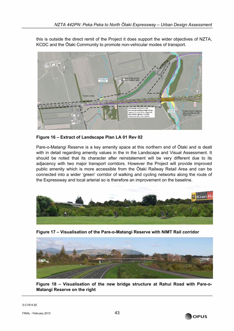
NZTA 442PN: Peka Peka to North Õtaki Expressway – Urban Design Assessment
this is outside the direct remit of the Project it does support the wider objectives of NZTA, KCDC and the Ōtaki Community to promote non-vehicular modes of transport.
Figure 16 – Extract of Landscape Plan LA 01 Rev 02 Pare-o-Matangi Reserve is a key amenity space at this northern end of Ōtaki and is dealt with in detail regarding amenity values in the in the Landscape and Visual Assessment. It should be noted that its character after reinstatement will be very different due to its adjacency with two major transport corridors. However the Project will provide improved public amenity which is more accessible from the Ōtaki Railway Retail Area and can be connected into a wider ‘green’ corridor of walking and cycling networks along the route of the Expressway and local arterial so is therefore an improvement on the baseline.
Figure 17 – Visualisation of the Pare-o-Matangi Reserve with NIMT Rail corridor
Figure 18 – Visualisation of the new bridge structure at Rahui Road with Pare-o-Matangi Reserve on the right
5-C1814.92
FINAL - February 2013 43
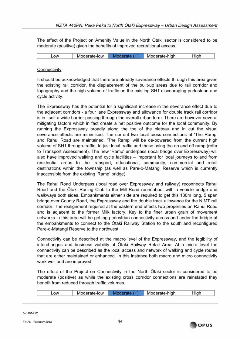
NZTA 442PN: Peka Peka to North Õtaki Expressway – Urban Design Assessment
The effect of the Project on Amenity Value in the North Ōtaki sector is considered to be moderate (positive) given the benefits of improved recreational access.
Low Moderate-low Moderate (+) Moderate-high High
Connectivity
It should be acknowledged that there are already severance effects through this area given the existing rail corridor, the displacement of the built-up areas due to rail corridor and topography and the high volume of traffic on the existing SH1 discouraging pedestrian and cycle activity.
The Expressway has the potential for a significant increase in the severance effect due to the adjacent corridors - a four lane Expressway and allowance for double track rail corridor is in itself a wide barrier passing through the overall urban form. There are however several mitigating factors which in fact create a net positive outcome for the local community. By running the Expressway broadly along the toe of the plateau and in cut the visual severance effects are minimised. The current two local cross connections at ‘The Ramp’ and Rahui Road are maintained. ‘The Ramp’ will be de-powered from the current high volume of SH1 through-traffic, to just local traffic and those using the on and off ramp (refer to Transport Assessment). The new ‘Ramp’ underpass (local bridge over Expressway) will also have improved walking and cycle facilities – important for local journeys to and from residential areas to the transport, educational, community, commercial and retail destinations within the township (as well as Pare-o-Matangi Reserve which is currently inaccessible from the existing ‘Ramp’ bridge).
The Rahui Road Underpass (local road over Expressway and railway) reconnects Rahui Road and the Ōtaki Racing Club to the Mill Road roundabout with a vehicle bridge and walkways both sides. Embankments either side are required to get this 130m long, 5 span bridge over County Road, the Expressway and the double track allowance for the NIMT rail corridor. The realignment required at the eastern end effects two properties on Rahui Road and is adjacent to the former Milk factory. Key to the finer urban grain of movement networks in this area will be getting pedestrian connectivity across and under the bridge at the embankments to connect to the Ōtaki Railway Station to the south and reconfigured Pare-o-Matangi Reserve to the northwest.
Connectivity can be described at the macro level of the Expressway, and the legibility of interchanges and business viability of Ōtaki Railway Retail Area. At a micro level the connectivity can be described as the local access and network of walking and cycle routes that are either maintained or enhanced. In this instance both macro and micro connectivity work well and are improved.
The effect of the Project on Connectivity in the North Ōtaki sector is considered to be moderate (positive) as while the existing cross corridor connections are reinstated they benefit from reduced through traffic volumes.
Low Moderate-low Moderate (+) Moderate-high High
5-C1814.92
FINAL - February 2013 44
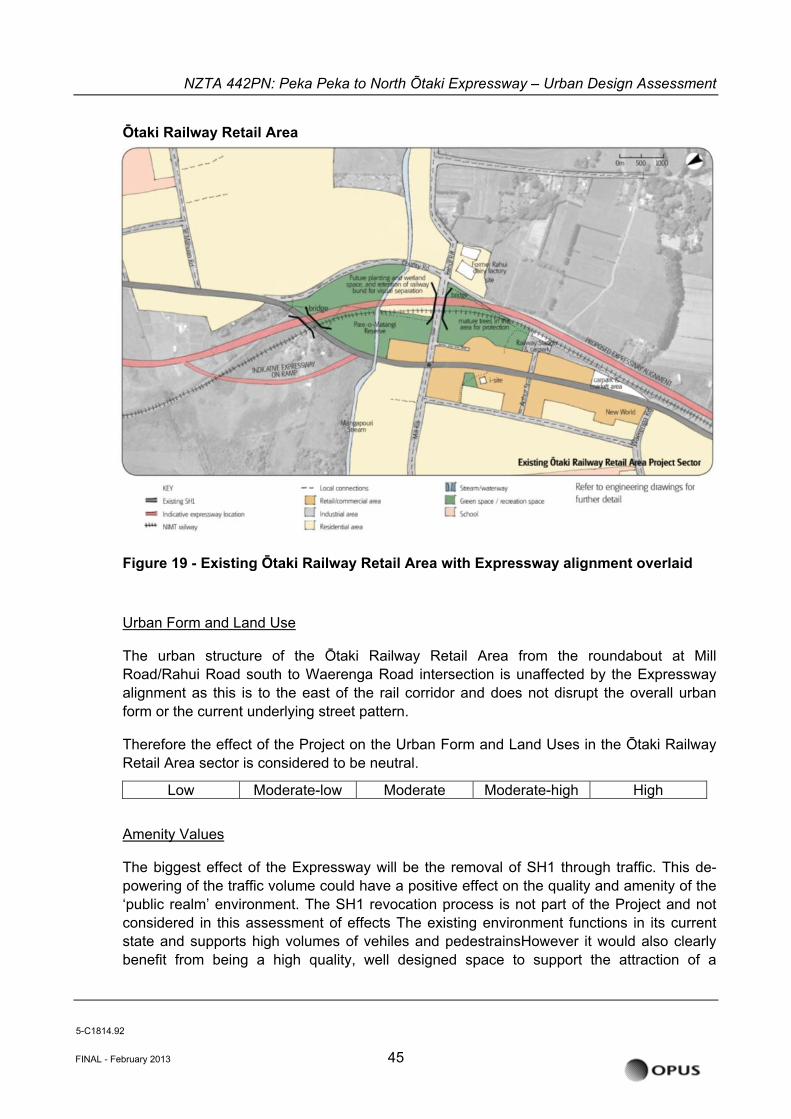
NZTA 442PN: Peka Peka to North Õtaki Expressway – Urban Design Assessment
Ōtaki Railway Retail Area
FINAL - February 2013 45
Figure 19 - Existing Ōtaki Railway Retail Area with Expressway alignment overlaid
Urban Form and Land Use
The urban structure of the Ōtaki Railway Retail Area from the roundabout at Mill Road/Rahui Road south to Waerenga Road intersection is unaffected by the Expressway alignment as this is to the east of the rail corridor and does not disrupt the overall urban form or the current underlying street pattern.
Therefore the effect of the Project on the Urban Form and Land Uses in the Ōtaki Railway Retail Area sector is considered to be neutral.
Low Moderate-low Moderate Moderate-high High
Amenity Values
The biggest effect of the Expressway will be the removal of SH1 through traffic. This de-powering of the traffic volume could have a positive effect on the quality and amenity of the ‘public realm’ environment. The SH1 revocation process is not part of the Project and not considered in this assessment of effects The existing environment functions in its current state and supports high volumes of vehiles and pedestrainsHowever it would also clearly benefit from being a high quality, well designed space to support the attraction of a
5-C1814.92
NZTA 442PN: Peka Peka to North Õtaki Expressway – Urban Design Assessment
proportion of passing trade for the outlet shops in the Railway Retail Centre (refer to Assessment of Economic Effects).
In terms of Rahui Road the character of this reinstated connection changes markedly. What was a rural road connecting into the town urban grid is now a grade separated, sinuously curved local bridge spanning across both the Expressway and NIMT rail corridor. This removes the interaction with existing frontages along its span, with the exception of the ends and elevates this connection above the surrounding townscape, in a similar way to the ‘Ramp’. The embankments however add to the new Pare-o-Matangi Reserve landscape.
The effect of the Project on Amenity Value in the Ōtaki Railway Retail Area sector is considered to be moderate (positive) given the benefits of reduced through traffic volumes.
Low Moderate-low Moderate (+) Moderate-high High
Connectivity
The reduction in through traffic noted previously will also have a positive benefit on other local connections and cross town movement as the diagonal connectivity is key feature of the Ōtaki urban form. It also allows the existing SH1 reinstated as a new local arterial to be unambiguously a north-south spine for the local community.
Two other items to note regarding connectivity are the Rahui Road local bridge in lieu of the current at-grade rail, and the minor realignment / rotation of the railway station building at the end of Arthur Street. The connectivity effects of the Rahui Road Underpass are covered in detail in sections 5.3 and 5.4 and conclude that the reinstatement of this second east-west link provided the most benefit in terms of overcoming severance effects across the corridors.
The realignment/rotation of the historic railway station is negligible from a wider urban design perspective as the interrelationship of the station building and entrance from Arthur Street is virtually unchanged at the scale of the urban form. It is important that this current easy access to the Ōtaki Railway Station is maintained as it is a key public transport infrastructure asset. Effects on the historic character of this rotation / realignment are considered separately under Heritage Assessment.
The effect of the Project on Connectivity in the Ōtaki Railway Retail Area sector is considered to be moderate (positive) through the benefit from reduced through traffic volumes.
Low Moderate-low Moderate (+) Moderate-high High
5-C1814.92
FINAL - February 2013 46
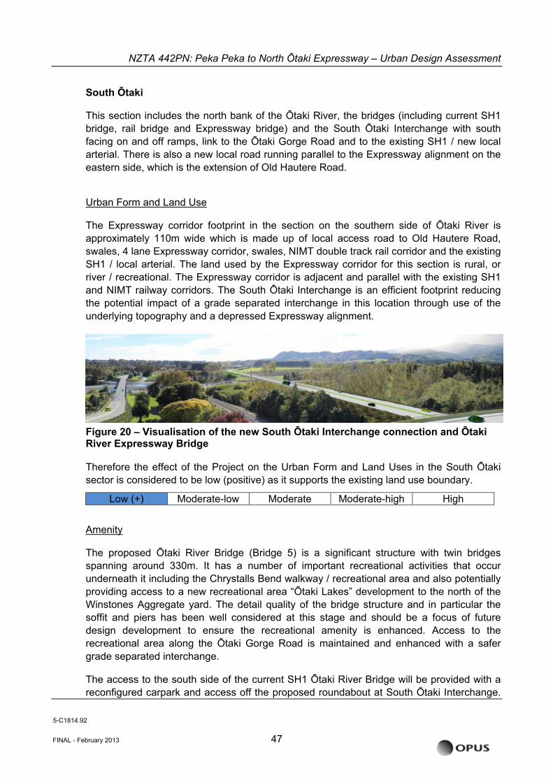
NZTA 442PN: Peka Peka to North Õtaki Expressway – Urban Design Assessment
South Ōtaki
This section includes the north bank of the Ōtaki River, the bridges (including current SH1 bridge, rail bridge and Expressway bridge) and the South Ōtaki Interchange with south facing on and off ramps, link to the Ōtaki Gorge Road and to the existing SH1 / new local arterial. There is also a new local road running parallel to the Expressway alignment on the eastern side, which is the extension of Old Hautere Road.
Urban Form and Land Use
FINAL - February 2013 47
The Expressway corridor footprint in the section on the southern side of Ōtaki River is approximately 110m wide which is made up of local access road to Old Hautere Road, swales, 4 lane Expressway corridor, swales, NIMT double track rail corridor and the existing SH1 / local arterial. The land used by the Expressway corridor for this section is rural, or river / recreational. The Expressway corridor is adjacent and parallel with the existing SH1 and NIMT railway corridors. The South Ōtaki Interchange is an efficient footprint reducing the potential impact of a grade separated interchange in this location through use of the un
Figure 20 – Visualisation of the new South Ōtaki Inte
derlying topography and a depressed Expressway alignment.
rchange connection and Ōtaki River Expressway Bridge
Therefore the effect of the Project on the Urban Form and Land Uses in the South Ōtaki ector is considered to be low (positive) as it supports the existing land use boundary.
s
Low (+) Moderate-low Moderate Moderate-high High
Amenity
s has a number of important recreational activities that occur
e soffit s has side stag e a focus of future
esign development to ensure the recreational amenity is enhanced. Access to the al area along the Ōtaki Gorge Road is maintained and enhanced with a safer
grade separated interchange.
reconfigured carpark and access off the proposed roundabout at South Ōtaki Interchange.
The proposed Ōtaki River Bridge (Bridge 5) is a significant structure with twin bridgepanning around 330m. It s
underneath it including the Chrystalls Bend walkway / recreational area and also potentially providing access to a new recreational area “Ōtaki Lakes” development to the north of the Winstones Aggregate yard. The detail quality of the bridge structure and in particular th
and pier been well con red at this e and should bdrecreation
The access to the south side of the current SH1 Ōtaki River Bridge will be provided with a
5-C1814.92
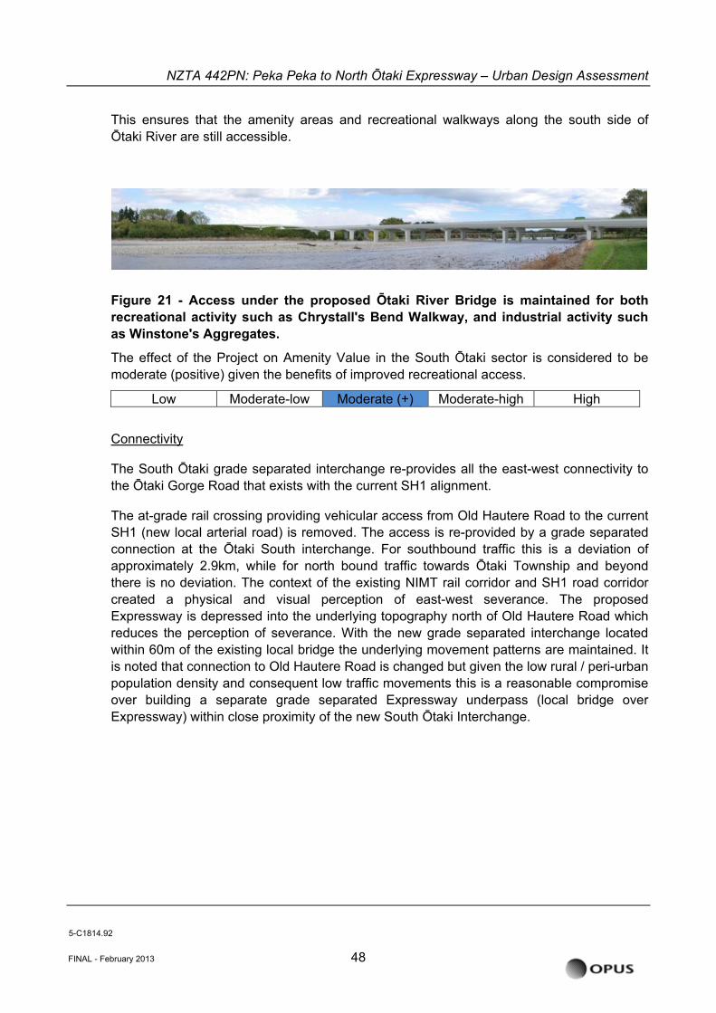
NZTA 442PN: Peka Peka to North Õtaki Expressway – Urban Design Assessment
This ensures that the amenity areas and recreational walkways along the south side of Ōtaki River are still accessible.
Figure 21 - Access under the
proposed Ōtaki River Bridge is maintained for both recreational activity such as Chrystall's Bend Walkway, and industrial activity such
s Winstone's Aggregates.
The effect of the Project on Amenity Value in the South Ōtaki sector is considered to be moderate (positive) given the benefits of improved recreational access.
Low Moderate-low
a
Moderate (+) Moderate-high High
Connectivity
ion of approximately 2.9km rth tow nship
ere is no deviation. The context of the existing NIMT rail corridor and SH1 road corridor hysical and visual perception of east-west severance. The proposed
Expressway is depressed into the underlying topography north of Old Hautere Road which
atterns are maintained. It is noted that connection to Old Hautere Road is changed but given the low rural / peri-urban
The South Ōtaki grade separated interchange re-provides all the east-west connectivity to the Ōtaki Gorge Road that exists with the current SH1 alignment.
The at-grade rail crossing providing vehicular access from Old Hautere Road to the current SH1 (new local arterial road) is removed. The access is re-provided by a grade separated connection at the Ōtaki South interchange. For southbound traffic this is a deviat
, while for no bound traffic ards Ōtaki Tow and beyond thcreated a p
reduces the perception of severance. With the new grade separated interchange located within 60m of the existing local bridge the underlying movement p
population density and consequent low traffic movements this is a reasonable compromise over building a separate grade separated Expressway underpass (local bridge over Expressway) within close proximity of the new South Ōtaki Interchange.
5-C1814.92
FINAL - February 2013 48
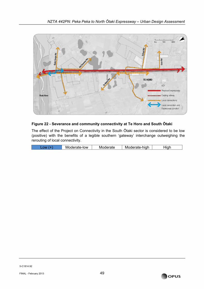
NZTA 442PN: Peka Peka to North Õtaki Expressway – Urban Design Assessment
Figure 22 - Severance and community connectivity at Te Horo and South Ōtaki
The effect of the Project on Connectivity in the South Ōtaki sector is considered to be low (positive) with the benefits of a legible southern ‘gateway’ interchange outweighing the rerouting of local connectivity.
Low (+) Moderate-low Moderate Moderate-high High
5-C1814.92
FINAL - February 2013 49
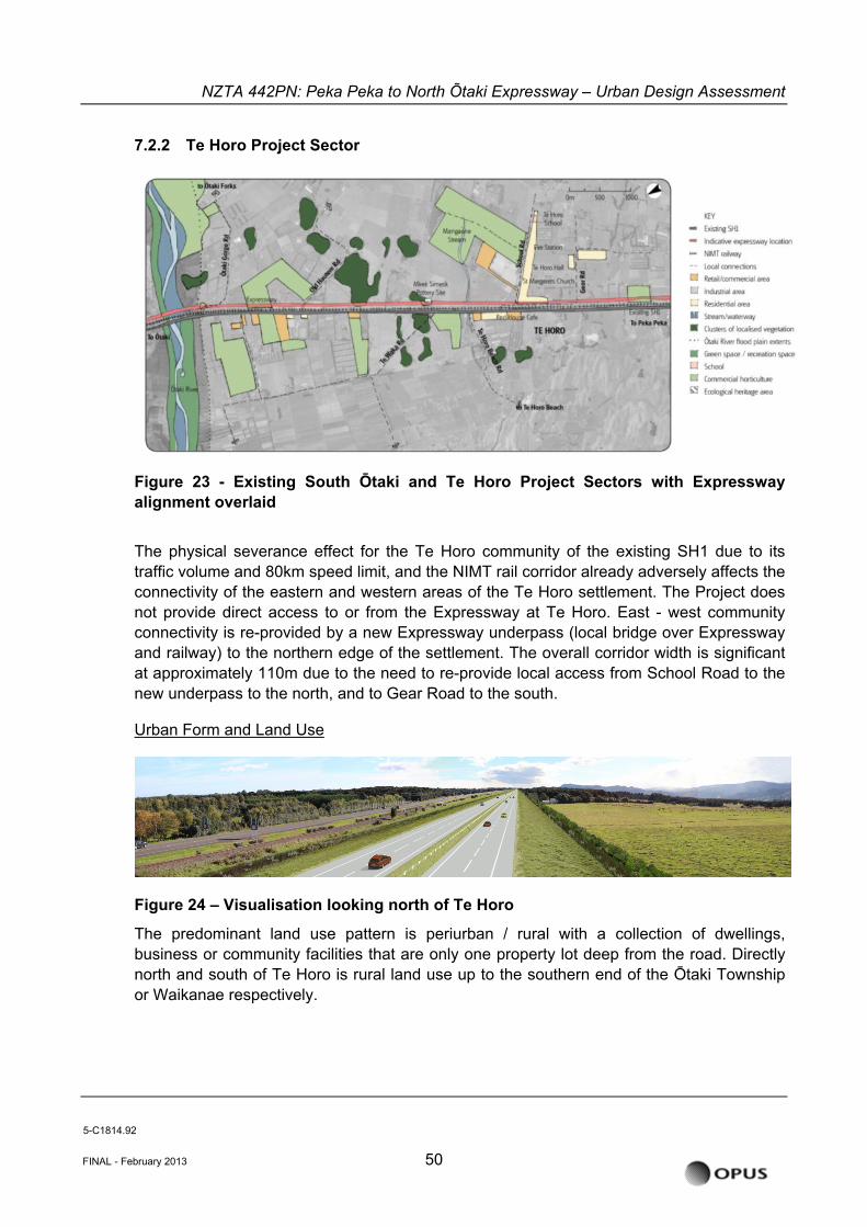
NZTA 442PN: Peka Peka to North Õtaki Expressway – Urban Design Assessment
7.2.2 Te Horo Project Sector
FINAL - February 2013 50
Figure 23 - Existing South Ōtaki and Te Horo Project Sectors with Expressway alignment overlaid
The physical severance effect for the Te Horo community of the existing SH1 due to its traffic volume and 80km speed limit, and the NIMT rail corridor already adversely affects the connectivity of the eastern and western areas of the Te Horo settlement. The Project does not provide direct access to or from the Expressway at Te Horo. East - west community connectivity is re-provided by a new Expressway underpass (local bridge over Expressway and railway) to the northern edge of the settlement. The overall corridor width is significant at approximately 110m due to the need to re-provide local access from School Road to the new underpass to the north, and to Gear Road to the south.
Urban Form and Land Use
Figure 24 – Visualisation looking north of Te Horo
The predominant land use pattern is periurban / rural with a collection of dwellings, business or community facilities that are only one property lot deep from the road. Directly north and south of Te Horo is rural land use up to the southern end of the Ōtaki Township or Waikanae respectively.
5-C1814.92
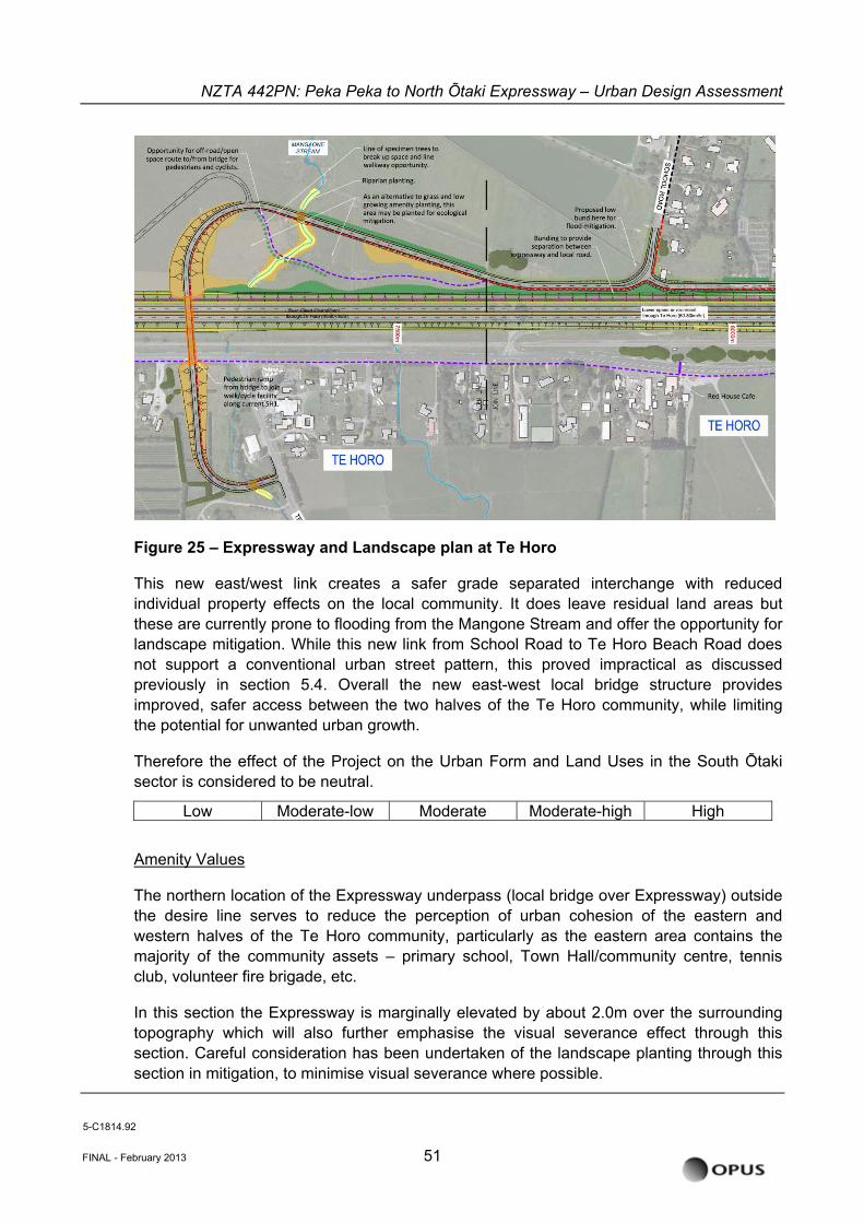
NZTA 442PN: Peka Peka to North Õtaki Expressway – Urban Design Assessment
Figure 25 – Expressway and Landscape plan at Te Horo
This new east/west link creates a safer grade separated interchange with reduced individual property effects on the local community. It does leave residual land areas but these are currently prone to flooding from the Mangone Stream and offer the opportunity for landscape mitigation. While this new link from School Road to Te Horo Beach Road does not support a conventional urban street pattern, this proved impractical as discussed previously in section 5.4. Overall the new east-west local bridge structure provides improved, safer access between the two halves of the Te Horo community, while limiting the potential for unwanted urban growth.
Therefore the effect of the Project on the Urban Form and Land Uses in the South Ōtaki sector is considered to be neutral.
Low Moderate-low Moderate Moderate-high High
Amenity Values
The northern location of the Expressway underpass (local bridge over Expressway) outside the desire line serves to reduce the perception of urban cohesion of the eastern and western halves of the Te Horo community, particularly as the eastern area contains the majority of the community assets – primary school, Town Hall/community centre, tennis club, volunteer fire brigade, etc.
In this section the Expressway is marginally elevated by about 2.0m over the surrounding topography which will also further emphasise the visual severance effect through this section. Careful consideration has been undertaken of the landscape planting through this section in mitigation, to minimise visual severance where possible.
5-C1814.92
FINAL - February 2013 51
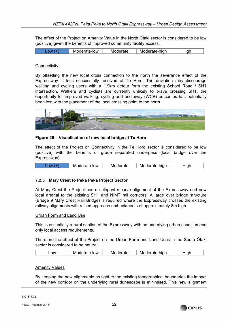
NZTA 442PN: Peka Peka to North Õtaki Expressway – Urban Design Assessment
The effect of the Project on Amenity Value in the North Ōtaki sector is considered to be low (positive) given the benefits of improved community facility access.
Low (+) Moderate-low Moderate Moderate-high High
Connectivity
By offsetting the new local cross connection to the north the severance effect of the Expressway is less successfully resolved at Te Horo. The deviation may discourage walking and cycling users with a 1.9km detour form the existing School Road / SH1 intersection. Walkers and cyclists are currently unlikely to brave crossing SH1, the opportunity for improved walking, cycling and bridleway (WCB) outcomes has potentially been lost with the placement of the local crossing point to the north.
Figure 26 – Visualisation of new local bridge at Te Horo
The effect of the Project on Connectivity in the Te Horo sector is considered to be low (positive) with the benefits of grade separated underpass (local bridge over the Expressway).
Low (+) Moderate-low Moderate Moderate-high High
7.2.3 Mary Crest to Peka Peka Project Sector
At Mary Crest the Project has an elegant s-curve alignment of the Expressway and new local arterial to the existing SH1 and NIMT rail corridors. A large over bridge structure (Bridge 9 Mary Crest Rail Bridge) is required where the Expressway crosses the existing railway alignments with raised approach embankments of approximately 8m high.
Urban Form and Land Use
This is essentially a rural section of the Expressway with no underlying urban condition and only local access requirements.
Therefore the effect of the Project on the Urban Form and Land Uses in the South Ōtaki sector is considered to be neutral.
Low Moderate-low Moderate Moderate-high High
Amenity Values
By keeping the new alignments as tight to the existing topographical boundaries the impact of the new corridor on the underlying rural dunescape is minimised. This new alignment
5-C1814.92
FINAL - February 2013 52
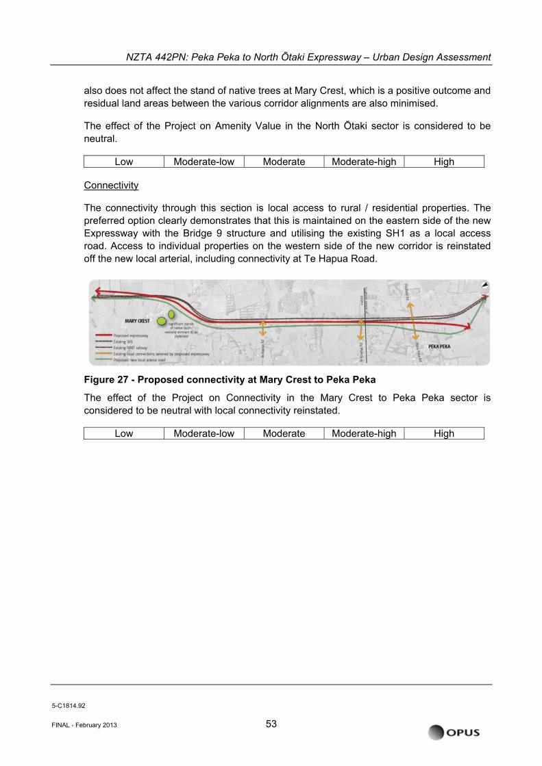
NZTA 442PN: Peka Peka to North Õtaki Expressway – Urban Design Assessment
also does not affect the stand of native trees at Mary Crest, which is a positive outcome and residual land areas between the various corridor alignments are also minimised.
The effect of the Project on Amenity Value in the North Ōtaki sector is considered to be neutral.
Low Moderate-low Moderate Moderate-high High
Connectivity
The connectivity through this section is local access to rural / residential properties. The preferred option clearly demonstrates that this is maintained on the eastern side of the new Expressway with the Bridge 9 structure and utilising the existing SH1 as a local access road. Access to individual properties on the western side of the new corridor is reinstated off the new local arterial, including connectivity at Te Hapua Road.
Figure 27 - Proposed connectivity at Mary Crest to Peka Peka
The effect of the Project on Connectivity in the Mary Crest to Peka Peka sector is considered to be neutral with local connectivity reinstated.
Low Moderate-low Moderate Moderate-high High
5-C1814.92
FINAL - February 2013 53
NZTA 442PN: Peka Peka to North Õtaki Expressway – Urban Design Assessment
7.3 Urban Design effects relative to baseline condition
The majority of the negative urban design effects have been avoided or remedied through the design process to date as is reflected in the assesment. This has been achieved through extensive stakeholder and community consultation and feedback which the design team has integrated into the overall proposal.
Key positive aspects include:
• The selection and fine tuning of the geometry for the interchange at the northern end of Ōtaki Township which utilises the existing urban grid and avoids significant property impacts.
• The reinstatement of the Rahui Road link which maintains a secondary connection to the east of the Expressway.
• The geometry and vertical alignment of the southern interchange to Ōtaki Township (refer to Figure 10 above) which uses the existing land form to reduce the overall impact of the major structures and provides a suitable gateway into the town.
• The severance of the direct connection of Old Hautere Road to the proposed local arterial ( existing SH1) and rerouting to Ōtaki Gorge Road, while controversial for some stakeholders, does avoid another major underpass structure on this long open stretch of Expressway and enhances the gateway experience at the south Ōtaki interchange.
• The realignment of the Te Horo link to the north which avoids property impacts on the western side of Te Horo, and specifically the Red House Café.
• The realignment of the Expressway in the Mary Crest section to avoid important areas of native vegetation.
• The sensitive design of the bridge and retaining structures along the entire route that have been developed to integrate into the surrounding land forms where possible, complement existing structures and offer the opportunity to enhance the amenity values along key recreational corridors such as the Ōtaki River / Chrystalls Bend Walkway.
7.4 Urban Design Benefits and Opportunities
• Many of the urban design benefits of the Expressway will be realised on the old SH1 route as improved low-speed environments for local motorists/ pedestrians/businesses. There are also future opportunities for Ōtaki streetscape improvement on the new local arterial.
• Driver experience on the Expressway can be improved - the kinetic experience of arriving in/passing through/leaving the Kapiti Coast.
• Opportunity to enhance the Railway Retail Area in terms of streetscape and public realm.
5-C1814.92
FINAL - February 2013 54
NZTA 442PN: Peka Peka to North Õtaki Expressway – Urban Design Assessment
• The Pare-o-Matangi Reserve and adjacent open spaces are likely to change significantly as a result of the Expressway. However, these open spaces also present opportunities for the Project. First, if the reserve is extended, the open space can provide a useful separation between the new road, relocated railway line and the town. Second, the open space allows an underpass on Rahui Rd to be treated as a landscape element with longer ramps and a high-quality pedestrian environment.
• To the south of Ōtaki, the river and its associated bridge provide a potentially memorable and dramatic gateway experience for motorists entering as part of a wider sequence which heralds the departure from or arrival to the Kapiti Coast and the wider Wellington Region.
• Creating gateway zones at the northern and southern entrances to Ōtaki, to make it easy for Expressway motorists to visit Ōtaki. Gateway treatments could include formal planting and appropriate advance signage.
• Maintaining access to recreational areas including Chrystalls Bend Walkway and the Pare-o-Matangi Reserve.
5-C1814.92
FINAL - February 2013 55
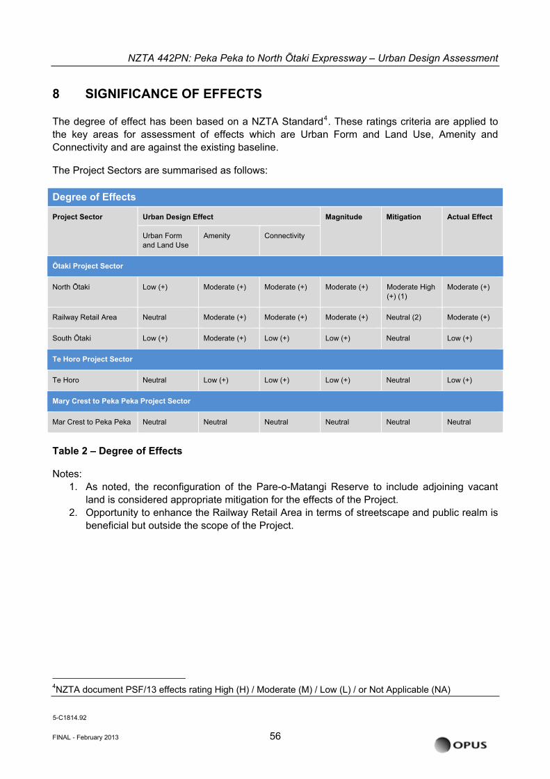
NZTA 442PN: Peka Peka to North Õtaki Expressway – Urban Design Assessment
8 SIGNIFICANCE OF EFFECTS
The degree of effect has been based on a NZTA Standard4. These ratings criteria are applied to the key areas for assessment of effects which are Urban Form and Land Use, Amenity and Connectivity and are against the existing baseline.
The Project Sectors are summarised as follows: Degree of Effects
Project Sector Urban Design Effect Magnitude Mitigation Actual Effect
Urban Form and Land Use
Amenity Connectivity
Ōtaki Project Sector
North Ōtaki Low (+) Moderate (+) Moderate (+) Moderate (+) Moderate High (+) (1)
Moderate (+)
Railway Retail Area Neutral Moderate (+) Moderate (+) Moderate (+) Neutral (2) Moderate (+)
South Ōtaki Low (+) Moderate (+) Low (+) Low (+) Neutral Low (+)
Te Horo Project Sector
Te Horo Neutral Low (+) Low (+) Low (+) Neutral Low (+)
Mary Crest to Peka Peka Project Sector
Mar Crest to Peka Peka Neutral Neutral Neutral Neutral Neutral Neutral
Table 2 – Degree of Effects
Notes: 1. As noted, the reconfiguration of the Pare-o-Matangi Reserve to include adjoining vacant
land is considered appropriate mitigation for the effects of the Project. 2. Opportunity to enhance the Railway Retail Area in terms of streetscape and public realm is
beneficial but outside the scope of the Project.
4NZTA document PSF/13 effects rating High (H) / Moderate (M) / Low (L) / or Not Applicable (NA)
5-C1814.92
FINAL - February 2013 56
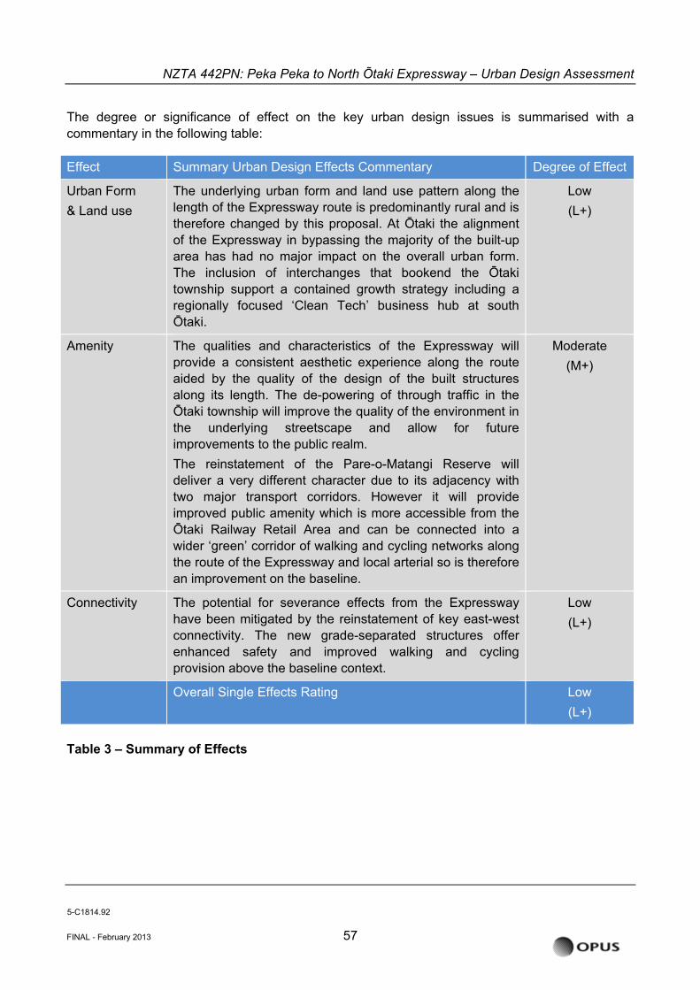
NZTA 442PN: Peka Peka to North Õtaki Expressway – Urban Design Assessment
The degree or significance of effect on the key urban design issues is summarised with a commentary in the following table:
Effect Summary Urban Design Effects Commentary Degree of Effect
Urban Form & Land use
The underlying urban form and land use pattern along the length of the Expressway route is predominantly rural and is therefore changed by this proposal. At Ōtaki the alignment of the Expressway in bypassing the majority of the built-up area has had no major impact on the overall urban form. The inclusion of interchanges that bookend the Ōtaki township support a contained growth strategy including a regionally focused ‘Clean Tech’ business hub at south Ōtaki.
Low (L+)
Amenity The qualities and characteristics of the Expressway will provide a consistent aesthetic experience along the route aided by the quality of the design of the built structures along its length. The de-powering of through traffic in the Ōtaki township will improve the quality of the environment in the underlying streetscape and allow for future improvements to the public realm. The reinstatement of the Pare-o-Matangi Reserve will deliver a very different character due to its adjacency with two major transport corridors. However it will provide improved public amenity which is more accessible from the Ōtaki Railway Retail Area and can be connected into a wider ‘green’ corridor of walking and cycling networks along the route of the Expressway and local arterial so is therefore an improvement on the baseline.
Moderate (M+)
Connectivity The potential for severance effects from the Expressway have been mitigated by the reinstatement of key east-west connectivity. The new grade-separated structures offer enhanced safety and improved walking and cycling provision above the baseline context.
Low (L+)
Overall Single Effects Rating Low (L+)
Table 3 – Summary of Effects
5-C1814.92
FINAL - February 2013 57
NZTA 442PN: Peka Peka to North Õtaki Expressway – Urban Design Assessment
9 ABILITY TO AVOID/REMEDY/MITIGATE EFFECTS
9.1 Urban and Landscape Design Framework Mitigation Guidelines
Various measures have been incorporated into the design of the Project and subsequent measures proposed, so as to align with the purpose and principle of the RMA that includes ‘avoiding, remedying and mitigating’ any adverse effects. The Project’s ULDF ‘sets the scene’ for these design and mitigation measures in providing corridor wide design principles and objectives; these are listed at Section 14 Appendices.
9.2 Potential Additional Mitigation Measures
Potential additional mitigation measures are identified below:
In terms of amenity values a key opportunity for the Expressway exists in the offset mitigation proposed for the enhanced Pare-o-Matangi Reserve, which is located directly to the north of the reinstated Rahui Road Expressway and railway crossing. This is dealt with in more detail in the Landscape and Visual Effects Assessment but it is important to also note in the wider context of this Urban Design Report. The amenity values afforded by this green space directly adjacent to the Railway Retail Area cannot be understated, nor can the significant community input already invested in developing this area by the local ‘Keep Ōtaki Beautiful’ organisation. In the latest consultation round KCDC have also noted in their submission that the proposed Pare-o-Matangi Reserve space is a key mitigation opportunity and KCDC supports the current proposal.
The revocation of the existing SH1 will also be an extremely important part of the success of the urban design outcomes for primarily the Ōtaki township section but also along the remainder of the existing route which is to be reclassified as a Local Arterial. With appropriate linkages and crossings to enable connectivity between either side of the Expressway, the existing SH1 will provide a functional route for local traffic and will form part of an integrated network.
Although the Expressway includes linkages to the existing SH1 and local roads, and the construction of a new section of SH1 to replace that built over by the Expressway, any redevelopment of the existing SH1 itself does not form part of this application. Any development of this road will be undertaken in the future and any required approvals sought at that time.
The Expressway proposal does not prevent the construction of parallel walking and cycling facilities along the existing SH1 corridor. Such features are not part of this application. They will be addressed through the SH1 revocation process, whereby the section of SH1 no longer required as State highway is transferred to KCDC. Final decisions on the form of SH1 and any re-development of this are not yet made, however high level principles have been agreed between NZTA and KCDC. These principles will be used, in conjunction with KCDC, to refine the re-development requirements for SH1.
5-C1814.92
FINAL - February 2013 58
NZTA 442PN: Peka Peka to North Õtaki Expressway – Urban Design Assessment
There are minor residual effects due to the severance of existing minor cross corridor connectivity which are primarily around access to individual properties, or collection of properties. While these connections have been rerouted there will be increased journey times for some individual property owners which were considered by the team in the MCAT process to be acceptable.
10 SUGGESTED CHANGES
There are no major or significant changes suggested to the proposed alignment of the Expressway to further mitigate the urban design effects outlined above.
5-C1814.92
FINAL - February 2013 59
NZTA 442PN: Peka Peka to North Õtaki Expressway – Urban Design Assessment
11 CONCLUSION
In conclusion the overall urban design outcome is rated as low (positive).
The existing urban form (natural and built environment) and land use patterns are not significantly disrupted as the Expressway alignment broadly follows the existing rail corridor on what is predominantly rural land. In particular the retention of the underlying urban form within the Ōtaki Township is a good urban design result. Importantly the current cross-corridor connections are retained, with one exception at Old Hautere Road, and in the case of North Ōtaki are in fact enhanced with improved pedestrian and cycleway provision. This is a positive outcome on the potential for community severance with a new transport corridor.
The suggested additional mitigation measures will improve the finer level outcomes of the Expressway around walking and cycling connectivity and networks. By removing the State highway traffic from the existing urban / residential street network there will be improved outcomes for local residents in connectivity across the urban grain – particularly from the Waitohu plateau residential area to Main Street, and other community, retail and community facilities in the west. While this focus on secondary connectivity modes is of particular benefit in the Ōtaki Township with a higher population density, this focus on walking and cycling connectivity and networks will have a positive effect on the full project route.
This reduction in through traffic will change the nature of the existing SH1 retail area. Economic, social and traffic effects are covered in other specialist reports. In urban design terms the underlying urban street pattern in Ōtaki is unchanged, with cross connections reinstated at the Ramp and at Rahui Road. While the railway station is rotated on its site to accommodate a realigned NIMT importantly it still forms the visual termination to Arthur Street, which in turn is the minor cross axis of the railway retail area.
Overall the majority of effects of the Expressway in the Urban Design context have primarily been avoided, remedied or mitigated through an integrated design approach. Any residual urban design effects are acceptable in my expert opinion and can be further mitigated by good urban design principles and implementation of secondary connectivity and streetscape.
Additional opportunities which sit outside the scope of this assessment are the quality of the urban design of the SH1 revocation process, and any additional opportunities for enhancement of the public realm which exist with the improved environment through Ōtaki with reduced through traffic volumes.
Overall the alignment and connectivity provided by the Expressway support good patterns of urban form, land use and amenity. The future successful implementation of the Project in urban design terms lies with a focus on the next phases of detailed design of structures, pedestrian and cycling provision along the full project route (particularly north-south movement) and connectivity and an emphasis on high-quality design outcomes for the revocation process and any public realm enhancement.
5-C1814.92
FINAL - February 2013 60
NZTA 442PN: Peka Peka to North Õtaki Expressway – Urban Design Assessment
12 REFERENCES
The following are key background documents that have formed the basis of this urban design assessment:
• New Zealand Urban Design Protocol (MfE)
• The Urban Design Policy (NZTA)
• Peka Peka to North Ōtaki Expressway Project Objectives
• Peka Peka to North Ōtaki Expressway Urban and Landscape Design Framework, prepared for NZTA by Opus International Consultants Ltd, September 2012 – draft status
• Peka Peka to North Ōtaki Expressway (Ōtaki North to Rahui Road Section) Landscape and Visual Assessment (Effects on Ōtaki North to Rahui Road, the Pare-o-Matangi Reserve and Recommended Mitigation Measures)
• Current Peka Peka to North Ōtaki Expressway reports i.e. Alternative Corridors Technical Feasibility, SARA Specialist Report – Urban Design, along with associated scheme drawings
• Ōtaki Vision Document (Ōtaki Community Board/KCDC)
• KCDC’s submission to the 2009 consultation in particular the Urban Design Review carried out by Common Ground Studio.
• KCDC’s submission to the 2011 consultations (March 18th 2011 received)
• KCDC’s submission on the Peka Peka to North Ōtaki Expressway Project, dated 21st August 2012
• Peka Peka to North Ōtaki Expressway Project MCAT Assessments - Urban Design Criteria
5-C1814.92
FINAL - February 2013 61