Embed Size (px)
Citation preview
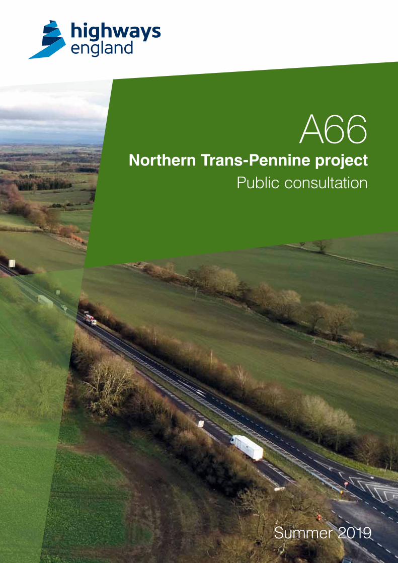
Summer 2019
A66Northern Trans-Pennine project
Public consultation
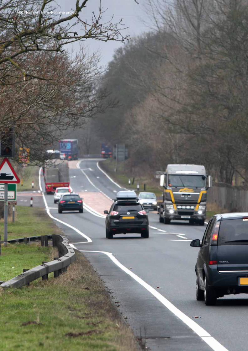
A66 Northern Trans-Pennine project
Public consultation
Contents
Foreword .........................................................................................................................................2
Investing in your roads ....................................................................................................................3
How to respond ..............................................................................................................................4
Consultation events ........................................................................................................................4
Where to get further information ...............................................................................................5
The positive strategic impact of improving the A66 .........................................................................6
Why we need this project ................................................................................................................7
The options .....................................................................................................................................9
M6 junction 40 to Kemplay Bank roundabout (A66/A6 interchange) ...................................... 10
Penrith to Temple Sowerby .................................................................................................... 12
Temple Sowerby to Appleby – Kirkby Thore .......................................................................... 14
Temple Sowerby to Appleby – Crackenthorpe ....................................................................... 16
Appleby to Brough ................................................................................................................. 18
Bowes Bypass .......................................................................................................................20
Cross Lanes to Rokeby ..........................................................................................................22
Stephen Bank to Carkin Moor ................................................................................................ 24
Junctions ......................................................................................................................................27
How we propose to reduce impacts ..............................................................................................28
Discounted options .......................................................................................................................29
Next steps .....................................................................................................................................32
1
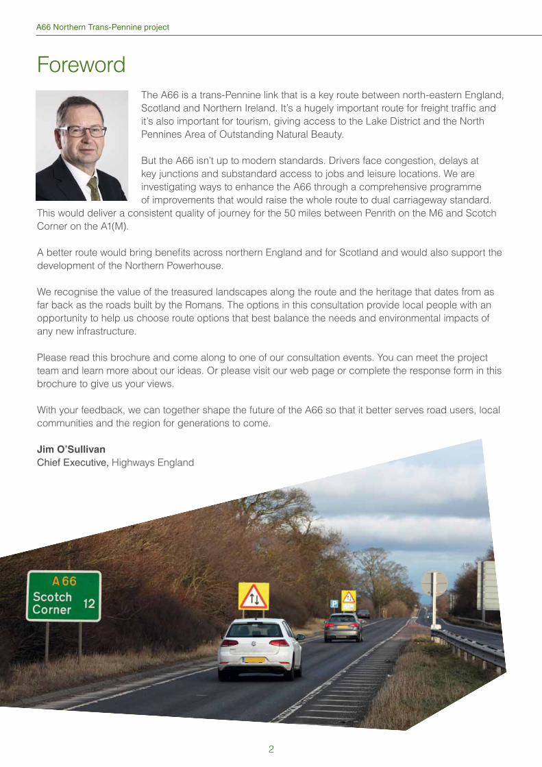
A66 Northern Trans-Pennine project
Foreword
The A66 is a trans-Pennine link that is a key route between north-eastern England,
Scotland and Northern Ireland. It’s a hugely important route for freight traffi c and
it’s also important for tourism, giving access to the Lake District and the North
Pennines Area of Outstanding Natural Beauty.
But the A66 isn’t up to modern standards. Drivers face congestion, delays at
key junctions and substandard access to jobs and leisure locations. We are
investigating ways to enhance the A66 through a comprehensive programme
of improvements that would raise the whole route to dual carriageway standard.
This would deliver a consistent quality of journey for the 50 miles between Penrith on the M6 and Scotch
Corner on the A1(M).
A better route would bring benefi ts across northern England and for Scotland and would also support the
development of the Northern Powerhouse.
We recognise the value of the treasured landscapes along the route and the heritage that dates from as
far back as the roads built by the Romans. The options in this consultation provide local people with an
opportunity to help us choose route options that best balance the needs and environmental impacts of
any new infrastructure.
Please read this brochure and come along to one of our consultation events. You can meet the project
team and learn more about our ideas. Or please visit our web page or complete the response form in this
brochure to give us your views.
With your feedback, we can together shape the future of the A66 so that it better serves road users, local
communities and the region for generations to come.
Jim O’Sullivan
Chief Executive, Highways England
2
Public consultation
Investing in your roads
At Highways England we believe in a connected
country and our network makes these connections
happen. We strive to improve our major roads and
motorways - engineering the future to keep people
moving today and moving better tomorrow. We
want to make sure all our major roads are more
dependable, durable and, most importantly, safe.
We have been commissioned by the Department
for Transport (DfT) to investigate the potential to
improve the A66 between M6 junction 40 at Penrith
and the A1(M) at Scotch Corner. This is in order to
address the lack of east / west connectivity across
the Pennines in the north of England.
This is one of the most important highways
investments in the North of England and will
signifi cantly improve journey times and driver
experience while drastically reducing the number of
accidents on this critical local and national route.
We are proposing to invest around one billion
pounds to dual the remaining single carriageway
sections of the A66. This will signifi cantly improve
journeys, safety and connectivity, which is great
news for the local, regional and national economy.
Our planned improvements for the road and a
modern approach to design will help protect the
local environment and important designated areas
such as local historic sites.
The project will involve dualling multiple sections
of single carriageway between M6 junction 40
at Penrith and the A1(M) at Scotch Corner. Other
improvements are proposed along its length, such
as at Kemplay Roundabout and the junctions with
the M6 and A1(M). This work is important to enable
future growth and will help the economies of both
the North East and Cumbria, as well as improving
journeys across the country.
The A66 has been upgraded from single
carriageway to dual in a number of stages since
the 1970s, with the most recent dual section,
the Temple Sowerby Bypass, opening in 2007.
However, more than 18 miles of single carriageway
remain making the route accident-prone and
unreliable.
In 2014, the government announced that it intended
to examine the case for dualling one of the routes
across the Pennines in the north of England. In
2017, it was announced that the A66 had presented
the strongest case for an upgrade and that plans
for full dualling between the M6 junction 40 and the
A1(M) at Scotch Corner would be developed for the
next Road Investment Strategy.
Our plans will ensure the entire route has two lanes
in both directions along the full 50-mile route.
In 2003, we consulted on similar proposals but
were unable to progress these at the time. However,
the feedback we received has been very useful and
has helped us to develop the current proposals.
In this brochure we explain our proposals and
provide maps with further information. We will also
give details of how you can give us your feedback
during this public consultation.
This is a non-statutory public consultation on our
options for the project, the results of which will help
to inform our decision about which option to take
forward. It is not the only time we’ll be consulting on
the A66 improvements.
While there is no legal obligation for us to undertake
a non-statutory consultation, we are passionate
about understanding people’s views on our
proposals early in the process, enabling us to refi ne
the design by involving the community before we
carry out a further consultation process on the
design of our preferred route. This will give you
another opportunity to get involved and share your
views.
Following this, we will then make an application
for a Development Consent Order (DCO) to obtain
planning permission to build it. This is required
because this project is categorised as a Nationally
Signifi cant Infrastructure Project (NSIP) under the
Planning Act 2008.
3
A66 Northern Trans-Pennine project
How to respond
We’re holding a public consultation on our
proposals and we’d like to hear what you think,
so please share any concerns, ideas or local
knowledge that you may have.
The consultation will run for eight weeks from 16
May 2019 to 11 July 2019 and there are lots of
ways you can tell us what you think. You can come
along to one of our public consultation events or
you can write to us by post or email. Details of how
you can respond are below.
Your comments will help us better understand the
local area and any potential impacts our project
may have on the community. We will listen to
everyone’s feedback and we’ll consider these
before we select a preferred option.
Please respond using one of the following methods
by midnight on Thursday 11 July 2019.
Online: complete the response form online at
www.highwaysengland.co.uk/A66TransPennine
Response form: Complete the consultation
response form in this brochure and return it
using the Freepost envelope provided
Email: send your response by email to:
Post: write to us at Freepost A66 NORTHERN
TRANS-PENNINE PROJECT
All responses should be returned by the date and
time above to ensure we can consider them when
we are refi ning the design.
Consultation events
One of the best ways to fi nd out more about our
proposals and have your say is to come to one of
our consultation events. This is a major investment
and we are keen to talk to as many people as
possible to ensure all the positive benefi ts are
realised and to minimise any impacts on local
people.
At the events, you’ll be able to fi nd out more about
this transformational project and speak to members
of the project team, who will be happy to answer
any questions.
We will be at key locations listed below. These
are drop-in events so there is no need to book an
appointment.
All venues are fully accessible.
Thursday 16 May, 1.30pm – 7pmGilling West Village Hall, High Street,
Gilling West, Richmond, DL10 5JG
Friday 17 May, 11am – 7pm and
Saturday 18 May, 10am – 2pmAW Jenkinson Suite (ground fl oor),
Penrith Rugby Club, Winters Park, Penrith,
CA11 8RQ
Wednesday 22 May, 11am – 7pm and
Thursday 23 May, 11am – 7pmGilling West Village Hall, High Street,
Gilling West, Richmond, DL10 5JG
Wednesday 29 May, 11am – 7pm,Thursday 30 May, 10am – 3pm,Friday 31 May, 11am – 7pm and
Saturday 1 June, 10am – 2pmMain Hall (ground fl oor), The Appleby Hub,
Chapel Street, Appleby-in-Westmorland,
CA16 6QR
Tuesday 4 June, 11am – 7pm,Wednesday 5 June, 10am – 2pm and
Thursday 6 June, 10am – 2pmThe Lake Room (1st fl oor), The Rooms,
Penrith Parish Centre, St Andrews Place,
Penrith, CA11 7XX
4
Public consultation
Wednesday 12 June, 11am – 7pm,Thursday 13 June, 11am – 7pm,Friday 14 June, 11am – 7pm and
Saturday 15 June, 10am – 2pmThe Witham Room (1st fl oor), The Witham,
3 Horse Market, Barnard Castle,
DL12 8LY
Monday 17 June, 10am – 2pm and
Tuesday 18 June, 11am – 7pmThe Lake Room (1st fl oor), The Rooms,
Penrith Parish Centre, St Andrews Place,
Penrith, CA11 7XX
Friday 21 June, 11am – 7pm and
Saturday 22 June, 12pm – 4pmTownsend Suite (1st fl oor), The Station,
Station Yard, Richmond,
DL10 4LD
All of the above venues are well-served by
public transport, however, if travelling by car,
attendees should be aware of the following parking
arrangements.
Penrith Parish Centre – there is no on-site
parking so, if travelling by car, please use local car
parks. The nearest disabled parking is located on
Friargate.
Penrith Rugby Club – free on-site parking for up
to 60 cars.
Gilling West Village Hall, Richmond – on-street
parking only.
The Appleby Hub – pay and display car parking at
Broad Close.
The Witham, Barnard Castle – on-street parking
only.
The Station, Richmond – pay and display car
parking between 8am and 4pm (free after 4pm)
Where to get further information
Further copies of this brochure and response
form are available at several public locations
across the A66 from Thursday 16 May. The full
list is available here www.highwaysengland.co.uk/A66TransPennine and availability will depend on
opening times of each of the locations.
Responses can be handed in at consultation
events or sent to the address provided on the form.
If you wish to read our public consultation strategy
on how we are conducting this consultation, please
visit www.highwaysengland.co.uk/A66TransPennine
5
A66 Northern Trans-Pennine project
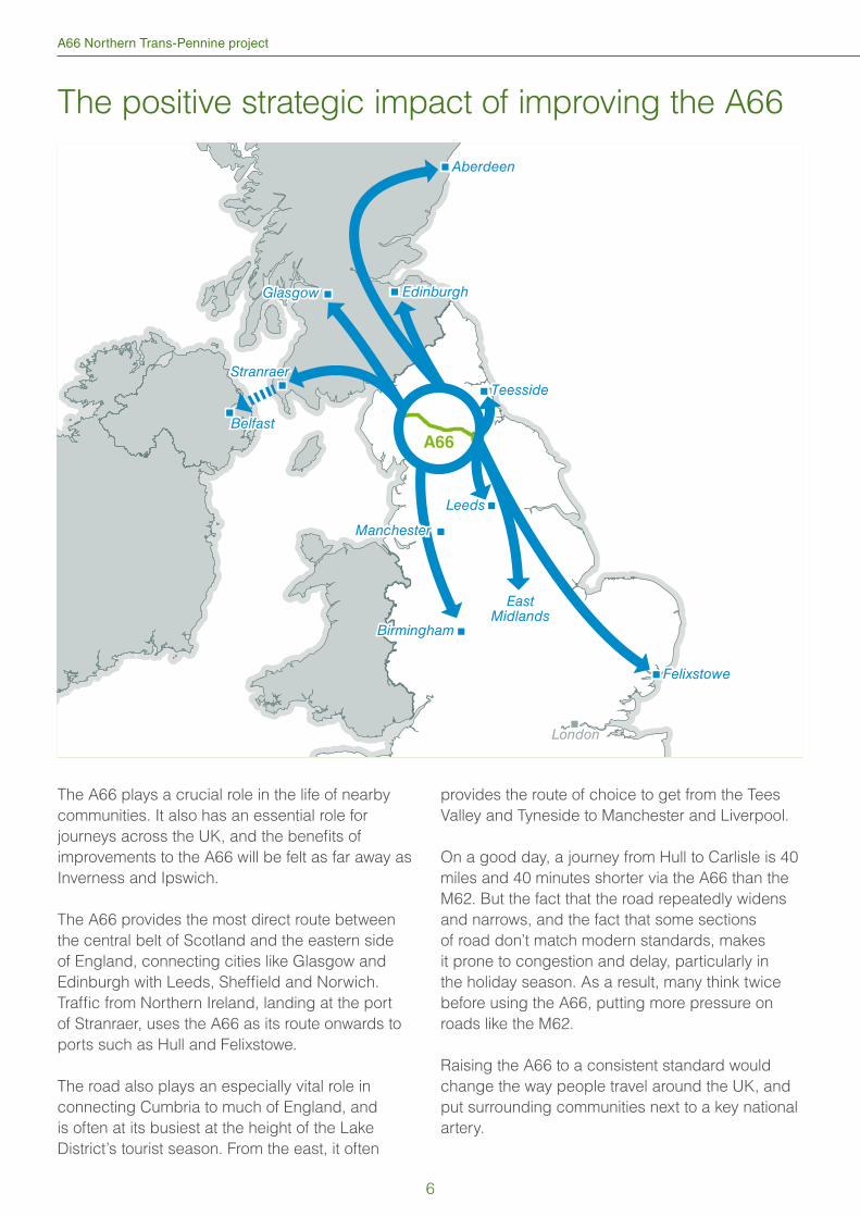
The A66 plays a crucial role in the life of nearby
communities. It also has an essential role for
journeys across the UK, and the benefi ts of
improvements to the A66 will be felt as far away as
Inverness and Ipswich.
The A66 provides the most direct route between
the central belt of Scotland and the eastern side
of England, connecting cities like Glasgow and
Edinburgh with Leeds, Sheffi eld and Norwich.
Traffi c from Northern Ireland, landing at the port
of Stranraer, uses the A66 as its route onwards to
ports such as Hull and Felixstowe.
The road also plays an especially vital role in
connecting Cumbria to much of England, and
is often at its busiest at the height of the Lake
District’s tourist season. From the east, it often
provides the route of choice to get from the Tees
Valley and Tyneside to Manchester and Liverpool.
On a good day, a journey from Hull to Carlisle is 40
miles and 40 minutes shorter via the A66 than the
M62. But the fact that the road repeatedly widens
and narrows, and the fact that some sections
of road don’t match modern standards, makes
it prone to congestion and delay, particularly in
the holiday season. As a result, many think twice
before using the A66, putting more pressure on
roads like the M62.
Raising the A66 to a consistent standard would
change the way people travel around the UK, and
put surrounding communities next to a key national
artery.
A66
Teesside
Glasgow Edinburgh
Birmingham
EastMidlands
London
Felixstowe
Stranraer
BelfastBelfast
LeedsLeeds
Aberdeen
Manchester
The positive strategic impact of improving the A66
6
Public consultation
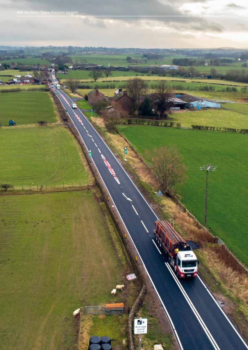
Why we need this project
The A66 between M6 junction 40 and A1(M) at
Scotch Corner is 50 miles long, 18 miles of which is
in single lane sections.
It is both a key local road and a national and
regional strategic link, carrying high levels of freight
traffi c, as well as being an important route for
tourism. Additionally, the route not only links the
east and west but is the best available option for
traffi c travelling between the east of England and
the west of Scotland.
Despite several upgrades to the route since the
1970s, the A66 still suffers from congestion,
unreliable journey times and a higher-than-average
number of accidents. Bad weather can severely
impact conditions on the road, resulting in closures
which are frustrating for road users, including
hauliers.
This project will deliver a number of benefi ts
for local communities with faster journey times,
improved accessibility and better local connectivity
through utilising the ‘old’ A66 and connecting to the
local road network.
It will also be good news for all road users who
will have greater confi dence in getting to their
destinations on time.
The objectives of the A66 Northern Trans-Pennine project are split as follows:
Safety – A consistent standard of dual carriageway,
with the same speed limit throughout, may reduce
the number of accidents. Use of the ‘old’ A66 as
part of the local road network will provide better,
safer routes for cyclists and pedestrians.
Connectivity – Improving connectivity for people
living and working nearby and creating better
facilities for cyclists and pedestrians. Reducing
congestion and improving the reliability of people’s
journeys between the M6 at Penrith and the A1(M)
Scotch Corner and nationwide. It also improves
connectivity between the key employment areas of
Cumbria, Tees Valley and Tyne and Wear.
Environmental – Minimising noise levels for
people living and working near the route and
reducing the congestion currently occurring in
the single carriageway sections. The project is
also being designed to minimise any potential
negative impacts on the natural environment
and landscapes of the North Pennines and Lake
District.
Economic – Improving strategic regional and
national connectivity, particularly for hauliers.
Heavy goods vehicles account for a quarter of all
traffi c on the road and any delays to journeys can
have an extremely negative effect on business and
commerce, including lost working time and missed
shipment slots.
Tourism – Improving access to key tourist
destinations such as the North Pennines and Lake
District.
Community – Re-connecting communities and
providing better links between settlements along
the route as well as improving access to services
such as healthcare, employment areas and
education.
Capacity – Reducing delays and queues during
busy periods and improving the performance
of key junctions such as the A66/A6 and the M6
junction 40.
Increasing reliability – An improved A66, with
consistent speed limits, will lead to less accidents
which, in turn, makes the road more reliable. Also,
having a dual carriageway provides the option to
close lanes where required due to accidents or
break downs and still keep traffi c moving.
7
8
A66 Northern Trans-Pennine project
Public consultation
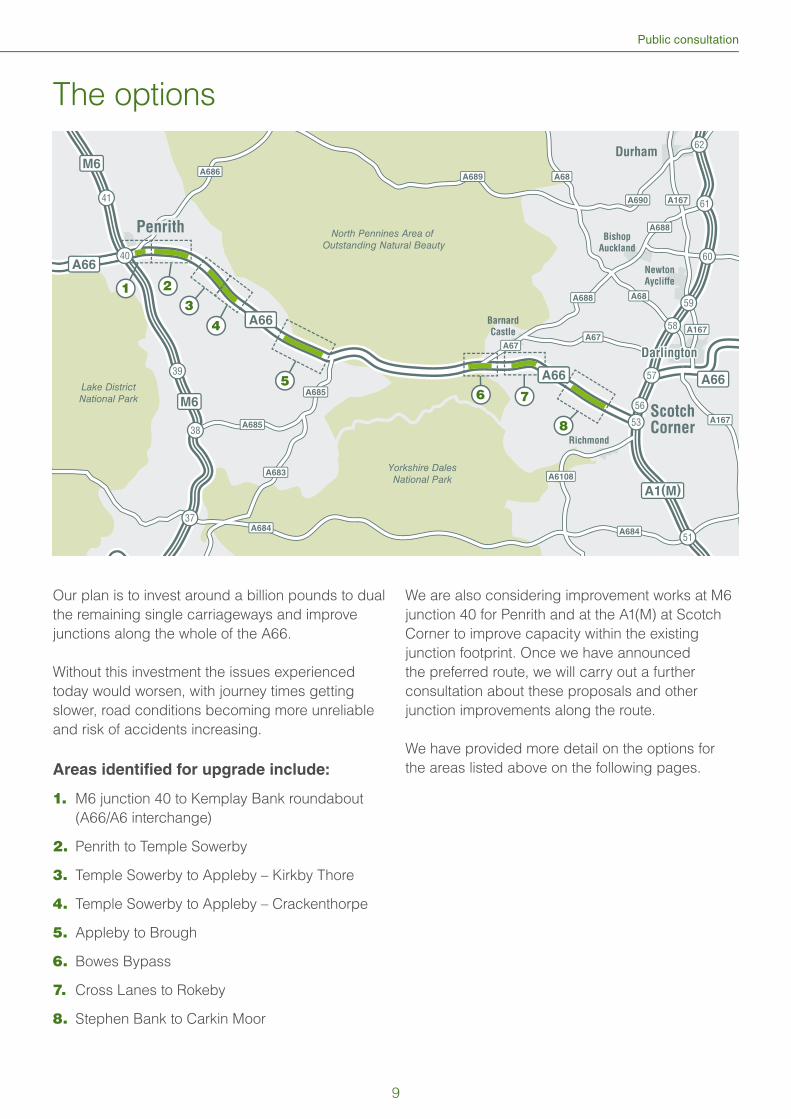
The options
Our plan is to invest around a billion pounds to dual
the remaining single carriageways and improve
junctions along the whole of the A66.
Without this investment the issues experienced
today would worsen, with journey times getting
slower, road conditions becoming more unreliable
and risk of accidents increasing.
Areas identified for upgrade include:
1. M6 junction 40 to Kemplay Bank roundabout
(A66/A6 interchange)
2. Penrith to Temple Sowerby
3. Temple Sowerby to Appleby – Kirkby Thore
4. Temple Sowerby to Appleby – Crackenthorpe
5. Appleby to Brough
6. Bowes Bypass
7. Cross Lanes to Rokeby
8. Stephen Bank to Carkin Moor
We are also considering improvement works at M6
junction 40 for Penrith and at the A1(M) at Scotch
Corner to improve capacity within the existing
junction footprint. Once we have announced
the preferred route, we will carry out a further
consultation about these proposals and other
junction improvements along the route.
We have provided more detail on the options for
the areas listed above on the following pages.
56
53
51
37
38
39
41
57
58
59
60
61
62
DarlingtonDarlington
Newton
Aycliffe
Richmond
Barnard
Castle
PenrithPenrith
ScotchCorner
Bishop
Auckland
Durham
A1(M)
A688
A685
A685
A683
A684
A686A689
A688
A690
A6108
A167
A167
A167
A684
A67A67
A68
A68
A66
M6
M6
Lake DistrictNational Park
Yorkshire DalesNational Park
North Pennines Area of Outstanding Natural Beauty
A66
A66A66
A66
213
4
56 7
8
40
A66
9
A66 Northern Trans-Pennine project
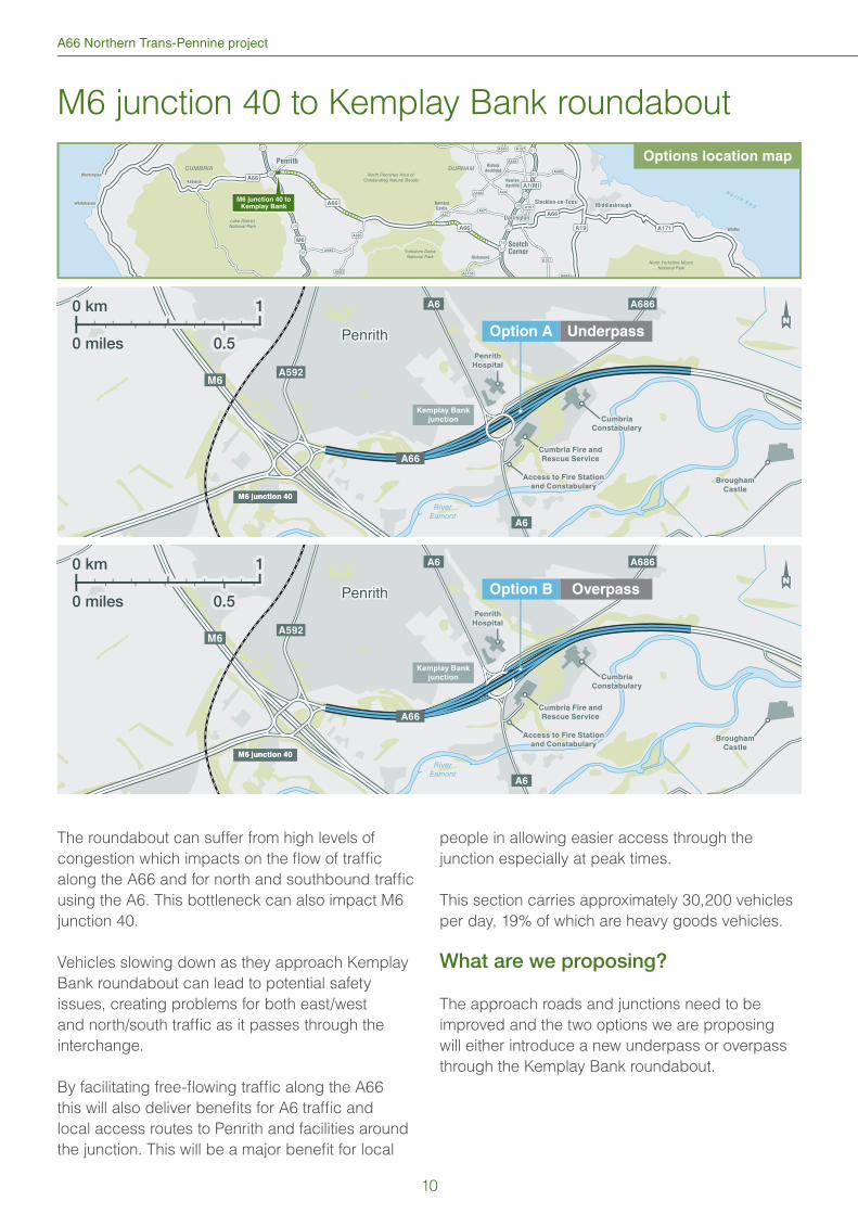
M6 junction 40 to Kemplay Bank roundabout
The roundabout can suffer from high levels of
congestion which impacts on the fl ow of traffi c
along the A66 and for north and southbound traffi c
using the A6. This bottleneck can also impact M6
junction 40.
Vehicles slowing down as they approach Kemplay
Bank roundabout can lead to potential safety
issues, creating problems for both east/west
and north/south traffi c as it passes through the
interchange.
By facilitating free-fl owing traffi c along the A66
this will also deliver benefi ts for A6 traffi c and
local access routes to Penrith and facilities around
the junction. This will be a major benefi t for local
people in allowing easier access through the
junction especially at peak times.
This section carries approximately 30,200 vehicles
per day, 19% of which are heavy goods vehicles.
What are we proposing?
The approach roads and junctions need to be
improved and the two options we are proposing
will either introduce a new underpass or overpass
through the Kemplay Bank roundabout.
38
39
41
57
58
59
60
61
CUMBRIA DURHAM
DarlingtonDarlington
Stockton-on-TeesStockton-on-TeesMiddlesbroughMiddlesbrough
Newton
Aycliffe
Richmond
Barnard
Castle
PenrithPenrith
ScotchCorner
Bishop
Auckland
A1(M)
A689
A688
A685
A685
A683
A688
A690
A6108
A167
A167
A167
A684
A67A67
A68
A19
A66
M6
N o r t h S e a
Lake DistrictNational Park
Yorkshire DalesNational Park
North Pennines Area of Outstanding Natural BeautyA66
A66
A171 WhitbyWhitby
North Yorkshire MoorsNational Park
5653
WorkingtonWorkington
WhitehavenWhitehaven
KeswickKeswick
40
A66
M6 junction 40 toKemplay Bank
RiverEamont
Penrith
Brougham
Castle
Option A Underpass
A66
A592
A686A6
A6
M6
Cumbria Fire and
Rescue Service
Access to Fire Station
and Constabulary
Cumbria
Constabulary
Cumbria
Constabulary
M6 junction 40M6 junction 40
Penrith
Hospital
Penrith
Hospital
0 km 1
0 miles 0.5
Kemplay Bank
junction
RiverEamont
Penrith
A66
A592
A686A6
A6
Cumbria Fire and
Rescue Service
Access to Fire Station
and Constabulary
Cumbria
Constabulary
Cumbria
Constabulary
M6 junction 40M6 junction 40
Option B Overpass
Penrith
Hospital
Penrith
Hospital
Kemplay Bank
junction
Brougham
Castle
M6
0 km 1
0 miles 0.5
Options location map
10
Public consultation
Option A (underpass)
A new dual carriageway under Kemplay Bank
roundabout providing an un-interrupted route for
the A66 east and westbound.
This option would require signifi cant work on each
of the arms of the roundabout, new retaining wall
and bridge installations and the reconstruction of
the roundabout itself.
The underpass serving the police and fi re services
would need to be removed and an alternative new
access road constructed that would link into The
Green, providing access to all the facilities in the
south east of the junction.
Option B (overpass)
A new dual carriageway over the existing Kemplay
Bank roundabout providing an uninterrupted route
for the A66 eastbound and westbound.
All other elements of this option would be the same
as Option A.
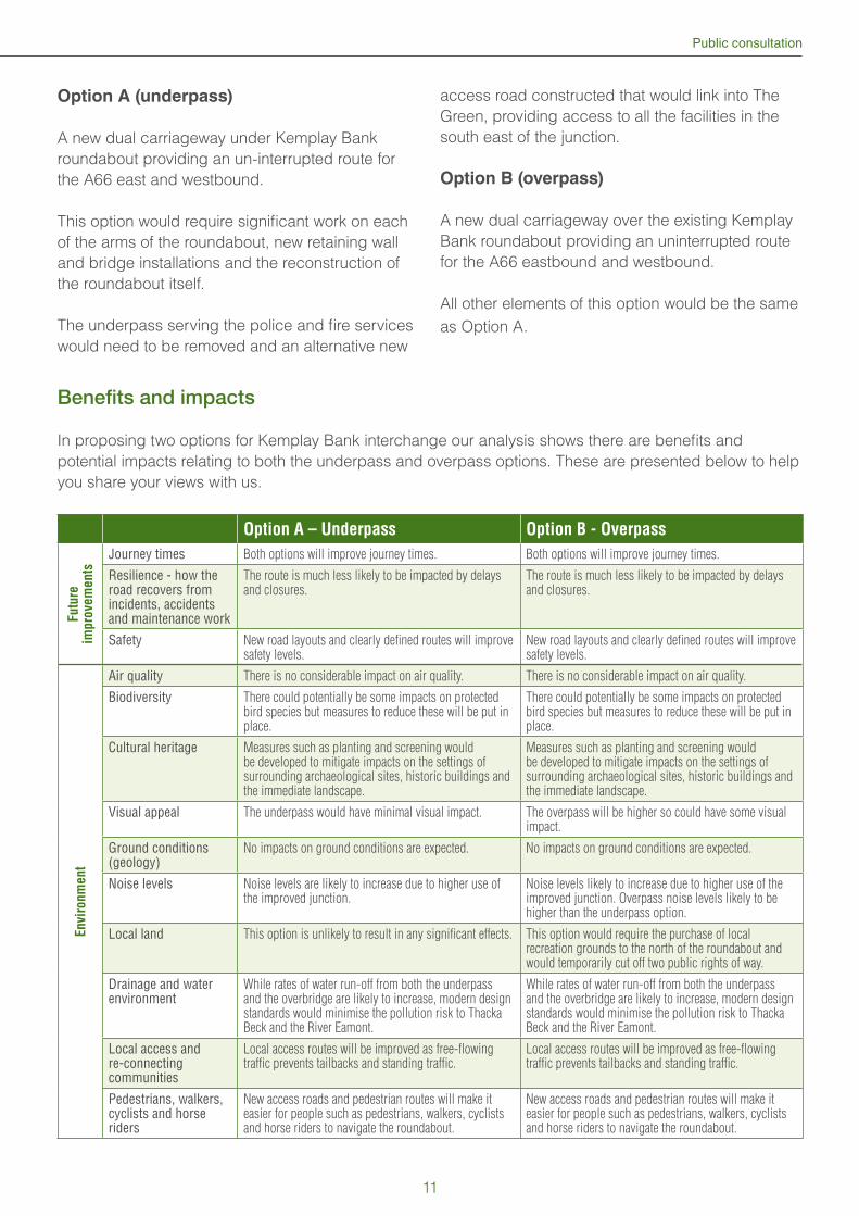
Benefi ts and impacts
In proposing two options for Kemplay Bank interchange our analysis shows there are benefi ts and
potential impacts relating to both the underpass and overpass options. These are presented below to help
you share your views with us.
Option A – Underpass Option B - Overpass
Futu
re
impro
vem
ents
Journey times Both options will improve journey times. Both options will improve journey times.
Resilience - how the road recovers from incidents, accidents and maintenance work
The route is much less likely to be impacted by delays and closures.
The route is much less likely to be impacted by delays and closures.
Safety New road layouts and clearly defi ned routes will improve safety levels.
New road layouts and clearly defi ned routes will improve safety levels.
Envi
ronm
ent
Air quality There is no considerable impact on air quality. There is no considerable impact on air quality.
Biodiversity There could potentially be some impacts on protected bird species but measures to reduce these will be put in place.
There could potentially be some impacts on protected bird species but measures to reduce these will be put in place.
Cultural heritage Measures such as planting and screening would be developed to mitigate impacts on the settings of surrounding archaeological sites, historic buildings and the immediate landscape.
Measures such as planting and screening would be developed to mitigate impacts on the settings of surrounding archaeological sites, historic buildings and the immediate landscape.
Visual appeal The underpass would have minimal visual impact. The overpass will be higher so could have some visual impact.
Ground conditions (geology)
No impacts on ground conditions are expected. No impacts on ground conditions are expected.
Noise levels Noise levels are likely to increase due to higher use of the improved junction.
Noise levels likely to increase due to higher use of the improved junction. Overpass noise levels likely to be higher than the underpass option.
Local land This option is unlikely to result in any signifi cant effects. This option would require the purchase of local recreation grounds to the north of the roundabout and would temporarily cut off two public rights of way.
Drainage and water environment
While rates of water run-off from both the underpass and the overbridge are likely to increase, modern design standards would minimise the pollution risk to Thacka Beck and the River Eamont.
While rates of water run-off from both the underpass and the overbridge are likely to increase, modern design standards would minimise the pollution risk to Thacka Beck and the River Eamont.
Local access and re-connecting communities
Local access routes will be improved as free-fl owing traffi c prevents tailbacks and standing traffi c.
Local access routes will be improved as free-fl owing traffi c prevents tailbacks and standing traffi c.
Pedestrians, walkers, cyclists and horse riders
New access roads and pedestrian routes will make it easier for people such as pedestrians, walkers, cyclists and horse riders to navigate the roundabout.
New access roads and pedestrian routes will make it easier for people such as pedestrians, walkers, cyclists and horse riders to navigate the roundabout.
11
A66 Northern Trans-Pennine project
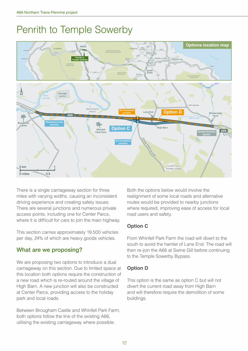
Penrith to Temple Sowerby
There is a single carriageway section for three
miles with varying widths, causing an inconsistent
driving experience and creating safety issues.
There are several junctions and numerous private
access points, including one for Center Parcs,
where it is diffi cult for cars to join the main highway.
This section carries approximately 19,500 vehicles
per day, 24% of which are heavy goods vehicles.
What are we proposing?
We are proposing two options to introduce a dual
carriageway on this section. Due to limited space at
this location both options require the construction of
a new road which is re-routed around the village of
High Barn. A new junction will also be constructed
at Center Parcs, providing access to the holiday
park and local roads.
Between Brougham Castle and Whinfell Park Farm,
both options follow the line of the existing A66,
utilising the existing carriageway where possible.
Both the options below would involve the
realignment of some local roads and alternative
routes would be provided to nearby junctions
where required, improving ease of access for local
road users and safety.
Option C
From Whinfell Park Farm the road will divert to the
south to avoid the hamlet of Lane End. The road will
then re-join the A66 at Swine Gill before continuing
to the Temple Sowerby Bypass.
Option D
This option is the same as option C but will not
divert the current road away from High Barn
and will therefore require the demolition of some
buildings.
38
39
41
57
58
59
60
61
CUMBRIA DURHAM
DarlingtonDarlington
Stockton-on-TeesStockton-on-TeesMiddlesbroughMiddlesbrough
Newton
Aycliffe
Richmond
Barnard
Castle
PenrithPenrith
ScotchCorner
Bishop
Auckland
A1(M)
A689
A688
A685
A685
A683
A688
A690
A6108
A167
A167
A167
A684
A67A67
A68
A19
A66
M6
Lake DistrictNational Park
Yorkshire DalesNational Park
North Pennines Area of Outstanding Natural BeautyA66
A66
A171 WhitbyWhitby
North Yorkshire MoorsNational Park
5653
N o r t h S e a
WorkingtonWorkington
WhitehavenWhitehaven
KeswickKeswick
40
A66
Penrith toTemple Sowerby
Whinfell
Park Farm
RiverEamont
Swine Gill
Ce
nte
r Parcs
ac
c
ess
Westbound only
junctionBrougham
Castle
Option C
Option D
All-movement
junction
All-movement
junction
A66
A66
Center ParcsHoliday Village
BarrackbankWood
BarrackbankWood
Sewage
works
Sewage
works
Lane End
High Barn
Woodside
Winderwath
Farm
0 km 1
0 miles 0.5
Temple Sowerby
bypass
Options location map
12
Public consultation
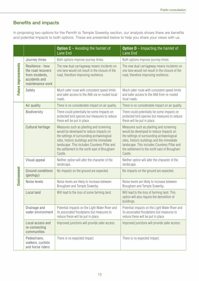
Benefi ts and impacts
In proposing two options for the Penrith to Temple Sowerby section, our analysis shows there are benefi ts
and potential impacts to both options. These are presented below to help you share your views with us.
Option C – Avoiding the hamlet of Lane End
Option D – Impacting the hamlet of Lane End
Fu
ture
im
pro
ve
me
nts
Journey times Both options improve journey times. Both options improve journey times.
Resilience - how the road recovers from incidents, accidents and maintenance work
The new dual carriageway means incidents on
one lane would not result in the closure of the
road, therefore improving resilience.
The new dual carriageway means incidents on
one lane would not result in the closure of the
road, therefore improving resilience.
Safety Much safer route with consistent speed limits
and safer access to the A66 via re-routed local
roads.
Much safer route with consistent speed limits
and safer access to the A66 from re-routed
local roads.
En
vir
on
me
nt
Air quality There is no considerable impact on air quality. There is no considerable impact on air quality.
Biodiversity There could potentially be some impacts on
protected bird species but measures to reduce
these will be put in place.
There could potentially be some impacts on
protected bird species but measures to reduce
these will be put in place.
Cultural heritage Measures such as planting and screening
would be developed to reduce impacts on
the settings of surrounding archaeological
sites, historic buildings and the immediate
landscape. This includes Countess Pillar and
the settlement to the north east of Brougham
Castle.
Measures such as planting and screening
would be developed to reduce impacts on
the settings of surrounding archaeological
sites, historic buildings and the immediate
landscape. This includes Countess Pillar and
the settlement to the north east of Brougham
Castle.
Visual appeal Neither option will alter the character of the
landscape.
Neither option will alter the character of the
landscape.
Ground conditions (geology)
No impacts on the ground are expected. No impacts on the ground are expected.
Noise levels Noise levels are likely to increase between
Brougham and Temple Sowerby.
Noise levels are likely to increase between
Brougham and Temple Sowerby.
Local land Will lead to the loss of some farming land. Will lead to the loss of farming land. This
option will also require the demolition of
buildings.
Drainage and water environment
Potential impacts on the Light Water River and
its associated fl oodplains but measures to
reduce these will be put in place.
Potential impacts on the Light Water River and
its associated fl oodplains but measures to
reduce these will be put in place.
Local access and re-connecting communities
Improved junctions will provide safer access. Improved junctions will provide safer access.
Pedestrians, walkers, cyclists and horse riders
There is no expected impact. There is no expected impact.
13
A66 Northern Trans-Pennine project
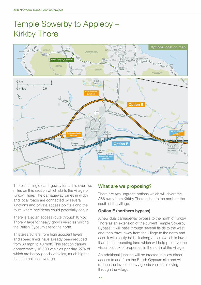
Temple Sowerby to Appleby –
Kirkby Thore
38
39
41
57
58
59
60
61
CUMBRIA DURHAM
DarlingtonDarlington
Stockton-on-TeesStockton-on-TeesMiddlesbroughMiddlesbrough
Newton
Aycliffe
Richmond
Barnard
Castle
PenrithPenrith
ScotchCorner
Bishop
Auckland
A1(M)
A689
A688
A685
A685
A683
A688
A690
A6108
A167
A167
A167
A684
A67A67
A68
A19
A66
M6
Lake DistrictNational Park
Yorkshire DalesNational Park
North Pennines Area of Outstanding Natural BeautyA66
A66
A171 WhitbyWhitby
North Yorkshire MoorsNational Park
5653
N o r t h S e a
WorkingtonWorkington
WhitehavenWhitehaven
KeswickKeswick
40
A66
Temple Sowerby to Appleby – Kirkby Thore
River
RiverEden
RiverEden
Trout Beck
Trout Beck
Disused railway
KirkbyThore
Ma
in S
tre
et
Ma
in S
tre
et
Station R
oad
Sleastonhow Lane
Sleastonhow Lane
Priest LanePriest Lane
Option E
Option F
0 km 1
0 miles 0.5
Westbound only
junction
Eastbound only
junction
Petrol
Station
Petrol
Station
Bridge End
Farm
Bridge End
Farm
Sewage
works
Sewage
works
Scheduled
monument
Scheduled
monument
Scheduled
monument
Scheduled
monument
All-movement
junction
A66
British
Gypsum
All-movement
junction
There is a single carriageway for a little over two
miles on this section which skirts the village of
Kirkby Thore. The carriageway varies in width
and local roads are connected by several
junctions and private access points along the
route where accidents could potentially occur.
There is also an access route through Kirkby
Thore village for heavy goods vehicles visiting
the British Gypsum site to the north.
This area suffers from high accident levels
and speed limits have already been reduced
from 60 mph to 40 mph. This section carries
approximately 16,500 vehicles per day, 27% of
which are heavy goods vehicles, much higher
than the national average.
What are we proposing?
There are two upgrade options which will divert the
A66 away from Kirkby Thore either to the north or the
south of the village.
Option E (northern bypass)
A new dual carriageway bypass to the north of Kirkby
Thore as an extension of the current Temple Sowerby
Bypass. It will pass through several fi elds to the west
and then travel away from the village to the north and
east. It will mostly be built along a route which is lower
than the surrounding land which will help preserve the
visual outlook of properties in the north of the village.
An additional junction will be created to allow direct
access to and from the British Gypsum site and will
reduce the level of heavy goods vehicles moving
through the village.
Options location map
14
Public consultation
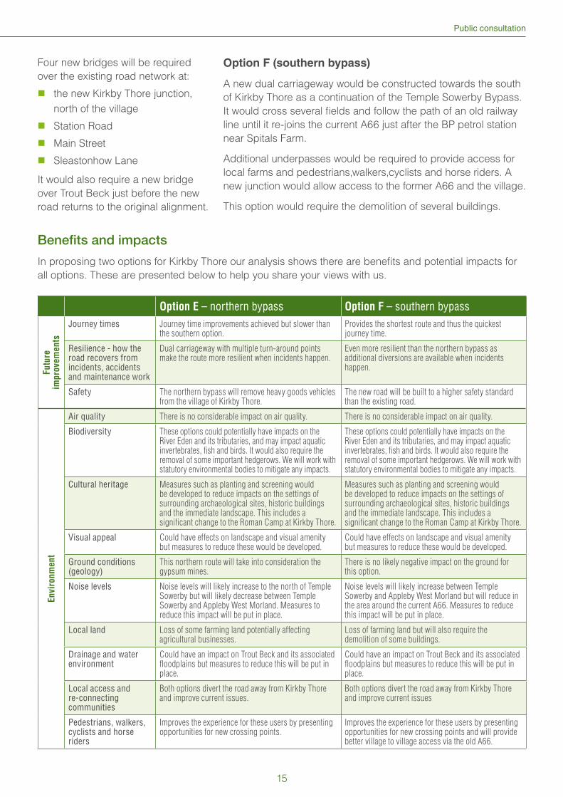
Four new bridges will be required
over the existing road network at:
the new Kirkby Thore junction,
north of the village
Station Road
Main Street
Sleastonhow Lane
It would also require a new bridge
over Trout Beck just before the new
road returns to the original alignment.
Benefi ts and impacts
In proposing two options for Kirkby Thore our analysis shows there are benefi ts and potential impacts for
all options. These are presented below to help you share your views with us.
Option E – northern bypass Option F – southern bypass
Fu
ture
im
pro
ve
me
nts
Journey times Journey time improvements achieved but slower than the southern option.
Provides the shortest route and thus the quickest journey time.
Resilience - how the road recovers from incidents, accidents and maintenance work
Dual carriageway with multiple turn-around points make the route more resilient when incidents happen.
Even more resilient than the northern bypass as additional diversions are available when incidents happen.
Safety The northern bypass will remove heavy goods vehicles from the village of Kirkby Thore.
The new road will be built to a higher safety standard than the existing road.
En
vir
on
me
nt
Air quality There is no considerable impact on air quality. There is no considerable impact on air quality.
Biodiversity These options could potentially have impacts on the River Eden and its tributaries, and may impact aquatic invertebrates, fi sh and birds. It would also require the removal of some important hedgerows. We will work with statutory environmental bodies to mitigate any impacts.
These options could potentially have impacts on the River Eden and its tributaries, and may impact aquatic invertebrates, fi sh and birds. It would also require the removal of some important hedgerows. We will work with statutory environmental bodies to mitigate any impacts.
Cultural heritage Measures such as planting and screening would be developed to reduce impacts on the settings of surrounding archaeological sites, historic buildings and the immediate landscape. This includes a signifi cant change to the Roman Camp at Kirkby Thore.
Measures such as planting and screening would be developed to reduce impacts on the settings of surrounding archaeological sites, historic buildings and the immediate landscape. This includes a signifi cant change to the Roman Camp at Kirkby Thore.
Visual appeal Could have effects on landscape and visual amenity but measures to reduce these would be developed.
Could have effects on landscape and visual amenity but measures to reduce these would be developed.
Ground conditions (geology)
This northern route will take into consideration the gypsum mines.
There is no likely negative impact on the ground for this option.
Noise levels Noise levels will likely increase to the north of Temple Sowerby but will likely decrease between Temple Sowerby and Appleby West Morland. Measures to reduce this impact will be put in place.
Noise levels will likely increase between Temple Sowerby and Appleby West Morland but will reduce in the area around the current A66. Measures to reduce this impact will be put in place.
Local land Loss of some farming land potentially affecting agricultural businesses.
Loss of farming land but will also require the demolition of some buildings.
Drainage and water environment
Could have an impact on Trout Beck and its associated fl oodplains but measures to reduce this will be put in place.
Could have an impact on Trout Beck and its associated fl oodplains but measures to reduce this will be put in place.
Local access and re-connecting communities
Both options divert the road away from Kirkby Thore and improve current issues.
Both options divert the road away from Kirkby Thore and improve current issues
Pedestrians, walkers, cyclists and horse riders
Improves the experience for these users by presenting opportunities for new crossing points.
Improves the experience for these users by presenting opportunities for new crossing points and will provide better village to village access via the old A66.
Option F (southern bypass)
A new dual carriageway would be constructed towards the south
of Kirkby Thore as a continuation of the Temple Sowerby Bypass.
It would cross several fi elds and follow the path of an old railway
line until it re-joins the current A66 just after the BP petrol station
near Spitals Farm.
Additional underpasses would be required to provide access for
local farms and pedestrians,walkers,cyclists and horse riders. A
new junction would allow access to the former A66 and the village.
This option would require the demolition of several buildings.
15
A66 Northern Trans-Pennine project
Temple Sowerby to Appleby –
Crackenthorpe
5653
38
39
41
57
58
59
60
61
CUMBRIA DURHAM
DarlingtonDarlington
Stockton-on-TeesStockton-on-TeesMiddlesbroughMiddlesbrough
Newton
Aycliffe
Richmond
Barnard
Castle
PenrithPenrith
ScotchCorner
Bishop
Auckland
A1(M)
A689
A688
A685
A685
A683
A688
A690
A6108
A167
A167
A167
A684
A67A67
A68
A19
A66
M6
Lake DistrictNational Park
Yorkshire DalesNational Park
North Pennines Area of Outstanding Natural BeautyA66
A66
A171 WhitbyWhitby
North Yorkshire MoorsNational Park
N o r t h S e a
WorkingtonWorkington
WhitehavenWhitehaven
KeswickKeswick
40
A66
Temple Sowerby to Appleby – Crackenthorpe
RiverEden
RiverEden
RiverEden River
Eden
Trout Beck
Bram
pton B
eck
Frith Beck
Roman
road
Roman
road
Roger Head
Farm
Roger Head
Farm
Crackenthorpe
Appleby
Brampton
LongMarton
Option H
Option G
0 km 1
0 miles 0.5
Scheduled
monument
Scheduled
monument
All-movement
junction
All-movement
junction
A66
Existing railway
line and bridge
All-movement
junction
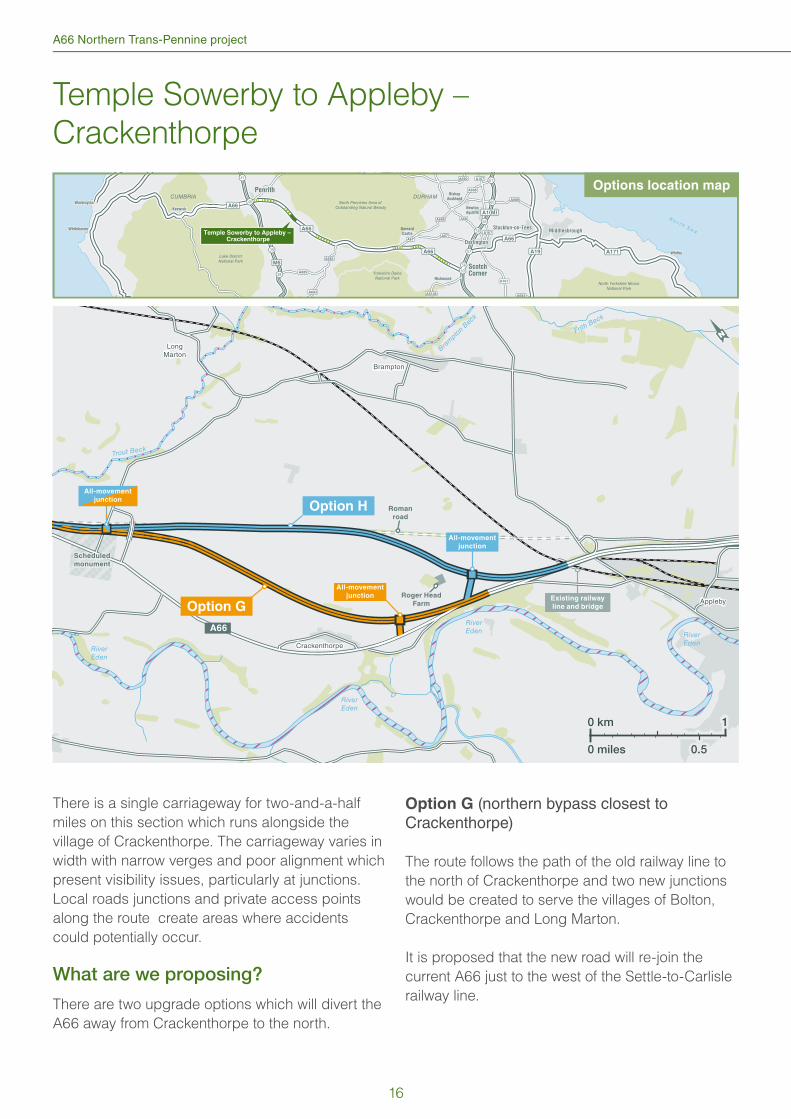
There is a single carriageway for two-and-a-half
miles on this section which runs alongside the
village of Crackenthorpe. The carriageway varies in
width with narrow verges and poor alignment which
present visibility issues, particularly at junctions.
Local roads junctions and private access points
along the route create areas where accidents
could potentially occur.
What are we proposing?
There are two upgrade options which will divert the
A66 away from Crackenthorpe to the north.
Option G (northern bypass closest to Crackenthorpe)
The route follows the path of the old railway line to
the north of Crackenthorpe and two new junctions
would be created to serve the villages of Bolton,
Crackenthorpe and Long Marton.
It is proposed that the new road will re-join the
current A66 just to the west of the Settle-to-Carlisle
railway line.
Options location map
16
Public consultation
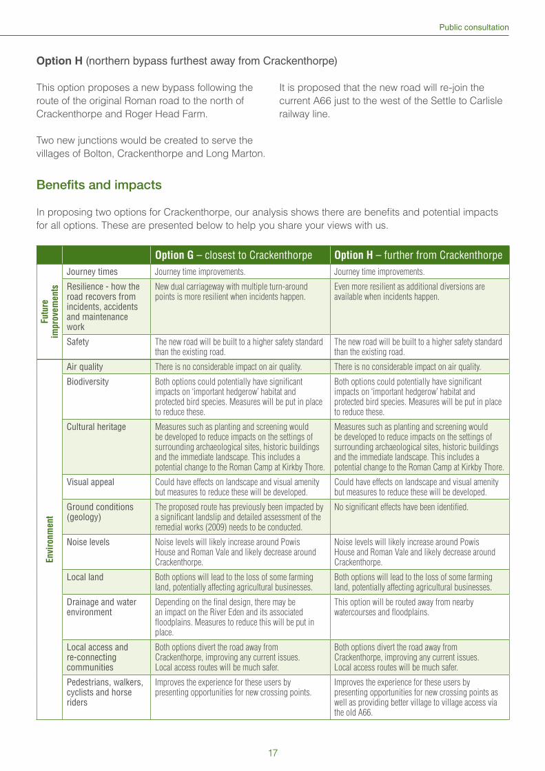
Option H (northern bypass furthest away from Crackenthorpe)
This option proposes a new bypass following the
route of the original Roman road to the north of
Crackenthorpe and Roger Head Farm.
Two new junctions would be created to serve the
villages of Bolton, Crackenthorpe and Long Marton.
It is proposed that the new road will re-join the
current A66 just to the west of the Settle to Carlisle
railway line.
Benefi ts and impacts
In proposing two options for Crackenthorpe, our analysis shows there are benefi ts and potential impacts
for all options. These are presented below to help you share your views with us.
Option G – closest to Crackenthorpe Option H – further from Crackenthorpe
Futu
re
impro
vem
ents
Journey times Journey time improvements. Journey time improvements.
Resilience - how the road recovers from incidents, accidents and maintenance work
New dual carriageway with multiple turn-around points is more resilient when incidents happen.
Even more resilient as additional diversions are available when incidents happen.
Safety The new road will be built to a higher safety standard than the existing road.
The new road will be built to a higher safety standard than the existing road.
Envi
ronm
ent
Air quality There is no considerable impact on air quality. There is no considerable impact on air quality.
Biodiversity Both options could potentially have signifi cant impacts on ‘important hedgerow’ habitat and protected bird species. Measures will be put in place to reduce these.
Both options could potentially have signifi cant impacts on ‘important hedgerow’ habitat and protected bird species. Measures will be put in place to reduce these.
Cultural heritage Measures such as planting and screening would be developed to reduce impacts on the settings of surrounding archaeological sites, historic buildings and the immediate landscape. This includes a potential change to the Roman Camp at Kirkby Thore.
Measures such as planting and screening would be developed to reduce impacts on the settings of surrounding archaeological sites, historic buildings and the immediate landscape. This includes a potential change to the Roman Camp at Kirkby Thore.
Visual appeal Could have effects on landscape and visual amenity but measures to reduce these will be developed.
Could have effects on landscape and visual amenity but measures to reduce these will be developed.
Ground conditions (geology)
The proposed route has previously been impacted by a signifi cant landslip and detailed assessment of the remedial works (2009) needs to be conducted.
No signifi cant effects have been identifi ed.
Noise levels Noise levels will likely increase around Powis House and Roman Vale and likely decrease around Crackenthorpe.
Noise levels will likely increase around Powis House and Roman Vale and likely decrease around Crackenthorpe.
Local land Both options will lead to the loss of some farming land, potentially affecting agricultural businesses.
Both options will lead to the loss of some farming land, potentially affecting agricultural businesses.
Drainage and water environment
Depending on the fi nal design, there may be an impact on the River Eden and its associated fl oodplains. Measures to reduce this will be put in place.
This option will be routed away from nearby watercourses and fl oodplains.
Local access and re-connecting communities
Both options divert the road away from Crackenthorpe, improving any current issues. Local access routes will be much safer.
Both options divert the road away from Crackenthorpe, improving any current issues. Local access routes will be much safer.
Pedestrians, walkers, cyclists and horse riders
Improves the experience for these users by presenting opportunities for new crossing points.
Improves the experience for these users by presenting opportunities for new crossing points as well as providing better village to village access via the old A66.
17
A66 Northern Trans-Pennine project
Appleby to Brough
38
39
41
57
58
59
60
61
CUMBRIA DURHAM
DarlingtonDarlington
Stockton-on-TeesStockton-on-TeesMiddlesbroughMiddlesbrough
Newton
Aycliffe
Richmond
Barnard
Castle
PenrithPenrith
ScotchCorner
Bishop
Auckland
A1(M)
A689
A688
A685
A685
A683
A688
A690
A6108
A167
A167
A167
A684
A67A67
A68
A19
A66
M6
Lake DistrictNational Park
Yorkshire DalesNational Park
North Pennines Area of Outstanding Natural Beauty
A66
A66
A171 WhitbyWhitby
North Yorkshire MoorsNational Park
5653
N o r t h S e a
WorkingtonWorkington
WhitehavenWhitehaven
KeswickKeswick
40
A66
Appleby to Brough
BlackSike
RiverEden
RiverEden
Warcop Flitholme
Wildboar Hill
Sandford
Area of Outstanding Natural BeautyArea of Outstanding Natural Beauty
Sandford MireSandford Mire
Cafe 66Cafe 66
All-movement
junction
Option I
Disused railway
Disused railway
A66
A66
Heritage railwayHeritage railway
MOD Training
Camp
Westbound only
junction
Westbound only
junction
Westbound only
junction
0 km 1
0 miles 0.5
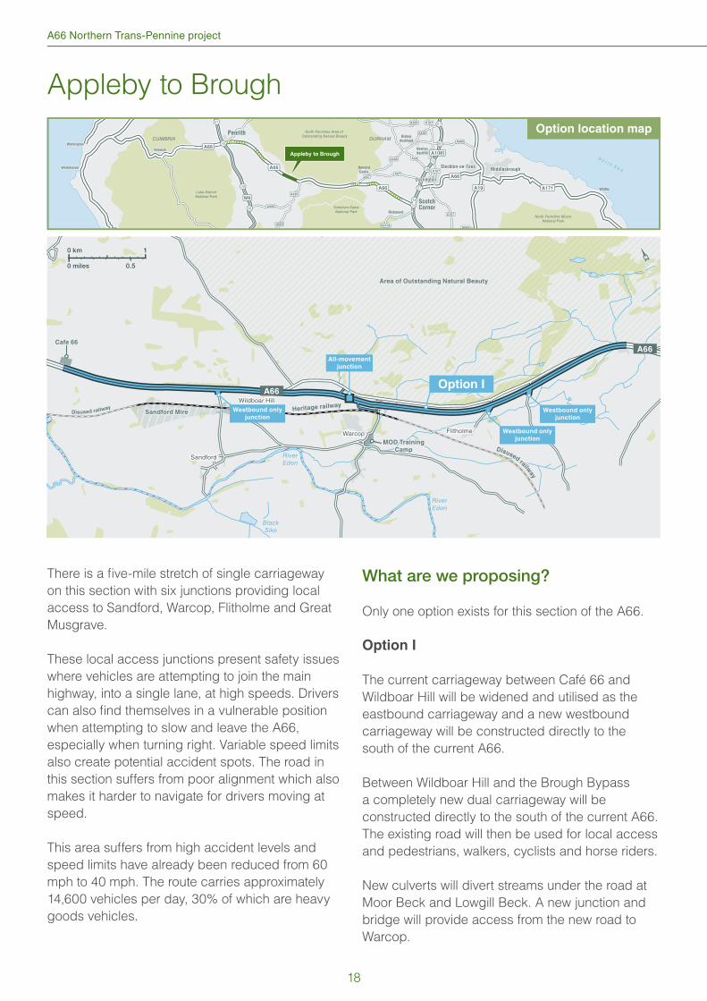
There is a fi ve-mile stretch of single carriageway
on this section with six junctions providing local
access to Sandford, Warcop, Flitholme and Great
Musgrave.
These local access junctions present safety issues
where vehicles are attempting to join the main
highway, into a single lane, at high speeds. Drivers
can also fi nd themselves in a vulnerable position
when attempting to slow and leave the A66,
especially when turning right. Variable speed limits
also create potential accident spots. The road in
this section suffers from poor alignment which also
makes it harder to navigate for drivers moving at
speed.
This area suffers from high accident levels and
speed limits have already been reduced from 60
mph to 40 mph. The route carries approximately
14,600 vehicles per day, 30% of which are heavy
goods vehicles.
What are we proposing?
Only one option exists for this section of the A66.
Option I
The current carriageway between Café 66 and
Wildboar Hill will be widened and utilised as the
eastbound carriageway and a new westbound
carriageway will be constructed directly to the
south of the current A66.
Between Wildboar Hill and the Brough Bypass
a completely new dual carriageway will be
constructed directly to the south of the current A66.
The existing road will then be used for local access
and pedestrians, walkers, cyclists and horse riders.
New culverts will divert streams under the road at
Moor Beck and Lowgill Beck. A new junction and
bridge will provide access from the new road to
Warcop.
Option location map
18
Public consultation
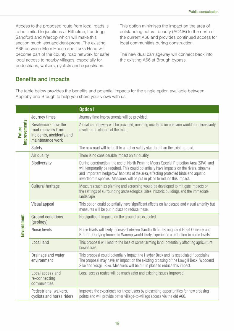
Access to the proposed route from local roads is
to be limited to junctions at Flitholme, Landrigg,
Sandford and Warcop which will make this
section much less accident-prone. The existing
A66 between Moor House and Turks Head will
become part of the county road network for safer
local access to nearby villages, especially for
pedestrians, walkers, cyclists and equestrians.
This option minimises the impact on the area of
outstanding natural beauty (AONB) to the north of
the current A66 and provides continued access for
local communities during construction.
The new dual carriageway will connect back into
the existing A66 at Brough bypass.
Benefi ts and impacts
The table below provides the benefi ts and potential impacts for the single option available between
Appleby and Brough to help you share your views with us.
Option I
Fu
ture
imp
rovem
en
ts
Journey times Journey time improvements will be provided.
Resilience - how the road recovers from incidents, accidents and maintenance work
A dual carriageway will be provided, meaning incidents on one lane would not necessarily
result in the closure of the road.
Safety The new road will be built to a higher safety standard than the existing road.
En
vir
on
me
nt
Air quality There is no considerable impact on air quality.
Biodiversity During construction, the use of North Pennine Moors Special Protection Area (SPA) land
will temporarily be required. This could potentially have impacts on the rivers, streams
and ‘important hedgerow’ habitats of the area, affecting protected birds and aquatic
invertebrate species. Measures will be put in place to reduce this impact.
Cultural heritage Measures such as planting and screening would be developed to mitigate impacts on
the settings of surrounding archaeological sites, historic buildings and the immediate
landscape.
Visual appeal This option could potentially have signifi cant effects on landscape and visual amenity but
measures will be put in place to reduce these.
Ground conditions (geology)
No signifi cant impacts on the ground are expected.
Noise levels Noise levels will likely increase between Sandforth and Brough and Great Ormside and
Brough. Outlying homes in Warcop would likely experience a reduction in noise levels.
Local land This proposal will lead to the loss of some farming land, potentially affecting agricultural
businesses.
Drainage and water environment
This proposal could potentially impact the Hayber Beck and its associated fl oodplains.
The proposal may have an impact on the existing crossing of the Lowgill Beck, Woodend
Sike and Yosgill Sike. Measures will be put in place to reduce this impact.
Local access and re-connecting communities
Local access routes will be much safer and existing issues improved.
Pedestrians, walkers, cyclists and horse riders
Improves the experience for these users by presenting opportunities for new crossing
points and will provide better village-to-village access via the old A66.
19
A66 Northern Trans-Pennine project
Bowes Bypass
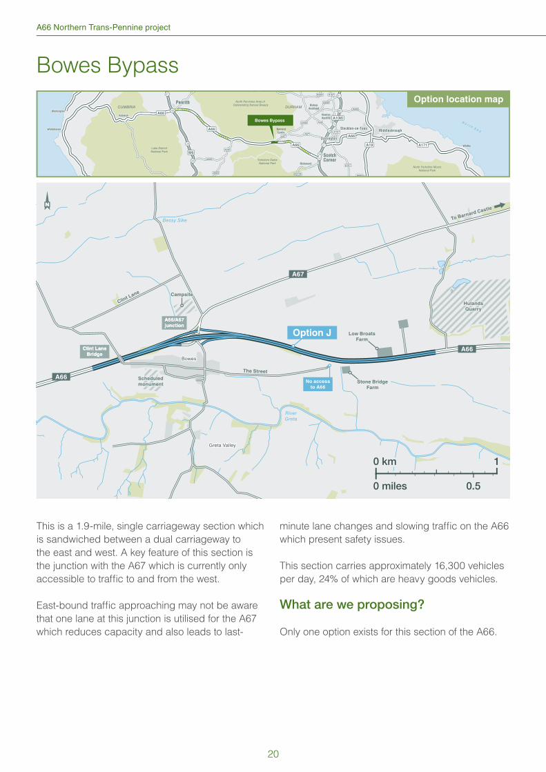
This is a 1.9-mile, single carriageway section which
is sandwiched between a dual carriageway to
the east and west. A key feature of this section is
the junction with the A67 which is currently only
accessible to traffi c to and from the west.
East-bound traffi c approaching may not be aware
that one lane at this junction is utilised for the A67
which reduces capacity and also leads to last-
minute lane changes and slowing traffi c on the A66
which present safety issues.
This section carries approximately 16,300 vehicles
per day, 24% of which are heavy goods vehicles.
What are we proposing?
Only one option exists for this section of the A66.
38
39
41
57
58
59
60
61
CUMBRIA DURHAM
DarlingtonDarlington
Stockton-on-TeesStockton-on-TeesMiddlesbroughMiddlesbrough
Newton
Aycliffe
Richmond
Barnard
Castle
PenrithPenrith
ScotchCorner
Bishop
Auckland
A1(M)
A689
A688
A685
A685
A683
A688
A690
A6108
A167
A167
A167
A684
A67A67
A68
A19
A66
M6
Lake DistrictNational Park
Yorkshire DalesNational Park
North Pennines Area of Outstanding Natural Beauty
A66
A66
A171 WhitbyWhitby
North Yorkshire MoorsNational Park
5653
N o r t h S e a
WorkingtonWorkington
WhitehavenWhitehaven
KeswickKeswick
40
A66
Bowes Bypass
Hulands
Quarry
Hulands
Quarry
Bessy Sike
RiverGreta
Greta Valley
Bowes
Option J
Stone Bridge
Farm
Stone Bridge
Farm
Low Broats
Farm
Low Broats
Farm
Scheduled
monument
Scheduled
monument
A66
A66
A67
The StreetThe Street
CampsiteCampsite
Clint L
ane
Clint L
ane
To Barnard Castle
To Barnard Castle
A66/A67
junction
A66/A67
junction
Clint Lane
Bridge
Clint Lane
Bridge
No access
to A66
0 km 1
0 miles 0.5
Option location map
20
Public consultation
Option J
We are proposing to widen the carriageway to the
north of Bowes village and between Clint Lane
Bridge and the junction for the A67 where a new
eastbound slip road junction is being considered.
After the A67 junction we are proposing to use
the existing carriageway for westbound traffi c and
construct a new eastbound carriageway north of
the current road. This will require new or extended
bridges to be built.
Two new eastbound slip roads will be built,
providing access to and from the A67 and the
village of Bowes. This would require the demolition
of some derelict buildings and neighbouring barn
structure.
The Roman road known as The Street will be
closed and access between Bowes village and
the A66 instead provided by the upgraded Bowes
junction, making access to the A66 safer for local
traffi c.
Benefi ts and impacts
The table below provides the benefi ts and potential impacts for the single option available for the Bowes
bypass to help you share your views with us.
Option J
Futu
re
impro
vem
ents
Journey times Journey time improvements.
Resilience - how the road recovers from incidents, accidents and maintenance work
This section becomes more resilient due to the increase in options for diversion routes
and the introduction of more turn-around points.
Safety The new road will be built to a higher safety standard than the existing road.
Envi
ronm
ent
Air quality There is no considerable impact on air quality.
Biodiversity During construction, the use of North Pennine Moors Special Protection Area (SPA)
land will temporarily be required. This option could potentially have signifi cant impacts
on the North Pennine Moors SPA and protected birds and species. Measures will be
put in place to reduce this impact.
Cultural heritage Measures such as planting and screening would be developed to reduce impacts on
the settings of surrounding archaeological sites, historic buildings and the immediate
landscape.
Visual appeal The western end of this proposal will slightly impact the North Pennines Area of
Outstanding Natural Beauty (AONB). During construction it is expected that the
surrounding area will be impacted, although the current A66 is already a feature of the
landscape.
Ground conditions (geology) No signifi cant impacts on the ground are expected.
Noise land Noise levels are likely to increase around Bowes.
Local community This proposal may lead to the loss of some farming land and potentially the demolition
of some buildings. The disused Bowes train station will also be demolished.
Drainage and water environment
This proposal does not directly impact on any watercourses or fl oodplains.
Local access and re-connecting communities
Local access routes will be much safer and existing issues improved. All routes
provided for at an improved Bowes junction.
Pedestrians, walkers, cyclists and horse riders
All current crossing points will be maintained.
21
A66 Northern Trans-Pennine project
Cross Lanes to Rokeby
38
39
41
57
58
59
60
61
CUMBRIA DURHAM
DarlingtonDarlington
Stockton-on-TeesStockton-on-TeesMiddlesbroughMiddlesbrough
Newton
Aycliffe
Richmond
Barnard
Castle
PenrithPenrith
ScotchCorner
Bishop
Auckland
A1(M)
A689
A688
A685
A685
A683
A688
A690
A6108
A167
A167
A167
A684
A67A67
A68
A19
A66
M6
Lake DistrictNational Park
Yorkshire DalesNational Park
North Pennines Area of Outstanding Natural Beauty
A66
A66
A171 WhitbyWhitby
North Yorkshire MoorsNational Park
5653
N o r t h S e a
WorkingtonWorkington
WhitehavenWhitehaven
KeswickKeswick
40
A66
Cross Lanes toRokeby
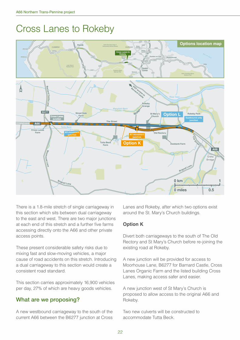
There is a 1.8-mile stretch of single carriageway in
this section which sits between dual carriageway
to the east and west. There are two major junctions
at each end of this stretch and a further fi ve farms
accessing directly onto the A66 and other private
access points.
These present considerable safety risks due to
mixing fast and slow-moving vehicles, a major
cause of road accidents on this stretch. Introducing
a dual carriageway to this section would create a
consistent road standard.
This section carries approximately 16,900 vehicles
per day, 27% of which are heavy goods vehicles.
What are we proposing?
A new westbound carriageway to the south of the
current A66 between the B6277 junction at Cross
Lanes and Rokeby, after which two options exist
around the St. Mary’s Church buildings.
Option K
Divert both carriageways to the south of The Old
Rectory and St Mary’s Church before re-joining the
existing road at Rokeby.
A new junction will be provided for access to
Moorhouse Lane, B6277 for Barnard Castle, Cross
Lanes Organic Farm and the listed building Cross
Lanes, making access safer and easier.
A new junction west of St Mary’s Church is
proposed to allow access to the original A66 and
Rokeby.
Two new culverts will be constructed to
accommodate Tutta Beck.
HG
V access to
Barnard C
astle
HG
V access to
Barnard C
astle
Tutta Beck
Manyfold Beck
River Tees
Th
e
S
treet
Brignall Lane
GretaBridge
Eastbound only
junction
Option K
Option L
A66
B6277
All-movement
junction
All-movement
junction
The StreetThe Street
Brignall L
ane
Brignall L
ane
Mo
orh
ou
se L
an
e
Rokeby ParkRokeby Park
Ba
rna
rd C
as
tle L
an
e
Cross Lanes
Farm
Tutta Beck
Farm
Street Side
Farm
Street Side
FarmSt Mary’s
Church
St Mary’s
Church
Rokeby
Grange
Rokeby
Grange
Old Rectory
Ewebank Farm
Cross Lanes
junction
Cross Lanes
junction
A66
0 km 1
0 miles 0.5
Options location map
22
Public consultation
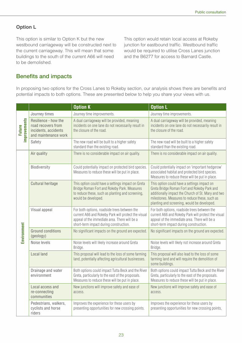
Option L
This option is similar to Option K but the new
westbound carriageway will be constructed next to
the current carriageway. This will mean that some
buildings to the south of the current A66 will need
to be demolished.
This option would retain local access at Rokeby
junction for eastbound traffi c. Westbound traffi c
would be required to utilise Cross Lanes junction
and the B6277 for access to Barnard Castle.
Benefi ts and impacts
In proposing two options for the Cross Lanes to Rokeby section, our analysis shows there are benefi ts and
potential impacts to both options. These are presented below to help you share your views with us.
Option K Option L
Fu
ture
imp
rove
me
nts
Journey times Journey time improvements. Journey time improvements.
Resilience - how the road recovers from incidents, accidents and maintenance work
A dual carriageway will be provided, meaning
incidents on one lane do not necessarily result in
the closure of the road.
A dual carriageway will be provided, meaning
incidents on one lane do not necessarily result in
the closure of the road.
Safety The new road will be built to a higher safety
standard than the existing road.
The new road will be built to a higher safety
standard than the existing road.
En
vir
on
me
nt
Air quality There is no considerable impact on air quality. There is no considerable impact on air quality.
Biodiversity Could potentially impact on protected bird species.
Measures to reduce these will be put in place.
Could potentially impact on ‘important hedgerow’
associated habitat and protected bird species.
Measures to reduce these will be put in place.
Cultural heritage This option could have a settings impact on Greta
Bridge Roman Fort and Rokeby Park. Measures
to reduce these, such as planting and screening,
would be developed.
This option could have a settings impact on
Greta Bridge Roman Fort and Rokeby Park and
additionally impact the Church of St. Mary and two
milestones. Measures to reduce these, such as
planting and screening, would be developed.
Visual appeal For both options, roadside trees between the
current A66 and Rokeby Park will protect the visual
appeal of the immediate area. There will be a
short-term impact during construction.
For both options, roadside trees between the
current A66 and Rokeby Park will protect the visual
appeal of the immediate area. There will be a
short-term impact during construction.
Ground conditions (geology)
No signifi cant impacts on the ground are expected. No signifi cant impacts on the ground are expected.
Noise levels Noise levels will likely increase around Greta
Bridge.
Noise levels will likely not increase around Greta
Bridge.
Local land This proposal will lead to the loss of some farming
land, potentially affecting agricultural businesses.
This proposal will also lead to the loss of some
farming land and will require the demolition of
some buildings.
Drainage and water environment
Both options could impact Tutta Beck and the River
Greta, particularly to the east of the proposals.
Measures to reduce these will be put in place.
Both options could impact Tutta Beck and the River
Greta, particularly to the east of the proposals.
Measures to reduce these will be put in place.
Local access and re-connecting communities
New junctions will improve safety and ease of
access.
New junctions will improve safety and ease of
access.
Pedestrians, walkers, cyclists and horse riders
Improves the experience for these users by
presenting opportunities for new crossing points.
Improves the experience for these users by
presenting opportunities for new crossing points,
23
A66 Northern Trans-Pennine project
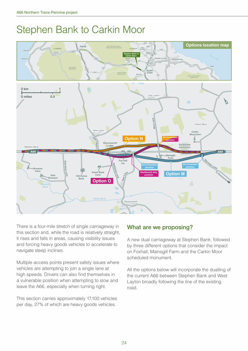
Stephen Bank to Carkin Moor
38
39
41
57
58
59
60
61
CUMBRIA DURHAM
DarlingtonDarlington
Stockton-on-TeesStockton-on-TeesMiddlesbroughMiddlesbrough
Newton
Aycliffe
Richmond
Barnard
Castle
PenrithPenrith
ScotchCorner
Bishop
Auckland
A1(M)
A689
A688
A685
A685
A683
A688
A690
A6108
A167
A167
A167
A684
A67A67
A68
A19
A66
M6
N o r t h S e a
Lake DistrictNational Park
Yorkshire DalesNational Park
North Pennines Area of Outstanding Natural Beauty
A66
A66
A171 WhitbyWhitby
North Yorkshire MoorsNational Park
5653
WorkingtonWorkington
WhitehavenWhitehaven
KeswickKeswick
40
A66
Stephen Bank toCarkin Moor
Holme Beck
BrowsonBeck
Dic
k S
co
t Lan
e
Warrener Lane
Co
llie
r L
ane
Waitla
nd
s L
an
e
Ne
w L
ane
West Layton
Ravensworth
East Layton
Carkin Moor
Stephen BankScheduled
monument
All-movement
junctionAll-movement
junction
All-movement
junction
Eastbound only
junction
Mo
or
La
ne
Mo
or
La
ne
East
Browson
Fox Hall
Inn
To Richm
ond
To Richm
ond
Green Bank
FarmOld Dunsa
Bank
Mainsgill
Farm
Carkin
Moor Farm
Browson
Farm
Ravensworth
Lodge
Option N
Option M
Option O
A66 A66
0 km 1
0 miles 0.5
There is a four-mile stretch of single carriageway in
this section and, while the road is relatively straight,
it rises and falls in areas, causing visibility issues
and forcing heavy goods vehicles to accelerate to
navigate steep inclines.
Multiple access points present safety issues where
vehicles are attempting to join a single lane at
high speeds. Drivers can also fi nd themselves in
a vulnerable position when attempting to slow and
leave the A66, especially when turning right.
This section carries approximately 17,100 vehicles
per day, 27% of which are heavy goods vehicles.
What are we proposing?
A new dual carriageway at Stephen Bank, followed
by three different options that consider the impact
on Foxhall, Mainsgill Farm and the Carkin Moor
scheduled monument.
All the options below will incorporate the dualling of
the current A66 between Stephen Bank and West
Layton broadly following the line of the existing
road.
Options location map
24

Public consultation
Option M
After West Layton, we propose a new dual
carriageway to the south of the existing A66 and
the properties at Foxhall and Mainsgill Farm. It will
re-join with the A66 at Carkin Moor Farm beyond
the scheduled monument.
A new junction and bridge at New Lane to provide
access to the new A66 for several properties
and the villages of East and West Layton and
Ravensworth. Several underpasses will be created
to maintain land access and public rights of way.
Option N
After West Layton, we propose a new dual
carriageway to the north of the existing A66 and the
properties at Foxhall and Mainsgill Farm, before re-
joining the A66 at Carkin Moor Farm.
A new junction and bridge on Moor Lane will
provide safe and easy access to the old A66, the
villages of East and West Layton and Ravensworth
and the Mainsgill Farm Shop.
The new dual carriageway is expected to re-join the
A66 just after Mainsgill Farm and therefore requires
the widening of the road through the scheduled
monument.
Option O
This option follows the same route as option M as
far as New Lane where it diverts north avoiding
Mainsgill Farm shop.
A new eastbound junction at Foxhall to provide
local access to the old A66 and West Layton. New
Lane will be realigned to connect with the new A66
to provide access for Ravensworth.
The proposed route will continue in a northerly
direction to a new junction at Moor Lane which will
provide access from Mainsgill Farm and the former
A66.
The new dual carriageway is expected to re-join the
A66 just after Mainsgill Farm and therefore requires
the widening of the road through the scheduled
monument.
Benefi ts and impacts
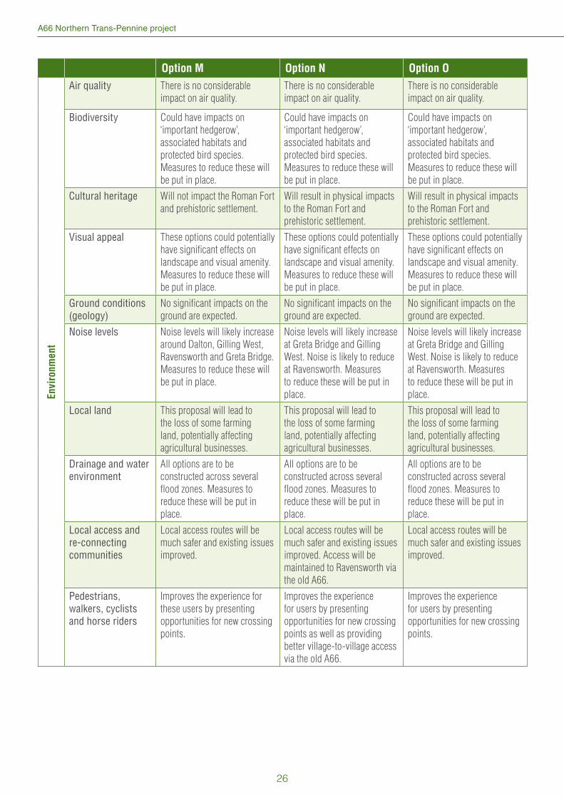
In proposing three options for the Stephen Bank to Carkin Moor section, our analysis shows there are
benefi ts and potential impacts to each option. These are presented below to help you share your views
with us.
Option M Option N Option O
Fu
ture
im
pro
ve
me
nts
Journey times Improved journey times. Improved journey times. Improved journey times.
Resilience - how the road recovers from incidents, accidents and maintenance work
The route is much more
resilient with the dual
carriageway meaning incidents
on one lane would not result
in the closure of the road. The
original A66 will also provide
additional diversion routes.
The route is much more
resilient with the dual
carriageway meaning incidents
on one lane would not result in
the closure of the road.
The route is much more
resilient with the dual
carriageway meaning incidents
on one lane would not result in
the closure of the road.
Safety The new road will be built to a
higher safety standard than the
existing road.
The new road will be built to a
higher safety standard than the
existing road.
The new road will be built to a
higher safety standard than the
existing road.
Table continues overleaf
25
A66 Northern Trans-Pennine project
Option M Option N Option O
En
vir
on
me
nt
Air quality There is no considerable
impact on air quality.
There is no considerable
impact on air quality.
There is no considerable
impact on air quality.
Biodiversity Could have impacts on
‘important hedgerow’,
associated habitats and
protected bird species.
Measures to reduce these will
be put in place.
Could have impacts on
‘important hedgerow’,
associated habitats and
protected bird species.
Measures to reduce these will
be put in place.
Could have impacts on
‘important hedgerow’,
associated habitats and
protected bird species.
Measures to reduce these will
be put in place.
Cultural heritage Will not impact the Roman Fort
and prehistoric settlement.
Will result in physical impacts
to the Roman Fort and
prehistoric settlement.
Will result in physical impacts
to the Roman Fort and
prehistoric settlement.
Visual appeal These options could potentially
have signifi cant effects on
landscape and visual amenity.
Measures to reduce these will
be put in place.
These options could potentially
have signifi cant effects on
landscape and visual amenity.
Measures to reduce these will
be put in place.
These options could potentially
have signifi cant effects on
landscape and visual amenity.
Measures to reduce these will
be put in place.
Ground conditions (geology)
No signifi cant impacts on the
ground are expected.
No signifi cant impacts on the
ground are expected.
No signifi cant impacts on the
ground are expected.
Noise levels Noise levels will likely increase
around Dalton, Gilling West,
Ravensworth and Greta Bridge.
Measures to reduce these will
be put in place.
Noise levels will likely increase
at Greta Bridge and Gilling
West. Noise is likely to reduce
at Ravensworth. Measures
to reduce these will be put in
place.
Noise levels will likely increase
at Greta Bridge and Gilling
West. Noise is likely to reduce
at Ravensworth. Measures
to reduce these will be put in
place.
Local land This proposal will lead to
the loss of some farming
land, potentially affecting
agricultural businesses.
This proposal will lead to
the loss of some farming
land, potentially affecting
agricultural businesses.
This proposal will lead to
the loss of some farming
land, potentially affecting
agricultural businesses.
Drainage and water environment
All options are to be
constructed across several
fl ood zones. Measures to
reduce these will be put in
place.
All options are to be
constructed across several
fl ood zones. Measures to
reduce these will be put in
place.
All options are to be
constructed across several
fl ood zones. Measures to
reduce these will be put in
place.
Local access and re-connecting communities
Local access routes will be
much safer and existing issues
improved.
Local access routes will be
much safer and existing issues
improved. Access will be
maintained to Ravensworth via
the old A66.
Local access routes will be
much safer and existing issues
improved.
Pedestrians, walkers, cyclists and horse riders
Improves the experience for
these users by presenting
opportunities for new crossing
points.
Improves the experience
for users by presenting
opportunities for new crossing
points as well as providing
better village-to-village access
via the old A66.
Improves the experience
for users by presenting
opportunities for new crossing
points.
26
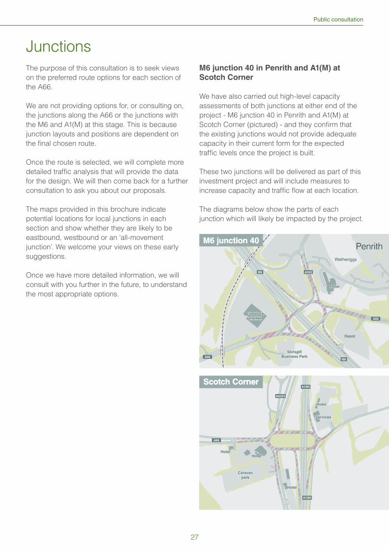
Public consultation
Junctions
The purpose of this consultation is to seek views
on the preferred route options for each section of
the A66.
We are not providing options for, or consulting on,
the junctions along the A66 or the junctions with
the M6 and A1(M) at this stage. This is because
junction layouts and positions are dependent on
the fi nal chosen route.
Once the route is selected, we will complete more
detailed traffi c analysis that will provide the data
for the design. We will then come back for a further
consultation to ask you about our proposals.
The maps provided in this brochure indicate
potential locations for local junctions in each
section and show whether they are likely to be
eastbound, westbound or an ‘all-movement
junction’. We welcome your views on these early
suggestions.
Once we have more detailed information, we will
consult with you further in the future, to understand
the most appropriate options.
M6 junction 40 in Penrith and A1(M) at
Scotch Corner
We have also carried out high-level capacity
assessments of both junctions at either end of the
project - M6 junction 40 in Penrith and A1(M) at
Scotch Corner (pictured) - and they confi rm that
the existing junctions would not provide adequate
capacity in their current form for the expected
traffi c levels once the project is built.
These two junctions will be delivered as part of this
investment project and will include measures to
increase capacity and traffi c fl ow at each location.
The diagrams below show the parts of each
junction which will likely be impacted by the project.
Penrith
A66
A66
A592M6
M6
M6 junction 40M6 junction 40
Hotel
Livestock
market
Depot
Skirsgill
Business Park
Wetheriggs
A66
A1(M)
A1(M)
A6055
Scotch CornerScotch Corner
Hotel
Hotel
HotelHotel
Caravan
park
Services
27
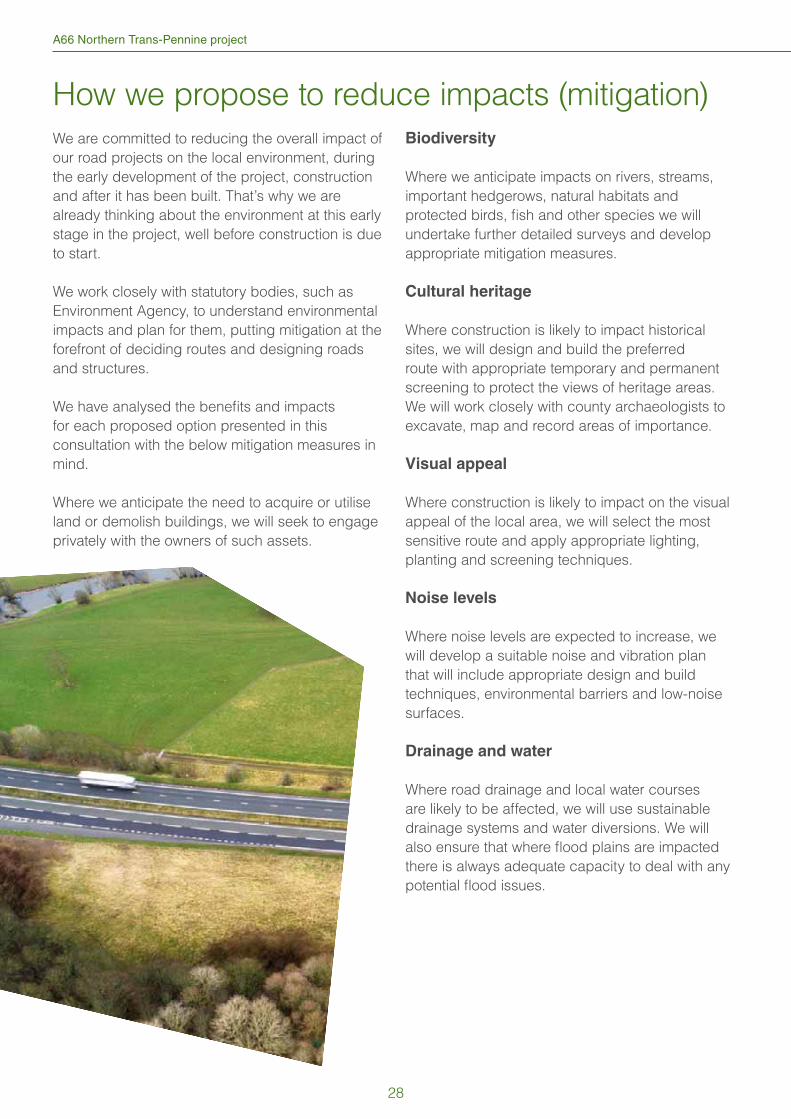
A66 Northern Trans-Pennine project
How we propose to reduce impacts (mitigation)
We are committed to reducing the overall impact of
our road projects on the local environment, during
the early development of the project, construction
and after it has been built. That’s why we are
already thinking about the environment at this early
stage in the project, well before construction is due
to start.
We work closely with statutory bodies, such as
Environment Agency, to understand environmental
impacts and plan for them, putting mitigation at the
forefront of deciding routes and designing roads
and structures.
We have analysed the benefi ts and impacts
for each proposed option presented in this
consultation with the below mitigation measures in
mind.
Where we anticipate the need to acquire or utilise
land or demolish buildings, we will seek to engage
privately with the owners of such assets.
Biodiversity
Where we anticipate impacts on rivers, streams,
important hedgerows, natural habitats and
protected birds, fi sh and other species we will
undertake further detailed surveys and develop
appropriate mitigation measures.
Cultural heritage
Where construction is likely to impact historical
sites, we will design and build the preferred
route with appropriate temporary and permanent
screening to protect the views of heritage areas.
We will work closely with county archaeologists to
excavate, map and record areas of importance.
Visual appeal
Where construction is likely to impact on the visual
appeal of the local area, we will select the most
sensitive route and apply appropriate lighting,
planting and screening techniques.
Noise levels
Where noise levels are expected to increase, we
will develop a suitable noise and vibration plan
that will include appropriate design and build
techniques, environmental barriers and low-noise
surfaces.
Drainage and water
Where road drainage and local water courses
are likely to be affected, we will use sustainable
drainage systems and water diversions. We will
also ensure that where fl ood plains are impacted
there is always adequate capacity to deal with any
potential fl ood issues.
28
Public consultation
Discounted options
The options outlined in this brochure have been
shortlisted from a much longer list of options which
have been considered for each section.
Following a number of assessments carried out
in developing this project, various options were
discounted prior to consultation as they were
considered not to be viable. Typically, these were
options which would have presented such serious
environmental impacts that statutory environmental
bodies would have rejected them or required
extensive mitigation measures.
Where multiple similar options existed only the most
viable options have advanced to the shortlist.
This process of shortlisting our options avoids
unnecessary spending of public funds on more
detailed design and appraisal for options which are
unlikely to be acceptable to consultees.
In total, we have discounted 19 options, described
below.
Penrith North Bypass
Dual carriageway bypassing Penrith to the north
east, connecting the M6 junction 40 with the A66 at
Center Parcs.
This option was discounted because of the
signifi cant environmental impact on scheduled
monuments, landscape, ancient woodland and
biodiversity. The bypass would have also required
signifi cant land take and major earthworks leading
to high cost and few economic benefi ts.
Penrith South Bypass
Dual carriageway bypassing Penrith to the south,
utilising the line of the disused railway. This option
would connect the A66 in Kirkby Thore with the M6
south of junction 40 where a new motorway junction
would be required.
This option was discounted due to substantial
environmental impacts including direct loss of land
within the Site of Special Scientifi c Interest (SSSI),
National Nature Reserve (NNR) and the loss of
ancient woodland. It would have also required a
crossing of the West Coast main line of the railway
and a junction with the M6 which would lead to
high cost and few economic benefi ts. In addition,
results of traffi c surveys and modelling show there
is lower demand on the stretch between the A66
and M6 south, compared to between the A66 and
M6 north.
M6 junction 40 to Kemplay Bank
interchange
A third option was considered that would have seen
the A66 pass through the roundabout at ground
level with an added fourth lane, creating extra
capacity. It was discounted after analysis showed
it would not provide enough capacity to meet
expected future traffi c levels.
This option would have also required the demolition
of nearby buildings, including Toll Bar Cottage and
the removal of surrounding trees.
Penrith to Temple Sowerby
A third option was considered that would have
involved a longer route to completely avoid the
hamlet of Lane End. This would have required
additional land being purchased in and around
Lane End and the construction of new roads
and structures in the immediate area. It was not
presented at the 2003 consultation and has been
discounted this time as it would require a longer,
more expensive diversion to avoid the properties
of Lane End. Due to the nature of this diversion, it
would have further isolated Lane End by removing
access to the local road network.
29
A66 Northern Trans-Pennine project
Temple Sowerby to Appleby
Six discounted options have been considered for
this section of the A66.
1. (6A1) A longer, northern bypass of the village
of Kirkby Thore was considered but discounted
because it would have resulted in longer
journey times, affecting the economic benefi ts
of the project and bringing signifi cant impacts
on the landscape and agricultural land.
Construction costs were higher and there were
increased risks due to the close vicinity of
underground mines. It was not taken forward for
the 2003 consultation.
2. (6B1) An alternative route for the new
carriageway was considered but discounted
as it would have negatively impacted local
historical monuments, required the compulsory
purchase and demolition of a signifi cant amount
of buildings and the need to construct multiple
local access routes. Noise pollution would have
increased for the residents of Kirkby Thore. This
option was considered in the 2003 consultation.
3. (6C1) Using and widening a longer stretch of
the current A66 was considered but discounted
as it would have affected several local access
points and commercial and residential
frontages. In the 2003 consultation, a similar
option was considered but only received
support from 2% of respondents.
4. (6D1) A more direct alternative route was
considered but was discounted due to the
severe negative impacts on local historical
monuments and the village of Kirkby Thore.
Several Grade II listed buildings would have
been affected and high levels of demolition
would have been required. This option would
have also decreased local connectivity.
This option was not considered in the 2003
consultation.
5. (6A2) An additional northern bypass of
Crackenthorpe was also considered but this
would have resulted in longer journey times,
would have negatively affected the landscape
and foot and bridal paths and would have
disconnected Crackenthorpe Stud from the
road network. Ecology issues were also
considered too detrimental and does not
demonstrate value for money. This option was
not considered in 2003.
6. (6B2) Widening of the current A66 at
Crackenthorpe was investigated but discounted
due to its potential encroachment on the
Redlands Bank monument site and the removal
of trees from the Chapel Wood ancient
woodland. The Grade II listed Milestone would
have needed to be relocated and several
buildings close to Crackenthorpe would have
needed to be demolished whilst multiple new
access points constructed. This option was
considered in 2003.
Appleby to Brough
All these options have been considered.
1. (8A1) A similar version to the current widening
proposal was considered but discounted due
to the diffi culty of construction, the impact on
the nearby Area of Outstanding Natural Beauty
(AONB) and the encroachment on the site of
the Warcop Roman Camp and road.
2. (8B1) An option was considered that would see
a new route constructed directly through the
Warcop Roman Camp, resulting in the complete
loss of this historical site. Additional land would
have been required from the North Pennine
Moors AONB and would have negatively
affected several properties near Warcop and
Warcop Hall.
3. (8D1) A route option was considered that would
have utilised 90% of the Eden Valley railway and
would have a severe impact on this tourist and
heritage attraction. Residents of Warcop village
would also have been disadvantaged due to the
proximity of the new road. This option was also
considered poor value for money.
4. (8B2) A new route was considered that would
travel directly through the North Pennine Moors
AONB but was discounted for environmental
and ecology reasons. Considerable disruption
was envisaged during the construction phase.
30
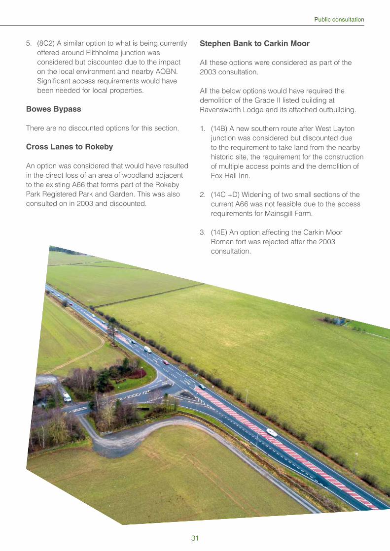
Public consultation
5. (8C2) A similar option to what is being currently
offered around Flithholme junction was
considered but discounted due to the impact
on the local environment and nearby AOBN.
Signifi cant access requirements would have
been needed for local properties.
Bowes Bypass
There are no discounted options for this section.
Cross Lanes to Rokeby
An option was considered that would have resulted
in the direct loss of an area of woodland adjacent
to the existing A66 that forms part of the Rokeby
Park Registered Park and Garden. This was also
consulted on in 2003 and discounted.
Stephen Bank to Carkin Moor
All these options were considered as part of the
2003 consultation.
All the below options would have required the
demolition of the Grade II listed building at
Ravensworth Lodge and its attached outbuilding.
1. (14B) A new southern route after West Layton
junction was considered but discounted due
to the requirement to take land from the nearby
historic site, the requirement for the construction
of multiple access points and the demolition of
Fox Hall Inn.
2. (14C +D) Widening of two small sections of the
current A66 was not feasible due to the access
requirements for Mainsgill Farm.
3. (14E) An option affecting the Carkin Moor
Roman fort was rejected after the 2003
consultation.
31
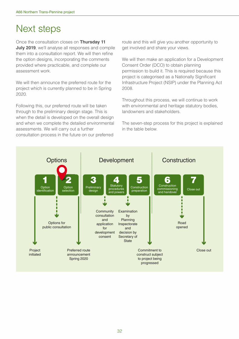
A66 Northern Trans-Pennine project
Next steps
Once the consultation closes on Thursday 11
July 2019, we’ll analyse all responses and compile
them into a consultation report. We will then refi ne
the option designs, incorporating the comments
provided where practicable, and complete our
assessment work.
We will then announce the preferred route for the
project which is currently planned to be in Spring
2020.
Following this, our preferred route will be taken
through to the preliminary design stage. This is
when the detail is developed on the overall design
and when we complete the detailed environmental
assessments. We will carry out a further
consultation process in the future on our preferred
route and this will give you another opportunity to
get involved and share your views.
We will then make an application for a Development
Consent Order (DCO) to obtain planning
permission to build it. This is required because this
project is categorised as a Nationally Signifi cant
Infrastructure Project (NSIP) under the Planning Act
2008.
Throughout this process, we will continue to work
with environmental and heritage statutory bodies,
landowners and stakeholders.
The seven-step process for this project is explained
in the table below.
Options
Projectinitiated
Preferred routeannouncement
Spring 2020
Options forpublic consultation
Development Construction
Optionidentification
1Option
selection
2Preliminary
design
3Constructionpreparation
5Close out
7Statutory
proceduresand powers
4Construction
commissioningand handover
6
Commitment toconstruct subjectto project being
progressed
Close out
Roadopened
Communityconsultation
andapplication
fordevelopment
consent
Examinationby
PlanningInspectorate
anddecision bySecretary of
State
222222222
32
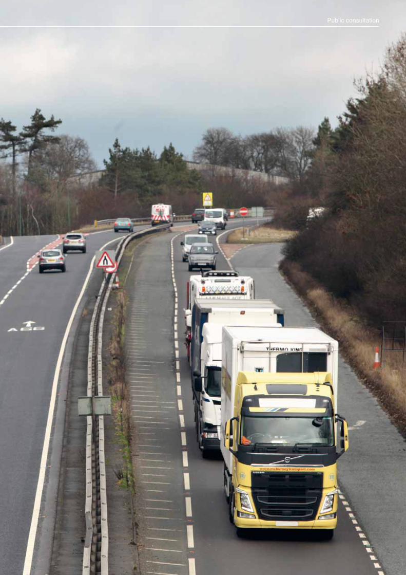
Public consultation
If you need help accessing this or any other Highways England information,please call 0300 123 5000 and we will help you.
© Crown copyright 2019.
You may re-use this information (not including logos) free of charge in any format or medium, under the terms of the Open Government Licence. To view this licence: visit www.nationalarchives.gov.uk/doc/open-government-licence/
write to the Information Policy Team, The National Archives, Kew,
London TW9 4DU, or email [email protected].
Mapping (where present): © Crown copyright and database rights 2019 OS 100030649. You are permitted to use this data solely to enable you to respond to, or interact with, the organisation that provided you with the data. You are not permitted to copy, sub-licence, distribute or sell any of this data to third parties in any form.
This document is also available on our website at www.highwaysengland.co.uk
Highways England creative job number MCR19_0071
If you have any enquiries about this publication email [email protected] or call 0300 123 5000*. Please quote the Highways England publications code PR09/19.
*Calls to 03 numbers cost no more than a national rate call to an 01 or 02 number and must count towards any inclusive minutes in the same way as 01 and 02 calls.
These rules apply to calls from any type of line including mobile, BT, other fixed line or payphone. Calls may be recorded or monitored.
Printed on paper from well-managed forests and other controlled sources when issued directly by Highways England.
Registered office Bridge House, 1 Walnut Tree Close, Guildford GU1 4LZ
Highways England Company Limited registered in England and Wales number 09346363
If you need help accessing this or any other Highways England information,please call 0300 123 5000 and we will help you.