Embed Size (px)
Citation preview
Using ArcReader™ and ArcGIS™ Publisher
GIS by ESRI ™
™
���������� ������
�����������������
�����������������������������
����������������������������!��������"��!������������������ ���#��$���������!�����������������������#���������������#������������!�����������������������%���������������#�&������&���'�������������(���������#��$���%�������!������������������������%���������&���������������������&����!��������������������������&��%�����������������������������������&�"������"����������������#�����%�����������)!������!��%�����������*�������+������&����&,- (�#.��$����&��������&��/�,0,1-2 &����
����������������������������!������!%3���������#���!������
�����������������
��������������� �������������
�� ������������ �������������������
������#���&���!�������&���'������������������!�������!%3�������������4����������������������������������5����������)!��������������� ��� �6'4�+� �6��57 ���������!�&!��&�!��������&���������!��%�������5�����������!%3�����������������������8��9:����012;���������&��&������<=�(2/-0>?8��9:����012/<=�(2/-0>���'��8��92���22'2���2�<���������� ��������6��'����!�����#���>?���68���@9�:����010 2:<(AB2//:>< ��������6��>���'��68���9��0�0� �<����!�����#���>&���������%�����������'+��!���!���������&,- (�#.��$����&��������&��/�,0,1-2 &����
����&���������%�����&���������&���5��&�����5������&5��%�����&���+��&5��������(�#��$&���������&����6�&����+�&���###�������������������$�&����������������$�&������������$��������������������&���!����������!���&������������3!�����������
A�������������������!��������������������������$�������������������$�����������������������$�#�����
Attribution.pmd 09/19/2002, 1:18 PM1
IN THIS CHAPTER
9
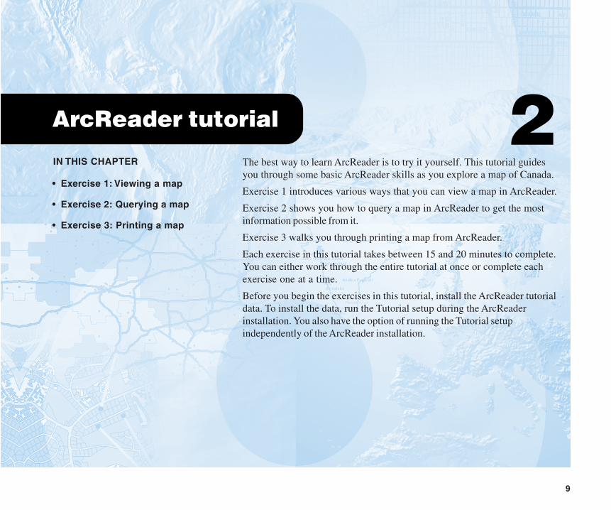
ArcReader tutorial 2• Exercise 1: Viewing a map
• Exercise 2: Querying a map
• Exercise 3: Printing a map
The best way to learn ArcReader is to try it yourself. This tutorial guidesyou through some basic ArcReader skills as you explore a map of Canada.
Exercise 1 introduces various ways that you can view a map in ArcReader.
Exercise 2 shows you how to query a map in ArcReader to get the mostinformation possible from it.
Exercise 3 walks you through printing a map from ArcReader.
Each exercise in this tutorial takes between 15 and 20 minutes to complete.You can either work through the entire tutorial at once or complete eachexercise one at a time.
Before you begin the exercises in this tutorial, install the ArcReader tutorialdata. To install the data, run the Tutorial setup during the ArcReaderinstallation. You also have the option of running the Tutorial setupindependently of the ArcReader installation.
10 USING ARCREADER AND ARCGIS PUBLISHER
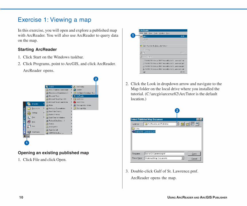
2. Click the Look in dropdown arrow and navigate to theMap folder on the local drive where you installed thetutorial. (C:\arcgis\arcexe82\ArcTutor is the defaultlocation.)
3. Double-click Gulf of St. Lawrence.pmf.
ArcReader opens the map.
Exercise 1: Viewing a map
In this exercise, you will open and explore a published mapwith ArcReader. You will also use ArcReader to query dataon the map.
Starting ArcReader
1. Click Start on the Windows taskbar.
2. Click Programs, point to ArcGIS, and click ArcReader.
ArcReader opens.
Opening an existing published map
1. Click File and click Open.
�
�
�
�
ARCREADER TUTORIAL 11
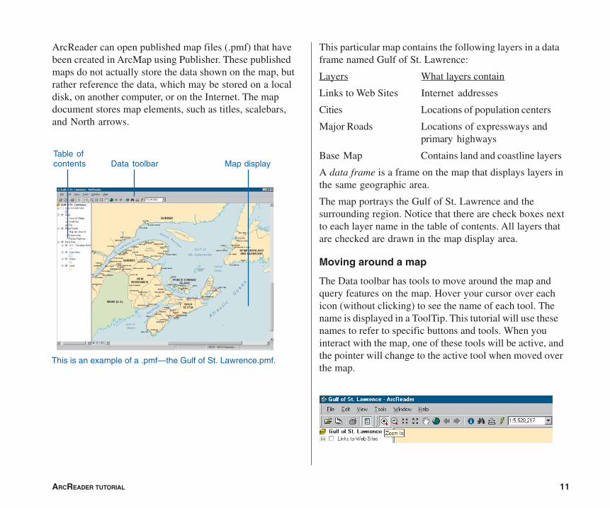
ArcReader can open published map files (.pmf) that havebeen created in ArcMap using Publisher. These publishedmaps do not actually store the data shown on the map, butrather reference the data, which may be stored on a localdisk, on another computer, or on the Internet. The mapdocument stores map elements, such as titles, scalebars,and North arrows.
This particular map contains the following layers in a dataframe named Gulf of St. Lawrence:
Layers What layers contain
Links to Web Sites Internet addresses
Cities Locations of population centers
Major Roads Locations of expressways andprimary highways
Base Map Contains land and coastline layers
A data frame is a frame on the map that displays layers inthe same geographic area.
The map portrays the Gulf of St. Lawrence and thesurrounding region. Notice that there are check boxes nextto each layer name in the table of contents. All layers thatare checked are drawn in the map display area.
Moving around a map
The Data toolbar has tools to move around the map andquery features on the map. Hover your cursor over eachicon (without clicking) to see the name of each tool. Thename is displayed in a ToolTip. This tutorial will use thesenames to refer to specific buttons and tools. When youinteract with the map, one of these tools will be active, andthe pointer will change to the active tool when moved overthe map.
This is an example of a .pmf—the Gulf of St. Lawrence.pmf.
Table ofcontents Data toolbar Map display
12 USING ARCREADER AND ARCGIS PUBLISHER
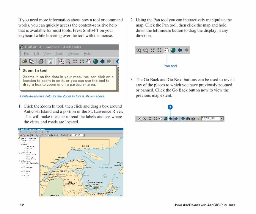
If you need more information about how a tool or commandworks, you can quickly access the context-sensitive helpthat is available for most tools. Press Shift+F1 on yourkeyboard while hovering over the tool with the mouse.
1. Click the Zoom In tool, then click and drag a box aroundAnticosti Island and a portion of the St. Lawrence River.This will make it easier to read the labels and see wherethe cities and roads are located.
2. Using the Pan tool you can interactively manipulate themap. Click the Pan tool, then click the map and holddown the left mouse button to drag the display in anydirection.
3. The Go Back and Go Next buttons can be used to revisitany of the places to which you have previously zoomedor panned. Click the Go Back button now to view theprevious map extent.Context-sensitive help for the Zoom In tool is shown above.
Pan tool
�

ARCREADER TUTORIAL 13
Using bookmarks
Bookmarks are named map extents created by the publisherof the map. The publisher zooms to a specific view of themap and saves it for future use. You can access thepublisher’s saved extents by selecting Bookmarks.
1. Click the View menu, point to Bookmarks, then clickPrince Edward Island.
The map now shows Prince Edward Island.
2. Click the View tab, point to Bookmarks, then click Gulfof St. Lawrence to reset the map to its original display.
To learn how to set bookmarks, see Using ArcMap.
�
�
14 USING ARCREADER AND ARCGIS PUBLISHER
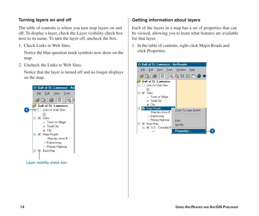
Turning layers on and off
The table of contents is where you turn map layers on andoff. To display a layer, check the Layer visibility check boxnext to its name. To turn the layer off, uncheck the box.
1. Check Links to Web Sites.
Notice the blue question mark symbols now draw on themap.
2. Uncheck the Links to Web Sites.
Notice that the layer is turned off and no longer displayson the map.
Getting information about layers
Each of the layers in a map has a set of properties that canbe viewed, allowing you to learn what features are availablefor that layer.
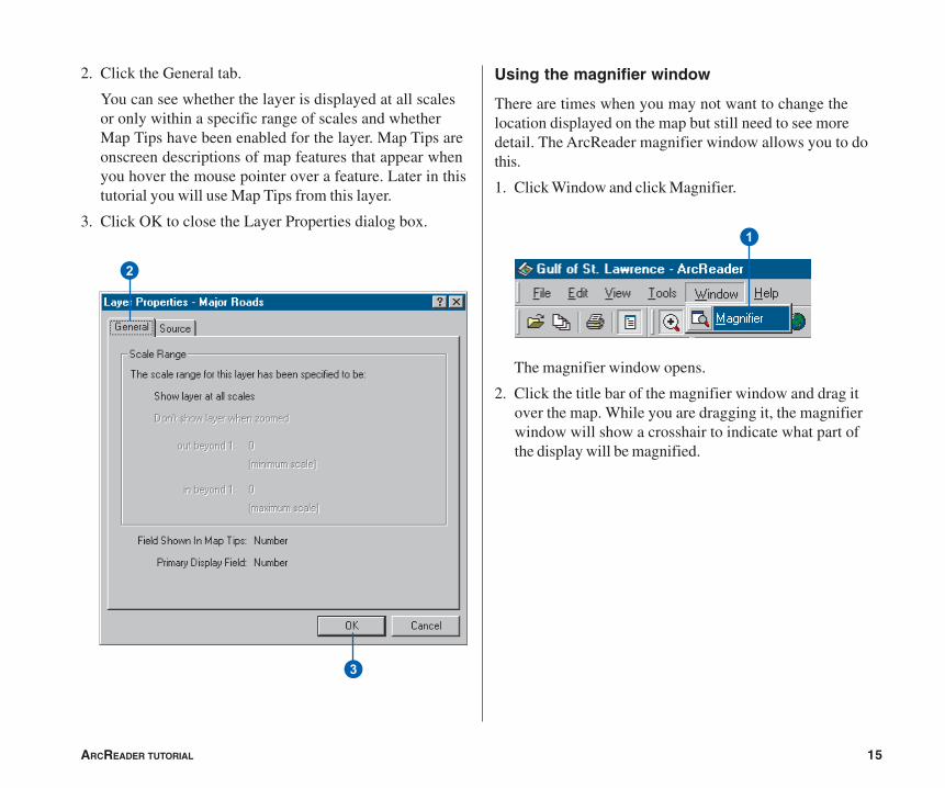
1. In the table of contents, right-click Major Roads andclick Properties.
Layer visibility check box
�
�
ARCREADER TUTORIAL 15
Using the magnifier window
There are times when you may not want to change thelocation displayed on the map but still need to see moredetail. The ArcReader magnifier window allows you to dothis.
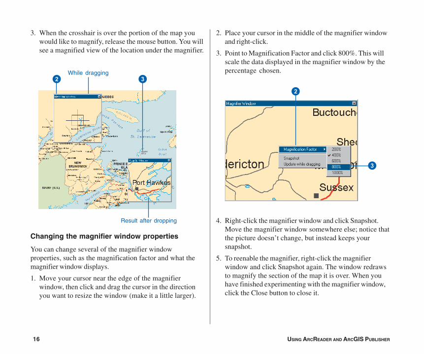
1. Click Window and click Magnifier.
The magnifier window opens.
2. Click the title bar of the magnifier window and drag itover the map. While you are dragging it, the magnifierwindow will show a crosshair to indicate what part ofthe display will be magnified.
2. Click the General tab.
You can see whether the layer is displayed at all scalesor only within a specific range of scales and whetherMap Tips have been enabled for the layer. Map Tips areonscreen descriptions of map features that appear whenyou hover the mouse pointer over a feature. Later in thistutorial you will use Map Tips from this layer.
3. Click OK to close the Layer Properties dialog box.
�
�
�
16 USING ARCREADER AND ARCGIS PUBLISHER
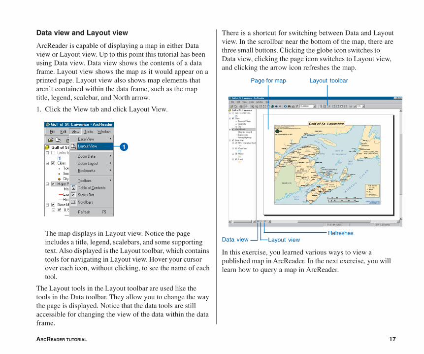
3. When the crosshair is over the portion of the map youwould like to magnify, release the mouse button. You willsee a magnified view of the location under the magnifier.
Changing the magnifier window properties
You can change several of the magnifier windowproperties, such as the magnification factor and what themagnifier window displays.
1. Move your cursor near the edge of the magnifierwindow, then click and drag the cursor in the directionyou want to resize the window (make it a little larger).
2. Place your cursor in the middle of the magnifier windowand right-click.
3. Point to Magnification Factor and click 800%. This willscale the data displayed in the magnifier window by thepercentage chosen.
4. Right-click the magnifier window and click Snapshot.Move the magnifier window somewhere else; notice thatthe picture doesn’t change, but instead keeps yoursnapshot.
5. To reenable the magnifier, right-click the magnifierwindow and click Snapshot again. The window redrawsto magnify the section of the map it is over. When youhave finished experimenting with the magnifier window,click the Close button to close it.
� �While dragging
Result after dropping
�
�
ARCREADER TUTORIAL 17
Data view and Layout view
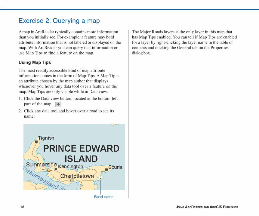
ArcReader is capable of displaying a map in either Dataview or Layout view. Up to this point this tutorial has beenusing Data view. Data view shows the contents of a dataframe. Layout view shows the map as it would appear on aprinted page. Layout view also shows map elements thataren’t contained within the data frame, such as the maptitle, legend, scalebar, and North arrow.
1. Click the View tab and click Layout View.
The map displays in Layout view. Notice the pageincludes a title, legend, scalebars, and some supportingtext. Also displayed is the Layout toolbar, which containstools for navigating in Layout view. Hover your cursorover each icon, without clicking, to see the name of eachtool.
The Layout tools in the Layout toolbar are used like thetools in the Data toolbar. They allow you to change the waythe page is displayed. Notice that the data tools are stillaccessible for changing the view of the data within the dataframe.
Page for map
Data view
Layout toolbar
Layout viewRefreshes
�
There is a shortcut for switching between Data and Layoutview. In the scrollbar near the bottom of the map, there arethree small buttons. Clicking the globe icon switches toData view, clicking the page icon switches to Layout view,and clicking the arrow icon refreshes the map.
In this exercise, you learned various ways to view apublished map in ArcReader. In the next exercise, you willlearn how to query a map in ArcReader.
18 USING ARCREADER AND ARCGIS PUBLISHER
A map in ArcReader typically contains more informationthan you initially see. For example, a feature may holdattribute information that is not labeled or displayed on themap. With ArcReader you can query that information oruse Map Tips to find a feature on the map.
Using Map Tips
The most readily accessible kind of map attributeinformation comes in the form of Map Tips. A Map Tip isan attribute chosen by the map author that displayswhenever you hover any data tool over a feature on themap. Map Tips are only visible while in Data view.
1. Click the Data view button, located at the bottom-leftpart of the map.
2. Click any data tool and hover over a road to see itsname.
The Major Roads layers is the only layer in this map thathas Map Tips enabled. You can tell if Map Tips are enabledfor a layer by right-clicking the layer name in the table ofcontents and clicking the General tab on the Propertiesdialog box.
Road name
Exercise 2: Querying a map
ARCREADER TUTORIAL 19
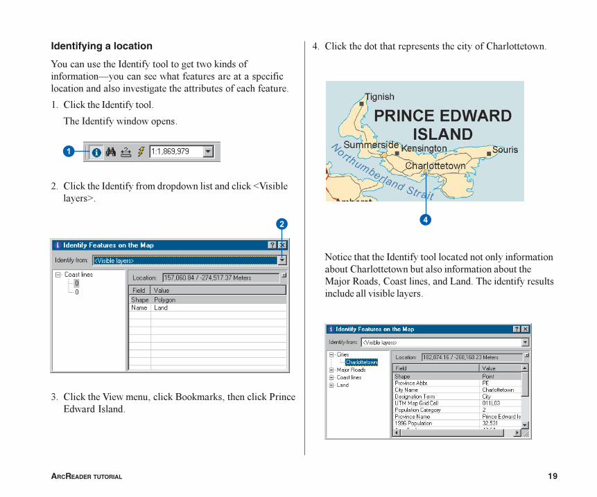
Identifying a location
�������������� ������������������� ����������������������������������������������������������� �����������������������������������
�� ��������� ���������
���� �������� ��������
�� ��������� ���������� ��� ���������� ������� !����������"�
#� ��������!������$�������%��������$����������&����' ��� ������ �
�
��
(� �������� �������������������������������
)���������� ������������� �����������������������������������������������������������*�+���,�� �$����������$��� �-�� ������ ��������������� ������������������
20 USING ARCREADER AND ARCGIS PUBLISHER
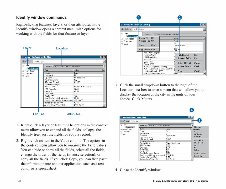
Identify window commands
,���.��������������$������$�������������������� �������� �������������/������������������������������������ ����������������������
�� ,���.����������������������������������������/����������������/��� ���������� �$����������� ������$���������� �$��������������� �
�� ,���.�����������������!�����������������������������/�����������������������0���1�� ����������������� ������������������ �$�������������� �$���������� ���������� ��2������������3$����������������� ��������������������$������������������������������������������������$�����������/ ������������� ���
#� �������������� ��� ����������������������-�������/���/�������������������������������� ��������������������������������������������������������*���
(� �������� �������� ���
Feature Attributes
Layer Location
�
�
� �
ARCREADER TUTORIAL 21
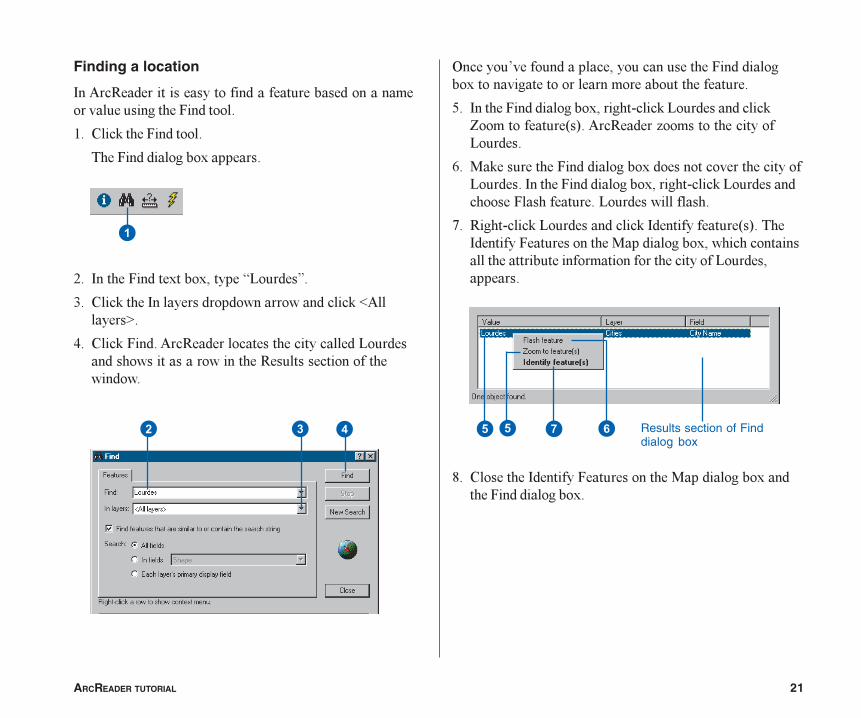
Finding a location
���4��,� ���������������� ����������� �������������������������1�� �����
�� ��������1�� �����
���1�� � ��������/��������
�� �����1�� �/���/$����5-��� �6�
#� ����������������� ��� ������������ ������� 4�������"�
(� ������1�� ��4��,� ������������������ �-��� ��� �����������������������,������������������ ���
�
7������8������ �������$��������������1�� � �������/������������������������������������
9� �����1�� � ��������/$�����.������-��� ���� ������:����������2�3��4��,� ��0���������������-��� ��
;� *���������1�� � ��������/� �������������������-��� ��������1�� � ��������/$�����.������-��� ���� ������1�����������-��� �������������
<� ,���.������-��� ���� �������� ���������2�3����� �����1����������*��� ��������/$��������������������������������������������������-��� �$�������
=� �������� �����1����������*��� ��������/��� ��1�� � ��������/�
�� �� Results section of Finddialog box
� ��
22 USING ARCREADER AND ARCGIS PUBLISHER
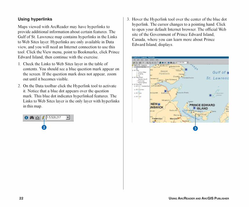
Using hyperlinks
*������� �����4��,� �������������������������� �� ��������������������������������������>�������?��-���������������������������������-������@��?���������A�����������������������������B�����$��� ����������� ���������������������������������������!������$��������%��������$�������&����' ��� ������ $�����������������/�����
�� �������-�������@��?����������������������������������� ���������C��������������������������������C����������� �����������$�0��������������������������
�� 7����B������������������A����������������������)������������� ���������������C�������������������� ���� ������������� ����������-�������@��?�����������������������������������������������
#� A������A������������������������������� ������������������������������������������� ������������������ ������������������������������@���������>����������&�����' ��� ������ $���� �$���������������������������&����' ��� ������ $� ��������
� �
ARCREADER TUTORIAL 23
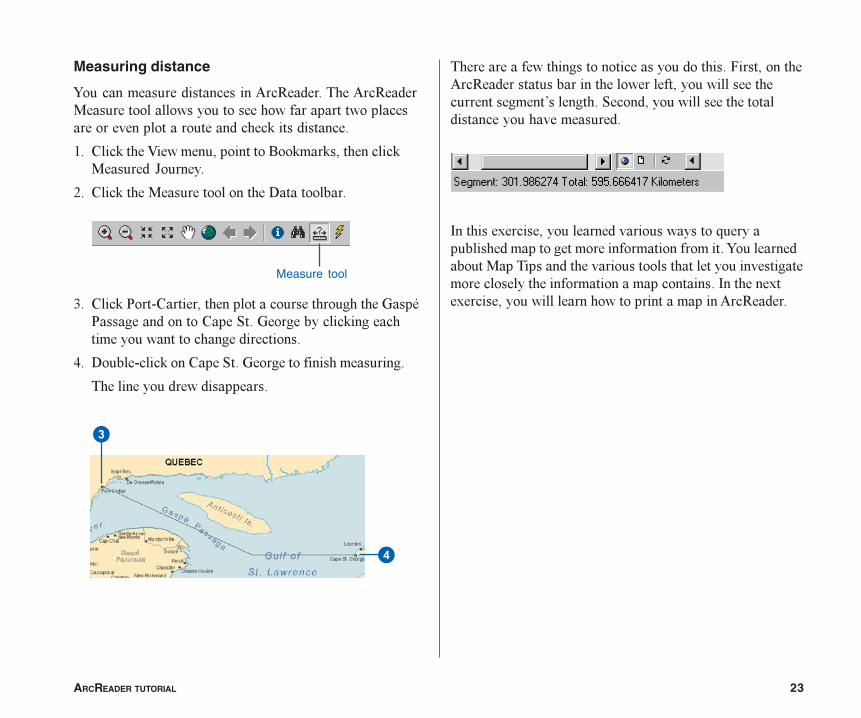
Measuring distance
�������������� ����������4��,� ������4��,� �*������������������������������������������������������������������ ��������� ������
�� ��������!������$��������%��������$���������*���� �D������
�� ��������*��������������B����������
#� ������&��.�����$�������������������������>���E&�������� ����������?��>�������������������������������������� ��������
(� B����.�������������?��>����������������������
����������� ��� ���������
�������������������������������� �������1���$�����4��,� �����������������������$�����������������������8��������?��� $����������������� ������������������� �
�������/����$��������� ����������������C������������ ���������������������������������������� �����*���������� �����������������������������������������������������������������������������//����$�����������������������������������4��,� ��
Measure tool
�
�
24 USING ARCREADER AND ARCGIS PUBLISHER
����������������������/����$����������� �������������������������������������� ��������������������0�2���4(3�������������� ������������������.�� .�������������������
�� ��������4��,� ��1��������� �������&���?���
���&���?��� ��������/������������ ��������/������������������������������������������������������������������������������������
�� ������������������������������������������� ����������$��������?��#��7�����$�������&���������&���?��� ��������/��� ����������������������������������������������
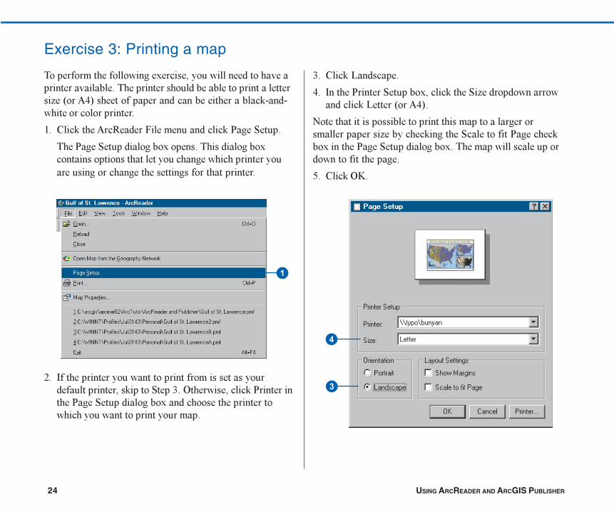
Exercise 3: Printing a map
�
�
�
#� ������-�� �����
(� �����&�����?�����/$���������?�0� ��� ����������� �������-��2���4(3�
)�����������������������������������������������������������0��������������?���������&���������/������&���?��� ��������/������������������������ ���������������
9� ������7F�
ARCREADER TUTORIAL 25
Printing a map
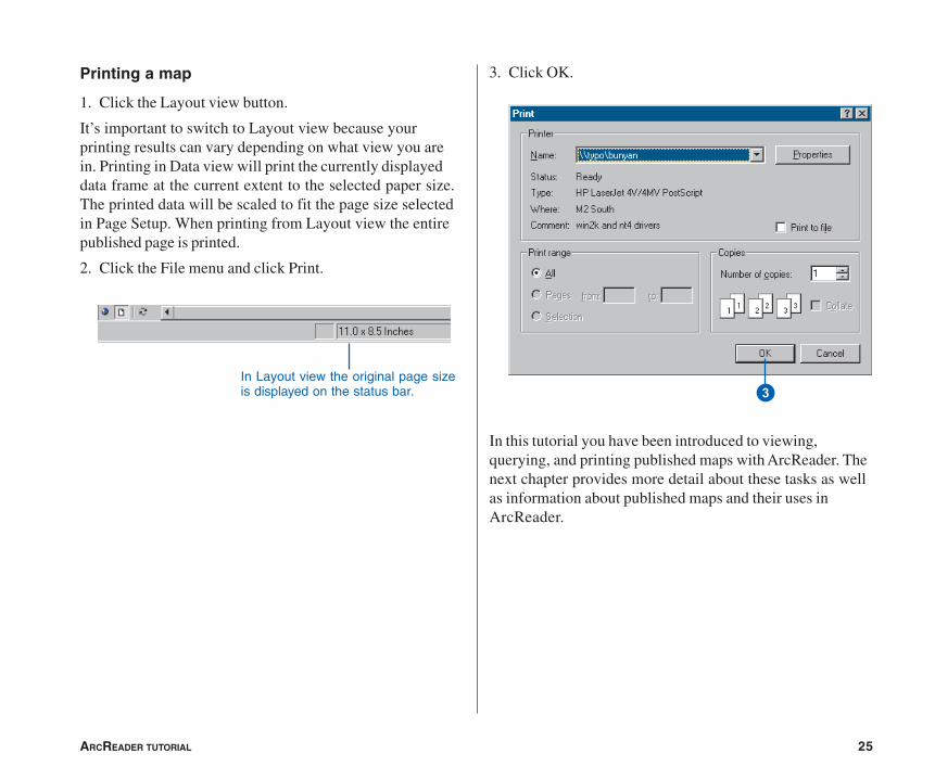
1. Click the Layout view button.
It’s important to switch to Layout view because yourprinting results can vary depending on what view you arein. Printing in Data view will print the currently displayeddata frame at the current extent to the selected paper size.The printed data will be scaled to fit the page size selectedin Page Setup. When printing from Layout view the entirepublished page is printed.
2. Click the File menu and click Print.
3. Click OK.
In this tutorial you have been introduced to viewing,querying, and printing published maps with ArcReader. Thenext chapter provides more detail about these tasks as wellas information about published maps and their uses inArcReader.
In Layout view the original page sizeis displayed on the status bar. �


![Python and ArcGIS Enterprise - static.packt-cdn.com€¦ · Python and ArcGIS Enterprise [ 2 ] ArcGIS enterprise Starting with ArcGIS 10.5, ArcGIS Server is now called ArcGIS Enterprise](https://img.pdfslide.net/doc/110x75/5ecf20757db43a10014313b7/python-and-arcgis-enterprise-python-and-arcgis-enterprise-2-arcgis-enterprise.jpg)