Embed Size (px)
Citation preview
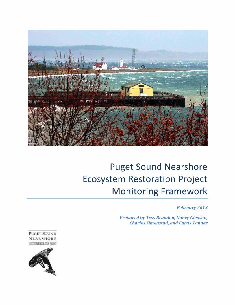
Puget Sound Nearshore Ecosystem Restoration Project
Monitoring Framework
February 2013
Prepared by Tess Brandon, Nancy Gleason, Charles Simenstad, and Curtis Tanner
Technical subject matter of this document was produced by the Puget Sound Nearshore Ecosystem Restoration Project (PSNERP), which is entirely responsible for its contents. Copyright 2013. This document may be freely copied and distributed without charge.
Recommended bibliographic citation:
Brandon, T., N. Gleason, C. Simenstad, and C. Tanner. 2013. Puget Sound Nearshore Ecosystem Restoration Project Monitoring Framework. Prepared for the Puget Sound Nearshore Ecosystem Restoration Project. Published by Washington Department of Fish and Wildlife, Olympia, Washington, and U.S. Army Corps of Engineers, Seattle, Washington. 73 pp.
Cover photo: Hugh Shipman, Washington Department of Ecology.
i
Table of Contents
List of Figures .......................................................................................................................................................... ii List of Tables ..........................................................................................................................................................iii List of Acronyms.................................................................................................................................................... iv 1. Introduction ................................................................................................................................................... 1 2. Background .................................................................................................................................................... 3
2.1 Process-based Restoration ....................................................................................................................................... 3 2.2 Program Context: Prior Work by PSNERP ........................................................................................................ 3 2.3 Restoration Approach ................................................................................................................................................ 5
3. Overview of Effectiveness Monitoring Framework ......................................................................... 9 3.1 Goals ................................................................................................................................................................................... 9 3.2 Approach .......................................................................................................................................................................... 9 3.3 Indicators and Metrics ............................................................................................................................................ 10 3.4 Uncertainties, Contingency Planning, and Programmatic Improvement ....................................... 11
4. Effectiveness Monitoring of Restoration Sites ................................................................................ 15 4.1 River Delta Strategy ................................................................................................................................................. 15
4.1.1 Predicted Functional Outcomes ............................................................................................................ 15 4.1.2 Uncertainties ................................................................................................................................................. 16 4.1.3 Monitoring Indicators, Metrics, and Adaptive Management Responses .............................. 16
4.2 Beach Strategy ............................................................................................................................................................ 28 4.2.1 Predicted Functional Outcomes ............................................................................................................ 28 4.2.2 Uncertainties ................................................................................................................................................. 29 4.2.3 Monitoring Indicators, Metrics, and Adaptive Management Responses .............................. 29
4.3 Barrier Embayment Strategy............................................................................................................................... 36 4.3.1 Predicted Functional Outcomes ............................................................................................................ 36 4.3.2 Uncertainties ................................................................................................................................................. 37 4.3.3 Monitoring Indicators, Metrics, and Adaptive Management Responses .............................. 37
4.4 Coastal Inlet Strategy .............................................................................................................................................. 51 4.4.1 Predicted Functional Outcomes ............................................................................................................ 51 4.4.2 Uncertainties ................................................................................................................................................. 52 4.4.3 Monitoring Indicators, Metrics, and Adaptive Management Responses .............................. 52
5. Implementation of Effectiveness Monitoring ................................................................................. 63 5.1 Development of Site-level Monitoring Plans ................................................................................................. 63 5.2 Site Monitoring Design ............................................................................................................................................ 63
5.2.1 Sampling Methodology ............................................................................................................................. 63 5.2.2 Reference Sites ............................................................................................................................................. 64
5.3 Organizational Framework .................................................................................................................................. 65 5.4 Analysis and Reporting ........................................................................................................................................... 66 5.5 Data Management .................................................................................................................................................... 66
6. Validation Monitoring ............................................................................................................................. 68 6.1 Goals ................................................................................................................................................................................ 68 6.2 Approach ....................................................................................................................................................................... 68 6.3 Predicted Functional Outcomes .......................................................................................................................... 69 6.4 Uncertainties and Programmatic Improvement ........................................................................................ 69
7. References ................................................................................................................................................... 71
ii
List of Figures
Figure 2-1: Basic conceptual model of process-based restoration. Stressors are removed to restore nearshore processes. Restored processes interact to generate structural and functional ecosystem responses, ultimately delivering desired functions, goods, and services. ......................................................................................................................... 5
Figure 4-1: Example of a typical Puget Sound river delta depicting the degraded system prior to restoration, and the structural and functional responses of the system following restoration. ........................................................................................................................18
Figure 4-2: Conceptual model of management measures, restored processes, and structural and functional responses for the river delta strategy. ....................................................19
Figure 4-3: Example of a typical Puget Sound beach depicting the degraded system prior to restoration, and the structural and functional responses of the system following restoration. ........................................................................................................................................30
Figure 4-4: Conceptual model of management measures, restored processes, and structural and functional responses for the beach strategy. ..............................................................31
Figure 4-5: Example of a typical Puget Sound barrier embayment depicting the degraded system prior to restoration, and the structural and functional responses of the system following restoration. .................................................................................................................38
Figure 4-6: Conceptual model of management measures, restored processes, and structural and functional responses for the barrier embayment strategy. ..................................39
Figure 4-7: Example of a typical Puget Sound coastal inlet depicting the degraded system prior to restoration, and the structural and functional responses of the system following restoration. ........................................................................................................................53
Figure 4-8: Conceptual model of management measures, restored processes, and structural and functional responses for the coastal Inlet strategy. .................................................54
iii
List of Tables
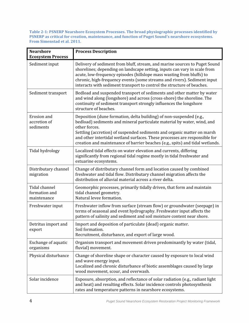
Table 2-1: PSNERP Nearshore Ecosystem Processes.. ........................................................................... 4
Table 2-2: PSNERP Restoration Strategies and Associated Sites. ...................................................... 7
Table 3-1: PSNERP Monitoring Questions and Adaptive Management Responses. ................ 14
Table 4-1: River Delta Strategy Monitoring Table. ............................................................................... 20
Table 4-2: Beach Strategy Monitoring Table ........................................................................................... 31
Table 4-3: Barrier Embayment Strategy Monitoring Table. .............................................................. 40
Table 4-4: Coastal Inlet Strategy Monitoring Table. ............................................................................. 55
iv
List of Acronyms
BACI Before-After-Control-Impact
EFG&S Ecosystem Functions, Goods, and Services
GI General Investigation
LWD Large Woody Debris
PSNERP Puget Sound Nearshore Ecosystem Restoration Project
VEC Valued Ecosystem Component
WDFW Washington Department of Fish and Wildlife
WRDA Water Resources Development Act
Puget Sound Nearshore Ecosystem Restoration Project Monitoring Framework 1
1. Introduction
The Puget Sound Nearshore Ecosystem Restoration Project (PSNERP) is a large-scale, comprehensive initiative to protect and restore the natural processes, structures, and functions of Puget Sound’s nearshore ecosystems. The initiative is being conducted under the U.S. Army Corps of Engineers (Corps) general investigation (GI) authority with the Washington State Department of Fish and Wildlife (WDFW) serving as the non-Federal sponsor. This GI is intended to support broader restoration efforts in the Puget Sound region, including those being coordinated by the Puget Sound Partnership. The culmination of this GI is the delivery of a Final Feasibility Report with a near-term plan of action, which includes recommendation for authorization of strategically selected restoration sites for implementation by the Corps.1
Successful ecosystem restoration requires two basic tools: the ability to alter ecosystems to recreate a desired condition, and the ability to determine whether those manipulations have produced, or are producing, the desired condition (Keddy 2000). This second tool is achieved through systematic monitoring of restoration outcomes. Accordingly, Corps regulations require as an element of the Feasibility Report a plan for “monitoring the success of the ecosystem restoration” (USACE 2009). The monitoring plan must focus on key indicators of project performance to address the question of whether restoration sites and associated management measures are achieving stated objectives.
In its Implementation Guidance for Section 2039 of the Water Resources Development Act of 2007 (WRDA), the Corps defines monitoring as "the systematic collection and analysis of data that provides information useful for assessing project performance, determining whether ecological success has been achieved, or whether adaptive management may be needed to attain project benefits" (USACE 2009). In this context, the Corps uses the term "adaptive management" to denote "contingency planning" – in other words, determining the need for, and implementing, mid-course corrections to restoration actions. Thus, the Corps recognizes that even the most strategically planned restoration actions can yield unexpected results. Comprehensive monitoring of a site documents and diagnoses these results especially in the early, formative stages, providing information useful for taking corrective action. In this way, it reduces the risk of failure and enables effective, responsive management of restoration actions.
The restoration sites selected by PSNERP employ a suite of management measures that attempt to address a complex set of objectives. These management measures are linked to their predicted ecological outcomes through a series of assumptions. While these assumptions are based on the best current scientific understanding, they involve scientific uncertainties inherent in ecosystem restoration. Monitoring and adaptive management
1 As “restoration” is used here, it encompasses restoration activities as well as preservation and protection of undegraded sites. Preservation that is recommended as the result of a Corps feasibility study is the responsibility solely of the non-Federal sponsor.
2 Puget Sound Nearshore Ecosystem Restoration Project Monitoring Framework
provides a mechanism for testing assumptions and further reducing these uncertainties. As the scientific record develops, relationships, conceptual models, management measures, and ultimately restoration designs can be refined for use in future actions or to improve existing actions.
Comprehensive monitoring of any restoration program generally falls into three broad categories:
Implementation monitoring, also known as compliance monitoring, evaluates whether or not planned restoration tasks have been carried out as intended. In other words, implementation monitoring is designed to answer the questions, “Did we do what we said we would do? Did we follow all applicable standards and guidelines when we did it?”
Effectiveness monitoring evaluates whether or not restoration actions are achieving their stated objectives. Effectiveness monitoring is designed to answer the question, “Did the completed actions achieve the intended outcomes? To what degree did we meet our site-specific objectives?”
Validation monitoring tests the assumptions linking objectives and program goals. It is designed to answer the question, “Are these objectives the right ones to achieve program goals, or are our underlying assumptions wrong?”
All three types of monitoring are critical to the success of a restoration program. The monitoring framework presented in this document focuses primarily on effectiveness monitoring, as it is the fundamental monitoring responsibility of the Corps and non-Federal sponsor. Validation monitoring is necessary for programmatic adaptation and learning, but is presented as secondary in this framework to reflect its prioritization level. The completion of implementation monitoring is assumed to be part of project construction best practices. Thus, guidance for implementation monitoring is outside of the scope of this document.
This document is intended to support comprehensive decision-making for the construction phase of the program, including engineering and design of restoration sites. It will be used to develop individual site-specific monitoring plans for the proposed restoration sites, providing a framework to assess the effectiveness of actions taken to restore nearshore ecosystem processes by measuring the response of specific indicators. Successful implementation of these plans will also enhance understanding of physical and biological nearshore processes and the ecosystem goods and services they support. This understanding will benefit the broader restoration community of Puget Sound.
Puget Sound Nearshore Ecosystem Restoration Project Monitoring Framework 3
2. Background
2.1 Process-based Restoration
PSNERP's approach to the GI study is unique in that it focuses on understanding, evaluating, and restoring degraded ecosystem processes (Table 2-1). Where other restoration initiatives focus on addressing symptoms of ecosystem degradation such as single-species population decline or habitat loss, PSNERP's approach addresses the physiographic problems that underlie ecosystem degradation. The scientific and technical basis for this approach is documented in PSNERP guidance documents and reflects the emerging scientific discussion about the need to integrate understanding of ecosystem process into restoration planning. Goetz et al. (2004) stresses the importance of the physiographic processes that are responsible for building and sustaining landscape structures that support functions of an ecosystem. These structures and functions in turn provide valued ecosystem goods and services.
While full recovery of ecosystem function can be attempted through recreation of ecosystem structure, the long-term performance and effectiveness of such an approach is highly uncertain without restoration of the fundamental processes that maintain that structure (Simenstad et al. 2006). Indeed, there is little evidence for successful, long-term restoration of habitat structure. Restoration of degraded physiographic processes enables an ecosystem to be naturally productive, self-sustaining, and resilient, maximizing the likelihood that it will continue to provide functions, goods, and services into the future (Goetz et al. 2004, Greiner 2010, Cereghino et al. 2012).
2.2 Program Context: Prior Work by PSNERP
PSNERP was initiated in 2001 to evaluate the degradation of nearshore ecosystems in Puget Sound and to guide the restoration and protection of these ecosystems. To achieve this purpose, PSNERP initially gathered Sound-wide data to perform an analysis of historical change. This analysis quantified changes to the structure of Puget Sound’s nearshore ecosystems over the past as a proxy for understanding historical nearshore processes (Simenstad et al. 2011). Results of the analysis indicated dramatic changes in Puget Sound nearshore ecosystems, including loss of wetlands, coastal embayments, and other landforms, and widespread distribution of stressors that impact ecosystem processes. The impact of these changes on nearshore ecosystem functions, goods, and services was also evaluated (Fresh et al. 2011, Simenstad et al. 2011, Cereghino et al. 2012).
To understand better the observed changes and loss, PSNERP conducted a Strategic Needs Assessment to characterize the impact of anthropogenic shoreline alterations on nearshore ecosystem processes (Schlenger et al. 2011). The assessment identified the major stressors contributing to the observed degradation, and quantified this degradation for 11 critical landscape-forming processes (Table 2-1). The assessment also assessed the impact of major stressors on valued ecosystem functions, goods, and services. The result was a clear problem statement identifying the major changes in Puget Sound nearshore ecosystems that should be the focus of restoration and protection actions (Fresh et al. 2011).
4 Puget Sound Nearshore Ecosystem Restoration Project Monitoring Framework
Table 2-1: PSNERP Nearshore Ecosystem Processes. The broad physiographic processes identified by PSNERP as critical for creation, maintenance, and function of Puget Sound’s nearshore ecosystems. From Simenstad et al. 2011.
Nearshore Ecosystem Process
Process Description
Sediment input Delivery of sediment from bluff, stream, and marine sources to Puget Sound shorelines; depending on landscape setting, inputs can vary in scale from acute, low-frequency episodes (hillslope mass wasting from bluffs) to chronic, high-frequency events (some streams and rivers). Sediment input interacts with sediment transport to control the structure of beaches.
Sediment transport Bedload and suspended transport of sediments and other matter by water and wind along (longshore) and across (cross-shore) the shoreline. The continuity of sediment transport strongly influences the longshore structure of beaches.
Erosion and accretion of sediments
Deposition (dune formation, delta building) of non-suspended (e.g., bedload) sediments and mineral particulate material by water, wind, and other forces. Settling (accretion) of suspended sediments and organic matter on marsh and other intertidal wetland surfaces. These processes are responsible for creation and maintenance of barrier beaches (e.g., spits) and tidal wetlands.
Tidal hydrology Localized tidal effects on water elevation and currents, differing significantly from regional tidal regime mostly in tidal freshwater and estuarine ecosystems.
Distributary channel migration
Change of distributary channel form and location caused by combined freshwater and tidal flow. Distributary channel migration affects the distribution of alluvial material across a river delta.
Tidal channel formation and maintenance
Geomorphic processes, primarily tidally driven, that form and maintain tidal channel geometry. Natural levee formation.
Freshwater input Freshwater inflow from surface (stream flow) or groundwater (seepage) in terms of seasonal and event hydrography. Freshwater input affects the pattern of salinity and sediment and soil moisture content near shore.
Detritus import and export
Import and deposition of particulate (dead) organic matter. Soil formation. Recruitment, disturbance, and export of large wood.
Exchange of aquatic organisms
Organism transport and movement driven predominantly by water (tidal, fluvial) movement.
Physical disturbance Change of shoreline shape or character caused by exposure to local wind and wave energy input. Localized and chronic disturbance of biotic assemblages caused by large wood movement, scour, and overwash.
Solar incidence Exposure, absorption, and reflectance of solar radiation (e.g., radiant light and heat) and resulting effects. Solar incidence controls photosynthesis rates and temperature patterns in nearshore ecosystems.

Puget Sound Nearshore Ecosystem Restoration Project Monitoring Framework 5
From this problem statement, PSNERP developed four program-scale objectives for achieving process-based nearshore restoration in Puget Sound:
1. Restore the size and quality of large river delta estuaries and nearshore processes the deltas support.
2. Restore the number and quality of coastal embayments.
3. Restore the size and quality of beaches and bluffs.
4. Increase understanding of natural process restoration in order to improve effectiveness of program actions.
These objectives provide a planning framework from which more specific ecosystem objectives and restoration actions can be developed.
2.3 Restoration Approach
In order to address program-scale objectives, PSNERP developed four restoration and protection strategies that focus on restoration of river deltas, beaches, barrier embayments, and coastal inlets (Cereghino et al. 2012). This classification scheme is consistent with Shipman's (2008) division of the Puget Sound shoreline by geomorphic system, and reflects the four distinct ways that nearshore processes structure the shoreline in each system. Accordingly, each system supports a distinct set of ecosystem functions, goods, and
services. All four systems are required for restoration of historical ecosystem services provided by nearshore ecosystems (Cereghino et al. 2012).
Each strategy aims to restore critical landscape-forming processes by using management measures that remove the stressors currently impeding those processes (Clancy et al. 2009). Once restored, the processes are hypothesized to initiate structural and functional responses, ultimately leading to a productive, self-sustaining, and resilient system capable of producing the valued ecosystem goods and services historically associated with that strategy (Figure 2-1). The relationship between management measures, target processes, and ecosystem structures and functions for each strategy is based on a conceptual model derived from current scientific understanding of the system (Simenstad et al. 2006; Clancy et al. 2009). Specific conceptual models for each of the four landform strategies are
Figure 2-1: Basic conceptual model of process-based restoration.
6 Puget Sound Nearshore Ecosystem Restoration Project Monitoring Framework
described later in this document.
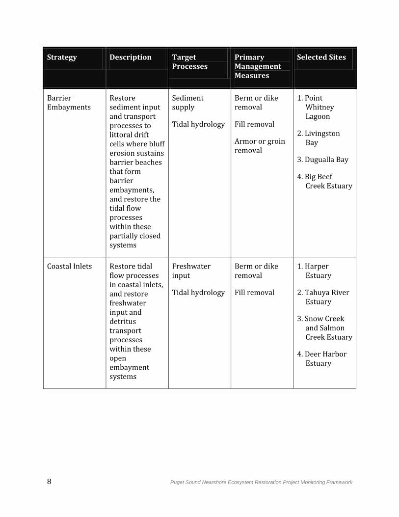
Management measures may be applied alone or in combination to remove stressors and restore target processes. Restoration sites consist of one or more management measures applied at one or more discrete locations, constructed concurrently or in succession. Eighteen restoration sites have been selected as part of the near-term plan for the GI, and are recommended for authorization and implementation by the Corps. These sites were selected from lists of restoration opportunities identified by various governmental and non-governmental organizations throughout Puget Sound (ESA 2011). As a group, they cover all four strategies, addressing the broad suite of process-based PSNERP objectives and contributing to the recovery of lost functions, goods, and services of nearshore ecosystems in Puget Sound. The sites, and the restoration strategies to which they belong, are listed in Table 2-2. Although the sites selected by PSNERP were used to develop this framework, it is intended to be applicable to any action designed to restore nearshore processes in river deltas, beaches, barrier embayments, or coastal inlets in Puget Sound.
Puget Sound Nearshore Ecosystem Restoration Project Monitoring Framework 7
Table 2-2: PSNERP Restoration Strategies and Associated Sites.
Strategy Description Target Processes
Primary Management Measures
Selected Sites
River Deltas Restore freshwater input and tidal processes where major river floodplains meet marine waters
Tidal hydrology
Freshwater input
Berm or dike removal
1. Nooksack River Delta
2. Everett Marshland
3. Telegraph Slough
4. Deepwater Slough
5. Milltown Island
6. Spencer Island
7. North Fork Skagit River Delta
8. Duckabush River Estuary
Beaches Restore sediment input and transport processes to littoral drift cells where bluff erosion sustains beach structure
Sediment supply
Armor removal
Groin removal
1. Beaconsfield Feeder Bluff
2. WDNR Budd Inlet Beach
8 Puget Sound Nearshore Ecosystem Restoration Project Monitoring Framework
Strategy Description Target Processes
Primary Management Measures
Selected Sites
Barrier Embayments
Restore sediment input and transport processes to littoral drift cells where bluff erosion sustains barrier beaches that form barrier embayments, and restore the tidal flow processes within these partially closed systems
Sediment supply
Tidal hydrology
Berm or dike removal
Fill removal
Armor or groin removal
1. Point Whitney Lagoon
2. Livingston Bay
3. Dugualla Bay
4. Big Beef Creek Estuary
Coastal Inlets Restore tidal flow processes in coastal inlets, and restore freshwater input and detritus transport processes within these open embayment systems
Freshwater input
Tidal hydrology
Berm or dike removal
Fill removal
1. Harper Estuary
2. Tahuya River Estuary
3. Snow Creek and Salmon Creek Estuary
4. Deer Harbor Estuary
Puget Sound Nearshore Ecosystem Restoration Project Monitoring Framework 9
3. Overview of Effectiveness Monitoring Framework
Effectiveness monitoring is the primary focus of this document, as it is the fundamental monitoring responsibility of the Corps and non-Federal sponsor. By evaluating performance criteria for each restoration action, effectiveness monitoring tests whether actions are achieving their stated ecological objectives. Measuring and tracking these criteria provides feedback to determine if any adjustments to the restoration action are necessary to improve its probability or degree of ecological success. If properly planned and maintained, this feedback leads to increased knowledge, reducing uncertainty in the outcomes of restoration, and allowing sequential improvement of management actions in meeting the objectives from site to project scales. This feedback is the basis of an adaptive management framework.
The extent to which different treatments are applied to address the same management objective, including no-action control treatments, determines whether the adaptive management program is considered “passive” or “active” (Murray and Marmorek, 2003). Currently, project managers perceive constraints within the Corps program, which likely preclude or limit actions that might be considered experimental in nature. Despite the recognized learning benefits associated with active adaptive management, these program constraints and associated funding limitations lead us to advance a narrower framework. This monitoring framework supports passive adaptive management at the site-specific scale, rather than more ambitious active programmatic adaptive management. If the authorizing environment for the program changes over the decades-long timeframe anticipated for implementation, this conservative approach may be reassessed and a more robust adaptive management approach developed.
3.1 Goals
The goals of effectiveness monitoring of PSNERP restoration actions are to:
1. Assess the effectiveness of restoration actions in achieving defined objectives;
2. Determine where corrective action is needed to improve the effectiveness of restoration actions, and inform decisions about how to take such corrective action; and
3. Reduce risks and uncertainties associated with future restoration actions by increasing understanding of the relationships between restoration actions and restored ecosystem processes, structures, and functions for Puget Sound nearshore ecosystems.
3.2 Approach
The four PSNERP restoration strategies identify management measures used to restore processes, which in turn generate a series of structural and functional responses specific to the ecosystem. These responses constitute a set of predicted ecological and other ecosystem goods and services outcomes that indicate the performance of the restoration site. Performance of the restoration site is documented through an evaluation of
10 Puget Sound Nearshore Ecosystem Restoration Project Monitoring Framework
monitoring results as measured against these predicted outcomes. Thus, these outcomes effectively serve as strategy-specific objectives. In order to achieve the monitoring goals stated above, effectiveness monitoring of PSNERP restoration sites must answer the question, "Do management measures as implemented restore processes necessary to achieve objectives of improved ecosystem functions, goods and services?"
Processes are inherently difficult to measure and quantify directly, and need to be related to expected structural and functional responses in order to fully demonstrate restoration performance. As a result, structural and functional responses are typically monitored directly as indicators of restored processes. The causal relationships among restored processes and structural and functional responses are defined by strategy-specific conceptual models. This approach is consistent with the analytical process used to define and plan restoration needs: using the same conceptual models, structural changes documented in the historical change analysis were translated into implications of process degradation (Simenstad et al. 2011).
3.3 Indicators and Metrics
Ecosystem interactions addressed in the conceptual models occur primarily between process and structure, with both separately and in combination influencing ecosystem functions (Simenstad et al. 2006; Clancy et al. 2009). For each strategy, there are also two levels of ecosystem processes: target processes, without which ecosystem restoration would be considered incomplete; and secondary processes, which rely on restoration of the target processes to operate most fully. These overlapping hierarchies are captured in monitoring by three levels of indicators of increasing complexity and interrelatedness:
Primary indicators are structural responses that are directly related (i.e., through a single causal relationship in the conceptual model) to the target processes for that strategy. For example, tidal hydrology is a target process for the river deltas strategy. Enhanced tidal prism is a direct result of restored tidal hydrology, and is monitored as a primary indicator for restoration sites in the river delta strategy.
Secondary indicators are structural responses that are supported by any combination of restored processes for that strategy, including target and secondary processes. Compared to primary indicators, they are less directly related to restoration of the target processes for that strategy. For example, colonization by native vegetation is a structural response in the river delta strategy that relies on two restored processes: erosion and accretion of sediments, and exchange of aquatic organisms. These two processes operate most fully where tidal hydrology and freshwater input – the two target processes for the river delta strategy – are fully restored (Cereghino et al. 2012).
Tertiary indicators are structural or functional responses that require the restoration of all nearshore processes for that strategy, including both target and secondary processes, and often one or more structural responses as well. Compared to primary and secondary indicators, they are the most complex and least directly related to restoration of the target processes for that strategy. For example, increased shoreline length and complexity is a structural response in the river delta
Puget Sound Nearshore Ecosystem Restoration Project Monitoring Framework 11
strategy that depends on at least partial restoration of all processes in the river delta strategy, as well as several structural responses, including marsh plain redevelopment and channel network redevelopment.
All three levels of indicators must be monitored to evaluate whether they follow a predicted response. This response is developed from the best scientific understanding of the system's evolution following implementation of the restoration site. Metrics for each indicator are selected to provide enough information to track an indicator through its predicted response, as well as to explain why an indicator is (or is not) developing as predicted. For example, in the river delta strategy, site-scale topography measurements will track marsh plain redevelopment over time. Should the marsh plain fail to redevelop, measurements of local sediment accretion and erosion may help provide an explanation.
In general, this monitoring framework anticipates the use of reference sites. A reference site provides a basis of comparison to the restoration site and to pre-restoration conditions, helps inform acceptable values for monitoring metrics (Goetz et al. 2004), and can serve as a covariate that takes into account natural variability (Roni et al. 2005). Use of reference sites is discussed further in Section 5.2.
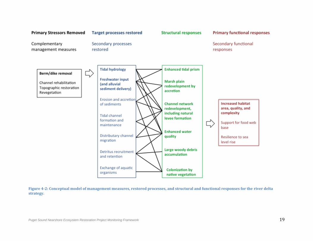
Each indicator is presented in this document as an element in a monitoring table, together with its predicted response and the metrics required for assessment. Also listed are the primary processes that support it – in other words, the indicator can develop according to its predicted response only if those processes have been restored. Each indicator is also presented as an element in the conceptual model diagram (for example, Figure 4-2), either as a structural response or a primary functional response. This diagram provides a simplified graphical representation of the complex linkages between ecosystem processes, structures, and functions. One monitoring table and one conceptual model diagram are presented for each of the four PSNERP restoration strategies.
3.4 Uncertainties, Contingency Planning, and Programmatic Improvement
Several types of uncertainties exist in the practice of ecosystem restoration. These uncertainties are derived from:
The response of the system to restoration. These arise from assumptions made in the conceptual model and can introduce risk of failure or delay meeting objectives.
Cumulative effects. Multiple restoration actions, particularly within a shoreline “process unit”, can interact in unpredictable ways with synergistic or countervailing results.2
2 A “process unit” is the basic spatial unit of the PSNERP change analysis (Simenstad et al. 2010), strategic needs assessment (Schlenger et al. 2011), and strategies analysis for nearshore protection and restoration (Cereghino et al. 2012), It is defined as a segment of Puget Sound shoreline comprising a drift cell, within which beach sedimentary processes are confined by drift cell indicators of sediment transport, convergence, and divergence; and the adjacent upland watershed area.
12 Puget Sound Nearshore Ecosystem Restoration Project Monitoring Framework
External factors and constraints. Factors outside the control of the restoration action can affect performance. These may include uncertain future change such as accelerated sea level rise, or practical constraints such as human modifications to watersheds or protection of private property.
In the PSNERP monitoring framework, uncertainties can be addressed at three scales: (1) the individual restoration site scale; (2) the scale over which individual projects may interact across common nearshore ecosystem processes, (e.g., the shoreline process unit scale); and, (3) and the collection of PSNERP restoration sites, or program scale. Effectiveness monitoring reduces risk associated with uncertainties at the site scale through contingency planning. At the program scale, information from effectiveness monitoring is used for programmatic improvement.
At the site scale, effectiveness monitoring reduces uncertainties associated with the response of the system to restoration by answering questions derived from the conceptual model. Each ecosystem interaction in the model, or linkage between a process, structure, or function, represents a separate monitoring question. Monitoring answers these questions by systematically tracking indicators over time and comparing results to a predicted response. If an indicator does not develop as predicted, a contingency plan presents options and instructions for corrective action. More specific adaptive management responses are presented for each indicator in the strategy-specific monitoring tables in the following section of this document.
Although effectiveness monitoring is performed at the site scale, the information it generates can be used to inform decisions and make improvements at the program scale. Monitoring of primary, secondary, and tertiary indicators tests assumptions and reduces uncertainties associated with the conceptual models, enabling refinement of those models over time. In addition to improving existing sites, refined models can be used to make the next generation of restoration sites more effective.
The large spatial scale and long timeframe that characterize the monitoring of PSNERP restoration sites are also critical to programmatic improvement. Information from effectiveness monitoring across all PSNERP restoration sites can be used to reduce uncertainties about cumulative effects, while also tracking progress toward PSNERP program-scale objectives. The same information, collected over a long period as part of the broader assessment of nearshore restoration in Puget Sound, can be used to track and understand the response of the system to external factors such as climate change and land use patterns. This information can be used to adjust the objectives, design, and implementation of the next generation of restoration sites, as well as to adapt program objectives to changing conditions.
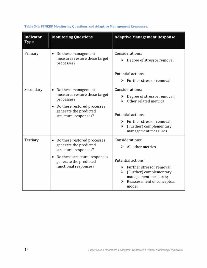
Table 3-1 shows the types of monitoring questions and contingency plans that apply to the three levels of PSNERP indicators. Contingency plans are presented as management responses to unfavorable monitoring results. These responses consist of information that must be considered to explain the unfavorable results, and potential corrective actions to help reverse them and move the system toward success. More specific adaptive
Puget Sound Nearshore Ecosystem Restoration Project Monitoring Framework 13
management responses are presented for each indicator in the strategy-specific monitoring tables in the following section of this document.
Although effectiveness monitoring is performed at the site scale, the information it generates can be used to inform decisions and make improvements at the program scale. Monitoring of primary, secondary, and tertiary indicators tests assumptions and reduces uncertainties associated with the conceptual models, enabling refinement of those models over time. In addition to improving existing sites, refined models can be used to make the next generation of restoration sites more effective.
The large spatial scale and long timeframe that characterize the monitoring of PSNERP restoration sites are also critical to programmatic improvement. Information from effectiveness monitoring across all PSNERP restoration sites can be used to reduce uncertainties about cumulative effects, while also tracking progress toward PSNERP program-scale objectives. The same information, collected over a long period as part of the broader assessment of nearshore restoration in Puget Sound, can be used to track and understand the response of the system to external factors such as climate change and land use patterns. This information can be used to adjust the objectives, design, and implementation of the next generation of restoration sites, as well as to adapt program objectives to changing conditions.
14 Puget Sound Nearshore Ecosystem Restoration Project Monitoring Framework
Table 3-1: PSNERP Monitoring Questions and Adaptive Management Responses.
Indicator Type
Monitoring Questions Adaptive Management Response
Primary Do these management measures restore these target processes?
Considerations:
Degree of stressor removal
Potential actions:
Further stressor removal
Secondary Do these management measures restore these target processes?
Do these restored processes generate the predicted structural responses?
Considerations:
Degree of stressor removal; Other related metrics
Potential actions:
Further stressor removal; (Further) complementary
management measures
Tertiary Do these restored processes generate the predicted structural responses?
Do these structural responses generate the predicted functional responses?
Considerations:
All other metrics
Potential actions:
Further stressor removal; (Further) complementary
management measures; Reassessment of conceptual
model
Puget Sound Nearshore Ecosystem Restoration Project Monitoring Framework 15
4. Effectiveness Monitoring of Restoration Sites
Monitoring frameworks are presented in this section for each of the four PSNERP restoration strategies: river deltas, beaches, barrier embayments, and coastal inlets. Each strategy is described as a single system with a set of management measures and ecosystem processes to restore. This reflects the distinct way that nearshore processes structure the shoreline in each system, and is valid for the purpose of developing a monitoring framework. However, natural variation among restoration sites within each strategy will warrant slightly different approaches to monitoring.
It is assumed that as plans for the sites advance from current level of design (10%) to final design and construction, increasingly detailed monitoring plans will be developed for the sites. The indicators and metrics presented here for each strategy represent a comprehensive “shopping list” for monitoring restoration sites within that strategy. Monitoring plans developed for individual restoration sites are anticipated to vary from these according to site-scale conditions and requirements.
4.1 River Delta Strategy
4.1.1 Predicted Functional Outcomes
River deltas are formed where broad tidal surge plains meet marine waters. Most river deltas in Puget Sound have been extensively modified through urban and agricultural development and land use. Delta wetlands have been cut off from tidal flow by dikes, or eliminated through filling. Reduced tidal flushing and alluvial sediment input have prevented water and sediment from reaching marshes, causing subsidence, stalling of tidal channel formation and maintenance, and an overall decline in total delta shoreline length and complexity (Cereghino et al. 2012).
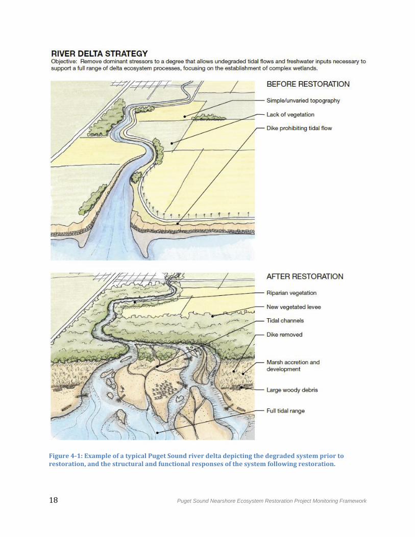
The restoration objective for river deltas is to remove dominant stressors to a degree that allows undegraded tidal flows and freshwater inputs necessary to support a full range of delta ecosystem processes, focusing on the reestablishment of complex wetlands (Figure 4-1). Restoration of tidal hydrology and freshwater input will lead to an enhanced tidal prism, as well as reconnection to natural flooding events. Increased flushing will change levels of organic carbon, oxygen, and nutrients in nearshore waters, and lead to the redevelopment of a salinity gradient appropriate to a diverse wetland system. Reconnection to freshwater input will lead to alluvial sediment and woody debris deposition and a gradual accretion of the marsh plain, which, together with the salinity gradient, will foster colonization by native marsh vegetation. Water flow and erosion will create tidal and distributary channel networks of varying complexity, which can deliver nutrients and detritus to nearshore ecosystems for use by invertebrates, fish, nearshore birds, and other species (Figure 4-2). Natural levees will develop alongside channels and can ultimately support riparian corridors (ESA 2011).
Following restoration of delta ecosystem processes, the system should develop redundant representation of delta ecosystem components, including tidal surge plain, tidal fresh and
16 Puget Sound Nearshore Ecosystem Restoration Project Monitoring Framework
oligohaline transition swamp, salt marsh, tidal flat, subtidal flat, distributary channel, tidal channel, and riparian forest. The restoration site should consist of well-connected large patches, and total shoreline length should increase (Cereghino et al. 2012).
Primary management measures include berm or dike removal or modification in order to restore tidal hydrology and freshwater input. Where primary management measures may be insufficient to achieve predicted structural and functional responses, they may be complemented as necessary by channel modification, topographic restoration, or revegetation.
4.1.2 Uncertainties
Response of the system to restoration:
The degree of channel excavation for several restoration sites is based on the assumption that increased flow and tidal energy will allow channels to redevelop and sustain themselves naturally. If this assumption is incorrect, further channel excavation may be necessary.
Increased tidal flushing may increase wave action, increasing erosion and turbidity, as well as flood risk to adjacent areas.
Unanticipated impacts to adjacent landowners.
Ongoing maintenance costs that will limit project effectiveness in the long run (e.g., cost of removing invasive species, cost of maintaining dikes/berms)
Cumulative effects, external factors, and constraints:
In general, there is uncertainty as to whether the alluvial sediment supply available for accretion within the site will be sufficient to sustain marsh development. Restoration sites within the same shoreline process unit could create new sediment sinks, reducing this sediment supply.
The effects of climate change introduce uncertainty, particularly about flooding frequency, magnitude, and duration, as well as the salinity gradient and resulting vegetation distribution. Sea level rise due to climate change could outpace accretion rates, preventing marsh vegetation adaptation.
Watershed conditions, such as urban development and land use, may strongly affect sediment deposition and maintenance of water quality.
Drainage on neighboring or upstream agricultural fields.
Existing public access and use of area.
4.1.3 Monitoring Indicators, Metrics, and Adaptive Management Responses
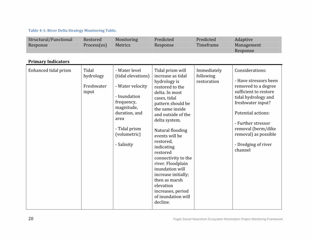
Based on our conceptual model for the river delta strategy, Table 4-1 outlines the relationships between indicators of structural and functional response and associated monitoring metrics. The predicted response and timeframe for metrics is described in
Puget Sound Nearshore Ecosystem Restoration Project Monitoring Framework 17
general terms. Also listed are the primary processes that support proposed indicators – in other words, the indicator can develop according to its predicted response only if associated processes have been restored. This document is currently limited to an effectiveness monitoring framework for functional objectives. Site-specific constraints will also include actions necessary for protecting adjacent landowners, maintaining or replacing public uses of the site, and other factors to insure social acceptability. During future planning, engineering, and design phases, site-specific management constraints will be identified and addressed as part of the stakeholder involvement strategy, including the WDFW Restoration Pathway.
18 Puget Sound Nearshore Ecosystem Restoration Project Monitoring Framework
Figure 4-1: Example of a typical Puget Sound river delta depicting the degraded system prior to restoration, and the structural and functional responses of the system following restoration.
Puget Sound Nearshore Ecosystem Restoration Project Monitoring Framework 19
Figure 4-2: Conceptual model of management measures, restored processes, and structural and functional responses for the river delta strategy.
20 Puget Sound Nearshore Ecosystem Restoration Project Monitoring Framework
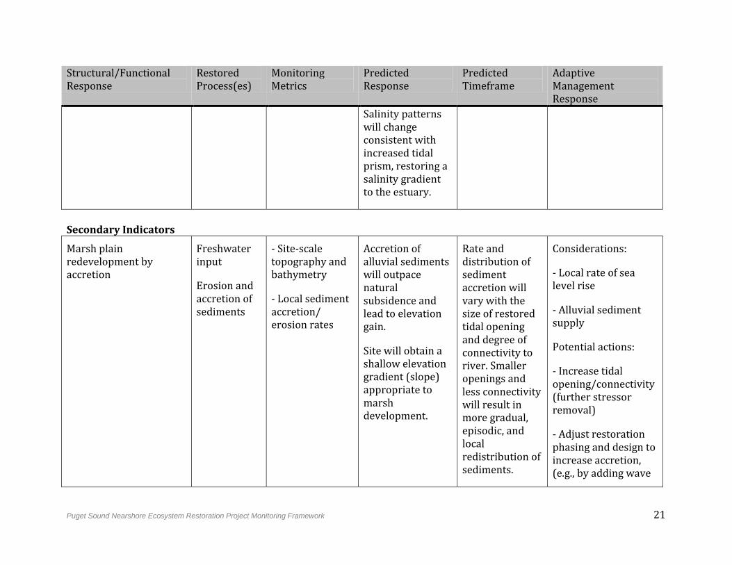
Table 4-1: River Delta Strategy Monitoring Table.
Structural/Functional Response
Restored Process(es)
Monitoring Metrics
Predicted Response
Predicted Timeframe
Adaptive Management Response
Primary Indicators
Enhanced tidal prism Tidal hydrology
Freshwater input
- Water level (tidal elevations)
- Water velocity
- Inundation frequency, magnitude, duration, and area
- Tidal prism (volumetric)
- Salinity
Tidal prism will increase as tidal hydrology is restored to the delta. In most cases, tidal pattern should be the same inside and outside of the delta system.
Natural flooding events will be restored, indicating restored connectivity to the river. Floodplain inundation will increase initially; then as marsh elevation increases, period of inundation will decline.
Immediately following restoration
Considerations:
- Have stressors been removed to a degree sufficient to restore tidal hydrology and freshwater input?
Potential actions:
- Further stressor removal (berm/dike removal) as possible
- Dredging of river channel
Puget Sound Nearshore Ecosystem Restoration Project Monitoring Framework 21
Structural/Functional Response
Restored Process(es)
Monitoring Metrics
Predicted Response
Predicted Timeframe
Adaptive Management Response
Salinity patterns will change consistent with increased tidal prism, restoring a salinity gradient to the estuary.
Secondary Indicators
Marsh plain redevelopment by accretion
Freshwater input
Erosion and accretion of sediments
- Site-scale topography and bathymetry
- Local sediment accretion/ erosion rates
Accretion of alluvial sediments will outpace natural subsidence and lead to elevation gain.
Site will obtain a shallow elevation gradient (slope) appropriate to marsh development.
Rate and distribution of sediment accretion will vary with the size of restored tidal opening and degree of connectivity to river. Smaller openings and less connectivity will result in more gradual, episodic, and local redistribution of sediments.
Considerations:
- Local rate of sea level rise
- Alluvial sediment supply
Potential actions:
- Increase tidal opening/connectivity (further stressor removal)
- Adjust restoration phasing and design to increase accretion, (e.g., by adding wave
22 Puget Sound Nearshore Ecosystem Restoration Project Monitoring Framework
Structural/Functional Response
Restored Process(es)
Monitoring Metrics
Predicted Response
Predicted Timeframe
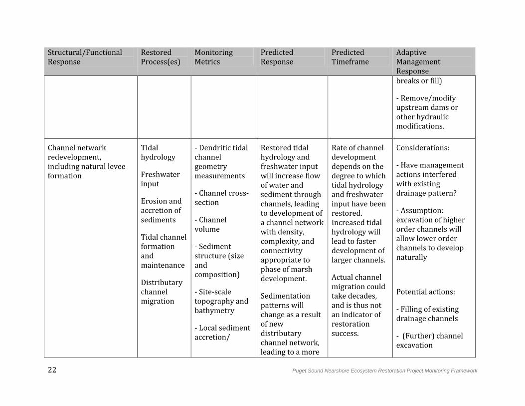
Adaptive Management Response breaks or fill)
- Remove/modify upstream dams or other hydraulic modifications.
Channel network redevelopment, including natural levee formation
Tidal hydrology
Freshwater input
Erosion and accretion of sediments
Tidal channel formation and maintenance
Distributary channel migration
- Dendritic tidal channel geometry measurements
- Channel cross-section
- Channel volume
- Sediment structure (size and composition)
- Site-scale topography and bathymetry
- Local sediment accretion/
Restored tidal hydrology and freshwater input will increase flow of water and sediment through channels, leading to development of a channel network with density, complexity, and connectivity appropriate to phase of marsh development.
Sedimentation patterns will change as a result of new distributary channel network, leading to a more
Rate of channel development depends on the degree to which tidal hydrology and freshwater input have been restored. Increased tidal hydrology will lead to faster development of larger channels.
Actual channel migration could take decades, and is thus not an indicator of restoration success.
Considerations:
- Have management actions interfered with existing drainage pattern?
- Assumption: excavation of higher order channels will allow lower order channels to develop naturally
Potential actions:
- Filling of existing drainage channels
- (Further) channel excavation
Puget Sound Nearshore Ecosystem Restoration Project Monitoring Framework 23
Structural/Functional Response
Restored Process(es)
Monitoring Metrics
Predicted Response
Predicted Timeframe
Adaptive Management Response
erosion
diverse topography. Natural levees with coarser, better-drained soils will develop next to channels; these can eventually support riparian corridors.
Channels should have the potential to migrate freely over time, though actual migration is not an indicator of restoration success.
- (Further) creation starter berms/levees
Enhanced water quality Tidal hydrology
Freshwater input
Tidal channel formation and
- Dissolved organic carbon
- Dissolved oxygen
- pH
Increased flushing and connectivity will lead to enhanced water quality in terms of habitat conditions (i.e,. indicators directly relevant to biology),
Rapid change expected after restoration of tidal hydrology and freshwater input.
Considerations:
- Water velocity and other indicators of flushing
- Channel drainage network development
24 Puget Sound Nearshore Ecosystem Restoration Project Monitoring Framework
Structural/Functional Response
Restored Process(es)
Monitoring Metrics
Predicted Response
Predicted Timeframe
Adaptive Management Response
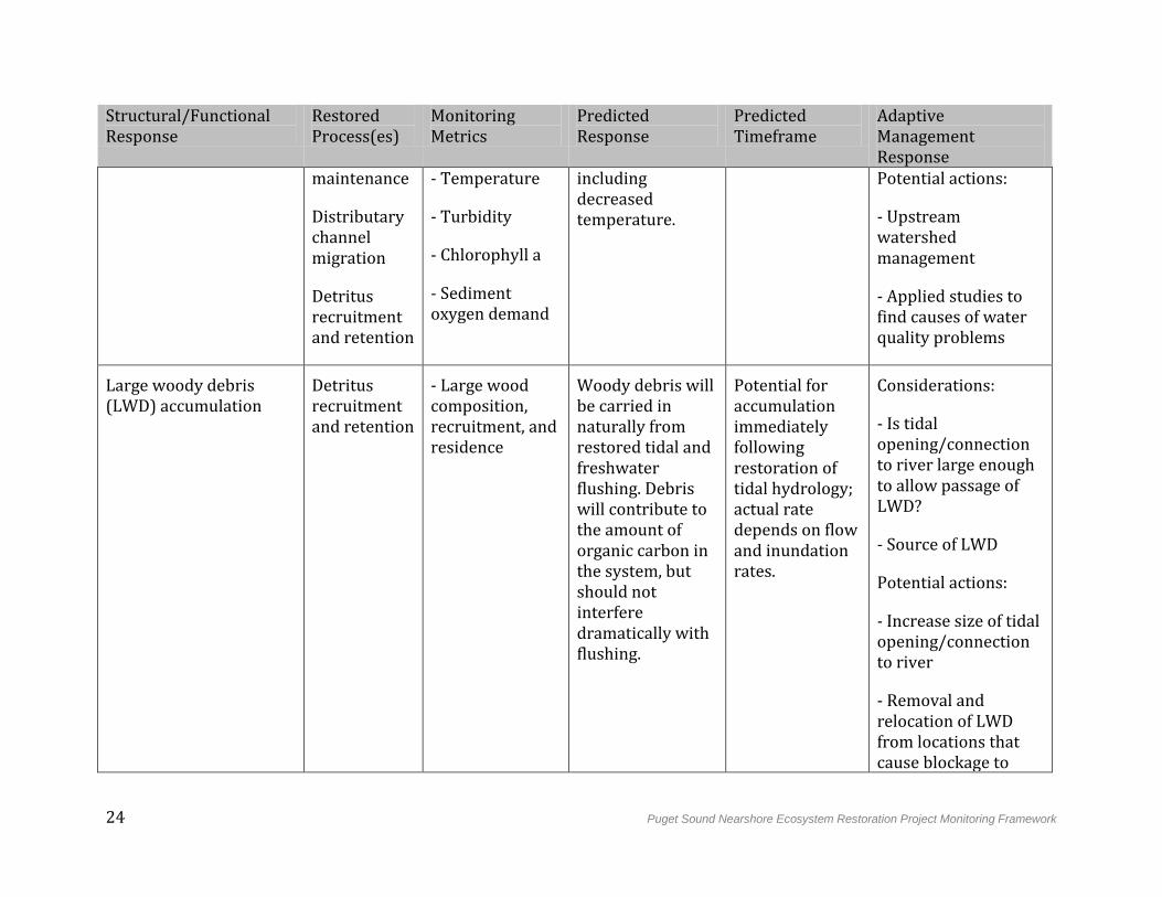
maintenance
Distributary channel migration
Detritus recruitment and retention
- Temperature
- Turbidity
- Chlorophyll a
- Sediment oxygen demand
including decreased temperature.
Potential actions:
- Upstream watershed management
- Applied studies to find causes of water quality problems
Large woody debris (LWD) accumulation
Detritus recruitment and retention
- Large wood composition, recruitment, and residence
Woody debris will be carried in naturally from restored tidal and freshwater flushing. Debris will contribute to the amount of organic carbon in the system, but should not interfere dramatically with flushing.
Potential for accumulation immediately following restoration of tidal hydrology; actual rate depends on flow and inundation rates.
Considerations:
- Is tidal opening/connection to river large enough to allow passage of LWD?
- Source of LWD
Potential actions:
- Increase size of tidal opening/connection to river
- Removal and relocation of LWD from locations that cause blockage to
Puget Sound Nearshore Ecosystem Restoration Project Monitoring Framework 25
Structural/Functional Response
Restored Process(es)
Monitoring Metrics
Predicted Response
Predicted Timeframe
Adaptive Management Response flow, particularly following weather and/or inundation events
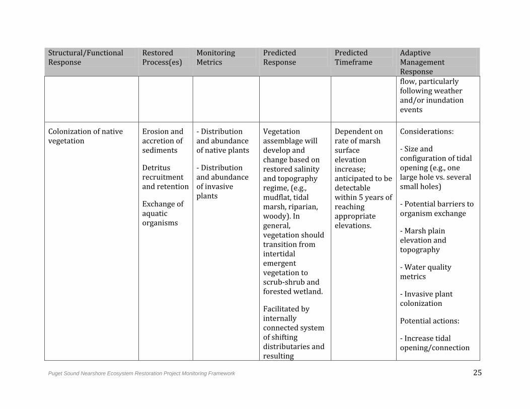
Colonization of native vegetation
Erosion and accretion of sediments
Detritus recruitment and retention
Exchange of aquatic organisms
- Distribution and abundance of native plants
- Distribution and abundance of invasive plants
Vegetation assemblage will develop and change based on restored salinity and topography regime, (e.g., mudflat, tidal marsh, riparian, woody). In general, vegetation should transition from intertidal emergent vegetation to scrub-shrub and forested wetland.
Facilitated by internally connected system of shifting distributaries and resulting
Dependent on rate of marsh surface elevation increase; anticipated to be detectable within 5 years of reaching appropriate elevations.
Considerations:
- Size and configuration of tidal opening (e.g., one large hole vs. several small holes)
- Potential barriers to organism exchange
- Marsh plain elevation and topography
- Water quality metrics
- Invasive plant colonization
Potential actions:
- Increase tidal opening/connection
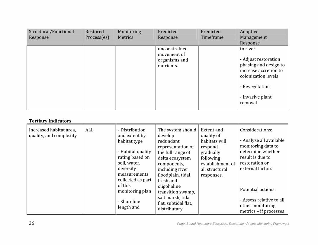
26 Puget Sound Nearshore Ecosystem Restoration Project Monitoring Framework
Structural/Functional Response
Restored Process(es)
Monitoring Metrics
Predicted Response
Predicted Timeframe
Adaptive Management Response
unconstrained movement of organisms and nutrients.
to river
- Adjust restoration phasing and design to increase accretion to colonization levels
- Revegetation
- Invasive plant removal
Tertiary Indicators
Increased habitat area, quality, and complexity
ALL - Distribution and extent by habitat type
- Habitat quality rating based on soil, water, diversity measurements collected as part of this monitoring plan
- Shoreline length and
The system should develop redundant representation of the full range of delta ecosystem components, including river floodplain, tidal fresh and oligohaline transition swamp, salt marsh, tidal flat, subtidal flat, distributary
Extent and quality of habitats will respond gradually following establishment of all structural responses.
Considerations:
- Analyze all available monitoring data to determine whether result is due to restoration or external factors
Potential actions:
- Assess relative to all other monitoring metrics – if processes
Puget Sound Nearshore Ecosystem Restoration Project Monitoring Framework 27
Structural/Functional Response
Restored Process(es)
Monitoring Metrics
Predicted Response
Predicted Timeframe
Adaptive Management Response
complexity
- Landscape connectivity and patchiness
channel, tidal channel, and riparian forest.
Development of complex channel networks will result in enhanced shoreline length and complexity.
The site should be formed of contiguous large patches that are well connected to each other and to the surrounding riverine, terrestrial, and marine landscape.
have been restored but habitat function has not, consider change to conceptual model
28 Puget Sound Nearshore Ecosystem Restoration Project Monitoring Framework
4.2 Beach Strategy
4.2.1 Predicted Functional Outcomes
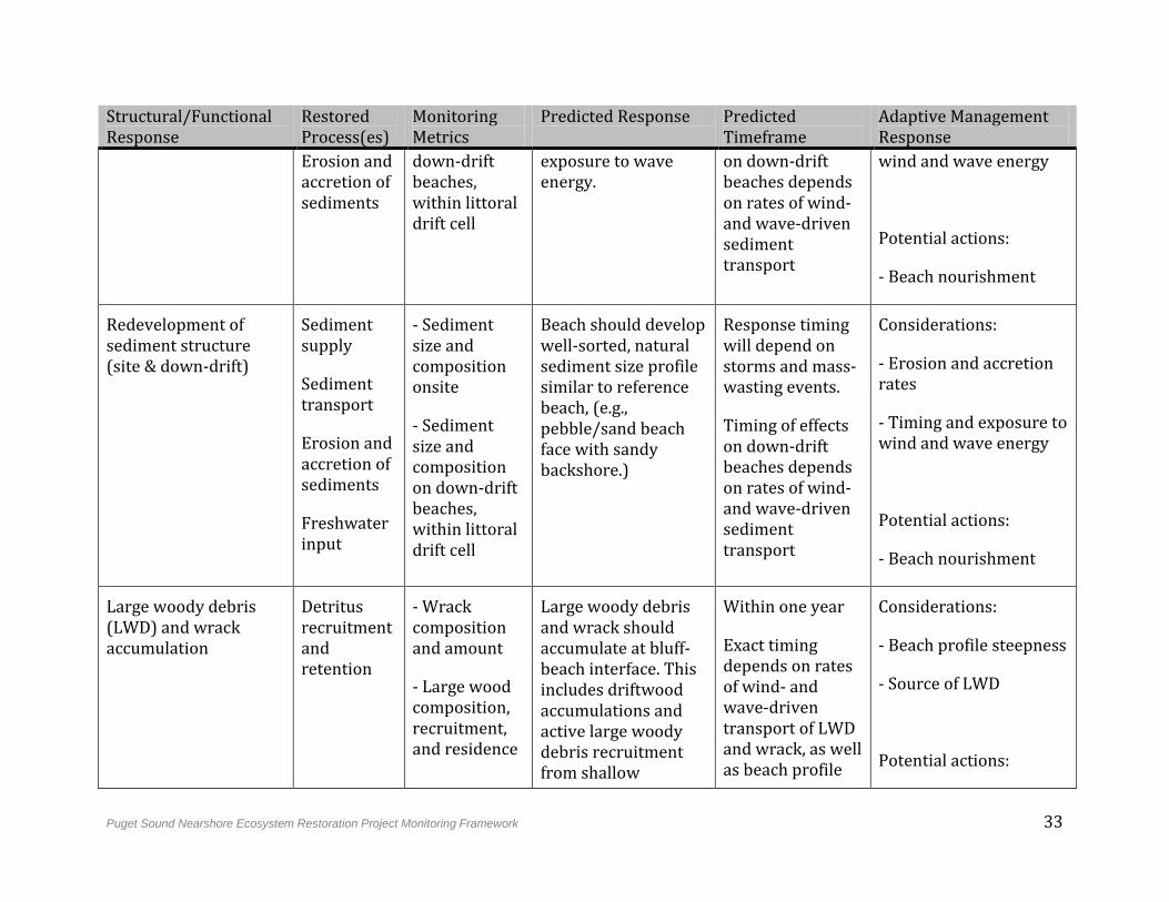
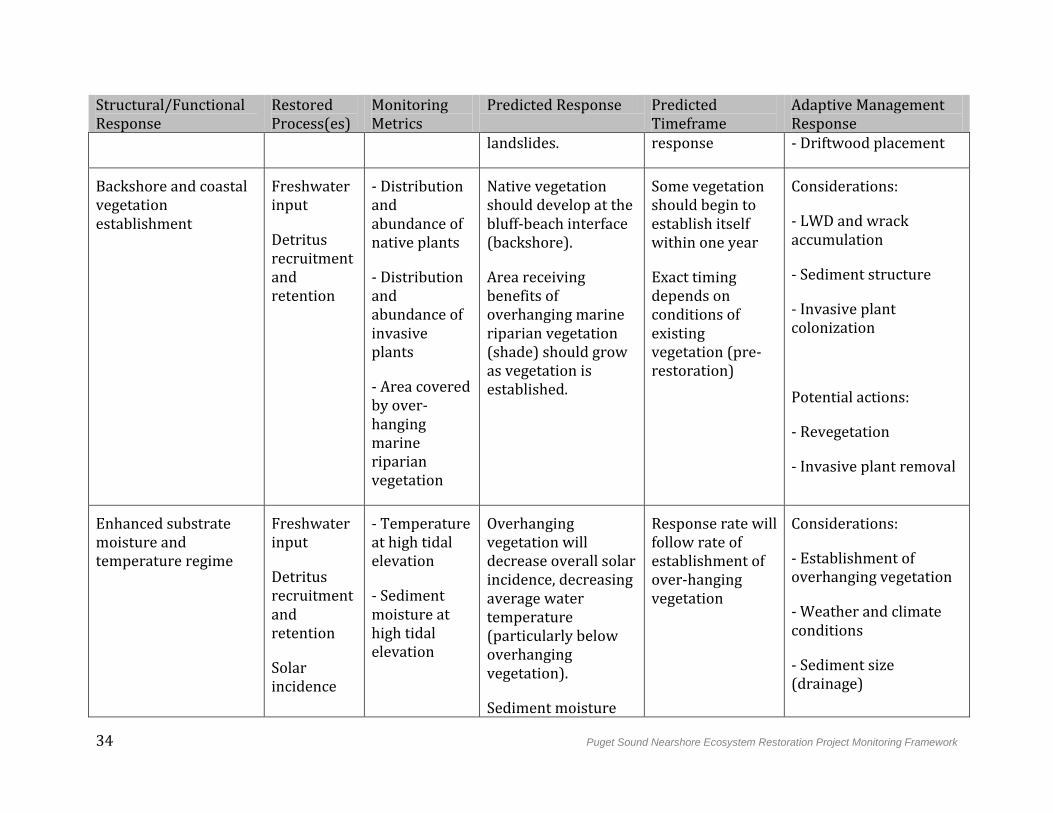
Historically, 50% of the Puget Sound shoreline was composed of beach systems. Concurrent with coastal development, shoreline armoring has been built to protect private property on bluffs and banks from erosion. Armoring has led to the alteration of more than 500 km of bluff-backed shore, which has cut off the sediment supply that maintains down-drift beaches (Cereghino et al. 2012). Armoring also increases potential for loss of beach area and elevation over time (Johannessen and MacLennan 2007), which can decrease resilience to sea level rise (Pethick 2001). By removing or preventing colonization of vegetation and inhibiting wrack and woody debris accumulation, armoring can reduce beach productivity and diversity. Relative to river deltas, barrier embayments, and coastal inlets, degraded beach processes have a greater potential to impact nearshore ecosystems beyond the geographical limits of the altered beaches themselves.
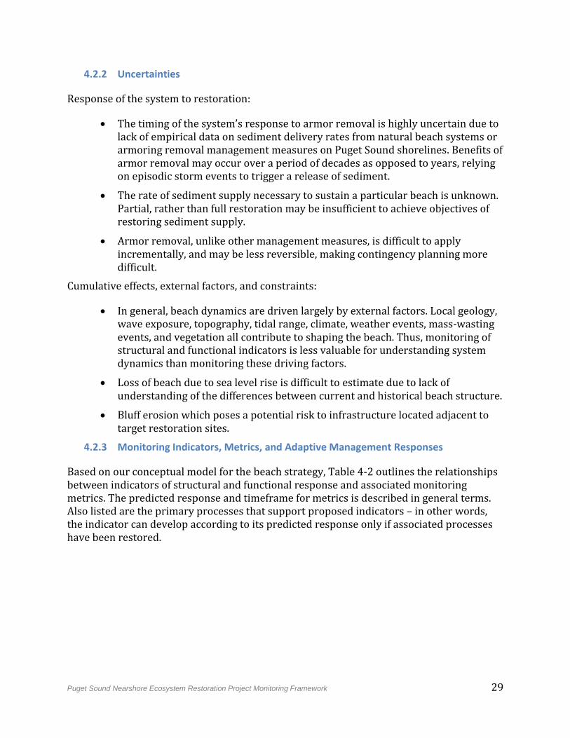
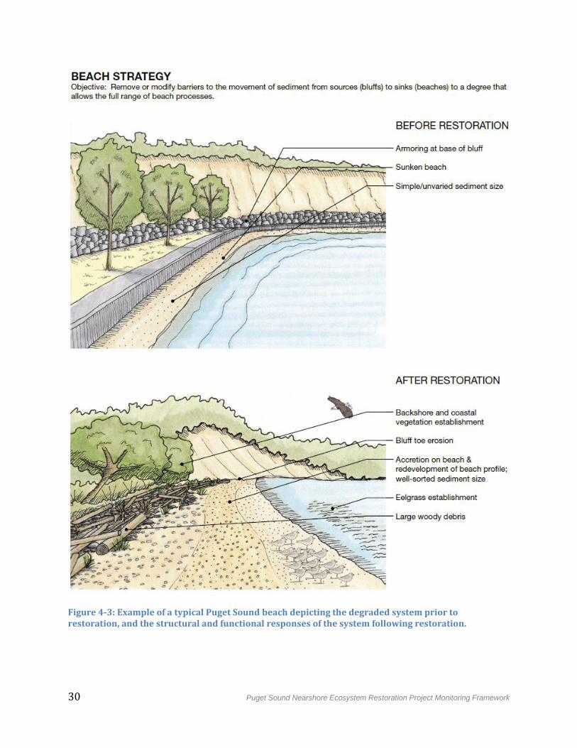
The restoration objective for beaches is to remove or modify barriers to the movement of sediment from sources (bluffs) to sinks (beaches) to a degree that allows the full range of beach processes (Figure 4-3). Figure 4-4 outlines our conceptual model of the relationship between stressor removal, restored processes, and predicted structural and functional responses. Restoration of sediment supply and transport processes is expected to reinitiate bluff toe erosion and increase sediment delivery to down-drift beaches. Restored sediment input and erosion processes will redevelop the beach profile to its former configuration, and the beach will develop a well-sorted, natural sediment size profile. Both site and adjacent beach area should increase. Wrack, large woody debris, and native vegetation should accumulate and develop at the bluff-beach interface. In general, the landward portion of the nearshore zone should provide riparian functions, as well as a historical quantity and quality of ground surface freshwater inputs. This, together with increased overhanging vegetation, will contribute to enhanced sediment moisture content and cooler nearshore waters (ESA 2011; Cereghino et al. 2012).
The primary management measure for beach restoration is armor removal or modification in order to restore sediment supply from feeder bluffs. Groin removal is also a primary measure where cross-shore structures impound sediment and starve down-drift beaches. Where primary management measures are insufficient to achieve predicted structural and functional responses, they may be complemented as necessary by topographic restoration and revegetation.
Puget Sound Nearshore Ecosystem Restoration Project Monitoring Framework 29
4.2.2 Uncertainties
Response of the system to restoration:
The timing of the system’s response to armor removal is highly uncertain due to lack of empirical data on sediment delivery rates from natural beach systems or armoring removal management measures on Puget Sound shorelines. Benefits of armor removal may occur over a period of decades as opposed to years, relying on episodic storm events to trigger a release of sediment.
The rate of sediment supply necessary to sustain a particular beach is unknown. Partial, rather than full restoration may be insufficient to achieve objectives of restoring sediment supply.
Armor removal, unlike other management measures, is difficult to apply incrementally, and may be less reversible, making contingency planning more difficult.
Cumulative effects, external factors, and constraints:
In general, beach dynamics are driven largely by external factors. Local geology, wave exposure, topography, tidal range, climate, weather events, mass-wasting events, and vegetation all contribute to shaping the beach. Thus, monitoring of structural and functional indicators is less valuable for understanding system dynamics than monitoring these driving factors.
Loss of beach due to sea level rise is difficult to estimate due to lack of understanding of the differences between current and historical beach structure.
Bluff erosion which poses a potential risk to infrastructure located adjacent to target restoration sites.
4.2.3 Monitoring Indicators, Metrics, and Adaptive Management Responses
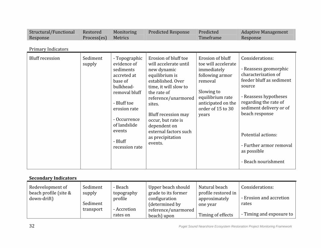
Based on our conceptual model for the beach strategy, Table 4-2 outlines the relationships between indicators of structural and functional response and associated monitoring metrics. The predicted response and timeframe for metrics is described in general terms. Also listed are the primary processes that support proposed indicators – in other words, the indicator can develop according to its predicted response only if associated processes have been restored.
30 Puget Sound Nearshore Ecosystem Restoration Project Monitoring Framework
Figure 4-3: Example of a typical Puget Sound beach depicting the degraded system prior to restoration, and the structural and functional responses of the system following restoration.
Puget Sound Nearshore Ecosystem Restoration Project Monitoring Framework 31
Figure 4-4: Conceptual model of management measures, restored processes, and structural and functional responses for the beach strategy.
Table 4-2: Beach Strategy Monitoring Table.
32 Puget Sound Nearshore Ecosystem Restoration Project Monitoring Framework
Structural/Functional Response
Restored Process(es)
Monitoring Metrics
Predicted Response Predicted Timeframe
Adaptive Management Response
Primary Indicators
Bluff recession Sediment supply
- Topographic evidence of sediments accreted at base of bulkhead-removal bluff
- Bluff toe erosion rate
- Occurrence of landslide events
- Bluff recession rate
Erosion of bluff toe will accelerate until new dynamic equilibrium is established. Over time, it will slow to the rate of reference/unarmored sites.
Bluff recession may occur, but rate is dependent on external factors such as precipitation events.
Erosion of bluff toe will accelerate immediately following armor removal
Slowing to equilibrium rate anticipated on the order of 15 to 30 years
Considerations:
- Reassess geomorphic characterization of feeder bluff as sediment source
- Reassess hypotheses regarding the rate of sediment delivery or of beach response
Potential actions:
- Further armor removal as possible
- Beach nourishment
Secondary Indicators
Redevelopment of beach profile (site & down-drift)
Sediment supply
Sediment transport
- Beach topography profile
- Accretion rates on
Upper beach should grade to its former configuration (determined by reference/unarmored beach) upon
Natural beach profile restored in approximately one year
Timing of effects
Considerations:
- Erosion and accretion rates
- Timing and exposure to
Puget Sound Nearshore Ecosystem Restoration Project Monitoring Framework 33
Structural/Functional Response
Restored Process(es)
Monitoring Metrics
Predicted Response Predicted Timeframe
Adaptive Management Response
Erosion and accretion of sediments
down-drift beaches, within littoral drift cell
exposure to wave energy.
on down-drift beaches depends on rates of wind- and wave-driven sediment transport
wind and wave energy
Potential actions:
- Beach nourishment
Redevelopment of sediment structure (site & down-drift)
Sediment supply
Sediment transport
Erosion and accretion of sediments
Freshwater input
- Sediment size and composition onsite
- Sediment size and composition on down-drift beaches, within littoral drift cell
Beach should develop well-sorted, natural sediment size profile similar to reference beach, (e.g., pebble/sand beach face with sandy backshore.)
Response timing will depend on storms and mass-wasting events.
Timing of effects on down-drift beaches depends on rates of wind- and wave-driven sediment transport
Considerations:
- Erosion and accretion rates
- Timing and exposure to wind and wave energy
Potential actions:
- Beach nourishment
Large woody debris (LWD) and wrack accumulation
Detritus recruitment and retention
- Wrack composition and amount
- Large wood composition, recruitment, and residence
Large woody debris and wrack should accumulate at bluff-beach interface. This includes driftwood accumulations and active large woody debris recruitment from shallow
Within one year
Exact timing depends on rates of wind- and wave-driven transport of LWD and wrack, as well as beach profile
Considerations:
- Beach profile steepness
- Source of LWD
Potential actions:
34 Puget Sound Nearshore Ecosystem Restoration Project Monitoring Framework
Structural/Functional Response
Restored Process(es)
Monitoring Metrics
Predicted Response Predicted Timeframe
Adaptive Management Response
landslides. response - Driftwood placement
Backshore and coastal vegetation establishment
Freshwater input
Detritus recruitment and retention
- Distribution and abundance of native plants
- Distribution and abundance of invasive plants
- Area covered by over-hanging marine riparian vegetation
Native vegetation should develop at the bluff-beach interface (backshore).
Area receiving benefits of overhanging marine riparian vegetation (shade) should grow as vegetation is established.
Some vegetation should begin to establish itself within one year
Exact timing depends on conditions of existing vegetation (pre-restoration)
Considerations:
- LWD and wrack accumulation
- Sediment structure
- Invasive plant colonization
Potential actions:
- Revegetation
- Invasive plant removal
Enhanced substrate moisture and temperature regime
Freshwater input
Detritus recruitment and retention
Solar incidence
- Temperature at high tidal elevation
- Sediment moisture at high tidal elevation
Overhanging vegetation will decrease overall solar incidence, decreasing average water temperature (particularly below overhanging vegetation).
Sediment moisture
Response rate will follow rate of establishment of over-hanging vegetation
Considerations:
- Establishment of overhanging vegetation
- Weather and climate conditions
- Sediment size (drainage)
Puget Sound Nearshore Ecosystem Restoration Project Monitoring Framework 35
Structural/Functional Response
Restored Process(es)
Monitoring Metrics
Predicted Response Predicted Timeframe
Adaptive Management Response
content should increase as a result of slowed evaporation and restored freshwater input, where applicable.
Potential actions:
- Revegetation
- Invasive plant removal
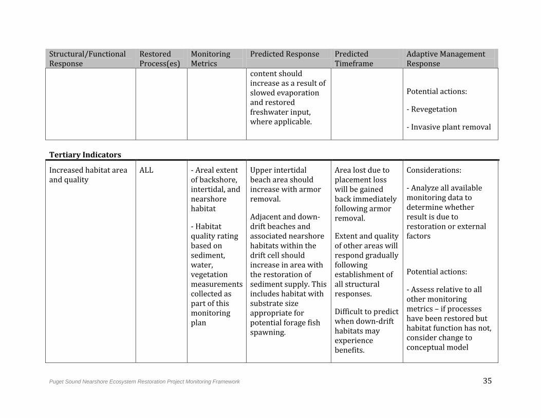
Tertiary Indicators
Increased habitat area and quality
ALL - Areal extent of backshore, intertidal, and nearshore habitat
- Habitat quality rating based on sediment, water, vegetation measurements collected as part of this monitoring plan
Upper intertidal beach area should increase with armor removal.
Adjacent and down-drift beaches and associated nearshore habitats within the drift cell should increase in area with the restoration of sediment supply. This includes habitat with substrate size appropriate for potential forage fish spawning.
Area lost due to placement loss will be gained back immediately following armor removal.
Extent and quality of other areas will respond gradually following establishment of all structural responses.
Difficult to predict when down-drift habitats may experience benefits.
Considerations:
- Analyze all available monitoring data to determine whether result is due to restoration or external factors
Potential actions:
- Assess relative to all other monitoring metrics – if processes have been restored but habitat function has not, consider change to conceptual model
36 Puget Sound Nearshore Ecosystem Restoration Project Monitoring Framework
4.3 Barrier Embayment Strategy
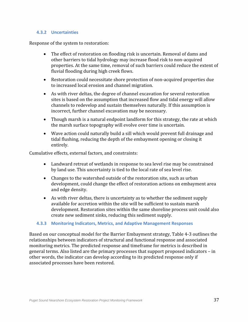
4.3.1 Predicted Functional Outcomes
Structures and functions of barrier embayments are affected by the condition of the beach system that sustains the barrier, and are increasingly sediment-starved due to shoreline armoring. Transportation infrastructure built on top of barrier features can prevent natural migration and increase beach loss from erosion. Filling or diking for development has disconnected many embayments from tidal influence, and may cause the embayment opening to close completely.
The restoration objective for barrier embayments is to remove dominant stressors to restore sediment supply and transport processes to littoral drift cells where bluff erosion sustains barrier beaches that form barrier embayments, and to remove dominant stressors to restore the tidal processes found therein (Figure 4-5). Figure 4-4 outlines our conceptual model of the relationship between stressor removal, restored processes, and predicted structural and functional responses. Following removal of stressors to tidal hydrology, tidal prism will increase incrementally. This will result in enhanced tidal elevations and increased flushing, as well as the reestablishment of a salinity gradient throughout the embayment. Increased tidal flow through channels will lead to the development of a channel network and associated diverse topography. Increased flow will also improve levels of organic carbon, oxygen, and nutrients in embayment waters, especially in lagoons that are reconnected to tidal influence by the restoration action. Sediments delivered by tidal channels will lead to a gradual accretion of the marsh plain, which, together with the unconstrained flow of water and organic material through those channels, will foster colonization by native marsh vegetation. Restored sediment and transport processes will lead to sediment deposition within the embayment and along the shoreline, increasing the extent of barrier beach. Restored littoral processes will rework sediment in the embayment and barrier feature, depositing sediment within the embayment opening until equilibrium is achieved between tidal forces and wave action (ESA 2011).
Following restoration of barrier embayment ecosystem processes, the system should develop redundant representation of barrier embayment ecosystem components including, where historically present, stream delta or ponds, tidal flats, salt marsh, channels, tidal delta, beach berm, beach face, and low tide terrace. The restoration site should consist of one well-connected large patch, and total shoreline length should increase (Cereghino et al. 2012).
Primary management measures include berm or dike removal or modification to restore tidal hydrology where embayment topography is intact, or topographic restoration (fill removal) where an embayment has been filled. Armor or groin removal is another primary management measure to restore sediment supply to a barrier feature, as well as removal of infrastructure that hinders natural inlet channel form and movement. Where primary management measures are insufficient to achieve predicted structural and functional responses, they may be complemented as necessary by hydraulic modification or channel rehabilitation.
Puget Sound Nearshore Ecosystem Restoration Project Monitoring Framework 37
4.3.2 Uncertainties
Response of the system to restoration:
The effect of restoration on flooding risk is uncertain. Removal of dams and other barriers to tidal hydrology may increase flood risk to non-acquired properties. At the same time, removal of such barriers could reduce the extent of fluvial flooding during high creek flows.
Restoration could necessitate shore protection of non-acquired properties due to increased local erosion and channel migration.
As with river deltas, the degree of channel excavation for several restoration sites is based on the assumption that increased flow and tidal energy will allow channels to redevelop and sustain themselves naturally. If this assumption is incorrect, further channel excavation may be necessary.
Though marsh is a natural endpoint landform for this strategy, the rate at which the marsh surface topography will evolve over time is uncertain.
Wave action could naturally build a sill which would prevent full drainage and tidal flushing, reducing the depth of the embayment opening or closing it entirely.
Cumulative effects, external factors, and constraints:
Landward retreat of wetlands in response to sea level rise may be constrained by land use. This uncertainty is tied to the local rate of sea level rise.
Changes to the watershed outside of the restoration site, such as urban development, could change the effect of restoration actions on embayment area and edge density.
As with river deltas, there is uncertainty as to whether the sediment supply available for accretion within the site will be sufficient to sustain marsh development. Restoration sites within the same shoreline process unit could also create new sediment sinks, reducing this sediment supply.
4.3.3 Monitoring Indicators, Metrics, and Adaptive Management Responses
Based on our conceptual model for the Barrier Embayment strategy, Table 4-3 outlines the relationships between indicators of structural and functional response and associated monitoring metrics. The predicted response and timeframe for metrics is described in general terms. Also listed are the primary processes that support proposed indicators – in other words, the indicator can develop according to its predicted response only if associated processes have been restored.
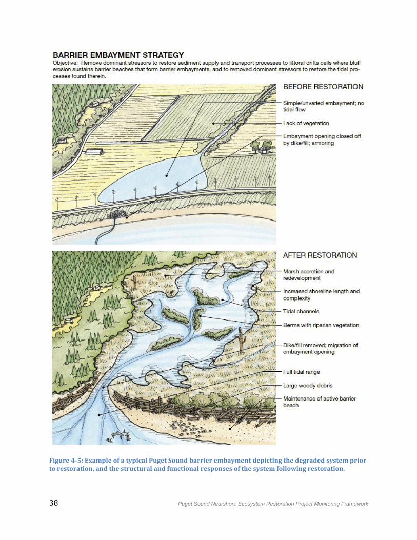
38 Puget Sound Nearshore Ecosystem Restoration Project Monitoring Framework
Figure 4-5: Example of a typical Puget Sound barrier embayment depicting the degraded system prior to restoration, and the structural and functional responses of the system following restoration.
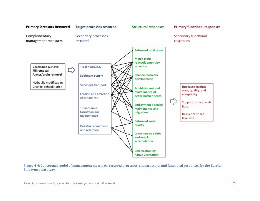
Puget Sound Nearshore Ecosystem Restoration Project Monitoring Framework 39
Figure 4-6: Conceptual model of management measures, restored processes, and structural and functional responses for the Barrier Embayment strategy.
40 Puget Sound Nearshore Ecosystem Restoration Project Monitoring Framework
Table 4-3: Barrier Embayment Strategy Monitoring Table.
Structural/Functional Response
Restored Process(es)
Monitoring Metrics
Predicted Response Predicted Timeframe
Adaptive Management Response
Primary Indicators
Enhanced tidal prism Tidal hydrology
- Water level (tidal elevations)
- Water velocity
- Tidal prism (volumetric)
- Salinity
Tidal prism will increase incrementally, resulting in enhanced tidal elevations, increased water velocity/flushing, and reestablishment of a salinity gradient throughout the embayment.
Immediately following restoration
Considerations:
- Have stressors been removed to a degree sufficient to restore tidal hydrology and freshwater input?
- Calculation of full, restored tidal prism and associated size of embayment opening
Potential actions:
- Further stressor removal (berm/dike removal) as possible
Bluff recession Sediment supply
- Changes in topographic evidence of sediments accreted at base
Armor removal will restore sediment supply from feeder bluff to barrier feature by way of
Timing depends on rates of wind- and wave-driven
Considerations:
-Reassess geomorphic characterization of
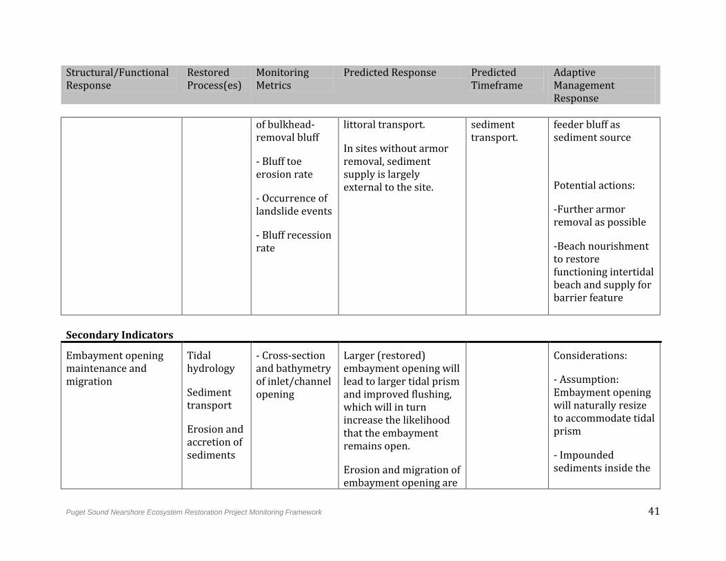
Puget Sound Nearshore Ecosystem Restoration Project Monitoring Framework 41
Structural/Functional Response
Restored Process(es)
Monitoring Metrics
Predicted Response Predicted Timeframe
Adaptive Management Response
of bulkhead-removal bluff
- Bluff toe erosion rate
- Occurrence of landslide events
- Bluff recession rate
littoral transport.
In sites without armor removal, sediment supply is largely external to the site.
sediment transport.
feeder bluff as sediment source
Potential actions:
-Further armor removal as possible
-Beach nourishment to restore functioning intertidal beach and supply for barrier feature
Secondary Indicators
Embayment opening maintenance and migration
Tidal hydrology
Sediment transport
Erosion and accretion of sediments
- Cross-section and bathymetry of inlet/channel opening
Larger (restored) embayment opening will lead to larger tidal prism and improved flushing, which will in turn increase the likelihood that the embayment remains open.
Erosion and migration of embayment opening are
Considerations:
- Assumption: Embayment opening will naturally resize to accommodate tidal prism
- Impounded sediments inside the
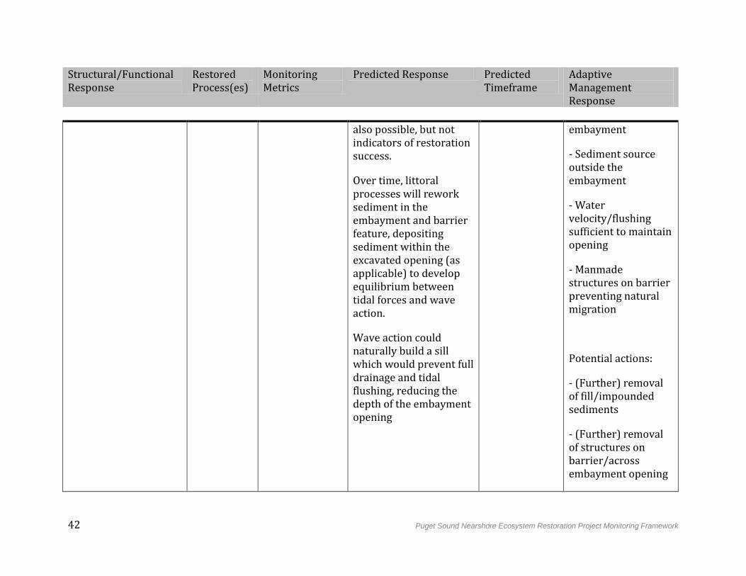
42 Puget Sound Nearshore Ecosystem Restoration Project Monitoring Framework
Structural/Functional Response
Restored Process(es)
Monitoring Metrics
Predicted Response Predicted Timeframe
Adaptive Management Response
also possible, but not indicators of restoration success.
Over time, littoral processes will rework sediment in the embayment and barrier feature, depositing sediment within the excavated opening (as applicable) to develop equilibrium between tidal forces and wave action.
Wave action could naturally build a sill which would prevent full drainage and tidal flushing, reducing the depth of the embayment opening
embayment
- Sediment source outside the embayment
- Water velocity/flushing sufficient to maintain opening
- Manmade structures on barrier preventing natural migration
Potential actions:
- (Further) removal of fill/impounded sediments
- (Further) removal of structures on barrier/across embayment opening
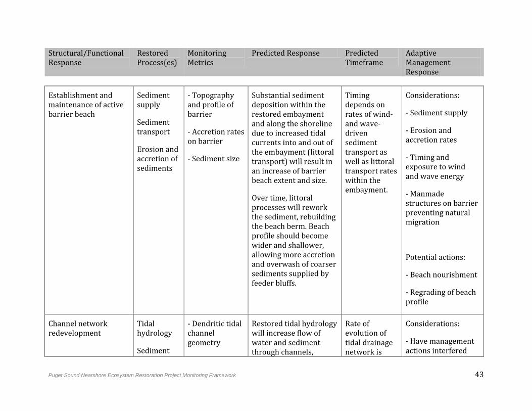
Puget Sound Nearshore Ecosystem Restoration Project Monitoring Framework 43
Structural/Functional Response
Restored Process(es)
Monitoring Metrics
Predicted Response Predicted Timeframe
Adaptive Management Response
Establishment and maintenance of active barrier beach
Sediment supply
Sediment transport
Erosion and accretion of sediments
- Topography and profile of barrier
- Accretion rates on barrier
- Sediment size
Substantial sediment deposition within the restored embayment and along the shoreline due to increased tidal currents into and out of the embayment (littoral transport) will result in an increase of barrier beach extent and size.
Over time, littoral processes will rework the sediment, rebuilding the beach berm. Beach profile should become wider and shallower, allowing more accretion and overwash of coarser sediments supplied by feeder bluffs.
Timing depends on rates of wind- and wave-driven sediment transport as well as littoral transport rates within the embayment.
Considerations:
- Sediment supply
- Erosion and accretion rates
- Timing and exposure to wind and wave energy
- Manmade structures on barrier preventing natural migration
Potential actions:
- Beach nourishment
- Regrading of beach profile
Channel network redevelopment
Tidal hydrology
Sediment
- Dendritic tidal channel geometry
Restored tidal hydrology will increase flow of water and sediment through channels,
Rate of evolution of tidal drainage network is
Considerations:
- Have management actions interfered
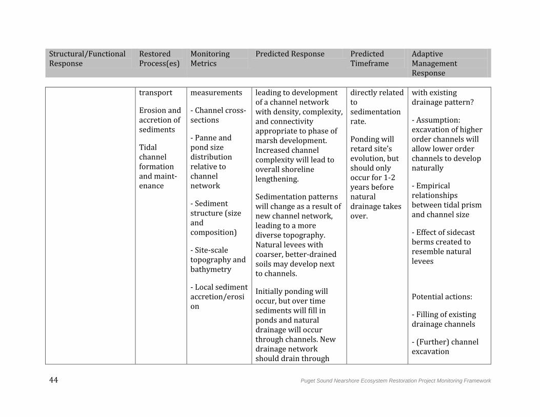
44 Puget Sound Nearshore Ecosystem Restoration Project Monitoring Framework
Structural/Functional Response
Restored Process(es)
Monitoring Metrics
Predicted Response Predicted Timeframe
Adaptive Management Response
transport
Erosion and accretion of sediments
Tidal channel formation and maint-enance
measurements
- Channel cross-sections
- Panne and pond size distribution relative to channel network
- Sediment structure (size and composition)
- Site-scale topography and bathymetry
- Local sediment accretion/erosion
leading to development of a channel network with density, complexity, and connectivity appropriate to phase of marsh development. Increased channel complexity will lead to overall shoreline lengthening.
Sedimentation patterns will change as a result of new channel network, leading to a more diverse topography. Natural levees with coarser, better-drained soils may develop next to channels.
Initially ponding will occur, but over time sediments will fill in ponds and natural drainage will occur through channels. New drainage network should drain through
directly related to sedimentation rate.
Ponding will retard site’s evolution, but should only occur for 1-2 years before natural drainage takes over.
with existing drainage pattern?
- Assumption: excavation of higher order channels will allow lower order channels to develop naturally
- Empirical relationships between tidal prism and channel size
- Effect of sidecast berms created to resemble natural levees
Potential actions:
- Filling of existing drainage channels
- (Further) channel excavation
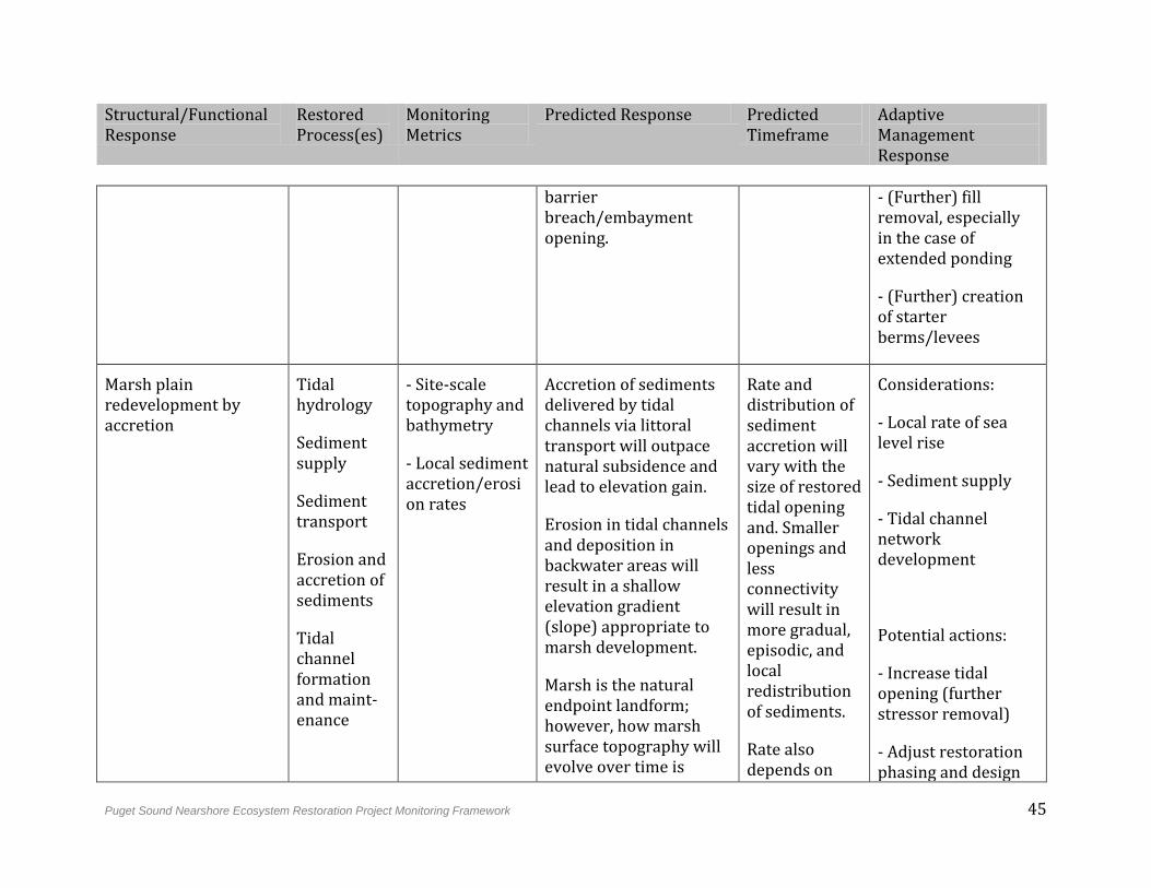
Puget Sound Nearshore Ecosystem Restoration Project Monitoring Framework 45
Structural/Functional Response
Restored Process(es)
Monitoring Metrics
Predicted Response Predicted Timeframe
Adaptive Management Response
barrier breach/embayment opening.
- (Further) fill removal, especially in the case of extended ponding
- (Further) creation of starter berms/levees
Marsh plain redevelopment by accretion
Tidal hydrology
Sediment supply
Sediment transport
Erosion and accretion of sediments
Tidal channel formation and maint-enance
- Site-scale topography and bathymetry
- Local sediment accretion/erosion rates
Accretion of sediments delivered by tidal channels via littoral transport will outpace natural subsidence and lead to elevation gain.
Erosion in tidal channels and deposition in backwater areas will result in a shallow elevation gradient (slope) appropriate to marsh development.
Marsh is the natural endpoint landform; however, how marsh surface topography will evolve over time is
Rate and distribution of sediment accretion will vary with the size of restored tidal opening and. Smaller openings and less connectivity will result in more gradual, episodic, and local redistribution of sediments.
Rate also depends on
Considerations:
- Local rate of sea level rise
- Sediment supply
- Tidal channel network development
Potential actions:
- Increase tidal opening (further stressor removal)
- Adjust restoration phasing and design
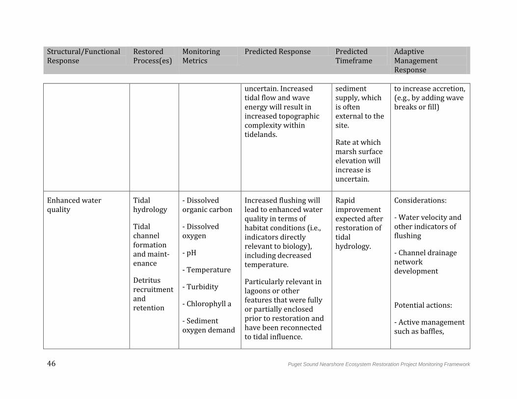
46 Puget Sound Nearshore Ecosystem Restoration Project Monitoring Framework
Structural/Functional Response
Restored Process(es)
Monitoring Metrics
Predicted Response Predicted Timeframe
Adaptive Management Response
uncertain. Increased tidal flow and wave energy will result in increased topographic complexity within tidelands.
sediment supply, which is often external to the site.
Rate at which marsh surface elevation will increase is uncertain.
to increase accretion, (e.g., by adding wave breaks or fill)
Enhanced water quality
Tidal hydrology
Tidal channel formation and maint-enance
Detritus recruitment and retention
- Dissolved organic carbon
- Dissolved oxygen
- pH
- Temperature
- Turbidity
- Chlorophyll a
- Sediment oxygen demand
Increased flushing will lead to enhanced water quality in terms of habitat conditions (i.e., indicators directly relevant to biology), including decreased temperature.
Particularly relevant in lagoons or other features that were fully or partially enclosed prior to restoration and have been reconnected to tidal influence.
Rapid improvement expected after restoration of tidal hydrology.
Considerations:
- Water velocity and other indicators of flushing
- Channel drainage network development
Potential actions:
- Active management such as baffles,
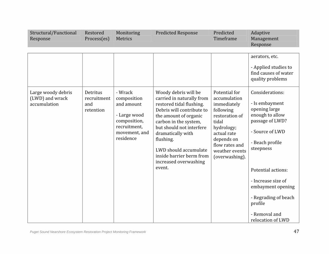
Puget Sound Nearshore Ecosystem Restoration Project Monitoring Framework 47
Structural/Functional Response
Restored Process(es)
Monitoring Metrics
Predicted Response Predicted Timeframe
Adaptive Management Response
aerators, etc.
- Applied studies to find causes of water quality problems
Large woody debris (LWD) and wrack accumulation
Detritus recruitment and retention
- Wrack composition and amount
- Large wood composition, recruitment, movement, and residence
Woody debris will be carried in naturally from restored tidal flushing. Debris will contribute to the amount of organic carbon in the system, but should not interfere dramatically with flushing.
LWD should accumulate inside barrier berm from increased overwashing event.
Potential for accumulation immediately following restoration of tidal hydrology; actual rate depends on flow rates and weather events (overwashing).
Considerations:
- Is embayment opening large enough to allow passage of LWD?
- Source of LWD
- Beach profile steepness
Potential actions:
- Increase size of embayment opening
- Regrading of beach profile
- Removal and relocation of LWD
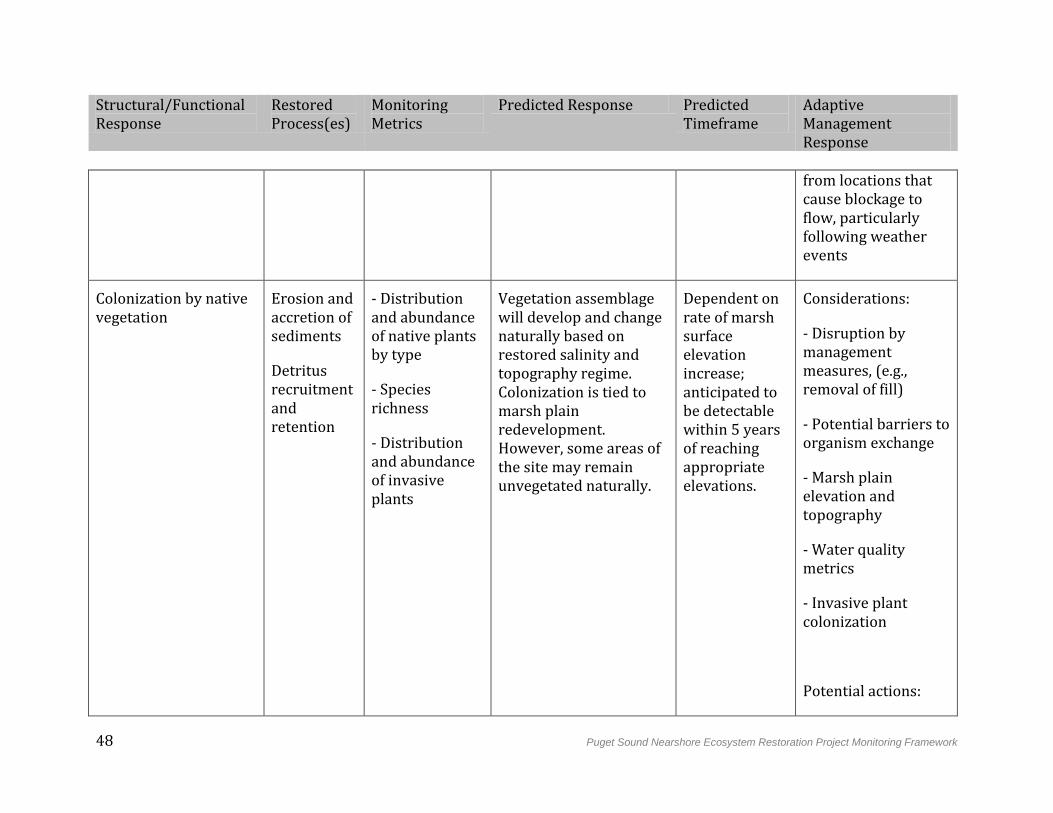
48 Puget Sound Nearshore Ecosystem Restoration Project Monitoring Framework
Structural/Functional Response
Restored Process(es)
Monitoring Metrics
Predicted Response Predicted Timeframe
Adaptive Management Response
from locations that cause blockage to flow, particularly following weather events
Colonization by native vegetation
Erosion and accretion of sediments
Detritus recruitment and retention
- Distribution and abundance of native plants by type
- Species richness
- Distribution and abundance of invasive plants
Vegetation assemblage will develop and change naturally based on restored salinity and topography regime. Colonization is tied to marsh plain redevelopment. However, some areas of the site may remain unvegetated naturally.
Dependent on rate of marsh surface elevation increase; anticipated to be detectable within 5 years of reaching appropriate elevations.
Considerations:
- Disruption by management measures, (e.g., removal of fill)
- Potential barriers to organism exchange
- Marsh plain elevation and topography
- Water quality metrics
- Invasive plant colonization
Potential actions:
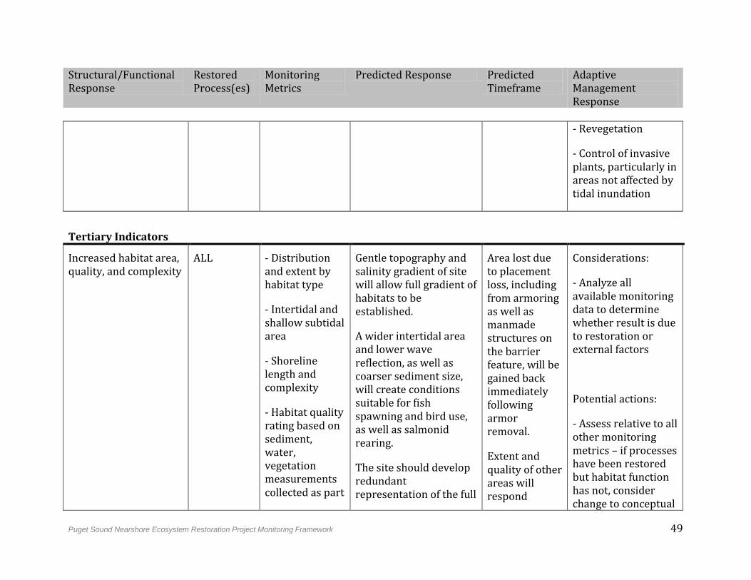
Puget Sound Nearshore Ecosystem Restoration Project Monitoring Framework 49
Structural/Functional Response
Restored Process(es)
Monitoring Metrics
Predicted Response Predicted Timeframe
Adaptive Management Response
- Revegetation
- Control of invasive plants, particularly in areas not affected by tidal inundation
Tertiary Indicators
Increased habitat area, quality, and complexity
ALL - Distribution and extent by habitat type
- Intertidal and shallow subtidal area
- Shoreline length and complexity
- Habitat quality rating based on sediment, water, vegetation measurements collected as part
Gentle topography and salinity gradient of site will allow full gradient of habitats to be established.
A wider intertidal area and lower wave reflection, as well as coarser sediment size, will create conditions suitable for fish spawning and bird use, as well as salmonid rearing.
The site should develop redundant representation of the full
Area lost due to placement loss, including from armoring as well as manmade structures on the barrier feature, will be gained back immediately following armor removal.
Extent and quality of other areas will respond
Considerations:
- Analyze all available monitoring data to determine whether result is due to restoration or external factors
Potential actions:
- Assess relative to all other monitoring metrics – if processes have been restored but habitat function has not, consider change to conceptual
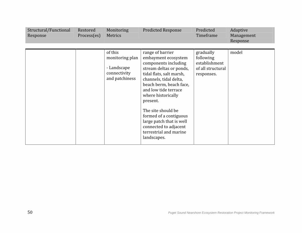
50 Puget Sound Nearshore Ecosystem Restoration Project Monitoring Framework
Structural/Functional Response
Restored Process(es)
Monitoring Metrics
Predicted Response Predicted Timeframe
Adaptive Management Response
of this monitoring plan
- Landscape connectivity and patchiness
range of barrier embayment ecosystem components including stream deltas or ponds, tidal flats, salt marsh, channels, tidal delta, beach berm, beach face, and low tide terrace where historically present.
The site should be formed of a contiguous large patch that is well connected to adjacent terrestrial and marine landscapes.
gradually following establishment of all structural responses.
model
Puget Sound Nearshore Ecosystem Restoration Project Monitoring Framework 51
4.4 Coastal Inlet Strategy
4.4.1 Predicted Functional Outcomes
Like barrier embayments, coastal inlets are defined by an area protected from wave energy by landscape configuration, and provide sheltered conditions for aquatic species. Coastal inlets differ from barrier embayments in the more perennial input of freshwater in the inlets. In addition, though a barrier feature may be present, it is less important to restoration objectives, which are more focused on bringing tidal and freshwater flushing back into the inlet system. Thirty-eight percent of historically mapped coastal inlets in Puget Sound have been modified from natural shoreline (Cereghino et al. 2012). These features have been filled or diked for development, disconnecting them from natural freshwater and tidal inputs.
The restoration objective for coastal inlets is to remove dominant stressors to a degree that allows undegraded tidal flows and freshwater inputs necessary to support a full range of coastal inlet ecosystem processes (Figure 4-7). Figure 4-8 outlines our conceptual model of the relationship between stressor removal, restored processes, and predicted structural and functional responses. Following restoration of tidal hydrology, tidal flushing will increase, and the inlet will maintain an opening appropriate to the size of the restored tidal prism. Restored flow through tidal channels will mobilize sediments and import water, while creating a complex network of more distinct, larger tidal channels. Increased water velocity will also excavate a network of dendritic marsh channels, increasing marsh area and complexity. Increased flushing through these channels will improve levels of organic carbon, oxygen, and nutrients in nearshore waters, and lead to the redevelopment of a salinity gradient throughout the inlet. Woody debris will be imported naturally and contribute to the biomass and structure of organic material near shore, and vegetation assemblages should recolonize according to the restored salinity and topography regime. In particular, floral and faunal assemblages should change from freshwater to saltwater marsh upon reconnection to tidal flushing (ESA 2011).
Following restoration of coastal inlet ecosystem processes, the system should develop redundant representation of coastal inlet ecosystem components including, where historically present, creek delta with swamp, scrub-shrub, marsh, tide flat, and channels. The restoration site should consist of well-connected large patches, and total shoreline length should increase (Cereghino et al. 2012).
Primary management measures include berm or dike removal where inlet topography is largely intact or topographic restoration (fill removal) where an inlet has been filled. Where primary management measures are insufficient to achieve predicted structural and functional responses, they may be complemented as necessary by hydraulic modification or revegetation.
52 Puget Sound Nearshore Ecosystem Restoration Project Monitoring Framework
4.4.2 Uncertainties
Response of the system to restoration:
The effect of restoration on flooding risk is uncertain. Removal of dams and other barriers to tidal hydrology may increase flood risk to non-acquired properties. At the same time, removal of such barriers could reduce the extent of fluvial flooding during high creek flows.
Restoration could necessitate shoreline armoring of non-acquired properties due to increased local erosion and channel migration.
As with river deltas, the degree of channel excavation for several restoration sites is based on the assumption that increased flow and tidal energy will allow channels to redevelop and sustain themselves naturally. If this assumption is incorrect, further channel excavation may be necessary.
Cumulative effects, external factors, and constraints:
Landward retreat of wetlands in response to sea level rise may be constrained by land use. This uncertainty is tied to the local rate of sea level rise.
Changes to the watershed outside of the site, such as urban development, could change the effect of restoration actions on inlet area and edge density.
4.4.3 Monitoring Indicators, Metrics, and Adaptive Management Responses
Based on our conceptual model for the Coastal Inlet strategy, Table 4-4 outlines the relationships between indicators of structural and functional response and associated monitoring metrics. The predicted response and timeframe for metrics is described in general terms. Also listed are the primary processes that support proposed indicators – in other words, the indicator can develop according to its predicted response only if associated processes have been restored.
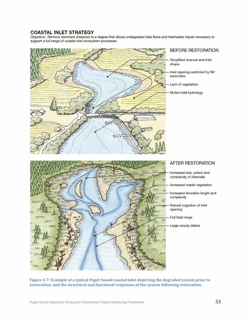
Puget Sound Nearshore Ecosystem Restoration Project Monitoring Framework 53
Figure 4-7: Example of a typical Puget Sound coastal inlet depicting the degraded system prior to restoration, and the structural and functional responses of the system following restoration.
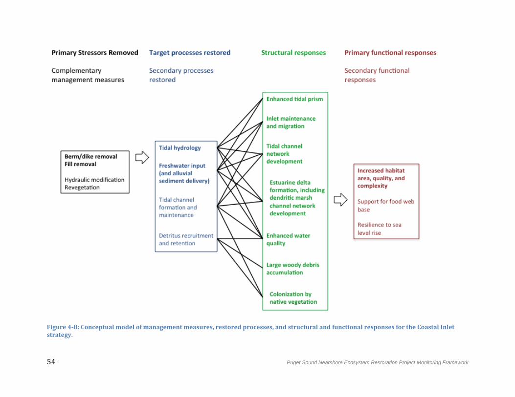
54 Puget Sound Nearshore Ecosystem Restoration Project Monitoring Framework
Figure 4-8: Conceptual model of management measures, restored processes, and structural and functional responses for the Coastal Inlet strategy.
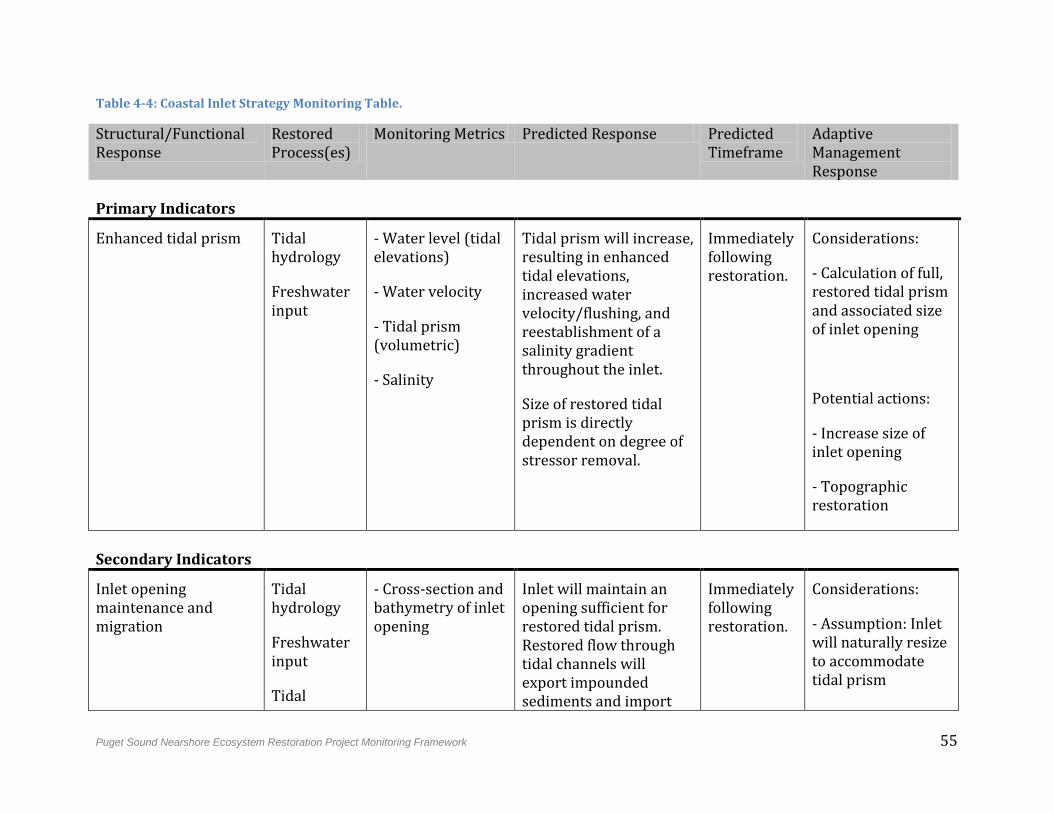
Puget Sound Nearshore Ecosystem Restoration Project Monitoring Framework 55
Table 4-4: Coastal Inlet Strategy Monitoring Table.
Structural/Functional Response
Restored Process(es)
Monitoring Metrics Predicted Response Predicted Timeframe
Adaptive Management Response
Primary Indicators
Enhanced tidal prism Tidal hydrology
Freshwater input
- Water level (tidal elevations)
- Water velocity
- Tidal prism (volumetric)
- Salinity
Tidal prism will increase, resulting in enhanced tidal elevations, increased water velocity/flushing, and reestablishment of a salinity gradient throughout the inlet.
Size of restored tidal prism is directly dependent on degree of stressor removal.
Immediately following restoration.
Considerations:
- Calculation of full, restored tidal prism and associated size of inlet opening
Potential actions:
- Increase size of inlet opening
- Topographic restoration
Secondary Indicators
Inlet opening maintenance and migration
Tidal hydrology
Freshwater input
Tidal
- Cross-section and bathymetry of inlet opening
Inlet will maintain an opening sufficient for restored tidal prism. Restored flow through tidal channels will export impounded sediments and import
Immediately following restoration.
Considerations:
- Assumption: Inlet will naturally resize to accommodate tidal prism
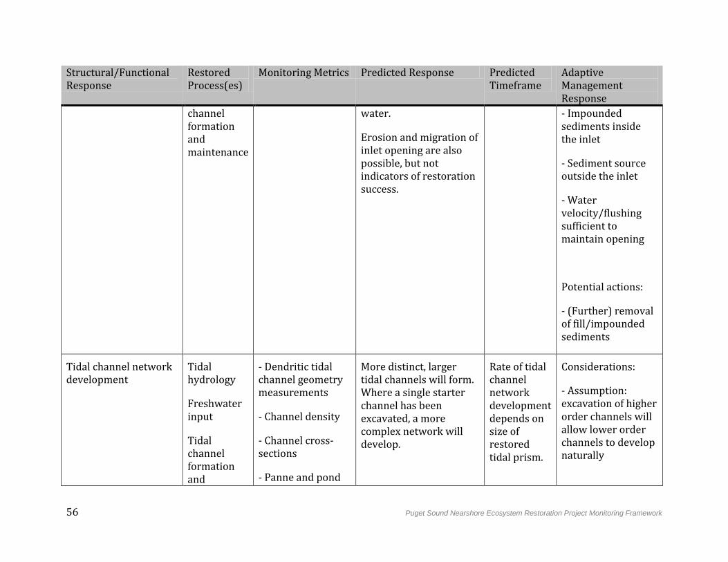
56 Puget Sound Nearshore Ecosystem Restoration Project Monitoring Framework
Structural/Functional Response
Restored Process(es)
Monitoring Metrics Predicted Response Predicted Timeframe
Adaptive Management Response
channel formation and maintenance
water.
Erosion and migration of inlet opening are also possible, but not indicators of restoration success.
- Impounded sediments inside the inlet
- Sediment source outside the inlet
- Water velocity/flushing sufficient to maintain opening
Potential actions:
- (Further) removal of fill/impounded sediments
Tidal channel network development
Tidal hydrology
Freshwater input
Tidal channel formation and
- Dendritic tidal channel geometry measurements
- Channel density
- Channel cross-sections
- Panne and pond
More distinct, larger tidal channels will form. Where a single starter channel has been excavated, a more complex network will develop.
Rate of tidal channel network development depends on size of restored tidal prism.
Considerations:
- Assumption: excavation of higher order channels will allow lower order channels to develop naturally
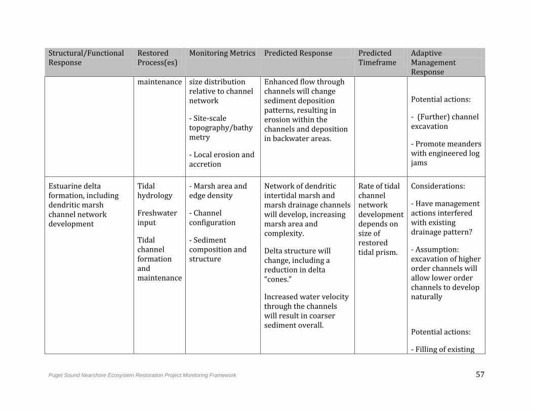
Puget Sound Nearshore Ecosystem Restoration Project Monitoring Framework 57
Structural/Functional Response
Restored Process(es)
Monitoring Metrics Predicted Response Predicted Timeframe
Adaptive Management Response
maintenance size distribution relative to channel network
- Site-scale topography/bathymetry
- Local erosion and accretion
Enhanced flow through channels will change sediment deposition patterns, resulting in erosion within the channels and deposition in backwater areas.
Potential actions:
- (Further) channel excavation
- Promote meanders with engineered log jams
Estuarine delta formation, including dendritic marsh channel network development
Tidal hydrology
Freshwater input
Tidal channel formation and maintenance
- Marsh area and edge density
- Channel configuration
- Sediment composition and structure
Network of dendritic intertidal marsh and marsh drainage channels will develop, increasing marsh area and complexity.
Delta structure will change, including a reduction in delta “cones.”
Increased water velocity through the channels will result in coarser sediment overall.
Rate of tidal channel network development depends on size of restored tidal prism.
Considerations:
- Have management actions interfered with existing drainage pattern?
- Assumption: excavation of higher order channels will allow lower order channels to develop naturally
Potential actions:
- Filling of existing
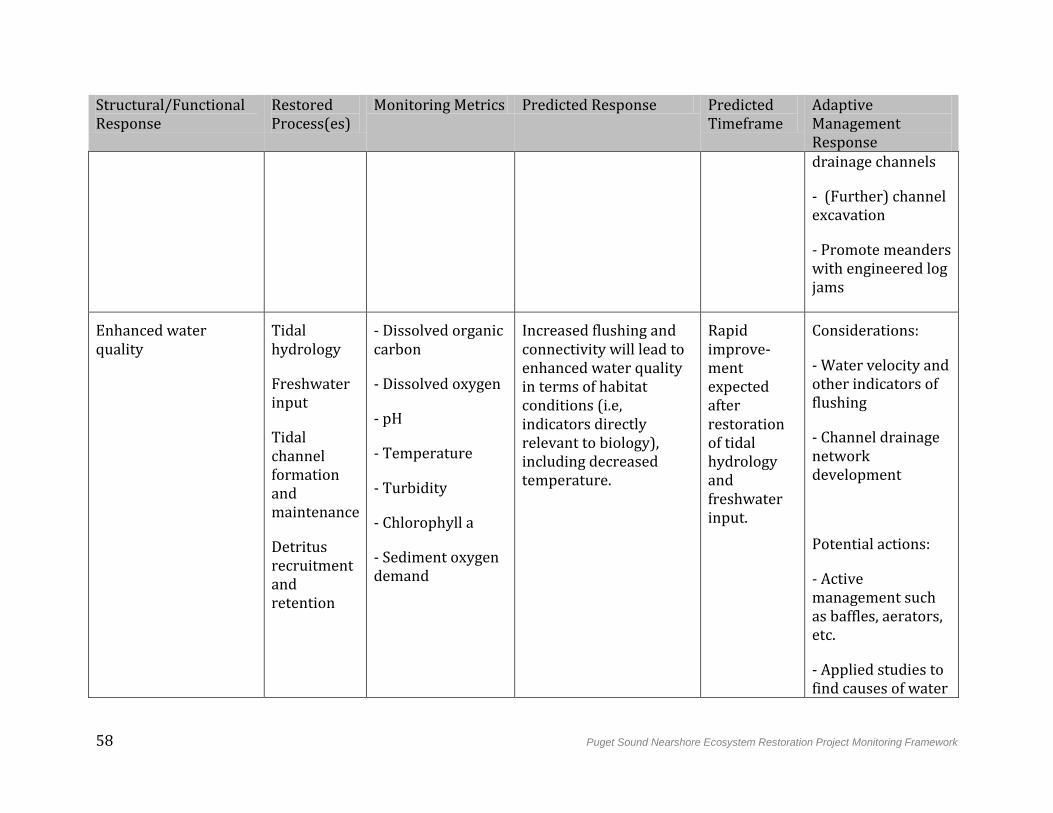
58 Puget Sound Nearshore Ecosystem Restoration Project Monitoring Framework
Structural/Functional Response
Restored Process(es)
Monitoring Metrics Predicted Response Predicted Timeframe
Adaptive Management Response drainage channels
- (Further) channel excavation
- Promote meanders with engineered log jams
Enhanced water quality
Tidal hydrology
Freshwater input
Tidal channel formation and maintenance
Detritus recruitment and retention
- Dissolved organic carbon
- Dissolved oxygen
- pH
- Temperature
- Turbidity
- Chlorophyll a
- Sediment oxygen demand
Increased flushing and connectivity will lead to enhanced water quality in terms of habitat conditions (i.e, indicators directly relevant to biology), including decreased temperature.
Rapid improve-ment expected after restoration of tidal hydrology and freshwater input.
Considerations:
- Water velocity and other indicators of flushing
- Channel drainage network development
Potential actions:
- Active management such as baffles, aerators, etc.
- Applied studies to find causes of water
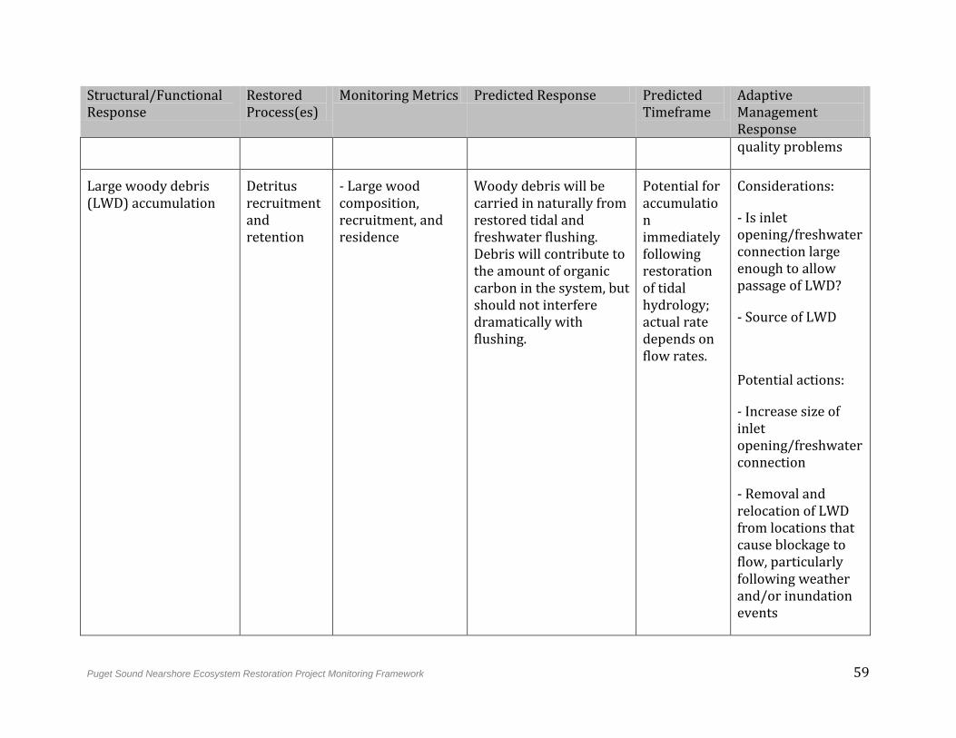
Puget Sound Nearshore Ecosystem Restoration Project Monitoring Framework 59
Structural/Functional Response
Restored Process(es)
Monitoring Metrics Predicted Response Predicted Timeframe
Adaptive Management Response quality problems
Large woody debris (LWD) accumulation
Detritus recruitment and retention
- Large wood composition, recruitment, and residence
Woody debris will be carried in naturally from restored tidal and freshwater flushing. Debris will contribute to the amount of organic carbon in the system, but should not interfere dramatically with flushing.
Potential for accumulation immediately following restoration of tidal hydrology; actual rate depends on flow rates.
Considerations:
- Is inlet opening/freshwater connection large enough to allow passage of LWD?
- Source of LWD
Potential actions:
- Increase size of inlet opening/freshwater connection
- Removal and relocation of LWD from locations that cause blockage to flow, particularly following weather and/or inundation events
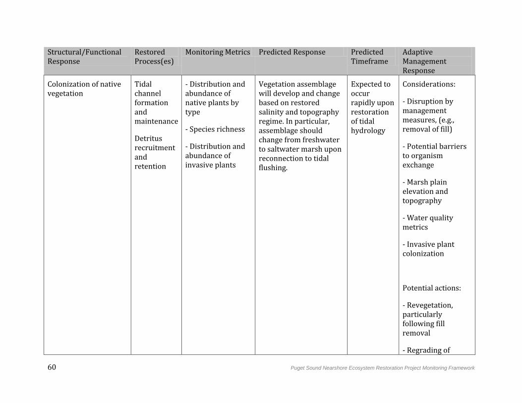
60 Puget Sound Nearshore Ecosystem Restoration Project Monitoring Framework
Structural/Functional Response
Restored Process(es)
Monitoring Metrics Predicted Response Predicted Timeframe
Adaptive Management Response
Colonization of native vegetation
Tidal channel formation and maintenance
Detritus recruitment and retention
- Distribution and abundance of native plants by type
- Species richness
- Distribution and abundance of invasive plants
Vegetation assemblage will develop and change based on restored salinity and topography regime. In particular, assemblage should change from freshwater to saltwater marsh upon reconnection to tidal flushing.
Expected to occur rapidly upon restoration of tidal hydrology
Considerations:
- Disruption by management measures, (e.g., removal of fill)
- Potential barriers to organism exchange
- Marsh plain elevation and topography
- Water quality metrics
- Invasive plant colonization
Potential actions:
- Revegetation, particularly following fill removal
- Regrading of
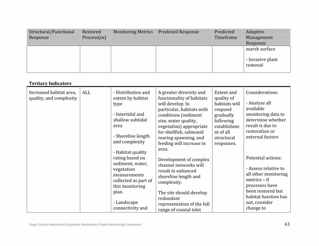
Puget Sound Nearshore Ecosystem Restoration Project Monitoring Framework 61
Structural/Functional Response
Restored Process(es)
Monitoring Metrics Predicted Response Predicted Timeframe
Adaptive Management Response marsh surface
- Invasive plant removal
Tertiary Indicators
Increased habitat area, quality, and complexity
ALL - Distribution and extent by habitat type
- Intertidal and shallow subtidal area
- Shoreline length and complexity
- Habitat quality rating based on sediment, water, vegetation measurements collected as part of this monitoring plan.
- Landscape connectivity and
A greater diversity and functionality of habitats will develop. In particular, habitats with conditions (sediment size, water quality, vegetation) appropriate for shellfish, salmonid rearing spawning, and feeding will increase in area.
Development of complex channel networks will result in enhanced shoreline length and complexity.
The site should develop redundant representation of the full range of coastal inlet
Extent and quality of habitats will respond gradually following establishment of all structural responses.
Considerations:
- Analyze all available monitoring data to determine whether result is due to restoration or external factors
Potential actions:
- Assess relative to all other monitoring metrics – if processes have been restored but habitat function has not, consider change to
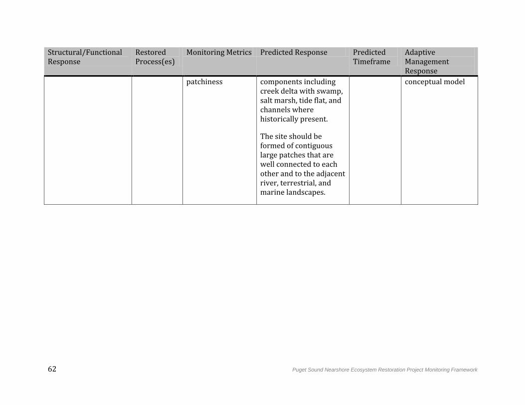
62 Puget Sound Nearshore Ecosystem Restoration Project Monitoring Framework
Structural/Functional Response
Restored Process(es)
Monitoring Metrics Predicted Response Predicted Timeframe
Adaptive Management Response
patchiness components including creek delta with swamp, salt marsh, tide flat, and channels where historically present.
The site should be formed of contiguous large patches that are well connected to each other and to the adjacent river, terrestrial, and marine landscapes.
conceptual model
Puget Sound Nearshore Ecosystem Restoration Project Monitoring Framework 63
5. Implementation of Effectiveness Monitoring
Effectiveness monitoring, using the framework outlined in Section 4, will be initiated upon completion of construction of the restoration site, although studies may have occurred at one or more reference sites prior to this time. According to Corps guidance, monitoring will be cost-shared between the Corps and the non-Federal sponsor for 10 years, after which time all costs will be the responsibility of the non-Federal sponsor. Once achievement of project objectives has been demonstrated by monitoring results and documented by the Corps and the non-Federal sponsor, no further monitoring will be required (USACE 2009). However, the non-Federal sponsors and other organizations pursuing more in-depth resolution of scientific uncertainties addressed by the site may continue certain elements of the effectiveness monitoring as part of more comprehensive validation monitoring efforts.
5.1 Development of Site-level Monitoring Plans
Earlier sections of this document provide a framework for monitoring PSNERP restoration strategies, and should be used to develop specific monitoring plans for individual sites. Site sponsors should draw from current scientific understanding, reference sites, historical conditions, stakeholder input, and traditional ecological knowledge to develop plans that satisfy the unique monitoring needs of each site. The Conceptual Design Report for each of the sites should be reviewed to determine if the identified site-specific risks and uncertainties have associated monitoring needs.
As required, additional scientific investigations and modeling should be used to develop site-specific predicted ecological outcomes and select appropriate metrics to measure and track these outcomes. Site-specific plans should also address monitoring of potential construction-related impacts such as sediment suspension or contamination from nearshore fill removal. To ensure integrity of the monitoring plan, site sponsors should work with PSNERP scientists, local scientists, and local resource managers to define monitoring targets for each metric, as well as an estimate of how long the site will need to be monitored before declaring functional performance.
5.2 Site Monitoring Design
5.2.1 Sampling Methodology
Design and implementation of site-specific monitoring of a restoration action should ideally originate with the development of restoration goals framed in part by the ecosystem processes, structure, and functions targeted for restoration. Effective monitoring of progress toward these goals can then be achieved through a scientific framework of repeated sampling, long-term data sets, and statistical analysis. Standard, proven, and repeatable monitoring methods should be used where possible to make results comparable across all PSNERP restoration sites. Monitoring methods should incorporate flexibility and event-triggered sampling to account for schedule interruptions due to natural variability, stochastic events, and regional trends. In general, sampling approaches and
64 Puget Sound Nearshore Ecosystem Restoration Project Monitoring Framework
instrumentation selected for each restoration site should prioritize standardization and cost-effectiveness. For example, photogrammetric remote-sensing could be employed to provide information on a large number of monitoring metrics across all four restoration strategies.
Change can occur over multiple temporal and spatial scales, and this heterogeneity should be reflected in monitoring design. The landscape-forming processes that are the focus of PSNERP restoration strategy vary within a given region, and may encompass multiple ecosystem units. These processes typically range from meters to hundreds of meters (e.g., cross-beach, tidal slough) or hundreds of meters to kilometers (e.g., along-beach within a drift cell, or within a salinity regime). Site-scale monitoring is intended to examine development of these processes within the footprint of the site; this monitoring should include analysis of the restoration site as well as any reference sites. In general, monitoring should demonstrate trends through time, and sampling frequency should differ for each monitoring metric according to temporal scale, monitoring questions, resource availability, and instrumentation capacity. However, change that occurs early after restoration is often accelerated. As such, intensive monitoring that allows for contingency planning should occur in the first five to 10 years after restoration, followed by a period of less frequent sampling.
5.2.2 Reference Sites
Linking a desired ecosystem response to a specific management measure within a site will require careful selection of the most appropriate reference site(s), which should be explicitly identified as part of the site-specific monitoring plan. A reference site provides a basis of comparison to the restoration site and to pre-restoration conditions, helps inform acceptable values for monitoring metrics (Goetz et al. 2004), and can serve as a covariate that takes into account natural variability (Roni et al. 2005). It should have a minimal history of anthropogenic disturbance and exhibit a natural range of processes, and thus the target condition for the restoration (NRC 1992). The reference site should be comparable in process, structure, and function to the restoration site before it was degraded. Despite the challenges of identifying a relatively undisturbed reference site that is directly comparable to the restoration site, monitoring often involves pairing of treatment and reference (or “control”) sites in a BACI (Before-After-Control-Impact) methodology to distinguish natural from treatment variability, and to reduce sample size and simplify data analyses (Roni at al. 2005). In general, the reference and restoration sites should be monitored with similar intensity to allow for more direct comparison of monitoring metrics, and baseline data should be collected from both reference and restoration sites before construction in order to detect change in critical processes over time.
The considerable natural variability in natural ecosystem processes (e.g., those influenced by landscape setting) often calls for monitoring a suite of reference sites (Short et al. 2000; Anisfeld 2012). The optimal timing for incorporation of reference sites, and particularly a complex of reference conditions, would be in the planning stage of the restoration, when goals are defined. However, inclusion of reference site structure and processes, much less ecosystem function, is inconsistent and relatively rare among the restoration sites
Puget Sound Nearshore Ecosystem Restoration Project Monitoring Framework 65
considered by PSNERP. Comprehensive development of a suite of reference sites to monitor in concert with the PSNERP restoration sites would likely fall under broader, programmatic coordination with the non-Federal sponsors, especially when validation monitoring (see Section 6) is incorporated into such a comprehensive monitoring scheme. Such a coordinated approach would potentially serve other Federal and non-Federal restoration actions, as well as draw on established nearshore ecosystem monitoring, such as the Padilla Bay National Estuarine Research Reserve’s long-term monitoring and research, to serve the needs of the broader Puget Sound restoration community.
5.3 Organizational Framework
Due to the complex nature of management of lands and natural resources, monitoring must be an inter-institutional effort. While it is possible that a centralized organizational framework may be established to oversee monitoring and analyze results, each of the 19 PSNERP restoration sites will not necessarily be monitored by the same organization. Instead, as part of the development of the site-specific monitoring plan, entities other than the Corps or the non-Federal sponsor will perform the monitoring at some or all restoration sites. Entities responsible for monitoring will provide monitoring results back to the Corps and the non-Federal sponsor. This direct line of communication is critical to allow for active contingency planning. All parties who are involved in or affected by the restoration site must have access to monitoring results, and results should be publicly available. The Corps will use these results in consultation with the non-Federal sponsor to guide decisions regarding any necessary mid-course corrections to the management measures applied at a restoration site (USACE 2009). They will also be used by PSNERP to continue to develop and improve new restoration actions that move the program toward its overall objectives.
Because ecosystem restoration affects people both within and outside of the program at every stage, stakeholder involvement and public outreach should be as transparent and inclusive a process as possible. Broad stakeholder involvement will benefit restoration planning by ensuring use of the best possible scientific information, including local and traditional ecological knowledge. Individual stakeholder groups may complement the program's assessment of monitoring results with analyses that cater to a specific ecosystem service, such as forage fish spawning or juvenile salmon rearing habitat.
In order to maximize the benefits of PSNERP restoration sites, monitoring efforts must be integrated with other outreach efforts of the broader Puget Sound restoration community. In general, stakeholder input at every level is necessary to address complex restoration issues, such as competing land uses or risks to adjacent properties, successfully. This can be accomplished through a combined strategy of sponsored community workshops, ongoing informal dialogues, and leveraging the outreach capabilities of involved, local non-governmental organizations. By fostering a relationship with the public, the Corps can facilitate the success of PSNERP restoration actions, and assist with broader nearshore ecosystem restoration in Puget Sound. Such information feedback will lead to better understanding of nearshore ecosystem restoration that will increase functional performance of PSNERP actions. Sharing of both emerging monitoring results as well as
66 Puget Sound Nearshore Ecosystem Restoration Project Monitoring Framework
adaptive management actions will facilitate learning and programmatic improvement: restoration actions and scientific investigations conducted concurrently outside of PSNERP may provide insight into new science needs, restoration strategies, and monitoring approaches. Communication and collaboration should be fostered and maintained with Federal, state, and local agencies, as well as tribal governments, non-profit organizations, and community groups. This can be done as a continuation of the Stakeholder Involvement Plan developed during the feasibility phase of the GI. In addition to information sharing, this collaboration may include cooperative planning efforts, shared construction, shared operations and maintenance, or shared monitoring activities.
5.4 Analysis and Reporting
In order to support management of restoration sites, raw monitoring data and basic field reports should be supplied to the party conducting data analysis as soon as possible following data collection. Raw monitoring data must be processed and converted into actionable information. This involves quality control, statistical analysis, and summary and presentation in regular reports. These reports should emphasize full reporting and synthesis of results into coherent narrative and graphical presentations. They should be provided in a timely manner to the Corps and non-Federal sponsor, and published online through the PSNERP website for consumption by the broader restoration community and the public.
When appropriate, PSNERP should seek peer-review of the synthesized monitoring results. In general, peer review is a critical element of any science-based program. It helps to ensure use of best available science, can validate or provide alternative interpretations of monitoring results, and can make methods and conclusions defensible. PSNERP has incorporated product-specific peer review of technical documents as well as programmatic review of science usage into the selection process for restoration sites. Under this monitoring framework, peer-review will continue for reports, decision-support tools, and other products generated from monitoring results. Results should also be shared less formally through participation in regional conferences and major science symposia such as the Salish Sea Ecosystem Conference. These events can serve as two-way conduits for restoration knowledge between PSNERP and the broader restoration community. Ultimately, PSNERP should ensure that results from monitoring and adaptive actions are integrated with broader regional management initiatives, such as the Puget Sound Partnership’s Puget Sound Science Update.
5.5 Data Management
In order to inform restoration science and decision-making into the future, monitoring data must be preserved and stewarded for long-term access and usability. Formal archiving is critical to ensure establishment of institutional memory within the program, and to develop the redundancy and long time series necessary for rigorous statistical analysis. A data management plan separate from this document should be developed in the pre-construction phase before monitoring data begin to flow. This plan should identify an agency or organization capable of providing long-term stewardship of the data while adaptively meeting the needs of the Project. Ideally, this agency will provide the full suite of
Puget Sound Nearshore Ecosystem Restoration Project Monitoring Framework 67
archival services, including ingest, data management, archival storage, access, preservation planning, and administration (CCSDS 2003).
The data management plan should provide for data discovery and access by the public. This may be accomplished directly by the archival agency, or through a separate online portal. Data should be made available in standard, well-documented formats, so that they can be incorporated into a larger Puget Sound-wide data set. This will enable timely use of the data for site-scale improvement and adaptive management responses within the program. It will also allow scientists inside and outside of PSNERP to inform and refine ecosystem models, which in turn can be used to predict outcomes for future restoration actions or programs.
68 Puget Sound Nearshore Ecosystem Restoration Project Monitoring Framework
6. Validation Monitoring
Whenever feasible, effectiveness monitoring of PSNERP restoration sites should be integrated with regional initiatives that are testing the assumed linkages between functional objectives and overall goals of Puget Sound-wide conservation and restoration programs. Linking to these external monitoring and science efforts would increase understanding of the relationship between PSNERP’s process-based restoration and the delivery of ecosystem functions, goods, and services (EFG&S). Validation monitoring is secondary to this document, and is not a responsibility of the Corps and non-Federal sponsor. Thus, the PSNERP strategy for validation monitoring involves enabling monitoring efforts of relevant EFG&S by other groups in Puget Sound. This strategy enhances PSNERP’s connection to the broader Puget Sound restoration community, while simultaneously collecting valuable validation monitoring information that can be used to improve the next generation of restoration sites in Puget Sound.
6.1 Goals
Alterations of natural processes damage nearshore ecosystem structures and functions, all three of which provide EFG&S that people value. There is an emerging policy focus on framing restoration benefits in terms of EFG&S, which would allow more direct economic valuation. However, the response of EFG&S to specific restoration actions is difficult to predict due to a high degree of influence from external factors, natural variability, and uncertainty in response timing. For this reason, validation monitoring is not used to evaluate the effectiveness of restoration actions. Instead, the goal of validation monitoring is to increase understanding of the relationship between process-based restoration actions and EFG&S. This includes increasing predictability of social attitudes about nearshore ecosystems and the social and economic benefits derived from their restoration.
6.2 Approach
Validation monitoring of PSNERP restoration should be framed around the assumed linkages between process-based restoration and EFG&S. Where feasible, EFG&S can be monitored directly and results compared to predicted functional outcomes. These predictions are based on historical provision of EFG&S by a given system, as well as current scientific understanding of that system. Although EFG&S encompass a broad suite of provisioning, regulating, supporting and cultural benefits to humans (Simenstad et al. 2011), PSNERP has attached particular emphasis to Valued Ecosystem Components (VECs; Leschine and Peterson 2007). Although VECs form a very small subset of the EFG&S provided by Puget Sound nearshore ecosystems, they are intended to represent ecologically and socially relevant beneficiaries of PSNERP restoration actions, and are recognized by many people as emblematic of a “healthy” Puget Sound (Schlenger et al. 2011). Due to their regional importance, many efforts are underway across Puget Sound to monitor many of the VECs, providing PSNERP with opportunities to link their restoration actions to validation-monitoring goals.
The PSNERP restoration sites will provide opportunities to learn how various aspects of nearshore ecosystem restoration influence and are influenced by public perception and
Puget Sound Nearshore Ecosystem Restoration Project Monitoring Framework 69
attitudes. Social data collection is especially important to those restoration sites constrained by private property. Willingness-to-pay or other valuation indicators can be used to assess how much the public values non-commodity EFG&S such as aesthetics. Social and economic monitoring are beyond the scope of the monitoring tasks performed by the Corps and non-Federal sponsor, but their analysis can be facilitated through efforts monitoring VECs. As more detailed plans for PSNERP implementation monitoring are developed, opportunities to leverage this investment and coordinate with Sound-wide monitoring efforts to address validation monitoring will be pursued.
6.3 Predicted Functional Outcomes
Although Puget Sound’s nearshore ecosystems provide many EFG&S, one of the more important EFG&S is the provision habitat for a variety of fish, shellfish, birds, and other wildlife. Many species and life history types of juvenile Pacific salmon rely on tidal marshes and channel networks of deltas and small estuaries and shorelines of the barrier beaches of open coastal inlets for rearing and foraging. In addition, over 30 species of shorebirds, as well as migratory and predatory birds, use these habitats for migration, forage, feeding, roosting, and reproduction (Collins and Sheik 2005; Buchanan 2006; Dethier 2006; Fresh 2006; Eissinger 2007; Mumford 2007; Penttila 2007). In addition to these valued habitat functions, nearshore ecosystems provide EFG&S that are economically important, including production of benthic invertebrates and insects, nutrient cycling, water filtration, drainage and flood management, recreation, and shellfish production (Schlenger et al. 2011).
6.4 Uncertainties and Programmatic Improvement
Validation monitoring addresses uncertainties associated with the assumptions linking PSNERP process-based restoration with the delivery of EFG&S. These include questions regarding the impacts of stressors to nearshore processes on EFG&S, such as whether such impacts can be effectively reversed by site-specific restoration. Compared to structural and functional responses, predicted ecological outcomes are often less clearly or directly linked to restoration actions for EFG&S. As a result, causal relationships are difficult to define from monitoring results at the site scale. Analysis of validation monitoring results from a collection of restoration sites within a single strategy group, or across many regional restoration and protection initiatives, reduces these uncertainties.
As might be expected from the embryonic science and technology of ecosystem restoration, there are a plethora of uncertainties associated with assumptions about EFG&S that will reliably derive from the many management measures deployed, as well as across different types and scales of Puget Sound’s nearshore landforms. An extensive list of questions was compiled for the comprehensive PSNERP research plan (Gelfenbaum et al. 2006), many of which are still unresolved and would be critical candidates for focused validation monitoring that could be deployed among the program’s candidate restoration sites. A few examples of some of the more persistent uncertainties that still plague restoration planning and design across individual- to multiple-site scales, and which are prime candidates for validation monitoring, include:
70 Puget Sound Nearshore Ecosystem Restoration Project Monitoring Framework
Management measure-specific:
Restoring Tidal Hydrology
o Will dendritic tidal channel systems evolve more naturally complex plan-form structure (in erosive sediments) without intervention than with constructed tidal channels?
o Is there a difference between dike breaching and dike removal in vegetation recruitment and fish utilization of a recovering wetland?
Bulkhead Removal
o What are the attributes of forage fish habitat that are restored or enhanced by a bulkhead removal?
o At what scale does bulkhead removal become meaningful/beneficial? How effective are alternative techniques and do they restore the relationships among processes, structure, or functions?
Beach Nourishment
o Will forage fish spawn on nourished beaches?
o Does sediment placed on the beach face move offshore to benefit nearshore biota outside the nourishment footprint?
o Independent of a management measure or comprising multiple measures:
o How does variability in site-scale habitat features (e.g., water depth and vegetation characteristics) and landscape-scale habitat features affect juvenile salmon and other VEC performance?
o Is there a cumulative effect of restoring degraded nearshore ecosystems that are adjacent to protected/conserved shorelines?
For the same reason EFG&S responses are difficult to predict, they are also difficult to address through site-scale contingency planning. Results from validation monitoring of EFG&S are therefore used primarily for programmatic improvement, e.g., “adaptive learning” (McLain and Lee 1996). Analysis of these results can be used to increase scientific understanding of the links between restoration actions and EFG&S for a given strategy, which could lead to a shift in scope or approach for the next generation of restoration sites. Ultimately, the benefits of process-based restoration of nearshore ecosystems could be defined in terms of the EFG&S they provide, linking these directly to process, structure, and function and strengthening to our understanding of Puget Sound’s nearshore ecosystems.
Puget Sound Nearshore Ecosystem Restoration Project Monitoring Framework 71
7. References
Anisfeld, S. C. 2012. Biogeochemical responses to tidal restoration. Pp. 39-58 in C. T. Roman and D. M. Burdick (eds.), Tidal Marsh Restoration: A Synthesis of Science and Management. Island Press, Washington, D.C. 406 pp.
Buchanan, J.B. 2006. Nearshore birds in Puget Sound. Puget Sound Nearshore Partnership Report No. 2006-05. Published by Seattle District, U.S. Army Corps of Engineers, Seattle, WA.
Cereghino, P., J. Toft, C. Simenstad, E. Iverson, S. Campbell, C. Behrens, and J. Burke. 2012. Strategies for nearshore protection and restoration in Puget Sound. Puget Sound Nearshore Report No. 2012-01. Published by Washington Department of Fish and Wildlife, Olympia, Washington, and the U.S. Army Corps of Engineers, Seattle, WA.
Clancy, M., I. Logan, J. Lowe, J. Johannessen, A. MacLennan, F.B. Van Cleve, J. Dillon, B. Lyons, R. Carman, P. Cereghino, B. Barnard, C. Tanner, D. Myers, R. Clark, J. White, C.A. Simenstad, M. Gilmer, and N. Chin. 2009. Management measures for protecting and restoring the Puget Sound nearshore. Puget Sound Nearshore Partnership Report No. 2009-01. Published by Seattle District, Washington Department of Fish and Wildlife, Olympia, WA.
Collins, B.D. and A.J. Sheik. 2005. Historical reconstruction, classification, and change analysis of Puget Sound tidal marshes. Prepared for Washington Department of Natural Resources. Puget Sound River History Project, Department of Earth and Space Sciences, University of Washington, Seattle, WA.
CCSDS (Consultative Committee for Space Data Systems). 2003. Reference Model for an Open Archival Information System (OAIS). CCSDS 650.0-B-1, Blue Book, Washington, DC. Adopted as ISO 14721:2003.
Dethier, M.N. 2006. Native shellfish in nearshore ecosystems of Puget Sound. Puget Sound Nearshore Partnership Report No. 2006-04. Published by Seattle District, U.S. Army Corps of Engineers, Seattle, WA.
Eissinger, A.M. 2007. Great blue herons in Puget Sound. Puget Sound Nearshore Partnership Report No. 2007-06. Published by Seattle District, U.S. Army Corps of Engineers, Seattle, WA.
ESA (Environmental Science Associates). 2011. Strategic Restoration Conceptual Engineering — Final Design Report. Prepared by Environmental Science Associates (including ESA-PWA), Anchor QEA, KPFF Engineers, Coastal Geologic Services for the Washington Department of Fish and Wildlife, and U.S. Army Corps of Engineers, Seattle District in support of PSNERP.
Fresh, K.L. 2006. Juvenile Pacific Salmon in Puget Sound. Puget Sound Nearshore Partnership Report No. 2006-06. Published by Seattle District, U.S. Army Corps of Engineers, Seattle, WA.
Fresh, K.L., M. Dethier, C. Simenstad, M. Logsdon, H. Shipman, C. Tanner, T. Leschine, T. Mumford, G. Gelfenbaum, R. Shuman, and J. Newton. 2011. Implications of observed
72 Puget Sound Nearshore Ecosystem Restoration Project Monitoring Framework
anthropogenic changes to nearshore ecosystems in Puget Sound. Puget Sound Nearshore Ecosystem Restoration Project Report No. 2011-03. Published by Washington Department of Fish and Wildlife, Olympia, WA, and U.S. Army Corps of Engineers, Seattle, WA.
Gelfenbaum, G., T. Mumford, J. Brennan, H. Case, M. Dethier, K. Fresh, F. Goetz, M. van Heeswijk, T.M., Leschine, M. Logsdon, D. Myers, J. Newton, H. Shipman, C.A. Simenstad, C. Tanner, and D. Woodson, 2006. Coastal Habitats in Puget Sound: A research plan in support of the Puget Sound Nearshore Partnership. Puget Sound Nearshore Partnership Report No. 2006-1. Published by the U.S. Geological Survey, Seattle, WA.
Goetz, F., C. Tanner, C. Simenstad, K. Fresh, T. Mumford, M. Logsdon. 2004. Guiding restoration principles. Puget Sound Nearshore Partnership Report No. 2004-03. Published by Washington Sea Grant Program, University of Washington, Seattle, WA.
Greiner, C.A. 2010. Principles for strategic conservation and restoration. Puget Sound Nearshore Report No. 2010-1. Published by Washington Department of Fish and Wildlife, Olympia, WA.
Johannessen, J. and A. MacLennan. 2007. Beaches and bluffs of Puget Sound. Puget Sound Nearshore Partnership Report No. 2007-04. Published by Seattle District, U.S. Army Corps of Engineers, Seattle, WA.
Keddy, P.A. 2000. Wetland ecology: Principles and conservation. Cambridge University Press, 614 pp.
Leschine, T.M. and A.W. Petersen. 2007. Valuing Puget Sound’s valued ecosystem components. Puget Sound Nearshore Partnership Report No. 2007-07. Published by Seattle District, U.S. Army Corps of Engineers, Seattle, WA.
McLain, R. J., and R. G. Lee. 1996. Adaptive management: promises and pitfalls. Environ. Mgmt. 20:437-448.
Mumford, T.F. 2007. Kelp and eelgrass in Puget Sound. Puget Sound Nearshore Partnership Report No. 2007-05. Published by Seattle District, U.S. Army Corps of Engineers, Seattle, WA.
Murray, C. and D. Marmorek. 2003. Adaptive Management and Ecological Restoration. Chapter 24, in:Freiderici, P. (ed.). 2003. Ecological Restoration of Southwestern Ponderosa Pine Forests. Island Press (Washington,CoveloCA, London), pp. 417-428.
National Research Council (NRC). 1992. Restoration of Aquatic Ecosystems. National Acad. Press, Washington, DC.
Penttila, D. 2007. Marine Forage Fishes in Puget Sound. Puget Sound Nearshore Partnership Report No. 2007-03. Published by Seattle District, U.S. Army Corps of Engineers, Seattle, WA.
Pethick, J. 2001. Coastal management and sea-level rise. Catena, vol. 42, pp. 307-322.
Roni, P., M.C. Liermann, C. Jordan and E. A. Steel. 2005. Steps for designing a monitoring and evaluation programs for aquatic restoration. Pp. 13-34 in P. Roni (ed.), Monitoring
Puget Sound Nearshore Ecosystem Restoration Project Monitoring Framework 73
Stream and Watershed Restoration. American Fisheries Society, Bethesda, MD. 300 pp.
Schlenger, P., A. MacLennan, E. Iverson, K. Fresh, C. Tanner, B. Lyons, S. Todd, R. Carman, D. Myers, S. Campbell, and A. Wick. 2011. Strategic Needs Assessment: Analysis of Nearshore Ecosystem Process Degradation in Puget Sound. Prepared for the Puget Sound Nearshore Ecosystem Restoration Project. Technical Report 2011-02.
Shipman, H. 2008. A geomorphic classification of Puget Sound nearshore landforms. Puget Sound Nearshore Partnership Report No. 2008-01. Published by Seattle District, U.S. Army Corps of Engineers, Seattle, WA.
Short, F. T., D. M. Burdick, C. A. Short, R. C. Davis, and P. Morgan. 2000. Developing success criteria for restored eelgrass, salt marsh and mud flat habitats. Ecol. Engineer. 15:239-252.
Simenstad, C., M. Logsdon, K. Fresh, H. Shipman, M. Dethier, and J. Newton. 2006. Conceptual model for assessing restoration of Puget Sound nearshore ecosystems. Puget Sound Nearshore Partnership Report No. 2006-03. Published by Washington Sea Grant Program, University of Washington, Seattle, WA.
Simenstad, C., M. Ramirez, J. Burke, M. Logsdon, H. Shipman, C. Tanner, J. Toft, B. Craig, C. Davis, J. Fung, P. Bloch, K. Fresh, D. Myers, E. Iverson, A. Bailey, P. Schlenger, C. Kiblinger, P. Myre, W. Gertsel, and A. MacLennan. 2011. Historical change of Puget Sound shorelines: Puget Sound Nearshore Ecosystem Project Change Analysis. Puget Sound Nearshore Report No. 2011-01. Published by Washington Department of Fish and Wildlife, Olympia, Washington, and U.S. Army Corps of Engineers, Seattle, WA.
USACE (U.S. Army Corps of Engineers). 2009. Implementation Guidance for Section 2039 of the Water Resources Development Act of 2007 (WRDA 2007) – Monitoring Ecosystem Restoration. Memorandum for Commanders, Major Subordinate Commands. August 31, 2009.