Embed Size (px)
Citation preview
PUP2013-00003 Richmond 20MHz, LLC (nTelos) Staff Report for Board of Supervisors Public Hearing Prepared May 30, 2013
This report is prepared by the Henrico County Planning Staff to provide information to the Planning Commission and the Board of Supervisors to assist them in making a decision on this application. It may also be useful to others interested in this zoning matter.
I. PUBLIC HEARINGS:
Planning Commission:
Board of Supervisors:
March 14, 2013 April 11 , 2013 May 9, 2013
June 11 , 2013
Deferred at applicant's request Deferred at applicant's request Recommended for approval
Pending
II. IDENTIFICATION AND LOCA TIONAL INFORMATION:
Request:
Existing Zoning:
Acreage:
Proposed Use:
Location of Property:
Magisterial District:
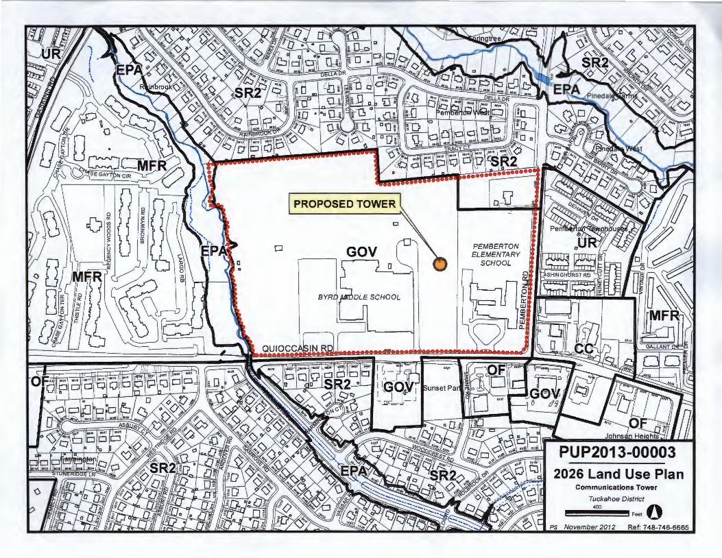
2026 Comprehensive Plan Recommendation:
Parcel No:
Zoning of Surrounding Property:
PUP2013-00003
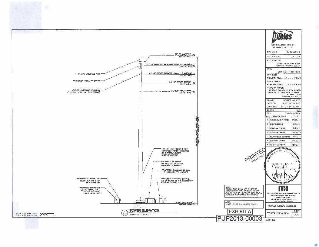
Construct a 169'-high monopole telecommunications tower and related equipment
A-1 Agricultural District
Lease Area- 2,500 square feet
Telecommunications tower
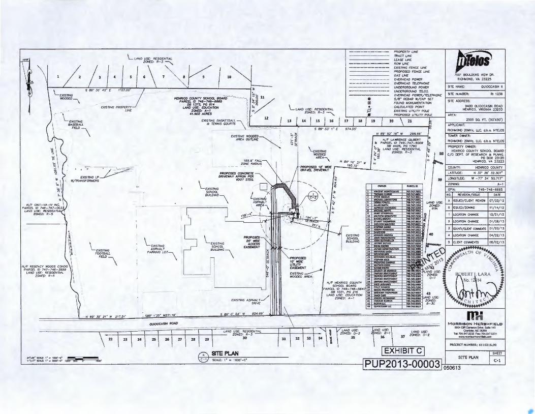
North line of Quioccasin Road (State Route 157) approximately 650' north of its intersection with Shane Road (9400 Quioccasin Road - Harry Flood Byrd Middle School)
Tuckahoe
Government
Part of 7 48-7 46-6665
North: South: East:
West:
R-3 One-Family Residence District R-3 One-Family Residence District A-1 Agricultural District (Elementary School) RTH Residential Townhouse District A-1 Agricultural District R-5 General Residence District
Page 1
Ill. SUMMARY OF STAFF REPORT COMMENTS:
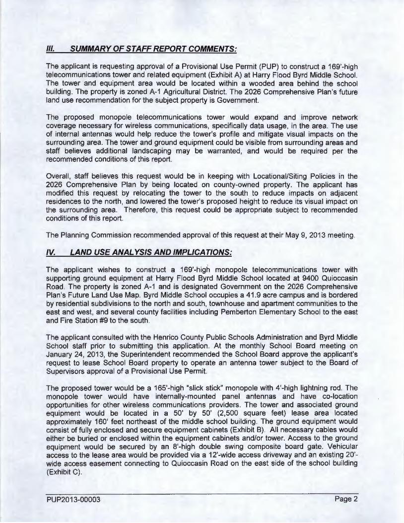
The applicant is requesting approval of a Provisional Use Permit (PUP) to construct a 169'-high telecommunications tower and related equipment (Exhibit A) at Harry Flood Byrd Middle School. The tower and equipment area would be located within a wooded area behind the school building. The property is zoned A-1 Agricultural District. The 2026 Comprehensive Plan's future land use recommendation for the subject property is Government.
The proposed monopole telecommunications tower would expand and improve network coverage necessary for wireless communications, specifically data usage, in the area. The use of internal antennas would help reduce the tower's profile and mitigate visual impacts on the surrounding area. The tower and ground equipment could be visible from surrounding areas and staff believes additional landscaping may be warranted , and would be required per the recommended conditions of this report.
Overall , staff believes this request would be in keeping with Locationai/Siting Policies in the 2026 Comprehensive Plan by being located on county-owned property. The applicant has modified this request by relocating the tower to the south to reduce impacts on adjacent residences to the north, and lowered the tower's proposed height to reduce its visual impact on the surrounding area. Therefore, this request could be appropriate subject to recommended conditions of this report.
The Planning Commission recommended approval of this request at their May 9, 2013 meeting.
IV. LAND USE ANALYSIS AND IMPLICATIONS:
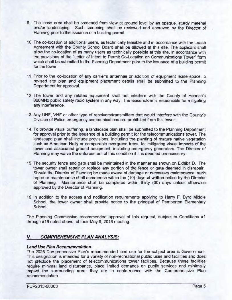
' The applicant wishes to construct a 169'-high monopole telecommunications tower with supporting ground equipment at Harry Flood Byrd Middle School located at 9400 Quioccasin Road. The property is zoned A-1 and is designated Government on the 2026 Comprehensive Plan 's Future Land Use Map. Byrd Middle School occupies a 41.9 acre campus and is bordered by residential subdivisions to the north and south, townhouse and apartment communities to the east and west, and several county facilities including Pemberton Elementary Schqol to the east and Fire Station #9 to the south.
The applicant consulted with the Henrico County Public Schools Administration and Byrd Middle School staff prior to submitting this application. At the monthly School Board meeting on January 24, 2013, the Superintendent recommended the School Board approve the applicant's request to lease School Board property to operate an antenna tower subject to the Board of Supervisors approval of a Provisional Use Permit.
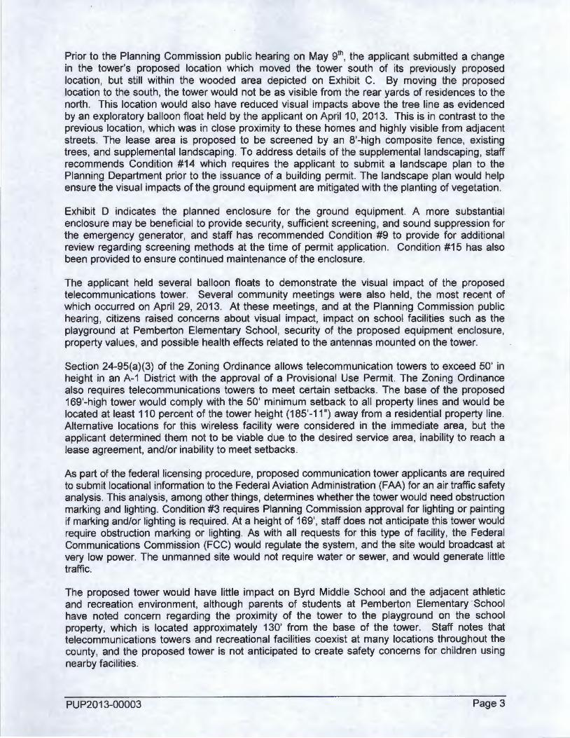
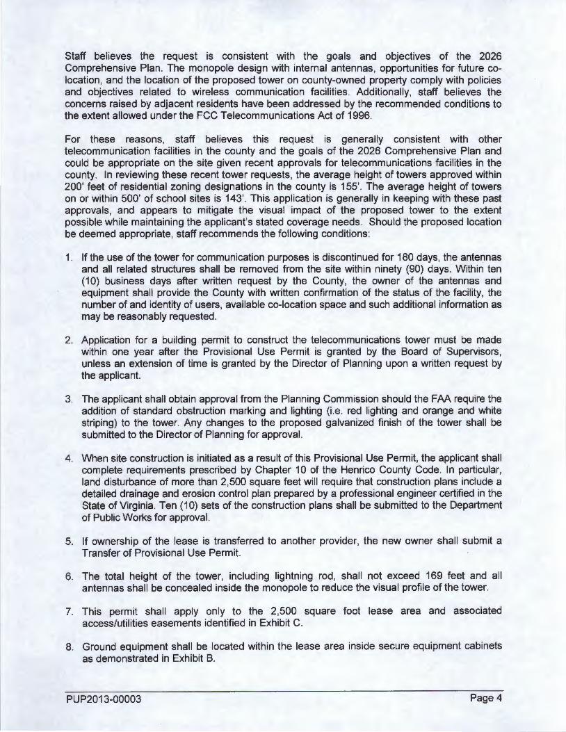
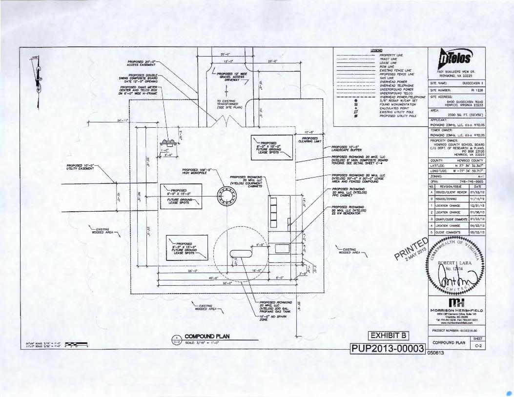
The proposed tower would be a 165'-high "slick stick" monopole with 4'-high lightning rod. The monopole tower would have internally-mounted panel antennas and have co-location opportunities for other wireless communications providers. The tower and associated ground equipment would be located in a 50' by 50' (2,500 square feet) lease area located approximately 160' feet northeast of the middle school building. The ground equipment would consist of fully enclosed and secure equipment cabinets (Exhibit B) . All necessary cables would either be buried or enclosed within the equipment cabinets and/or tower. Access to the ground equipment would be secured by an 8'-high double swing composite board gate. Vehicular access to the lease area would be provided via a 12'-wide access driveway and an existing 20'wide access easement connecting to Quioccasin Road on the east side of the school building (Exhibit C) .
PUP2013-00003 Page 2
Prior to the Planning Commission public hearing on May 91h, the applicant submitted a change
in the tower's proposed location which moved the tower south of its previously proposed location, but still within the wooded area depicted on Exhibit C. By moving the proposed location to the south, the tower would not be as visible from the rear yards of residences to the north. This location would also have reduced visual impacts above the tree line as evidenced by an exploratory balloon float held by the applicant on April 10, 2013. This is in contrast to the previous location, which was in close proximity to these homes and highly visible from adjacent streets. The lease area is proposed to be screened by an 8'-high composite fence, existing trees, and supplemental landscaping. To address details of the supplemental landscaping , staff recommends Condition #14 which requires the applicant to submit a landscape plan to the Planning Department prior to the issuance of a building permit. The landscape plan would help ensure the visual impacts of the ground equipment are mitigated with the planting of vegetation .
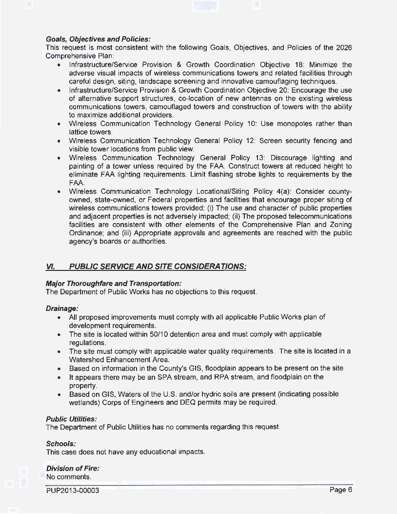
Exhibit D indicates the planned enclosure for the ground equipment. A more substantial enclosure may be beneficial to provide security, sufficient screening , and sound suppression for the emergency generator, and staff has recommended Condition #9 to provide for additional review regarding screening methods at the time of permit application. Condition #15 has also been provided to ensure continued maintenance of the enclosure.
The applicant held several balloon floats to demonstrate the visual impact of the proposed telecommunications tower. Several community meetings were also held, the most recent of which occurred on April 29, 2013. At these meetings, and at the Planning Commission public hearing, citizens raised concerns about visual impact, impact on school facilities such as the playground at Pemberton Elementary School , security of the proposed equipment enclosure, property values, and possible health effects related to the antennas mounted on the tower.
Section 24-95(a)(3) of the Zoning Ordinance allows telecommunication towers to exceed 50' in height in an A-1 District with the approval of a Provisional Use Permit. The Zoning Ordinance also requires telecommunications towers to meet certain setbacks. The base of the proposed 169'-high tower would comply with the 50' minimum setback to all property lines and would be located at least 110 percent of the tower height (185'-11 ") away from a residential property line. Alternative locations for this wireless facility were considered in the immediate area, but the applicant determined them not to be viable due to the desired service area, inability to reach a lease agreement, and/or inability to meet setbacks.
As part of the federal licensing procedure, proposed communication tower applicants are required to submit locational information to the Federal Aviation Administration (FAA) for an air traffic safety analysis. This analysis, among other things, determines whether the tower would need obstruction marking and lighting. Condition #3 requires Planning Commission approval for lighting or painting if marking and/or lighting is required. At a height of 169', staff does not anticipate this tower would require obstruction marking or lighting. As with all requests for this type of facility, the Federal Communications Commission (FCC) would regulate the system, and the site would broadcast at very low power. The unmanned site would not require water or sewer, and would generate little traffic.
The proposed tower would have little impact on Byrd Middle School and the adjacent athletic and recreation environment, although parents of students at Pemberton Elementary School have noted concern regarding the proximity of the tower to the playground on the school property, which is located approximately 130' from the base of the tower. Staff notes that telecommunications towers and recreational facilities coexist at many locations throughout the county, and the proposed tower is not anticipated to create safety concerns for children using nearby facilities .
PUP2013-00003 Page 3
Staff believes the request is consistent with the goals and objectives of the 2026 Comprehensive Plan. The monopole design with internal antennas, opportunities for future colocation, and the location of the proposed tower on county-owned property comply with policies and objectives related to wireless communication facilities . Additionally, staff believes the concerns raised by adjacent residents have been addressed by the recommended conditions to the extent allowed under the FCC Telecommunications Act of 1996.
For these reasons, staff believes this request is generally consistent with other telecommunication facilities in the county and the goals of the 2026 Comprehensive Plan and could be appropriate on the site given recent approvals for telecommunications facilities in the county. In reviewing these recent tower requests , the average height of towers approved within 200' feet of residential zoning designations in the county is 155'. The average height of towers on or within 500' of school sites is 143'. This application is generally in keeping with these past approvals, and appears to mitigate the visual impact of the proposed tower to the extent possible while maintaining the applicant's stated coverage needs. Should the proposed location be deemed appropriate, staff recommends the following conditions:
1. If the use of the tower for communication purposes is discontinued for 180 days, the antennas and all related structures shall be removed from the site within ninety (90) days. Within ten (1 0) business days after written request by the County, the owner of the antennas and equipment shall provide the County with written confirmation of the status of the facility, the number of and identity of users, available co-location space and such additional information as may be reasonably requested.
2. Application for a building permit to construct the telecommunications tower must be made within one year after the Provisional Use Permit is granted by the Board of Supervisors, unless an extension of time is granted by the Director of Planning upon a written request by the applicant.
3. The applicant shall obtain approval from the Planning Commission should the FAA require the addition of standard obstruction marking and lighting (i.e. red lighting and orange and white striping) to the tower. Any changes to the proposed galvanized finish of the tower shall be submitted to the Director of Planning for approval.
4. When site construction is initiated as a result of this Provisional Use Permit, the applicant shall complete requirements prescribed by Chapter 10 of the Henrico County Code. In particular, land disturbance of more than 2,500 square feet will require that construction plans include a detailed drainage and erosion control plan prepared by a professional engineer certified in the State of Virginia. Ten (1 0) sets of the construction plans shall be submitted to the Department of Public Works for approval.
5. If ownership of the lease is transferred to another provider, the new owner shall submit a Transfer of Provisional Use Permit.
6. The total height of the tower, including lightning rod, shall not exceed 169 feet and all antennas shall be concealed inside the monopole to reduce the visual profile of the tower.
7. This permit shall apply only to the 2,500 square foot lease area and associated access/utilities easements identified in Exhibit C.
8. Ground equipment shall be located within the lease area inside secure equipment cabinets as demonstrated in Exhibit B.
PUP2013-00003 Page 4
9. The lease area shall be screened from view at ground level by an opaque, sturdy material and/or landscaping. Such screening shall be reviewed and approved by the Director of Planning prior to the issuance of a building permit.
10. The co-location of additional users, as technically feasible and in accordance with the Lease Agreement with the County School Board shall be allowed at this site. The applicant shall allow the co-location of as many users as technically possible at this site, in 'accordance with the provisions of the "Letter of Intent to Permit Co-Location on Communications Tower'' form which shall be submitted to the Planning Department prior to the issuance of a building permit for the tower.
11 . Prior to the co-location of any carrier's antennas or addition of equipment lease space, a revised site plan and equipment placement details shall be submitted to the Planning Department for approval.
12. The tower and any related equipment shall not interfere with the County of Henrico's BOOM Hz public safety radio system in any way. The leaseholder is responsible for mitigating any interference.
13. Any UHF, VHF or other type of receivers/transmitters that would interfere with the County's Division of Police emergency communications are prohibited from this tower.
14. To provide visual buffering, a landscape plan shall be submitted to the Planning Department for approval prior to the issuance of a building permit for the telecommunications tower. The landscape plan shall include provisions, including the planting of mature native vegetation such as American Holly or comparable evergreen trees, for mitigating visual impacts of the tower and associated ground equipment, including emergency generators. The Director of Planning may waive the enforcement of this condition if it is deemed unnecessary.
15. The security fence and gate shall be maintained in the manner as shown on Exhibit D. The tower owner shall repair or replace any portion of the fence or gate deemed in disrepair. Should the Director of Planning be made aware of damage or necessary maintenance, such repair or maintenance shall commence within ten (1 0) days of written notice by the Director of Planning. Maintenance shall be completed within thirty (30) days unless otherwise approved by the Director of Planning.
16. In addition to the access and notification requirements applying to Harry F. Byrd Middle School , the tower owner shall provide notice to the principal of Pemberton Elementary School.
The Planning Commission recommended approval of this request, subject to Conditions #1 through #16 noted above, at their May 9, 2013 meeting.
V. COMPREHENSIVE PLAN ANALYSIS:
Land Use Plan Recommendation: The 2026 Comprehensive Plan 's recommended land use for the subject area is Government. This designation is intended for a variety of non-recreational public uses and facilities and does not preclude the placement of telecommunications tower facilities. Because these facilities require minimal land disturbance, place limited demands on public services and minimally impact the surrounding area, they are in conformance with the Comprehensive Plan recommendation.
PUP2013-00003 Page 5
Goals, Objectives and Policies: This request is most consistent with the following Goals, Objectives, and Policies of the 2026 Comprehensive Plan:
• Infrastructure/Service Provision & Growth Coordination Objective 18: Minimize the adverse visual impacts of wireless communications towers and related facilities through careful design, siting , landscape screening and innovative camouflaging techniques.
• Infrastructure/Service Provision & Growth Coordination Objective 20: Encourage the use of alternative support structures, co-location of new antennas on the existing wireless communications towers, camouflaged towers and construction of towers with the ability to maximize additional providers.
• Wireless Communication Technology General Policy 10: Use monopoles rather than lattice towers.
• Wireless Communication Technology General Policy 12: Screen security fencing and visible tower locations from public view.
• Wireless Communication Technology General Policy 13: Discourage lighting and painting of a tower unless required by the FAA. Construct towers at reduced height to eliminate FAA lighting requirements. Limit flashing strobe lights to requirements by the FAA.
• Wireless Communication Technology Locationai/Siting Policy 4(a) : Consider countyowned, state-owned, or Federal properties and facilities that encourage proper siting of wireless communications towers provided: (i) The use and character of public properties and adjacent properties is not adversely impacted; (ii) The proposed telecommunications facilities are consistent with other elements of the Comprehensive Plan and Zoning Ordinance; and (iii) Appropriate approvals and agreements are reached with the public agency's boards or authorities.
VI. PUBLIC SERVICE AND SITE CONSIDERATIONS:
Major Thoroughfare and Transportation: The Department of Public Works has no objections to this request.
Drainage: • All proposed improvements must comply with all applicable Public Works plan of
development requirements. • The site is located within 50/10 detention area and must comply with applicable
regulations. • The site must comply with applicable water quality requirements. The site is located in a
Watershed Enhancement Area. • Based on information in the County's GIS, floodplain appears to be present on the site • It appears there may be an SPA stream, and RPA stream, and floodplain on the
property. • Based on GIS, Waters of the U.S. and/or hydric soils are present (indicating possible
wetlands) Corps of Engineers and DEQ permits may be required .
Public Utilities: The Department of Public Utilities has no comments regarding this request.
Schools: This case does not have any educational impacts.
Division of Fire: No comments.
PUP2013-00003 Page 6
Division of Police: No comments.
General Services: The Department of General Services recommends the communications carrier conduct the necessary studies to ensure the tower does not interfere with the communication equipment located at Fire Station #9.
Public Libraries: No comments.
Recreation and Parks: No park or recreation facilities , historical, archeological or battlefield impact.
Community Revitalization: No comments.
Topography and Land Characteristics Adaptability: There are no known topographic reasons why the site cannot be developed as proposed.
PUP2013-00003 Page 7
24"•36" sc.«rU: l / ll"- 1' - 0" l l "on·~l/&4" •1 '-o·
4 '-0" HIGH UCHTNING ROO
PROPOseD PAHR ANTENNAS
FUTURE ANTENNAS LOCA TlON ( TYP.)(NOT PART OF THIS PERMIT)
PROPOSED 6 METER AHO T£l.CO BOX ON 6'-0"
MfO£ H-FRAM£
PROPOSED COMPOSITE:
BOA~~g &rri~ C-4 FOR 0£TAJLS
TOP OF loiONOPOt£ 'M'-()"AC.L
C.L OF PROPOSCD RICINOND 2011Hz 'ffo ~ $
C.L OF FUTUR£ RJCHIIOND 2011Hz U.C ANTENNAS #..
I:::>,_) f.\ TOWER ELEVATION ~ SCAL£, 3/32" - 1'-0"
150'-'0-A.C::L'f'
C.L OF F?JTVR£ CARRIER ,tJ.... t41J'~o ... AG.~
C.L OF F1ITUR£ CARRIER I,J()'-()" AG.L
PROPOSED RICHMOND 20 MHz, LLC (NT£1.05) PPC CABINET
NOTr: Cot.OCA TlON SHALL BE IN STRICT ACCORDANCE ~1H ORIGINAL TOWER DESIGN AND/OR CURRENT STRUCTURAL ANALYSIS P£RF'ORM£0 BY OTHERS.
NOTr: TOWER TO BE GALVANIZED FINISH.
I EXHIBIT A-]
PUP2013-00003
~ 7501 BOULOERS VIEW DR.
RICHMOND, VA 23225
SITE NAME: OU!OCCASIN I!
SITE NUMBER: Rl 1236
SITE ADDRESS:
9400 OUtOCCASIN ROAD HENRICO, VIRQNIA 23233
AREA:
2500 SQ. FT. (50'X~')
APPLICANT:
RIOit.tOND 20t.tHz, LLC. d.b.a. NTELOS
TOWER O'M'-IER:
RICHMOND 20MHz, LLC, d.b.a. NTELOS
PROPERTY OWNER: HENRICO COUNTY SCHOOL BOARD
C/0 DEPT. Of RESEARCH & PLNNG.
COUNTY:
LAnTUDE:
LONGITUDE'
ZONING:
GPIN:
PO BOX 23120 HENRICO, VA 23223
HENRICO COUNTY
N 37" 36' 32.307"
w -77' 34' 50.717.
A-1
748-746-6665
NO. OAT[
07/23/ 12
0 IISSUED/ZONINC 11/14/12
1 ILOCATION CHANCE 12/ 21/12
2 !LOCATION CHANGE 01 / 08/ 13
3 ICOUNTY/CUENT COio!MENTS I 01 / 23/ 13
4 !LOCATION CHANGE 04/22/1 3
Wti M ORRISO N HERSHFIELC
8804 Cit!' c.nwon Ortv•. Sub 145 cn.rtotte. NC28269
Tel: 704.SH.5235 FlllC 704.547.5231 -.~lleld.com
PROJECT NUMBER: 6110216.00
TOWER ELEVATION
050613
~ 20'-0~
12·-o· 20'-0~ PROPOseD 20'-0* ACCE'SS £ASOrt£NT
PROPOS£D DOUBLE SWING COMPOSITE BOARD
L PROPOS£D 12' .. a':---'+1--'lo',~--------; GRA~ ACC£55
CAT£ 12'-0* OPENING DRIYEWAY
PROPOSED GANG METER + CCNTF:R AND Tn.CO BOK ON 6'-0* WID£ H- FRAAI£
TO EXISnNG TRANSFORMER (5££ SIT£ PLAN)
\ i \, 24'- 11 \/
q I c: .,
/ I Jr I -------1 ~ I
I I
1 : I '-1.~ -, I
L 10'-o· L
\.._ PROPOS£D
~- PROPOS£D 1 I CI£ARING UMI T I I I
• (;) . 0 f/1
PROPOSED 10'- 0 .. LANDSCAPe: BUFFER
.LEli£lll! PROPERTY UN£ TRAC T LINE LEASE LINE ROW LINE
EXISnNG F(NC£ UN£ PROPOSED FENCE UN£
GAS LINE OVERHEAD POWER OVERHEAD TCLEPHON£
UNDERGROUND POv.E"R UNDERGROUND T£LCO.
OVf:RHEAO POVt£R/T(L£PHON£ -'/8" REBAR W/CAP SET FOUND MONUMENT A TION
CALCULA TE"D POINT £X/STING UnUTY POL£ PROPOSED UnUTY POLE
I I ~ I ~-1 I
~~~rc:~~~; I ~
9'-0* )( f!i '-0* FUTURE GROUND
L£AS£ SPOTS~
~1
PROPOSED RICHMOND 20 IlHZ. U.C
'--------.J ! f!&~Z~ ~H~~~[brr c':~ARD I
~~~ PROPOS£0 RICHMOND 20 MHZ, UC " PROPOSED 169'-0'" HIGH MONOPOt.£ I
I
------~~:rr~~ l ' I PROPOS£0 Rla-IMOND
20 MHZ. LLC (HTELOS) EQUIPMENT
CABIN£TS
I I (HTELOS) 50'- 0 " X 50'-0" L£AS£ I
1 AR£A AND FENCED COMPOUND
I I '-- PROPOS£D I I PROPOS£1) RICHMOND 20 MHZ, LLC (NT£1..05) PPC CA81N£T o·-o· x 1 ~ ·-o· !!:_
~ I c: I I PROPOSED RIOIMOND I ~'fN =0
""'\ ~ ------------'IJ.---jl~-f~-+~--j~ 2D MHz. UC (HTELOS) i" I 22 KW GENERA TOR
I \_<xtsnNG I I ~~ I /------
woooro AREA , I b I / \ I I /
' I
I "-PROPOSED 11
\ 9'-o· x 1~·-o" ' J u_l ftJ'TUR£ GROUND { 1 1 lEAS£ SPOTS --........._ 1
I I "" I ~ I \ ! L-----------\-- . : 25'- 0" ' i i· 40'-0" ',.... l i l I ! L----------------------------- ---------------- -- ------------------ ________ J
/
\_[X/STING ~ WOODED AREA \ q)'
ZON£
\_EXISTING W000£0 AR(A \
PJTW 7501 BOULDERS VIEW OR.
RICHMOND, VA 23225
SITE NAME: OUIOCCASIN 11
SITE NUMBER: Rt 1236
SITE ADDRESS:
9400 OUIOCCASIN ROAD HENRICO, VIRGINIA 23233
AREA:
2500 SO. FT. ( 50'X50')
APPUCANT:
RIOiMONO 20MHz, LLC, d.b.o. NTELOS
TOWER O'MilER:
R1QofMONO 20t-!Hz, LLC, d.b.o. NlUOS
PROPERTY OVt'NER:
HENRICO COUNTY SCHOOL BOARD C/0 DEPT. OF RESEARCH & PLNNG.
PO BOX 23120 HENRICO, VA 23223
COUNTY: HENRICO COUNTY
LATITUOL N 37' 36' 32.307"
LONG1TUOE' w -77' 34' 50.717"
ZONING: A-1
GPlN; 748-746-6665
NO. REVISION/ISSUE OAT£
A IISSUEO/CUENT REVIEW I 07/23/ 12
0 IISSUED/ZONINC 11/14/12
1 I LOCATlON CHANCE 12/21/12
2 ILOCATlON CHANCE 01/08/ 13
3 ICOUNTY/aJENT COtn.IENTS I 01/23/ 13
4 I LOCA TlON CHANCE 04/22/13
5 ICUENT COMMENTS 05/02/1 3
w,; M ORRISO N HER SHFIELO
8e04 Clllr c.m.ron om.. Suh 145 Chilrtotte, NC21l269
T .. : 704.547.5235 Fax: 704.547.5231 -.~hkt.oom
PROJECT NUMBER: 6110216.00
@ COMPOUND PLAN {- I ~XHIBIT~ SHEET
24'•38' SCIU: l / W - 1'-o· ~ : c:2 SCALE: J/16" • 1'-o" COMPOUND PLAN
.. -.,-~,/J>' • ··-o· • ' 0 • • PUP2013-00003 ---- -- c-2
\_ LAND US£: RESIDENTIAL
PROPE:RTY UN£ TRACT UN£ LEAS£ LIN£ ROW LIN£ ~* "· \
EXISTING PROPERTY UNE
\_EXISTING BAS£8ALL
FIELD\
Njr REGENCY loK>ODS CONDO PARCEL ID 747-746- J559
LAND USE: RESIDENTIAL ZONED: R-5
-
W/TR EXISTING LP / ~ ANSFORMERS ~
\_EXISTING FOOTBALL FIELD\
N 89' J9 ' 21 ~ W 217.51.
ZON\ED' R- J ~ I / / 1 ·'··, .• aV g / 1o
' ··, .. 1
HENRICO COUNTY SCHOOl BOARD PARCEl 10 7....,-74-a-8885
08 1.37.3, PC 614 LAND US£: EDUCATION
ZONED: A-f 41.902 ACRES
• 1!1
EXISTING F£NC£ LIN£ PROPOSED FENCE UN£ GAS UN£ OVERHEAD POWER OVERHEAD TELEPHONE
7501 BOULDERS VIEW OR.
RICHMOND, VA. 23225
UNDERGROUND POWER SITE NAME: OUIOCCA.SIN II
UNDERGROUND TELCO. Dl 1236 OVERHEAD POWER/TELEPHONE SITE NUMBER:
;~~DRr::u:{;::TI;/ t-SI-1£_ A_OO- R-E-SS- :--------I
CALCULA TF:D POINT 94-00 OUIOCCASIN ROAD EXISTING UTILITY POLE HENRICO, VIRGIN IA 23233
• PROPOSED UTILITY POL£ AREA:
·- I 12 1 EXISTING BASKETBALL\ >~ , 13 ., f <u
& 1£NNIS COURTS \ ~...L· --_.i<--...J...-:-=.I:-:,:-::,-:-'--:-:~::--I......--..L...---..l...----i> 2500 SO. FT. (50'X50')
APPLICANT:
\_EXISTING ASPHALT
PARKING LOT\
. Sll8" I 'JS " W271.18'
OU/OCCASIN ROAD
EXISTING WOODED~ AREA OUn.INE ~
185.9' FALL ZONE RADIUS
PROPOSED CONCROF DRIVEWAY APRON PER
\IDOTSTDS.
\_EXISTING SCHOOt BUILDING\
\_EXISTING SCHOOL BUILDING\
EXISTING ASPHALT_/ DRIVE
s 89" o· s•~ w 824.69 '
:..,ts · ~ '-I!! ~ill
\_EXISTING WOODED AREA\
Njr LA'M?ENCE GILBERT ~ PARCEL ID 749-747-6009 • DB 4405, PC 1790
~~ LAND f~~D~£:~5NTIAL
~~ "'
RIOiMONO 20WHz, LLC, d.b.o. NlUOS
TO¥.£R O'MIIER:
RIOiMONO lOMHz, LLC, d.b.o. NlUOS
PROPERTY O'MIIER:
HENRICO COUNTY SCHOOL BOARD 38 C/0 DEPT. OF RESEARCH & PLNNG.
PO BOX 23120 ~ HENRICO, VA. 23223
COUNTY: HENRICO COUNTY
LATITUDE: N 37' 36' 32.307'
39 I LONGHUOE: w - 77" 34' 50. 717~
ZONING: A-1
GPIN: 748-746-6665
NO. REVISION/ISSUE OAT£
A. ISSUEO/CUENT R£'1/!EW 07/23/ 12
0 ISSUED/ZONING 11/14/12
I LOCATION CHANCE 12/21/12
2 LOCATION CHANCE 01/08/ 1J
J COUNTY /CUENT COMMENTS 01 / 23/ 13
.4 I LOCATION CHANGE 04/22/ 13
------,===~==+=+==+1 =~=~\ ~!f==jl=·= .. ~LAND USE' RESIDENTIAL I I I I
\ " I ll I ·I "I u I " ll i " I - ,;-' I EXHIBIT c I lAND US£:
37 ZONED: 0-2
M ORRISON HERSHFIELO 8604 Clfr Ca.,.,-on ~. &Jh 1-45
cnartone. NC 28269 T.t 704.S47.5235 Fu: 704.547.5231
-.morritonherahhkl.oom
PROJ ECT NUMBER: 6110216.00
ffi ~~ ~~ ;:::~:=::::::~: ,£""".rai ,l!c.,. \B) SCALE, •• IOOO'-o' PUP2013-00003 1-l_-::-: __ :-::-_:-::-__ - - ---'---'
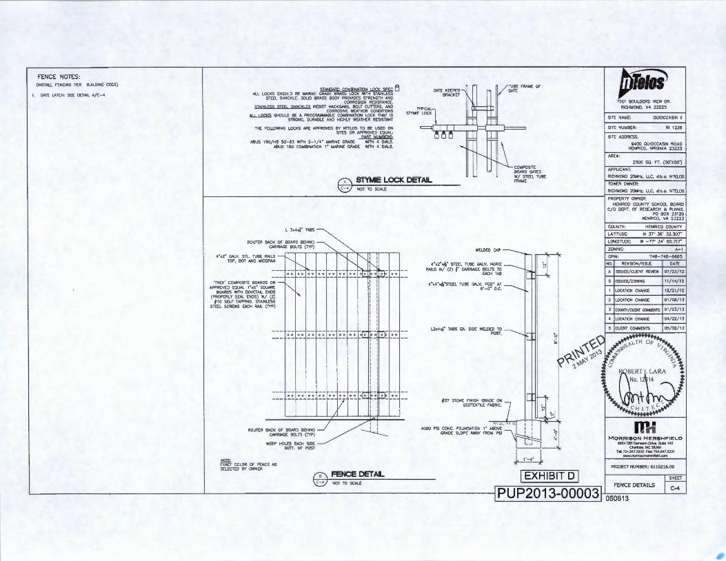
FENCE NOTES: {INSTALL FENCING PER BUILDING CODE)
1. GATE LATCH : SEE DETAIL A/C-4
SJANOARQ COMAINAJION LOCK Sp EC ~ All LOCKS SHOULD BE MARINE GRADE BRASS LOCK WITH STAINLESS
STEEL SHACKLE, SOUO BRASS BODY PROVIDES STRENGTH AND CORROSION RESISTANCE.
STAIN! ESS SJf fl SHACK! ES RESIST HACKSAWS, BOLT CUTIERS, AND CORROSIVE WEATHER CONDinONS
~ SHOULD BE A PROGRAMMABLE CO~BINATION LOCK THAT IS STRONG, DURABLE AND HIGHLY WEATHER RESISTANT
THE FOLLOWING LOCKS AAE APPROVED BY NTELOS TO BE USED ON SITES OR APPROVED EQUAL:
PART NUhjRER$·
ABUS 180/HB 50- 6J WITH 2-1/4" t.!ARINE GRADE WITH 4 DIALS. ABUS 180 COt.4 81NATION t " MARINE GRADE WITH 4 DIALS.
GATE KEEPER......., BRACKET
STYMIE LOCK TYPICALl
==tf" ~
'
1\ I
LLI IT
V TUBE FRAME OF' GATE
~
rn~-"' (7\ STYMIE LOCK DETAIL ~~~~~TUBE
FRAME
4·x2· GALV. STL. TUBE RAILS TOP, BOT AND I.AIDSPAN
'TREX' COMPOSITE BOARDS 0-;-1{-- -APPROVED EQUAL 1•x6· SQUARE
BOARDS WITH DOVETAIL ENDS (PROPERLY SEAL ENOS) W/ (2)
f1 D SELF TAPPING, STAINLESS STEEL SCREWS EACH RAIL {TYP)
~ NOT TO SCALE
~~~~]~~!~~~~~~~~~--
---r--[-J--r--[-1--f--f,-W[_J __ 0000000000000000 00 00 --- -- - -- -- - 7 -- : -: -- - --1 1
ROUTER BACK OF BOARD BEHIND ~ : : CARR1AGE BOLTS (TYP) ~
WEEP HOLES EACH SIDE BOTT. OF POST
= EXACT COLOR OF FENCE AS SELECTED BY OWNER
(9\ FENCE DETAL
WELDED CAP ----
CARRIAGE BOLTS TO N •"•2""l\" STEEL TU -=mr RAlLS W/ (2) j" BE CJoi.V. HORIZ
EACH TAB ~
4•x4•Xl'\•STEEL TUBE GALV. POST AT 6' - 0" o.c. ---.........._
'-'••><J" TASS EA SlOE WELOE~;~ ~
#57 STONE FINISH GRADE ON CAh_ GEOTEXTlLE FABR1C. 7 _ I ~~
4000 P$1 i~i :~~:t~~~~ ~~0~ ~ ~~ w I EXHIBIT D I
~* 7501 BOULDERS VIEW OR.
RICHMOND, VA 23225
SITE NAME: OUIOCCASIN II
SITE NUI.!BER: Rl 1236
SITE ADDRESS:
9400 OUIOCCASIN ROAD HENRICO, VIRGINIA 23233
AREA:
2500 50. H. (50'X50')
APPUCANT:
RICHMOND 20MHz, LLC, d.b.o. NTELOS
TO'NER OWNER:
RICHMOND 20MHz, LLC, d.b.o. NTELOS
PROPERTY OWNER: HENRICO COUNTY SCHOOL BOARD
C/0 DEPT. OF RESEARCH & PLNNG. PO BOX 23120
HENRICO, VA 23223
COUNTY: HENRICO COUNTY
LATITUDE: N 37' 36' 32.307•
LONGITUDE: W - 77' 34' 50.717•
ZONING: A-1
GPIN· 748 -746-6665
NO. REVISION/ISSUE DATE
A ISSUED/CUENT REVIEW 07/23/12
0 ISSUED/ZONING 11/14/12
1 LOCATION CHANGE 12/21/12
2 LOCATION CHANGE 01/DS/13
3 COUNTY/CliENT COtJ.~ENTS 01/23/ 13
4 ILOCATION CHANGE 04/22/13
5 ICUENT C0Mt.4ENTS 00/02/13
w,; M ORRISON H E RSHFIELO
seG4 CI!T c.m.ron DrN•. &Ill• 145 ~•. NC282tl9
Tel: 704.547.5235 Fax: 704.5-47.5231 www.A'IOfli.onherW!IIeld.oorn
PROJECT NUMBER: 61102 16.00
'.:c:J NOT TO SCALE _ FENCE DETAILS
L_------------------~----------------------------------~ PUP2013-00003~o~so~s 1 3----~~
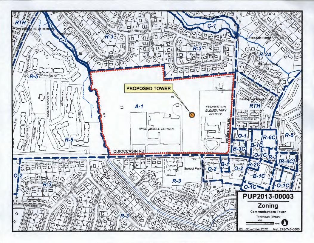
Zoning Communications Tower
Tuckahoe District
400 0 Feet
November 2012 Ref: 748-746-6665
PEMBERTON ELEMENTARY
SCHOOL
2026 Land Use Plan Communications Tower
Tuckahoe District
400 0 Feet
November 2012 Ref: 748-746-6665