Embed Size (px)
Citation preview
BOARD OF COUNTY COMMISSIONERS SARPY COUNTY, NEBRASKA
2016-38
RESOLUTION AUTHORIZING CHAIR TO SIGN PROFESSIONAL SERVICES AGREEMENT WITH HDR ENGINEERING, INC. FOR PROJECT C-77 {19-3) A
WHEREAS, pursuant to Neb. Rev. Stat. §23-104(6) the County has the power to do all acts in relation to the concerns of the County necessary to the exercise of its corporate powers; and,
WHEREAS, pursuant to Neb. Rev. Stat. §23-103 the powers of the County as a body are exercised by the County Board; and,
WHEREAS, general supervision and control of the public roads of each county is vested in the County Board by virtue of Neb. Rev . Stat. §39-1402; and,
WHEREAS, the County of Sarpy desires to enter into a contract for professional services with HDR Engineering, Inc. as outlined in the Agreement attached hereto for purposes of designing the realignment of Platteview Road and new intersection of Platteview Road at 841
h Street, known as Sarpy County Project C-77 (19-3) A: and,
WHEREAS, entering into the contract for professional design services with HDR Engineering, Inc. is in the best interests of the citizens of Sarpy County and the traveling public.
NOW, THEREFORE, BE IT RESOLVED by the Sarpy County Board of Commissioners that this Board hereby approves and adopts the attached Agreement with HDR Engineering Inc.
BE IT FURTHER RESOLVED that the Chairman of this Board, together with the County Clerk, is hereby authorized to sign on behalf of this Board the Agreement with HDR Engineering, Inc., a copy of which is attached, and any other related documents, the same being approved by the Board.
The above Resolution was approved by a vote of the Sarpy County Board of Commissioners at a public meeting
duly held in accordance with the applicable law on the q-tb- day of February, 2016.
Attest
SEAL
SHORT FORM AGREEMENT BETWEEN OWNER AND HOR ENGINEERING, INC. FOR PROFESSIONAL SERVICES
THIS AGREEMENT is made as of this 9-ii- day of~~~=.:::.:::_--=t.,,--~· 20_1.k, between Sarpy County, Nebraska ("OWNER") and HDR ENGINEERING, C., ("ENGINEER") a Nebraska corporation, with principal offices at 8404 Indian Hills Drive, Omaha, Nebraska, 68114 for services in connection with the project known as 841
h
& Platteview Road Realignment ("Project");
WHEREAS, OWNER desires to engage ENGINEER to provide professional engineering, consulting and related services ("Services") in connection with the Project; and
WHEREAS, ENGINEER desires to render these Services as described in SECTION I, Scope of Services.
NOW, THEREFORE, OWNER and ENGINEER in consideration of the mutual covenants contained herein, agree as follows:
SECTION I. SCOPE OF SERVICES
ENGINEER will provide Services for the Project, which consist of the Scope of Services as outlined on the attached Exhibit A.
SECTION II. TERMS AND CONDITIONS OF ENGINEERING SERVICES
The "HDR Engineering, Inc. Tenns and Conditions for Professional Services," which are attached hereto in Exhibit B, are incorporated into this Agreement by this reference as if fully set forth herein.
SECTION III. RESPONSIBILITIES OF OWNER
The OWNER shall provide the information set forth in paragraph 6 of the attached "HDR Engineering, Inc. Terms and Conditions for Professional Services."
SECTION IV. COMPENSATION
Compensation for ENGINEER'S services under this Agreement shall be on the basis of
cost plus fixed fee. ENGINEER'S fixed fee will be thirty seven thousand, four hundred fifty-nine Dollars ($37,459) . Cost shall be an amount equal to salary cost times a factor of2.5549. Reimbursable expenses incurred in connection with such services shall be in addition to ENGINEER'S compensation.
Agreement for Professional Services 9-2014
The amount of any sales tax, excise tax, value added tax (VAT), or gross receipts tax that may be imposed on this Agreement shall be added to the ENGINEER'S compensation as Reimbursable Expenses.
Compensation terms are defined as follows:
Reimbursable Expense shall mean the actual expenses incurred directly or indirectly in connection with the Project for transportation travel, subconsultants, subcontractors, technology charges, telephone, telex, shipping and express, and other incurred expense.
Cost-Plus-Fixed Fee shall mean Cost plus a Fixed Fee.
Cost, as used in "Cost-Plus-Fixed Fee," shall mean Direct Labor Cost plus Overhead Costs, plus Reimbursable Expense.
Overhead Costs, as used in "Cost-Plus-Fixed Fee," shall mean indirect costs which include payroll and administrative expenses. For this Agreement, overhead costs shall be (one hundred fifty-five point forty-nine) percent (155.49%) of Direct Labor Cost.
Fixed Fee shall mean a fixed amount of fee that is added to the Cost in a Cost-Plus-Fixed Fee basis of payment. The sum of Cost and Fixed Fee shall be the compensation for the Scope of Services. The Costs may vary, but the Fixed Fee shall remain the same provided the Scope of Services does not change.
SECTIONV. PERIOD OF SERVICE
Upon receipt of written authorization to proceed, ENGINEER shall perform the services
within the time period(s) described in Exhibit A.
Unless otherwise stated in this Agreement, the rates of compensation for ENGINEER'S services have been agreed to in anticipation of the orderly and continuous progress of the project through completion. If any specified dates for the completion of ENGINEER'S services are exceeded through no fault of the ENGINEER, the time for performance of those services shall be automatically extended for a period which may be reasonably required for their completion and all rates, measures and amounts of ENGINEER'S compensation shall be equitably adjusted.
SECTION VI. SPECIAL PROVISIONS
NON-DISCRIMINATION CLAUSE: Pursuant to Neb. Rev. Stat. §73-102, the parties declare, promise, and warrant that they have and will continue to comply fully with Title VI of the Civil Rights Act of 1964, as amended (42 U.S.C.A § 1985, et seq.) and the Nebraska Fair Employment Practice Act, Neb. Rev. Stat. § 48-1101, et seq., in
that there shall be no discrimination against any employee who is employed in the performance of this agreement, or against any applicant for such employment, because of age, color, national origin, race, religion, creed, disability or sex.
Agreement for Professional Services 2 9-2014

E-VERIFY: Engineer shall register with and use the E-Verify Program, or an equivalent federal program designated by the United States Department of Homeland Security or other federal agency authorized to verify the work eligibility status of a newly hired employee pursuant to the Immigration Reform and Control Act of 1986, to determine the work eligibility status of new employees physically performing services within the state where the work shall be performed. Engineer shall require the same of each subconsultant.
Agreement for Professional Services 3 9-2014
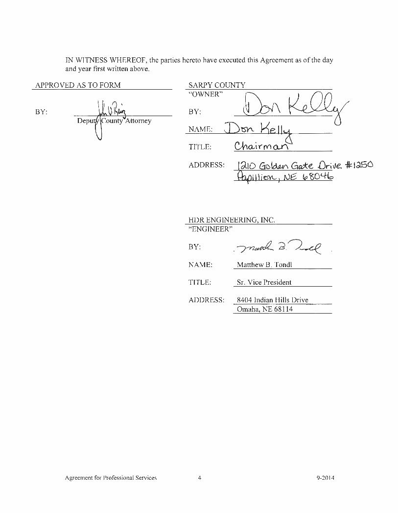
IN WlTNESS WHEREOF, the parties hereto have executed this Agreement as of the day and year first written above.
APPROVED AS TO FORM SARPY COUNTY
BY: Depu
Agreement for Professional Services
"OWNER"
BY:
NAME:
TITLE:
ADDRESS: ld.10 G-u~ Ga.*e. Drille. -a=:1a56 '1t'} i 1 \it:$)'\_, 1 rJe: "' io %
HDR ENGINEERING, INC. "ENGINEER"
BY: _ 7--n~ d.~~ NAME: Matthew B. Tondl
TITLE: Sr. Vice President
ADDRESS : 8404 Indian Hills Drive Omaha, NE 68114
4 9-2014

EXHIBIT A
SCOPE OF SERVICES
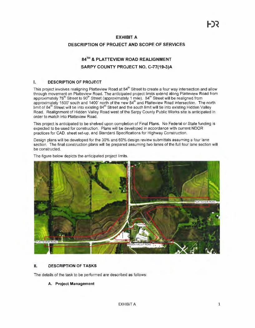
EXHIBIT A
DESCRIPTION OF PROJECT AND SCOPE OF SERVICES
84rH & PLATTEVIEW ROAD REALIGNMENT
SARPY COUNTY PROJECT NO. C-77(19-3)A
I. DESCRIPTION OF PROJECT
This project involves realigning Platteview Road at 841h Street to create a four way intersection and allow
through movement on Platteview Road. The anticipated project limits extend along Platteview Road from approximately 781
h Street to 901h Street (approximately 1 mile). 841
h Street will be realigned from approximately 1500' south and 1400' north of the new 841
h and Platteview Road intersection. The north limit of 841
h Street will tie into existing 841h Street and the south limit will tie into existing Hidden Valley
Road. Realignment of Hidden Valley Road west of the Sarpy County Public Works site is anticipated in order to match into Platteview Road.
This project is anticipated to be shelved upon completion of Final Plans. No Federal or State funding is expected to be used for construction. Plans will be developed in accordance with current NOOR practices for CAO, sheet set-up, and Standard Specifications for Highway Construction.
Design plans will be developed for the 30% and 60% design review submittals assuming a four lane section. The final construction plans will be prepared assuming two lanes of the full four lane section will be constructed.
The figure below depicts the anticipated project limits.
II. DESCRIPTION OF TASKS
The details of the task to be performed are described as follows:
A. Project Management
EXHIBIT A 1
1-)~
This task includes activities to initiate and monitor project schedules, staffing assignments and internal cost controls throughout the life of the design contract. Also included are efforts to prepare and process invoices, monthly progress reports, initial project setup, and final project closeout.
Regular project correspondence with Sarpy County via phone, fax , email and mail are included in this task.
Meetings with Sarpy County will include a Project Kickoff meeting, a 30% Plans meeting to confirm roadway geometrics and prel iminary drainage, a 60% Plans meeting to review construction limits and right of way needs, and two additional "as needed" meetings. Agendas and meetings minutes will be prepared for each meeting. Each meeting is anticipated to include three people for two hours. Other task specific meetings are documented elsewhere within this scope.
One project site visit with Sarpy County is included. It is anticipated this site visit will occur at the 30% Plans milestone. Two people will participate in this site visit. Other task specific project site visits are included elsewhere within th is scope.
Quality Control reviews at the 30%, 60%, and Final plan submittals will be performed by a senior engineer independent of the core design team.
B. Data Collection and Field Survey
Sarpy County will provide control surveys and topographic surveys for this project. HOR will coordinate with Sarpy County surveyors to establish survey limits and special survey requests.
HOR will perform a field review of the provided survey information for completeness and to identify additional information needed to aid design. HOR will develop additional survey requests and coordinate with Sarpy County surveyors if additional survey is needed during design.
C. Conceptual Roadway Analysis
Establish design criteria for the project. Evaluate up to 3 alternatives for improving the horizontal and vertical geometrics from the 2009 Feasibility Study. Analysis will include a comparison style matrix to include items such as geometrics, earthwork, stream impacts, required right of way, current constructability, and future expansion.
Typical sections for Platteview Road will be developed for the full four-lane scenario. Up to three alternatives will be evaluated for constructability of a partial two-lane section with consideration for future constructability.
Project plots will be developed depicting the plan and profile for each alternative.
A meeting will be held with HOR and Sarpy County to review the alternatives and determine the preferred alternative to continue design.
D. Environmental
This task includes environmental studies that can be used to assist in the design process and minimize project impacts. Because the project will be shelved for a later date, activities are tailored to provide data for design while minimizing , to the extent possible, the amount of re-work that will be required when the project is advanced.
i. Data Collection
The following data will be obtained from publicly available sources and compiled in a GIS database.
Data Type Data Source
Land Use/Land Cover USONNRCS/UNL
Homes and Other Structures Aerial lmaaerv
Threatened and Endanaered USFWS/NGPC 1
EXHIBIT A 2
1-)~
Species Habitat and Known Ranqe
Cultural Resources/NRHP NE SHP02
Wetlands I Waterways NWI I NHD
Floodplain NDEQ I FEMA
Wells NDEQ /UNL I Aerial Imagery
Municipal Limits Census
WMA and NGPC Properties NGPC
Conservation Easements National Conservation Easement Database
Federal Lands Census I ESRI
Existing/Future Land Use/Zoning Sarpy County and City of Papillion
Road Census I ESRI NE Dept. Roads
Topoqraphy DNR/USGS
Parcel Data Sarpy County Assessor
Communication Towers Federal Communication Commission I Aerial Imagery Pipelines (Trunk Lines) (gas -liquid) National Pipeline Mapping System (NPMS)
Notes: 1 Includes species lists and range maps. Does not include sensitive data from the NGPC. 2 Includes sites listed on the NHRP. Does not include sensitive data from the NESHPO.
The database compiled from the above resources will be used to identify resources present. Using this information, HOR Environmental Scientists will make an assessment of potential for impacts in the Environmental Technical Memorandum and environmental constraints map. During the data review, should a resou rce or potential impact be identified that HOR determines may warrant further investigation, HOR will notify Sarpy County to discuss how to proceed through the addition of services to this scope of service.
ii. Wetland Determinations
HOR will conduct wetland determinations in the study area to identify potential wetland areas for the design process. Wetland determinations identify potential wetland areas based on vegetation and hydrology, without soils verification . Full wetland delineations with soils verification will be required prior to permitting and construction. Wetland delineations completed in accordance with appl icable U.S. Army Corps of Engineers (USACE) guidance documents (Wetland Delineation Manual and Midwest Regional Supplement) and development of a Section 404 permit application are not included in this scope of services.
Wetland determinations will be conducted by a team of two HOR Environmental Scientists throughout the entire Project Area, including the area surrounding the 2 existing large box culverts and the channel that runs parallel with Platteview Road , east of 84th Street. Waterways will also be documented during the wetland determination process. Following completion of necessary fieldwork, HOR will prepare documentation that includes a text summary, data forms , and mapping for inclusion in the Environmental Technical Memorandum and environmental constraints map.
iii. Hazardous Materials Review
HOR will complete a desktop Hazardous Materials Review (HMR) within the Project Area to identify conditions that indicate an existing release, a past release, or a material threat of a release, of any hazardous substances or petroleum products into structures, on the property or into the soils, groundwater, or surface water. There are two known existing septic fields in the vicinity of the project.
EXHIBIT A 3

1-)~
The HMR will include a regulatory file review (local, state and federal agencies). The purpose of this review will be to identify sites within the Project Area (one tenth mile on either side of the project's centerline) . Any sites identified during the file review will be assessed for their potential impact on the project. Based on the availability of Google Earth Street View photographs, a site visit is not included for this task.
The HMR will cover (1) conducting a study of the Project Area for local , state and federal environmental database records; (2) reviewing readily available aerial photographs, (3) conducting interviews with property owners, local agencies and regulators, if necessary, and (4) preparing written findings will be documented in the Environmental Technical Memorandum and environmental constraints map.
iv. Environmental Technical Memorandum and Environmental Constraints Map
An Environmental Technical Memorandum will be developed to document the environmental resources identified in tasks D.i. through D.iii. The map will be included in the Environmental Technical Memorandum and will be used during roadway concept development. This Environmental Constraints Map will be used during roadway concept development.
E. Geotechnical
i. Site Visit to Observe Site and Modify the Boring Locations
Two representatives of HOR will make one site visit to observe site conditions and modify the boring locations, if necessary, prior to drilling. GPS equipment capable of locating borings within 3 feet will be used by the sub-consultant to locate the proposed boring locations and to document the actual boring locations. The sub-consultant will record the coordinates of the revised locations and provide them to HOR.
ii. Coordination of Subconsultant for Drilling
HOR will provide drilling sub-consultant with coordinates for the locations of borings before the drilling work. The sub-consultant will provide full time supervision and field observation during drilling and sampling to gather data for geotechnical analysis and design. One representative of HOR will visit the project site during the drilling to observe the work and will consult with the sub-consultant to make adjustments in the exploration program as needed.
Drilling sub-consultant shall be responsible for drilling and logging soil borings, sampling , insitu testing and laboratory testing under the direction of HOR. The drilling sub-consultant shall also be responsible for recording the water level readings during and after drilling , including delayed water levels in borings where groundwater is encountered. No groundwater monitoring wells are proposed for this work. The sub-consultant will prepare the final boring logs.
The sub-consultant services will include obtaining necessary authorization and permits to execute the drilling program, contacting Nebraska One Call for utility locate services, obtaining verbal permission for access from landowners and businesses, providing traffic control during drilling operations if needed, and backfilling borings in accordance with state requirements.
iii. Assignment and Coordination of Laboratory Testing
HOR will review the preliminary results of the drilling and sampling program as it proceeds and will modify the program to gather additional data, as necessary.
HOR will assign, coordinate and perform quality control check of the laboratory testing program and assign additional testing as needed.
iv. Review Boring Logs and Laboratory Testing Data
HOR will review the typed boring logs and laboratory test data, and prepare tabulation of test data.
EXHIBIT A 4
1-)~
v. Development of Soil Profiles and Soil Design Parameters
HOR will prepare soil profiles and soil design parameters for use in the evaluation of subsurface conditions and in the settlement and stability analyses of the proposed embankments.
vi. Geotechnical Analyses for Roadway Embankments
HOR will perform engineering analyses for the following tasks:
• Slope Stability Analyses for embankment fills at up to 8 critical sections • Settlement Analyses for embankment fills at up to 8 crit ical sections
vii. Geotechnical Analyses for Culverts
HOR will perform final engineering analyses for the following tasks:
• Settlement Analyses for two box culverts • Development of geotechnical design and construction recommendations for two box
culverts
viii. Evaluation of Subgrade Preparation/Ground Improvement Measures
HOR will perform final evaluation of subgrade preparation including:
• Evaluation of subgrade preparation measures • Evaluation of need for ground improvement to support embankments
ix. Preparation of Geotechnical Report
HOR will prepare a Geotechnical Report summarizing results of the field exploration and laboratory testing programs, roadway subgrade analyses , slope stability analyses, settlement analyses, and recommendations for the construction of roadway embankments and culverts.
F. Traffic Analysis
i. Compile and Review Data
Review and summarize existing count data. This task assumes Sarpy County will provide existing traffic volumes at the following locations:
• 841h Street, north of Platteview Road
• Platteview Road , east of 841h Street
• Platteview Road , west of 841h Street
Traffic data for the AM and PM peak hour turning volumes at the 84th and Platteview intersection will be taken from the 2014 counts as part of the Metro Area Travel Improvement Study.
ii. Develop AM & PM Peak Hour Traffic Volumes
Traffic projections will be developed for the following scenarios, using information contained in the latest MAPA Forecasting Model :
• 2015 existing year • Opening year (2-lane scenario) • Interim year (5 Years after Opening Year) • 2040 full build (4-lane scenario)
Opening year is to be estimated based on discussions with Sarpy County during the course of this design contract.
EXHIBIT A 5
1-)~
iii. Traffic Analysis
Perform AM & PM peak hour traffic operational analysis for the scenarios identified in Task K.2 to aid development of the roadway design. A signal warrant analysis will be conducted to determine when the signal is justified, using the criteria specified in the Manual on Uniform Traffic Control Devices (MUTCD). The analysis will also identify the approximate timing to construct the full build . The previous studies, counts, and volumes will be compared to determine any storage length or geometry modifications that are necessary for the interim or full build design.
Submit a brief technical memorandum documenting the analysis described above.
G. Roadway Design
i. 30% Design Plans - Full Build
This task will include finalizing the horizontal and vertical geometry for the preferred alternative from Task C of this scope. This effort includes the plan and profile sheet development for Platteview Road , 84th Street, Hidden Valley Road, and other connecting side streets and entrances. Superelevation design is included in this task. Intersection sight distance will be analyzed at each intersection.
Typical cross sections will be created which depict the full build four-lane scenario.
Cross sections will be developed at 50 ' intervals. Included in this task is the development of a basic roadway model using Corridor Modeler to develop the cross sections.
ii. 60% Design Plans - Full Build
Approximate Right of Way and Easement limits will be established based on anticipated construction limits. A strip map will be developed to depict the anticipated project right of way and easement requirements. Development of tract maps and legal descriptions is not included.
An enclosed storm sewer system is not anticipated for this project. Standard ditches and special ditches will be designed to accommodate the four-lane project drainage. Cross road culverts are included in Task H.
Cross sections will be updated to include select locations such as culverts and entrances to provide plan clarity.
iii. 60% Design Plans - Partial Build
Plans will be updated to depict the partial build scenario. Sheets to be updated include typical cross sections, plan and profile sheets, and cross sections.
The roadway model will be updated to depict the partial build scenario.
The ditches for the full build scenario are anticipated to accommodate the partial build scenario. Additional ditches to accommodate only the two-lane scenario are not included.
iv. Final Design Plans - Partial Build
A jointing layout will be provided for Platteview Road and 84th Street. Additional detail such as spot elevations will be provided at the intersection of Platteview Road and 84th Street if necessary to provide clarity.
Construction and Removal sheets will be developed with appropriate notes detailing build and removal items.
Finalize cross sections. Construction limits and final earthwork quantities are included.
Sheets such as Title Sheet, Summary of Quantities, General Notes, and Miscellaneous Details will be developed to support the clarity of the plans. Refer to the Estimated Sheet Count included with this scope.
EXHIBIT A 6
1-)~
Additional tasks to be performed to support and supplement the development of the Final Design Plans are found in the following tasks.
H. Hydrology and Hydraulics
The primary focus of the hydraulic analysis will address a proposed major structure under Platteview Road near the east project limits and another proposed major structure under 84th Street. Based on aerial photography, the contributing area for the Platteview Road structure is several square miles (but less than 10 square miles) in size and for the 84th Street structure is slightly more than 1 square mile in size. Both structures are anticipated to be bridge sized or major structures and will be designed to comply with the Bridge Division hydrologic and hydraulic criteria. There are expected to be two other cross-drain structures found on the project and are expected to measure less than 20 feet across the inside faces of exterior walls. These culverts will be designed to comply with the NOOR Drainage Design and Erosion Control Manual Chapter 8 hydrologic and hydraulic criteria.
No floodplain has been delineated by federal , state, or local jurisdictions. There is an existing rural residential development downstream of the project, so in add ition to hydrologic and hydraulic analysis for proposed conditions , analysis will include evaluation of existing hydraulic conditions so existing and proposed conditions can be compared . Since no floodplain has been delineated for this project location , no floodplain development permit is anticipated.
i. Hydrologic Analysis
NOOR Regression equations will be used to estimate the flood flow magnitude - frequency generated by the watershed for the major structures and the rational method used for the other two cross-dra in culvert locations.
ii. Hydraulic Modeling
Perform hydraul ic analysis required to provide data for preparation of roadway geometric revisions & grading and to provide supporting documentation for preparation of NOOR forms and submittals. NOOR Hydrologic and hydraulic analyses will be used for th is project. A cursory field review will be performed to assess hydraulic cond itions immediately upstream and downstream of the roadway for determination of applicable hydraulic modeling parameters used for hydraulic analyses.
A HEC-RAS hydraulic model of the proposed roadway crossing major structures will be prepared:
• Execute the model without the existing drainage structure and roadway; this model will become the natural conditions model (NCM).
• Execute the NCM with the existing drainage structure and roadway; th is model will become the existing conditions model (ECM).
• Modify the ECM for proposed roadway modifications; this will become the proposed model (PCM).
• Execute the PCM to determine hydraulic effect on water surface profiles for the proposed roadway cond ition and compare to the ECM to confirm the proposed structure complies with NOOR criteria.
• Scour will be evaluated using NOOR Drainage Design and Erosion Control Manual criteria.
The cross-drain culverts will be designed to comply with the current version of the NOOR Drainage Design and Erosion Control Manual.
iii. Documentation
Prepare draft techn ical memorandum documenting the hydrologic and hydraulic analyses of the proposed roadway project for review and comment by NOOR. The memorandum will contain a map showing the approximate contributing area for the four drainage structures. Prepare final technical memorandum incorporating review comments.
EXHIBIT A 7
I. Structural Design
Two Bridge Length (>20' along the centerline of road) box culverts will be included with this project. HOR will complete DR Form 67 and include the hydraulic analysis report from Task H for each structure and coordinate with NOOR. NOOR will design, detail, stamp and load rate LRFD compliant Concrete Box Culvert plans for two culverts at no cost to HOR or Sarpy County.
J. Intersection Lighting
Develop design plans showing lighting systems to be installed at new intersections. Scope includes the development of 1"=50' plan view drawings that detail the locations of the lighting components including light poles, light fixtures, lighting controllers , pull boxes, junction boxes, conduit routing (underground and exposed) , and connection to electrical services.
Temporary lighting plans will be developed to detail lighting systems at up to two temporary intersections.
K. Signal Design
i. 60% Design for full build
Prepare 60% traffic signal design plan at the intersection of 84th Street/Platteview Road for the full build. The traffic signal plans will include the following elements :
• Anticipated signal pole type , location, and mast arm lengths • Anticipated signal head arrangements on each pole and anticipated signal phasing • Anticipated traffic signal controller location
ii. 100% Design interim
If a traffic signal is warranted during the opening year or interim year, as identified in the traffic analysis, prepare 100% traffic signal plans and construction documents for a new traffic signal at 84th Street/Platteview Road. This task includes one (1) coordination meeting with Sarpy County staff to discuss the preliminary plans, detection preferences, interim signal duration, and any other signal related requirements. Prepare quantity tabulations and cost estimate.
L. Erosion Control
Temporary and Permanent Erosion Control Plans will be developed for the final plans based on Chapter 2 of the NOOR Drainage Design and Erosion Control Manual dated August 2006.
M. Temporary Traffic Control
This task includes effort to develop the construction phasing and traffic control plans identifying the sequence of construction for the two-lane construction scenario. It is anticipated to include three stages of construction with only one of the three legs of the intersection being closed at any one time. The traffic control plans will follow the 2009 MUTCD standards for temporary signing , striping , and barricades.
N. Pavement Marking and Signing
This task includes effort to develop the pavement marking and signing plans for the final plans in accordance with the 2009 MUTCD. The signing plan is limited to standard traffic control signs found in the 2009 MUTCD and the 2011 Nebraska Supplement to the 2009 MUTCD. No signs will be designed as part of this scope.
0. Public Information
A public meeting will be held after the 30% design milestone. The meeting will follow an informal, open house format without a presentation. HOR will create a contact list of adjacent property owners, prepare exhibits (assume one scroll and two boards). and prepare and distribute meeting notifications (assume up to 100 invites) . HOR will prepare handouts, comment forms, sign-in sheets and name tags. Sarpy County will make arrangements for the location of the meeting. Two
EXHIBIT A 8
1-)~
HOR staff will attend the meeting to explain the project and answer questions. HOR will compile public comments received at the meeting and provide written responses (5 estimated) to comments when necessary. One-on-one meetings with property owners are not included with this scope.
P. Utility Coordination
HOR will provide preliminary plans to the utility companies which are known to have facilities with in the project limits. Utility companies will be responsible for identifying their facilities on the plans. HOR will review the received utility information for potential conflicts and prepare a spreadsheet summarizing potential utility conflicts.
Q. Quantities and Cost Estimates
Quantities and construction cost estimates will be developed for the 30% design plans, 60% design plans. and final plans. The 30% and 60% design plan cost estimates will be based on the full four lane section. The final plan cost estimate will be for the two-lane construction scenario.
Ill. DELIVERABLES
A. Monthly Progress Reports and Invoices B. Conceptual Roadway Analysis scroll plots C. Conceptual Roadway Analysis comparison matrix D. GIS Database of Environmental Information E. Environmental Technical Memorandum F. Environmental Constraints Map G. Draft Geotechnical Report (PDF) H. Final Geotechnical Report (PDF) I. Traffic Analysis Technical Memorandum (PDF) J . Draft Hydraulics and Hydrology Techn ical Memorandum (PDF) K. Final Hydraulics and Hydrology Technical Memorandum (PDF) L. Potential Utility Conflicts Spreadsheet (XLS) M. Public Meeting exhibits/handouts/comment sheets N. 30% Plans for Full Build scenario 0 . 60% Plans for Full Build scenario P. Final Plans for the Construction scenario (including electronic Microstation files) Q. Construction Cost Estimates at 30%, 60%, and Final
IV. ASSUMPTIONS AND UNDERSTANDINGS
General
A. No Federal or State funding is used for this project. B. 30% and 60% Plans will be developed using a four-lane divided section on Platteview
Road. C. Final Plans will be developed using a two-lane section to be determined during the
Conceptual Roadway Analysis. D. Plans will be developed according to current NOOR practices for CAD, sheet set-up, and
Standard Specifications for Highway Construction. E. Final plans will be prepared as a single construction package. F. No effort is included for advertising, letting or construction phase services.
Environmental
A. No Federal or State funding is used for th is project. NEPA analysis is not included. B. Wetland delineations will be required prior to submittal of a Section 404 Permit
Application and project construction . Wetland delineation is not included in this scope. C. Development of environmental permit applications is not included.
EXHIBIT A 9
D. Surveys for cultural resources and threatened and endangered species are not included. E. Wetland determination fieldwork needs to be performed during the growing season,
which is generally defined as May 1 to November 1. Wetland determinations outside of this period may not be as accurate due to deteriorated vegetation conditions resulting from cold weather.
F. Up to two property owner interviews are included for the Hazardous Materials Review.
Geotechnical
A. A subconsultant will be secured to perform field drilling exploration and laboratory testing. B. Geotechnical fieldwork in farm fields can be completed without restriction which may
result in crop damage. Contingency for crop damage is included in the drilling proposal. C. Design of stability berms or ground improvement systems will not be required. 0 . No effort is included related to the relocation of the existing creek. E. No effort is included related to study of borrow sites as the contractor will be required to
provide borrow soil. F. Sarpy County will provide review comments within two weeks after submittal of the draft
geotechnical report to the County.
Traffic Analysis
A. Sarpy County will perform existing traffic counts and provide AM and PM peak hour turning movements at the four intersections noted in Task F.i. of this scope.
Roadway Geometric Design
A. Sarpy County will provide a pavement determination B. Design will be based on the following reference material :
a. 2011 AASHTO Greenbook b. 2011 AASHTO Roadside Design Guide
C. No effort is included for: a. Enclosed storm sewer design b. Sidewalk or trail design c. Retaining wall design d. Landscaping or aesthetics e. Development of special provisions
Hydrology and Hydraulics
A. Initial agency coordination and the cursory field visit are assumed to occur on the same day and be attended by 2 HOR personnel.
B. There is no delineated floodplain . Level of effort and fee for hydraulic modeling the two major structures is based on preparing natural, existing and proposed conditions model using the 100-year peak flow rates from NOOR Drainage Design and Erosion Control Manual Regression Equations for design.
C. Level of effort and fee for hydraulic modeling the cross drain culverts is based on 2 cross drain culverts on the western leg of the proposed project using the NOOR Drainage Design and Erosion Control Manual. Regression Equations will be used for the Major structures and Rational Method for the two (2) cross-drain structures on the western leg of the proposed project.
D. If available at the two major structures, existing hydraulic performance information for the existing structure will be compared to the ECM for the proposed major structures, and a brief explanation will be prepared if there are notable differences. ECM and PCM models of the major structure on Platteview Road will be compared for 2-year and 10-year peak flow rates at the Platteview Road ROW downstream limit. Design of modifications to the proposed structure to approximate existing 2-year and 10-year peak flow rates could be evaluated as additional services.
E. Proposed condition HEC-RAS model will be developed for one (1) proposed roadway design alternative. Additional roadway design alternatives could be evaluated as additional services.
EXHIBIT A 10
1-)~
F. One trapezoidal section outlet channel design alternative for the 841h Street structure
using the most direct route to the existing channel will be evaluated. Inlet and outlet locations of the other structures are expected to be at respective existing stream beds. Additional outlet channel design alternatives could be evaluated as additional services.
Structural Design
A NOOR will provide full structural design and plans for two bridge sized box culverts. No other structural design will be required .
B. No retaining walls or noise walls are included.
Intersection Lighting
A HOR shall utilize Nebraska Department of Roads lighting standard details and specifications. In addition , the work shall be prepared in accordance with the following standards: • AASHTO Roadway Lighting Design Guide , 2005 Edition. • IESNA American National Standard Practice for Roadway Lighting (RP-8-00). • FHWA Roadway Lighting Handbook, dated August 2012.
8. Photometric calculations shall be prepared using Visual Lighting Software. The following parameters shall be utilized for this project: • Pole mounted roadway luminaires will be Type II or Ill medium semi-cutoff, as
required. • Pole mounted roadway luminaires shall be 250W HPS traditional arm-mounted
cobra-head style luminaires installed on 40' steel or aluminum poles. • Proposed lighting system shall be fed from a 120/240 volt, 60 Hz single phase. • Basis for design will be 0.8 to 1.0 average foot-candles with a uniformity of 3:1 to
4:1. C. Lighting installation details will be developed based on best available roadway design
information. D. Existing lighting components including poles , luminaires, and controllers shall not be
reused for permanent intersection lighting. All permanent lighting components shall be new. Existing poles may however be used for temporary lighting.
E. Permanent lighting shall be provided at up to five intersections. F. Temporary lighting shall be provided at up to two temporary intersections. G. All fixtures shall be High Pressure Sodium (HPS). H. No continuous lighting throughout project.
Erosion Control
A Detention basins will not be required .
Public Information
A. Two people to attend one public meeting for three hours. Includes set-up and breakdown.
Quantities and Cost Estimates
A. Cost estimates will be based on anticipated construction costs as of the date of the estimate. Escalation to a construction year will not be included.
EXHIBIT A 11
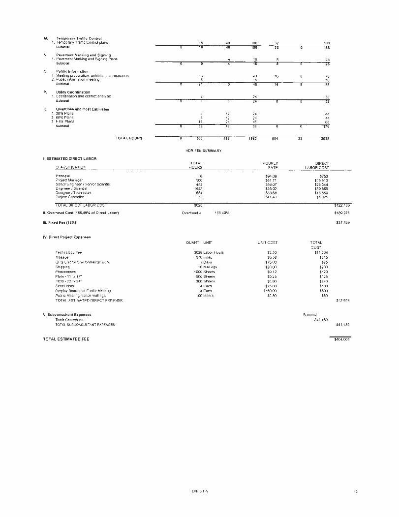
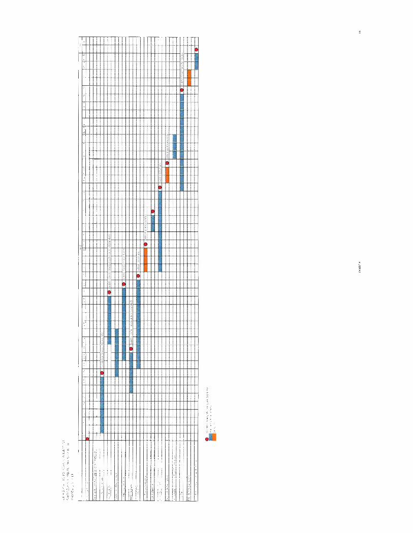
HOR Scope and Fee Summary
84TH & PLATTEVIEW ROAD REALIGNMENT Sarpy County Project Number C-77(19-J)A
Sarpy County, NE
Principal Project Sr. Eng / Eng./ Designer I Project TASK Manager Sr. Sci. Sci. Technician Controller TOTAL
A. Project Management 1. Project Administration 72 24 104 2. Coorespondence 48 48 3. Project Meetings 15 20 35 4. Site Visit 4 4 8 5. Quality Control Reviews 36
Subtotal
B. Data Collection and Field Survey 1. Coordination with surveyors 16 24 2. Field Review of survey 8 16
Subtotal
C. Conceptual Roadway Analygls 1. Develop and evaluate geometric alternatives 16 80 24 122 2. Develop typica l section alternatives 16 24 8 48 3. Constructability analysis 16 32 52 4. Review meeting with Sarpy County 6 10
Subtotal 10 48 142 32 232
D. Environmental 1. Data Collection 18 2. Wetland Determination 40 3. Desktop Hazardous Materials Eval 36 4. Tech Memo and Constraints Map 26
Subtotal
E. Geotechnlcal 1 Site VisiUModify Boring Locations 4 4 8 2. Coordination of Subconsultant 4 16 22 3. Assign/Coordinate Lab Testing 6 24 30 4. Review Boring Logs and Lab Data 6 24 30 5. Develop Soil Profi les/Design Parameters 6 24 30 6. Geotech. Analysis for Embankments 24 11 2 136 7. Geotech. Analysis for Culverts 16 20 8. Evaluation of Subgrade Preparation 4 16 20 9. Preparation of Geotechnical Reports 12 48 24 84
Subtotal
F. Traffic Analysis 1. Compile!Review Data 16 2. Develop Volumes 20 3. Traffic Analysis 76
Subtotal
G. Roadway Geometric Design i. 30% Design Plans • Full Build 1. Finalize Horizontal and Vertical AlignmenH 16 24 60 20 120 2. Typical Sections 4 20 16 40 3. Create Cross Sections and Roadway Model 12 32 80 32 156 ii. 60% Design Plans - Full Build 4 Right of Way and Easement limits 20 12 40 5. Ditch Design and Construction Limits 24 60 12 96 6. Update Cross Sections and add select locations 8 32 20 60 ill. 60% Design Plans· Partial Build 7. Update Plans for partial build scenario 8 24 32 8. Update Roadway model for partia l bui ld scenaric 24 24
Iv. Final Design Plans - Partial Build g. Jointing Layout 4 24 12 40
10. Construction and Removals 20 40 32 92 11. Finalize Cross Sections 8 32 24 68 12. Supporting plan sheets 32 20 60
Subtotal 48 124 432 224 828
H. Hydrology and Hydraulics 1. Hydrologic Analyses 2 12 14 2. Hydraulic Analyses 12 42 54 3. Documentation 6 24 37
Subtotal
Structural Design 1. Coord ination with NOOR 10 14
Subtotal
J . Intersection Lighting 1. Standard Note Sheet 4 4 2. Schedule Sheets 6 4 11 3. Permanent Lighting Layout Sheets 30 35 68 4. Temporary Lighting Layout Sheets 12 14 27 5. Deta il Sheets 8 12 21 6. Schematic Sheets 6 8 15 7 Photometric Calculations 16 16 8. Electrical Service Coordination 3 5
Subtotal
K. Signal Design 1. 60% Design Full Build 34 24 62 2. 100% Design Interim 88 32 128
Subtotal
L. Erosion Control 1 Temporary Erosion Control plans 32 12 52 2. Permanent Erosion Control plans 16 16 40
Subtotal
EXHIBIT A 12
M. Temporary Traffic Control 1. Temporary Traffic Control plans
Subtotal
N. Pavement Marking and Signing 1. Pavement Marking and Signing Plans
Subtotal
0. Public Information 1. Meeting preparation. exhibits, and responses 2. Public information meeting
Subtotal
P. Utility Coordination 1. Coordination and confl ict analysis
Subtotal
Q. Quantities and Cost Estimates 1. 30% Plans 2. 60% Plans 3. Final Plans
Subtotal
I. ESTIMATED DIRECT LABOR
CLASSIFICATION
Principal Project Manager Senior Engineer I Senior Scientist Engineer I Scientist Designer I T echnician Project Controller
TOTA[ DIRECT LABOR cost
TOTAL HOURS
II. Overhead Cost (155.49% of Direct Labor)
Ill. Fixed Fee (12%)
IV. Direct Project Expenses
Technology Fee Mileage GPS Unit for Environmental work Shipping Photocopies PlotS·11"x17" Plots - 22" x 34" Scroll Plots Display Boards for Public Meeting Public Meeting Notice mailings TOTAL ESTIMATED DIRECT EXPENSE
V. Subconsultant Expenses Thiele Geotech Inc. TOTAL SUBCONSULT ANT EXPENSES
TOTAL ESTIMATED FEE
16 40 16 40
16 5
8 8
16
300 452
HOR FEE SUMMARY
TOTAL HOURS
8 300 452
1682 554
32
3028
Overhead= 155.49%
QUANT UNIT
3028 Labor Hours 370 miles
1 Days 10 Mail ings
1000 Sheets 500 Sheets 300 Sheets
4 Each 4 Each
100 letters
EXHIBIT A
100 32 188 100 32 188
16 28
40 16 78 5 10
24 32
44 44 88
1682 554 32 3028
HOURLY DIRECT RATE LABOR COST
$94.09 $753 $5 1.71 $15,513 $56.07 $25,344 $36.02 $60,586 $33.68 $18,659 $41.40 $1 ,325
$122. 180
$189,978
$37,459
UNIT COST TOTAL COST
$3.70 $11 ,204 $0.58 $215
$75.00 $75 $20.00 $200
$0.12 $120 $0.25 $125 $0.80 $240
$25.00 $100 $150.00 $600
$0.50 $50 $12,928
Subtotal $4 1,459
$41 ,459
$404,004
13
!1 g ~ ,.
!~

EXHIBITB
TERMS AND CONDITIONS
HOR Engineering, Inc. Terms and Conditions for Professional Services
1. STANDARD OF PERFORMANCE The standard of care for all professional engineering, consulting and related services performed or furnished by ENGINEER and its employees under this Agreement will be the care and skill ordinarily used by members of ENGINEER's profession practicing under the same or similar circumstances at the same time and in the same locality. ENGINEER makes no warranties, express or implied, under this Agreement or otherwise. in connection with ENGINEER's services.
2. INSURANCE/INDEMNITY ENGINEER agrees to procure and maintain. at its expense, the following insurance during the performance of services under this agreement: a. Workers' Compensation: Coverage A - Statutory b. Workers Compensation Coverage B Employer's Liability
i. Each Accident : $500.000 ii. Disease, Policy Limit: $500,000 iii. Disease, Each Employee: $500,000
c. General Liability i. Each Occurrence (Bodily Injury and Property Damage): $1 ,000,000 ii . General Aggregate: $2,000,000
d. Auto Liability i. Combined Single: $1,000,000
e. Professional Liability: i. Per Claim: $1 ,000,000 ii. General Aggregate: $2,000,000
g. All policies of property insurance shall contain provisions to the effect that Engineer and Engineer's consultants' interests are covered and that in the event of payment of any loss or damage the insurers shall have no rights of recovery against any of the insureds or additional insureds thereunder.
OWNER shall be made an additional insured on Commercial General and Automobile Liability insurance policies and certificates of insurance will be furnished to the OWNER ENGINEER agrees to indemnify OWNER for claims to the extent caused by ENGINEER's negligent acts, errors or omissions. However. neither Party to this Agreement shall be liable to the other Party for any special , incidental. indirect. or consequential damages (including but not limited to loss of profits or revenue; loss of use or opportunity; loss of good will ; cost of substitute facil ities. goods, or services; and/or cost of capital) arising out of, resulting from. or in any way related to the Project or the Agreement from any cause or causes, including but not limited to any such damages caused by the negligence, errors or omissions, strict liability or breach of contract.
3. OPINIONS OF PROBABLE COST (COST ESTIMATES) Any opinions of probable project cost or probable construction cost provided by ENGINEER are made on the basis of information available to ENGINEER and on the basis of ENGINEER's experience and qualifications, and represents its judgment as an experienced and qualified professional engineer. However. since ENGINEER has no control over the cost of labor, materials, equipment or services furnished by others, or over the contractor(s') methods of determining prices, or over competitive bidding or market conditions. ENGINEER does not guarantee that proposals, bids or actual project or construction cost will not vary from opinions of probable cost ENGINEER prepares.
4. CONSTRUCTION PROCEDURES ENGINEER's observation or monitoring portions of the work performed under construction contracts shall not relieve the contractor from its responsibility for performing work in accordance with applicable contract documents. ENGINEER shall not control or have charge of, and shall not be responsible for, construction means, methods, techniques, sequences, procedures of construction, health or safety programs or precautions connected with the work and shall not manage, supervise, control or have charge of construction. ENGINEER shall not be responsible for the acts or omissions of the contractor or other parties on the project ENGINEER shall be entitled to review all construction contract documents and to require that no provisions extend the duties or liabilities of ENGINEER beyond those set forth in this Agreement. OWNER agrees to include ENGINEER as an indemnified party in OWNER's construction contracts for the work, which shall protect ENGINEER to the same degree as OWNER. Further.
OWNER agrees that ENGINEER shall be listed as an additional insured under the construction contractor's liability insurance policies.
5. CONTROLLING LAW This Agreement is to be governed by the law of the state where ENGINEER's services are performed.
6. SERVICES AND INFORMATION OWNER will provide all criteria and information pertaining to OWNER's requirements for the project, including design objectives and constraints. space, capacity and performance requirements , fiexibility and expandability, and any budgetary limitations. OWNER will also provide copies of any OWNER-furnished Standard Details. Standard Specifications. or Standard Bidding Documents which are to be incorporated into the project.
The OWNER agrees to bear full responsibility for the technical accuracy and content of OWNER-furnished documents and services.
In performing professional engineering and related services hereunder, it is understood by OWNER that ENGINEER is not engaged in rendering any type of legal, insurance or accounting services, opinions or advice. Further, it is the OWNER's sole responsibility to obtain the advice of an attorney, insurance counselor or accountant to protect the OWNER's legal and financial interests. To that end. the OWNER agrees that OWNER or the OWNER's representative will examine all studies, reports, sketches, drawings, specifications, proposals and other documents, opinions or advice prepared or provided by ENGINEER, and will obtain the advice of an attorney, insurance counselor or other consultant as the OWNER deems necessary to protect the OWNER's interests before OWNER takes action or forebears to take action based upon or relying upon the services provided by ENGINEER.
7. SUCCESSORS AND ASSIGNS OWNER and ENGINEER, respectively , bind themselves, their partners, successors. assigns, and legal representatives to the covenants of this Agreement. Neither OWNER nor ENGINEER will assign, sublet, or transfer any interest in this Agreement or claims arising therefrom without the written consent of the other.
8. RE-USE OF DOCUMENTS All documents, including all reports, drawings, specifications, computer software or other items prepared or furnished by ENGINEER pursuant to this Agreement, are instruments of service with respect to the project. ENGINEER retains ownership of all such documents. OWNER may retain copies of the documents for its information and reference in connection with the project; however. none of the documents are intended or represented to be suitable for reuse by OWNER or others on extensions of the project or on any other project. Any reuse without written verification or adaptation by ENGINEER for the specific purpose intended will be at OWNER's sole risk and without liability or legal exposure to ENGINEER, and OWNER will defend, indemnify and hold harmless ENGINEER from all claims, damages, losses and expenses, including attorney's fees, arising or resulting therefrom. Any such verification or adaptation will entitle ENGINEER to further compensation at rates to be agreed upon by OWNER and ENGINEER.
9. TERMINATION OF AGREEMENT OWNER or ENGINEER may terminate the Agreement. in whole or in part, by giving seven (7) days written notice to the other party. Where the method of payment is "lump sum," or cost reimbursement, the final invoice will include all services and expenses associated with the project up to the effective date of termination . An equitable adjustment shall also be made to provide for termination settlement costs ENGINEER incurs as a result of commitments that had become firm before termination, and for a reasonable profit for services performed.
10. SEVERABILITY If any provision of this agreement is held invalid or unenforceable, the remaining provisions shall be valid and binding upon the parties. One or more waivers by either party of any provision, term or condition shall not be construed by the other party as a waiver of any subsequent breach of the same provision, term or condition.
11 . INVOICES
(5/2014)
ENGINEER will submit monthly invoices for services rendered and OWNER will make prompt payments in response to ENGINEER's invoices.
ENGINEER will retain receipts for reimbursable expenses in general accordance with Internal Revenue Service rules pertaining to the support of expenditures for income tax purposes. Receipts will be available for inspection by OWNER's auditors upon request.
If OWNER disputes any items in ENGINEER's invoice for any reason, including the lack of supporting documentation, OWNER may temporarily delete the disputed item and pay the remaining amount of the invoice. OWNER will promptly notify ENGINEER of the dispute and request clarification and/or correction. After any dispute has been settled, ENGINEER will include the disputed item on a subsequent, regularly scheduled invoice, or on a special invoice for the disputed item only.
OWNER recognizes that late payment of invoices results in extra expenses for ENGINEER. ENGINEER retains the right to assess OWNER interest at the rate of one percent (1 %) per month, but not to exceed the maximum rate allowed by law, on invoices which are not paid within thirty (30) days from the date of the invoice. In the event undisputed portions of ENGINEER's invoices are not paid when due, ENGINEER also reserves the right, after seven (7) days prior written notice, to suspend the performance of its services under this Agreement until all past due amounts have been paid in full.
12. CHANGES The parties agree that no change or modification to this Agreement , or any attachments hereto, shall have any force or effect unless the change is reduced to writing, dated, and made part of this Agreement. The execution of the change shall be authorized and signed in the same manner as this Agreement. Adjustments in the period of services and in compensation shall be in accordance with applicable paragraphs and sections of this Agreement. Any proposed fees by ENGINEER are estimates to perform the services required to complete the project as ENGINEER understands it to be defined. For those projects involving conceptual or process development services, activities often are not fully definable in the initial planning. In any event, as the project progresses, the facts developed may dictate a change in the services to be performed , which may alter the scope. ENGINEER will inform OWNER of such situations so that changes in scope and adjustments to the time of performance and compensation can be made as required. If such change, additional services, or suspension of services results in an increase or decrease in the cost of or time required for performance of the services, an equitable adjustment shall be made, and the Agreement modified accordingly.
13. CONTROLLING AGREEMENT These Terms and Conditions shall take precedence over any inconsistent or contradictory provisions contained in any proposal, contract, purchase order, requisition, notice-to-proceed, or like document.
14. EQUAL EMPLOYMENT AND NONDISCRIMINATION In connection with the services under this Agreement, ENGINEER agrees to comply with the applicable provisions of federal and state Equal Employment Opportunity for individuals based on color, religion , sex, or national origin, or disabled veteran, recently separated veteran, other protected veteran and armed forces service medal veteran status, disabilities under provisions of executive order 11246, and other employment, statutes and regulations, as stated in Title 41 Part 60 of the Code of Federal Regulations§ 60-1.4 (a-f), § 60-300.5 (a-e), § 60-741 (ae).
15. HAZARDOUS MATERIALS OWNER represents to ENGINEER that, to the best of its knowledge, no hazardous materials are present at the project site. However, in the event hazardous materials are known to be present, OWNER represents that to the best of its knowledge it has disclosed to ENGINEER the existence of all such hazardous materials, including but not limited to asbestos, PCB's, petroleum, hazardous waste, or radioactive material located at or near the project site, including type, quantity and location of such hazardous materials. It is acknowledged by both parties that ENGINEER's scope of services do not include services related in any way to hazardous materials. In the event ENGINEER or any other party encounters undisclosed hazardous materials, ENGINEER shall have the obligation to notify OWNER and, to the extent required by law or regulation , the appropriate governmental officials , and ENGINEER may, at its option and without liability for delay, consequential or any other damages to OWNER, suspend performance of services on that portion
Terms & Conditions for Professional Services 2
of the project affected by hazardous materials until OWNER: (i) retains appropriate specialist consultant(s) or contractor(s) to identify and, as appropriate, abate, remediate , or remove the hazardous materials; and (ii) warrants that the project site is in full compliance with all applicable laws and regulations. OWNER acknowledges that ENGINEER is performing professional services for OWNER and that ENGINEER is not and shall not be required to become an "arranger, " "operator," "generator," or "transporter" of hazardous materials, as defined in the Comprehensive Environmental Response, Compensation, and Liability Act of 1990 (CERCLA}, which are or may be encountered at or near the project site in connection with ENGINEER's services under this Agreement. If ENGINEER's services hereunder cannot be performed because of the existence of hazardous materials, ENGINEER shall be entitled to terminate this Agreement for cause on 30 days written notice. To the fullest extent permitted by law, OWNER shall indemnify and hold
harmless ENGINEER, its officers, directors, partners, employees, and subconsultants from and against all costs, losses, and damages (including but not limited to all fees and charges of engineers, architects, attorneys, and other professionals, and all court or arbitration or other dispute resolution costs) caused by, arising out of or resulting from hazardous materials, provided that (i) any such cost, loss, or damage is attributable to bodily injury, sickness, disease, or death, or injury to or destruction of tangible property (other than completed Work), including the loss of use resulting therefrom, and (ii) nothing in this paragraph shall obligate OWNER to indemnify any individual or entity from and against the consequences of that individual 's or entity's sole negligence or willful misconduct.
16. EXECUTION This Agreement, including the exhibits and schedules made part hereof, constitute the entire Agreement between ENGINEER and OWNER, supersedes and controls over all prior written or oral understandings. This Agreement may be amended, supplemented or modified only by a written instrument duly executed by the parties.
17. ALLOCATION OF RISK OWNER AND ENGINEER HAVE EVALUATED THE RISKS AND REWARDS ASSOCIATED WITH THIS PROJECT, INCLUDING ENGINEER'S FEE RELATIVE TO THE RISKS ASSUMED, AND AGREE TO ALLOCATE CERTAIN OF THE RISKS, SO, TO THE FULLEST EXTENT PERMITTED BY LAW, THE TOTAL AGGREGATE LIABILITY OF ENGINEER (AND ITS RELATED CORPORATIONS, SUBCONSUL TANTS AND EMPLOYEES) TO OWNER AND THIRD PARTIES GRANTED RELIANCE IS LIMITED TO THE GREATER OF $100,000 OR ITS FEE, FOR ANY AND ALL INJURIES, DAMAGES, CLAIMS, LOSSES, OR EXPENSES (INCLUDING ATTORNEY AND EXPERT FEES) ARISING OUT OF ENGINEER'S SERVICES OR THIS AGREEMENT REGARDLESS OF CAUSE(S) OR THE THEORY OF LIABILITY, INCLUDING NEGLIGENCE, INDEMNITY, OR OTHER RECOVERY. THIS LIMITATION SHALL NOT APPLY TO THE EXTENT THE DAMAGE IS PAID UNDER ENGINEER'S COMMERCIAL GENERAL LIABILITY INSURANCE POLICY.
18. LITIGATION SUPPORT In the event ENGINEER is required to respond to a subpoena, government inquiry or other legal process related to the services in connection with a legal or dispute resolution proceeding to which ENGINEER is not a party, OWNER shall reimburse ENGINEER for reasonable costs in responding and compensate ENGINEER at its then standard rates for reasonable time incurred in gathering information and documents and attending depositions, hearings, and trial.
19. UTILITY LOCATION If underground sampling/testing is to be performed, a local utility locating service shall be contacted to make arrangements for all utilities to determine the location of underground utilities. In addition, OWNER shall notify ENGINEER of the presence and location of any underground utilities located on the OWNER's property which are not the responsibility of private/public utilities. ENGINEER shall take reasonable precautions to avoid damaging underground utilities that are property marked. The OWNER agrees to waive any claim against ENGINEER and will indemnify and hold ENGINEER harmless from any claim of liability, injury or loss caused by or allegedly caused by ENGINEER's damaging of underground utilities that are not properly marked or are not called to ENGINEER's attention prior to beginning the underground sampling/testing.
(5/2014)