Embed Size (px)
Citation preview
ARTICLE IN PRESS
0277-3791/$ - se
doi:10.1016/j.qu
�CorrespondE-mail addr
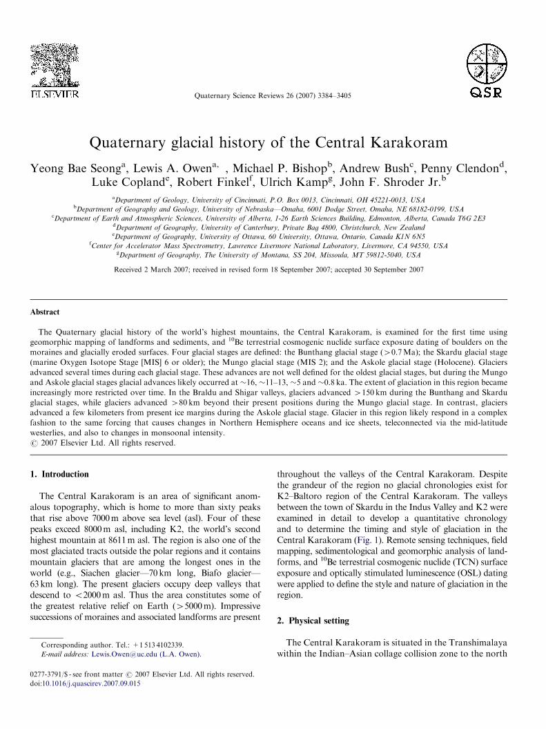
Quaternary Science Reviews 26 (2007) 3384–3405
Quaternary glacial history of the Central Karakoram
Yeong Bae Seonga, Lewis A. Owena,�, Michael P. Bishopb, Andrew Bushc, Penny Clendond,Luke Coplande, Robert Finkelf, Ulrich Kampg, John F. Shroder Jr.b
aDepartment of Geology, University of Cincinnati, P.O. Box 0013, Cincinnati, OH 45221-0013, USAbDepartment of Geography and Geology, University of Nebraska—Omaha, 6001 Dodge Street, Omaha, NE 68182-0199, USA
cDepartment of Earth and Atmospheric Sciences, University of Alberta, 1-26 Earth Sciences Building, Edmonton, Alberta, Canada T6G 2E3dDepartment of Geography, University of Canterbury, Private Bag 4800, Christchurch, New ZealandeDepartment of Geography, University of Ottawa, 60 University, Ottawa, Ontario, Canada K1N 6N5
fCenter for Accelerator Mass Spectrometry, Lawrence Livermore National Laboratory, Livermore, CA 94550, USAgDepartment of Geography, The University of Montana, SS 204, Missoula, MT 59812-5040, USA
Received 2 March 2007; received in revised form 18 September 2007; accepted 30 September 2007
Abstract
The Quaternary glacial history of the world’s highest mountains, the Central Karakoram, is examined for the first time using
geomorphic mapping of landforms and sediments, and 10Be terrestrial cosmogenic nuclide surface exposure dating of boulders on the
moraines and glacially eroded surfaces. Four glacial stages are defined: the Bunthang glacial stage (40.7Ma); the Skardu glacial stage
(marine Oxygen Isotope Stage [MIS] 6 or older); the Mungo glacial stage (MIS 2); and the Askole glacial stage (Holocene). Glaciers
advanced several times during each glacial stage. These advances are not well defined for the oldest glacial stages, but during the Mungo
and Askole glacial stages glacial advances likely occurred at �16, �11–13, �5 and �0.8 ka. The extent of glaciation in this region became
increasingly more restricted over time. In the Braldu and Shigar valleys, glaciers advanced 4150 km during the Bunthang and Skardu
glacial stages, while glaciers advanced 480 km beyond their present positions during the Mungo glacial stage. In contrast, glaciers
advanced a few kilometers from present ice margins during the Askole glacial stage. Glacier in this region likely respond in a complex
fashion to the same forcing that causes changes in Northern Hemisphere oceans and ice sheets, teleconnected via the mid-latitude
westerlies, and also to changes in monsoonal intensity.
r 2007 Elsevier Ltd. All rights reserved.
1. Introduction
The Central Karakoram is an area of significant anom-alous topography, which is home to more than sixty peaksthat rise above 7000m above sea level (asl). Four of thesepeaks exceed 8000m asl, including K2, the world’s secondhighest mountain at 8611m asl. The region is also one of themost glaciated tracts outside the polar regions and it containsmountain glaciers that are among the longest ones in theworld (e.g., Siachen glacier—70km long, Biafo glacier—63km long). The present glaciers occupy deep valleys thatdescend to o2000m asl. Thus the area constitutes some ofthe greatest relative relief on Earth (45000m). Impressivesuccessions of moraines and associated landforms are present
e front matter r 2007 Elsevier Ltd. All rights reserved.
ascirev.2007.09.015
ing author. Tel.: +1513 4102339.
ess: [email protected] (L.A. Owen).
throughout the valleys of the Central Karakoram. Despitethe grandeur of the region no glacial chronologies exist forK2–Baltoro region of the Central Karakoram. The valleysbetween the town of Skardu in the Indus Valley and K2 wereexamined in detail to develop a quantitative chronologyand to determine the timing and style of glaciation in theCentral Karakoram (Fig. 1). Remote sensing techniques, fieldmapping, sedimentological and geomorphic analysis of land-forms, and 10Be terrestrial cosmogenic nuclide (TCN) surfaceexposure and optically stimulated luminescence (OSL) datingwere applied to define the style and nature of glaciation in theregion.
2. Physical setting
The Central Karakoram is situated in the Transhimalayawithin the Indian–Asian collage collision zone to the north
ARTICLE IN PRESS
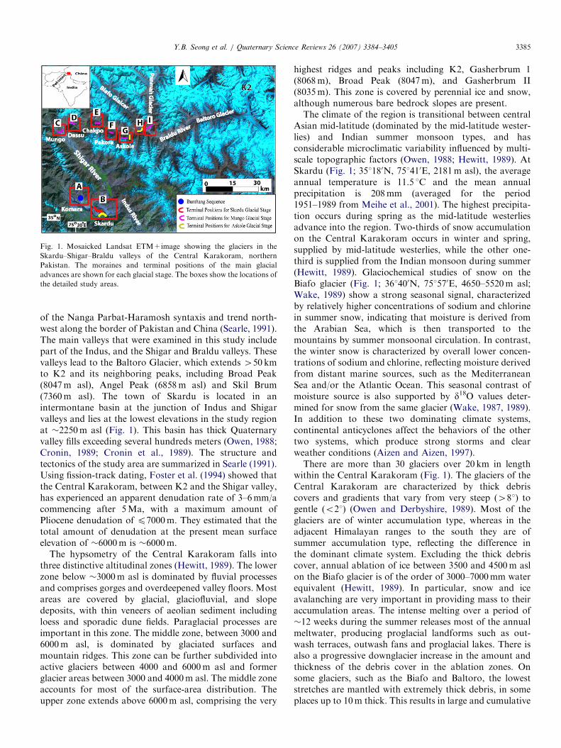
Fig. 1. Mosaicked Landsat ETM+image showing the glaciers in the
Skardu–Shigar–Braldu valleys of the Central Karakoram, northern
Pakistan. The moraines and terminal positions of the main glacial
advances are shown for each glacial stage. The boxes show the locations of
the detailed study areas.
Y.B. Seong et al. / Quaternary Science Reviews 26 (2007) 3384–3405 3385
of the Nanga Parbat-Haramosh syntaxis and trend north-west along the border of Pakistan and China (Searle, 1991).The main valleys that were examined in this study includepart of the Indus, and the Shigar and Braldu valleys. Thesevalleys lead to the Baltoro Glacier, which extends 450 kmto K2 and its neighboring peaks, including Broad Peak(8047m asl), Angel Peak (6858m asl) and Skil Brum(7360m asl). The town of Skardu is located in anintermontane basin at the junction of Indus and Shigarvalleys and lies at the lowest elevations in the study regionat �2250m asl (Fig. 1). This basin has thick Quaternaryvalley fills exceeding several hundreds meters (Owen, 1988;Cronin, 1989; Cronin et al., 1989). The structure andtectonics of the study area are summarized in Searle (1991).Using fission-track dating, Foster et al. (1994) showed thatthe Central Karakoram, between K2 and the Shigar valley,has experienced an apparent denudation rate of 3–6mm/acommencing after 5Ma, with a maximum amount ofPliocene denudation of p7000m. They estimated that thetotal amount of denudation at the present mean surfaceelevation of �6000m is �6000m.
The hypsometry of the Central Karakoram falls intothree distinctive altitudinal zones (Hewitt, 1989). The lowerzone below �3000m asl is dominated by fluvial processesand comprises gorges and overdeepened valley floors. Mostareas are covered by glacial, glaciofluvial, and slopedeposits, with thin veneers of aeolian sediment includingloess and sporadic dune fields. Paraglacial processes areimportant in this zone. The middle zone, between 3000 and6000m asl, is dominated by glaciated surfaces andmountain ridges. This zone can be further subdivided intoactive glaciers between 4000 and 6000m asl and formerglacier areas between 3000 and 4000m asl. The middle zoneaccounts for most of the surface-area distribution. Theupper zone extends above 6000m asl, comprising the very
highest ridges and peaks including K2, Gasherbrum 1(8068m), Broad Peak (8047m), and Gasherbrum II(8035m). This zone is covered by perennial ice and snow,although numerous bare bedrock slopes are present.The climate of the region is transitional between central
Asian mid-latitude (dominated by the mid-latitude wester-lies) and Indian summer monsoon types, and hasconsiderable microclimatic variability influenced by multi-scale topographic factors (Owen, 1988; Hewitt, 1989). AtSkardu (Fig. 1; 351180N, 751410E, 2181m asl), the averageannual temperature is 11.5 1C and the mean annualprecipitation is 208mm (averaged for the period1951–1989 from Meihe et al., 2001). The highest precipita-tion occurs during spring as the mid-latitude westerliesadvance into the region. Two-thirds of snow accumulationon the Central Karakoram occurs in winter and spring,supplied by mid-latitude westerlies, while the other one-third is supplied from the Indian monsoon during summer(Hewitt, 1989). Glaciochemical studies of snow on theBiafo glacier (Fig. 1; 361400N, 751570E, 4650–5520m asl;Wake, 1989) show a strong seasonal signal, characterizedby relatively higher concentrations of sodium and chlorinein summer snow, indicating that moisture is derived fromthe Arabian Sea, which is then transported to themountains by summer monsoonal circulation. In contrast,the winter snow is characterized by overall lower concen-trations of sodium and chlorine, reflecting moisture derivedfrom distant marine sources, such as the MediterraneanSea and/or the Atlantic Ocean. This seasonal contrast ofmoisture source is also supported by d18O values deter-mined for snow from the same glacier (Wake, 1987, 1989).In addition to these two dominating climate systems,continental anticyclones affect the behaviors of the othertwo systems, which produce strong storms and clearweather conditions (Aizen and Aizen, 1997).There are more than 30 glaciers over 20 km in length
within the Central Karakoram (Fig. 1). The glaciers of theCentral Karakoram are characterized by thick debriscovers and gradients that vary from very steep (481) togentle (o21) (Owen and Derbyshire, 1989). Most of theglaciers are of winter accumulation type, whereas in theadjacent Himalayan ranges to the south they are ofsummer accumulation type, reflecting the difference inthe dominant climate system. Excluding the thick debriscover, annual ablation of ice between 3500 and 4500m aslon the Biafo glacier is of the order of 3000–7000mm waterequivalent (Hewitt, 1989). In particular, snow and iceavalanching are very important in providing mass to theiraccumulation areas. The intense melting over a period of�12 weeks during the summer releases most of the annualmeltwater, producing proglacial landforms such as out-wash terraces, outwash fans and proglacial lakes. There isalso a progressive downglacier increase in the amount andthickness of the debris cover in the ablation zones. Onsome glaciers, such as the Biafo and Baltoro, the loweststretches are mantled with extremely thick debris, in someplaces up to 10m thick. This results in large and cumulative
ARTICLE IN PRESSY.B. Seong et al. / Quaternary Science Reviews 26 (2007) 3384–34053386
down-glacier effects on melting, ice-margin conditions andthe development of thermokarst forms. Many authorsargue that glaciers in this region are probably moreresponsive to change in precipitation than in temperatureand that this characteristic likely extends back into theprevious glacial cycles (Derbyshire, 1981; Shi, 2002; Owenet al., 2005).
The altitude effect on precipitation in the CentralKarakoram results in an altitudinal zonation of vegetation.Vegetation is scarce along the valley floors and on thelower valley side slopes, which are of desert type, and isreplaced with increasing altitudes by temperate coniferoustrees and eventually by alpine meadow vegetation.Furthermore, the altitudinal precipitation gradient influ-ences the relative role of Earth-surface processes producingaltitudinal variations in the dominant landform patternsand geomorphic processes (Paffen et al., 1956; Hewitt,1989).
3. Previous glacial geologic studies
Drew (1873) and Dianelli (1922) provided the firstdescriptions of the glacial geomorphology of the Skarduregion. They described Karpochi Rock (sometimes knownas the Rock of Skardu) at Skardu and identified tills on itssurface. They suggested that a large glacier had extendedfrom the Shigar Valley into Skardu to deposit the tills.Cronin et al. (1989) described a 1.3-km-thick sedimentarysuccession that is located in the NW corner of Skardubasin, which they named the Bunthang Sequence (Figs. 1Aand 2). This sequence comprises a basal diamicton overlainby lacustrine and glaciofluvial sediments. Based onpaleomagnetic studies they suggested that the basal tillstarted to accumulate towards the end of the Matuyamachron (ca 0.72Ma). On the basis of their similar locations,elevations and stratigraphic positions, they correlated itwith till exposed on Karpochi Rock (Figs. 1B and 3–5).
Owen (1988) undertook a study of the Quaternarygeology of the Skardu basin and provided a reconstructionof the history and extent of glaciation. He recognized fourmajor glacial surfaces throughout the Skardu basin and inthe Shigar valley. These were attributed to differentglaciations, but they were not named. Owen (1988)suggested that the earliest of these glaciations might pre-date the Pleistocene. Later, Hewitt (1989, 1999, 2005)highlighted the problems of misidentifying landslidedeposits and moraines throughout the Karakoram, andhe reinterpreted many of the moraines in the Indus andShigar valley as catastrophic rock avalanches.
4. Methods
The Skardu basin, the Shigar and Braldu valleys and theBaltoro glaciers were examined and detailed samplingstudies were undertaken in nine areas within the region(Fig. 1). This allowed us to examine the glacial andassociated landforms and to develop a glacial stratigraphy
for the Central Karakoram. Moraines, paraglacial fans,catastrophic flood deposits, and river terraces were mappedin the field aided by remote sensing and correlatedmorphostratigraphically using the standard techniques ofDerbyshire and Owen (1990). The morphostratigraphicrelationships between glacial and associated landformswere used to aid in our sampling strategy for dating.The moraines (m) in each of the study areas (A–I) were
assigned a number relative to their age (1 is the oldest).Moraine m1A, for example, is the oldest moraine in studyarea A and m3I is the youngest moraine in study area I.Using a combination of morphostratigraphy, relativedating and TCN surface exposure dating, broad correla-tions were made between the valleys studied in the region,and the moraines and the sediments were assigned to one offour glacial stages. Each glacial stage was named after anearby village (Table 1).The oldest glacial stage, the Bunthang, comprises highly
dissected valley-fill sediments within the Skardu Basin. Thenext, the Skardu glacial stage, comprises moraines anderoded till on top of mesas within the Skardu Basin and onhigh (b1000m above the valley floor) benches along thelower stretches of the Shigar valley. The next youngestglacial stage, the Mungo, comprises moraines and glaciallyeroded bedrock surfaces along the Braldu and upper Shigarvalley that rise to 42000m above the present valley floors.The youngest glacial stage, the Askole, comprises sharpcrested moraines at the heads of tributary valleys along theBraldu valley.As there is little organic material suitable for 14C dating
and if any, most of the deposits are out of range of 14C, weapplied 10Be TCN surface-exposure dating to rock surfacesand boulders on the moraines and associated landforms tohelp define the timing of glaciation. We also applied OSLmethods at one location within the Skardu Basin. Over thelast decade, the application of the newly developingtechniques of TCN surface exposure and OSL dating hasallowed many of the Late Quaternary glacial successionswithin the Himalaya and Tibet to be dated with variousdegrees of confidence (Sharma and Owen, 1996; Richardset al., 2000a, b; Phillips et al., 2000; Owen et al., 2001,2002a–c, 2003a, b, 2006; Tsukamoto et al., 2002; Finkelet al., 2003; Spencer and Owen, 2004; Seong et al., 2007a).We followed the methods and techniques in these studies asa framework for sampling and data analysis.Samples for 10Be TCN surface exposure dating were
collected by chiseling �500 g of rock from the uppersurfaces of quartz-rich boulders along moraine crests or onglacially eroded bedrock surfaces. Locations were chosenwhere there was no apparent evidence of exhumation orslope instability. The largest boulders and the highestpoints on glacially eroded bedrock surfaces were chosen tohelp reduce the possibility that the boulders and rocksurfaces may have been covered with snow for significantperiods (several months of the year) or were previouslycovered with sediment. To provide a check on thereproducibility of the dating and a check for the possibility
ARTICLE IN PRESS
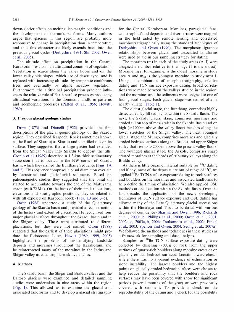
Fig. 2. The geomorphology of the Bunthang Sequence: (A) view of the Bunthang sequence near Skardu, looking northwest from the Karpochi Rock. The
width of Bunthang outcrop in the view is �5 km. The Indus River in the foreground flows from right to left. The vegetated area on the alluvial fan is the
village of Kuardu. Pale horizontal stratified bed at top of the outcrop comprises interfingering glaciofluvial and lacustrine sediments, which overlie darker
alluvial gravel deposit. The alluvial gravel units thin toward the Indus River; (B) schematic summary of the physical stratigraphy of the Bunthang
Sequence (after Cronin et al., 1989). Lithologic abbreviations: ms is mudstone; ms (t) is rhythmically bedded mudstone; ss is sandstone; fgl is fanglomerate;
(C) wet-sediment deformation structure developed within the Bunthang sequence. View looking south from the village of Kuardu; (D) modified version of
Owen and Derbyshire’s (1988) log showing the structures in the lower part of the Bunthang sequence viewed south from the village of Kuardu
(35124.0870N, 75131.5760E).
Y.B. Seong et al. / Quaternary Science Reviews 26 (2007) 3384–3405 3387
of the inheritance of TCNs by prior exposure to cosmic rays,several (four to seven) samples from each moraine ridge orglacially eroded bedrock surface were sampled and dated.The degree of weathering and site conditions for eachsampling site were recorded. Topographic shielding wasdetermined by measuring the inclination from each samplingsite to the top of surrounding mountain ridges and peaks.
All the samples for 10Be TCN surface exposure datingwere prepared in the geochronology laboratories at theUniversity of Cincinnati. First, the samples were crushed
and sieved. Quartz was then separated from the250–500 mm particle size fractions using the methods ofKohl and Nishiizumi (1992). After the addition of 9Becarrier (�0.07mg/g of SiO2), Be was separated and purifiedby ion exchange chromatography and precipitated atpH47. The hydroxides were oxidized by ignition in quartzcrucibles. BeO was mixed with Nb metal and loaded intostainless steel cathodes for the determination of the10Be/9Be ratios by accelerator mass spectrometry (AMS)at the Center for AMS in the Lawrence Livermore
ARTICLE IN PRESS
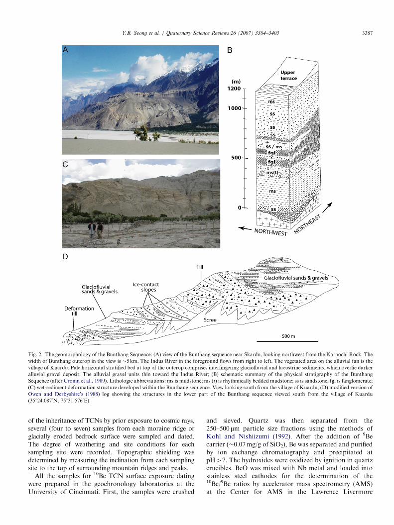
Fig. 3. Glaciated rock surfaces and glacial landforms around the Skardu: (A) map showing the extent of glacial ice in the Skardu area (after Owen, 1988);
(B) ASTER image of moraine ridges, showing the locations where glacial boulders were sampled for 10Be TCN exposure dating on the Karpochi Rock
(each number refers to the number of the TCN sample). Stratified lake sediments (La) are present against the cliff of the Karpochi Rock; (C) ASTER
image showing the locations of sampling sites used to define the ages of moraine near the K2 motel. Vegetation is highlighted in purple. m1B and m2B are
moraine stratigraphy used in Table 2; (D) locations for OSL samples OSL K2-1 and OSL K2-2.
Y.B. Seong et al. / Quaternary Science Reviews 26 (2007) 3384–34053388
National Laboratory. Isotope ratios were compared toICN Pharmaceutical, Incorporated 10Be standards pre-pared by K. Nishiizumi (pers. comm., 1995), using a 10Behalf-life of 1.5� 106 yr. The measured isotope ratios werecorrected using blank samples (with a mean 10Be/9Be ratioof 1.5� 10�1470.3� 10�15) and converted to TCN con-centrations in quartz using the total 10Be in the samplesand the sample weights. TCN 10Be concentrations werethen converted to zero-erosion exposure ages using sealevel high latitude (SLHL) 10Be production rate of4.98 atom/g of quartz/a (Stone, 2000; Balco and Stone,2007). 10Be production rates were scaled to the latitude andelevation of the sampling sites using the scaling factors ofStone (2000) with 3% SLHL muon contribution. There isstill debate concerning the correct scaling method andSLHL rate, possibly impacting the model exposure age.However, uncertainties in absolute production rates andscaling factors have far less impact on relative chronologiesfor events in a limited geographic area.
Two sediment samples were collected for OSL datingfrom a terrace section in Skardu by hammering light-tighttubes into freshly exposed sediments (Fig. 3D). The tubesremained sealed until processed in the safe light conditionsin the Geochronology Laboratory at the University of
Cincinnati. Sample preparation follows the methodsdescribed in Owen et al. (2007). Approximately 20 g ofthe dried sub-sample from the sediment sample was groundto a fine powder and sent to the USGS Reactor in Denverfor neutron-activation analysis (INAA) to determine theconcentration of radioisotopes for dose-rate determination.Variable water content throughout the section may haveoccurred throughout the history of the section. However, itis not possible to determine the degree of such changes. Thedose rate was therefore assumed to have remained constantand a 1075% water content value was used to helpaccount for possible changes in water content.Luminescence measurements were undertaken on quartz
for the dominant particle size for each sample using a RisoAutomated TL/IRSL/Blue DA-15 C/D OSL DatingSystem. Luminescence from the quartz grains was stimu-lated using an array of blue light emitting diodes (470 nm,50mW/cm2) filtered using a green long-pass GG-420 filter.Detection was through a Hoya U-340 filter. All quartzaliquots were screened for feldspar contamination usinginfrared stimulation with infrared light emitting diodes(870 nm, 150mW/cm2). All OSL signals were detectedusing a 52mm diameter photomultiplier tube (9235B). RisoSequence Editor software was used for hardware control.
ARTICLE IN PRESS
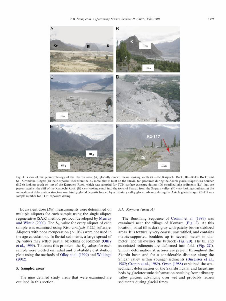
Fig. 4. Views of the geomorphology of the Skardu area; (A) glacially eroded mesas looking south (K—the Karpochi Rock; Bl—Bluko Rock; and
St—Strondoka Ridge); (B) the Karpochi Rock from the K2 motel that is built on the alluvial fan produced during the Askole glacial stage; (C) a boulder
(K2-6) looking south on top of the Karpochi Rock, which was sampled for TCN surface exposure dating; (D) stratified lake sediments (La) that are
present against the cliff of the Karpochi Rock; (E) view looking south into the town of Skardu from the Satpura valley; (F) view looking southeast at the
wet-sediment deformation structure overlain by glacial deposits formed by a tributary valley glacier advance during the Askole glacial stage. K2-117 was
sample number for TCN exposure dating.
Y.B. Seong et al. / Quaternary Science Reviews 26 (2007) 3384–3405 3389
Equivalent dose (DE) measurements were determined onmultiple aliquots for each sample using the single aliquotregenerative (SAR) method protocol developed by Murrayand Wintle (2000). The DE value for every aliquot of eachsample was examined using Riso Analysis 3.22b software.Aliquots with poor recuperation (410%) were not used inthe age calculations. In fluvial sediments, a large spread ofDE values may reflect partial bleaching of sediment (Olleyet al., 1999). To assess this problem, the DE values for eachsample were plotted on radial and probability distributionplots using the methods of Olley et al. (1999) and Wallinga(2002).
5. Sampled areas
The nine detailed study areas that were examined areoutlined in this section.
5.1. Komara (area A)
The Bunthang Sequence of Cronin et al. (1989) wasexamined near the village of Komara (Fig. 2). At thislocation, basal till is dark gray with patchy brown oxidizedareas. It is texturally very coarse, unstratified, and containsmatrix-supported boulders up to several meters in dia-meter. The till overlies the bedrock (Fig. 2B). The till andassociated sediments are deformed into folds (Fig. 2C).Similar deformation structures are present throughout theSkardu basin and for a considerable distance along theShigar valley within younger sediments (Burgisser et al.,1982; Cronin et al., 1989). Owen (1988) explained the wet-sediment deformation of the Skardu fluvial and lacustrinebeds by glaciotectonic deformation resulting from tributaryvalley glaciers advancing over wet and probably frozensediments during glacial times.
ARTICLE IN PRESS
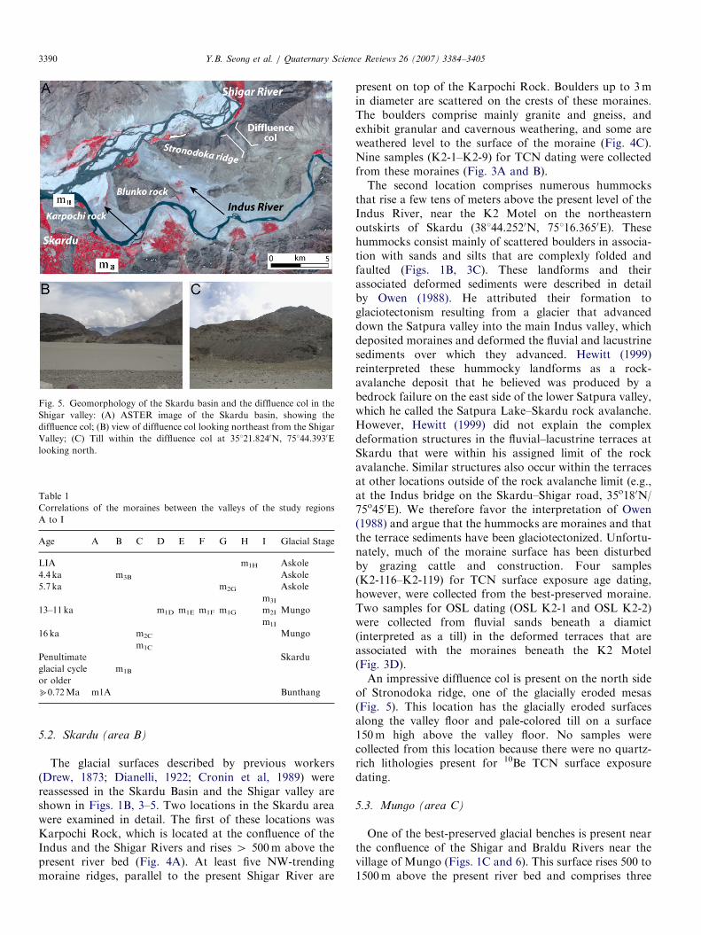
Fig. 5. Geomorphology of the Skardu basin and the diffluence col in the
Shigar valley: (A) ASTER image of the Skardu basin, showing the
diffluence col; (B) view of diffluence col looking northeast from the Shigar
Valley; (C) Till within the diffluence col at 35121.8240N, 75144.3930E
looking north.
Table 1
Correlations of the moraines between the valleys of the study regions
A to I
Age A B C D E F G H I Glacial Stage
LIA m1H Askole
4.4 ka m3B Askole
5.7 ka m2G Askole
m3I
13–11 ka m1D m1E m1F m1G m2I Mungo
m1I
16 ka m2C Mungo
m1C
Penultimate Skardu
glacial cycle m1B
or older
b0.72Ma m1A Bunthang
Y.B. Seong et al. / Quaternary Science Reviews 26 (2007) 3384–34053390
5.2. Skardu (area B)
The glacial surfaces described by previous workers(Drew, 1873; Dianelli, 1922; Cronin et al, 1989) werereassessed in the Skardu Basin and the Shigar valley areshown in Figs. 1B, 3–5. Two locations in the Skardu areawere examined in detail. The first of these locations wasKarpochi Rock, which is located at the confluence of theIndus and the Shigar Rivers and rises 4 500m above thepresent river bed (Fig. 4A). At least five NW-trendingmoraine ridges, parallel to the present Shigar River are
present on top of the Karpochi Rock. Boulders up to 3min diameter are scattered on the crests of these moraines.The boulders comprise mainly granite and gneiss, andexhibit granular and cavernous weathering, and some areweathered level to the surface of the moraine (Fig. 4C).Nine samples (K2-1–K2-9) for TCN dating were collectedfrom these moraines (Fig. 3A and B).The second location comprises numerous hummocks
that rise a few tens of meters above the present level of theIndus River, near the K2 Motel on the northeasternoutskirts of Skardu (38144.2520N, 75116.3650E). Thesehummocks consist mainly of scattered boulders in associa-tion with sands and silts that are complexly folded andfaulted (Figs. 1B, 3C). These landforms and theirassociated deformed sediments were described in detailby Owen (1988). He attributed their formation toglaciotectonism resulting from a glacier that advanceddown the Satpura valley into the main Indus valley, whichdeposited moraines and deformed the fluvial and lacustrinesediments over which they advanced. Hewitt (1999)reinterpreted these hummocky landforms as a rock-avalanche deposit that he believed was produced by abedrock failure on the east side of the lower Satpura valley,which he called the Satpura Lake–Skardu rock avalanche.However, Hewitt (1999) did not explain the complexdeformation structures in the fluvial–lacustrine terraces atSkardu that were within his assigned limit of the rockavalanche. Similar structures also occur within the terracesat other locations outside of the rock avalanche limit (e.g.,at the Indus bridge on the Skardu–Shigar road, 35o180N/75o450E). We therefore favor the interpretation of Owen(1988) and argue that the hummocks are moraines and thatthe terrace sediments have been glaciotectonized. Unfortu-nately, much of the moraine surface has been disturbedby grazing cattle and construction. Four samples(K2-116–K2-119) for TCN surface exposure age dating,however, were collected from the best-preserved moraine.Two samples for OSL dating (OSL K2-1 and OSL K2-2)were collected from fluvial sands beneath a diamict(interpreted as a till) in the deformed terraces that areassociated with the moraines beneath the K2 Motel(Fig. 3D).An impressive diffluence col is present on the north side
of Stronodoka ridge, one of the glacially eroded mesas(Fig. 5). This location has the glacially eroded surfacesalong the valley floor and pale-colored till on a surface150m high above the valley floor. No samples werecollected from this location because there were no quartz-rich lithologies present for 10Be TCN surface exposuredating.
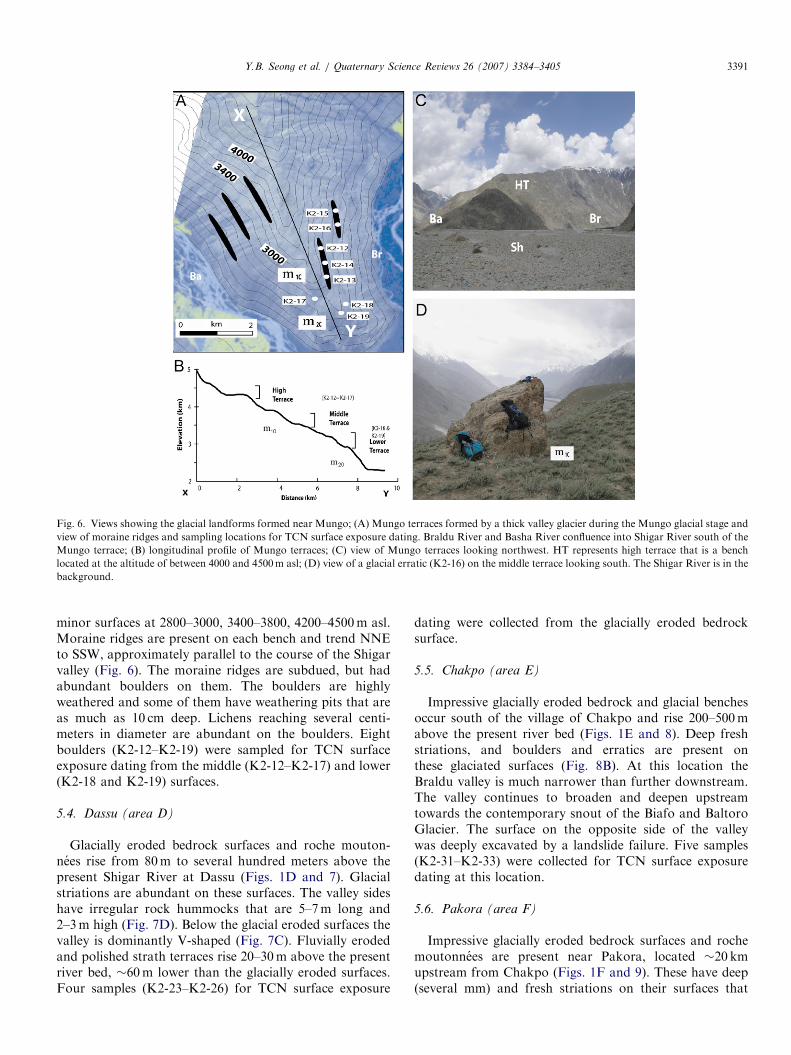
5.3. Mungo (area C)
One of the best-preserved glacial benches is present nearthe confluence of the Shigar and Braldu Rivers near thevillage of Mungo (Figs. 1C and 6). This surface rises 500 to1500m above the present river bed and comprises three
ARTICLE IN PRESS
Fig. 6. Views showing the glacial landforms formed near Mungo; (A) Mungo terraces formed by a thick valley glacier during the Mungo glacial stage and
view of moraine ridges and sampling locations for TCN surface exposure dating. Braldu River and Basha River confluence into Shigar River south of the
Mungo terrace; (B) longitudinal profile of Mungo terraces; (C) view of Mungo terraces looking northwest. HT represents high terrace that is a bench
located at the altitude of between 4000 and 4500m asl; (D) view of a glacial erratic (K2-16) on the middle terrace looking south. The Shigar River is in the
background.
Y.B. Seong et al. / Quaternary Science Reviews 26 (2007) 3384–3405 3391
minor surfaces at 2800–3000, 3400–3800, 4200–4500m asl.Moraine ridges are present on each bench and trend NNEto SSW, approximately parallel to the course of the Shigarvalley (Fig. 6). The moraine ridges are subdued, but hadabundant boulders on them. The boulders are highlyweathered and some of them have weathering pits that areas much as 10 cm deep. Lichens reaching several centi-meters in diameter are abundant on the boulders. Eightboulders (K2-12–K2-19) were sampled for TCN surfaceexposure dating from the middle (K2-12–K2-17) and lower(K2-18 and K2-19) surfaces.
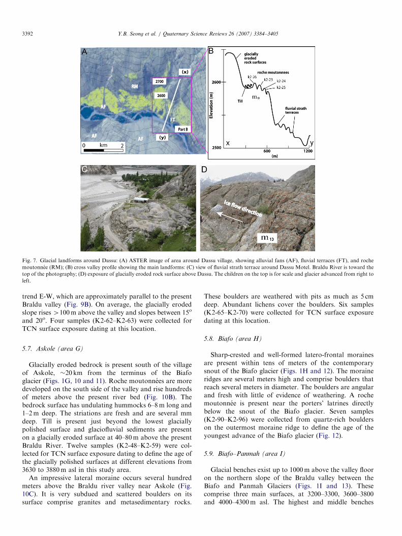
5.4. Dassu (area D)
Glacially eroded bedrock surfaces and roche mouton-nees rise from 80m to several hundred meters above thepresent Shigar River at Dassu (Figs. 1D and 7). Glacialstriations are abundant on these surfaces. The valley sideshave irregular rock hummocks that are 5–7m long and2–3m high (Fig. 7D). Below the glacial eroded surfaces thevalley is dominantly V-shaped (Fig. 7C). Fluvially erodedand polished strath terraces rise 20–30m above the presentriver bed, �60m lower than the glacially eroded surfaces.Four samples (K2-23–K2-26) for TCN surface exposure
dating were collected from the glacially eroded bedrocksurface.
5.5. Chakpo (area E)
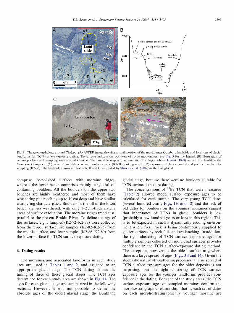
Impressive glacially eroded bedrock and glacial benchesoccur south of the village of Chakpo and rise 200–500mabove the present river bed (Figs. 1E and 8). Deep freshstriations, and boulders and erratics are present onthese glaciated surfaces (Fig. 8B). At this location theBraldu valley is much narrower than further downstream.The valley continues to broaden and deepen upstreamtowards the contemporary snout of the Biafo and BaltoroGlacier. The surface on the opposite side of the valleywas deeply excavated by a landslide failure. Five samples(K2-31–K2-33) were collected for TCN surface exposuredating at this location.
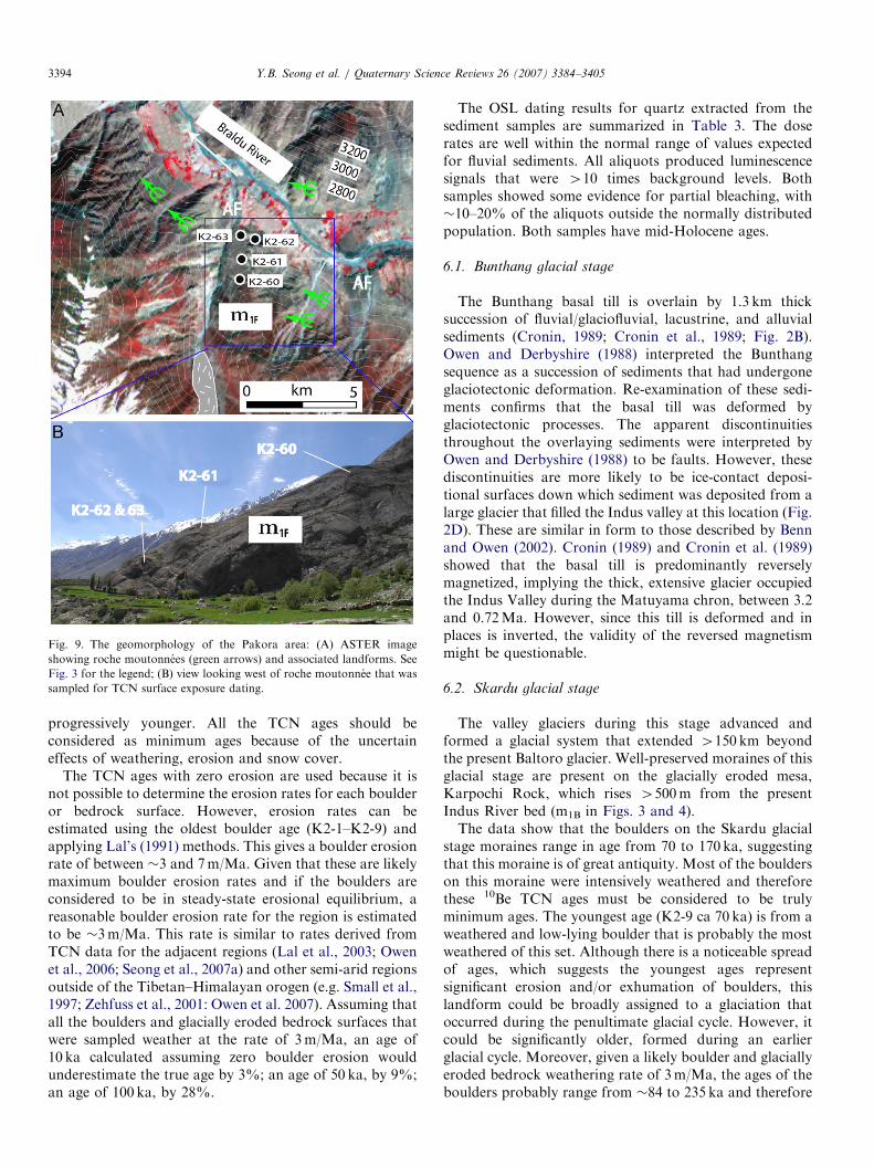
5.6. Pakora (area F)
Impressive glacially eroded bedrock surfaces and rochemoutonnees are present near Pakora, located �20 kmupstream from Chakpo (Figs. 1F and 9). These have deep(several mm) and fresh striations on their surfaces that
ARTICLE IN PRESS
Fig. 7. Glacial landforms around Dassu: (A) ASTER image of area around Dassu village, showing alluvial fans (AF), fluvial terraces (FT), and roche
moutonnee (RM); (B) cross valley profile showing the main landforms: (C) view of fluvial strath terrace around Dassu Motel. Braldu River is toward the
top of the photography; (D) exposure of glacially eroded rock surface above Dassu. The children on the top is for scale and glacier advanced from right to
left.
Y.B. Seong et al. / Quaternary Science Reviews 26 (2007) 3384–34053392
trend E-W, which are approximately parallel to the presentBraldu valley (Fig. 9B). On average, the glacially erodedslope rises4100m above the valley and slopes between 15o
and 20o. Four samples (K2-62–K2-63) were collected forTCN surface exposure dating at this location.
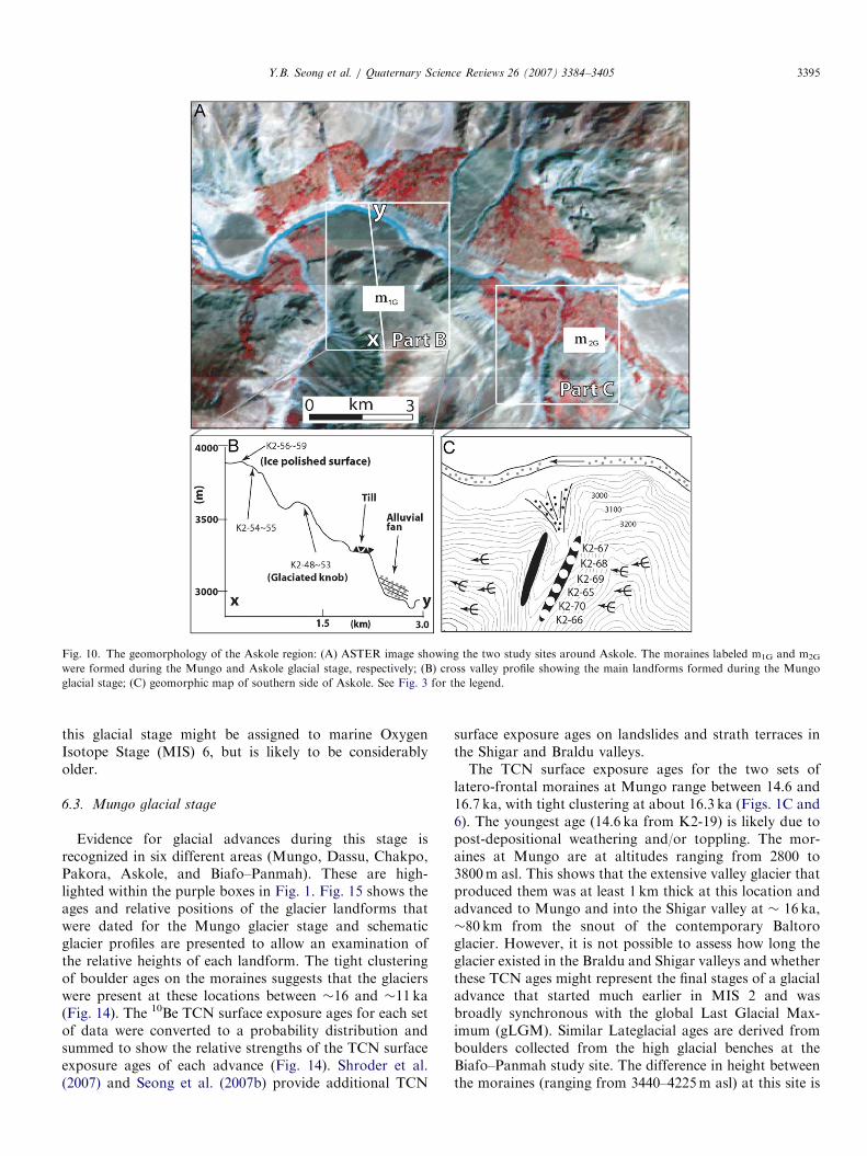
5.7. Askole (area G)
Glacially eroded bedrock is present south of the villageof Askole, �20 km from the terminus of the Biafoglacier (Figs. 1G, 10 and 11). Roche moutonnees are moredeveloped on the south side of the valley and rise hundredsof meters above the present river bed (Fig. 10B). Thebedrock surface has undulating hummocks 6–8m long and1–2m deep. The striations are fresh and are several mmdeep. Till is present just beyond the lowest glaciallypolished surface and glaciofluvial sediments are presenton a glacially eroded surface at 40–80m above the presentBraldu River. Twelve samples (K2-48–K2-59) were col-lected for TCN surface exposure dating to define the age ofthe glacially polished surfaces at different elevations from3630 to 3880m asl in this study area.
An impressive lateral moraine occurs several hundredmeters above the Braldu river valley near Askole (Fig.10C). It is very subdued and scattered boulders on itssurface comprise granites and metasedimentary rocks.
These boulders are weathered with pits as much as 5 cmdeep. Abundant lichens cover the boulders. Six samples(K2-65–K2-70) were collected for TCN surface exposuredating at this location.
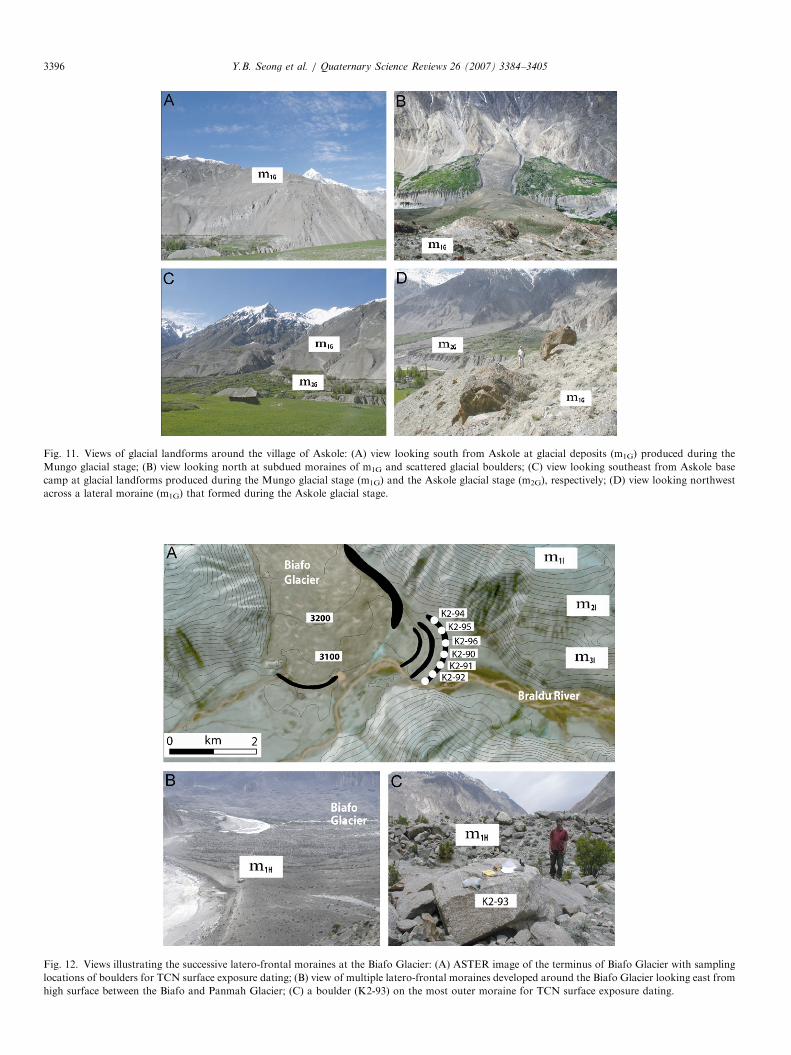
5.8. Biafo (area H)
Sharp-crested and well-formed latero-frontal morainesare present within tens of meters of the contemporarysnout of the Biafo glacier (Figs. 1H and 12). The moraineridges are several meters high and comprise boulders thatreach several meters in diameter. The boulders are angularand fresh with little of evidence of weathering. A rochemoutonnee is present near the porters’ latrines directlybelow the snout of the Biafo glacier. Seven samples(K2-90–K2-96) were collected from quartz-rich boulderson the outermost moraine ridge to define the age of theyoungest advance of the Biafo glacier (Fig. 12).
5.9. Biafo–Panmah (area I)
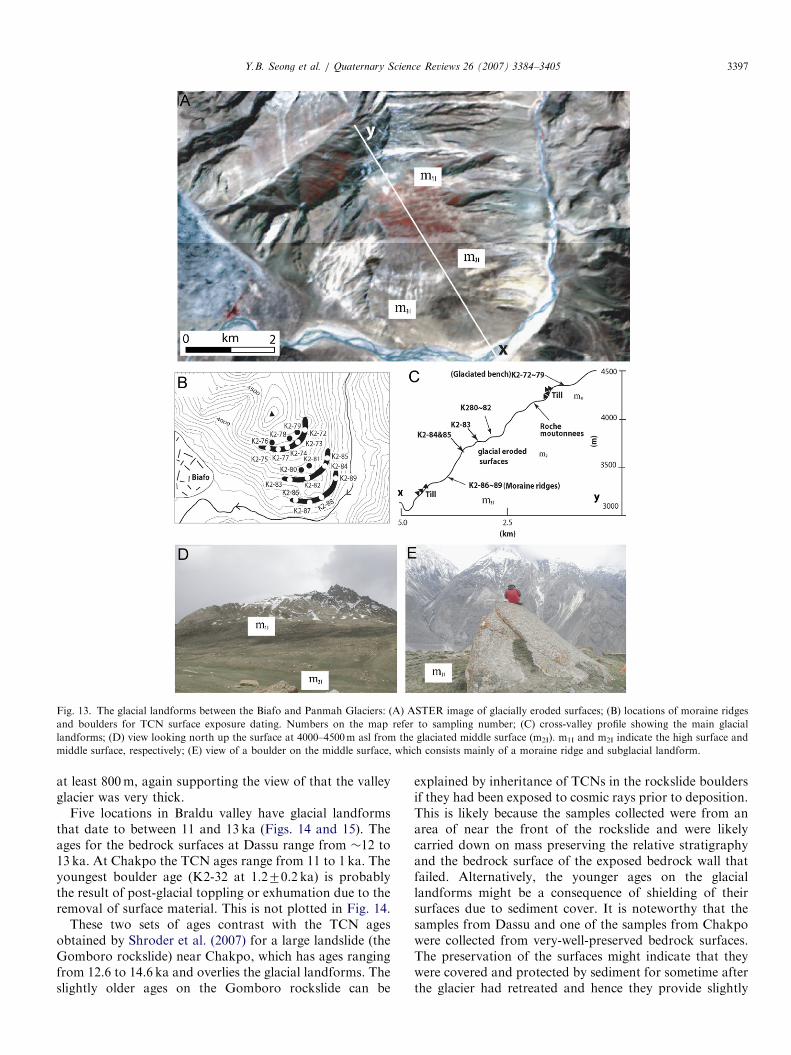
Glacial benches exist up to 1000m above the valley flooron the northern slope of the Braldu valley between theBiafo and Panmah Glaciers (Figs. 1I and 13). Thesecomprise three main surfaces, at 3200–3300, 3600–3800and 4000–4300m asl. The highest and middle benches
ARTICLE IN PRESS
Fig. 8. The geomorphology around Chakpo: (A) ASTER image showing a small portion of the much larger Gomboro landslide and locations of glacial
landforms for TCN surface exposure dating. The arrows indicate the positions of roche moutonnees. See Fig. 3 for the legend; (B) illustration of
geomorphology and sampling sites around Chakpo. The landslide map is diagrammatic of a larger whole. Hewitt (1998) named this landslide the
Gomboro Complex I; (C) view of landslide scar and boulder erratic (K2-31) looking north; (D) exposure of glacier eroded and polished surface for
sampling (K2-33). The landslide shown in photos A, B and C was dated by Shroder et al. (2007) to the Lateglacial.
Y.B. Seong et al. / Quaternary Science Reviews 26 (2007) 3384–3405 3393
comprise ice-polished surfaces with moraine ridges,whereas the lower bench comprises mainly subglacial tillcontaining boulders. All the boulders on the upper twobenches are highly weathered and most of them haveweathering pits reaching up to 10 cm deep and have similarweathering characteristics. Boulders in the till of the lowerbench are less weathered, with only 1–2 cm-thick patchyareas of surface exfoliation. The moraine ridges trend east,parallel to the present Braldu River. To define the age ofthe surfaces, eight samples (K2-72–K2-79) were collectedfrom the upper surface, six samples (K2-82–K2-85) fromthe middle surface, and four samples (K2-86–K2-89) fromthe lower surface for TCN surface exposure dating.
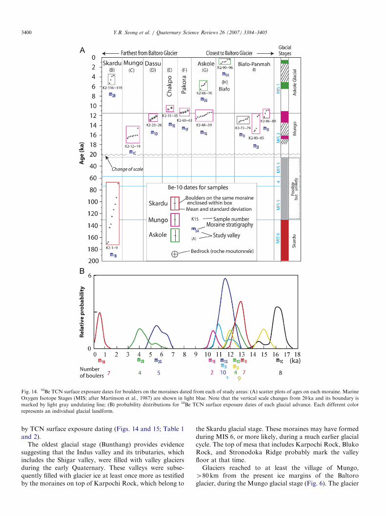
6. Dating results
The moraines and associated landforms in each studyarea are listed in Tables 1 and 2, and assigned to anappropriate glacial stage. The TCN dating defines thetiming of three of these glacial stages. The TCN agesdetermined for each study area are shown in Fig. 14. Theages for each glacial stage are summarized in the followingsections. However, it was not possible to define theabsolute ages of the oldest glacial stage, the Bunthang
glacial stage, because there were no boulders suitable forTCN surface exposure dating.The concentrations of 10Be TCN that were measured
(Table 2) allowed model surface exposure ages to becalculated for each sample. The very young TCN dates(several hundred years; Figs. 1H and 12) and the lack ofold dates for boulders on the youngest moraines suggestthat inheritance of TCNs in glacial boulders is low(probably a few hundred years or less) in this region. Thisis to be expected in such a dynamically eroding environ-ment where fresh rock is being continuously supplied toglacier surfaces by rock falls and avalanching. In addition,the tight clustering of TCN surface exposure ages formultiple samples collected on individual surfaces providesconfidence in the TCN surface-exposure dating method.The exception, however, is the oldest surface m1B wherethere is a large spread of ages (Figs. 3B and 14). Given thestochastic nature of weathering processes, a large spread ofTCN surface exposure ages for the older deposits is notsurprising, but the tight clustering of TCN surfaceexposure ages for the younger landforms provides con-fidence in the dating. For each of the study areas, the TCNsurface exposure ages on sampled moraines confirm themorphostratigraphic relationship: that is, each set of dateson each morphostratigraphically younger moraine are
ARTICLE IN PRESS
Fig. 9. The geomorphology of the Pakora area: (A) ASTER image
showing roche moutonnees (green arrows) and associated landforms. See
Fig. 3 for the legend; (B) view looking west of roche moutonnee that was
sampled for TCN surface exposure dating.
Y.B. Seong et al. / Quaternary Science Reviews 26 (2007) 3384–34053394
progressively younger. All the TCN ages should beconsidered as minimum ages because of the uncertaineffects of weathering, erosion and snow cover.
The TCN ages with zero erosion are used because it isnot possible to determine the erosion rates for each boulderor bedrock surface. However, erosion rates can beestimated using the oldest boulder age (K2-1–K2-9) andapplying Lal’s (1991) methods. This gives a boulder erosionrate of between �3 and 7m/Ma. Given that these are likelymaximum boulder erosion rates and if the boulders areconsidered to be in steady-state erosional equilibrium, areasonable boulder erosion rate for the region is estimatedto be �3m/Ma. This rate is similar to rates derived fromTCN data for the adjacent regions (Lal et al., 2003; Owenet al., 2006; Seong et al., 2007a) and other semi-arid regionsoutside of the Tibetan–Himalayan orogen (e.g. Small et al.,1997; Zehfuss et al., 2001: Owen et al. 2007). Assuming thatall the boulders and glacially eroded bedrock surfaces thatwere sampled weather at the rate of 3m/Ma, an age of10 ka calculated assuming zero boulder erosion wouldunderestimate the true age by 3%; an age of 50 ka, by 9%;an age of 100 ka, by 28%.
The OSL dating results for quartz extracted from thesediment samples are summarized in Table 3. The doserates are well within the normal range of values expectedfor fluvial sediments. All aliquots produced luminescencesignals that were 410 times background levels. Bothsamples showed some evidence for partial bleaching, with�10–20% of the aliquots outside the normally distributedpopulation. Both samples have mid-Holocene ages.
6.1. Bunthang glacial stage
The Bunthang basal till is overlain by 1.3 km thicksuccession of fluvial/glaciofluvial, lacustrine, and alluvialsediments (Cronin, 1989; Cronin et al., 1989; Fig. 2B).Owen and Derbyshire (1988) interpreted the Bunthangsequence as a succession of sediments that had undergoneglaciotectonic deformation. Re-examination of these sedi-ments confirms that the basal till was deformed byglaciotectonic processes. The apparent discontinuitiesthroughout the overlaying sediments were interpreted byOwen and Derbyshire (1988) to be faults. However, thesediscontinuities are more likely to be ice-contact deposi-tional surfaces down which sediment was deposited from alarge glacier that filled the Indus valley at this location (Fig.2D). These are similar in form to those described by Bennand Owen (2002). Cronin (1989) and Cronin et al. (1989)showed that the basal till is predominantly reverselymagnetized, implying the thick, extensive glacier occupiedthe Indus Valley during the Matuyama chron, between 3.2and 0.72Ma. However, since this till is deformed and inplaces is inverted, the validity of the reversed magnetismmight be questionable.
6.2. Skardu glacial stage
The valley glaciers during this stage advanced andformed a glacial system that extended 4150 km beyondthe present Baltoro glacier. Well-preserved moraines of thisglacial stage are present on the glacially eroded mesa,Karpochi Rock, which rises 4500m from the presentIndus River bed (m1B in Figs. 3 and 4).The data show that the boulders on the Skardu glacial
stage moraines range in age from 70 to 170 ka, suggestingthat this moraine is of great antiquity. Most of the boulderson this moraine were intensively weathered and thereforethese 10Be TCN ages must be considered to be trulyminimum ages. The youngest age (K2-9 ca 70 ka) is from aweathered and low-lying boulder that is probably the mostweathered of this set. Although there is a noticeable spreadof ages, which suggests the youngest ages representsignificant erosion and/or exhumation of boulders, thislandform could be broadly assigned to a glaciation thatoccurred during the penultimate glacial cycle. However, itcould be significantly older, formed during an earlierglacial cycle. Moreover, given a likely boulder and glaciallyeroded bedrock weathering rate of 3m/Ma, the ages of theboulders probably range from �84 to 235 ka and therefore
ARTICLE IN PRESS
Fig. 10. The geomorphology of the Askole region: (A) ASTER image showing the two study sites around Askole. The moraines labeled m1G and m2G
were formed during the Mungo and Askole glacial stage, respectively; (B) cross valley profile showing the main landforms formed during the Mungo
glacial stage; (C) geomorphic map of southern side of Askole. See Fig. 3 for the legend.
Y.B. Seong et al. / Quaternary Science Reviews 26 (2007) 3384–3405 3395
this glacial stage might be assigned to marine OxygenIsotope Stage (MIS) 6, but is likely to be considerablyolder.
6.3. Mungo glacial stage
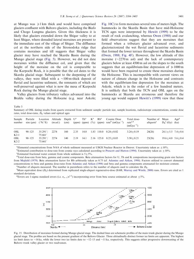
Evidence for glacial advances during this stage isrecognized in six different areas (Mungo, Dassu, Chakpo,Pakora, Askole, and Biafo–Panmah). These are high-lighted within the purple boxes in Fig. 1. Fig. 15 shows theages and relative positions of the glacier landforms thatwere dated for the Mungo glacier stage and schematicglacier profiles are presented to allow an examination ofthe relative heights of each landform. The tight clusteringof boulder ages on the moraines suggests that the glacierswere present at these locations between �16 and �11 ka(Fig. 14). The 10Be TCN surface exposure ages for each setof data were converted to a probability distribution andsummed to show the relative strengths of the TCN surfaceexposure ages of each advance (Fig. 14). Shroder et al.(2007) and Seong et al. (2007b) provide additional TCN
surface exposure ages on landslides and strath terraces inthe Shigar and Braldu valleys.The TCN surface exposure ages for the two sets of
latero-frontal moraines at Mungo range between 14.6 and16.7 ka, with tight clustering at about 16.3 ka (Figs. 1C and6). The youngest age (14.6 ka from K2-19) is likely due topost-depositional weathering and/or toppling. The mor-aines at Mungo are at altitudes ranging from 2800 to3800m asl. This shows that the extensive valley glacier thatproduced them was at least 1 km thick at this location andadvanced to Mungo and into the Shigar valley at � 16 ka,�80 km from the snout of the contemporary Baltoroglacier. However, it is not possible to assess how long theglacier existed in the Braldu and Shigar valleys and whetherthese TCN ages might represent the final stages of a glacialadvance that started much earlier in MIS 2 and wasbroadly synchronous with the global Last Glacial Max-imum (gLGM). Similar Lateglacial ages are derived fromboulders collected from the high glacial benches at theBiafo–Panmah study site. The difference in height betweenthe moraines (ranging from 3440–4225m asl) at this site is
ARTICLE IN PRESS
Fig. 12. Views illustrating the successive latero-frontal moraines at the Biafo Glacier: (A) ASTER image of the terminus of Biafo Glacier with sampling
locations of boulders for TCN surface exposure dating; (B) view of multiple latero-frontal moraines developed around the Biafo Glacier looking east from
high surface between the Biafo and Panmah Glacier; (C) a boulder (K2-93) on the most outer moraine for TCN surface exposure dating.
Fig. 11. Views of glacial landforms around the village of Askole: (A) view looking south from Askole at glacial deposits (m1G) produced during the
Mungo glacial stage; (B) view looking north at subdued moraines of m1G and scattered glacial boulders; (C) view looking southeast from Askole base
camp at glacial landforms produced during the Mungo glacial stage (m1G) and the Askole glacial stage (m2G), respectively; (D) view looking northwest
across a lateral moraine (m1G) that formed during the Askole glacial stage.
Y.B. Seong et al. / Quaternary Science Reviews 26 (2007) 3384–34053396
ARTICLE IN PRESS
Fig. 13. The glacial landforms between the Biafo and Panmah Glaciers: (A) ASTER image of glacially eroded surfaces; (B) locations of moraine ridges
and boulders for TCN surface exposure dating. Numbers on the map refer to sampling number; (C) cross-valley profile showing the main glacial
landforms; (D) view looking north up the surface at 4000–4500m asl from the glaciated middle surface (m2I). m1I and m2I indicate the high surface and
middle surface, respectively; (E) view of a boulder on the middle surface, which consists mainly of a moraine ridge and subglacial landform.
Y.B. Seong et al. / Quaternary Science Reviews 26 (2007) 3384–3405 3397
at least 800m, again supporting the view of that the valleyglacier was very thick.
Five locations in Braldu valley have glacial landformsthat date to between 11 and 13 ka (Figs. 14 and 15). Theages for the bedrock surfaces at Dassu range from �12 to13 ka. At Chakpo the TCN ages range from 11 to 1 ka. Theyoungest boulder age (K2-32 at 1.270.2 ka) is probablythe result of post-glacial toppling or exhumation due to theremoval of surface material. This is not plotted in Fig. 14.
These two sets of ages contrast with the TCN agesobtained by Shroder et al. (2007) for a large landslide (theGomboro rockslide) near Chakpo, which has ages rangingfrom 12.6 to 14.6 ka and overlies the glacial landforms. Theslightly older ages on the Gomboro rockslide can be
explained by inheritance of TCNs in the rockslide bouldersif they had been exposed to cosmic rays prior to deposition.This is likely because the samples collected were from anarea of near the front of the rockslide and were likelycarried down on mass preserving the relative stratigraphyand the bedrock surface of the exposed bedrock wall thatfailed. Alternatively, the younger ages on the glaciallandforms might be a consequence of shielding of theirsurfaces due to sediment cover. It is noteworthy that thesamples from Dassu and one of the samples from Chakpowere collected from very-well-preserved bedrock surfaces.The preservation of the surfaces might indicate that theywere covered and protected by sediment for sometime afterthe glacier had retreated and hence they provide slightly

ARTICLE IN PRESS
Table 2
Sampling locations for boulders, boulder size, topographic shielding factors, 10Be concentrations, and 10Be surface exposure ages
Sample ID Latitude
(70.001N1)
Longitude
(70.001E1)
Altitude
(m asl)
Shielding
factoraBoulder height/
width (m)
10Be
(106 atoms/g)b
10Be Exposure
age (ka)
Map
location on
Fig. 1
Moraine
number
K2-1 35.315 75.626 2598 1.00 2.1/1.9 3.4970.11 124.974.1 B m1B
K2-2 35.314 75.625 2601 1.00 3.2/2.5 4.6570.07 167.672.5 B m1B
K2-3 35.314 75.625 2611 1.00 4.7/2.6 3.8670.09 137.573.4 B m1B
K2-4 35.315 75.623 2598 1.00 1.1/2.8 4.7170.09 170.273.4 B m1B
K2-5 35.314 75.626 2602 1.00 1.1/2.3 2.9470.05 104.371.9 B m1B
K2-6 35.314 75.627 2613 1.00 1.4/5.1 4.0270.11 143.274.0 B m1B
K2-7 35.317 75.621 2545 1.00 0.9/2.9 2.5370.06 93.072.3 B m1B
K2-8 35.318 75.618 2557 1.00 1.2/2.6 3.1070.07 113.572.8 B m1B
K2-9 35.318 75.617 2557 1.00 0.9/3.5 1.9170.05 70.371.7 B m1B
K2-12 35.677 75.469 2950 1.00 1.0/3.6 0.5870.01 16.170.4 C m1C
K2-13 35.677 75.469 2952 1.00 2.0/3.3 0.6070.02 16.770.4 C m1C
K2-14 35.677 75.475 2945 1.00 0.6/1.5 0.5870.02 16.170.5 C m1C
K2-15 35.679 75.469 2950 1.00 2.6/6.1 0.5870.02 16.370.6 C m1C
K2-16 35.678 75.469 2951 1.00 0.6/1.2 0.5870.02 16.070.4 C m1C
K2-17 35.676 75.469 2950 1.00 1.1/1.1 0.5870.02 16.370.4 C m1C
K2-18 35.675 75.466 2868 1.00 1.0/1.4 0.5670.01 16.470.4 C m1C
K2-19 35.675 75.466 2865 1.00 0.7/2.0 0.5070.02 14.670.5 C m1C
K2-23 35.718 75.520 2646 0.96 Bedrock 0.3770.01 12.970.5 D m1D
K2-24 35.718 75.520 2631 0.96 Bedrock 0.3570.01 12.470.5 D m1D
K2-25 35.718 75.520 2631 0.96 Bedrock 0.3470.01 12.170.4 D m1D
K2-26 35.719 75.520 2650 0.96 Bedrock 0.3670.01 12.670.4 D m1D
K2-31 35.721 75.676 3164 0.94 1.6/10.4 0.4070.01 10.470.3 E m1E
K2-32 35.722 75.674 3166 0.94 1.6/10.4 0.0670.01 1.270.2 E m1E
K2-33 35.724 75.672 3052 0.96 Bedrock 0.3970.01 10.770.4 E m1E
K2-34 35.672 75.799 3160 0.94 Bedrock c E m1E
K2-35 35.672 75.799 3164 0.94 Bedrock c E m1E
K2-48 35.671 75.799 3633 1.00 1.6/2.8 0.6070.02 11.470.4 G m1G
K2-49 35.671 75.799 3631 1.00 0.8/2.5 0.6170.02 11.470.4 G m1G
K2-50 35.671 75.799 3640 1.00 0.8/2.5 0.6570.02 12.370.4 G m1G
K2-51 35.671 75.799 3644 1.00 2.0/4.7 0.6070.02 11.370.3 G m1G
K2-52 35.667 75.798 3636 1.00 1.7/2.2 0.6070.02 11.270.3 G m1G
K2-53 35.667 75.797 3643 1.00 3.9/5.2 0.6570.02 12.170.3 G m1G
K2-54 35.666 75.797 3824 1.00 0.4/6.1 0.4870.01 8.270.2 G m1G
K2-55 35.666 75.796 3825 1.00 2.3/2.9 0.7170.02 12.170.3 G m1G
K2-56 35.668 75.797 3881 1.00 1.5/7.4 0.7370.02 12.070.4 G m1G
K2-58 35.694 75.719 3879 1.00 1.0/2.4 0.7270.03 11.870.4 G m1G
K2-59 35.694 75.719 3811 1.00 1.3/3.2 0.7270.02 12.370.3 G m1G
K2-60 35.694 75.719 3031 0.94 Bedrock 0.4170.01 11.470.3 F m1F
K2-61 35.694 75.718 3032 0.93 Bedrock 0.4070.01 11.470.3 F m1F
K2-62 35.672 75.814 3017 0.94 Bedrock 0.3870.02 10.970.4 F m1F
K2-63 35.672 75.814 2944 0.69 Bedrock 0.2970.01 11.770.4 F m1F
K2-65 35.672 75.814 3113 0.80 2.5/3.5 0.4070.01 12.670.4 G m2G
K2-66 35.672 75.814 3128 0.80 1.2/2.0 0.1670.01 5.170.2 G m2G
K2-67 35.672 75.814 3122 0.80 1.5/1.7 0.1770.01 5.470.2 G m2G
K2-68 35.672 75.814 3113 0.80 0.7/1.0 0.1870.01 5.870.2 G m2G
K2-69 35.703 75.954 3109 0.80 1.4/0.9 0.2170.01 6.570.2 G m2G
K2-70 35.703 75.952 3106 0.79 1.2/1.7 0.1870.01 5.770.2 G m2G
K2-72 35.703 75.953 4209 1.00 0.9/3.4 0.9170.02 12.770.3 I m1I
K2-73 35.704 75.952 4213 1.00 1.9/2.1 0.9370.02 12.970.3 I m1I
K2-74 35.703 75.952 4212 1.00 1.1/2.8 0.9470.02 13.170.3 I m1I
K2-75 35.703 75.948 4215 1.00 1.6/5.0 0.9270.03 12.770.4 I m1I
K2-76 35.703 75.947 4211 1.00 1.0/3.1 1.1970.03 16.570.4 I m1I
K2-77 35.703 75.943 4211 1.00 2.6/1.3 0.9670.02 13.370.3 I m1I
K2-78 35.695 75.957 4225 1.00 1.7/4.1 0.9470.02 13.070.3 I m1I
K2-79 35.694 75.958 4221 1.00 1.2/4.0 0.8970.02 12.470.3 I m1I
K2-80 35.694 75.958 3823 0.81 1.0/3.9 0.7170.02 15.070.4 I m2I
K2-81 35.693 75.960 3821 0.81 1.1/2.7 0.7370.02 15.370.5 I m2I
K2-82 35.692 75.960 3818 0.81 2.0/1.8 0.7070.02 14.770.4 I m2I
K2-83 35.692 75.961 3779 1.00 3.8/4.1 2.5670.06 45.071.1 I m2I
K2-84 35.689 75.941 3768 1.00 1.9/4.7 0.6870.02 11.970.3 I m2I
K2-85 35.689 75.941 3766 0.99 5.3/9.1 0.6970.03 12.270.5 I m2I
Y.B. Seong et al. / Quaternary Science Reviews 26 (2007) 3384–34053398
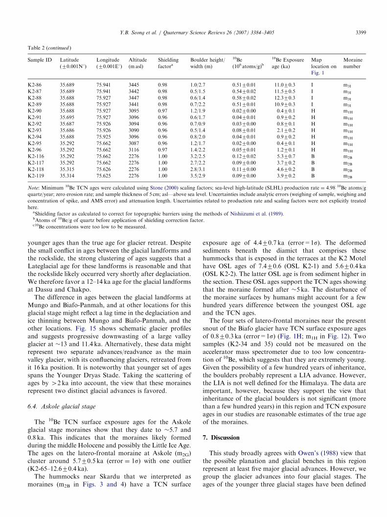
ARTICLE IN PRESS
Table 2 (continued )
Sample ID Latitude
(70.001N1)
Longitude
(70.001E1)
Altitude
(m asl)
Shielding
factoraBoulder height/
width (m)
10Be
(106 atoms/g)b
10Be Exposure
age (ka)
Map
location on
Fig. 1
Moraine
number
K2-86 35.689 75.941 3445 0.98 1.0/2.7 0.5170.01 11.070.3 I m3I
K2-87 35.689 75.941 3442 0.98 0.5/1.5 0.5470.02 11.570.5 I m3I
K2-88 35.688 75.927 3447 0.98 0.6/1.4 0.5870.02 12.370.3 I m3I
K2-89 35.688 75.927 3441 0.98 0.7/2.2 0.5170.01 10.970.3 I m3I
K2-90 35.688 75.927 3095 0.97 1.2/1.9 0.0270.00 0.470.1 H m1H
K2-91 35.695 75.927 3096 0.96 0.6/1.7 0.0470.01 0.970.2 H m1H
K2-92 35.687 75.926 3094 0.96 0.7/0.9 0.0370.00 0.870.1 H m1H
K2-93 35.686 75.926 3090 0.96 0.5/1.4 0.0870.01 2.170.2 H m1H
K2-94 35.688 75.925 3096 0.96 0.8/2.0 0.0470.01 0.970.2 H m1H
K2-95 35.292 75.662 3087 0.96 1.2/1.7 0.0270.00 0.470.1 H m1H
K2-96 35.292 75.662 3116 0.97 1.4/2.2 0.0570.01 1.270.1 H m1H
K2-116 35.292 75.662 2276 1.00 3.2/2.5 0.1270.02 5.370.7 B m2B
K2-117 35.292 75.662 2276 1.00 2.7/2.2 0.0970.00 3.770.2 B m2B
K2-118 35.315 75.626 2276 1.00 2.8/3.1 0.1170.00 4.670.2 B m2B
K2-119 35.314 75.625 2276 1.00 3.5/2.9 0.0970.00 3.970.2 B m2B
Note: Minimum 10Be TCN ages were calculated using Stone (2000) scaling factors; sea-level high-latitude (SLHL) production rate ¼ 4.98 10Be atoms/g
quartz/year; zero erosion rate; and sample thickness of 5 cm; asl—above sea level. Uncertainties include analytic errors (weighing of sample, weighing and
concentration of spike, and AMS error) and attenuation length. Uncertainties related to production rate and scaling factors were not explicitly treated
here.aShielding factor as calculated to correct for topographic barriers using the methods of Nishiizumi et al. (1989).bAtoms of 10Be/g of quartz before application of shielding correction factor.c10Be concentrations were too low to be measured.
Y.B. Seong et al. / Quaternary Science Reviews 26 (2007) 3384–3405 3399
younger ages than the true age for glacier retreat. Despitethe small conflict in ages between the glacial landforms andthe rockslide, the strong clustering of ages suggests that aLateglacial age for these landforms is reasonable and thatthe rockslide likely occurred very shortly after deglaciation.We therefore favor a 12–14 ka age for the glacial landformsat Dassu and Chakpo.
The difference in ages between the glacial landforms atMungo and Biafo-Panmah, and at other locations for thisglacial stage might reflect a lag time in the deglaciation andice thinning between Mungo and Biafo-Panmah, and theother locations. Fig. 15 shows schematic glacier profilesand suggests progressive downwasting of a large valleyglacier at �13 and 11.4 ka. Alternatively, these data mightrepresent two separate advances/readvance as the mainvalley glacier, with its confluencing glaciers, retreated fromit 16 ka position. It is noteworthy that younger set of agesspans the Younger Dryas Stade. Taking the scattering ofages by 42 ka into account, the view that these morainesrepresent two distinct glacial advances is favored.
6.4. Askole glacial stage
The 10Be TCN surface exposure ages for the Askoleglacial stage moraines show that they date to �5.7 and0.8 ka. This indicates that the moraines likely formedduring the middle Holocene and possibly the Little Ice Age.The ages on the latero-frontal moraine at Askole (m2G)cluster around 5.770.5 ka (error ¼ 1s) with one outlier(K2-65–12.670.4 ka).
The hummocks near Skardu that we interpreted asmoraines (m2B in Figs. 3 and 4) have a TCN surface
exposure age of 4.470.7 ka (error=1s). The deformedsediments beneath the diamict that comprises thesehummocks that is exposed in the terraces at the K2 Motelhave OSL ages of 7.470.6 (OSL K2-1) and 5.670.4 ka(OSL K2-2). The latter OSL age is from sediment higher inthe section. These OSL ages support the TCN ages showingthat the moraine formed after �5 ka. The disturbance ofthe moraine surfaces by humans might account for a fewhundred years difference between the youngest OSL ageand the TCN ages.The four sets of latero-frontal moraines near the present
snout of the Biafo glacier have TCN surface exposure agesof 0.870.3 ka (error=1s) (Fig. 1H; m1H in Fig. 12). Twosamples (K2-34 and 35) could not be measured on theaccelerator mass spectrometer due to too low concentra-tion of 10Be, which suggests that they are extremely young.Given the possibility of a few hundred years of inheritance,the boulders probably represent a LIA advance. However,the LIA is not well defined for the Himalaya. The data areimportant, however, because they support the view thatinheritance of the glacial boulders is not significant (morethan a few hundred years) in this region and TCN exposureages in our studies are reasonable estimates of the true ageof the moraines.
7. Discussion
This study broadly agrees with Owen’s (1988) view thatthe possible planation and glacial benches in this regionrepresent at least five major glacial advances. However, wegroup the glacier advances into four glacial stages. Theages of the younger three glacial stages have been defined
ARTICLE IN PRESS
Fig. 14. 10Be TCN surface exposure dates for boulders on the moraines dated from each of study areas: (A) scatter plots of ages on each moraine. Marine
Oxygen Isotope Stages (MIS; after Martinson et al., 1987) are shown in light blue. Note that the vertical scale changes from 20 ka and its boundary is
marked by light gray undulating line; (B) probability distributions for 10Be TCN surface exposure dates of each glacial advance. Each different color
represents an individual glacial landform.
Y.B. Seong et al. / Quaternary Science Reviews 26 (2007) 3384–34053400
by TCN surface exposure dating (Figs. 14 and 15; Table 1and 2).
The oldest glacial stage (Bunthang) provides evidencesuggesting that the Indus valley and its tributaries, whichincludes the Shigar valley, were filled with valley glaciersduring the early Quaternary. These valleys were subse-quently filled with glacier ice at least once more as testifiedby the moraines on top of Karpochi Rock, which belong to
the Skardu glacial stage. These moraines may have formedduring MIS 6, or more likely, during a much earlier glacialcycle. The top of mesa that includes Karpochi Rock, BlukoRock, and Stronodoka Ridge probably mark the valleyfloor at that time.Glaciers reached to at least the village of Mungo,
480 km from the present ice margins of the Baltoroglacier, during the Mungo glacial stage (Fig. 6). The glacier
ARTICLE IN PRESSY.B. Seong et al. / Quaternary Science Reviews 26 (2007) 3384–3405 3401
at Mungo was X1 km thick and would have comprisedglaciers confluent with Baltoro glaciers, including the Biafoand Chogo Lungma glaciers. Given this thickness it islikely that glaciers extended down the Shigar valley to atleast Shigar, where denuded lateral moraines are present tothe immediate east of the village of Shigar. The diffluencecol at the northern side of the Stronodoka ridge thatcontains moraines and till suggests that Shigar valleyglacier may have reached the Skardu Basin during theMungo glacial stage (Fig. 5). However, we did not datemoraines within the diffluence col, and given that theheight of the moraine on the col is comparable tothe Karpochi Rock, it is possible that the col dates to theSkardu glacial stage. Subsequent to the deepening of thevalleys, they were filled with a �100m-thick deposit offluvial and lacustrine sediment, the remnants of which arewell-preserved against what is now the mesa of KarpochiRock during the Mungo glacial stage.
Valley glaciers from tributary valleys advanced into theBraldu valley during the Holocene (e.g. near Askole;
Table 3
Summary of OSL dating results from quartz extracted from sediment sample
rates, total dose-rates, DE values and optical ages
Sample
number
Particle
size (mm)
Location
(1N/1E)
Altitude
(masl.)
Depth
(cm)
Ua
(ppm)
Tha
(ppm)
Ka
(%)
Rb
(pp
OSL
K2-1
90–125 35.2911/
75.6611
2274 160 2.35 14.0 1.83 110
OSL
K2-2
90–125 35.2911/
75.6611
2274 140 2.19 14.1 2.16 125
aElemental concentrations from NAA of whole sediment measured at USGbEstimated contribution to dose-rate from cosmic rays calculated accordingcEstimated fractional water content from whole sediment is 575%.dTotal dose-rate from beta, gamma and cosmic components. Beta attenuati
from Mejdahl (1979). Beta attenuation factor for Rb arbitrarily taken as 0.7
concentrations to beta and gamma dose-rates from Adamiec and Aitken (199eNumber of aliquots measured. The number in parenthesis refers to the numfMean equivalent dose (DE) determined from replicated single-aliquot regen
standard deviation.gErrors are 1-sigma standard errors (i.e. sn�1/n
1/2) incorporating error from
Fig. 15. Distribution of moraines formed during Mungo glacial stage. The dash
glacial stage. The profiles are based on the present gradient of the Baltoro Glac
ice limit dates to �16 ka, while the lower two ice limits date to �12–13 and
Baltoro trunk valley glacier or two readvances.
Fig. 10C) to form moraines several tens of meters high. Thehummocks in the Skardu Basin that have mid-HoloceneTCN ages were interpreted by Hewitt (1999) to be theresult of rock avalanching, whereas Owen (1988) and ourfield observations suggest that they are moraines thatformed when a tributary glacier advanced over, andglaciotectonized the wet fluvial and lacustrine sedimentsthat formed the lower terrace throughout the Skardu Basin(Owen, 1988; Fig. 4F). However, the low altitude of thismoraine (�2270m asl) and the lack of contemporaryglaciers below at least 4500m asl on the slopes to the southsuggests that an equilibrium-line depression of b1000mwould have been required to create these moraines duringthe Holocene. This is incompatible with current views onnature of climate change in the Holocene and contrastswith the equilibrium-line depression for the moraines atAskole, which is in the order of a few hundred meters.It is unlikely that both the TCN and OSL ages on thehummocks at Skardu are erroneous and therefore theyoung age would support Hewitt’s (1999) view that these
: particle size, sample locations, radioisotope concentrations, cosmic dose
a
m)
Cosmic Dose
rateb (mGya�1)
Total dose-
ratec,d
(mGya�1)
Number of
aliquotseMean
DEf (Gy)
Ageg
(ka)
.0 0.2470.02 3.2470.19 24(26) 24.175.5 7.470.6
.0 0.2570.03 3.5070.21 23(26) 19.674.0 5.670.4
S Nuclear Reactor in Denver. Uncertainty taken as 710%.
to Prescott and Hutton (1994). Uncertainty taken as 710%.
on factors for U, Th and K compositions incorporating grain size factors
5 (cf. Adamiec and Aitken, 1998). Factors utilized to convert elemental
8) and beta and gamma components attenuated for moisture content.
ber of aliquots used to calculate the DE.
erative-dose (SAR; Murray and Wintle, 2000) runs. Errors are cited as 1
beta source estimated at about 75%.
ed lines are schematic profiles of the main trunk glacier during the Mungo
ier. Three altitudinally distinct former ice limits are apparent. The highest
�11 ka, respectively. This suggests either progressive downwasting of the
ARTICLE IN PRESSY.B. Seong et al. / Quaternary Science Reviews 26 (2007) 3384–34053402
deposits are the result of rock avalanching. However, thecomplex deformation structures in the terraces still needfurther explanation to be attributed to the result ofdeformation due to rock avalanching. At this stage,therefore, we refrain from using this landform for glacialreconstructions until further geomorphic, sedimentologicaland geochronological studies have been undertaken onsimilar landforms in the Skardu Basin.
The present climate of the central Karakoram isdominated by mid-latitude westerlies with minor monsoo-nal influence. During low latitude insolation maxima,however, the climate was likely to be more influenced byvariations in the intensity of the south Asian monsoon(Sirocko et al., 1991). This would lead to an increase and afarther-north penetration of monsoon-derived moisture,which in turn could result in positive glacier mass balancesas precipitation falls as snow at high altitudes. In additionto changes in the Indian summer monsoon, cooling eventsassociated with increased ice rafting events in the NorthAtlantic, Heinrich events during glacial times (Bond et al.,1992) and the Rapid Climate Changes of Bond et al. (1997,2001) during the Lateglacial and the Holocene, could beteleconnected via the mid-latitude westerlies to theTranshimalaya resulting in glacial advances (Aizen et al.,2001; Barry and Chorley, 2003). In the Central Karakoramit is likely that glaciation is influenced by both oscillationsin the south Asian monsoon and the mid-latitude wester-lies. Making connection between glacial events and twoclimate systems and correlating the glacial successions inthe Central Karakoram with specific dated climatic eventsis difficult because of the uncertainties related to the use ofTCN surface exposure dating. Nevertheless, broad correla-tion can be made between regions and with climatic events.
The oldest glacial stage that was dated, the Skarduglacial, has TCN surface exposure ages that suggests thatthe moraines of this stage may have formed during MIS 6or more likely in an earlier glacial cycle. The uncertainty ofthe age of this glacial stage makes it impossible to correlatewith other regions of the Himalayan–Tibetan orogen.However, it is notable that glacial advances older than thelast glacial cycle have been recognized in adjacent regions.These include the Karasu glacial stage of MuztagAta–Kongur Shan (Seong et al., 2007a) and Leh glacialstage in Ladakh (Owen et al., 2006) that probably date to127–305 and 4400 ka, respectively. The lack of old datesthroughout most Himalayan study areas may be the resultof poor preservation, particularly in the more monsoon-influenced regions where fluvial and mass-movementprocesses are more dominant. Alternatively, it may be thatin other regions, glaciation during the last glacial cycle wasextensive enough to have destroyed evidence of earlyglaciations.
There is no glacial geologic evidence in the CentralKarakoram for a glacier advance between MIS 5 throughMIS 3. The lack of evidence for a glacial advance duringthe early part of the last glacial cycle is likely due to thepoor preservation potential in this high energy environ-
ment as paraglacial and post-glacial processes easilyrework and destroy glacial landforms. Barnard et al.(2003, 2004a, b, 2006), for example, showed how effectiveand efficient paraglacial processes are at reworking glacialand associated deposits in other regions of the Hima-layan–Tibetan orogen. Alternatively the MIS 2 advancesmay have been more extensive and could have destroyedany evidence for glacial advances during MIS 5 throughMIS 3. Given the records of glacial advance during theearly part of the last glacial cycle in the adjacent areas, suchas the Hunza Valley that has a similar climate regime, it islikely that glacial, paraglacial and post-glacial processesdestroyed the evidence of former glacial deposits.The Mungo glacial stage probably represents multiple
glacial advances during the MIS 2. These glaciationsresulted in the formation of well-preserved lateral morainesand roche moutonnees by thick valley glaciers along theBraldu valley. Glaciation during the Mungo glacial stagewas less extensive than during the Skardu glacial stage. Thetight cluster of ages allows us to tentatively assign themoraine at Mungo village (m1C and m2C) to Heinrich event1. The younger ages of 11–13 ka on glacial landforms ispossibly coincident with the Younger Dryas Stade.However, the span of Younger Dryas Stade is only 1300years and given the uncertainty with production rates andweathering it is difficult to unequivocally assign theselandforms to this climostratigrahic time. If the Mungoglacial stage advances occurred at these climostratigraphictimes, this suggests that the glaciation in this region is likelyto be associated with Northern Hemisphere coolingteleconnected by mid-latitude westerlies. Evidence for suchteleconnections is provided by other climate proxiesaround the Tibetan Plateau, including the Chinese loessrecord (Porter and Zhou, 2006) and the Tibetan ice corerecords (Thompson et al., 1989). The combination ofcooler temperatures with increased precipitation suppliedby the mid-latitude westerlies, which brought moisturefrom the Mediterranean, Black Sea, Caspian Sea and AralSea, allowed the glaciers in the Central Karakoram toadvance well into the main valley during the Mungo glacialstage. In addition to these teleconnections that affect themid-latitude westerlies, evidence from numerical simula-tions suggests enhanced monsoon flow at 16 ka comparedto the gLGM (Bush et al., 2007). Both summer and wintermonsoons are stronger at 16 ka than at the gLGM withenhanced precipitation, particularly over the Karakoram.In this region it is likely that glaciation was influenced bychanges in both the mid-latitude westerlies and the Indiansummer monsoon.The dated Askole glacial stage glacial landforms that are
present within the region were examined in two differentareas, Askole, and Biafo (m2G and m1H in Table 1). Theglacial advances during the Askole glacial stage in theregion might be synchronous with the Holocene Bondevents 3 and 0, which are apparent in North Atlantic deepsea records (Bond et al., 2001). However, presently there isno other independent data for the Karakoram to support

ARTICLE IN PRESSY.B. Seong et al. / Quaternary Science Reviews 26 (2007) 3384–3405 3403
significant climate change at these times and thesecorrelations need to be more fully tested in future work.If these glacier advances are synchronous with Bond eventsthen the lower temperature at these times, and the likelyincreased frequencies and magnitude of storm trackdevelopment in the region might have increased themoisture supply to the region (Denton and Karlen, 1973;An and Porter, 1997; Alley and Agustsdottir, 2005; Porterand Zhou, 2006; Seong et al., 2007a), which in turn likelyresulted in positive glacier mass balances, allowing glaciersto advance. This combination of relatively high winteraccumulation and lower temperature may have helpeddrive the tributary glacial advance during the Holocene.Likewise, during the Little Ice Age, the total snowaccumulation at Dasuopu ice sheet in southern Tibet was30% higher than the summer amounts in northern India(Thompson, 2000). This was possibly the result of theincreased winter snowfall as westerly low-pressure systemslinked to the North Atlantic pushed farther east along theHimalaya than they normally do today. The increasedalbedo due to increased snowfall and the colder tempera-tures would have allowed excess snow to fall and persistlate into each year. This in turn would have weakened theIndian summer monsoon.
Each successive glaciation in the study region becameprogressively less extensive, from 4200 km long and42 km thick valley glaciers to restricted (a few kilometers)tributary valley glacier advances. We cannot determine thereason for this pattern, but it might reflect a global patternof progressively more restricted mountain glaciationthroughout the Quaternary, or a more local control relatedto topographic constrains and/or uplift.
Correlating glacial advances between regions in theHimalayan–Tibetan orogen is difficult. Owen et al. (2005,2006) suggested broad correlations between distant re-gions, but was limited by the accuracy and precision of thedating. We therefore refrain from detailed correlations withother areas of the Himalayan–Tibetan orogen. Our CentralKarakoram study, however, highlights the striking con-trasts in the extent of glaciation between neighboringregions. For example, in the Hunza valley, �50 km NW ofthe K2-Baltoro region, glaciers did not advance more thana few kilometers during MIS 2 and 1 (Owen et al., 2002b),whereas in the K2-Baltoro region extensive valley glaciersadvanced many tens of kilometers from their presentpositions during MIS 2. As our knowledge of the timingand extent of Quaternary glaciation in the Himalayan–Tibetan orogen improves, such as provided by our study, itmay become possible to resolve the relative roles of difficultmajor climatic systems in forcing glaciation in CentralAsia.
8. Conclusions
The geomorphology and 10Be TCN chronology showsthat glaciers in this region likely advanced during the earlyQuaternary (Bunthang glacial stage), MIS 6 or more likely
during a much earlier glacial cycle (the Skardu glacialstage), MIS 2 (Mungo glacial stage), and the Holocene(Askole glacial stage). Our 10Be TCN data for the Mungoglacial stage show that glaciers likely advanced at �16 kaand between 13 and 11 ka. The former may represent adeglaciation age for the gLGM or it more likely representsa distinct advance broadly synchronous with ice-raftingevents in the North Atlantic during the Heinrich event 1.The latter glacial advance (13–11 ka) might represent adeglaciation age for the former, but more likely representsa separate advance during the Younger Dryas Stade. Theglacial advances during the Askole glacial stage might be inphase with the Holocene rapid climate changes, althoughthe scattered ages and uncertainty with the TCN produc-tion rates and scaling factors cannot allow us to unequi-vocally assign them to climatic events. Our initial resultssuggest that the record of glacial advances in western Tibetsupports the view that atmospheric teleconnections be-tween the Tibet and the Northern Hemisphere ice sheetsand oceans existed throughout the Late Quaternary. This isalso consistent with earlier suggestions that changes in thephysical oceanography of the North Atlantic Ocean affectthe climate downwind, including the strength and path ofstorm tracks within the mid-latitude westerly system thatpasses over western Tibet, which in turn force glaciation.However, we cannot exclude a likely strong monsoonalinfluence. Our glacial chronology nevertheless provides aframework for future studies on paleo-environmentalchange and landscape evolution in Central Asia to helpanswer key questions regarding the nature of climatechange and to test tectonic and geomorphic models fororogenic belts.
Acknowledgments
We would like to acknowledge the long-term and highlyfruitful relationship with the late Syed Hamidullah, formerDirector of the Center of Excellence at Peshawar Uni-versity, who did so much to help us with this project. Wewould also like to thank his students, Faisal Khan andMohammad Shahid, for their excellent assistance in thefield. Special thanks to the medics of University ofNebraska at Omaha, lead by Keith Brown and BruceHagen, for their support in the field. This research wassupported by funding from the National GeographicSociety and the US National Science Foundation (GrantBCS-0242339) to the University of Nebraska—Omaha andthe University of Cincinnati. Part of this work wasundertaken at the Lawrence Livermore National Labora-tory (under DOE Contract W-7405-ENG-48). This re-search formed part of Y.B. Seong’s doctoral research,which was partially supported by a Meyers Fellowship atthe University of Cincinnati. Special thanks to ThomasLowell for suggestions on an early draft of this paper, andEd Brook, Alan Gillespie and an anonymous reviewer fortheir useful and constructive review.
ARTICLE IN PRESSY.B. Seong et al. / Quaternary Science Reviews 26 (2007) 3384–34053404
References
Adamiec, G., Aitken, M., 1998. Dose-rate conversion factors: update.
Ancient TL 16, 37–50.
Aizen, V., Aizen, E., 1997. Hydrological cycles on the north and south
peripheries of mountain–glacial basins of Central Asia. Hydrological
Processes 11, 451–469.
Aizen, E.M., Aizen, V.B., Melack, J.M., Nakamura, T., Ohta, T., 2001.
Precipitation and atmospheric circulation patterns at mid-latitudes of
Asia. International Journal of Climatology 21, 535–556.
Alley, R.B., Agustsdottir, A.M., 2005. The 8 ka event: cause and
consequence of a major Holocene abrupt climate change. Quaternary
Science Reviews 24, 1123–1149.
An, Z.S., Porter, S.C., 1997. Millennial-scale climatic oscillations during
the last interglaciation in central China. Geology 25, 603–606.
Balco, G., Stone, J.O., 2007. A simple, internally consistent, and easily
accessible means of calculating surface exposure ages or erosion rates
from 10Be and 26Al measurements. Quaternary Geochronology, in
press.
Barnard, P.L., Owen, L.A., Finkel, R.C., Asahi, K., 2003. Landscape
response to deglaciation in a high relief, monsoon-influenced alpine
environment, Langtang Himal, Nepal. Quaternary Science Reviews 25,
2162–2176.
Barnard, P.L., Owen, L.A., Finkel, R.C., 2004a. Style and timing of
glacial and paraglacial sedimentation in a monsoonal influenced high
Himalayan environment, the upper Bhagirathi Valley, Garhwal,
Himalaya. Sedimentary Geology 165, 199–221.
Barnard, P.L., Owen, L.A., Sharma, M.C., Finkel., R.C., 2004b. Late
Quaternary landscape evolution of a monsoon-influenced high
Himalayan valley, Gori Ganga, Nanda Devi, NE Garhwal. Geomor-
phology 61, 91–110.
Barnard, P.L., Owen, L.A., Finkel, R.C., 2006. Quaternary fans and
terraces in the Khumbu Himal south of Mount Everest: their
characteristics, age and formation. Journal of Geological Society of
London 163, 383–399.
Barry, R.G., Chorley, R.J., 2003. Atmosphere, Weather, and Climate,
eighth ed. 279pp.
Benn, D.I., Owen, L.A., 2002. Himalayan glacial sedimentary environ-
ments: a framework for reconstructing and dating former glacial
extents in high mountain regions. Quaternary International 97-98,
3–26.
Bond, G., Heinrich, H., Broecker, W., Labeyrie, L., Mc-Manus, J.,
Andrews, J., Huon, S., Jantschik, R., Clasen, S., Simet, C., Tedesco,
K., Klas, M., Bonani, G., Ivy, S., 1992. Evidence for massive
discharges of icebergs into the North Atlantic during the last glacial
period. Nature 360, 245–249.
Bond, G., Showers, W., Cheseby, M., Lotti, R., Almasi, P., deMenocal,
P., Priore, P., Cullen, H., Hajdas, I., Bonani, G., 1997. A pervasive
millenial-scale cycle in North Atlantic Holocene and glacial climates.
Science 278, 1257–1266.
Bond, G., Kromer, B., Beer, J., Muscheler, R., Evans, M., Showers, W.,
Hoffmann, S., Lotti-Bond, R., Hajdas, I., Bonani, G., 2001. Persistent
solar influence on North Atlantic climate during the Holocene. Science
294, 2130–2136.
Burgisser, H.M., Gansser, A., Pika, J., 1982. Lateglacial lake sediments of
the Indus Valley area, northwestern Himalayas. Eclogae Geologische
Helvetica 75, 51–63.
Bush, A.B.G., Bishop, M., Copland, L., Kamp, U., Owen, L.A., Seong,
Y.B., Shroder, J., Clendon, P., 2007. Himalayan climate at 16,000
years before present: changes in monsoon circulations and the
westerlies, in preparation.
Cronin, V.S., 1989. Structural setting of the Skardu intermontane basin,
Karakoram Himalaya, Pakistan. Geological Society of America
Special Paper 232, 183–201.
Cronin, V.S., Johnson, W.P., Johnson, N.M., Johnson, G.D., 1989.
Chronostratigraphy of the upper Cenozoic Bunthang sequence and
possible mechanisms controlling base level in Skardu intermontane
basin, Karakoram, Himalaya, Pakistan. Geological Society of
America Special Paper 232, 295–309.
Denton, G.H., Karlen, W., 1973. Holocene climatic variations: their
pattern and possible cause. Quaternary Research 3, 155–205.
Derbyshire, E., 1981. Glacier regime and glacial sediment facies: a
hypothetical framework for the Qinghai-Xizang Plateau. In: Proceed-
ings of Symposium on Qinghai-Xizang (Tibet) Plateau, vol. 2. Beijing,
China. Science Press, Beijing, Geological and Ecological studies of
Qinghai-Xizang Plateau. pp. 1649–1656.
Derbyshire, E., Owen, L.A., 1990. Quaternary alluvial fans
in the Karakoram Mountains. In: Rachocki, A.H., Church, M.
(Eds.), Alluvial Fans: A Field Approach. Wiley, Chichester,
pp. 27–53.
Dianelli, G., 1922. Studi sul glaciale Spedizone Italian de Filippi nell’
Himalaia, Caracorume Turchestan/Cinese (1913–1914). Ser. II, 3,
p.658.
Drew, F., 1873. Alluvial and lacustrine deposits and glacial records of the
upper Indus basin. Part 1: alluvial deposits. Geological Society of
London Quarterly Journal 29, 449–471.
Finkel, R.C., Owen, L.A., Barnard, P.L., Caffee, M.W., 2003. Beryllium-
10 dating of Mount Everest moraines indicates a strong monsoonal
influence and glacial synchroniety throughout the Himalya. Geology
31, 561–564.
Foster, D.A., Gleadow, A.J.W., Mortimer, G., 1994. Rapid Pliocene
exhumation in the Karakoram (Pakistan), revealed by fission-track
thermochronology of the K2 gneiss. Geology 22, 19–22.
Hewitt, K., 1989. The altitudinal organisation of Karakoram geomorphic
processes and depositional environments. Zeitschrift fur Geomorpho-
logie, N.F. Suppl.-Bd 76, 9–32.
Hewitt, K., 1998. Catastrophic landslides and their effects on the Upper
Indus streams, Karakoram Himalaya, northern Pakistan. Geomor-
phology 26, 47–80.
Hewitt, K., 1999. Quaternary moraines vs. catastrophic avalanches in the
Karakoram Himalaya, northern Pakistan. Quaternary Research 51,
220–237.
Hewit, K., 2005. The Karakoram anomaly? Glacier Expansion and the
‘Elevation Effect,’ Karakoram Himalaya. Mountain Research and
Development 25, 332–340.
Kohl, C.P., Nishiizumi, K., 1992. Chemical isolation of quartz for
measurement of in situ produced cosmogenic nuclides. Geochimica et
Cosmochimica Acta 56, 3583–3587.
Lal, D., 1991. Cosmic ray labeling of erosion surfaces: in situ nuclide
production rates and erosion models. Earth and Planetary Science
Letters 104, 429–439.
Lal, D., Harris, N.B.W., Sharma, K.K., Gu, Z., Ding, L., Liu, T., Dong,
W., Caffee, M.W., Jull, A.J.T., 2003. Erosion history of the Tibetan
Plateau since the Last Interglacial: constrains from the first studies of
cosmogenic 10Be from Tibetan bedrock: Earth and Planetary Science
Letters 217, 33–42.
Meihe, G., Winiger, M., Bohner, J., Yili, Z., 2001. Climatic diagram map
of High Asia 1: purpose and concepts. Erdkunde 55, 94–97.
Mejdahl, V., 1979. Thermoluminescence dating: beta attenuation in quartz
grains. Archaeometry 21, 61–73.
Murray, A.S., Wintle, A.G., 2000. Luminescence dating of quartz using an
improved single-aliquot regenerative-dose protocol. Radiation Mea-
surements 32, 57–73.
Nishiizumi, K., Winterer, E.L., Kohl, C.P., Lal, D., Arnold, J.R., Klein,
J., Middleton, R., 1989. Cosmic ray production rates of 10Be and 26Al
in quartz from glacially polished rocks. Journal of Geophysical
Research 94 (B12), 17,907–17,915.
Olley, J.M., Caitcheon, G.G., Roberts, R.G., 1999. The origin of dose
distributions in fluvial sediments, and the prospect of dating single
grains from fluvial deposits using optically stimulated luminescence.
Radiation Measurements 30, 207–217.
Owen, L.A., 1988. Wet-sediment deformation of Quaternary and recent
sediments in the Skardu Basin, Karakoram Mountains, Pakistan. In:
Croot (Ed.), Glaciotectonics: Forms and Processes. Balkema, Rotter-
dam, pp. 123–148.
ARTICLE IN PRESSY.B. Seong et al. / Quaternary Science Reviews 26 (2007) 3384–3405 3405
Owen, L.A., Derbyshire, E., 1988. Glacially deformed diamictons in the
Karakoram Mountains, northern Pakistan. In: Croot (Ed.), Glacio-
tectonics: Forms and Processes. Balkema, Rotterdam, pp. 149–176.
Owen, L.A., Derbyshire, E., 1989. The Karakoram glacial depositional
system. Zeitschrift fur Geomorphologie 76, 33–73.
Owen, L.A., Gualtieri, L., Finkel, R.C., Caffee, M.W., Benn, D.I.,
Sharma, M.C., 2001. Cosmogenic radionuclide dating of glacial
landforms in the Lahul Himalaya, northern India: defining the timing
of Late Quaternary glaciation. Journal of Quaternary Science 16,
555–563.
Owen, L.A., Finkel, R.C., Caffee, M.W., 2002a. A note on the extent of
glaciation in the Himalaya during the global Last Glacial Maximum.
Quaternary Science Reviews 21, 147–157.
Owen, L.A., Finkel, R.C., Caffee, M.W., Gualtieri, L., 2002b. Timing of
multiple Late Quaternary glaciations in the Hunza Valley, Karakoram
Mountains, northern Pakistan: defined by cosmogenic radionuclide
dating of moraines. Geological Society of America Bulletin 114,
593–604.
Owen, L.A., Kamp, U., Spencer, J.Q., Haserodt, K., 2002c. Timing and
style of Late Quaternary glaciation in the eastern Hindu Kush, Chitral,
northern Pakistan: a review and revision of the glacial chronology
based on new optically stimulated luminescence dating. Quaternary
International 97–98, 41–55.
Owen, L.A., Spencer, J.Q., Ma, H., Barnard, P.L., Derbyshire, E., Finkel,
R.C., Caffee, M.W., Zeng, Y.N., 2003a. Timing of Late Quaternary
glaciation along the southwestern slopes of the Qilian Shan, Tibet.
Boreas 32, 281–291.
Owen, L.A., Finkel, R.C., Ma, H., Spencer, J.Q., Derbyshire, E., Barnard,
P.L., Caffee, M.W., 2003b. Timing and style of Late Quaternary
glaciations in NE Tibet. Geological Society of America Bulletin 115,
1356–1364.
Owen, L.A., Finkel., R.C., Barnard, P.L., Haizhhou, M., Asahi, K.,
Caffee, M.W., Derbyshire, E., 2005. Climatic and topographic
controls on the style and timing of Late Quaternary glaciation
throughout Tibet and the Himalaya defined by 10Be cosmogenic
radionuclide surface exposure dating. Quaternary Science Reviews 24,
1391–1411.
Owen, L.A., Caffee, M.W., Bovard, K.R., Finkel, R.C., Sharma, M.C.,
2006. Terrestrial cosmogenic nuclide surface exposure dating of
the oldest glacial successions in the Himalayan orogen. Ladakh
Range, northern India. Geological Society of America Bulletin 118,
383–392.
Owen, L.A., Bright, J., Finkel, R.C., Jaiswal, M.K., Kaufman, D.S.,
Mahan, S., Radtke, U., Schneider, J.S., Sharp, W., Singhvi, A.K.,
Warren, C.N., 2007. Numerical dating of a Late Quaternary spit-
shoreline complex at the northern end of Silver Lake playa, Mojave
Desert, California: a comparison of the applicability of radiocarbon,
luminescence, terrestrial cosmogenic nuclide, electron spin resonance,
U-series and amino acid racemization methods. Quaternary Interna-
tional 166, 87–110.
Paffen, K.H., Pillewizer, W., Schneide, H.J., 1956. Forschungen im
Hunza-Karakoram. Erdkunde 10, 1–33.
Phillips, W.M., Sloan, V.F., Shroder Jr., J.F., Sharma, P., Clarke, M.L.,
Rendell, H.M., 2000. Asynchronous glaciation at Nanga Parbat,
northwestern Himalaya Mountains, Pakistan. Geology 28, 431–434.
Porter, S.C., Zhou, W., 2006. Synchronism of Holocene East Asian
monsoon variations and North Atlantic drift-ice tracers. Quaternary
Research 65, 443–449.
Prescott, J.R., Hutton, J.T., 1994. Cosmic ray contributions to dose rates
for luminescence and ESR dating: Large depths and long-term time
variations. Radiation Measurements 23, 497–500.
Richards, B.W.M., Owen, L.A., Rhodes, E.J., 2000a. Timing of Late
Quaternary glaciations in the Himalayas of northern Pakistan. Journal
of Quaternary Science 15, 283–297.
Richards, B.W.M., Benn, D., Owen, L.A., Rhodes, E.J., Spencer, J.Q.,
2000b. Timing of Late Quaternary glaciations south of Mount Everest
in the Khumbu Himal, Nepal. Geological Society of America Bulletin
112, 1621–1632.
Searle, M.P., 1991. Geology and Tectonics of the Karakoram Mountains.
Wiley, Chichester, 358pp.
Seong, Y.B., Owen, L.A., Yi, Y., Finkel, C.R., 2007a. Quaternary glaciation
of Muztag Ata and Kongur Shan: evidence for glacier response to rapid
climate changes throughout the Lateglacial and Holocene in westernmost
Tibet. Geological Society of America Bulletin, in review.
Seong, Y.B., Owen, L.A., Bishop, M.P., Bush, A., Clendon, P., Copland,
L., Finkel, R.C., Kamp, U., Shroder, J.F., 2007b. Rates of fluvial
bedrock incision within an actively uplifting orogen: Central Kar-
akoram Mountains, northern Pakistan. Geomorphology, in press.
Sharma, M.C., Owen, L.A., 1996. Quaternary glacial history of the
Garhwal Himalaya, India. Quaternary Science Reviews 15, 335–365.
Shi, Y., 2002. Characteristics of late Quaternary monsoonal glaciation on
the Tibetan Plateau and in East Asia. Quaternary International 97–98,
79–91.
Shroder, J., Bishop, M., Bush, A., Copeland, L., Kamp, U., Owen, L.A.,
Seong, Y.B., Weeks, P., 2007. Postglacial slope failure and denudation
in the Central Karakoram (tentative), in preparation.
Sirocko, F., Sarnthein, M., Lango, H., Erlenkeuser, H., 1991. The
atmospheric summer circulation and coastal upwelling in the Arabian
Sea during the Holocene and the last glaciation. Quaternary Research
36, 72–73.
Small, E.E., Anderson, R.S., Repka, J.L., Finkel, R.C., 1997. Erosion
rates of alpine bedrock summit surfaces deduced from in situ Be-10
and Al-26. Earth and Planetary Science Letters 150, 413–425.
Spencer, J.Q., Owen, L.A., 2004. Optically stimulated luminescence dating
of Late Quaternary glaciogenic sediments in the upper Hunza valley:
validating the timing of glaciation and assessing dating methods.
Quaternary Sciences Reviews 23, 175–191.
Stone, J.O., 2000. Air pressure and cosmogenic isotope production.
Journal of Geophysical Research 105, 23753–23759.
Thompson, L.G., 2000. Ice core evidence for climate change in the
Tropics: implications for our future. Quaternary Science Reviews 19,
19–35.
Thompson, L.G., Mosley-Thompson, E., Davis, M.E., Bolzan, J.F., Dai,
J., Yao, T., Gundestrup, N., Wu, X., Klein, L., Xie, Z., 1989.
Holocene–Late Pleistocene climatic ice core records from Qinghai-
Tibetan Plateau. Science 246, 474–477.
Tsukamoto, S., Asahi, K., Watanabe, T., Kondo, R., Rink, W.J., 2002.
Timing of past glaciation in Kanchenjunga Himal, Nepal by optically
stimulated luminescence dating of tills. Quaternary International 97/
98, 57–68.
Wake, C.P., 1987. Snow accumulation studies in the central Karakoram.
In: Proceedings of the Eastern Snow Conference, vol. 44, 1987,
pp. 19–33.
Wake, C.P., 1989. Glaciochemical investigations as a tool for determining
the spatial and seasonal variation of snow accumulation in the central
Karakoram, northern Pakistan. Annals of Glaciology 13, 279–284.
Wallinga, J., 2002. Optically stimulated luminescence dating of fluvial
deposits: a review. Boreas 31, 303–322.
Zehfuss, P.H., Bierman, P.R., Gillespie, A.R., Burke, R.A., Caffee, M.C.,
2001. Slip rates on the Fish Springs fault, Owens Valley, California,
deduced from cosmogenic 10Be and 26Al and soil development on fan
surfaces. Geological Society of America Bulletin 113, 241–255.