Embed Size (px)
Citation preview
QUETHIOCK PARISH NEIGHBOURHOOD DEVELOPMENT PLAN 2010 – 2030
Table of Contents Page No
FOREWORD 2
1. INTRODUCTION 3
2. A DESCRIPTION OF QUETHIOCK PARISH 4
3. THE VIEW OF THE COMMUNITY 6
4. THE NPPF, CARADON AND CORNWALL LOCAL PLANS 7
5. VISION AND OBJECTIVES 7
6. POLICIES 8
HOUSING POLICY 9
Policy H1: Housing Development 9
BUSINESS POLICIES 11
Policy B1: Small Business – Change of Use 11 Policy B2: Small Business – New Build 12
COMMUNITY POLICIES 13
Policy C1: Quethiock Pavilion 13
Policy C2: Children’s Play Area 14
Policy C3: Quethiock School Playing Field 14
6th May 2015
1
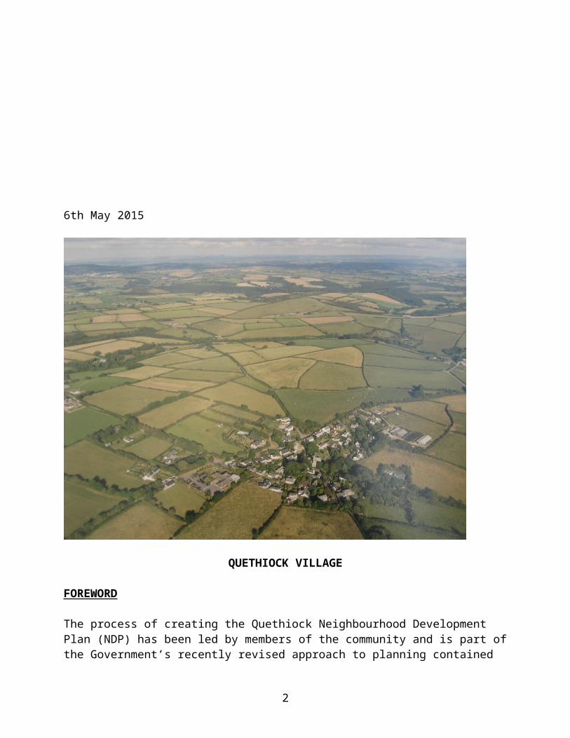
QUETHIOCK VILLAGE
FOREWORD
The process of creating the Quethiock Neighbourhood Development Plan (NDP) has been led by members of the community and is part of the Government’s recently revised approach to planning contained in the Localism Act of 2011 i.e. local people have more say about what happens in the area in which they live.
The aim of this NDP is to put forward the wishes of the community as to any future development. The Parish Council’s vision for 2031 is that we will have established new housing to meet the local community’s needs, the school will have benefitted from increased numbers and that the Pavilion will have become the hub of the Parish.
Quethiock Parish Council has overseen the development of the NDP but has delegated the preparation of the NDP to the Steering Group. A Parish Councillor, who had taken part in Cornwall Council’s NDP training, has chaired the Steering Group.
This NDP contains a number of policies, which includes some areas where the Parish Council will encourage some small developments and changes, and other areas such as “Green Spaces’ that the community wish to protect. These policies have been drafted following interaction and consultation with the residents of Quethiock Parish “the Parish”. Details of the consultation process are contained in the Consultation Statement, published separately.
2
1. INTRODUCTION
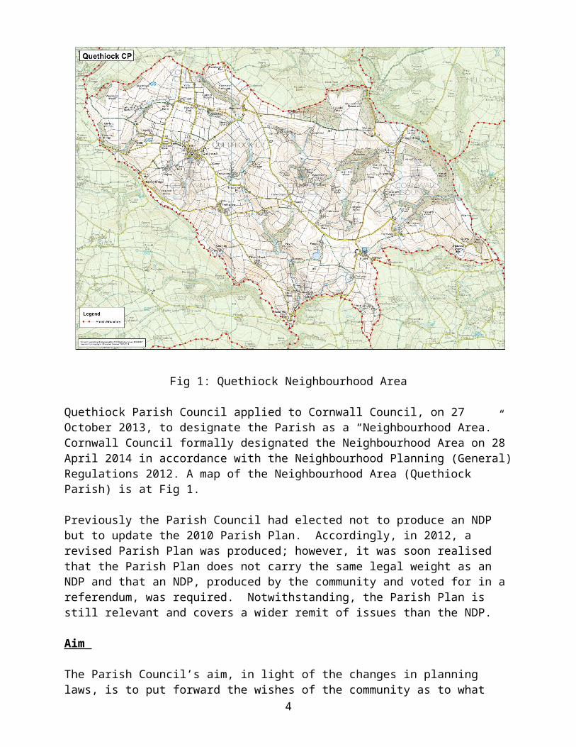
Fig 1: Quethiock Neighbourhood Area
Quethiock Parish Council applied to Cornwall Council, on 27 October 2013, to designate the Parish as a “Neighbourhood Area.” Cornwall Council formally designated the Neighbourhood Area on 28 April 2014 in accordance with the Neighbourhood Planning (General) Regulations 2012. A map of the Neighbourhood Area (Quethiock Parish) is at Fig 1.
Previously the Parish Council had elected not to produce an NDP but to update the 2010 Parish Plan. Accordingly, in 2012, a revised Parish Plan was produced; however, it was soon realised that the Parish Plan does not carry the same legal weight as an NDP and that an NDP, produced by the community and voted for in a referendum, was required. Notwithstanding, the Parish Plan is still relevant and covers a wider remit of issues than the NDP.
Aim
The Parish Council’s aim, in light of the changes in planning laws, is to put forward the wishes of the community as to what future development in the Parish should be. This plan would then form part of Cornwall Council’s Development Plan and become a “Planning Consideration” which gives our Parish its proper say regarding any future development. Our intention is to direct and shape the density and mix of private and affordable housing and other developments within the Parish. We wish to encourage appropriate growth and sustainable development whilst ensuring farmland, the rural nature of the Parish and its natural beauty are protected.
3
Neighbourhood Plans
The National Planning Policy Framework (NPPF) states:
“Neighbourhood planning gives communities direct power to develop a shared vision for their neighbourhood and deliver the sustainable development they need. Neighbourhood Plans must be in general conformity with the strategic policies of the Local Plan. Neighbourhood Plans should reflect these policies and neighbourhoods should plan positively to support them. Neighbourhood Plans and Orders should not promote less development than set out in the Local Plan or undermine its strategic policies.”
NDPs add detail at the local level allowing communities to shape and direct development.
Plan Period
In line with Cornwall Council’s Local Plan this NDP covers the period 2010 to 2030. It has been prepared in accordance with the NPPF March 2012, Caradon Local Plan First Alteration (Aug 2007), Cornwall Local Plan Proposed Submission Document March 2014, Neighbourhood Planning Regulations 2012, and the European Directive on Strategic Environmental Assessment 2004.
Strategic Environmental Assessment
Neighbourhood Plans may be subject to Strategic Environmental Assessment (SEA) under the EU Directive. This requires that the environmental effects of the policies and proposals be assessed against a series of environmental objectives during their formulation. However, this NDP does not propose to specifically allocate land for housing or other purposes. A formal Screening Opinion was requested from Cornwall Council in September 2014. In November 2014 it was confirmed that an SEA was not required.
Monitoring
Quethiock Parish Council will monitor this NDP annually using the objectives outlined in Section 5.
2. A DESCRIPTION OF QUETHIOCK PARISH
The Parish
Quethiock Parish is in an extremely rural location measuring 1854 hectares; it includes the village of Quethiock and the hamlets of Trehunist and Blunts. There are several smaller settlements with 10 or fewer homes e.g. Tilland, Trecorme, Haye and Holwood. In 2015 there are approximately 214 households within the Parish.
Demographics
The 2011 National Census recorded:
20% of the population was under 18. 45% was over 50.
4
28% was 60 or over. Total population was 493. There were 200 dwellings. The density of the Parish (persons per hectare) was 0.3 against an average
for Cornwall of 1.5 and England 4.1.
Approximately 35% of residents live in Quethiock Village. Elsewhere the Parish is made up of small, scattered communities often 5 or 6 houses around older farms where outbuildings have been converted.
Environment and Agriculture
The Parish is set in some of Cornwall’s most beautiful countryside. The environmental baseline for the Parish shows that:
Ecology: The Parish has no National Nature Reserves, Sites of Special Scientific Interest, Special Protection Areas, Special Areas of Conservation or Ramsar Sites
Landscape : The Parish is not within the Area of Outstanding Natural Beauty: however, the eastern part of the Parish is designated locally as an Area of Great Landscape Value. The Parish lies within National Character Area 152: Cornish Killas and two Landscape Character Areas: LCA 22 South East Cornwall Plateau and LCA25 Lynher and Tiddy River valleys.
Heritage and The Historic Environment : There are two Scheduled Monuments: Clapper Bridge on the boundary with St Mellion Parish and the medieval churchyard cross in Quethiock church.
It has fairly rich agricultural land devoted mainly to dairy, beef and sheep farming. Most crops grown are for animal feed. Arable land is restricted due to the undulating nature of the land. River valleys and streams dissect the rolling farmland. Some of these are wooded. Hedgerows bound the majority of roads and farm fields. All of the access roads into the Parish are single track with passing places.
Facilities and Services
There are no shops within the Parish nor are there any pubs or other leisure facilities. Other than farming, the only businesses in the Parish are business units at Holwood Farm, vehicle service and repair in Blunts and Coombe, “Trailerland” in Trehunist and a very few B&B and holiday lets. A number of residents work from home requiring access to the Internet; however connections can be slow and unreliable. Quethiock village was upgraded to fibre optic in early 2015 but not everyone in the Parish is connected through Quethiock.
Quethiock C of E Voluntary Aided Primary School, which caters for 4-11 year olds, amply covers local needs and has a large intake from outside the Parish. The school is part of the St Barnabas Multi Academy Trust. The school has had extremely good results in recent inspections: “good with outstanding features” in both Ofsted and SIAMs. However, the demographics of the Parish and the whole of SE Cornwall have meant a sharp drop in the number of pupils attending the school. In order to keep this valuable facility it is necessary to attract more families to the Parish and to encourage parents from outside the Parish to send their children to the school. Additional facilities that would aid parents who are in full-time employment would be welcomed as would
5
pre-school facilities that would start children’s education in the area and provide a natural progression to Quethiock School.
The local bus service provides the only means for non-driving parishioners to access shops, amenities etc. There is currently one bus a day (Mon – Fri) from Blunts and Quethiock to Liskeard (via Menheniot) and onto Trago Mills. The service is felt to be inadequate by many, and the bus is not widely used by parishioners. A mobile Post Office visits Quethiock on Wednesdays in the Pavilion. This is an extremely valuable service, which is well used, and every effort must be made to retain the service. The Mobile Library visits Quethiock once a month and stops by the St Hugh’s Church gate; again, this is an extremely valuable service.
Currently Quethiock has a vibrant C of E Church catering for a wide variety of events and entertainments, which is well supported by the residents. The Methodist Chapel in Quethiock has recently closed and the site sold off. Blunts Methodist Chapel is well used and doubles as the village hall.
The Pavilion in Quethiock was built in 1989; it is run by a hardworking Management Committee and sustained by donations and fund raising events such as coffee mornings, big breakfasts and an annual horticultural show. The Pavilion can be hired for a minimal charge and is put to all sorts of uses from Parish Council meetings to birthday parties. Cornwall Council owns the land the Pavilion stands on; however, the Parish Council is attempting to obtain this land.
The Quethiock Horticultural Show is an annual summer event held on the school playing field and in the Pavilion and is well supported by the school, residents and non-residents alike.
Despite plenty of interest, there is currently no land allocated for allotments.
The cemetery is owned and maintained by Cornwall Council.
3. THE VIEW OF THE COMMUNITY
From the 2010 survey it was deduced that some small-scale development was needed to cater for local needs and growth but that the lack of infrastructure, inadequate roads, public transport, shops, etc., would naturally limit this. The Parish Council recognised a need to create the possibility for carefully structured, well-planned growth within the community in all areas in order to allow the community to flourish and not to be stifled by constraints. For example it fully supported the plans for the completed eight affordable houses at Blunts, which were funded by Cornwall Community Land Trust. Realistically though, the Parish Council felt that it was highly unlikely that a developer would be tempted to create new houses on a medium or large scale within the Parish unless there was significant improvement to the roads, the sewage system within Quethiock or the number of employment options other than farming. Furthermore, national and Local Plan policies limit new development in rural areas such as Quethiock.
The responses to the 2014 NDP questionnaire have shown that:
In general residents are in favour of some development and increase in housing in line with the Cornwall Local Plan.
The majority favoured affordable family homes for sale in any appropriate individual site within the Parish.
6
Developments should be single properties or small developments, which should be traditional and blend in with surrounding properties.
Any benefits provided by a developer should be used to improve the infrastructure (roads), sewerage, broadband and social facilities.
We should be encouraging and planning for new business but in individual units and only on suitable sites within the Parish.
There was support for domestic solar power development; however, there was virtually no support for large scale or industrial schemes. As to wind turbines, the majority in the Parish felt that no schemes were appropriate.
The Primary School and the school field, the Pavilion, St Hugh’s Church, Blunts Methodist Chapel, Blunts car park and the cemetery should all be designated as Assets of Community Value or Local Green Spaces and protected from any development.
There was strong support for an enhanced community centre, a play area for children of all ages in Quethiock and Blunts, some form of social facilities and a local shop.
Of note was the frustration with the appallingly low speed and intermittent broadband service and the feeling that this should be improved.
Whilst it was felt that the roads should be better maintained, a general widening of all roads would spoil the aesthetics and destroy the hedges which provide valuable space for flora and fauna and are a feature of rural Cornwall.
4. THE NPPF, CARADON AND CORNWALL LOCAL PLANS
The NPPF is an important guide in the preparation of Local Plans and Neighbourhood Plans. At the independent examination, the Neighbourhood Plan must demonstrate that it meets the Basic Conditions by having regard to national policies and advice and is in general conformity with the strategic policies contained in the development plan for the area of authority. Once adopted the Neighbourhood Plan will be an important means by which planning applications in the Parish will be judged.
The Parish of Quethiock lies within the Liskeard and Looe Community Network Area (CNA). The CNA is one of 19 within Cornwall. Cornwall Local Plan Proposed Submission Document March 2014 calls for 2650 new dwellings in the Liskeard and Looe CNA during the period 2010 – 2030. Of these 1250 will be in Liskeard with the remaining 1400 in the residual area. However, the Local Plan does not dictate numbers to parishes. The Neighbourhood Plan indicates that small-scale housing development would be appropriate in the parish during the Plan period. Applications for new housing development will be determined on their merits in the light of Local and Neighbourhood Plan policies.
5. VISION AND OBJECTIVES
Vision
The vision for Quethiock Parish in 2031 is:
The Parish of Quethiock has established appropriate new housing to meet the Parish’s needs for new, and especially affordable homes, by utilising any suitable sites within the Parish.
As part of the St Barnabas Multi Academy Trust, the Primary School has benefitted from increased numbers and continued to provide excellent schooling for ages 4 – 11 including pre-school facilities and after-school care.
7
The Pavilion has become the hub of the village having developed into a community centre with social and recreational facilities including a part-time shop.
The introduction of advanced communications has contributed towards the establishment of a number of small businesses including a number based in homes.
Objectives
To meet the vision a number of objectives have been identified and are outlined within the policies:
To meet future housing needs of the Parish. (Policy H1) To encourage suitable business development. (Policies B1 & B2) To protect and enhance community facilities and social cohesion. (Policies C1 & C2) To protect assets valuable to the community. (Policy C3)
6. POLICIES
Quethiock NDP contains a series of policies, the successful delivery of which during the plan period will achieve the community’s vision for the Parish.
The policies are in bold print below. The supporting text below each policy that is not in bold print contains background, explanations, rationales and/or intent of each policy. This text is to be used in construing, interpreting and resolving any ambiguities in each policy.
8
HOUSING POLICIES
Policy H1: Housing Development
Small-scale housing development shall be permitted at a level that is commensurate with and will help to support social and community facilities available in the Parish. This shall be developed through:
A. Infill development of one or two dwellings in the village, hamlets and small settlements.
B. Affordable Housing led exception schemes where there is a demonstrated local need for affordable homes.
C. The conversion of suitable disused buildings.
D. Housing for a rural worker where there is an essential need for a rural worker to live permanently at or near their place of work in the countryside.
New buildings should be designed to blend in with existing dwellings in the immediate area. The design of new housing should normally be in traditional Cornish style where that would be in keeping with existing buildings in the immediate area.
With a 2011 housing stock of 200 dwellings, Quethiock is amongst the least developed parishes in Cornwall with road infrastructure largely unchanged since the mid-twentieth century. Nevertheless, the majority of residents believe that an increase in housing of up to 10% within the plan period can help to support the retention and even growth of the very limited public and social facilities currently available without altering the extremely rural character of the Parish.
The Cornwall Local Plan Strategic Policies has not set a specific housing requirement for the parish. The development of about 20 or so additional homes in the Parish will help to deliver the housing requirement for the Liskeard and Looe CNA.
The Neighbourhood Plan seeks to accommodate the proposed housing growth whilst retaining the essential rural character of the Parish. Infill development should be proportionate to the scale of the settlement and within its boundaries, respect the settlement and landscape character of the locality and not physically extend the settlement. It must clearly relate to part of an established settlement and not isolated dwellings.
Within the Parish, there already exists some diversity in the architectural styles of buildings; some residential areas are predominately composed of houses in traditional Cornish style and others are mainly of somewhat more modern bungalows with, for example, less steeply pitched roofs than traditional Cornish style, tiled roofs, rendered external walls, larger windows and attached garages.
The intent of this Policy is that any new building reasonably blends with existing properties in the immediate area and does not look out of place. It is acknowledged that to make new properties blend in requires not only that the architectural style of any new building not be different from existing properties in the immediate area, but also requires that the scale, height and green space be within reasonable proportion to other properties in the immediate area. Cornish styling includes features such as, but not limited to, natural local stone-clad or slate-clad buildings, stone quoins, Cornish slate roofs that are steeply pitched, granite lintels, and casement windows. In
9
addition, new buildings in traditional Cornish style are favoured where they would not be completely out of place with existing buildings in the immediate area. The Cornwall Council Design Guide 2013 sets out further advice on local design considerations.
10
BUSINESS POLICIES
Policy B1: Small Businesses – Change of use .
The change of use of existing agricultural and residential buildings and outbuildings to A1 (shops), A2 (financial, professional services), A3 (restaurants and cafés), A4 (pubs), B1 (businesses suitable for residential areas without loss of amenity) and C1 (hotels and guest houses) will be permitted provided that the change of use:
A. Would not have a materially adverse impact on the amenities of nearby residential properties or the rural environment in terms of its scale and visual appearance, noise, effluent or fumes it would emit, and the traffic it would generate.
B. Would not give rise to an unacceptable increase of road traffic.
Economic growth in rural areas will create jobs and prosperity; however, there are no large businesses in the Parish, farming being at its heart. Road access is severely restricted from all directions. Local based businesses have grown mainly to support local farmers for example field machinery contracting, hedge and tree maintenance and vehicle repairs.
Some farmers have developed B&B businesses or holiday lets to supplement their income but this is not the typical Cornish holiday area being situated away from the sea and moors.
There is a strong desire within the community (56% of survey responses) to encourage new business within the Parish with a preference for allowing change of use of existing buildings. However, throughout the survey widespread concerns over the condition and capacity of local roads was stated as a key issue, and this factor must be used as a key assessment of the suitability of any new business proposals. Many residents in the community greatly value this area for its rural tranquillity. Accordingly, the Parish Council’s intent is that in any change of use that is considered, great care is taken to ensure that there will be no material negative impact on neighbouring residential properties. The development of new businesses should not require major road improvements involving road widening and the loss of hedgerows.
11
Policy B2: Small Businesses – New Build.
The construction of new single business premises of up to 150m2 floor area and not exceeding 4m in height for A1 (shops), A2 (financial, professional services), A3 (restaurants and cafés), A4 (pubs), B1 (business suitable for residential areas without loss of amenity) and C1 (hotels and guest houses) will be permitted provided that the new building:
A. Is of an appropriate scale and it is sited, designed and landscaped to be sympathetic to the character and appearance of neighbouring residential properties.
B. Would not have a materially adverse impact on the amenities of nearby residential properties or the rural environment in terms of its scale and visual appearance, noise, effluent or fumes it would emit, and the traffic it would generate.
C. Would not give rise to an unacceptable increase of road traffic.
Exceptionally, new buildings larger than 150m2 will be permitted:
D. Where the above criteria (A-C) are satisfied.
E. The need for business to be located in the area is demonstrated.
F. There are no buildings suitable for conversion in the area.
This policy permits the development of new business premises of a scale and design in keeping with the character of the local area. Exceptionally, where larger premises are required, developers will be asked to demonstrate that all the criteria set out in the policy are satisfied and that there is a need to locate the building in the area and that there are no existing buildings in the area that are suitable for conversion to the proposed use.
The maximum height indicated in the policy is based on a building sufficiently high to accommodate typical light and medium duty equipment associated with construction, highway maintenance, land and forestry management activities whilst not exceeding the typical height of a single storey residential building. The maximum floor area is based on the most common size of new-build, start-up, single bay, industrial units found across the UK.
As with Policy B1 above, the impact of any potential increase in road traffic arising from the new business on the local highway network will be an important consideration. The development of new businesses should not require major road improvements involving road widening and the loss of hedgerows.
12
COMMUNITY POLICIES
Policy C1: Quethiock Pavilion.
The improvement and enhancement of the Pavilion at Quethiock will be permitted for:
A. Use by the local community for social and educational use.
B. As a community-run licensed social club.
C. As a community-run shop/post office.
Fig 2: Quethiock Pavilion and School Playing Field The Pavilion is situated to the west of Quethiock village adjacent to the school playing field; it is highlighted in Fig 2. There is an overwhelming desire to see an improvement in community facilities. The present Pavilion, the only secular meeting place in the whole Parish, is limited by fire regulations and physical size to an absolute maximum of 50 people. It is too small to accommodate any bar facilities, has no stage area for local drama productions and lacks both length and height to allow any sporting or leisure activities. The space for enlargement is limited. At present it is run by a Management Committee, which has managed to maintain the building with a limited budget raised by social events and volunteer help. Cornwall Council owns the ground it is situated on; it is hoped the Parish Council will take it over and so secure the site for future generations. The Pavilion is currently under-used, due in part to its size and lack of facilities mentioned above. However, it does have the advantage of being adjacent to the school’s playing field and this easy access is important for such events as the Quethiock Horticultural Show. Those calling for a new village hall with improved facilities thought of it as a more cohesive entity not only encompassing the ideas mentioned above but also space for a community shop.
13
Policy C2: Children’s Play Area.
The provision of children’s play areas equipped with play equipment will be supported in Quethiock and Blunts.
There is a desire for more facilities for young people, particularly play areas. Although presently the under 18 population of the Parish is small (20% at the census), there is a strong feeling that anything which the Parish can do to make local facilities more attractive for young families can only help to support the continued presence of the local primary school. With the recent expansion of Blunts (the hamlet has grown with the 8 affordable houses built in 2011 - it is now double the size it was in 2010) it is felt that at least some play facilities could be supported there also.
Policy C3: Quethiock School Playing Field
Quethiock School Playing Field is designated as a Local Green Space.
Development of the Quethiock School Playing Field will only be permitted for uses that are ancillary to the sport and recreational use of the land provided that the openness of the site is preserved.
This policy designates the school playing field, as shown in Fig 2, as a Local Green Space. The aim of this designation is to provide special protection against development for green areas of particular importance to local communities. The school playing field lies to the west of the school on the western outskirt of Quethiock village. Cornwall Council owns the land on which Quethiock School stands and the surrounding grounds including the playing field. This land is currently let on a long-term lease to the St Barnabas Multi Academy Trust of which Quethiock School is a part. We get a clear picture from the outcome of the 2014 questionnaire, taking the nominations for Quethiock School Grounds together with those for Quethiock School, of buildings and grounds widely regarded within the community as important community assets, to be valued and protected both now and into the future. The Parish Council is in the process of acquiring the land on which the Pavilion stands from Cornwall Council. The playing field is adjacent to the Pavilion and is used by the community as well as the school. It is the only green space available for children to safely play in away from any road. It is also used for the annual Horticultural Show when it is filled with a large marquee and numerous stalls.
14