Embed Size (px)
Citation preview
RATIONALISATION OF THE PROTECTED AREAS
SYSTEM OF HONDURAS
VOLUME 1: MAIN STUDY
Ir. Daan Vreugdenhil Dr. Paul R. House Carlos A. Cerrato, MSc. Lcdo. Ricardo A. Martínez Dra. Ana Cristina Pereira
Financed by PROBAP/World Bank/UNDP/GEF Prepared by WICE
Honduras, Tegucigalpa, 2002
RATIONALISATION OF THE PROTECTED AREAS SYS-TEM OF HONDURAS
TABLE OF CONTENTS 1. NATURE CONSERVATION IN HONDURAS 5
1.1. INTRODUCTION 5 1.2. BIODIVERSITY IN HONDURAS 6 1.3. THE CURRENT STATE OF CONSERVATION 6
1.3.1. The National System of Protected Areas of Honduras (SINAPH) 6 1.3.2. Institutional Framework 7
1.4. OBJECTIVES OF THE STUDY 10 2. METHOD 11
2.1. COST-EFFECTIVENESS 11 2.2. COMPARATIVE WEIGHTING 11
2.2.1. Computer aided weighting 11 2.2.2. Evaluation parameters 11 2.2.3. Protected areas system requirements 13 2.2.4. Model development 18 2.2.5. Cost estimates 18
2.3. THE PLANNING TEAM 18 2.4. INFORMATION SOURCES 19
3. RATIONALISATION 19 3.1. DEVELOPMENT MODELS 19
3.1.1. Model 1: Full SINAPH 19 3.1.2. Model 2: “Minimum Conservation System” 20 3.1.3. Model 3: The “National Parks System” 20
3.2. PRESENCE/GAP/VIABILITY ANALYSIS 20 3.2.1. Outside of legally or proposed protected area 21 3.2.2. Outside of legally but inside proposed protected areas 23 3.2.3. Underrepresented in legally protected areas 24 3.2.4. Represented in Legally Protected Areas 29
3.3. FLORA AND FAUNA IN SINAPH 29 3.4. EX SITU CONSERVATION 30 3.5. PERSONNEL, MATERIAL REQUIREMENTS AND COSTS 31
4. REVISION OF CATEGORIES 34
5. INSTITUTIONAL CONSIDERATIONS 37 5.1. THE “NATIONAL PARKS SYSTEM” OF HONDURAS 37
5.1.1. The “National Parks System” within SINAPH 37 5.1.2. The "National Parks Service" of Honduras 38 5.1.3. Normation and supervision 38
5.2. PRIVATE SECTOR INVOLVEMENT 41 6. ENVIRONMENTAL SERVICES 41
6.1. TOURISM 41 6.1.1. Tourism in Central America 41 6.1.2. Income from Tourism 41 6.1.3. Principal markets 43 6.1.4. Tourism in Honduras 44 6.1.5. Development strategy of the tourism sector 44 6.1.6. The importance of protected areas for the economy 44
The Prioritised Protected Areas of Honduras, an evaluation by the World Institute for Conservation and Environment, WICE 2
6.2. OTHER SERVICES 45 6.2.1. Donations 45 6.2.2. Water 46 6.2.3. Carbon sequestration 46 6.2.4. Research facilitating services 46 6.2.5. Bioprospecting 46
The Prioritised Protected Areas of Honduras, an evaluation by the World Institute for Conservation and Environment, WICE 3
Abbreviations and Acronyms
AFE/COHDEFOR Administración Forestal del Estado/ Corporación Hondureña de Desarrollo Forestal
AMUPROLAGO Asociación de Municipios del Lago de Yojoa
AMITIGRA Fundación Amigos de la Tigra BICA Bay Islands Conservation Association BM Banco Mundial CBMAP Corredor Biológico Mesoamericano del
Atlántico Panameño (GEF/World Bank)
CCAD Comisión Centroamericana de Ambi-ente y Desarrollo
CITES Convention on International Trade in Endangered Species of Wild Fauna and Flora
CLACDS Centro Latinoamericano para la Com-petitividad y Desarrollo Sostenible
CODDEFFAGOLF Comité para la Defensa y Desarrollo de la Flora y Fauna del Golfo de Fonseca
CONABIOH Comisión Nacional de Biodiversidad de Honduras
DIBIO Dirección General de Biodiversidad DIGEPESCA Dirección General de Pesca y Acua-
cultura EAP Escuela Agrícola Panamericana ENBRA Estrategia Nacional de Biodiversidad y
Plan de Acción ESNACIFOR Escuela Nacional de Ciencias Foresta-
les FAO Food and Agricultural Organisation
(United Nations) FEHRPF Fundación Ecologista Héctor Rodrigo
Pastor Fasquelle FIHT Federación Indígena Tawahka De Hon-
duras FUCAGUA Fundación Capiro, Calentura y Guai-
moreto FUCSA Fundación Cuero y Salado FUPNAPIB Fundación Parque Nacional Pico Bonito GEF Global Environmental Facility GEO Grupo Ecológico de Olancho GEPROTUR Gerencia de Proyectos Turísticos (of
SICA) GIS Geographic Information System GTZ Gesellschaft für Entwicklungs Zusam-
menarbeit (Germany) IDA International Development Association IDB Inter-American Development Bank IHT Instituto Hondureño de Turismo INADES Instituto Nacional De Desarrollo Soste-
nible INCAE Instituto Centroamericano de Adminis-
tración de Empresas ITC International Training Centre (Nether-
lands) IUCN International Union for the Conserva-
tion of Nature JBL Jardín Botanico Lancetilla KfW Kreditanstalt für Wiederaufbau (Fi-
nancing Institution for Development cooperation, Germany)
MBC Mesoamerican Biological Corridor MD Moderately drained MICOSYS Minimum Conservation System (WICE
computer planning programme) MOPAWI Organización Moskitia Pawisa NASA National Aeronautics and Space Ad-
ministration (USA) NGO Non-governmental Organisation OAS Organisation of American States ODA Overseas Development Agency (Great
Britain) PAAR Proyecto de Administración de Áreas
Rurales (Honduras/World Bank) PEMS Strategic Plan for the efficient and sus-
tainable management of the National Protected Areas System
POA Plan Operativo Anual PROARCA Programa Ambiental Regional para
Centroamérica (USAID) PROBAP Proyecto de Biodiversidad en Áreas
Prioritarias (Honduras/World Bank) PROLANSATE Fundación para la Protección de Lan-
cetilla, Punta Sal y Texíguat SAG Secretaría de Agricultura y Ganadería SAM Sistema Arrecifal Mesoamericano SERNA Secretaría de Recursos Naturales y
Ambiente (Honduras) SICA Sistema de Integración Centroameri-
cana SINAPH Sistema Nacional de Areas Protegidas
de Honduras TNC The Nature Conservancy TRIGOH Trinacional Alliance on the Golf of
Honduras UNAH Universidad Nacional Autónoma de
Honduras UNDP United Nations Development Pro-
gramme UNESCO United Nations Educational, Scientific,
and Cultural Organisation USAID United States Agency for International
Development USGS United States Geological Survey WB World Bank WCMC World Conservation Monitoring Center WICE World Institute for Conservation and
Environment WWF World Wide Fund For Nature
The Prioritised Protected Areas of Honduras, an evaluation by the World Institute for Conservation and Environment, WICE 4
Honduras’s population has grown from about 4.9 mil-lion inhabitants in 1991 to about 5.8 in 1998 and the projections are 9 million in another 18 years, as the population growth rate is still close to 3 percent. As rural population growth is usually higher than growth in urban areas, rural communities in Honduras will continue feeling the need to convert natural habitat into productive lands to support their livelihoods, and land pressure on protected areas is likely to continue for at least several more decades. Furthermore, the vast ma-jority of the people of Honduras are poor. As a result, the Government receives little revenue in taxes and therefore it is also poor. The needs for Government actions are enormous in the health sector, education, infrastructure, drinking water, etc. etc. On this long list of needs of the people of Honduras, conservation is just one more topic and financial contribution from the Government will always be restricted. This implies that the conservation sector must be rational in staking out its needs. The national conservation programme of Honduras needs to be highly cost effective in its ap-proach. This study helps the Government of Honduras in becoming more efficient in the execution of the most important part of its pursuit for conserving its natural heritage, its in situ conservation programme.
1. NATURE CONSERVATION IN HONDURAS
1.1.INTRODUCTION Of all the environmental problems affecting the Earth, the loss of species is among the most dramatic because it is irreversible. World wide, every day species are disappearing from the face of the earth. Biodiversity loss is largely caused by habitat destruction the result of the ever-growing need of society to occupy more land to feed and shelter a continuously growing popu-lation. Honduras too is suffering seriously from the conversion of forest into lands on which some form of production predominates. According to the FAO, (1996) deforestation particularly seemed to have accel-erated during the period 1980 – 1990. The Honduran Ecosystems Map, AFE/COHDEFOR1, 2002, which also covers waterbodies, shows that about 49 percent2 of the country is now still covered with more or less natural3 habitats. The authors of the current document have reasons to believe that deforestation has slowed down considerably over the last decade, particularly in the protected areas. This slow-down is the result of the recognition in the country that the possession of large wild spaces of natural land is important for both the well-being of the nation as well as for its economy. The study has been organised to facilitate different
levels of detail, depending of his/her interest: Particularly on a political level, there has been in-creased interest. The last two administrations have shown an increasing interest in conservation and the new administration under President Maduros has given off clear signals that it considers conservation an im-portant issue. Honduras has become aware that its nature is paramount for its growing tourism industry, which now has risen to occupy the second position of foreign trade earner, with 475 thousand travellers en-tering the country and an income of 256 million dollars in 2001 (Annex IV). It has become clear that nature is one of the driving forces attracting tourists, together with archaeology, gorgeous beaches, famous coral reefs and other more conventional attractions.
• VOLUME I, MAIN STUDY: Overall overview of the presentation of the study with all the con-clusions and an overall literature list for the entire study. The results of the selection alternatives in the WICE analysis programme MICOSYS, are presented in 3 separate table in MSEXCEL).
• VOLUME II, BIODIVERSITY OF HONDU-RAS: A biological overview of the scientific background and data of the study. This document has extensive distribution lists of species. The ma-rine data are presented in a separate annex in MSWORD; the vertebrates are presented in two separate data management tables in MSEXCEL.
• VOLUME III, ECOTOURISM: Analyses the most immediate economical value of SINAPH and gives popular descriptions of the protected areas with the highest tourism opportunities.
• VOLUME IV: SPECIES OF SPECIAL
CONCERN OF HONDURAS, 2002 UPDATE: The data collected required an analysis of the spe-cies of special concern (SSP in English; EPE in Spanish). After a first analysis in 1997 and an up-date in 1998, it was time to re-assess the list and benefit from considerable biological progress in the country. Recommendations are made on how to deal with these species, in and outside of the protected areas. The list is presented in a printable table in MSWORD and in a data management ta-ble in MSEXCELL.
1 Spanish title: “Mapa de Ecosistemas Vegetales de Hondu-ras” The mapping team included Mejía, House, Meyrat, Vásquez, Vreugdenhil and Cerrato. The current authors don’t agree to this title, as ecosystems by definition include all organisms, physical conditions and natural processes. Consequently “ecosystemas vegetales" don’t exist. We shall only refer to the terminology agreed in the “Ecosystem Map of Central America project”. 2 This map was partially based on 1994-1995 images of COHDEFOR, the current cover is probably somewhat less; we come back to that later. 3 The terms natural and modified natural are defined in the annex of Vreugdenhil et. al. (2002, in press). In the Honduras map, rather intensely grazed pine forests are mapped, which are on the borderline between natural habitat and production lands. Depending on the interpretation, the actual natural habitat cover may be somewhat lower.
• VOLUME V, LEGAL STATUS OF THE PROTECTED AREAS OF SINAPH, 2002 SITUATION: The analysis requires precise
The Prioritised Protected Areas of Honduras, an evaluation by the World Institute for Conservation and Environment, WICE 5
knowledge and a digitised map of the protected areas. Several official and internal documents showed different data and an exhaustive review was necessary to establish the 2002 situation. The document is annexed with an ArcView shape file, as well as a table in MSEXCEL.
• VOLUME VI, MANUAL OF MICOSYS: The study has been carried out with an analysis pro-gramme in Excel. The manual provides instruc-tions of use and scientific background information on the methodology.
• Recommandations in the document have been visualised with text in italic letters and bundled, for the executive reader, we made an executive summery that summarises the findings and lists the recommendations of all 6 volumes.
Files in English and Spanish can be downloaded from: http://www.birdlist.org/cam/honduras/hn_parks_study1.htm. Parallel to the present work, Vreugdenhil (2003, in press) has worked on a document that expands the theoretical background of this study: PROTECTED AREAS SYSTEM PLANNING AND MONITOR-ING. It will be made available electronically starting June 2003, from link http://www.birdlist.org/cam/honduras/hn_parks_study1.htm. 1.2.BIODIVERSITY IN HONDURAS Honduras is positioned in the northern extremes of the tropics and the interaction of geological formations with large-scale climatic expressions give rise to a surprising variety of climatic conditions for a relatively small country. These include the semi-dry Caribbean islands, wet humid tropical conditions in the North and dry tropical conditions in the South. Within this gradi-ent, the mountains, randomly spread over the territory give rise to sharp differentiation in temperature and humidity. Differences in average temperature and av-erage rainfall may vary respectively more than 10 de-grees and more than 3000 mm over a distance of less than 20 km. All these different conditions are ex-pected to lead to great differentiation in species com-position and the preliminary national lists of taxa are very impressive. According to the National Biodiversity Strategy and Action Plan (la Estrategia Nacional de Biodiversidad y Plan de Acción, ENBRA, SERNA/DIBIO, 2001), the number of registered plant species has grown to 7,524 species4, of which 170 are of limited distribution, 134
are considered endemic5 and 35 are considered threat-ened. The latest national birdlist counts 744 species6, 59 of which are considered threatened in the country, while 5 are on the IUCN endangered species list, which in-cludes the only nationally endemic bird, in Central America (http://Birdlist.org, 2002), the Honduran Em-erald. The list of mammals includes 231 species, of which 3 are endemic, 19 threatened, 8 in danger of getting extinct (Marineros, 2001) and 2 extinct. Of the 200 species of Reptiles registered in the country, 27 are endemic; 15 are endemic lizards Wilson, cs. (1998). The list of amphibians counts 116 species, including 38 endemics, while in the exclusive eco-nomic zone7 of Honduras of the Atlantic Ocean 194 species of fish are known to occur and 387 species in the Pacific Ocean (ENBRA, 2001). As arthropods are the world’s least known taxa, some scientists speculate that the Honduras list may reach up to some 30,000 species, even though currently no more than 2500 (Cave, pers. Com.) have been registered for the coun-try. 1.3.THE CURRENT STATE OF CONSERVATION 1.3.1. The National System of
Protected Areas of Honduras (SINAPH)
The National System of Protected Areas in Honduras (Sistema Nacional de Áreas Protegidas en Honduras", SINAPH), was legally established in 1993 under the General Environment Law, Decree 104-93 (Ley Gen-eral del Ambiente, Decreto 104-93). Table 1: “Number of Areas per Category” combines gazetted as well as proposed areas. The precise num-bers are not clear and vary by source. Volume V pre-sents the lists that the authors, with assistance of the staff of DAPVS, have found, where existing with co-ordinates and legal or proposed status. The document lists 102 areas, while the ENBRA mentions 112. The difference could not be accounted for, and this study assumes that the verified data of DAPVS are accurate. 5 In the course of this document we will slightly revise these figures to reflect the latest state of developments. 6 Fr references see Annex I, which lists 737 species. 7 (1)The exclusive economic zone is an area beyond and adjacent to the territorial sea, subject to the specific legal regime established in this Part (The UN Convention on the Law of the Sea, 1982), under which the rights and jurisdiction of the coastal State and the rights and freedoms of other States are governed by the relevant provisions of this Convention. (2) In the exclusive economic zone, the coastal State has: sovereign rights for the purpose of exploring and exploiting, conserving and managing the natural resources, whether living or non-living, of the waters superjacent to the sea-bed and of the sea-bed and its subsoil, and with regard to other activities for the economic exploitation and exploration of the zone, such as the production of energy from the water, currents and winds. Source:
4 This fabulous registration is the result of decades of the tireless systematic pioneering work of one of the foremost plant taxonomists in all of Central America, Dr. Cirrilo Nel-son, who, on his own initiative and with hardly any external funding produced the longest official national plant list of any of the countries of Central America.
(gopher://gopher.un.org/00/LOS/UNCLOS82/504263)
The Prioritised Protected Areas of Honduras, an evaluation by the World Institute for Conservation and Environment, WICE 6
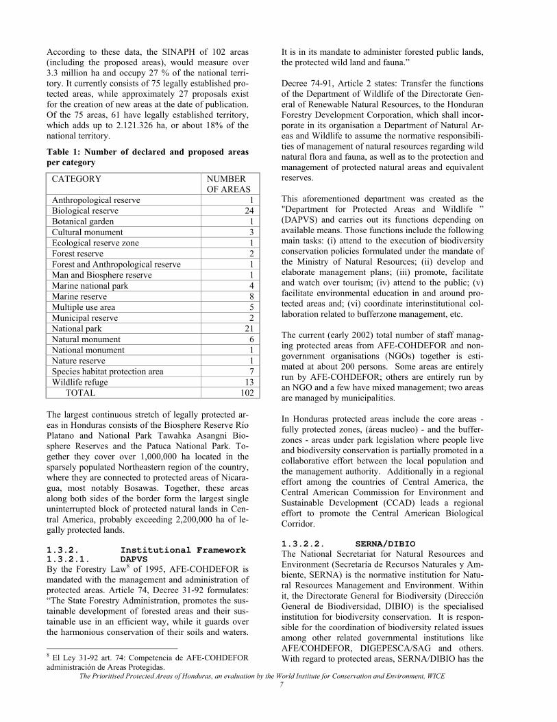
According to these data, the SINAPH of 102 areas (including the proposed areas), would measure over 3.3 million ha and occupy 27 % of the national terri-tory. It currently consists of 75 legally established pro-tected areas, while approximately 27 proposals exist for the creation of new areas at the date of publication. Of the 75 areas, 61 have legally established territory, which adds up to 2.121.326 ha, or about 18% of the national territory.
Table 1: Number of declared and proposed areas per category
CATEGORY NUMBER OF AREAS
Anthropological reserve 1 Biological reserve 24 Botanical garden 1 Cultural monument 3 Ecological reserve zone 1 Forest reserve 2 Forest and Anthropological reserve 1 Man and Biosphere reserve 1 Marine national park 4 Marine reserve 8 Multiple use area 5 Municipal reserve 2 National park 21 Natural monument 6 National monument 1 Nature reserve 1 Species habitat protection area 7 Wildlife refuge 13 TOTAL 102
The largest continuous stretch of legally protected ar-eas in Honduras consists of the Biosphere Reserve Río Platano and National Park Tawahka Asangni Bio-sphere Reserves and the Patuca National Park. To-gether they cover over 1,000,000 ha located in the sparsely populated Northeastern region of the country, where they are connected to protected areas of Nicara-gua, most notably Bosawas. Together, these areas along both sides of the border form the largest single uninterrupted block of protected natural lands in Cen-tral America, probably exceeding 2,200,000 ha of le-gally protected lands. 1.3.2. Institutional Framework 1.3.2.1. DAPVS By the Forestry Law8 of 1995, AFE-COHDEFOR is mandated with the management and administration of protected areas. Article 74, Decree 31-92 formulates: “The State Forestry Administration, promotes the sus-tainable development of forested areas and their sus-tainable use in an efficient way, while it guards over the harmonious conservation of their soils and waters.
It is in its mandate to administer forested public lands, the protected wild land and fauna.” Decree 74-91, Article 2 states: Transfer the functions of the Department of Wildlife of the Directorate Gen-eral of Renewable Natural Resources, to the Honduran Forestry Development Corporation, which shall incor-porate in its organisation a Department of Natural Ar-eas and Wildlife to assume the normative responsibili-ties of management of natural resources regarding wild natural flora and fauna, as well as to the protection and management of protected natural areas and equivalent reserves. This aforementioned department was created as the "Department for Protected Areas and Wildlife ” (DAPVS) and carries out its functions depending on available means. Those functions include the following main tasks: (i) attend to the execution of biodiversity conservation policies formulated under the mandate of the Ministry of Natural Resources; (ii) develop and elaborate management plans; (iii) promote, facilitate and watch over tourism; (iv) attend to the public; (v) facilitate environmental education in and around pro-tected areas and; (vi) coordinate interinstitutional col-laboration related to bufferzone management, etc. The current (early 2002) total number of staff manag-ing protected areas from AFE-COHDEFOR and non-government organisations (NGOs) together is esti-mated at about 200 persons. Some areas are entirely run by AFE-COHDEFOR; others are entirely run by an NGO and a few have mixed management; two areas are managed by municipalities. In Honduras protected areas include the core areas - fully protected zones, (áreas nucleo) - and the buffer-zones - areas under park legislation where people live and biodiversity conservation is partially promoted in a collaborative effort between the local population and the management authority. Additionally in a regional effort among the countries of Central America, the Central American Commission for Environment and Sustainable Development (CCAD) leads a regional effort to promote the Central American Biological Corridor. 1.3.2.2. SERNA/DIBIO The National Secretariat for Natural Resources and Environment (Secretaría de Recursos Naturales y Am-biente, SERNA) is the normative institution for Natu-ral Resources Management and Environment. Within it, the Directorate General for Biodiversity (Dirección General de Biodiversidad, DIBIO) is the specialised institution for biodiversity conservation. It is respon-sible for the coordination of biodiversity related issues among other related governmental institutions like AFE/COHDEFOR, DIGEPESCA/SAG and others. With regard to protected areas, SERNA/DIBIO has the
The Prioritised Protected Areas of Honduras, an evaluation by the World Institute for Conservation and Environment, WICE 7
8 El Ley 31-92 art. 74: Competencia de AFE-COHDEFOR administración de Areas Protegidas.
mandate to propose legislation for declaring protected areas to the Congress of the Republic. DIBIO also is the focal point for GEF and the man-dated institution for international programmes such as the Mesoamerican Biological Corridor (MBC), the Mesoamerican Reef System (SAM) initiatives of the CCAD, the Trinacional Alliance on the Golf of Hon-duras (TRIGOH) with Belize and Guatemala and the coordination of the Scientific Authority of CITES in Honduras. In 2001, DIBIO finished the Study on Bio-diversity of Honduras, a regional action under the aus-pices of the CCAD for all countries of Central Amer-ica, as well as aforementioned ENBRA. 1.3.2.3. IHT The Instituto Hondureño de Turismo (IHT) was cre-ated in 1993 under decree No. 103-93. The principle mandate of the institution deal with execution of the national tourism policy, regulation, tourism zoning and promotion of tourism to Honduras and strengthen the private sector. Its primary relation with management of protected areas is the importance of protected areas for the tourism sector. It has selected priority areas for tourism and it advises DAPVS on certain protected areas visitation issues. 1.3.2.4. DIGEPESCA Normation and regulation of fishing in Honduras are the mandate of the Directorate General of Fishing and Aquaculture (Dirección General de Pesca y Acuacul-tura, DIGEPESCA) of the National Secretariat of Ag-riculture and Cattle Raising (Secretaría de Agricultura y Ganadería, SAG). It has regional offices in San Pedro Sula, La Ceiba, Trujillo, Islas de la Bahía, Puerto Lempira and San Lorenzo. One of the main limitations of DIGEPESCA is that it is very difficult to apply the law which dates back to 1959. During the Modernisation of the State, only commercial activities were left to DIGEPESCA, while the regulation of non-commercial aquatic organisms was delegated to DAPVS. The primary fishery resources in Honduras are the shrimp, lobster, conch, crab and scale fish. In 1971 the fishing fleet counted only 28 ships and 17 shrimp farms. In 1997 Honduras had grown to be the largest fishing nation of Central America with 118 registered ships, 171 shrimp farms, 42 fishing ships and 10 conch fishing ships. The commercial fishing fleet operates in the Caribbean. The Golfo de Fonseca Honduras is the principle area for production of shrimp in Aquaculture. For this purpose large quantities of larvae and postlar-vae are caught at from the coastal waters of the estu-ary. Regular fishing in the Pacific Ocean only takes place on a small scale. 1.3.2.5. CONABIOH The National Committee of Honduras on Biodiversity (Comisión Nacional de Biodiversidad de Honduras,
CONABIOH) advises the Government on decisions regarding biodiversity, such as on the ENBRA. It is composed of a group of specialists of different related fields as well as representatives of actors focussed on biodiversity and natural resources management. It was formed on initiative from the CCAD in elaboration of the Convention of the Conservation and Protection of Natural Areas in Central America, which was ratified by Honduras in Legislative Decree 183-94 of Decem-ber 1994. The secretariat is carried out by DIBIO and it has four specialised technical committees: (1) Bio-ethics, (2) Biotechnology and Biosecurity, (3) Sustain-able use of Biodiversity, (4) Conservation of Genetic Resources. 1.3.2.6. NGOs AFE-COHDEFOR has delegated the management of 21 protected areas to NGOs. Table 2, "NGOs manag-ing Protected Areas", lists the NGOs, their headquar-ters and the area(s) they administer.
The Prioritised Protected Areas of Honduras, an evaluation by the World Institute for Conservation and Environment, WICE 8
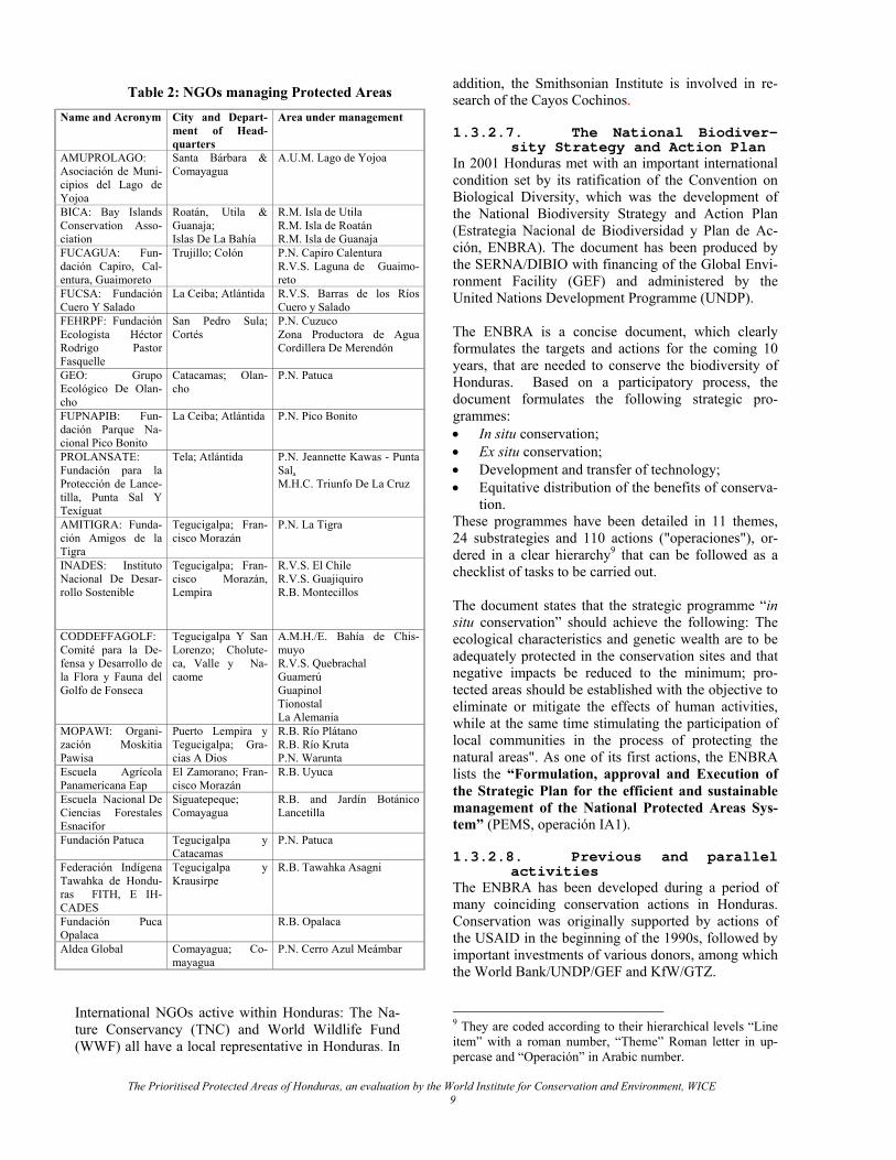
Table 2: NGOs managing Protected Areas Name and Acronym City and Depart-
ment of Head-quarters
Area under management
AMUPROLAGO: Asociación de Muni-cipios del Lago de Yojoa
Santa Bárbara & Comayagua
A.U.M. Lago de Yojoa
BICA: Bay Islands Conservation Asso-ciation
Roatán, Utila & Guanaja; Islas De La Bahía
R.M. Isla de Utila R.M. Isla de Roatán R.M. Isla de Guanaja
FUCAGUA: Fun-dación Capiro, Cal-entura, Guaimoreto
Trujillo; Colón
P.N. Capiro Calentura R.V.S. Laguna de Guaimo-reto
FUCSA: Fundación Cuero Y Salado
La Ceiba; Atlántida R.V.S. Barras de los Ríos Cuero y Salado
FEHRPF: Fundación Ecologista Héctor Rodrigo Pastor Fasquelle
San Pedro Sula; Cortés
P.N. Cuzuco Zona Productora de Agua Cordillera De Merendón
GEO: Grupo Ecológico De Olan-cho
Catacamas; Olan-cho
P.N. Patuca
FUPNAPIB: Fun-dación Parque Na-cional Pico Bonito
La Ceiba; Atlántida P.N. Pico Bonito
PROLANSATE: Fundación para la Protección de Lance-tilla, Punta Sal Y Texíguat
Tela; Atlántida P.N. Jeannette Kawas - Punta Sal, M.H.C. Triunfo De La Cruz
AMITIGRA: Funda-ción Amigos de la Tigra
Tegucigalpa; Fran-cisco Morazán
P.N. La Tigra
INADES: Instituto Nacional De Desar-rollo Sostenible
Tegucigalpa; Fran-cisco Morazán, Lempira
R.V.S. El Chile R.V.S. Guajiquiro R.B. Montecillos
CODDEFFAGOLF: Comité para la De-fensa y Desarrollo de la Flora y Fauna del Golfo de Fonseca
Tegucigalpa Y San Lorenzo; Cholute-ca, Valle y Na-caome
A.M.H./E. Bahía de Chis-muyo R.V.S. Quebrachal Guamerú Guapinol Tionostal La Alemania
MOPAWI: Organi-zación Moskitia Pawisa
Puerto Lempira y Tegucigalpa; Gra-cias A Dios
R.B. Río Plátano R.B. Río Kruta P.N. Warunta
Escuela Agrícola Panamericana Eap
El Zamorano; Fran-cisco Morazán
R.B. Uyuca
Escuela Nacional De Ciencias Forestales Esnacifor
Siguatepeque; Comayagua
R.B. and Jardín Botánico Lancetilla
Fundación Patuca Tegucigalpa y Catacamas
P.N. Patuca
Federación Indígena Tawahka de Hondu-ras FITH, E IH-CADES
Tegucigalpa y Krausirpe
R.B. Tawahka Asagni
Fundación Puca Opalaca
R.B. Opalaca
Aldea Global Comayagua; Co-mayagua
P.N. Cerro Azul Meámbar
International NGOs active within Honduras: The Na-ture Conservancy (TNC) and World Wildlife Fund (WWF) all have a local representative in Honduras. In
addition, the Smithsonian Institute is involved in re-search of the Cayos Cochinos. 1.3.2.7. The National Biodiver-
sity Strategy and Action Plan In 2001 Honduras met with an important international condition set by its ratification of the Convention on Biological Diversity, which was the development of the National Biodiversity Strategy and Action Plan (Estrategia Nacional de Biodiversidad y Plan de Ac-ción, ENBRA). The document has been produced by the SERNA/DIBIO with financing of the Global Envi-ronment Facility (GEF) and administered by the United Nations Development Programme (UNDP). The ENBRA is a concise document, which clearly formulates the targets and actions for the coming 10 years, that are needed to conserve the biodiversity of Honduras. Based on a participatory process, the document formulates the following strategic pro-grammes: • In situ conservation; • Ex situ conservation; • Development and transfer of technology; • Equitative distribution of the benefits of conserva-
tion. These programmes have been detailed in 11 themes, 24 substrategies and 110 actions ("operaciones"), or-dered in a clear hierarchy9 that can be followed as a checklist of tasks to be carried out. The document states that the strategic programme “in situ conservation” should achieve the following: The ecological characteristics and genetic wealth are to be adequately protected in the conservation sites and that negative impacts be reduced to the minimum; pro-tected areas should be established with the objective to eliminate or mitigate the effects of human activities, while at the same time stimulating the participation of local communities in the process of protecting the natural areas". As one of its first actions, the ENBRA lists the “Formulation, approval and Execution of the Strategic Plan for the efficient and sustainable management of the National Protected Areas Sys-tem” (PEMS, operación IA1). 1.3.2.8. Previous and parallel
activities The ENBRA has been developed during a period of many coinciding conservation actions in Honduras. Conservation was originally supported by actions of the USAID in the beginning of the 1990s, followed by important investments of various donors, among which the World Bank/UNDP/GEF and KfW/GTZ. 9 They are coded according to their hierarchical levels “Line item” with a roman number, “Theme” Roman letter in up-percase and “Operación” in Arabic number.
The Prioritised Protected Areas of Honduras, an evaluation by the World Institute for Conservation and Environment, WICE 9
The involvement of the World Bank in the environ-ment sector of Honduras started with the Environment Development Project in 1995, which, among other things, resulted in the creation of SERNA and DIBIO. In 1998 the twin projects PAAR (IDA funding) and PROBAP (GEF funding) were initiated under joint execution by COHDEFOR, the World Bank and UNDP. Those projects have been designed to strengthen the national biodiversity conservation ef-forts with a strong investment in a number of protected areas of SINAPH; the current study is a part of that effort.
• Monitoring • Infrastructure The current document deals with Programme 2, Planning and evaluation, but as a result of the study, various recommendations also deal in part with several of other the other programmes. Previous to the present study, several activities of the ENBRA had to be in place: • Updating of the Life Zones Map (IA11)10 • Development of the ecosystems map (IA12) • Production of the protected areas map (IA13) Actions (IA11) and (IA12) were available prior to the study and action (IA13) has been carried out to facili-tate the current study under a separate contract.
The biodiversity component of the PAAR project in-vests in the areas of national and international signifi-cance outside of the Mesoamerican Biological Corri-dor (MBC), while the PROBAB project focuses on areas that form part of the MBC. They also develop a mechanism of self financing and promotion of in-volvement of NGOs and local communities. One of the important achievements of these projects has been the production of the Ecosystems Map of Honduras. This map, gives rise to hope, since it clearly shows that con-siderable stretches of land are covered with a broad range of different habitats. In fact, in the following chapters, we will show that most of Honduras’s biodi-versity still survives and thanks to the ecosystems map we now know where to find it. Almost all of it is right where we want it to be: in the Honduran Protected Areas System, SINAPH.
1.4.OBJECTIVES OF THE STUDY A national biodiversity conservation system assumes a series of measures, which provide conditions to - hu-manly speaking - secure the continuity of the maxi-mum number of species in a given country. The ques-tion is “What is a realistic scenario?” With a proposed SINAPH covering 27 percent of the national territory, a Honduran population approaching 9,000,000 inhabi-tants in by the year 2020 (Wilson et al.), and one of the poorest populations in the region, the country needs to become efficient in its biodiversity conservation ef-forts. While conservationists would like to conserve all species native to the country, the pressures of soci-ety render such wishes difficult to achieve. There is not enough land available to host all native species, nor are there sufficient funds to properly manage them. The challenge is to strike a broadly accepted balance between the "maximum number of species" and the broad range of other aspirations of the society as a whole. To make such analysis, one needs to select ar-eas on the bases of sound scientific criteria. In pursuit of such balance, this study has been formulated to ful-fil the following objectives:
1.3.2.9. A Strategic plan for an
efficient and sustainable man-agement of SINAPH (PEMS)
The development of the PEMS was considered one of the most critical and urgent actions of the ENBRA, as it deals with what must be considered the heart of bio-diversity conservation: The establishment and man-agement of protected natural areas is one of the most effective ways to warrant the conservation and sustain-able development of natural resources in Honduras. It is clear from the ENBRA that the primary objective of SINAPH is to durably provide conditions and in situ shelter to a representative set of the Flora and Fauna of Honduras, and to provide environmental services com-patible with the first objective, such as: (1) production of high quality water – particularly if taken from within or at the periphery of a protected area – (2) visi-tation, (3) environmental education, (3) gene pool, (4) conservation of outstanding landscapes, etc. The final draft of the PEMS was presented at the end of 2001.
• Identify on the basis of scientific biological crite-ria:
The protected areas in the of national and international significance for biodiversity protection;
Important conservation gaps in SINAPH and according to need propose the crea-tion of (a) new protected area(s);
Areas with other management priorities to be managed by more appropriate or-ganisations like local governments or private institutions;
• Propose an integrated rational, cost-effective and affordable in situ biodiversity conservation system of national significance;
The PEMS too has been structured for efficient and logical execution and lists the following programmes: • Institutional Development of SINAPH • Planning and Evaluation • Environmental Services • Research • Communication
The Prioritised Protected Areas of Honduras, an evaluation by the World Institute for Conservation and Environment, WICE 10
10 As the ecosystems map not only considers many ecologi-cal data and floristic data but also climatic elements, the ecosystems map is much more detailed than the Life Zones methodology. Therefore, action (IA11) may be considered to be executed.
• Propose areas to be eligible for financing by the Protected Areas Trust (FAP);
• Prepare cost estimates of the rationalised biodiver-sity conservation system;
• Review and propose – according to need – to re-categorise the protected areas of the proposed sys-tem;
• Identify the primary environmental services op-portunities of the proposed system, with emphasis on tourism;
• Present a solid science-based document for fund-raising among international donors.
2. METHOD
An important task of planners is to regulate land-uses to meet certain objectives, so that the results differ from those expected from spontaneous development. This usually comes with certain requirements or limi-tations as compared to unregulated use, and conse-quently it has an impact, particularly on local commu-nities. In the case of conservation lands, conversion of natural habitat into productive land is usually prohib-ited, as well as non-regulated hunting and gathering. Once established, very little management of the natural resources themselves are required. Nevertheless, they cannot be left unattended; they need continuous atten-tion, such as public relations care, monitoring and pa-trolling, which are activities, requiring staff, buildings and equipment. Each additional hectare involves addi-tional costs. Such costs will re-occur every year. Thus, by setting aside land for conservation, a society en-forces certain limitations on local communities and assumes a long-term financial commitment to meet with the management requirements. Once conservation lands have been designated, policy makers and managers have to make choices, such as, where to finance what activities, which areas need more attention, what locations can be used by the pub-lic and which areas should never be impaired. They need to weight the importance of many different pa-rameters. For complex multifactor planning, decision-makers may benefit from a computer programme to help them in dealing with multiple variables in a con-sistent way. AFE-COHDEFOR has decided to have such analysis be carried out by the MICOSYS programme of the World Institute for Conservation and Environment to compare areas on the basis of scores for biological, socio-economical and cultural variables. 2.1.COST-EFFECTIVENESS The most efficient way of setting up and maintaining a national biodiversity conservation system is by com-posing an integrated system which warrants the con-servation of the maximum number of species on the minimum area of land and water at minimal costs. A
system that would incorporate one example of each existing ecosystem thus provides the highest biodiver-sity on a minimum area of land. However, one exam-ple of each ecosystem would provide a low level of security for continuity, as many species could become extinct at once by natural disasters such as fires and hurricanes. A safe minimum standard of conserva-tion should be set to secure continuity of biodiversity, while restricting conservation land claims to the strictly necessary. 2.2.COMPARATIVE WEIGHTING 2.2.1. Computer aided weight-
ing The comparative weighting takes place on the basis of a selection of ecological, taxonomical and socio-economical variables. Each variable can be assigned a value or algorithm on the basis of a professional judgement; thus, each value by its very nature is sub-jective. But once established, the processing of each parameter is carried out mathematically and performed identically for each variable and each area. As the pa-rameters become numbers, the MICOSYS programme facilitates the paradoxical exercise of "adding apples and oranges". In the end it comes up with a numerical score for each evaluated area, which has come about by identical calculations. Such scores allow relative comparisons between the different areas. Of course those values are indicative and should not be used in an absolute sense. 2.2.2. Evaluation parameters The current study evaluates the intrinsic values of the protected areas of the SINAPH, taking ecosystems and species of special concern, as its point of departure. Although the primacy of biodiversity and natural heri-tage values in ascribing protected area status is pre-eminent, many protected areas in Honduras also serve to provide environmental services, notably tourism, recreation, production of drinking water, research and education. Where appropriate, the programme assigns those services-potential a value. Obviously, not all purposes can be served in a biodi-versity conservation system and one must determine what is desired. As SINAPH’s role as the prime terri-tory for in situ biodiversity conservation, one must select those areas of SINAPH that are indispensable for conservation purposes and where biodiversity con-servation management objectives must prevail. In those areas non-consumptive environmental services are possible, but those must always be subject to limi-tations set by the primary objective of the area, which is biodiversity conservation. Some elements must be weighted that must be considered as threatening or negative elements in the evaluation and the programme may assign a negative value to such conditions.
The Prioritised Protected Areas of Honduras, an evaluation by the World Institute for Conservation and Environment, WICE 11
The programme has been set up to weight the follow-ing parameters of the protected areas of SINAPH: • Size of the reserves • Size of the land/water under cultivation • Tourism value • Environmental ducation • Scientific research • Size of economically used parts of watersheds • Ecosystems • Geomorphologic highlights • Extraordinarily scenic landscapes • Archaeological remains • Species of special concern • Investment costs • Recurrent costs • Staffing needs The detailed argumentation for their selection and their weighting is explained in Volume VI, Manual MICO-SYS. For the purpose of valuation, all legally declared protected areas, as well as those proposed protected areas that have a territorial definition in their proposal have been polygonised and measured in hectares, using the ArcView 3.1 GIS software of ESRI. This has fa-cilitated measurements of territory related validations, such as ecosystems and productive lands. By many, SINAPH is considered to include both le-gally established areas and proposed areas. Legally, this is not a correct approach, as merely proposing an area in a study cannot be supposed to have any legal status. In this study we make an explicit distinction between those areas that are legally established and those that are not. We also must draw the attention to the fact that a number of areas are legally declared, but without any territorial definition or co-ordinates. Such areas lack territory and must also be considered to be non-existing until their co-ordinates are legally estab-lished. Such areas are treated as proposed areas. 2.2.2.1. Size of the reserves The size of a protected area is important for its effec-tiveness as an in situ conservation instrument for the following reasons: • The number of species present in an ecosystem
increases with size; • With increasing size, a protected area is likely to
harbour more different ecosystems; • Some species migrate within their range during
their life cycle or during a season cycle (different parts of a watershed, different elevations). Larger areas are more likely to foresee in all requirements of such cycles.
• The population sizes of organisms in larger territo-ries are bigger and are therefore more resilient to fluctuations and support greater genetic flow; this
is particularly relevant for species in need of large territories.
• Large areas have a more favourable sur-face/periphery ratio and as a result, negative ex-ternal effects have less of an impact on the area as a whole. Also management is relatively cheaper, as management is particularly directed at preven-tion and mitigation of external effects.
We must bare in mind however, that while the impor-tance of a protected area increases with its size, these benefits do not increase in a straightforward fashion, they rather follow a declining curve, particularly the increasing number of species captured (Arrhenius, 1921). 2.2.2.2. Size of the land under
cultivation Many protected areas in Honduras have lands or wa-ters (shrimp farms) under some form of productive land-use. These lands have been identified and mapped as productive lands in the Ecosystems map. Those areas are no longer very suitable for vital eco-systems with their organisms. Therefore, the sizes of the productive lands within the protected areas have been measured and valued negatively. 2.2.2.3. Tourism value Particularly the national parks, who’s secondary objec-tive is “to provide enjoyment for present and future generations”, may have important tourism values. Points are assigned for present and potential value. Very inaccessible areas like the ones in the Mosquitia triangle are not granted any points11. 2.2.2.4. Education Education may generally be considered to be covered under tourism value12, a few cases stand out well above the average conditions of tourism potential. These are areas with easy access at a very short dis-tance from a major city: • La Tigra visible from Tegucigalpa; • El Merendon dominating the skyline of San Pedro
Sula; • Pico Bonito “watching” over La Ceiba. 2.2.2.5. Scientific research The benefits of scientific research for society are too evident and broad to even make an attempt to list them in this brief paragraph. There are some beneficial op-portunities of research in protected areas, however, that are often overlooked. Protected areas attract for-eign researchers that can only study tropical biology in the tropics. Particularly interesting are research sta-tions that are established in co-operation between a national and foreign institution. Such centres create
11 The Biosphere Reserve Río Plátano had about 1500 visi-tors in 2001 and has been assigned 20 points (see Annex IV).
The Prioritised Protected Areas of Honduras, an evaluation by the World Institute for Conservation and Environment, WICE 12
12 Tourism to protected areas has a high educational signifi-cance, particularly for families with children.
local employment, opportunities for national scientists to benefit from foreign knowledge, increased scientific output, foreign currency generation, etc. In Honduras the best example has been the centre at Cayos Cochi-nos, that for some time had been maintained in col-laboration between a national NGO and the Smith-sonian Institute. The Lancetilla Botanical Garden has initiated an effort to become the tropical research cen-tre for Northern Honduras, for which it already is rather well equipped and suitably located. 2.2.2.6. Size of economically
used parts of watersheds All land is part of one watershed or the other, and giv-ing a value to all analysed areas would merely lead to the repetition of the validation of the total land size. Therefore only those parts of watershed are taken into considerations that are actually used to produce water for drinking water or hydroelectric purposes. Sizes must be calculated as the watersheds above the intake points. 2.2.2.7. Ecosystems The Map of the Ecosystems of Central America (Vreugdenhil, 2002, The World Bank, 2002 http://www.birdlist.org/cam/themes/map_download_page.htm) has been produced to give better insights into wealth and distribution of species of Belize, Guate-mala, El Salvador, Honduras, Nicaragua, Costa Rica and Panama. The Honduran Ecosystems Map forms the Honduras section in that integrated regional map. The Ecosystems Map of Honduras was produced using the UNESCO system (Mueller-Dombois & Ellenberg, 1974), which is fundamentally a species independent physiognomic, hierarchical vegetation classification system. It takes into account ecological factors such as climate, elevation, seasonality and human intervention (Vreugdenhil et al., 2002). One of the main advantages of this system is that the distribution of many ecosys-tems that can be observed in the field can also be rec-ognised on satellite images. Furthermore, satellite im-ages normally clearly show human intervention in primary vegetation and therefore an ecosystems map based on the combination of the UNESCO classifica-tion and satellite images shows the actual status of ecosystem conservation at the time the satellite image was taken. The map of Honduras was based on images taken in the period 1994 – 2000, and as a result, some of the shapes of the ecosystem polygons may be somewhat outdated. Vreugdenhil, et al., (2002), argue that the ecosystem classes mapped in the Central American Ecosystems Map represent fairly distinct – though often partially overlapping – sets of species. However, since we as-sume that the UNESCO classes, particularly if ex-tended with diagnostic species, represent sets of spe-cies and their mutual interrelationships and processes,
fauna elements are as intrinsic to the ecosystem classes of the Central American Ecosystems Map (Vreugden-hil, et al., 2002) as are flora elements. The ecosystem classes are therefore currently the closest proxy avail-able to provide a differentiation of species sets that is not biased by such common factors as access or insti-tutionalised study areas. 2.2.2.8. Geomorphologic high-
lights Most protected areas systems in the world include spe-cial or unique geomorphologic formations. Such high-lights are expressions of the physical nature that are not necessarily important for biodiversity conservation, but which form an inseparable part of nature and which are highly valued for their aesthetic beauty. Such formations may include rocks of a remarkable coloration or shape, caves, water wells, waterfalls, canyons, etc. 2.2.2.9. Extraordinarily scenic
landscapes Extraordinary landscapes are different from the previ-ous tourism value in the sense that they apply to condi-tions of a more generic nature. A protected area of extremely difficult access may still provide a beautiful landscape from a distance, while an area with very easy access may have greater tourism potential while sometimes having lesser scenic landscape value. 2.2.2.10. Archaeological remains In some cases protected areas may host the last links with our past in the form of archaeological remains. They may vary from isolated pre-historical tools to unique monuments. In this study only the most con-spicuous monuments have been taken in consideration. 2.2.2.11. Species of special con-
cern In previous paragraphs we have argued that the ecosys-tems of the Ecosystems Map of Honduras responsibly serves as a proxy for species in a representation/gap analysis. In theory they would include all the sets of species of special concern and the ecosystem classes would distribute them without sampling bias. Never-theless, regular species13 of special concern and en-demic species are also considered in the system. 2.2.3. Protected areas system
requirements 2.2.3.1. Species representation Every 10 years, the International Union for the Con-servation of Nature (IUCN, which unites more than 980 conservation government institutions and NGOs from more than 140 countries, http://IUCN.org) organ-ises “World Parks Congresses. The IIIrd World Parks Congres was held in Bali, Indonesia. The Congress adopted what is referred to as the “Bali Declaration”, which called for 'the establishment, by 1993, of a
The Prioritised Protected Areas of Honduras, an evaluation by the World Institute for Conservation and Environment, WICE 13
13 These terms are elaborated in the Manual of MICOSYS.
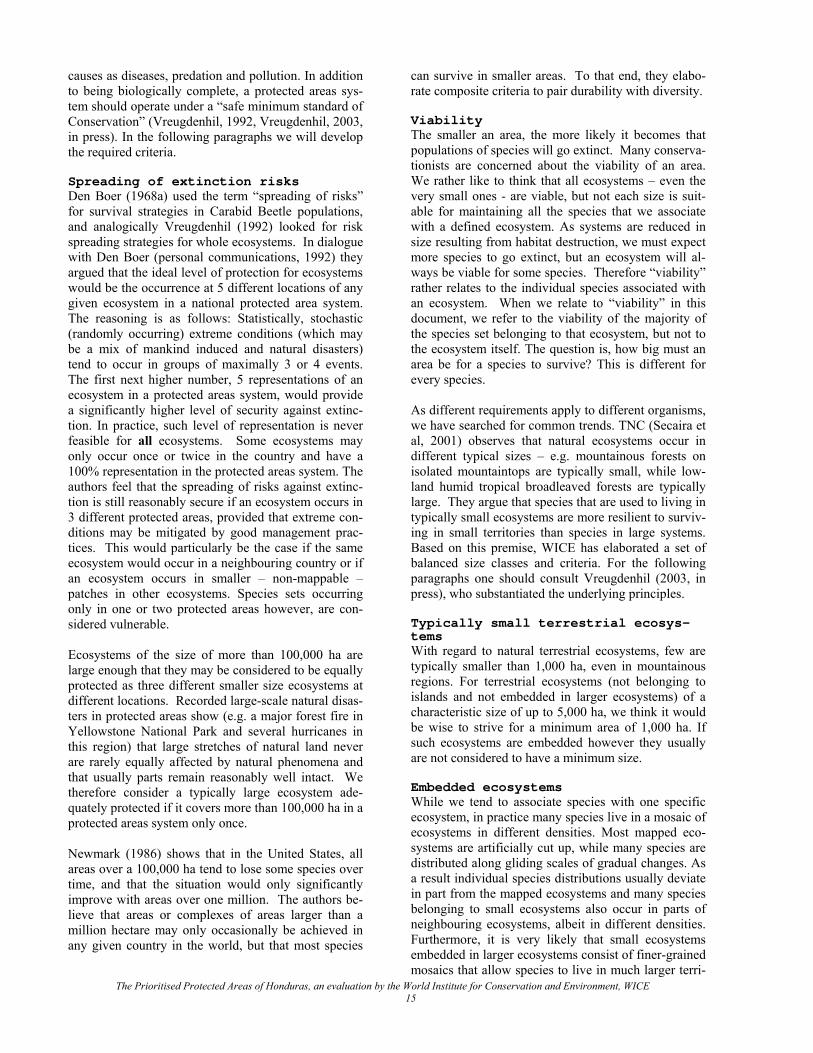
worldwide network of national parks and protected areas, exemplifying all terrestrial ecological regions". It was also agreed at the Congress that a bio-geographical approach should be used in selecting additional protected areas. In the underlying Bali Action Plan, the objective was set to expand the worldwide network of protected areas to 10% of all terrestrial ecological regions. An important question is if that target can meet the expectations of society and durably conserve a significant representation of the variety of life on earth? Vreugdenhil (2003, in press, elaborates this issue and the present document is based on his findings. In order to answer that question, one can use one of the oldest models in ecology, which is broadly accepted among both plant- and animal ecologists. Based on investigation of species diversity within certain delim-ited plots, Arrhenius concluded that the number of species increases continuously less as the area in-creases. This phenomenon, is known as the spe-cies/area relationship (SAR). This is reflected in the quantitative formula S = cAz, in which S represents the number of species and A the size of the area. The con-stant c is an empirically determined multiplier that varies among taxa and areas (USA Commission on Life Sciences, 1995), and which may be ignored when comparing the percentages of S and A, as done in this analysis. The exponent z varies according to the topog-raphic diversity and isolation of the area. It is usually larger for islands (around 0.3) than for the mainland (commonly assumed less that 0.2); Dobson, (1996) suggests 0.15.
Figure 1: Estimate of percentile extinction of species in function of percentile habitat destruction. The x axis shows how the percentage of species numbers de-creases with the percentage of remaining of any given ecosystem. Curve “a” shows the percentile species loss for z = 0.3 and curve “b” for z = 0.15.
Figure 1 plots the percentages of species lost against the percentage of ecosystem lost for (a) an island situa-tion in which z = 0.3 and (b) for a large land mass in which z = 0.15. The curve is often referred to as the
“species-area curve”. Figure 2: “Estimate of percentile extinction of species in function of percentile habitat destruction” plots the percentile extinction of species in function of percentile habitat destruction. These hold true irrespective of the type of ecosystem, cli-matic conditions, geographical position or its species density. Some interesting positions for mainland con-ditions are: 5 percent of an ecosystem would conserve more than 60 percent of the species, 10 percent would protect about 70 percent of the species and 30 percents protects about 80% of the species. Above 30 % even large increases in total area would add proportionally very few species. To increase inclusion of species, one should target inclusion of a sample of every ecosystem still existing in the country. Given the detail of ecosystem mapping feasible for even large regions with the UNESCO clas-sification system (Mueller-Dombois, & Ellenberg, 1974), the application of maps based on this method will significantly boost the number of species in con-servation systems. At this level of detail however, it is rarely possible to target 10 % of the historically pre-sent territory of the ecosystems, and the authors feel that targeting 10 % of the currently still surviving eco-systems is more realistic. This will be further elabo-rated later in the document. The mapping information about Honduras based on the “Map of the Ecosystems of Central America” is much more detailed than the coarse “terrestrial ecological regions” defined in the Bali Declaration. This allows the development of very realistic and cost-effective biodiversity conservation system models with high species representation and reasonable conservation security (see Vreugdenhil, 2003, in press). 2.2.3.2. Safe Minimum Standard
of Conservation While presence/absence of species in a conservation system should be the first selection criteria, it certainly is not the only one. After all, it would be of little avail, if we would select a system of protected areas in which many of the species that we target to conserve will not be able to survive. The most efficient way of setting up and maintaining a conservation system is by com-posing an integrated system which includes the maxi-mum number of species on the minimum area of land and water. Having just one example of each existing ecosystem would thus provide the highest biodiversity on a minimum area of land and at a minimum cost. However, having just one example of each ecosystem would provide a low level of security for continuity, as over time, ecosystems get exposed to serious distur-bances and mishaps. Large proportions of sets of spe-cies belonging to a certain ecosystem may become locally extinct when stricken by natural disasters such as fires and hurricanes, while individual species are subject to terminal fluctuation risks, inflicted by such
The Prioritised Protected Areas of Honduras, an evaluation by the World Institute for Conservation and Environment, WICE 14
causes as diseases, predation and pollution. In addition to being biologically complete, a protected areas sys-tem should operate under a “safe minimum standard of Conservation” (Vreugdenhil, 1992, Vreugdenhil, 2003, in press). In the following paragraphs we will develop the required criteria. Spreading of extinction risks Den Boer (1968a) used the term “spreading of risks” for survival strategies in Carabid Beetle populations, and analogically Vreugdenhil (1992) looked for risk spreading strategies for whole ecosystems. In dialogue with Den Boer (personal communications, 1992) they argued that the ideal level of protection for ecosystems would be the occurrence at 5 different locations of any given ecosystem in a national protected area system. The reasoning is as follows: Statistically, stochastic (randomly occurring) extreme conditions (which may be a mix of mankind induced and natural disasters) tend to occur in groups of maximally 3 or 4 events. The first next higher number, 5 representations of an ecosystem in a protected areas system, would provide a significantly higher level of security against extinc-tion. In practice, such level of representation is never feasible for all ecosystems. Some ecosystems may only occur once or twice in the country and have a 100% representation in the protected areas system. The authors feel that the spreading of risks against extinc-tion is still reasonably secure if an ecosystem occurs in 3 different protected areas, provided that extreme con-ditions may be mitigated by good management prac-tices. This would particularly be the case if the same ecosystem would occur in a neighbouring country or if an ecosystem occurs in smaller – non-mappable – patches in other ecosystems. Species sets occurring only in one or two protected areas however, are con-sidered vulnerable. Ecosystems of the size of more than 100,000 ha are large enough that they may be considered to be equally protected as three different smaller size ecosystems at different locations. Recorded large-scale natural disas-ters in protected areas show (e.g. a major forest fire in Yellowstone National Park and several hurricanes in this region) that large stretches of natural land never are rarely equally affected by natural phenomena and that usually parts remain reasonably well intact. We therefore consider a typically large ecosystem ade-quately protected if it covers more than 100,000 ha in a protected areas system only once. Newmark (1986) shows that in the United States, all areas over a 100,000 ha tend to lose some species over time, and that the situation would only significantly improve with areas over one million. The authors be-lieve that areas or complexes of areas larger than a million hectare may only occasionally be achieved in any given country in the world, but that most species
can survive in smaller areas. To that end, they elabo-rate composite criteria to pair durability with diversity. Viability The smaller an area, the more likely it becomes that populations of species will go extinct. Many conserva-tionists are concerned about the viability of an area. We rather like to think that all ecosystems – even the very small ones - are viable, but not each size is suit-able for maintaining all the species that we associate with a defined ecosystem. As systems are reduced in size resulting from habitat destruction, we must expect more species to go extinct, but an ecosystem will al-ways be viable for some species. Therefore “viability” rather relates to the individual species associated with an ecosystem. When we relate to “viability” in this document, we refer to the viability of the majority of the species set belonging to that ecosystem, but not to the ecosystem itself. The question is, how big must an area be for a species to survive? This is different for every species. As different requirements apply to different organisms, we have searched for common trends. TNC (Secaira et al, 2001) observes that natural ecosystems occur in different typical sizes – e.g. mountainous forests on isolated mountaintops are typically small, while low-land humid tropical broadleaved forests are typically large. They argue that species that are used to living in typically small ecosystems are more resilient to surviv-ing in small territories than species in large systems. Based on this premise, WICE has elaborated a set of balanced size classes and criteria. For the following paragraphs one should consult Vreugdenhil (2003, in press), who substantiated the underlying principles. Typically small terrestrial ecosys-tems With regard to natural terrestrial ecosystems, few are typically smaller than 1,000 ha, even in mountainous regions. For terrestrial ecosystems (not belonging to islands and not embedded in larger ecosystems) of a characteristic size of up to 5,000 ha, we think it would be wise to strive for a minimum area of 1,000 ha. If such ecosystems are embedded however they usually are not considered to have a minimum size. Embedded ecosystems While we tend to associate species with one specific ecosystem, in practice many species live in a mosaic of ecosystems in different densities. Most mapped eco-systems are artificially cut up, while many species are distributed along gliding scales of gradual changes. As a result individual species distributions usually deviate in part from the mapped ecosystems and many species belonging to small ecosystems also occur in parts of neighbouring ecosystems, albeit in different densities. Furthermore, it is very likely that small ecosystems embedded in larger ecosystems consist of finer-grained mosaics that allow species to live in much larger terri-
The Prioritised Protected Areas of Honduras, an evaluation by the World Institute for Conservation and Environment, WICE 15
tories than the mapped ecosystem units suggest. We therefore expect that embedded small ecosystems usu-ally provide viable conditions for the populations that have established themselves long ago. The number of species typical for that ecosystem however will be smaller in smaller ecosystems than in large ones. Typically large terrestrial ecosys-tems With regard to very large ecosystems, in the level of detail of the Ecosystems Map, very few ecosystems in Central America are of a typical size of more than 50,000 ha to 500,000 ha. More often than not, large natural areas consist of mosaics of several different ecosystems, of much smaller characteristic sizes, meaning that even for large-scale ecosystems, a mini-mum size of 10,000 ha of stand-alone large-scale eco-systems should be enough for the survival of most plant species14 and for most animal species under 1 m. Typically medium size terrestrial ecosystems Somewhere between typically large and small terres-trial ecosystems are medium size ecosystems. After reviewing sizes of ecosystems in Central America, we arbitrarily defined them to be between 5,000 and 50,000 ha, and we assessed their minimum size at 5000 ha, unless embedded. Aquatic ecosystems For aquatic ecosystems, one must rather consider the quantitative and qualitative viability of the water sys-tem (ranging from watersheds, estuaries, and coastal waters to minuscule isolated pools) as a whole, in which many recognized ecosystems are important but inter-dependent ecologically connected subsystems. Such sub-systems – often linear in shape - may be very small and specific species may be associated with them. Even though such species have specific ecologi-cal preferences, many populations of aquatic species cover much larger areas than the ecosystems where the majority of them are found. Most small aquatic ecosys-tems are part of larger aquatic ecosystems, even if they are only occasionally connected (pools, oxbow rivers). Even very small temporarily connected water bodies should be regarded as embedded ecosystems, which may hold viable populations of organisms in very small sizes. On water systems, no minimum size can be suggested. Most terrestrial ecosystems are traversed by rivers and thus include aquatic ecosystems. These aquatic elements in predominantly terrestrial ecosys-tems are usually part of water systems that reach far beyond the protected area, and consequently the viabil-ity of the aquatic species in such areas are subject to the integrity of those entire water systems. Usually integral water management of such systems is required
to warrant the integrity of flora and fauna of gazetted lands. With regard to connectivity between subsystems in water systems, it should be noted that within the latter, connectivity is far better than among terrestrial ecosys-tems. Theories on biological corridors for terrestrial ecosystems often do not apply to aquatic ecosystems, as virtually all aquatic organisms in a water system are connected through swimming, flying or currents. Non-territorially connected “stepping stones” are usually sufficient to connect populations (e.g. migratory birds, manatee) over large distances. Genetic flow A further point of consideration is the concern with genetic flow in small populations of animals requiring large areas. In the past, several animals on the verge of extinction were feared to soon become extinct (Mörzer Bruijns, 1972, pers. com.) because their se-verely reduced populations would be genetically too impoverished to survive. The case of the Przwalski's Horse was given as a showcase. In 1998, during one of his missions, Vreugdenhil learned that the Przwal-ski's Horse was successfully reintroduced to its ances-tral territory, the Mongolian highland prairies. Nowa-days, several species have increased from world wide populations of a few hundred to several hundreds of thousands or more (the American and European Bi-sons, Vicuña) and several species are surviving at less dramatic but more viable numbers after having recu-perated from one or two dozen individuals. While we don’t know is how long a drain on genetic diversity may last, it is clear that the resilience to severe genetic-diversity-drain fortunately is bigger than we feared previously. That does not mean that we should take this concern lightly. Frequent and/or long-term deple-tion of a population to very low numbers will in the end lead to reduced genetic variability and thus re-duced tolerance to continuously changing environ-mental conditions or to the inbreeding of genetic de-fects. Also, the costs of bringing a species back from a very small population to viability are excessively high (thousands of times more costly than keeping species viable in natural ecosystems). The authors just want to make the point that hope should not be given up as long as there are still some individuals alive, but a con-servation system should be designed to avoid condi-tions in which species will decline to extremely low numbers. This cannot always be materialised how-ever, as is the case of the Honduran Emerald (the en-demic humming bird Amazilia luciae). The size of a country allowing, one should strive for at least one area or group of contiguous areas of 1 percent of the national territory or at least 1,000,000 ha, pref-erably larger, in which large birds of prey and mam-malian predators may keep up a healthy population and where large herbivores may roam. Such areas are usu-
The Prioritised Protected Areas of Honduras, an evaluation by the World Institute for Conservation and Environment, WICE 16
14 These criteria need reconsideration for areas with migrat-ing ungulates and possibly the low-diversity macro-ecosystems of the Northern Arctic.
ally not determined by criteria of composition of eco-systems but rather by mere availability.
We have to realise that we live in an era in which spe-cies will disappear forever and not everything can be done to prevent that. We have to search for the best possible solutions in the setting of the societies where we live and work. This means that some ecosystems can only be conserved as isolated islands surrounded by production lands. In these areas certain species can survive while others are bound to be lost. If such eco-systems are the last remnants remaining in a country, the authors feel that they still need to be conserved, even though their habitats cannot be connected to oth-ers, hoping that at least a part of them will turn out to be resilient to ecological isolation.
Many of these larger animals – particularly the mam-malian predators - are not fully dependent on natural habitat. Many may leave natural habitats and roam through rural areas. If left alone, individuals may con-nect with populations of their kind in other protected areas, thus breaking their genetic isolation. In most rural societies, farmers are inclined to hunt down every predator that roams the region. This habit might be diverted if farmers are compensated for the occasional kill of a domestic animal. It is recommended to create a modest (1 percent of the national biodiversity con-servation budget) predator kill compensation fund that operates under a clear set of rules in combination with a campaign to leave wandering predators alone.
When ecological connectivity is not feasible, occa-sionally, human interference may be required in the form of artificial exchange of individuals among popu-lations or assisted re-stocking. This has become com-mon practice in Southern Africa (H.H.T. Prins, 2002, pers. com.). Biological connectivity may not be real-ised if financial resources are restricted or if land-use conditions of the lands between protected areas render such conditions ecologically very difficult. If choices must be made to finance the conservation of a pro-tected area or a connecting corridor, usually the pro-tected area must prevail, as the latter protects more species than the corridor.
Ecological connectivity During periods on a geological time scale, all popula-tions will go extinct, and in nature, local extinction does occur (Den Boer, 1977). Under natural circum-stances, ecosystems that have lost a species, will usu-ally be re-stocked. Whether or not members of another population will replace a locally extinct population depends on many factors, such as the mobility of the species, distance from the nearest population that might re-stock and ecological connectivity. In larger protected areas, many of the smaller species may re-populate vacated sites from within.
A final observation is at place. This analysis has been carried out at a national level, assuming that the Hon-durans would desire to conserve their own national natural heritage. Most species have far wider ranges than the territory of Honduras and their survival is likely to also be secured in neighbouring countries. This will considerably enhance both their likely occur-rence in protected areas as well as their long-term sur-vival chance in the region as a whole.
Biological corridors potentially offer a passage for re-stocking and exchange of genetic material among populations, but in principle, a corridor only serves to that purpose for all organisms if it is ecologically identical to the connected areas. An inhabited terres-trial biological corridor with mainly intervened arbore-ous cover – like shade coffee or agro-forestry planta-tions - provides connectivity to those species that can at least temporarily survive under those intervened conditions and that are mobile; that is a very limited selection of species compared to the ones that live in the connected natural ecosystems. Strong flying spe-cies generally don’t need natural ecosystems as they can fly across unsuitable areas, while weak flyers would fall in a corridor, that is no longer their habitat. Hence, primarily medium sized and big mammals benefit from biological corridors.
2.2.3.3. Requirements for a du-
rable minimum conservation system
Considering the former issues, we suggest to strive after meeting the following criteria to compose a con-servation system with a safe minimum standard of conservation that is broadly representative of at least the presently surviving biodiversity: • 10 percent of the national territory protected under
strict biodiversity conservation legislation and management with no human occupation or land use other than non-consumptive environmental services (Bali Declaration);
Connectivity becomes rather restricted between eco-systems of different nature, even more so if the con-necting ecosystem is still of another (e.g. intervened) type. An extended marshland is a poor biological cor-ridor for most terrestrial organisms and a savannah provides limited connectivity for forest-dwelling spe-cies, while a lowland tropical forest does not provide connectivity for the vast majority of high elevation species.
• 1 protected area or area complex should have a minimum size of 1,000,000 ha (1 percent of the country);
• Incorporate 2 to 3 examples of each ecosystem in different areas;
• Typically small terrestrial ecosystems should have a minimum of 1000 ha;
The Prioritised Protected Areas of Honduras, an evaluation by the World Institute for Conservation and Environment, WICE 17
• Typically large isolated terrestrial ecosystems should have of a minimum of 10,000 ha;
• Typically medium sized isolated terrestrial ecosys-tems should have of a minimum of 5,000 ha;
• Each ecosystem should occur twice at or above its minimum size or as embedded ecosystems, or only once if it covers more than 100,000 ha.
• The integrity of water systems encompassing pro-tected aquatic ecosystems should be conserved through adequate management measures.
• A modest specific set of measures to back the in situ system for threatened species through some ex-situ conservation measures.
It is important to realise that probably no in country in the world all these criteria can be met, and that no sys-tem can be devised that can conserve all species of a country. While trying to meet as well as possible with these criteria in Honduras, the authors believe that this would lead to conserving the highest possible level of species conservation for the country, but that unavoid-ably some species will be lost for Honduras and some for the entire world. 2.2.4. Model development When all the data have been entered into MICOSYS, it will be possible to compose different conservation models. This process requires various steps of evalua-tion and it is very important that the protected areas management is involved in the process at the highest level, so that the managers are fully aware of the dif-ferent choices and in the end are comfortable with the results of the final selection. After all, they will have to live with the selected model and defend it both po-litically and to the public. The first step in the selection of models is the removal of low scoring areas from the table. Criteria for re-moval will vary from study area to study area, depend-ing on the status of conservation. It has become com-mon practice in the application of MICOSYS to recog-nise three levels of quality, based on the final scores. Those levels are set at twice or above the maximum ecosystem value for areas of probable national signifi-cance and once or under the maximum ecosystem value for areas of no national significance: Level 1: Areas whose scores suggest that the areas may be of major importance for conservation of the biodiversity of the country. All those areas should be maintained in the computer programme; Level 2: areas whose conservation significance to the country is not yet quite clear. The level 2 areas should be evaluated individually by examining from where they obtain the scores. If their scores come from an abundance of species of special concern, while factors like size and ecosystems score low values, the area probably is not of national significance for biodiversity conservation. High numbers of species of special con-
cern usually merely indicate that an area is better stud-ied than others. On the other hand, an area that has at least one high score for an ecosystem should be evalu-ated further. A high ecosystem score means that the area either has the largest portion of that ecosystem and/or that it occurs in no more than 1 or 2 other areas. Such areas may be of national significance for biodi-versity conservation. When the non-essential level-2-areas are identified, they should be taken out of the computer programme as well. The Reduced selection of areas has all areas, which may be of national impor-tance, but the programme may still contain an overrep-resentation of ecosystems, which may result in heavy maintenance costs of the protected areas system. Level 3: areas whose levels suggest that they be of very limited relevance to the conservation in the coun-try (areas of merely local or regional importance). Those areas should be taken out of the computer pro-gramme; 2.2.5. Cost estimates As prioritising in biodiversity conservation is not merely a function of biological and social values, but also of financial requirements, MICOSYS has been designed to make rough first estimates of investment needs and recurrent costs as well. As variations in area-specific requirements average out when applied for more areas, the reliability of those estimates in-creases when applied for a large number of areas. First the programme calculates the needs for field sta-tions as a function of the land surface. Then it calcu-lates the staffing needs per field post, which generates a total field-staff need per protected area. It also esti-mates equipment and transportation needs related to staff and buildings, as well as the need for trails. Spe-cial infrastructure needs include regional offices, mul-tiple use centres and visitor centres, which have to be entered individually. Each such type of special build-ings generates its own staffing and equipment re-quirements. Maintenance and write-off are calculated for buildings and equipment. All prices are entered in 2002 US dollar values on the bases of experience of the projects PAAR and PROBAP. Where possible, the data were calibrated with real information as provided by area administrators of the protected areas and DAPVS. 2.3.THE PLANNING TEAM The design of the rationalisation has been carried out under the responsibility of the World Institute for Con-servation and Environment (WICE), an international “nature conservation think tank” that has worked in Europe, the United States, Latin America, Africa and Asia.15
The Prioritised Protected Areas of Honduras, an evaluation by the World Institute for Conservation and Environment, WICE 18
15 Many of its members are experienced conservationists in their countries of residence. It has been instrumental in the financing of GEF, World Bank and UNDP biodiversity pro-
The planning team was composed of the following members: • Ir. Daan Vreugdenhil, Director WICE, specialist
in conservation planning, GIS-ecosystem mapping and eco-tourism;
• Dr. Paul R. House, Professor in Botany, Lecturer in Plant Taxonomy, Pharmaceutical Botany, and Economic Botany, at the National University of Honduras, specialist in ecosystem mapping, tax-onomy and ethno-botany;
• Carlos A. Cerrato B., MSc., Professor Wildlife management, at the National University of Hondu-ras. Zoologist, marine and aquatic biologist;
• Dr. Ana Cristina Pereira, President of the National Commission of Banking and Insurance, Econo-mist with special experience in conservation fi-nancing and knowledgeable amateur orchid bota-nist;
• Lcdo. Ricardo A. Martínez C., Independent advi-sor of the Minister of Tourism, former director of the Instituto Hondureño de Turismo, specialist in tourism, project leader of the national Tourism Strategy and various ecotourism projects and plans;
• Alexis Sánchez, GIS expert; • Lcda. Emily Weitnauer, Tourism specialist; • Lcda. Carmen Linarte, biologist and database
manager. 2.4.INFORMATION SOURCES
Table 3: Information from Institutions and Scien-tists
Information from Institutions and Scientists DAPVS List of Protected Areas, manage-
ment plans, POAs, data on Per-sonal and equipment, Ecosystems map and documentation, other documentation
SERNA ENBRA and documentation UNAH Botanical information IHT National Strategy on Tourism Pilar Thorn M.A., Profesor Departa-mento de Biología UNAH.
Ornithological information on presence of birds in cloud forests and on species of special concern
Dr. Paul R. House, Professor Depar-tamento de Biolo-gía UNAH.
Botanical data and information on ecosystems
Dr. Cirilo Nelson, Botanical data
Profesor Departa-mento de Biología UNAH. Dr. James R. McCranie
Distribution of endemic amphibi-ans and reptiles
Lic. Maynor A. García M., Profe-sor Departamento de Biología UNAH.
Zoological data
Lcda. Thelma Me-jía, Profesor De-partamento de Biología UNAH.
Ecosystem information
Leonel Marineros, MSc., DAPVS.
Distribution of mammals
Carlos Cerrato, MSc., Profesor Departamento de Biología UNAH.
Distribution of icthiofauna and molluscs
Dr. Enoc Burgos Coral Reef data David Medina Ornithological data In agreement with the terms of reference, the evalua-tion has been carried out on the bases of available data16 only. 3. RATIONALISATION
3.1.DEVELOPMENT MODELS In the process of the study a total of 5 main and several more intermediate models17 were developed; three of which are presented in the report: Model 1: "Complete SINAPH"; Model 2: "Minimum Conservation System"; Model 3: “National Parks System”18. In order to avoid lengthy repetitions of data and con-siderations, the essence of each model is very briefly described, but than the full evaluation is only described for Model 3: the “National Parks System”. That model has come about in a final session between the study team and key professionals of DAPVS and has the full support of COHDEFOR. 3.1.1. Model 1: Full SINAPH The SINAPH as currently constituted has grown over some 30 years, in a piecemeal fashion, targeting 16 Often data existing in private collections or databases of scientists or those belonging to autonomous or private insti-tutions are not available to the Government and some could not be consulted. 17 Two other models varied so little from the three models included in this study, that - with the consent of COHDE-FOR - they are not being presented for clarity purposes.
The Prioritised Protected Areas of Honduras, an evaluation by the World Institute for Conservation and Environment, WICE 19
18 The explanation of the term is provided in chapter 5.1.1 The National Parks system within SINAPH, where it reads: With the majority of the selected areas falling into the cate-gory of national parks, it would be a wise strategic approach to collectively nominate the selected protected areas of na-tional and international significance the “National Parks System” of Honduras within the SINAPH.
jects in many countries of the world, it has developed na-tional protected areas strategies, management plans and suc-cessful ecotourism development schemes. In Central Amer-ica, WICE has been involved in the development or execu-tion of elements of conservation programmes in each one of the 7 countries of the Region, as well as Southern Mexico.
mostly mountain cloud forests, lowland rainforest and wetlands. Even though complete ecosystem inclusion was not taken into consideration during the creation of SINAPH it contains 58 of the 59 natural ecosystems examined in this study. Equally impressive is that 21 of these ecosystems have over 90 % of their total area protected within SINAPH, and a further 20 ecosystems have between 50% and 90 % of there total areas pro-tected. In fact only 5 ecosystems have less than 10 % of their total area protected. If all the protected areas in SINAPH were equally well conserved and protected there would be little need for a rationalisation process, but this is clearly not the case. A number of protected areas in Honduras contain no mappable natural ecosys-tems, and are at best conserving no more than tradi-tional agricultural practices. 3.1.2. Model 2: “ Minimum Con-
servation System ” The model “Minimum Conservation System” consists of the minimum number of areas that still contain all ecosystems in the country: the “minimum conservation system”. Selection of the largest and best-conserved area of each ecosystem created the minimum model. Areas that only contain ecosystems that are found in a better state of conservation elsewhere have all been eliminated. Even well known and well-established areas were eliminated if their ecosystems are non-essential. Even though the minimum conservation system is complete in its representation of ecosystems, it has not taken in consideration the function of a biodiversity conservation system, which is to durably conserve biodiversity. It is therefore weak in the criteria on spreading of extinction risks and minimum sizes of ecosystems for viable populations. It is obvious that many ecosystems are poorly represented and highly vulnerable in this model. To deal with this situation, the poorly represented ecosystems were analysed and another model was created to which areas were added that would substantially contribute to the viability of the populations that live within them. This is the most economical and viable model19. For reasons men-tioned in the next paragraph this model is not further elaborated. 3.1.3. Model 3: The “National
Parks System ” The composition of aforementioned model does not take into account the realities of every day. Every country has highly appreciated well-established or renowned protected areas that can never be ignored, even if their ecosystems turn out to be non-essential in the most economical viable model. Such areas should be added to the system in what may be considered the realistic or rationalised model. The addition of these added areas was done in a joint session between the
planning team and key officials of DAPVS. This model still needs addition of ecosystems that are not found in the selected areas of SINAPH. For the not-yet-protected areas, new field studies and planning is required; this study will have to limit itself to recom-mendations on how to proceed to fill the gaps. As MICOSYS evaluates all the ecosystems and species of special concern both registered in the country and registered in the protected areas system, it is possible to carry out a presence-gap-viability analysis on the “National Parks System” model. This establishes which ecosystems and/or species of special concern are missing, underrepresented and helps evaluate in which ecosystems the survival of species is less secure. 3.2.PRESENCE/GAP/VIABILITY ANALYSIS The Ecosystems Map of Honduras identifies 70 eco-systems, which it breaks down into forests, shrubland, savannahs and wetlands, as well as a few production land-use types. Together they cover some 6,113,395 hectares (49.7 %), and agricultural systems covers some 6,195,793 hectares (50.3 %), of Honduras. Even though these are in some ways still encouraging fig-ures, half of the surviving natural areas are found in the Mosquito Coast, meaning that natural areas in the Honduran interior are increasingly fragmented and isolated. For the analysis, all of the agro-ecosystems in the original map were combined into one, some aquatic ecosystems that were not evenly mapped such as river courses were discarded, as well as a few ecosystems that were considered as minor mapping errors (see Annex II). In total 59 ecosystems were used in the analysis (see figures 2-4). Of these 59 ecosystems 58 are found protected within the 41 legal or proposed reserves found in the National Park System, the same number as in the total SINAPH. The proportion of the total area of each of the 54 ecosystems found in the “National Parks System” varies from 1 % to 100 % of the distribution as shown on the Ecosystems Map of Honduras (2% to 100% in SINAPH). The presence/gaps analysis takes into account ecosys-tems not found or under-represented in “National Park System”. The IUCN considers those ecosystems un-der-represented that occur in less than 10 % of their original distribution in protected areas. It is however difficult to work with this criterion, given the level of detail of the mapped ecosystems of Honduras. While it may be possible to estimate what may originally have existed in Honduras at a coarse level of eco-regions20, this is not the case for the fine-grained physiognomic ecosystems as mapped with the Ecosys-tems Map of Honduras. The ecoregions methodology
The Prioritised Protected Areas of Honduras, an evaluation by the World Institute for Conservation and Environment, WICE 20
20 - The TNC has used that approach (TNC Honduras, pers. com. to House, 2001) for Central America - 19 Model not presented.
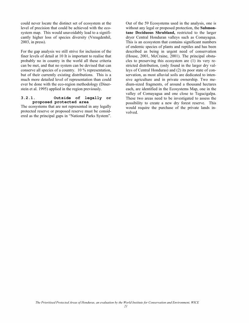
could never locate the distinct set of ecosystem at the level of precision that could be achieved with the eco-system map. This would unavoidably lead to a signifi-cantly higher loss of species diversity (Vreugdenhil, 2003, in press). For the gap analysis we still strive for inclusion of the finer levels of detail at 10 It is important to realise that probably no in country in the world all these criteria can be met, and that no system can be devised that can conserve all species of a country. 10 % representation, but of their currently existing distributions. This is a much more detailed level of representation than could ever be done with the eco-region methodology (Diner-stein et al. 1995) applied in the region previously. 3.2.1. Outside of legally or
proposed protected area The ecosystems that are not represented in any legally protected reserve or proposed reserve must be consid-ered as the principal gaps in “National Parks System”.
Out of the 59 Ecosystems used in the analysis, one is without any legal or proposed protection, the Submon-tane Deciduous Shrubland, restricted to the larger dryer Central Honduran valleys such as Comayagua. This is an ecosystem that contains significant numbers of endemic species of plants and reptiles and has been described as being in urgent need of conservation (House, 2001, McCraine, 2001). The principal obsta-cles to preserving this ecosystem are (1) its very re-stricted distribution, (only found in the larger dry val-leys of Central Honduras) and (2) its poor state of con-servation, as most alluvial soils are dedicated to inten-sive agriculture and in private ownership. Two me-dium-sized fragments, of around a thousand hectares each, are identified in the Ecosystems Map, one in the valley of Comayagua and one close to Tegucigalpa. These two areas need to be investigated to assess the possibility to create a new dry forest reserve. This would require the purchase of the private lands in-volved.
The Prioritised Protected Areas of Honduras, an evaluation by the World Institute for Conservation and Environment, WICE 21
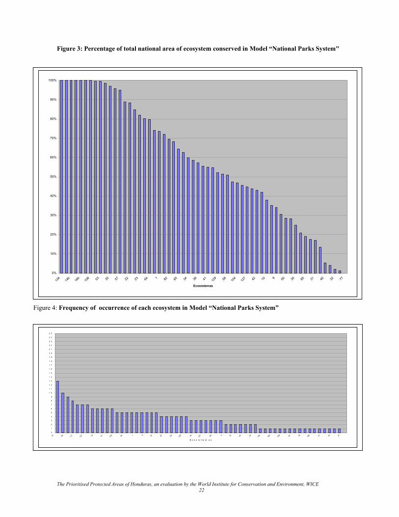
Figure 3: Percentage of total national area of ecosystem conserved in Model “National Parks System"
F
0%
10%
20%
30%
40%
50%
60%
70%
80%
90%
100%
134
14b
16b
108 53 35 57 22 23 64 1 82 65 34 38 41 12
9 58 104
127 42 10 9 50 30 85 31 40 32 77
Ecosistemas
igure 4: Frequency of occurrence of each ecosystem in Model “National Parks System”
2 5
0
1
2
3
4
5
6
7
8
9
1 0
1 1
1 2
1 3
1 4
1 5
1 6
1 7
1 8
1 9
2 0
2 1
2 2
2 3
2 4
14 65 111
121 16 41 13
4 64 1 9 37 22 82 129 34 12
7 86 4 15 42 30 14b
16b
108 67 78 10
9 31 75 77
E c o s i s t e m a s
The Prioritised Protected Areas of Honduras, an evaluation by the World Institute for Conservation and Environment, WICE 22
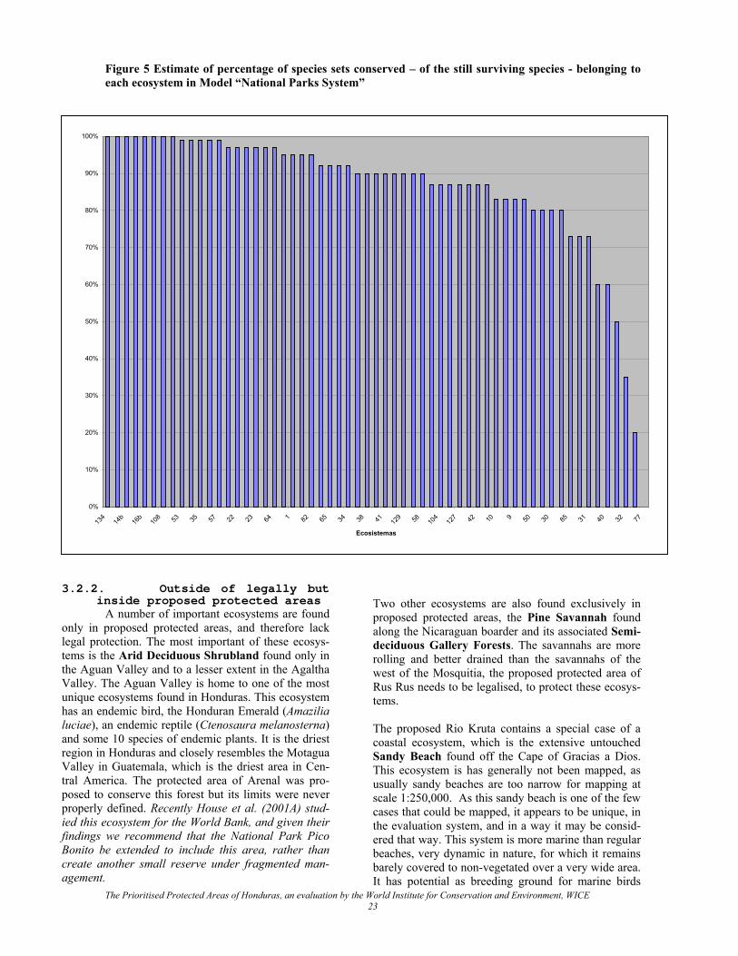
Figure 5 Estimate of percentage of species sets conserved – of the still surviving species - belonging to each ecosystem in Model “National Parks System”
100%
3
olttVuhlarVtppifBca
0%
10%
20%
30%
40%
50%
60%
70%
80%
90%
134
14b
16b
108 53 35 57 22 23 64 1 82 65 34 38 41 12
9 58 104
127 42 10 9 50 30 85 31 40 32 77
Ecosistemas
.2.2. Outside of legally but inside proposed protected areas Two other ecosystems are also found exclusively in
proposed protected areas, the Pine Savannah found along the Nicaraguan boarder and its associated Semi-deciduous Gallery Forests. The savannahs are more rolling and better drained than the savannahs of the west of the Mosquitia, the proposed protected area of Rus Rus needs to be legalised, to protect these ecosys-tems.
A number of important ecosystems are found nly in proposed protected areas, and therefore lack egal protection. The most important of these ecosys-ems is the Arid Deciduous Shrubland found only in he Aguan Valley and to a lesser extent in the Agaltha alley. The Aguan Valley is home to one of the most nique ecosystems found in Honduras. This ecosystem as an endemic bird, the Honduran Emerald (Amazilia uciae), an endemic reptile (Ctenosaura melanosterna) nd some 10 species of endemic plants. It is the driest egion in Honduras and closely resembles the Motagua alley in Guatemala, which is the driest area in Cen-
ral America. The protected area of Arenal was pro-osed to conserve this forest but its limits were never roperly defined. Recently House et al. (2001A) stud-ed this ecosystem for the World Bank, and given their indings we recommend that the National Park Pico onito be extended to include this area, rather than reate another small reserve under fragmented man-gement.
The Prioritised Protected Areas of Honduras, an evaluation by the World Institute for Conservation and Environment, WICE 23
The proposed Rio Kruta contains a special case of a coastal ecosystem, which is the extensive untouched Sandy Beach found off the Cape of Gracias a Dios. This ecosystem is has generally not been mapped, as usually sandy beaches are too narrow for mapping at scale 1:250,000. As this sandy beach is one of the few cases that could be mapped, it appears to be unique, in the evaluation system, and in a way it may be consid-ered that way. This system is more marine than regular beaches, very dynamic in nature, for which it remains barely covered to non-vegetated over a very wide area. It has potential as breeding ground for marine birds
that breed on sandbanks and wide beaches, such as terns. It is not under urgent threat, though in the case of yet-to-be discovered presence of nesting marine birdlife protection this would be necessary. Also for other caracteristics, the proposed Kruta reserve is makes part of the "National Parks System, However, this area is very populated. For biodiversity conserva-tion only, the less inhabited downstream half of the proposed area is needed and the document proposes to only gazette 60,000 ha around the river mouth. 3.2.3. Underrepresented in le-
gally protected areas All ecosystems that have less than 10 % of there total area within the “National Parks System” are consid-ered underrepresented. An important result of the eco-systems analysis is the discovery that the three largest pine forest ecosystems in Honduras are all heavily underrepresented: • With only 407 ha (2 %), the lowland well-drained
Pine forest21 is all but absent from the system. It found in small patches along the San Pedro Sula Valley and in much smaller areas on the Pacific Coast. These forests differ form their much more common submontane neighbours in that the pre-dominant tree species is Pinus caribea and not Pinus oocarpa. Considering the cost of buying a significant proportion of this ecosystem, the best option would be to identify an area of National Forest that contains this ecosystem and elevate it to reserve status within SINAPH. The preferred solution would be to include this ecosystem by ex-tending one of the existing forest reserves in the Sula valley (Cusuco, Merendon), but if no Na-tional Forest is found close to these existing areas it might be necessary to set up a completely new reserve.
• With 11636 ha., the Submontane Pine forest has only 1 % of its total area legally protected in the "National Park System" Model (2% in SINAPH). As many of the remaining tracts of this forest type are found in Olancho within extractive reserves, it is recommended that a part of one of these Na-tional Forests be elevated to the status of a pro-tected area.
• With only 5 % of its total occurrence in the “Na-tional Parks System” Model, the Lower Montane Pine forest is also underrepresented and it is rec-ommended that any new pine forest reserve cre-ated for the expansion of the previous ecosystems should also include some areas of this ecosystem.
• The Pacific Deciduous Shrubland found in the south of Honduras is underrepresented in the SINAPH in that only 4 % of its total area is pro-tected. The majority of mapped locations of this ecosystem is found around the Guanacuare Re-
serve and a minor alteration in the limits of this reserve would protect well over 10 % of this eco-system. This ecosystem is secondary in nature, the product of human intervention; the climax ecosys-tem in this area is not deciduous shrubland and if adequately protected, these shrublands would gradually return to either Semi-Deciduous or De-ciduous Forest.
The Prioritised Protected Areas of Honduras, an evaluation by the World Institute for Conservation and Environment, WICE 24
21 In the text we don’t use the full names used on the map as they would make the document difficult to read.
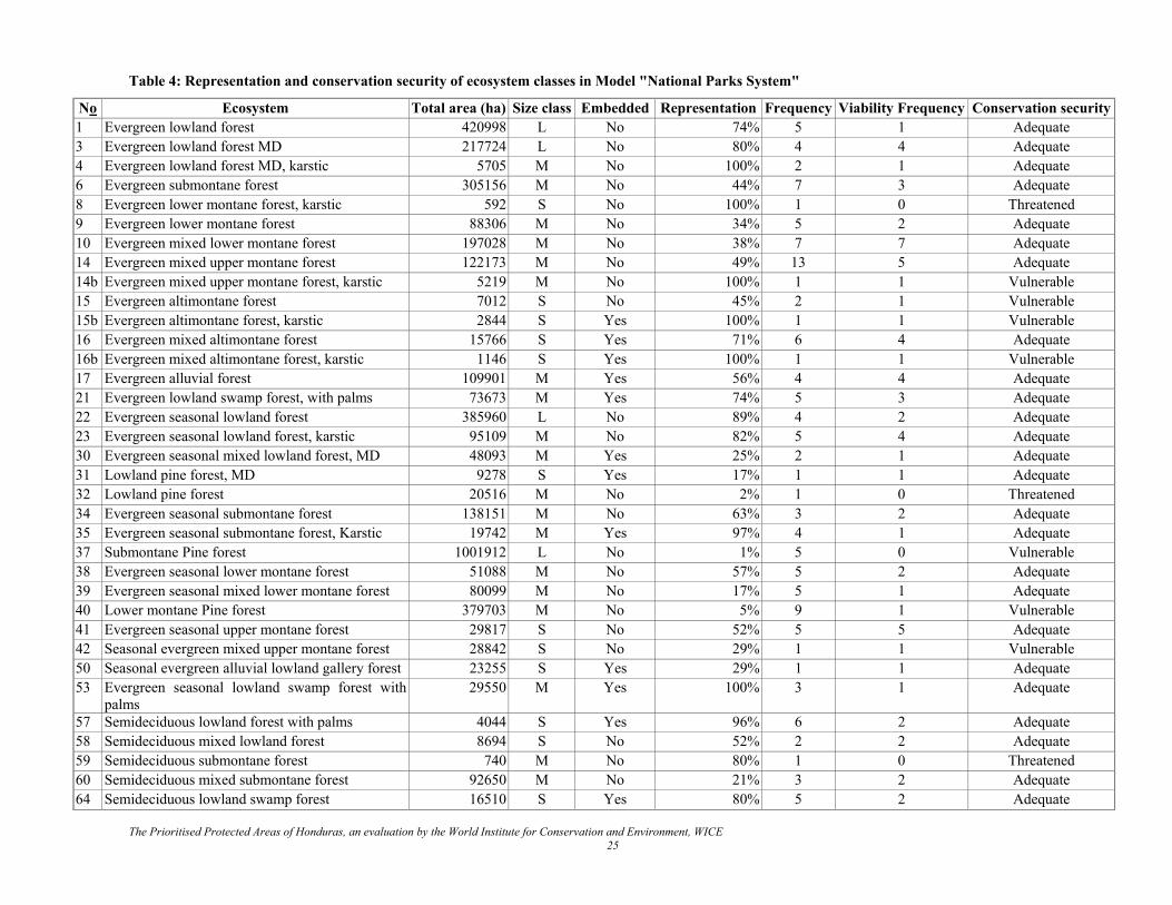
Table 4: Representation and conservation security of ecosystem classes in Model "National Parks System"
No Ecosystem Total area (ha) Size class Embedded Representation Frequency Viability Frequency Conservation security 1 Evergreen lowland forest 420998 L No 74% 5 1 Adequate 3 Evergreen lowland forest MD 217724 L No 80% 4 4 Adequate 4 Evergreen lowland forest MD, karstic 5705 M No 100% 2 1 Adequate 6 Evergreen submontane forest 305156 M No 44% 7 3 Adequate 8 Evergreen lower montane forest, karstic 592 S No 100% 1 0 Threatened 9 Evergreen lower montane forest 88306 M No 34% 5 2 Adequate 10 Evergreen mixed lower montane forest 197028 M No 38% 7 7 Adequate 14 Evergreen mixed upper montane forest 122173 M No 49% 13 5 Adequate 14b Evergreen mixed upper montane forest, karstic 5219 M No 100% 1 1 Vulnerable 15 Evergreen altimontane forest 7012 S No 45% 2 1 Vulnerable 15b Evergreen altimontane forest, karstic 2844 S Yes 100% 1 1 Vulnerable 16 Evergreen mixed altimontane forest 15766 S Yes 71% 6 4 Adequate 16b Evergreen mixed altimontane forest, karstic 1146 S Yes 100% 1 1 Vulnerable 17 Evergreen alluvial forest 109901 M Yes 56% 4 4 Adequate 21 Evergreen lowland swamp forest, with palms 73673 M Yes 74% 5 3 Adequate 22 Evergreen seasonal lowland forest 385960 L No 89% 4 2 Adequate 23 Evergreen seasonal lowland forest, karstic 95109 M No 82% 5 4 Adequate 30 Evergreen seasonal mixed lowland forest, MD 48093 M Yes 25% 2 1 Adequate 31 Lowland pine forest, MD 9278 S Yes 17% 1 1 Adequate 32 Lowland pine forest 20516 M No 2% 1 0 Threatened 34 Evergreen seasonal submontane forest 138151 M No 63% 3 2 Adequate 35 Evergreen seasonal submontane forest, Karstic 19742 M Yes 97% 4 1 Adequate 37 Submontane Pine forest 1001912 L No 1% 5 0 Vulnerable38 Evergreen seasonal lower montane forest 51088 M No 57% 5 2 Adequate 39 Evergreen seasonal mixed lower montane forest 80099 M No 17% 5 1 Adequate 40 Lower montane Pine forest 379703 M No 5% 9 1 Vulnerable 41 Evergreen seasonal upper montane forest 29817 S No 52% 5 5 Adequate 42 Seasonal evergreen mixed upper montane forest 28842 S No 29% 1 1 Vulnerable 50 Seasonal evergreen alluvial lowland gallery forest 23255 S Yes 29% 1 1 Adequate 53 Evergreen seasonal lowland swamp forest with
palms 29550 M Yes 100% 3 1 Adequate
57 Semideciduous lowland forest with palms 4044 S Yes 96% 6 2 Adequate 58 Semideciduous mixed lowland forest 8694 S No 52% 2 2 Adequate 59 Semideciduous submontane forest 740 M No 80% 1 0 Threatened 60 Semideciduous mixed submontane forest 92650 M No 21% 3 2 Adequate 64 Semideciduous lowland swamp forest 16510 S Yes 80% 5 2 Adequate
The Prioritised Protected Areas of Honduras, an evaluation by the World Institute for Conservation and Environment, WICE 25
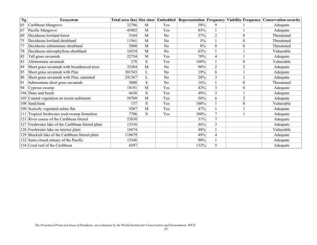
No Ecosystem Total area (ha) Size class Embedded Representation Frequency Viability Frequency Conservation security 65 Caribbean Mangrove 32786 M Yes 58% 9 1 Adequate 67 Pacific Mangrove 45882 M Yes 85% 1 1 Adequate 69 Deciduous lowland forest 5104 M No 37% 2 0 Threatened75 Deciduous lowland shrubland 11561 M No 5% 1 0 Threatened 77 Deciduous submontane shrubland 5000 M No 0% 0 0 Threatened 78 Deciduous microphyllous shrubland 16534 M No 63% 1 1 Vulnerable82 Tall grass savannah 22754 M Yes 70% 4 1 Adequate 83 Altimontane savannah 278 S Yes 100% 1 0 Vulnerable 84 Short grass savannah with broadleaved trees 33384 M No 96% 2 2 Adequate 85 Short grass savannah with Pine 301543 L No 19% 6 1 Adequate 86 Short grass savannah with Pine, saturated 241367 L No 28% 3 1 Adequate 91 Submontane short grass savannah 3008 S No 16% 1 0 Threatened 94 Cyperus swamp 18181 M Yes 42% 3 0 Adequate 104 Dune and beach 6638 S Yes 48% 3 1 Adequate 105 Coastal vegetation on recent sediments 59709 M Yes 58% 6 2 Adequate108 Sand bank 157 S Yes 100% 1 0 Vulnerable 109 Scarcely vegetated saline flat 9387 M Yes 47% 1 1 Adequate 111 Tropical freshwater reed-swamp formation 7706 S Yes 100% 7 1 Adequate 121 River course of the Caribbean littoral 52030 31% 7 Adequate 127 Freshwater lake of the Caribbean littoral plain 15336 46% 3 Adequate 128 Freshwater lake on interior plain 16874 48% 1 Vulnerable 129 Brackish lake of the Caribbean littoral plain 118679 49% 4 Adequate 132 Semi-closed estuary of the Pacific 15346 90% 1 Adequate 134 Coral reef of the Caribbean 6597 132% 5 Adequate
The Prioritised Protected Areas of Honduras, an evaluation by the World Institute for Conservation and Environment, WICE 26
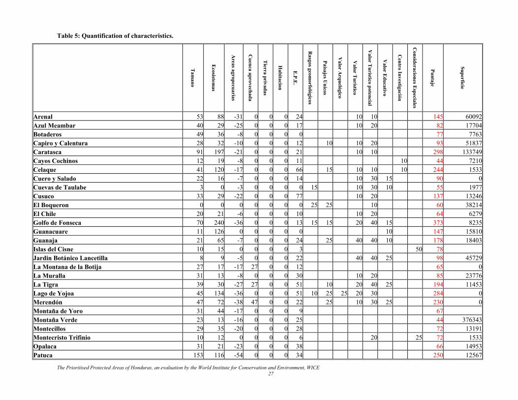
Table 5: Quantification of characteristics.
Tam
ano
Ecosistem
as
Areas agropecuarias
Cuenca aprovechada
Tierra privadas
Habitacion
E.P.E
.
Rasgos geom
orfológicos
Paisajes Unicos
Valor A
rquelógico
Valor T
urístico
Valor T
urístico potencial
Valor E
ducativo
Centro Investigación
Consideraciones E
speciales
Puntaje
Superficie
Arenal 53 88 -31 0 0 0 24 10 10 145 60092 Azul Meambar 40 29 -25 0 0 0 17 10 20 82 17704 Botaderos 49 36 -8 0 0 0 0 77 7763 Capiro y Calentura 28 32 -10 0 0 0 12 10 10 20 93 51837 Caratasca 91 197 -21 0 0 0 21 10 10 298 133749 Cayos Cochinos 12 19 -8 0 0 0 11 10 44 7210 Celaque 41 120 -17 0 0 0 66 15 10 10 10 244 1533 Cuero y Salado 22 16 -7 0 0 0 14 10 30 15 90 0 Cuevas de Taulabe 3 0 -3 0 0 0 0 15 10 30 10 55 1977 Cusuco 33 29 -22 0 0 0 77 10 20 137 13246 El Boqueron 0 0 0 0 0 0 0 25 25 10 60 38214 El Chile 20 21 -6 0 0 0 10 10 20 64 6279 Golfo de Fonseca 70 240 -36 0 0 0 13 15 15 20 40 15 373 8235 Guanacuare 11 126 0 0 0 0 0 10 147 15810 Guanaja 21 65 -7 0 0 0 24 25 40 40 10 178 18403 Islas del Cisne 10 15 0 0 0 0 3 50 78 Jardin Botánico Lancetilla 8 9 -5 0 0 0 22 40 40 25 98 45729 La Montana de la Botija 27 17 -17 27 0 0 12 65 0 La Muralla 31 13 -8 0 0 0 30 10 20 85 23776 La Tigra 39 30 -27 27 0 0 51 10 20 40 25 194 11453 Lago de Yojoa 45 134 -36 0 0 0 51 10 25 25 20 30 284 0 Merendón 47 72 -38 47 0 0 22 25 10 30 25 230 0 Montaña de Yoro 31 44 -17 0 0 0 9 67 Montaña Verde 23 13 -16 0 0 0 25 44 376343 Montecillos 29 35 -20 0 0 0 28 72 13191 Montecristo Trifinio 10 12 0 0 0 0 6 20 25 72 1533 Opalaca 31 21 -23 0 0 0 38 66 14953 Patuca 153 116 -54 0 0 0 34 250 12567
The Prioritised Protected Areas of Honduras, an evaluation by the World Institute for Conservation and Environment, WICE 27
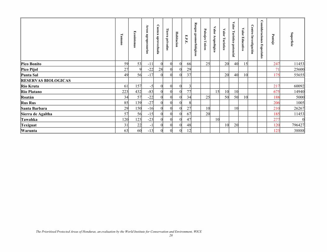
Tam
ano
Ecosistem
as
Areas agropecuarias
Cuenca aprovechada
Tierra privadas
Habitacion
E.P.E
.
Rasgos geom
orfológicos
Paisajes Unicos
Valor A
rquelógico
Valor T
urístico
Valor T
urístico potencial
Valor E
ducativo
Centro Investigación
Puntaje
Superficie
Consideraciones E
speciales Pico Bonito 59 53 -11 0 0 0 66 25 20 40 15 247 11453 Pico Pijol 27 9 -22 28 0 0 29 71 25600 Punta Sal 49 56 -17 0 0 0 37 20 40 10 175 55655 RESERVAS BIOLOGICAS Río Kruta 61 157 -5 0 0 0 3 217 60092 Río Platano 223 432 -83 0 0 0 77 15 10 10 675 14940 Roatán 34 57 -22 0 0 0 34 25 50 50 10 188 5000 Rus Rus 85 139 -27 0 0 0 8 206 1005 Santa Barbara 29 150 -16 0 0 0 27 10 10 210 26267 Sierra de Agaltha 57 56 -15 0 0 0 67 20 185 11453 Tawahka 120 123 -23 0 0 0 47 10 277 0 Texiguat 31 22 -1 0 0 0 48 10 20 120 796427 Warunta 63 60 -13 0 0 0 12 123 38888
The Prioritised Protected Areas of Honduras, an evaluation by the World Institute for Conservation and Environment, WICE 28
3.2.4. Represented in Legally Protected Areas
3.2.4.1. Species representation Apart form the previously mentioned five under repre-sented ecosystems, the remaining 54 ecosystems have at least 10 % (the minimum) of their total area pro-tected within the “National Parks System”. Of these, 45 have over 30 % (point of optimum efficiency for biodiversity conservation) of their surviving surface protected. Most of the 13 ecosystems that are more than 90 % protected within “National Parks System” are small and somewhat restricted, such as the high mountain savannah found on Mount Celáque. Amongst the 31 ecosystems that are over 50% protected within the “National Parks System” are some of Honduras richest and most extensive ecosystems such as the moder-ately drained evergreen forest with 80 % protected, well-drained evergreen lowland forest, 74 % pro-tected and seasonal evergreen well drained forest, 88% protected. 3.2.4.2. Spreading of extinction
risks Within the “National Parks System” some 14 ecosys-tems are only found in one protected area (14 in SINAPH), which represents a low level of spreading of extinction risks. As the majority of these ecosystems are only found in that one protected area, and nowhere else in the country, their conservation security cannot be improved. A further 2 ecosystems are found in 2 protected areas. The unique elements of the species sets (which is never 100%) of these rare ecosystems must be considered vulnerable in the “National Park System” model. The remaining 42 ecosystems are found in 3 or more protected areas and their species sets are considered to be adequately protected. 3.2.4.3. Minimum areas Of the 59 ecosystems 18 belong to small size type eco-systems, 30 to medium sized type ecosystems and 6 to large size type ecosystems. Aquatic ecosystems do not have a minimum area and were not considered as sys-tem conditions. Of the small size type ecosystems 14, are found in sizes of 1,000 ha or more. Some 4 eco-systems are only found in areas smaller than 1000 ha, 2 of which are not embedded in other ecosystems, and consequently must be considered to be vulnerable and to shelter species that may be threatened in Honduras because of insufficient natural territories. These eco-systems are the Evergreen lower montane forest, karstic found in the Lago de Yojoa protected area and the Submontane Short Grass Savannah found in the Golfo de Fonseca protected area.
Of the 30 ecosystems belonging to the medium class category 5 are found in areas smaller than the mini-
mum 5000 ha. As none of these ecosystems are em-bedded, each of them must be considered to be vulner-able. Three of these ecosystems have already been discussed as underrepresented ecosystems. The re-maining two are the Deciduous Lowland forest and the Semi-deciduous Submontane forest. These eco-systems are found in the Golfo de Fonseca and Gua-nacuare protected areas, and some adjustment of the present boundaries would protect larger and more vi-able areas of these ecosystems. Honduras has 6 large class ecosystems of which only the Submontane Pine forest22 is under-sized, and an extension of this ecosystem is needed to warrant suffi-cient viability of its species in the “National Parks Sys-tem” model. With regard to species with very large-scale territorial needs, Honduras is endowed with the largest single continuous group of protected areas in Central Amer-ica, which together cover about 1,300,000 ha. Those areas are continuous with at least another 900,000 ha in Nicaragua. It is believed that any species of top-predator may durably survive in this area, if conditions such as poaching, nest-disturbance and poisoning can be adequately prevented. The number of protected areas in which each ecosys-tem occurs remains an important gauge of the viability of the “National Parks System” as a whole. The "Complete SINAPH" Model contains 14 ecosystems found in less than 3 protected areas, the same figure is found in the “National Parks System” group, suggest-ing that the latter group is not fundamentally more vulnerable than full SINAPH. In the "Complete SINAPH" Model the most common ecosystem was found in 23 protected areas, in the “National Parks System” Model it is found in 12 protected areas. The precise situation of the Bay Islands National Ma-rine Park could not be satisfactorily assessed with the current digital GIS data. With rather unique terrestrial ecosystems and a variety of nationally unique terres-trial species (of Caribbean origin), the terrestrial eco-systems of the Bay Islands are probably not adequately covered and may need expansion to war. Also the terri-torial cover of the coral reef habitat needs additional analysis and reconsideration. 3.3.FLORA AND FAUNA IN SINAPH It is not known how many of the 7524 species of plants reported for Honduras (Nelson, pers. com., 2002) are found within protected areas. Plants are not only the largest reported group of organisms found in Honduras
22 It is also underrepresented from the point of view of spe-cies representation and the expansion has been dealt with under that criterion.
(many fewer than 7000 species of arthropods have as yet been reported) (Cave, pers. Com.) they are proba-bly also - given their much more limited mobility - more unevenly distributed than most vertebrates. At this moment in time only two relatively small pro-tected areas have comprehensive plant inventories, Cerro Uyuca studied by The Pan-American School of Agriculture (EAP), and Cuero y Salado studied by The National University (UNAH). Cerro Uyuca is Hondu-ras smallest cloud forest reserve (807 ha), yet it has a recorded flora of 600+ species of plants, including 11 endemic species, one of which Paspalum uyucense is found only on this mountain. Cerro Uyuca is also home to an important flag species Lycaste virginalis one of the three CITES 1 plants found in Honduras as well as to the endemic Honduran Small-eared Shrew. That such a small area contains 8.5 % of the national flora is both a testimony to the richness of these cloud forest ecosystems and it indicates that thorough inven-tory work is likely to discover a great variety of spe-cies – including endemic ones in the seasonal cloud forests reserves found across central Honduras. Cuero y Salado on the North coast of Honduras is one of Honduras smaller wetland reserves (7948 ha) and has a recorded flora of more than 800 species23. Even though this area has 11. 3 % of the National flora, it has no reported endemic plant species. These two protected areas contain very different ecosystems and would have very few species in common; together they con-tain some 19 % of the nationally recorded flora. If we assume that the total remaining area of an eco-system contains 100 % of the species belonging to that ecosystem, we can use the curve of Fig. 1 to calculate how species would still be present in a reduced area. If we take Dobson's more positive upper curve and as-sume that all ecosystems are equally diverse we can calculate that the “National Parks System” would con-tain about 85 % of the total terrestrial biodiversity of the country (75 % on the lower curve). Certain ecosys-tems such as Evergreen Broadleaved Forests (rainfor-ests) are especially diverse, as opposed to others that are rather species poor, such as the gramanoid wet-lands, mangroves and the Pine savannahs. As the Ev-ergreen Broadleaved Forests are very well represented in the park system (from 41 % to 100 % inclusion), the “National Parks System” might be expected to contain closer to 90 % of the total currently existing biodiver-sity found in the country. If the recommendation can be successful carried out to gazette and acquire the 5 underrepresented ecosystems including the species-rich dry forests, the total biodi-versity within the "National Park System" calculated
on the Dobson curve would rise to 90% of the cur-rently surviving species in the country. The latter ecosystem represents the most generally destroyed previously existing common ecosystem and its protection would bring it at least partially back into existence through natural regeneration. Tilman et al. (1994) observe that there is a considerable gap be-tween the moment of habitat destruction and the ex-tinction of many species. Apparently many species still hang on to survival in hidden remnants of habitat such as ravines and steep slopes. They refer to this as ex-tinction dept. We hope to benefit from this phenome-non in the case of this particular habitat. The authors feel that this is possible, because many species of dry deciduous forests are much more resilient to habitat destruction than species of humid tropical forests. This is due to their mechanisms to resist stress, such as un-derground survival of tissue during the dry season, very resilient seeds, etc. Cut-over dry forests may grow back directly from sprouts form the roots, with-out passing through centuries lasting cycles of matura-tion towards a “climax phase”. We are inclined to believe that the similar resilience applies to many fauna elements and that many organisms still survive in hidden corners of the landscape, particularly steep slopes and gullies. It would be an academic speculation whether this would raise the biodiversity protection level of the "National Parks System" model to 80 or 90% of the originally present flora and fauna of Honduras. What really matters is the realisation that Honduras is still in time to provide shelter and preserve the vast majority of the species that occurred in the country at the time that the Spanish colonisers set foot at the coasts of the Americas. The 170 plants of special concern consist of endemic or rare species found in very few locations in the coun-try. That 125 (74%) of these species are found within SINAPH is very encouraging. Within the National Park System" Model, 367 or 70% of the species of special concern are protected. When SSP have not been recorder to occur in SINAPH, that does not mean that those species are only found outside of the model. Many SSP not yet recorded within SINAPH are likely to also exist within the model and so far just have not been yet been recorded within the system. Ultimately, it is expected that more than 90% of SSP turn out to occur in the system. 3.4.EX SITU CONSERVATION By the end of the day, there will always be a number of species for which there is no or not enough place in the Arc. Some of them may be helped with a few management measures. Some populations of birds may occasionally need strengthening by captive breed-ing programmes. Rare plant, amphibian or reptile
23 As water tends to provide high biological connectivity, endemic species are much less common in wetlands.
The Prioritised Protected Areas of Honduras, an evaluation by the World Institute for Conservation and Environment, WICE 30
species that cannot not be included in protected areas, because their known distribution could not be in-cluded, may be helped by merely translocating a num-ber of individuals to the most suitable nearest-by pro-tected area. As these species are rare in their own environment, they lack invasive qualities and are very unlikely to pose any threat to resident organisms in there nearby area of introduction. It is suggested that a moderately sized threatened-species management fund be created (2 percent of the total national biodi-versity conservation budget).
The following main categories of positions are consid-ered: 1. Directors, one for the National Parks Service and
one for each regional office and or for very large areas;
2. Professional staff for the headquarters and re-gional offices and in the case of very large areas this may include a specialist for environmental education and a resident biologist;
3. Chief Administrators for personnel management and financial administration;
4. Chief Rangers for each National Park; Apart from such measures, it recommended to create a back-up ex situ endemic and rare species conservation programme for Honduras, consisting of 3 botanical gardens: one at the Atlantic coast (Lancetilla), one in a dry region (Tegucigalpa could qualify) and one at an elevation above 2000 m. Together these three gardens should have a complete collection of endemic species of plants in the country. Additionally, one of these gardens should have a Reptiles and Amphibian house with a full life collection of all the endemic herpeto-fauna. The latter could probably be best realised in Lancetilla. Such ex situ conservation collections to back up the in situ conservation programme should qualify for being subsidised from the threatened-species management fund.
5. Promotional staff; 6. Park Rangers; 7. Voluntary Park Rangers; 8. Secretarial staff for both Central and Regional
staff. Categories 1 and 2 have been averaged in professional staff in the programme; categories 3, 4, 5 and 8 have been averaged in the intermediate level and category 6 in the lower level. 80 percent of the staff is supposed to be working in the field, 10 percent in regional of-fices and 10 percent in the headquarters. Material requirements are supposed to be related to staffing and to services. The field staff needs accom-modation in the field, working equipment and trans-portation. Staff of both regional and national offices needs office space and office equipment. Visitors re-quire visitation infrastructure and facilities.
3.5.PERSONNEL, MATERIAL REQUIREMENTS
AND COSTS An overview of personnel, material requirements and costs is summarised in Table 5, "Recurrent costs" and Table 6: "Investment costs" for all three models. For the management of the “National Parks System” staffing is required for
Management plans are planned for each protected area, which includes clustered areas for the models 2 and 3, while it considers individual plans for model 1. The updating cycle is budgeted for 10 years, in deviation of the current practice of five years. WICE is of the opinion, that updates every five years involve too high a cost in consultant fees. Whenever a specific issue needs to be solved during the period of ten years that can be done as an interim addendum to the manage-ment plan in force, which may be written by in-house professional staff. Such addenda would need proper hearing procedures for stakeholders. So far all man-agement plans have been written without a national perspective. As a result, each plan is only considering its own needs and making demands on financing and staffing resources, without considering the financial limitations imposed by the national financial crisis and the joint needs of the system as a whole. As a result, many plans are unrealistic in their demands. To deal with that problem, existing and future plans all need to be reviewed on their consistency and compliance with the national policy and financing strategy, before be-ing approved.
• the Central Office; • Regional Administrative Offices; • The National Parks.
Field staff requirements are calculated proportionate to the area with a formula which is explained in the man-ual. Regional staff and headquarters staffs each are calculated as 10 percent additional staff for the respec-tive offices. MICOSYS calculates the need for about 700 - 750 staff members for the "National Parks Ser-vice" model of 2.4 million hectares. To compare this with the situation of Costa Rica in 1992 (Vreugdenhil, 1992). Costa Rica had 1.1 million hectares under simi-lar management as proposed in this document. MI-COSYS had calculated the need of about 400 staff, which coincided with the factual situation in the field at the time. Given the fact that the "National Parks System" would be more than twice as large as the "Conservation Areas System" of Costa Rica, a staff requirement of 700 for Honduras seems a reasonable estimate.
The programme calculates average needs and costs. Those may vary per protected area, depending on local
The Prioritised Protected Areas of Honduras, an evaluation by the World Institute for Conservation and Environment, WICE 31
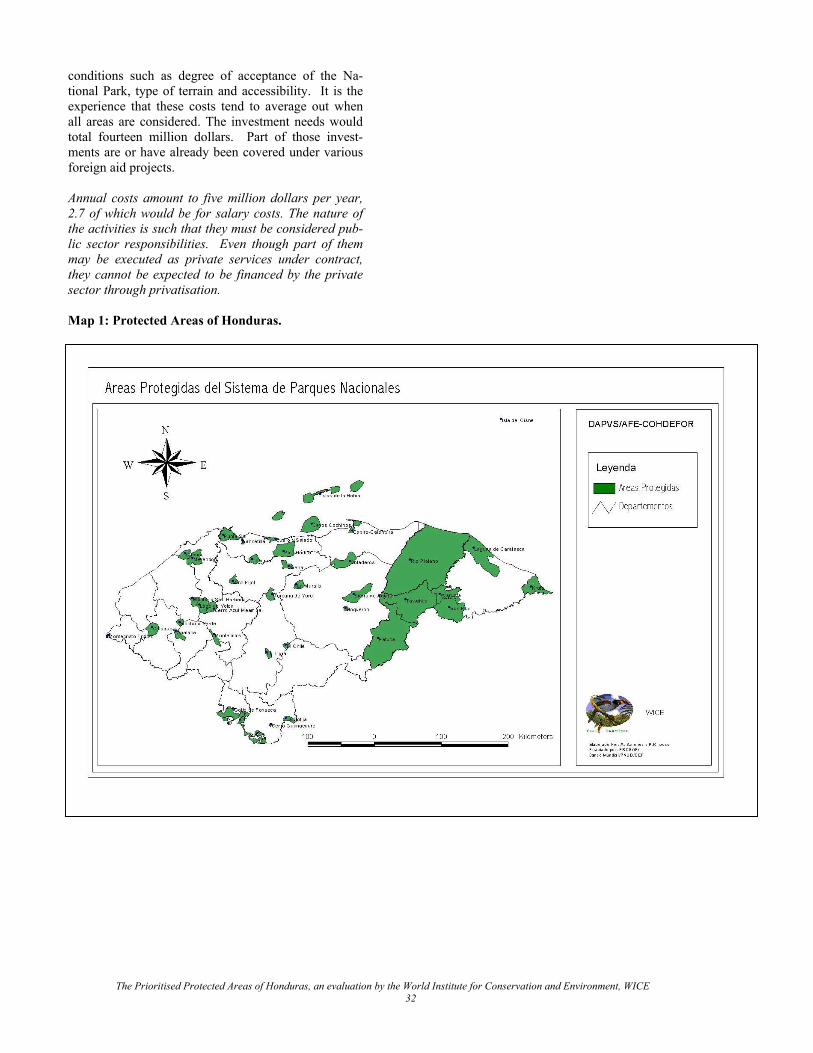
conditions such as degree of acceptance of the Na-tional Park, type of terrain and accessibility. It is the experience that these costs tend to average out when all areas are considered. The investment needs would total fourteen million dollars. Part of those invest-ments are or have already been covered under various foreign aid projects. Annual costs amount to five million dollars per year, 2.7 of which would be for salary costs. The nature of the activities is such that they must be considered pub-lic sector responsibilities. Even though part of them may be executed as private services under contract, they cannot be expected to be financed by the private sector through privatisation. Map 1: Protected Areas of Honduras.
The Prioritised Protected Areas of Honduras, an evaluation by the World Institute for Conservation and Environment, WICE 32

Table 6: Recurrent Costs per Model
Models: SINAPH Minimum NPS SINAPH Minimum NPS SINAPH Minimum NPSCost Categories Field and administrative staff Professional staff Costs
Field staff 1137 679 742 2348519 1509435 1648378Staff for regional offices 57 34 37 95 57 37 737503 440474 510172Staff for the headquarters 57 34 37 95 57 37 737503 440474 510172Ranger stations 307380 176720 193640Vehicles 1777500 945000 1057500Multiple use centres 9894 9894 9894Visitor centres 600199 600176 600176Trails 306885 183287 198091Updating of management plans 142076 84855 91709Regional offices 56000 48000 56000Headquarters 10000 10000 10000Predator compensation fund 70335 44483 48857Threatened species management fund 140669 88966 97715Total recurrent costs $7,244,463 $4,581,765 $5,032,304
Table 7: Investment Costs Per Model
Units CostsCost Categories SINAPH MINIMUM NPS SINAPH MINIMUM NPS
Ranger stations 327 188 206 7,684,500 4418000 4841000 Vehicles 158 84 94 3,950,000 2100000 2350000Multiple use centres 1 262,650 262650 262650Visitor centres 4 4 4 1,687,400 1687400 1687400trails 1137 km 679 km 734 km 3,068,845 1832868 1980910 Management plans 32 1,420,762 848550 917088Regional offices 7 7 7 1,400,000 1200000 1400000Headquarters 1 1 1 250,000 250000 250000Equipment for regional offices 113,661 67884 74133Equipment for the headquarters 113,661 67884 74133Total investments $19,951,479.1 $12,735,236.7 $13,837,313.0
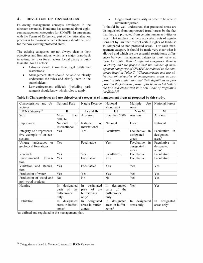
4. REVISION OF CATEGORIES
Following management concepts developed in the nineteen seventies, Honduras has assumed about eight-een management categories for SINAPH. In agreement with the Terms of Reference, part of the rationalisation process is to re-assess which categories should be used for the now existing protected areas. The existing categories are not always clear in their objectives and limitations, which is a major draw-back in setting the rules for all actors. Legal clarity is quin-tessential for all actors:
• Citizens should know their legal rights and restrictions;
• Management staff should be able to clearly understand the rules and clarify them to the stakeholders;
• Law-enforcement officials (including park rangers) should know which rules to apply;
• Judges must have clarity in order to be able to administer justice.
It should be well understood that protected areas are distinguished from unprotected (rural) areas by the fact that they are protected from certain human activities or uses. That implies that there are certain sets of regula-tions set by law that restrict certain rights of land-use as compared to non-protected areas. For each man-agement category it should be made very clear what is allowed and which are the essential restrictions; differ-ences between management categories must leave no room for doubt. With 18 different categories, there is no clarity and we propose that the number of man-agement categories of SINAPH be reduced to the cate-gories listed in Table 7, “Characteristics and use ob-jectives of categories of management areas as pro-posed in this study” and that their definitions as pro-posed in the following paragraphs be included both in the law and elaborated in a new Code of Regulation for SINAPH
Table 8: Characteristics and use objectives of categories of management areas as proposed by this study.
Characteristics and ob-jectives
National Park Nature Reserve National Monument
Multiple Use Area
National Forest
IUCN Category24 II Ia and Ib III V or VI VI Size More than
5000 ha Any size Less than 5000 Any size Any size
Importance National or International
National or International
National Local National
Integrity of a representa-tive example of an eco-system
Yes Yes Facultative Facultative in designated areas1
Facultative in designated areas1
Unique landscapes or geological formations
Yes Facultative Yes Facultative in designated areas1
Facultative in designated areas1
Research Yes Yes Facultative Facultative Facultative Environmental Educa-tion
Yes Facultative Yes Facultative Facultative
Visitation and Recrea-tion
Yes Facultative Yes Yes Yes
Production of water Yes Yes Yes Yes Yes Production of wood and non-wood products
No No No Yes Yes
Hunting In designated parts of the bufferzones only1
In designated parts of the bufferzones only1
In designated parts of the bufferzones only1
Yes Yes
Habitation In designated areas in buffer-zones1
In designated areas in buffer-zones1
In designated areas in buffer-zones1
In designated areas only1
In designated areas only1
1 as defined and regulated in the management plan.
24 Categories are listed in Volume I, Annex II, IUCN Categories.
A Natural Monument is a natural terrestrial or aquatic area – usually less than 5000 ha - of national importance to protect the integrity of a representative sample of one or more ecosystems with their ecologi-cal processes and genetic flow, groups of species, unique natural phenomena or to conserve outstanding landscapes and/or natural beauty in an unaltered state. A management plan is subject to approval by the management authority, after a stakeholder hearing process. It defines zoning, including the visitation ar-eas. Non-consumptive use is permitted – if compatible with natural ecological processes and subject to regu-lation in the management plan - specifically, scientific research, environmental education, visitation and har-vesting of water; forbidden are any human productive or extractive land uses.
The advisory team has taken the six world wide IUCN management categories as the point of departure for defining the proposed categories, as those categories basically cover all the different existing options into clear and distinct sets of rules. Specific legal defini-tions are proposed for each Honduran category. The precise legal clarity, the wording has been kept exactly the same for all categories where the conditions coin-cide. Differences are made clear by textual differentia-tion or absence. A National park is a large – usually over 5000 ha - natural terrestrial or aquatic area of national impor-tance to protect the integrity of a representative sam-ple of one or more ecosystems with their ecological processes and genetic flow, groups of species, unique natural phenomena and to conserve outstanding land-scapes and/or natural beauty in an unaltered state. A management plan is subject to approval by the man-agement authority, after a stakeholder hearing proc-ess. It defines the nuclear and bufferzone(s) and other zoning, including, for the nuclear zone the visitation areas, and for the bufferzone(s) land-use, areas for habitation and biodiversity conservation, as well as land use regulation and wildlife management to pro-tect biodiversity in the bufferzones. In the nuclear zone(s) non-consumptive use is permitted – if compati-ble with natural ecological processes and subject to regulation in the management plan - specifically, sci-entific research, environmental education, visitation and harvesting of water; forbidden are any human productive or extractive land use. In the bufferzones hunting is forbidden, unless by ethnic groups with tra-ditional land-uses, in which case the hunting regimen shall be defined in the management plan.
Assuming these definitions, the areas of the “National Parks system” model have been selected as an inte-grated group of areas that together is expected to con-serve the majority of biodiversity of Honduras through ecosystem protection. Each one has ecosystems whose integrity is essential for the conservation of the na-tional heritage of Honduras’ biodiversity. The advisory group recommends that several protected areas be combined into one single protected area: • National Park Pico Bonito would be unified with
Texiguat and Arenal; • Golfo de Fonseca National Park would result from
the merger of the estuarine protected areas on the south coast;
• Bay Islands National Park already consists of the three larger Bay Islands;
• Rus Rus National Park would include Warunta in the proposal;
A Nature Reserve is a natural terrestrial or aquatic area of national importance to protect the integrity of a representative sample of one or more ecosystems with their ecological processes and genetic flow, groups of species, unique natural phenomena and to conserve outstanding landscapes and/or natural beauty in an unaltered state. A management plan is subject to approval by the management authority, after a stakeholder hearing process. It defines the nuclear and bufferzone(s) and other zoning, including for the bufferzone(s) land-use, areas for habitation and biodi-versity conservation, as well as land use regulation and wildlife management to protect biodiversity in the bufferzones. In the nuclear zone(s) non-consumptive use is permitted – if compatible with natural ecological processes and subject to regulation in the management plan - specifically, scientific research, environmental education, and harvesting of water; forbidden are any human productive or extractive land use. In the buffer-zones hunting is forbidden, unless by ethnic groups with traditional land-uses, in which case the hunting regimen shall be defined in the management plan.
• Lago de Yojoa would encompass Santa Barbara and Mount Azul Meambar;
• Capiro y Calenturo would be expanded with La-guna Guaymoreto.
The unification of these areas would upgrade the splendour of each unit, it would simplify the admini-stration and it would enhance the public recognition of these high-profile national parks. After the merging of these areas, Honduras would have 24 national parks, 4 biological reserves and 2 natural monuments. Whether this can be done legally or only from a management point of view may vary from case to case, but it is im-portant to at least present those areas to the public as integrated national park units. This would also need to be reflected in fully integrated management plans. This should be considered as the regional plans as pro-posed in the draft strategy for SINAPH. Unification would also lead to reduced management costs, as some of the management functions could be reduced, resulting from the lower management costs for larger protected areas.
The Prioritised Protected Areas of Honduras, an evaluation by the World Institute for Conservation and Environment, WICE 35
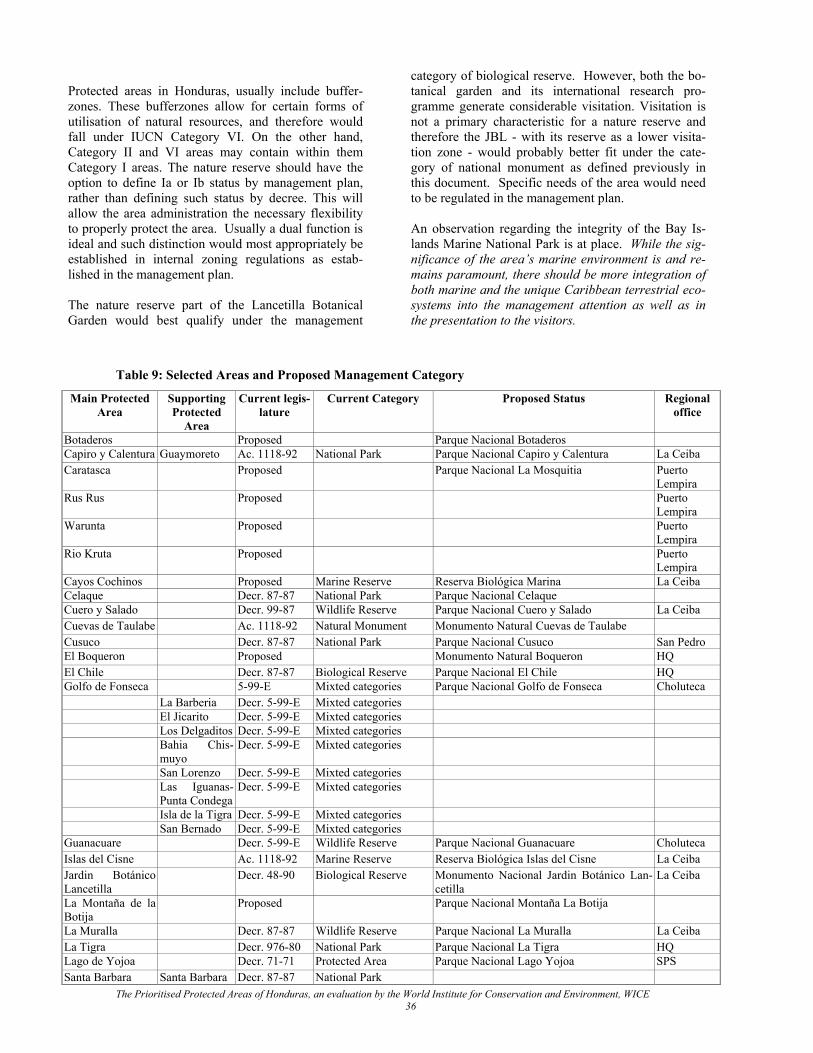
Protected areas in Honduras, usually include buffer-zones. These bufferzones allow for certain forms of utilisation of natural resources, and therefore would fall under IUCN Category VI. On the other hand, Category II and VI areas may contain within them Category I areas. The nature reserve should have the option to define Ia or Ib status by management plan, rather than defining such status by decree. This will allow the area administration the necessary flexibility to properly protect the area. Usually a dual function is ideal and such distinction would most appropriately be established in internal zoning regulations as estab-lished in the management plan. The nature reserve part of the Lancetilla Botanical Garden would best qualify under the management
category of biological reserve. However, both the bo-tanical garden and its international research pro-gramme generate considerable visitation. Visitation is not a primary characteristic for a nature reserve and therefore the JBL - with its reserve as a lower visita-tion zone - would probably better fit under the cate-gory of national monument as defined previously in this document. Specific needs of the area would need to be regulated in the management plan. An observation regarding the integrity of the Bay Is-lands Marine National Park is at place. While the sig-nificance of the area’s marine environment is and re-mains paramount, there should be more integration of both marine and the unique Caribbean terrestrial eco-systems into the management attention as well as in the presentation to the visitors.
Table 9: Selected Areas and Proposed Management Category
Main Protected Area
Supporting Protected
Area
Current legis-lature
Current Category Proposed Status Regional office
Botaderos Proposed Parque Nacional Botaderos Capiro y Calentura Guaymoreto Ac. 1118-92 National Park Parque Nacional Capiro y Calentura La Ceiba Caratasca Proposed Parque Nacional La Mosquitia Puerto
Lempira Rus Rus Proposed Puerto
Lempira Warunta Proposed Puerto
Lempira Rio Kruta Proposed Puerto
Lempira Cayos Cochinos Proposed Marine Reserve Reserva Biológica Marina La Ceiba Celaque Decr. 87-87 National Park Parque Nacional Celaque Cuero y Salado Decr. 99-87 Wildlife Reserve Parque Nacional Cuero y Salado La Ceiba Cuevas de Taulabe Ac. 1118-92 Natural Monument Monumento Natural Cuevas de Taulabe Cusuco Decr. 87-87 National Park Parque Nacional Cusuco San Pedro El Boqueron Proposed Monumento Natural Boqueron HQ El Chile Decr. 87-87 Biological Reserve Parque Nacional El Chile HQ Golfo de Fonseca 5-99-E Mixted categories Parque Nacional Golfo de Fonseca Choluteca La Barberia Decr. 5-99-E Mixted categories El Jicarito Decr. 5-99-E Mixted categories Los Delgaditos Decr. 5-99-E Mixted categories Bahia Chis-
muyo Decr. 5-99-E Mixted categories
San Lorenzo Decr. 5-99-E Mixted categories Las Iguanas-
Punta Condega Decr. 5-99-E Mixted categories
Isla de la Tigra Decr. 5-99-E Mixted categories San Bernado Decr. 5-99-E Mixted categories Guanacuare Decr. 5-99-E Wildlife Reserve Parque Nacional Guanacuare Choluteca Islas del Cisne Ac. 1118-92 Marine Reserve Reserva Biológica Islas del Cisne La Ceiba Jardin Botánico Lancetilla
Decr. 48-90 Biological Reserve Monumento Nacional Jardin Botánico Lan-cetilla
La Ceiba
La Montaña de la Botija
Proposed Parque Nacional Montaña La Botija
La Muralla Decr. 87-87 Wildlife Reserve Parque Nacional La Muralla La Ceiba La Tigra Decr. 976-80 National Park Parque Nacional La Tigra HQ Lago de Yojoa Decr. 71-71 Protected Area Parque Nacional Lago Yojoa SPS Santa Barbara Santa Barbara Decr. 87-87 National Park
The Prioritised Protected Areas of Honduras, an evaluation by the World Institute for Conservation and Environment, WICE 36
Main Protected Area
Supporting Protected
Area
Current legis-lature
Current Category Proposed Status Regional office
Azul Meamber Azul Meambar Decr. 87-87 National Park Merendón Decr. 46-90 Water Production Area Parque Nacional Merendon SPS Montaña Verde Decr. 87-87 Wildlife Reserve Reserva Biológica Montaña Verde HQ Montecristo Tri-finio
Decr. 87-87 National Park Parque Nacional Montecristo Trifinio Santa Rosa de Copan
Opalaca Decr. 87-87 Biological Reserve Parque Nacional Opalaca Patuca Decr. 157-99 National Park Parque Nacional Patuca Pico Bonito Decr. 87-87 National Park Parque Nacional Pico Bonito La Ceiba Texiguat Texiguat Decr. 87-87 Wildlife Reserve Arenal Arenal Ac. 1118-02 Biological Reserve Pico Pijol Decr. 87-87 National Park Parque Nacional Pijol HQ Punta Sal Ac. 1118-92 National Park Parque Nacional Jeannette Kawas La Ceiba Río Platano Decr. 97-80
170-97 National Park Parque Nacional Biósfera Río Platano Catacamas
Islas de Bahia Ac. 1118-92 Marine National Park Parque Nacional Marino Islas de la Bahía Roatán Marine National Park Roatán Isla de Utila Marine National Park Guanaja Marine National Park Sierra de Agaltha Decr. 87-87 National Park Parque Nacional Sierra Agaltha Catacamas Tawahka Decr. 157-99 National Park Parque Nacional Biósfera Tawahka Catacamas The non-selected areas are all considered of more local importance and it is recommended that they all be re-categorised to serve much broader management objec-tives to fulfil the needs of local communities as de-fined under the definition for multiple use areas: A Multiple Use Area is a terrestrial or aquatic area of local importance to integrate and harmonise pro-ductive land use with (1) the conservation of fragments of natural and semi-natural ecosystems and fauna elements (2) the production of high quality water, (3) recreation (4) forestry and extractive use, as well as scientific research and environmental education. A management plan is subject to approval by the De-partmental or Municipal authority or authorities25, after a stakeholder hearing process. The management plan defines zoning of areas for habitation, recreation and other land use and it regulates the use of natural resources of the area. It is very important that the management of multiple use areas be brought as closely as possible to the local beneficiaries by full decentralisation and their man-agement should fall solely under municipal mandate. To achieve this, local administrations should obtain the legal authority for management so that they may solely take decentralised management decisions or delegate management to local communities or NGOs as seen fit. They should also be delegated the authority to enforce the law with municipal rangers. National forests are distinct from multiple use areas in their objective to particularly produce wood-products and that they are of national importance. As none of
the areas need to be re-categorised under this category, a precise definition is not proposed.
25 This applies when one area falls in the jurisdiction of more than one municipality.
Within the SINAPH there is one area of national sig-nificance, Copan National Park, that is of high profile, but does not fit in the SINAPH profile of protected areas. The area is administered by the Instituto de Antropología, which has no practical relationship with any conservation-oriented authority; this area should be reclassified as an Archaeological Park under the mandate of that institution. If this is not yet the case, it is recommended that Man-agement plans for SINAPH be mandated by law to legally impose zoning, such as land-use, restriction and regulation of construction, building, housing and habitation. 5. INSTITUTIONAL CONSIDERA-
TIONS
5.1.THE “NATIONAL PARKS SYSTEM ” OF HONDURAS
5.1.1. The “National Parks System ” within SINAPH
With the majority of the selected areas falling into the category of national parks, it would be a wise strategic approach to collectively nominate the selected pro-tected areas of national and international significance the “National Parks System” of Honduras within the SINAPH. This would enhance the prestige of the SINAPH to both the national public and the interna-tional tourism market. The establishment of the “Na-tional Parks System” would have to be realised in a new Code of Regulations for SINAPH, in which the categories be limited as proposed in this document and in which there is a distinction between the areas of national and international significance administered
The Prioritised Protected Areas of Honduras, an evaluation by the World Institute for Conservation and Environment, WICE 37
under the mandate of the National Government on the one hand and, on the other hand, the areas of local im-portance, administered under the mandate of munici-palities26.
5.1.3. Normation and supervi-sion
5.1.3.1. Normation and supervi-sion of multiple use areas
With the existence of a normative and supervisory Gov-ernment institution, it would be desirable to transfer the normation and supervision of the management of multiple use areas by municipalities to SERNA/DIBIO, so that the new "National Parks Service" may focus at the task at hand: the management of the areas of "National Parks System" only.
5.1.2. The "National Parks
Service" of Honduras With a DAPVS legally responsible for primarily na-tional parks, it would be no more than logical to offi-cially elevate DAPVS to the level of National Parks Service, with the same benefits of enhanced prestige, which will thus improve its image, authority and pub-lic recognition.
5.1.3.2. Supervision of species
conservation and law-enforcement of species conser-vation
The administration of protected areas in Honduras is rather unique in the sense that the management of many nationally owned protected areas has been dele-gated to different NGOs. While this level of public support is highly commendable, it also risks fragment-ing the coherence of the system. It is in the interest of all parties concerned to avoid such development and jointly work at a tight integration of the mandated ad-ministration and the NGOs. The latter already have taken a significant step towards integration by the crea-tion of the Alliance of Protected Areas, but integration must still go further. To the broad Honduran public, it should not be visible who administers their national parks. The "National Parks System" concept should have one single profile for the entire nation: one logo, one national uniform design and staff in all the na-tional parks, nature reserves and natural monuments (regardless of his/her status of employment with an NGO or the "National Parks Service") that sends out the same conservation message everywhere. This unique mixed private/public model of administration would require a major effort from all parties con-cerned. With the government institution being named the National Parks Service, it might be worth consider-ing naming the Alliance something like the National Parks Alliance.
If DAPVS be transformed into the National Parks Service, the tasks of supervision of species conservation (hunting, harvesting and sales of wild species) should be delegated to SERNA/DIBIO, so that the former can dedicate all its attention and resources to its prime task at hand, the con-servation of Honduras’ “National Parks System”. 5.1.3.3. Proposal of new pro-
tected areas and moratorium The protected areas of national and international signifi-cance have been selected as an integrated and interre-lated group to protect the broadest possible set of species of Honduras. It is essential that all gaps in legal status, management category and where appropriate corrections of limits be legally corrected speedily and that no area be left behind. At the same token it would be recommendable to with-draw all current proposals for declaration of areas that have not been selected as areas of national significance and impose a five year moratorium on the proposition of any new protected area so that the recommendations of current report can be properly implemented, including the formulation of a new code of regulations for the SINAPH. Legally existing areas that have not been se-lected as areas of national significance should be re-categorised to multiple use areas.
In spite of great involvement of NGOs in the manage-ment of protected areas, the involvement of the real owners of the national parks, the People of Honduras, is still very low. Mechanisms should be explored to greatly increase the involvement of the Hondurans. A powerful instrument could be to sell a national annual (family) entry pass at an affordable price. This pass would require the registration of the pass holder with an address. The passholder would automatically re-ceive a national parks membership to the Alliance and a three-monthly news journal, with the announcements of achievements, special excursions, family activities and children and students programmes.
5.1.3.4. Definition and correc-tion of legal boundaries
In some cases, bufferzones add size to the protected areas while offering little additional biodiversity value. As a result, they raise costs, as management costs are size re-lated. Furthermore, the presence of significant numbers of inhabitants in bufferzones requires even more attention to the public and thus higher staff density than the nuclear zones. Therefore the bufferzones should be proportionate in size and practical; heavily populated areas should be excluded from the protected areas altogether, as they don’t contribute to conservation and only increase con-flicts of interest, management complexity and costs.
Current boundaries need to be reviewed on possibili-ties to reduce unwarranted inclusion of excessive hu-man habitation. Other areas need some correction of legal boundaries to include additional vital habitat. Areas in need of corrections of limits are listed in Ta-
26 Honduras has 2 levels of government: The National Gov-ernment and Municipalities.
The Prioritised Protected Areas of Honduras, an evaluation by the World Institute for Conservation and Environment, WICE 38
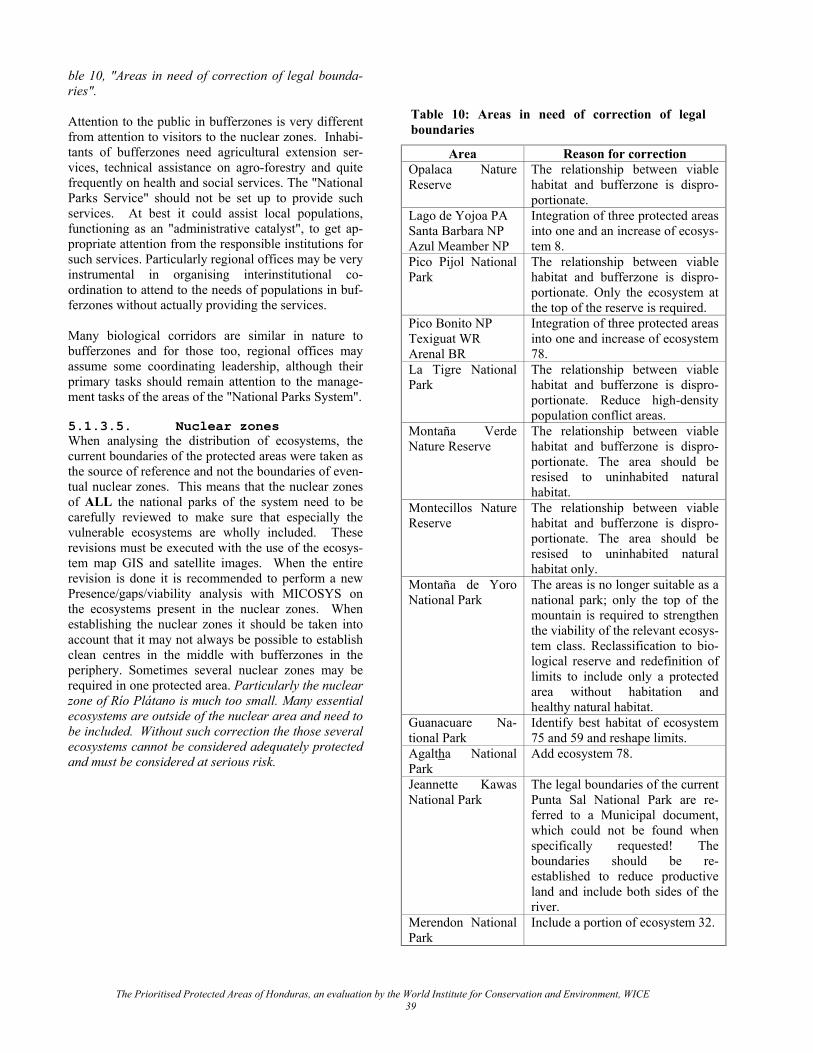
ble 10, "Areas in need of correction of legal bounda-ries".
Table 10: Areas in need of correction of legal boundaries Attention to the public in bufferzones is very different
from attention to visitors to the nuclear zones. Inhabi-tants of bufferzones need agricultural extension ser-vices, technical assistance on agro-forestry and quite frequently on health and social services. The "National Parks Service" should not be set up to provide such services. At best it could assist local populations, functioning as an "administrative catalyst", to get ap-propriate attention from the responsible institutions for such services. Particularly regional offices may be very instrumental in organising interinstitutional co-ordination to attend to the needs of populations in buf-ferzones without actually providing the services.
Area Reason for correction Opalaca Nature Reserve
The relationship between viable habitat and bufferzone is dispro-portionate.
Lago de Yojoa PA Santa Barbara NP Azul Meamber NP
Integration of three protected areas into one and an increase of ecosys-tem 8.
Pico Pijol National Park
The relationship between viable habitat and bufferzone is dispro-portionate. Only the ecosystem at the top of the reserve is required.
Pico Bonito NP Texiguat WR Arenal BR
Integration of three protected areas into one and increase of ecosystem 78.
La Tigre National Park
The relationship between viable habitat and bufferzone is dispro-portionate. Reduce high-density population conflict areas.
Montaña Verde Nature Reserve
The relationship between viable habitat and bufferzone is dispro-portionate. The area should be resised to uninhabited natural habitat.
Montecillos Nature Reserve
The relationship between viable habitat and bufferzone is dispro-portionate. The area should be resised to uninhabited natural habitat only.
Montaña de Yoro National Park
The areas is no longer suitable as a national park; only the top of the mountain is required to strengthen the viability of the relevant ecosys-tem class. Reclassification to bio-logical reserve and redefinition of limits to include only a protected area without habitation and healthy natural habitat.
Guanacuare Na-tional Park
Identify best habitat of ecosystem 75 and 59 and reshape limits.
Agaltha National Park
Add ecosystem 78.
Jeannette Kawas National Park
The legal boundaries of the current Punta Sal National Park are re-ferred to a Municipal document, which could not be found when specifically requested! The boundaries should be re-established to reduce productive land and include both sides of the river.
Merendon National Park
Include a portion of ecosystem 32.
Many biological corridors are similar in nature to bufferzones and for those too, regional offices may assume some coordinating leadership, although their primary tasks should remain attention to the manage-ment tasks of the areas of the "National Parks System". 5.1.3.5. Nuclear zones When analysing the distribution of ecosystems, the current boundaries of the protected areas were taken as the source of reference and not the boundaries of even-tual nuclear zones. This means that the nuclear zones of ALL the national parks of the system need to be carefully reviewed to make sure that especially the vulnerable ecosystems are wholly included. These revisions must be executed with the use of the ecosys-tem map GIS and satellite images. When the entire revision is done it is recommended to perform a new Presence/gaps/viability analysis with MICOSYS on the ecosystems present in the nuclear zones. When establishing the nuclear zones it should be taken into account that it may not always be possible to establish clean centres in the middle with bufferzones in the periphery. Sometimes several nuclear zones may be required in one protected area. Particularly the nuclear zone of Río Plátano is much too small. Many essential ecosystems are outside of the nuclear area and need to be included. Without such correction the those several ecosystems cannot be considered adequately protected and must be considered at serious risk.
The Prioritised Protected Areas of Honduras, an evaluation by the World Institute for Conservation and Environment, WICE 39
5.1.3.6. Deconcentration and
delegation To match the qualification of "National Parks System", the Department for Protected Areas, DAPVS, would have to be upgraded to the "National Parks Service" and become a direct-line-authority with its own re-gional offices. Regardless of its legal position in the national administration, this "National Parks Service" should be presented to the public as a self-functioning unit and not as a dependency of a larger organisation, such as AFE-COHDEFOR. The management of national parks can only be carried out by an organisation specialised in nature conserva-tion and management of visitors. This requires prop-erly trained professional national parks management staff operating from regional conservation offices that have the full control over their own tasks. Given the selection of National Parks, recognizable dedicated national parks regional offices27, directly under the "National Parks Service" would be required in Roatán, La Ceiba, Puerto Lempira, Catacamas, Santa Rosa de Copan, San Pedro Sula and Choluteca. The protected areas around the capital would be managed from the headquarters in Tegucigalpa. In this set-up "National Parks Service" needs to be a highly deconcentrated28 line organisation, which consists of three linear levels: • The Headquarters; • Regional offices; • The field. Each level has its own responsibilities: • The staff of the Headquarters deals with integra-
tion of the “National Parks System” as a whole: it sets national standards and policies on visitation, national rules and regulations for bufferzones, etc.; pricing of services, distribution of budgets and staff, review of consistency with national pol-icy and financing strategy after which approval of management plans, interministerial contacts at a national level; management agreements with ex-ternal parties; dealing with the public on national issues. It also coordinates the monitoring of the system as a whole, as this is part of the supervi-sion of the functioning and success of the organi-sation.
• The staff of the Regional offices have a high level of autonomy when dealing with day-to-day man-
agement. They are responsible for the actual man-agement, acquisition of goods and services for their protected areas, supervision and management of staff, organisation of field monitoring, periodic reporting to the Central office, preparation of management plans and annual budgets, interinsti-tutional coordination and defence of the interests of their parks, attending to the public – both local actors and visitors - of the parks under their juris-diction and supervision of delegated management to NGOs.
• The field staff deals continuously and directly with the public, both visitors and the local actors. The tasks involve routine execution of service rounds, promotion of the National Parks philoso-phy among the local population, monitoring the condition of the park, observation, reporting and registration irregularities, basic maintenance on trails, etc.
The delegation of tasks to NGOs has somewhat compli-cated the assessment of staffing requirements in MICO-SYS. It is very likely that duplication of staff at a re-gional level is unavoidable. Delegating a management task to a NGO requires that the field staff be supervised, and administered, for which both professional and admin-istrative staff is required. However, the interinstitutional coordinating tasks, non-NGO staff, monitoring, supervi-sion of the task execution by the NGO, etc. all require both professional and administrative personnel. It was not possible in the context of this study to fully analyse the consequences, of this situation, and the estimates of personnel costs may actually be a bit higher. It is ex-pected that office costs will be higher as the NGOs are usually housed separately. To promote progressing inte-gration and cost-efficiency it is recommended that when the National Parks Service obtains its independent re-gional offices, that the NGOs be housed in the same buildings as much as possible. Management of protected areas by different organisations leads to loss of identity towards the public (both national and international) as well as loss of technical critical mass. As each NGO manages its own area, institutional experience of the management system as a whole is more difficult to establish and each NGO can only have limited professional staff and know how. A single integral man-agement organisation is much better equipped to have in-house specialisation and inter-area know-how. Exchange of management experience is much more likely to flow within one managerial organisation than among a collec-tion of different small organisations. Another factor that needs attention is equal remuneration of staff to avoid salary discontent. The benefits of managerial renovation, personnel satisfaction and professional enhancement through staff rotation are more readily established in an integrated management organisation. The "National Parks Service" and the "National Parks Alliance" need to find mechanisms for salary equality and integrated career development through exchange of personnel and job rota-tion.
27 These regional offices have been budgeted in the pro-gramme. If rented, the costs would probably be lower and the investment requirements would disappear. 28 Deconcentration implies that tasks of the central govern-ment are delegated to the regional offices of the same organi-sation. Decentralisation assumes the transfer of mandate and tasks to local administrations, in the case of Honduras, the municipalities.
The Prioritised Protected Areas of Honduras, an evaluation by the World Institute for Conservation and Environment, WICE 40
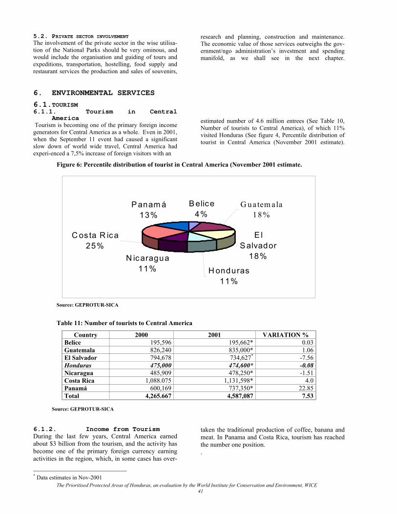
5.2. PRIVATE SECTOR INVOLVEMENT The involvement of the private sector in the wise utilisa-tion of the National Parks should be very ominous, and would include the organisation and guiding of tours and expeditions, transportation, hostelling, food supply and restaurant services the production and sales of souvenirs,
research and planning, construction and maintenance. The economic value of those services outweighs the gov-ernment/ngo administration’s investment and spending manifold, as we shall see in the next chapter.
6. ENVIRONMENTAL SERVICES
6.1.TOURISM 6.1.1. Tourism in Central
America Tourism is becoming one of the primary foreign income generators for Central America as a whole. Even in 2001, when the September 11 event had caused a significant slow down of world wide travel, Central America had experi-enced a 7,5% increase of foreign visitors with an
estimated number of 4.6 million entrees (See Table 10, Number of tourists to Central America), of which 11% visited Honduras (See figure 4, Percentile distribution of tourist in Central America (November 2001 estimate).
Figure 6: Percentile distribution of tourist in Central America (November 2001 estimate.
P anam á13%
C os ta R ica25%
N icaragua11% H onduras
11%
E l S alvador
18%
G uatem ala1 8 %
B elice4%
Source: GEPROTUR-SICA
Table 11: Number of tourists to Central America
Country 2000 2001 VARIATION % Belice 195,596 195,662* 0.03 Guatemala 826,240 835,000* 1.06 El Salvador 794,678 734,627* -7.56 Honduras 475,000 474,600* -0.08 Nicaragua 485,909 478,250* -1.51 Costa Rica 1,088.075 1,131,598* 4.0 Panamá 600,169 737,350* 22.85 Total 4,265.667 4,587,087 7.53
Source: GEPROTUR-SICA
* Data estimates in Nov-2001
6.1.2. Income from Tourism During the last few years, Central America earned about $3 billion from the tourism, and the activity has become one of the primary foreign currency earning activities in the region, which, in some cases has over-
taken the traditional production of coffee, banana and meat. In Panama and Costa Rica, tourism has reached the number one position. .
The Prioritised Protected Areas of Honduras, an evaluation by the World Institute for Conservation and Environment, WICE 41

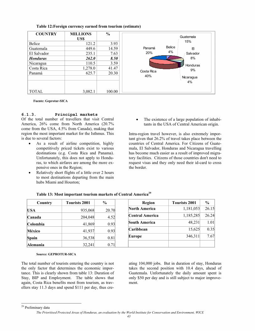
Table 12:Foreign currency earned from tourism (estimate)
COUNTRY MILLIONS US$
%
Belice 121.2 3.93 Guatemala 449.6 14.59 El Salvador 235.1 7.63 Honduras 262.0 8.50 Nicaragua 110.5 3.59 Costa Rica 1,278.0 41.47 Panamá 625.7 20.30
TOTAL 3,082.1 100.00
Belice4%
Guatemala15%
El Salvador
8%
Honduras9%
Nicaragua4%
Costa Rica40%
Panamá20%
Fuente: Geprotur-SICA 6.1.3. Principal markets Of the total number of travellers that visit Central America, 26% come from North America (20.7% come from the USA, 4.5% from Canada), making that region the most important market for the Isthmus. This is due to several factors:
• As a result of airline competition, highly competitively priced tickets exist to various destinations (e.g. Costa Rica and Panama). Unfortunately, this does not apply to Hondu-ras, to which airfares are among the more ex-pensive ones in the Region;
• Relatively short flights of a little over 2 hours to most destinations departing from the main hubs Miami and Houston;
• The existence of a large population of inhabi-tants in the USA of Central American origin.
Intra-region travel however, is also extremely impor-tant given that 26.2% of travel takes place between the countries of Central America. For Citizens of Guate-mala, El Salvador, Honduras and Nicaragua travelling has become much easier as a result of improved migra-tory facilities. Citizens of those countries don't need to request visas and they only need their id-card to cross the border.
Table 13: Most important tourism markets of Central America29
Country Tourists 2001 % Region Tourists 2001 %
USA 935,068 20.70 North America 1,181,053 26.15
Canada 204,048 4.52 Central America 1,185,285 26.24
Colombia 41,869 0.93 South America 48,231 1.01
México 41,937 0.93 Caribbean 15,625 0.35
Spain 36,538 0.81 Europe 346,311 7.67
Alemania 32,241 0.71
Source: GEPROTUR-SICA
29 Preliminary data
The total number of tourists entering the country is not the only factor that determines the economic impor-tance. This is clearly shown from table 13: Duration of Stay, BIP and Employment. The table shows that again, Costa Rica benefits most from tourism, as trav-ellers stay 11.3 days and spend $111 per day, thus cre-
ating 104,000 jobs. But in duration of stay, Honduras takes the second position with 10.4 days, ahead of Guatemala. Unfortunately the daily amount spent is only $50 per day and is still subject to major improve-ment.
The Prioritised Protected Areas of Honduras, an evaluation by the World Institute for Conservation and Environment, WICE 43
The Prioritised Protected Areas of Honduras, an evaluation by the World Institute for Conservation and Environment, WICE 44
Table 14: Duration of stay, BIP and Employment.
Country Average per day
% BIP Position as ex-port product
Creation of jobs
Days Expenses ($) Direct Indirect Belice 7 N/D 18 N/D N/D N/D Guatemala 9 85.3 N/D First 36,000 54,000 El Salvador 4 80 1.7 Sixth 11,920 N/D Honduras 10.4 50 N/D Second 30,288 32,288 Nicaragua 3.3 70 N/D Second 8,400 25,300 Costa Rica 11.3 110.9 7.2 First 104,000 N/D Panamá 3 283 8.50 Third 24,303 59,791
Source: GEPROTUR-SICA
6.1.4. Tourism in Honduras Tourism in Honduras has particularly benefited from a dramatic growth in visits from Caribbean cruise ships: In 1999 it received 57 thousand visitors and in 2000 218 thousand visitors. Cruise passengers usually stay for a day and sign up for day activities, such as a day on the beach, SCUBA-diving, an excursion to a na-tional park, rafting, etc. Those activities must be within a reasonable distance from the harbour and pro-tected areas like Pico Bonito, Texigüat, Lancetilla, Jeannette Kawas, Cueros y Salados are important can-didates. The IHT lists the following "tourism products" or at-tractions for Honduras: • Archaeology and Anthropology • Reefs and beaches • Nature and adventure • Colonial and modern cities • Living ethnic groups • Group events and conventions As a result of these attractions, tourism in Honduras has become a growing source of employment. This is not the result of merely spontaneous development; pro-active government actions and politics have contrib-uted to this growth, particularly the following factors: • The law on tourism incentives, which has contrib-
uted to considerable investments in infrastructure and supply of attractions;
• Increased budget and successful marketing; • Tourism staff training; • Political, economical and social stability. 6.1.5. Development strategy of
the tourism sector In spite of its broad range of tourism products, the tourism sector of Honduras still is in its early phase of development. Not all products have been optimally developed and in order to become competitive, many issues need to be addressed. The recent process of stra-tegic planning of the development of tourism in Hon-
duras has been guided by two important policy docu-ments: • El Plan del Desarrollo Turístico Sostenible de
Honduras 1998-2002 (Martínez, 1997); • Turismo en Honduras: El Reto de la Competitivi-
dad (INCAE and CLACDS, 1998). One of the objectives of those plans was to establish a strategic vision towards the future on which to base a policy for strengthening the sector and becoming the motor for economic development of Honduras. During the administration of President Flores, different programmes, plans and actions were taken within aforementioned strategies by both the tourism industry and by the administration. It turned out however, that in reality not all of the programme envisioned by IN-CAE could be executed. During the first 100 days of the new administration under President Ricardo Maduro, the IHT and a group of Honduran entrepre-neurs established a new Action Plan to for executing a programme based on the principles proposed by IN-CAE. This Action Plan identifies 7 program points: • Institutional development; • Product development; • Municipal development; • Natural Resources development; • Promotion; • Tourist safety; • International Co-operation. While all of these programmes are important, particu-larly programmes 2, 4 and 5 are directly relevant for the development and promotion of visitation to pro-tected areas. 6.1.6. The importance of pro-
tected areas for the economy Basic visitation infrastructure and services in protected areas have to contribute to an unforgettable visitation experience: trails, toilets, interpretation programmes, park guides, visitor centres, canopy walkways, audio-visual presentation of flora and fauna, etc. To make the national parks more accessible for visitation, important
immediate actions are required in the following fields, some of which could be carried out as an emergency accessibility improvement programme: • Organisation of a comprehensive competitive but
cost-covering tariff structure and fee collection programme for each of the areas and activities;
• Development of a marketing programme for na-ture as a visitation destination;
• Train private tourism outfitters and park adminis-trators in selling both directly to the public and to distributors (wholesale);
• Make emergency access improvements for Pico Bonito, La Tigra30, Jeannette Kawas and Meren-don31;
• Benefits visible to the people of the region of the Golfo de Fonseca National Park need urgent im-provement and the area administration should de-velop visitation programmes.
• The Cuevas de Taulabe Natural Monument would add a significant new feature to Honduras’s selec-tion and it is recommended that at least the main cave be prepared for visitation at the short range, while additional caves be explored for additional opportunities.
41% of the tourists to Honduras come for business purposes, 32% come for leisure and vacation and 26% for visiting friends and family (Annex 4) e majority of the vacationing tourists to Honduras come in search of a special interest - non-traditional products - such as SCUBA-diving, archaeology, rafting, exploration of nature, etc., but also many business travellers and fam-ily visitors incorporate an occasional outing in their visit and most visitor end up taking more than one ex-cursion or activity during their visit. According to the Ecotourism Society (1998), North Americans most often go out for a walk, preferably on nature trails where they can observe wildlife and beautiful scenery, and it is obvious that national parks have a major role to play in that field. The important question is "What is the role of pro-tected areas in the tourism product of Honduras"? World wide, experts are seeing more and more that travellers are searching for unique experiences. Nature and a green image of a country, together with its cul-
tural background are important factors of choice when travellers start selecting their destinations.
30 The area administration of MITIGRA is concerned that improved access would set of an urbanisation spree. Such development should be prevented through strict zoning in the management plan and consecutive law enforcement. 31 The core area of Merendon is property of the City of San Pedro Sula, to which the area functions as a watershed pro-tector. However, with such a splendid tropical mountain forest so close to the city, the value of the area for both edu-cational and tourism income generation is under utilised and basic visitation infrastructure like a modest visitor center and interpretation trails are paramount.
In Honduras, studies carried out by the Tourism Insti-tute, IHT, reveal that in 2001, 17% of the tourists, or 54% of tourists that came for primarily recreational purposes, engaged in nature and adventure oriented activities. 42% of the tourists expressed that the ele-ment they liked the most about the country was its nature, while 23 % enjoyed its environment and public spaces. Apart from being an important tourism generator, well managed and visitable protected areas build a sense of national prestige that contribute positively to a nation's business climate. A visit to the fabulously beautiful ruins of Copan and the serene beauty of the forests of Pico Bonito of La Tigra may have a very positive ef-fect on business decisions of foreign investors. Given the importance of national parks to the national economy, we recommend that the IHT and DAPVS in a joint effort further a continuous marketing pro-gramme for the visitation of national parks in Hondu-ras in large volume nature oriented magazines like national Geographic and the house magazines of the Sierra Club, the British Birding association, Audubon Society, the Nature Conservancy, and similar maga-zines in Germany, France, Italy and Spain. 6.2.OTHER SERVICES The economic value of protected areas for biodiversity conservation mainly stems from non-consumptive uses. This chapter does not pretend to give a full over-view of theoretical options, it rather discusses some of the primary opportunities and challenges for Honduras. A preliminary analysis has been made of opportunities in Honduras. As a point of departure the authors like to re-iterate that the involvement of the private sector in the wise utilisation of the National Parks should be very omi-nous, and would include the organisation and guiding of tours and expeditions, transportation, hostelling, food supply and restaurant services, the production and sales of souvenirs, research and planning, construction and maintenance of area infrastructure. The economic value of those services outweighs the government/ngo management expenditure manifold, as we shall see in the next chapter. The following benefits may be ob-served for the national economy. 6.2.1. Donations As first to mention is the fact that public multi- and bi-lateral and private donor institutions pay considerable amounts of grant money in biodiversity protection re-lated programmes, which become invested in the coun-
The Prioritised Protected Areas of Honduras, an evaluation by the World Institute for Conservation and Environment, WICE 45
try and which are appreciable benefits for the national economy. 6.2.2. Water An important economic benefit can be the production of sediment-lean water in relatively stabilised flows for drinking water production and hydroelectricity genera-tion. The economic benefits are equivalent to the addi-tional costs of the production of drinking water or the generation hydroelectricity if the area in question would not be protected. Particularly the absence of silt is important, as silt fill up reservoirs, wears turbines and involves higher purification costs. If water is taken somewhere from a river at al large distance from a protected area, the beneficial effect of silt-poor water may be lost if other tributaries have silted the river at the point of intake. In such case, the economic benefit of watershed pro-tection by a protected area may have been lost. For drinking water, the benefits become practically irrele-vant if the water is not harvested immediately at the basis of the protected area in question. In the case that water is harvested from within a protected area, often not all parts of the watershed actually feed into the tributary with the point of intake. The economic bene-fit would only be relevant, for those areas or their parts, which actually feed into the tributary where the harvesting takes place. Honduras is increasingly suffering from shortages of water. As both its population and the level of economic development increase, the demand for quality water, both for drinking and hydroelectricty will rise further. On the other hand, more (semi-) forested land outside of the protected areas are bound to be converted into non-forestry lands and the watershed protection value of the remaining lands will become increasingly im-portant as time goes by. 6.2.3. Carbon sequestration World wide there are several private CO2-producers - Electrical companies - who provide funding for dura-ble CO2-sequestration. By planting forests, atmos-pheric CO2 becomes fixed in trees, and thereby the CO2 production from thermo-power generation is re-versed. Costa Rica has been lobbying to recognise that unless forests are protected, they would be transformed into agricultural land and the fixed carbon would be burnt into CO2. Therefore, forest protected under long-term commitment should also qualify for carbon sequestration agreements. So far, there are still very few CO2-producers willing to pay for forestry based carbon sequestration. If these funds do become avail-able, however, the amounts are very considerable and could become important sources of revenue for the Protected Areas fund, (FAP). In order to qualify in this field, it is very important that Honduras establishes a
proven record of forest (and thus protected areas) con-servation. 6.2.4. Research facilitating
services In some cases, quality facilities in protected areas for researchers are in growing demand. The benefits from such facilities are various and important. Direct bene-fits are the expenditures those programmes make through the operation of the facilities with foreign funding, thus generating contracts and jobs. Indirect benefits are the elevation of the academic gremia of the country, which – as we see in the case of Costa Rica – go far beyond the green sciences, as the present day green sciences are surrounded by physical, com-puter and social sciences, which all benefit from the presence of such centres of excellence. In Mesoamerica, particularly Costa Rica (La Selva, Guanacaste) and Panama (Canal zone) benefit from those opportunities. As mentioned previously, the au-thors believe that Honduras should promote the Bo-tanical Garden Lancetilla (JBL). JBL already has quite an attractive base structure, it has a parcel of natural ecosystem as part of the reserve belonging to the gar-den and it is conveniently located near Pico Bonito National Park (in the sense of this document including Texiguat). Additionally, it should be promoted to fa-cilitate national and international research from the multiple use centre in Celaque National Park. 6.2.5. Bioprospecting Genetic material as an economic asset is still in its exploratory phase. As far as the authors know, the fa-mous experiment of INBio in Costa Rica, to prospect the biodiversity resource on commercial chemical and pharmaceutical products has not produced any com-mercial results yet. Honduras is a far less likely candi-date for commercial research contracts, as its scientific infrastructure needed to attract similar investors is much less developed. Furthermore, as bioprospecting is not dependent on any particular country, it would seem far more efficient for investors to cash in on an already on-going programme, than to start a new pro-gramme from scratch. Honduras should not have its hopes too high on a programme of similar magnitude. Regionalisation of the INBio, however, might provide a chance for other Mesoamerican countries, including Honduras. Honduras could explore if INBio is inter-ested in bilateral co-operation. The Lancetilla Botani-cal Garden would be a potential candidate for such co-operation and if interested in taking an initiative in this field, it would be recommendable if it would be backed up by SERNA/DIBIO. Maybe this could be combined with its endeavour to become an interna-tional tropical research centre.
The Prioritised Protected Areas of Honduras, an evaluation by the World Institute for Conservation and Environment, WICE 46
Literature Archaga, L.A. & Marineros, L.E., 1996, Honduras: Dentro del Contexto del Corredor Biológico Mesoamericano,
CCAD/AFE COHDEFOR/PNUD/DEF. Arrhenius, O., 1921, Species and Area, Journal of Ecology 9:95-99. Bussing, W. & M. López., 1993, Peces demersales y pelágicos costeros del Pacífico de Centro América, Revista de
Biología Tropical. CCAD, 1999, Listas de Fauna de Importancia para la Conservación en Centro América, Ed.: Solis Rivera, V., &
Brenes, O. IUCN/WWF. Ceballos-Lascurain, H., 2001, Integrating Biodiversity into the Tourism Sector: Best Practice Guidelines,
UNEP/GEF. Ceballos-Lascurain, H., 2000, Relevant Ecotourism Experiences Around the World, Centro Latinoamericano para la Competitividad y Desarrollo Sostenible, 1999, Plan de Mejora de la Competitividad
del Turismo en Honduras. Un Reporte de Progreso, Collar, N.J. Gonzaga, L.P., Krabbe, N., Madroño, A. Naranjo, L.G., Parker III, T.A. & Wege, D.C., 1992,
Threatened Birds of the Américas, The ICBP.IUCN Red Data Book, Third ed.,part 2, Smithonian Institute Press.
Cerrato, C., 1982, Aves de los humedales del Golfo de Fonseca, UNAH Cerrato, C., 1986, Moluscos del Caribe de Honduras, Departamento de Biología UNAH Cerrato, C., 1996, Conservación de la biodiversidad en las áreas protegidas del Corredor Biológico Mesoamericano
en Honduras, Proyecto Conservación de la Biodiversidad en Honduras PNUD (Proyecto HON/96/G41) y AFE/COHDEFOR
Cerrato, C., 2000, La biodiversidad de los ecosistemas costero-marinos y de agua dulce de Honduras, Dirección de Biodiversidad DIBIO/SERNA
Cruz, G.A. & Cerrato, C.A., 1990, Diagnóstico sobre la situación de la Vida Silvestre en Honduras, Programa Regional en Manejo de Vida Silvestre para Mesoamérica y el Carible, Un. Nac., Heredia, Costa Rica.
DiBio, 2001, Estudio sobre Diversidad Biologica de la Republica de Honduras, Secretaria de Recursos Naturales y Ambiente, Direccion General de Biodiversidad.
DiBio, 2000, Diagnostico del Potencial Ecoturístico de 13 Áreas Protegidas en Honduras y Concepto de Desarrollo Turístico para 4 Áreas Prioritarias, Luso Consult GMBH. Hamburg, Alemania.
Dobson, A,.P., 1996, Conservation and Biodiversity, Scientific American Library. Ecoturism Society, 1998, USA Ecoturism Statistical Factsheet, Hernández Díaz, E.A. 1993, Estrategia para el Desarrollo Turístico de Honduras al Año 2010, Hernández Díaz, E.A. 2001, Estrategia para el Desarrollo Turístico de Honduras. Años 2000-2005, FAO y Secretaría de Recursos Naturales, SRN, 1986, principales recursos pesqueros de la plataforma del Caribe
noreste de Honduras 1985 – 1986, FAO – SRN. FODESTUR, 2001, No year, Proyectos de Uso Sostenible de los Recursos Naturales en America Central y El
Caribe. La Ruta Verde Centroamericana: Un Producto Regional de Ecoturismo Sostenible, FUCSA, 2002, Estadísticas de ingreso de visitantes del año 2001, Fundación AMITIGRA, 2002, Estadísticas de ingreso de visitantes del año 2001, Fundación Ecologista HRPF, 2002, Estadísticas de ingreso de visitantes del año 2001. FUPNAPIB, 2002, Estadísticas de ingreso de visitantes del año 2001. García Mendez, M.A., 1994, Mamíferos en Peligor de Extinción en Honduras. García Mendez, M.A., 1994, Mamíferos en Peligro de Extinción en Honduras. Haffer J., 1982, General aspects of the refuge theory, Ed.: Prance, G.T., In: Biological Diversification in the Tropics,
University of Colombia Press, New York. Harbor Branch Oceanogra-phic Institution, Inc. HBOI, 1998, Submersible and Scuba collections on the coastal
waters of Honduras, The Bay Islands: Biomedical and biodiversity research of the benthic communities with emphasis on the Porifera and Gorgonacea. Final Cruise Report, HBOI.
IUCN, 1994, Guidelines for Protected Areas Management Categories, IUCN, Cambridge, UK and Gland, Switzer-land. 261pp. Hagen, R.T. No year, A Guide For Countries Preparing National Biodiversity Strategies And Action Plans, United
Nations Development Programme, Global Environment Facility. House, P.R., 1997, Ethnobotany of the Tawhka:Agricultural Practice and Forest Manegement in Lowland Central
The Prioritised Protected Areas of Honduras, an evaluation by the World Institute for Conservation and Environment, WICE 47
America, (Doctoral Thesis)University of Reading. House, P.R., 2001, Mapa de Plantas Endemicas de Honduras, In: Memorias de la XIII semana Cientifica,
Universisdad Nacional Autonoma de Honduras. IHT, No year, Encuesta del Gasto Turístico, Morales Group. III Congreso Nacional de Turismo, 2000, Lineamientos Estratégicos para el Desarrollo del Turismo en la República
de Honduras. – Una Visión del Futuro-, INCAE y El Centro Latinoamericano para la Competitividad y Desarrollo Sostenible, 1998, Turismo en Honduras.
El Reto de la Competitividad.,INCAE. Marineros, L., 1998, Mamíferos y Reptiles, INADES. Marineros, L., Martínez G.F., 1998, Mamíferos de Honduras, Guía de Campo de los, Instituto Nacional de Ambiente
y Desarrollo. Marineros, L., 2000, Las Serpientes de Honduras, Guía de las, SERNA. Martin, M., 1972, A biografic analysis of the freshwater fishes of Honduras, Thesis PhD. University of Southern
California. Mejía, T., C. Díaz, 2001, Mapa de ecosistemas de Honduras. COHDEFOR/PROBAPP. Miller, K., 1996, Balancing the Scales: Guidelines for Increasing Biodiversity’s Chances Through Bioregional
Management, World Resources Institute. Newmark, W.D., 1986, Species-area relationship and its determinants for mammals in western North American
Parks, Perez, D., S. Thorn & House, P. R., 2001, Impacto de la pavimentación de la carretera Olanchito-San Lorenzo sobre
la hábitat del Colibri Esmeralda Hondureña (Amacilia luciae), SOPTRAVI/BANCO MUNDIAL. PNUD e IHT, 1993, Biodiversidad y Desarrollo Sostenible en el Parque Nacional Punta Sal y Jardín Botánico
Lancetilla, Bahía de Tela, Honduras, PNUD e IHT. PROLANSATE, 2002, Estadísticas de ingreso de visitantes del año 2001, Propuesta para Estructuración de Política de Fomento del Ecoturismo”, 1998, Cluster de Turismo de Honduras. Sub
- Comisión de Ecoturismo. Tegucigalpa. Proyecto Celaque, 2002, Estadísticas de ingreso de visitantes del año 2001. Proyecto Preparatorio Áreas Protegidas de Honduras, 1996a, Aprovechamiento de las Áreas Protegidas de
Honduras. Documento de Trabajo. Proyecto Preparatorio Áreas Protegidas de Honduras. Proyecto Preparatorio Áreas Protegidas de Honduras, 1996b, Aprovechamiento de las Áreas Protegidas de
Honduras. Documento de Trabajo II. Retos A Enfrentar, Proyecto Preparatorio Áreas Protegidas de Honduras, 1996c, Aprovechamiento de las Áreas Protegidas de
Honduras”. Documento de Trabajo III. Nuevas Salidas, Proyecto Utila, 1995- 1999, Informes del estado del arrecife en Utila, Islas de la Bahía, SERNA, 2001, Estudio sobre Diversidad Biológica de la República de Honduras, Dirección de Biodiversidad
DIBIO/SERNA, SERNA, 2001, Informe del Estado del Ambiente Honduras 2000, Secretaría de Recursos Naturales y Ambiente.
Ediciones Zas, Comayagüela. Sobrevilla, C y Bath, P., 1992, Evaluación ecológica Rapida, Programa de Ciencias para América Latina, TNC. Thorn, S., Medina, D., R. Downing y Bonta, M., 1999, Areas importantes para aves (IBAs) en Honduras, UNAH. Thorn, S., 1993, Primer inventario de aves típicas en seis bosques nublados de Honduras,
CONSEFORH/ESNACIFOR COHDEFOR, ODA –ESNACIFOR. Young, K., 2002, Lista de aves de Honduras. Revisado por Thorn S., y Stokes, A.,Borrador preliminar. UICN, 1998, Memorias del Taller Regional Conservación Sostenible de la Biodiversidad Marina., Ed.:Villela, L.,
IUCN/ORMA. Vreugdenhil, D., Meerman, J., Meyrat, A.K., Gómez, A.D., Graham, D.J., 2002, Map of the Ecosystems of Central
America, Final Report, The World Bank, Washington, D.C. Vreugdenhil, D., 2003, Protected Areas System Planning And Monitoring, In press. Vreugdenhil & Archaga, 1996, Aprovechamiento de las Áreas Protegidas de Honduras, World Bank, internal
working document. Wilson, L.D., J.R.MacCranie & Espinal, M.R., 1998, The Ecogeography of the Honduran Herpetofauna and the
design of biotic reserves, In: Mesoamerican Herpetology:Systematics, Zoogeography and Conservation. Ed. J.D. Johnson, R.G.Webb. & O.A. Flores-Villeda, University of Texas, El Paso.
The Prioritised Protected Areas of Honduras, an evaluation by the World Institute for Conservation and Environment, WICE 48
The Prioritised Protected Areas of Honduras, an evaluation by the World Institute for Conservation and Environment, WICE 49
ANNEX I: IUCN MANAGEMENT CATEGORIES32
32 IUCN (1994). Guidelines for Protected Areas Management Categories. IUCN, Cambridge, UK and Gland, Switzerland. 261pp.
The definition of a protected area adopted by IUCN is: An area of land and/or sea especially dedicated to the protection and maintenance of biological diversity, and of natural and associated cultural resources, and managed through legal or other effective means. Although all protected areas meet the general purposes contained in this definition, in practice the precise pur-poses for which protected areas are managed differ greatly. The following are the main purposes of man-agement: • Scientific research • Wilderness protection • Preservation of species and genetic diversity • Maintenance of environmental services • Protection of specific natural and cultural features • Tourism and recreation • Education • Sustainable use of resources from natural ecosys-
tems • Maintenance of cultural and traditional attributes Categories of Protected Area IUCN has defined a series of protected area manage-ment categories based on management objective. Defi-nitions of these categories, and examples of each, are provided in Guidelines for Protected Area Manage-ment Categories (IUCN, 1994). The six categories are: CATEGORY Ia: Strict Nature Reserve: protected area managed mainly for science Definition: Area of land and/or sea possessing some outstanding or representative ecosystems, geological or physiological features and/or species, available primarily for scientific research and/or environmental monitoring. CATEGORY Ib : Wilderness Area: protected area managed mainly for wilderness protection Definition:Large area of unmodified or slightly modi-fied land, and/or sea, retaining its natural character and influence, without permanent or significant habi-tation, which is protected and managed so as to pre-serve its natural condition. CATEGORY II : National Park: protected area man-aged mainly for ecosystem protection and recreation Definition:Natural area of land and/or sea, designated to (a) protect the ecological integrity of one or more ecosystems for present and future generations, (b) ex-clude exploitation or occupation inimical to the pur-poses of designation of the area and (c) provide a foundation for spiritual, scientific, educational, recrea-tional and visitor opportunities, all of which must be environmentally and culturally compatible.
CATEGORY III : Natural Monument: protected area managed mainly for conservation of specific natu-ral features Definition: Area containing one, or more, specific natural or natural/cultural feature which is of out-standing or unique value because of its inherent rarity, representative or aesthetic qualities or cultural signifi-cance. CATEGORY IV : Habitat/Species Management Area 1: protected area managed mainly for conserva-tion through management intervention Definition: Area of land and/or sea subject to active intervention for management purposes so as to ensure the maintenance of habitats and/or to meet the re-quirements of specific species. CATEGORY V : Protected Landscape/Seascape: protected area managed mainly for landscape/seascape conservation and recreation Definition: Area of land, with coast and sea as appro-priate, where the interaction of people and nature over time has produced an area of distinct character with significant aesthetic, ecological and/or cultural value, and often with high biological diversity. Safeguarding the integrity of this traditional interaction is vital to the protection, maintenance and evolution of such an area. CATEGORY VI : Managed Resource Protected Area: protected area managed mainly for the sustain-able use of natural ecosystems Definition: Area containing predominantly unmodified natural systems, managed to ensure long term protec-tion and maintenance of biological diversity, while providing at the same time a sustainable flow of natu-ral products and services to meet community needs. _________________________ 1 Comment from the advisory team: This category has been particu-larly created for nature conservation conditions in Europe, as on that continent hardly any natural ecosystems remain. Most protected areas protect so-called cultural ecosystems, which have been formed over the centuries under continuous harvesting regimes, and many species would not survive if conditions were left to return to a non-managed stage. Examples are the famous Atlantic moorlands, peat lands, alpine meadows and even most of the forests, as they too have been planted. These areas need scheduled grazing with cattle, burn-ing and/or mowing. It is important to realise that these conditions and (extremely expensive) management needs barely exist in the tropics of Central America. This category has been purposely left out of the proposal, as – when small scale – needs arise, they can be amply fulfilled under the regulations of a management plan or under categories V or VI. Temporary measures for restauration purposes, such as for habitat restauration of deciduous forests, can be under-taken under categories I, II and III.