Embed Size (px)
Citation preview
From: RIES, A. C., BUTLER, R. W. H. & GRAHAM, R. H. (eds) 2007. Deformation of the Continental Crust: TheLegacy of Mike Coward. Geological Society, London, Special Publications, 272, 571–587.0305-8719/07/$15 © The Geological Society of London 2007.
Reactivated Palaeozoic normal faults: controls on the formationof Carlin-type gold deposits in north-central Nevada
JOHN L. MUNTEAN1, MICHAEL P. COWARD2 & CHARLES A. TARNOCAI3
1Nevada Bureau of Mines and Geology, Mail Stop 178, University of Nevada, Reno,NV 89557-0088, USA (e-mail: [email protected])
2Ries–Coward Associates Ltd, 70 Grosvenor Road, Caversham, Reading RG4 5ES, UK3Oro Gold Resources Ltd, Suite 1440–625 Howe Street, Vancouver, British Columbia,
Canada V6C 2T6
Abstract: Mappable surface structures control linear trends of Carlin-type gold depositsin north–central Nevada. Some of these structures probably resulted from reactivation ofPalaeozoic normal faults, linked to underlying basement faults that originated during riftingof western North America during the Proterozoic. These old faults served as conduits for deepcrustal hydrothermal fluids responsible for formation of Carlin-type gold deposits in theEocene. The reactivated structures are recognized by stratigraphic and structural features.Stratigraphic features include rapid facies changes, growth fault sequences and sedimentarydebris-flow breccias. Structural features resulted from inversion of the normal faults duringthe Late Palaeozoic Antler and subsequent orogenies. Inversion features include asymmetrichanging-wall anticlines, flower-like structures, and ‘floating island’ geometries. Inversionresulted in structural culminations that occur directly over the basement faults, providing anoptimal setting for the formation of Carlin-type gold deposits.
reactivated Palaeozoic normal fault zones thatprobably had their origins in the Proterozoicduring rifting of the western margin of NorthAmerica, as suggested by Tosdal et al. (2000).Mappable geological features that define theCarlin and Battle Mountain–Eureka trends andpossibly new trends of Carlin-type gold depositsare described.
Rifting of the western margin of NorthAmerica resulted in deposition of dominantlyquartzite, and siltstone, in latest Proterozoic toearliest Cambrian times. Development of thepassive margin sequence continued throughthe Devonian with deposition of interbeddedcarbonates and shales on the shelf and, to thewest, silty carbonate units along the continentalslope. By the end of the Devonian, at least 8–10km of sediments were deposited (Stewart 1972,1980; Stewart & Poole 1974; Bond et al. 1985;Poole et al. 1992). In earliest Mississippian times,deep-water siliciclastic and basaltic rocks(referred to here as the upper plate) were thrusteastward over the shelf-slope sequence (referredto here as the lower plate) along the RobertsMountain Thrust during the Antler Orogeny(Roberts 1951; see also Poole et al. 1992). Subse-quent compressional events in the Late Palaeo-zoic and Mesozoic include the Humboldt,Sonoma, Elko and Sevier orogenies (see Stewart1980; Thorman et al. 1991; Burchfiel et al. 1992).
North–central Nevada is one of the world’smost important gold provinces. More than 6000tonnes of gold have been produced or identified(Nevada Bureau of Mines and Geology 2004).The vast majority of the gold occurs in depositsknown as Carlin-type gold deposits becauseof similarities to the famous Carlin gold mine.Carlin-type gold deposits are epigenetic, dissemi-nated auriferous pyrite deposits characterizedby carbonate dissolution, argillic alteration, andsilicification of typically calcareous sedimentaryrocks (Hofstra & Cline 2000; Cline et al. 2006).They formed during a short time interval in theEocene between c. 42 and 36 Ma (Hofstra et al.1999; Tretbar et al. 2000; Arehart et al. 2003).The alignment of ore deposits in Nevada hasbeen recognized for many years (e.g. Roberts1960, 1966). The Carlin and Battle Mountain–Eureka trends are the two best known alignmentsof Carlin-type gold deposits. The Carlin andBattle Mountain–Eureka trends have beendemonstrated to correspond to gross geophysicaland isotopic features (see Grauch et al. 2003),including gradients in basement gravity (Grauchet al. 1995), zones of electrical conductivity(Rodriguez 1998) and initial strontium and leadisotope ratios of Mesozoic and Tertiary igneousrocks (Wooden et al. 1998; Tosdal et al. 2000).In this paper it is argued that the Carlin andBattle Mountain–Eureka trends correspond to
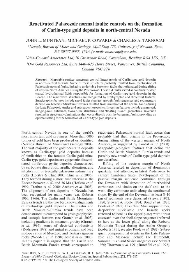
572 J. L. MUNTEAN ET AL.
Fig. 1. Shaded relief map of north–central Nevada showing locations of Carlin-type gold deposits and Palaeozoicnormal faults identified in this study. The corresponding numbers refer to the list in Table 3. The dashed linedelimits the area that was analysed for this study. For reference, the continuous lines outline counties innorth–central Nevada.
573REACTIVATED PALAEOZOIC NORMAL FAULTS
In the Eocene, north–central Nevada experi-enced an abrupt shift in tectonic activity fromcompression to extension and renewed magma-tism (see Burchfiel et al. 1992; Christiansen &Yeats 1992; Cline et al. 2005).
Typically, ‘thin-skinned’ fold and thrustfeatures that formed during the Late Palaeozoicand Mesozoic orogenies have been described inNevada (see Stewart 1980). However, inversionof Proterozoic extensional faults during theLate Mesozoic–Early Tertiary Laramide Oro-geny has been documented to the east in theRocky Mountains (e.g. Davis 1978; Marshaket al. 2000). ‘Thick-skinned’ deformation andinversion features, which are typical of deformedcratonic margins worldwide (see Coward 1994),have been only rarely described for Nevada inthe literature (e.g. Carpenter et al. 1993; Tosdal2001; Cline et al. 2005). Yigit et al. (2003) sug-gested that Palaeozoic normal faults may havecontrolled gold mineralization in the Gold Bardistrict in Nevada. However, they interpretedfault-propagation folds and thrust faults, withimbricate splay geometries in the Gold Canyondeposit, to have developed over the tips of majorlow-angle thrust faults rather than by inversionof a high-angle Palaeozoic normal fault (Yigitet al. 2003, fig. 15). A major goal of this paper
is to present evidence consistent with inversionand ‘thick-skinned’ deformation in several locali-ties throughout north–central Nevada. The othergoal of the paper is to present a spatial relation-ship between Palaeozoic normal faults and thelocation of Carlin-type gold deposits and arguethat the faults served as the main conduitsfor deep auriferous hydrothermal fluids, sourcedfrom the middle to lower crust.
Evidence for Palaeozoic normal faults innorth–central Nevada
Based on analysis of published geological maps,field checks, mine visits, review of literatureand local detailed mapping, evidence has beenfound for Palaeozoic normal faults throughoutnorth–central Nevada (Fig. 1). In addition totypical methods of dating earliest movement onstructures (offset of units of known age, strati-graphic superimposition), we identified bothstratigraphic features (Table 1) and featuresof fault inversion (Table 2) that suggest thepresence of Palaeozoic normal faults.
Features of fault inversion include chara-cteristic fold and fault geometries that formwhen normal faults are reactivated duringcompressional orogenies, as summarized by
Table 1. Sedimentary and stratigraphic relationships used to recognize Palaeozoic normal faults
(1) Thickening, thinning or abrupt facies changes in Palaeozoic rocks, especially towards faults(2) Growth fault sequences(3) Sedimentary breccias with linear boundaries(4) Reefs or other shallow carbonate sequences forming on the top of tilted fault blocks(5) Syngenetic barite or sulphide occurrences in the lower plate of the Roberts Mountains Thrust(6) Local absences of widespread stratigraphic units
Table 2. Inversion and other structural features used to recognize Palaeozoic normal faults
(1) Fault propagation folds: fold geometries that involve long, gently dipping backlimbs and short, steepforelimbs
(2) Monoclines(3) Related kinematics between folds and high-angle faults(4) ‘Flower structures’: radiating arrays of faults in the steep forelimb area that root on a master fault
(wedge-shaped in section) and are subparallel in trend to the axial plane of the associated anticline(5) Footwall shortcut thrust faults(6) ‘Floating-island’ geometries(7) Narrow zones of anomalously trending fold axes within a thrust terrain(8) Refolded or non-cylindrical folded upper plate rocks(9) Folded thrust faults
(10) Zones of upright to inclined, tight to isoclinal folds in rocks that otherwise have recumbent or open folds(11) High-angle reverse faults(12) Folds with anomalous vergence
574 J. L. MUNTEAN ET AL.
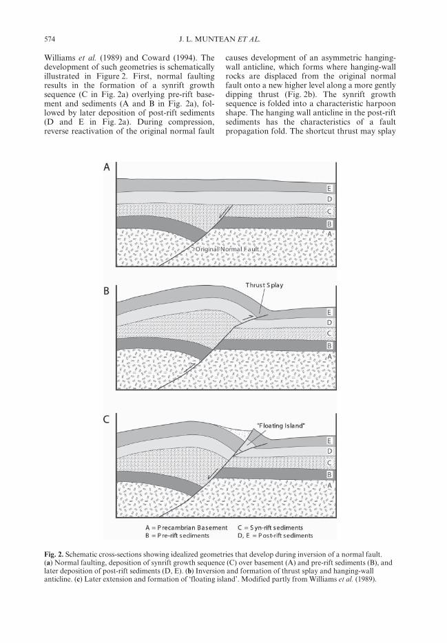
Williams et al. (1989) and Coward (1994). Thedevelopment of such geometries is schematicallyillustrated in Figure 2. First, normal faultingresults in the formation of a synrift growthsequence (C in Fig. 2a) overlying pre-rift base-ment and sediments (A and B in Fig. 2a), fol-lowed by later deposition of post-rift sediments(D and E in Fig. 2a). During compression,reverse reactivation of the original normal fault
causes development of an asymmetric hanging-wall anticline, which forms where hanging-wallrocks are displaced from the original normalfault onto a new higher level along a more gentlydipping thrust (Fig. 2b). The synrift growthsequence is folded into a characteristic harpoonshape. The hanging wall anticline in the post-riftsediments has the characteristics of a faultpropagation fold. The shortcut thrust may splay
Fig. 2. Schematic cross-sections showing idealized geometries that develop during inversion of a normal fault.(a) Normal faulting, deposition of synrift growth sequence (C) over basement (A) and pre-rift sediments (B), andlater deposition of post-rift sediments (D, E). (b) Inversion and formation of thrust splay and hanging-wallanticline. (c) Later extension and formation of ‘floating island’. Modified partly from Williams et al. (1989).
575REACTIVATED PALAEOZOIC NORMAL FAULTS
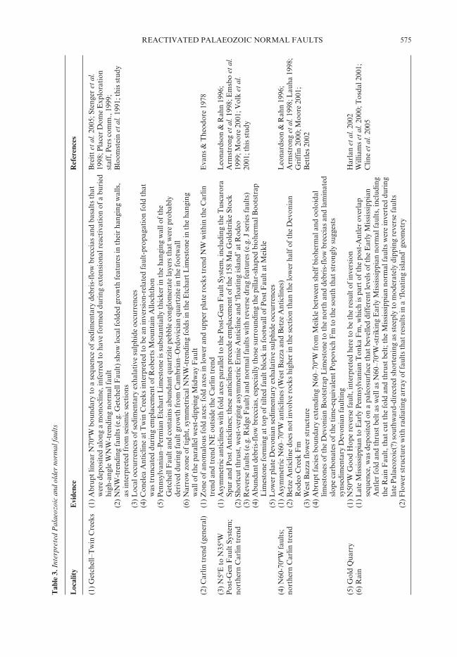
Tab
le 3
. Int
erpr
eted
Pal
aeoz
oic
and
olde
r no
rmal
faul
ts
Loc
ality
Evi
denc
eR
efer
ence
s
(1) G
etch
ell–
Tw
in C
reek
s(1
)A
brup
t lin
ear
N70
ºW b
ound
ary
to a
seq
uenc
e of
sed
imen
tary
deb
ris-
flow
bre
ccia
s an
d ba
salt
s th
atB
reit
t et a
l. 20
05; S
teng
er e
t al.
wer
e de
posi
ted
alon
g a
mon
oclin
e, in
ferr
ed to
hav
e fo
rmed
dur
ing
exte
nsio
nal r
eact
ivat
ion
of a
bur
ied
1998
; Pla
cer
Dom
e E
xplo
rati
on h
igh-
angl
e W
NW
-tre
ndin
g no
rmal
faul
tst
aff,
Per
s co
mm
., 19
99;
(2)
NN
W-t
rend
ing
faul
ts (e
.g. G
etch
ell F
ault
) sho
w lo
cal f
olde
d gr
owth
feat
ures
in th
eir
hang
ing
wal
ls,
Blo
omst
ein
et a
l. 19
91; t
his
stud
y a
s in
terp
rete
d fr
om s
eism
ic s
ecti
ons
(3)
Loc
al o
ccur
renc
es o
f sed
imen
tary
exh
alat
ive
sulp
hide
occ
urre
nces
(4)
Con
elea
Ant
iclin
e at
Tw
in C
reek
s in
terp
rete
d to
be
an in
vers
ion-
rela
ted
faul
t-pr
opag
atio
n fo
ld th
at w
as tr
unca
ted
duri
ng e
mpl
acem
ent o
f Rob
erts
Mou
ntai
n A
lloch
thon
(5)
Pen
nsyl
vani
an–P
erm
ian
Etc
hart
Lim
esto
ne is
sub
stan
tial
ly th
icke
r in
the
hang
ing
wal
l of t
he G
etch
ell F
ault
and
con
tain
s ab
unda
nt q
uart
zite
peb
ble
cong
lom
erat
e la
yers
that
wer
e pr
obab
ly d
eriv
ed d
urin
g fa
ult g
row
th fr
om C
ambr
ian–
Ord
ovic
ian
quar
tzit
e in
the
foot
wal
l(6
)N
arro
w z
one
of ti
ght,
sym
met
rica
l NN
W-t
rend
ing
fold
s in
the
Etc
hart
Lim
esto
ne in
the
hang
ing
wal
l of t
he p
aral
lel w
est-
dipp
ing
Mid
way
Fau
lt(2
) Car
lin tr
end
(gen
eral
)(1
)Z
one
of a
nom
alou
s fo
ld a
xes:
fold
axe
s in
low
er a
nd u
pper
pla
te r
ocks
tren
d N
W w
ithi
n th
e C
arlin
Eva
ns &
The
odor
e 19
78 t
rend
and
tren
d N
E o
utsi
de th
e C
arlin
tren
d(3
) N5º
E to
N35
ºW(1
)A
sym
met
ric
anti
clin
es w
ith
fold
axe
s pa
ralle
l to
the
Pos
t-G
en F
ault
Sys
tem
, inc
ludi
ng th
e T
usca
rora
Leo
nard
son
& R
ahn
1996
;P
ost-
Gen
Fau
lt S
yste
m;
Spu
r an
d P
ost A
ntic
lines
; the
se a
ntic
lines
pre
cede
em
plac
emen
t of t
he 1
58 M
a G
olds
trik
e St
ock
Arm
stro
ng e
t al.
1998
; Em
sbo
et a
l.no
rthe
rn C
arlin
tren
d(2
)Sh
ortc
ut th
rust
, wes
t-ve
rgin
g as
ymm
etri
c E
rnie
Ant
iclin
e an
d ‘f
loat
ing
isla
nd’ a
t Rod
eo19
99; M
oore
200
1; V
olk
et a
l.(3
)R
ever
se fa
ults
(e.g
. Rid
ge F
ault
) and
nor
mal
faul
ts w
ith
reve
rse
drag
feat
ures
(e.g
. J s
erie
s fa
ults
)20
01; t
his
stud
y(4
)A
bund
ant d
ebri
s-fl
ow b
recc
ias,
esp
ecia
lly th
ose
surr
ound
ing
the
pilla
r-sh
aped
bio
herm
al B
oots
trap
Lim
esto
ne fo
rmin
g at
top
of ti
lted
faul
t blo
ck in
foot
wal
l of P
ost F
ault
at M
eikl
e(5
)L
ower
pla
te D
evon
ian
sedi
men
tary
exh
alat
ive
sulp
hide
occ
urre
nces
(4) N
60-7
0ºW
faul
ts;
(1)
Asy
mm
etri
c N
60–7
0ºW
ant
iclin
es (W
est B
azza
and
Bet
ze A
ntic
lines
)L
eona
rdso
n &
Rah
n 19
96;
nort
hern
Car
lin tr
end
(2)
Bet
ze A
ntic
line
does
not
invo
lve
rock
s hi
gher
in th
e se
ctio
n th
an th
e lo
wer
hal
f of t
he D
evon
ian
Arm
stro
ng e
t al.
1998
; Lau
ha 1
998;
Rod
eo C
reek
Fm
Gri
ffin
200
0; M
oore
200
1;(3
) Wes
t Baz
za fl
ower
str
uctu
reB
ettl
es 2
002
(4) A
brup
t fac
ies
boun
dary
ext
endi
ng N
60–7
0ºW
from
Mei
kle
betw
een
shel
f bio
herm
al a
nd o
oloi
dal
lim
esto
nes
of th
e D
evon
ian
Boo
tstr
ap L
imes
tone
to th
e no
rth
and
debr
is-f
low
bre
ccia
s an
d la
min
ated
slo
pe c
arbo
nate
s of
the
tim
e-eq
uiva
lent
Pop
ovic
h F
m to
the
sout
h th
at s
tron
gly
sugg
ests
syn
sedi
men
tary
Dev
onia
n fa
ulti
ng(5
) Gol
d Q
uarr
y(1
)N
50ºW
Goo
d H
ope
reve
rse
faul
t, in
terp
rete
d he
re to
be
the
resu
lt o
f inv
ersi
onH
arla
n et
al.
2002
(6) R
ain
(1) L
ate
Mis
siss
ippi
an to
Ear
ly P
enns
ylva
nian
Ton
ka F
m, w
hich
is p
art o
f the
pos
t-A
ntle
r ov
erla
pW
illia
ms
et a
l. 20
00; T
osda
l 200
1; s
eque
nce,
was
dep
osit
ed o
n a
pale
osur
face
that
bev
elle
d di
ffer
ent l
evel
s of
the
Ear
ly M
issi
ssip
pian
Clin
e et
al.
2005
Ant
ler
fold
and
thru
st b
elt a
s w
ell a
s N
60–7
0ºW
-str
ikin
g E
arly
Mis
siss
ippi
an n
orm
al fa
ults
, inc
ludi
ng t
he R
ain
Fau
lt, t
hat c
ut th
e fo
ld a
nd th
rust
bel
t; th
e M
issi
ssip
pian
nor
mal
faul
ts w
ere
inve
rted
dur
ing
lat
e P
alae
ozoi
c(?)
sou
thw
ard-
dire
cted
sho
rten
ing
as s
teep
ly to
mod
erat
ely
dipp
ing
reve
rse
faul
ts(2
) Flo
wer
str
uctu
re w
ith
radi
atin
g ar
ray
of fa
ults
that
res
ults
in a
‘flo
atin
g is
land
’ geo
met
ry
576 J. L. MUNTEAN ET AL.T
able
3. C
onti
nued
Loc
ality
Evi
denc
eR
efer
ence
s
(7) P
iñon
and
Sul
fur
(1)
Ero
sion
al r
emov
al o
f Dev
onia
n D
evil’
s G
ate
Lim
esto
ne a
nd e
xhum
atio
n of
the
Dev
onia
n T
eleg
raph
Car
lisle
& N
elso
n 19
90; C
arpe
nter
Spri
ngs
Ran
ges
Can
yon
Fm
as
a re
sult
of a
sym
met
ric,
hig
h-an
gle
faul
t pro
paga
tion
fold
s, p
rior
to e
mpl
acem
ent o
fet
al.
1993
; Thi
s st
udy
Rob
erts
Mou
ntai
n A
lloch
thon
(2)
Pre
senc
e of
car
bona
te d
ebri
s-fl
ow b
recc
ias
loca
lly in
the
low
er p
late
Dev
onia
n T
eleg
raph
Can
yon
Fm
dol
omit
es, n
ear
Uni
on P
ass
(3)
Asy
mm
etri
c an
ticl
ines
wit
h N
5ºE
–N25
ºW-t
rend
ing
fold
axe
s th
at fo
ld th
e R
ober
ts M
ount
ain
thru
st(4
) L
ocal
ly s
ourc
ed a
ngul
ar q
uart
zite
frag
men
ts in
con
glom
erat
e of
the
Per
mia
n G
arde
n V
alle
y F
n, w
hich
are
in h
angi
ngw
all o
f hig
h-an
gle
faul
t wit
h qu
artz
ites
of t
he D
evon
ian
Oxy
oke
Can
yon
Fm
in
the
foot
wal
l, ne
ar G
arde
n P
ass
(8) B
ald
Mou
ntai
n(1
) W
NW
dis
trib
utio
n of
: (a)
Mis
siss
ippi
an D
iam
ond
Pea
k F
m c
ongl
omer
ate
faci
es, (
b) P
enns
ylva
nian
Cox
& O
tto
1995
; Nut
t et
al. 2
000;
Ely
Fm
ree
f fac
ies,
(c) m
ulti
ple
faci
es tr
ansi
tion
s in
the
Per
mia
n A
rctu
ras
Fm
, and
(d) P
erm
ian
Thi
s st
udy
Car
bon
Rid
ge p
latf
orm
faci
es, f
rom
the
Dia
mon
d M
ount
ains
to th
e B
utte
Ran
ge(2
) A
sym
met
ric
N50
–60º
W a
ntic
line
alon
g no
rthe
aste
rn fl
ank
of N
W-a
ligne
d la
te J
uras
sic
Bal
d M
ount
ain
Stoc
k; C
ambr
ian–
Ord
ovic
ian
stra
ta in
the
anti
clin
e ha
ve la
tera
l fac
ies
chan
ges
to c
arbo
nate
deb
ris-
flow
bre
ccia
s(3
) N
NE
-tre
ndin
g re
vers
e fa
ults
(9) D
iam
ond
Ran
ge(1
) T
hick
Per
mia
n co
nglo
mer
ates
are
inte
rpre
ted
to b
e re
cord
ing
Per
mia
n ex
tens
ion
Nol
an e
t al.
1971
; Thi
s st
udy
(2)
Ove
rtur
ned
asym
met
ric
anti
clin
e–sy
nclin
e pa
irs
(10)
Rob
erts
Mou
ntai
ns(1
) A
sym
met
ric
NW
-tre
ndin
g an
ticl
ines
that
fold
the
Rob
erts
Mou
ntai
n th
rust
Mur
phy
et a
l. 19
78; Y
igit
et a
l.(2
) F
low
er s
truc
ture
s in
the
stee
p fo
relim
b of
the
NW
-tre
ndin
g as
ymm
etri
c an
ticl
ine
in G
old
Can
yon
2003
; Thi
s st
udy
ope
n pi
t(3
) T
rans
vers
e W
NW
-tre
ndin
g an
ticl
ine
asso
ciat
ed w
ith
Gol
d B
ar s
atel
lite
gold
dep
osit
s(1
1) C
orte
z(1
) B
oth
WN
W a
nd N
NW
-tre
ndin
g as
ymm
etri
c an
ticl
ines
that
fold
the
Rob
erts
Mou
ntai
n th
rust
in th
eG
illul
y &
Mas
ursk
y 19
65;
han
ging
wal
l of t
he C
orte
z F
ault
Ros
s 19
77; T
his
stud
y(2
) O
rdov
icia
n E
urek
a Q
uart
zite
unc
onfo
rmab
ly o
verl
ies
the
Cam
bria
n H
ambu
rg D
olom
ite;
nea
rly
100
0 m
of C
ambr
ian
and
Ord
ovic
ian
stra
tigr
aphy
is m
issi
ng (C
ambr
ian
Dun
derb
erg
and
Win
dfal
l F
ms,
Ord
ovic
ian
Pog
onip
Gro
up)
(3)
Wes
t-ve
rgin
g re
cum
bent
fold
s in
Hor
se C
anyo
n op
en p
its,
inte
rpre
ted
to b
e an
ticl
ines
rel
ated
to s
hort
cut t
hrus
ts in
the
foot
wal
l of t
he N
NW
-tre
ndin
g H
orse
Can
yon
faul
t zon
e(1
2) P
ipel
ine–
Gol
d A
cres
(1)
N15
–30º
W-t
rend
ing
asym
met
ric,
eas
t-ve
rgin
g an
ticl
ine
just
wes
t of t
he P
ipel
ine
open
pit
Foo
et a
l. 19
96a,
b; W
ruck
e, 1
974;
(2)
N50
–60º
W fo
lds
in lo
w-a
ngle
she
ar z
one
that
hos
ts P
ipel
ine
Thi
s st
udy
(3)
Nar
row
zon
e of
tigh
t N50
–60º
W fo
lds
alon
g th
e no
rthe
rn m
argi
n of
Gol
d A
cres
wes
t of P
ipel
ine
ope
n pi
t(1
3) M
arig
old
(1)
Tru
ncat
ion
of N
NW
-tre
ndin
g hi
gh-a
ngle
nor
mal
faul
ts b
y G
olco
nda
Thr
ust (
Ear
ly T
rias
sic)
inM
arig
old
min
e st
aff,
per
s. c
omm
., t
he 8
Sou
th o
pen
pit
1999
; McG
ibbo
n &
Wal
lace
200
0(2
) A
brup
t lat
eral
faci
es c
hang
es in
clud
ing
thic
k ha
ngin
g-w
all s
edim
enta
ry b
recc
ias
in P
enns
ylva
nian
Edn
a M
tn F
m.,
whi
ch th
in a
way
from
NN
W-t
rend
ing
faul
ts(1
4) L
one
Tre
e(1
) C
ongl
omer
ates
of t
he P
enns
ylva
nian
Bat
tle
Fm
wit
h cl
asts
of q
uart
zite
thin
con
side
rabl
y aw
ayL
one
Tre
e m
ine
staf
f, P
ers.
com
m.
fro
m L
one
Tre
e H
ill, w
hich
is c
ompo
sed
of q
uart
zite
of t
he O
rdov
icia
n V
alm
y F
m19
99
577REACTIVATED PALAEOZOIC NORMAL FAULTS
into imbricate fans, which can be termed in adescriptive sense a ‘flower structure’. Such flowerstructures in Nevada have commonly beenattributed to strike-slip faulting (e.g. Lauha 1998;Williams et al. 2000). Thrusts like this can create‘floating islands’ (Fig. 2c). When a later phase ofnormal motion along the inverted fault takesplace, as during Teritary extension in Nevada.The hanging wall is dropped down and a wedgeof older rocks is created between younger rocksin a triangular-shaped zone of deformation. Ifa footwall shortcut thrust does not form andmovement of the hanging wall along the originalnormal fault ceases, upright to inclined, tightto isoclinal, symmetrical folds can form in thehanging wall.
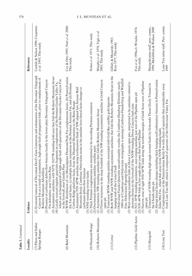
Many of the inversion geometries illustratedin Figure 2 and listed in Table 2 are present innorth–central Nevada and are described in thispaper; namely, fault-propagation folds, flowerstructures and floating islands. However, noneof these features are unique to inversion. Aspointed out by Cooper et al. (1989), inversioncannot be unequivocally recognized unlessfolded growth sequences are present. Therefore,except for growth fault sequences, either foldedor unfolded, few if any of the features in Tables 1and 2 prove the existence of Palaeozoic normalfaults. This paper does not fully document anyfolded growth sequences. However, it is believedthat the presence of several features in Tables 1and 2 at given localities in Figure 1 is highlysuggestive of a Palaeozoic normal fault, and, ata minimum, Palaeozoic normal faults andsubsequent inversion of those faults should beconsidered as a viable hypothesis to explain theobserved features. Table 3 lists the localitiesnumbered in Figure 1 and the corresponding,supporting evidence for Palaeozoic normalfaults. Next, more detailed evidence is presentedfor Palaeozoic normal faults at Garden Pass,in the northern Carlin trend, and in the Getchelldistrict.
Garden Pass
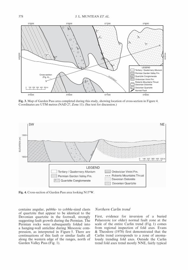
At Garden Pass (Fig. 1), a half-graben boundedby a west-dipping fault contains conglomerates,sandstones and sandy limestones of Permianage (Garden Valley Formation) (Figs 3 and 4).The Permian rocks rest on the Ordovician VininiFormation, which is in the upper plate of theRoberts Mountain Thrust. In the footwall ofthe fault are Devonian dolomites and locallyquartzites that are in the lower plate of theRoberts Mountain Thrust. Within the Permianrocks there is a prominent conglomerate thatT
able
3. C
onti
nued
Loc
ality
Evi
denc
eR
efer
ence
s
(15)
Edn
a M
ount
ains
(1) P
enns
ylva
nian
Hig
hway
Lim
esto
ne th
ins
out i
n ha
ngin
g w
alls
aw
ay fr
om N
NW
-tre
ndin
g fa
ults
Eri
ckso
n &
Mar
sh 1
974a
,b;
(2) C
ongl
omer
ates
of t
he P
enns
ylva
nian
Bat
tle
Fm
thin
con
side
rabl
y to
war
d ax
es o
f WN
W-t
rend
ing
Thi
s st
udy
fol
ds, s
ugge
stin
g pa
laeo
topo
grap
hic
high
(3) N
NW
-tre
ndin
g re
vers
e fa
ult t
hat p
lace
s C
ambr
ian
Pre
ble
Fm
up
agai
nst O
rdov
icia
n V
alm
y F
m(1
6) J
erri
tt C
anyo
n(1
) ‘F
loat
ing
isla
nd’ i
n th
e fo
otw
all o
f the
WN
W-t
rend
ing
New
Dee
p F
ault
in th
e M
urra
y M
ine
Hof
stra
et a
l. 19
99; D
ewit
t 200
1;Jo
nes
2005
(2) W
NW
faul
ts a
re fi
lled
by 3
20 M
a an
desi
te d
ykes
(3) W
NW
faul
ts in
terp
rete
d as
late
ral r
amps
to S
E-d
irec
ted
thru
stin
g an
d du
plex
ing
(17)
Aus
tin
area
(1) W
NW
-tre
ndin
g m
onoc
lines
that
ove
rpri
nt th
e pr
omin
ent N
NE
str
uctu
ral t
rend
in th
e ra
nges
McK
ee, 1
968,
197
6;(T
oiya
be a
nd(2
) Cam
bria
n to
Ear
ly M
issi
ssip
pian
str
ata
and
stru
ctur
es a
re c
ut a
nd ti
lted
by
nort
h-di
ppin
g no
rmal
Smit
h &
Mill
er, 1
990
Toq
uim
a ra
nges
) f
ault
s an
d th
en b
evel
led
and
over
lain
by
Pen
nsyl
vani
an to
Ear
ly P
erm
ian
sedi
men
tary
seq
uenc
es w
ith
loc
al m
afic
lava
flow
s(1
8) R
aven
swoo
d(1
) NW
-tre
ndin
g as
ymm
etri
c an
ticl
ine
and
mon
oclin
es th
at o
verp
rint
the
prom
inen
t NN
E s
truc
tura
lT
his
stud
y(s
outh
ern
Shos
hone
tre
nd in
the
rang
e an
d fo
ld R
ober
ts M
ount
ain
Thr
ust
Ran
ge)
578 J. L. MUNTEAN ET AL.
Northern Carlin trend
First, evidence for inversion of a buriedPalaeozoic (or older) normal fault zone at thescale of the entire Carlin trend (Fig. 1) comesfrom regional inspection of fold axes. Evans& Theodore (1978) first demonstrated that theCarlin trend corresponds to a zone of anoma-lously trending fold axes. Outside the Carlintrend fold axes trend mostly NNE, fairly typical
Fig. 3. Map of Garden Pass area completed during this study, showing location of cross-section in Figure 4.Coordinates are UTM metres (NAD 27, Zone 11). (See text for discussion.)
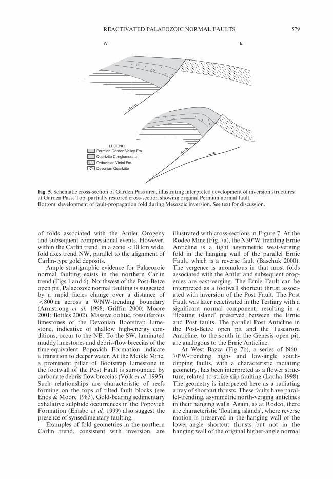
contains angular, pebble- to cobble-sized clastsof quartzite that appear to be identical to theDevonian quartzite in the footwall, stronglysuggesting fault growth during the Permian. ThePermian rocks were subsequently folded intoa hanging-wall anticline during Mesozoic com-pression, as interpreted in Figure 5. There arecontinuations of this fault or similar faults allalong the western edge of the ranges, north ofGarden Valley Pass (Fig. 1).
Fig. 4. Cross-section of Garden Pass area looking N15°W.
579REACTIVATED PALAEOZOIC NORMAL FAULTS
of folds associated with the Antler Orogenyand subsequent compressional events. However,within the Carlin trend, in a zone <10 km wide,fold axes trend NW, parallel to the alignment ofCarlin-type gold deposits.
Ample stratigraphic evidence for Palaeozoicnormal faulting exists in the northern Carlintrend (Figs 1 and 6). Northwest of the Post-Betzeopen pit, Palaeozoic normal faulting is suggestedby a rapid facies change over a distance of<800 m across a WNW-trending boundary(Armstrong et al. 1998; Griffin 2000; Moore2001; Bettles 2002). Massive oolitic, fossiliferouslimestones of the Devonian Bootstrap Lime-stone, indicative of shallow high-energy con-ditions, occur to the NE. To the SW, laminatedmuddy limestones and debris-flow breccias of thetime-equivalent Popovich Formation indicatea transition to deeper water. At the Meikle Mine,a prominent pillar of Bootstrap Limestone inthe footwall of the Post Fault is surrounded bycarbonate debris-flow breccias (Volk et al. 1995).Such relationships are characteristic of reefsforming on the tops of tilted fault blocks (seeEnos & Moore 1983). Gold-bearing sedimentaryexhalative sulphide occurrences in the PopovichFormation (Emsbo et al. 1999) also suggest thepresence of synsedimentary faulting.
Examples of fold geometries in the northernCarlin trend, consistent with inversion, are
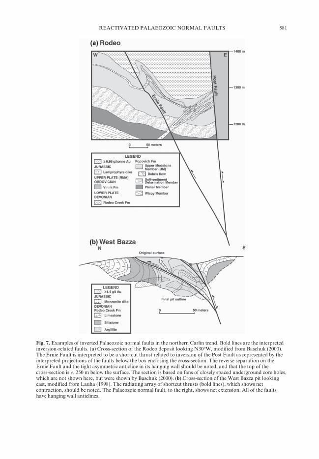
illustrated with cross-sections in Figure 7. At theRodeo Mine (Fig. 7a), the N30ºW-trending ErnieAnticline is a tight asymmetric west-vergingfold in the hanging wall of the parallel ErnieFault, which is a reverse fault (Baschuk 2000).The vergence is anomalous in that most foldsassociated with the Antler and subsequent orog-enies are east-verging. The Ernie Fault can beinterpreted as a footwall shortcut thrust associ-ated with inversion of the Post Fault. The PostFault was later reactivated in the Tertiary with asignificant normal component, resulting in a‘floating island’ preserved between the Ernieand Post faults. The parallel Post Anticline inthe Post-Betze open pit and the TuscaroraAnticline, to the south in the Genesis open pit,are analogous to the Ernie Anticline.
At West Bazza (Fig. 7b), a series of N60–70ºW-trending high- and low-angle south-dipping faults, with a characteristic radiatinggeometry, has been interpreted as a flower struc-ture, related to strike-slip faulting (Lauha 1998).The geometry is interpreted here as a radiatingarray of shortcut thrusts. These faults have paral-lel-trending, asymmetric north-verging anticlinesin their hanging walls. Again, as at Rodeo, thereare characteristic ‘floating islands’, where reversemotion is preserved in the hanging wall of thelower-angle shortcut thrusts but not in thehanging wall of the original higher-angle normal
Fig. 5. Schematic cross-section of Garden Pass area, illustrating interpreted development of inversion structuresat Garden Pass. Top: partially restored cross-section showing original Permian normal fault.Bottom: development of fault-propagation fold during Mesozoic inversion. See text for discussion.
580 J. L. MUNTEAN ET AL.
fault. The shortcut thrusts are locally intruded byJurassic dykes, indicating that the structure isat least Jurassic in age (Lauha 1998). The flowerstructure in the West Bazza Pit is parallel, butwith opposite vergence, to the Betze Anticline,a main ore-control in the Post-Betze open pit.The Betze Anticline has been related to theemplacement of the Jurassic Goldstrike Stock(Leonardson & Rahn 1996); however, the foldspredate the Goldstrike Stock, as argued byMoore (2001). Both the West Bazza and Betzeanticlines are interpreted to be related to reac-tivation of Palaeozoic WNW-trending faults thatdeveloped along the southern boundary of theBootstrap Limestone shelf.
Getchell
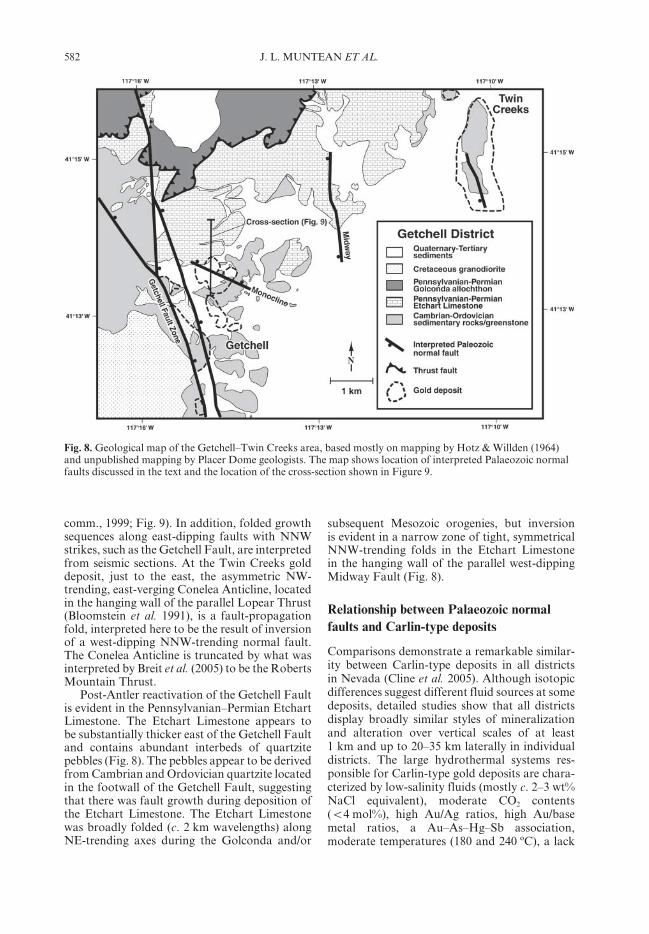
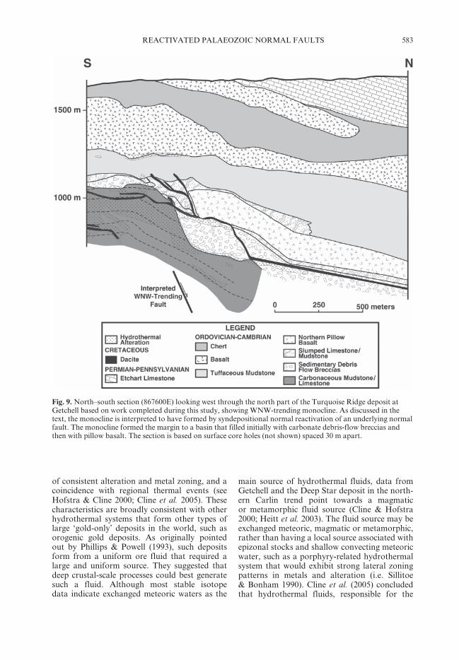
As for the northern Carlin trend, evidence forboth NNW- and WNW-trending Palaeozoicnormal faults is present in the Getchell district(Figs 1 and 8). A lower sequence of pillow basaltand underlying sedimentary debris-flow brecciasof Cambrian–Ordovician age has a sharp N70ºWsouthern margin that is an important ore controlto the Turquoise Ridge deposit (Fig. 8). Themargin occurs along the northern limb of amonocline that is interpreted to have formed bysyndepositional reactivation of an underlyingnorth-dipping, WNW-trending Palaeozoicnormal fault (Placer Dome Exploration, pers.
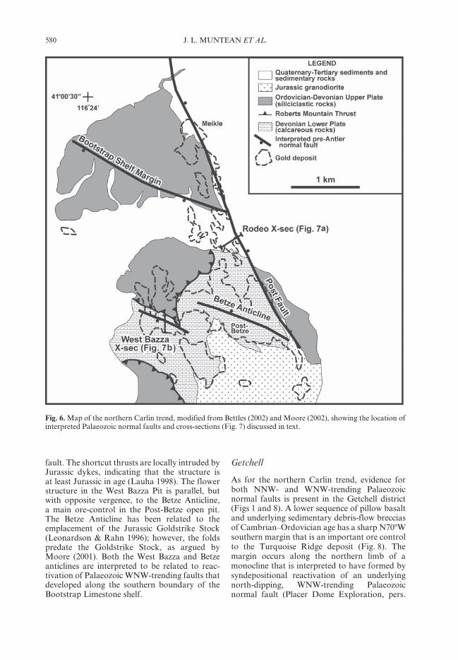
Fig. 6. Map of the northern Carlin trend, modified from Bettles (2002) and Moore (2002), showing the location ofinterpreted Palaeozoic normal faults and cross-sections (Fig. 7) discussed in text.
581REACTIVATED PALAEOZOIC NORMAL FAULTS
Fig. 7. Examples of inverted Palaeozoic normal faults in the northern Carlin trend. Bold lines are the interpretedinversion-related faults. (a) Cross-section of the Rodeo deposit looking N30°W, modified from Baschuk (2000).The Ernie Fault is interpreted to be a shortcut thrust related to inversion of the Post Fault as represented by theinterpreted projections of the faults below the box enclosing the cross-section. The reverse separation on theErnie Fault and the tight asymmetric anticline in its hanging wall should be noted; and that the top of thecross-section is c. 250 m below the surface. The section is based on fans of closely spaced underground core holes,which are not shown here, but were shown by Baschuk (2000). (b) Cross-section of the West Bazza pit lookingeast, modified from Lauha (1998). The radiating array of shortcut thrusts (bold lines), which shows netcontraction, should be noted. The Palaeozoic normal fault, to the right, shows net extension. All of the faultshave hanging wall anticlines.
582 J. L. MUNTEAN ET AL.
comm., 1999; Fig. 9). In addition, folded growthsequences along east-dipping faults with NNWstrikes, such as the Getchell Fault, are interpretedfrom seismic sections. At the Twin Creeks golddeposit, just to the east, the asymmetric NW-trending, east-verging Conelea Anticline, locatedin the hanging wall of the parallel Lopear Thrust(Bloomstein et al. 1991), is a fault-propagationfold, interpreted here to be the result of inversionof a west-dipping NNW-trending normal fault.The Conelea Anticline is truncated by what wasinterpreted by Breit et al. (2005) to be the RobertsMountain Thrust.
Post-Antler reactivation of the Getchell Faultis evident in the Pennsylvanian–Permian EtchartLimestone. The Etchart Limestone appears tobe substantially thicker east of the Getchell Faultand contains abundant interbeds of quartzitepebbles (Fig. 8). The pebbles appear to be derivedfrom Cambrian and Ordovician quartzite locatedin the footwall of the Getchell Fault, suggestingthat there was fault growth during deposition ofthe Etchart Limestone. The Etchart Limestonewas broadly folded (c. 2 km wavelengths) alongNE-trending axes during the Golconda and/or
subsequent Mesozoic orogenies, but inversionis evident in a narrow zone of tight, symmetricalNNW-trending folds in the Etchart Limestonein the hanging wall of the parallel west-dippingMidway Fault (Fig. 8).
Relationship between Palaeozoic normalfaults and Carlin-type deposits
Comparisons demonstrate a remarkable similar-ity between Carlin-type deposits in all districtsin Nevada (Cline et al. 2005). Although isotopicdifferences suggest different fluid sources at somedeposits, detailed studies show that all districtsdisplay broadly similar styles of mineralizationand alteration over vertical scales of at least1 km and up to 20–35 km laterally in individualdistricts. The large hydrothermal systems res-ponsible for Carlin-type gold deposits are chara-cterized by low-salinity fluids (mostly c. 2–3 wt%NaCl equivalent), moderate CO2 contents(<4 mol%), high Au/Ag ratios, high Au/basemetal ratios, a Au–As–Hg–Sb association,moderate temperatures (180 and 240 ºC), a lack
Fig. 8. Geological map of the Getchell–Twin Creeks area, based mostly on mapping by Hotz & Willden (1964)and unpublished mapping by Placer Dome geologists. The map shows location of interpreted Palaeozoic normalfaults discussed in the text and the location of the cross-section shown in Figure 9.
583REACTIVATED PALAEOZOIC NORMAL FAULTS
of consistent alteration and metal zoning, and acoincidence with regional thermal events (seeHofstra & Cline 2000; Cline et al. 2005). Thesecharacteristics are broadly consistent with otherhydrothermal systems that form other types oflarge ‘gold-only’ deposits in the world, such asorogenic gold deposits. As originally pointedout by Phillips & Powell (1993), such depositsform from a uniform ore fluid that required alarge and uniform source. They suggested thatdeep crustal-scale processes could best generatesuch a fluid. Although most stable isotopedata indicate exchanged meteoric waters as the
main source of hydrothermal fluids, data fromGetchell and the Deep Star deposit in the north-ern Carlin trend point towards a magmaticor metamorphic fluid source (Cline & Hofstra2000; Heitt et al. 2003). The fluid source may beexchanged meteoric, magmatic or metamorphic,rather than having a local source associated withepizonal stocks and shallow convecting meteoricwater, such as a porphyry-related hydrothermalsystem that would exhibit strong lateral zoningpatterns in metals and alteration (i.e. Sillitoe& Bonham 1990). Cline et al. (2005) concludedthat hydrothermal fluids, responsible for the
Fig. 9. North–south section (867600E) looking west through the north part of the Turquoise Ridge deposit atGetchell based on work completed during this study, showing WNW-trending monocline. As discussed in thetext, the monocline is interpreted to have formed by syndepositional normal reactivation of an underlying normalfault. The monocline formed the margin to a basin that filled initially with carbonate debris-flow breccias andthen with pillow basalt. The section is based on surface core holes (not shown) spaced 30 m apart.
584 J. L. MUNTEAN ET AL.
formation of Carlin-type deposits, had theirorigins during removal of the Farallon slabbelow north–central Nevada in the Eocene,which promoted deep crustal melting, progrademetamorphism and devolatilization, thus gener-ating deep, primitive fluids. In the upper crust,ore fluids were then diluted by exchanged mete-oric waters, prior to depositing gold within a fewkilometres of the surface.
Figure 1 shows a close spatial correlationbetween the proposed Palaeozoic normal faultsand the location of Carlin-type gold deposits.Zones of Palaeozoic normal faults are coincidentwith the Carlin and Battle Mountain–Eurekatrends. There is an inherent bias because thisstudy focused on mine areas where the exposureis better and there is much more information.However, Figure 1 also shows proposed Palaeo-zoic normal faults well away from known mines.As shown in Figure 1 and described in Table 3,Palaeozoic normal faults that have been identi-fied in this study mostly trend NNW (N0–30ºW)and WNW (N50–70ºW). Studies of rift strataand dyke swarms in the Rocky Mountains, theColorado Plateau and the Mid-continent indi-cate that WNW-trending faults originally formedduring a rifting event between 1.1 and 1.3 Ga,and formation of north-trending faults andreactivation of WNW-trending faults occurredbetween 0.7 and 0.9 Ga (Marshak et al. 2000;Timmons et al. 2001). Thorman & Ketner(1979) first pointed out evidence for N50–70ºW-trending basement faults of probable Proterozoicorigin in northeastern Nevada (e.g. Wells Fault)based on offset of regional stratigraphic andstructural features.
The coincidence of these Proterozoic featureswith the Palaeozoic faults identified in thisstudy, strongly suggests that the faults are linkedat depth with basement faults, formed duringcontinental rifting of western North Americain Proterozoic times and were continuallyreactivated in the Early Palaeozoic during theformation of the continental margin. Suchbasement-penetrating, linked high-angle faultsystems probably have a greater vertical extentthan later faults and served as the main collectingpoints and conduits for deep, gold-bearingcrustal fluids responsible for Carlin-type miner-alization in the Eocene. Inversion of thesefault systems during the Antler and subsequentorogenies commonly resulted in structuralculminations, especially where NNW- andWNN-trending Palaeozoic normal faults inter-sect. Subsequent erosion of these culminationsled to the currently observed windows oflower plate rocks. The superimposition of thesestructural culminations over Palaeozoic normal
faults created an optimal setting for theformation of Carlin-type gold deposits.
This paper would not be possible without the supportand contributions of many geologists. From PlacerDome, including the Cortez, Bald Mountain, andTurquoise Ridge mines, we would like to acknowledgeJ. Thorson, R. Conelea, P. Klipfel, A. Norman,R. Marcio, V. Chevillon, G. Edmondo, R. Hays,K. Balleweg, J. Hebert, T. Thompson, J. Brady,S. Thomas, D. Bahrey, K. Wood and A. Dorff. Weespecially acknowledge A. Jackson and E. Gonzales-Urien of Placer Dome for suggesting the study andsupporting it to its completion. The mine staffs ofNewmont Mining, Barrick Gold, Anglo Gold, andGlamis Gold are congratulated for graciously givingmine tours and publishing data from their properties.J.L.M. is especially grateful to Placer Dome, specificallyW. Howald and G. Hall, for allowing publication ofthese data and concepts that were generated with hiscolleagues during his tenure with Placer Dome as anexploration geologist. We also thank C. Thorman andE. Nelson for their constructive reviews of the manu-script. Also, J.L.M. will be eternally indebted to MikeCoward for opening his eyes to the forest as well as thetrees.
References
AREHART, G. B., CHAKURIAN, A. M., TRETBAR, D. R.,CHRISTENSEN, J. N., MCINNES, B. A. & DONELICK,R. A. 2003. Evaluation of radioisotope dating ofCarlin-type deposits in the Great Basin, WesternNorth America, and implications for depositgenesis. Economic Geology, 98, 235–248.
ARMSTRONG, A. K., THEODORE, T. G., OSCARSON,R. L. et al. 1998. Preliminary facies analysis ofSilurian and Devonian autochthonous rocksthat host gold along the Carlin trend, Nevada.United States. In: TOSDAL, R. M. (ed.) Contributionsto the Gold Metallogeny of Northern Nevada. USGeological Survey Open-File Report, 98–338,38–68.
BASCHUK, G. J. 2000. Lithological and structural orecontrols within the upper zone of Barrick’s Rodeodeposit, Eureka County, Nevada. In: CLUER, J. K.,PRICE, J. G., STRUHSACKER, E. M., HARDYMAN,R. F. & MORRIS, C. L. (eds) Geology and Ore Depos-its 2000: the Great Basin and Beyond. GeologicalSociety of Nevada, Reno, 989–1001.
BETTLES, K. 2002. Exploration and geology, 1962 to2002, at the Goldstrike property, Carlin trend,Nevada. In: GOLDFARB, R. J. & NIELSEN, R. L.(eds) Integrated Methods for Discovery: GlobalExploration in the Twenty-first Century. Societyof Economic Geologists Special Publications, 9,275–298.
BLOOMSTEIN, E. I., MASSINGILL, G. L., PARRATT, R. L.& PELTONEN, D. R. 1991. Discovery, geology, andmineralization of the Rabbit Creek gold deposit,Humboldt county, Nevada. In: RAINES, G. L.,LISLE, R. E., SCHAFER R. W., & WILKINSON, W. H.(eds) Geology and Ore Deposits of the Great Basin.Geological Society of Nevada, Reno, 821–843.
585REACTIVATED PALAEOZOIC NORMAL FAULTS
BOND, G. C., CHRISTIE-BLICK, N., KOMINZ, M. A. &DEVLIN, W. J. 1985. An early Cambrian rift topost-rift transition in the Cordillera of westernNorth America. Nature, 316, 742–745.
BREIT, F. J., RESSEL, M. W., ANDERSON, S. D. &MARNIE-MUIRHEAD, E. M. 2005. Geology and golddeposits of the Twin Creeks Mine, HumboldtCounty, Nevada. Field Trip Guidebook 4, Sediment-Hosted Gold Deposits of the Getchell District,Nevada. Symposium 2005 Window to the World.Geological Society of Nevada, Reno, 77–102.
BURCHFIEL, B. C., COWAN, D. S. & DAVIS, G. A. 1992.Tectonic overview of the Cordilleran orogen inthe western United States. In: BURCHFIEL, B. C.,LIPMAN, P. W., & ZOBACK, M. L. (eds) The Geologyof North America, the Cordilleran Orogen: Conter-minous U.S. Geological Society of America Decadein North American Geology Series, G-3, 9–56.
CARLISLE, D. & NELSON, C. A. 1990. Geologic Mapof the Mineral Hill Quadrangle, Nevada. NevadaBureau of Mines and Geology Map, 97.
CARPENTER, J. A., CARPENTER, D. G. & DOBBS, S. W.1993. Structural analysis of the Pine Valley area,Nevada. Nevada Petroleum Society 1993 FieldConference Guidebook, 9–49. Nevada PetroleumSociety, Inc, Reno, Nevada.
CHRISTIANSEN, R. L. & YEATS, R. S. 1992. Post-Laramide geology of the U.S. Cordilleran region.In: BURCHFIEL, B. C., LIPMAN, P. W. & ZOBACK,M. L. (eds) The Geology of North America, theCordilleran Orogen: Conterminous U.S. GeologicalSociety of America, Decade in North AmericanGeology Series, G-3, 261–406.
CLINE, J. S. & HOFSTRA, A. H. 2000. Ore fluid evolutionat the Getchell Carlin-type gold deposit, Nevada,USA. European Journal of Mineralogy, 12, 195–212.
CLINE, J. S., HOFSTRA, A. H., MUNTEAN, J. L., TOSDAL,R. M. & HICKEY, K. A. 2005. Carlin-type golddeposits in Nevada: critical geologic characteristicsand viable models. In: HEDENQUIST, J. W.,THOMPSON, J. F. H., GOLDFARB, R. J. & RICHARDS,J. P. (eds) Economic Geology 100th AnniversaryVolume. Society of Economic Geologists, inc,Littleton, Colorado, 451–484.
COOPER, M. A., WILLIAMS, G. D., DE GRACIANSKY,P. C. et al. 1989. Inversion tectonics — a discussion.In: COOPER, M. A. & WILLIAMS, G. D. (eds) Inver-sion Tectonics. Geological Society, London, SpecialPublications, 44, 335–347.
COWARD, M. 1994. Inversion tectonics. In: HANCOCK,P. L. (ed.) Continental Deformation. Permagon,Oxford, 289–304.
COX, B. E. & OTTO, B. R. 1995. Interim report for theBald Mountain–Alligator Ridge regional geologicmapping project. Unpublished Placer Dome USinternal report.
DAVIS, G. H. 1978. Monocline fold pattern of theColorado Plateau. In: MATTHEWS, V., III (ed.)Laramide Folding Associated with Basement BlockFaulting in the Western United States. GeologicalSociety of America, Memoirs, 151, 215–233.
DEWITT, A. B. 2001. Structural architecture ofthe Jerritt Canyon district and gold deposits.In: SHADDRICK, D. R, ZBINDEN, E., MATHEWSON,
D. C. & PRENN, C. (eds) Regional Tectonics andStructural Control of Ore: the Major Gold Trends ofNorthern Nevada. Geological Society of NevadaSpecial Publications, 33, 135–145.
EMSBO, P., HUTCHINSON, R. W., HOFSTRA, A. H.,VOLK, J. A., BETTLES, K. H., BASCHUK, G. J. &JOHNSON, C. A. 1999. Syngenetic Au on theCarlin trend: implications for Carlin-type deposits.Geology, 27, 59–62.
ENOS, P. & MOORE, C. H. 1983. Fore-reef slope.In: SCHOLLE, P. A., BEBOUT, D. G. & MOORE, C. H.(eds) Carbonate Depositional Environments. Ameri-can Association of Petroleum Geologists Memoirs,33, 507–538.
ERICKSON, R. L. & MARSH, S. P. 1974a. Geologic Mapof the Iron Point Quadrangle, Humboldt County,Nevada. US Geological Survey Map, GQ-1175.
ERICKSON, R. L. & MARSH, S. P. 1974b. Geologic Mapof the Golconda Quadrangle, Humboldt County,Nevada. US Geological Survey Map, GQ-1174.
EVANS, J. G. & THEODORE, T. G. 1978. Deformation ofthe Roberts Mountains Allochthon in North–CentralNevada. US Geological Survey, ProfessionalPapers, 1060.
FOO, S. T., HAYS, R. C., JR & MCCORMACK J. K.1996a. Geology and mineralization of the Pipelinegold deposit, Lander county, Nevada. In: COYNER,A. R. & FAHEY, P. L. (eds) Geology and Ore Depos-its of the American Cordillera. Geological Society ofNevada, Reno, 95–109.
FOO, S. T., HAYS, R. C., JR & MCCORMACK J. K.1996b. Geology and mineralization of the SouthPipeline gold deposit, Lander county, Nevada.In: COYNER, A. R. & FAHEY, P. L. (eds) Geology andOre Deposits of the American Cordillera. GeologicalSociety of Nevada, Reno, 111–121.
GILLULY, J. & MASURSKY, H. 1965. Geology of theCortez Quadrangle, Nevada. US Geological SurveyBulletin, 1175.
GRAUCH, V. J. S., JACHENS, R. C. & BLAKELY, R. J.1995. Evidence for a basement structure relatedto the Cortez disseminated gold deposit trend andimplications for regional exploration in Nevada.Economic Geology, 90, 203–207.
GRAUCH, V. J. S., RODRIGUEZ, B. D. & WOODEN, J. L.2003. Geophysical and isotopic constraints oncrustal structure related to mineral trends in north–central Nevada and implications for tectonichistory. Economic Geology, 98, 269–286.
GRIFFIN, G. L. 2000. Paleogeography of late Silurian–Devonian autochthonous carbonates: implicationsfor old faults and intrusive distribution, Goldstrikeproperty, Nevada (abstract). In: CLUER, J. K.,PRICE, J. G., STRUHSACKER, E. M., HARDYMAN,R. F. & MORRIS, C. L. (eds) Geology and Ore Depos-its 2000: the Great Basin and Beyond. GeologicalSociety of Nevada, Reno, A8.
HARLAN, J. B., HARRIS, D. A., MALLETE, P. M.,NORBY, J. W., ROTA, J. C. & SAGAR, J. J. 2002.Geology and mineralization of the MaggieCreek District. In: THOMPSON, T. B., TEAL, L. &MEEUWIG, R. O. (eds) Gold Deposits of the CarlinTrend. Nevada Bureau of Mines and GeologyBulletin, 111, 115–142.
586 J. L. MUNTEAN ET AL.
HEITT, D. G., DUNBAR, W. W., THOMPSON, T. B. &JACKSON, R. G. 2003. Geology and geochemistry ofthe Deep Star gold deposit, Carlin trend, Nevada.Economic Geology, 98, 1107–1136.
HOFSTRA, A. H. & CLINE, J. S. 2000, Characteristicsand models for Carlin-type gold deposits. In:HAGEMANN, S. E. & BROWN, P. E. (eds) Gold in2000. Reviews in Economic Geology, 13, 163–220.
HOFSTRA, A. H., SNEE, L. W., RYE, R. O. et al. 1999.Age constraints on Jerritt Canyon and otherCarlin-type gold deposits in the western UnitedStates—relationship to mid-Tertiary extension andmagmatism. Economic Geology, 94, 769–802.
HOTZ, P.E. & WILLDEN, R. 1964. Geology and MineralDeposits of the Osgood Mountains Quadrangle,Humboldt County, Nevada. US Geological Survey,Professional Papers, 431.
JONES, M. 2005. Jerritt Canyon district IndependenceMountains, Elko County, Nevada, gold’s atfault. In: CALICRATE, T., LEAVITT, E., O’MALLEY,P. & CRAFFORD, E. J. (eds) Field Trip Guidebook 8,Sediment-Hosted Gold Deposits of the IndependenceRange, Nevada. Symposium 2005 Window to theWorld. Geological Society of Nevada, Reno,99–122.
LAUHA, E. A. 1998. The West Bazza pit and its relation-ship to the Screamer deposit. In: KIZIS, J. A. (ed.)Shallow Expressions of Deep, High-Grade GoldDeposits. Geological Society of Nevada SpecialPublications, Reno, 28, 133–145.
LEONARDSON, R. W. & RAHN, J. E. 1996, Geologyof the Betze–Post gold deposits, Eureka County,Nevada. In: COYNER, A. R. & FAHEY, P. L.(eds) Geology and Ore Deposits of the AmericanCordillera. Geological Society of Nevada, Reno,61–94.
MARSHAK, S., KARLSTROM, K. & TIMMONS, J. M. 2000.Inversion of Proterozoic extensional faults: Anexplanation for the pattern of Laramide andAncestral Rockies intracratonic deformation,United States. Geology, 28, 735–738.
MCGIBBON, D. H. & WALLACE, A. B. 2000. Geologyof the Marigold area, In: THEODORE, T. G. (ed.)Geology of Pluton-related Gold Mineralization atBattle Mountain, Nevada. Monographs in MineralResource Science, Center for Mineral Resources,University of Arizona, 2, 222–240.
MCKEE, E. H. 1968. Geologic Map of the Austin Quad-rangle, Lander County, Nevada. US GeologicalSurvey Map, GQ-1307.
MCKEE, E. H. 1976. Geology of the Northern Part ofthe Toquima Range, Lander, Eureka, and Nye Coun-ties, Nevada. US Geological Survey, ProfessionalPapers, 931.
MOORE, S. 2001. Ages of fault movement andstepwise development of structural fabrics on theCarlin trend. In: SHADDRICK, D. R., ZBINDEN, E.,MATHEWSON, D. C. & PRENN, C. (eds) RegionalTectonics and Structural Control of Ore: the majorGold Trends of Northern Nevada. Geological Societyof Nevada, Special Publications, 33, 71–89.
MOORE, S. 2002. Geology of the northern Carlin trend(map). In: THOMPSON, T. B., TEAL, L. & MEEUWIG,R. O. (eds) Gold Deposits of the Carlin Trend.
Nevada Bureau of Mines and Geology Bulletin,111.
MURPHY, M. A., MCKEE, E. H., WINTERER, E. L.,MATTI, J. C. & DUNHAM, J. B. 1978. PreliminaryGeologic Map of the Roberts Creek Quadrangle,Nevada. US Geological Survey Open-File Report,78–376.
Nevada Bureau of Mines and Geology. 2004. TheNevada Mineral Industry 2003. Nevada Bureau ofMines and Geology, Special Publications, MI-2003.
NOLAN, T. B., MERRIAM, C. W. & BREW, D. A. 1971.Geologic Map of the Eureka Quadrangle, Eureka andWhite Pine Counties, Nevada. US Geological SurveyMap, I-612.
NUTT, C. J., HOFSTRA, A. H., HART, K. S. &MORTENSEN, J. K. 2000. Structural setting and gen-esis of gold deposits in the Bald Mountain–AlligatorRidge area, east–central Nevada. In: CLUER, J. K.,PRICE, J. G., STRUHSACKER, E. M., HARDYMAN,R. F. & MORRIS, C. L. (eds) Geology and Ore Depos-its 2000: the Great Basin and Beyond. GeologicalSociety of Nevada, Reno, 513–537.
PHILLIPS, G. N. & POWELL, R. 1993. Link between goldprovinces. Economic Geology, 88, 1084–1098.
POOLE, F. G., STEWART, J. H., PALMER, A. R. et al.1992. Latest Precambrian to latest Devoniantime: Development of a continental margin. In:BURCHFIEL, B. C., LIPMAN, P. W. & ZOBACK, M. L.(eds) The Geology of North America, the CordilleranOrogen: Conterminous U.S. Geological Societyof America, Decade in North American GeologySeries, G-3, 9–56.
ROBERTS, R. J. 1951. Geology of the Antler PeakQuadrangle, Nevada. US Geological Survey Map,GQ-10.
ROBERTS, R. J. 1960. Alignment of Mining Districtsin North–Central Nevada. US Geological Survey,Professional Papers, 400-B, B17–B19.
ROBERTS, R. J. 1966. Metallogenic Provinces andMineral Belts in Nevada. Nevada Bureau of MinesReport, 13, A, 47–72.
RODRIGUEZ, B. D. 1998. Regional crustal structurebeneath the Carlin trend, Nevada based on deepelectrical geophysical measurements. In: TOSDAL,R. M. (ed.) Contributions to the Gold Metallogeny ofNorthern Nevada. US Geological Survey Open-FileReport, 98–338, 15–19.
ROSS, R. J., JR 1977. Ordovician paleogeography ofthe western United States. In: STEWART, J. H.,STEVENS, C. H. & FRITSCHE, A. E. (eds) PaleozoicPaleogeography of the Western United States.Pacific Section, Society of Economic Paleontolo-gists and Mineralogists, Pacific Coast Paleogeogra-phy Symposium, 1, 19–38.
SILLITOE, R. H. & BONHAM, H. F. 1990. Sediment-hosted gold deposits: distal products of magmatic–hydrothermal systems. Geology, 18, 157–161.
SMITH, D. L. & MILLER, E. L. 1990. Late Paleozoicextension in the Great Basin western United States.Geology, 18, 712–715.
STENGER, D. P., KESLER, S. E., PELTONEN, D. R. &TAPPER, C. J. 1998. Deposition of gold in Carlin-type deposits: the role of sulfidation and decarbon-ation at Twin Creeks, Nevada. Economic Geology,93, 201–215.
587REACTIVATED PALAEOZOIC NORMAL FAULTS
STEWART, J. H. 1972. Initial deposits in the Cordillerangeosyncline: evidence of a Late Precambrian separa-tion. Geological Society of America Bulletin, 83,1345–1360.
STEWART, J. H. 1980. Geology of Nevada. NevadaBureau of Mines and Geology Special Publications,4.
STEWART, J. H. & POOLE, F. G. 1974. Lower Paleozoicand uppermost Precambrian Cordilleran mio-geocline, Great Basin, western United States. In:DICKINSON, W. R. (ed.) Tectonics and Sedimenta-tion. Society of Economic Paleontologist andMineralogists, Special Publications, 22, 28–57.
THORMAN, C. H. & KETNER, K. B. 1979. West-northwest strike-slip faults and other structures inallochthonous rocks in central and eastern Nevadaand western Utah. In: NEWMAN, G. W. & GOODE,H. D. (eds) Basin and Range Symposium. RockyMountain Association of Geologists, 123–134.
THORMAN, C. H., KETNER, K. B., BROOKS, W. E.,SNEE, L. W. & ZIMMERMAN, R. A. 1991. LateMesozoic-Cenozoic tectonics in northeasternNevada. In: RAINES, G. L., LISLE, R. E., SCHAFER
R. W., & WILKINSON, W. H. (eds) Geology and OreDeposits of the Great Basin, Geological Society ofNevada, Reno, 25–45.
TIMMONS, J. M., KARLSTROM, K. E., DEHLER, C. M.,GEISSMAN, J. W. & HEIZLER, M. T. 2001. Protero-zoic multistage (ca. 1.1 and 0.8 Ga) extensionrecorded in the Grand Canyon Supergroup andestablishment of northwest- and north-trendingtectonic grains in the southwestern UnitedStates. Geological Society of America Bulletin, 113,163–190.
TOSDAL, R. M. 2001. Building the structural archi-tecture of the Carlin trend: evidence from thenorthern Piñon Range, northeastern Nevada.In: SHADDRICK, D. R, ZBINDEN, E., MATHEWSON,D. C. & PRENN, C. (eds) Regional Tectonics andStructural Control of Ore: the major Gold Trendsof Northern Nevada. Geological Society of NevadaSpecial Publications, 33, 129–134.
TOSDAL, R. M., WOODEN, J. L. & KISTLER, R. W. 2000.Geometry of the Neoproterozoic continental break-up, and implications for location of Nevada mineralbelts. In: CLUER, J. K., PRICE, J. G., STRUHSACKER,E. M., HARDYMAN, R. F. & MORRIS, C. L. (eds)
Geology and Ore Deposits 2000: the Great Basinand Beyond. Geological Society of Nevada, Reno,451–466.
TRETBAR, D. R., AREHART, G. B. & CHRISTENSEN, J. N.2000. Dating gold deposition in a Carlin-typegold deposit using Rb/Sr methods on the mineralgalkhaite. Geology, 28, 947–950.
VOLK, J., LAUHA, E., LEONARDSON, R. & RAHN, J.1995. Structural geology of the Betze-Post andMeikle deposits, Elko and Eureka Counties. In:GREEN, S. (ed.) Trip B—Structural Geology of theCarlin Trend, Geology and Ore Deposits of theAmerican Cordillera: Geological Society of NevadaField Trip Guidebook, Geological Society ofNevada, Reno, 180–194.
VOLK, J., WEAKLY, C., PENICK, M. & LANDER, A. 2001.Structural geology of the Goldstrike property,north–central Nevada. In: SHADDRICK, D. R.,ZBINDEN, E., MATHEWSON, D. C. & PRENN, C. (eds)Regional Tectonics and Structural Control of Ore:The Major Gold Trends of Northern Nevada.Geological Society of Nevada Special Publications,33, 361–380.
WILLIAMS, C. L., THOMPSON, T. B., POWELL, J. L. &DUNBAR, W. 2000. Gold-bearing breccias of theRain mine, Carlin trend, Nevada, USA. EconomicGeology, 95, 391–404.
WILLIAMS, G. D., POWELL, C. M. & COOPER, M. A.1989. Geometry and kinematics of inversion tecton-ics. In: COOPER, M. A. & WILLIAMS, G. D. (eds)Inversion Tectonics. Geological Society, London,Special Publications, 44, 3–15.
WOODEN, J. L., KISTLER, R. W. & TOSDAL, R. M. 1998.Pb isotopic mapping of crustal structure in thenorthern Great Basin and relationships to Audeposit trends. In: TOSDAL, R. M. (ed.) Contribu-tions to the Gold Metallogeny of Northern Nevada.US Geological Survey Open-File Report, 98–338,20–33.
WRUCKE, C. T. 1974. Geologic Map of the Gold Acres–Tenabo Area, Shoshone Range, Lander county,Nevada. US Geological Survey Map, MF-647.
YIGIT, O., NELSON, E. P., HITZMAN, M. W. &HOFSTRA, A. H. 2003. Structural controls on Carlin-type gold mineralization in the Gold Bar district,Eureka County, Nevada. Economic Geology, 98,1173–1188.