Embed Size (px)
Citation preview
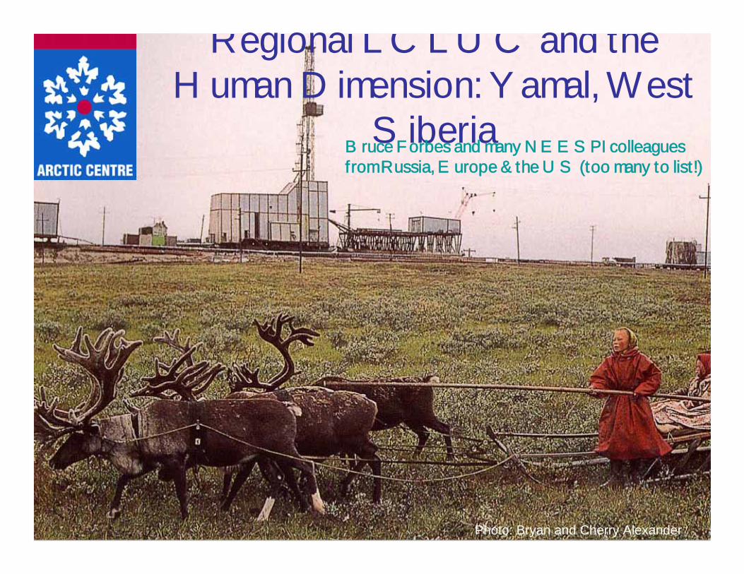
Regional LCLUC and the Human Dimension: Yamal, West
Siberia
Photo: Bryan and Cherry Alexander
Bruce Forbes and many NEESPI colleagues from Russia, Europe & the US (too many to list!)
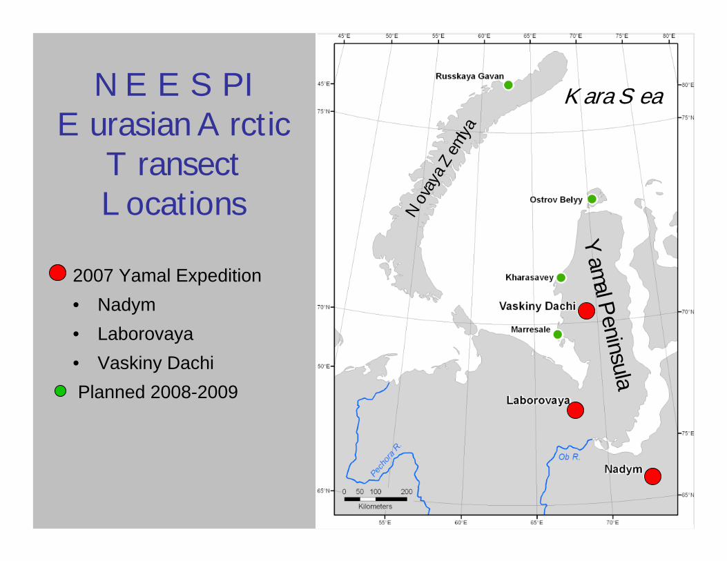
NEESPIEurasian Arctic
Transect Locations
2007 Yamal Expedition• Nadym• Laborovaya• Vaskiny DachiPlanned 2008-2009
Yamal Peninsula
Kara Sea
Novay
a Zem
lya
**
*20052006
2007
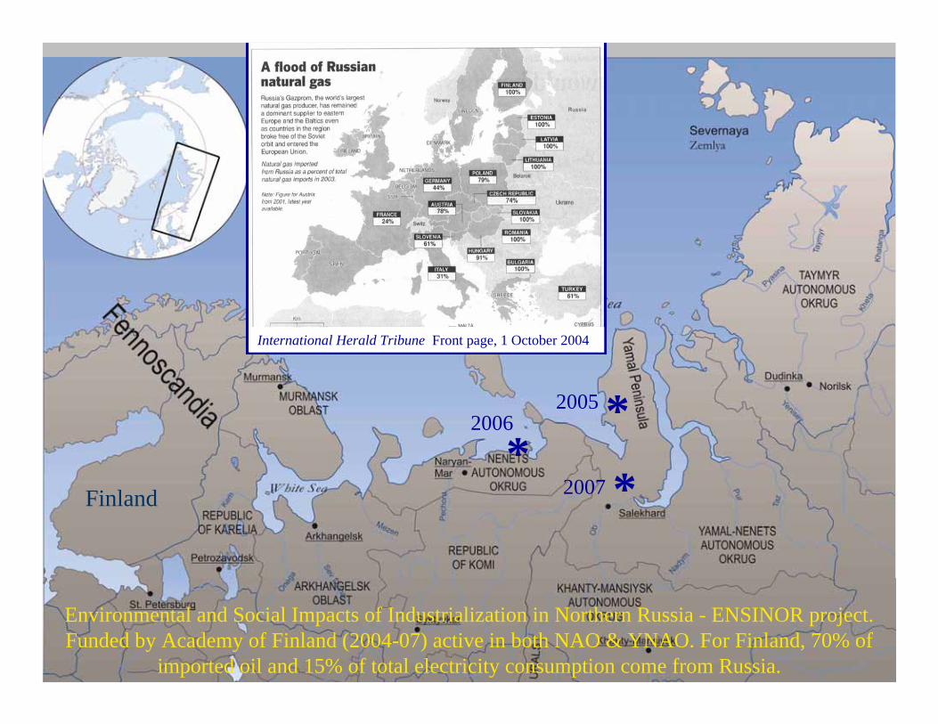
Environmental and Social Impacts of Industrialization in Northern Russia - ENSINOR project. Funded by Academy of Finland (2004-07) active in both NAO & YNAO. For Finland, 70% of
imported oil and 15% of total electricity consumption come from Russia.
International Herald Tribune Front page, 1 October 2004
Finland
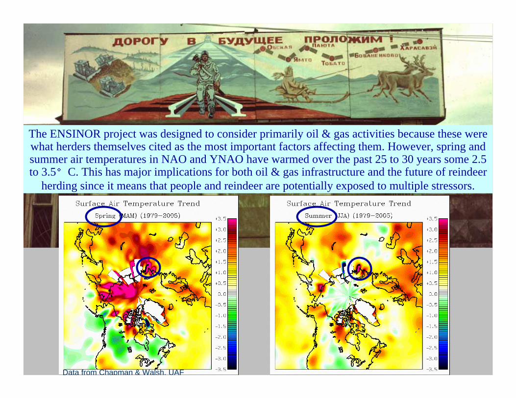
The ENSINOR project was designed to consider primarily oil & gas activities because these were what herders themselves cited as the most important factors affecting them. However, spring and summer air temperatures in NAO and YNAO have warmed over the past 25 to 30 years some 2.5 to 3.5°C. This has major implications for both oil & gas infrastructure and the future of reindeer
herding since it means that people and reindeer are potentially exposed to multiple stressors.
Data from Chapman & Walsh, UAF
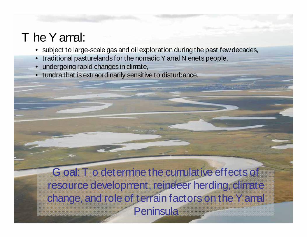
Goal: To determine the cumulative effects of resource development, reindeer herding, climate change, and role of terrain factors on the Yamal
Peninsula
The Yamal:• subject to large-scale gas and oil exploration during the past few decades,• traditional pasturelands for the nomadic Yamal Nenets people, • undergoing rapid changes in climate,• tundra that is extraordinarily sensitive to disturbance.
Effects of industrial development:
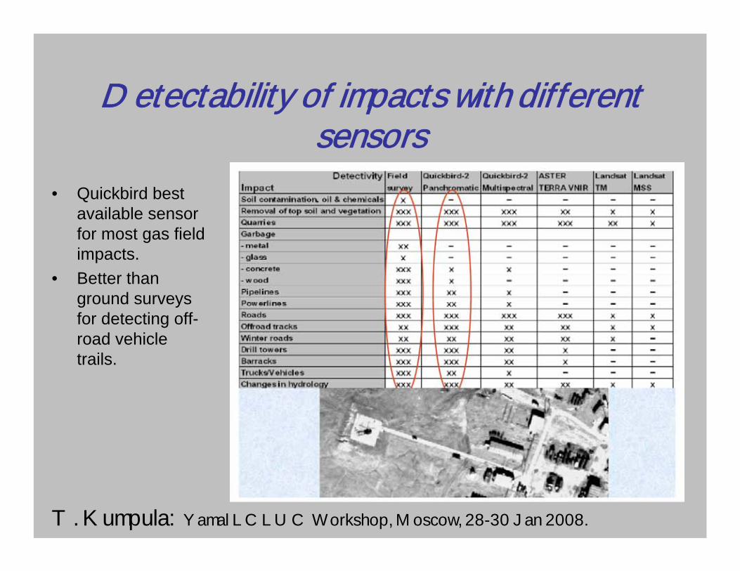
Detectability of impacts with different sensors
• Quickbird best available sensor for most gas field impacts.
• Better thanground surveys for detecting off-road vehicle trails.
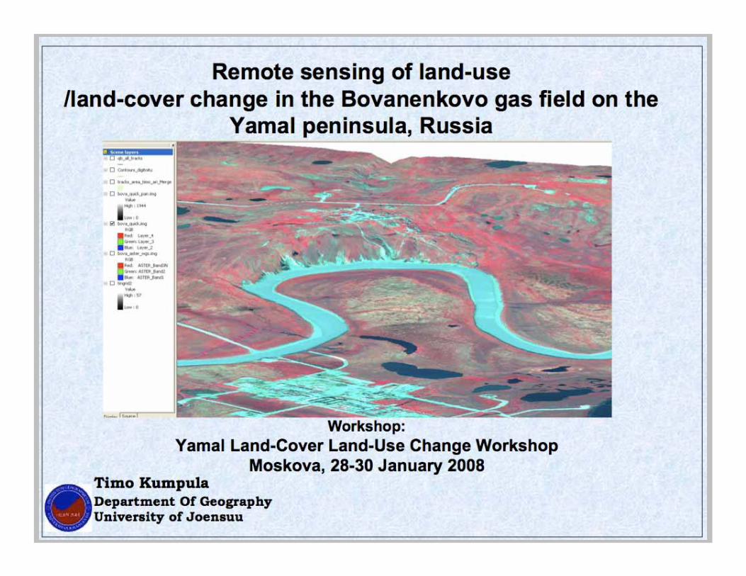
T. Kumpula: Yamal LCLUC Workshop, Moscow, 28-30 Jan 2008.
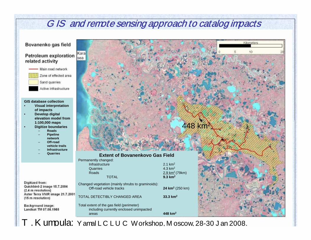
GIS and remote sensing approach to catalog impacts
448 km2
Extent of Bovanenkovo Gas FieldPermanently changed:
Infrastructure 2.1 km2
Quarries 4.3 km2
Roads 2.9 km2 (79km)TOTAL 9.3 km2
Changed vegetation (mainly shrubs to graminoids):Off-road vehicle tracks 24 km2 (250 km)
TOTAL DETECTIBLY CHANGED AREA 33.3 km2
Total extent of the gas field (perimeter)including currently enclosed unimpacted areas 448 km2
GIS database collection• Visual interpretation
of impacts• Develop digital
elevation model from 1:100,000 maps
• Digitize boundaries– Roads– Pipeline
network– Off-road
vehicle trails– Infrastructure– Quarries
T. Kumpula: Yamal LCLUC Workshop, Moscow, 28-30 Jan 2008.
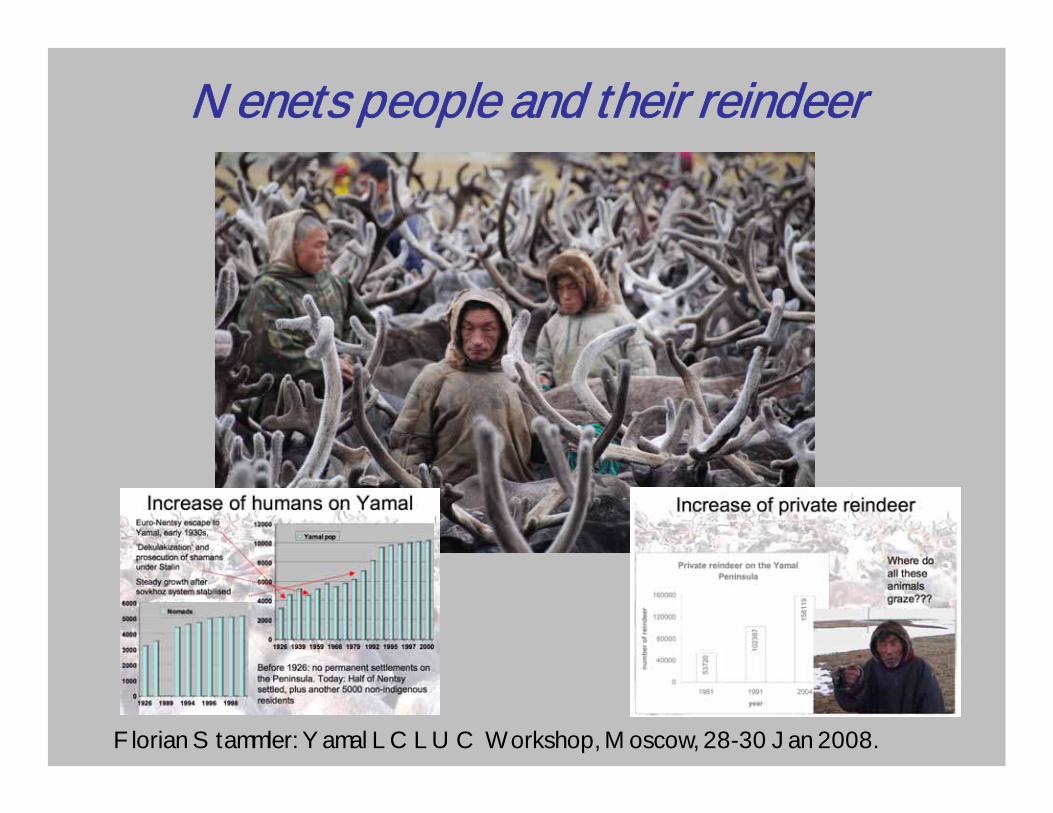
Nenets people and their reindeer
Florian Stammler: Yamal LCLUC Workshop, Moscow, 28-30 Jan 2008.
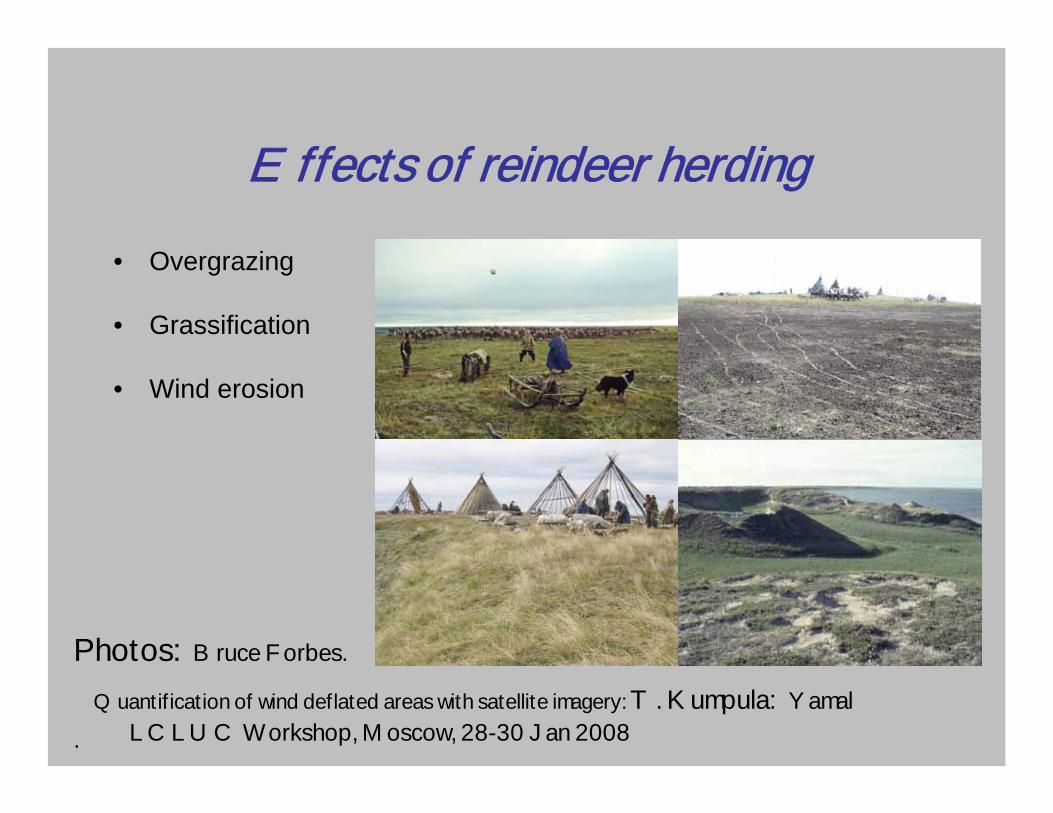
Effects of reindeer herding• Overgrazing
• Grassification
• Wind erosion
Quantification of wind deflated areas with satellite imagery: T. Kumpula: Yamal LCLUC Workshop, Moscow, 28-30 Jan 2008
Photos: Bruce Forbes.
.
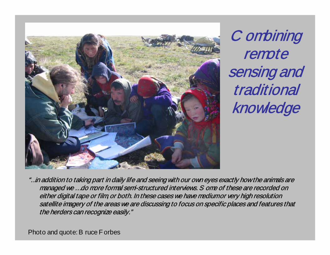
Combining remote
sensing and traditional knowledge
“…in addition to taking part in daily life and seeing with our own eyes exactly how the animals are managed we … do more formal semi-structured interviews. Some of these are recorded on either digital tape or film, or both. In these cases we have medium or very high resolution satellite imagery of the areas we are discussing to focus on specific places and features that the herders can recognize easily.”
Photo and quote: Bruce Forbes
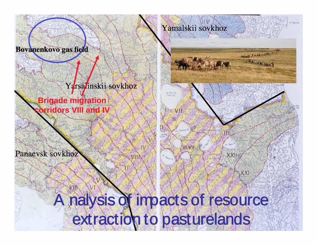
Analysis of impacts of resource extraction to pasturelands
Brigade migration corridors VIII and IV
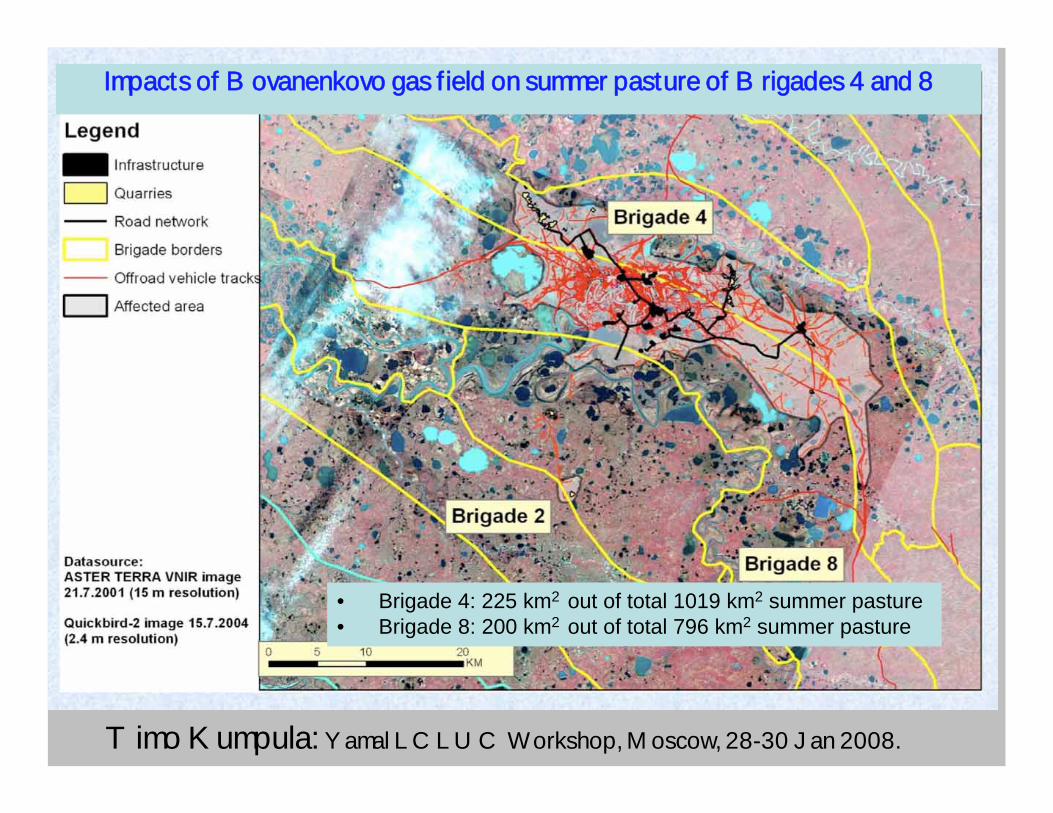
Timo Kumpula: Yamal LCLUC Workshop, Moscow, 28-30 Jan 2008.
Impacts of Bovanenkovo gas field on summer pasture of Brigades 4 and 8
• Brigade 4: 225 km2 out of total 1019 km2 summer pasture• Brigade 8: 200 km2 out of total 796 km2 summer pasture
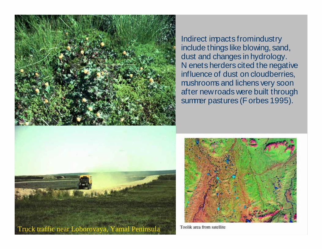
Indirect impacts from industry include things like blowing, sand, dust and changes in hydrology. Nenets herders cited the negative influence of dust on cloudberries, mushrooms and lichens very soon after new roads were built through summer pastures (Forbes 1995).
Truck traffic near Loborovaya, Yamal Peninsula
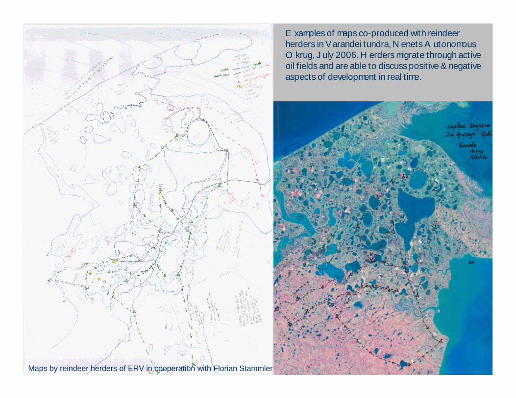
Examples of maps co-produced with reindeer herders in Varandei tundra, Nenets Autonomous Okrug, July 2006. Herders migrate through active oil fields and are able to discuss positive & negative aspects of development in real time.
Maps by reindeer herders of ERV in cooperation with Florian Stammler
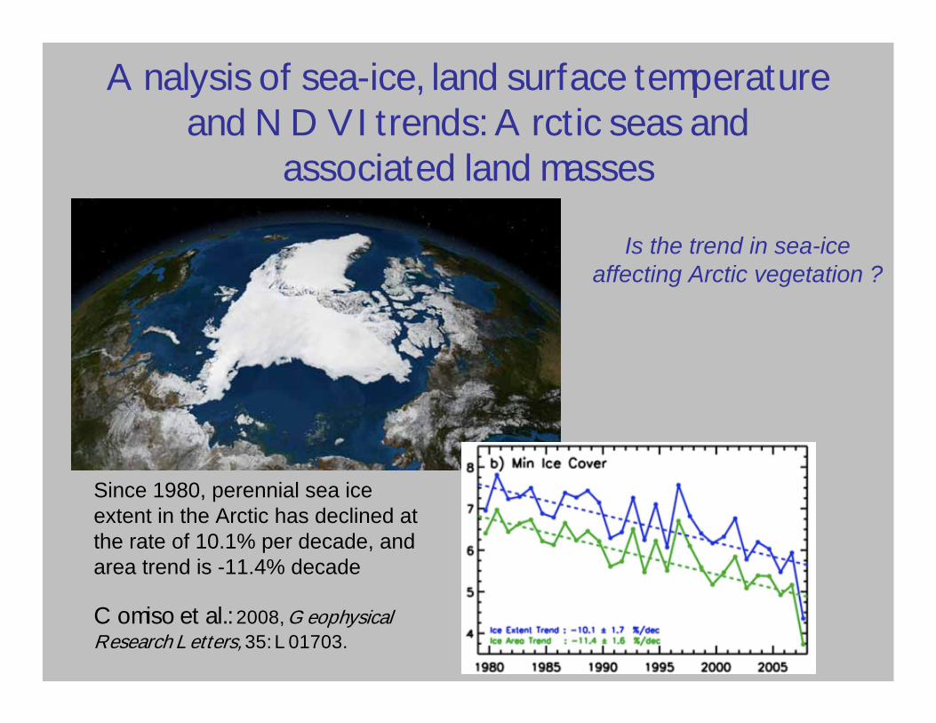
Is the trend in sea-iceaffecting Arctic vegetation ?
Since 1980, perennial sea ice extent in the Arctic has declined at the rate of 10.1% per decade, and area trend is -11.4% decade
Comiso et al.: 2008, Geophysical Research Letters, 35: L01703.
2007!
Analysis of sea-ice, land surface temperature and NDVI trends: Arctic seas and
associated land masses
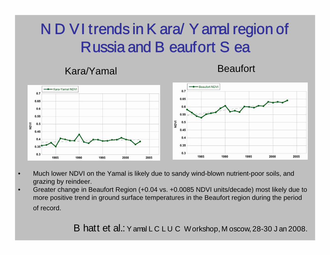
NDVI trends in Kara/Yamal region of Russia and Beaufort Sea
BeaufortKara/Yamal
• Much lower NDVI on the Yamal is likely due to sandy wind-blown nutrient-poor soils, and grazing by reindeer.
• Greater change in Beaufort Region (+0.04 vs. +0.0085 NDVI units/decade) most likely due tomore positive trend in ground surface temperatures in the Beaufort region during the period of record.
Bhatt et al.: Yamal LCLUC Workshop, Moscow, 28-30 Jan 2008.

Other effects on NDVI
Raynolds et al.: 2008, Yamal LCLUC Workshop, Moscow.
Yamal regionCircumpolar Arctic
• Summer warmth explains only 2% of the regional variance in NDVI on the Yamal!
• Elevation, landscape type, vegetation type, and substrate explain 58%.
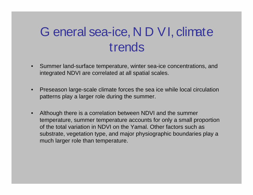
General sea-ice, NDVI, climate trends
• Summer land-surface temperature, winter sea-ice concentrations, andintegrated NDVI are correlated at all spatial scales.
• Preseason large-scale climate forces the sea ice while local circulation patterns play a larger role during the summer.
• Although there is a correlation between NDVI and the summer temperature, summer temperature accounts for only a small proportion of the total variation in NDVI on the Yamal. Other factors such as substrate, vegetation type, and major physiographic boundaries play a much larger role than temperature.
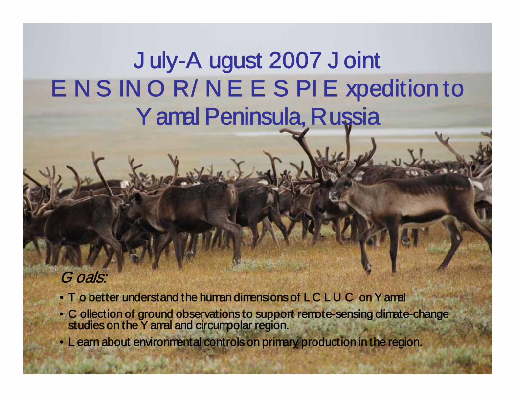
July-August 2007 Joint ENSINOR/NEESPI Expedition to
Yamal Peninsula, Russia
Goals:• To better understand the human dimensions of LCLUC on Yamal• Collection of ground observations to support remote-sensing climate-change
studies on the Yamal and circumpolar region.• Learn about environmental controls on primary production in the region.
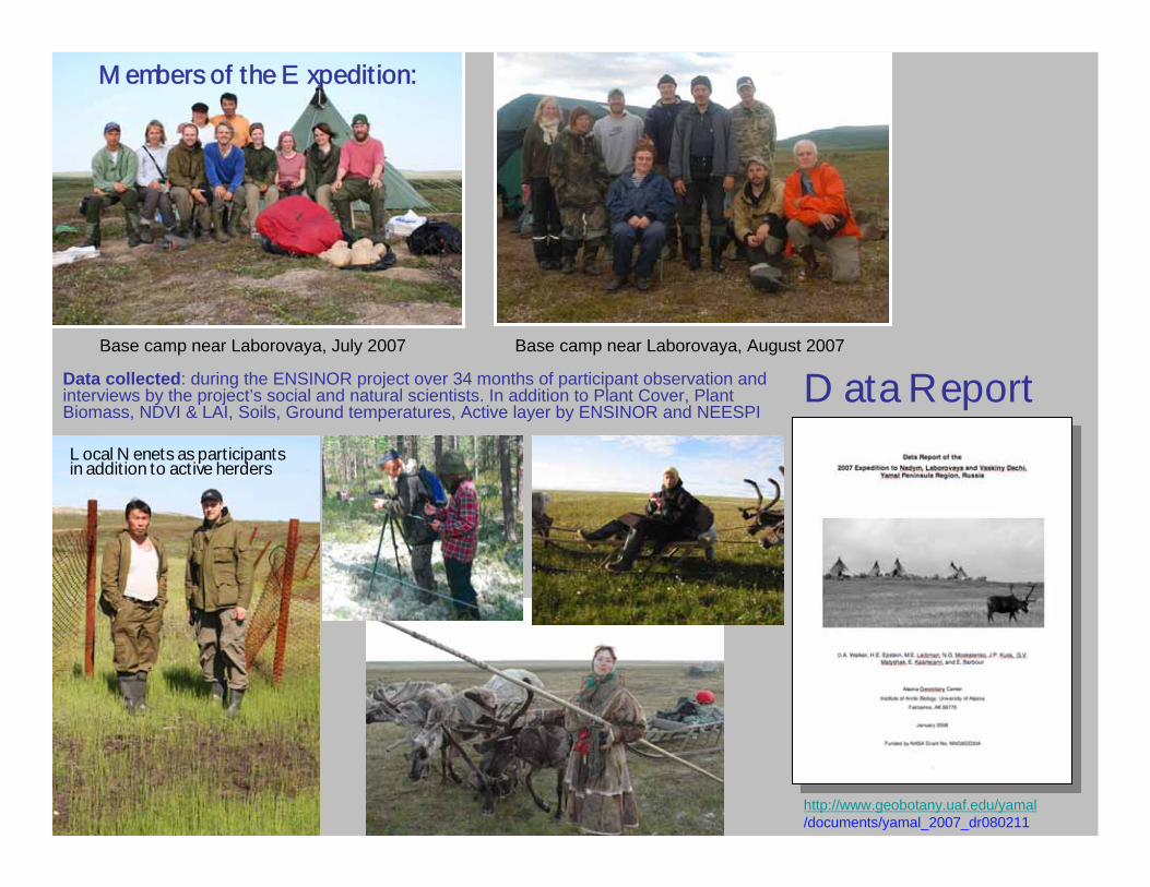
Base camp near Laborovaya, August 2007Base camp near Laborovaya, July 2007
Data Report
http://www.geobotany.uaf.edu/yamal/documents/yamal_2007_dr080211
Members of the Expedition:
Data collected: during the ENSINOR project over 34 months of participant observation and interviews by the project’s social and natural scientists. In addition to Plant Cover, Plant Biomass, NDVI & LAI, Soils, Ground temperatures, Active layer by ENSINOR and NEESPI
Local Nenets as participants in addition to active herders
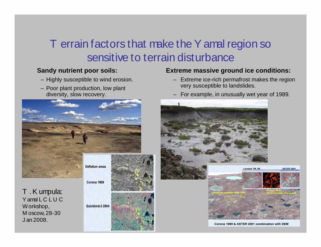
Terrain factors that make the Yamal region so sensitive to terrain disturbance
Extreme massive ground ice conditions:– Extreme ice-rich permafrost makes the region
very susceptible to landslides.– For example, in unusually wet year of 1989.
Sandy nutrient poor soils:– Highly susceptible to wind erosion.– Poor plant production, low plant
diversity, slow recovery.
T. Kumpula: Yamal LCLUC Workshop, Moscow, 28-30 Jan 2008.

Vaskiny Dachi: Unique successional sequences related to Quaternary history,
massive ground ice, landslides and soils
• Dense willow thickets develop on old landslides after leaching of salts from clayey marine sediments.
Ukraintseva and Liebman: 2007, 1st North American Landslide Conference, Vail, CO.
20-yr old landslide200-yr old landslide
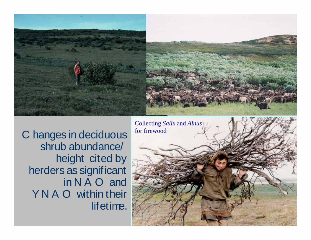
Changes in deciduous shrub abundance/
height cited by herders as significant
in NAO and YNAO within their
lifetime.
Collecting Salix and Alnusfor firewood
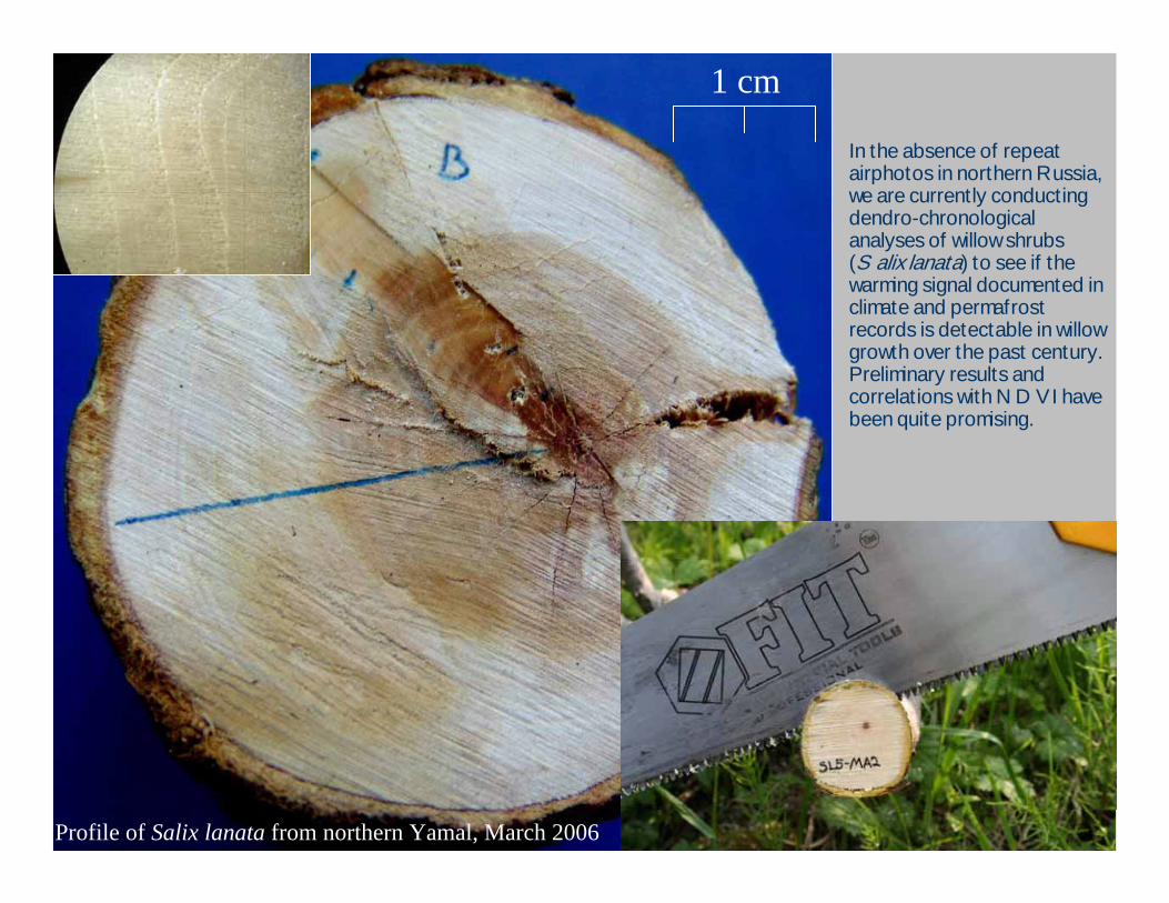
In the absence of repeat airphotos in northern Russia, we are currently conducting dendro-chronological analyses of willow shrubs (Salix lanata) to see if the warming signal documented in climate and permafrost records is detectable in willow growth over the past century. Preliminary results and correlations with NDVI have been quite promising.
Profile of Salix lanata from northern Yamal, March 2006
1 cm
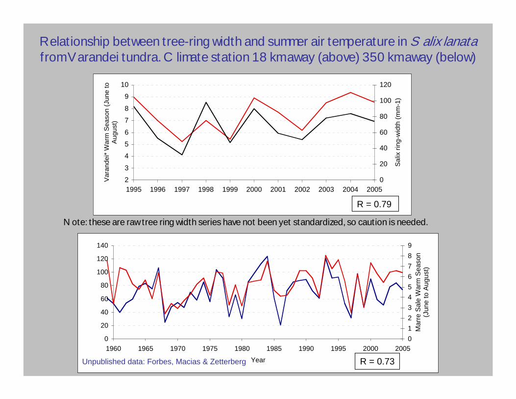
Relationship between tree-ring width and summer air temperature in Salix lanatafrom Varandei tundra. Climate station 18 km away (above) 350 km away (below)
2
3
4
5
6
7
8
9
10
1995 1996 1997 1998 1999 2000 2001 2002 2003 2004 2005
Var
ande
i* W
arm
Sea
son
(Jun
e to
A
ugus
t)
0
20
40
60
80
100
120
Sal
ix ri
ng-w
idth
(mm
-1)
0
20
40
60
80
100
120
140
1960 1965 1970 1975 1980 1985 1990 1995 2000 2005
Year
0123456789
Mar
re S
ale
War
m S
easo
n(J
une
to A
ugus
t)
Note: these are raw tree ring width series have not been yet standardized, so caution is needed.R = 0.79
R = 0.73Unpublished data: Forbes, Macias & Zetterberg
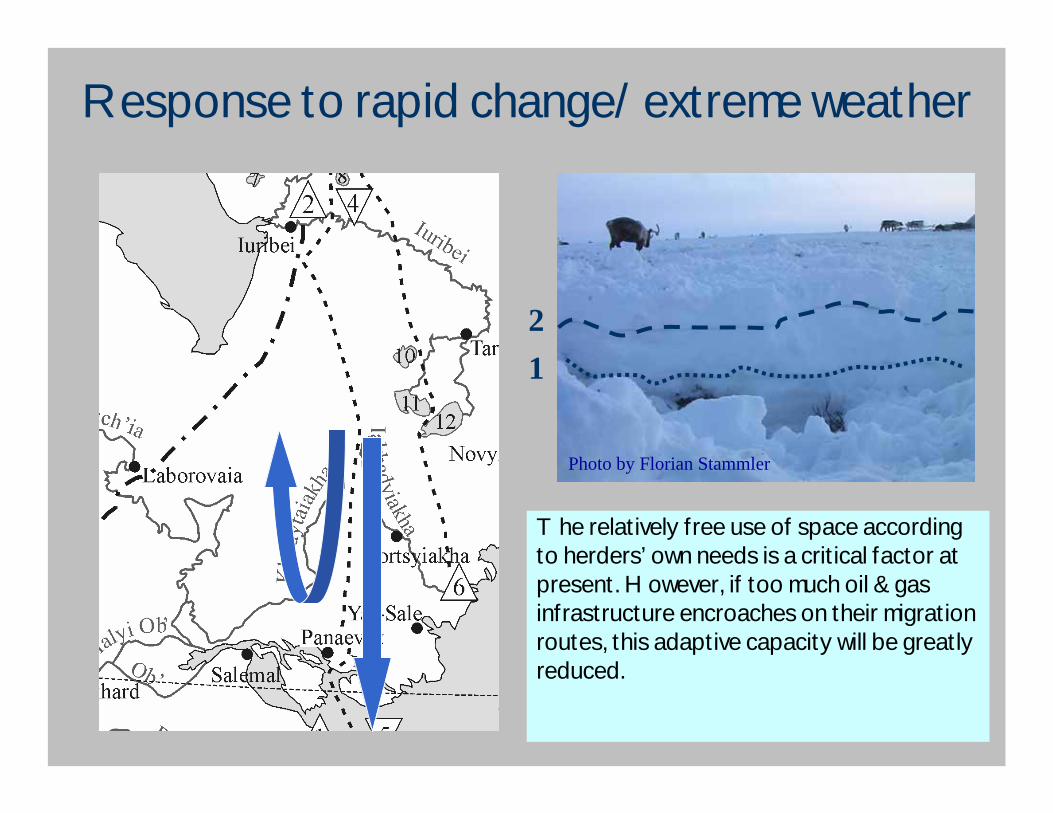
Response to rapid change/extreme weather
• Icing over of pastures in winter• Strategy: change of migration
route
12
Photo by Florian Stammler
The relatively free use of space according to herders’ own needs is a critical factor at present. However, if too much oil & gas infrastructure encroaches on their migration routes, this adaptive capacity will be greatly reduced.
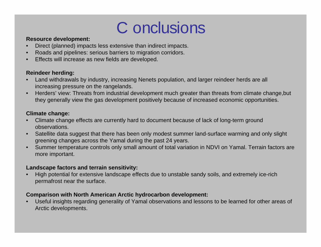
ConclusionsResource development:• Direct (planned) impacts less extensive than indirect impacts.• Roads and pipelines: serious barriers to migration corridors. • Effects will increase as new fields are developed.
Reindeer herding:• Land withdrawals by industry, increasing Nenets population, and larger reindeer herds are all
increasing pressure on the rangelands.• Herders’ view: Threats from industrial development much greater than threats from climate change,but
they generally view the gas development positively because of increased economic opportunities.
Climate change:• Climate change effects are currently hard to document because of lack of long-term ground
observations.• Satellite data suggest that there has been only modest summer land-surface warming and only slight
greening changes across the Yamal during the past 24 years.• Summer temperature controls only small amount of total variation in NDVI on Yamal. Terrain factors are
more important.
Landscape factors and terrain sensitivity:• High potential for extensive landscape effects due to unstable sandy soils, and extremely ice-rich
permafrost near the surface.
Comparison with North American Arctic hydrocarbon development:• Useful insights regarding generality of Yamal observations and lessons to be learned for other areas of
Arctic developments.
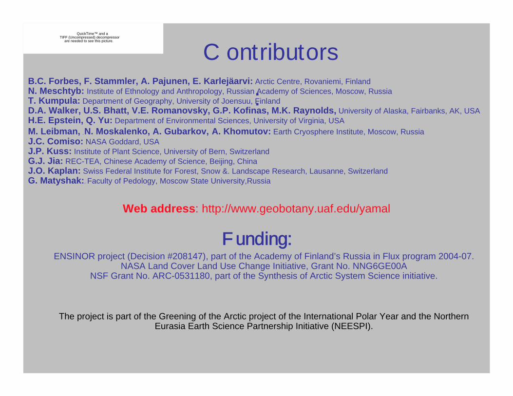
:B.C. Forbes, F. Stammler, A. Pajunen, E. Karlejäarvi: Arctic Centre, Rovaniemi, FinlandN. Meschtyb: Institute of Ethnology and Anthropology, Russian Academy of Sciences, Moscow, RussiaT. Kumpula: Department of Geography, University of Joensuu, FinlandD.A. Walker, U.S. Bhatt, V.E. Romanovsky, G.P. Kofinas, M.K. Raynolds, University of Alaska, Fairbanks, AK, USAH.E. Epstein, Q. Yu: Department of Environmental Sciences, University of Virginia, USAM. Leibman, ,N. Moskalenko, A. Gubarkov, A. Khomutov: Earth Cryosphere Institute, Moscow, RussiaJ.C. Comiso: NASA Goddard, USAJ.P. Kuss: Institute of Plant Science, University of Bern, SwitzerlandG.J. Jia: REC-TEA, Chinese Academy of Science, Beijing, ChinaJ.O. Kaplan: Swiss Federal Institute for Forest, Snow &. Landscape Research, Lausanne, SwitzerlandG. Matyshak:,:: Faculty of Pedology, Moscow State University,Russia
Web address: http://www.geobotany.uaf.edu/yamal
Funding:ENSINOR project (Decision #208147), part of the Academy of Finland’s Russia in Flux program 2004-07.
NASA Land Cover Land Use Change Initiative, Grant No. NNG6GE00ANSF Grant No. ARC-0531180, part of the Synthesis of Arctic System Science initiative.
The project is part of the Greening of the Arctic project of the International Polar Year and the Northern Eurasia Earth Science Partnership Initiative (NEESPI).
QuickTime™ and aTIFF (Uncompressed) decompressor
are needed to see this picture. Contributors
Thank you!
http://www.arcticcentre.org/ensinor