Embed Size (px)
Citation preview
REVIEW OF THE LOWER ORDOVICIAN ELLENBURGER GROUP
OF THE PERMIAN BASIN, WEST TEXAS
Robert Loucks
Bureau of Economic Geology Jackson School of Geosciences
The University of Texas at Austin Austin, TX
ABSTRACT
The Ellenburger Group of the West Texas Permian Basin is part of a Lower
Ordovician carbonate platform sequence that covers a large area of the United States. During
the Early Ordovician, the Permian Basin area was located on the southwest edge of the
Laurentia plate between 20° and 30° latitude. The equator crossed northern Canada, situating
Texas in a tropical to subtropical latitude. The area of Texas was a shallow-water shelf, with
deeper water conditions to the south where it bordered the Iapetus Ocean.
Shallow-water carbonates were deposited on the shelf, and deep-water shales and
carbonates were deposited on the slope and in the basin. The interior of the shelf produced
restricted environments, whereas the outer shelf produced open-marine conditions.
Diagenesis of the Ellenburger Group is complex, and the processes that produced the
diagenesis spanned millions of years. Three major diagenetic processes strongly affected
Ellenburger carbonates: (1) dolomitization, (2) karsting, and (3) tectonic fracturing. Pore
networks in the Ellenburger are complex because of the amount of brecciation and fracturing
associated with karsting. Networks can consist of any combination of the following pore
types, depending on depth of burial: (1) matrix, (2) cavernous, (3) interclast, (4) crackle-
/mosaic-breccia fractures, or (5) tectonic-related fractures.
The Ellenburger Group is an ongoing, important exploration target in West Texas.
Carbonate depositional systems within the Ellenburger Group are relatively simple; however,
the diagenetic overprint is complex, producing strong spatial heterogeneity within the
reservoir systems.
1
INTRODUCTION
The Ellenburger Group of the Permian Basin is part of a Lower Ordovician
carbonate platform sequence that covers a large area of the United States (Figures 1, 2)
(Ross, 1976; Kerans, 1988, 1990). It is well known for being one of the largest shallow-
water carbonate platforms in the geologic record (covering thousands of square miles and
as much as 500 mi wide in West Texas), being extensively karsted at the Sauk
unconformity, with its widespread hydrocarbon production. Hydrocarbon production
ranges from as shallow as 856 ft in West Era field in Cooke County, Texas, to as deep as
25,735 ft in McComb field in Pecos County, Texas. A review of the Ellenburger Group
will help explain the sedimentology and diagenesis that have resulted in this widespread
producing unit.
The first inclusive studies of the Ellenburger Group were completed by Cloud et
al. (1945), Cloud and Barnes (1948, 1957), and Barnes et al. (1959). These studies cover
many aspects of the group, ranging from stratigraphy to diagenesis to chemistry. Much
has been learned since then about carbonate sedimentology and diagenesis, and these new
concepts were integrated into later studies by Kerans (1988, 1989), which cover regional
geologic setting, depositional systems, facies analysis, depositional history, diagenesis,
and paleokarsting. Many other papers have described the local geology of fields (e.g.,
Loucks and Anderson, 1980, 1985; Combs et al., 2003) and outcrop areas (e.g.,
Goldhammer et al., 1992; Lucia, 1995, 1996; Loucks et al., 2004) or have elaborated on
paleokarsting (e.g., Lucia, 1971, 1995, 1996; Loucks and Anderson, 1985; Kerans, 1988,
1989, 1990; Candelaria and Reed, 1992; Loucks and Handford, 1992; Loucks, 1999;
Loucks et al., 2004; Loucks, 2007; McDonnell et al., 2007).
Major objectives of this paper are to review (1) regional geological setting and
general stratigraphy; (2) depositional systems, facies analysis, and depositional history;
(3) general regional diagenesis; (4) reservoir characteristics; and (5) the petroleum
system. Many of the data are from published literature; however, new insights can be
derived by integrating these data.
2
REGIONAL GEOLOGICAL SETTING
At global plate scale during the Early Ordovician, the West Texas Permian Basin
area was located on the southwest edge of the Laurentia plate between 20° and 30°
latitude (Figure 1) (Blakey, 2005a, b). The equator crossed northern Canada (Figure 1),
situating Texas in a tropical to subtropical latitude (Lindsay and Koskelin, 1993). Much
of the United States was covered by a shallow sea. Most of Texas was a shallow-water
shelf with deeper water conditions to the south, where it bordered the Iapetus Ocean. The
Texas Arch (Figures 2), a large land complex, existed in North Texas and New Mexico.
Ross (1976) and Kerans (1990) pointed out that the main depositional settings
within the Permian Basin for the Ellenburger Group were the deeper water slope and the
shallower water carbonate platform. Ross (1976) presented the broad Lower Ordovician
carbonate platform as having an interior of dolomite and an outer area of limestone
(Figure 2). Seaward of the limestone he postulated black shale. Kerans (1990) interpreted
Ross’s map in terms of depositional settings (Figure 3), the dolomite being a restricted
shelf interior and the limestone being an outer rim of more open-shelf deposits. Seaward
of the platform was a deeper water slope system (shales), which Kerans (1990) claimed
to be represented by the Marathon Limestone. The Ellenburger Group in the south part of
Texas, where the deeper water equivalent strata would have been, was strongly affected
by the Ouachita Orogeny when the South American plate was thrust against the North
American plate (Figure 2). Basinal and slope facies strata were destroyed or extensively
structurally deformed. Ellenburger Group facies cannot be traced south of the slope
setting in southwest Texas because of the Ouachita Orogeny.
Kerans (1990) recognized that several peripheral structural features affected
deposition of Ellenburger sediments in the West Texas New Mexico area (Figure 4);
however, most of the platform was relatively flat. Major structural features in the area
that formed after Early Ordovician time include the Middle Ordovician Toboas Basin and
the Pennsylvanian Central Basin Platform (Galley, 1958).
Structural maps of the top Ellenburger Group (Figure 5) and top Precambrian
intervals (Figure 6) show the Ellenburger Group as a structural low in the area of the
Permian Basin. In the Midland Basin area, the top of Ellenburger carbonate is as deep as
3
11,000 ft, shallower over the Central Basin Platform, and as deep as 25,000 ft in the
Delaware Basin. Isopach maps (Figure 4) by the Texas Water Development Board
(1972), Wilson (1993), and Lindsay and Koskelin (1993) show thickening of the
Ellenburger Group into the area of the Permian Basin.
GENERAL STRATIGRAPHY
The Ellenburger Group is equivalent to the El Paso Group in the Franklin
Mountains, the Arbuckle Group in northeast Texas and Midcontinent, the Knox Group in
the eastern United States, and the Beekmantown Group of the northeastern United States.
In West Texas the Ellenburger Group overlies the Cambrian Bliss subarkosic sandstone
(Loucks and Anderson, 1980). In the Llano area, Barnes et al. (1959) divided the
Ellenburger Group from bottom to top into the Tanyard, Gorman, and Honeycut
Formations. Kerans (1990) compared the Llano stratigraphic section to the subsurface
stratigraphy of West Texas (Figure 7). A worldwide hiatus appeared at the end of Early
Ordovician deposition, creating an extensive second-order unconformity (Sauk-
Tippecanoe Supersequence Boundary defined by Sloss [1963]; Figure 7). This
unconformity produced extensive karsting throughout the United States and is discussed
later in this paper. In West Texas, the upper Middle Ordovician Simpson Group was
deposited above this unconformity (Figure 7).
A general second-order sequence stratigraphic framework was proposed by
Kupecz (1992) for the Ellenburger Group in West Texas (Figure 8). The contact between
the Precambrian and the Lower Ordovician intervals represents a lowstand of sea level of
unknown duration; the Bliss Sandstone sediments are partly lowstand erosional deposits
(Loucks and Anderson, 1985). The lower second-order transgressive systems tract
includes the Bliss Sandstone and the lower Ellenburger alluvial fan to interbedded
shallow-subtidal paracycles. The second-order highstand systems tracts include the upper
interbedded paracycles of peritidal deposits. The next second-order lowstand produced
the Sauk-Tippecanoe sequence boundary.
A detailed sequence stratigraphy of the Lower Ordovician of West Texas
(Figure 9) was worked out by Goldhammer et al. (1992), Goldhammer (1996), and
4
Goldhammer and Lehmann (1996), who worked in the Franklin Mountains in far West
Texas and who compared their work to that in other areas, including the Arbuckle
Mountains in Oklahoma (Figure 9). They divided the general Lower Ordovician section,
which they called the Sauk-C second-order supersequence, into nine third-order
sequences (Figure 9) on the basis of higher order stacking patterns. Each third-order
sequence had a duration of 1 to 10 million years. Goldhammer et al. (1992) stated that the
origin and control of third-order sequences in the Lower Ordovician remain problematic
because this period of time lacks evidence of major glaciation.
In the Franklin Mountains, Goldhammer et al. (1992), Goldhammer (1996), and
Goldhammer and Lehmann (1996) recognized only the lower seven sequences (Figure 9),
and they included the Bliss Sandstone as the lowest sequence. The sequences in this area
range from 2 to 6 million years in duration. Within the third-order sequences, these
researchers recognized numerous higher order sequences at the scale of fourth- and fifth-
order parasequences, which are detailed depositional units that consist of meter-scale
aggradational or progradational depositional cycles. This is the stratigraphic architectural
scale that is used for flow-unit modeling in reservoir characterization (Kerans et al.,
1994).
DEPOSITIONAL FACIES AND DEPOSITIONAL SYSTEMS
Ellenburger Platform Systems
Loucks and Anderson (1980, 1985) presented depositional models (Figures 10,
11) of the Ellenburger section in Puckett field, Pecos County, West Texas. Their data
consist of two cores that provide ~1,700 ft of overlapping, continuous coverage of the
section (Figure 12). They defined the lower Ellenburger section as being dominated by
alluvial fan/coastal sabkha paracycles, the middle Ellenburger as subtidal paracycles, and
the upper Ellenburger as supratidal/intertidal paracycles. Numerous fourth- and fifth-
order cycles occur within this Puckett Ellenburger section. These researchers recognized
many solution-collapsed zones that they attributed to exposure surfaces of different
duration (Figure 12).
5
Kerans (1990) completed the most detailed and complete regional Ellenburger
depositional systems and facies analysis on the basis of wireline-log and core material.
Much of the rest of this section is a summary of Kerans’ work. (See Kerans [1990] for
complete description and interpretation of facies.) He recognized six general lithofacies
(Figure 7):
(1) Litharenite: fan delta – marginal marine depositional system
(2) Mixed siliciclastic-carbonate packstone/grainstone: lower tidal-flat depositional
system
(3) Ooid and peloid grainstone: high-energy restricted-shelf depositional system
(4) Mottled mudstone: low-energy restricted-shelf depositional system
(5) Laminated mudstone: upper tidal-flat depositional system
(6) Gastropod-intraclast-peloid packstone/grainstone: open shallow-water-shelf
depositional system
Fan Delta – Marginal Marine Depositional System
Description: Kerans (1990) noted that this system contains two prominent facies:
cross-stratified litharenite and massive to cross-stratified pebbly sandstone to
conglomerate. Sedimentary structures include thick trough and tabular crossbeds, parallel
current lamination, and graded and massive beds. Clastic grains are composed of granite
and quartzite rock fragments, feldspar, and quartz.
Interpretation: According to Kerans (1990) this unit was deposited as a fan delta –
marginal marine depositional system. It is a basal retrogradational clastic deposit where
the Ellenburger Group onlaps the Precambrian basement. Loucks and Anderson (1985)
presented a similar interpretation of a fan-delta complex prograding into a shallow
subtidal environment (Figure 11).
Lower Tidal-Flat Depositional System
Description: Kerans (1990) stated that the dominant facies are mixed siliciclastic-
peloid packstone-grainstone, intraclastic breccia, stromatolitic boundstone containing
6
silicified nodular anhydrite, ooid grainstone, and carbonate mudstone. These facies are
mostly dolomitized. Kerans (1990) noted that the siliciclastic content is related to
distribution of the sandstone below. Sedimentary structures include relict cross-
stratification, scour channels, stromatolites, flat cryptalgal laminites, and silica-replaced
evaporate nodules.
Interpretation: According to Kerans (1990) this unit was deposited in a lower
tidal-flat depositional system in close association with the fan-delta depositional system
(Figure 10). Upward in the section carbonate tidal flats override the fan deltas. Kerans
(1990) presented the idealized cycle within this system as an upward-shoaling succession.
Tidal-flat complexes prograded across subtidal shoals and intervening lagoonal muds
(Figure 10). The relict evaporate nodules indicate an arid sabkha climate (Loucks and
Anderson, 1985; Kerans, 1990). Kerans (1990) pointed out that thin siliciclastic sand
laminae in tidal-flat laminites represent eolian deposits, whereas thicker sand units
represent periodic sheetflood deposits from adjacent alluvial fans. Loucks and Anderson
(1985) also recognized quartz sandstone units in the algal laminae.
High-Energy Restricted-Shelf Depositional System
Description: Kerans (1990) noted that this system is characterized by ooid
grainstone; ooid-peloid packstone-grainstone; laminated, massive, and mottled mudstone;
and minor cyanobacterial boundstone. It also contains coarse-crystalline white chert and
rare gastropod molds. Coarse dolomite fabric is common. Depositional structures include
cross-stratification, intraclastic breccias, small stromatolites, cryptalgal mats, and
silicified relict nodular anhydrite.
Interpretation: According to Kerans (1990) this unit was deposited in a high-
energy restricted-shelf depositional system. He stated that this system represents the
period of maximum marine inundation during the Ellenburger transgression. He noted
that extensive ooid shoals dominated the shelf and bioturbated mudstones formed in
protected settings between shoals (Figure 11). Cryptalgal laminites and mudstones (tidal
flats) with relict evaporate nodules may mark local shoaling cycles or more extensive
upward-shoaling events. Kerans (1990) noted that the lack of fauna suggests restricted
7
circulation on the shelf produced by shoal-related restriction or by later destruction by
dolomitization.
Low-Energy Restricted-Shelf Depositional System
Description: Kerans (1990) described this widespread system as a “remarkably
homogeneous sequence of gray to dark-gray, fine- to medium-crystalline dolomite
containing irregular mottling and lesser parallel-laminated mudstone and peloid
wackestone.” He noted sparse fauna of a few gastropods and nautiloids. The facies is
highly dolomitized.
Interpretation: According to Kerans (1990) this unit was deposited in a low-
energy restricted-shelf depositional system (Figure 11). The mottling is considered to be
the result of bioturbation. It is a restricted shelf deposit ranging from subtidal mudstones
to shoaling areas with tidal flats. Kerans (1990) noted that seaward this system
interfingers with the open-marine, shallow-water shelf depositional system, fitting the
model of Ross (1976) (Figure 2).
Upper Tidal-Flat Depositional System
Description: Kerans (1990) noted that the dominant facies in this system is
smooth and parallel or irregular and crinkled laminated dolomite. Other facies include
mottled mudstone, current-laminated dolostone, and beds of intraclastic breccia.
Sedimentary structures include desiccation cracks, current laminations, nodular chert
(relict evaporates?), and stromatolites.
Interpretation: According to Kerans (1990) this unit was deposited in an upper
tidal-flat depositional system. A common cycle is composed of a basal bioturbated
mudstone passing through current-laminated mudstone and into cryptalgal laminated
mudstone, with desiccation structures and intraclastic breccias (Figure 11). Kerans (1990)
noted that the mottled and current-laminated mudstones intercalated with the laminites
are low-energy shelf deposits and intercalated ooid-peloid grainstone beds are storm
deposits transported from high-energy shoals offshore (Figure 11). Kerans (1990)
8
suggested that the upper tidal-flat depositional system consisted of a broad tidal-flat
environment situated landward of the lagoon-mud shoal complex. This model is similar
to that presented by Loucks and Anderson (1985) (Figure 11). The depositional system
occurs near the top of the Ellenburger succession.
Open Shallow-Water-Shelf Depositional System
Description: Kerans (1990) noted that the rocks in this system are mainly
limestone, which is in contrast to many of the other sections of the Ellenburger interval.
Facies include peloid and ooid grainstones, mollusk-peloidal packstones, intraclastic
breccias, cryptalgal laminated mudstones, digitate stromatolitic boundstones, bioturbated
mudstones, and thin quartzarenite beds. Again, in general contrast to the other
depositional systems, this system has abundant fossils, including sponges, trilobites,
gastropods, bivalves, and cephalopods. Kerans (1990) described the grainstones and
packstones as massive or displaying parallel current laminations. He noted abundant
desiccation cracks in the laminites, as well as fenestral fabric.
Interpretation: According to Kerans (1990) this unit was deposited in an open,
shallow-water-shelf depositional system. He described the depositional setting as a
complex mosaic of tidal-flat subenvironments, shallow-water subtidal carbonate sand
bars, and locally thin stromatolite bioherms and biostromes (Figure 11). He interpreted
the greater diversity of fauna, lack of evaporate evidence, and presence of high-energy
grainstones and packstones as suggesting a moderate-current energy environment with
open-marine circulation. He speculated that this system may have occurred close to the
shelf edge or slope break.
Marathon Limestone Deeper Water System
The Marathon Limestone is the time-equivalent, deeper water slope facies of the
Ellenburger shallow-water-platform facies (Berry, 1960; Young, 1968; Ross, 1982;
Kerans, 1990). In West Texas, it occurs in the Marathon Basin (Young, 1968) and on the
west margin of the Diablo Platform (Lucia, 1968, 1969).
9
Description: Kerans (1990) described the unit as containing graptolite-bearing
shale, siliciclastic siltstone, lime grainstone and lime mudstone, and debris-flow
megabreccia. Sedimentary structures consist of graded beds, horizontal laminations, sole
marks, flute casts, and soft-sediment deformation structures (slump folds).
Interpretation: According to Kerans (1990) this unit was deposited in a more
basinal setting than the laterally equivalent Ellenburger depositional systems. He defined
the setting as a distally steepened ramp. He recognized that the thin-bedded shale,
siltstone, and lime grainstone-mudstone packages are Bouma turbidite sequences
produced by turbidity currents on a deeper water slope. Both Young (1968) and Kerans
(1990) interpreted the massively bedded megabreccias as deeper water debris-flow
deposits.
General Depositional History of the Ellenburger Group
Kerans (1990) summarized the depositional history of the Ellenburger Group in
four stages (Figure 13).
Stage 1: Marked by retrogradational deposition of fan delta – marginal marine
depositional system continuous with Early Cambrian transgression (Kerans, 1990).
Kerans (1990) described interfingering of the basal siliciclastics with overlying tidal-flat
and shallow-water subtidal deposits of the lower tidal-flat depositional system. This
transition represents initial transgression and associated retrogradational sedimentation.
Kerans (1990) noted that this stage was followed by regional progradation and
aggradation of peritidal carbonate facies. This stage of deposition filled in existing
paleotopography resulting in a low-relief platform.
Stage 2: Kerans (1990) documented rapid transgression and widespread
aggradational deposition of the high-energy, restricted-shelf depositional system across
much of West and Central Texas during this stage. He noted that the transgression
produced an extensive carbonate sand sheet over much of the platform. He interpreted a
moderately hypersaline setting on the basis of rare macrofauna, evidence of evaporites,
and abundance of ooids.
10
Stage 3: Kerans (1990) stated that upward transition from the high-energy,
restricted-shelf depositional systems to the low-energy, restricted-shelf depositional
systems is evidence of a second regression across the Ellenburger shelf. Progradation
during this stage is marked by transition of landward upper tidal flats to more seaward,
low-energy, restricted subtidal to intertidal facies to farthest seaward, open-marine,
shallow-water-shelf facies. Kerans (1990) recognized that laminated mudstones of the
upper tidal-flat depositional system represent maximum regression across the Ellenburger
inner shelf.
Stage 4: Near the end of the Early Ordovician there was a worldwide eustatic
lowstand, the timing of which is reported to be Whiterockian in age (Sloss, 1963; Ham
and Wilson, 1967), and whose length of exposure covered several million years.
Throughout the United States, an extensive karst terrain formed on the Ellenburger
platform carbonates (Kerans, 1988, 1989, 1990). During this long period of exposure,
thick sections of cave developed, resulting in extensive paleocave collapse breccias
within the Ellenburger section (Lucia, 1971; Loucks and Anderson, 1980, 1985; Kerans,
1988, 1989, 1990; Wilson et al., 1992; Loucks 1999). The time-equivalent, slope-
deposited Marathon Limestone was not exposed during this sea-level drop (Kerans,
1990). The area appears to have had continuous deposition from the Early Ordovician
through the Middle Ordovician.
GENERAL REGIONAL DIAGENESIS
Diagenesis of the Ellenburger Group is complex, and the processes that produced
the diagenesis covered millions of years (e.g., Folk, 1959; Lucia, 1971; Loucks and
Anderson, 1985; Lee and Friedman, 1987; Kerans, 1988, 1989, 1990; Kupecz and Land,
1991; Amthor and Friedman, 1991; Loucks, 1999, 2003). Several studies have presented
detailed diagenetic analysis of the Ellenburger (Kerans, 1990; Kupecz and Land, 1991;
Amthor and Friedman, 1991). A paragenetic chart is presented in Figures 14. Three major
diagenetic processes are important to discuss: (1) dolomitization, (2) karsting, and
(3) tectonic fracturing. Other diagenetic features are present but do not impact the
appearance or reservoir quality of the Ellenburger as much as these three do. In the
11
following discussion of these diagenetic processes, only an overview will be presented,
and the reader is referred to literature on Ellenburger diagenesis for a complete and
detailed discussion.
Understanding Diagenesis in the Ellenburger Group
As stated earlier, diagenesis of the Ellenburger Group is complex. Detailed
diagenesis can be worked out for any location, but trying to explain the complete
diagenetic history for the entire Ellenburger carbonate section in West Texas may be
beyond our reach because of relatively sparse subsurface data, length of time (±20
million years), thick stratigraphic section (possibly as many as six third-order sequences),
and the large area involved. Remember that carbonates generally undergo diagenesis
early in their history, especially if they are subjected to meteoric water. With the number
of third-order sequences in the section and the time represented by each sequence (2 to
5 million years), extensive early and shallow diagenesis probably occurred but was later
masked by intense dolomitization.
At the end of Early Ordovician time, a several-million-year hiatus occurred,
exposing the Ellenburger Group and subjecting it to meteoric karst processes. Several
authors have demonstrated that the karst affected strata at least 300 to 1,000 ft beneath
the unconformity (e.g., Kerans 1988, 1989; Lucia, 1995; Loucks, 1999). With the
occurrence of Ouachita thrusting from the Mississippian through the Pennsylvanian, vast
quantities of hydrothermal fluids moved though available permeable pathways within the
Ellenburger, producing late-stage diagenesis (e.g., Kupecz and Land, 1991). Following
lithification, different parts of the Ellenburger Group were subjected to tectonic stresses,
producing fractures and more late-stage diagenesis, which probably affected local areas
(e.g., Loucks and Anderson, 1985; Kearns, 1990; Loucks, 2003).
Loucks (2003) presented an overview of the origins of fractures in Ordovician
strata and concluded that in order to explain the complex diagenesis in these strata, one
must sort all events into a well-documented paragenetic sequence—the most reliable
method of delineating timing of events and features. He demonstrated that karsting and
paleocave collapse breccias and related fractures and some tectonic fractures had
12
occurred before the hydrothermal events that had produced saddle dolomite. But first he
had to establish well-documented paragenetic relationships.
Dolomitization
Of the several authors (Kerans, 1990; Kupecz and Land, 1991; Amthor and
Friedman, 1991) that have attempted to understand the regional dolomite history, Kupecz
and Land (1991) appear to have made the most progress. This section will mainly address
findings of Kupecz and Land (1991) but will still include observations and conclusions
from the other authors. Kupecz and Land’s (1991) paragenetic sequence is presented in
Figure 14. Their study covered a large area of West Texas, as well as the Llano Uplift
area in Central Texas. They used both cores and outcrop as a data source and combined
petrography with carbon, oxygen, and strontium isotopes.
Kupecz and Land (1991) recognized five general stages of dolomitization
(Figure 14). Generations of dolomite were separated into early-stage dolomitization,
which predated the Sauk unconformity, and late-stage dolomitization, which postdated
the Sauk unconformity. They attributed 90% of the dolomite as early stage and 10% as
late stage.
Kupecz and Land (1991) Dolomite Types:
(1) Stage 1 prekarstification early-stage dolomite (Dolomite E1)
a. Description: Crystal size ranges from 5 to 700 μ but varies by facies. In
cryptalgal laminites crystal sizes range from 5 to 100 μ. These euhedral
crystals have planar interfaces. In millimeter-laminated facies crystal size
ranges from 5 to 70 μ, and in the bioturbated mudstones crystal size
ranges from 5 to 700 μ. Kupecz and Land (1991) thought that some of the
coarser crystals were a product of later recrystallization.
b. Interpretation: Kupecz and Land (1991) documented that this dolomite
replaced lime mud or mudstone and that the dolomite predated
karstification because it is found in nonkarsted rock as well as in clasts
created by karsting. Therefore, it must have formed before karsting for it
13
to have been brecciated. Probable source of Mg for dolomitization is
seawater (Kupecz and Land, 1991).
(2) Stage 2 postkarstification late-stage dolomite (Dolomite L1)
a. Description: This replacement dolomite consists of coarse-crystalline
euhedral rhombs with crystal size ranging from 200 to 2,000 μ. Its
homogeneous cathodoluminescence and homogeneous backscattered
imaging suggest that this dolomite type has undergone recrystallization
(Kupecz and Land, 1991). This stage of dolomitization is a regional event
and is related to hydrothermal fluids.
b. Interpretation: Late-stage origin is based on coarse-crystal size (Kupecz
and Land, 1991).
(3) Stage 3 postkarstification late-stage dolomite (Dolomite L2)
a. Description: Crystals have planar interfaces, sizes range from 100 to
3,500 μ, and crystals have subhedral to anhedral shapes. Extinction ranges
from straight to undulose.
b. Interpretation: This stage is a replacement type of dolomite (Kupecz and
Land, 1991). Late origin is based on relationship to a later stage chert and
its replacement of early-stage dolomite E1. Much of the grainstone facies
is replaced by this stage of dolomitization, which is related to
hydrothermal fluids. Probable source of Mg for dolomitization is
dissolution of previously precipitated dolomite (Kupecz and Land, 1991).
(4) Stage 4 postkarstification late-stage dolomite (Dolomite C1)
a. Description: Crystals are subhedral with undulose extinction
(saddle/baroque dolomite), and sizes range from 100 to 5,000 μ.
b. Interpretation: Pore-filling cement (Kupecz and Land, 1991). Paragenetic
sequence is established by the fact that Dolomite C1 postdates Dolomite
L2 and was corroded before Dolomite C 2 was precipitated. Probable
source of Mg for dolomitization is dissolution of previously precipitated
dolomite (Kupecz and Land, 1991). This stage of dolomitization is a
regional event and is related to hydrothermal fluids.
(5) Stage 5 postkarstification late-stage dolomite (Dolomite C2)
14
a. Description: Subhedral white crystals with moderate to strong undulose
extinction (saddle/baroque dolomite), and crystal sizes range from 100 to
7,500 μ. Contain abundant fluid inclusions.
b. Interpretation: Pore-filling cement (Kupecz and Land, 1991). Occurred
after corrosion of Dolomite C1. Probable source of Mg for dolomitization
is dissolution of previously precipitated dolomite (Kupecz and Land,
1991). This stage of dolomitization is related to hydrothermal fluids.
Kupecz and Land (1991) provided the only integrated analysis of fluid-flow
pathways and sources of Mg for the different dolomitizing events. Early-stage
prekarstification dolomite is associated with muddier rocks, and the source of Mg was
probably seawater. Kerans (1990) similarly attributed these finer crystalline dolomites to
penecontemporaneous replacement of mud in tidal flats and to regionally extensive reflux
processes during deposition.
Late-stage postkarstification dolomites are attributed by Kupecz and Land (1991)
to warm, reactive fluids, which were expelled from basinal shales during the Ouachita
Orogeny. The fluids are thought to have been corrosive, as evidenced by corroded
dolomite rhombs (Kupecz and Land, 1991). This corrosion provided the Mg necessary
for dolomitization. The warm, overpressured fluids were episodically released and
migrated hundreds of miles from the foldbelt toward New Mexico (Figure 15). These
fluids migrated through high-permeability aquifers of the Bliss Sandstone, basal
subarkose facies of the Ellenburger, as well as grainstone facies and paleocave breccia
zones. Figure 15 from Kupecz and Land (1991) shows the regional isotopic composition
of late-stage Dolomite L2. The pattern of lighter to heavier delta-O18 away from the
foldbelt to the south suggests movement and cooling of fluids to the northwest. Kupecz
and Land’s (1991) regional dolomitization model is displayed in Figure 15. Figure 16
shows the tectonic setting that produced the hydrothermal fluids.
Kerans (1990) defined three major styles of dolomitization:
(1) Very fine crystalline dolomite that he considered as a replacement product
penecontemporaneous with deposition in a tidal-flat setting.
(2) Fine- to medium-crystalline dolomite appearing in all facies and that contributed
to regionally extensive reflux processes during Ellenburger deposition.
15
(3) Coarse-crystalline replacement mosaic dolomite and saddle (baroque) dolomite
associated with burial.
Kerans’ first two types of dolomite are probably equivalent to Kupecz and Land’s
(1991) early-stage Dolomite E1. His coarse-crystalline replacement mosaic dolomite and
saddle dolomite are equivalent to Kupecz and Land’s (1991) late-stage dolomites.
Amthor and Friedman (1991) also recognized early- to late-stage dolomitization of
the Ellenburger Group (Figures 17, 18). Similar to Kerans (1990) and Kupecz and Land
(1991), Amthor and Friedman (1991) described early-stage, low-temperature, fine-
crystalline dolomites associated with lime muds, where the Mg was supplied by diffusion
from overlying seawater. Amthor and Friedman (1991) also described medium- to
coarse-crystalline dolomite that replaced grains and matrix in the depth range of 1,500 to
6,000 ft. These dolomites are postkarstification and are probably replacement Dolomite
L1 and L2 of Kupecz and Land (1991). Amthor and Friedman’s (1991) last stage of
dolomite is assigned a deep-burial origin (>6,000 ft) and consists of coarse-crystalline
saddle dolomite. Its occurrence is both pore filling and replacive, and it is Dolomite L2,
C1, and C2 of Kupecz and Land (1991). Amthor and Friedman (1991) also noticed
extensive corrosion of previously precipitated dolomite, and they invoked a fluid-flow
model similar to that of Kupecz and Land (1991), in which fluids were associated with
the Ouachita Orogeny.
Overall, much of the Ellenburger is dolomitized. Dolomitization favors preserving
open fractures and pores because it is mechanically and chemically more stable than
limestone. Pores within dolomites are commonly preserved to deeper burial depths and
higher temperatures than those of pores in limestone. Also, limestone breccia clasts tend
to undergo extensive pressure solution at their boundaries and lose all interclast pores
(Loucks and Handford, 1992), whereas dolomite breccia clasts are more chemically and
mechanically stable with burial.
Karsting
Karsting is a complex, large-scale diagenetic event that strongly affected the
Ellenburger Group. The process may affect only the surface of a carbonate terrain,
16
forming terra rosa, or extensively dissolve the carbonate surface, creating karst towers
(Figure 19). It can also produce extensive subsurface dissolution in the form of dolines,
caves, etc. (Figure 19). The next several paragraphs are meant to provide a background
on karst systems that are seen in the Ellenburger Group.
Review of Caves and Paleocaves
Loucks (1999) provided a review of paleocave carbonate reservoirs. He stressed
that to understand the features of paleocave systems, an understanding of how paleocave
systems form is necessary. The best approach to such an understanding is to review how
modern cave systems form at the surface and evolve into coalesced, collapsed-paleocave
systems in the subsurface. Loucks (1999) described this evolutionary process, and the
review presented here is mainly from that investigation.
To describe the features or elements of both modern and ancient cave systems,
Loucks (1999) proposed a ternary classification of breccias and clastic deposits in cave
systems based on relationships between crackle breccia, chaotic breccia, and cave-
sediment fill (Figure 20). Crackle breccias have thin fractures separating breccia clasts.
Individual clasts can be fitted back together. Mosaic breccias are similar to crackle
breccias, but displacement between clasts is greater and some clast rotation is evident.
Chaotic breccias are characterized by extensive rotation and displacement of clasts. The
clasts can be derived from multiple horizons, producing polymictic breccias. Chaotic
breccias grade from matrix-free, clast-supported breccias to matrix-supported breccias.
Loucks (1999) also showed that paleocave systems have complex histories of
formation (Figure 21). They are products of near-surface cave development, including
dissolutional excavation of passages, breakdown of passages, and sedimentation in cave
passages. These are followed by later-burial cave collapse, compaction, and coalescence.
Phreatic or vadose-zone dissolution creates cave passages (Figures 19, 21).
Passages are excavated where surface recharge is concentrated by preexisting pore
systems, such as bedding planes or fractures (Palmer, 1991), that extend continuously
between groundwater input, such as sinkholes, and groundwater output, such as springs
(Ford, 1988).
17

Cave ceilings and walls are under stress from the weight of overlying strata. A
tension dome—a zone of maximum shear stress—is induced by the presence of a cavity
(White, 1988), and stress is relieved by collapse of the rock mass within the stress zone,
which commonly starts in the vadose zone. In the phreatic zone, water supplies 40% of
the ceiling support through buoyancy (White and White, 1968). Removal of this support
in the vadose zone weakens the ceiling and can result in its collapse. Major products of
collapsed ceiling and walls are chaotic breakdown breccia on the floor of the cave
passage (Figures 19, 21). In addition, stress release around cave passages produces
crackle breccias in cave-ceiling and cave-wall host rocks (Figures 19, 21).
Near-surface dissolutional excavation and cave sedimentation terminate as cave-
bearing strata are buried into the subsurface. Extensive mechanical compacting begins,
resulting in collapse of remaining passages and further brecciation of blocks and slabs
(Figure 21). Multiple stages of collapse occur over a broad depth range, and foot-scale bit
drops (cavernous pores) are not uncommon at depths of 6,000 to 7,000 ft (Loucks, 1999).
The areal cross-sectional extent of brecciation and fracturing after burial and collapse is
greater than that of the original passage (Figure 21). Collapsed, but relatively intact, strata
over the collapsed chamber are fractured and form burial cave-roof crackle and mosaic
breccias with loosely to tightly fitted clasts (Figure 21). Sag feature and faults
(suprastratal deformation) can occur over collapsed passages (Figure 21) (Lucia, 1971,
1995, 1996; Kerans, 1988, 1989, 1990; Hardage et al., 1996; Loucks, 1999, 2003, 2007;
McDonnell et al., 2007).
Development of a large collapsed paleocave reservoir is the result of several
stages of development (Figure 22). The more extensive coalesced, collapsed-paleocave
system originated at composite unconformities, where several cave systems may
overprint themselves during several million years of exposure to karst processes
(Figure 22) (Esteban 1991; Lucia, 1995; Loucks, 1999). As the multiple-episode cave
system subsides into the deeper subsurface, wall and ceiling rock adjoining open
passages collapses and forms breccias that radiate from the passage and may intersect
with fractures from other collapsed passages and older breccias within the system. This
process forms coalesced, collapsed-paleocave systems and associated reservoirs that are
hundreds to thousands of feet across, thousands of feet long, and tens to hundreds of feet
18
thick. Internal spatial complexity is high, resulting from the collapse and coalescing of
numerous passages and cave-wall and cave-ceiling strata. These breccias and fractures
are commonly major reservoirs in the Ellenburger Group. The reader is referred to
Kerans (1988, 1989, 1990), Loucks and Handford (1992), Hammes et al. (1996), and
Loucks (1999, 2001, 2003) for discussions about paleocave systems in the Ellenburger
Group.
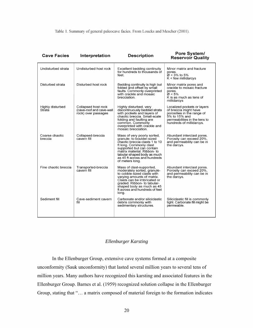
Loucks and Mescher (2001) developed a classification of paleocave facies (Figure
23, Table 1). Six basic cave facies are recognized in a paleocave system and are classified
by rock textures, fabrics, and structures: (1) undisturbed strata (undisturbed host rock),
(2) disturbed strata (disturbed host rock), (3) highly disturbed strata (collapsed roof and
wall rock), (4) coarse chaotic breccia (collapsed-breccia cavern fill), (5) fine chaotic
breccia (transported-breccia cavern fill), and (6) sediment fill (cave-sediment cavern fill).
Each paleocave facies can be distinct and adjoin sharply with adjacent facies, or they may
show gradation into adjacent facies within the coalesced, collapsed-paleocave system.
Pore networks associated with paleocave reservoirs can consist of cavernous pores,
interclast pores, crackle- and mosaic-breccia fractures, tectonic fractures, and, less
commonly, matrix pores. The paleocave facies classification, in conjunction with burial-
history data, can be used to describe the complex geology expressed in coalesced,
collapsed-paleocave systems and can be used to explain and predict pore-type
distribution and magnitude of reservoir quality.
19
Ellenburger Karsting
In the Ellenburger Group, extensive cave systems formed at a composite
unconformity (Sauk unconformity) that lasted several million years to several tens of
million years. Many authors have recognized this karsting and associated features in the
Ellenburger Group. Barnes et al. (1959) recognized solution collapse in the Ellenburger
Group, stating that “… a matrix composed of material foreign to the formation indicates
20
breccia formed by solution and collapse probably related to an erosional unconformity.”
Lucia (1971) was the first to promote that the extensive brecciation seen in the El Paso
Group (equivalent to the Ellenburger Group) was associated with karst dissolution and
was not the result of tectonic brecciation. Loucks and Anderson (1980, 1985) in Puckett
field in Pecos County also realized that many of the breccias in the Ellenburger Group
were related to solution collapse (Figure 11). They associated them with exposed
diagenetic terrains. Kerans (1988, 1989, 1990) strongly established karsting and cave
development in the Ellenburger Group. He proposed paleocave models (Figure 24) that
were immediately accepted and applied.
Lucia’s (1971, 1995, 1996) work in the El Paso Group in the Franklin Mountains
of far West Texas presents an excellent outcrop analog for coalesced, collapsed-
paleocave systems. He mapped a large paleocave system that was developed in the upper
1,000 ft of the El Paso Group during a 33-m.y. time gap (Figures 25, 26). Large fracture
systems and collapse-breccia zones 1,000 ft thick, 1,500 ft wide, and >1 mi long mark the
collapsed-paleocave system. Lucia (1995) noted that the cavernous porosity could have
been as high as 30% before infilling with cave-sediment fill and cement.
Within the southern Franklin Mountains, Lucia (1995) described the Great
McKelligon Sag in McKelligon Canyon along the eastern face (Figure 27). The sag,
~1,500 ft wide and ~150 ft deep, formed by collapse of paleocaves in the El Paso section
after the Montoya and Fusselman units were deposited, buried, and lithified. It is an
important feature that paints a complete picture of a coalesced, collapsed-paleocave
system (Loucks, 1999). Hardage et al. (1996), Loucks (2003), and McDonnell et al.
(2007) all stressed that collapse of a coalesced-paleocave system not only affects the
karsted unit, but also strongly affects the units above (Figure 22). Loucks (2003) called
the deformation of younger lithified units “suprastratal deformation.” Besides the
example of suprastratal deformation shown in the Great McKelligon Sag, examples of
suprastratal deformation from seismic in the Ellenburger Group can be seen in Hardage et
al. (1996), Loucks (1999, 2003), and McDonnell et al. (2007) and from wireline-log cross
sections by Kerans (1989) (his Figure 25).
Kerans (1988, 1989, 1990) presented an excellent overview of paleokarst in the
Ellenburger Group. His paleocave models (Figure 24) were the first to define paleocave
21
floor, paleocave sediment fill, and paleocave roof. Figures 28 through 32 present several
cores and associated core slabs from collapsed-paleocave systems, which emphasize
Kerans’ paleocave model. Paleocave terrigenous-bearing sediment fill is strikingly
apparent from gamma-ray, spontaneous potential, and resistivity logs (Kerans, 1988,
1989, 1990). Paleocave fabrics can also be recognized on electrical imaging tools
(Hammes, 1997). Kerans (1988, 1989) discussed several breccia types, including (1) a
laterally persistent breccia association formed in the upper phreatic zone (water table)
karst and (2) a laterally restricted breccia association formed by deep phreatic dissolution
and collapse.
Kerans (1990), in his sequence of diagenetic events (his Figure 37), noted that the
Ellenburger section had been subjected to karsting during several periods of time. The
main karst event was at the Early Ordovician Sauk-Tippecanoe Supersequence boundary.
In local areas it was karsted several more times. In the Llano area of Texas, Kupecz and
Land (1991) showed that the Ellenburger stayed near the surface until deep burial during
Later Pennsylvanian subsidence (Figure 33A). Loucks et al. (2000) recognized conodonts
in cave-sediment fill from paleocaves in the Llano that would indicate exposure during
the Middle to Late Ordovician, Late Devonian, and Earliest Mississippian times. Also,
they established other strong periods of karsting during Pennsylvanian, Cretaceous, and
Tertiary times. Combs et al. (2003) noted a second period of karsting in the Ellenburger
interval in Barnhart field in Reagan County, where the Wolfcamp clastic overlies the
Ellenburger Group. Their burial-history diagram (Figure 33B) displays the two periods of
karsting.
Tectonic Fracturing
In the past there has been controversy on the origin of many of the breccias and
fractures in the Ellenburger Group. Some workers (e.g., Ijirighoi and Schreiber, 1986)
wanted to assign most, if not all, fractures and breccias to a tectonic origin. They thought
that faulting could produce these widespread breccias. The extensive size and shape of
most Ellenburger breccias and the inclusion of cave-sediment fill, speleothems, and
younger conodonts preclude a simple tectonic origin (Loucks, 2003).
22
However, several authors have noted tectonic fractures in the Ellenburger section
(e.g., Loucks and Anderson, 1985; Kerans, 1989; Holtz and Kerans, 1992; Combs et al.,
2003). Each of these authors recognized that tectonic fractures cut across lithified
breccias. Kerans (1989) noted the fractures cutting late saddle dolomite and suggested
that the Pennsylvanian foreland deformation that affected much of West and Central
Texas, as described by Budnik (1987), probably produced many tectonic-related
fractures. However, as pointed out by many authors, paleocave collapse can also produce
fractures that are not associated with tectonic events. Kerans (1990), Lucia (1996), and
Loucks (1999, 2003) showed that suprastratal deformation above collapsing paleocave
systems can create sags, faults, and numerous fractures (Figure 22).
Kerans (1989) pointed out several distinct ways to separate karst-related fractures
from tectonic-related fractures:
(1) Tectonic fractures are commonly the youngest fractures in the core and generally
crosscut karst-related fractures.
(2) Tectonic fractures postdate saddle dolomite. In the Llano area, however, saddle
dolomite fills in a well-developed Pennsylvanian fracture set (Loucks, 2003).
(3) Karst-related fractures are generally near the top of the Ellenburger section,
whereas tectonic-related fractures can occur throughout the Ellenburger section.
Loucks and Mescher (1998) presented additional criteria for separating karst-related
fractures from tectonic-related fractures:
(1) Tectonic fractures generally show a strong relationship to regional stress patterns
and have well-defined, oriented sets of fractures, whereas karst-related fractures
respond to near-field stresses and fracture orientation is more random than
tectonic fractures.
(2) Regional tectonic fractures are generally spaced at >1-inch scale and commonly at
1-ft or larger scale. Karst-related fractures (crackle-breccia fractures) can be
closely spaced—only a fraction of an inch apart.
(3) Breccias associated with tectonic-derived faults commonly form a narrow band
around the fault only a few feet wide but may be tens of feet wide. Karst-related
breccias can be thousands of feet wide and hundreds of feet thick, contain a large
23
range of clast sizes, and show hydrodynamic sedimentary structures in the
sediment fill.
(4) Tectonic faults are linear or curved in map view. Karst-related faults are linear,
curved, or cylindrical (Hardage et al., 1996; Loucks, 1999, McDonnell et al.,
2007) in map view.
Tectonic- and karst-related fractures are both present in the Ellenburger section. Detailed
analysis of the fractures can commonly define their origin.
RESERVOIR CHARACTERISTICS
Pore Types
Pore networks in the Ellenburger are complex because of the amount of
dolomitization, brecciation, and fracturing associated with karsting and regional tectonic
deformation. Pore networks can consist of any combination of the following pore types,
depending on depth of burial (Loucks, 1999): (1) matrix, (2) cavernous, (3) interclast,
(4) crackle-/mosaic-breccia fractures, or (5) tectonic-related fractures.
Loucks (1999) presented an idealized plot of how karst-related Ellenburger pore
networks probably change with depth (Figure 34). Relative abundance of pore types and
relative depth of burial are estimates based on review of near-surface modern cave
systems and buried paleocave systems (see Table 2 in Loucks, 1999). Large voids may be
preserved down to 8,000 to 9,000 ft of burial, but they eventually collapse, forming
smaller interclast pores and fractures associated with crackle and mosaic breccias.
Coarse-interclast pores between large clasts are reduced by rotation of clasts to more
stable positions and by rebrecciation of clasts to smaller fragments (Figure 21). As
passages and large interclast pores in the cave system collapse, fine-interclast pores first
increase and then decrease, whereas fracture pore types become more abundant. Cave-
sediment fill is commonly cemented tight during burial diagenesis in the Ellenburger
carbonates, especially if it is terrigenous sediment or it has a terrigenous sediment
component. In the Ellenburger carbonates, matrix porosity is generally low (<5%),
consisting of common matrix pore types such as interparticle, moldic, intercrystalline, or
24
micropores. See Table 1 (Loucks and Mescher, 2001) for a general estimate of reservoir
quality by paleocave facies types.
Three-Dimensional Architecture of an Ellenburger
Coalesced, Collapsed-Paleocave System
The three-dimensional, interwell-scale architecture of a Lower Ordovician
Ellenburger coalesced, collapsed-paleocave system was constructed through integration
of 7.8 mi of ground-penetrating radar (GPR), 29 shallow cores (~50 ft long), and outcrop
data within a large quarry (McMechan et al., 1998, 2002; Loucks et al., 2000; Loucks et
al., 2004). Data were collected near Marble Falls in Central Texas over an area (~2,600 ×
~3,300 ft) that could cover several oil-well locations (~160 ac) typical of a region such as
West Texas (Figure 35). Integration of core-based facies descriptions with GPR-
reflection response identified several paleocave facies that could be deciphered and
mapped using GPR data alone (Figure 36): (1) continuous reflections image the
undisturbed strata, (2) relatively continuous reflections (more than tens of feet)
characterized by faults and folds image the disturbed strata, and (3) chaotic reflections
having little to no perceptible continuity image heterogeneous cave-related facies
recognized in core that cannot be individually resolved with GPR data. These latter facies
include highly disturbed strata, coarse-clast chaotic breccia, fine-clast chaotic breccia,
and cave-sediment fill.
The three-dimensional architecture of the coalesced, collapsed-paleocave system
based on core and GPR data indicates that trends of brecciated bodies are as much as
1,100 ft wide, >3300 ft long, and tens of feet high (Figures 37, 38). These brecciated
bodies are coalesced, collapsed paleocaves. Between the brecciated bodies are areas of
disturbed and undisturbed host rock that are jointly as much as 660 ft wide.
Representative cores from the study are presented in Figure 39.
As a cave system is buried, many structural features form by mechanical
compaction, and these features, including folds, sags, and faults, were documented in the
study by McMechan et al. (1998, 2002) and Loucks et al. (2004). Folds and sags measure
from ~10 ft to several hundred feet wide. Collapse-related faults are numerous and can
25
have several feet of throw. Most are normal faults, but some reverse faults also occur. See
Figures 40 to 43 for examples of collapsed-paleocave features from GPR and outcrop
data.
Megascale Architecture
Coalesced, collapsed-paleocave systems are megascale geologic features that can
have dimensions of hundreds to thousands of square miles laterally and several thousand
feet vertically (Loucks, 1999, 2003). Strata above and below the unconformity are
affected by late collapse in the subsurface (Figure 22).
A coalesced, collapsed-paleocave system can be divided into two parts (Loucks,
2007): (1) a lower section of karsted strata that contains collapsed paleocaves and (2) an
upper section of strata that is deformed to various degrees (suprastratal deformation) by
the collapse and compaction of the lower section of paleocave-bearing strata (Figure 22).
The collapse and compaction of cave systems provide the potential for development of
large-scale fracture/fault systems that can extend from the collapsed interval upward
several thousand feet. These fracture/fault systems are not related to regional tectonic
stresses.
Both Kerans (1990) and Loucks (1999, 2007) speculated that the regional pattern of
karsted Ellenburger reservoirs probably follows a rectilinear pattern as a result of regional
fractures controlling cave development. Loucks (1999) presented data from subsurface
seismic and from mining areas that express the rectilinear pattern of paleocave systems
(Figure 44). Lucia (1995) presented a map of the paleocave system in the El Paso Group
that also displays a rectilinear pattern (Figure 26). The coalesced brecciated bodies
mapped by Loucks et al. (2004) in the Marble Falls area are rectilinear (Figure 37). At a
larger scale, Canter et al. (1993) showed a regional isopach map of Ellenburger paleocave
sediments over tens of square miles (Figure 45) having a strong rectilinear pattern. Also,
a modified map of Hardage et al. (1996) of rectilinear suprastratal deformation trends,
associated with Ellenburger subsurface paleocave collapse, in Wise County, Texas, lines
up in a rectilinear pattern (Figure 46). A later study of this area by McDonnell et al.
(2007) presents this pattern as well, but in more detail. Strong evidence therefore
suggests that coalesced, collapsed-paleocave systems have rectilinear patterns that may
26
be associated with regional fracture systems. However, at present no definitive study has
shown an actual regional paleofracture system that has controlled these rectilinear
patterns.
HYDROCARBON PRODUCTION
Holtz and Kerans (1992) estimated that the original in-place oil in the Lower
Ordovician strata had been ~11 million barrels of oil equivalent (MMboe), 3.8 MMboe of
which had been produced at the time of their article. Production from the Ellenburger
since 1970 from Railroad Commission of Texas files has been 488.5 million barrels
(MMbbl) of oil and 13.5 trillion cubic feet (Tcf) of gas (personal communication from
Romulo Briceno, Bureau of Economic Geology). Total hydrocarbons produced are
2, 249 billion barrels of oil equivalent (Bboe).
Holtz and Kerans (1992) tabulated 149 oil and/or gas reservoirs that each has
produced >1 MMbbl of oil equivalent. According to Railroad Commission of Texas files,
there are approximately 700 fields of various sizes within the Ellenburger Group in Texas
(personal communication from Romulo Briceno, Bureau of Economic Geology).
Holtz and Kerans (1992) divided Ellenburger reservoirs into three groups
(Figure 47):
(1) Karst-modified reservoirs: Reservoirs formed in the inner-ramp depositional
setting and affected by extensive dolomitization and karsting. Karst-related
fractures and interclast pores are the main pore types, with tectonic fractures
secondary. These reservoirs are characterized by moderately thick net pay, low
porosity, moderate permeability, low initial water saturation, and moderate
residual oil saturation.
(2) Ramp carbonates: Reservoirs formed in middle- to outer-ramp depositional
settings and dolomitized to various degrees. Predominant pores types are
intercrystalline and interparticle, with tectonic and karst fractures being
secondary. These reservoirs are characterized by thinnest net pay, highest
porosity, moderate permeability, highest initial water saturation, and highest
residual oil saturation.
27
(3) Tectonically fractured dolomites: Reservoirs formed in the inner-ramp
depositional environment, subsequently extensively dolomitized, karsted, and,
lastly, extensively tectonically fractured. Tectonic-related fractures are the
dominant pore type, and the other pore types are commonly fractures. These
reservoirs are characterized by the thickest net pay, lowest porosity, lowest
permeability, and lowest initial water saturation.
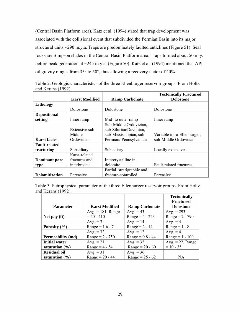
Tables 2 and 3 from Holtz and Kerans (1992) summarize geologic and reservoir traits
of each group. Note that Ellenburger reservoirs generally have low porosities (a few
percent) and fair permeabilities (one to a few hundred millidarcys). The low porosities
and fair permeabilities are the result of permeability being related to fracture-type pores.
Figure 48 shows field averages of porosity and permeability for a number of Ellenburger
fields. Average porosities are low, whereas permeabilities are fair. This relationship is the
result of karst-related fracture pores. Figure 49 is a histogram of productive (past and
present) wells drilled into the Ellenburger Group. Producing wells show a range from
856 ft (Originala Petroleum #1 Gensler well in Archer County, Texas) to 25,735 ft
(Exxon Mobil McComb Gas Unit B well in Pecos County, Texas). A recent review of
Texas oil fields by Dutton et al. (2005) states that the Karst-Modified Reservoir play had
produced ~1.5 Bbbl of oil and the Ellenburger Ramp Carbonate play had produced
~164 MMbbl of oil as of 2005.
Figure 50 by Katz et al. (1994) is an event chart for the Simpson-Ellenburger
petroleum system, showing the temporal relationships of essential elements and
processes. Even though the source of the petroleum system is problematic, these workers
thought that the source rocks are shales within the Simpson Group. However, where the
Simpson is absent, Ellenburger oil appears to be sourced from the Woodford Shale or
younger strata (Pennsylvanian or Permian) (Kvenvolden and Squires, 1967). Katz et al.
(1994) mentioned that the level of organics within the Ellenburger section is too lean
(<0.5% total organic carbon [TOC]) to be capable of generating commercial quantities of
hydrocarbons. The Simpson has >1% TOC. These workers’ ideas about reservoir rock
type in Ellenburger carbonates come from articles cited earlier in this paper, and these
reservoir rocks within this petroleum system are buried between 8,530 and 13,240 ft
28
(Central Basin Platform area). Katz et al. (1994) stated that trap development was
associated with the collisional event that subdivided the Permian Basin into its major
structural units ~290 m.y.a. Traps are predominately faulted anticlines (Figure 51). Seal
rocks are Simpson shales in the Central Basin Platform area. Traps formed about 50 m.y.
before peak generation at ~245 m.y.a. (Figure 50). Katz et al. (1994) mentioned that API
oil gravity ranges from 35° to 50°, thus allowing a recovery factor of 40%.
Table 2. Geologic characteristics of the three Ellenburger reservoir groups. From Holtz and Kerans (1992).
Tectonically Fractured Dolostone Karst Modified Ramp Carbonate
Lithology Dolostone Dolostone Dolostone Depositional setting Inner ramp Mid- to outer ramp Inner ramp
Sub-Middle Ordovician, sub-Silurian/Devonian, sub-Mississippian, sub-Permian/ Pennsylvanian
Extensive sub-Middle Ordovician
Variable intra-Ellenburger, sub-Middle Ordovician Karst facies
Fault-related fracturing Subsidiary Subsidiary Locally extensive
Karst-related fractures and interbreccia
Dominant pore type
Intercrystalline in dolomite Fault-related fractures Partial, stratigraphic and fracture-controlled Dolomitization Pervasive Pervasive
Table 3. Petrophysical parameter of the three Ellenburger reservoir groups. From Holtz and Kerans (1992).
Tectonically Fractured Dolostone
Parameter Karst Modified Ramp Carbonate
Avg. = 181, Range = 20 - 410
Avg. = 43 Avg. = 293, Range = 7 - 790 Net pay (ft) Range = 4 - 223
Avg. = 3 Avg. = 14 Avg. = 4 Porosity (%) Range = 1.6 - 7 Range = 2 - 14 Range = 1 - 8
Avg. = 32 Avg. = 12 Avg. = 4 Permeability (md) Range = 2 - 750 Range = 0.8 - 44 Range = 1 - 100 Initial water Avg. = 21 Avg. = 32 Avg. = 22, Range
= 10 - 35 saturation (%) Range = 4 - 54 Range = 20 - 60 Residual oil Avg. = 31 Avg. = 36 saturation (%) Range = 20 - 44 Range = 25 - 62 NA
29
COMMENTS ON APPROACHES TO EXPLORATION AND
FIELD DEVELOPMENT
Exploration
The vast majority of Ellenburger fields are trapped in anticlinal or faulted
anticlinal structures (Figure 51). Because Ellenburger reservoirs are mainly structural
plays, seismic is needed to define these structural prospects. Complexities of the structure
must be delineated to focus on correct trapping geometry. Stratigraphic trapping in the
highly karsted and fractured Ellenburger carbonate is probably not common because
some level of communication is generally within the carbonate, although poor. After a
structure is defined, fault compartmentalization of the structure must be mapped. If 3-D
seismic analysis is able to display the sag features produced by collapse of the cave
system (Loucks, 1999), these collapsed zones may contain the highest reservoir quality
(Purves et al., 1992).
Many wells testing the Ellenburger section penetrate only the top of the interval to
prevent water from being encountered when drilling too deep (Kerans, 1990). Caution
must be taken to ensure that the full prospective section is tested and that any vertical
permeability barriers are penetrated (Loucks and Anderson, 1985; Kerans, 1990). Kerans
(1990) provided an excellent example from University Block 13 field in Andrews
County, Texas, where a series of wells drilled into the very top of the Ellenburger section
were produced and then later deepened (Figure 52). The deepened wells encountered new
hydrocarbons that had been separated from the upper unit by paleocave fill and tight
carbonate. The cave-fill-prone intervals are distinctive on wireline logs. Note that a cave
fill by itself cannot be a laterally continuous permeability barrier because its limited
lateral extent is controlled by the size of the original cave itself (Loucks, 1999, 2001).
Kerans (1990), Loucks and Handford (1992), Hammes et al. (1996), and Loucks
(1999) all stressed that karsted reservoirs can have stacked porous brecciated zones
(Figure 29). These stacked reservoir zones are results of multiple cave passages forming
during base-level drop while a cave system is developing (Figure 19). Commonly each of
the paleocave passage levels will be in contact with one another because of cave collapse
30
and associated fracturing. However, as Kerans (1990) showed for University Block 13
field, this is not always the case.
In any test of the Ellenburger section, a core or image log is necessary to evaluate
the section properly. Commonly porosity will be low (<5%) as calculated from wireline
logs; however, permeability from karst-related fracturing may be in the hundreds of
millidarcys. Core will provide a proper reservoir quality analysis, and image logs will
provide a description of the fractured pore network in the rock (Hammes, 1997).
Field Development
Field development of paleocave reservoirs should be based on integrated studies
that include data from 3-D seismic surveys, cores, borehole image logs, conventional
wireline logs, and engineering data (Loucks, 1999). In some cases it might be possible to
identify cavernous or intraclast porosity from 3-D seismic data (Bouvier et al., 1990).
Cores and borehole image logs are necessary to recognize and describe paleocave
reservoir facies (Hammes, 1997). Whole-core data are recommended over core-plug data
because of the scale and complexity of pore systems in paleocave reservoirs. Sags
associated with cave collapse should be mapped because they may indicate location of
the best coalesced reservoirs (Purves et al., 1992; Lucia, 1996; Loucks, 1999). Different
cave passage levels of the paleocave system need to be identified and analyzed to
determine whether they are separate reservoirs or in vertical communication with one
another (Kerans, 1988, 1990). Because of the significant spatial complexity within
coalesced paleocave systems, horizontal wells may be an option for improving recovery.
Kerans (1988) stated that in the Mobil Block 36 lease of the Emma Ellenburger reservoir,
“Adjacent wells in this 40-acre-spaced reservoir have varied in production, one to the
other, anywhere from 0 to 900,000 barrels of oil from the lower collapse zone.” He noted
that this variability is probably related to changes in paleocave facies. The detailed
paleocave system maps provided by Loucks et al. (2004) would support this conclusion.
Kerans (1988) listed other fields, such as Shafter Lake and Big Lake fields, as showing
strong lateral reservoir heterogeneity. Other workers that addressed different aspects of
exploration and development are Kerans (1990), Wright et al. (1991), Mazzullo and
31
Mazzullo (1992), Hammes et al. (1996), Lucia (1996), Mazzullo and Chilingarian (1996),
and Loucks (1999).
CONCLUSIONS
The Ellenburger Group of the Permian Basin is part of a Lower Ordovician
carbonate platform succession that covered large areas of the United States. During the
Early Ordovician, the West Texas Permian Basin area was located on the southwest edge
of the Laurentia plate between 20° and 30° latitude. The equator crossed northern
Canada, situating Texas in a tropical to subtropical latitude. Texas was a shallow-water
shelf with deeper water conditions to the south where it bordered the Iapetus Ocean. The
Ellenburger Group in the south part of the Permian Basin, where the deeper water
equivalent strata would have been, was strongly affected by the Ouachita Orogeny. The
basinal and slope facies strata were destroyed or extensively structurally deformed. A
worldwide hiatus appeared at the end of Early Ordovician deposition, creating an
extensive second-order unconformity (Sauk-Tippecanoe Supersequence Boundary). This
unconformity produced extensive karsting throughout the United States, including Texas.
The general depositional history of the Ellenburger was defined by Kerans (1990)
as (1) Marked by retrogradational deposition of a fan delta – marginal marine
depositional system continuous with the Early Cambrian transgression. This stage was
followed by regional progradation and aggradation of peritidal carbonate facies.
(2) Rapid transgression and widespread aggradational deposition of the high-energy
restricted-shelf depositional system across much of West and Central Texas during this
stage. It has been interpreted as a moderately hypersaline setting, given the rare
macrofauna, evidence of evaporites, and abundance of ooids. (3) Upward transition from
the high-energy restricted shelf depositional system to the low-energy restricted-shelf
depositional systems as evidenced by a second regression across the Ellenburger shelf.
Progradation during this stage is marked by transition of landward upper tidal flats to
more seaward, low-energy restricted subtidal to intertidal facies to farthest seaward open-
marine, shallow-water shelf facies. (4) Near the end of the Early Ordovician there was a
32
worldwide eustatic lowstand—the exposure spanned several million years and exposed
the Ellenburger Platform in West Texas, producing an extensive karst terrain.
Diagenesis of the Ellenburger Group is complex, and the processes that produced
it spanned millions of years. Three major diagenetic processes are important to recognize:
(1) dolomitization, (2) karsting, and (3) tectonic fracturing. Five general stages of
dolomitization were recognized by Kupecz and Land (1991). Generations of dolomite
were separated into early-stage dolomitization, which predated the Sauk unconformity,
and late-stage dolomitization, which postdated the Sauk unconformity. They attributed
90% of the dolomite to prekarstification, early-stage dolomite, and 10% of the dolomite
to postkarstification, late-stage dolomite. Early-stage prekarstification dolomite is
associated with muddier rocks, and the source of Mg was probably seawater. Late-stage
postkarstification dolomites are attributed to warm, reactive fluids, which were expelled
from basinal shales during the Ouachita Orogeny. Fluids are thought to have been
corrosive, as evidenced by corroded dolomite rhombs. This corrosion provided the Mg
necessary for dolomitization. The fluids migrated through high-permeability aquifers of
the Bliss Sandstone, basal subarkose facies of the Ellenburger, as well as grainstone
facies and paleocave breccia zones. In the Ellenburger Group, extensive cave systems
formed at a composite unconformity (Sauk unconformity) that lasted several million
years to several tens of million years. These cave systems collapsed with burial, creating
widespread brecciated and fractured carbonate bodies that form many of the Ellenburger
reservoirs. As much as 1,000 ft of section can be affected, but more commonly only the
top 300 ft is affected. Lithified strata above the karsted Ellenburger are also affected by
suprastratal deformation. The West Texas area has been periodically tectonically active
following Ellenburger deposition, producing faults and fractures associated with these
tectonic periods.
Pore networks in the Ellenburger are complex because of the amount of
brecciation and fracturing associated with karsting. Pore networks can consist of any
combination of the following pore types, depending on depth of burial (Loucks, 1999):
(1) matrix, (2) cavernous, (3) interclast, (4) crackle-/mosaic-breccia fractures, or
(5) tectonic-related fractures. The pore network evolved with burial and diagenesis.
33
Coalesced, collapsed-paleocave systems are megascale geologic features that can
have dimensions of hundreds to thousands of square miles laterally and several thousand
feet vertically. Strata above and below the unconformity are affected by late collapse in
the subsurface. A coalesced, collapsed-paleocave system can be divided into (1) a lower
section of karsted strata that contains collapsed paleocaves and (2) an upper section of
strata that is deformed to various degrees (suprastratal deformation) by the collapse and
compaction of the lower section of paleocave-bearing strata. The regional pattern of
karsted Ellenburger reservoirs probably follows a rectilinear pattern as a result of regional
fractures controlling original cave-system development.
The Ellenburger Group is an ongoing important exploration target in West Texas.
The structural play covers a depth interval of >25,000 ft. Carbonate depositional systems
within the Ellenburger Group are relatively simple; however, the diagenetic overprint is
complex and it is this complex diagenetic overprint that produces strong spatial
heterogeneity within the reservoir systems.
ACKNOWLEDGMENT
Publication authorized by the Director, Bureau of Economic Geology. Special
thanks are given to Lana Dieterich for editing the manuscript. Funding for this study
came from the State of Texas Advanced Resource Recovery Program.
REFERENCES
Amthor, J. E., and Friedman, G. M., 1991, Dolomite-rock textures and secondary
porosity development in Ellenburger Group carbonates (Lower Ordovician), West
Texas and southeastern New Mexico: Sedimentology, v. 38, p. 343–362.
Barnes, V. E., Cloud, P. E., Jr., Dixon, L. P., Folk, R. L., Jonas, E. C., Palmer, A. R., and
Tynan, E. J., 1959, Stratigraphy of the pre-Simpson Paleozoic subsurface rocks of
Texas and southeast New Mexico: University of Texas, Austin, Bureau of
Economic Geology Publication 5924, 294 p.
34
Berry, W. B. N., 1960, Graptolite faunas of the Marathon region, West Texas: University
of Texas, Austin, Bureau of Economic Geology Publication 6005, 179 p.
Blakey, R., 2005a, Regional paleogeographic views of earth history; paleogeographic
globes: http://jan.ucc.nau.edu/~rcb7/RCB.html.
Blakey, R., 2005b, Paleogeography and geologic evolution of North America; Images
that track the ancient landscapes of North America:
http://jan.ucc.nau.edu/~rcb7/RCB.html.
Bouvier, J. D., Gevers, E. C.A., and Wigley, P. L., 1990, #-D seismic interpretation and
lateral prediction of the Amposta Marino field (Spanish Mediterranean Sea):
Geologie en Mijnbouw, v. 69, p. 105–120.
Budnik, T. T., 1987, Left-lateral intraplate deformation along the Ancestral Rocky
Mountains: implications for late Paleozoic plate motions: Tectonophysics, v. 132,
p. 195–214.
Candelaria, M. P., and Reed, eds., C. L., 1992, Paleokarst, karst related diagenesis and
reservoir development: Examples from Ordovician-Devonian age strata of West
Texas and the Mid-Continent: Permian Basin Section, Society of Economic
Paleontologists and Mineralogists Publication No. 92-33, 202 p.
Canter, K. L., Stearns, D. B., Geesaman, R. C., and Wilson, J. L., 1993, Paleostructural
and related paleokarst controls on reservoir development in the Lower Ordovician
Ellenburger Group, Val Verde Basin, in Fritz, R. D., Wilson, J. L., and D. A.
Yurewicz, D. A., eds., Paleokarst related hydrocarbon reservoirs: SEPM Core
Workshop No. 18, New Orleans, April 25, p. 61–101.
Cloud, P. E., and Barnes, V. E., 1948, The Ellenburger Group of Central Texas:
University of Texas, Austin, Bureau of Economic Geology Publication 4621,
473 p.
Cloud, P. E., and Barnes, V. E., 1957, Early Ordovician sea in Central Texas: Geological
Society of American Memoir 67, p. 163–214.
Cloud, P. E., Barnes, V. E., and Bridge, J. 1945, Stratigraphy of the Ellenburger Group in
Central Texas—a progress report: University of Texas, Austin, Bureau of
Economic Geology Publication 4301, p. 133–161.
35
Combs, D. M., Loucks, R. G., and Ruppel, S. C., 2003, Lower Ordovician Ellenburger
Group collapsed paleocave facies and associated pore network in the Barnhart
field, Texas, in Hunt, T. J., and Lufholm, P. H., The Permian Basin: back to
basics: West Texas Geological Society Fall Symposium: West Texas Geological
Society Publication #03-112, p. 397–418.
Custer, M. A., 1957, Polar field, Kent County, Texas, in Heard, F. A., ed., Occurrence of
oil and gas in West Texas: University of Texas, Austin, Bureau of Economic
Geology Publication No. 5716, p. 200–282.
Dutton, S. P., Kim, E. M., Broadhead, R. F., Breton, C. L., Raatz, W. D., Ruppel, S. C.,
and Kerans, Charles, 2005, Play analysis and digital portfolio of major oil
reservoirs in the Permian Basin: The University of Texas at Austin, Bureau of
Economic Geology Report of Investigations No. 271, 287 p., CD-ROM.
Entzminger, D. J., 1994, Shafter Lake (Ellenburger), in Oil & gas fields in West Texas:
West Texas Geological Society Publication 94-96, v. 4, p. 247–250.
Folk, R. L., 1959, Thin-section examination of Pre-Simpson Paleozoic rocks, in Barnes,
V. E., Cloud, P. E., Jr., Dixon, L. P., Folk, R. L., Jonas, E. C., Palmer, A. R., and
Tynan, E. J., Stratigraphy of the pre-Simpson Paleozoic subsurface rocks of Texas
and southeast New Mexico: University of Texas, Austin, Bureau of Economic
Geology Publication. 5924, p. 95–130.
Ford, D. C., 1988, Characteristics of dissolutional cave systems in carbonate rocks, in
James, N. P., and Choquette, P. W., eds., Paleokarst: Springer-Verlag, p. 25–57.
Esteban, M., 1991, Palaeokarst: practical applications, in Wright, V. P., Esteban, M., and
Smart, P. L., eds., Palaeokarst and palaeokarstic reservoirs: Postgraduate
Research for Sedimentology, University of Reading, PRIS Contribution No. 152,
p. 89–119.
Galley, J. E., 1958, Oil and geology in the Permian Basin of Texas and New Mexico, in
Weeks, W. L., ed., Habitat of oil: American Association of Petroleum Geologists
Special Publication, p. 395–446.
Goldhammer, R. K., 1996, Facies architecture, cyclic and sequence stratigraphy: the
Lower Ordovician El Paso Group, West Texas, in Stoudt, E. L., ed., Precambrian-
Devonian geology of the Franklin Mountains, West Texas—Analogs for
36
exploration and production in Ordovician and Silurian karsted reservoirs in the
Permian basin: West Texas Geological Society Annual Field Trip Guidebook,
WTGS Publication No. 96-100, p. 71–98.
Goldhammer, R. K., and Lehmann, P. J., 1996, Chaos in El Paso, in Stoudt, E. L., ed.,
Precambrian-Devonian geology of the Franklin Mountains, West Texas—Analogs
for exploration and production in Ordovician and Silurian karsted reservoirs in the
Permian basin: West Texas Geological Society 1996 Annual Field Trip
Guidebook: WTGS Publication No. 96-100, p. 125–140.
Goldhammer, R. K., Lehmann, P. J., and Dunn, P. A., 1992, Third-order sequence
boundaries and high frequency cycle stacking pattern in Lower Ordovician
platform carbonates, El Paso Group (Texas): Implications for carbonate sequence
stratigraphy, in Candelaria, M. P., and Reed, C. L., eds., Paleokarst, karst related
diagenesis and reservoir development: examples from Ordovician-Devonian age
strata of West Texas and the Mid-Continent: Permian Basin Section, SEPM
(Society for Sedimentary Geology), Publication No. 92–33, p. 59–92.
Ham, W. E., and Wilson, J. L., 1967, Paleozoic epeirogeny and orogeny in the central
United States: American Journal of Science, v. 265, no, 5, p. 332–407.
Hammes, U., 1997, Electrical imaging catalog: microresistivity images and core photos
from fractured, karsted, and brecciated carbonate rocks: The University of Texas
at Austin, Bureau of Economic Geology Geological Circular 97-2, 40 p.
Hammes, Ursula, Lucia, F. J., and Kerans, Charles, 1996, Reservoir heterogeneity in
karst-related reservoirs: Lower Ordovician Ellenburger Group, West Texas, in
Stoudt, E. L., ed., Precambrian–Devonian geology of the Franklin Mountains,
West Texas—analogs for exploration and production in Ordovician and Silurian
karsted reservoirs in the Permian Basin: West Texas Geological Society,
Publication No. 96-100, p. 99–117.
Hardage, B. A., Carr, D. L., Lancaster, D. E., Simmons, J. L., Jr., Elphick, R. Y.,
Pendleton, V. M., and Johns, R. A., 1996, 3-D seismic evidence of the effects of
carbonate karst collapse on overlying clastic stratigraphy and reservoir
compartmentalization: Geophysics, v. 61, p. 1336–1350.
37
Hardwick, J. V., 1957, Block 32 field, Crane County, Texas, in Heard, F. A., ed.,
Occurrence of oil and gas in West Texas: The University of Texas at Austin,
Bureau of Economic Geology Publication No. 5716, p. 40–46.
Holland, R. R., 1966, Puckett, Ellenburger, Pecos County, Texas, in Oil and gas fields in
West Texas—A symposium: West Texas Geological Society Publication 66-52,
p. 291–295.
Holtz, M. H., and Kerans, C., 1992, Characterization and categorization of West Texas
Ellenburger reservoirs, in Candelaria, M. P., and Reed, C. L., eds., Paleokarst,
karst related diagenesis and reservoir development: examples from Ordovician-
Devonian age strata of West Texas and the Mid-Continent: Permian Basin Section
SEPM Publication No. 92-33, p. 31–44.
Ijirighoi, B. T., and Schreiber, J. F., Jr., 1986, Origin and classification of fractures and
related breccia in the Lower Ordovician Ellenburger Group, West Texas: West
Texas Geological Society Bulletin, v. 26, p. 9–15.
Katz, B. J., Dawson, W. C., Robison, V. D., and Elrod, L. W., 1994, Simpson—
Ellenburger(.) petroleum system of the Central Basin Platform, West Texas,
U.S.A., in Magoon, L. B. and Dow, W. G., eds., The petroleum system—from
source to trap: AAPG Memoir 60, p. 453–461.
Kerans, Charles, 1988, Karst-controlled reservoir heterogeneity in Ellenburger Group
carbonates of West Texas: reply: AAPG Bulletin, v. 72, p. 1160–1183.
Kerans, Charles, 1989, Karst-controlled reservoir heterogeneity and an example from the
Ellenburger Group (Lower Ordovician) of West Texas: The University of Texas
at Austin, Bureau of Economic Geology Report of Investigations No. 186, 40 p.
Kerans, Charles, 1990, Depositional systems and karst geology of the Ellenburger Group
(Lower Ordovician), subsurface West Texas: The University of Texas at Austin,
Bureau of Economic Geology Report of Investigations No. 193, 63 p., 6 pl.
Kerans, Charles, Lucia, F. J., and Senger, R. K., 1994, integrated characterization of
carbonate ramp reservoirs using Permian San Andres outcrop analogs: AAPG
Bulletin, v. 78, p. 181–216.
38
Kvenvolden, K. A., and Squires, R. M., 1967, Carbon isotopic composition of crude oils
from Ellenburger Group (Lower Ordovician), Permian basin, West Texas and
eastern New Mexico: AAPG Bulletin, v. 51, p. 1293–1303.
Kupecz, J. A., 1992, Sequence boundary control on hydrocarbon reservoir development,
Ellenburger Group, Texas, in Candelaria, M. P., and Reed, C. L., eds., Paleokarst,
karst related diagenesis and reservoir development: examples from Ordovician-
Devonian age strata of West Texas and the Mid-Continent: Permian Basin
Section, (Society for Sedimentary Geology), Publication No. 92–33, p. 55–58.
Kupecz, J. A., and L. S. Land, 1991, Late-stage dolomitization of the Lower Ordovician
Ellenburger Group, West Texas: Journal of Sedimentary Petrology, v. 61, p. 551–
574.
Lee, I. Y., and Friedman, G. M., 1987, Deep-burial dolomitization in the Ordovician
Ellenburger Group carbonates, West Texas and southeastern New Mexico—
Reply: Journal of Sedimentary Petrology, v. 58, p. 910–913.
Lindsay, R. F., and Koskelin, K. M., 1993, Arbuckle Group (Late Cambrian-early
Ordovician) shallowing-upward parasequences and sequences, southern
Oklahoma, in Keller, D. R., and Reed, C. L., eds., Paleokarst, karst related
diagenesis and reservoir development: examples from Ordovician-Devonian age
strata of West Texas and the Mid-Continent: Permian Basin Section SEPM
Publication No. 92-33, p. 45–65.
Loucks, R. G., 1999, Paleocave carbonate reservoirs: origins, burial-depth modifications,
spatial complexity, and reservoir implications: AAPG Bulletin, v. 83, p. 1795–
1834.
Loucks, R. G., 2001, Modern analogs for paleocave-sediment fills and their importance
in identifying paleocave reservoirs: Gulf Coast Association of Geological
Societies Transactions, v. 46, p. 195–206.
Loucks, R. G., 2003, Understanding the development of breccias and fractures in
Ordovician carbonate reservoirs, in Hunt, T. J., and Lufholm, P. H., The Permian
Basin: back to basics: West Texas Geological Society Fall Symposium: West
Texas Geological Society Publication No. 03-112, p. 231–252.
39
Loucks, R. G., 2007, A review of coalesced, collapsed-paleocave systems and associated
suprastratal deformation: Acta Carsologica, v. 36, no. 1, p. 121–132.
Loucks, R. G., and Anderson, J. H., 1980, Depositional facies and porosity development
in Lower Ordovician Ellenburger dolomite, Puckett Field, Pecos County, Texas,
in Halley, R. B. and Loucks, R. G., eds., Carbonate reservoir rocks: SEPM Core
Workshop No. 1, p. 1–31.
Loucks, R. G., and Anderson, J. H., 1985, Depositional facies, diagenetic terrains, and
porosity development in Lower Ordovician Ellenburger Dolomite, Puckett Field,
West Texas, in Roehl, P. O., and Choquette, P. W., eds., Carbonate petroleum
reservoirs: Springer-Verlag, p. 19–38.
Loucks, R. G., and Handford, R. H., 1992, Origin and recognition of fractures, breccias,
and sediment fills in paleocave-reservoir networks, in Candelaria, M. P., and
Reed, C. L., eds., Paleokarst, karst related diagenesis and reservoir development:
examples from Ordovician-Devonian age strata of West Texas and the Mid-
Continent: Permian Basin Section, SEPM (Society for Sedimentary Geology),
Publication No. 92–33, p. 31–44.
Loucks, R. G., and Mescher, P. A, 1998, Origin of fractures and breccias associated with
coalesced collapsed paleocave systems (abs.), in Rocky Mountain Association
Symposium on Fractured Reservoirs: Practical Exploration and Development
Strategies, unpaginated.
Loucks, R. G., and Mescher, P., 2001, Paleocave facies classification and associated pore
types, in American Association of Petroleum Geologists, Southwest Section,
Annual Meeting, Dallas, Texas, March 11–13, CD-ROM, 18 p.
Loucks, R. G., Mescher, P., and McMechan, G. A., 2000, Architecture of a coalesced,
collapsed-paleocave system in the Lower Ordovician Ellenburger Group, Dean
Word Quarry, Marble Falls, Texas: Final report prepared for the Gas Research
Institute, GRI-00/0122, CD-ROM.
Loucks, R. G., Mescher, P. K., and McMechan, G. A., 2004, Three-dimensional
architecture of a coalesced, collapsed-paleocave system in the Lower Ordovician
Ellenburger Group, Central Texas: AAPG Bulletin, v. 88, no. 5, p. 545–564.
40
Lucia, F. J., 1971, Lower Paleozoic history of the western Diablo Platform, West Texas
and south-central New Mexico, in Cys, J. M., ed., Robledo Mountains and
Franklin Mountains—1971 Field Conference Guidebook: Permian Basin Section,
SEPM, p. 174–214.
Lucia, F. J., 1968, Sedimentation and paleogeography of the El Paso Group, in Stewart,
W. J., ed., Delaware basin exploration: West Texas Geological Society
Guidebook No. 68-55, p. 61–75.
Lucia, F. J., 1969, Lower Paleozoic history of the western Diablo Platform of West Texas
and south-central New Mexico, in Seewald, K., and Sundeen, D., eds., The
geologic framework of the Chihuahua tectonic belt: West Texas Geological
Society, p. 39–56.
Lucia, F. J., 1995, Lower Paleozoic cavern development, collapse, and dolomitization,
Franklin Mountains, El Paso, Texas, in Budd, D. A., Saller, A. H., and Harris,
P. M., eds., Unconformities and porosity in carbonate strata: AAPG Memoir 63,
p. 279–300.
Lucia, F. J., 1996, Structural and fracture implications of Franklin Mountains collapse
brecciation, in Stoudt, E. L., ed., Precambrian-Devonian geology of the Franklin
Mountains, West Texas—Analogs for exploration and production in Ordovician
and Silurian karsted reservoirs in the Permian basin: West Texas Geological
Society 196 Annual Field Trip Guidebook, WTGS Publication No. 96-100,
p. 117–123.
Mazzullo, S. J., and G. V. Chilingarian, 1996, Hydrocarbon reservoirs in karsted
carbonate rocks, in Chilingarian, G. V., Mazzullo, S. J., and Rieke, H. H., eds.,
Carbonate reservoir characterization: a geologic-engineering analysis, Part II:
Elsevier, p. 797–685.
Mazzullo, S. J., and Mazzullo, L. J., 1992, Paleokarst and karst-associated hydrocarbon
reservoirs in the Fusselman Formation, West Texas, Permian basin, in Candelaria,
M. P., and Reed, C. L., eds., Paleokarst, karst related diagenesis and reservoir
development: examples from Ordovician-Devonian age strata of West Texas and
the Mid-Continent: Permian Basin Section, SEPM (Society for Sedimentary
Geology), Publication No. 92–33, p. 110–120.
41
McDonnell, Angela, Loucks, R. G., and Dooley, Tim, 2007, Quantifying the origin and
geometry of circular sag structures in northern Fort Worth Basin, Texas:
paleocave collapse, pull-apart fault systems, or hydrothermal alteration? AAPG
Bulletin, v. 91, no. 9, p. 1295–1318.
McMechan, G. A., Loucks, R. G., Mescher, P. A., and Zeng, Xiaoxian, 2002,
Characterization of a coalesced, collapsed paleocave reservoir analog using GPR
and well-core data: Geophysics, v. 67, no. 4, p. 1148–1158.
McMechan, G. A., Loucks, R. G., Zeng, X., and Mescher, P. A., 1998, Ground
penetrating radar imaging of a collapsed paleocave system in the Ellenburger
dolomite, Central Texas: Journal of Applied Geophysics, v. 39, p. 1–10.
Palmer, A. N., 1991, Origin and morphology of limestone caves: Geological Society of
America Bulletin, v. 103, p. 1–21.
Purves, W. J., E. B. Burnitt, L. R. Weathers, and L. K. Wipperman, 1992, Cave/pillar
definition in the Ordovician Ellenburger reservoir by 3-D seismic, Pegasus field,
Midland and Upton counties, Texas (abs.): AAPG Annual Meeting Program and
Abstracts, p. 108.
Ross, R. J., Jr., 1976, Ordovician sedimentation in the western United States, in Bassett,
M. G., ed., The Ordovician System: Proceedings of a Paleontological Association
Symposium: Birmingham, p. 73–105.
Ross, R. J., Jr., 1982, The Ordovician System in the United States―correlation chart and
explanatory note: International Union of Geological Sciences Publication 12,
73 p.
Ruppel, S. C., Jones, R. H., Breton, C. L., and Kane, J. A., 2005, Preparation of maps
depicting geothermal gradient and Precambrian structure in the Permian Basin:
The University of Texas at Austin, Bureau of Economic Geology, contract report
prepared for the U.S. Geological Survey under order no. 04CRSA0834 and
requisition no. 04CRPR01474, 23 p. + CD-ROM.
Sloss, L. L., 1963, Sequences in the cratonic interior of North America: Geological
Society of America Bulletin, v. 74, p. 93–114.
Texas Water Development Board, 1972, A survey of the subsurface saline water of
Texas: Austin, TWDB, v. 1, 113 p.
42
White, W. B., 1988, Geomorphology and hydrology of karst terrains: New York, Oxford
University Press, 464 p.
White, E. L., and White, W. B., 1968, Dynamics of sediment transport in limestone
caves: National Speleothem Society Bulletin, v. 30, 115–129.
Wilson, J. L., Medlock, R. L., Fritz, R. D., Canter, K. L., and Geesaman, R. G., 1992, A
review of Cambro-Orodovician breccias in North America, in Keller, D. R., and.
Reed, C. L, eds., Paleokarst, karst related diagenesis and reservoir development:
examples from Ordovician-Devonian age strata of West Texas and the Mid-
Continent: Permian Basin Section SEPM Publication No. 92-33, p. 19–29.
Wright, V. P., Esteban, M., and Smart, P. L., eds., 1991, Palaeokarst and palaeokarstic
reservoirs: Postgraduate Research for Sedimentology, University, PRIS
Contribution No. 152, 158 p.
Young, L. M., 1968, Sedimentary petrology of the Marathon Formation, (Lower
Ordovician), Trans-Pecos Texas: The University of Texas at Austin at Austin,
Ph.D. dissertation, 234 p.
43
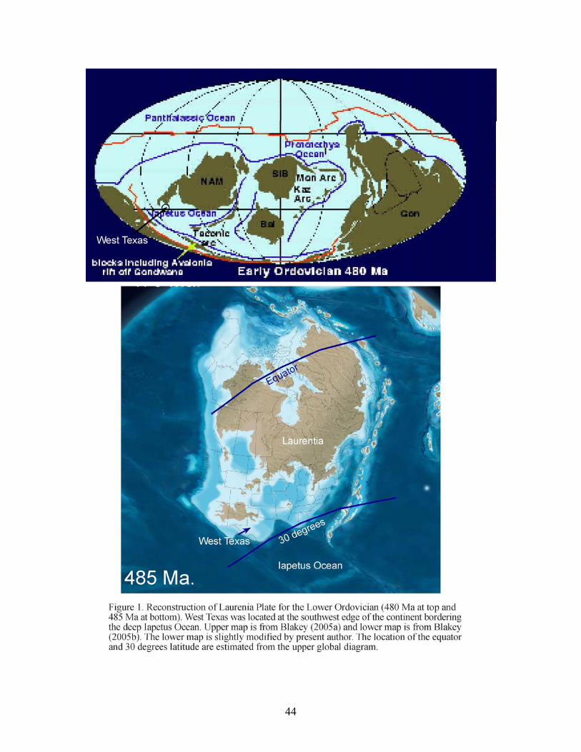
44
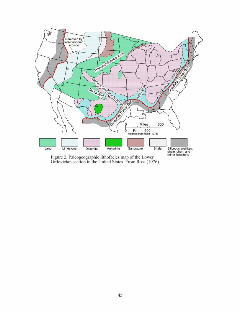
45
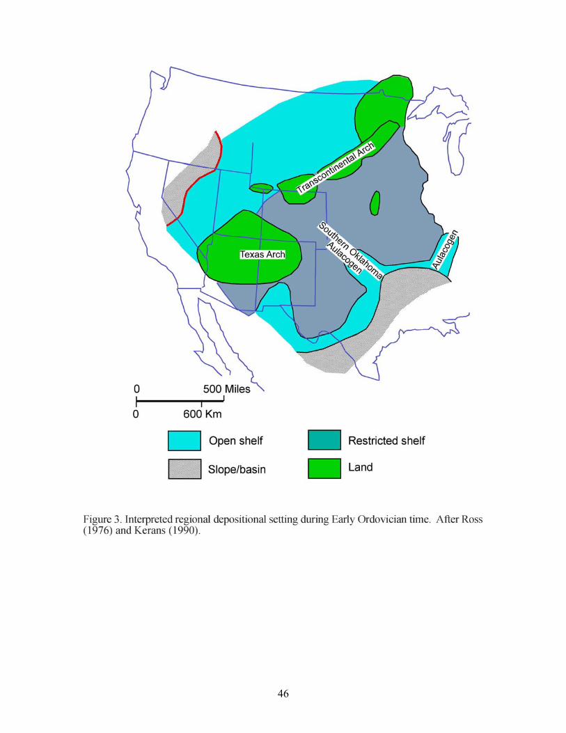
46
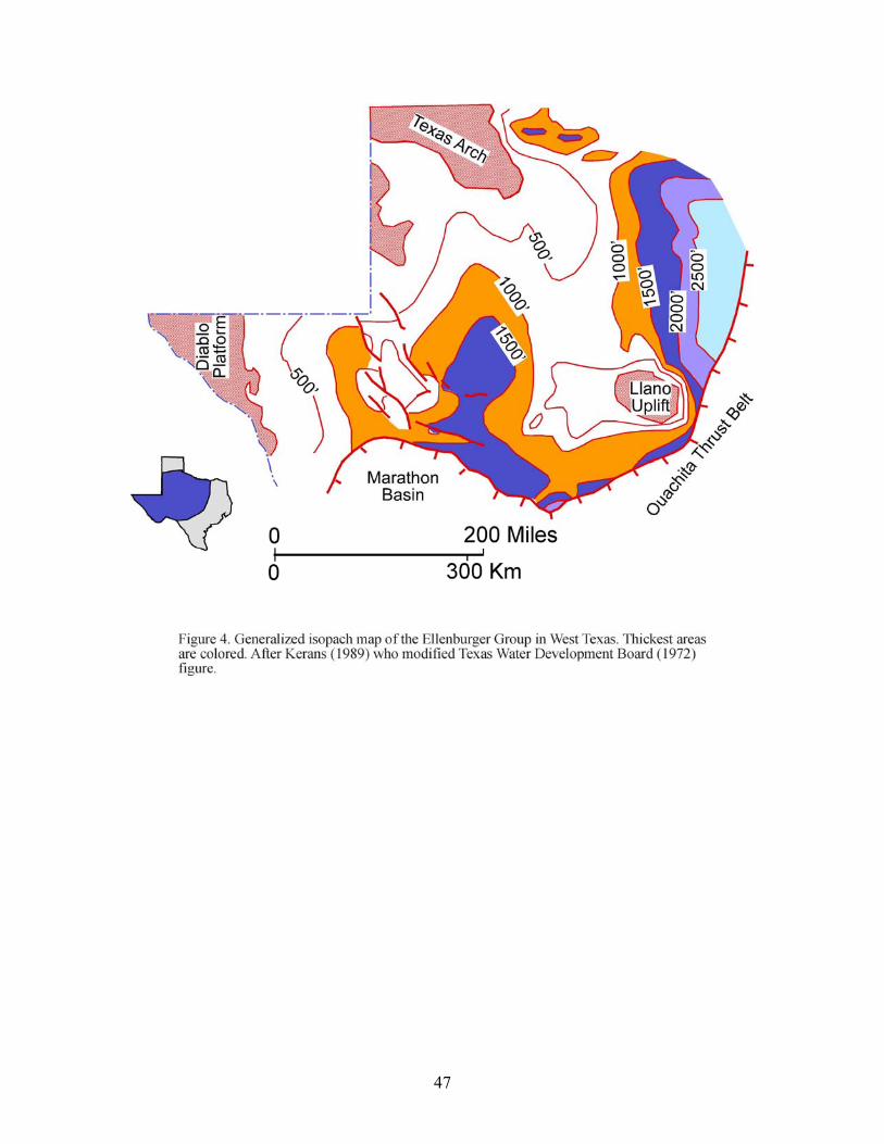
47
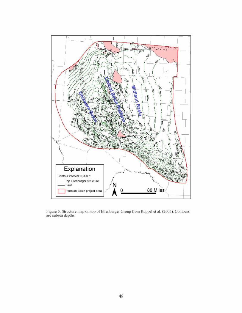
48
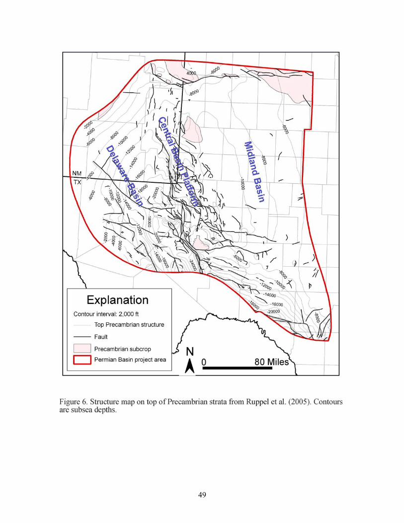
49
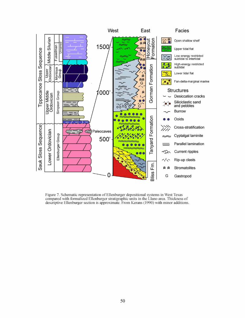
50
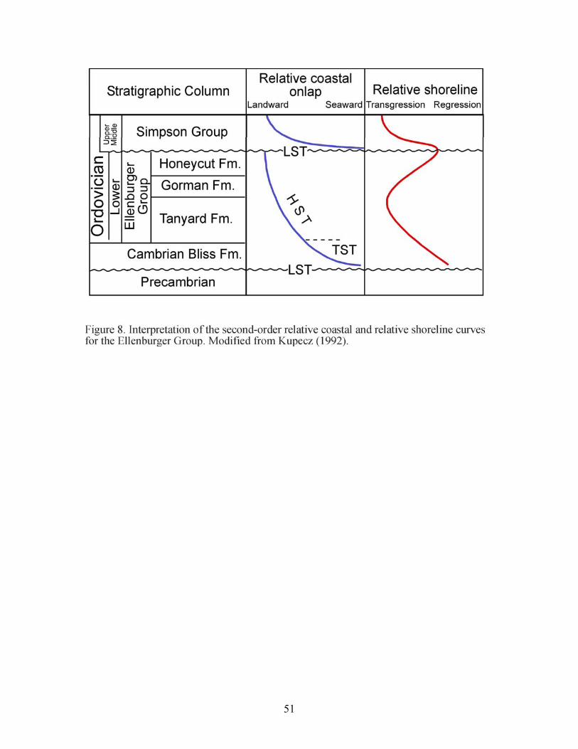
51
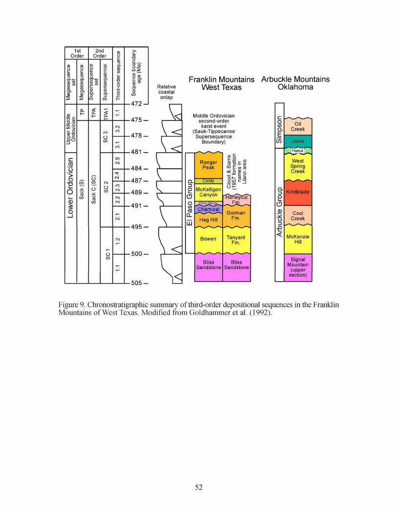
52
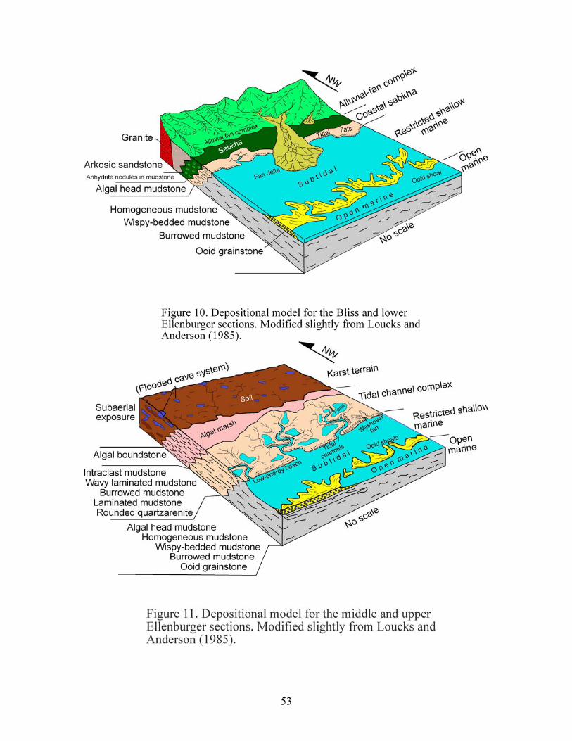
53
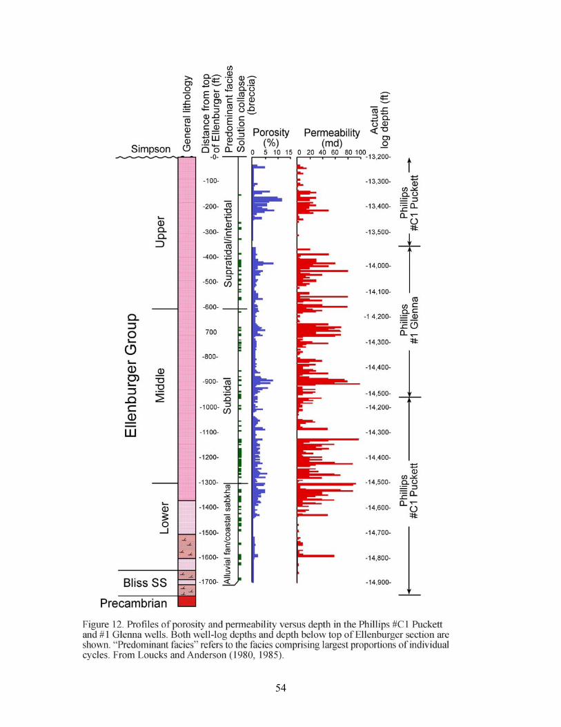
54
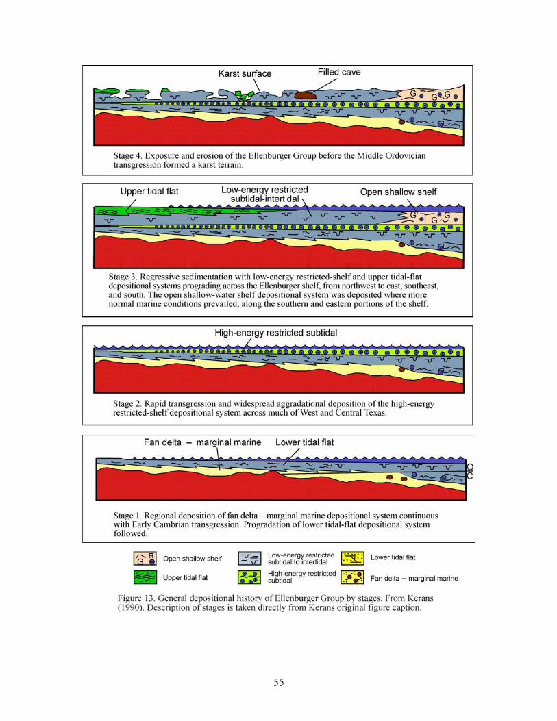
55
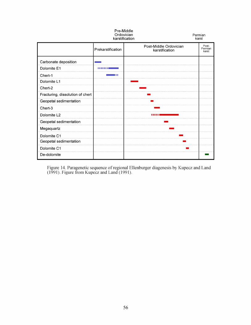
56
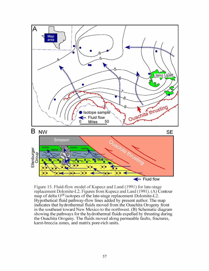
57
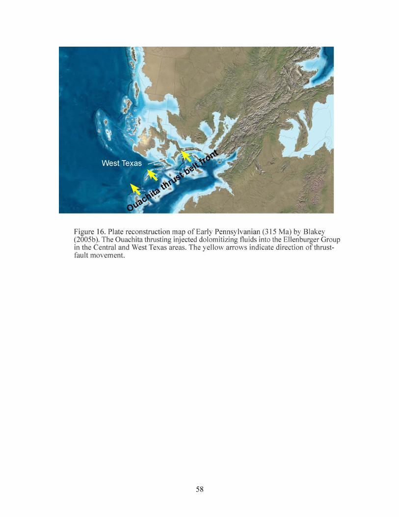
58
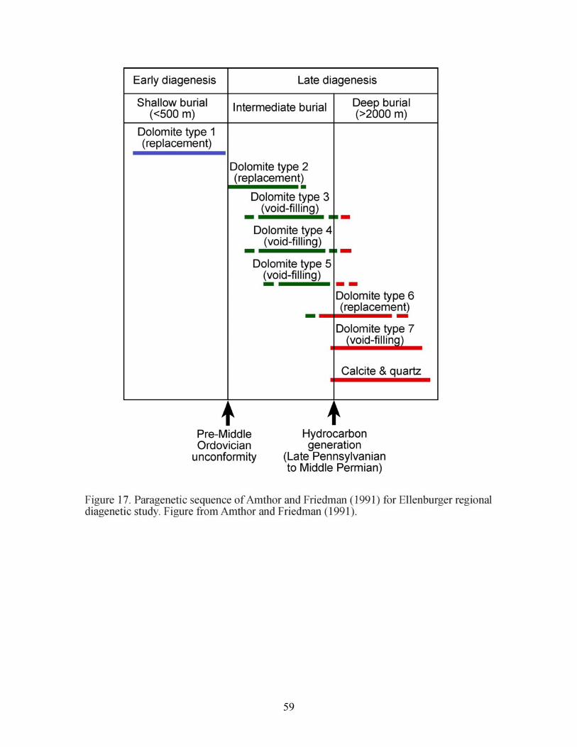
59
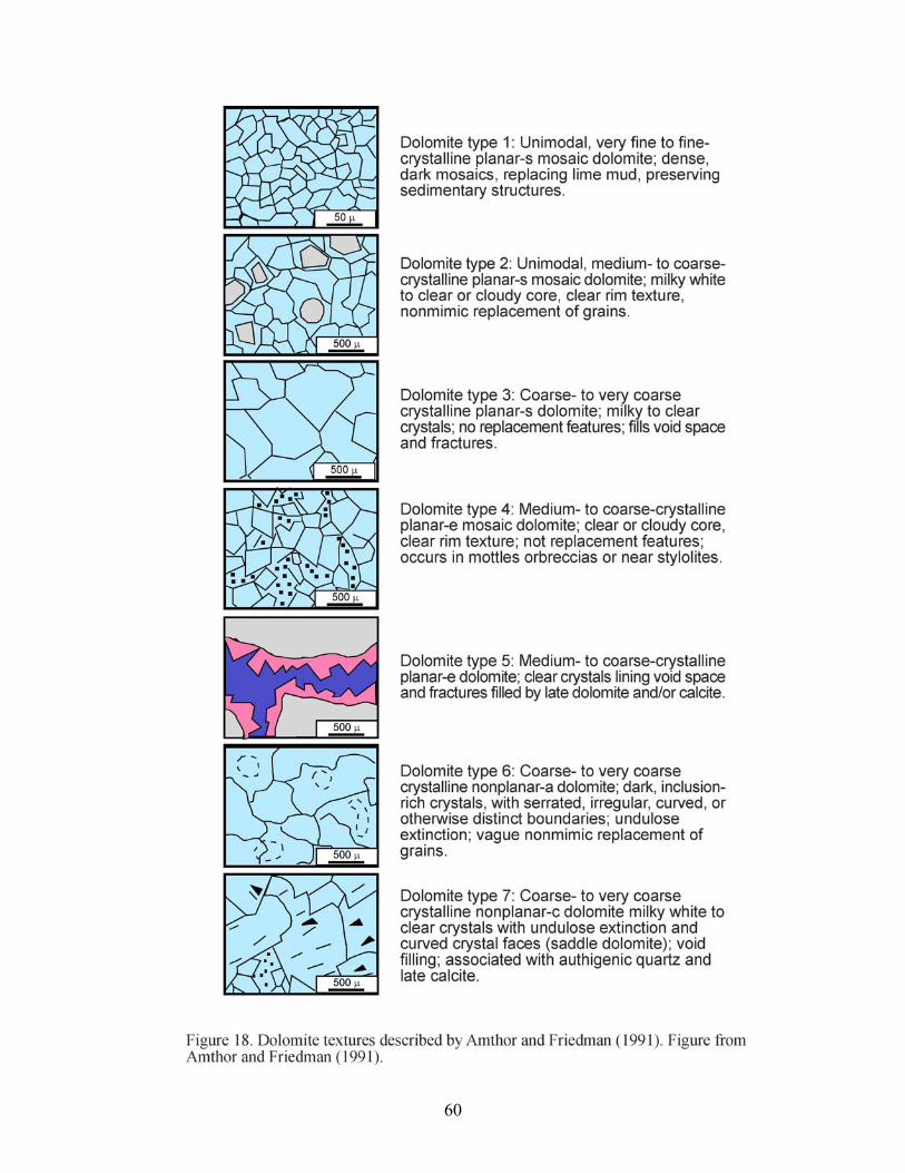
60
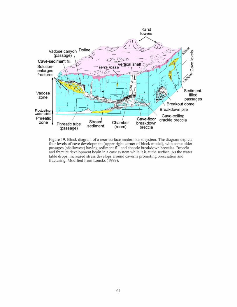
61
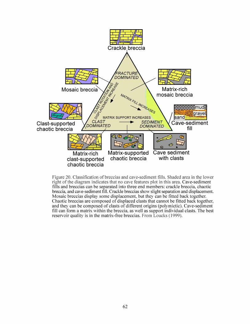
62
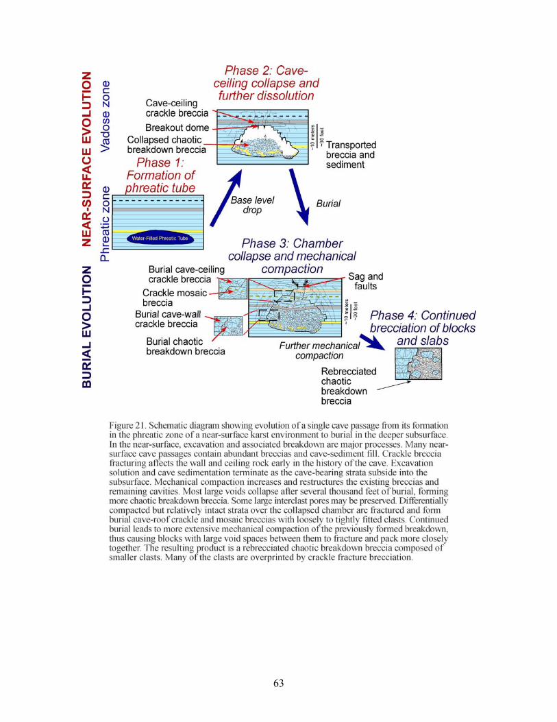
63
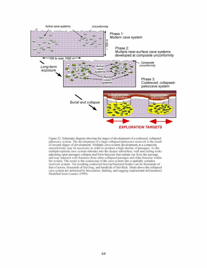
64
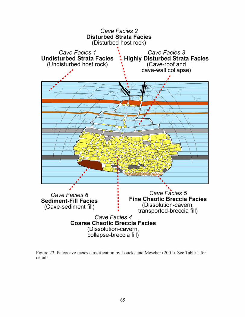
65
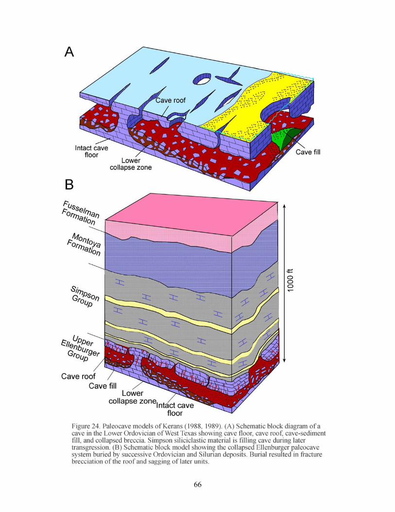
66
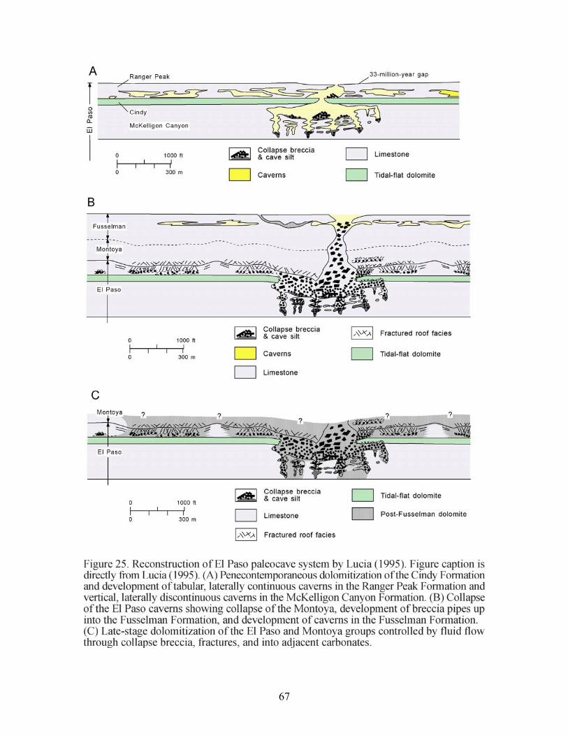
67
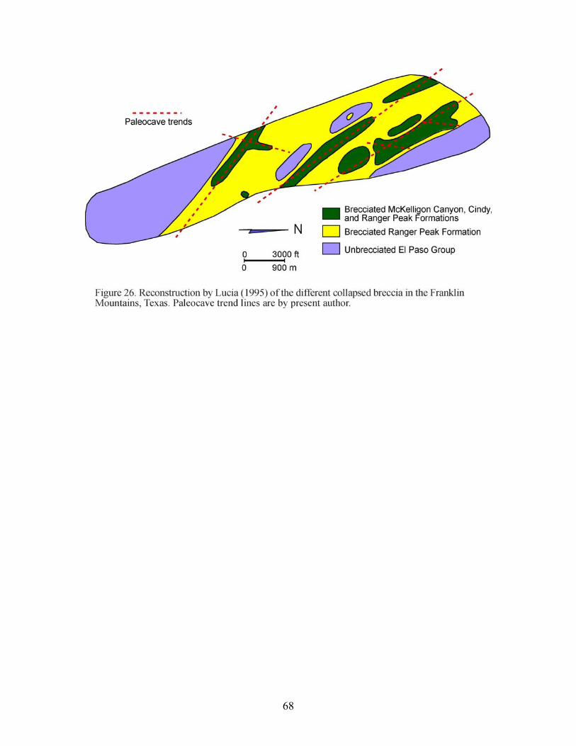
68
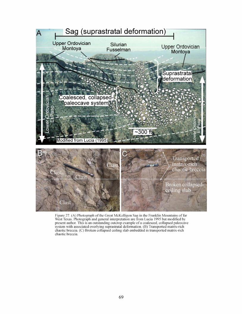
69
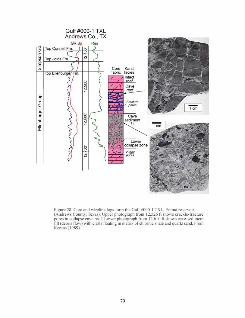
70
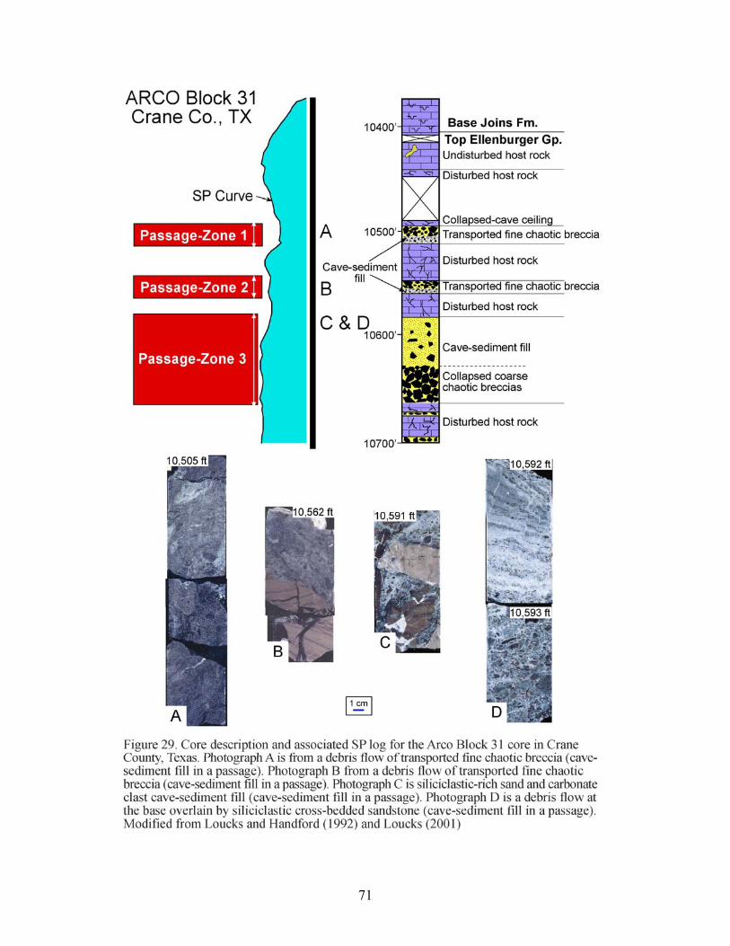
71
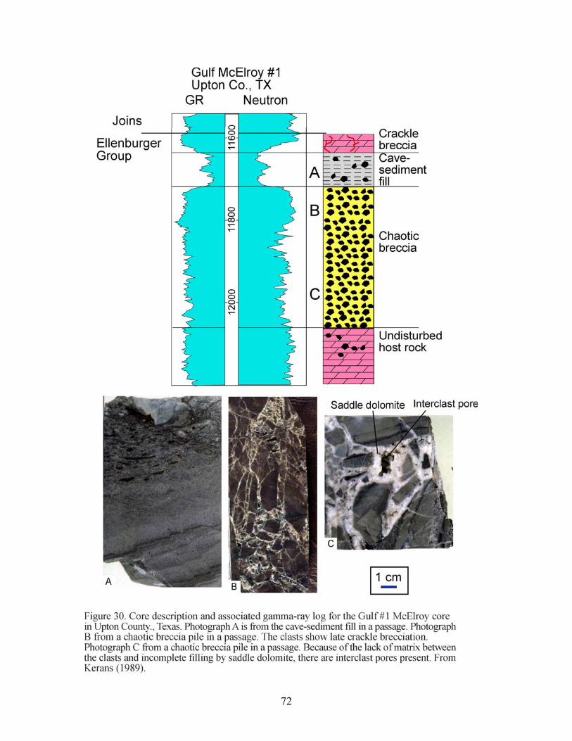
72
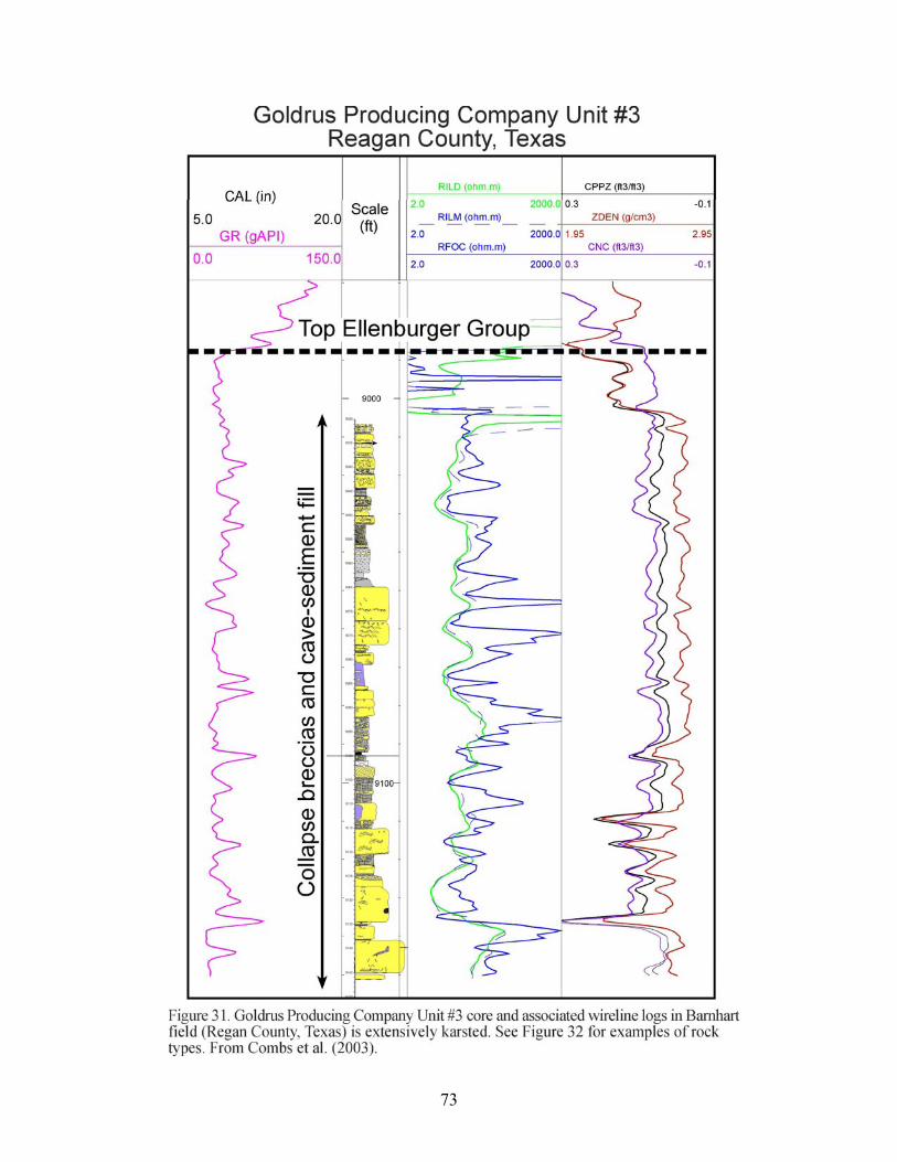
73
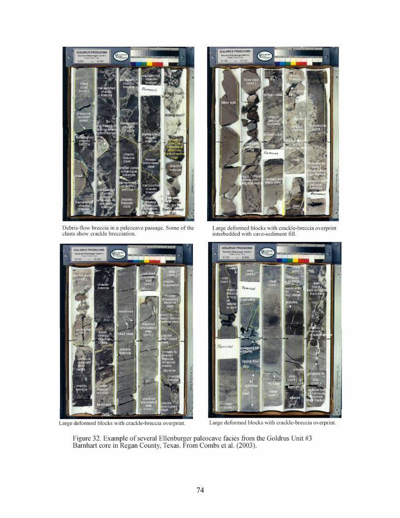
74
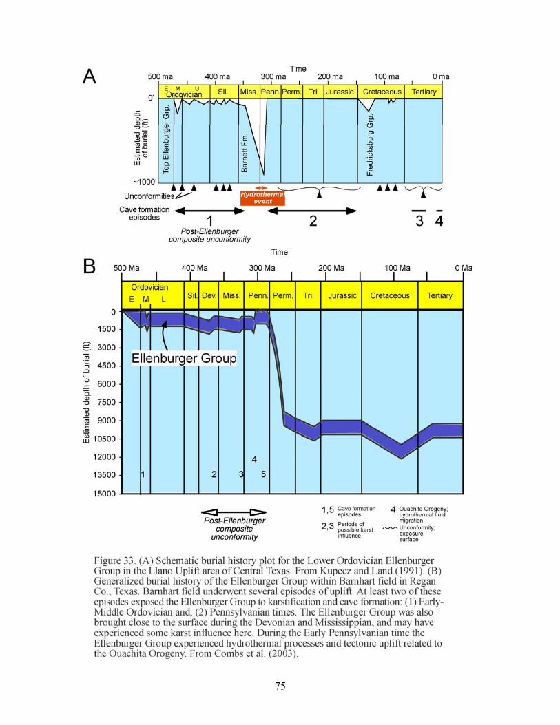
75
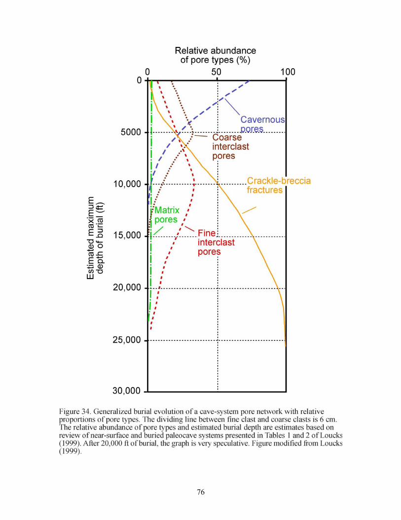
76
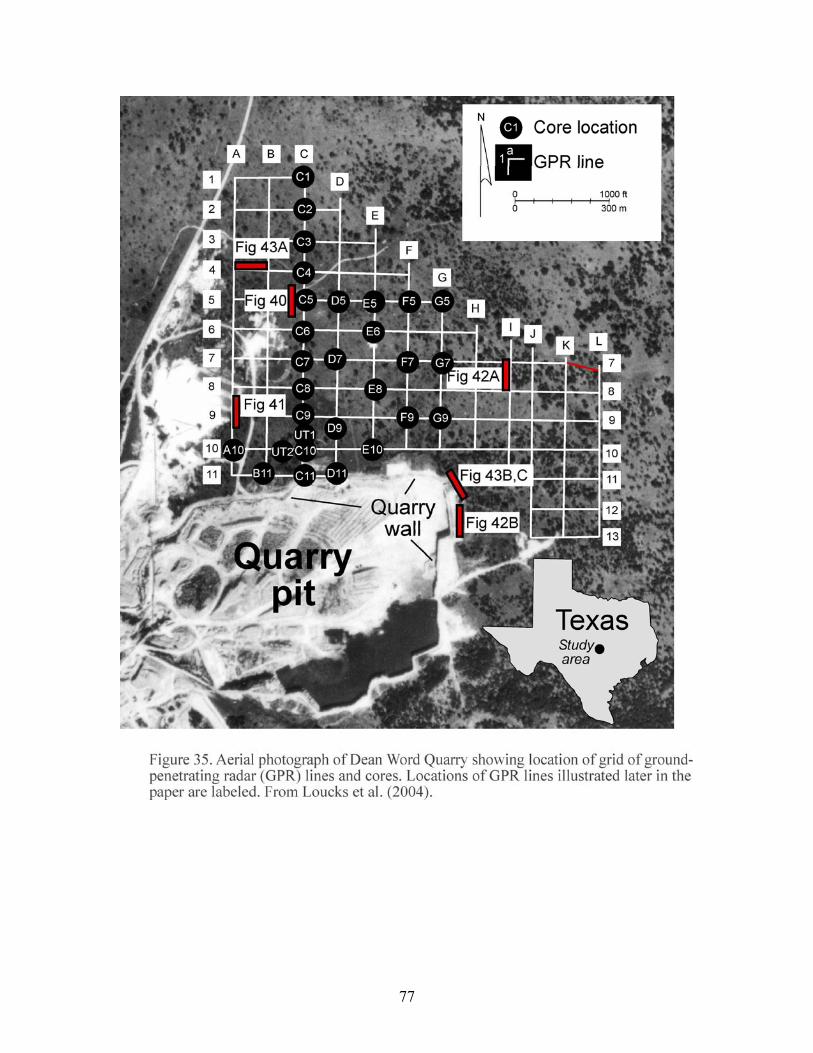
77
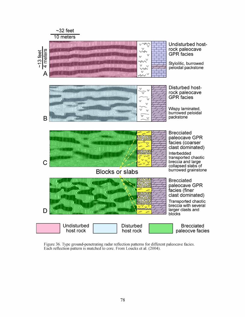
78
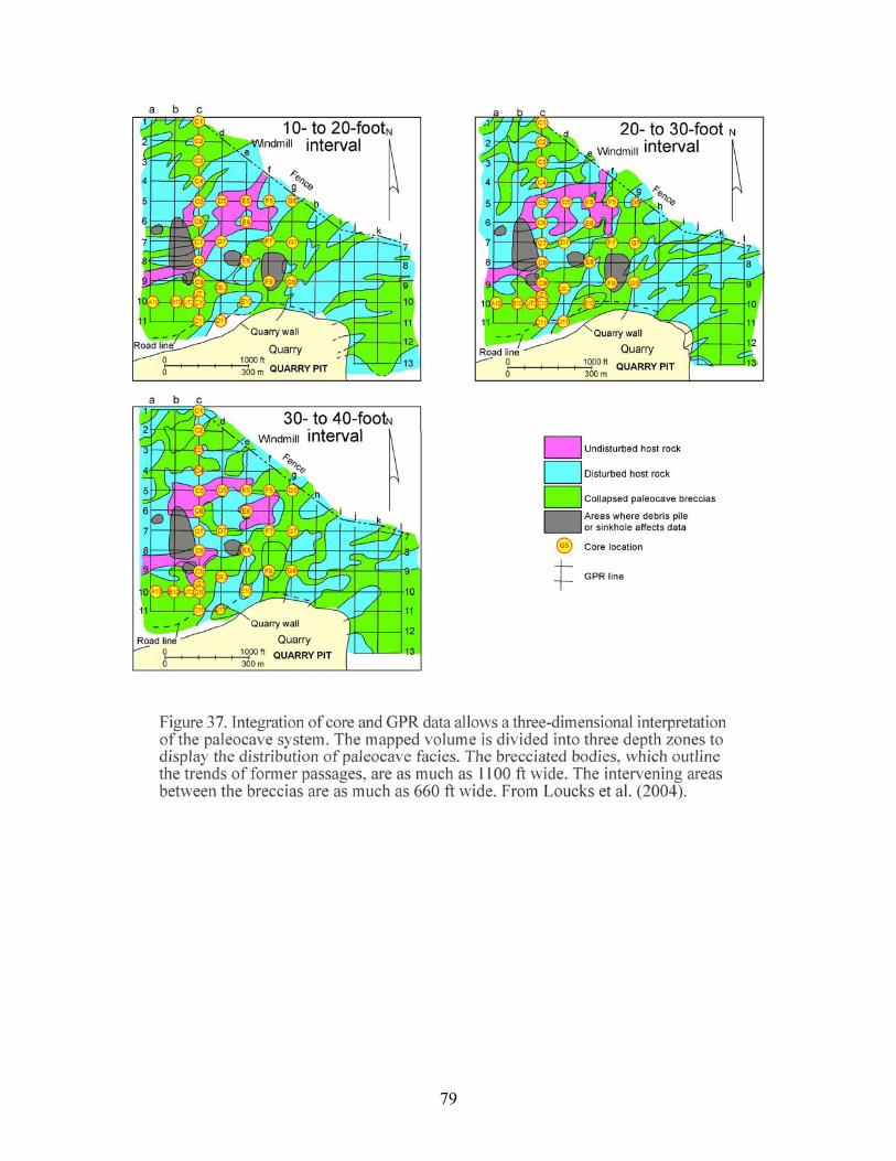
79
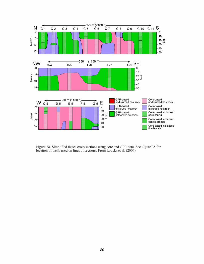
80
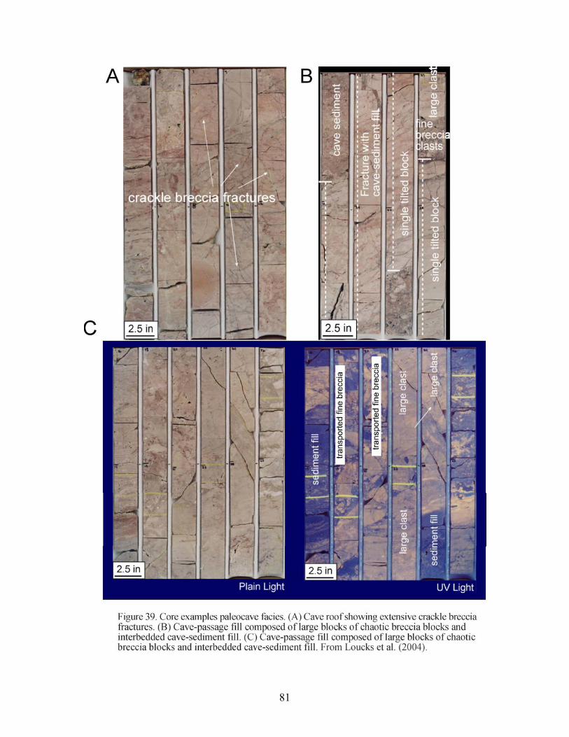
81
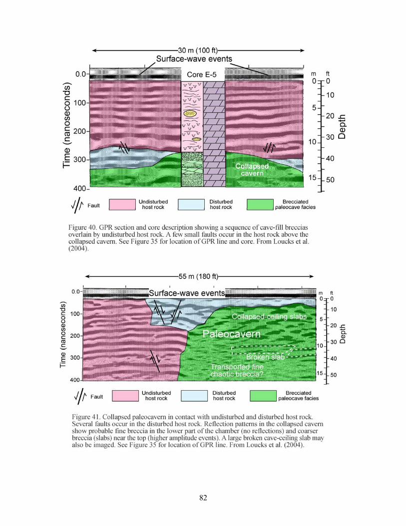
82
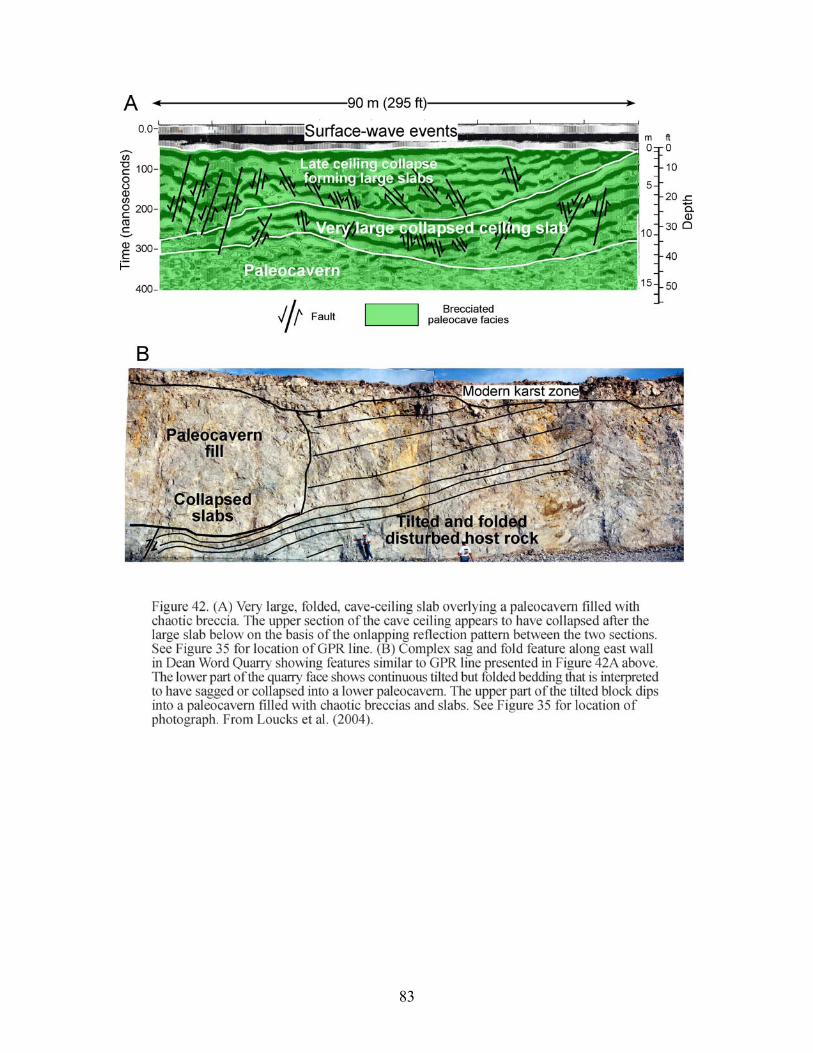
83
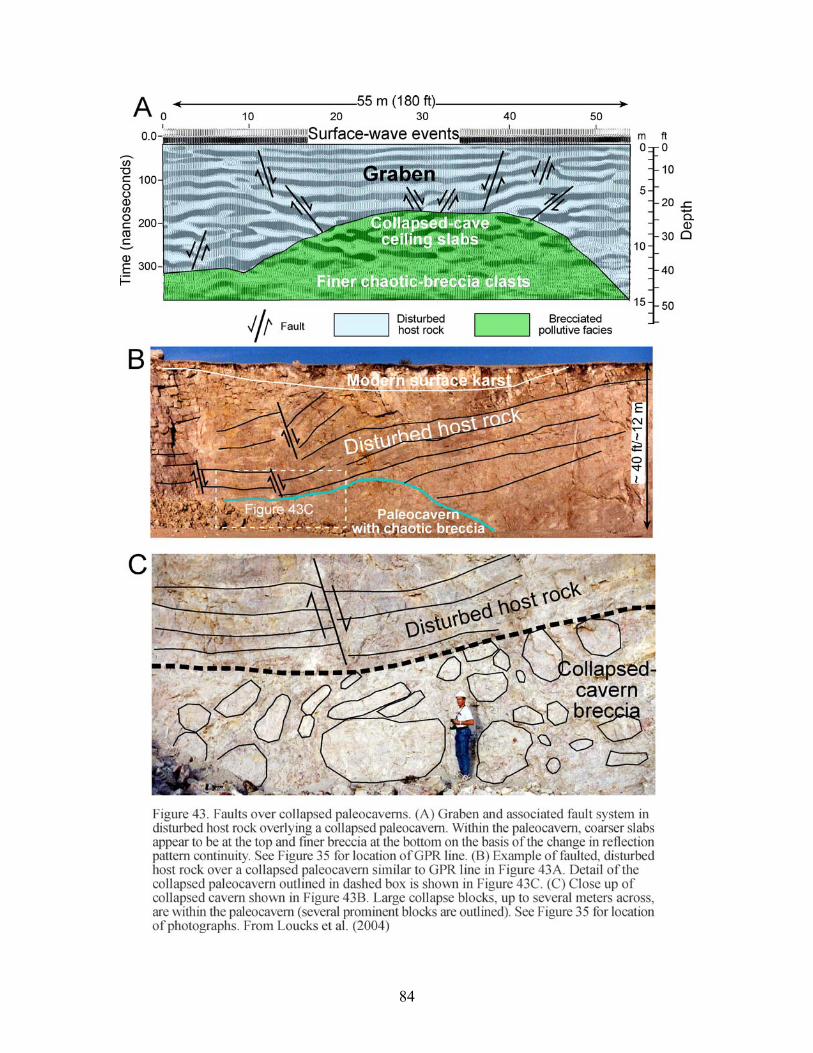
84
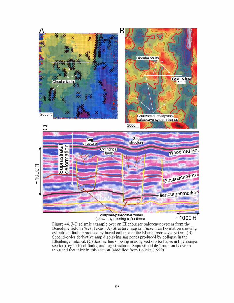
85
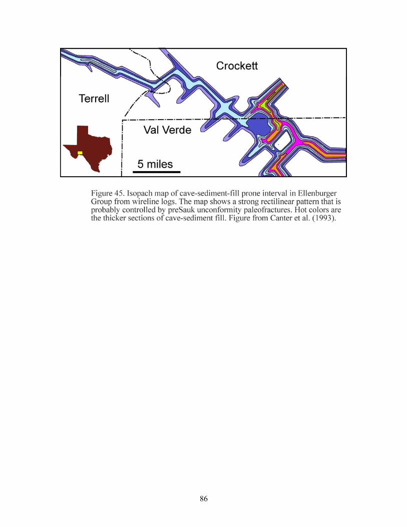
86
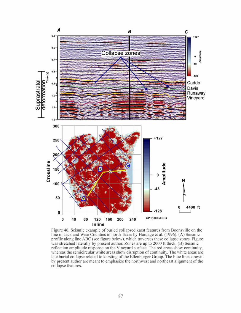
87
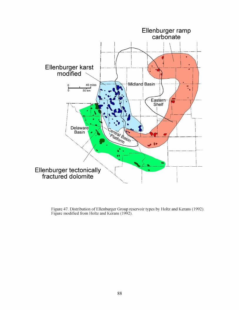
88
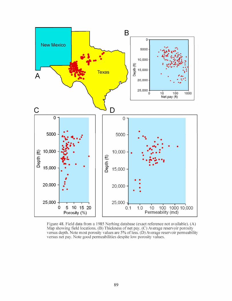
89
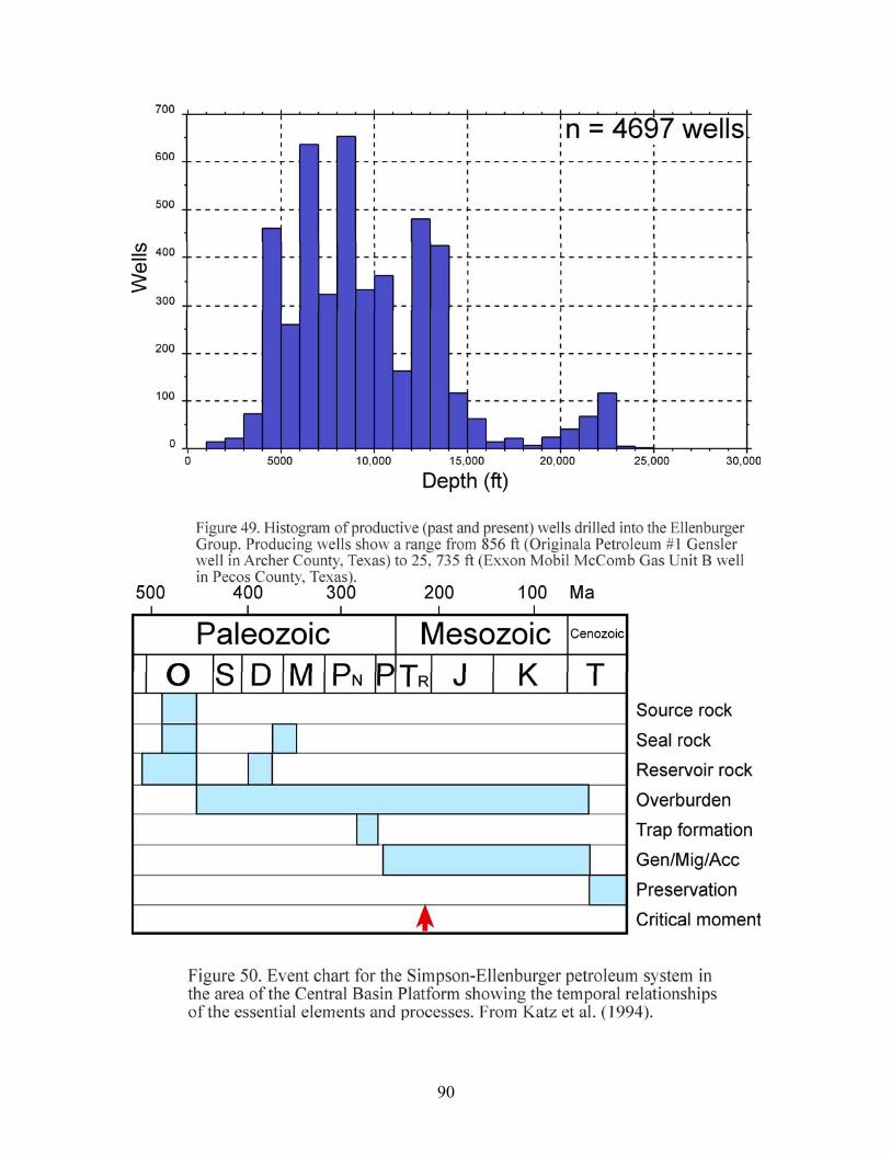
90

91
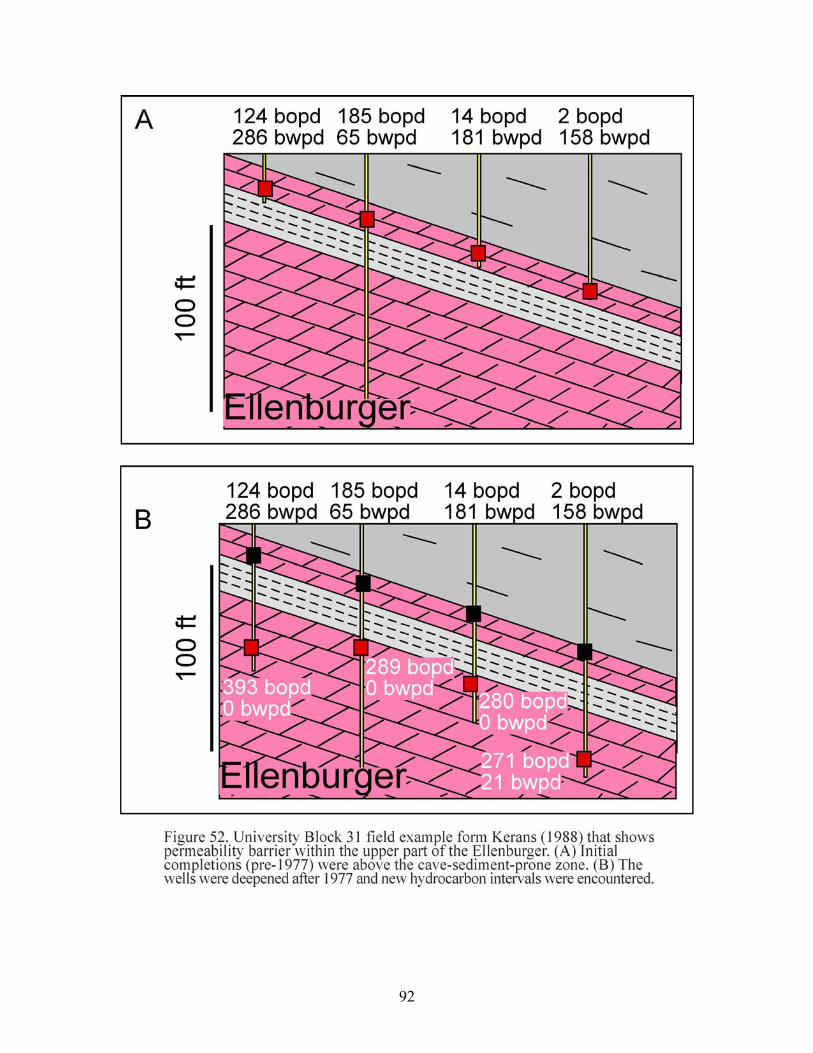
92