Embed Size (px)
Citation preview
393MORPHODYNAMICS OF THE DANUBE DELTA
RIVER DELTA MORPHODYNAMICS: EXAMPLES FROM THE DANUBE DELTA
LIVIU GIOSAN AND JEFFREY P. DONNELLYDepartment of Geology and Geophysics, Woods Hole Oceanographic Institution, Woods Hole, Massachusetts 02543, U.S.A.
e-mail: [email protected] VESPREMEANU
Department of Geography, Bucharest University, Bucharest, RomaniaJANOK P. BHATTACHARYA AND CORNEL OLARIU
Geosciences Department, University of Texas at Dallas, Richardson, Texas 75083-0688, U.S.A.AND
FRANK S. BUONAIUTOMarine Sciences Research Center, State University of New York, Stony Brook, New York 11794, U.S.A
ABSTRACT: The Danube, with its mouths at the Black Sea, has been economically and strategically one of the most important rivers in Europe;consequently, its delta has been studied since the Nineteenth Century. Although many morphological and sedimentological aspects of theDanube delta are well understood, its late Quaternary evolution remains ambiguous. This uncertainty reflects in part the complexity ofthe sea-level variations and water-chemistry changes related to the periodic isolation of the Black Sea during eustatic lowstands, but alsoa lack of accurate age control of the deltaic deposits. On the basis of a review of existing radiocarbon dates, we propose that the developmentof the delta at the open coast started approximately 6,000–5,500 14C years ago, much later than the 9,000 14C years BP previously suggested.
Morphodynamics of the open-coast Danube delta has been determined largely by the interaction between fluvial deposition and thestrong southward wave-induced longshore transport. Morphological and facies asymmetry displayed by the marine lobes of the Danubedelta indicate that a strong and sustained southward-directed longshore transport has been a persistent process along the delta shore.Coastal evolution on the adjacent nondeltaic coast is also strongly coupled to the delta morphodynamics via the longshore transport.Analysis of recent deltaic progradation of the youngest open-coast lobes of Danube delta indicates that river-mouth morphodynamics ishighly nonlinear, involving multiple feedbacks among subaerial deltaic progradation, deposition on the subaqueous delta, current andwave hydrodynamics, and wave–current interactions. First, a feedback loop is activated by the hydraulic groin effect of the river plume,which leads to a mutually sustained progradation of the updrift coast and subaqueous delta at the mouth. Second, the development of ashallow subaqueous delta platform, strongly offset to the downdrift direction, helps dissipate waves reaching the platform, leading toentrapment of sediment on the platform. Third, increased flood-induced deposition on the subaqueous delta platform, followed by wavereworking, leads to recurrent emergence of barrier islands at its offshore edge; longshore transport is then channeled (i.e., intensified andguided) by the new coast along the barrier, leading to a rapid alongshore expansion of the subaqueous delta in the downdrift direction.Although the sedimentation processes are complex, the resulting morphology at the mouth exhibits a tendency to self-organize that isreflected and preserved by the facies architecture of wave-influenced lobes.
River Deltas—Concepts, Models, and ExamplesSEPM Special Publication No. 83, Copyright © 2005SEPM (Society for Sedimentary Geology), ISBN 1-56576-113-8, p. 393–411.
INTRODUCTION
The morphodynamics of deltaic coasts has been a less wellexplored aspect in the evolution of deltas. Coastal morphologicalunits such as barriers, estuaries, or deltas have traditionally beenstudied in isolation, ignoring the fact they co-evolve interdepen-dently (e.g., Cowell et al., 2004). Feedbacks between the evolvingmorphology of a delta and basinal hydrodynamics remain inad-equately known, as are the interactions between contemporane-ous lobes within a delta (e.g., Komar, 1973, 1998) or the influenceexerted by a delta on the dynamics of adjacent nondeltaic coastsand vice versa (e.g., Penland and Suter, 1989; Jiménez et al., 1997;Stanley et al., 1997; Aslan et al., 2003; Corregiari et al., thisvolume). Although there has been much recent progress in un-derstanding suspended-sediment deposition from river plumes(e.g., Syvitski and Bahr, 2001; Geyer et al., 2004), the dynamics ofcoarse sediments at river mouths has received little attention, inlarge part because of the inability of conventional techniques toprovide reliable direct measurements. However, it is becomingincreasingly clear that river-mouth processes involving bed-loadtransport exert a primary control on the larger delta morphologyand facies architecture (e.g., Wright, 1985; Dominguez et al., 1983,1987; Giosan, 1998; Rodriguez et al., 2000; Bhattacharya andGiosan, 2003, Fielding et al., this volume; Willis, this volume).
Our paper explores the morphodynamics of the wave-influ-enced Danube delta with the intent to clarify its Holocene evolu-tion. Although the Danube delta has been monitored since themiddle of the Nineteenth Century, mainly for navigation pur-poses, many aspects of its evolution, including a reliable chronol-ogy, remain uncertain. We critically review less accessible litera-ture on the subject as well as discuss new data to outline acoherent model for the development of the Danube delta. Wefurther argue that a large-scale morphodynamics approach isnecessary for establishing key controls not only for the evolutionof any delta plain but also for the adjacent nondeltaic coast andsubaqueous delta. This is particularly important for the manage-ment of Danube delta, Europe’s largest wetland ecosystem, whereeconomic and environmental interests among and within ripar-ian nations are often divergent, leading to environmental pres-sure both from upstream factors and from downstream changesin the Black Sea basin (Margesson, 1997; Lancelot et al., 2002).
ENVIRONMENTAL SETTING
Fluvial Regime
The Danube River is the second largest European river afterthe Volga in terms of catchment area (817,000 km2) and length
394 L. GIOSAN, J.P. DONNELLY, E. VESPREMEANU, J.P. BHATTACHARYA, C. OLARIU, AND F.S. BUONAIUTO
A
B
C
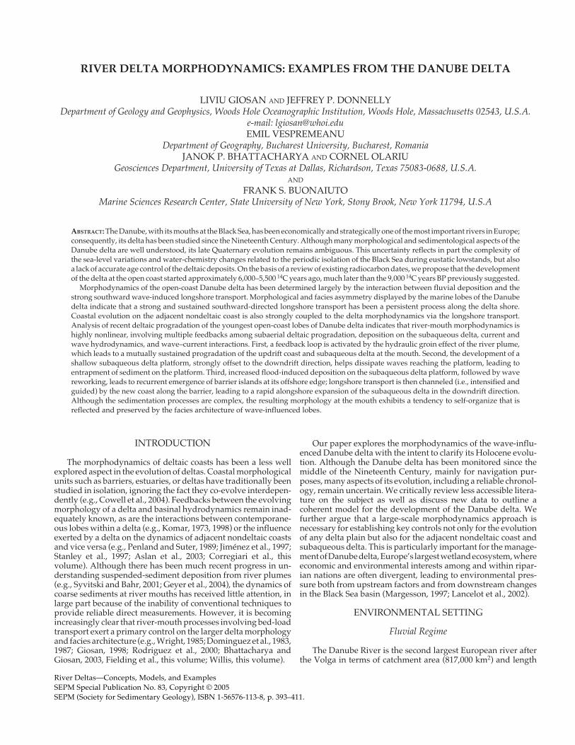
(2870 km) as well as water and sediment discharge (Milliman andMeade, 1983; Meade, 1996). The climate in the drainage basin,which covers most of central and southeastern Europe, is conti-nental, with Atlantic and Mediterranean influences in the west-ern and southern regions of the basin, respectively (Rimbu et al.,2002). The average annual precipitation, evaporation, and runoffare 816 mm, 547 mm, and 246 mm, in that order (Panin and Jipa,2002).
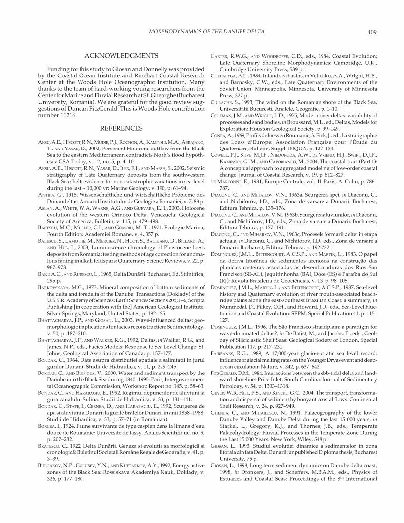
The decadal variation of the Danube flow is influenced by theNorth Atlantic Oscillation (NAO) via precipitation anomalies inthe drainage basin, with a lower than normal river flow when theNAO index is positive (Rimbu et al., 2002). The average annualdischarge reported between 1840 and 1995 is ~ 6240 m3/s, with thehighest average annual discharge of ~ 9250 m3/s in 1970 (Bondarand Blendea, 2000). The peak discharge during the year occurs inlate spring (Fig. 1; Diaconu and Mihailov, 1963a; Vörösmarty et al.,1998), following snowmelt; there is roughly two times as muchdischarge in the spring compared to the fall (Reschke et al., 2002).Extensive damming, especially in the lower basin (Fig. 1), has
reduced the suspended-sediment discharge at the apex of thedelta from ~ 67 x 106 metric tons per year between 1921 and 1960(Diaconu and Mihailov, 1963b) to ~ 25–35 x 106 metric tons peryear at present (Panin and Jipa, 2002). The bed-load sedimentdischarge at the Danube mouths has been estimated to rangebetween ~ 4.6 and ~ 5.3 x 10⁹ kg/year (Bondar et al., 1992).
In the delta region, the Danube river splits into three maindistributaries: the Chilia (Kilia), the Sulina, and the Sf. Gheorghe(St. George). Since 1856, when the first estimates of the flow weremade by the European Danube Commission (EDC), dischargethrough the main navigation route, the Sulina arm, has steadilyincreased (from 7% to 19%), while the Sf. Gheorghe and the Chiliadistributaries have correspondingly decreased their flow (from30% to 23% and from 63% to 57%, respectively) as a consequenceof sustained maintenance and improvement projects for naviga-tion on Sulina and intensive channelization in the delta (Diaconuand Mihailov, 1963a; Panin, 2003). After similar human interven-tions on the Sf. Gheorghe arm during the 1980s, discharge in thisdistributary started to increase (Panin, 2003). Suspended load is
FIG. 1.—A) Characteristics of the Danube river drainage basin and discharge. B) Discharge between 1840 and 1995 (bold black line,annual average values from Bondar and Blendea, 2000; gray thin line, monthly measurements, Rimbu et al., 2002). C) Hydrographfor the discharge of the Danube between 1921 and 1985 (Vörösmarty et al., 1998).
Month
Dis
charg
e (
m3/s
)
395MORPHODYNAMICS OF THE DANUBE DELTA
redistributed among the Danube’s main distributaries, with theChilia transporting ~ 55% of the total load, the Sulina ~ 21%, andthe Sf. Gheorghe ~ 23%, whereas the bed-load sediment dischargeis split 57–65% to the Chilia, 19–25% to the Sulina, and 19–21% forthe Sf. Gheorghe (Bondar et al., 1992; Bondar and Harabagiu, 1992).
Basin Characteristics
The Danube flows and builds its delta into the Black Sea, a semi-enclosed basin connected to the World Ocean via the Sea ofMarmara and the Mediterranean. Although evaporation (350 km3/year) exceeds precipitation (300 km3/year), the average salinity ofthe Black Sea is low (~ 18 per mil) because of the freshwater (350km3/year) provided by rivers draining a large part of Europe andAsia (Özsoy and Ünlüata, 1997). The Danube annually discharges77% of the total river runoff to the Black Sea and 85% of the runoffentering the northwestern shelf. The resulting buoyant plume,augmented with freshwater by southward coastal current fed bythe Nistru (Dniestr), the Dniepr, and the Southern Bug rivers,propagates onto the shelf and along the coast toward the southwest(Stanev et al., 2002; Yankovsky et al., 2004). The coastal plumefurther interacts with the western cyclonic gyre of the Rim Current,forming quasi-persistent anticyclonic eddies over the middle shelf(Fig. 2; Oguz et al., 1993; Korotaev et al., 2003; Yankovsky et al.,2004). Via its plume, the quantity and quality of Danube water andsuspended-sediment discharge exerts a strong influence on sedi-mentation, water-column and sediment chemistry, and ecosys-tems of the northwestern shelf of the Black Sea (Bacescu et al., 1971;Humborg et al., 1997; Lancelot et al., 2002).
The Black Sea is a microtidal basin with semidiurnal tidesranging between 7 and 12 cm. Tides are negligible in comparisonto other water-level fluctuations such as seiches and storm surges,which can elevate the sea level at the coast between 1 and 2 m(RCMGG, 1994). Interannual and interdecadal sea-level varia-tions, ranging from 20 to 55 cm along the coast influenced by theDanube plume, appear to correlate with changes in the Danubedischarge (Malciu and Diaconu, 2001).
Long-term relative sea-level change on the Danube delta coastat Sulina is 2.47 mm/year (Vespremeanu et al., 2004). South of thedelta, at Constantza, reported values for the relative sea-levelchange vary between 1 and 3 mm/year (see references inVespremeanu et al., 2004). However, a cursory comparison of thesea-level data from Sulina and Constantza with nearby tidegauges in Bulgaria and Ukraine (reported on the PermanentService for Mean Sea Level website http://www.pol.ac.uk/psmsl/ ) suggests that data from Romanian coast is likely affectedby significant datum and/or reporting errors and need to bereconsidered in an in-depth examination before using them forstudies of sea-level change.
The average wind speed in the northwestern Black Sea isbetween 5 and 6.5 m/s (Bulgakov et al., 1992). Winds from thenortheast quadrant are dominant (Ciulache, 1993). Long-termvisual observations of wave height and directions are availableoffshore Constantza (Giosan et al., 1999). The distribution ofwave directions was highly skewed, with most waves (82%)arriving dominantly from the left-hand side relative to the re-gional direction of the coast (i.e., northeast quadrant); the annualaverage significant wave height was 0.8 m, with an annualstandard deviation of 1 m and a mean period of 5 seconds (Giosanet al., 1999).
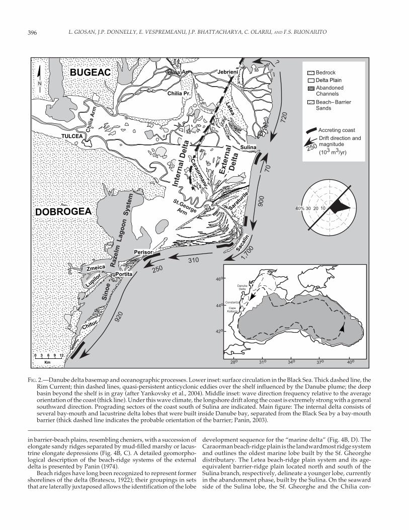
GEOMORPHOLOGY OF THE DELTA PLAIN
With no significant tides in the Black Sea, dividing the deltaplain into upper and lower parts, separated at the upstream
limit of the tidal influence (Coleman and Wright, 1975) is notwarranted. However, two distinct delta-plain regions are recog-nized (Fig. 2; Antipa, 1915) on the basis of the distribution ofchannels, flood basins and lakes, and sand-ridge geometries.The “fluvial delta” developed in the former Danube Bay delim-ited by the Bugeac loess plateau (on the Scythian Platform) andthe North Dobrogean Orogen (Figs. 2, 3). The “marine delta”developed largely outside Danube Bay and exhibits a clearwave-influenced morphology (Figs. 2, 3). Spratt (1860) was thefirst to propose that the Danube has built its initial delta into anembayment protected by a bay-mouth barrier extending fromthe Bugeac toward Dobrogea (Fig. 2); subject to an intensedebate among Romanian researchers (e.g., Antipa, 1915; Bratescu,1922), the barrier hypothesis was strengthened by subsequentwork (Zenkovich, 1956; Panin, 1989; see also discussion below).To avoid misnomers, we will use “internal delta plain” as thegeneric name for bay-head and lacustrine delta lobes builtwithin the Danube bay and “external delta plain” for the wave-influenced lobes developed outside the bay, in front of theDanube bay-mouth barrier.
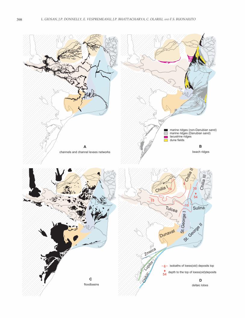
Marine beach ridges are absent in the internal delta plain,indicating a total lack of wave influence (Fig. 4B); a network ofbifurcating or anastomosing, active and abandoned distribu-tary channels and levees indicates development in a shelteredenvironment (Fig. 4A). The channel network partitions the deltaplain into numerous flood basins covered by marshes and lakes(Fig. 4C). The distributary channels are organized into drainagesystems that define three separate lobes (Fig. 4A). The largestdrainage system, corresponding to the Tulcea lobe, which prob-ably developed initially as a bay-head delta (Antipa, 1915),consists of channels associated upstream with the Tulcea dis-tributary and the upper course of the Chilia distributary, andfarther downstream with the Sulina and the Sf. Gheorghe, afterthey split from the Tulcea branch (Fig. 2, Fig. 4A, D). The channeldensity decreases between the upper and the lower Tulcea lobe(Fig. 4C, D).
The morphology of the predeltaic relief played a limitingrole in the direction and rate of progradation of the delta, asproposed by Murgoci (1912), Antipa (1915), and later Gheneaand Mihailescu (1991). The Tulcea lobe probably advanced inthe direction of the alluvial valley along the general direction ofthe modern Sf. Gheorghe distributary (see data in Liteanu andPricajan, 1963), which continues on the shelf with a network ofburied channels leading to the Danube (Viteaz) canyon on theslope (Popescu et al., 2004). Two smaller drainage systems areassociated with the Chilia arm (Fig. 4A, D); they are separatedfrom the Tulcea lobe by lacustrine beach ridges and from eachother by the Chilia loess promontory, which juts south from theBugeac plateau (Fig. 4B; Antipa, 1915; Popp, 1961; Panin, 1983).The loess relief below these drainage systems (Ghenea andMihailescu, 1991) suggests that the upstream system, the ChiliaI lobe, had evolved as a lacustrine delta in a shallow depressionon the loess platform. The Chilia II lobe developed subsequentlyas a lacustrine or a bay-head delta in a small protected embay-ment (Fig. 4D; Popp, 1961). Both the morphology of the Chilia Iand II lobes as well as lithology of short cores described there(Popp, 1961; Munteanu, 1996) suggest sediment deposition onchannel levees as well as in flood basins, which is typical foranastomosing channels (Makaske, 2001), rather than for braidedchannels as previously proposed (Panin, 2003).
The external delta plain consists of several laterally offsetlobes developed by deltaic distributaries after they reached theopen coast. Amalgamated beach ridges form extensive beach-ridge plains that are capped in places by dune fields with heightsup to ~ 12 m (Fig. 4B). Non-amalgamated beach ridges organize
396 L. GIOSAN, J.P. DONNELLY, E. VESPREMEANU, J.P. BHATTACHARYA, C. OLARIU, AND F.S. BUONAIUTO
FIG. 2.—Danube delta basemap and oceanographic processes. Lower inset: surface circulation in the Black Sea. Thick dashed line, theRim Current; thin dashed lines, quasi-persistent anticyclonic eddies over the shelf influenced by the Danube plume; the deepbasin beyond the shelf is in gray (after Yankovsky et al., 2004). Middle inset: wave direction frequency relative to the averageorientation of the coast (thick line). Under this wave climate, the longshore drift along the coast is extremely strong with a generalsouthward direction. Prograding sectors of the coast south of Sulina are indicated. Main figure: The internal delta consists ofseveral bay-mouth and lacustrine delta lobes that were built inside Danube bay, separated from the Black Sea by a bay-mouthbarrier (thick dashed line indicates the probable orientation of the barrier; Panin, 2003).
-
TULCEA
Sulina Arm
St.GeorgeArm
ChiliaArm
Sinoe-
Razelm
LagoonSystem
InternalDelta
External
Delta
Sulina
Perisor
Saraturile
Caraorman
Chituc
1,700
310
250
920
900
70
720
?
Portita
Letea
Jebrieni
N
0 3 6 9 12
Km
40% 30 20 10
Bedrock
AbandonedChannels
Beach–BarrierSands
Delta Plain
Accreting coast
Drift direction andmagnitude
(103 m3/yr)250
46o
44o
42o
28o 31o 34o 37o 40o
Constantza
CapeKaliacra
DanubeDelta
Lupilor
Zmeica
DOBROGEA
BUGEAC
Sacalin
Chilia Pr.
in barrier-beach plains, resembling cheniers, with a succession ofelongate sandy ridges separated by mud-filled marshy or lacus-trine elongate depressions (Fig. 4B, C). A detailed geomorpho-logical description of the beach-ridge systems of the externaldelta is presented by Panin (1974).
Beach ridges have long been recognized to represent formershorelines of the delta (Bratescu, 1922); their groupings in setsthat are laterally juxtaposed allows the identification of the lobe
development sequence for the “marine delta” (Fig. 4B, D). TheCaraorman beach-ridge plain is the landwardmost ridge systemand outlines the oldest marine lobe built by the Sf. Gheorghedistributary. The Letea beach-ridge plain system and its age-equivalent barrier-ridge plain located north and south of theSulina branch, respectively, delineate a younger lobe, currentlyin the abandonment phase, built by the Sulina. On the seawardside of the Sulina lobe, the Sf. Gheorghe and the Chilia con-
397MORPHODYNAMICS OF THE DANUBE DELTA
structed the youngest lobes of the Danube delta that are stillcurrently active. The Sf. Gheorghe II lobe exhibits a similarmorphologic asymmetry, with an updrift beach-ridge plain(Saraturile) and a barrier plain on the downdrift side, whereasthe Chilia has built a largely river-dominated lobe (Chilia III).The number of secondary distributary channels is much re-duced for the wave-dominated lobes compared to the bay-heador lacustrine deltas from the internal delta or the open-marineChilia III lobe (Fig. 4C). Lakes and flood basins are substantiallyfewer in most of the external delta compared to the internaldelta plain, with the notable exception of the southern half of theSulina lobe (Fig. 4C).
The deltaic coast continues to the south with a series of bay-mouth barriers fronting the large lagoon system of Razelm–Sinoe (Fig. 2, Fig. 4B, C). At least three generations of barrierscan be distinguished: Zmeica, Lupilor, and Chituc. The lattertwo display amalgamated beach ridges at their southern ex-tremities. Another deltaic lobe, the Dunavatz, developed, atleast in part, under bay-head and/or lacustrine conditions,filling the northeastern sector of the Razelm lagoon (Fig. 4D). Nobeach ridges are evident in the Dunavatz lobe morphology, andthe number of channels, levees, and/or flood basins is muchreduced compared to the other bay-head/lacustrine lobes dis-cussed previously (Fig. 4).
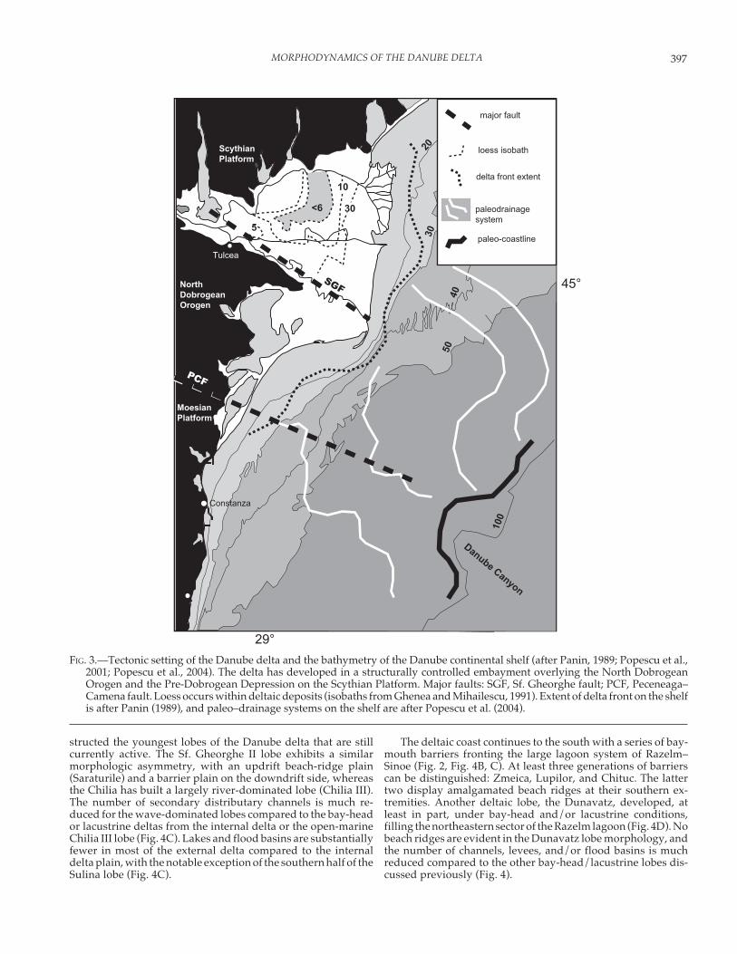
FIG. 3.—Tectonic setting of the Danube delta and the bathymetry of the Danube continental shelf (after Panin, 1989; Popescu et al.,2001; Popescu et al., 2004). The delta has developed in a structurally controlled embayment overlying the North DobrogeanOrogen and the Pre-Dobrogean Depression on the Scythian Platform. Major faults: SGF, Sf. Gheorghe fault; PCF, Peceneaga–Camena fault. Loess occurs within deltaic deposits (isobaths from Ghenea and Mihailescu, 1991). Extent of delta front on the shelfis after Panin (1989), and paleo–drainage systems on the shelf are after Popescu et al. (2004).
398 L. GIOSAN, J.P. DONNELLY, E. VESPREMEANU, J.P. BHATTACHARYA, C. OLARIU, AND F.S. BUONAIUTO
������������ ���������
�������� ���������������������� ����������������
������������������������� �������� �
� �
����������
��
��
�����������
��
���������������������������������
����������������������������������
����
�
�����
������ ��
�������
� ��������
�����
��
������� ���
�����
���������
�
��
!�������
"�����
������
399MORPHODYNAMICS OF THE DANUBE DELTA
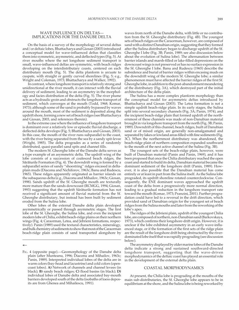
WAVE INFLUENCE ON DELTAS—IMPLICATIONS FOR THE DANUBE DELTA
On the basis of a survey of the morphology of several deltasand/or deltaic lobes, Bhattacharya and Giosan (2003) introduceda conceptual model for wave-influenced deltas that classifiesthem into symmetric, asymmetric, and deflected types (Fig. 5). Atriver mouths where the net longshore sediment transport issmall, wave-influenced deltas are symmetric, with beach ridgesdeveloping on the interdistributary coasts, centered on eachdistributary mouth (Fig. 5). The delta planform is arcuate tocuspate, with straight or gently curved shorelines (Fig. 5; e.g.,Wright and Coleman, 1973; Bhattacharya and Walker, 1992).
In contrast, where longshore transport is relatively strong andunidirectional at the river mouth, it can interact with the fluvialdelivery of sediment, leading to an asymmetry in the morphol-ogy and facies distribution of the delta (Fig. 5). The river plumeacts as a hydraulic groin and obstructs the longshore transport ofsediment, which converges at the mouth (Todd, 1968; Komar,1973); although some of the sand is probably bypassed by wavesaround the mouth, most of the sediment is deposited along theupdrift shore, forming a new set of beach ridges (see Bhattacharyaand Giosan, 2003, and references therein).
In the extreme case where the influence of longshore transportis dominant over a relatively low or episodic fluvial discharge, adeflected delta develops (Fig. 5; Bhattacharya and Giosan, 2003).In this case, the mouth of the river runs subparallel to the coast,with the river being separated from the sea by a sandy spit-levee(Wright, 1985). The delta progrades as a series of randomlydistributed, quasi-parallel sand spits and channel fills.
The modern Sf. Gheorghe lobe of the Danube delta serves asa type example of an asymmetric delta. The updrift wing of thelobe consists of a succession of coalesced beach ridges, theSãrãturile Formation (Fig. 4). The downdrift wing is formed by asubparallel series of sandy “shoestring” ridges encased in delta-plain muds (Diaconu and Nichiforov, 1963c; Banu and Rudescu,1965). These ridges apparently originated as barrier islands onthe subaqueous delta (e.g., Diaconu and Mihailov, 1963c; Giosan,1998). Sands updrift of the Sf. Gheorghe mouth are texturallymore mature than the sands downcoast (RCMGG, 1994; Giosan,1993) suggesting that the updrift Sãrãturile formation has notreceived a significant amount of fluvial material from the Sf.Gheorghe distributary, but instead has been built by sedimenteroded from the Sulina lobe.
Other lobes of the external Danube delta plain developedasymmetrically or passed through asymmetric stages. The firstlobe of the Sf. Gheorghe, the Sulina lobe, and even the incipientmodern lobe of Chilia, exhibit beach-ridge plains on their northernwings (Fig. 4; Caraorman, Letea, and Jebrieni formations, respec-tively). Panin (1989) used the textural characteristics, mineralogy,and bulk chemistry of sediments to show that most of the Caraormanbeach-ridge plain consists of sand transported alongshore by
←FIG. 4 (opposite page).—Geomorphology of the Danube delta
plain (after Munteanu, 1996; Diaconu and Mihailov, 1963c;Panin, 1989). Interpreted individual lobes of the delta are inwarm colors (bay-head and lacustrine) and cold colors (open-coast lobes). A) Network of channels and channel levees (inblack); B) sandy beach ridges; C) flood basins (in black); D)individual lobes of Danube delta and associated bay-mouthbarriers developed south of the delta (isobaths of loess depos-its are from Ghenea and Mihailescu, 1991).
waves from north of the Danube delta, with little or no contribu-tion from the Sf. Gheorghe distributary (Fig. 4B). The youngestsets of beach ridges on the Caraorman, however, are composed ofsand with a distinct Danubian origin, suggesting that they formedafter the Sulina distributary began to discharge updrift of the Sf.Gheorghe I lobe (Fig. 3B; Panin, 1989; see also discussion belowabout the evolution of Sulina lobe). The alternanation betweenbarrier islands and marsh-filled or lake-filled depressions on thedowncoast wings is not preserved or has no surface expression inthe Sf. Gheorghe I lobe. Banu and Rudescu (1965) describe thesubsidence and burial of barrier ridges within encasing muds onthe downdrift wing of the modern Sf. Gheorghe lobe; a similarphenomenon must have affected the barrier ridges of the first Sf.Gheorghe lobe, in addition to the post-abandonment meanderingof the distributary (Fig. 3A), which destroyed part of the initialarchitecture of the delta plain.
The Sulina has a more complex planform morphology thanthe conceptual model for asymmetric deltas introduced byBhattacharya and Giosan (2003). The Letea formation is not asimple updrift beach-ridge plain. In its early stages, the Sulinasplit into several secondary channels (Fig. 3A; Panin, 1974), andthe incipient beach-ridge plain that formed updrift of the north-ernmost of these channels was made of non-Danubian materialbrought in via longshore transport from the north (Fig. 3B; Panin,1989). Downdrift of this channel, beach ridges, built of Danubiansand or of mixed origin, are generally non-amalgamated andseparated by lakes or lowland areas filled with fine sediments (Fig.3C). When the northernmost distributary was abandoned, thebeach-ridge plain of northern composition expanded southwardto the mouth of the next active channel of the Sulina (Fig. 3B).
The youngest sets of the beach-ridge plain, however, werebuilt of Danubian material (Panin and Panin, 1969), and it hasbeen proposed that once the Chilia distributary reached the opencoast and started to build its delta, Danubian material became thedominant sediment of the longshore drift (Panin, 1989). How-ever, it is also possible that the Danubian material has comeentirely or at least in part from the Sulina itself. As the Sulina lobeprograded, its updrift shoreline rotated counterclockwise. Con-sequently, the ENE dominant waves approached the updriftcoast of the delta from a progressively more normal direction,leading to a gradual reduction in the longshore transport ratetoward the mouth (Komar, 1973; Pranzini, 2001). Further progra-dation could have led to a reversal in the drift direction, whichprovided sand of Danubian origin for the youngest set of beachridges from the Sulina mouths and later from the reworking of thelobe’s apex.
The ridges of the Jebrieni plain, updrift of the youngest Chilialobe, are composed of northern, non-Danubian sand (Barkovskaya,1973), which confirms their longshore-drift origin. However, it isunclear if the lobe exhibited asymmetry in an early wave-influ-enced stage, or if the formation of the first sets of the ridge plainare the result of the longshore drift being obstructed by the river-dominated lobe itself that was rapidly prograding (see discussionbelow).
The asymmetry displayed by older marine lobes of the Danubedelta indicate a strong and sustained southward-directedlongshore transport, suggesting that the wave-drivenmorphodynamics of the deltaic coast has played an essential rolein the development of the external delta plain.
COASTAL MORPHODYNAMICS
At present, the Chilia lobe is prograding at the mouths of themain sub-distributaries, the Sf. Gheorghe lobe appears to be inequilibrium at the shore, and the Sulina lobe is being reworked by
400 L. GIOSAN, J.P. DONNELLY, E. VESPREMEANU, J.P. BHATTACHARYA, C. OLARIU, AND F.S. BUONAIUTO
waves (Giosan et al., 1999). The delta front extends to waterdepths between 15 and 45 m, depending both on the accommoda-tion provided by the antecedent morphology of the continentalshelf and on the intensity of progradation of active or relict lobes(Fig. 2; Panin, 1989). The prodelta does not cover the whole widthof the shelf, but extends to water depths of 50–60 m, endingoffshore into coarser-grained palimpsest sediments (Panin, 1989).The alongshore extent of the prodelta is offset to the south, and itssouthward limit is apparently diffuse (Panin, 1989). Suspendedsediments from the Danube plume entrained in the buoyancy-driven coastal current extend at times well to the south of thedelta, toward the Bosporus (Yankovsky et al., 2004).
The depth of the delta front is significantly greater than theclosure depth that defines the nearshore zone, which occurs at~ 9 m (Giosan et al., 1999). Intense wave reworking keeps thenearshore sandy zone between distributary mouths to the depthof closure (Giosan et al., 1999). However, the texture of bottomsediments beyond the closure depth suggests that the delta-front foresets are a mixture of sand and mud (Panin et al., 1986).Early cores taken on the mouth bar at Sulina showed interstrati-fied muds and sands (Hartley, 1862, 1894–95).
Longshore-Drift System
Giosan et al. (1999) analyzed the longshore sediment-trans-port pattern along the Romanian sector of the deltaic and associ-
ated lagoonal coast. They determined sediment budgets based onshoreline change rates of Vespremeanu and Stefanescu (1988)and on numerical modeling of the potential longshore transportusing a wave-energy-flux method based on wave characteristicsmeasured between 1972 and 1981. The calculated longshoretransport rates were found to be extremely high, with averagevalues of ~ 900,000 m3/year along sectors of the coast directlyfacing the dominant ENE waves (i.e., Sulina–Sacalin and thesouthern part of the Razelm–Sinoe bay-mouth barrier) and reach-ing a maximum along the Sacalin barrier, where the nearshoreslope is steepest (Fig. 2).
The quantity of sand transported in the nearshore system is ofmagnitude similar to the amount of bed load delivered by the Sf.Gheorghe or the Sulina (~ 1 million m3/year; Bondar and Harabagiu,1992). If the Chilia delivers a similar ratio of bed load to suspendedsediment as compared to the other distributaries, we can estimateits bed-load discharge at ~ 3 million m3/year. This value is signifi-cantly higher than for estimates of longshore transport rate alongthe Chilia coast (~ 700,000 m3/year to the south; Shuisky, 1984) andhas allowed an intense progradation of the delta plain. The mouthof the Sulina is heavily engineered and has been dredged periodi-cally since the 1860s (Giosan et al., 1999; Panin, 2003).
A first-order agreement exists between the net transportpatterns resulting from the two independent approaches em-ployed by Giosan et al. (1999), suggesting that the coastal dynam-ics at decadal time scales is controlled largely by the magnitude
�� �������� ����� �� ���� �
!� �����
#������ $�%�����������
$��� $������
&������
!'�'(�
������
)�*�+,, )�-�+,,)�-�+,,
�%������)�%������
FIG. 5.—Process diagram for wave-influenced deltas (from Bhattacharya and Giosan, 2003). Generalized delta morphologiescorresponding to different values of the asymmetry index are shown. The upper row includes deltas preserving a lowerproportion of fluvially derived mud, and the bottom row represents examples of deltas comprising more heterolithic deposits.
401MORPHODYNAMICS OF THE DANUBE DELTA
and direction of the longshore transport. However, themorphodynamics of barrier sectors of the coast is also influencedby overwash, in addition to the longshore transport. Moreover, inthe dynamic regions at distributaries mouths, assumptions madeby the model (e.g., no feedback between sedimentation andnearshore wave climate and no wave–river plume interactions)do not hold and should be explored further.
Sfantu Gheorghe Mouth
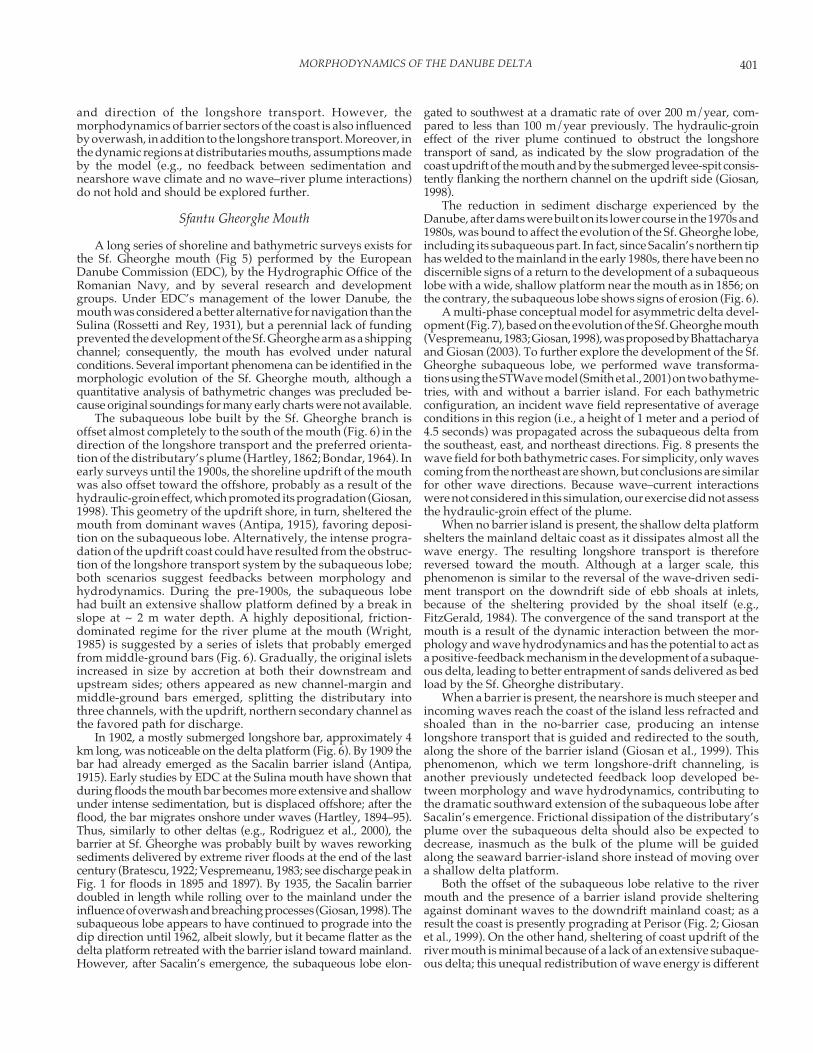
A long series of shoreline and bathymetric surveys exists forthe Sf. Gheorghe mouth (Fig 5) performed by the EuropeanDanube Commission (EDC), by the Hydrographic Office of theRomanian Navy, and by several research and developmentgroups. Under EDC’s management of the lower Danube, themouth was considered a better alternative for navigation than theSulina (Rossetti and Rey, 1931), but a perennial lack of fundingprevented the development of the Sf. Gheorghe arm as a shippingchannel; consequently, the mouth has evolved under naturalconditions. Several important phenomena can be identified in themorphologic evolution of the Sf. Gheorghe mouth, although aquantitative analysis of bathymetric changes was precluded be-cause original soundings for many early charts were not available.
The subaqueous lobe built by the Sf. Gheorghe branch isoffset almost completely to the south of the mouth (Fig. 6) in thedirection of the longshore transport and the preferred orienta-tion of the distributary’s plume (Hartley, 1862; Bondar, 1964). Inearly surveys until the 1900s, the shoreline updrift of the mouthwas also offset toward the offshore, probably as a result of thehydraulic-groin effect, which promoted its progradation (Giosan,1998). This geometry of the updrift shore, in turn, sheltered themouth from dominant waves (Antipa, 1915), favoring deposi-tion on the subaqueous lobe. Alternatively, the intense progra-dation of the updrift coast could have resulted from the obstruc-tion of the longshore transport system by the subaqueous lobe;both scenarios suggest feedbacks between morphology andhydrodynamics. During the pre-1900s, the subaqueous lobehad built an extensive shallow platform defined by a break inslope at ~ 2 m water depth. A highly depositional, friction-dominated regime for the river plume at the mouth (Wright,1985) is suggested by a series of islets that probably emergedfrom middle-ground bars (Fig. 6). Gradually, the original isletsincreased in size by accretion at both their downstream andupstream sides; others appeared as new channel-margin andmiddle-ground bars emerged, splitting the distributary intothree channels, with the updrift, northern secondary channel asthe favored path for discharge.
In 1902, a mostly submerged longshore bar, approximately 4km long, was noticeable on the delta platform (Fig. 6). By 1909 thebar had already emerged as the Sacalin barrier island (Antipa,1915). Early studies by EDC at the Sulina mouth have shown thatduring floods the mouth bar becomes more extensive and shallowunder intense sedimentation, but is displaced offshore; after theflood, the bar migrates onshore under waves (Hartley, 1894–95).Thus, similarly to other deltas (e.g., Rodriguez et al., 2000), thebarrier at Sf. Gheorghe was probably built by waves reworkingsediments delivered by extreme river floods at the end of the lastcentury (Bratescu, 1922; Vespremeanu, 1983; see discharge peak inFig. 1 for floods in 1895 and 1897). By 1935, the Sacalin barrierdoubled in length while rolling over to the mainland under theinfluence of overwash and breaching processes (Giosan, 1998). Thesubaqueous lobe appears to have continued to prograde into thedip direction until 1962, albeit slowly, but it became flatter as thedelta platform retreated with the barrier island toward mainland.However, after Sacalin’s emergence, the subaqueous lobe elon-
gated to southwest at a dramatic rate of over 200 m/year, com-pared to less than 100 m/year previously. The hydraulic-groineffect of the river plume continued to obstruct the longshoretransport of sand, as indicated by the slow progradation of thecoast updrift of the mouth and by the submerged levee-spit consis-tently flanking the northern channel on the updrift side (Giosan,1998).
The reduction in sediment discharge experienced by theDanube, after dams were built on its lower course in the 1970s and1980s, was bound to affect the evolution of the Sf. Gheorghe lobe,including its subaqueous part. In fact, since Sacalin’s northern tiphas welded to the mainland in the early 1980s, there have been nodiscernible signs of a return to the development of a subaqueouslobe with a wide, shallow platform near the mouth as in 1856; onthe contrary, the subaqueous lobe shows signs of erosion (Fig. 6).
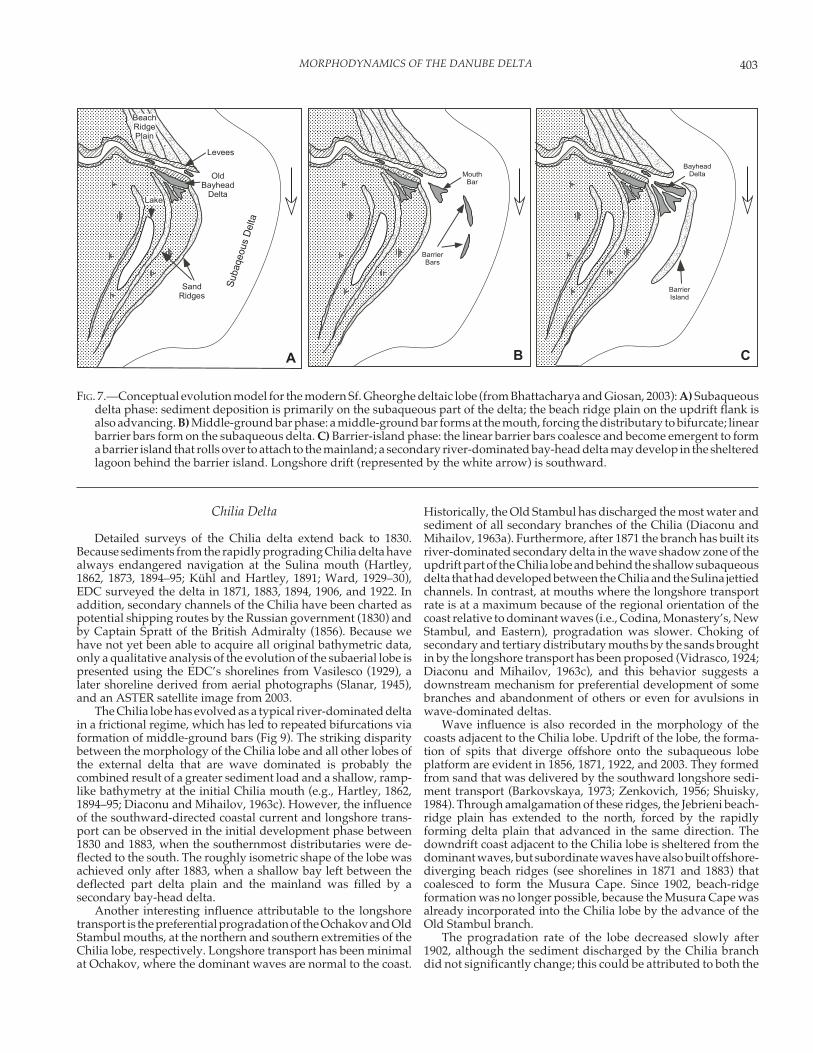
A multi-phase conceptual model for asymmetric delta devel-opment (Fig. 7), based on the evolution of the Sf. Gheorghe mouth(Vespremeanu, 1983; Giosan, 1998), was proposed by Bhattacharyaand Giosan (2003). To further explore the development of the Sf.Gheorghe subaqueous lobe, we performed wave transforma-tions using the STWave model (Smith et al., 2001) on two bathyme-tries, with and without a barrier island. For each bathymetricconfiguration, an incident wave field representative of averageconditions in this region (i.e., a height of 1 meter and a period of4.5 seconds) was propagated across the subaqueous delta fromthe southeast, east, and northeast directions. Fig. 8 presents thewave field for both bathymetric cases. For simplicity, only wavescoming from the northeast are shown, but conclusions are similarfor other wave directions. Because wave–current interactionswere not considered in this simulation, our exercise did not assessthe hydraulic-groin effect of the plume.
When no barrier island is present, the shallow delta platformshelters the mainland deltaic coast as it dissipates almost all thewave energy. The resulting longshore transport is thereforereversed toward the mouth. Although at a larger scale, thisphenomenon is similar to the reversal of the wave-driven sedi-ment transport on the downdrift side of ebb shoals at inlets,because of the sheltering provided by the shoal itself (e.g.,FitzGerald, 1984). The convergence of the sand transport at themouth is a result of the dynamic interaction between the mor-phology and wave hydrodynamics and has the potential to act asa positive-feedback mechanism in the development of a subaque-ous delta, leading to better entrapment of sands delivered as bedload by the Sf. Gheorghe distributary.
When a barrier is present, the nearshore is much steeper andincoming waves reach the coast of the island less refracted andshoaled than in the no-barrier case, producing an intenselongshore transport that is guided and redirected to the south,along the shore of the barrier island (Giosan et al., 1999). Thisphenomenon, which we term longshore-drift channeling, isanother previously undetected feedback loop developed be-tween morphology and wave hydrodynamics, contributing tothe dramatic southward extension of the subaqueous lobe afterSacalin’s emergence. Frictional dissipation of the distributary’splume over the subaqueous delta should also be expected todecrease, inasmuch as the bulk of the plume will be guidedalong the seaward barrier-island shore instead of moving overa shallow delta platform.
Both the offset of the subaqueous lobe relative to the rivermouth and the presence of a barrier island provide shelteringagainst dominant waves to the downdrift mainland coast; as aresult the coast is presently prograding at Perisor (Fig. 2; Giosanet al., 1999). On the other hand, sheltering of coast updrift of theriver mouth is minimal because of a lack of an extensive subaque-ous delta; this unequal redistribution of wave energy is different
402 L. GIOSAN, J.P. DONNELLY, E. VESPREMEANU, J.P. BHATTACHARYA, C. OLARIU, AND F.S. BUONAIUTO
from the one envisioned for a subaqueous delta symmetricallydeveloped around a deltaic lobe (e.g., Komar, 1973).
Barriers
Sacalin Island has increased in length at rates over 100 m/year under the influence of high longshore sediment transportrate (Giosan, 1998; Vespremeanu et al., 2004). However, theshoreline progradation predicted for the southern half of theisland by the convergence in the modeled sediment transport(Giosan et al., 1999) is not supported by the data on shorelinechange, which show a continuous retreat along the entire lengthof the island. The barrier is actually rolling over toward themainland (Fig. 6; Giosan, 1998) in an overwash mode (e.g.,Kana, 1996). The southern half of the barrier retreats fasterbecause it is narrower and has a lower elevation than thenorthern part, making it more likely to be overtopped andbreached during storms (Giosan et al., 1999). In turn, the mobil-ity of the northern tip of the Sacalin shore has decreased consid-erably since the island joined the mainland in the late 1970s, inresponse to the reduction in accommodation space available foroverwash deposits in the backshore.
Because the wave climate was constantly energetic, driving alarge southward drift during the development of the externaldelta (see considerations above), the evolution of the Sacalin
barrier could serve as a model for the development of the olderbarriers that are segmenting and closing the Razelm–Sinoe la-goon. On the outermost barrier that fronts the open sea, a similarrollover behavior is encountered. The retreat of the shoreline isalso greater along narrower stretches that have ample accommo-dation provided by the lagoon behind (Vespremeanu andStefanescu, 1988). Each bay-mouth barrier probably evolvedfrom an elongating spit with sediments delivered from the deltaiccoast via the longshore-transport system. Judging by Sacalin’srates of elongation, if the bay was initially shallow, the spits couldhave closed it over several centuries. If the bay was deep, con-struction of a barrier-island platform would have been necessary;recurves apparent at the southern tips of the two last generationsof barriers (i.e., Lupilor and Chituc) might be indicative of suchdevelopment in deeper waters.
Storm-induced washovers and breachings probably rotatedthe spit into the lagoon as its tip rolled over faster than its root,which was more stable or even prograding in the wave shadowzone provided by updrift deltaic lobes (Fig. 2). This rotation of thebarrier, combined with the accretionary regime at its root, likelypromoted the development of a new spit extending from thedeltaic coast. Once this second spit closed the bay, the barrierfrom the first generation was entirely protected from open-coastwaves and subjected only to the considerably less energeticlacustrine wave climate.
FIG. 6.—Evolution of Sf. Gheorghe mouth between 1856 and 2000. Land is in black, and the delta platform (shallow than –2 m) is ingray. Note that intervals for bathymetric contours are not the same on all charts.
403MORPHODYNAMICS OF THE DANUBE DELTA
Chilia Delta
Detailed surveys of the Chilia delta extend back to 1830.Because sediments from the rapidly prograding Chilia delta havealways endangered navigation at the Sulina mouth (Hartley,1862, 1873, 1894–95; Kühl and Hartley, 1891; Ward, 1929–30),EDC surveyed the delta in 1871, 1883, 1894, 1906, and 1922. Inaddition, secondary channels of the Chilia have been charted aspotential shipping routes by the Russian government (1830) andby Captain Spratt of the British Admiralty (1856). Because wehave not yet been able to acquire all original bathymetric data,only a qualitative analysis of the evolution of the subaerial lobe ispresented using the EDC’s shorelines from Vasilesco (1929), alater shoreline derived from aerial photographs (Slanar, 1945),and an ASTER satellite image from 2003.
The Chilia lobe has evolved as a typical river-dominated deltain a frictional regime, which has led to repeated bifurcations viaformation of middle-ground bars (Fig 9). The striking disparitybetween the morphology of the Chilia lobe and all other lobes ofthe external delta that are wave dominated is probably thecombined result of a greater sediment load and a shallow, ramp-like bathymetry at the initial Chilia mouth (e.g., Hartley, 1862,1894–95; Diaconu and Mihailov, 1963c). However, the influenceof the southward-directed coastal current and longshore trans-port can be observed in the initial development phase between1830 and 1883, when the southernmost distributaries were de-flected to the south. The roughly isometric shape of the lobe wasachieved only after 1883, when a shallow bay left between thedeflected part delta plain and the mainland was filled by asecondary bay-head delta.
Another interesting influence attributable to the longshoretransport is the preferential progradation of the Ochakov and OldStambul mouths, at the northern and southern extremities of theChilia lobe, respectively. Longshore transport has been minimalat Ochakov, where the dominant waves are normal to the coast.
Historically, the Old Stambul has discharged the most water andsediment of all secondary branches of the Chilia (Diaconu andMihailov, 1963a). Furthermore, after 1871 the branch has built itsriver-dominated secondary delta in the wave shadow zone of theupdrift part of the Chilia lobe and behind the shallow subaqueousdelta that had developed between the Chilia and the Sulina jettiedchannels. In contrast, at mouths where the longshore transportrate is at a maximum because of the regional orientation of thecoast relative to dominant waves (i.e., Codina, Monastery’s, NewStambul, and Eastern), progradation was slower. Choking ofsecondary and tertiary distributary mouths by the sands broughtin by the longshore transport has been proposed (Vidrasco, 1924;Diaconu and Mihailov, 1963c), and this behavior suggests adownstream mechanism for preferential development of somebranches and abandonment of others or even for avulsions inwave-dominated deltas.
Wave influence is also recorded in the morphology of thecoasts adjacent to the Chilia lobe. Updrift of the lobe, the forma-tion of spits that diverge offshore onto the subaqueous lobeplatform are evident in 1856, 1871, 1922, and 2003. They formedfrom sand that was delivered by the southward longshore sedi-ment transport (Barkovskaya, 1973; Zenkovich, 1956; Shuisky,1984). Through amalgamation of these ridges, the Jebrieni beach-ridge plain has extended to the north, forced by the rapidlyforming delta plain that advanced in the same direction. Thedowndrift coast adjacent to the Chilia lobe is sheltered from thedominant waves, but subordinate waves have also built offshore-diverging beach ridges (see shorelines in 1871 and 1883) thatcoalesced to form the Musura Cape. Since 1902, beach-ridgeformation was no longer possible, because the Musura Cape wasalready incorporated into the Chilia lobe by the advance of theOld Stambul branch.
The progradation rate of the lobe decreased slowly after1902, although the sediment discharged by the Chilia branchdid not significantly change; this could be attributed to both the
!��
.���$�%��������
����/�� �
����0��������
$����/�� �&���
!��
1�����$��
$������$���
$�%��������
$�����������
�� �� �
FIG. 7.—Conceptual evolution model for the modern Sf. Gheorghe deltaic lobe (from Bhattacharya and Giosan, 2003): A) Subaqueousdelta phase: sediment deposition is primarily on the subaqueous part of the delta; the beach ridge plain on the updrift flank isalso advancing. B) Middle-ground bar phase: a middle-ground bar forms at the mouth, forcing the distributary to bifurcate; linearbarrier bars form on the subaqueous delta. C) Barrier-island phase: the linear barrier bars coalesce and become emergent to forma barrier island that rolls over to attach to the mainland; a secondary river-dominated bay-head delta may develop in the shelteredlagoon behind the barrier island. Longshore drift (represented by the white arrow) is southward.
404 L. GIOSAN, J.P. DONNELLY, E. VESPREMEANU, J.P. BHATTACHARYA, C. OLARIU, AND F.S. BUONAIUTO
advance of the lobe in progressively deeper water and to thedecrease in sediment delivered by the distributary per unitshoreline as the lobe perimeter progressively increased. In 1940,the first clear signs of erosion are apparent, especially on thecentral coast of the lobe between the Ochakov and the Easternsecondary branches. By 2003, the Chilia has already become awave-dominated lobe. The main secondary channels are evolv-ing independently as wave-dominated secondary deltas. Be-cause of a minimal net longshore transport at the mouth, thenorthern Ochakov branch is building a symmetric secondarydelta with flying spits developing on both sides of the mouth.The other two branches that are important in terms of discharge,the New and Old Stambul, are building asymmetric secondarydeltas with barrier islands developing downdrift of their mouths.A shallow subaqueous platform and a clear offshore offset of theupdrift coast at the Old Stambul mouth are visible in 2003.Emergence of the Musura barrier island at this mouth after 1988(Vespremeanu-Stroe, 2004) suggests that increased amounts ofsand will be delivered by the longshore transport system to-ward the navigation channel at the Sulina mouth, in a naturalexperiment that will further test the drift-channeling hypoth-esis proposed herein. In 2003, the barrier was over 5 km in lengthand its southern tip almost touched the northern jetty of theSulina channel.
EVOLUTION OF THE DANUBE DELTA
Pre-Holocene Geology
The Danube delta occupies a large, structurally controlledembayment along the southern margin of the East European
Platform (Fig. 3). It overlies a portion of the North DobrogeanOrogen, the westernmost sector of a Cimmerian (Mesozoic) foldbelt extending through Crimea into the Asian Cimmerides, andpart of the Pre-Dobrogean Depression, a possible remnant of theformer Cimmerian foredeep, characterized by a thick sequence ofMiddle Jurassic to Lower Cretaceous sediments covering theCaledonian–Hercynian basement of the Scythian Platform(Hippolyte, 2002, and references therein). The North DobrogeanOrogen is separated to the south from the Moesian Platform bythe NW-trending Peceneaga–Camena crustal fault, and itoverthrusts to the north the sediments of the Pre-DobrogeanDepression along a NW-trending reverse fault running roughlyalong the modern course of the Sf. Gheorghe distributary of theDanube (Hippolyte, 2002, and references therein).
Sediment deposition on the Danube deep-sea fan should be areliable indicator for the inception of the Danube drainage intothe Black Sea. Winguth et al. (2000) correlated fan sequences to acomposite oxygen isotope curve, a proxy for glacio-eustaticchanges, and suggested that the fan started to develop ~ 900 ka.However, during lowstands, when global sea level fell below thedepth of the sill connecting the Black Sea to the Mediterranean,the Black Sea became isolated, and its water level oscillatedindependently (e.g., Major et al., 2002). During isolation periods,the level in the Black Sea was controlled by the magnitude of riverdischarge, augmented at times by meltwater, as well as by directprecipitation and evaporation modulated by the regional cli-mate. All these controls probably led to high-frequency abruptlake-level cycles, much as in the Caspian Sea (e.g., Ryan et al.,1997; Major et al., 2002). Therefore, the date proposed by Winguthet al. (2000) should be considered a maximum estimate for theinception of the discharge of the Danube into the Black Sea.
A B
FIG. 8.—Wave transformation of a monochromatic northeasterly wave field of 1 m height (represented by the length of the wavevectors at the eastern side of the chart) and 4.5 s period that was propagated from deep water (> 30 m) on A) 1856 and B) 1935bathymetries.
405MORPHODYNAMICS OF THE DANUBE DELTA
Although hundreds of boreholes have been drilled in theDanube delta since the 1950s, there is little certainty about thestratigraphical architecture of the transgressive and highstanddeltaic deposits preserved beneath the delta plain. Publishedinterpretations of these cores (Liteanu and Pricajan, 1963) arebased solely on lithologic descriptions combined with somefaunal checks. Deltaic deposits are ~ 50 m thick on average andcomprise two to three stacked coarsening-upward facies succes-sions, 10 to 30 m thick, capped by levels of peat. This suggestspreservation of several deltaic allomembers since the last low-stand. The deltaic facies overlie fluvial deposits, mostly gravels,that we interpret to represent alluvial valley fills of the lastlowstand. However, in the pre–sequence stratigraphy era, on thebasis of alternation of high-salinity vs. low-salinity fauna, Liteanuand Pricajan (1963) proposed a “layer-cake” stratigraphic modelfor the deltaic deposits, assigning a mid-Pleistocene age to theoldest preserved alluvial sediments. Their early model contra-dicts existing data on Pleistocene sea-level variations in the BlackSea (e.g., Chepalyga, 1984; Zubakov, 1988) and does not take intoaccount the fact that relict low-salinity faunas are known to
persist during marine highstands in some deltaic sub-environ-ments (Spratt, 1860; Borcea, 1924).
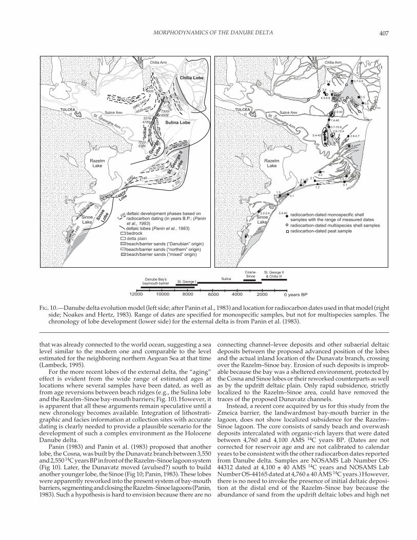
Panin (1972) reinterpreted borehole data along the central axisof the delta plain and proposed that the deltaic lithosome consistsentirely of transgressive and highstand deposits of Holocene age.Later, Panin et al. (1983) proposed that older highstand depositsare preserved below the easternmost part of the Holocene deltaplain, on the basis of the presence of older reworked mollusks (seebelow). However, Ghenea and Mihailescu (1991) showed thatloess and loessoid deposits, first described by Kühl and Hartley(1891), occur extensively at shallow subsurface depths in most ofthe northern half of the delta (Fig. 4D). Eolian deposition, includ-ing loess, was pervasive on the northern and northwestern shoresand shelf of the Black Sea during glacial stages (Conea, 1969;Shcherbakov et al., 1978; Balescu et al., 2003). Deltaic deposits, ifpresent below the loess horizon (Liteanu and Pricajan, 1963), arethus clearly older than Holocene. Preservation of loess in thenorthern sector of Danube delta suggests that the alluvial valleyduring the last lowstand was located along the present course ofthe Sf. Gheorghe branch and that the filling sequence for the
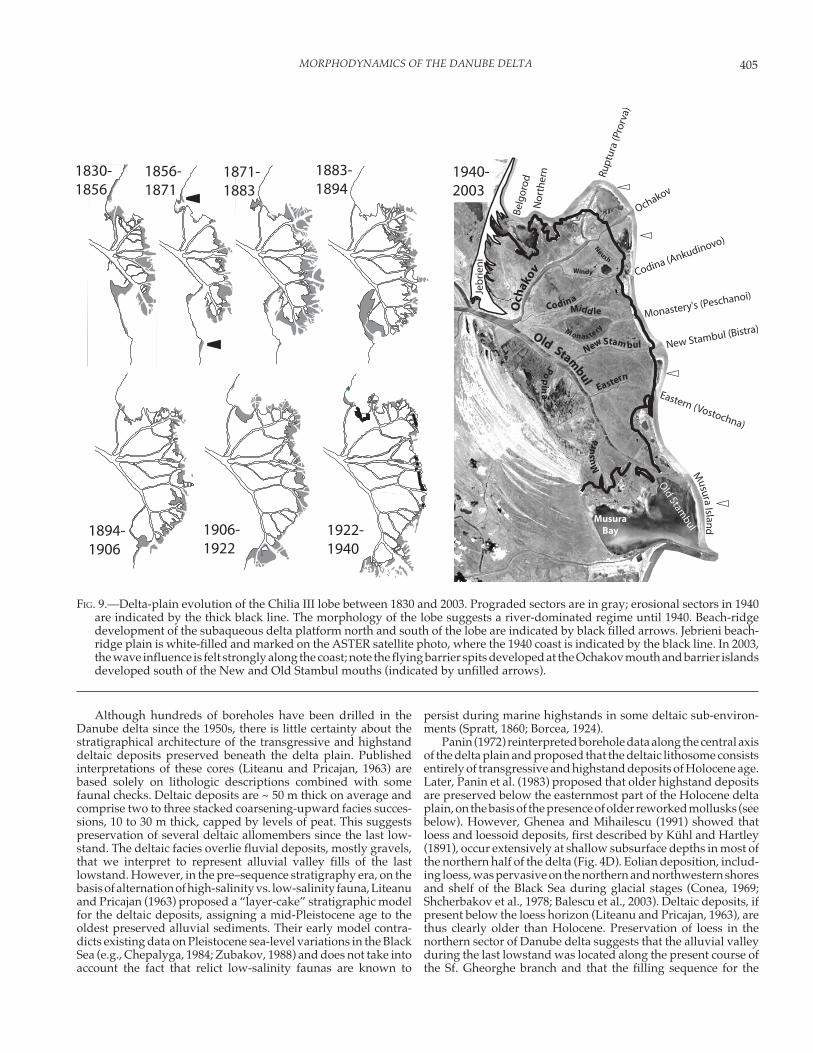
FIG. 9.—Delta-plain evolution of the Chilia III lobe between 1830 and 2003. Prograded sectors are in gray; erosional sectors in 1940are indicated by the thick black line. The morphology of the lobe suggests a river-dominated regime until 1940. Beach-ridgedevelopment of the subaqueous delta platform north and south of the lobe are indicated by black filled arrows. Jebrieni beach-ridge plain is white-filled and marked on the ASTER satellite photo, where the 1940 coast is indicated by the black line. In 2003,the wave influence is felt strongly along the coast; note the flying barrier spits developed at the Ochakov mouth and barrier islandsdeveloped south of the New and Old Stambul mouths (indicated by unfilled arrows).
406 L. GIOSAN, J.P. DONNELLY, E. VESPREMEANU, J.P. BHATTACHARYA, C. OLARIU, AND F.S. BUONAIUTO
Danube Bay as well as the growth of the first open-coast lobe (Sf.Gheorghe I) probably was controlled by the paleorelief devel-oped during the last lowstand. Further work on subsurfacestratigraphy and an independent chronology is required to eluci-date the subsurface stratigraphic architecture of the deltaic de-posits.
Holocene Development
Before the 1950s, research on the evolution of the Danubedelta was limited mostly to the interpretation of external deltagrowth using land surveys (Antipa, 1915; Bratescu, 1922; Valsan,1934; de Martonne, 1931, Slanar, 1945). The succession of lobedevelopment had been hotly debated among early scholars,with much of the confusion resulting from the fact that someresearchers postulated the development of beach-ridge plainsdowndrift from a fluvial feeder distributary rather than updriftof the mouth of the distributary (e.g., Bratescu, 1922) or consid-ered them to be strictly marine strandplains (e.g., Valsan, 1934).De Martonne (1931) was the first to sketch a realistic sequencefor the development of the external delta: he proposed that theSf. Gheorghe built the first open-coast lobe, followed by theSulina, followed by a new Sf. Gheorghe lobe, and later by theyoungest Chilia lobe. Mihailescu (1947) presented support forthis scenario by proposing that the updrift beach-ridge plainsform by the obstruction of the longshore drift, by the riverplume. Later, Zenkovich (1956) showed that the progradation ofthe Chilia lobe blocked the longshore drift, leading to amalgam-ation of beach ridges updrift of the lobe (Jebrieni beach ridgeplain; Fig. 9), proposing a similar model for the older lobes of thedelta. Panin and Panin (1969) and Panin (1974, 1989) usedtextural, mineralogical, and chemical composition of sedimentsto confirm the lobe development sequence proposed by deMartonne (1931) and Zenkovich (1956) by showing that most ofthe Caraorman and the early Letea beach-ridge plain consists ofsand transported from the north with little or no contributionfrom their corresponding feeder distributaries. Morphodynamicconsiderations require a continuous, and direct, rather thanembayed, nearshore zone to have existed between the Bugeacand the first Sf. Gheorghe mouth for allochthonous sediment tobe transported from north of the Danube bay to form the updriftwing of the Sf. Gheorghe lobe without being trapped in theformer Danube bay. This condition is not fulfilled without abay-mouth barrier straddling the former Danube bay; its devel-opment was probably favored, and its position controlled, bythe predeltaic loess relief, which ramps up toward the continent(Fig. 4D; Ghenea and Mihailescu, 199).
Much of the early effort in trying to establish a chronologyfor delta development was spent in trying to reconstruct theancient geography of the delta as described by Greek andRoman authors. The only modern chronology available is basedon the conventional radiocarbon dating of mostly molluskshells (Fig. 10; Panin et al., 1983). There is a recognized difficultyof dating deltaic formations because age inversions are common(see review in Stanley, 2001). In the case of the Danube delta,although the dating technique used in developing the chronol-ogy was valid (Noakes and Herz, 1983), the method of collectingdatable material and the subsequent interpretation of datesmakes the chronology uncertain. Most shells were collected atdepths between 1 and 3 m (Noakes and Herz, 1983; Panin et al.,1983), but no lithostratigraphic and facies description is pro-vided for the collection sites, which makes it difficult to assesswhat deltaic subenvironments have actually been dated and ifreworking or condensed intervals were likely to affect sam-pling. The large quantity of carbonate material needed for
dating probably precluded the use of single shells that could beascertained to be in situ; indeed, all shells dated showed signs ofreworking (Panin et al., 1983).
A number of samples dated by Panin et al. (1983) are olderthan Holocene: the age of multispecies mollusk samples as wellas some monospecific samples of Paphia (Tapes) senescens, Ostreaedulis, Cerithium (Thericium) vulgatum, and Chlamys (Flexopecten)glabra was attributed by Panin et al. (1983) to inclusion ofspecimens from older marine episodes in the dated samples.However, with the exception of Paphia senescens, the otherspecies cannot be discounted in the chronology because theyalso lived in the Black Sea during the Holocene (e.g., Nevesskaya,1965). During the last glacial interval, the Black Sea was isolatedand sustained a freshwater Caspian-type fauna rather than amarine one (see Ryan et al., 1997, and references therein). Thesalinization threshold for establishment of a marine fauna didnot occur in the Black Sea before 8,400–8,500 14C years BP(Scherbakov and Babak, 1979; Ross and Degens, 1974; see alsodiscussions in Ryan et al., 1997, and Major et al., 2001); however,the age spread for dated samples of marine mollusks extendsmuch earlier than that. Barring any systematic local effects onthe radiocarbon content of the dissolved inorganic carbon, onthe metabolic carbon used by the mollusks, or diagenetic post-depositional changes in shell chemistry (see Stanley, 2001, andreferences therein), the reasonable explanation for this discrep-ancy is the one proposed by Panin et al. (1983): inclusion ofshells of marine species from older marine intervals in the datedsamples, altering their age toward values older than their timeof deposition. Furthermore, by dating multiple shells in a singlesample, there is no reason to believe that Holocene samplesshowing ages younger than the salinity threshold have not alsobeen affected by a similar “aging” effect.
The northern wing of the Sf. Gheorghe I lobe, which was thefirst to prograde outside of the Danube bay bay-mouth barrier, iscomposed of ridges that are higher than the present Black Sealevel, even in places that have not been affected by dune construc-tion. As discussed previously, the allochthonous composition ofthese ridges requires a bay-mouth barrier extending from theBugeac to the Sf. Gheorghe mouth, before the first deltaic lobebegan to prograde. The bay-mouth barrier that closed the formerDanube bay was interpreted to have formed between 11,700 and9,800 14C years BP in its central part and between 10,700 and 7,50014C years BP in its southern part (Fig. 10; Panin et al., 1983). Thisargues for a sea level close to the present one no later than 9,800years ago. However, although it has been suggested that theBlack Sea level was between –20 and –40 m at that time (seediscussions in, e.g., Aksu et al., 2002a, and Aksu et al., 2002b, andRyan et al., 2003), compared to the ~ –50 m of world ocean(Fairbanks, 1989), to our knowledge no other reliable data exist tosupport a level as high as today.
Because of the progradational character of a wave-dominateddelta lobe, on a beach-ridge plain beach ridges become youngerin the offshore direction as the mouth of the distributary ad-vances; once a ridge is stranded by the next-forming ridge, it canno longer sustain a marine fauna. The youngest sample of thedated marine shell mixtures from a ridge should be the bestrepresentation of the stranding time; taking into account thepossible “aging effect” when measuring mixtures, that date isalso the oldest possible age for the stranding. If we apply this lineof reasoning to the western edge of the Caraorman beach-ridgeplain, the inception of progradation for the first lobe of Sf.Gheorghe, and therefore of the entire external delta plain, couldnot be much older than ~ 5,500–6,000 14C years BP, the youngestages reported for marine assemblage samples collected there(Noakes and Hertz, 1983). This age is consistent with a Black Sea
407MORPHODYNAMICS OF THE DANUBE DELTA
that was already connected to the world ocean, suggesting a sealevel similar to the modern one and comparable to the levelestimated for the neighboring northern Aegean Sea at that time(Lambeck, 1995).
For the more recent lobes of the external delta, the “aging”effect is evident from the wide range of estimated ages atlocations where several samples have been dated, as well asfrom age reversions between beach ridges (e.g., the Sulina lobeand the Razelm–Sinoe bay-mouth barriers; Fig. 10). However, itis apparent that all these arguments remain speculative until anew chronology becomes available. Integration of lithostrati-graphic and facies information at collection sites with accuratedating is clearly needed to provide a plausible scenario for thedevelopment of such a complex environment as the HoloceneDanube delta.
Panin (1983) and Panin et al. (1983) proposed that anotherlobe, the Cosna, was built by the Dunavatz branch between 3,550and 2,550 14C years BP in front of the Razelm–Sinoe lagoon system(Fig 10). Later, the Dunavatz moved (avulsed?) south to buildanother younger lobe, the Sinoe (Fig 10; Panin, 1983). These lobeswere apparently reworked into the present system of bay-mouthbarriers, segmenting and closing the Razelm–Sinoe lagoons (Panin,1983). Such a hypothesis is hard to envision because there are no
connecting channel–levee deposits and other subaerial deltaicdeposits between the proposed advanced position of the lobesand the actual inland location of the Dunavatz branch, crossingover the Razelm–Sinoe bay. Erosion of such deposits is improb-able because the bay was a sheltered environment, protected bythe Cosna and Sinoe lobes or their reworked counterparts as wellas by the updrift deltaic plain. Only rapid subsidence, strictlylocalized to the Razelm–Sinoe area, could have removed thetraces of the proposed Dunavatz channels.
Instead, a recent core acquired by us for this study from theZmeica barrier, the landwardmost bay-mouth barrier in thelagoon, does not show localized subsidence for the Razelm–Sinoe lagoon. The core consists of sandy beach and overwashdeposits intercalated with organic-rich layers that were datedbetween 4,760 and 4,100 AMS 14C years BP. (Dates are notcorrected for reservoir age and are not calibrated to calendaryears to be consistent with the other radiocarbon dates reportedfrom Danube delta. Samples are NOSAMS Lab Number OS-44312 dated at 4,100 ± 40 AMS 14C years and NOSAMS LabNumber OS-44165 dated at 4,760 ± 40 AMS 14C years.) However,there is no need to invoke the presence of initial deltaic deposi-tion at the distal end of the Razelm–Sinoe bay because theabundance of sand from the updrift deltaic lobes and high net
�
�����������)��
�������� ��)��
������)��
/�2���!��
����!��
������
����3������������� ������ ���� ��
���������
������������������������������������������� ����%����$�&�4��������
�������� ����������������������������� ��
��������� �
� !�"���#��$�
�� �
� !�"���#��$$�
�� �
�������� �
$�� ����
�%�
������
�� �
�����
�� �
����3������������� ����� ���� ������3������������� ��5� ���� ��
���������
�����
��������������������
������
�� ��� ��
������
���
���
� �
� �������
��
��
���
��
������
�����������
�� �
������
����
���
���
���
���
������
���
������������������
������
����
���������
�
�����������)��
�������� ��)��
������)��
/�2���!��
����!��
6�7�7,
6�6�7,
8�9�8�:
;�6
,�,
9�7�7,
8�9�;6�<
;�7
;�:8�7
7�8�6�<
+�<�;8�7
+�<�7�9
8�7
+�8
,�;
;�6�;�9
;�+
+�;+�;
;�:
8�;
;�6
+�+�+�7
+�;
������������������������������������������������� ���������������
��������������������������������������
�������������������������
6�7�7,
=,,, <,,, 7,,, +,,, ,�%����$&
������� �������
������� ����>� ���������
;,,,,;+,,,
�����$�%����%������������
��������
FIG. 10.—Danube delta evolution model (left side; after Panin et al., 1983) and location for radiocarbon dates used in that model (rightside; Noakes and Hertz, 1983). Range of dates are specified for monospecific samples, but not for multispecies samples. Thechronology of lobe development (lower side) for the external delta is from Panin et al. (1983).
408 L. GIOSAN, J.P. DONNELLY, E. VESPREMEANU, J.P. BHATTACHARYA, C. OLARIU, AND F.S. BUONAIUTO
longshore transport rate to the south combined with the rolloverbehavior of barriers have been favorable all along to the devel-opment of successive bay-mouth barriers downdrift of theHolocene delta (see previous discussion).
CONCLUDING REMARKS
Morphodynamics addresses the coupled adjustments amonghydrodynamic processes, sediment transport, sedimentation,and morphology, and has become an established paradigm forstudying coastal evolution (e.g., Carter and Woodroofe, 1994;Wright, 1995; Short, 1999). Compared to other clastic coasts, themorphodynamics of deltas is complicated by the continuousand/or episodic delivery of freshwater and sediment to the coastby one or several rivers through one or multiple mouths. Thesolids load discharged by the river comprises both suspendedfine sediment in the river plume and coarse bedload. Althoughour understanding of morphodynamic processes related to sedi-mentation processes related to plume development has madeimportant gains over the last several years with the advent ofprograms like STRATAFORM, EUROSTRATAFORM, andEURODELTA (see e.g., Syvitski and Trincardi, in press, andpapers therein; Nittrouer, 1999), morphodynamic studies of thecoarse, bed-load fraction is seriously lagging behind. However,sedimentation of the coarse-grade sediments appears to be adominant factor in the evolution of river mouths (Wright, 1985)and further, in determining the facies architecture of wave-dominated deltas as well as the distribution of reservoir-qualitylithosomes (Bhattacharya and Giosan, 2003).
Our present analysis of the Danube delta development re-evaluates the knowledge about a long-studied but still poorlyunderstood delta, while introducing several novelmorphodynamic aspects of river-mouth and deltaic deposition inwave-influenced environments that will provide a basis for fur-ther quantitative field and modeling studies.
Once a delta progrades to the open coast, it forms a discretesubaqueous protuberance. In many cases, the protuberance isalso expressed at the shoreline, which progrades relative to theadjacent coasts. From a hydrodynamical perspective, this deltaic“bulge” can be viewed as a morphological perturbation to theregional circulation system. Morphodynamic adjustments be-tween the deltaic morphology and the fluvial and basinal hydro-dynamics are most intense at the river mouths. Morphodynamicsof wave-dominated deltaic distributary mouths is highly nonlin-ear, involving multiple feedbacks between subaerial deltaic pro-gradation, deposition on the subaqueous delta, current and wavehydrodynamics, and wave–current interactions. In spite of thiscomplexity, the morphology at the mouth exhibits a tendency toself-organize that is reflected and preserved in a coherent seriesof stratigraphic architectural styles (Wright, 1977; Dominguez,1996; Bhattacharya and Giosan, 2003).
Morphodynamic models (e.g., Komar, 1973; Cowell et al.,2004) identify the rotation of the delta shoreline as a phenomenonresponsible for changes in the longshore drift along the deltaiccoast. Assuming that the offshore wave regime is not signifi-cantly skewed to one side of the regional orientation of the coast,as a delta progrades, the angle of wave attack increases along bothsides of the mouth, increasing the longshore transport away fromthe mouth. Changes in the drift magnitude can be thought of asa feedback loop between subaerial morphology of the delta andwaves, which ultimately limits the growth of the deltaic protru-sion. For purposes of numerical modeling, rotation is generallyconceptualized as a two-dimensional problem by assuming thatthe nearshore profile is invariable for the entire deltaic coast.However, where the offshore wave direction is skewed toward
one side of the regional orientation of the coast, the downdriftside is sheltered from dominant waves and longshore transportconverges at the mouth.
The river plume interacts with the surface waves to increasethe convergence of the longshore sediment transport updrift ofthe river mouth (i.e., the hydraulic-groin effect of the plume ofTodd, 1968, and Komar, 1973). The groin effect occurs regardlessof the presence of suspended sediment in the plume. However,the increase in the density of the plumes by addition of suspendedsediment leads to an increase in the density contrast between theplume and the coastal waters (e.g., Rodriguez et al., 2000), result-ing in wave-energy dissipation when waves encounter the plume.Where the longshore drift reaching the mouth is significant, afeedback loop develops between the relatively rapid prograda-tion of the updrift coast caused by the hydraulic-groin effect and/or by the development of a subaqueous delta, leading to a mouththat is progressively more sheltered from waves, which in turn,results in an increase in sedimentation on the subaqueous deltaplatform.
On the updrift side, the longshore transport obstructed bythe river plume delivers sand to build a deltaic beach-ridgeplain comprising mostly allochthonous sediments. However,the subaqueous delta develops mostly on the opposite, downdriftside of the mouth, activating another positive feedback betweenmorphology and wave hydrodynamics. Waves reaching thedowndrift coast dissipate their energy more effectively over thesubaqueous delta compared to the coast updrift of the mouth,where no subaqueous delta platform is present. This results inmore quiescent conditions downdrift of the mouth, favoring theexpansion of the subaqueous delta. Development of a shallowsubaqueous delta platform allows deposition of mouth bars toform offshore at the edge of the platform during floods. Wavescan then rework these bars into barrier islands fronting the deltaplatform.
As the emergent barrier becomes the new shoreline for thedowndrift half of the delta, it produces a response of the delta tothe wave hydrodynamics. Wave energy is no longer dissipatedover the shallow delta platform; moreover, the waves reach thebarrier shore incompletely refracted, resulting in a channeling ofthe longshore transport (i.e., intensification of the transport guidedalong the shore of the barrier). This in turn leads to a more rapiddevelopment of the subaqueous delta in the alongshore direction.
As much as the river plume, wave-driven longshore transporttransmits morphological signals from the deltaic coast to adjacentnondeltaic coastal compartments or from one deltaic lobe toanother. Sheltering from waves by the subaerial and subaqueouslobe and development of barrier-spit “wings” are some of themore obvious features occurring downdrift of a delta. Sedimentderived from the river could also impose a certain heterogeneityin the nearshore (e.g., forced accumulation of muds in an other-wise energetic environment), leading to a strong coupling be-tween hydrodynamic and morphodynamic processes in regionsfar from the river mouth, in contrast to a homogeneous system(Sheremet and Stone, 2003).
In recent 3-D modeling efforts that include waves as a forcingfactor (Overeem et al., this volume), offsets between the subaque-ous depocenters and their delta-plain counterparts are clearlydeveloped. However, the simulated response of a river mouth toa strong longshore drift is invariably a deflection downdrift,without updrift–downdrift offsets or the emergence of barrierislands. Three-dimensional sedimentation models that includewave–current interactions, a movable heterogeneous bed, andseparate bedload and plume dynamics modules are required tobegin to address the complexity of the morphodynamics at wave-dominated river mouths.
409MORPHODYNAMICS OF THE DANUBE DELTA
ACKNOWLEDGMENTS
Funding for this study to Giosan and Donnelly was providedby the Coastal Ocean Institute and Rinehart Coastal ResearchCenter at the Woods Hole Oceanographic Institution. Manythanks to the team of hard-working young researchers from theCenter for Marine and Fluvial Research at Sf. Gheorghe (BucharestUniversity, Romania). We are grateful for the good review sug-gestions of Duncan FitzGerald. This is Woods Hole contributionnumber 11216.
REFERENCES
AKSU, A.E., HISCOTT, R.N., MUDIE, P.J., ROCHON, A., KAMINSKI, M.A., ABRAJANO,T., AND YASAR, D., 2002, Persistent Holocene outflow from the BlackSea to the eastern Mediterranean contradicts Noah’s flood hypoth-esis: GSA Today, v. 12, no. 5, p. 4–10.
AKSU, A.E., HISCOTT, R.N., YASAR, D., ILER, F.I., AND MARSH, S., 2002, Seismicstratigraphy of Late Quaternary deposits from the southwesternBlack Sea shelf: evidence for non-catastrophic variations in sea-levelduring the last ~ 10,000 yr: Marine Geology, v. 190, p. 61–94.
ANTIPA, G., 1915, Wissenschaftliche und wirtschaftliche Probleme desDonaudeltas: Anuarul Institutului de Geologie a Romaniei, v. 7, 88 p.
ASLAN, A., WHITE, W.A, WARNE, A.G., AND GUEVARA, E.H., 2003, Holoceneevolution of the western Orinoco Delta, Venezuela: GeologicalSociety of America, Bulletin, v. 115, p. 479–498.
BACESCU, M.C., MULLER, G.I., AND GOMOIU, M.-T., 1971, Ecologie Marina,Fourth Edition: Academiei Romane, v. 4, 357 p.
BALESCU, S., LAMOTHE, M., MERCIER, N., HUOT, S., BALTEANU, D., BILLARD, A.,AND HUS, J., 2003, Luminescence chronology of Pleistocene loessdeposits from Romania: testing methods of age correction for anoma-lous fading in alkali feldspars: Quaternary Science Reviews, v. 22, p.967–973.
BANU A.C., AND RUDESCU, L., 1965, Delta Dunãrii: Bucharest, Ed. Stiintifica,295 p.
BARKOVSKAYA, M.G., 1973, Mineral composition of bottom sediments ofthe delta and foredelta of the Danube: Transactions (Doklady) of theU.S.S.R. Academy of Sciences: Earth Sciences Sections 205; 1–6, ScriptaPublishing [in cooperation with the] American Geological Institute,Silver Springs, Maryland, United States, p. 192-195.
BHATTACHARYA, J.P., AND GIOSAN, L., 2003, Wave-influenced deltas: geo-morphologic implications for facies reconstruction: Sedimentology,v. 50, p. 187–210.
BHATTACHARYA, J.P., AND WALKER, R.G., 1992, Deltas, in Walker, R.G., andJames, N.P., eds., Facies Models: Response to Sea Level Change: St.Johns, Geological Association of Canada, p. 157–177.
BONDAR, C., 1964, Date asupra distributiei spatiale a salinitatii in jurulgurilor Dunarii: Studii de Hidraulica, v. 11, p. 229–245.
BONDAR, C., AND BLENDEA, V., 2000, Water and sediment transport by theDanube into the Black Sea during 1840–1995: Paris, Intergovernmen-tal Oceanographic Commission, Workshop Report no. 145, p. 58–63.
BONDAR, C., AND HARABAGIU, E., 1992, Regimul depunerilor de aluviuni lagura canalului Sulina: Studii de Hidraulica, v. 33, p. 131–141.
BONDAR, C., STATE, I., CERNEA, D., AND HARABAGIU, E., 1992, Scurgerea deapa si aluviuni a Dunarii la gurile bratelor Dunarii in anii 1858–1988:Studii de Hidraulica, v. 33, p. 57–71 (in Romanian).
BORCEA, I., 1924, Faune survivante de type caspien dans la limans d’eaudouce de Roumanie: Universite de Iassy, Anales Scientifique, no. 9,p. 207–232.
BRATESCU, C., 1922, Delta Dunãrii. Geneza si evolutia sa morfologicã sicronologicã: Buletinul Societaii Române Regale de Geografie, v. 41, p.3–39.
BULGAKOV, N.P., GOLUBEV, Y.N., AND KUFTARKOV, A.Y., 1992, Energy activezones of the Black Sea: Rossiskaya Akademiya Nauk, Doklady, v.326, p. 177–180.
CARTER, R.W.G., AND WOODROFFE, C.D., eds., 1984, Coastal Evolution;Late Quaternary Shoreline Morphodynamics: Cambridge, U.K.,Cambridge University Press, 539 p.
CHEPALYGA, A.L., 1984, Inland sea basins, in Velichko, A.A., Wright, H.E.,and Barnosky, C.W., eds., Late Quaternary Environments of theSoviet Union: Minneapolis, Minnesota, University of MinnesotaPress, 327 p.
CIULACHE, S., 1993, The wind on the Romanian shore of the Black Sea,Universitatii Bucuresti, Analele, Geografie, p. 1–10.
COLEMAN, J.M., AND WRIGHT, L.D., 1975, Modern river deltas: variability ofprocesses and sand bodies, in Broussard, M.L., ed., Deltas, Models forExploration: Houston Geological Society, p. 99–149.
CONEA, A., 1969, Profils de loess en Roumanie, in Fink, J., ed., La stratigraphiedes Loess d’Europe: Association Française pour l’Étude duQuaternaire, Bulletin, Suppl. INQUA, p. 127–134.
COWELL, P.J., STIVE, M.J.F., NIEDORODA, A.W., DE VRIEND, H.J., SWIFT, D.J.P.,KAMINSKY, G.-M., AND CAPOBIANCO, M., 2004, The coastal-tract (Part 1):A conceptual approach to aggregated modeling of low-order coastalchange: Journal of Coastal Research, v. 19, p. 812–827.
DE MARTONNE, E., 1931, Europe Centrale, vol. II: Paris, A. Colin, p. 786–787.
DIACONU, C., AND MIHAILOV, V.N., 1963a, Scurgerea apei, in Diaconu, C.,and Nichiforov, I.D., eds., Zona de varsare a Dunarii: Bucharest,Editura Tehnica, p. 135–176.
DIACONU, C., AND MIHAILOV, V.N., 1963b, Scurgerea aluviunilor, in Diaconu,C., and Nichiforov, I.D., eds., Zona de varsare a Dunarii: Bucharest,Editura Tehnica, p. 177–191.
DIACONU, C., AND MIHAILOV, V.N., 1963c, Procesele formarii deltei in etapaactuala, in Diaconu, C., and Nichiforov, I.D., eds., Zona de varsare aDunarii: Bucharest, Editura Tehnica, p. 192-222.
DOMINGUEZ, J.M.L., BITTENCOURT, A.C.S.P., AND MARTIN, L., 1983, O papelda deriva litorânea de sedimentos arenosos na construção dasplanícies costeiras associadas às desembocaduras dos Rios SãoFrancisco (SE-AL), Jequitinhonha (BA), Doce (ES) e Paraíba do Sul(RJ): Revista Brasileira de Geociências, v. 13, p. 98–105.
DOMINGUEZ, J.M.L., MARTIN, L., AND BITTENCOURT, A.C.S.P., 1987, Sea-levelhistory and Quaternary evolution of river mouth-associated beach-ridge plains along the east-southeast Brazilian Coast: a summary, inNummedal, D., Pilkey, O.H., and Howard, J.D., eds., Sea-Level Fluc-tuation and Coastal Evolution: SEPM, Special Publication 41, p. 115–127.
DOMINGUEZ, J.M.L., 1996, The São Francisco strandplain: a paradigm forwave-dominated deltas?, in De Batist, M., and Jacobs, P., eds., Geol-ogy of Siliciclastic Shelf Seas: Geological Society of London, SpecialPublication 117, p. 217–231.
FAIRBANKS, R.G., 1989, A 17,000-year glacio-eustatic sea level record:influence of glacial melting rates on the Younger Dryas event and deep-ocean circulation: Nature, v. 342, p. 637–642.
FITZGERALD, D.M., 1984, Interactions between the ebb-tidal delta and land-ward shoreline: Price Inlet, South Carolina: Journal of SedimentaryPetrology, v. 54, p. 1303–1318.
GEYER, W.R, HILL, P.S., AND KINEKE, G.C., 2004, The transport, transforma-tion and dispersal of sediment by buoyant coastal flows: ContinentalShelf Research, v. 24, p. 927–949.
GHENEA, C., AND MIHAILESCU, N., 1991, Palaeogeography of the lowerDanube Valley and Danube Delta during the last 15 000 years, inStarkel, L., Gregory, K.J., and Thornes, J.B., eds., TemperatePalaeohydrology; Fluvial Processes in the Temperate Zone Duringthe Last 15 000 Years: New York, Wiley, 548 p.
GIOSAN, L., 1993, Studiul evolutiei dinamice a sedimentelor in zonalitorala din fata Deltei Dunarii: unpublished Diploma thesis, BucharestUniversity, 75 p.
GIOSAN, L., 1998, Long term sediment dynamics on Danube delta coast,1998, in Dronkers, J., and Scheffers, M.B.A.M., eds., Physics ofEstuaries and Coastal Seas: Proceedings of the 8th International
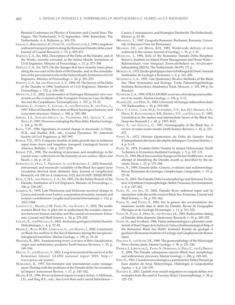
410 L. GIOSAN, J.P. DONNELLY, E. VESPREMEANU, J.P. BHATTACHARYA, C. OLARIU, AND F.S. BUONAIUTO
Biennial Conference on Physics of Estuaries and Coastal Seas: TheHague, The Netherlands, 9–12 September, 1996: Rotterdam, TheNetherlands, A.A. Balkema, p. 365–376.
GIOSAN, L., BOKUNIEWICZ, H., PANIN, N., AND POSTOLACHE, I., 1999, Longshoresediment transport pattern along the Romanian Danube delta coast:Journal of Coastal Research, v. 15, p. 859–871.
HARTLEY, C.A., SIR, 1862, Description of the Delta of the Danube, and ofthe Works, recently executed, at the Sulina Mouth: Institution ofCivil Engineers, Minutes of Proceedings, v. 21, p. 277–308.
HARTLEY, C.A., SIR, 1873, On the changes that have recently taken placealong the sea coast of the delta of the Danube, and on the consolida-tion of the provisional works at the Sulina Mouth: Institution of CivilEngineers, Minutes of Proceedings, v. 36, p. 201–253.
HARTLEY, C.A., SIR, AND HARCOURT, L.V., 1894–95, The Survey of the Deltaof the Danube in 1894: Institution of Civil Engineers, Minutes ofProceedings, v. 122, p. 336–342.
HIPPOLYTE, J.-C., 2002, Geodynamics of Dobrogea (Romania): new con-straints on the evolution of the Tornquist–Teisseyre Line, the BlackSea and the Carpathians: Tectonophysics, v. 357, p. 33–53.
HUMBORG, C., ITTEKKOT, V., COCIASU, A., VON BODUNGEN, B., AND POPA, L.,1997, Effect of Danube River dam on Black Sea biogeochemistry andecosystem structure: Nature, v. 386, p. 385–388.
JIMÉNEZ, J.A., SANCHEZ-ARCILLA, A., VALDEMORO, H.I., GRACIA, V., AND
NIETO, F., 1997, Processes reshaping the Ebro delta: Marine Geology,v. 144, p. 59–79.
KANA, T.W., 1996, Signatures of coastal change at mesoscale, in Dally,W.R., and Ziedler, R.B., eds., Coastal Dynamics ’95: AmericanSociety of Civil Engineers, p. 987–997.
KOMAR, P.D., 1973, Computer models of delta growth due to sedimentinput from rivers and longshore transport: Geological Society ofAmerica, Bulletin, v. 84, p. 2217–2226.
KOMAR, P.D., 1998, The modeling of processes and morphology in thecoastal zone—reflections on the maturity of our science: Shore andBeach, v. 66, p. 10–22.
KOROTAEV, G., OGUZ, T., NIKIFOROV, A., AND KOBLINSKY, C., 2003, Seasonal,interannual, and mesoscale variability of the Black Sea upper layercirculation derived from altimeter data, Journal of GeophysicalResearch, vol. 108, no. 4, citation no. 3122, doi:10.1029/2002JC001508.
KÜHL, C.H.L., AND HARTLEY, C.A., SIR, 1891, On the Sulina Branch of theDanube: Institution of Civil Engineers, Minutes of Proceedings, v.106, p. 238–247.
LAMBECK, K., 1995, Late Pleistocene and Holocene sea-level change inGreece and south-west Turkey: a separation of eustatic, isostatic andtectonic contributions: Geophysical Journal International, v. 122, p.1022–1044.
LANCELOT, C., MARTIN, J.-M. PANIN, N., AND ZAITSEV, Y., 2002, The north-western Black Sea: A pilot site to understand the complex interac-tion between human activities and the coastal environment: Estua-rine, Coastal and Shelf Science, v. 54, p. 279–283.
LITEANU, E., AND PRICAJAN, A., 1963, Alcãtuirea geologicã a Deltei Dunãrii:Hidrobiologia, v. 4, p. 57–82.
MAJOR, C., RYAN, W.B.F., LERICOLAIS, G., AND HAJDAS, I., 2002, Constraintson Black Sea outflow to the Sea of Marmara during the last glacial–interglacial transition: Marine Geology, v. 190, p. 19–34.
MAKASKE, B., 2001, Anastomosing rivers: a review of their classification,origin and sedimentary products: Earth-Science Reviews, v. 53, p.149–196.
MALCIU, V., AND DIACONU, V., 2001, Long-term trend of the sea level at theRomanian littoral: GLOSS national report 2001, http://www.pol.ac.uk/psmsl/.
MARGESSON, R., 1997, Environment and international water manage-ment: Dealing with the problems of the Danube delta: Environmen-tal Impact Assessment Review, v. 17, p. 145–162.
MEADE, R.H., 1996, River-sediment inputs to major deltas, in Milliman,J.D., and Haq, B.U., eds., Sea-Level Rise and Coastal Subsidence—
Causes, Consequences, and Strategies: Dordrecht, The Netherlands,Kluwer, p. 63–85.
MIHAILESCU, V., 1947, Geografia Romaniei: Bucharest, Romania, Univer-sity of Bucurest Press (in Romanian).
MILLIMAN, J.D., AND MEADE, R.H., 1983, World-wide delivery of riversediment to the oceans: Journal of Geology, v. 91, p. 1–21.
MUNTEANU, I., 1996, Soils of the Romanian Danube Delta BiosphereReserve: Institute for Inland Water Management and Waste Water –Rijksinstituut voor Integraal Zoetwaterbeheer en Afvalwater-behandeling (RIZA), The Netherlands, 96-070, 171 p.
MURGOCI, G., 1912, Etudes géologiques dans la Dobrogea de Nord: AnuarulInstitutului de Geologie a Romaniei, v. 6, p. 161–200.
NEVESSKAYA, L.A., 1995, Late Quaternary Bivalve Mollusks of the BlackSea: Their Systematics and Ecology: Trudy PaleontologicheskogoInstituta, Rossiyskaya Akademiya Nauk, Moscow, v. 105, 390 p. (inRussian).
NITTROUER, C.A., 1999, STRATAFORM: overview of its design and synthe-sis of its results: Marine Geology, v. 154, p. 3–12.
NOAKES, J.E., AND HERZ, N., 1983, University of Georgia radiocarbon datesVII: Radiocarbon, v. 25, p. 919–929.
OGUZ, T., LATUN, , LATIF, M.A., VLADIMIROV, V.V., SUR, H.I., MARKOV, A.A.,ÖZSOY, E., KOTOVSHCHIKOV, B.B., EREMEEV, V.V., AND ÜNLÜATA, Ü., 1993,Circulation in the surface and intermediate layers of the Black Sea:Deep-Sea Research I, v. 40, p. 1597–1612.
ÖZSOY, E., AND ÜNLÜATA, Ü., 1997, Oceanography of the Black Sea: Areview of some recent results: Earth-Science Reviews, v. 42, p. 231–272.
PANIN, N., 1972, Histoire Quaternaire du Delta du Danube. Essaid’interprétation des facies des dépôts deltaïques: Cercetari Marine, v.4, p. 5–15.
PANIN, N., 1974, Evolutia Deltei Dunãrii în timpul Holocenului: StudiiTechnnice si Economice-Institutul Geologic, v. 5, p. 107–121.
PANIN, N., 1983, Black Sea coast line changes in the last 10,000 years. A newattempt at identifying the Danube mouth as described by the an-cients: Dacia, v. 27, p. 175–184.
PANIN, N., 1989, Danube delta. Genesis, evolution and sedimentology:Revue Roumaine de Géologie, Géophysique, Géographie, v. 33, p.25–36.
PANIN, N., 2003, The Danube Delta Geomorphology and Holocene Evolu-tion: A Synthesis: Géomorphologie : Relief, Processus, Environnement,v. 4, p. 247–262.
PANIN, N., AND JIPA, D., 2002, Danube River sediment input and itsinteraction with the north-western Black Sea: Estuarine, Coastal andShelf Science, v. 54, p. 551–562.
PANIN, N., and PANIN, S., 1969, Sur la genese des accumulations desmineraux lourds dans le delta du Danube, Revue de GeographiePhysique et de Geologie Dynamique, v. 11, p. 511–522.
PANIN, N., PANIN, S., HERZ, N., AND NOAKES, J.E., 1983, Radiocarbon datingof Danube delta deposits: Quaternary Research, v. 19, p. 249–255.
PANIN, N., and 14 others, 1986, Harta sedimentologica a platoului conti-nental al Marii Negre de la Sulina la Tulcea (Sedimentological Map ofthe Romanian Black Sea Shelf): Institutul Român de geologie sigeofizica (Romanian Institute of Geology and Geophysics) (in Roma-nian).
PENLAND, S., AND SUTER, J.R., 1989, The geomorphology of the MississippiRiver chenier plain: Marine Geology, v. 90, p. 231–240.
POPESCU, I., LERICOLAIS, G., PANIN, N., NORMAND, A., DINU, C., AND LE DREZEN,E., 2004, The Danube subaqueous canyon (Black Sea): morphologyand sedimentary processes: Marine Geology, v. 206, p. 249–265.
POPP, N., 1961, Caracterizarea litologica a paminturilor Deltei Dunarii pebaza datelor de foraj: Meteorologia, Hidrologia si GospodarireaApelor, v. 4, p. 126–139.
PRANZINI, E., 2001, Updrift river mouth migration on cuspate deltas: twoexamples from the coast of Tuscany (Italy): Geomorphology, v. 38, p.125–132.
411MORPHODYNAMICS OF THE DANUBE DELTA
RCMGG (ROMANIAN CENTER FOR MARINE GEOLOGY AND GEOECOLOGY), 1994,Monitoringul geo-ecologic al sistemului Dunare-Delta-Litoral-MareaNeagra: Centrul Roman de Geologie and Geoecologie Marina,Bucharest, 46 p.
RESCHKE, S., ITTEKKOT, V., AND PANIN, N., 2002, The nature of organic matterin the Danube River particles and north-western Black Sea sediments:Estuarine, Coastal and Shelf Science, v. 54, p. 563–574.
RIMBU, N., BORONEANT, C., BUTA, C., AND DIMA, M., 2002, Decadal variabilityof the Danube river streamflow in the lower basin and its relation withthe North Atlantic Oscillation: International Journal of Climatology,v. 22, p. 1169–1179.
RODRIGUEZ, A.B., HAMILTON, M.D., AND ANDERSON, J.B., 2000, Facies andevolution of the modern Brazos Delta, Texas; wave versus floodinfluence: Journal of Sedimentary Research, v. 70, p. 283–295.
ROSS, D.A., AND DEGENS, E.T., 1974, Recent sediments of the Black Sea, inDegens, E.T., and Ross, D.A., eds., The Black Sea: Geology, Chemistry,and Biology: American Association of Petroleum Geologists, Memoir20, p. 183–199.
ROSSETTI, C., AND REY, F., 1931, La Commission Européenne du Danube etson oeuvre de 1856 a 1,931: Paris, Imprimerie Nationale, 526 p.
RYAN, W.B.F., PITMAN, W.C., MAJOR, C.O., SHIMKUS, K., MOSKALENKO, V.,JONES, G.A., DIMITROV, P., GORÜR, N., SAKINÇ, M., AND YÜCE, H., 1997,An abrupt drowning of the Black Sea: Marine Geology, v. 138, p.119–126.
SHCHERBAKOV, F.A., AND KAPLIN, P.A., 1978, Osadkonakoplenie nakontinental’noi okraine Chernogo moria (Sedimentation on the Con-tinental Shelf of the Black Sea: Moscow, Nauka, 211 p.
SHEREMET, A., AND STONE, G.W., 2003, Observations of nearshore wavedissipation over muddy sea beds: Journal of Geophysical Research,vol. 108, no. C11, citation no. 3357, doi:10.1029/2003JC001885.
SHORT, A.D., 1999, Handbook of Beach and Shoreface Morphodynamics:New York, John Wiley & Sons, 392 p.
SHUISKY, Y.D., 1984, Dynamics of Kiliya delta coastline of the Danuberiver: Soviet Oceanographic Institute, Transactions, v. 172, p. 50–60.
SLANAR, H., 1945, Zur Kartographie und Morphologie des Donaudeltas,Geographische Gesellschaft, Mitteilungen, v. 88, no. 1–12, p. 30–47.
SMITH, J.M., SHERLOCK, A.R., AND RESIO, D.T., 2001, STWAVE: Steady-StateSpectral Wave Model, User guide for STWAVE Version 3.0, ERDC/CHL SR-01-01: U.S. Army Engineer Research and DevelopmentCenter, Vicksburg, Mississippi.
SPRATT, T.R.N., 1860, On the freshwater deposits of Bessarabia: GeologicalSociety of London, Quarterly Journal, v. 16, p. 281–294.
STANEV, E.V., BECKERS, J.M., LANCELOT, C., STANEVA, J.V., LE TRAON, P.Y.,PENEVA, E.L., AND GREGOIRE, M., 2002, Coastal–open ocean exchange inthe Black Sea: Observations and modeling: Estuarine, Coastal andShelf Science, v. 54, p. 601–620.
STANLEY, D.J., 2001, Dating modern deltas: Progress, problems, andprognostics: Annual Review of Earth and Planetary Sciences, v. 29, p.257–294.
STANLEY, D.J., MART, Y., AND NIR, Y., 1997, Clay mineral distributions tointerpret Nile cell provenance and dispersal: II. Coastal plain from Niledelta to northern Israel, Journal of Coastal Research, v. 13, p. 506–533.
SYVITSKI, J.P.M., AND BAHR, D.B., 2001, Numerical models of marine sedi-ment transport and deposition: Computers & Geosciences, v. 27, p.617–618.
SYVITSKI, J.P.M., AND TRINCARDI, F., in press, Introduction: Marine Geology,Comdelta Special Issue.
TODD, T.W., 1968, Dynamic diversion: influence of longshore current–tidal flow interaction on chenier and barrier island plains: Journal ofSedimentary Petrology, v. 38, p. 734–746.
VALSAN, G., 1934, Nouvelle hypothèse sur le Delta du Danube: Warsaw,Congrès International de Géographie, Comptes Rendus II, p. 342–355.
VASILESCO, G., 1929, Débit solide du Danube et évolution recente du sondelta: Bucharest, Société Anonyme Roumaine, “Electrica” Press, 75 p.
VESPREMEANU, E., 1983, Geomorphological evolution of Sfintu Gheorghearm mouth (Danube delta, North-West of the Black Sea) in the last 200years: Revue Roumaine de Geologie, Geographie et Geophysique, v.27, p. 61–68.
VESPREMEANU, E., AND STEFANESCU, D., 1988, Present-day geomorphologicalprocesses on the Romanian delta and lagoon littoral of the Black Sea:Universitatea Bucuresti, Anale – Geografie, v. 37, p. 85–91.
VESPREMEANU, E., VESPREMEANU-STROE, A., and CONSTANTINESCU, S. , in press,The Black Sea level oscillations in the last 150 years: UniversitatiiBucuresti, Analele, Geografie, v. 52.
VESPREMEANU-STROE, A., 2004, Tarmul deltaic danubian al Marii Negre—studiu de geomorfologie: Bucharest University, Unpublished Ph.D.thesis, 199 p.
VIDRASCO, I., 1924, La voie navigable maritime du Danube: Bucharest,45 p.
VÖRÖSMARTY, C.J., FEKETE, B., AND TUCKER, B.A., 1998, River DischargeDatabase: The Institute for the Study of Earth, Oceans, and Space,University of New Hampshire, http://www.rivdis.sr.unh.edu/.
WARD, E.T., 1929-30, The Navigability of Lower Danube: Institution ofCivil Engineers, Minutes of Proceedings, v. 230, p. 280–332.
WINGUTH, C., WONG, H.K., PANIN, N., DINU, C., GEORGESCU, P., UNGUREANU,G., KRUGLIAKOV, V.V., AND PODSHUVEIT, V., 2000, Upper Quaternarywater level history and sedimentation in the northwestern Black Sea:Marine Geology, v. 167, p. 127–146.
WRIGHT, L.D., 1977, Sediment transport and deposition at river mouths: asynthesis: Geological Society of America, Bulletin, v. 88, p. 857–868.
WRIGHT, L.D., 1985, River Deltas, in Davis, R.A., ed., Coastal SedimentaryEnvironments: New York, Springer-Verlag, p. 1–76.
YANKOVSKY, A.E., LEMESHKO, E.M., AND ILYIN, Y.P., 2004, The influence ofshelfbreak forcing on the alongshelf penetration of the Danube buoy-ant water, Black sea: Continental Shelf Research, v. 24, p. 1083–1098.
ZENKOVICH, V.P., 1956, Zagadka Dunaiskoi Delty: Priroda, v. 45, p. 86–90.ZUBAKOV, V.A., 1988, Climatostratigraphic scheme of the Black Sea Pleis-
tocene and its correlation with the oxygen-isotope scale and glacialevents: Quaternary Research, v. 29, p. 1–24.

412 L. GIOSAN, J.P. DONNELLY, E. VESPREMEANU, J.P. BHATTACHARYA, C. OLARIU, AND F.S. BUONAIUTO