Embed Size (px)
Citation preview
www.elsevier.com/locate/earscirev
Earth-Science Reviews 67 (2004) 159–218
River patterns and their meaning
C.R. Twidale*
Geology and Geophysics, School of Earth and Environmental Sciences, The University of Adelaide, G.P.O. Box 498, Adelaide,
South Australia 5005, Australia
Received 20 November 2002; accepted 10 March 2004
Abstract
Rivers are largely responsible for shaping the Earth’s continental landscapes. River patterns, the spatial arrangements of
channels in the landscape, are determined by slope and structure. At site and sector scale, channel morphology varies spatially
and in time, but river patterns and drainage texture, or the frequency of stream lines per unit area, together determine the
intricacy, or otherwise, of topography. Most river patterns evolve through natural selection. Slope induces the formation of such
patterns as parallel, radial and distributary, while structure produces straight, angular, trellis and annular arrangements. Once
established, patterns tend to persist. Nevertheless, at many sites the usual patterns have been disturbed and patterns that are
anomalous in terms of slope and structure have been produced by diversion, tectonism, volcanism, glaciation, mass movements,
and human activities; by antecedence, superimposition, inheritance or underprinting; by the persistence of deeply eroding rivers
which encounter alien structures; and by climatic change.
River patterns provide clues to underlying structure and to the chronology of events. They have also proved significant in the
search for minerals.
D 2004 Elsevier B.V. All rights reserved.
Keywords: River pattern; Natural selection; Adjusted streams; Anomalous streams; Climatic change; Inversion
1. Introduction amounting to a mere 0.6141% of the total water on
Water is critical not only to life but also to the
understanding of scenery. Water occupies more than
70% of the Earth’s surface, most of it (97%) in the
ocean basins, but only a small part of these waters
directly affects the sculpture of the land. Certainly,
wind-driven waves and saline waters have helped
shape the coastal zones, past and present, and sea
level acts as a baselevel to which many rivers are
graded, but shallow groundwaters and runoff, together
0012-8252/$ - see front matter D 2004 Elsevier B.V. All rights reserved.
doi:10.1016/j.earscirev.2004.03.001
* Tel.: +61-8-8303-5392; fax: +61-8-8303-4347.
E-mail address: [email protected] (C.R. Twidale).
Earth (Nace, 1960), are in large measure responsible
for shaping the land surface, especially at the medium
and small scales.
Groundwaters extend to depths of 10 km below the
land surface but are mostly found within 700–800 m
of the surface. These shallow groundwaters comprise
the phreatic waters below the water table, which are
fed by descending meteoric or vadose (‘wandering’)
waters. Charged with chemicals and biota these
groundwaters react with rock-forming minerals and
contribute substantially to rock weathering which is
an essential precursor to erosion.
Thus, groundwaters are responsible for the for-
mation of the weathered mantle or regolith, and for
C.R. Twidale / Earth-Science Reviews 67 (2004) 159–218160
the weathering front (Mabbutt, 1961), the interface
between regolith and cohesive intrinsically fresh
rock. Weaknesses in the country rock are exploited
by moisture and the weathering front is frequently
irregular in detail: a topography is developed. The
regolith is much more susceptible to erosion than are
most types of fresh rock. In many areas it has been
stripped to expose the erstwhile weathering front as
a landform or landform assemblage. Though the
origin of such forms can in many instances be
traced into the distant past and are in reality multi-
stage (Twidale and Vidal Romani, 1994) they are
also, and more commonly, referred to as two-stage,
because they evolve in a more immediate sense in
two distinct phases, subsurface weathering, followed
by erosion of the weathering products. They are also
known as etch forms because they are due to the
etching or eating away of the bedrock by ground-
waters (Twidale, 2002).
Evacuation of the regolith has been achieved by
different agencies according to time and place, but
rivers have been, and remain, dominant in shaping the
land surface. The patterns of upland and lowland,
valley and divide, that dominate the continents at the
medium and local scales are due to differential
erosion by rivers. Even in the midlatitude deserts
most erosional forms have been shaped by rivers
related either to humid climates of the past or to
occasional floods characteristic of the present regime
(Peel, 1941). Also, much of the sand moulded by the
wind into desert dunes has been transported to the
arid lands by rivers (e.g., Wopfner and Twidale, 1988,
2001; but see also, Pell et al., 1999, 2000). Rivers
supply most of the detritus shaped by wind-driven
waves to form the beaches, spits and bars found on
many coasts, as well as foredunes constructed of sand
blown by onshore winds from the adjacent beaches.
Melting ice generates rivers that have eroded systems
of valleys within and beneath the ice, as well as
depositing huge volumes of sediment in various
fluvioglacial forms.
Overland flow of water, or runoff, takes the form
partly of diffuse wash, partly of channeled flows
known as rills, runnels, rivulets, streams and rivers.
This review is concerned with channeled flows which
result directly from precipitation and runoff, from the
melting of snow and ice, and from springs and seep-
ages of groundwaters, in decantation flows.
2. Definitions
Some parts of the Earth’s land areas lack surface
drainage and are said to be areic, though in some such
areas, as well as in certain lithological environments,
rivers flow beneath the surface and are said to be
cryptoreic or ‘hidden’. Areas with surface drainage
are divided into exoreic or endoreic according to
whether the rivers and streams run to the sea or to
basins of interior drainage. Permanent or perennial
rivers run at all times, though discharge varies tempo-
rally as well as spatially. Intermittent streams flow
seasonally, as in monsoon lands, but in a regular and
dependable pattern, whereas the flow of episodic
rivers, characteristic of the midlatitude deserts, is
spasmodic and unpredictable. Rivers that rise in high
rainfall areas but then survive passage across desert or
semi-arid regions, rivers such as the Nile and the
Murray, are termed allogenic or exotic.
Rivers flow in channels which vary in plan form
both in space and in time. Different sections of the same
stream may develop different channel forms: a single
winding, sinuous plan shape here, multiple interlaced
forms elsewhere. Drainage lines or channels can be
considered from different points of view. River, or
drainage, patterns are the spatial arrangements of
streams. Drainage texture is the relative spacing of
stream lines per unit area of catchment, and drainage
density is its statistical expression, the total length of
streams in a given basin divided by its area. Pattern and
texture, taken together with degree of incision or relief
amplitude, determines the texture or roughness of
terrain and the areal extent, inclination and relative
spacing of slopes.
Pattern and texture together determine form, and
density can be seen as operating within the context of
pattern. For instance, fractures may determine that an
angular pattern develops on a given granite outcrop,
but the degree of weathering and state of stress of the
rock, the prevailing slope, age of the surface and
various climatic factors influence the development
of stream spacing within the confines of the pattern.
The significance of drainage density in understand-
ing landscape has long been recognised (e.g., Glock,
1932; Douglas, 1977; Dunne, 1980), if only because it
controls the texture of relief. Johnson (1933) claimed
that the steeper the slope the more streams there were;
which is questionable in some areas but Dietrich et al.
C.R. Twidale / Earth-Science Reviews 67 (2004) 159–218 161
(1986) have recently reached similar conclusions.
Clearly the nature of the country rock is of prime
significance also, for permeability and perviousness
exert a major control on runoff and infiltration (e.g.,
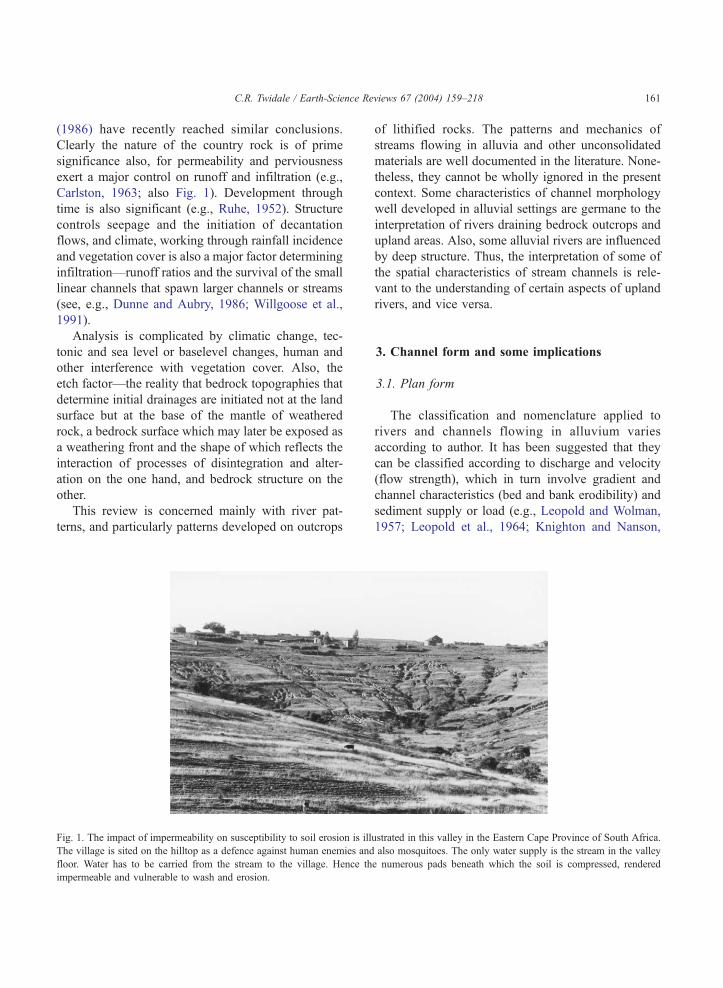
Carlston, 1963; also Fig. 1). Development through
time is also significant (e.g., Ruhe, 1952). Structure
controls seepage and the initiation of decantation
flows, and climate, working through rainfall incidence
and vegetation cover is also a major factor determining
infiltration—runoff ratios and the survival of the small
linear channels that spawn larger channels or streams
(see, e.g., Dunne and Aubry, 1986; Willgoose et al.,
1991).
Analysis is complicated by climatic change, tec-
tonic and sea level or baselevel changes, human and
other interference with vegetation cover. Also, the
etch factor—the reality that bedrock topographies that
determine initial drainages are initiated not at the land
surface but at the base of the mantle of weathered
rock, a bedrock surface which may later be exposed as
a weathering front and the shape of which reflects the
interaction of processes of disintegration and alter-
ation on the one hand, and bedrock structure on the
other.
This review is concerned mainly with river pat-
terns, and particularly patterns developed on outcrops
Fig. 1. The impact of impermeability on susceptibility to soil erosion is ill
The village is sited on the hilltop as a defence against human enemies and
floor. Water has to be carried from the stream to the village. Hence th
impermeable and vulnerable to wash and erosion.
of lithified rocks. The patterns and mechanics of
streams flowing in alluvia and other unconsolidated
materials are well documented in the literature. None-
theless, they cannot be wholly ignored in the present
context. Some characteristics of channel morphology
well developed in alluvial settings are germane to the
interpretation of rivers draining bedrock outcrops and
upland areas. Also, some alluvial rivers are influenced
by deep structure. Thus, the interpretation of some of
the spatial characteristics of stream channels is rele-
vant to the understanding of certain aspects of upland
rivers, and vice versa.
3. Channel form and some implications
3.1. Plan form
The classification and nomenclature applied to
rivers and channels flowing in alluvium varies
according to author. It has been suggested that they
can be classified according to discharge and velocity
(flow strength), which in turn involve gradient and
channel characteristics (bed and bank erodibility) and
sediment supply or load (e.g., Leopold and Wolman,
1957; Leopold et al., 1964; Knighton and Nanson,
ustrated in this valley in the Eastern Cape Province of South Africa.
also mosquitoes. The only water supply is the stream in the valley
e numerous pads beneath which the soil is compressed, rendered
C.R. Twidale / Earth-Science Reviews 67 (2004) 159–218162
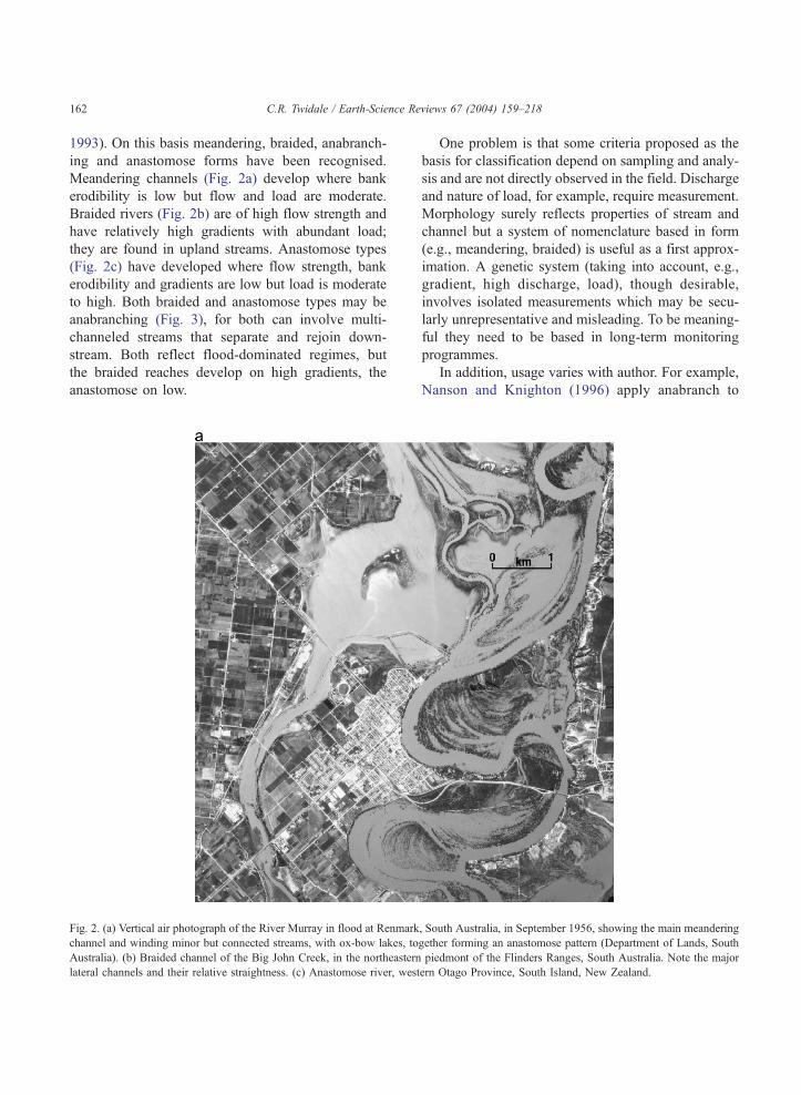
1993). On this basis meandering, braided, anabranch-
ing and anastomose forms have been recognised.
Meandering channels (Fig. 2a) develop where bank
erodibility is low but flow and load are moderate.
Braided rivers (Fig. 2b) are of high flow strength and
have relatively high gradients with abundant load;
they are found in upland streams. Anastomose types
(Fig. 2c) have developed where flow strength, bank
erodibility and gradients are low but load is moderate
to high. Both braided and anastomose types may be
anabranching (Fig. 3), for both can involve multi-
channeled streams that separate and rejoin down-
stream. Both reflect flood-dominated regimes, but
the braided reaches develop on high gradients, the
anastomose on low.
Fig. 2. (a) Vertical air photograph of the River Murray in flood at Renmark
channel and winding minor but connected streams, with ox-bow lakes, to
Australia). (b) Braided channel of the Big John Creek, in the northeastern
lateral channels and their relative straightness. (c) Anastomose river, west
One problem is that some criteria proposed as the
basis for classification depend on sampling and analy-
sis and are not directly observed in the field. Discharge
and nature of load, for example, require measurement.
Morphology surely reflects properties of stream and
channel but a system of nomenclature based in form
(e.g., meandering, braided) is useful as a first approx-
imation. A genetic system (taking into account, e.g.,
gradient, high discharge, load), though desirable,
involves isolated measurements which may be secu-
larly unrepresentative and misleading. To be meaning-
ful they need to be based in long-term monitoring
programmes.
In addition, usage varies with author. For example,
Nanson and Knighton (1996) apply anabranch to
, South Australia, in September 1956, showing the main meandering
gether forming an anastomose pattern (Department of Lands, South
piedmont of the Flinders Ranges, South Australia. Note the major
ern Otago Province, South Island, New Zealand.
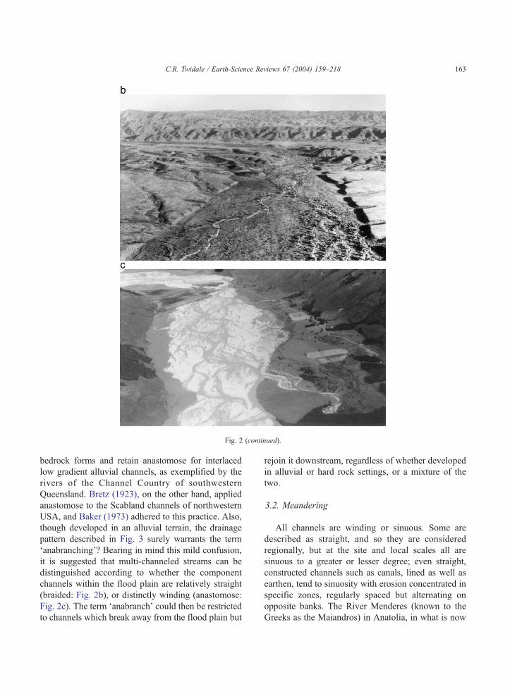
Fig. 2 (continued).
C.R. Twidale / Earth-Science Reviews 67 (2004) 159–218 163
bedrock forms and retain anastomose for interlaced
low gradient alluvial channels, as exemplified by the
rivers of the Channel Country of southwestern
Queensland. Bretz (1923), on the other hand, applied
anastomose to the Scabland channels of northwestern
USA, and Baker (1973) adhered to this practice. Also,
though developed in an alluvial terrain, the drainage
pattern described in Fig. 3 surely warrants the term
‘anabranching’? Bearing in mind this mild confusion,
it is suggested that multi-channeled streams can be
distinguished according to whether the component
channels within the flood plain are relatively straight
(braided: Fig. 2b), or distinctly winding (anastomose:
Fig. 2c). The term ‘anabranch’ could then be restricted
to channels which break away from the flood plain but
rejoin it downstream, regardless of whether developed
in alluvial or hard rock settings, or a mixture of the
two.
3.2. Meandering
All channels are winding or sinuous. Some are
described as straight, and so they are considered
regionally, but at the site and local scales all are
sinuous to a greater or lesser degree; even straight,
constructed channels such as canals, lined as well as
earthen, tend to sinuosity with erosion concentrated in
specific zones, regularly spaced but alternating on
opposite banks. The River Menderes (known to the
Greeks as the Maiandros) in Anatolia, in what is now
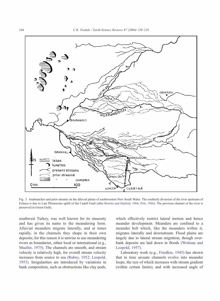
Fig. 3. Anabranches and prior streams on the alluvial plains of southwestern New South Wales. The southerly diversion of the river upstream of
Echuca is due to Late Pleistocene uplift of the Cadell Fault (after Bowler and Harford, 1966; Pels, 1966). The previous channel of the river is
preserved in Green Gully.
C.R. Twidale / Earth-Science Reviews 67 (2004) 159–218164
southwest Turkey, was well known for its sinuosity
and has given its name to the meandering form.
Alluvial meanders migrate laterally, and at times
rapidly, in the channels they shape in their own
deposits; for this reason it is unwise to use meandering
rivers as boundaries, either local or international (e.g.,
Mueller, 1975). The channels are smooth, and stream
velocity is relatively high, for overall stream velocity
increases from source to sea (Rubey, 1952; Leopold,
1953). Irregularities are introduced by variations in
bank composition, such as obstructions like clay pods,
which effectively restrict lateral motion and hence
meander development. Meanders are confined to a
meander belt which, like the meanders within it,
migrates laterally and downstream. Flood plains are
largely due to lateral stream migration, though over-
bank deposits are laid down in floods (Wolman and
Leopold, 1957).
Laboratory work (e.g., Friedkin, 1945) has shown
that in time arcuate channels evolve into meander
loops, the size of which increases with stream gradient
(within certain limits), and with increased angle of
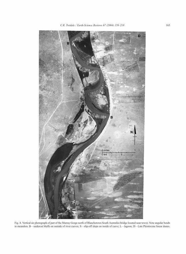
Fig. 4. Vertical air photograph of part of the Murray Gorge north of Blanchetown South Australia (bridge located near town). Note angular bends
in meanders. B—undercut bluffs on outside of river curves; S—slip-off slope on inside of curve; L—lagoon; D—Late Pleistocene linear dunes.
C.R. Twidale / Earth-Science Reviews 67 (2004) 159–218 165
C.R. Twidale / Earth-Science Re166
attack or degree of non-parallelism between current and
banks. Also, as more sediment enters a flow the more
rapidly are loops developed. There is a fairly constant
relationship between stream discharge (Q) at bankfull
stage, width of channel, meander radius, and wave
length, all being proportional to the square root of
discharge (Q1/2) (Leopold andWolman, 1960; Leopold
et al., 1964).
The depth of the channel is not constant, for the
bed consists of regular alternations of pools, and
shoals, bars or riffles in a downstream direction. All
else being equal, the more sinuous a stream the deeper
it is. The meander belt migrates laterally as well as
downstream, and within it meanders also develop
increasing sinuosity, eventually producing cut-offs or
oxbow lakes. Meanders also migrate downstream, in
places gradually but elsewhere so rapidly as to pro-
duce angular bends, rather than smooth curves, where
the migrating channel cuts across and intersects the
next loop downstream (Fig. 4). In flood, the channel
tends to straighten and chutes are formed cutting
across the inside of the river curves.
Most meanders are smooth so that the curvature is
as gentle as possible. This suggests that frictional
losses are minimal and that the meander is a ‘least
work’ form. Chance obstructions undoubtedly induce
diversions, unequal flow and curves and meanders that
are transmitted downstream. Transfer of load within
the channel from the inside to the outside of curves is
an effect rather than a cause, for meanders form in
streams of water devoid of sediment. If the rotation of
the earth as expressed in the Coriolis Force affected
river flow, as has been suggested, northern hemisphere
rivers ought preferentially to erode their right banks
and southern hemisphere flows, the left, but there is no
evidence that this consistently has taken place.
It can be argued that where one medium, water,
flows over another, rock, a wave motion is produced,
creating areas of high and low velocity, of erosion (or
non-deposition) and deposition, or pools and shoals.
Deposition could cause channel widening, an in-
crease in wetted perimeter and loss of energy. Bank
erosion could be concentrated in areas of high bed
velocity and hydraulic efficiency resulting in differ-
ential bank erosion, a winding course and, eventually,
meanders. On the other hand, the formation of pools
and shoals could be an effect, rather than a cause, of
meanders.
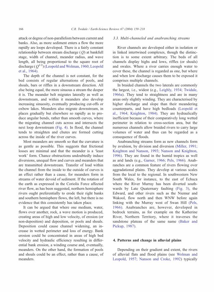
3.3. Multi-channeled and anabranching streams
River channels are developed either in isolation or
in linked intertwined complexes, though the distinc-
tion is to some extent arbitrary. The beds of all
channels display highs and lows, riffles (or shoals)
and swales. Where a river carries enough water to
cover these, the channel is regarded as one, but where
and when low discharge causes them to be exposed it
comprises multiple channels.
In braided channels the two laterals are commonly
the largest, i.e., widest (e.g., Leighly, 1934; Twidale,
1966a). They tend to straightness and are in many
areas only slightly winding. They are characterised by
higher discharge and slope than their meandering
counterparts, and have high bedloads (Leopold et
al., 1964; Knighton, 1984). They are hydraulically
inefficient because of their comparatively long wetted
perimeter in relation to cross-section area, but the
numerous channels allow braided rivers to carry large
volumes of water and thus can be regarded as a
consequence of floods.
Anabranching streams form as new channels form
by avulsion, by division and diversion (Miller, 1991;
Knighton and Nanson, 1993; Nanson and Knighton,
1996). They are found in the humid tropics as well
as arid lands (e.g., Garner, 1966; Pels, 1966). Anab-
ranches are a common feature of rivers flowing over
aggradational plains. They develop at various scales
from the local to the regional. In southwestern New
South Wales, for instance, to the east of Echuca
where the River Murray has been diverted south-
wards by Late Quaternary faulting (Fig. 3), the
Edward, and other rivers such as the Niemur and
Wakool, flow north and then WNW before again
linking with the Murray west of Swan Hill (Pels,
1966). Anabranches are, however, developed in
bedrock terrains, as for example on the Katherine
River, Northern Territory, where it traverses the
sandstone plateau of the same name (Baker and
Pickup, 1987).
views 67 (2004) 159–218
4. Patterns and change in alluvial plains
Depending on their gradient and extent, the rivers
of alluvial flats and flood plains (see Wolman and
Leopold, 1957; Nanson and Croke, 1992) typically
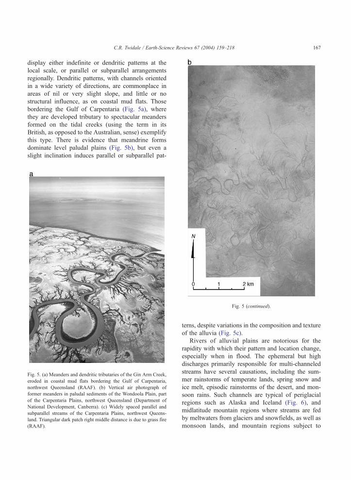
C.R. Twidale / Earth-Science Reviews 67 (2004) 159–218 167
display either indefinite or dendritic patterns at the
local scale, or parallel or subparallel arrangements
regionally. Dendritic patterns, with channels oriented
in a wide variety of directions, are commonplace in
areas of nil or very slight slope, and little or no
structural influence, as on coastal mud flats. Those
bordering the Gulf of Carpentaria (Fig. 5a), where
they are developed tributary to spectacular meanders
formed on the tidal creeks (using the term in its
British, as opposed to the Australian, sense) exemplify
this type. There is evidence that meandrine forms
dominate level paludal plains (Fig. 5b), but even a
slight inclination induces parallel or subparallel pat-
Fig. 5. (a) Meanders and dendritic tributaries of the Gin Arm Creek,
eroded in coastal mud flats bordering the Gulf of Carpentaria,
northwest Queensland (RAAF). (b) Vertical air photograph of
former meanders in paludal sediments of the Wondoola Plain, part
of the Carpentaria Plains, northwest Queensland (Department of
National Development, Canberra). (c) Widely spaced parallel and
subparallel streams of the Carpentaria Plains, northwest Queens-
land. Triangular dark patch right middle distance is due to grass fire
(RAAF).
Fig. 5 (continued).
terns, despite variations in the composition and texture
of the alluvia (Fig. 5c).
Rivers of alluvial plains are notorious for the
rapidity with which their pattern and location change,
especially when in flood. The ephemeral but high
discharges primarily responsible for multi-channeled
streams have several causations, including the sum-
mer rainstorms of temperate lands, spring snow and
ice melt, episodic rainstorms of the desert, and mon-
soon rains. Such channels are typical of periglacial
regions such as Alaska and Iceland (Fig. 6), and
midlatitude mountain regions where streams are fed
by meltwaters from glaciers and snowfields, as well as
monsoon lands, and mountain regions subject to
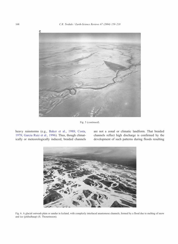
Fig. 5 (continued).
C.R. Twidale / Earth-Science Reviews 67 (2004) 159–218168
heavy rainstorms (e.g., Baker et al., 1988; Costa,
1978; Garcia Ruiz et al., 1996). Thus, though climat-
ically or meteorologically induced, braided channels
Fig. 6. A glacial outwash plain or sandur in Iceland, with complexly interla
and ice (jokhulhaup) (S. Thorarinsson).
are not a zonal or climatic landform. That braided
channels reflect high discharge is confirmed by the
development of such patterns during floods resulting
ced anastomose channels, formed by a flood due to melting of snow
C.R. Twidale / Earth-Science Reviews 67 (2004) 159–218 169
from catastrophic events such as dam-bursts (e.g.,
Kiersch, 1964). The failure of the Malpasset Dam
near Frejus (between Cannes and Toulon) in southern
France, released a huge volume of water and huge
blocks of rock and other debris were carried on the
resultant flood (Tricart, 1960). Where it emerged from
the upland, the River Reyran spread over the land-
scape in innumerable small channels and overland
comparable with relic distributary streams on covered
pediments shaped in the piedmonts of semiarid
uplands (e.g., Twidale, 1981; Bourne and Twidale,
1998).
Demonstrated rates of change in rivers flowing in
their own alluvium are astonishing: the Brahmaputra,
10 km in the last 150 years; the Kosi, 113 km in 228
years; the Tisza, 100 km during the Holocene, and so
Fig. 7. Location map of northeast China showing changing course of Hw
(British Admiralty), 1943).
on (see Osborn and du Toit, 1990). Such recent
changes of river position are not temporally atypical.
Extant rivers have moved laterally during the later
Cainozoic. For example, the Red Deer River has
migrated at least 5 km in the later Pleistocene; the
Missouri in northeastern Montana, some 80 km in last
10 Ma; the Yellowstone, 56 km in the last 7 Ma; in the
Black Hills of Dakota, Rapid Creek has shifted 8 km
since the Miocene; in Nebraska, Pumpkin Creek has
moved laterally 6 km during the Quaternary, and the
Potomac River about 90 km (for references, see
Osborn and du Toit, 1990).
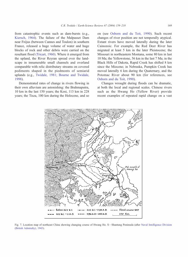
Changes wrought during floods can be dramatic,
at both the local and regional scales. Chinese rivers
such as the Hwang Ho (Yellow River) provide
recent examples of repeated rapid change on a vast
ang Ho. S—Shantung Peninsula (after Naval Intelligence Division
C.R. Twidale / Earth-Science Reviews 67 (2004) 159–218170
scale (Fig. 7). The fertile plain of the lower Hwang
Ho is the gift of the river in that it is a deltaic
alluvial plain deposited by the river below Kaifeng.
It is, however, also known as China’s sorrow
because of the disastrous floods frequently generated
on it. In this middle sector, around Tungkwan the
Hwang is joined by the Wei and Fen both of which
contribute immense quantities of silt derived from
the loess plateau. Here the river may carry as much
as 40% by weight in sediment, and some of its
tributaries as much as 48%. By contrast, it is rare to
find sediment amounting to more than 10% by
weight in ‘normal’ rivers, and even 2–3% is con-
sidered high.
What is now the Shantung Peninsula was once an
island which has been linked to the mainland as a
result of alluviation of the Hwang Ho. The river has
repeatedly broken its banks, flooded, migrated and
reestablished itself elsewhere. At one time or another
it has occupied almost every part of the plain from
Tiensin in the north to the lakes of northern Kiangsu
in the south. From 602 BC to 1194 AD, it flowed to
the Gulf of Pohai to the north of the present outlet,
and before that even further north, not far south of
Shanhaikwan, near where the Great Wall reaches the
sea. But from 1194 to 1853 its course from Kaifeng
was ESE to an outfall far south of the Shantung
Peninsula, usurping the channel of the lower Hwang
Ho. Then, following a great flood and destruction of
dykes in 1853–1855, the Hwang changed to its
present course, reaching the sea just north of the
Shantung Peninsula. Floods occurred due to the river
silting and building up its own bed between levees,
eventually bursting or overtopping banks (Naval In-
telligence Division, 1943). Yet the 1853 flood event
was by no means the greatest on the river, for
sedimentological evidence shows that it was exceeded
four times between 6000 and 8000 years ago (Yang et
al., 2000).
By contrast with the Chinese experience, however,
some floods apparently achieve little in the way of
either erosion or deposition. Thus during the 1974
monsoonal flooding of the Carpentaria Plains the
turbid waters of rivers draining the Isa Highlands
were essentially confined to the channels. There was
extensive flooding near the coast, and inland the broad
flat riverless plains carried standing water, which
drained into marginal channels when their levels fell.
There was some gullying but overall little change to
the Plio-Pleistocene plains (Simpson and Doutch,
1977).
5. River patterns
5.1. General remarks on the nature of rivers and river
patterns
Hills (1963, p. 439) remarked that possibly the
greatest aid that geomorphology offers to structural
geology is to be derived from drainage patterns. They
not only provide clues as to possible structure, for
example fracture patterns and bedrock type, but they
also assist in unravelling local and regional geological
chronology. In addition, the development of river
patterns is relevant to the search for diamonds (e.g.,
de Wit, 1999), gold (e.g., Clark, 1966) and uranium
minerals (e.g., Binks and Hooper, 1984).
River patterns develop through natural selection.
On an initial slope (for the sake of discussion, a raised
and tilted seafloor or a volcanic slope) runoff forms
overland linear flows, the spacing of which is a
function of rock permeability and discharge (in time
and space) and of slope. Of, let us say, 10 channels on a
particular slope sector, one will become the dominant
or master stream, most likely because its course
coincides with a weakness in the substrate—a less
permeable outcrop or a fracture, perhaps. Alternative-
ly, the complex of factors determining drainage density
may come into play.
Once a river incises its bed more than its com-
petitors, it attracts more groundwater flow and runoff
simply because it is the local lowest baselevel.
Positive feedback effects cut in and subject only to
baselevel control, the erosional potential of the
master river is increasingly enhanced. Moreover,
erosion is unequal (Crickmay, 1932, 1976). Energy
is concentrated within and near river channels. Quite
extensive divides either lack enduring channels
(Knopf, 1924; Horton, 1945)—even rills are ephem-
eral (e.g., Dunne and Aubry, 1986)—or are charac-
terised by dry valleys (e.g., Dietrich et al., 1986).
Thus, river patterns ought to be long-lasting and
many are, even in terms of geological time. Extant
rivers of at least Eocene age have been recognised in
the Yilgarn of Western Australia (Van de Graaff et
C.R. Twidale / Earth-Science Reviews 67 (2004) 159–218 171
al., 1977; Commander, 1989; Clarke, 1994) and in
the Mt. Lofty and Flinders ranges of South Australia
(Twidale, 1997).
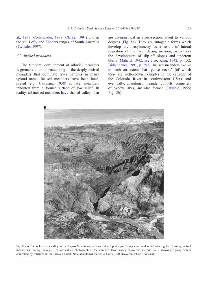
5.2. Incised meanders
The temporal development of alluvial meanders
is germane to an understanding of the deeply incised
meanders that dominate river patterns in many
upland areas. Incised meanders have been inter-
preted (e.g., Campana, 1958) as river meanders
inherited from a former surface of low relief. In
reality, all incised meanders have shaped valleys that
Fig. 8. (a) Entrenched river valley in the Zagros Mountains, with well dev
meanders (Hunting Surveys). (b) Vertical air photograph of the Zambe
controlled by fractures in the Jurassic basalt. Note abandoned incised cut-
are asymmetrical in cross-section, albeit to various
degrees (Fig. 8a). They are autogenic forms which
develop their asymmetry as a result of lateral
migration of the river during incision, as witness
the development of slip-off slopes and undercut
bluffs (Mahard, 1942; see also, King, 1942, p. 152;
Birkenhauer, 1991, p. 297). Incised meanders evolve
to such an extent that ‘goose necks’ (of which
there are well-known examples in the canyons of
the Colorado River in southwestern USA), and
eventually, abandoned meander cut-offs, congeners
of oxbow lakes, are also formed (Twidale, 1955;
Fig. 8b).
eloped slip-off slopes and undercut bluffs together forming incised
zi River valley below the Victoria Falls, showing zig-zag pattern
offs (CO) (Government of Rhodesia).
Fig. 8 (continued).
C.R. Twidale / Earth-Science Reviews 67 (2004) 159–218172
In greater measure than their plains counterparts,
incised meanders display structural control. East of
Adelaide, where the River Torrens flows through the
western margin of the Mt. Lofty Ranges, it pursues a
winding course in its gorge section. The river channel
and gorge trend parallel to strike (in phyllite) and
cleavage (in gneiss) for a substantial proportion of
their length in this sector (Twidale, 1972). The straight
arms of the intrenched Shenandoah River near Stras-
burg, VA, are other notable examples.
5.3. Adjusted and anomalous patterns
The spatial arrangements of streams and rivers can
be considered adjusted to or concordant with slope and
structure, or anomalous (transverse, exotic) in terms of
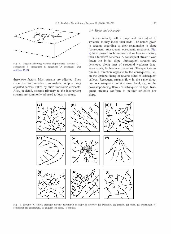
Fig. 9. Diagram showing various slope-related streams: C—
consequent; S—subsequent; R—resequent; O—obsequent (after
Johnson, 1932).
C.R. Twidale / Earth-Science Re
these two factors. Most streams are adjusted. Even
rivers that are considered anomalous comprise long
adjusted sectors linked by short transverse elements.
Also, in detail, streams tributary to the incongruent
streams are commonly adjusted to local structure.
Fig. 10. Sketches of various drainage patterns determined by slope or
centripetal, (f ) distributary, (g) angular, (h) trellis, (i) annular.
5.4. Slope and structure
Rivers initially follow slope and then adjust to
structure as they incise their beds. The names given
to streams according to their relationship to slope
(consequent, subsequent, obsequent, resequent: Fig.
9) have proved to be impractical or less satisfactory
than alternative schemes. A consequent stream flows
down the initial slope. Subsequent streams are
developed along lines of structural weakness (e.g.,
weak strata, by headward erosion). Obsequent rivers
run in a direction opposite to the consequents, i.e.,
on the upslope-facing or reverse sides of subsequent
valleys. Resequent streams flow in the same direc-
tion as consequents but at a lower level, e.g., on the
downslope-facing flanks of subsequent valleys. Inse-
quent streams conform to neither structure nor
slope.
views 67 (2004) 159–218 173
structure. (a) Dendritic, (b) parallel, (c) radial, (d) centrifugal, (e)
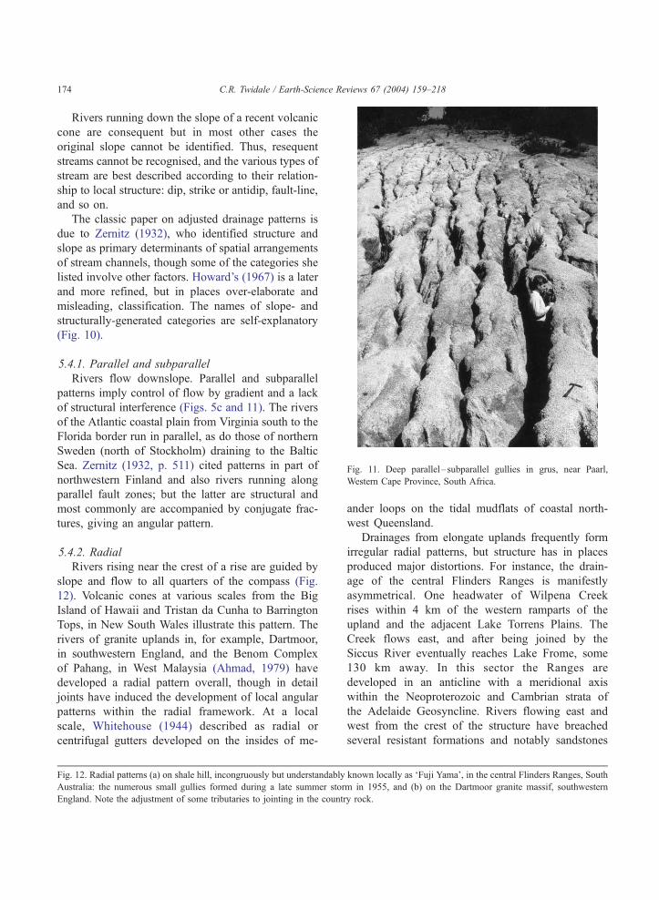
Fig. 11. Deep parallel–subparallel gullies in grus, near Paarl,
Western Cape Province, South Africa.
C.R. Twidale / Earth-Science Reviews 67 (2004) 159–218174
Rivers running down the slope of a recent volcanic
cone are consequent but in most other cases the
original slope cannot be identified. Thus, resequent
streams cannot be recognised, and the various types of
stream are best described according to their relation-
ship to local structure: dip, strike or antidip, fault-line,
and so on.
The classic paper on adjusted drainage patterns is
due to Zernitz (1932), who identified structure and
slope as primary determinants of spatial arrangements
of stream channels, though some of the categories she
listed involve other factors. Howard’s (1967) is a later
and more refined, but in places over-elaborate and
misleading, classification. The names of slope- and
structurally-generated categories are self-explanatory
(Fig. 10).
5.4.1. Parallel and subparallel
Rivers flow downslope. Parallel and subparallel
patterns imply control of flow by gradient and a lack
of structural interference (Figs. 5c and 11). The rivers
of the Atlantic coastal plain from Virginia south to the
Florida border run in parallel, as do those of northern
Sweden (north of Stockholm) draining to the Baltic
Sea. Zernitz (1932, p. 511) cited patterns in part of
northwestern Finland and also rivers running along
parallel fault zones; but the latter are structural and
most commonly are accompanied by conjugate frac-
tures, giving an angular pattern.
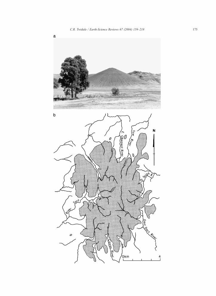
5.4.2. Radial
Rivers rising near the crest of a rise are guided by
slope and flow to all quarters of the compass (Fig.
12). Volcanic cones at various scales from the Big
Island of Hawaii and Tristan da Cunha to Barrington
Tops, in New South Wales illustrate this pattern. The
rivers of granite uplands in, for example, Dartmoor,
in southwestern England, and the Benom Complex
of Pahang, in West Malaysia (Ahmad, 1979) have
developed a radial pattern overall, though in detail
joints have induced the development of local angular
patterns within the radial framework. At a local
scale, Whitehouse (1944) described as radial or
centrifugal gutters developed on the insides of me-
Fig. 12. Radial patterns (a) on shale hill, incongruously but understandably
Australia: the numerous small gullies formed during a late summer stor
England. Note the adjustment of some tributaries to jointing in the countr
ander loops on the tidal mudflats of coastal north-
west Queensland.
Drainages from elongate uplands frequently form
irregular radial patterns, but structure has in places
produced major distortions. For instance, the drain-
age of the central Flinders Ranges is manifestly
asymmetrical. One headwater of Wilpena Creek
rises within 4 km of the western ramparts of the
upland and the adjacent Lake Torrens Plains. The
Creek flows east, and after being joined by the
Siccus River eventually reaches Lake Frome, some
130 km away. In this sector the Ranges are
developed in an anticline with a meridional axis
within the Neoproterozoic and Cambrian strata of
the Adelaide Geosyncline. Rivers flowing east and
west from the crest of the structure have breached
several resistant formations and notably sandstones
known locally as ‘Fuji Yama’, in the central Flinders Ranges, South
m in 1955, and (b) on the Dartmoor granite massif, southwestern
y rock.
C.R. Twidale / Earth-Science Reviews 67 (2004) 159–218 175
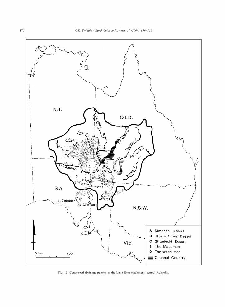
Fig. 13. Centripetal drainage pattern of the Lake Eyre catchment, central Australia.
C.R. Twidale / Earth-Science Reviews 67 (2004) 159–218176
C.R. Twidale / Earth-Science Reviews 67 (2004) 159–218 177
and quartzites, but because the source of detritus
deposited in the Geosyncline was to the west (the
Gawler Craton), strata are thicker on the west and
thinner to the east. Thus, the Pound Subgroup
arenaceous beds (Rawnsley Quartzite and Bonney
Sandstone) are about three times as thick in the
west as to the east. For this reason the east-flowing
streams were able to incise their beds more rapidly
than their western counterparts, and headed back to
capture many of the original west-flowing streams.
The stratigraphic evidence shows that this pattern
has developed over a period of at least 130 million
years (Twidale and Bourne, 1996).
5.4.3. Centripetal
Rivers that converge upon a common area form
a centripetal pattern. They have developed at var-
ious scales. Lake Eyre is the focus of a catchment
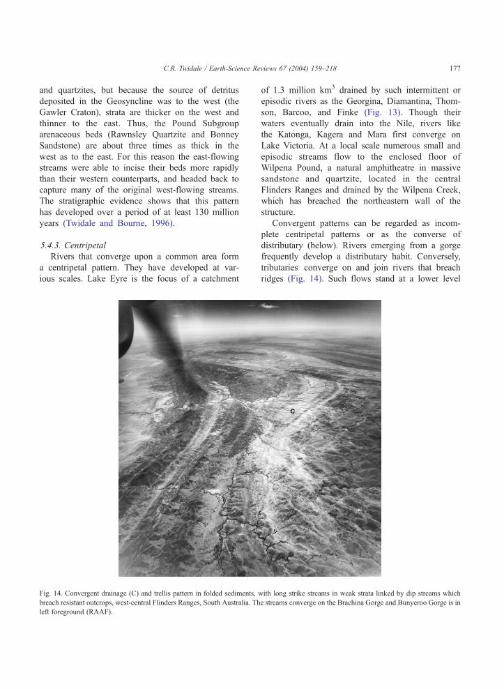
Fig. 14. Convergent drainage (C) and trellis pattern in folded sediments, w
breach resistant outcrops, west-central Flinders Ranges, South Australia. Th
left foreground (RAAF).
of 1.3 million km3 drained by such intermittent or
episodic rivers as the Georgina, Diamantina, Thom-
son, Barcoo, and Finke (Fig. 13). Though their
waters eventually drain into the Nile, rivers like
the Katonga, Kagera and Mara first converge on
Lake Victoria. At a local scale numerous small and
episodic streams flow to the enclosed floor of
Wilpena Pound, a natural amphitheatre in massive
sandstone and quartzite, located in the central
Flinders Ranges and drained by the Wilpena Creek,
which has breached the northeastern wall of the
structure.
Convergent patterns can be regarded as incom-
plete centripetal patterns or as the converse of
distributary (below). Rivers emerging from a gorge
frequently develop a distributary habit. Conversely,
tributaries converge on and join rivers that breach
ridges (Fig. 14). Such flows stand at a lower level
ith long strike streams in weak strata linked by dip streams which
e streams converge on the Brachina Gorge and Bunyeroo Gorge is in
C.R. Twidale / Earth-Science Re178
than any others in the vicinity, and for this reason river
capture (q.v.) is frequently involved in the develop-
ment of convergence.
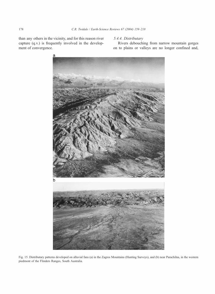
Fig. 15. Distributary patterns developed on alluvial fans (a) in the Zagros M
piedmont of the Flinders Ranges, South Australia.
5.4.4. Distributary
Rivers debouching from narrow mountain gorges
on to plains or valleys are no longer confined and,
views 67 (2004) 159–218
ountains (Hunting Surveys), and (b) near Parachilna, in the western
C.R. Twidale / Earth-Science Reviews 67 (2004) 159–218 179
especially in episodic or periodic floods, tend to
break their banks and develop a multitude of chan-
nels (Fig. 15). Total wetted perimeter relative to total
cross-section area of channels is increased and de-
position is induced. In the western piedmont of the
Flinders Ranges, however, both covered pediments
and alluvial fans have been shaped by distributary
streams. Both of these forms, one essentially ero-
sional, the other depositional, are fan-shaped, sloping
down in all directions within the half-circle originat-
ing at the apex or point of debouchment of the river.
Both display radiating, distributary or divaricating
(Blackwelder, 1931) stream patterns comprising nu-
merous interlaced channels, the location of which
can change in major floods. Whether pediment or
fan has formed depends on the character of the load
and to some extent relief amplitude, which in turn
vary with the nature of the catchment (Bourne and
Twidale, 1998).
Deltas form where rivers flow into the ocean or
lakes. Various patterns develop according to the
relative densities of the river and sea waters (Bates,
1953): long comparatively narrow deltas where the
incoming flood flow is heavier than the sea or lake
water (the Colorado in Lake Mead), arcuate or fan-
shaped where the two are roughly the same (the Nile
Delta), but elongate and distributary where the river
water is less dense than the sea—the bird foot type
exemplified by the Mississippi Delta.
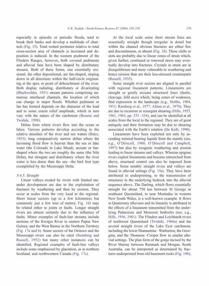
5.4.5. Straight
Linear valleys eroded by rivers with limited me-
ander development are due to the exploitation of
fractures by weathering and then by erosion. They
occur at scales from the very local to the regional.
Short linear sectors (up to a few kilometres but
commonly just a few tens of metres; Fig. 16) may
be related either to joints or faults. Longer straight
rivers are almost certainly due to the influence of
faults. Minor examples of fault-line streams include
sections of the Kwagia River in eastern Papua New
Guinea, and the West Baines in the Northern Territory
(Fig. 17a and b). Some sectors of the Orinoco and the
Mississippi rivers can also be cited (Sternberg and
Russell, 1952) but many other instances can be
identified. Regional examples of fault-line valleys
include some emphasised by glaciation, as in northern
Scotland, and northwestern Canada (Fig. 17c).
At the local scale some short stream lines are
essentially straight though irregular in detail but
within the channel obvious fractures are either few
and discontinuous, or absent (Fig. 18). These clefts or
slots are probably due to linear zones of strain which,
given further, continued or renewed stress may even-
tually develop into fractures. Crystals in strain are in
disequilibrium and more vulnerable to weathering and
hence erosion than are their less-stressed counterparts
(Russell, 1935).
Some straight river sectors are aligned in parallel
with regional lineament patterns. Lineaments are
straight or gently arcuate structural lines (faults,
cleavage, fold axes) which, being zones of weakness,
find expression in the landscape (e.g., Hobbs, 1904,
1911; Ramberg et al., 1977; Allum et al., 1978). They
are due to recurrent or resurgent shearing (Hills, 1955,
1961, 1963, pp. 333–334), and can be identified at all
scales from the local to the regional. They are of great
antiquity and their formation may be due to shearing
associated with the Earth’s rotation (De Kalb, 1990).
Lineaments have been exploited not only by as-
cending mineral-bearing liquids from the mantle (see,
e.g., O’Driscoll, 1986; O’Driscoll and Campbell,
1997) but also by exogenic weathering and erosion
leading to linear streams and valleys. Whereas epigene
rivers exploit lineaments and become entrenched from
above, structural control can also be imposed from
below. Some notably straight rivers and valleys are
found in alluvial settings (Fig. 19a). They have been
attributed to underprinting, to the transmission of
structures in the underlying bedrock into the alluvial
sequence above. The Darling, which flows essentially
straight for about 750 km between St George in
southeast Queensland, to near Menindee in western
New South Wales, is a well-known example. It flows
in Quaternary alluvium and its linearity is attributed to
the effects of a lineament transmitted from the under-
lying Palaeozoic and Mesozoic bedrocks (see, e.g.,
Hills, 1956, 1961). The Flinders and Leichhardt rivers
of northwest Queensland (Twidale, 1966a) and the
several straight rivers of the Lake Eyre catchment,
including the lower Diamantina–Warburton, the Geor-
gina, and the Thomson–Cooper flow in similar allu-
vial settings. The plan form of the gorge incised by the
River Murray between Renmark and Morgan, South
Australia, can be interpreted as determined by frac-
tures underprinted from old basement rocks (Fig. 19b),
Fig. 16. (a) Straight clefts or slots developed along joints exploited by weathering and runoff, Paarlberg, Western Province, South Africa. (b)
Kluftkarren in granite developed along fracture zone, Kwaterski Rocks, northwestern Eyre Peninsula, South Australia. (c) Vertical air
photograph of straight streams in schist near Otago, South Island, New Zealand. The main drainage lines run parallel to the cleavage of the
bedrock. X—schist residual (N.Z. Government; see also Turner, 1952).
C.R. Twidale / Earth-Science Reviews 67 (2004) 159–218180
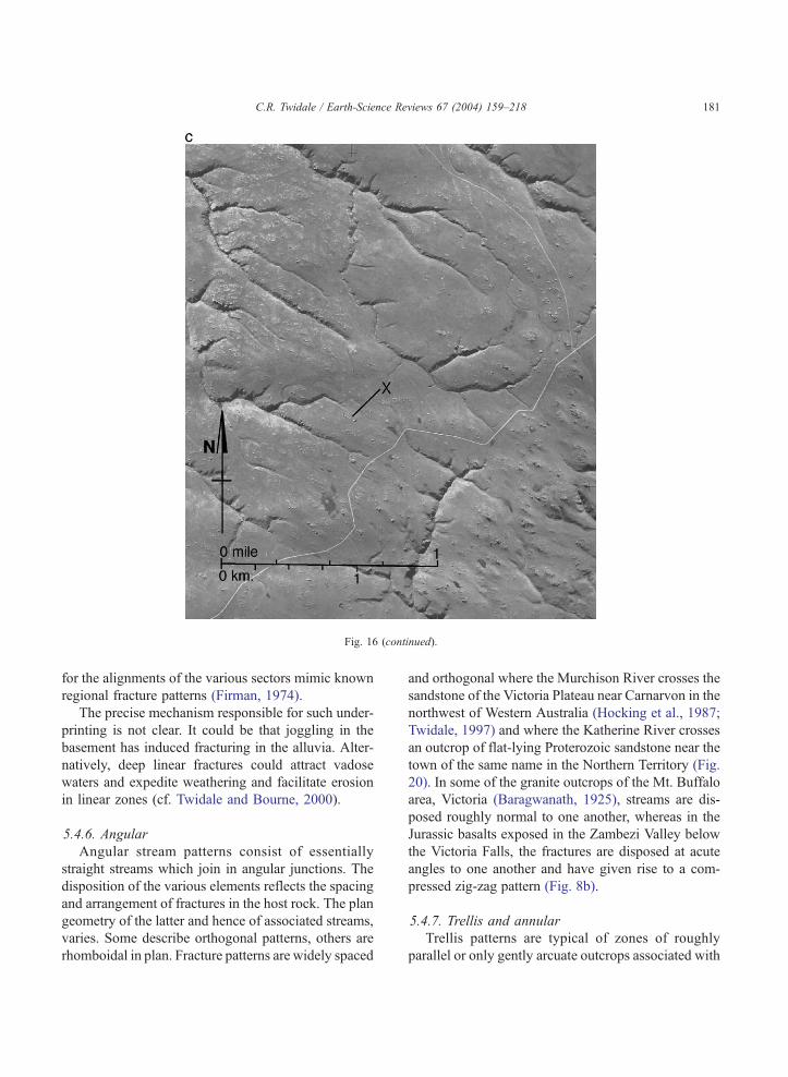
Fig. 16 (continued).
C.R. Twidale / Earth-Science Reviews 67 (2004) 159–218 181
for the alignments of the various sectors mimic known
regional fracture patterns (Firman, 1974).
The precise mechanism responsible for such under-
printing is not clear. It could be that joggling in the
basement has induced fracturing in the alluvia. Alter-
natively, deep linear fractures could attract vadose
waters and expedite weathering and facilitate erosion
in linear zones (cf. Twidale and Bourne, 2000).
5.4.6. Angular
Angular stream patterns consist of essentially
straight streams which join in angular junctions. The
disposition of the various elements reflects the spacing
and arrangement of fractures in the host rock. The plan
geometry of the latter and hence of associated streams,
varies. Some describe orthogonal patterns, others are
rhomboidal in plan. Fracture patterns are widely spaced
and orthogonal where the Murchison River crosses the
sandstone of the Victoria Plateau near Carnarvon in the
northwest of Western Australia (Hocking et al., 1987;
Twidale, 1997) and where the Katherine River crosses
an outcrop of flat-lying Proterozoic sandstone near the
town of the same name in the Northern Territory (Fig.
20). In some of the granite outcrops of the Mt. Buffalo
area, Victoria (Baragwanath, 1925), streams are dis-
posed roughly normal to one another, whereas in the
Jurassic basalts exposed in the Zambezi Valley below
the Victoria Falls, the fractures are disposed at acute
angles to one another and have given rise to a com-
pressed zig-zag pattern (Fig. 8b).
5.4.7. Trellis and annular
Trellis patterns are typical of zones of roughly
parallel or only gently arcuate outcrops associated with
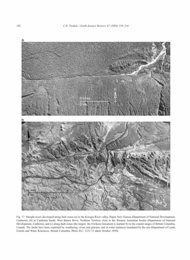
Fig. 17. Straight rivers developed along fault zones (a) in the Kwagia River valley, Papua New Guinea (Department of National Development,
Canberra), (b) in Cambrian basalt, West Baines River, Northern Territory close to the Western Australian border (Department of National
Development, Canberra), and (c) along fault zones (the largest, the Owikeno lineament is marked X) in the coastal ranges of British Columbia,
Canada. The faults have been exploited by weathering, rivers and glaciers, and in some instances inundated by the sea (Department of Lands
Forests and Water Resources, British Columbia. Photo B.C. 1231.72 taken October 1950).
C.R. Twidale / Earth-Science Reviews 67 (2004) 159–218182
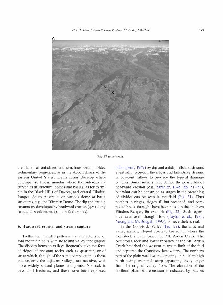
Fig. 17 (continued).
C.R. Twidale / Earth-Science Reviews 67 (2004) 159–218 183
the flanks of anticlines and synclines within folded
sedimentary sequences, as in the Appalachians of the
eastern United States. Trellis forms develop where
outcrops are linear, annular where the outcrops are
curved as in structural domes and basins, as for exam-
ple in the Black Hills of Dakota, and central Flinders
Ranges, South Australia, on various dome or basin
structures, e.g., the Blinman Dome. The dip and antidip
streams are developed by headward erosion (q.v.) along
structural weaknesses (joint or fault zones).
6. Headward erosion and stream capture
Trellis and annular patterns are characteristic of
fold mountain belts with ridge and valley topography.
The divides between valleys frequently take the form
of ridges of resistant rocks such as quartzite, or of
strata which, though of the same composition as those
that underlie the adjacent valleys, are massive, with
more widely spaced planes and joints. No rock is
devoid of fractures, and these have been exploited
(Thompson, 1949) by dip and antidip rills and streams
eventually to breach the ridges and link strike streams
in adjacent valleys to produce the typical drainage
patterns. Some authors have denied the possibility of
headward erosion (e.g., Strahler, 1945, pp. 51–52),
but what can be construed as stages in the breaching
of divides can be seen in the field (Fig. 21). Thus
notches in ridges, ridges all but breached, and com-
pleted break-throughs have been noted in the southern
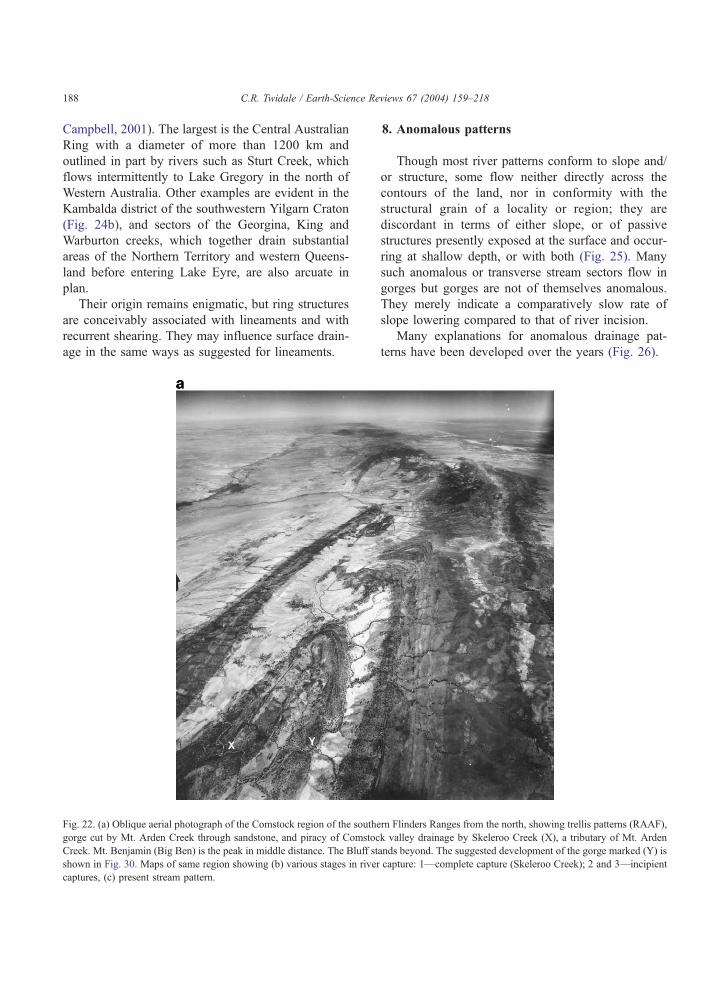
Flinders Ranges, for example (Fig. 22). Such regres-
sive extension, though slow (Taylor et al., 1985;
Young and McDougall, 1993), is nevertheless real.
In the Comstock Valley (Fig. 22), the anticlinal
valley initially sloped down to the south, where the
Comstock stream joined the Mt. Arden Creek. The
Skeleroo Creek and lower tributary of the Mt. Arden
Creek breached the western quartzite limb of the fold
and captured the Comstock headwaters. The northern
part of the plain was lowered creating an 8–10 m high
north-facing erosional scarp separating the younger
from the original valley floor. The elevation of the
northern plain before erosion is indicated by patches
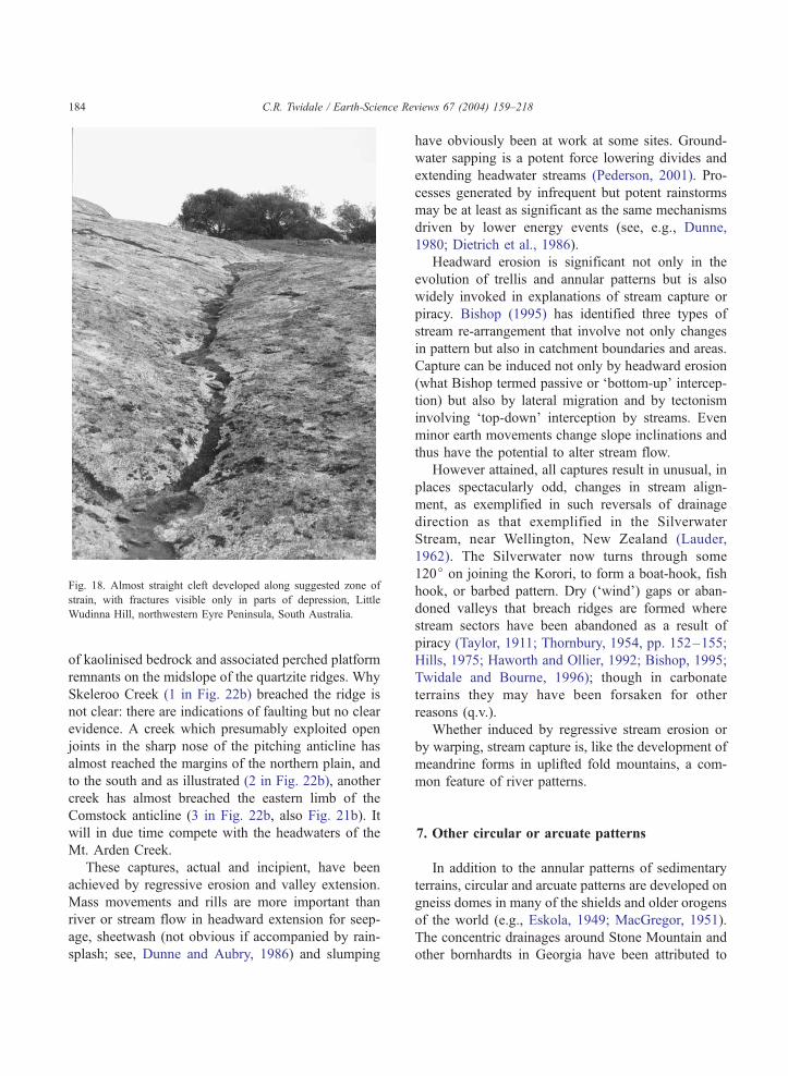
Fig. 18. Almost straight cleft developed along suggested zone of
strain, with fractures visible only in parts of depression, Little
Wudinna Hill, northwestern Eyre Peninsula, South Australia.
C.R. Twidale / Earth-Science Reviews 67 (2004) 159–218184
of kaolinised bedrock and associated perched platform
remnants on the midslope of the quartzite ridges. Why
Skeleroo Creek (1 in Fig. 22b) breached the ridge is
not clear: there are indications of faulting but no clear
evidence. A creek which presumably exploited open
joints in the sharp nose of the pitching anticline has
almost reached the margins of the northern plain, and
to the south and as illustrated (2 in Fig. 22b), another
creek has almost breached the eastern limb of the
Comstock anticline (3 in Fig. 22b, also Fig. 21b). It
will in due time compete with the headwaters of the
Mt. Arden Creek.
These captures, actual and incipient, have been
achieved by regressive erosion and valley extension.
Mass movements and rills are more important than
river or stream flow in headward extension for seep-
age, sheetwash (not obvious if accompanied by rain-
splash; see, Dunne and Aubry, 1986) and slumping
have obviously been at work at some sites. Ground-
water sapping is a potent force lowering divides and
extending headwater streams (Pederson, 2001). Pro-
cesses generated by infrequent but potent rainstorms
may be at least as significant as the same mechanisms
driven by lower energy events (see, e.g., Dunne,
1980; Dietrich et al., 1986).
Headward erosion is significant not only in the
evolution of trellis and annular patterns but is also
widely invoked in explanations of stream capture or
piracy. Bishop (1995) has identified three types of
stream re-arrangement that involve not only changes
in pattern but also in catchment boundaries and areas.
Capture can be induced not only by headward erosion
(what Bishop termed passive or ‘bottom-up’ intercep-
tion) but also by lateral migration and by tectonism
involving ‘top-down’ interception by streams. Even
minor earth movements change slope inclinations and
thus have the potential to alter stream flow.
However attained, all captures result in unusual, in
places spectacularly odd, changes in stream align-
ment, as exemplified in such reversals of drainage
direction as that exemplified in the Silverwater
Stream, near Wellington, New Zealand (Lauder,
1962). The Silverwater now turns through some
120j on joining the Korori, to form a boat-hook, fish
hook, or barbed pattern. Dry (‘wind’) gaps or aban-
doned valleys that breach ridges are formed where
stream sectors have been abandoned as a result of
piracy (Taylor, 1911; Thornbury, 1954, pp. 152–155;
Hills, 1975; Haworth and Ollier, 1992; Bishop, 1995;
Twidale and Bourne, 1996); though in carbonate
terrains they may have been forsaken for other
reasons (q.v.).
Whether induced by regressive stream erosion or
by warping, stream capture is, like the development of
meandrine forms in uplifted fold mountains, a com-
mon feature of river patterns.
7. Other circular or arcuate patterns
In addition to the annular patterns of sedimentary
terrains, circular and arcuate patterns are developed on
gneiss domes in many of the shields and older orogens
of the world (e.g., Eskola, 1949; MacGregor, 1951).
The concentric drainages around Stone Mountain and
other bornhardts in Georgia have been attributed to
C.R. Twidale / Earth-Science Reviews 67 (2004) 159–218 185
scarp-foot weathering (Dennison, 1997; see also Clay-
ton, 1956; Twidale, 1962). Other arcuate and circular
patterns are related to meteorite impacts. For example,
though orthogonal systems are most common in the
Neoproterozoic ignimbrites of the Gawler Ranges,
South Australia, rhomboidal patterns are developed
in places, consistent with torsional strain (e.g., De
Kalb, 1990) but around the Acraman impact, concen-
tric arcuate fractures are superimposed on the regional
orthogonal pattern (Fig. 23) (e.g., Crawford, 1963;
Williams, 1986, 1994; Twidale and Campbell, 1990).
Arcuate patterns are developed at the regional scale
in crystalline terrains around the North Atlantic
Fig. 19. (a) Underprinted straight rivers of central and northern Australia
Upwarp is also shown. Straight lines indicate lineaments. (b) Angular vall
River Murray between Renmark and Morgan, South Australia. Downstream
line. The linked sector A–B is some 16 km long.
(Richter and Kaminine, 1956), but they are found also
in other geological settings, for instance in the Western
Cordillera of North America (Alaska, Arizona, Mex-
ico) and in the Appalachian region. They have been
reported from central and northeastern Africa and
adjacent parts of the Arabian Peninsula (Saul, 1978;
Baker et al., 1991), and from southern Africa and
Australia (Brock, 1972; Kutina, 1995). In Arizona and
the Appalachians they occur in elongate clusters trend-
ing northwest and northeast, respectively.
Using geophysical (Bouguer anomaly) maps
O’Driscoll and Campbell (1997) identified not only
lineaments but also ring structures (Fig. 24a) (see also
. Diversion of headwaters of the Diamantina River by the Selwyn
ey patterns developed along suggested underprinted fractures on the
from A, river flows in gorge. Morgan Fault shown by heavy dashed
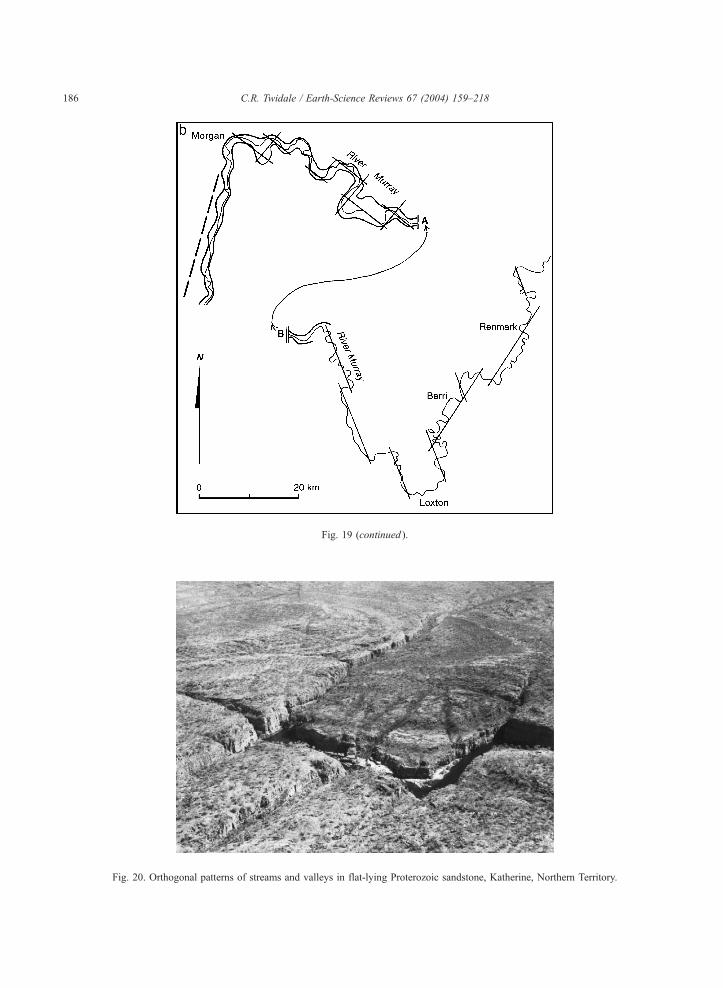
Fig. 19 (continued ).
Fig. 20. Orthogonal patterns of streams and valleys in flat-lying Proterozoic sandstone, Katherine, Northern Territory.
C.R. Twidale / Earth-Science Reviews 67 (2004) 159–218186
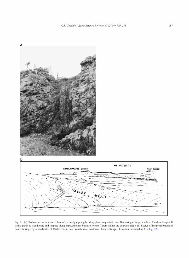
Fig. 21. (a) Shallow recess in scoured face of vertically dipping bedding plane in quartzite near Buckaringa Gorge, southern Flinders Ranges. It
is due partly to weathering and sapping along exposed joints but also to runoff from within the quartzite ridge. (b) Sketch of incipient breach of
quartzite ridge by a headwater of Castle Creek, near Yarrah Vale, southern Flinders Ranges. Location indicated at 3 in Fig. 22b.
C.R. Twidale / Earth-Science Reviews 67 (2004) 159–218 187
C.R. Twidale / Earth-Science Reviews 67 (2004) 159–218188
Campbell, 2001). The largest is the Central Australian
Ring with a diameter of more than 1200 km and
outlined in part by rivers such as Sturt Creek, which
flows intermittently to Lake Gregory in the north of
Western Australia. Other examples are evident in the
Kambalda district of the southwestern Yilgarn Craton
(Fig. 24b), and sectors of the Georgina, King and
Warburton creeks, which together drain substantial
areas of the Northern Territory and western Queens-
land before entering Lake Eyre, are also arcuate in
plan.
Their origin remains enigmatic, but ring structures
are conceivably associated with lineaments and with
recurrent shearing. They may influence surface drain-
age in the same ways as suggested for lineaments.
Fig. 22. (a) Oblique aerial photograph of the Comstock region of the south
gorge cut by Mt. Arden Creek through sandstone, and piracy of Comstoc
Creek. Mt. Benjamin (Big Ben) is the peak in middle distance. The Bluff st
shown in Fig. 30. Maps of same region showing (b) various stages in river
captures, (c) present stream pattern.
8. Anomalous patterns
Though most river patterns conform to slope and/
or structure, some flow neither directly across the
contours of the land, nor in conformity with the
structural grain of a locality or region; they are
discordant in terms of either slope, or of passive
structures presently exposed at the surface and occur-
ring at shallow depth, or with both (Fig. 25). Many
such anomalous or transverse stream sectors flow in
gorges but gorges are not of themselves anomalous.
They merely indicate a comparatively slow rate of
slope lowering compared to that of river incision.
Many explanations for anomalous drainage pat-
terns have been developed over the years (Fig. 26).
ern Flinders Ranges from the north, showing trellis patterns (RAAF),
k valley drainage by Skeleroo Creek (X), a tributary of Mt. Arden
ands beyond. The suggested development of the gorge marked (Y) is
capture: 1—complete capture (Skeleroo Creek); 2 and 3—incipient
(continued).
C.R. Twidale / Earth-Science Reviews 67 (2004) 159–218 189
8.1. Diversion
8.1.1. Tectonic
In some areas pre-existing stream courses have
been diverted either by faulting or warping. The
southerly diversion of the River Murray at Echuca
(Fig. 3), in northern Victoria (Harris, 1939; Bowler
and Harford, 1966), is an example of the former. The
so-called ‘palm-tree’ pattern, of the Diamantina head-
waters (Fig. 19a), in northwest Queensland, is a
diversion due to recent activity of the Selwyn Upwarp
(Taylor, 1911; Opik, 1961; Twidale, 1966b). As
mentioned previously, Bishop (1995) has queried the
efficacy of headward erosion as a cause of river
piracy, and suggests that diversions due to warping
are more common than has been supposed.
Major rivers like the Mahanadi, Godavari, Krishna
and Kaweri rise in the western Ghats and flow across
the breadth of peninsular India to the Bay of Bengal.
Only the fault-controlled Narmada and Tapi (e.g., Kale
et al., 1996; Chamyal et al., 2002) run to the west to the
Arabian Sea. In southern Brazil, rivers such as the Rio
Grande and Iguac�u rise near the coast and flow inland
to join the Parana River, which flows to the sea in the
Fig. 22
La Plata estuary. Such regional anomalies, as well as
several in southern Africa, have been explained as due
to doming of the crust related to large-radius magmatic
uplift followed by rifting of the structure (Cox, 1989).
Alternatively, uplift at the margins of continental crust
following faulting and plate separation, could account
for the drainage disturbances and reversals evident
in the southern Yilgarn Craton of Western Australia
(Commander, 1989; Fig. 24b).
8.1.2. Volcanic
Extensive lava fields such as that of the Deccan in
peninsular India and many parts of north Queensland
(Stephenson et al., 1980) have overwhelmed the pre-
existing landscapes, including drainage systems. Ba-
saltic flows have blocked pre-existing valleys, diverting
pre-existing streams. At the margins of the lava fields,
valley flows frequently cause one axial river to be
replaced by two parallel streams, each running between
the edge of the lava tongue and the declivity of the
valley side slopes. Such twin channels are located on
either side of a lava flow in the valley of the Einasleigh
River downstream from Einasleigh township and Tala-
roo Homestead, with the well-named Parallel Creek to
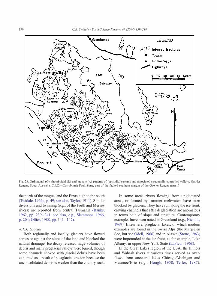
Fig. 23. Orthogonal (O), rhomboidal (R) and arcuate (A) patterns of (episodic) streams and associated structurally controlled valleys, Gawler
Ranges, South Australia. C.F.Z.—Corrobinnie Fault Zone, part of the faulted southern margin of the Gawler Ranges massif.
C.R. Twidale / Earth-Science Reviews 67 (2004) 159–218190
the north of the tongue, and the Einasleigh to the south
(Twidale, 1966a, p. 49; see also, Taylor, 1911). Similar
diversions and twinning (e.g., of the Forth and Mersey
rivers) are reported from central Tasmania (Banks,
1962, pp. 239–241; see also, e.g., Slemmons, 1966,
p. 204; Ollier, 1988, pp. 141–147).
8.1.3. Glacial
Both regionally and locally, glaciers have flowed
across or against the slope of the land and blocked the
natural drainage. Ice decay released huge volumes of
debris and many preglacial valleys were buried, though
some channels choked with glacial debris have been
exhumed as a result of postglacial erosion because the
unconsolidated debris is weaker than the country rock.
In some areas rivers flowing from unglaciated
areas, or formed by summer meltwaters have been
blocked by glaciers. They have run along the ice front,
carving channels that after deglaciation are anomalous
in terms both of slope and structure. Contemporary
examples have been noted in Greenland (e.g., Nichols,
1969). Elsewhere, proglacial lakes, of which modern
examples are found in the Swiss Alps (the Marjeelen
See, but see Odell, 1966) and in Alaska (Stone, 1963)
were impounded at the ice front, as for example, Lake
Albany, in upper New York State (LaFleur, 1968).
In the Great Lakes region of the USA, the Illinois
and Wabash rivers at various times served as over-
flows from ancestral lakes Chicago/Michigan and
Maumee/Erie (e.g., Hough, 1958; Teller, 1987).
C.R. Twidale / Earth-Science Reviews 67 (2004) 159–218 191
Where these overflowed they again eroded channels
some of which paralleled the ice front. The
Urstromtaler of the north European plain consist of
several such channels linked together in a series of
channels associated with stages in the recession of the
last ice sheet. Others, such as Newton Dale in north
Yorkshire at the regional scale, and the Barnetby Gap,
north Lincolnshire at the local, but both with distal
deltaic deposits (Kendall, 1902; Twidale, 1956a), took
water away from the ice front, again cutting anoma-
lous channels.
Glacial deposition has disturbed pre-existing drain-
age patterns and together with the frozen ground
typical of periglacial and nival climates, which
impedes permeability, has produced local internal
drainage basins characterised by swamps and lakes,
as well as rivers. The Lake Plateau of Labrador is well
named.
8.1.4. Landslides and other mass movements of debris
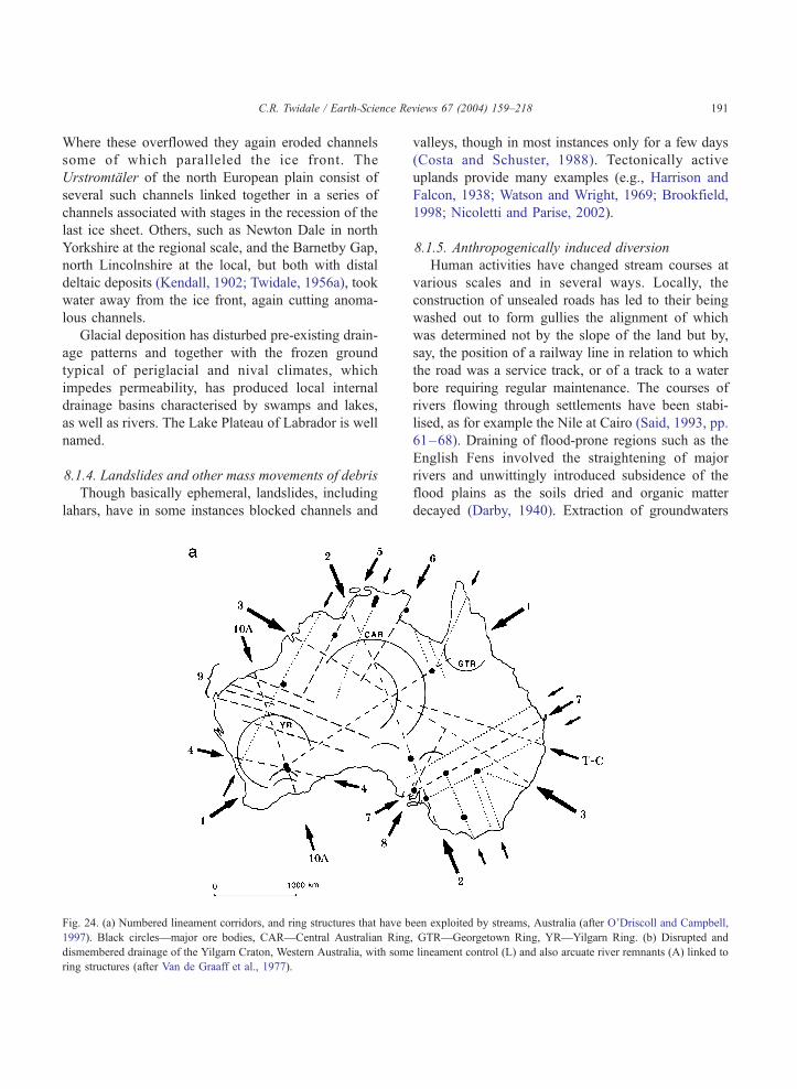
Though basically ephemeral, landslides, including
lahars, have in some instances blocked channels and
Fig. 24. (a) Numbered lineament corridors, and ring structures that have b
1997). Black circles—major ore bodies, CAR—Central Australian Ring
dismembered drainage of the Yilgarn Craton, Western Australia, with some
ring structures (after Van de Graaff et al., 1977).
valleys, though in most instances only for a few days
(Costa and Schuster, 1988). Tectonically active
uplands provide many examples (e.g., Harrison and
Falcon, 1938; Watson and Wright, 1969; Brookfield,
1998; Nicoletti and Parise, 2002).
8.1.5. Anthropogenically induced diversion
Human activities have changed stream courses at
various scales and in several ways. Locally, the
construction of unsealed roads has led to their being
washed out to form gullies the alignment of which
was determined not by the slope of the land but by,
say, the position of a railway line in relation to which
the road was a service track, or of a track to a water
bore requiring regular maintenance. The courses of
rivers flowing through settlements have been stabi-
lised, as for example the Nile at Cairo (Said, 1993, pp.
61–68). Draining of flood-prone regions such as the
English Fens involved the straightening of major
rivers and unwittingly introduced subsidence of the
flood plains as the soils dried and organic matter
decayed (Darby, 1940). Extraction of groundwaters
een exploited by streams, Australia (after O’Driscoll and Campbell,
, GTR—Georgetown Ring, YR—Yilgarn Ring. (b) Disrupted and
lineament control (L) and also arcuate river remnants (A) linked to
Fig. 24 (continued).
C.R. Twidale / Earth-Science Reviews 67 (2004) 159–218192
for irrigation purposes has caused surface lowering in
such areas as the Central Valley of California (e.g.,
Lofgren and Klausing, 1969), and more recently on
the north China Plain where a 2 m lowering over an
area of some 40,000 km2 is anticipated.
Like mild warping, such changes in slope may
interfere with pre-existing drainage patterns. Where
subsidence results in cracking, as in southern New
Mexico, ephemeral and local development of arcuate,
orthogonal and polygonal stream patterns has been
induced (e.g., Contaldo and Mueller, 1991).
8.2. Antecedence
Where a river has maintained its course through an
area of land that has risen either through faulting or
folding, the river is said to be antecedent (Medlicott,
1860; Hayden, 1862; Powell, 1875; Dutton, 1882;
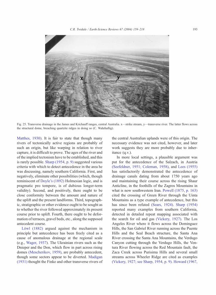
Fig. 25. Transverse drainage in the James and Krichauff ranges, central Australia. x—strike stream, y—transverse river. The latter flows across
the structural dome, breaching quartzite ridges in doing so (C. Wahrhaftig).
C.R. Twidale / Earth-Science Reviews 67 (2004) 159–218 193
Matthes, 1930). It is fair to state that though many
rivers of tectonically active regions are probably of
such an origin, but like warping in relation to river
capture, it is difficult to prove. The ages of the river and
of the implied tectonism have to be established, and this
is rarely possible. Sharp (1954, p. 9) suggested various
criteria with which to detect antecedence in the area he
was discussing, namely southern California. First, and
negatively, eliminate other possibilities (which, though
reminiscent of Doyle’s (1892) Holmesian logic, and is
pragmatic pro tempore, is of dubious longer-term
validity). Second, and positively, there ought to be
close conformity between the amount and nature of
the uplift and the present landforms. Third, topograph-
ic, stratigraphic or other evidence ought to be sought as
to whether the river followed approximately its present
course prior to uplift. Fourth, there ought to be defor-
mation of terraces, gravel beds, etc., along the supposed
antecedent course.
Lowl (1882) argued against the mechanism in
principle but antecedence has been freely cited as a
cause of anomalous drainage at the regional scale
(e.g., Wager, 1937). The Ukrainian rivers such as the
Dnieper and the Don, which flow in part across rising
domes (Mescherikov, 1959), are probably antecedent,
though some sectors appear to be diverted. Madigan
(1931) thought the Finke and other transverse rivers of
the central Australian uplands were of this origin. The
necessary evidence was not cited, however, and later
work suggests they are more probably due to inher-
itance (q.v.).
In more local settings, a plausible argument was
put for the antecedence of the Salzach, in Austria
(Seefeldner, 1951; Coleman, 1958), and Lees (1955)
has satisfactorily demonstrated the antecedence of
drainage canals dating from about 1750 years ago
and maintaining their course across the rising Shaur
Anticline, in the foothills of the Zagros Mountains in
what is now southwestern Iran. Powell (1875, p. 163)
cited the crossing of Green River through the Uinta
Mountains as a type example of antecedence, but this
has since been refuted (Sears, 1924). Sharp (1954)
reported many examples from southern California,
detected in detailed repeat mapping associated with
the search for oil and gas (Vickery, 1927). The Los
Angeles River where it flows across the Dominguez
Hills, the San Gabriel River running across the Puente
Hills and the Seal Beach structure, the Santa Ana
River crossing the Santa Ana Mountains, the Verdugo
Canyon cutting through the Verdugo Hills, the Ven-
tura River flowing across the Red Mountain fault, the
Zaca Creek across Purisima Hills and several small
streams across Wheeler Ridge are cited as examples
(Vickery, 1927; see Sharp, 1954, p. 9). Howard (1967,
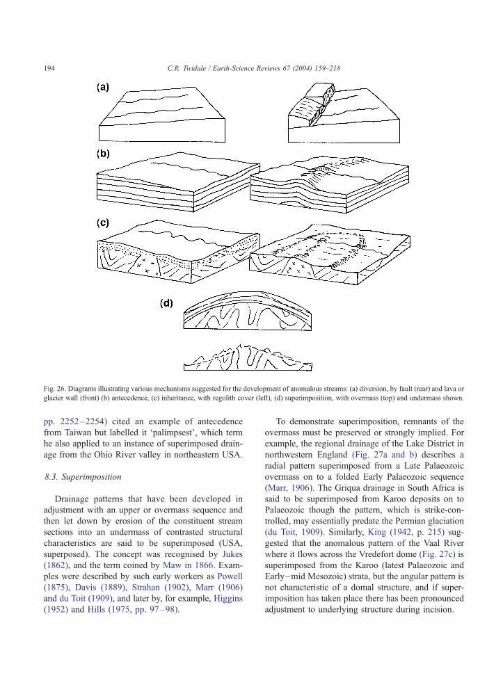
Fig. 26. Diagrams illustrating various mechanisms suggested for the development of anomalous streams: (a) diversion, by fault (rear) and lava or
glacier wall (front) (b) antecedence, (c) inheritance, with regolith cover (left), (d) superimposition, with overmass (top) and undermass shown.
C.R. Twidale / Earth-Science Reviews 67 (2004) 159–218194
pp. 2252–2254) cited an example of antecedence
from Taiwan but labelled it ‘palimpsest’, which term
he also applied to an instance of superimposed drain-
age from the Ohio River valley in northeastern USA.
8.3. Superimposition
Drainage patterns that have been developed in
adjustment with an upper or overmass sequence and
then let down by erosion of the constituent stream
sections into an undermass of contrasted structural
characteristics are said to be superimposed (USA,
superposed). The concept was recognised by Jukes
(1862), and the term coined by Maw in 1866. Exam-
ples were described by such early workers as Powell
(1875), Davis (1889), Strahan (1902), Marr (1906)
and du Toit (1909), and later by, for example, Higgins
(1952) and Hills (1975, pp. 97–98).
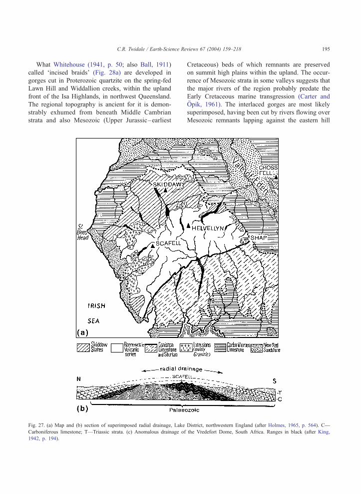
To demonstrate superimposition, remnants of the
overmass must be preserved or strongly implied. For
example, the regional drainage of the Lake District in
northwestern England (Fig. 27a and b) describes a
radial pattern superimposed from a Late Palaeozoic
overmass on to a folded Early Palaeozoic sequence
(Marr, 1906). The Griqua drainage in South Africa is
said to be superimposed from Karoo deposits on to
Palaeozoic though the pattern, which is strike-con-
trolled, may essentially predate the Permian glaciation
(du Toit, 1909). Similarly, King (1942, p. 215) sug-
gested that the anomalous pattern of the Vaal River
where it flows across the Vredefort dome (Fig. 27c) is
superimposed from the Karoo (latest Palaeozoic and
Early–mid Mesozoic) strata, but the angular pattern is
not characteristic of a domal structure, and if super-
imposition has taken place there has been pronounced
adjustment to underlying structure during incision.
C.R. Twidale / Earth-Science Reviews 67 (2004) 159–218 195
What Whitehouse (1941, p. 50; also Ball, 1911)
called ‘incised braids’ (Fig. 28a) are developed in
gorges cut in Proterozoic quartzite on the spring-fed
Lawn Hill and Widdallion creeks, within the upland
front of the Isa Highlands, in northwest Queensland.
The regional topography is ancient for it is demon-
strably exhumed from beneath Middle Cambrian
strata and also Mesozoic (Upper Jurassic–earliest
Fig. 27. (a) Map and (b) section of superimposed radial drainage, Lake
Carboniferous limestone; T—Triassic strata. (c) Anomalous drainage of
1942, p. 194).
Cretaceous) beds of which remnants are preserved
on summit high plains within the upland. The occur-
rence of Mesozoic strata in some valleys suggests that
the major rivers of the region probably predate the
Early Cretaceous marine transgression (Carter and
Opik, 1961). The interlaced gorges are most likely
superimposed, having been cut by rivers flowing over
Mesozoic remnants lapping against the eastern hill
District, northwestern England (after Holmes, 1965, p. 564). C—
the Vredefort Dome, South Africa. Ranges in black (after King,
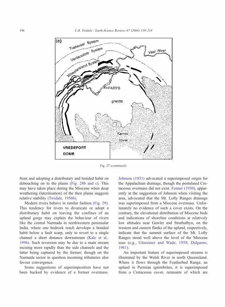
Fig. 27 (continued ).
C.R. Twidale / Earth-Science Reviews 67 (2004) 159–218196
front and adopting a distributary and braided habit on
debouching on to the plains (Fig. 28b and c). This
may have taken place during the Miocene when deep
weathering (lateritisation) of the then plains suggests
relative stability (Twidale, 1956b).
Modern rivers behave in similar fashion (Fig. 29).
This tendency for rivers to divaricate or adopt a
distributary habit on leaving the confines of an
upland gorge may explain the behaviour of rivers
like the central Narmada in northwestern peninsular
India, where one bedrock reach develops a braided
habit below a fault scarp, only to revert to a single
channel a short distance downstream (Kale et al.,
1996). Such reversion may be due to a main stream
incising more rapidly than the side channels and the
latter being captured by the former; though on the
Narmada sector in question incoming tributaries also
favour convergence.
Some suggestions of superimposition have not
been backed by evidence of a former overmass.
Johnson (1931) advocated a superimposed origin for
the Appalachian drainage, though the postulated Cre-
taceous overmass did not exist. Fenner (1930), appar-
ently at the suggestion of Johnson when visiting the
area, advocated that the Mt. Lofty Ranges drainage
was superimposed from a Miocene overmass. Unfor-
tunately no evidence of such a cover exists. On the
contrary, the elevational distribution of Miocene beds
and indications of shoreline conditions at relatively
low altitudes near Gawler and Strathalbyn, on the
western and eastern flanks of the upland, respectively,
indicate that the summit surface of the Mt. Lofty
Ranges stood well above the level of the Miocene
seas (e.g., Glaessner and Wade, 1958; Dalgarno,
1961).
An important feature of superimposed streams is
illustrated by the Walsh River in north Queensland.
Where it flows through the Featherbed Range, an
upland in Permian ignimbrites, it is superimposed
from a Cretaceous cover, remnants of which are
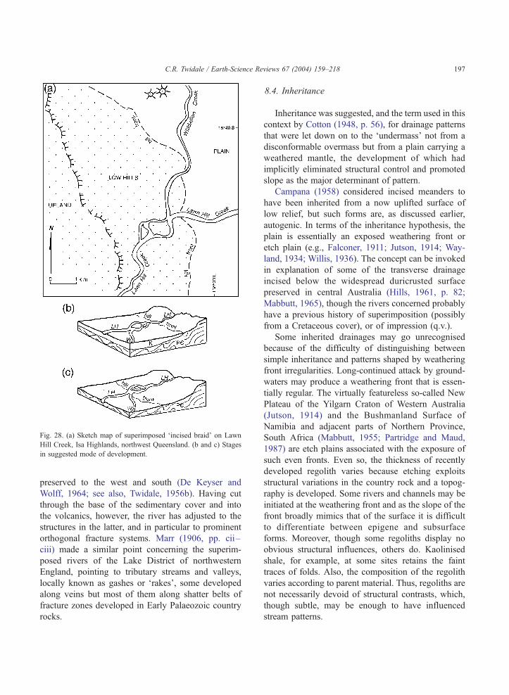
Fig. 28. (a) Sketch map of superimposed ‘incised braid’ on Lawn
Hill Creek, Isa Highlands, northwest Queensland. (b and c) Stages
in suggested mode of development.
C.R. Twidale / Earth-Science Re
preserved to the west and south (De Keyser and
Wolff, 1964; see also, Twidale, 1956b). Having cut
through the base of the sedimentary cover and into
the volcanics, however, the river has adjusted to the
structures in the latter, and in particular to prominent
orthogonal fracture systems. Marr (1906, pp. cii–
ciii) made a similar point concerning the superim-
posed rivers of the Lake District of northwestern
England, pointing to tributary streams and valleys,
locally known as gashes or ‘rakes’, some developed
along veins but most of them along shatter belts of
fracture zones developed in Early Palaeozoic country
rocks.
8.4. Inheritance
Inheritance was suggested, and the term used in this
context by Cotton (1948, p. 56), for drainage patterns
that were let down on to the ‘undermass’ not from a
disconformable overmass but from a plain carrying a
weathered mantle, the development of which had
implicitly eliminated structural control and promoted
slope as the major determinant of pattern.
Campana (1958) considered incised meanders to
have been inherited from a now uplifted surface of
low relief, but such forms are, as discussed earlier,
autogenic. In terms of the inheritance hypothesis, the
plain is essentially an exposed weathering front or
etch plain (e.g., Falconer, 1911; Jutson, 1914; Way-
land, 1934; Willis, 1936). The concept can be invoked
in explanation of some of the transverse drainage
incised below the widespread duricrusted surface
preserved in central Australia (Hills, 1961, p. 82;
Mabbutt, 1965), though the rivers concerned probably
have a previous history of superimposition (possibly
from a Cretaceous cover), or of impression (q.v.).
Some inherited drainages may go unrecognised
because of the difficulty of distinguishing between
simple inheritance and patterns shaped by weathering
front irregularities. Long-continued attack by ground-
waters may produce a weathering front that is essen-
tially regular. The virtually featureless so-called New
Plateau of the Yilgarn Craton of Western Australia
(Jutson, 1914) and the Bushmanland Surface of
Namibia and adjacent parts of Northern Province,
South Africa (Mabbutt, 1955; Partridge and Maud,
1987) are etch plains associated with the exposure of
such even fronts. Even so, the thickness of recently
developed regolith varies because etching exploits
structural variations in the country rock and a topog-
raphy is developed. Some rivers and channels may be
initiated at the weathering front and as the slope of the
front broadly mimics that of the surface it is difficult
to differentiate between epigene and subsurface
forms. Moreover, though some regoliths display no
obvious structural influences, others do. Kaolinised
shale, for example, at some sites retains the faint
traces of folds. Also, the composition of the regolith
varies according to parent material. Thus, regoliths are
not necessarily devoid of structural contrasts, which,
though subtle, may be enough to have influenced
stream patterns.
views 67 (2004) 159–218 197
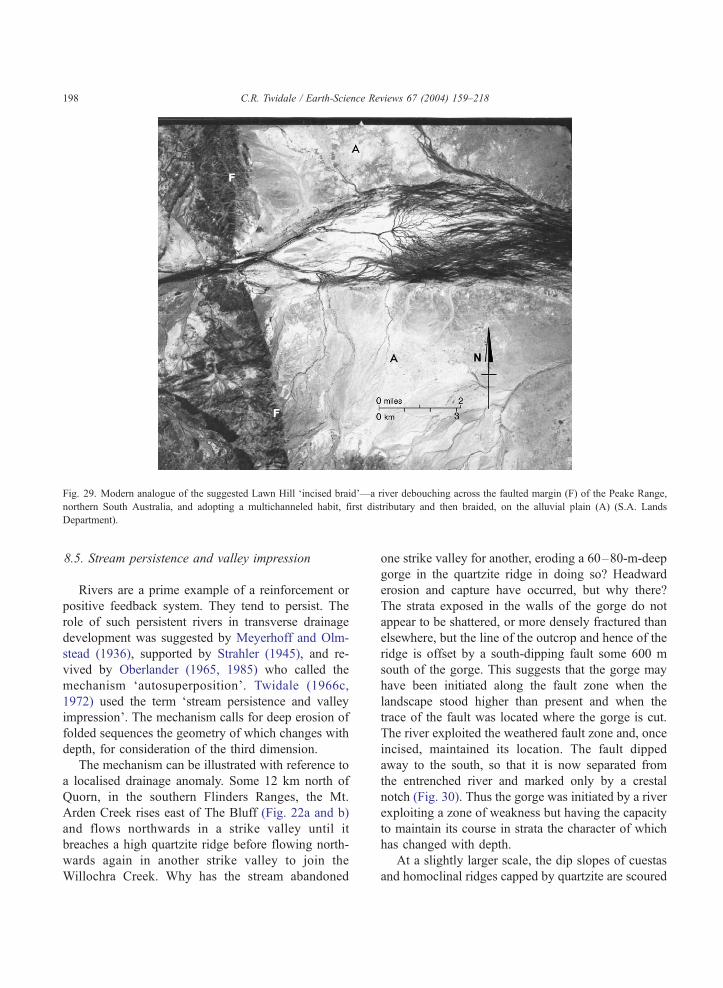
Fig. 29. Modern analogue of the suggested Lawn Hill ‘incised braid’—a river debouching across the faulted margin (F) of the Peake Range,
northern South Australia, and adopting a multichanneled habit, first distributary and then braided, on the alluvial plain (A) (S.A. Lands
Department).
C.R. Twidale / Earth-Science Reviews 67 (2004) 159–218198
8.5. Stream persistence and valley impression
Rivers are a prime example of a reinforcement or
positive feedback system. They tend to persist. The
role of such persistent rivers in transverse drainage
development was suggested by Meyerhoff and Olm-
stead (1936), supported by Strahler (1945), and re-
vived by Oberlander (1965, 1985) who called the
mechanism ‘autosuperposition’. Twidale (1966c,
1972) used the term ‘stream persistence and valley
impression’. The mechanism calls for deep erosion of
folded sequences the geometry of which changes with
depth, for consideration of the third dimension.
The mechanism can be illustrated with reference to
a localised drainage anomaly. Some 12 km north of
Quorn, in the southern Flinders Ranges, the Mt.
Arden Creek rises east of The Bluff (Fig. 22a and b)
and flows northwards in a strike valley until it
breaches a high quartzite ridge before flowing north-
wards again in another strike valley to join the
Willochra Creek. Why has the stream abandoned
one strike valley for another, eroding a 60–80-m-deep
gorge in the quartzite ridge in doing so? Headward
erosion and capture have occurred, but why there?
The strata exposed in the walls of the gorge do not
appear to be shattered, or more densely fractured than
elsewhere, but the line of the outcrop and hence of the
ridge is offset by a south-dipping fault some 600 m
south of the gorge. This suggests that the gorge may
have been initiated along the fault zone when the
landscape stood higher than present and when the
trace of the fault was located where the gorge is cut.
The river exploited the weathered fault zone and, once
incised, maintained its location. The fault dipped
away to the south, so that it is now separated from
the entrenched river and marked only by a crestal
notch (Fig. 30). Thus the gorge was initiated by a river
exploiting a zone of weakness but having the capacity
to maintain its course in strata the character of which
has changed with depth.
At a slightly larger scale, the dip slopes of cuestas
and homoclinal ridges capped by quartzite are scoured
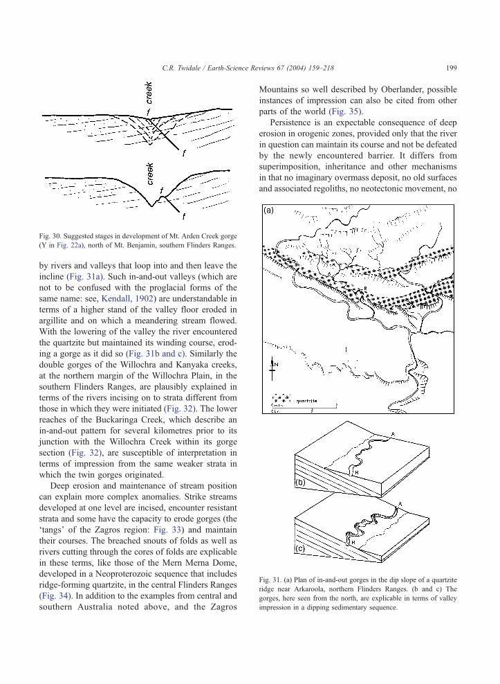
Fig. 30. Suggested stages in development of Mt. Arden Creek gorge
(Y in Fig. 22a), north of Mt. Benjamin, southern Flinders Ranges.
Fig. 31. (a) Plan of in-and-out gorges in the dip slope of a quartzite
ridge near Arkaroola, northern Flinders Ranges. (b and c) The
gorges, here seen from the north, are explicable in terms of valley
impression in a dipping sedimentary sequence.
C.R. Twidale / Earth-Science Reviews 67 (2004) 159–218 199
by rivers and valleys that loop into and then leave the
incline (Fig. 31a). Such in-and-out valleys (which are
not to be confused with the proglacial forms of the
same name: see, Kendall, 1902) are understandable in
terms of a higher stand of the valley floor eroded in
argillite and on which a meandering stream flowed.
With the lowering of the valley the river encountered
the quartzite but maintained its winding course, erod-
ing a gorge as it did so (Fig. 31b and c). Similarly the
double gorges of the Willochra and Kanyaka creeks,
at the northern margin of the Willochra Plain, in the
southern Flinders Ranges, are plausibly explained in
terms of the rivers incising on to strata different from
those in which they were initiated (Fig. 32). The lower
reaches of the Buckaringa Creek, which describe an
in-and-out pattern for several kilometres prior to its
junction with the Willochra Creek within its gorge
section (Fig. 32), are susceptible of interpretation in
terms of impression from the same weaker strata in
which the twin gorges originated.
Deep erosion and maintenance of stream position
can explain more complex anomalies. Strike streams
developed at one level are incised, encounter resistant
strata and some have the capacity to erode gorges (the
‘tangs’ of the Zagros region: Fig. 33) and maintain
their courses. The breached snouts of folds as well as
rivers cutting through the cores of folds are explicable
in these terms, like those of the Mern Merna Dome,
developed in a Neoproterozoic sequence that includes
ridge-forming quartzite, in the central Flinders Ranges
(Fig. 34). In addition to the examples from central and
southern Australia noted above, and the Zagros
Mountains so well described by Oberlander, possible
instances of impression can also be cited from other
parts of the world (Fig. 35).
Persistence is an expectable consequence of deep
erosion in orogenic zones, provided only that the river
in question can maintain its course and not be defeated
by the newly encountered barrier. It differs from
superimposition, inheritance and other mechanisms
in that no imaginary overmass deposit, no old surfaces
and associated regoliths, no neotectonic movement, no
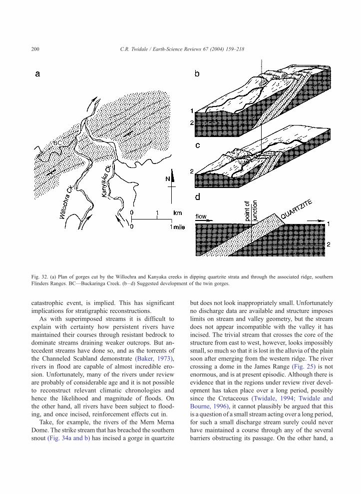
Fig. 32. (a) Plan of gorges cut by the Willochra and Kanyaka creeks in dipping quartzite strata and through the associated ridge, southern
Flinders Ranges. BC—Buckaringa Creek. (b–d) Suggested development of the twin gorges.
C.R. Twidale / Earth-Science Reviews 67 (2004) 159–218200
catastrophic event, is implied. This has significant
implications for stratigraphic reconstructions.
As with superimposed streams it is difficult to
explain with certainty how persistent rivers have
maintained their courses through resistant bedrock to
dominate streams draining weaker outcrops. But an-
tecedent streams have done so, and as the torrents of
the Channeled Scabland demonstrate (Baker, 1973),
rivers in flood are capable of almost incredible ero-
sion. Unfortunately, many of the rivers under review
are probably of considerable age and it is not possible
to reconstruct relevant climatic chronologies and
hence the likelihood and magnitude of floods. On
the other hand, all rivers have been subject to flood-
ing, and once incised, reinforcement effects cut in.
Take, for example, the rivers of the Mern Merna
Dome. The strike stream that has breached the southern
snout (Fig. 34a and b) has incised a gorge in quartzite
but does not look inappropriately small. Unfortunately
no discharge data are available and structure imposes
limits on stream and valley geometry, but the stream
does not appear incompatible with the valley it has
incised. The trivial stream that crosses the core of the
structure from east to west, however, looks impossibly
small, so much so that it is lost in the alluvia of the plain
soon after emerging from the western ridge. The river
crossing a dome in the James Range (Fig. 25) is not
enormous, and is at present episodic. Although there is
evidence that in the regions under review river devel-
opment has taken place over a long period, possibly
since the Cretaceous (Twidale, 1994; Twidale and
Bourne, 1996), it cannot plausibly be argued that this
is a question of a small stream acting over a long period,
for such a small discharge stream surely could never
have maintained a course through any of the several
barriers obstructing its passage. On the other hand, a
C.R. Twidale / Earth-Science Reviews 67 (2004) 159–218 201
higher discharge river capable of maintaining its course
by eroding through quartzitic bedrockmay have shrunk
as a result of the onset of aridity, of which there is local
and regional evidence.
9. Cryptoreic drainage
Some areic areas are not what they seem. Surface
channels are lacking but there are rivers underground.
Some drainage systems in the eastern Sahara Desert
(the present Selima Sand Sheet) and the Great Sandy
Desert of northwestern Australia have been buried
beneath desert sands and have only been detected by
ground penetrating radar (McCauley et al., 1982;
Tapley, 1988).
Cryptoreic drainage may be complete as in areas of
extensive karst, such as the Causses of southern
France, the Dolomites of Montenegro and adjacent
areas, and the Nullarbor Plain (Fig. 36), southern
Australia, or interrupted, where rivers sink beneath
the ground on encountering a limestone outcrop, as
Fig. 33. (a) Breached snout of denuded anticline cut by gorges or ‘tangs’,
persistence and valley impression during deep erosion of sedimentary sequ
depth.
for instance Cave Spring Creek in the Fitzroy Valley
of the northwest of Western Australia (Jennings and
Sweeting, 1963), and the Andabara River in the West
Highlands of Papua New Guinea (Jennings, 1985, p.
34). The subterranean stream patterns of karst regions
are, however, influenced by the same factors as
surface drainage, cave systems and drainage lines
commonly exhibiting marked joint control. Miocene
limestone in the Mt. Gambier district, in the South
East of South Australia, has been dissolved along
partings to form caves in plan patterns (Marker, 1975)
that coincide with those of the prevailing orthogonal
fracture system.
The rolling chalk ‘Downs’ or uplands of south-
eastern England and northern France are well known
for their dry valleys. The name is somewhat mislead-
ing for some of the valleys carry streams after heavy
rains but they are most commonly dry. They have
been cogently explained in terms of recession of
scarps eroded in dipping strata (Fig. 37) causing the
water table to be lowered and leading to abandonment
of the stream channels lower and lower in the dip-
Zagros Mountains (Hunting Surveys). (b) Diagram showing stream
ence, the character (composition, geometry) of which changes with
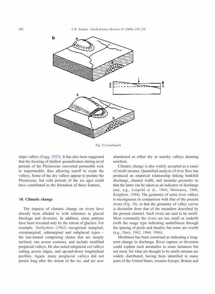
Fig. 33 (continued ).
C.R. Twidale / Earth-Science Reviews 67 (2004) 159–218202
slope valleys (Fagg, 1923). It has also been suggested
that the freezing of shallow groundwaters during nival
periods of the Pleistocene converted permeable rock
to impermeable, thus allowing runoff to erode the
valleys. Some of the dry valleys appear to predate the
Pleistocene, but cold periods of the ice ages could
have contributed to the formation of these features.
10. Climatic change
The impacts of climatic change on rivers have
already been alluded to with reference to glacial
blockage and diversion. In addition, some patterns
have been revealed only by the retreat of glaciers. For
example, Derbyshire (1962) recognised marginal,
extramarginal, submarginal and subglacial types—
the last-named comprising chutes that are steeply
inclined, run across contours, and include modified
preglacial valleys. He also noted subglacial col valleys
cutting across ridges, and up-and-down longitudinal
profiles. Again, many proglacial valleys did not
persist long after the retreat of the ice, and are now
abandoned as either dry or marshy valleys draining
nowhere.
Climatic change is also widely accepted as a cause
of misfit streams. Quantified analysis of river flow has
produced an empirical relationship linking bankfull
discharge, channel width, and meander geometry so
that the latter can be taken as an indicator of discharge
(see, e.g., Leopold et al., 1964; Morisawa, 1968;
Knighton, 1984). The geometry of some river valleys
is incongruous in comparison with that of the present
rivers (Fig. 38), in that the geometry of valley curves
is dissimilar from that of the meanders described by
the present channel. Such rivers are said to be misfit.
Most commonly the rivers are too small or underfit
(with the osage type indicating underfitness through
the spacing of pools and shoals); but some are overfit
(e.g., Dury, 1962, 1964, 1986).
Misfitness has been construed as indicating a long-
term change in discharge. River capture or diversion
could explain such anomalies in some instances but
not most, for what are thought to be misfit streams are
widely distributed, having been identified in many
parts of the United States, western Europe, Britain and
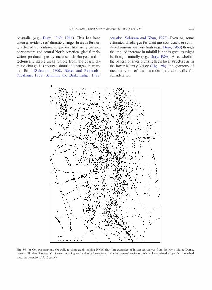
C.R. Twidale / Earth-Science Reviews 67 (2004) 159–218 203
Australia (e.g., Dury, 1960, 1964). This has been
taken as evidence of climatic change. In areas former-
ly affected by continental glaciers, like many parts of
northeastern and central North America, glacial melt-
waters produced greatly increased discharges, and in
tectonically stable areas remote from the coast, cli-
matic change has induced dramatic changes in chan-
nel form (Schumm, 1968; Baker and Penteado-
Oreallana, 1977; Schumm and Brakenridge, 1987;
Fig. 34. (a) Contour map and (b) oblique photograph looking NNW, sho
western Flinders Ranges. X—Stream crossing entire domical structure, in
snout in quartzite (J.A. Bourne).
see also, Schumm and Khan, 1972). Even so, some
estimated discharges for what are now desert or semi-
desert regions are very high (e.g., Dury, 1960) though
the implied increase in rainfall is not as great as might
be thought initially (e.g., Dury, 1986). Also, whether
the pattern of river bluffs reflects local structure as in
the lower Murray Valley (Fig. 19b), the geometry of
meanders, or of the meander belt also calls for
consideration.
wing examples of impressed valleys from the Mern Merna Dome,
cluding several resistant beds and associated ridges, Y—breached
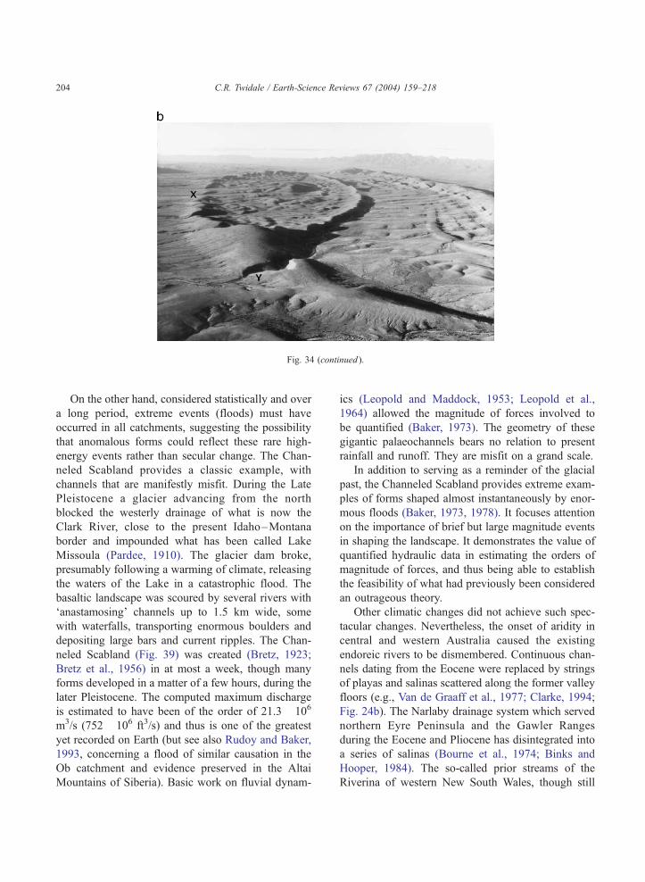
Fig. 34 (continued ).
C.R. Twidale / Earth-Science Reviews 67 (2004) 159–218204
On the other hand, considered statistically and over
a long period, extreme events (floods) must have
occurred in all catchments, suggesting the possibility
that anomalous forms could reflect these rare high-
energy events rather than secular change. The Chan-
neled Scabland provides a classic example, with
channels that are manifestly misfit. During the Late
Pleistocene a glacier advancing from the north
blocked the westerly drainage of what is now the
Clark River, close to the present Idaho–Montana
border and impounded what has been called Lake
Missoula (Pardee, 1910). The glacier dam broke,
presumably following a warming of climate, releasing
the waters of the Lake in a catastrophic flood. The
basaltic landscape was scoured by several rivers with
‘anastamosing’ channels up to 1.5 km wide, some
with waterfalls, transporting enormous boulders and
depositing large bars and current ripples. The Chan-
neled Scabland (Fig. 39) was created (Bretz, 1923;
Bretz et al., 1956) in at most a week, though many
forms developed in a matter of a few hours, during the
later Pleistocene. The computed maximum discharge
is estimated to have been of the order of 21.3� 106
m3/s (752� 106 ft3/s) and thus is one of the greatest
yet recorded on Earth (but see also Rudoy and Baker,
1993, concerning a flood of similar causation in the
Ob catchment and evidence preserved in the Altai
Mountains of Siberia). Basic work on fluvial dynam-
ics (Leopold and Maddock, 1953; Leopold et al.,
1964) allowed the magnitude of forces involved to
be quantified (Baker, 1973). The geometry of these
gigantic palaeochannels bears no relation to present
rainfall and runoff. They are misfit on a grand scale.
In addition to serving as a reminder of the glacial
past, the Channeled Scabland provides extreme exam-
ples of forms shaped almost instantaneously by enor-
mous floods (Baker, 1973, 1978). It focuses attention
on the importance of brief but large magnitude events
in shaping the landscape. It demonstrates the value of
quantified hydraulic data in estimating the orders of
magnitude of forces, and thus being able to establish
the feasibility of what had previously been considered
an outrageous theory.
Other climatic changes did not achieve such spec-
tacular changes. Nevertheless, the onset of aridity in
central and western Australia caused the existing
endoreic rivers to be dismembered. Continuous chan-
nels dating from the Eocene were replaced by strings
of playas and salinas scattered along the former valley
floors (e.g., Van de Graaff et al., 1977; Clarke, 1994;
Fig. 24b). The Narlaby drainage system which served
northern Eyre Peninsula and the Gawler Ranges
during the Eocene and Pliocene has disintegrated into
a series of salinas (Bourne et al., 1974; Binks and
Hooper, 1984). The so-called prior streams of the
Riverina of western New South Wales, though still
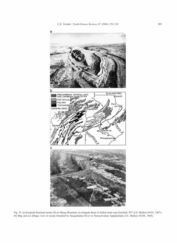
Fig. 35. (a) Incipient breached snouts (S) on Sheep Mountain, an elongate dome in folded strata near Greybull, WY (J.S. Shelton #6101, 1967).
(b) Map and (c) oblique view of snouts breached by Susquehanna River in Pennsylvanian Appalachians (J.S. Shelton #4108, 1960).
C.R. Twidale / Earth-Science Reviews 67 (2004) 159–218 205
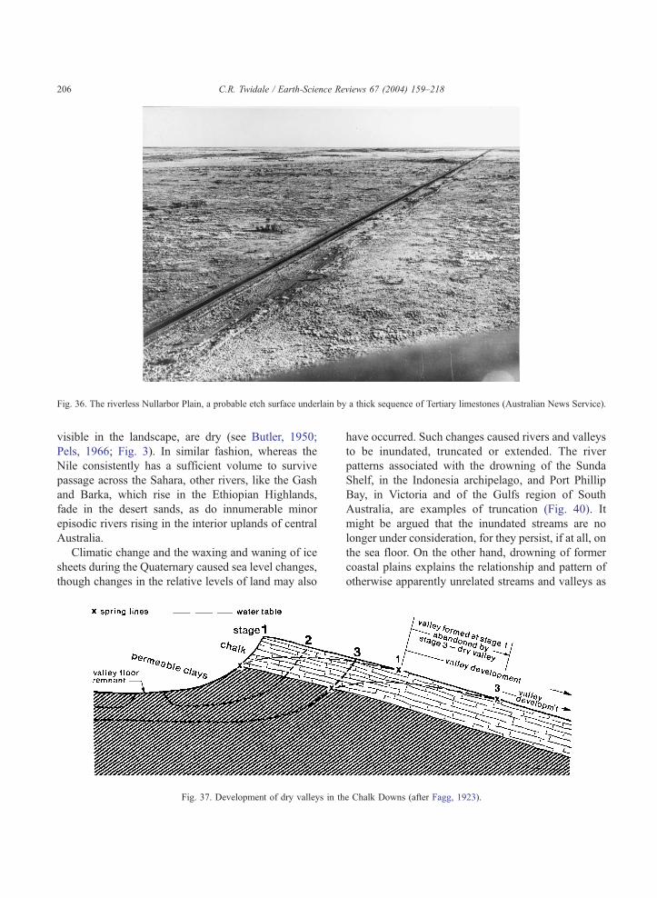
Fig. 36. The riverless Nullarbor Plain, a probable etch surface underlain by a thick sequence of Tertiary limestones (Australian News Service).
C.R. Twidale / Earth-Science Reviews 67 (2004) 159–218206
visible in the landscape, are dry (see Butler, 1950;
Pels, 1966; Fig. 3). In similar fashion, whereas the
Nile consistently has a sufficient volume to survive
passage across the Sahara, other rivers, like the Gash
and Barka, which rise in the Ethiopian Highlands,
fade in the desert sands, as do innumerable minor
episodic rivers rising in the interior uplands of central
Australia.
Climatic change and the waxing and waning of ice
sheets during the Quaternary caused sea level changes,
though changes in the relative levels of land may also
Fig. 37. Development of dry valleys in th
have occurred. Such changes caused rivers and valleys
to be inundated, truncated or extended. The river
patterns associated with the drowning of the Sunda
Shelf, in the Indonesia archipelago, and Port Phillip
Bay, in Victoria and of the Gulfs region of South
Australia, are examples of truncation (Fig. 40). It
might be argued that the inundated streams are no
longer under consideration, for they persist, if at all, on
the sea floor. On the other hand, drowning of former
coastal plains explains the relationship and pattern of
otherwise apparently unrelated streams and valleys as
e Chalk Downs (after Fagg, 1923).
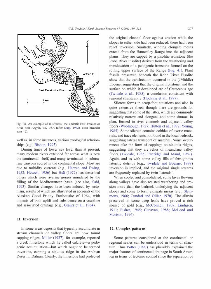
Fig. 38. An example of misfitness: the underfit East Pecatonica
River near Argyle, WI, USA (after Dury, 1962). Note meander
core—C.
C.R. Twidale / Earth-Science Reviews 67 (2004) 159–218 207
well as, in some instances, various zoological relation-
ships (e.g., Bishop, 1995).
During times of lower sea level than at present,
many modern rivers extended far across what is now
the continental shelf, and many terminated in subma-
rine canyons scored in the continental slope. Most are
due to turbidity currents (e.g., Heezen and Ewing,
1952; Heezen, 1956) but Hsu (1972) has described
others which were riverine gorges inundated by the
filling of the Mediterranean basin (see also, Said,
1993). Similar changes have been induced by tecto-
nism, results of which are illustrated in accounts of the
Alaskan Good Friday Earthquake of 1964, with
impacts of both uplift and subsidence on a coastline
and associated drainage (e.g., Grantz et al., 1964).
11. Inversion
In some areas deposits that typically accumulate in
stream channels or valley floors are now found
capping ridges. Miller (1937), for example, reported
a creek limestone which he called calcrete—a pedo-
genic accumulation—but which ought to be termed
travertine, capping a sinuous ridge in the Arabian
Desert in Dahran. Clearly, the limestone had protected
the original channel floor against erosion while the
slopes to either side had been reduced: there had been
relief inversion. Similarly, winding elongate mesas
extend from the Hamersley Range into the adjacent
plains. They are capped by a pisolitic ironstone (the
Robe River Pisolite) derived from the weathering and
translocation of a pedogenic ironstone formed on the
rolling upper surface of the Range (Fig. 41). Plant
fossils preserved beneath the Robe River Pisolite
show that the translocation occurred in the (?Middle)
Eocene, suggesting that the original ironstone, and the
surface on which it developed are of Cretaceous age
(Twidale et al., 1985); a conclusion consistent with
regional stratigraphy (Hocking et al., 1987).
Silcrete forms in scarp-foot situations and also in
quite extensive sheets though there are grounds for
suggesting that some of the latter, which are commonly
relatively narrow and elongate, and some sinuous in
plan, formed in river channels and adjacent valley
floors (Woolnough, 1927; Hutton et al., 1972; Young,
1985). Some silcrete contains cobbles of exotic mate-
rials, and trace elements not found in the local bedrock,
suggesting lateral transport of material. Some occur-
rences take the form of cappings on sinuous ridges,
suggesting that they are relics of meandrine valley
floors (Twidale, 1985; Partridge and Maud, 1987).
Again, and as with some valley fills of ferruginous
lateritic detritus (e.g., Twidale and Bourne, 1998)
inversion is implied, and the original single streams
are frequently replaced by twin ‘laterals’.
When cooled and consolidated, some lavas flowing
along valleys have also resisted weathering and ero-
sion more than the bedrock underlying the adjacent
slopes and come to form elongate mesas (e.g., Slem-
mons, 1966; Cundari and Ollier, 1970). The alluvia
preserved in some deep leads have proved a rich
source of gold (e.g., McConnell, 1907; Lindgren,
1911; Fisher, 1945; Canavan, 1988; McLeod and
Morison, 1996).
12. Complex patterns
Some patterns considered at the continental or
regional scales can be understood in terms of struc-
ture. Thus Potter (1997) has plausibly explained the
major features of continental drainage in South Amer-
ica in terms of tectonic control since the separation of
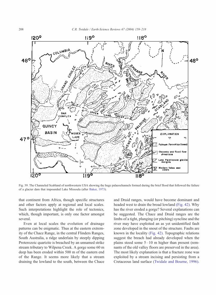
Fig. 39. The Channeled Scabland of northwestern USA showing the huge palaeochannels formed during the brief flood that followed the failure
of a glacier dam that impounded Lake Missoula (after Baker, 1973).
C.R. Twidale / Earth-Science Reviews 67 (2004) 159–218208
that continent from Africa, though specific structures
and other factors apply at regional and local scales.
Such interpretations highlight the role of tectonics,
which, though important, is only one factor amongst
several.
Even at local scales the evolution of drainage
patterns can be enigmatic. Thus at the eastern extrem-
ity of the Chace Range, in the central Flinders Ranges,
South Australia, a ridge underlain by steeply dipping
Proterozoic quartzite is breached by an unnamed strike
stream tributary to Wilpena Creek. A gorge some 60 m
deep has been eroded within 500 m of the eastern end
of the Range. It seems more likely that a stream
draining the lowland to the south, between the Chace
and Druid ranges, would have become dominant and
headed west to drain the broad lowland (Fig. 42). Why
has the river eroded a gorge? Several explanations can
be suggested. The Chace and Druid ranges are the
limbs of a tight, plunging (or pitching) syncline and the
river may have exploited an as yet unidentified fault
zone developed in the snout of the structure. Faults are
known in the locality (Fig. 42). Topographic relations
suggest the breach had already developed when the
plains stood some 5–10 m higher than present (rem-
nants of the old valley floors are preserved in the area).
The most likely explanation is that a fracture zone was
exploited by a stream incising and persisting from a
Cretaceous land surface (Twidale and Bourne, 1996).
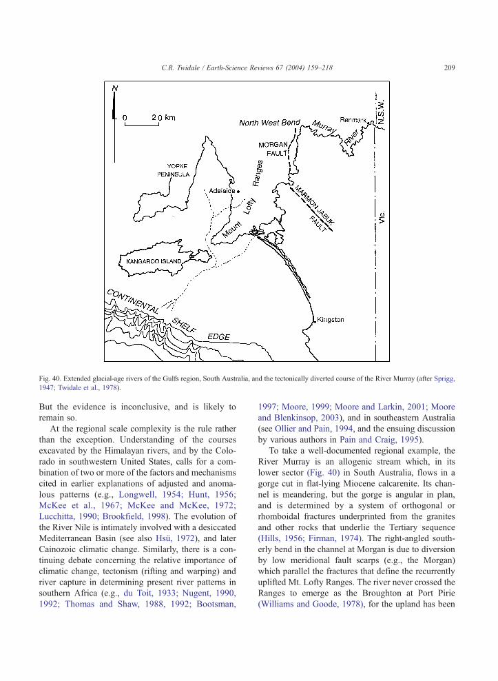
Fig. 40. Extended glacial-age rivers of the Gulfs region, South Australia, and the tectonically diverted course of the River Murray (after Sprigg,
1947; Twidale et al., 1978).
C.R. Twidale / Earth-Science Reviews 67 (2004) 159–218 209
But the evidence is inconclusive, and is likely to
remain so.
At the regional scale complexity is the rule rather
than the exception. Understanding of the courses
excavated by the Himalayan rivers, and by the Colo-
rado in southwestern United States, calls for a com-
bination of two or more of the factors and mechanisms
cited in earlier explanations of adjusted and anoma-
lous patterns (e.g., Longwell, 1954; Hunt, 1956;
McKee et al., 1967; McKee and McKee, 1972;
Lucchitta, 1990; Brookfield, 1998). The evolution of
the River Nile is intimately involved with a desiccated
Mediterranean Basin (see also Hsu, 1972), and later
Cainozoic climatic change. Similarly, there is a con-
tinuing debate concerning the relative importance of
climatic change, tectonism (rifting and warping) and
river capture in determining present river patterns in
southern Africa (e.g., du Toit, 1933; Nugent, 1990,
1992; Thomas and Shaw, 1988, 1992; Bootsman,
1997; Moore, 1999; Moore and Larkin, 2001; Moore
and Blenkinsop, 2003), and in southeastern Australia
(see Ollier and Pain, 1994, and the ensuing discussion
by various authors in Pain and Craig, 1995).
To take a well-documented regional example, the
River Murray is an allogenic stream which, in its
lower sector (Fig. 40) in South Australia, flows in a
gorge cut in flat-lying Miocene calcarenite. Its chan-
nel is meandering, but the gorge is angular in plan,
and is determined by a system of orthogonal or
rhomboidal fractures underprinted from the granites
and other rocks that underlie the Tertiary sequence
(Hills, 1956; Firman, 1974). The right-angled south-
erly bend in the channel at Morgan is due to diversion
by low meridional fault scarps (e.g., the Morgan)
which parallel the fractures that define the recurrently
uplifted Mt. Lofty Ranges. The river never crossed the
Ranges to emerge as the Broughton at Port Pirie
(Williams and Goode, 1978), for the upland has been
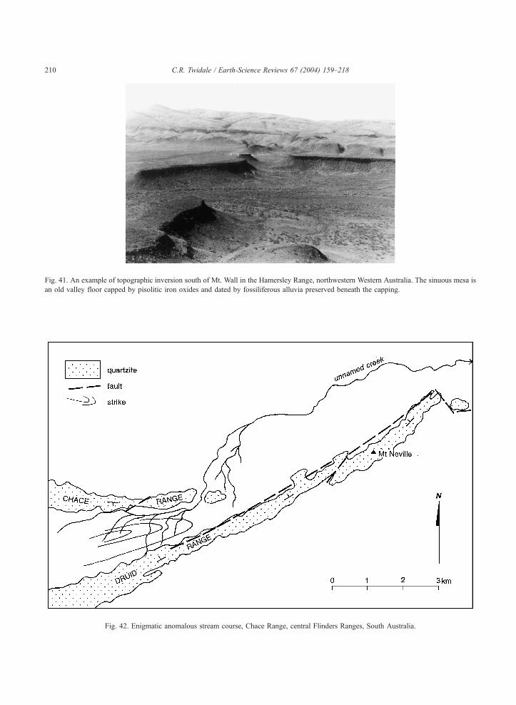
Fig. 41. An example of topographic inversion south of Mt. Wall in the Hamersley Range, northwestern Western Australia. The sinuous mesa is
an old valley floor capped by pisolitic iron oxides and dated by fossiliferous alluvia preserved beneath the capping.
Fig. 42. Enigmatic anomalous stream course, Chace Range, central Flinders Ranges, South Australia.
C.R. Twidale / Earth-Science Reviews 67 (2004) 159–218210
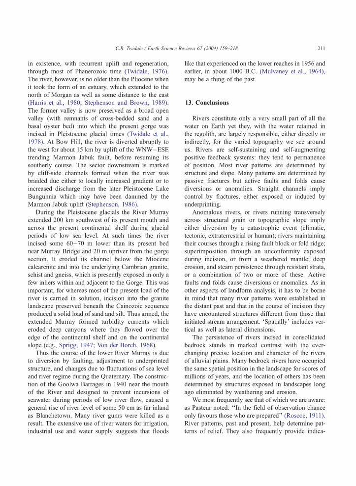
C.R. Twidale / Earth-Science Reviews 67 (2004) 159–218 211
in existence, with recurrent uplift and regeneration,
through most of Phanerozoic time (Twidale, 1976).
The river, however, is no older than the Pliocene when
it took the form of an estuary, which extended to the
north of Morgan as well as some distance to the east
(Harris et al., 1980; Stephenson and Brown, 1989).
The former valley is now preserved as a broad open
valley (with remnants of cross-bedded sand and a
basal oyster bed) into which the present gorge was
incised in Pleistocene glacial times (Twidale et al.,
1978). At Bow Hill, the river is diverted abruptly to
the west for about 15 km by uplift of the WNW–ESE
trending Marmon Jabuk fault, before resuming its
southerly course. The sector downstream is marked
by cliff-side channels formed when the river was
braided due either to locally increased gradient or to
increased discharge from the later Pleistocene Lake
Bungunnia which may have been dammed by the
Marmon Jabuk uplift (Stephenson, 1986).
During the Pleistocene glacials the River Murray
extended 200 km southwest of its present mouth and
across the present continental shelf during glacial
periods of low sea level. At such times the river
incised some 60–70 m lower than its present bed
near Murray Bridge and 20 m upriver from the gorge
section. It eroded its channel below the Miocene
calcarenite and into the underlying Cambrian granite,
schist and gneiss, which is presently exposed in only a
few inliers within and adjacent to the Gorge. This was
important, for whereas most of the present load of the
river is carried in solution, incision into the granite
landscape preserved beneath the Cainozoic sequence
produced a solid load of sand and silt. Thus armed, the
extended Murray formed turbidity currents which
eroded deep canyons where they flowed over the
edge of the continental shelf and on the continental
slope (e.g., Sprigg, 1947; Von der Borch, 1968).
Thus the course of the lower River Murray is due
to diversion by faulting, adjustment to underprinted
structure, and changes due to fluctuations of sea level
and river regime during the Quaternary. The construc-
tion of the Goolwa Barrages in 1940 near the mouth
of the River and designed to prevent incursions of
seawater during periods of low river flow, caused a
general rise of river level of some 50 cm as far inland
as Blanchetown. Many river gums were killed as a
result. The extensive use of river waters for irrigation,
industrial use and water supply suggests that floods
like that experienced on the lower reaches in 1956 and
earlier, in about 1000 B.C. (Mulvaney et al., 1964),
may be a thing of the past.
13. Conclusions
Rivers constitute only a very small part of all the
water on Earth yet they, with the water retained in
the regolith, are largely responsible, either directly or
indirectly, for the varied topography we see around
us. Rivers are self-sustaining and self-augmenting
positive feedback systems: they tend to permanence
of position. Most river patterns are determined by
structure and slope. Many patterns are determined by
passive fractures but active faults and folds cause
diversions or anomalies. Straight channels imply
control by fractures, either exposed or induced by
underprinting.
Anomalous rivers, or rivers running transversely
across structural grain or topographic slope imply
either diversion by a catastrophic event (climatic,
tectonic, extraterrestrial or human); rivers maintaining
their courses through a rising fault block or fold ridge;
superimposition through an unconformity exposed
during incision, or from a weathered mantle; deep
erosion, and steam persistence through resistant strata,
or a combination of two or more of these. Active
faults and folds cause diversions or anomalies. As in
other aspects of landform analysis, it has to be borne
in mind that many river patterns were established in
the distant past and that in the course of incision they
have encountered structures different from those that
initiated stream arrangement. ‘Spatially’ includes ver-
tical as well as lateral dimensions.
The persistence of rivers incised in consolidated
bedrock stands in marked contrast with the ever-
changing precise location and character of the rivers
of alluvial plains. Many bedrock rivers have occupied
the same spatial position in the landscape for scores of
millions of years, and the location of others has been
determined by structures exposed in landscapes long
ago eliminated by weathering and erosion.
We most frequently see that of which we are aware:
as Pasteur noted: ‘‘In the field of observation chance
only favours those who are prepared’’ (Roscoe, 1911).
River patterns, past and present, help determine pat-
terns of relief. They also frequently provide indica-
C.R. Twidale / Earth-Science Reviews 67 (2004) 159–218212
tions of structure and chronology at scales ranging
from the local to the regional for those who recognise
the evidence and its possible significance. They offer
challenging and rewarding fields of study.
Acknowledgements
The paper has benefited from critical readings by
Jerry Mueller of Las Cruces, NM, and my colleague
Jennie Bourne of Adelaide. Vic Baker and an
anonymous reviewer made several suggestions and
comments, all of which were welcome and many of
which have been incorporated in the text. The writer
expresses sincere thanks to all. Science would be the
poorer were there not rigorous and honest peer
review.
References
Ahmad, J.B., 1979. The petrology of the Benom Igneous Complex.
Special Paper-Geological Survey of Malaysia 2 (141 pp.).
Allum, J.A.E., O’Leary, D.W., Friedman, J.D., Pohn, H.A., 1978.
Lineament, linear, lineation; some proposed new standards for
old terms. Bulletin of the Geological Society of America 89,
159–160.
Baker, V.R., 1973. Paleohydrology and sedimentology of Lake
Missoula flooding in eastern Washington. Special Paper-Geo-
logical Society of America 144 (79 pp.).
Baker, V.R., 1978. The Spokane Flood controversy. In: Baker, V.R.,
Nummedal, D. (Eds.), The Channeled Scabland. National Aero-
nautics and Space Administration, Washington, DC, pp. 3–15.
Baker, V.R., Penteado-Oreallana, M.M., 1977. Adjustment to Qua-
ternary climatic change by the Colorado River in central Texas.
The Journal of Geology 85, 395–422.
Baker, V.R., Pickup, G., 1987. Flood geomorphology of the Kathe-
rine Gorge, Northern Territory, Australia. Geological Society of
America Bulletin 98, 635–646.
Baker, V.R., Kochel, R.C., Patton, P.C. (Eds.), 1988. Flood Geo-
morphology. Wiley, New York. 503 pp.
Baker, V.R., Finn, V.J., Komatsu, G., 1991. Morphostructural meg-
ageomorphology. Israel Journal of Earth-Sciences 41, 65–73.
Ball, L.C., 1911. The Burketown mineral field. Publication-Geolo-
gical Survey of Queensland 232 (57 pp.).
Banks, M.R., 1962. Volcanism. In: Spry, A., Banks, M.R. (Eds.),
The Geology of Tasmania. Journal of the Geological Society of
Australia, vol. 9 (2), pp. 239–241.
Baragwanath, W., 1925. The Aberfeldy district, Gippsland.
Memoirs-Geological Survey of Victoria 15 (45 pp.).
Bates, C.C., 1953. Rational theory of delta formation. American
Association of Petroleum Geologists Bulletin 37, 2119–2162.
Binks, P.J., Hooper, G.J., 1984. Uranium in Tertiary palaeochan-
nels, ‘West Coast Area’, South Australia. Proceedings-Austral-
asian Institute of Mining and Metallurgy 289, 271–275.
Birkenhauer, J., 1991. The Great Escarpment of southern Africa and
its coastal forelands—a re-appraisal. Munchener Geographische
Abhandlungen. Reihe B 11 (419 pp.).
Bishop, P., 1995. Drainage rearrangement by river capture, behea-
ding and diversion. Progress in PhysicalGeography19, 449–473.
Blackwelder, E., 1931. Desert plains. The Journal of Geology 39,
133–140.
Bootsman, C.S., 1997. On the evolution of the upper Molopo
Drainage. South African Geographical Journal 79, 83–92.
Bourne, J.A., Twidale, C.R., 1998. Pediments and alluvial fans:
genesis and relationships in the western piedmont of the Flin-
ders Ranges, South Australia. Australian Journal of Earth Sci-
ences 45, 123–135.
Bourne, J.A., Twidale, C.R., Smith, D.M., 1974. The Corrobinnie
Depression, Eyre Peninsula, South Australia. Transactions of the
Royal Society of South Australia 98, 139–152.
Bowler, J.M., Harford, L.B., 1966. Quaternary tectonics of the
riverine plain near Echuca, Victoria. Journal of the Geological
Society of Australia 13, 339–354.
Bretz, J.H., 1923. The Channeled Scabland of the Columbia Pla-
teau. The Journal of Geology 31, 617–649.
Bretz, J.H., Smith, H.T.U., Neff, G.E., 1956. Channeled Scabland
of Washington: new data and interpretations. Geological Society
of America Bulletin 67, 957–1049.
Brock, B.B., 1972. A Global Approach to Geology. Balkema, Cape
Town. 365 pp.
Brookfield, M.E., 1998. The evolution of the great river systems of
southern Asia during the Cenozoic India–Asia collision: rivers
draining southwards. Geomorphology 22, 285–312.
Butler, B.E., 1950. Theory of prior streams as a causal factor in soil
occurrence in the riverine plain of southeastern Australia. Aus-
tralian Journal of Agricultural Research 1, 231–252.
Campana, B., 1958. The Mt. Lofty–Olary region and Kangaroo
Island. In: Glaessner, M.F., Parkin, L.W. (Eds.), The Geology
of South Australia. Melbourne Univ. Press/Geological Society
of Australia, Melbourne, pp. 3–27.
Campbell, I.B., 2001. The Georgetown Ring, Queensland: mineral
associations in a rifted crest. Global Tectonics and Metallogeny
7, 209–214.
Canavan, F., 1988. Deep lead gold deposits of Victoria. Bulletin-
Geological Survey of Victoria 62 (101 pp.).
Carlston, C.W., 1963. Drainage density and streamflow. United
States Geological Survey Professional Paper 422-C (8 pp.).
Carter, E.K., Opik, A.A., 1961. Lawn Hill—4-Mile Geological
Series. Sheet E/54-9 Australian National Grid. Bureau of Mi-
neral Resources Geology and Geophysics Explanatory Notes 21
(17 pp.).
Chamyal, L.S., Maurya, D.M., Bhandari, S., Raj, R., 2002. Late
Quaternary geomorphic evolution of the lower Narmada valley,
Western India: implications for neotectonic activity along the
Narmada–Son Fault. Geomorphology 46, 177–202.
Clark, W.B., 1966. Economic mineral deposits of the Sierra
Nevada. In: Bailey, E.H. (Ed.), Geology of Northern Cal-
ifornia. Bulletin-California. Division of Mines, vol. 190,
pp. 209–214.
C.R. Twidale / Earth-Science Reviews 67 (2004) 159–218 213
Clarke, J.D.A., 1994. Evolution of the Lefroy and Cowan palae-
odrainage channels, Western Australia. Australian Journal of
Earth Sciences 41, 55–68.
Clayton, R.W., 1956. Linear depressions (Bergfussniederungen) in
savannah landscapes. Geographical Studies 3, 102–126.
Coleman, A., 1958. The terraces and antecedence of a part of the
River Salzach. Transactions and Papers-Institute of British
Geographers 25, 119–134.
Commander, D.P. (Compiler), 1989. Hydrogeological Map of West-
ern Australia. Scale 1:2,500,000. Geological Survey of Western
Australia, Perth.
Contaldo, G.J., Mueller, J.E., 1991. Earth fissures of the Mimbres
Basin, southwestern New Mexico. New Mexico Geology 13,
69–74.
Costa, J.E., 1978. Colorado Big Thompson flood: geologic evi-
dence of a rare hydraulic event. Geology 6, 617–620.
Costa, J.E., Schuster, R.L., 1988. The formation and failure of
natural dams. Geological Society of America Bulletin 100,
1054–1068.
Cotton, C.A., 1948. Landscape Whitcombe and Tombs, Christ-
church. 301 pp.
Cox, K.G., 1989. The role of mantle plumes in the development of
continental drainage systems. Nature 342, 873–877.
Crawford, A.R., 1963. Large ring structures in a South Australian
Precambrian volcanic complex. Nature 197 (4863), 140–142.
Crickmay, C.H., 1932. The significance of the physiography of the
Cypress Hills. Canadian Field-Naturalist 46, 185–186.
Crickmay, C.H., 1976. The hypothesis of unequal activity. In:
Melhorn, W.N., Flemal, R.C. (Eds.), Theories of Landform
Development. State University of New York, Binghamton,
NY, pp. 103–109.
Cundari, A., Ollier, C.D., 1970. Australian Landform Examples No.
17: inverted relief due to lava flows along valleys. Australian
Geographer 11, 291–293.
Dalgarno, C.R.,1961. The Geology of the Barossa Valley. Unpub-
lished MSc thesis. University of Adelaide, Adelaide. 105 pp.
Darby, H.C., 1940. The Drainage of the Fens. Cambridge Univ.
Press, London. 312 pp.
Davis, W.M., 1889. The geographical cycle. Geographical Journal
14, 481–504.
De Kalb, H.F., 1990. The Twisted Earth. Lytel Eorthe Press, Hilo,
HI. 156 pp.
De Keyser, F., Wolff, K.W., 1964. The geology and mineral
resources of the Chillagoe area, Queensland. Bulletin-Australia,
Bureau of Mineral Resources, Geology and Geophysics 70
(136 pp.).
Dennison, J.M., 1997. Origin of concentric annular drainage around
Stone Mountain and other inselbergs near Atlanta, Georgia.
GSA Abstracts with Programs, BTH 22, A-36.
Derbyshire, E., 1962. Fluvioglacial erosion near Knob Lake, central
Quebec–Labrador, Canada. Geological Society of America Bul-
letin 73, 1111–1126.
de Wit, M.C.J., 1999. Post-Gondwana drainage and the develop-
ment of diamond placers in western South Africa. Economic
Geology 94, 721–740.
Dietrich, W.E., Wilson, C.J., Reneau, S.L., 1986. Hollows, col-
luvium and landslides in soil-mantled landscapes. In: Abra-
hams, A.D. (Ed.), Hillslope Processes. Allen & Unwin, Boston,
pp. 361–388.
Douglas, I., 1977. Humid Landforms. Australian National Univ.
Press, Canberra. 288 pp.
Doyle, A.C., 1892. The Adventure of the Beryl Coronet. Strand
Magazine 3, 511–525.
Dunne, T., 1980. Spring sapping: formation and controls of channel
networks. Progress in Physical Geography 4, 211–229.
Dunne, T., Aubry, B.F., 1986. Evaluation of Horton’s theory of
sheetwash and rill erosion on the basis of field experiments.
In: Abrahams, A.D. (Ed.), Hillslope Processes. Allen & Unwin,
Boston, pp. 31–53.
Dury, G.H., 1960. Misfit streams; problems in interpretation, dis-
charge and distribution. Geographical Review 50, 219–242.
Dury, G.H., 1962. Results of seismic exploration of meandering
valleys. American Journal of Science 260, 691–706.
Dury, G.H., 1964. Principles of underfit streams. United States
Geological Survey Professional Paper 452A, 1–67.
Dury, G.H., 1986. The Face of the Earth, 5th edition. Allen &
Unwin, London. 242 pp.
du Toit, A.L., 1909. The evolution of the river system of Griqualand
West. Transactions of the Royal Society of South Africa 1,
347–361.
du Toit, A.L., 1933. Crustal movements as a factor in the evolu-
tion of South Africa. South African Geographical Journal 16,
3–20.
Dutton, C.E., 1882. The physical geology of the Grand Canon
district. Second Annual Report of the United States Geological
Survey 1880–81. Government Printing Office, Washington,
DC, pp. 49–166.
Eskola, P., 1949. The problem of mantled gneiss domes. Quarterly
Journal of the Geological Society of London 104, 461–476.
Fagg, C.C., 1923. The recession of the Chalk escarpment and the
development of chalk valleys in the regional survey area. Trans-
actions of the Croydon Natural History and Scientific Society 9,
93–112.
Falconer, J.D., 1911. The Geology and Geography of Northern
Nigeria. Macmillan, London. 295 pp.
Fenner, C., 1930. The major structural and physiographic features
of South Australia. Transactions of the Royal Society of South
Australia 54, 1–36.
Firman, J.B., 1974. Structural lineaments in South Australia. Tran-
sactions of the Royal Society of South Australia 98, 153–171.
Fisher, N.H., 1945. The fineness of gold, Morobe Goldfield, New
Guinea. Economic Geology, 40, 449–495; 537–563.
Friedkin, J.F., 1945. A Laboratory Study of the Meandering of
Alluvial Rivers. United States Waterways Experimental Station,
Vicksburg, MS. 40 pp.
Garcia Ruiz, J.M., White, S.M, Marti, C., Blas Valero, M., Paz, E.,
Gomez Villar, A., 1996. La catastrofe del Barranco de Aras
(Biescas, Pirineo Aragones) y su contexto espacio-temporal.
Consejo Superior de Investigaciones Cientificas. Instituto Pire-
naico de Ecologia, Zaragoza. 54 pp.
Garner, H.F., 1966. The derangement of the Rio Caroni, Venezuela.
Revue de Geomorphologie Dynamique 2, 50–83.
Glaessner, M.F., Wade, M., 1958. The St. Vincent Basin. In:
Glaessner, M.F., Parkin, L.W. (Eds.), The Geology of South
C.R. Twidale / Earth-Science Reviews 67 (2004) 159–218214
Australia. Melbourne Univ. Press/Geological Society of Aus-
tralia, Melbourne, pp. 115–126.
Glock, W.S., 1932. Available relief as a factor of control in the
profile of a land form. The Journal of Geology 40, 74–83.
Grantz, A., Plafker, G., Kachadoorian, R., 1964. Alaska’s Good
Friday earthquake, March 27, 1964. Circular-United States Geo-
logical Survey 491 (35 pp.).
Harris, W.J., 1939. Physiography of the Echuca district. Proceed-
ings of the Royal Society of Victoria 51, 45–60.
Harris, W.K., Lindsay, J.M., Twidale, C.R., 1980. Possible outlet
for an ancient River Murray in South Australia: 2. A discussion.
Search 11, 226–227.
Harrison, J.V., Falcon, N.L., 1938. An ancient landslip at Saidmar-
reh in southwestern Iran. The Journal of Geology 46, 296–309.
Haworth, R.J., Ollier, C.D., 1992. Continental rifting and drainage
reversal: the Clarence Valley, New South Wales. Earth Surface
Processes and Landforms 17, 387–397.
Hayden, F.V., 1862. Some remarks in regard to the period of ele-
vation of those ranges of the Rocky Mountains near the sources
of the Missouri River and its tributaries. American Journal of
Science 33, 305–313.
Heezen, B.C., 1956. The origin of submarine canyons. Scientific
American 195, 36–41.
Heezen, B.C., Ewing, M., 1952. Turbidity currents and submarine
slumps, and the 1929 Grand Banks earthquake. American Jour-
nal of Science 250, 849–873.
Higgins, C.G., 1952. The lower course of the Russian River, Cali-
fornia. University of California Publications in Geology 29,
181–264.
Hills, E.S., 1955. Die Landoberflache Australiens. Die Erde 7,
195–205.
Hills, E.S., 1956. A contribution to the morphotectonics of Aus-
tralia. Journal of the Geological Society of Australia 3, 1–15.
Hills, E.S., 1961. Morphotectonics and the geomorphological sci-
ences, with special reference to Australia. Quarterly Journal of
the Geological Society of London 117, 77–89.
Hills, E.S., 1963. Elements of Structural Geology. Methuen, Lon-
don. 483 pp.
Hills, E.S., 1975. Physiography of Victoria. Whitcombe and Tombs,
Melbourne. 373 pp.
Hobbs, W.H., 1904. Lineaments of the Atlantic border region. Geo-
logical Society of America Bulletin 15, 483–506.
Hobbs, W.H., 1911. Repeating patterns in the relief and structure of
the land. Geological Society of America Bulletin 22, 123–176.
Hocking, R.M., Moors, H.T., Van de Graaff, W.J.E., 1987. Geology
of the Carnarvon Basin, Western Australia. Bulletin-Geological
Survey of Western Australia 133 (289 pp.).
Holmes, A., 1965. Principles of Physical Geology. Nelson, London.
1288 pp.
Horton, R.E., 1945. Erosional development of streams and their
drainage basins. Geological Society of America Bulletin 56,
275–370.
Hough, J.L., 1958. Geology of the Great Lakes. University of Illi-
nois Press, Urbana. 313 pp.
Howard, A.D., 1967. Drainage analysis in geologic interpretation: a
summation. American Association of Petroleum Geologists Bul-
letin 51, 2246–2259.
Hsu, K.J., 1972. When the Mediterranean dried up. Scientific
American 227, 27–36.
Hunt, C.B., 1956. Cenozoic geology of the Colorado Plateau. Unit-
ed States Geological Survey Professional Paper 279 (99 pp.).
Hutton, J.T., Twidale, C.R., Milnes, A.R., Rosser, H., 1972. Com-
position and genesis of silcretes and silcrete skins from the Beda
valley, southern Arcoona Plateau, South Australia. Journal of
the Geological Society of Australia 19, 31–39.
Jennings, J.N., 1985. Karst Geomorphology. Blackwell, Oxford.
293 pp.
Jennings, J.N., Sweeting, M.M., 1963. The limestone ranges of the
Fitzroy Basin, Western Australia. Bonner Geographische
Abhandlungen 32 (60 pp.).
Johnson, D.W., 1931. Stream Sculpture on the Atlantic Slope. Co-
lumbia Univ. Press, New York. 142 pp.
Johnson, D.W., 1932. Streams and their significance. The Journal of
Geology 40, 481–497.
Johnson, D.W., 1933. Available relief and texture of topography: a
discussion. The Journal of Geology 41, 293–305.
Jukes, J.B., 1862. On the mode of formation of some of the early
river valleys in the south of Ireland. Quarterly Journal of the
Geological Society of London 18, 378–403.
Jutson, J.T., 1914. An outline of the physiographical geology (phys-
iography) of Western Australia. Bulletin-Geological Survey of
Western Australia 61 (240 pp.).
Kale, V.S., Baker, V.R., Mishra, S., 1996. Multi-channel patterns of
bedrock rivers: an example from the central Narmada basin,
India. Catena 26, 85–98.
Kendall, P.F., 1902. A system of glacier lakes in the Cleveland
Hills. Quarterly Journal of the Geological Society of London
58, 471–571.
Kiersch, G.W., 1964. Vaiont Reservoir disaster. Civil Engineering,
March, 32–39.
King, L.C., 1942. South African Scenery. Oliver and Boyd, Edin-
burgh. 340 pp.
Knighton, D., 1984. Fluvial Forms and Processes. Arnold, London.
218 pp.
Knighton, A.D., Nanson, G.C., 1993. Anastomosis and the contin-
uum of channel pattern. Earth Surface Processes and Landforms
18, 613–625.
Knopf, E.B., 1924. Correlation of residual erosion surfaces in the
eastern Appalachians. Geological Society of America Bulletin
35, 633–668.
Kutina, J., 1995. The role of linear and circular megastructures in
global Metallurgy—a new look at the South Africa–Eastern
South America connection. In: Barton, J.M., Copperthwaite,
Y.E. (Eds.), Centennial Congress. Extended Abstracts. II. Geo-
logical Society of South Africa, Johannesburg, pp. 142–145.
LaFleur, R.G., 1968. Glacial Lake Albany. In: Fairbridge, R.W.
(Ed.), Encyclopaedia of Geomorphology. Reinhold, New
York, p. 1295.
Lauder, W.R., 1962. The Kaiwharawhara capture. New Zealand
Journal of Geology and Geophysics 5, 141–142.
Lees, G.M., 1955. Recent earth movements in the Middle East.
Geologische Rundschau 42, 221–226.
Leighly, J., 1934. Turbulence and the transportation of rock debris
by streams. Geographical Review 24, 453–464.
C.R. Twidale / Earth-Science Reviews 67 (2004) 159–218 215
Leopold, L.B., 1953. Downstream change in velocity in rivers.
American Journal of Science 251, 606–624.
Leopold, L.B., Maddock, T., 1953. The hydraulic geometry of
stream channels and some physiographic implications. United
States Geological Survey Professional Paper 252 (57 pp.).
Leopold, L.B., Wolman, M.G., 1957. River channel patterns—
braided, meandering and straight. United States Geological Sur-
vey Professional Paper 282A, 39–85.
Leopold, L.B., Wolman, M.G., 1960. River meanders. Geological
Society of America Bulletin 71, 769–794.
Leopold, L.B., Wolman, M.G., Miller, J.P., 1964. Fluvial Processes
in Geomorphology. Freeman, San Francisco. 522 pp.
Lindgren, W., 1911. Tertiary gravels of the Sierra Nevada. United
States Geological Survey Professional Paper 73 (226 pp.).
Lofgren, B.E., Klausing, R.L., 1969. Land subsidence due to
ground-water withdrawal, Tulare–Wasco area, California. Unit-
ed States Geological Survey Professional Paper 437-B (103 pp.).
Longwell, C.R., 1954. History of the lower Colorado River and the
Imperial Depression. In: Jahns, R.H. (Ed.), Geology of Southern
California. Chap. 5 Geomorphology. Bulletin-California. Divi-
sion of Mines, vol. 170, pp. 53–56.
Lowl, F., 1882. Die Enstehung der Durchbruchsthaler. Pettermans
Mitteilungen 28, 405–416.
Lucchitta, I., 1990. History of the Grand Canyon and of the Colo-
rado River in Arizona. In: Beus, S., Morales, M. (Eds.), Grand
Canyon Geology. Oxford Univ. Press, New York, pp. 311–332.
Mabbutt, J.A., 1955. Erosion surfaces in Little Namaqualand. Trans-
actions of the Geological Society of South Africa 58, 1–18.
Mabbutt, J.A., 1961. ‘Basal surface’ or ‘weathering front’. Proceed-
ings of the Geologists’ Association of London 72, 357–358.
Mabbutt, J.A., 1965. The weathered land surface in central Aus-
tralia. Zeitschrift fur Geomorphologie 9, 82–114.
MacGregor, A.M., 1951. Some milestones in the Precambrian of
Rhodesia. Transactions of the Geological Society of South
Africa 54, 27–71.
Madigan, C.T., 1931. The physiography of the western MacDonnell
Ranges, central Australia. Geographical Journal 78, 417–433.
Mahard, R.H., 1942. The origin and significance of intrenched
meanders. Journal of Geomorphology 5, 32–44.
Marker, M.E., 1975. The Lower Southeast of South Australia: a
karst province. Department of Geography and Environmental
Studies, University of Witwatersrand Occasional Paper, vol. 13.
Johannesburg, 68 pp.
Marr, J.E., 1906. The influence of the geological structure of En-
glish Lakeland upon its present features—a study in physiogra-
phy. Quarterly Journal of the Geological Society of London 62,
lxvi–cxxviii.
Matthes, F.E., 1930. Geologic history of the Yosemite Valley. Unit-
ed States Geological Survey Professional Paper 160 (137 pp.).
Maw, G., 1866. Notes on the comparative structure of surfaces
produced by subaerial and marine erosion. Geological Magazine
3, 439–451.
McCauley, J.F., Schaber, G.G., Grolier, M.J., Haynes, C.V., Issain,
B., Elachi, C., Blom, R., 1982. Subsurface valleys and geoarch-
eology of the eastern Sahara revealed by shuttle radar. Science
218, 1004–1020.
McConnell, R.G., 1907. Report on the gold values in the Klondike
high-level gravels. Publication-Geological Survey of Canada
979 (34 pp.).
McKee, E.D., McKee, E.H., 1972. Pliocene uplift of the Grand
Canyon—time of drainage adjustment. Geological Society of
America Bulletin 83, 1923–1932.
McKee, E.D., Wilson, R.F., Breed, W.J., Breed, C.S., 1967. Evo-
lution of the Colorado River in Arizona; A Hypothesis Devel-
oped at the Symposium on Cenozoic Geology of the Colorado
Plateau in Arizona, August 1964. Northern Arizona Society of
Science and Art, Flagstaff, AZ. 67 pp.
McLeod, C.R., Morison, S.R., 1996. Placer gold, platinum. In:
Eckstrand, O.R., Sinclair, W.D., Thorpe, R.I. (Eds.), Geology
of Canadian Mineral Deposit Types. Geology of Canada. Geo-
logical Survey of Canada, vol. 8, pp. 23–42.
Medlicott, H.B., 1860. On the geological structure and relations of
the southern portion of the Himalayan range between the River
Ganges and Ravee. Memoir-Geological Survey of India 3 (Pa-
per 4) (206 pp.).
Mescherikov, Y.A., 1959. Contemporary movements of the Earth’s
crust. International Geology Review 1 (8), 40–51.
Meyerhoff, H.A., Olmstead, E.W., 1936. The origins of Appala-
chian drainage. American Journal of Science 36, 21–42.
Miller, R.P., 1937. Drainage lines in bas-relief. Journal of Geology
45, 432–438.
Miller, J.R., 1991. Development of anastomosing channels in south-
central Indiana. Geomorphology 4, 221–230.
Moore, A.E., 1999. A reappraisal of epeirogenic flexure axes in
southern Africa. South African Journal of Geology 102,
363–376.
Moore, A.E., Blenkinsop, T.G., 2003. The role of mantle plumes in
the development of continental-scale drainage patterns: the
southern African example revisited. South African Journal of
Geology 105, 353–360.
Moore, A.E., Larkin, P.A., 2001. Drainage evolution in south-cen-
tral Africa since the break-up of Gondwana. South African
Journal of Geology 104, 47–68.
Morisawa, M., 1968. Streams their Dynamics and Morphology.
McGraw-Hill, New York. 175 pp.
Mueller, J.E., 1975. Restless River. Texas Western Press, El Paso.
155 pp.
Mulvaney, D.J., Lawton, G.H., Twidale, C.R., 1964. Archaeologi-
cal excavation of rock-shelter No. 6 Fromm’s Landing, South
Australia. Proceedings of the Royal Society of Victoria 77,
479–516.
Nace, R.L., 1960. Water management, agriculture and ground-water
supplies. Circular-United States Geological Survey 415, 1–11.
Nanson, G.C., Croke, J.C., 1992. A genetic classification of flood-
plains. Geomorphology 4, 459–486.
Nanson, G.C., Knighton, A.D., 1996. Anabranching rivers: their
cause, character and classification. Earth Surface Processes
and Landforms 21, 217–239.
Naval Intelligence Division (British Admiralty), 1943. China Prop-
er. Volume I. Geographical Handbook Series, B.R. 910 Naval
Intelligence Division, London. 535 pp.
Nichols, R.L., 1969. Geomorphology of Inglefield land, north
Greenland. Meddelelser om Grønland 188 (109 pp.).
Nicoletti, P.G., Parise, M., 2002. Seven landslide dams of old seis-
C.R. Twidale / Earth-Science Reviews 67 (2004) 159–218216
mic origin in southeastern Sicily (Italy). Geomorphology 46,
203–222.
Nugent, C., 1990. The Zambezi River: tectonism, climatic change
and drainage evolution. Palaeogeography, Palaeoclimatology,
Palaeoecology 78, 55–69.
Nugent, C., 1992. The Zambezi River: tectonism, climatic change
and drainage evolution—reply to discussion. Palaeogeography,
Palaeoclimatology, Palaeoecology 80, 178–182.
Oberlander, T., 1965. The Zagros streams. Syracuse Geographical
Series 1 (168 pp.).
Oberlander, T., 1985. Origin of transverse drainage to structures in
orogens. In: Morisawa, M., Hack, J.T. (Eds.), Tectonic Geomor-
phology. Allen & Unwin, Boston, pp. 155–182.
Odell, N.E., 1966. TheMarjeelen Sea and its fluctuations. Ice 20, 27.
O’Driscoll, E.S.T., 1986. Observations of the lineament–ore rela-
tionship. Philosophical Transactions of the Royal Society of
London. Series A 317, 195–218.
O’Driscoll, E.S.T., Campbell, I.B., 1997. Mineral deposits related to
Australian continental ring and rift structures with some terres-
trial and planetary analogies. Global Tectonics and Metallogeny
6, 83–101.
Ollier, C.D., 1988. Volcanoes. Blackwell, Oxford. 228 pp.
Ollier, C.D., Pain, C.F., 1994. Landscape evolution and tectonics in
southeastern Australia. AGSO Journal of Australian Geology
and Geophysics 15, 235–245.
Opik, A.A., 1961. The geology and palaeontology of the head-
waters of the Burke River, Queensland. Bulletin-Bureau of Min-
eral Resources, Geology and Geophysics 53 (249 pp.).
Osborn, G., du Toit, C., 1990. Lateral planation of rivers as a
geomorphic agent. Geomorphology 4, 249–260.
Pain, C., Craig, M. (Eds.), 1995. Australian Regolith Conference
1995. AGSO Journal 16, 195–331.
Pardee, J.T., 1910. The glacial lake Missoula. The Journal of Ge-
ology 18, 376–386.
Partridge, T.C., Maud, R.R., 1987. Geomorphic evolution of south-
ern Africa since the Mesozoic. South African Geological Jour-
nal 90, 179–208.
Pederson, D.T., 2001. Stream piracy revisited: a groundwater sap-
ping solution. GSA Today 11 (9), 4–10.
Peel, R.F., 1941. Denudation landforms of the central Libyan Des-
ert. Journal of Geomorphology 4, 3–23.
Pell, S.D., Chivas, A.R., Williams, I.S., 1999. Great Victoria Des-
ert: development and sand provenance. Australian Journal of
Earth Sciences 46, 289–299.
Pell, S.D., Chivas, A.R., Williams, I.S., 2000. The Simpson, Strze-
lecki and Tirari deserts: development and sand provenance. Sed-
imentary Geology 130, 107–130.
Pels, S., 1966. Late Quaternary chronology of the riverine plain of
southeastern Australia. Journal of the Geological Society of
Australia 13, 27–40.
Powell, J.W., 1875. Exploration of the Colorado River of the West
and its Tributaries (1869–72). Government Printing Office,
Washington, DC. 291 pp.
Potter, P.E., 1997. The Mesozoic and Cainozoic paleodrainage of
South America: a natural history. Journal of South American
Earth Sciences 10, 331–344.
Ramberg, I.B., Gabrielsen, R.H., Larsen, B.T., Solli, A., 1977.
Analysis of fracture pattern in southern Norway. Geologie en
Mijnbouw 56, 295–310.
Richter, G.D., Kaminine, L.G., 1956. Caracteristique comparative
morphologique des boucliers de la partie Europeenne de
l’URSS. Essais de Geographie. Editions de l’ Academie des
Sciences de l’URSS, Moscow, pp. 82–92.
Roscoe, H.E., 1911. Pasteur, Louis. Encyclopaedia Britannica 20,
892–894.
Rubey, W.W., 1952. Geology and mineral resources of the Hardin
and Brussels quadrangles, in Illinois. United States Geological
Survey Professional Paper 218 (170 pp.).
Rudoy, A.N., Baker, V.R., 1993. Sedimentary effects of cataclysmic
late Pleistocene glacial outburst flooding, Altay Mountains,
Siberia. Sedimentary Geology 85, 53–62.
Ruhe, R.V., 1952. Topographic discontinuities of the Des Moines
lobe. American Journal of Science 250, 46–56.
Russell, G.A., 1935. Crystal growth in solution under local stress.
American Mineralogist 20, 733–737.
Said, R., 1993. The River Nile. Geology, Hydrology and Utiliza-
tion. Pergamon, Oxford. 320 pp.
Saul, J.M., 1978. Circular structures of large scale and great age on
the Earth’s surface. Nature 271, 345–349.
Schumm, S.A., 1968. River adjustment to altered hydrologic regi-
men—Murrumbidgee River and paleochannels, Australia. Unit-
ed States Geological Survey Professional Paper 598 (65 pp.).
Schumm, S.A., Brakenridge, G.R., 1987. River responses. In: Rud-
diman, W.F., Wright Jr., H.E. (Eds.), North America and Adja-
cent Oceans During the Last Deglaciation. The Geology of
North America, vol. K-3. Geological Society of America, Boul-
der, pp. 221–240.
Schumm, S.A., Khan, H.R., 1972. Experimental study of channel
patterns. Geological Society of America Bulletin 83, 1755–1770.
Sears, J.D., 1924. Relations of the Browns Formation and the Bishop
conglomerate and their role in the origin of the Green and Yampa
rivers. Geological Society of America Bulletin 35, 279–304.
Seefeldner, E., 1951. Die Enstehung der Salzachofen. Mitteilungen
der Gesellschaft Salzburger Landeskunde 91, 153–169.
Sharp, R.P., 1954. Some physiographic aspects of southern Califor-
nia. In: Jahns, R.H. (Ed.), Geology of Southern California.
Chap. 5 Geomorphology. California Division of Mines Bulletin,
vol. 170, pp. 5–10.
Simpson, C., Doutch, H.F., 1977. The 1974 wet-season flooding of
the southern Carpentaria Plains, northwest Queensland. BMR
Journal of Australian Geology and Geophysics 2, 43–51.
Slemmons, D.B., 1966. Cenozoic volcanism of the central Sierra
Nevada, California. In: Bailey, E.H. (Ed.), Geology of Northern
California. California Division of Mines and Geology Bulletin,
San Francisco, CA, vol. 190, pp. 199–208.
Sprigg, R.C., 1947. Submarine canyons of the New Guinea and
South Australian coasts. Transactions of the Royal Society of
South Australia 71, 296–310.
Stephenson, A.E., 1986. Lake Bungunnia—a Plio-Pleistocene meg-
alake in southern Australia. Palaeogeography, Palaeoclimatol-
ogy, Palaeoecology 57, 137–156.
Stephenson, A.E., Brown, C.M., 1989. The ancient River Murray
system. BMR Journal of Australian Geology and Geophysics
11, 387–395.
C.R. Twidale / Earth-Science Reviews 67 (2004) 159–218 217
Stephenson, P.J., Griffin, T.J., Sutherland, F.L., 1980. Cainozoic
volcanism in northeastern Australia. In: Henderson, R.A., Ste-
phenson, P.J. (Eds.), The Geology and Geophysics of Northeast-
ern Australia. Geological Society of Australia, North
Queensland Division, Townsville, pp. 349–374.
Sternberg, H.O’R., Russell, R.J., 1952. Fracture patterns in the
Amazon and Mississippi Valleys. International Geographical
Union Proceedings, Washington, pp. 380–385.
Stone, K.H., 1963. Alaskan ice-dammed lakes. Annals of the Amer-
ican Association of Geographers 53, 332–349.
Strahan, A., 1902. On the origin of the river system of South Wales
and its connection with that of the Severn and the Thames.
Quarterly Journal of the Geological Society of London 58,
207–222.
Strahler, A.N., 1945. Hypotheses of stream development in the
folded Appalachians of Pennsylvania. Geological Society of
America Bulletin 56, 45–88.
Tapley, I.J., 1988. The reconstruction of palaeodrainage and region-
al geologic structures in Australia’s Canning and Officer basins
using NOAA-AVHRR satellite imagery. Earth-Science Reviews
25, 409–425.
Taylor, T.G., 1911. Physiography of eastern Australia. Common-
wealth Bureau of Meteorology Bulletin 8 (18 pp.).
Taylor, G., Taylor, G.R., Bink, M., Foudoulis, C., Gordon, I., Hed-
strom, J., Minello, J., Whippy, F., 1985. Pre-basaltic topography
of the northern Monaro and its implications. Australian Journal
of Earth Sciences 32, 65–71.
Teller, J.T., 1987. Proglacial lakes and the southern margin of the
Laurentide Ice Sheet. In: Ruddiman, W.F., Wright Jr., H.E.
(Eds.), North America and Adjacent Oceans During the Last
Deglaciation. The Geology of North America, vol. K-3. Geo-
logical Society of America, Boulder, pp. 39–69.
Thomas, D.S.G., Shaw, P.A., 1988. Late Cainozoic drainage
evolution in the Zambezi Basin: geomorphological evidence
from the Kalahari rim. Journal of African Earth Sciences 7,
611–618.
Thomas, D.S.G., Shaw, P.A., 1992. The Zambezi River: tectonism,
climatic change and drainage evolution—is there really evi-
dence for catastrophic flood? A discussion. Palaeogeography,
Palaeoclimatology, Palaeoecology 91, 175–182.
Thompson, H.D., 1949. Drainage evolution in the Appalachians of
Pennsylvania. NewYorkAcademy of ScienceAnnals 52, 33–62.
Thornbury, W.D., 1954. Principles of Geomorphology. Wiley, New
York. 618 pp.
Tricart, J., 1960. Les aspects morphodynamiques de le catastrophe
de Frejus (Decembre 1959) et leurs consequences pour la remise
en etat de la vallee. Revue de Geomorphologie Dynamique 11,
64–71.
Turner, F.J., 1952. Gefugerelief illustrated by ‘schist tor’ topogra-
phy in central Otago, New Zealand. American Journal of Sci-
ence 250, 802–807.
Twidale, C.R., 1955. Interpretation of high-level meander cut-offs.
Australian Journal of Science 17, 157–163.
Twidale, C.R., 1956a. Glacial overflow channels in north Lincoln-
shire. Transactions and Papers of the Institute of British Geog-
raphers 22, 47–54.
Twidale, C.R., 1956b. Chronology of denudation in northwest
Queensland. Geological Society of America Bulletin 67,
867–882.
Twidale, C.R., 1962. Steepened margins of inselbergs from north-
western Eyre Peninsula, South Australia. Zeitschrift fur Geo-
morphologie 6, 51–69.
Twidale, C.R., 1966a. Geomorphology of the Leichhardt–Gilbert
Area, northwest Queensland. Land Research Series, vol. 16.
CSIRO, Melbourne. 56 pp.
Twidale, C.R., 1966b. Late Cainozoic activity of the Selwyn
Upwarp. Journal of the Geological Society of Australia 13,
491–494.
Twidale, C.R., 1966c. Chronology of denudation in the southern
Flinders Ranges, South Australia. Transactions of the Royal
Society of South Australia 90 (1), 3–28.
Twidale, C.R., 1972. The neglected third dimension. Zeitschrift fur
Geomorphologie 16, 283–300.
Twidale, C.R., 1976. Geomorphological evolution. In: Twidale,
C.R., Tyler, M.J., Webb, B.P. (Eds.), Natural History of the
Adelaide Region. Royal Society of South Australia, Adelaide,
pp. 43–59.
Twidale, C.R., 1981. Origins and environments of pediments. Jour-
nal of the Geological Society of Australia 28, 423–434.
Twidale, C.R., 1985. Old land surfaces and their implications for
models of landscape evolution. Revue de Geomorphologie
Dynamique 34, 131–147.
Twidale, C.R., 1994. Gondwanan (Late Jurassic and Cretaceous)
palaeosurfaces of the Australian craton. Palaeogeography, Palae-
oclimatology, Palaeoecology 112 (1–2), 157–186.
Twidale, C.R., 1997. Persistent and ancient rivers—some Austra-
lian examples. Physical Geography 18, 215–241.
Twidale, C.R., 2002. The two-stage concept of landform and
landscape development involving etching: origin, development
and implications of an idea. Earth-Science Reviews 57 (1–2),
37–74.
Twidale, C.R., Bourne, J.A., 1996. Development of the land sur-
face. In: Davies, M., Twidale, C.R., Tyler, M.J. (Eds.), Natural
History of the Flinders Ranges. Royal Society of South Aus-
tralia, Adelaide, pp. 46–62.
Twidale, C.R., Bourne, J.A., 1998. The use of duricrusts and topo-
graphic relationships in geomorphological correlation: conclu-
sions based in Australian experience. Catena 33, 105–122.
Twidale, C.R., Bourne, J.A., 2000. Dolines of the Pleistocene dune
calcarenite terrain of western Eyre Peninsula, South Australia: a
reflection of underprinting? Geomorphology 33 (1–2), 89–105.
Twidale, C.R., Campbell, E.M., 1990. Les Gawler Ranges, Aus-
tralie du Sud: un massif de roches volcaniques siliceuses, a la
geomorphologie originale. Revue de Geomorphologie Dynami-
que 39 (3), 97–113.
Twidale, C.R., Vidal Romani, J.R., 1994. On the multistage devel-
opment of etch forms. Geomorphology 11, 157–186.
Twidale, C.R., Lindsay, J.M., Bourne, J.A., 1978. Age and origin of
the Murray River and Gorge in South Australia. Proceedings of
the Royal Society of Victoria 90 (1), 27–42.
Twidale, C.R., Horwitz, R.C., Campbell, E.M., 1985. Hamers-
ley landscapes of the northwest of Western Australia. Revue
de Geographie Physique et de Geologie Dynamique 26,
173–186.
C.R. Twidale / Earth-Science Reviews 67 (2004) 159–218218
Van de Graaff, W.J.E., Crowe, R.W.A., Bunting, J.A., Jackson,
M.J., 1977. Relict Early Cainozoic drainages in arid Western
Australia. Zeitschrift fur Geomorphologie 21, 379–400.
Von der Borch, C.C., 1968. Southern Australian submarine can-
yons: their distribution and ages. Marine Geology 6, 267–279.
Vickery, F.F., 1927. The interpretation of the physiography of the
Los Angeles coastal belt. American Association of Petroleum
Geologists Bulletin 11, 417–424.
Wager, L.R., 1937. The Arun River drainage pattern and the rise of
the Himalaya. Geographical Journal 89, 239–250.
Watson, R.A., Wright, H.E., 1969. The Saidmarreh landslide. Spe-
cial Paper-Geological Society of America 123, 115–139.
Wayland, E.J., 1934. Peneplains and some erosional landforms.
Geological Survey of Uganda Annual Report and Bulletin 1,
77–79 (for year ending 31st March 1934).
Whitehouse, F.W., 1941. The surface of western Queensland. Pro-
ceedings of the Royal Society of Queensland 53, 1–22.
Whitehouse, F.W., 1944. The natural drainage of some very flat
monsoonal lands. Australian Geographer 4, 183–196.
Willgoose, G., Bras, R.L., Rodriguez-Iturbe, I., 1991. Results from
a new model of river basin evolution. Earth Surface Processes
and Landforms 16, 237–254.
Williams, G.E., 1986. The Acraman impact structure: source of
ejecta in late Precambrian shales, South Australia. Science
233, 200–203.
Williams, G.E., 1994. Acraman, South Australia: Australia’s largest
meteorite impact structure. Proceedings of the Royal Society of
Victoria 106, 105–127.
Williams, G.E., Goode, A.T.D., 1978. Possible western outlet
for an ancient Murray River in South Australia. Search 9,
443–447.
Willis, B., 1936. East African plateaus and rift valleys. Studies in
Comparative Seismology. Carnegie Institute Publication, vol.
470. Washington, DC, 358 pp.
Wolman, M.G., Leopold, L.B., 1957. River flood plains: some
observations on their formation. United States Geological Sur-
vey Professional Paper 282C, 87–109.
Woolnough, W.G., 1927. The duricrust of Australia. Journal of the
Royal Society of New South Wales 61, 1–53.
Wopfner, H., Twidale, C.R., 1988. Formation and age of desert
dunes in the Lake Eyre depocentres in central Australia. Geo-
logische Rundschau 77, 815–834.
Wopfner, H., Twidale, C.R., 2001. Australian desert dunes; wind
rift or depositional origin? Australian Journal of Earth Sciences
48, 239–244.
Yang, D., Yu, G., Xie, Y., Zhan, D., Li, Z., 2000. Sedimentary
records of large Holocene floods from the middle reaches of
the Yellow River, China. Geomorphology 33, 73–88.
Young, R.W., 1985. Silcrete distribution in eastern Australia. Zeits-
chrift fur Geomorphologie 29, 21–36.
Young, R.W., McDougall, I., 1993. Long-term landscape evolution.
Early Miocene and modern rivers in southern New South Wales.
The Journal of Geology 101, 35–49.
Zernitz, E.R., 1932. Drainage patterns and their significance. The
Journal of Geology 40, 498–521.