Embed Size (px)
Citation preview
RIVER RECOVERY IN AN URBAN CATCHMENT:TWIN STREAMS CATCHMENT, AUCKLAND, NEW ZEALAND
C. E. Gregory, H. E. Reid, and G. J. BrierleySchool of Geography, Geology, and Environmental Science
University of AucklandPrivate Bag 92019
Auckland, New Zealand
Abstract: This study examines the evolution of a small urbanizing catchment in Waitakere City, New Zealand over the period since European settlement. Geomorphic changes are interpreted from the use of historical documents complemented by sediment analysis at eight sites throughout the catchment. Differing forms and rates of geomorphic adjustment are characterized for five different types of stream. Reach sensitivity to change and trajectory of change are related to the capacity for adjustment of differing stream types and their position within the catchment. These relationships are analyzed using the recov-ery diagram developed by Fryirs and Brierley (2000). Profound disturbance has been expe-rienced, and streams have responded to a series of land use changes over a relatively short time frame (around 160 years). The system responded quickly to forest clearance and sub-sequent phases of pasture, horticulture, viticulture, and urbanization. Significant geomor-phic recovery is under way along most stream courses. While substantial increases in sediment yield are inferred, the fine-grained nature of these deposits has not significantly altered geomorphic features of headwater streams. In mid-catchment, benches have developed along overwidened channels. Prospects for geomorphic recovery are much more limited along lowland reaches, where cumulative impacts have brought about sig-nificant changes to river morphology, such that recovery to predisturbance conditions is no longer a realistic prospect over management time frames (50–100 years). The relative geomorphic resilience of this urbanizing catchment is considered to reflect the geologic imprint upon this landscape (a dissected volcano), the reforestation of headwater reaches within a short interval of initial clearance, and the location of urban impacts that are con-centrated in the lower part of the river system. [Key words: river evolution, human distur-bance, river change, river recovery, river sensitivity.]
INTRODUCTION
In recent decades urbanization has become a dominant driver of river change (Chin, 2006; Gregory, 2006; Gurnell et al., 2007). Given their visibility, urban streams are at the forefront of public concern for rehabilitation and sustainability projects (Bernhardt and Palmer, 2007). In these initiatives, prospects to improve river condition are maximized when rehabilitation activities “work with” natural ecosystem processes (Ward et al., 2001; Brierley and Fryirs, 2005). Such under-standing must build upon insights into the trajectory of geomorphic adjustment, and associated notions of river recovery (Gore, 1985; Gore and Shields, 1995; Fryirs and Brierley, 2000).
Geomorphic analysis provides a biophysical template with which to integrate our understanding of river systems. For example, it is increasingly recognized that
222
Physical Geography, 2008, 29, 3, pp. 222-246.Copyright © 2008 by Bellwether Publishing, Ltd. All rights reserved. DOI: 10.2747/0272-3646.29.3.222
RECOVERY OF URBAN RIVERS 223
geomorphic processes are central to the creation and maintenance of aquatic hab-itats and their diversity (e.g., Newson and Newson, 2000; Montgomery, 2001; Thomson et al., 2004). Catchment-scale applications of these principles underpin effective rehabilitation activities that target realistic, physically improved outcomes (Newson et al., 1998; Clarke et al., 2003; Brierley and Fryirs, 2005; Wohl et al., 2005).
Urban streams are subjected to enormous changes to their form and function (Gurnell et al., 2007), due to both direct and indirect disturbances (Paul and Meyer, 2001). Direct pressures induce intended changes to the channel, such as modifica-tions to alleviate the impacts of flood events. Indirect pressures are secondary responses to changes that are external to the channel, for example, increasing impervious surface area with changing land cover within the catchment. Geomor-phic river responses to urbanization have been largely framed in terms of the two-phase model of channel adjustment proposed by Wolman (1967), in which an ini-tial phase of channel aggradation in response to increased sediment inputs is fol-lowed by a decline in sediment yield and increased runoff (both volume and rate), which promotes incision. In her recent review, Chin (2006) concludes that these relationships have been affirmed across the globe, but there is notable variability in the rate of change between catchments. Responses are dependent upon the form, intensity, and extent of modifications to the channel and ground cover, along with the physical and climatic setting and the type of urban development.
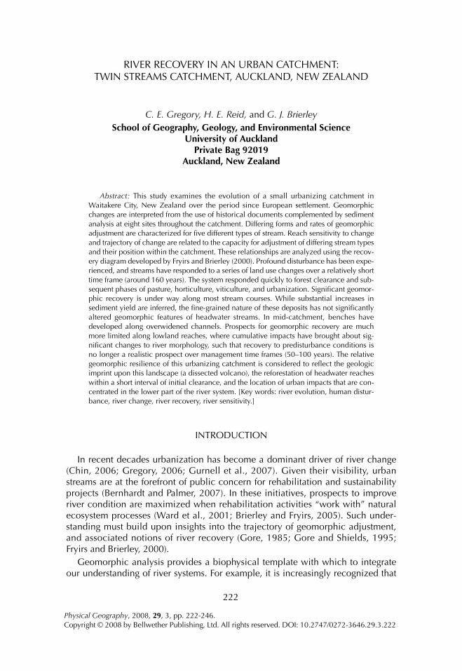
Analysis of geomorphic recovery pathways provides a sense of how a channel has adjusted following disturbance (Fryirs and Brierley, 2000). In some instances, responses to disturbance events may be absorbed by the system, while elsewhere an altered condition may be established (Simon, 1989). The former type of adjust-ment can be referred to as the behavioral regime of a river, while the latter response reflects geomorphic change (Brierley and Fryirs, 2005; Brierley et al., 2008). As noted on Figure 1, Fryirs and Brierley (2000) identify four trajectories of adjustment: retention of an intact condition, adjustment along a degradation pathway, a restora-tion pathway where the channel is readjusting toward its predisturbance state, and a creation pathway where the channel has adopted a different set of process-form relationships to those evident in its predisturbance condition (i.e., a different type of river) as the river adjusts to the altered set of boundary conditions.
Many river systems have a “memory” for past events, leading to complex responses, threshold changes, and a difficulty in teasing out intrinsic and extrinsic influences (Sear and Newson, 2003). This “memory” selectively records perturba-tions that are disproportionately large or long-lasting relative to the magnitude or longevity of the disturbance (Phillips, 2003). Hence, analysis of system response to disturbance events must be viewed in light of longer-term system variability, such as that induced by climate shifts or sea level changes (Downs and Gregory, 2004). Compounding this complexity, response processes are spatially variable, as differ-ent components of the landscape respond in different ways to the same disturbance event (Phillips, 2003). In river terms, disturbance responses reflect the sensitivity to change (Brunsden and Thornes, 1979) or capacity for adjustment (Brierley and Fryirs, 2005) of any given reach. Sensitivity is spatially variable (Thomas, 2001), controlled primarily by the imposed boundary conditions of each reach, including
224 GREGORY ET AL.
underlying geology and prevailing climate regime, which determine the slope, relief, and valley morphology (Brierley and Fryirs, 2005). These factors influence how readily bed character, channel morphology, and planform can be modified in light of available stream energy and any alterations to sediment and hydraulic regimes (termed the capacity for adjustment). Reaches that are subjected to the greatest modification of these attributes are highly sensitive, while those that have limited capacity for adjustment (e.g., a bedrock reach in a confined valley) absorb disturbances with negligible geomorphic change and are termed resilient to distur-bance.
Biophysical linkages within a catchment provide an additional layer of complex-ity in analysis of system responses to disturbance events. These linkages determine the efficiency with which responses to disturbance are propagated through a catch-ment (Harvey, 2002; Brierley et al., 2006). In highly connected systems, sediment is conveyed efficiently through the system. Where reaches are disconnected, sedi-ment transfer is asynchronous with disturbance drivers, producing lagged responses (Trimble, 1999; Fryirs et al., 2007). In many instances, particularly in the new world, stores of post-settlement deposits released following human disturbance to hillslopes are stored along valley floors (e.g., Fryirs and Brierley, 2001; Florsheim and Mount, 2003; Knox, 2006), sustaining high rates of sediment transfer from basins over decadal scales as these deposits are reworked (Trimble and Crosson, 2000; Wilkinson and McElroy, 2007). To place river responses to urbanization in context of these lagged, off-site impacts, geomorphic analyses must be performed at the catchment scale.
Parts of the New Zealand landscape are characterized by some of the highest rates of sediment production and delivery anywhere in the world (Hicks et al., 2000; Hicks and Shankar, 2003). There are some outstanding records of land use
Fig. 1. Recovery trajectory diagram of Fryirs and Brierley (2000). Following human disturbance to the sediment and/or hydraulic regime, a reach responds along a degradational pathway (left hand side of diagram). Over time, recovery may occur, either toward a restored condition (similar to predistur-bance conditions) or a created condition, where the river adopts a differing set of process-form relation-ships.
RECOVERY OF URBAN RIVERS 225
change (e.g., Guthrie-Smith, 1921) and environmental histories (e.g., Park, 1995). Extensive research has documented pronounced landslide activity in response to land use change (e.g., Glade, 2003). Various high-resolution studies have deter-mined accentuated rates of sedimentation in the period since European settlement on valley floors (e.g., Kasai et al., 2005) and floodplains (e.g., Gomez et al., 2007) and in lakes (e.g., Page et al., 1994), estuaries (e.g., Chague-Goff et al., 2000), and on the continental margin (e.g., Orpin et al., 2006). Despite this understanding, there are remarkably few catchment-scale analyses of alterations to source to sink sediment budgets that summarize landscape adjustments to human disturbance. The primary exception is the Waipaoa catchment in the North East Cape of North Island—a tectonically uplifting landscape that is dominated by highly erodible lithologies (Page et al., 2001). However, increases to the rate of sediment produc-tion and delivery following human disturbance in this area may not be representa-tive of the country as a whole. For example, although accentuated rates of sediment accumulation have been reported for coastal environments in the Northland/Auckland region (e.g., Hume and McGlone, 1986; Nichol et al., 2000; Hayward et al., 2006; Ogden et al., 2006), field-based investigations of catchment responses to human disturbance and associated knowledge of sediment production and delivery are sadly missing. In this study, stream responses to differing forms of human distur-bance are analyzed to determine the trajectory of change of each reach in an urban-izing catchment in West Auckland, New Zealand, using the recovery trajectory model outlined by Fryirs and Brierley (2000).
DESCRIPTION OF TWIN STREAMS CATCHMENT
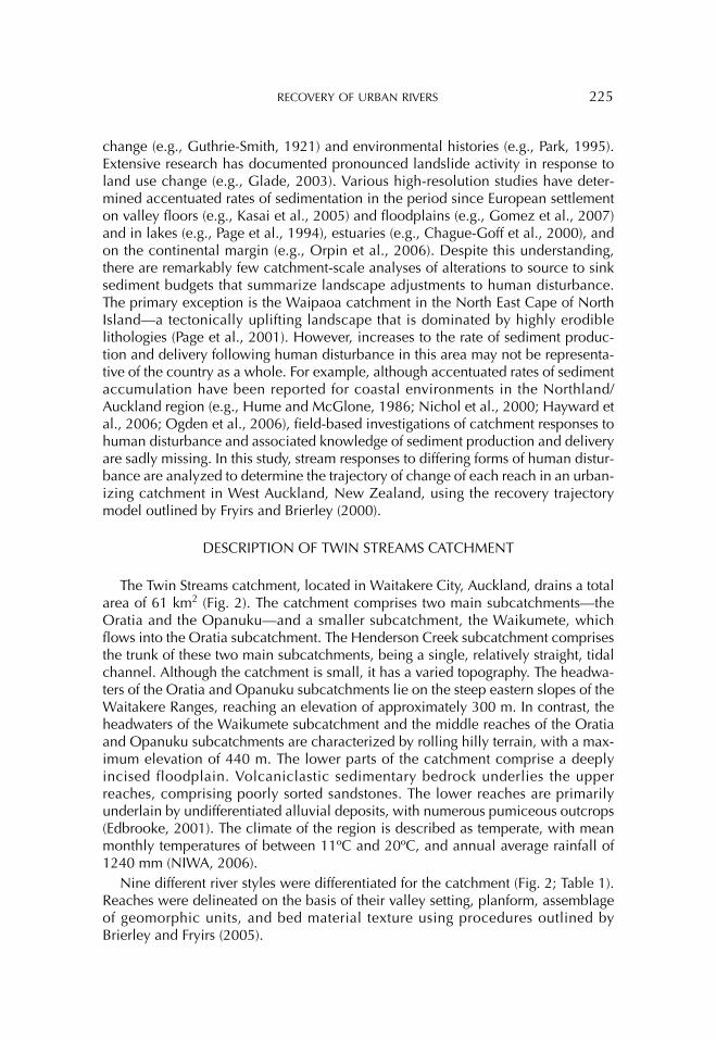
The Twin Streams catchment, located in Waitakere City, Auckland, drains a total area of 61 km2 (Fig. 2). The catchment comprises two main subcatchments—the Oratia and the Opanuku—and a smaller subcatchment, the Waikumete, which flows into the Oratia subcatchment. The Henderson Creek subcatchment comprises the trunk of these two main subcatchments, being a single, relatively straight, tidal channel. Although the catchment is small, it has a varied topography. The headwa-ters of the Oratia and Opanuku subcatchments lie on the steep eastern slopes of the Waitakere Ranges, reaching an elevation of approximately 300 m. In contrast, the headwaters of the Waikumete subcatchment and the middle reaches of the Oratia and Opanuku subcatchments are characterized by rolling hilly terrain, with a max-imum elevation of 440 m. The lower parts of the catchment comprise a deeply incised floodplain. Volcaniclastic sedimentary bedrock underlies the upper reaches, comprising poorly sorted sandstones. The lower reaches are primarily underlain by undifferentiated alluvial deposits, with numerous pumiceous outcrops (Edbrooke, 2001). The climate of the region is described as temperate, with mean monthly temperatures of between 11ºC and 20ºC, and annual average rainfall of 1240 mm (NIWA, 2006).
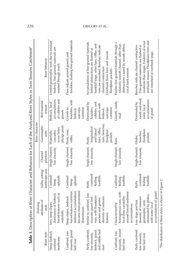
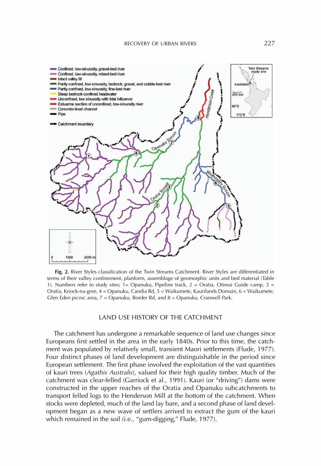
Nine different river styles were differentiated for the catchment (Fig. 2; Table 1). Reaches were delineated on the basis of their valley setting, planform, assemblage of geomorphic units, and bed material texture using procedures outlined by Brierley and Fryirs (2005).
226 GREGORY ET AL.
Table
1. D
escr
iptio
n of
Riv
er C
hara
cter
and
Beh
avio
r fo
r Ea
ch o
f the
Ana
lyze
d R
iver
Sty
les
in T
win
Str
eam
s C
atch
men
ta
Riv
er s
tyle
Def
inin
gat
trib
utes
of
styl
eV
alle
y se
tting
/la
ndsc
ape
unit
Riv
er c
hara
cter
Riv
er b
ehav
ior
Cha
nnel
plan
form
Geo
mor
phic
units
Bed
mat
eria
lte
xtur
e
Stee
p be
droc
k co
nfin
ed
head
wat
er
Ver
y st
eep
slop
es,
dom
inan
ce o
f bed
rock
fo
rced
feat
ures
suc
h as
w
ater
falls
.
Con
fined
/ St
eep
upla
nds
Sing
le c
hann
el,
low
sin
uosi
tyW
ater
falls
; ca
scad
es;
scou
r ho
les;
pl
unge
poo
ls
Bed
rock
, loc
al
accu
mul
atio
ns
of c
obbl
es a
nd
grav
els
Lim
ited
geom
orph
ic w
ork
due
to re
sist
ant
bedr
ock;
fine
-gra
ined
mat
eria
ls a
re
was
hed
thro
ugh
reac
h.
Con
fined
, low
si
nuos
ity g
rave
l be
d riv
er
Stee
p sl
opes
, bed
rock
fo
rced
feat
ures
com
mon
; se
dim
ent a
ccum
ulat
ions
be
com
e m
ore
prom
inen
t do
wns
trea
m.
Con
fined
St
eep
upla
nds
Sing
le c
hann
el,
low
sin
uosi
tyPo
ols;
run
s;
riffl
esG
rave
ls to
bo
ulde
rs, w
ith
bedr
ock
outc
rops
co
mm
on
Flow
adj
usts
aro
und
grav
els
and
boul
ders
, flu
shin
g fin
e-gr
aine
d m
ater
ials
Part
ly c
onfin
ed,
low
sin
uosi
ty,
bedr
ock,
gra
vel,
and
cobb
le b
ed
river
Sim
ilar
to c
onfin
ed, l
ow
sinu
osity
gra
vel b
ed
river
, with
floo
dpla
in
pock
ets
and
grea
ter
dive
rsity
of i
nstr
eam
fe
atur
es.
Part
ly
conf
ined
/ R
ollin
g fo
othi
lls
Sing
le c
hann
el,
low
sin
uosi
tyPo
ols;
lo
ngitu
dina
l an
d la
tera
l ba
rs; r
iffle
s;
runs
; ben
ches
; flo
odpl
ain
pock
ets
Dom
inat
ed b
y bo
ulde
rs,
cobb
les,
and
gr
avel
s w
ith
bedr
ock
outc
rops
co
mm
on
Acc
umul
atio
ns o
f fin
e-gr
aine
d m
ater
ials
be
hind
obs
truc
tions
are
flus
hed
at
bank
full
stag
e, w
hen
bars
, riff
les,
and
ru
ns a
re r
ewor
ked.
Ben
ches
indi
cate
ch
anne
l con
trac
tion.
Ove
rban
k flo
ws
form
and
rew
ork
flood
plai
n po
cket
s.
Con
fined
, low
si
nuos
ity, m
ixed
be
d riv
er
Cha
ract
eriz
ed b
y ho
mog
enou
s ru
ns, w
ith
loca
l flo
w v
aria
bilit
y ar
ound
forc
ed s
edim
ent
accu
mul
atio
ns.
Con
fined
/ R
ollin
g fo
othi
lls
Sing
le c
hann
el,
low
sin
uosi
tyR
uns
Gra
vels
, san
ds,
mud
Flus
hes
fine-
grai
ned
mat
eria
ls th
roug
h a
rela
tivel
y sm
ooth
cha
nnel
, oth
er th
an
obst
ruct
ions
cau
sed
by w
oody
deb
ris.
Lo
cal b
ank
eros
ion.
Part
ly c
onfin
ed,
low
sin
uosi
ty,
fine
bed
river
Low
slo
pe a
nd lo
w
dive
rsity
of i
nstr
eam
ge
omor
phic
uni
ts
(dom
inat
ed b
y gl
ides
), w
ith s
ome
loca
l ac
cum
ulat
ions
of g
rave
l.
Part
ly
conf
ined
/ R
ollin
g fo
othi
lls
Sing
le c
hann
el,
low
sin
uosi
tyG
lides
; be
nche
s;
flood
plai
n po
cket
s
Dom
inat
ed b
y sa
nds
and
mud
; so
me
loca
l ac
cum
ulat
ions
of
gra
vel
Ben
ches
indi
cate
cha
nnel
con
trac
tion.
Fi
ne-g
rain
ed m
ater
ials
are
flus
hed
at
mod
erat
e flo
w s
tage
s. E
vide
nce
of s
cour
an
d ba
nk e
rosi
on. F
lood
plai
ns fo
rm a
nd
are
rew
orke
d at
ove
rban
k st
age.
a The
dist
ribu
tion
of th
ese
styl
es is
sho
wn
in F
igur
e 2.
RECOVERY OF URBAN RIVERS 227
LAND USE HISTORY OF THE CATCHMENT
The catchment has undergone a remarkable sequence of land use changes since Europeans first settled in the area in the early 1840s. Prior to this time, the catch-ment was populated by relatively small, transient Maori settlements (Flude, 1977). Four distinct phases of land development are distinguishable in the period since European settlement. The first phase involved the exploitation of the vast quantities of kauri trees (Agathis Australis), valued for their high quality timber. Much of the catchment was clear-felled (Garriock et al., 1991). Kauri (or “driving”) dams were constructed in the upper reaches of the Oratia and Opanuku subcatchments to transport felled logs to the Henderson Mill at the bottom of the catchment. When stocks were depleted, much of the land lay bare, and a second phase of land devel-opment began as a new wave of settlers arrived to extract the gum of the kauri which remained in the soil (i.e., “gum-digging,” Flude, 1977).
Fig. 2. River Styles classification of the Twin Streams Catchment. River Styles are differentiated in terms of their valley confinement, planform, assemblage of geomorphic units and bed material (Table 1). Numbers refer to study sites; 1= Opanuku, Pipeline track, 2 = Oratia, Otimai Guide camp, 3 = Oratia, Knock-na-gree, 4 = Opanuku, Candia Rd, 5 = Waikumete, Kaurilands Domain, 6 = Waikumete, Glen Eden picnic area, 7 = Opanuku, Border Rd, and 8 = Opanuku, Cranwell Park.
228 GREGORY ET AL.
During the third phase, beginning during the 1870s, native vegetation began to regenerate in the upper parts of the Oratia and Opanuku subcatchments, while the middle and lower reaches and the Waikumete subcatchment were developed for a mixture of viticultural, horticultural and agricultural activities. Within the Henderson Creek subcatchment, a small settlement with small industries such as brick works developed (Garriock et al., 1991). Henderson Creek provided a vital communication link with the main Auckland settlement, with ships being able to navigate the creek (Flude, 1977). Later, during the 1910s and 1920s, a small settle-ment was established along the middle and upper reaches of the Waikumete sub-catchment.
The fourth land use phase began following World War Two, when the lower half of the catchment was developed intensively for urban settlement, with farms, orchards, and vineyards converted to suburbs. This process has continued until the present, expanding progressively upstream (Waitakere City Council, 2002a).
METHOD
To analyze the nature and rate of river responses to human disturbance across Twin Streams catchment, field analysis of channel changes based on geomorphic and sedimentologic investigations was tied to an assessment of historical records. Inevitably, the field record is incomplete and biased, described by Ager (1993) as sediment tied together with many holes. Although historical data in the form of maps, settlers notes, and anecdotal records were rarely produced with a geomor-phologist in mind (Gurnell et al., 2003), these sources can be interpreted to assess how and when the landscape has adjusted over time (Davis and Finlayson, 1999). Where data pertaining to a reach are not available, ergodic reasoning may be used, using reference conditions that operate under near equivalent conditions in similar catchment positions (Fryirs and Brierley, 2000).
The sedimentology of the out-of-channel geomorphic units was analyzed at rep-resentative sites for each river style in each subcatchment. Insights gained were related to historical records to make inferences about channel responses to human disturbances. Trajectories of change following European arrival were constructed for five river styles, relating cross-sectional timeslices constructed for each reach to phases of known land use changes. Patterns of evolution were then analyzed at the catchment scale, identifying linkages between reaches. While this methodology does not employ detailed quantitative analysis of disturbance responses, it does provide a clear sense of the changes to river morphology across the catchment in the period since European arrival.
RESULTS—CHANNEL ADJUSTMENTS FOLLOWING EUROPEAN ARRIVAL
Upper Oratia and Opanuku Subcatchments—Confined Low Sinuosity Gravel Bed River Style
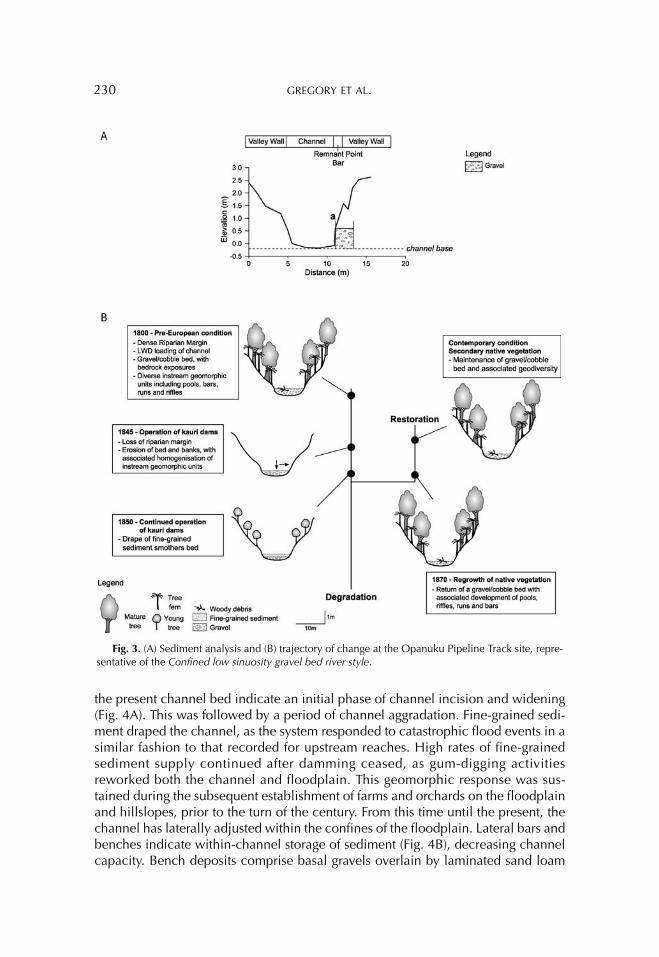
The headwater reaches of the Oratia and Opanuku subcatchments (Sites 1 and 2, Fig. 2) were subjected to initial logging of kauri, and the operation of kauri dams.
RECOVERY OF URBAN RIVERS 229
Operation of these dams caused catastrophic flooding, which had high erosive potential due to the log load, as noted by Diamond (1966, pp. 113–115):
It was an awesome sight to see logs weighing many tons being lifted as though they were matchsticks and carried by the relentless water as it forced its way down stream scouring out the banks and leaving land-slides and devastation in its wake… stones would become imbedded in them so that every log had to be inspected and any stones removed with a pick before being sawn.
Prior to European arrival, the reach had significant diversity in physical structure, including various bar types, pools, riffles and runs. Operation of kauri dams in the 1840s and 1850s decreased this geodiversity. Bed incision occurred during this period, as evidenced by the contemporary channel being inset by around 0.5 m within former bed materials (Fig. 3A). Anecdotal records indicate siltation of the channel bed following damming, as noted by Reed (1953, p. 220):
In the earlier days the banks of most of the streams were high enough to keep the flooded waters within reasonable bounds. Every time a dam was tripped, however, it carried down rocks, flotsam and jetsam of tim-ber and rubbish into the rivers, which eventually became silted up, thus reducing the height of the banks.
After the cessation of logging in the mid-1850s, hillslopes in these reaches were left to regenerate with native vegetation. As the sediment flux declined, and fine-grained sediment stored within the channel was transported downstream, bed het-erogeneity increased. This condition is inferred to resemble that prior to European arrival, placing the trajectory of change on the pathway to a fully restored condition (Fig. 3B).
The short reach of the Steep bedrock confined river style upstream of this site is located within an area of rugged topography (Fig. 2). Accessibility difficulties restricted land use to selective logging activities and this reach has retained an intact condition.
Middle Oratia and Opanuku Subcatchments—Partly Confined Low Sinuosity Bedrock, Gravel, and Cobble Bed River Style
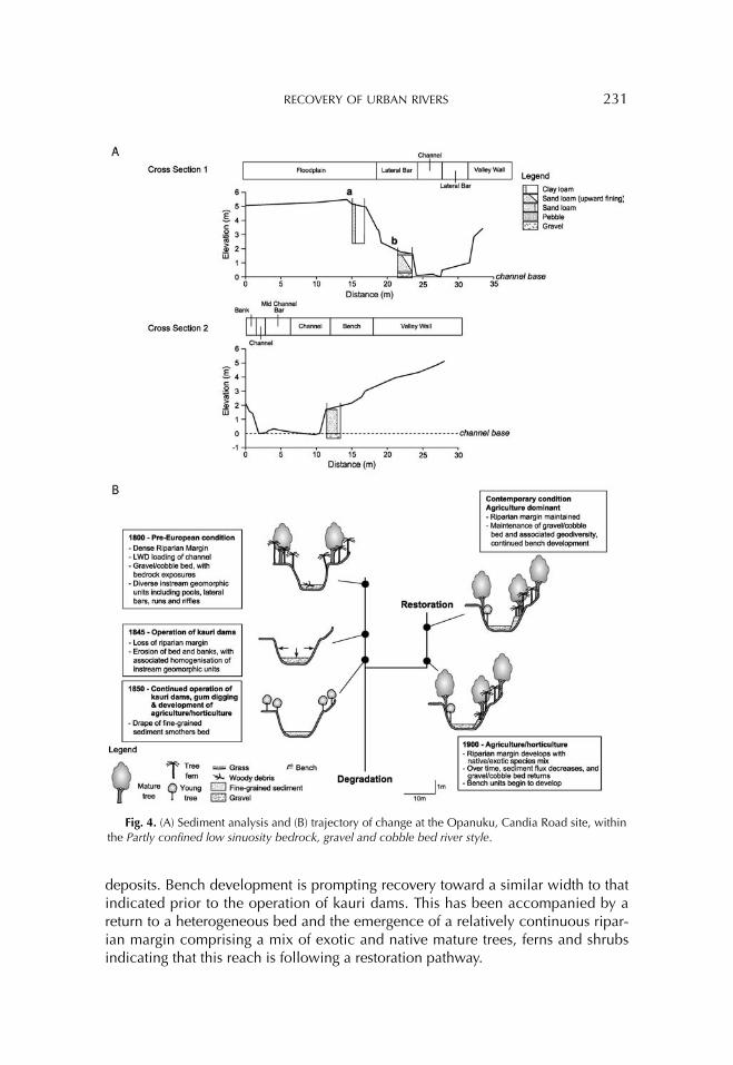
Prior to European arrival, these reaches (Sites 3 and 4, Fig. 2) were characterized by a cover of dense vegetation across the floodplain, prompting the development of a cohesive, vertically accreted floodplain that is characterized by fine-grained (clay-loam) deposits (Fig. 4A). Heterogeneity of the gravel-cobble bed was promoted by the bedrock forcing of pools and bars, as observed today. Loadings of wood along the channel were likely greater in the past, further enhancing geodiversity (Brooks and Brierley, 2002).
As noted for the upper catchment, these reaches were subjected to kauri logging and damming. Former channel bed deposits observed approximately 0.5 m above
230 GREGORY ET AL.
the present channel bed indicate an initial phase of channel incision and widening (Fig. 4A). This was followed by a period of channel aggradation. Fine-grained sedi-ment draped the channel, as the system responded to catastrophic flood events in a similar fashion to that recorded for upstream reaches. High rates of fine-grained sediment supply continued after damming ceased, as gum-digging activities reworked both the channel and floodplain. This geomorphic response was sus-tained during the subsequent establishment of farms and orchards on the floodplain and hillslopes, prior to the turn of the century. From this time until the present, the channel has laterally adjusted within the confines of the floodplain. Lateral bars and benches indicate within-channel storage of sediment (Fig. 4B), decreasing channel capacity. Bench deposits comprise basal gravels overlain by laminated sand loam
Fig. 3. (A) Sediment analysis and (B) trajectory of change at the Opanuku Pipeline Track site, repre-sentative of the Confined low sinuosity gravel bed river style.
RECOVERY OF URBAN RIVERS 231
deposits. Bench development is prompting recovery toward a similar width to that indicated prior to the operation of kauri dams. This has been accompanied by a return to a heterogeneous bed and the emergence of a relatively continuous ripar-ian margin comprising a mix of exotic and native mature trees, ferns and shrubs indicating that this reach is following a restoration pathway.
Fig. 4. (A) Sediment analysis and (B) trajectory of change at the Opanuku, Candia Road site, within the Partly confined low sinuosity bedrock, gravel and cobble bed river style.
232 GREGORY ET AL.
Upper Waikumete Subcatchment—Confined Low Sinuosity Mixed Bed River Style
The Confined low sinuosity mixed bed river style reaches in the upper Waikumete subcatchment have remained largely intact since European arrival in the catchment. While vegetation on the slopes of these confined reaches was cleared during the phase of deforestation in the 1840s–1850s, it is inferred that impacts upon channel form and function were minimal. High slopes and limited room for adjustment would have ensured that these reaches flushed additional sed-iment supplied to them quickly. Native vegetation was quickly reestablished along a number of the tributaries, particularly in the upper segments. Local areas in the lower sections of these reaches lack native riparian vegetation and large woody debris, and are characterized by a homogenous channel with limited geodiversity (Reid et al., 2008). These areas are progressing along a degradational pathway on the river recovery diagram. Reaches have been piped along some urbanized tribu-taries, completely modifying geomorphic form-process associations. This has resulted in a degraded condition.
An Intact valley fill remains in one reach of the Waikumete subcatchment. Geo-morphically, this reach has retained its pre-European condition throughout the period since European disturbance. Although this catchment has been urbanized, inferred increases in sediment load have not altered form-process associations, probably because of low stream power conditions.
Lower Waikumete Subcatchment—Partly Confined Low Sinuosity Fine Bed River Style
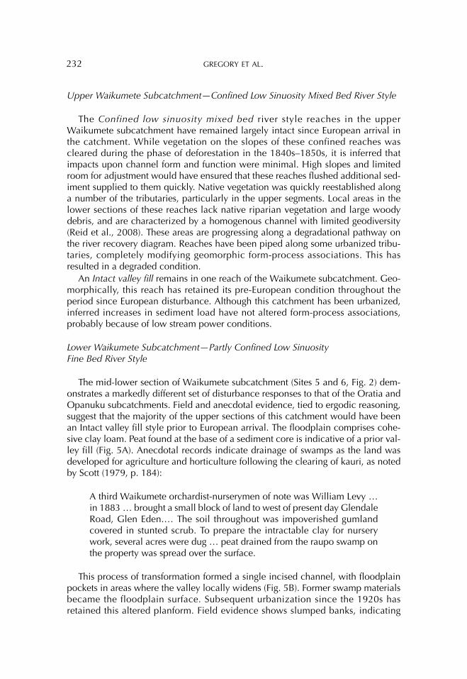
The mid-lower section of Waikumete subcatchment (Sites 5 and 6, Fig. 2) dem-onstrates a markedly different set of disturbance responses to that of the Oratia and Opanuku subcatchments. Field and anecdotal evidence, tied to ergodic reasoning, suggest that the majority of the upper sections of this catchment would have been an Intact valley fill style prior to European arrival. The floodplain comprises cohe-sive clay loam. Peat found at the base of a sediment core is indicative of a prior val-ley fill (Fig. 5A). Anecdotal records indicate drainage of swamps as the land was developed for agriculture and horticulture following the clearing of kauri, as noted by Scott (1979, p. 184):
A third Waikumete orchardist-nurserymen of note was William Levy … in 1883 … brought a small block of land to west of present day Glendale Road, Glen Eden.… The soil throughout was impoverished gumland covered in stunted scrub. To prepare the intractable clay for nursery work, several acres were dug … peat drained from the raupo swamp on the property was spread over the surface.
This process of transformation formed a single incised channel, with floodplain pockets in areas where the valley locally widens (Fig. 5B). Former swamp materials became the floodplain surface. Subsequent urbanization since the 1920s has retained this altered planform. Field evidence shows slumped banks, indicating
RECOVERY OF URBAN RIVERS 233
local widening of the channel. This has created the space in which bench units sub-sequently formed. An increase in the stormwater network since urbanization has likely generated more frequent, larger flows that have reworked floodplain sedi-ments (Wolman, 1967; Chin, 2006).
In summary, this reach is interpreted as moving along a creation pathway with a differing set of form-process associations to those evident at the time of European arrival. As such, predisturbance conditions no longer provide a realistic goal for rehabilitation projects (Fig. 5B). Drainage of intact valley fills has resulted in limited geodiversity within the channel, a condition that has been retained through to today (Reid et al., 2008).
The downstream segment of this reach provides no evidence of a prior intact val-ley fill (Fig. 6). The predisturbance condition of this site was a densely vegetated
Fig. 5. (A) Sediment analysis and (B) trajectory of change at the Waikumete Stream, Kaurilands Domain site within the Partly confined low sinuosity fine bed river style.
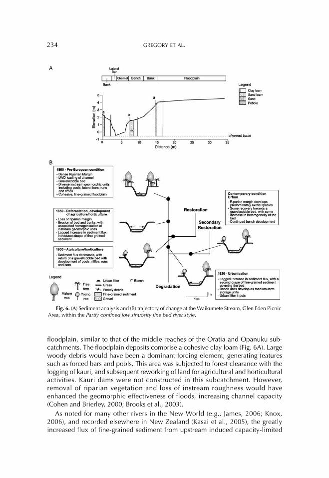
234 GREGORY ET AL.
floodplain, similar to that of the middle reaches of the Oratia and Opanuku sub-catchments. The floodplain deposits comprise a cohesive clay loam (Fig. 6A). Large woody debris would have been a dominant forcing element, generating features such as forced bars and pools. This area was subjected to forest clearance with the logging of kauri, and subsequent reworking of land for agricultural and horticultural activities. Kauri dams were not constructed in this subcatchment. However, removal of riparian vegetation and loss of instream roughness would have enhanced the geomorphic effectiveness of floods, increasing channel capacity (Cohen and Brierley, 2000; Brooks et al., 2003).
As noted for many other rivers in the New World (e.g., James, 2006; Knox, 2006), and recorded elsewhere in New Zealand (Kasai et al., 2005), the greatly increased flux of fine-grained sediment from upstream induced capacity-limited
Fig. 6. (A) Sediment analysis and (B) trajectory of change at the Waikumete Stream, Glen Eden Picnic Area, within the Partly confined low sinuosity fine bed river style.
RECOVERY OF URBAN RIVERS 235
conditions, and an extensive drape of materials resulted. However, as responses to upstream disturbance became less pronounced over time, the extent of reworking of the soil decreased, and sediment supply to the channel was reduced. Without the sustained high levels of input of fine-grained materials to the reach, flushing occurred, as indicated by bed conditions reported by Copedo (2003, p. 10):
In the early 20s and 30s the Oratia Stream had a shingle and rock bot-tom (no mud at all) and the banks were lined with beautiful Kowhai, ferns, poplars, etc.—in fact it was a very popular waterway; as many as a dozen fairly large launches and yachts would be anchored in the Falls Park lagoon over the Christmas holiday period.
The area began to urbanize in the 1920s. By the 1940s, a second flux of fine sed-iment was being propagated through the reach, as noted by Waitakere City Council (2002b, p. 35), “Clearance of bush and subdivision in the Oratia catchment lead to siltation of the Creek and the runoff from septic tanks and industry polluted the water.”
Bench units formed during this time of higher sediment flux, as indicated by a brick found within these deposits (Fig. 6A). The bench unit largely comprises sand loam deposits, with a thin layer of relatively uniform green sands. While the chan-nel contracted in some areas, elsewhere it locally widened and the council undertook works to mitigate erosion of channel banks (Waitakere City Council, 2002b). Reestablishment of a riparian margin increased loadings of instream wood and associated roughness (Copedo, 2003). This phase was accompanied by dumping of large volumes of urban litter into the channel (Waitakere City Coun-cil, 2002b).
It is inferred that as construction decreased in the upstream areas of the sub-catchment, the sediment yield correspondingly decreased over time. In addition, the stormwater network has altered the hydraulic regime, and fine sediment is now transported relatively efficiently through the reach. This was further enhanced by the clearing of the channel by the local government body in the 1980s and 1990s in efforts to decrease flooding of the floodplain. Some localized patches of fine sed-iment remain today, reflecting local variations in slope, channel width or flow obstructions (Reid et al., 2008).
Responses to human disturbance in this reach are characterized by a multiphase, variable trajectory of adjustment (Fig. 6B). Prior to European arrival, this reach is interpreted to have been similar to partly confined reaches in Oratia and Opanuku subcatchments. Floodplain pockets comprised very cohesive, clay-loam materials. The bed comprised gravel and cobble materials. The dense riparian margin added significant wood-induced roughness to the channel. Logging activities induced incision, expansion, and subsequent silting of the channel. After this initial phase of disturbance response, the reach was able to recover along a restoration pathway, as fine-grained sediments were flushed from the reach, increasing geodiversity. How-ever, horticultural and urbanization activities degraded channel condition. Addi-tional loads of fine-grained sediment smothered the channel and decreased bed heterogeneity. Today, as fine-grained sediments are less dominant in the channel
236 GREGORY ET AL.
and the cobble and gravel bed is returning, the channel is considered to be on a secondary restoration trajectory (Fig. 6B). This trajectory differs from the initial res-toration pathway, as bench units act as medium-term sediment storage features that reduce channel capacity.
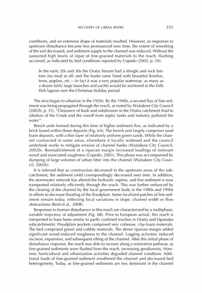
Lower Catchment—Unconfined Low Sinuosity River with Tidal Influence
Prior to European disturbance, the lower catchment (Sites 7 and 8, Fig. 2) had a densely vegetated floodplain with a single channeled gravel bed river (Fig. 7A). The floodplain comprises a cohesive clay loam. Large woody debris would have been a dominant forcing element, inducing lateral and mid-channel bars and pools. Bed-rock exposures would have been common, forcing pool development. As with the upper Oratia and Opanuku subcatchments, vegetation clearance, along with the high-flow events produced by the tripping of kauri dams, promoted incision and expansion of the channel (Fig. 7B). Sediment yield was massively increased in response to channel erosion and increased inputs of fine-grained sediment from the unvegetated slopes of upstream reaches. This pattern of geomorphic responses is entirely consistent with other areas of the world (e.g., Brooks and Brierley, 1997; Trimble, 1999; Fryirs and Brierley, 2001; Knox, 2006). Following cessation of dam-ming, the area remained unvegetated as gum-digging occurred. The land surround-ing the reach was then utilized for a mixture of viticultural, horticultural and agricultural activities. It is inferred that sediment flux through the reach slowly declined through this time, although a pulsed supply likely occurred as sediments were reworked sporadically from upstream reaches. By the 1920s, the reach had a gravel and bedrock bed, boats were able to navigate the channel, and the area was popular for its swimming holes (Flude, 1977; Jones, 2002).
By the 1940s, the channel began to become choked with silt (Waitakere City Council, 2002b). Around this time, the area experienced a boom in urbanization, with suburbs developing in the middle reaches and hillslopes. Over time, bench units have formed, as indicated by laminated bedding (Fig. 7A). A food wrapper, dated at 1998, was found 1 m below the surface, indicating rapid vertical accretion. Bank stabilization measures implemented since the 1980s, such as the reinforce-ment of banks with mesh wire, suggest that local areas were prone to bank erosion (Waitakere City Council, 2002b).
The initial incision, expansion, and subsequent silting of the channel in response to vegetation clearance and the operation of kauri dams has been char-acterized as an initial degradational phase (Fig. 7B). This reach then began on a pathway of restoration, as fine-grained materials were flushed from the reach, and geomorphic heterogeneity returned to the channel to some extent. However, with a secondary flux of fine sediment into the reach following urbanization, the chan-nel followed a degradational pathway once more. The reach is now inferred to be following a creation pathway. Irreversible change has occurred, and rates of sup-ply of fine-grained sediment exceed the capacity of the channel to flush them effi-ciently (Fig. 7B).
RECOVERY OF URBAN RIVERS 237
DISCUSSION
The Twin Streams catchment has been subjected to profound land use changes since European arrival in the area in the mid-1840s. Land use has varied throughout the catchment, reflecting both agricultural/horticultural potential and settlement history. Spatial variation in channel responses to disturbance reflect the pattern/rate
Fig. 7. (A) Sediment analysis and (B) trajectory of change at the Opanuku stream, Cranwell Park site, within the laterally unconfined river with tidal influence style.
238 GREGORY ET AL.
of land use changes, the capacity for adjustment of any given reach (i.e., its sensi-tivity to change, as indicated by river style), and the position, pattern, and connec-tivity of reaches within the catchment. More sensitive reaches in lowland areas have been subjected to the cumulative impacts of multiple phases of disturbance in upstream reaches, and continue to respond to the legacy of past disturbance events. Given this history of geomorphic responses to land use changes, the most recent phase of urbanization in Twin Streams Catchment is not considered to be the key determinant of contemporary river forms throughout most of this catchment, although it doubtless exerts a significant influence upon ecosystem processes and associated river health.
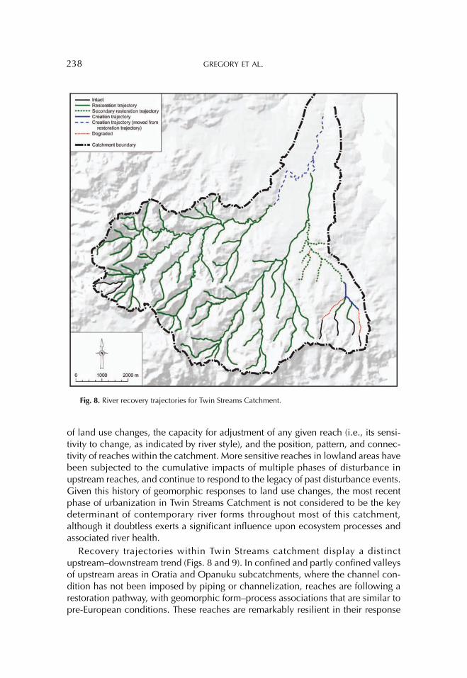
Recovery trajectories within Twin Streams catchment display a distinct upstream–downstream trend (Figs. 8 and 9). In confined and partly confined valleys of upstream areas in Oratia and Opanuku subcatchments, where the channel con-dition has not been imposed by piping or channelization, reaches are following a restoration pathway, with geomorphic form–process associations that are similar to pre-European conditions. These reaches are remarkably resilient in their response
Fig. 8. River recovery trajectories for Twin Streams Catchment.
RECOVERY OF URBAN RIVERS 239
to change, as they have a low capacity for adjustment, and sediment is easily con-veyed with limited alteration to geomorphic structure and function. As a result, these reaches have retained the same river style in the period since European settle-ment. In contrast, many headwater tributaries in the Waikumete subcatchment have metamorphosed from intact valley fills via drainage, channelization, or piping. However, degradational influences in upstream reaches of this subcatchment have not been sufficiently pronounced to compromise the resilience of midcatchment reaches, which are recovering toward a restored condition. Similarly, partly con-fined valleys in midcatchment reaches of the Oratia and Opanuku subcatchments are continuing to recover from the initial phase of channel expansion associated with forest clearance. Adjustments to subsequent land use changes (i.e., gum-digging, agriculture, horticulture, viticulture, and urbanization) have led to channel contraction through the development of benches.
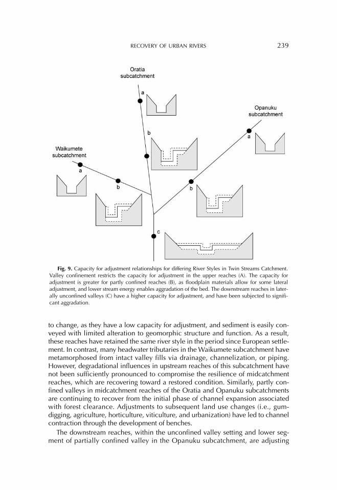
The downstream reaches, within the unconfined valley setting and lower seg-ment of partially confined valley in the Opanuku subcatchment, are adjusting
Fig. 9. Capacity for adjustment relationships for differing River Styles in Twin Streams Catchment. Valley confinement restricts the capacity for adjustment in the upper reaches (A). The capacity for adjustment is greater for partly confined reaches (B), as floodplain materials allow for some lateral adjustment, and lower stream energy enables aggradation of the bed. The downstream reaches in later-ally unconfined valleys (C) have a higher capacity for adjustment, and have been subjected to signifi-cant aggradation.
240 GREGORY ET AL.
toward a created condition. The potential for channel and floodplain compartments to be reworked ensures that these reaches have a higher capacity for adjustment (Fig. 9). This is particularly evident for the Partly confined low sinuosity fine bed river style and the Unconfined low sinuosity river with tidal influence). While fine-grained sediments are flushed through most of the middle and upper catchment, the low slope of lowland reaches limits the capacity of flow to transport the increased sediment flux associated with upstream land use changes (forest clearance, opera-tion of kauri dams, and farm, orchard, and urban development). Consequently, the channel has been transformed from a dominantly gravel and bedrock bed to a dominantly mud, silt, and sand bed (locally referred to as hard-bottomed and soft-bottomed streams, respectively).
This study has extended the river recovery diagram developed by Fryirs and Brierley (2000) as a tool to conceptualize river responses to land use changes. In this instance, multiple phases of response have been outlined for different positions within Twin Streams Catchment, as streams respond to a layer upon layer sequence of land use changes within a relatively short period of time. Across much of the catchment, reaches are still responding to the enlarged channel capacity that resulted from incision and lateral erosion following logging practices. However, in some reaches, phases of geomorphic recovery have been suppressed by further degradational influences, associated with agricultural, horticultural, and urban land use changes. For example, the lower reach of the Waikumete subcatchment and the Henderson Creek subcatchment display nonlinear trajectories of change (Figs. 6 and 7). Following a particular land use change, a reach may begin to recover, with channel forms that resemble their predisturbance condition. Reaches may then be subjected to further alteration of sediment and hydraulic regimes arising from the next phase of land use change. This may set the reach back along a pathway of deg-radation. Alternatively, as the reach responds to the secondary disturbance, it may recover along a differing recovery trajectory to that of the initial response.
The processes and controls of each river style, and their position within the catchment, affect the pattern and rate of geomorphic adjustments, and the way dis-turbance responses are propagated through the system (Hooke, 2003; Brierley et al., 2006; Fryirs et al., 2007). Spatial relationships and connectivity between reaches affect the pattern and rate of recovery trajectories. In this instance, sediment fluxes in the confined upstream reaches of the two main subcatchments were effi-ciently conveyed to reaches in the partly confined valley setting. Efficient convey-ance of sediment reflects the high connectivity of this system, as reported elsewhere for the New Zealand landscape (Fryirs et al., 2007). Significant recovery is evident in headwater settings, and contemporary rates of sediment flux are inferred not to be notably higher than during pre-European conditions (as noted by Kasai et al., 2005). A gravel bed channel has been regained across most mid-upper parts of Twin Streams catchment, marking recovery from a phase when fine-grained sediment draped the channel in response to pulsed inputs from upstream. Sediment gener-ated and conveyed through the catchment has increased sedimentation rates within the Waitemata Harbour (Hayward et al., 2006).
One of the remarkable attributes of headwater streams in Twin Streams catch-ment is their extremely healthy condition with significant instream heterogeneity,
RECOVERY OF URBAN RIVERS 241
especially when viewed in relation to the devastating impacts of forest clearance and the operation of kauri dams (Reid et al., 2008). This can be attributed, in part, to the volcanic history of the catchment. Although rates of sediment generation in this system have been high, they pale in significance relative to sediment inputs elsewhere on the North Island of New Zealand. For example, Page et al. (2001) report massive increases in sediment yield in response to landslide and gully mass-movement complexes following vegetation clearance in uplifting landscapes of the North-East Cape; a landscape characterized by highly erodible, weak sedimentary rocks elsewhere on the North Island of New Zealand (Page et al., 2001). In the Twin Streams catchment, fine-grained sediments transferred to valley floors following for-est clearance have been readily conveyed through highly connected, relatively con-fined valleys. Efficient conveyance of fine-grained sediment to lowland reaches has resulted in a substantially different set of disturbance responses within these areas. Extensive channel aggradation and drapes of fine-grained sediment limit the poten-tial for geomorphic recovery. In a sense, these materials act as a blanket, altering the pattern and rate of biophysical fluxes to the estuary (sensu Fryirs et al., 2007).
CONCLUSION
Analysis of river responses to human disturbance provide a critical context with which to frame approaches to river repair (Brierley and Fryirs, 2008). Rehabilitation efforts that strive to improve the health of aquatic ecosystems must build upon sound appreciation of the geomorphic structure and function of river systems, fram-ing reach-scale efforts within coherent catchment-scale plans (Wohl et al., 2005). The variable nature and rate of responses reflect catchment-specific considerations, determined largely by landscape and climatic considerations, and the history of any given system. If management strategies are to “work with nature,” they must build upon understanding of the character, behavior, and evolutionary trajectory of any given reach.
Such insights require catchment-scale investigations of recovery potential, as outlined in this study. Prospects for geomorphic recovery reflect the range and pattern of river types within the system, the nature of disturbance events, the sensi-tivity to change of any given part of the system, and the way in which disturbance responses are propagated through the system. Along middle and upper reaches of Twin Streams Catchment, rehabilitation of the channel to a similar geomorphic state to that which existed prior to human disturbance is a realistic vision for reha-bilitation activities. However, as the lower reaches of the catchment, and the upper reaches of the Waikumete subcatchment, have been transformed into a new river style, management applications must recognize that the pre-European state of these reaches does not provide an appropriate vision for rehabilitation plans. Rather, efforts should strive to enhance the heterogeneity of river structure, recognizing explicitly the altered boundary conditions under which this part of the river system now operates.
Although urbanization induces a profound impact upon the physical and eco-logical integrity of river systems, the nature of these impacts must be viewed in rela-tion to the condition of rivers at the time urbanization takes place. In most
242 GREGORY ET AL.
instances, urban sprawl affects rivers that are already responding to previous sets of land use changes. The relatively short history of European impacts upon river sys-tems in Twin Streams Catchment documented in this study demonstrates the resil-ience of many reaches, such that prospects for geomorphic recovery are good. This reflects the limited capacity for geomorphic adjustment for most streams in the catchment. However, the most sensitive reaches in the catchment lie in lowland areas; the place where cumulative impacts across the system as a whole are mani-fest. Ironically, this is also the most densely populated and “visible” part of the sys-tem. If recovery prospects are to be enhanced in these lowland areas, rehabilitation actions must address concerns for flow, sediment and nutrient fluxes in upper-middle catchment reaches.
Acknowledgments: We thank the Institute for Earth Sciences and Engineering at the University of Auckland for financial support for this work. Staff at Waitakere City Council provided logistical support. This was facilitated by Susan Owen at the University of Auckland. Tim Nolan and Igor Drecki, also at the University of Auckland, drafted the figures. Field work assistance was provided by Aingeru Soria, Hiroki Ogawa, Joanne Yee, and Iain McGillvary.
REFERENCES
Ager, D. (1993) The Nature of the Stratigraphical Record. Chichester, UK: John Wiley and Sons.
Bernhardt, E. S. and Palmer, M. A. (2007) Restoring streams in an urbanizing world. Freshwater Biology, Vol. 52, 738–751.
Brierley, G. and Fryirs, K. (2005) Geomorphology and River Management: Applica-tions of the River Styles Framework. Oxford, UK: Blackwell Publishing.
Brierley, G., Fryirs, K., and Jain, V. (2006) Landscape connectivity: The geographic basis of geomorphic applications. Area, Vol. 38, 165–174.
Brierley, G. J. and Fryirs, K. A. (2008) Moves towards an era of river repair. In G. J. Brierley and K. A. Fryirs, eds., River Futures: An Integrative Approach to River Repair. Washington, DC: Island Press, 3–15.
Brierley, G. J., Fryirs, K. A., Boulton, A., and Cullum, C. (2008) Working with change: The importance of evolutionary perspectives in framing the trajectory of river adjustment. In G. J. Brierley and K. A. Fryirs, eds., River Futures: An Integra-tive Approach to River Repair. Washington, DC: Island Press, 65–84.
Brooks, A. and Brierley, G. (1997) Geomorphic responses of lower Bega River to catchment disturbance, 1851–1926. Geomorphology, Vol. 18, 291–304.
Brooks, A. and Brierley, G. (2002) Mediated equilibrium: The influence of riparian vegetation and wood on the long-term evolution and behaviour of a near pristine river. Earth Surface Processes and Landforms, Vol. 27, 343–367.
Brooks, A., Brierley, G., and Millar, R. (2003) The long-term control of vegetation and woody debris on channel and floodplain evolution: Insights from a paired catchment study in southeastern Australia. Geomorphology, Vol. 51, 7–29.
Brunsden, D. and Thornes, J. (1979) Landscape sensitivity and change. Transactions of the Institute of British Geographers, Vol. NS4, 463–484.
RECOVERY OF URBAN RIVERS 243
Chague'-Goff, C., Nichol, S. L., Jenkinson, A. V., and Heijnis, H. (2000) Signatures of natural catastrophic events and anthropogenic impact in an estuarine environ-ment, New Zealand. Marine Geology, Vol. 167, No. 3–4, 285–301.
Chin, A. (2006) Urban transformation of river landscapes in a global context. Geo-morphology, Vol. 79, 460–487.
Clarke, S. J., Bruce-Burgess, L., and Wharton, G. (2003) Linking form and function: Towards an eco-hydromorphic approach to sustainable river restoration. Aquatic Conservation: Marine and Freshwater Ecosystems, Vol. 13, 439–450.
Cohen, T. and Brierley, G. (2000) Channel instability in a forested catchment, a case study from Jones Creek, East Gippsland, Australia. Geomorphology, Vol. 32, 109–128.
Copedo, B. (2003) A Brief History of Henderson Creek. Auckland, New Zealand: West Auckland Historical Society.
Davis, J. and Finlayson, B. (1999) The role of historical research in stream rehabili-tation: A case study from central Victoria. Second Australian Stream Manage-ment Conference 8–11 February 1999, Adelaide, South Australia, 199–204.
Diamond, J. (1966) Once—The Wilderness! (1st ed). Auckland, New Zealand: Wright and Jaques Ltd.
Downs, P. and Gregory, K. (2004) River Channel Management: Towards Sustainable Catchment Hydrosystems. New York, NY: Oxford University Press.
Edbrooke, S. W., ed. (2001) Geology of the Auckland Area Institute of Geological and Nuclear Sciences: Scale 1:250 000 Geological Map 3. Lower Hutt, New Zealand: Institute of Geological and Nuclear Sciences Limited.
Florsheim, J. L. and Mount, J. F. (2003) Changes in lowland floodplain sedimenta-tion processes: Pre-disturbance to post-rehabilitation, Cosumnes River, CA. Geo-morphology, Vol. 56, 305–323.
Flude, A. (1977) Henderson’s Mill: A History of Henderson 1849–1939. Auckland, New Zealand: Henderson Borough Council.
Fryirs, K. and Brierley, G. (2000) A geomorphic approach for the identification of river recovery potential. Physical Geography, Vol. 21, 244–277.
Fryirs, K. and Brierley, G. (2001) Variability in sediment delivery and storage along river courses in Bega catchment, NSW, Australia: Implications for geomorphic river recovery. Geomorphology, Vol. 38, 237–265.
Fryirs, K., Brierley, G., Preston, N., and Kasai, M. (2007) Buffers, barriers and blan-kets: The (dis)connectivity of catchment-scale sediment cascades. Catena, Vol. 70, 49–67.
Garriock, J., Sleeman, C., and Crane, S., eds. (1991) A Pictorial History of West Auckland. Auckland, New Zealand: Uniprint.
Glade, T. (2003) Landslide occurrence as a response to land use change: A review of evidence from New Zealand. Catena, Vol. 51, No. 3–4, 297–314.
Gomez, B., Carter, L., and Trustrum, N. A. (2007) A 2400 yr record of natural events and anthropogenic impacts in intercorrelated terrestrial and marine sediment cores: Waipaoa sedimentary system, New Zealand. Geological Society of America Bulletin, Vol. 119, 1415–1432.
Gore, J., ed. (1985) The Restoration of Rivers and Streams: Theories and Experience. Boston, MA: Butterworth Publishers.
244 GREGORY ET AL.
Gore, J. and Shields Jr., F. (1995) Can large rivers be restored? BioScience, Vol. 45, 142–152.
Gregory, K. (2006) The human role in changing river channels. Geomorphology, Vol. 79, 172–191.
Gurnell, A., Lee, M., and Souch, C. (2007) Urban rivers: Hydrology, geomorphol-ogy, ecology and opportunities for change. Geography Compass, Vol. 1, No. 5, 1118–1137.
Gurnell, A., Peiry, J., and Petts, G. (2003) Using historical data in fluvial geomor-phology. In G. Kondolf and H. Piégay, eds., Tools in Fluvial Geomorphology. Chichester, UK: Wiley, 77–101.
Guthrie-Smith, H. (1921) Tutira: The Story of a New Zealand Sheep Station. Edinburgh, UK: Blackwood.
Harvey, A. (2002) Effective timescales of coupling within fluvial systems. Geomor-phology, Vol. 44, 175–201.
Hayward, B., Grenell, H., Sabaa, A., Morley, M., and Horrocks, M. (2006) Effect and timing of increased freshwater runoff into sheltered harbor environments around Auckland City, New Zealand. Estuaries and Coasts, Vol. 29, 165–182.
Hicks, D. M., Gomez, B., and Trustrum, N. A. (2000) Erosion thresholds and sus-pended sediment yields, Waipaoa River Basin, New Zealand. Water Resources Research, Vol. 36, 1129–1143.
Hicks, D. M. and Shankar, U. (2003) Sediment yield from New Zealand rivers. NIWA Chart, Miscellaneous Series No. 79.
Hooke, J. (2003) Coarse sediment connectivity in river channel systems: A concep-tual framework and methodology. Geomorphology, Vol. 56, 79–94.
Hume, T. M. and McGlone, M. S. (1986) Sedimentation patterns and catchment use change recorded in the sediments of a shallow tidal creek, Lucas Creek, Upper Waitemata Harbour, New Zealand. New Zealand Journal of Marine and Fresh-water Research, Vol. 20, 677–687.
James, L. (2006) Bed waves at the basin scale: Implications for river management and restoration. Earth Surface Processes and Landforms, Vol. 31, 1692–1706.
Jones, P. (2002) Opanuku: Source to sea. New Zealand Geographic, Vol. 60, 49–56.Kasai, M., Brierley, G., Page, M., Marutani, T., and Trustrum, N. (2005) Impacts of
land use change on patterns of sediment flux Weraamaia catchment, New Zealand. Catena, Vol. 64, 27–60.
Knox, J. (2006) Floodplain sedimentation in the Upper Mississippi Valley: Natural versus human accelerated. Geomorphology, Vol. 79, 286–310.
Montgomery, D. (2001) Geomorphology, river ecology, and ecosystem manage-ment. In J. Dorava, D. Montgomery, B. Palcsak, and F. Fitzpatrick, eds., Geomorphic Processes and Riverine Habitat. Washington, DC: American Geo-physical Union, 247–253.
Newson, M., Harper, D., Padmore, C., Kemp, J., and Vogel, B. (1998) A cost-effective approach for linking habitats, flow types and species requirements. Aquatic Conservation: Marine and Freshwater Ecosystems, Vol. 8, 431–446.
Newson, M. and Newson, C. (2000) Geomorphology, ecology and riverine habitat. Mesoscale approaches to basin-scale challenges. Progress in Physical Geogra-phy, Vol. 24, 195–217.
RECOVERY OF URBAN RIVERS 245
Nichol, S. L., Augustinus, P. C., Gregory, M. R., Creese, R., and Horrocks, M. (2000) Geomorphic and sedimentary evidence of human impact on the New Zealand coastal landscape. Physical Geography, Vol. 21, No. 2, 109–132.
NIWA. (2006) Climate Summary Data. Retrieved July 12, 2006, from http://www.niwascience.co.nz/edu/resources/climate/summary/summary.xls
Ogden, J., Deng, Y., Horrocks, M., Nichol, S., and Anderson, S. (2006) Sequential impacts of Polynesian and European settlement on vegetation and environmen-tal processes recorded in sediments at Whangapoua Estuary, Great Barrier Island, New Zealand. Regional Environmental Change, Vol. 6, No. 1–2, 25–40.
Orpin, A. R., Alexander, C., Carter, L., Kuehl, S., and Walsh, J. P. (2006) Temporal and spatial complexity in post-glacial sedimentation on the tectonically active, Poverty Bay continental margin of New Zealand. Continental Shelf Research, Vol. 26, 2205–2224.
Page, M., Trustrum, N., Brackley, H., Gomez, B., Kasai, M., and Marutani, T. (2001) Waipaoa River North Island, New Zealand. In T. Marutani, G. Brierley, N. Trustrum, and M. Page, eds., Source-to-Sink Sedimentary Cascades in Pacific Rim Geo-Systems. Motomachi, Matsumoto, Nagano, Japan: Matsumoto Sabo Work Office, Ministry of Land, Infrastructure and Transport, 86–100.
Page, M., Trustrum, N. A., and DeRose, R. C. (1994) A high resolution record of storm-induced erosion from lake sediments, New Zealand. Journal of Paleolim-nology, Vol. 11, No. 3, 333–348.
Park, G. (1995) Nga Uruora. The Groves of Life: Ecology and History in a New Zealand Landscape. Wellington, New Zealand: Victoria University Press.
Paul, M. and Meyer, J. (2001) Streams in the urban landscape. Annual Review of Ecology and Systematics, Vol. 32, 333–365.
Phillips, J. (2003) Sources of nonlinearity and complexity in geomorphic systems. Progress in Physical Geography, Vol. 27, 1–23.
Reed, A. (1953) The Story of the Kauri. Wellington, New Zealand: AH and AW Reed.
Reid, H. E., Gregory, C., and Brierley, G. J. (2008). Measures of physical heteroge-neity in appraisal of geomorphic river condition for urban streams: Twin streams catchment, Auckland, New Zealand. Physical Geography, Vol. 29, 247–274.
Scott, D. (1979) Fire on the Clay: The Pakeha Comes to West Auckland. Auckland, New Zealand: Southern Cross Books.
Sear, D. and Newson, M. (2003) Environmental change in river channels: A neglected element. Towards geomorphological typologies, standards and moni-toring. The Science of the Total Environment, Vol. 310, 17–23.
Simon, A. (1989) A model of channel response in disturbed alluvial channels. Earth Surface Processes and Landforms, Vol. 14, 11–26.
Thomas, M. (2001) Landscape sensitivity in time and space—An introduction. Catena, Vol. 42, 83–98.
Thomson, J., Taylor, M., and Brierley, G. (2004) Are river styles ecologically mean-ingful? A test of the ecological significance of a geomorphic river characteriza-tion scheme. Aquatic Conservation: Marine and Freshwater Ecosystems, Vol. 14, 25–48.
246 GREGORY ET AL.
Trimble, S. (1999) Decreased rates of alluvial sediment storage in the Coon Creek Basin, Wisconsin, 1975–93. Science, Vol. 285, 1244–1246.
Trimble, S. W. and Crosson, P. (2000) Land use: U.S. soil erosion rates—Myth and reality. Science, Vol. 289, 248–250.
Waitakere City Council. (2002a) State of the City. Retrieved August 14, 2006, from www.waitakere.govt.nz/abtcit/ps/socreport.asp
Waitakere City Council. (2002b) Te Huruhuru—Henderson Creek Reserves Man-agement Plan. Auckland, New Zealand: Waitakere City Council.
Ward, J., Tockner, K., Uehlinger, U., and Malard, F. (2001) Understanding natural patterns and processes in river corridors as the basis for effective river restoration. Regulated Rivers: Research and Management, Vol. 17, 311–323.
Wilkinson, B. and McElroy, B. (2007) The impact of humans on continental erosion and sedimentation. GSA Bulletin, Vol. 119, 140–156.
Wohl, E., Angermeier, P., Bledsoe, B., Kondolf, G., MacDonnell, L., Merritt, D., Palmer, M., Poff, N., and Tarboton, D. (2005) River restoration. Water Resources Research, Vol. 41, No. W10301, 1–12. DOI: 10.1029/2005WR003985.
Wolman, M. (1967) A cycle of sedimentation and erosion in urban river channels. Geografiska Annaler, Vol. 49, No. A, 385–395.