Embed Size (px)
Citation preview
TAM
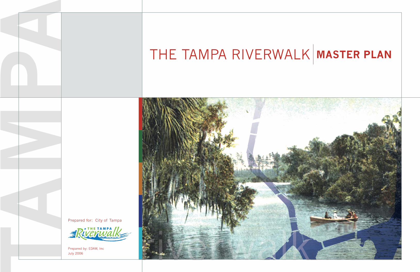
PA THE TAMPA RIVERWALK MASTER PLAN
riverwalkrPrepared for: City of Tampa
Prepared by: EDAW, Inc
July 2006
EDAW • HDR • Moffatt & Nichol • Ralph Appelbaum Associates • Echezabal & Associates Inc.
Honorable Pam Iorio, Mayor, City of Tampa
Tampa City Council Members:
Gwen Miller, District 1 At-Large, Chairperson
Shawn Harrison, District 7,
Chairman Pro-Tem
Rose V. Ferlita, District 2 At-Large
Linda Saul-Sena, District 3 At-Large
John Dingfelder, District 4
Kevin White, District 5
Mary C. Alvarez, District 6
ACKNOWLEDGEMENTS
Friends of the RiverwalkDan Mahurin, Chairman
EXECUTIVE STEERING GROUP
Albert Alfonso
Steve Anderson
Lyle Blanden
Keith Greminger
Lee Hoffman
Robin James
Beth Leytham
Troy Manthey
Larry Richey
Mary Scott
Randy Simmons
Ben Wacksman
SUB- COMMITTEE MEMBERS
Luci Ayer
Douglas Bartley
Patrick Berman
Bill Bishop
Robert Blount
LynnMarie Boitze
Karen Brand
Christine Burdick
Ron Campbell
Phil Casey
Becky Clayton
Leah Creal
John Curan
Joseph Dascola
Toni Everett
Tom Feaster
Mary Ann Ferenc
Kimberly Finn
Stephen Gardner
Truett Gardner
Kim Graham
Bill Hand
Marilyn Hett
Terry Holcomb
Susan House
Kelly Kavanaugh
June Kittay
Bill Manos
Anne-Marie Lenton
Susan Martin
Greg Minder
John Moors
John Mullen
Robin Nigh
Dave Parkinson
David Penn
Guy Revelle
Terrence Rice
Larry Richey
Susan Robinson
Ray Sandelli
Scott Shaw
Toni Short
L. Garry Smith
Wilson Stair
Jim Stefan
John Timmel
Belinda Wilson
Jim Valentine
Riverwalk Working GroupLee Hoffman, Chairman
John Archer
Julie Brown
Christine Bruno
Jim Burnside
Christine Burdick
Michael Chen
Santiago Corrada
Fran Davin
Shannon Edge
Jeanette Fenton
Jose Gelats
Raymond Green
Steve Hodge
Mark Huey
Arthur Hushen
Roy LaMotte
Cliff Langan
Liana Lopez
Mahdi Mansour
John Moors
John Newman
Robin Nigh
Karen Palus
Dave Parkinson
Arlington Ragsdale
David Smith
Kimberly Springer
Wilson Stair
Jim Stefan
Jim Valentine
David Vaughn
EXECUTIVE SUMMARY
developing the Master Plan, present the plan in detail and
outline a process for implementing the plan. Chapter 1
provides an introduction and background information on the
project. Chapter 2 describes the phases of the Master Plan
development process as it moved from Kick-Off and Inventory to
Review and Analysis, followed by Initial Concept Development
and then Final Concept Development. Chapter 3 describes
the comprehensive Tampa Riverwalk Master Plan for each
of the fi ve districts developed. Plans, images and text join
together to describe the Master Plan elements and features
by district and illustrate options considered and the rationale
for the Riverwalk designs developed, including the interpretive
program components. One of the exercises undertaken prior to
the completion of the Master Plan was a costing of all elements
identifi ed. Some elements were determined to be beyond the
scope of a current program and noted for future consideration.
Chapter 4 presents the Tampa Riverwalk 2010 Plan which is
the schematic design for all of the improvements that the City
intends to implement by October 2010. Chapter 5 discusses
implementation concerns including feasibility, phasing and
permitting issues.
The Master Plan sets forth a Riverwalk that begins at the North
Boulevard Bridge and meanders, like the river, to the Garrison
Channel and the Channel District. Adjacent to The Heights
development, the winding Riverwalk is set back from the
water and offers shaded areas and water overlooks. It then
intersects a retail/restaurant plaza before following a sweeping
curve through Water Works Park that is also set back from the
water’s edge to preserve trees and take advantage of shade.
The Riverwalk hugs the bank under the I-275 in a nod to the
utilitarian nature of this section before slowing down at the
Laurel Street Bridge, where it arcs out over the water as a
fl oating element and inland along the street as well, embracing
the green space fl anking the bridge as designated park space.
Continuing south past Laurel Street, the Riverwalk passes the
Tampa Bay Performing Arts Center and then encounters the
Cass Street Bridge. While extensive efforts were undertaken
to select the ideal crossing for Cass Street, the choice was
fi nally postponed to the design development phase at which
time plans for the redevelopment of Curtis Hixon Park will have
advanced to the point of helping defi ne the optimal solution.
Just past the park, the Riverwalk makes its grandest gesture,
arcing again out over the water as a fl oating element connecting
underneath the Kennedy Boulevard Bridge and coming back
to land adjacent to the Sheraton Tampa Riverwalk Hotel before
connecting to the northern edge of MacDill Park, where another
proposed restaurant enlivens the Park and the Riverwalk.
Passing Trump Tower Tampa, another planned restaurant and
new docking area add interest. The Riverwalk then dips under
Brorein Street, winds through USF Park and dips back under
Platt Street before emerging as a new fi xed overwater segment
abutting the Tampa Convention Center. This segment also
includes a pier element projecting out into the waterway, serving
as a physical and virtual gateway marker at the mouth of the
river. Just past the Tampa Convention Center to the east, the
Riverwalk intersects with the new Gateway Park, a welcoming
green space in this tight location. The Riverwalk passes the
Marriott Waterside Hotel and winds through Cotanchobee Fort
Brooke Park before traversing the Tampa Bay History Center
site and turning back north to Channelside Drive at the foot of
the emerging Channelside residential neighborhood.
Along its entire length, the Riverwalk will use interpretive
features, signage, and art to excite, educate and entertain
Riverwalk users, be they residents or visitors. When fully
implemented, The Tampa Riverwalk will be a major civic asset
for the entire community and Tampa’s downtown waterfront will
become an attractive, vibrant part of the city.
The completion of the Tampa Riverwalk Master Plan marks a
major milestone in the ongoing effort to revitalize downtown
Tampa’s waterfront through the development of a multi-purpose
walkway along the water from the Channelside area to the North
Boulevard Bridge. This effort began in earnest in the 1980s
with the completion of the Riverwalk elements of the Tampa
Convention Center and the 400 Ashley property. In 1989, the
City of Tampa offi cially adopted Riverwalk design standards and
additional Riverwalk segments were subsequently completed
including the Marriott Waterside and Cotanchobee Fort Brooke
Park, and more recently USF Park and MacDill Park.
Despite this progress, it became apparent to Mayor Pam Iorio
very early in her administration that the vision for the Riverwalk
was incomplete and needed to be revisited in light of changing
conditions and new priorities for the city, including the emergence
of plans for thousands of new residential units in downtown
Tampa. New residents of these units would naturally be drawn
to the water’s edge seeking recreation, relaxation, dining and
cultural activities. With many of these units scheduled for
completion in 2007–2008 and the Super Bowl scheduled for
2009, the further development of The Tampa Riverwalk was
seen as a necessary next step in enhancing the city’s quality
of life and image. City government undertook a competitive
selection process to hire a world class waterfront planning
and design fi rm, which resulted in the selection of EDAW, to
develop a comprehensive Riverwalk Master Plan that would
meet the city’s Riverwalk vision. Mayor Iorio also organized a
non-profi t civic committee, Friends of the Riverwalk, to oversee
the development of Riverwalk plans. Chaired by SunTrust
Bank Chairman, President and CEO Dan Mahurin, the group
has organized trips to other cities with riverwalk projects to
evaluate their successes and shortcomings and apply lessons
learned to The Tampa Riverwalk.
The following chapters describe the process followed in
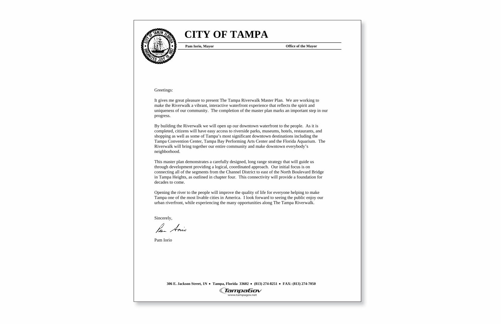
CITY OF TAMPA
Office of the Mayor
306 E. Jackson Street, 1N Tampa, Florida 33602 (813) 274-8251 FAX: (813) 274-7050
Pam Iorio, Mayor
Greetings:
It gives me great pleasure to present The Tampa Riverwalk Master Plan. We are working to make the Riverwalk a vibrant, interactive waterfront experience that reflects the spirit and uniqueness of our community. The completion of the master plan marks an important step in our progress.
By building the Riverwalk we will open up our downtown waterfront to the people. As it is completed, citizens will have easy access to riverside parks, museums, hotels, restaurants, and shopping as well as some of Tampa’s most significant downtown destinations including the Tampa Convention Center, Tampa Bay Performing Arts Center and the Florida Aquarium. The Riverwalk will bring together our entire community and make downtown everybody’s neighborhood.
This master plan demonstrates a carefully designed, long range strategy that will guide us through development providing a logical, coordinated approach. Our initial focus is on connecting all of the segments from the Channel District to east of the North Boulevard Bridge in Tampa Heights, as outlined in chapter four. This connectivity will provide a foundation for decades to come.
Opening the river to the people will improve the quality of life for everyone helping to make Tampa one of the most livable cities in America. I look forward to seeing the public enjoy our urban riverfront, while experiencing the many opportunities along The Tampa Riverwalk.
Sincerely,
Pam Iorio
introduction 6
TABLE OF CONTENTS
Introduction
Project Background 7
Project Location 9
Riverwalk Vision 10
process 12
Kickoff and Inventory
Official Kickoff Meetings 13
Site Visit 14
Client and Stakeholder Meetings 15
Data Gathering 16
Precedent Research 17
Review and Analysis
Introduction 19
Neighborhoods and Districts 20
Land Use 21
Open Space 22
Water Use 23
Transportation 24
Parking 25
Opportunities and Constraints 26
Framework Analysis 28
Initial Concept Development
Introduction 29
public meeting one – Program
and Features 30
Development of Initial Concept 32
Work Sessions 33
Final Concept Development
Preview Concepts 34
City Review and public meeting two 36
Final Concept Refinement 37
Design Standards Discussion 38
master plan development 40
Master Planning
Vision 41
Neighborhoods and Districts 42
Overview 43
District Plans
Water Works 44
Cultural 48
Downtown 52
Gateway 56
Channel 60
Land Use
Land Use Options 62
Land and Water Connections 63
Interpretive Planning
Introduction 64
Unifying Elements 65
Segment Stories 67
Navigating the Riverwalk 71
2010 plan 72
2010 Plan
Introduction 73
Schematic Master Plan 74
Connections 75
2010 Districts
Water Works 76
Cultural 78
Downtown 80
Gateway 82
Channel 84
Enhancements to 2010 Plan 86
chapter 1 chapter 2 chapter 3 chapter 4
implementation 88
Cost Estimate 89
Feasibility 90
Permitting Analysis 95
Phasing and Priorities 97
chapter 5
introductionchapter 1
INT
RO
DU
CT
ION
JULY 2006 introduction | 7
The City of Tampa has been consistently shaped over the
decades by its relationship with water. A large portion of the
city consists of a peninsula projecting into Tampa Bay, which
provides ocean access and is the largest open water estuary
in the State of Florida. Tampa’s downtown business district
is surrounded by water on three sides, the Hillsborough River
on the west, the Garrison Channel on the south, and the
Ybor Channel on the east. Some areas of the city, like the
residential neighborhoods along Bayshore Boulevard, have
capitalized on their waterfront location, while others, primarily
the downtown business district, have not. Like many cities
across the country, Tampa found itself in the 1970s with a
downtown that largely turned its back to the water and that
was substantially depleted with the move of housing and
businesses to the suburbs.
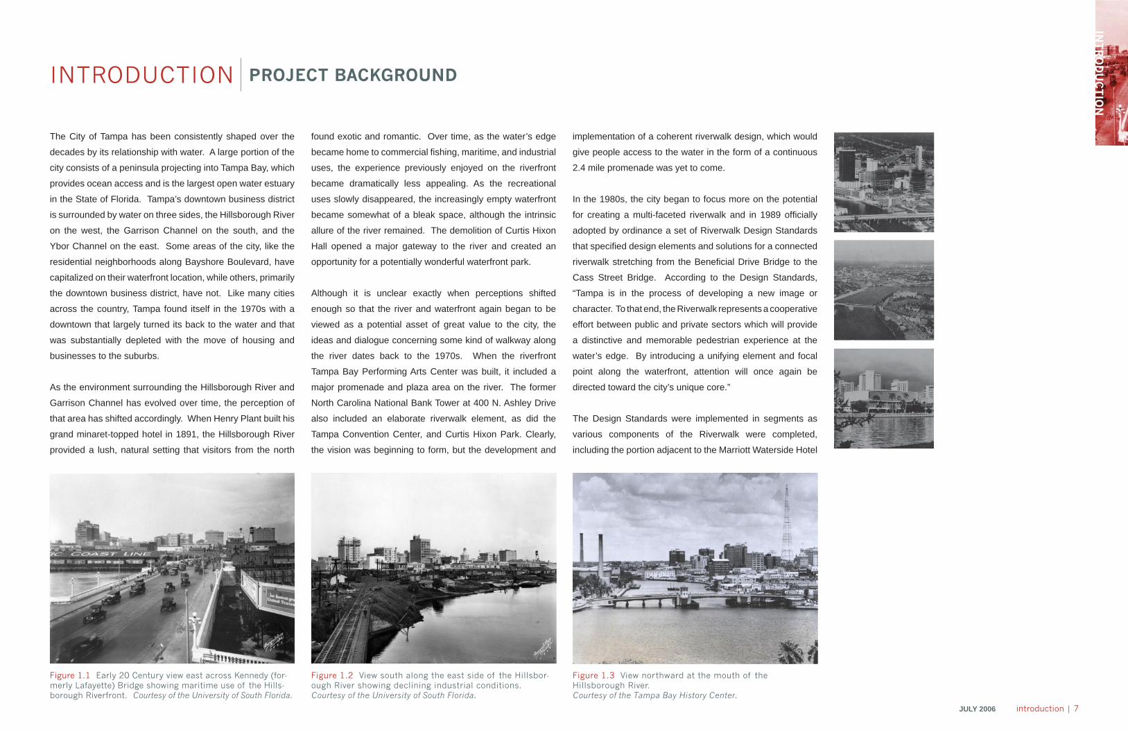
As the environment surrounding the Hillsborough River and
Garrison Channel has evolved over time, the perception of
that area has shifted accordingly. When Henry Plant built his
grand minaret-topped hotel in 1891, the Hillsborough River
provided a lush, natural setting that visitors from the north
Figure 1.1 Early 20 Century view east across Kennedy (for-merly Lafayette) Bridge showing maritime use of the Hills-borough Riverfront. Courtesy of the University of South Florida.
Figure 1.2 View south along the east side of the Hillsbor-ough River showing declining industrial conditions.Courtesy of the University of South Florida.
Figure 1.3 View northward at the mouth of the Hillsborough River.Courtesy of the Tampa Bay History Center.
found exotic and romantic. Over time, as the water’s edge
became home to commercial fi shing, maritime, and industrial
uses, the experience previously enjoyed on the riverfront
became dramatically less appealing. As the recreational
uses slowly disappeared, the increasingly empty waterfront
became somewhat of a bleak space, although the intrinsic
allure of the river remained. The demolition of Curtis Hixon
Hall opened a major gateway to the river and created an
opportunity for a potentially wonderful waterfront park.
Although it is unclear exactly when perceptions shifted
enough so that the river and waterfront again began to be
viewed as a potential asset of great value to the city, the
ideas and dialogue concerning some kind of walkway along
the river dates back to the 1970s. When the riverfront
Tampa Bay Performing Arts Center was built, it included a
major promenade and plaza area on the river. The former
North Carolina National Bank Tower at 400 N. Ashley Drive
also included an elaborate riverwalk element, as did the
Tampa Convention Center, and Curtis Hixon Park. Clearly,
the vision was beginning to form, but the development and
implementation of a coherent riverwalk design, which would
give people access to the water in the form of a continuous
2.4 mile promenade was yet to come.
In the 1980s, the city began to focus more on the potential
for creating a multi-faceted riverwalk and in 1989 offi cially
adopted by ordinance a set of Riverwalk Design Standards
that specifi ed design elements and solutions for a connected
riverwalk stretching from the Benefi cial Drive Bridge to the
Cass Street Bridge. According to the Design Standards,
“Tampa is in the process of developing a new image or
character. To that end, the Riverwalk represents a cooperative
effort between public and private sectors which will provide
a distinctive and memorable pedestrian experience at the
water’s edge. By introducing a unifying element and focal
point along the waterfront, attention will once again be
directed toward the city’s unique core.”
The Design Standards were implemented in segments as
various components of the Riverwalk were completed,
including the portion adjacent to the Marriott Waterside Hotel
INTRODUCTION PROJECT BACKGROUND
8 | introduction JULY 2006
and Cotanchobee Fort Brooke Park. More recently, the
Riverwalk elements of the University of South Florida (USF)
and MacDill Parks have been completed in accordance with
the 1989 standards. Despite this progress towards the city’s
1989 Riverwalk vision, it became apparent to Mayor Pam
Iorio very early in her administration that the vision for the
Riverwalk was incomplete and needed to be revisited in light
of changing conditions and new priorities for the city. Among
those changing conditions was the emergence of plans for
thousands of new residential units in downtown Tampa,
which would dramatically bolster the existing downtown core
uses of offi ce, residences and lodging. New residents of the
downtown neighborhood would naturally be drawn to the
water’s edge seeking recreation, relaxation, and even dining
and cultural activities. With many of these residential units
scheduled for completion in 2007 or 2008, and the Super
Bowl scheduled for 2009, the further development of The
Tampa Riverwalk was seen as a necessary next step in the
enhancement of the city’s quality of life.
Mayor Iorio identifi ed the development of a Tampa Riverwalk
Master Plan as a priority and a competitive selection process
to hire a leading planning and design fi rm to develop a
comprehensive master plan for the Riverwalk began. EDAW
was selected to develop the plan that would move the city’s
vision forward. Mayor Iorio also organized a civic committee
to oversee the development of Riverwalk plans, Friends
of the Riverwalk. Chaired by SunTrust Bank Chairman,
President, and CEO Dan Mahurin, the organization
includes subcommittees focused on particular aspects of
the Riverwalk. Members of the Friends of the Riverwalk
have met regularly and evaluated riverwalk projects in other
cities. Additionally, the organization is charged with soliciting
funds and evaluating long-term operations and maintenance
options for the Riverwalk.
The EDAW Tampa Riverwalk Project Team includes the
marine and environmental engineering fi rm Moffat and
Nichol, the civil engineering fi rm HDR, Inc., the survey
fi rm Echezabal and Associates, Inc., and the interpretive
programming fi rm Ralph Appelbaum and Associates. The
EDAW Team offi cially began work on the project in July
2005. The following chapters describe the process followed
in developing the master plan, present the plan in detail, and
outline a process for implementing the plan.
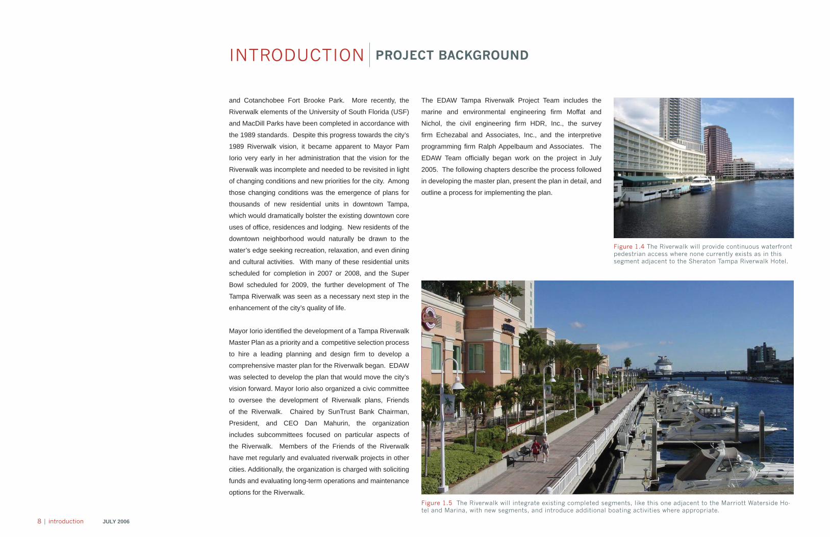
Figure 1.4 The Riverwalk will provide continuous waterfront pedestrian access where none currently exists as in this segment adjacent to the Sheraton Tampa Riverwalk Hotel.
Figure 1.5 The Riverwalk will integrate existing completed segments, like this one adjacent to the Marriott Waterside Ho-tel and Marina, with new segments, and introduce additional boating activities where appropriate.
INTRODUCTION PROJECT BACKGROUND
INT
RO
DU
CT
ION
JULY 2006 introduction | 9
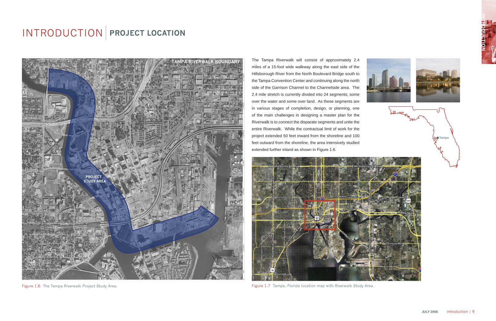
The Tampa Riverwalk will consist of approximately 2.4
miles of a 15-foot wide walkway along the east side of the
Hillsborough River from the North Boulevard Bridge south to
the Tampa Convention Center and continuing along the north
side of the Garrison Channel to the Channelside area. The
2.4 mile stretch is currently divided into 24 segments; some
over the water and some over land. As these segments are
in various stages of completion, design, or planning, one
of the main challenges in designing a master plan for the
Riverwalk is to connect the disparate segments and unite the
entire Riverwalk. While the contractual limit of work for the
project extended 50 feet inward from the shoreline and 100
feet outward from the shoreline, the area intensively studied
extended further inland as shown in Figure 1.6.
Tampa
INTRODUCTION PROJECT LOCATION
Figure 1.7 Tampa, Florida location map with Riverwalk Study Area.Figure 1.6 The Tampa Riverwalk Project Study Area.
10 | introduction JULY 2006
INTRODUCTION RIVERWALK VISION
Under the Iorio administration, city government has developed
a comprehensive vision for better utilizing and managing
one of Tampa’s greatest resources: its downtown urban
waterfront. The primary means of achieving the vision will be
the enhancement and completion of The Tampa Riverwalk
which will then serve as a catalyst for revitalizing adjacent
areas. The Tampa Riverwalk will create an “experience”
that can be easily accessed and enjoyed by residents and
visitors, creating an attractive and unique destination.
Key points of the city’s Riverwalk vision include:
• The Tampa Riverwalk will be a destination that
incorporates Tampa’s culture, arts, and natural amenities,
and provides opportunities for an active lifestyle.
• The Tampa Riverwalk will enhance the community,
economy and environment and will integrate the various
activities and destinations available in the downtown
area by linking them with an enjoyable and attractive
pedestrian walkway.
• The Tampa Riverwalk will provide a place for common
activities such as enjoying a cup of coffee, reading a
newspaper, relaxing along the waterfront, or eating
lunch.
• The Tampa Riverwalk will provide a venue for public art
and for regularly programmed activities and events.
• The Tampa Riverwalk will provide access to parks,
museums, hotels, restaurants, shopping, and key
destinations like the Tampa Convention Center, Tampa
Bay Performing Arts Center, waterfront hotels, the Florida
Aquarium, and residential projects.
• The Tampa Riverwalk will promote the economic
revitalization of downtown Tampa and the waterfront.
Key points of EDAW’s vision for The Tampa Riverwalk, all of
which complement the city’s Riverwalk vision, include:
“Create a vibrant and
interactive waterfront
experience for residents
and visitors that reflects
the spirit and uniqueness
of Tampa.”
– Mayor Pam Iorio
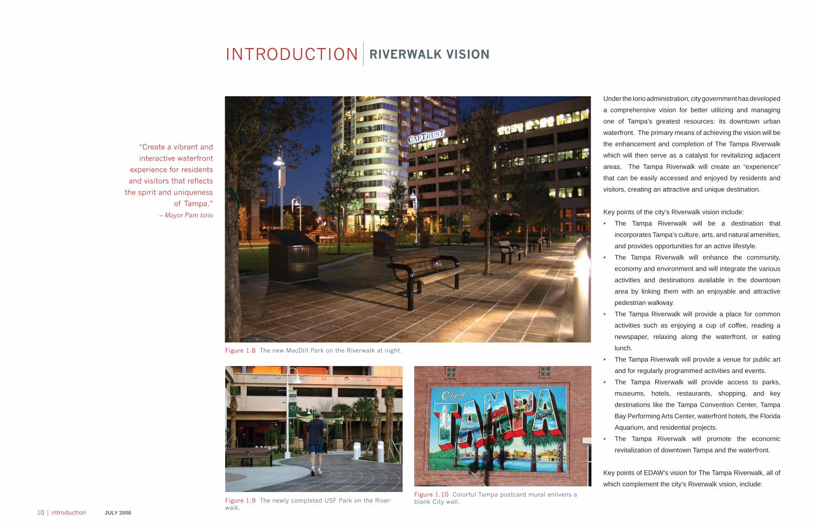
Figure 1.8 The new MacDill Park on the Riverwalk at night.
Figure 1.9 The newly completed USF Park on the River-walk.
Figure 1.10 Colorful Tampa postcard mural enlivens a blank City wall.
INT
RO
DU
CT
ION
JULY 2006 introduction | 11
• The Riverwalk will be a catalyst for a successful waterfront
by attracting people to the edge of land and water and
providing a wide range of experiences and activities
for them to enjoy there including passive and active
recreation, shopping, dining, entertainment, cultural
events, public art, exercise, and more.
• In order to attract the most users and therefore be
successful, the Riverwalk will appeal to both visitors and
residents by carefully integrating the natural movement
patterns of both groups so that using and enjoying the
Riverwalk becomes an effortless experience.
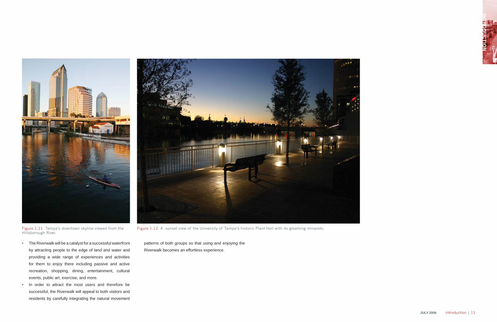
Figure 1.11 Tampa’s downtown skyline viewed from the Hillsborough River.
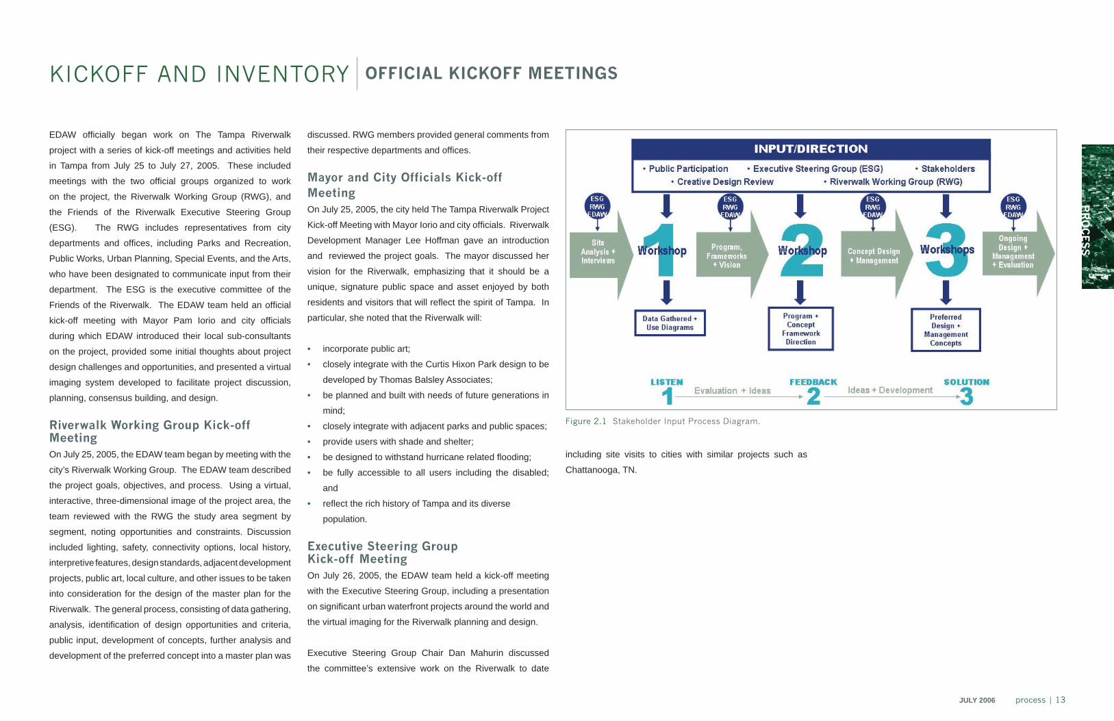
Figure 1.12 A sunset view of the University of Tampa’s historic Plant Hall with its gleaming minarets.

processchapter 2
PR
OC
ES
S
JULY 2006 process | 13
KICKOFF AND INVENTORY OFFICIAL KICKOFF MEETINGS
EDAW offi cially began work on The Tampa Riverwalk
project with a series of kick-off meetings and activities held
in Tampa from July 25 to July 27, 2005. These included
meetings with the two offi cial groups organized to work
on the project, the Riverwalk Working Group (RWG), and
the Friends of the Riverwalk Executive Steering Group
(ESG). The RWG includes representatives from city
departments and offi ces, including Parks and Recreation,
Public Works, Urban Planning, Special Events, and the Arts,
who have been designated to communicate input from their
department. The ESG is the executive committee of the
Friends of the Riverwalk. The EDAW team held an offi cial
kick-off meeting with Mayor Pam Iorio and city offi cials
during which EDAW introduced their local sub-consultants
on the project, provided some initial thoughts about project
design challenges and opportunities, and presented a virtual
imaging system developed to facilitate project discussion,
planning, consensus building, and design.
Riverwalk Working Group Kick-off Meeting On July 25, 2005, the EDAW team began by meeting with the
city’s Riverwalk Working Group. The EDAW team described
the project goals, objectives, and process. Using a virtual,
interactive, three-dimensional image of the project area, the
team reviewed with the RWG the study area segment by
segment, noting opportunities and constraints. Discussion
included lighting, safety, connectivity options, local history,
interpretive features, design standards, adjacent development
projects, public art, local culture, and other issues to be taken
into consideration for the design of the master plan for the
Riverwalk. The general process, consisting of data gathering,
analysis, identifi cation of design opportunities and criteria,
public input, development of concepts, further analysis and
development of the preferred concept into a master plan was
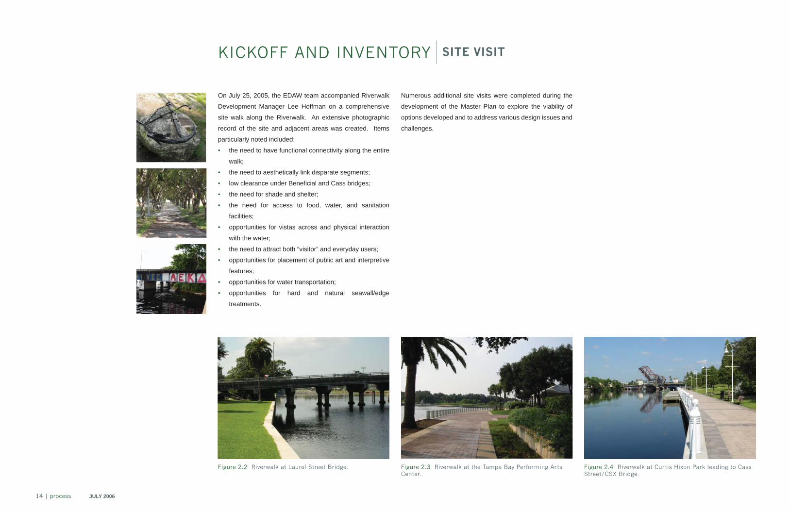
Figure 2.1 Stakeholder Input Process Diagram.
discussed. RWG members provided general comments from
their respective departments and offi ces.
Mayor and City Officials Kick-off Meeting
On July 25, 2005, the city held The Tampa Riverwalk Project
Kick-off Meeting with Mayor Iorio and city offi cials. Riverwalk
Development Manager Lee Hoffman gave an introduction
and reviewed the project goals. The mayor discussed her
vision for the Riverwalk, emphasizing that it should be a
unique, signature public space and asset enjoyed by both
residents and visitors that will refl ect the spirit of Tampa. In
particular, she noted that the Riverwalk will:
• incorporate public art;
• closely integrate with the Curtis Hixon Park design to be
developed by Thomas Balsley Associates;
• be planned and built with needs of future generations in
mind;
• closely integrate with adjacent parks and public spaces;
• provide users with shade and shelter;
• be designed to withstand hurricane related fl ooding;
• be fully accessible to all users including the disabled;
and
• refl ect the rich history of Tampa and its diverse
population.
Executive Steering GroupKick-off MeetingOn July 26, 2005, the EDAW team held a kick-off meeting
with the Executive Steering Group, including a presentation
on signifi cant urban waterfront projects around the world and
the virtual imaging for the Riverwalk planning and design.
Executive Steering Group Chair Dan Mahurin discussed
the committee’s extensive work on the Riverwalk to date
including site visits to cities with similar projects such as
Chattanooga, TN.
14 | process JULY 2006
On July 25, 2005, the EDAW team accompanied Riverwalk
Development Manager Lee Hoffman on a comprehensive
site walk along the Riverwalk. An extensive photographic
record of the site and adjacent areas was created. Items
particularly noted included:
• the need to have functional connectivity along the entire
walk;
• the need to aesthetically link disparate segments;
• low clearance under Benefi cial and Cass bridges;
• the need for shade and shelter;
• the need for access to food, water, and sanitation
facilities;
• opportunities for vistas across and physical interaction
with the water;
• the need to attract both “visitor” and everyday users;
• opportunities for placement of public art and interpretive
features;
• opportunities for water transportation;
• opportunities for hard and natural seawall/edge
treatments.
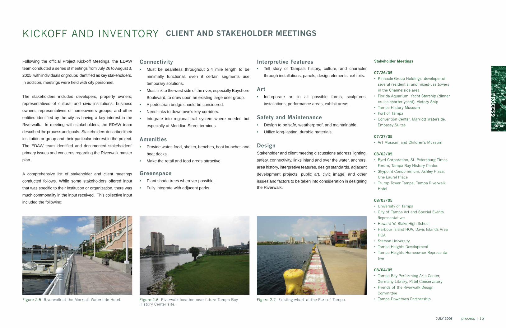
Figure 2.3 Riverwalk at the Tampa Bay Performing Arts Center.
Figure 2.4 Riverwalk at Curtis Hixon Park leading to Cass Street/CSX Bridge.
KICKOFF AND INVENTORY SITE VISIT
Figure 2.2 Riverwalk at Laurel Street Bridge.
Numerous additional site visits were completed during the
development of the Master Plan to explore the viability of
options developed and to address various design issues and
challenges.
PR
OC
ES
S
JULY 2006 process | 15
Figure 2.5 Riverwalk at the Marriott Waterside Hotel.
KICKOFF AND INVENTORY CLIENT AND STAKEHOLDER MEETINGS
Figure 2.6 Riverwalk location near future Tampa Bay History Center site.
Figure 2.7 Existing wharf at the Port of Tampa.
Following the offi cial Project Kick-off Meetings, the EDAW
team conducted a series of meetings from July 26 to August 3,
2005, with individuals or groups identifi ed as key stakeholders.
In addition, meetings were held with city personnel.
The stakeholders included developers, property owners,
representatives of cultural and civic institutions, business
owners, representatives of homeowners groups, and other
entities identifi ed by the city as having a key interest in the
Riverwalk. In meeting with stakeholders, the EDAW team
described the process and goals. Stakeholders described their
institution or group and their particular interest in the project.
The EDAW team identifi ed and documented stakeholders’
primary issues and concerns regarding the Riverwalk master
plan.
A comprehensive list of stakeholder and client meetings
conducted follows. While some stakeholders offered input
that was specifi c to their institution or organization, there was
much commonality in the input received. This collective input
included the following:
Connectivity
• Must be seamless throughout 2.4 mile length to be
minimally functional, even if certain segments use
temporary solutions.
• Must link to the west side of the river, especially Bayshore
Boulevard, to draw upon an existing large user group.
• A pedestrian bridge should be considered.
• Need links to downtown’s key corridors.
• Integrate into regional trail system where needed but
especially at Meridian Street terminus.
Amenities• Provide water, food, shelter, benches, boat launches and
boat docks.
• Make the retail and food areas attractive.
Greenspace• Plant shade trees wherever possible.
• Fully integrate with adjacent parks.
Interpretive Features• Tell story of Tampa’s history, culture, and character
through installations, panels, design elements, exhibits.
Art• Incorporate art in all possible forms, sculptures,
installations, performance areas, exhibit areas.
Safety and Maintenance• Design to be safe, weatherproof, and maintainable.
• Utilize long-lasting, durable materials.
DesignStakeholder and client meeting discussions address lighting,
safety, connectivity, links inland and over the water, anchors,
area history, interpretive features, design standards, adjacent
development projects, public art, civic image, and other
issues and factors to be taken into consideration in designing the Riverwalk.
Stakeholder Meetings
07/26/05
• Pinnacle Group Holdings, developer of
several residential and mixed-use towers
in the Channelside area.
• Florida Aquarium, Yacht Starship (dinner
cruise charter yacht), Victory Ship
• Tampa History Museum
• Port of Tampa
• Convention Center, Marriott Waterside,
Embassy Suites
07/27/05
• Art Museum and Children’s Museum
08/02/05
• Byrd Corporation, St. Petersburg Times
Forum, Tampa Bay History Center
• Skypoint Condominium, Ashley Plaza,
One Laurel Place
• Trump Tower Tampa, Tampa Riverwalk
Hotel
08/03/05
• University of Tampa
• City of Tampa Art and Special Events
Representatives
• Howard W. Blake High School
• Harbour Island HOA, Davis Islands Area
HOA
• Stetson University
• Tampa Heights Development
• Tampa Heights Homeowner Representa-
tive
08/04/05
• Tampa Bay Performing Arts Center,
Germany Library, Patel Conservatory
• Friends of the Riverwalk Design
Committee
• Tampa Downtown Partnership
16 | process JULY 2006
Beginning with the Riverwalk Working Group Project
Kickoff Meeting and continuing through the course of the
planning, EDAW requested a wide range of materials from
various entities that were needed to study, plan, and design
the Riverwalk. Stakeholders also provided information to
be taken into account in planning the project. In addition,
original survey information needed for designing the project
was obtained independently by EDAW. A comprehensive
inventory of materials was maintained to facilitate access to
needed information.
Art Center Lofts-plat Plat 1853-north boundary tract of land granted to county
of Hillsborough for county purposes in sections 13 and 24, township 29, range 18
Plat-waterfront-section 13 Henry & Knight’s 1853 map of the garrison showing
subdivision of US Gov’t Lots 9&10 Plat of Highland Park, Woodlawn park and Tampa heights Plat of Plant City, USA Caldwells’ Monument map-general map of Tampa Caldwells’ Monument map-northwest section Caldwells’ Monument map-middle section DOT benchmark form section 13 Hillsborough County benchmarks-monument details-land
boundary information system sections 29s ,18e, 24, and 29s, 19e, 19
SR 60 ROW map Railroad maps SR 93 (interstate 275) ROW maps15. Jacksonville Riverwalk Submerged Section plans 16. Hardemon Kempton Water Works Park plan 17. Executive Steering Group Parks subcommittee “Riverwalk
Parks in Downtown Tampa” and accompanying “Suggestions for Consideration by EDAW Relative to Parks and Public Spaces”
18. Tampa Riverwalk Segment 2A Under Platt Street Bridge 19. Byrd Group Channelside Development Plans – Blu 20. Smith and Associates Offering of 422 Channelside Property
Summarizing Downtown Development Projects 21. Comprehensive Plan – Central Business District 22. Market and Operating Potential Update for New Tampa
Museum of Art23. City of Tampa Department Directory 24. Tampa Convention Center Boat Docks25. Kennedy Drawbridge Inspection Report 4/22/05426. Hillsborough River Interlocal Planning Board & Technical
Advisory Council Riverwalk Memo of May 20, 2005 27. History Center Easement Agreement 28. URS DVD on Tampa Riverwalk, 4/19/05 29. Miscellaneous Tampa Promotional Material 30. URS DVD Riverwalk Existing Conditions Fall 2004
31. We Discovered Tampa 1960’s Promotional Video 32. Chatanooga Waterfront Over Time33. Tampa Bay History Center Materials on CD34. Tampa Destination Guide – Tampa Bay Convention and
Visitors Bureau 35. City of Tampa Riverwalk Brochure36. Life and Death of a Masterpiece – Landscape Architecture
Magazine story on Kiley Park37. Tampa Art Program and Lights On Tampa Program on CD 38. Site plan for Hillsborough River Tower – Cesar Pelli Project,
and west side Kennedy Bridge underbridge riverwalk connection
39. USF Park CAD fi le on CD40. Platt Connection CAD fi le on CD41. Cass Bridge Survey Information42. Benefi cial Bridge Survey Information43. Kennedy Bridge area survey information44. Ribbon of Green Parks Construction Drawings – CAD45. Convention Center Construction Drawings – scanned TIFs
KICKOFF AND INVENTORY DATA GATHERING
1. Bridge Plans – Harbor Island Bridge, Lafayette Street (Kennedy), Krause Street (Platt Street), Benefi cial Drive
2. Downtown 360 CD 3. Glatting Jackson Riverwalk master plan, 11x17 color4. Fort Brooke Park Improvements Vol. 1 of 2, 11x17 BW - 5. Ribbon of Green Plans, 11x17 BW 6. SOM Cultural District master plan PPT, 8.5x11 BW 7. Tampa CBD Riverwalk Design Standards 8. Tampa CBD Urban Design Guidelines 9. City of Tampa Development Reg., CBD, Channel District 10. Tampa Downtown Vision & Action Program-Final Report
and Summary 11. Trump Tower Docks information 12. Trump Tower Site Plan, 24x36 BW 13. Bridge Inspection Reports : Benefi cial, Harbour Island,
Brorein, Cass, Platt, Laurel14. Materials provided by Echezabal parcels S-13 T-29 R-18 parcels S-13 T-29 R-18 parcels S-24 T-29 R-18 City of Tampa atlas maps-section 13-T29S-R18E City of Tampa atlas maps-section 19-T29S-R19E City of Tampa atlas maps-section 24-T29S-R18E City of Tampa sanitary sewer section 13-T29S-R18E City of Tampa sanitary sewer section 24-T29S-R18E City of Tampa sanitary sewer section 19-T29S-R19E City of Tampa drainage maps 13-T29S-R18E City of Tampa drainage maps 24-T29S-R18E City of Tampa drainage maps 19-T29S-R19E
PR
OC
ES
S
JULY 2006 process | 17
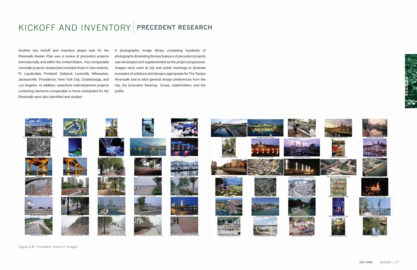
Another key kickoff and inventory phase task for the
Riverwalk Master Plan was a review of precedent projects
internationally and within the United States. Key comparable
riverwalk projects researched included those in San Antonio,
Ft. Lauderdale, Portland, Oakland, Louisville, Milwaukee,
Jacksonville, Providence, New York City, Chattanooga, and
Los Angeles. In addition, waterfront redevelopment projects
containing elements comparable to those anticipated for the
Riverwalk were also identifi ed and studied.
KICKOFF AND INVENTORY PRECEDENT RESEARCH
Figure 2.8 Precedent research images.
A photographic image library containing hundreds of
photographs illustrating the key features of precedent projects
was developed and supplemented as the project progressed.
Images were used at city and public meetings to illustrate
examples of solutions and designs appropriate for The Tampa
Riverwalk and to elicit general design preferences from the
city, the Executive Steering Group, stakeholders, and the
public.

18 | process JULY 2006
CHAPTER HEADER
PR
OC
ES
S
JULY 2006 process | 19
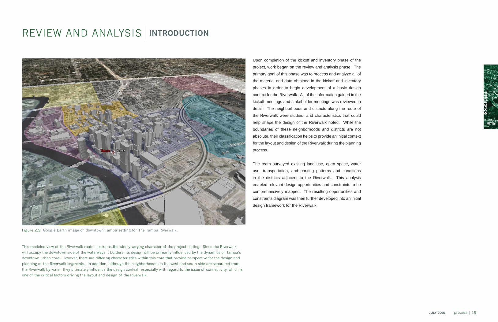
Upon completion of the kickoff and inventory phase of the
project, work began on the review and analysis phase. The
primary goal of this phase was to process and analyze all of
the material and data obtained in the kickoff and inventory
phases in order to begin development of a basic design
context for the Riverwalk. All of the information gained in the
kickoff meetings and stakeholder meetings was reviewed in
detail. The neighborhoods and districts along the route of
the Riverwalk were studied, and characteristics that could
help shape the design of the Riverwalk noted. While the
boundaries of these neighborhoods and districts are not
absolute, their classifi cation helps to provide an initial context
for the layout and design of the Riverwalk during the planning
process.
The team surveyed existing land use, open space, water
use, transportation, and parking patterns and conditions
in the districts adjacent to the Riverwalk. This analysis
enabled relevant design opportunities and constraints to be
comprehensively mapped. The resulting opportunities and
constraints diagram was then further developed into an initial
design framework for the Riverwalk.
Figure 2.9 Google Earth image of downtown Tampa setting for The Tampa Riverwalk.
This modeled view of the Riverwalk route illustrates the widely varying character of the project setting. Since the Riverwalk
will occupy the downtown side of the waterways it borders, its design will be primarily influenced by the dynamics of Tampa’s
downtown urban core. However, there are differing characteristics within this core that provide perspective for the design and
planning of the Riverwalk segments. In addition, although the neighborhoods on the west and south side are separated from
the Riverwalk by water, they ultimately influence the design context, especially with regard to the issue of connectivity, which is
one of the critical factors driving the layout and design of the Riverwalk.
REVIEW AND ANALYSIS INTRODUCTION
20 | process JULY 2006
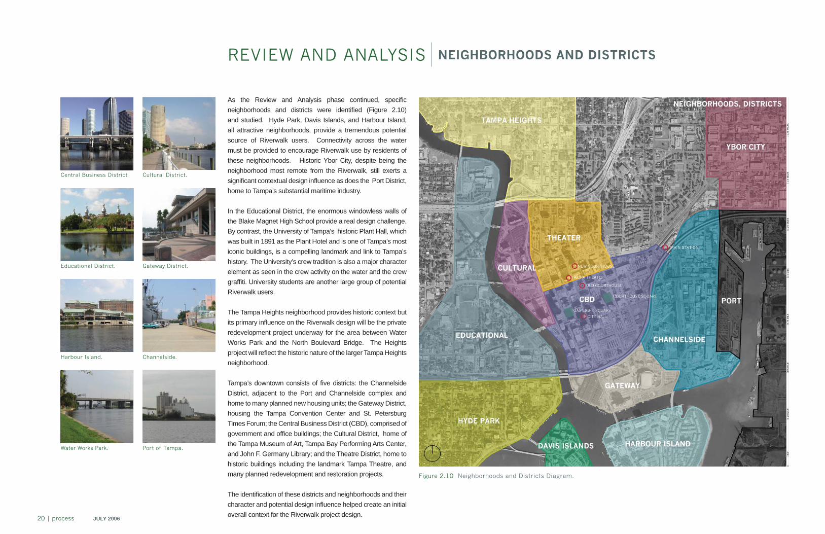
REVIEW AND ANALYSIS NEIGHBORHOODS AND DISTRICTS
Figure 2.10 Neighborhoods and Districts Diagram.
As the Review and Analysis phase continued, specifi c neighborhoods and districts were identifi ed (Figure 2.10) and studied. Hyde Park, Davis Islands, and Harbour Island, all attractive neighborhoods, provide a tremendous potential source of Riverwalk users. Connectivity across the water must be provided to encourage Riverwalk use by residents of these neighborhoods. Historic Ybor City, despite being the neighborhood most remote from the Riverwalk, still exerts a signifi cant contextual design infl uence as does the Port District, home to Tampa’s substantial maritime industry.
In the Educational District, the enormous windowless walls of the Blake Magnet High School provide a real design challenge. By contrast, the University of Tampa’s historic Plant Hall, which was built in 1891 as the Plant Hotel and is one of Tampa’s most iconic buildings, is a compelling landmark and link to Tampa’s history. The University’s crew tradition is also a major character element as seen in the crew activity on the water and the crew graffi ti. University students are another large group of potential Riverwalk users.
The Tampa Heights neighborhood provides historic context but its primary infl uence on the Riverwalk design will be the private redevelopment project underway for the area between Water Works Park and the North Boulevard Bridge. The Heights project will refl ect the historic nature of the larger Tampa Heights neighborhood.
Tampa’s downtown consists of fi ve districts: the Channelside District, adjacent to the Port and Channelside complex and home to many planned new housing units; the Gateway District, housing the Tampa Convention Center and St. Petersburg Times Forum; the Central Business District (CBD), comprised of government and offi ce buildings; the Cultural District, home of the Tampa Museum of Art, Tampa Bay Performing Arts Center, and John F. Germany Library; and the Theatre District, home to historic buildings including the landmark Tampa Theatre, and many planned redevelopment and restoration projects.
The identifi cation of these districts and neighborhoods and their character and potential design infl uence helped create an initial overall context for the Riverwalk project design.
Cultural District.
Port of Tampa.
Gateway District.
Channelside.
Central Business District
Educational District.
Harbour Island.
Water Works Park.
PR
OC
ES
S
JULY 2006 process | 21
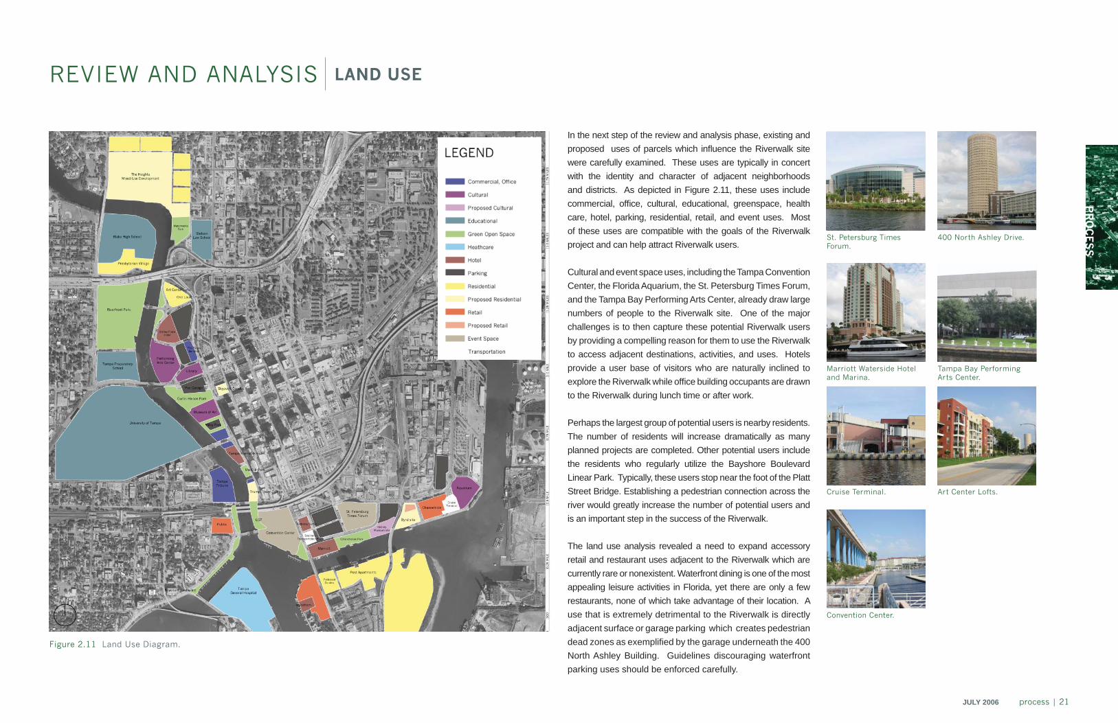
In the next step of the review and analysis phase, existing and proposed uses of parcels which infl uence the Riverwalk site were carefully examined. These uses are typically in concert with the identity and character of adjacent neighborhoods and districts. As depicted in Figure 2.11, these uses include commercial, offi ce, cultural, educational, greenspace, health care, hotel, parking, residential, retail, and event uses. Most of these uses are compatible with the goals of the Riverwalk project and can help attract Riverwalk users.
Cultural and event space uses, including the Tampa Convention Center, the Florida Aquarium, the St. Petersburg Times Forum, and the Tampa Bay Performing Arts Center, already draw large numbers of people to the Riverwalk site. One of the major challenges is to then capture these potential Riverwalk users by providing a compelling reason for them to use the Riverwalk to access adjacent destinations, activities, and uses. Hotels provide a user base of visitors who are naturally inclined to explore the Riverwalk while offi ce building occupants are drawn to the Riverwalk during lunch time or after work.
Perhaps the largest group of potential users is nearby residents. The number of residents will increase dramatically as many planned projects are completed. Other potential users include the residents who regularly utilize the Bayshore Boulevard Linear Park. Typically, these users stop near the foot of the Platt Street Bridge. Establishing a pedestrian connection across the river would greatly increase the number of potential users and is an important step in the success of the Riverwalk.
The land use analysis revealed a need to expand accessory retail and restaurant uses adjacent to the Riverwalk which are currently rare or nonexistent. Waterfront dining is one of the most appealing leisure activities in Florida, yet there are only a few restaurants, none of which take advantage of their location. A use that is extremely detrimental to the Riverwalk is directly adjacent surface or garage parking which creates pedestrian dead zones as exemplifi ed by the garage underneath the 400 North Ashley Building. Guidelines discouraging waterfront parking uses should be enforced carefully.
Figure 2.11 Land Use Diagram.
REVIEW AND ANALYSIS LAND USE
Cruise Terminal.
Marriott Waterside Hotel and Marina.
St. Petersburg Times Forum.
Art Center Lofts.
Tampa Bay Performing Arts Center.
400 North Ashley Drive.
Convention Center.
22 | process JULY 2006
MacDill Park.
REVIEW AND ANALYSIS OPEN SPACE
Figure 2.12 Open Space Diagram.
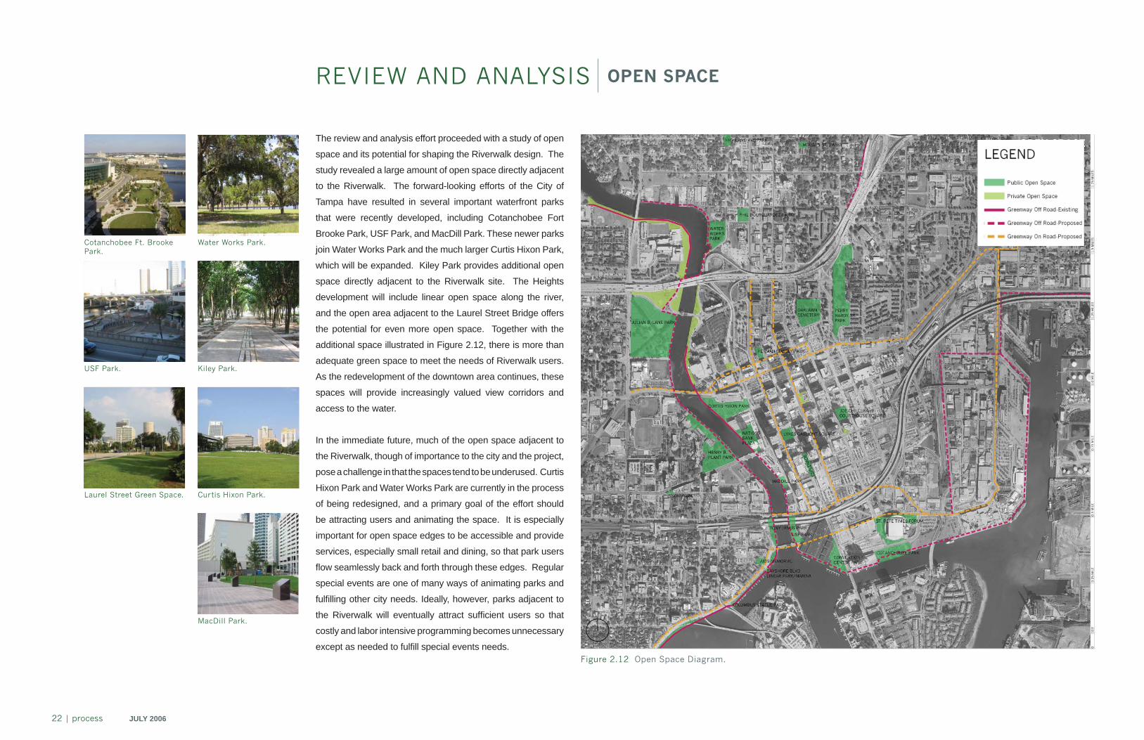
The review and analysis effort proceeded with a study of open
space and its potential for shaping the Riverwalk design. The
study revealed a large amount of open space directly adjacent
to the Riverwalk. The forward-looking efforts of the City of
Tampa have resulted in several important waterfront parks
that were recently developed, including Cotanchobee Fort
Brooke Park, USF Park, and MacDill Park. These newer parks
join Water Works Park and the much larger Curtis Hixon Park,
which will be expanded. Kiley Park provides additional open
space directly adjacent to the Riverwalk site. The Heights
development will include linear open space along the river,
and the open area adjacent to the Laurel Street Bridge offers
the potential for even more open space. Together with the
additional space illustrated in Figure 2.12, there is more than
adequate green space to meet the needs of Riverwalk users.
As the redevelopment of the downtown area continues, these
spaces will provide increasingly valued view corridors and
access to the water.
In the immediate future, much of the open space adjacent to
the Riverwalk, though of importance to the city and the project,
pose a challenge in that the spaces tend to be underused. Curtis
Hixon Park and Water Works Park are currently in the process
of being redesigned, and a primary goal of the effort should
be attracting users and animating the space. It is especially
important for open space edges to be accessible and provide
services, especially small retail and dining, so that park users
fl ow seamlessly back and forth through these edges. Regular
special events are one of many ways of animating parks and
fulfi lling other city needs. Ideally, however, parks adjacent to
the Riverwalk will eventually attract suffi cient users so that
costly and labor intensive programming becomes unnecessary
except as needed to fulfi ll special events needs.
Water Works Park.
Kiley Park.
Curtis Hixon Park.
Cotanchobee Ft. Brooke Park.
USF Park.
Laurel Street Green Space.
PR
OC
ES
S
JULY 2006 process | 23
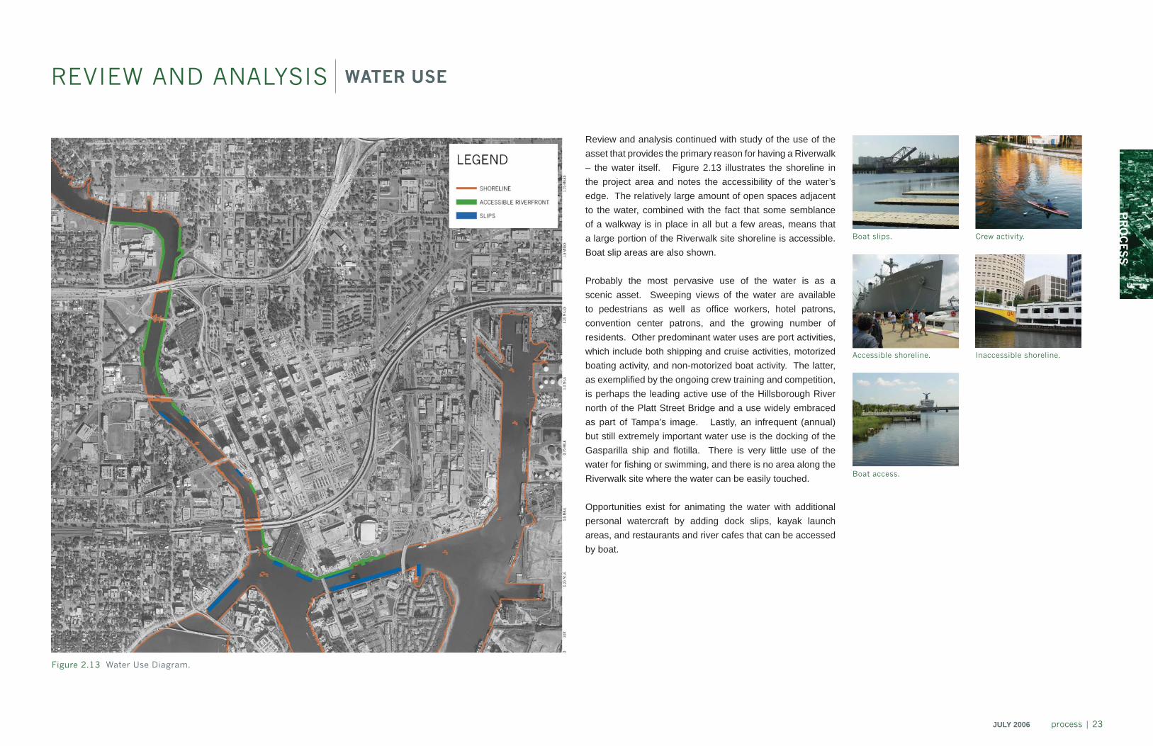
REVIEW AND ANALYSIS WATER USE
Review and analysis continued with study of the use of the asset that provides the primary reason for having a Riverwalk – the water itself. Figure 2.13 illustrates the shoreline in the project area and notes the accessibility of the water’s edge. The relatively large amount of open spaces adjacent to the water, combined with the fact that some semblance of a walkway is in place in all but a few areas, means that a large portion of the Riverwalk site shoreline is accessible. Boat slip areas are also shown.
Probably the most pervasive use of the water is as a scenic asset. Sweeping views of the water are available to pedestrians as well as offi ce workers, hotel patrons, convention center patrons, and the growing number of residents. Other predominant water uses are port activities, which include both shipping and cruise activities, motorized boating activity, and non-motorized boat activity. The latter, as exemplifi ed by the ongoing crew training and competition, is perhaps the leading active use of the Hillsborough River north of the Platt Street Bridge and a use widely embraced as part of Tampa’s image. Lastly, an infrequent (annual) but still extremely important water use is the docking of the Gasparilla ship and fl otilla. There is very little use of the water for fi shing or swimming, and there is no area along the Riverwalk site where the water can be easily touched.
Opportunities exist for animating the water with additional personal watercraft by adding dock slips, kayak launch areas, and restaurants and river cafes that can be accessed by boat.
Figure 2.13 Water Use Diagram.
Inaccessible shoreline.Accessible shoreline.
Boat access.
Boat slips. Crew activity.
24 | process JULY 2006
REVIEW AND ANALYSIS TRANSPORTATION
Figure 2.14 Transportation Diagram.
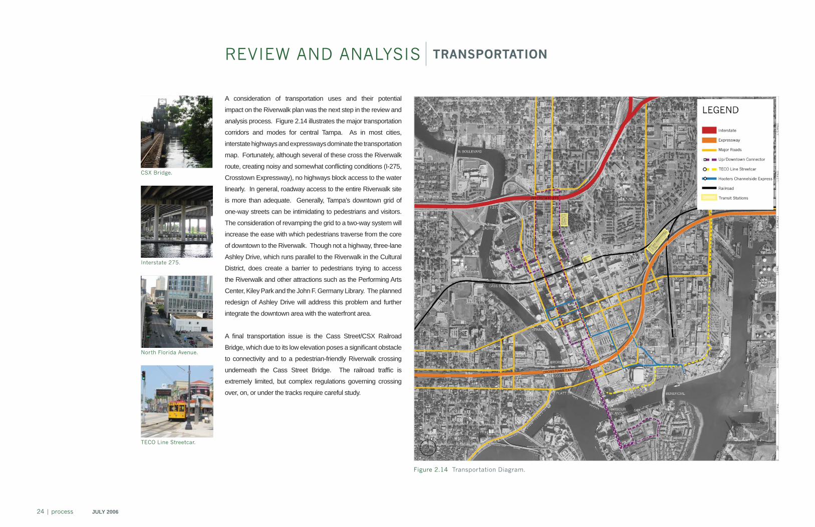
A consideration of transportation uses and their potential
impact on the Riverwalk plan was the next step in the review and
analysis process. Figure 2.14 illustrates the major transportation
corridors and modes for central Tampa. As in most cities,
interstate highways and expressways dominate the transportation
map. Fortunately, although several of these cross the Riverwalk
route, creating noisy and somewhat confl icting conditions (I-275,
Crosstown Expressway), no highways block access to the water
linearly. In general, roadway access to the entire Riverwalk site
is more than adequate. Generally, Tampa’s downtown grid of
one-way streets can be intimidating to pedestrians and visitors.
The consideration of revamping the grid to a two-way system will
increase the ease with which pedestrians traverse from the core
of downtown to the Riverwalk. Though not a highway, three-lane
Ashley Drive, which runs parallel to the Riverwalk in the Cultural
District, does create a barrier to pedestrians trying to access
the Riverwalk and other attractions such as the Performing Arts
Center, Kiley Park and the John F. Germany Library. The planned
redesign of Ashley Drive will address this problem and further
integrate the downtown area with the waterfront area.
A fi nal transportation issue is the Cass Street/CSX Railroad
Bridge, which due to its low elevation poses a signifi cant obstacle
to connectivity and to a pedestrian-friendly Riverwalk crossing
underneath the Cass Street Bridge. The railroad traffi c is
extremely limited, but complex regulations governing crossing
over, on, or under the tracks require careful study.
TECO Line Streetcar.
North Florida Avenue.
Interstate 275.
CSX Bridge.
PR
OC
ES
S
JULY 2006 process | 25
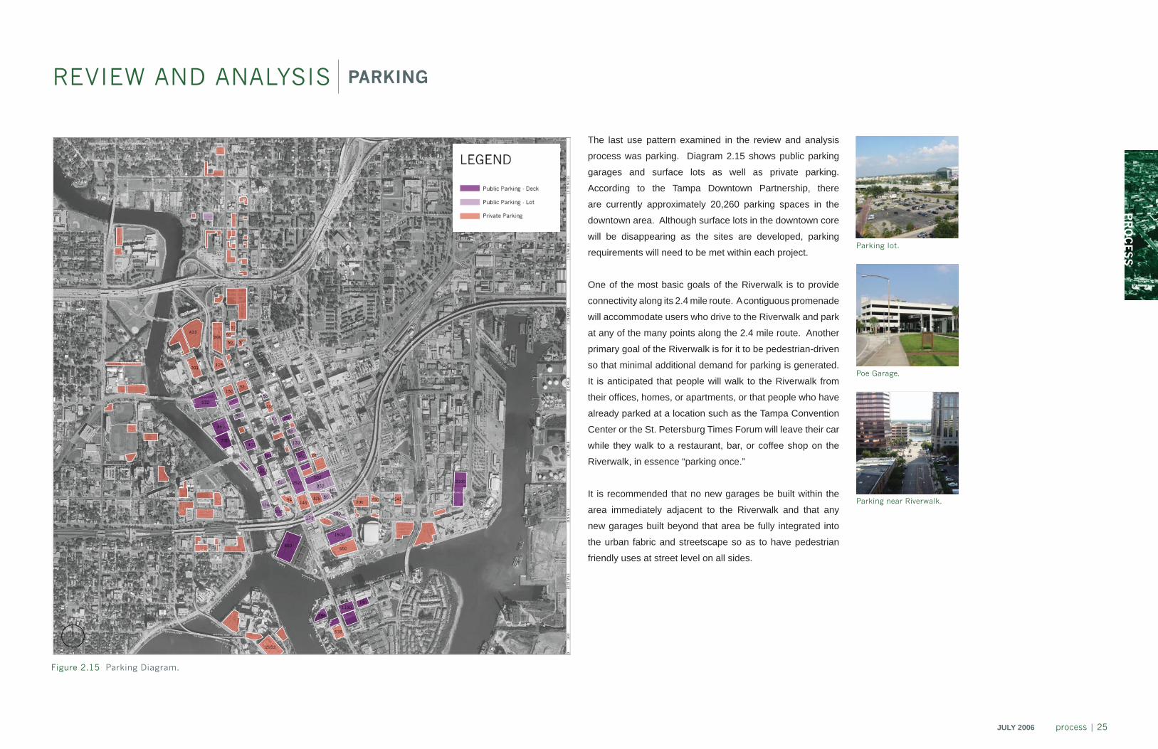
REVIEW AND ANALYSIS PARKING
The last use pattern examined in the review and analysis
process was parking. Diagram 2.15 shows public parking
garages and surface lots as well as private parking.
According to the Tampa Downtown Partnership, there
are currently approximately 20,260 parking spaces in the
downtown area. Although surface lots in the downtown core
will be disappearing as the sites are developed, parking
requirements will need to be met within each project.
One of the most basic goals of the Riverwalk is to provide
connectivity along its 2.4 mile route. A contiguous promenade
will accommodate users who drive to the Riverwalk and park
at any of the many points along the 2.4 mile route. Another
primary goal of the Riverwalk is for it to be pedestrian-driven
so that minimal additional demand for parking is generated.
It is anticipated that people will walk to the Riverwalk from
their offi ces, homes, or apartments, or that people who have
already parked at a location such as the Tampa Convention
Center or the St. Petersburg Times Forum will leave their car
while they walk to a restaurant, bar, or coffee shop on the
Riverwalk, in essence “parking once.”
It is recommended that no new garages be built within the
area immediately adjacent to the Riverwalk and that any
new garages built beyond that area be fully integrated into
the urban fabric and streetscape so as to have pedestrian
friendly uses at street level on all sides.
Figure 2.15 Parking Diagram.
Parking near Riverwalk.
Parking lot.
Poe Garage.
26 | process JULY 2006
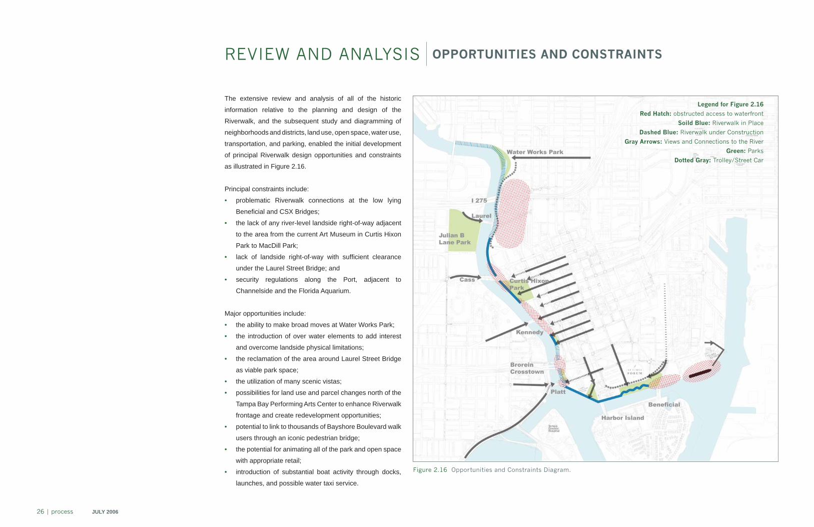
REVIEW AND ANALYSIS OPPORTUNITIES AND CONSTRAINTS
Figure 2.16 Opportunities and Constraints Diagram.
The extensive review and analysis of all of the historic
information relative to the planning and design of the
Riverwalk, and the subsequent study and diagramming of
neighborhoods and districts, land use, open space, water use,
transportation, and parking, enabled the initial development
of principal Riverwalk design opportunities and constraints
as illustrated in Figure 2.16.
Principal constraints include:
• problematic Riverwalk connections at the low lying
Benefi cial and CSX Bridges;
• the lack of any river-level landside right-of-way adjacent
to the area from the current Art Museum in Curtis Hixon
Park to MacDill Park;
• lack of landside right-of-way with suffi cient clearance
under the Laurel Street Bridge; and
• security regulations along the Port, adjacent to
Channelside and the Florida Aquarium.
Major opportunities include:
• the ability to make broad moves at Water Works Park;
• the introduction of over water elements to add interest
and overcome landside physical limitations;
• the reclamation of the area around Laurel Street Bridge
as viable park space;
• the utilization of many scenic vistas;
• possibilities for land use and parcel changes north of the
Tampa Bay Performing Arts Center to enhance Riverwalk
frontage and create redevelopment opportunities;
• potential to link to thousands of Bayshore Boulevard walk
users through an iconic pedestrian bridge;
• the potential for animating all of the park and open space
with appropriate retail;
• introduction of substantial boat activity through docks,
launches, and possible water taxi service.
Legend for Figure 2.16
Red Hatch: obstructed access to waterfront
Soild Blue: Riverwalk in Place
Dashed Blue: Riverwalk under Construction
Gray Arrows: Views and Connections to the River
Green: Parks
Dotted Gray: Trolley/Street Car

PR
OC
ES
S
JULY 2006 process | 27
Figure 2.17 Tampa Now. Figure 2.18 Tampa Future.
These collages of images, drawings, photographs, and text depict the Riverwalk design opportunities and constraints as they
were revealed during the Review and Analysis process. Figure 2.17 was designed to capture and graphically communicate the
current environment and context of the project site. Figure 2.18 illustrates an overall look and foundation of a contextually
responsive Riverwalk plan and design.
28 | process JULY 2006
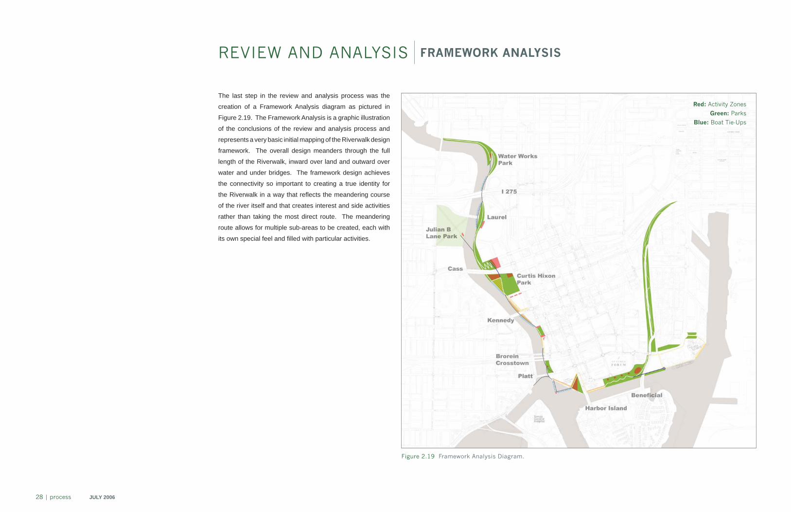
REVIEW AND ANALYSIS FRAMEWORK ANALYSIS
Figure 2.19 Framework Analysis Diagram.
The last step in the review and analysis process was the
creation of a Framework Analysis diagram as pictured in
Figure 2.19. The Framework Analysis is a graphic illustration
of the conclusions of the review and analysis process and
represents a very basic initial mapping of the Riverwalk design
framework. The overall design meanders through the full
length of the Riverwalk, inward over land and outward over
water and under bridges. The framework design achieves
the connectivity so important to creating a true identity for
the Riverwalk in a way that refl ects the meandering course
of the river itself and that creates interest and side activities
rather than taking the most direct route. The meandering
route allows for multiple sub-areas to be created, each with
its own special feel and fi lled with particular activities.
Red: Activity Zones
Green: Parks
Blue: Boat Tie-Ups
PR
OC
ES
S
JULY 2006 process | 29
Figure 2.20 Preliminary Master Plan Development.`
INITIAL CONCEPT DEVELOPMENT INTRODUCTION
With the data gathering and subsequent review and analysis
phases completed, the next step in the project was to begin
developing initial project concepts. In order to do this, it was
necessary to include the citizens in community meetings.
Goals of the public meetings were to communicate the results
of the review and analysis completed to date; to solicit public
comments on preferred Riverwalk activities, uses, character,
image preferences, and interpretive program elements; and
to consider the comments and preferences of one of the most
important groups when designing and planning the Riverwalk
– the public. The fi rst public meeting was held September
20, 2005 at the Tampa Convention Center.
Prior to the meeting, the EDAW team met with the Executive
Steering Group on September 12, 2005, and with Mayor
Iorio and city offi cials on September 13, 2005, to preview
the meeting presentation and program. The EDAW team
collaborated with the Tampa Downtown Partnership and
the Tampa Convention Center to communicate the location
and date to the public. In addition to the general public and
Riverwalk stakeholders, the meeting was attended by Tampa
City Council members, local media representatives, students,
and neighborhood representatives.
With the input from the public meeting, all of the information
gathered and analysis undertaken to date, the EDAW team
was able to begin developing initial master plan concepts.
Beginning with simple sketches, marked-up plans and aerial
photographs, the team went on to create detailed sketches,
plan views, 3D views, and before and after images of concepts
and options. These extensive project graphics were then
utilized in work sessions with the team and city to evaluate
and further develop preferred concepts and options.
30 | process JULY 2006
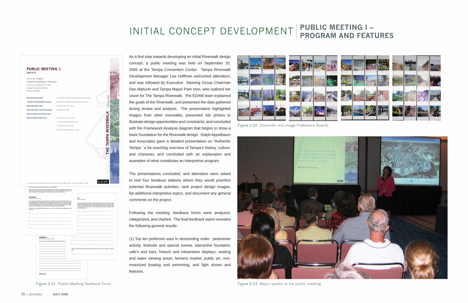
INITIAL CONCEPT DEVELOPMENT PUBLIC MEETING I – PROGRAM AND FEATURES
As a fi rst step towards developing an initial Riverwalk design
concept, a public meeting was held on September 20,
2005 at the Tampa Convention Center. Tampa Riverwalk
Development Manager Lee Hoffman welcomed attendees,
and was followed by Executive Steering Group Chairman
Dan Mahurin and Tampa Mayor Pam Iorio, who outlined her
vision for The Tampa Riverwalk. The EDAW team explained
the goals of the Riverwalk, and presented the data gathered
during review and analysis. The presentation highlighted
images from other riverwalks, presented site photos to
illustrate design opportunities and constraints, and concluded
with the Framework Analysis diagram that begins to show a
basic foundation for the Riverwalk design. Ralph Appelbaum
and Associates gave a detailed presentation on “Authentic
Tampa,” a far-reaching overview of Tampa’s history, culture,
and character, and concluded with an explanation and
examples of what constitutes an interpretive program.
The presentations concluded, and attendees were asked
to visit four breakout stations where they would prioritize
potential Riverwalk activities, rank project design images,
list additional interpretive topics, and document any general
comments on the project.
Following the meeting, feedback forms were analyzed,
categorized, and charted. The fi nal feedback report revealed
the following general results:
(1) Top ten preferred uses in descending order: pedestrian
activity, festivals and special events, interactive fountains,
cafe’s and bars, historic and interpretive displays, seating
and water viewing areas, farmers market, public art, non-
motorized boating and swimming, and light shows and
features.
Figure 2.21 Public Meeting Feedback Form. Figure 2.23 Mayor speaks at the public meeting.
Figure 2.22 Character and Image Preference Boards.
PR
OC
ES
S
JULY 2006 process | 31
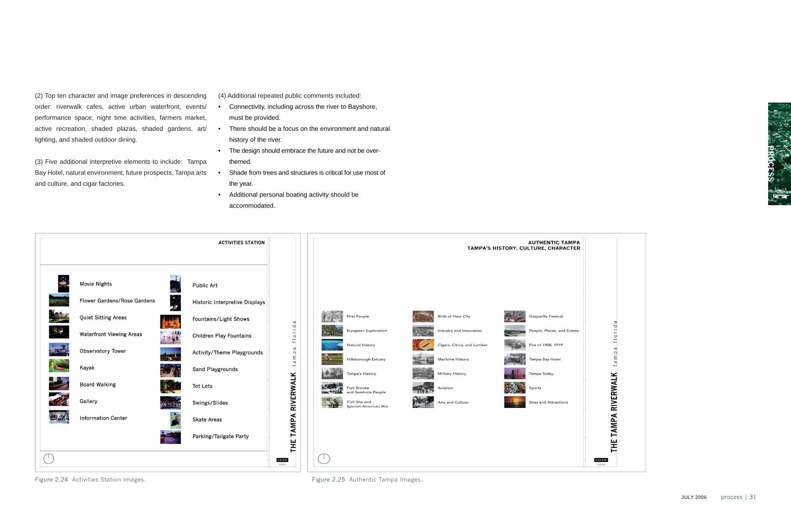
(2) Top ten character and image preferences in descending
order: riverwalk cafes, active urban waterfront, events/
performance space, night time activities, farmers market,
active recreation, shaded plazas, shaded gardens, art/
lighting, and shaded outdoor dining.
(3) Five additional interpretive elements to include: Tampa
Bay Hotel, natural environment, future prospects, Tampa arts
and culture, and cigar factories.
(4) Additional repeated public comments included:
• Connectivity, including across the river to Bayshore,
must be provided.
• There should be a focus on the environment and natural
history of the river.
• The design should embrace the future and not be over-
themed.
• Shade from trees and structures is critical for use most of
the year.
• Additional personal boating activity should be
accommodated.
Figure 2.24 Activities Station Images. Figure 2.25 Authentic Tampa Images.
32 | process JULY 2006
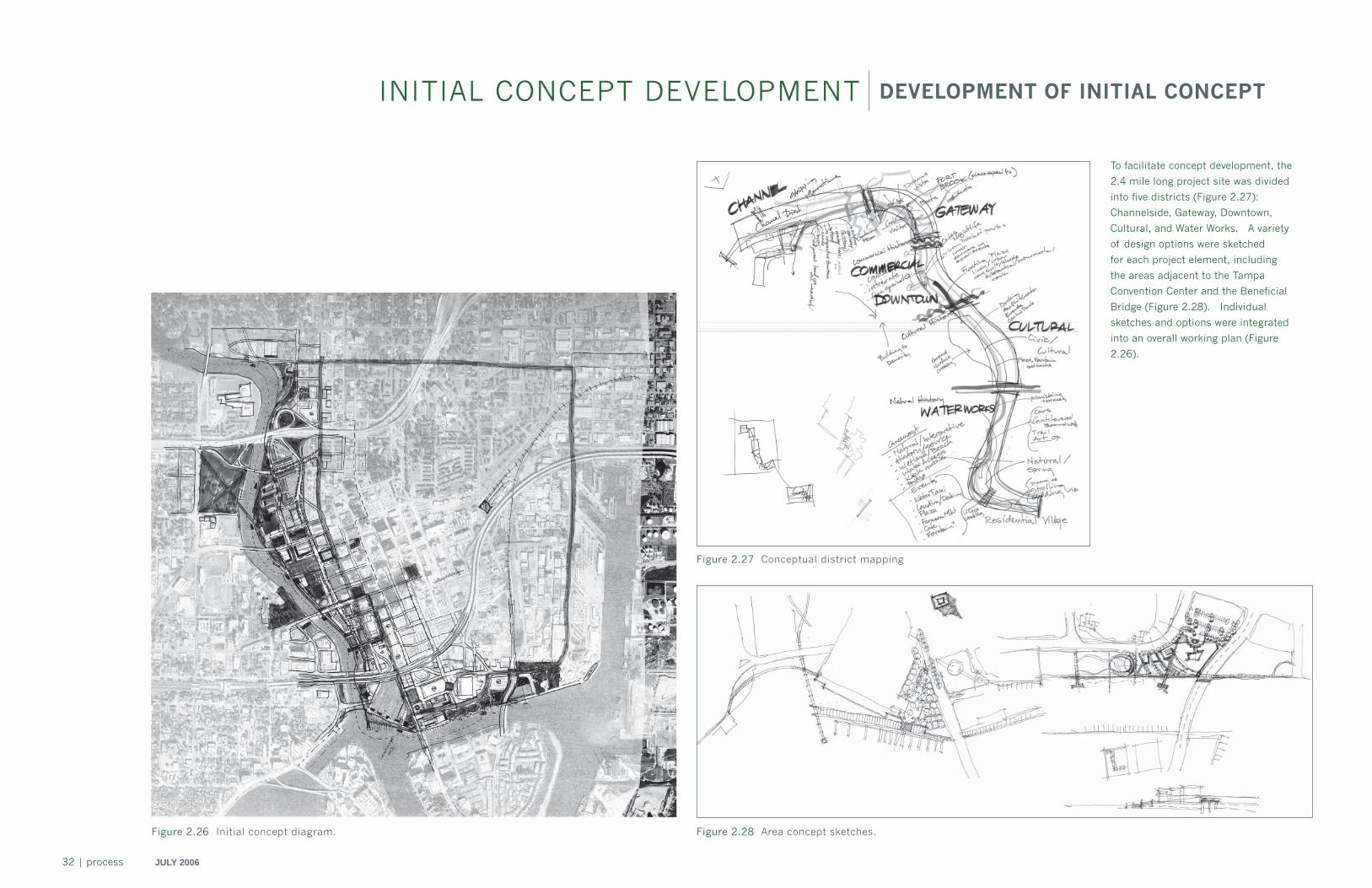
INITIAL CONCEPT DEVELOPMENT DEVELOPMENT OF INITIAL CONCEPT
Figure 2.28 Area concept sketches.Figure 2.26 Initial concept diagram.
Figure 2.27 Conceptual district mapping
To facilitate concept development, the
2.4 mile long project site was divided
into five districts (Figure 2.27):
Channelside, Gateway, Downtown,
Cultural, and Water Works. A variety
of design options were sketched
for each project element, including
the areas adjacent to the Tampa
Convention Center and the Beneficial
Bridge (Figure 2.28). Individual
sketches and options were integrated
into an overall working plan (Figure
2.26).
PR
OC
ES
S
JULY 2006 process | 33
INITIAL CONCEPT DEVELOPMENT WORK SESSIONS
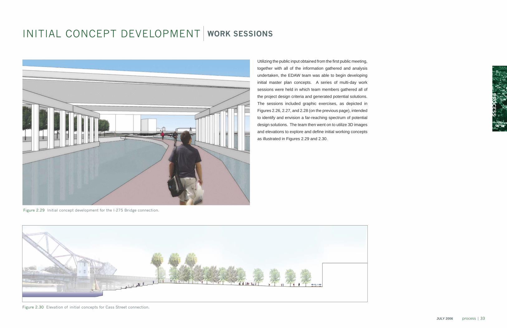
Utilizing the public input obtained from the fi rst public meeting,
together with all of the information gathered and analysis
undertaken, the EDAW team was able to begin developing
initial master plan concepts. A series of multi-day work
sessions were held in which team members gathered all of
the project design criteria and generated potential solutions.
The sessions included graphic exercises, as depicted in
Figures 2.26, 2.27, and 2.28 (on the previous page), intended
to identify and envision a far-reaching spectrum of potential
design solutions. The team then went on to utilize 3D images
and elevations to explore and defi ne initial working concepts
as illustrated in Figures 2.29 and 2.30.
Figure 2.30 Elevation of initial concepts for Cass Street connection.
Figure 2.29 Initial concept development for the I-275 Bridge connection.
34 | process JULY 2006
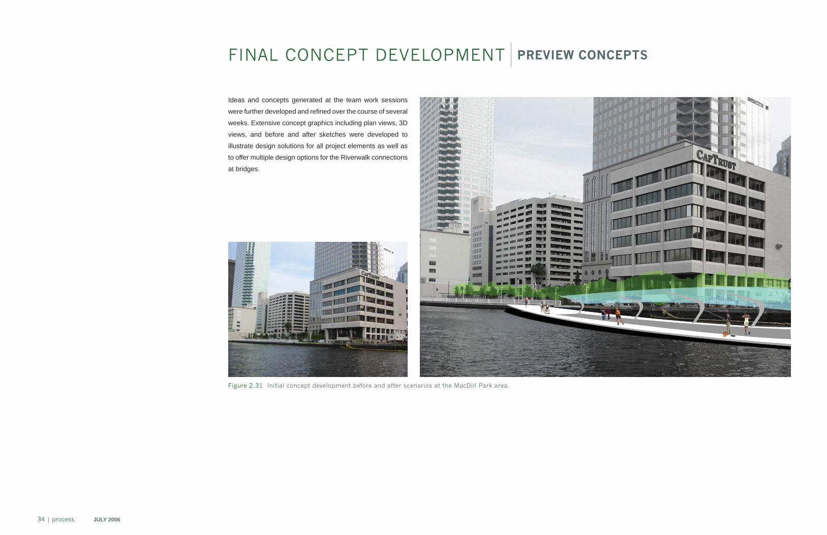
Ideas and concepts generated at the team work sessions
were further developed and refi ned over the course of several
weeks. Extensive concept graphics including plan views, 3D
views, and before and after sketches were developed to
illustrate design solutions for all project elements as well as
to offer multiple design options for the Riverwalk connections
at bridges.
FINAL CONCEPT DEVELOPMENT PREVIEW CONCEPTS
Figure 2.31 Initial concept development before and after scenarios at the MacDill Park area.
PR
OC
ES
S
JULY 2006 process | 35
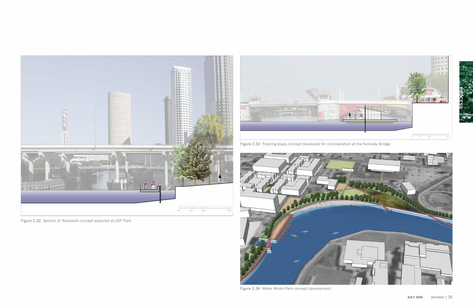
Figure 2.32 Section of Riverwalk concept explored at USF Park.
Figure 2.33 Floating plaza concept developed for consideration at the Kennedy Bridge.
Figure 2.34 Water Works Park concept development.
36 | process JULY 2006
FINAL CONCEPT DEVELOPMENT CITY REVIEW AND PUBLIC MEETING TWO
The fi nal concept development phase began with a
comprehensive review and discussion of initial concepts
with the Executive Steering Group and Riverwalk Working
Group representatives, and city offi cials at work sessions
on November 7 and 8, 2005. Design concepts and options
were updated to incorporate feedback and input from these
sessions before being presented at a second public meeting
on November 15, 2005 at the Tampa Bay Performing Arts
Center. Design concepts and options were described in
detail at the meeting and preferred solutions identifi ed.
Refi ned interpretive program elements were also presented
and discussed.
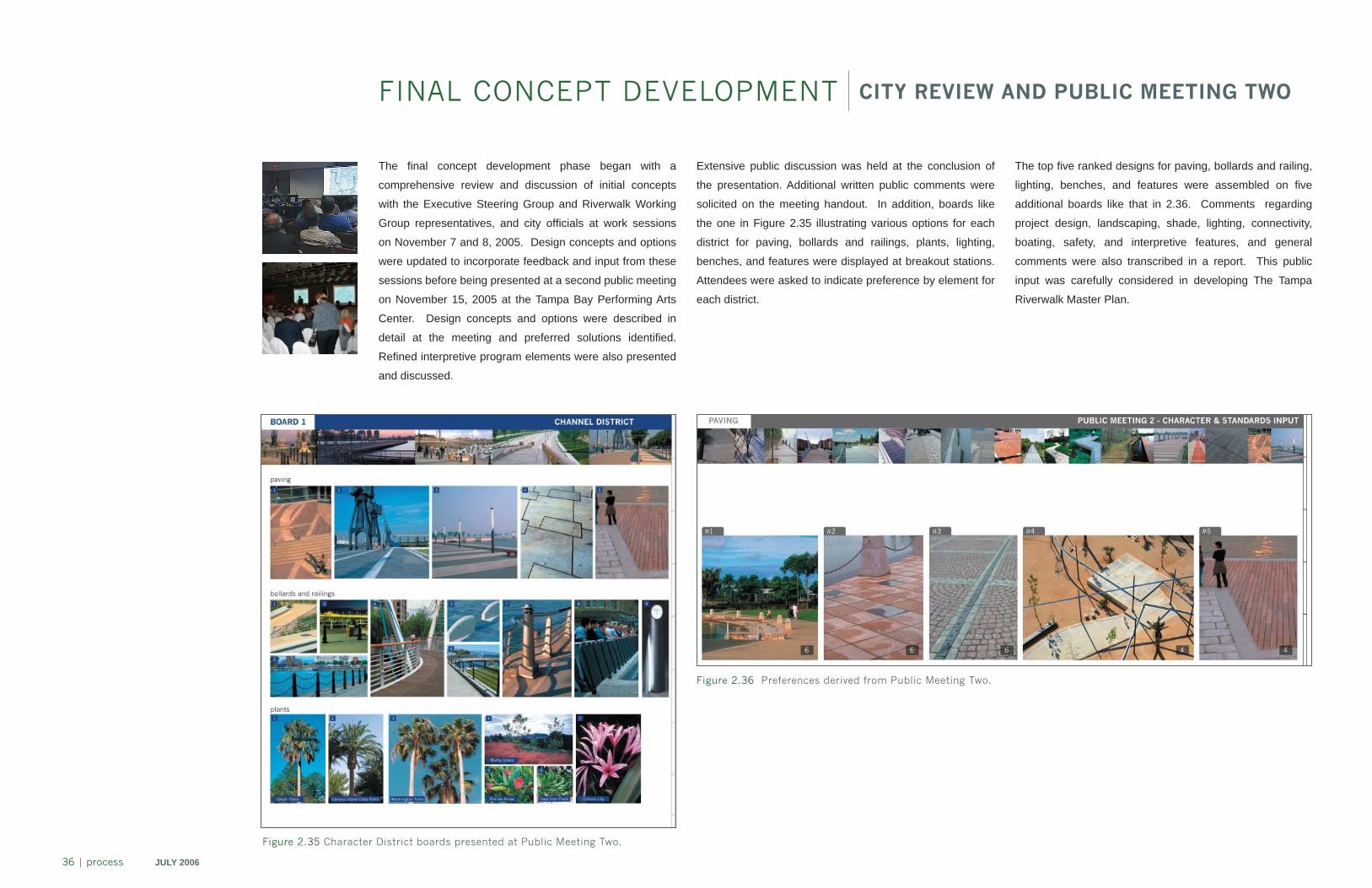
Figure 2.36 Preferences derived from Public Meeting Two.
Extensive public discussion was held at the conclusion of
the presentation. Additional written public comments were
solicited on the meeting handout. In addition, boards like
the one in Figure 2.35 illustrating various options for each
district for paving, bollards and railings, plants, lighting,
benches, and features were displayed at breakout stations.
Attendees were asked to indicate preference by element for
each district.
Figure 2.35 Character District boards presented at Public Meeting Two.
The top fi ve ranked designs for paving, bollards and railing,
lighting, benches, and features were assembled on fi ve
additional boards like that in 2.36. Comments regarding
project design, landscaping, shade, lighting, connectivity,
boating, safety, and interpretive features, and general
comments were also transcribed in a report. This public
input was carefully considered in developing The Tampa
Riverwalk Master Plan.
PR
OC
ES
S
JULY 2006 process | 37
FINAL CONCEPT DEVELOPMENT FINAL CONCEPT REFINEMENT
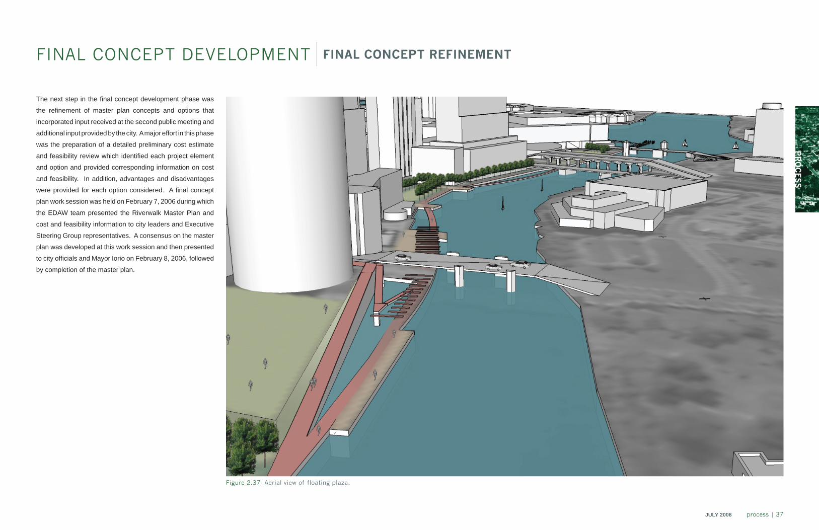
The next step in the fi nal concept development phase was
the refi nement of master plan concepts and options that
incorporated input received at the second public meeting and
additional input provided by the city. A major effort in this phase
was the preparation of a detailed preliminary cost estimate
and feasibility review which identifi ed each project element
and option and provided corresponding information on cost
and feasibility. In addition, advantages and disadvantages
were provided for each option considered. A fi nal concept
plan work session was held on February 7, 2006 during which
the EDAW team presented the Riverwalk Master Plan and
cost and feasibility information to city leaders and Executive
Steering Group representatives. A consensus on the master
plan was developed at this work session and then presented
to city offi cials and Mayor Iorio on February 8, 2006, followed
by completion of the master plan.
Figure 2.37 Aerial view of floating plaza.
38 | process JULY 2006
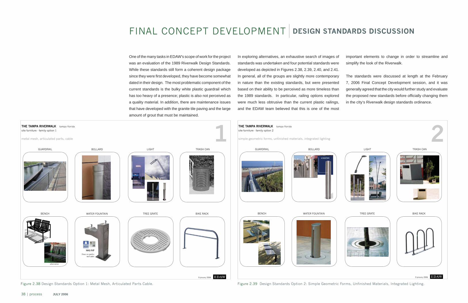
One of the many tasks in EDAW’s scope of work for the project
was an evaluation of the 1989 Riverwalk Design Standards.
While these standards still form a coherent design package
since they were fi rst developed, they have become somewhat
dated in their design. The most problematic component of the
current standards is the bulky white plastic guardrail which
has too heavy of a presence; plastic is also not perceived as
a quality material. In addition, there are maintenance issues
that have developed with the granite tile paving and the large
amount of grout that must be maintained.
FINAL CONCEPT DEVELOPMENT DESIGN STANDARDS DISCUSSION
THE TAMPA RIVERWALK tampa florida
site furniture - family option 1
9 january 2006
GUARDRAIL BOLLARD LIGHT TRASH CAN
BENCH WATER FOUNTAIN TREE GRATE
1metal mesh, articulated parts, cable
BIKE RACK
alternative
THE TAMPA RIVERWALK tampa florida
site furniture - family option 2
9 january 2006
GUARDRAIL BOLLARD LIGHT TRASH CAN
BENCH WATER FOUNTAIN TREE GRATE
2simple geometric forms, unfinished materials, integrated lighting
BIKE RACK
Figure 2.38 Design Standards Option 1: Metal Mesh, Articulated Parts Cable. Figure 2.39 Design Standards Option 2: Simple Geometric Forms, Unfinished Materials, Integrated Lighting.
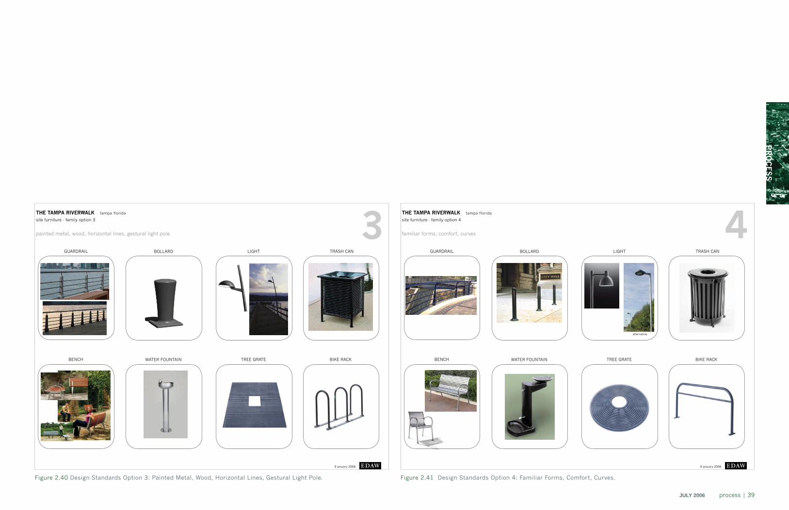
In exploring alternatives, an exhaustive search of images of
standards was undertaken and four potential standards were
developed as depicted in Figures 2.38, 2.39, 2.40, and 2.41.
In general, all of the groups are slightly more contemporary
in nature than the existing standards, but were presented
based on their ability to be perceived as more timeless than
the 1989 standards. In particular, railing options explored
were much less obtrusive than the current plastic railings,
and the EDAW team believed that this is one of the most
important elements to change in order to streamline and
simplify the look of the Riverwalk.
The standards were discussed at length at the February
7, 2006 Final Concept Development session, and it was
generally agreed that the city would further study and evaluate
the proposed new standards before offi cially changing them
in the cIty‘s Riverwalk design standards ordinance.
PR
OC
ES
S
JULY 2006 process | 39
THE TAMPA RIVERWALK tampa florida
site furniture - family option 3
9 january 2006
GUARDRAIL BOLLARD LIGHT TRASH CAN
BENCH WATER FOUNTAIN TREE GRATE
3painted metal, wood, horizontal lines, gestural light pole
BIKE RACK
THE TAMPA RIVERWALK tampa florida
site furniture - family option 4
9 january 2006
GUARDRAIL BOLLARD LIGHT TRASH CAN
BENCH WATER FOUNTAIN TREE GRATE
4familiar forms, comfort, curves
BIKE RACK
alternative
Figure 2.40 Design Standards Option 3: Painted Metal, Wood, Horizontal Lines, Gestural Light Pole. Figure 2.41 Design Standards Option 4: Familiar Forms, Comfort, Curves.
master plan developmentchapter 3
MA
ST
ER
PLA
N
JULY 2006 master plan | 41
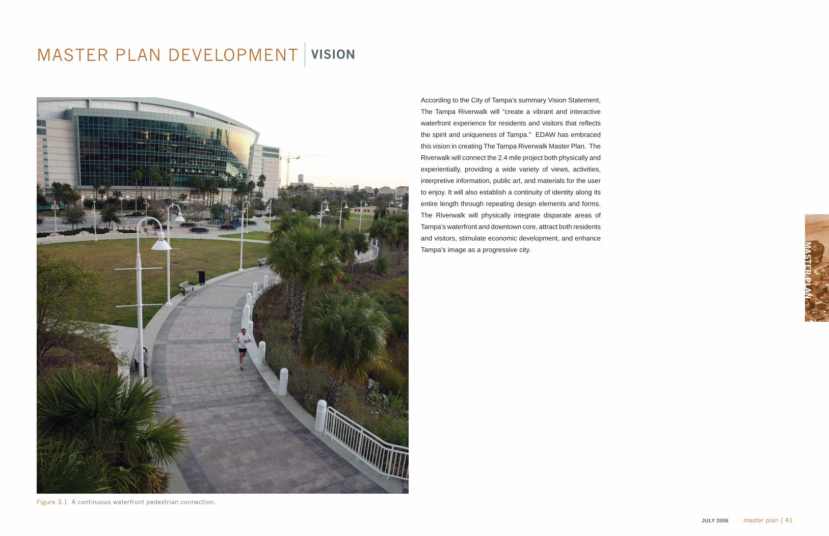
MASTER PLAN DEVELOPMENT VISION
According to the City of Tampa’s summary Vision Statement,
The Tampa Riverwalk will “create a vibrant and interactive
waterfront experience for residents and visitors that refl ects
the spirit and uniqueness of Tampa.” EDAW has embraced
this vision in creating The Tampa Riverwalk Master Plan. The
Riverwalk will connect the 2.4 mile project both physically and
experientially, providing a wide variety of views, activities,
interpretive information, public art, and materials for the user
to enjoy. It will also establish a continuity of identity along its
entire length through repeating design elements and forms.
The Riverwalk will physically integrate disparate areas of
Tampa’s waterfront and downtown core, attract both residents
and visitors, stimulate economic development, and enhance
Tampa’s image as a progressive city.
Figure 3.1 A continuous waterfront pedestrian connection.
42 | master plan JULY 2006
MASTER PLAN DEVELOPMENT NEIGHBORHOODS AND DISTRICTS
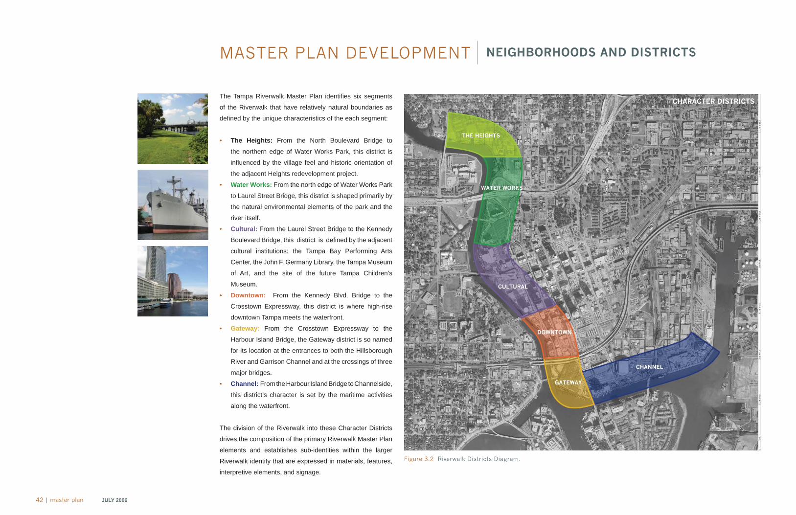
The Tampa Riverwalk Master Plan identifi es six segments
of the Riverwalk that have relatively natural boundaries as
defi ned by the unique characteristics of the each segment:
• The Heights: From the North Boulevard Bridge to
the northern edge of Water Works Park, this district is
infl uenced by the village feel and historic orientation of
the adjacent Heights redevelopment project.
• Water Works: From the north edge of Water Works Park
to Laurel Street Bridge, this district is shaped primarily by
the natural environmental elements of the park and the
river itself.
• Cultural: From the Laurel Street Bridge to the Kennedy
Boulevard Bridge, this district is defi ned by the adjacent
cultural institutions: the Tampa Bay Performing Arts
Center, the John F. Germany Library, the Tampa Museum
of Art, and the site of the future Tampa Children’s
Museum.
• Downtown: From the Kennedy Blvd. Bridge to the
Crosstown Expressway, this district is where high-rise
downtown Tampa meets the waterfront.
• Gateway: From the Crosstown Expressway to the
Harbour Island Bridge, the Gateway district is so named
for its location at the entrances to both the Hillsborough
River and Garrison Channel and at the crossings of three
major bridges.
• Channel: From the Harbour Island Bridge to Channelside,
this district’s character is set by the maritime activities
along the waterfront.
The division of the Riverwalk into these Character Districts
drives the composition of the primary Riverwalk Master Plan
elements and establishes sub-identities within the larger
Riverwalk identity that are expressed in materials, features,
interpretive elements, and signage.
Figure 3.2 Riverwalk Districts Diagram.
MA
ST
ER
PLA
N
JULY 2006 master plan | 43
MASTER PLAN DEVELOPMENT OVERVIEW
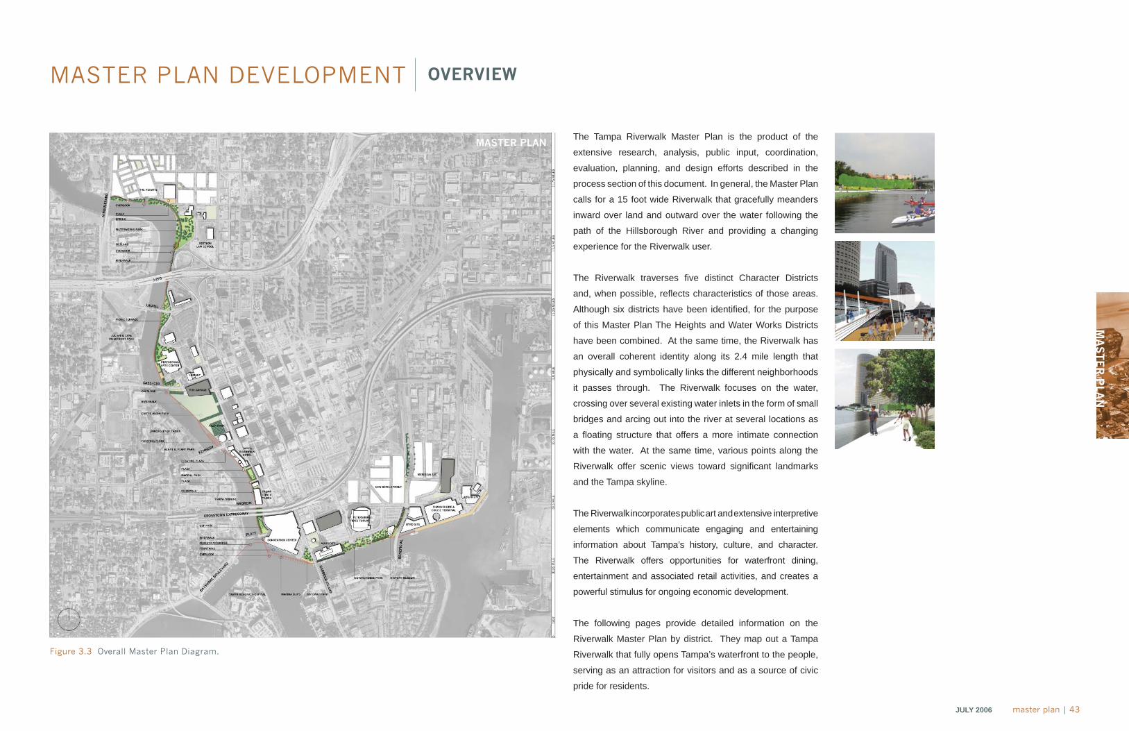
The Tampa Riverwalk Master Plan is the product of the
extensive research, analysis, public input, coordination,
evaluation, planning, and design efforts described in the
process section of this document. In general, the Master Plan
calls for a 15 foot wide Riverwalk that gracefully meanders
inward over land and outward over the water following the
path of the Hillsborough River and providing a changing
experience for the Riverwalk user.
The Riverwalk traverses fi ve distinct Character Districts
and, when possible, refl ects characteristics of those areas.
Although six districts have been identifi ed, for the purpose
of this Master Plan The Heights and Water Works Districts
have been combined. At the same time, the Riverwalk has
an overall coherent identity along its 2.4 mile length that
physically and symbolically links the different neighborhoods
it passes through. The Riverwalk focuses on the water,
crossing over several existing water inlets in the form of small
bridges and arcing out into the river at several locations as
a fl oating structure that offers a more intimate connection
with the water. At the same time, various points along the
Riverwalk offer scenic views toward signifi cant landmarks
and the Tampa skyline.
The Riverwalk incorporates public art and extensive interpretive
elements which communicate engaging and entertaining
information about Tampa’s history, culture, and character.
The Riverwalk offers opportunities for waterfront dining,
entertainment and associated retail activities, and creates a
powerful stimulus for ongoing economic development.
The following pages provide detailed information on the
Riverwalk Master Plan by district. They map out a Tampa
Riverwalk that fully opens Tampa’s waterfront to the people,
serving as an attraction for visitors and as a source of civic
pride for residents.
Figure 3.3 Overall Master Plan Diagram.
44 | master plan JULY 2006
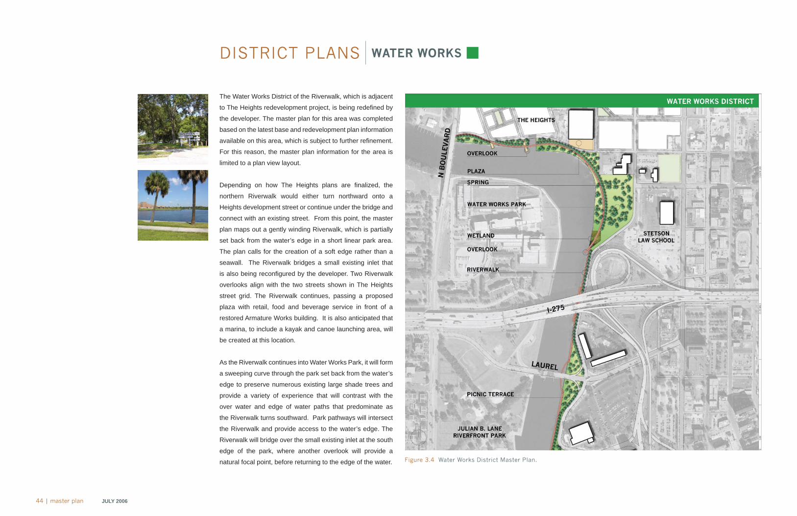
DISTRICT PLANS WATER WORKS
The Water Works District of the Riverwalk, which is adjacent
to The Heights redevelopment project, is being redefi ned by
the developer. The master plan for this area was completed
based on the latest base and redevelopment plan information
available on this area, which is subject to further refi nement.
For this reason, the master plan information for the area is
limited to a plan view layout.
Depending on how The Heights plans are fi nalized, the
northern Riverwalk would either turn northward onto a
Heights development street or continue under the bridge and
connect with an existing street. From this point, the master
plan maps out a gently winding Riverwalk, which is partially
set back from the water’s edge in a short linear park area.
The plan calls for the creation of a soft edge rather than a
seawall. The Riverwalk bridges a small existing inlet that
is also being reconfi gured by the developer. Two Riverwalk
overlooks align with the two streets shown in The Heights
street grid. The Riverwalk continues, passing a proposed
plaza with retail, food and beverage service in front of a
restored Armature Works building. It is also anticipated that
a marina, to include a kayak and canoe launching area, will
be created at this location.
As the Riverwalk continues into Water Works Park, it will form
a sweeping curve through the park set back from the water’s
edge to preserve numerous existing large shade trees and
provide a variety of experience that will contrast with the
over water and edge of water paths that predominate as
the Riverwalk turns southward. Park pathways will intersect
the Riverwalk and provide access to the water’s edge. The
Riverwalk will bridge over the small existing inlet at the south
edge of the park, where another overlook will provide a
natural focal point, before returning to the edge of the water. Figure 3.4 Water Works District Master Plan.
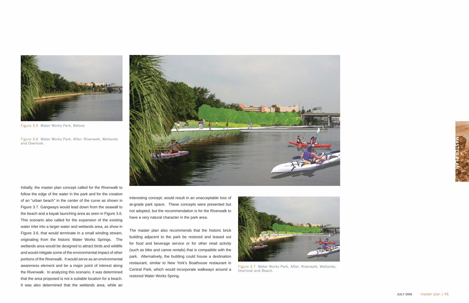
MA
ST
ER
PLA
N
JULY 2006 master plan | 45
Initially, the master plan concept called for the Riverwalk to
follow the edge of the water in the park and for the creation
of an “urban beach” in the center of the curve as shown in
Figure 3.7. Gangways would lead down from the seawall to
the beach and a kayak launching area as seen in Figure 3.6.
This scenario also called for the expansion of the existing
water inlet into a larger water and wetlands area, as show in
Figure 3.6, that would terminate in a small winding stream,
originating from the historic Water Works Springs. The
wetlands area would be designed to attract birds and wildlife
and would mitigate some of the environmental impact of other
portions of the Riverwalk. It would serve as an environmental
awareness element and be a major point of interest along
the Riverwalk. In analyzing this scenario, it was determined
that the area proposed is not a suitable location for a beach.
It was also determined that the wetlands area, while an
interesting concept, would result in an unacceptable loss of
at-grade park space. These concepts were presented but
not adopted, but the recommendation is for the Riverwalk to
have a very natural character in the park area.
The master plan also recommends that the historic brick
building adjacent to the park be restored and leased out
for food and beverage service or for other retail activity
(such as bike and canoe rentals) that is compatible with the
park. Alternatively, the building could house a destination
restaurant, similar to New York’s Boathouse restaurant in
Central Park, which would incorporate walkways around a
restored Water Works Spring.
Figure 3.5 Water Works Park, Before.
Figure 3.6 Water Works Park, After: Riverwalk, Wetlands and Overlook.
Figure 3.7 Water Works Park, After: Riverwalk, Wetlands, Overlook and Beach.
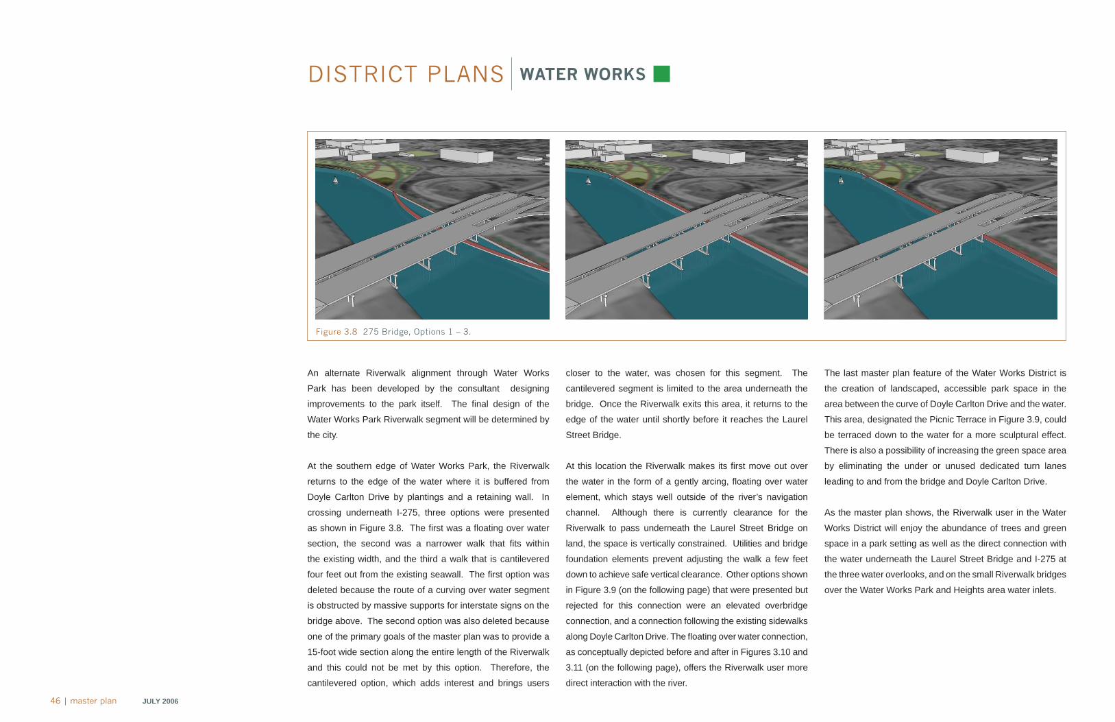
46 | master plan JULY 2006
DISTRICT PLANS WATER WORKS
closer to the water, was chosen for this segment. The
cantilevered segment is limited to the area underneath the
bridge. Once the Riverwalk exits this area, it returns to the
edge of the water until shortly before it reaches the Laurel
Street Bridge.
At this location the Riverwalk makes its fi rst move out over
the water in the form of a gently arcing, fl oating over water
element, which stays well outside of the river’s navigation
channel. Although there is currently clearance for the
Riverwalk to pass underneath the Laurel Street Bridge on
land, the space is vertically constrained. Utilities and bridge
foundation elements prevent adjusting the walk a few feet
down to achieve safe vertical clearance. Other options shown
in Figure 3.9 (on the following page) that were presented but
rejected for this connection were an elevated overbridge
connection, and a connection following the existing sidewalks
along Doyle Carlton Drive. The fl oating over water connection,
as conceptually depicted before and after in Figures 3.10 and
3.11 (on the following page), offers the Riverwalk user more
direct interaction with the river.
The last master plan feature of the Water Works District is
the creation of landscaped, accessible park space in the
area between the curve of Doyle Carlton Drive and the water.
This area, designated the Picnic Terrace in Figure 3.9, could
be terraced down to the water for a more sculptural effect.
There is also a possibility of increasing the green space area
by eliminating the under or unused dedicated turn lanes
leading to and from the bridge and Doyle Carlton Drive.
As the master plan shows, the Riverwalk user in the Water
Works District will enjoy the abundance of trees and green
space in a park setting as well as the direct connection with
the water underneath the Laurel Street Bridge and I-275 at
the three water overlooks, and on the small Riverwalk bridges
over the Water Works Park and Heights area water inlets.
An alternate Riverwalk alignment through Water Works
Park has been developed by the consultant designing
improvements to the park itself. The fi nal design of the
Water Works Park Riverwalk segment will be determined by
the city.
At the southern edge of Water Works Park, the Riverwalk
returns to the edge of the water where it is buffered from
Doyle Carlton Drive by plantings and a retaining wall. In
crossing underneath I-275, three options were presented
as shown in Figure 3.8. The fi rst was a fl oating over water
section, the second was a narrower walk that fi ts within
the existing width, and the third a walk that is cantilevered
four feet out from the existing seawall. The fi rst option was
deleted because the route of a curving over water segment
is obstructed by massive supports for interstate signs on the
bridge above. The second option was also deleted because
one of the primary goals of the master plan was to provide a
15-foot wide section along the entire length of the Riverwalk
and this could not be met by this option. Therefore, the
cantilevered option, which adds interest and brings users
Figure 3.8 275 Bridge, Options 1 – 3.

MA
ST
ER
PLA
N
JULY 2006 master plan | 47
Figure 3.10 Laurel Street Bridge, Before.
Figure 3.11 Laurel Street Bridge, After: Under Bridge Connection, Picnic Terraces and Riverwalk.
Figure 3.9 Laurel Street Bridge, Options 1 – 3.
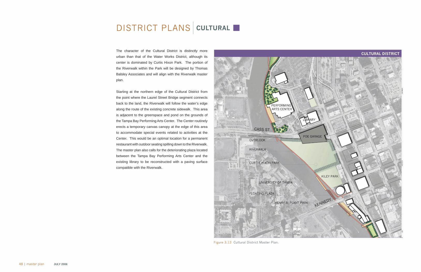
48 | master plan JULY 2006
DISTRICT PLANS CULTURAL
The character of the Cultural District is distinctly more
urban than that of the Water Works District, although its
center is dominated by Curtis Hixon Park. The portion of
the Riverwalk within the Park will be designed by Thomas
Balsley Associates and will align with the Riverwalk master
plan.
Starting at the northern edge of the Cultural District from
the point where the Laurel Street Bridge segment connects
back to the land, the Riverwalk will follow the water’s edge
along the route of the existing concrete sidewalk. This area
is adjacent to the greenspace and pond on the grounds of
the Tampa Bay Performing Arts Center. The Center routinely
erects a temporary canvas canopy at the edge of this area
to accommodate special events related to activities at the
Center. This would be an optimal location for a permanent
restaurant with outdoor seating spilling down to the Riverwalk.
The master plan also calls for the deteriorating plaza located
between the Tampa Bay Performing Arts Center and the
existing library to be reconstructed with a paving surface
compatible with the Riverwalk.
Figure 3.12 Cultural District Master Plan.
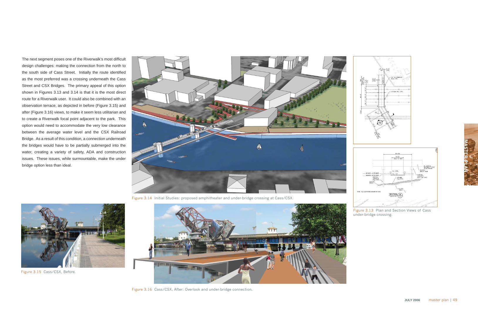
MA
ST
ER
PLA
N
JULY 2006 master plan | 49
The next segment poses one of the Riverwalk’s most diffi cult
design challenges: making the connection from the north to
the south side of Cass Street. Initially the route identifi ed
as the most preferred was a crossing underneath the Cass
Street and CSX Bridges. The primary appeal of this option
shown in Figures 3.13 and 3.14 is that it is the most direct
route for a Riverwalk user. It could also be combined with an
observation terrace, as depicted in before (Figure 3.15) and
after (Figure 3.16) views, to make it seem less utilitarian and
to create a Riverwalk focal point adjacent to the park. This
option would need to accommodate the very low clearance
between the average water level and the CSX Railroad
Bridge. As a result of this condition, a connection underneath
the bridges would have to be partially submerged into the
water, creating a variety of safety, ADA and construction
issues. These issues, while surmountable, make the under
bridge option less than ideal.
Figure 3.16 Cass/CSX, After: Overlook and under-bridge connection.
Figure 3.15 Cass/CSX, Before.
Figure 3.14 Initial Studies: proposed amphitheater and under-bridge crossing at Cass/CSX.
Figure 3.13 Plan and Section Views of Cass under-bridge crossing.
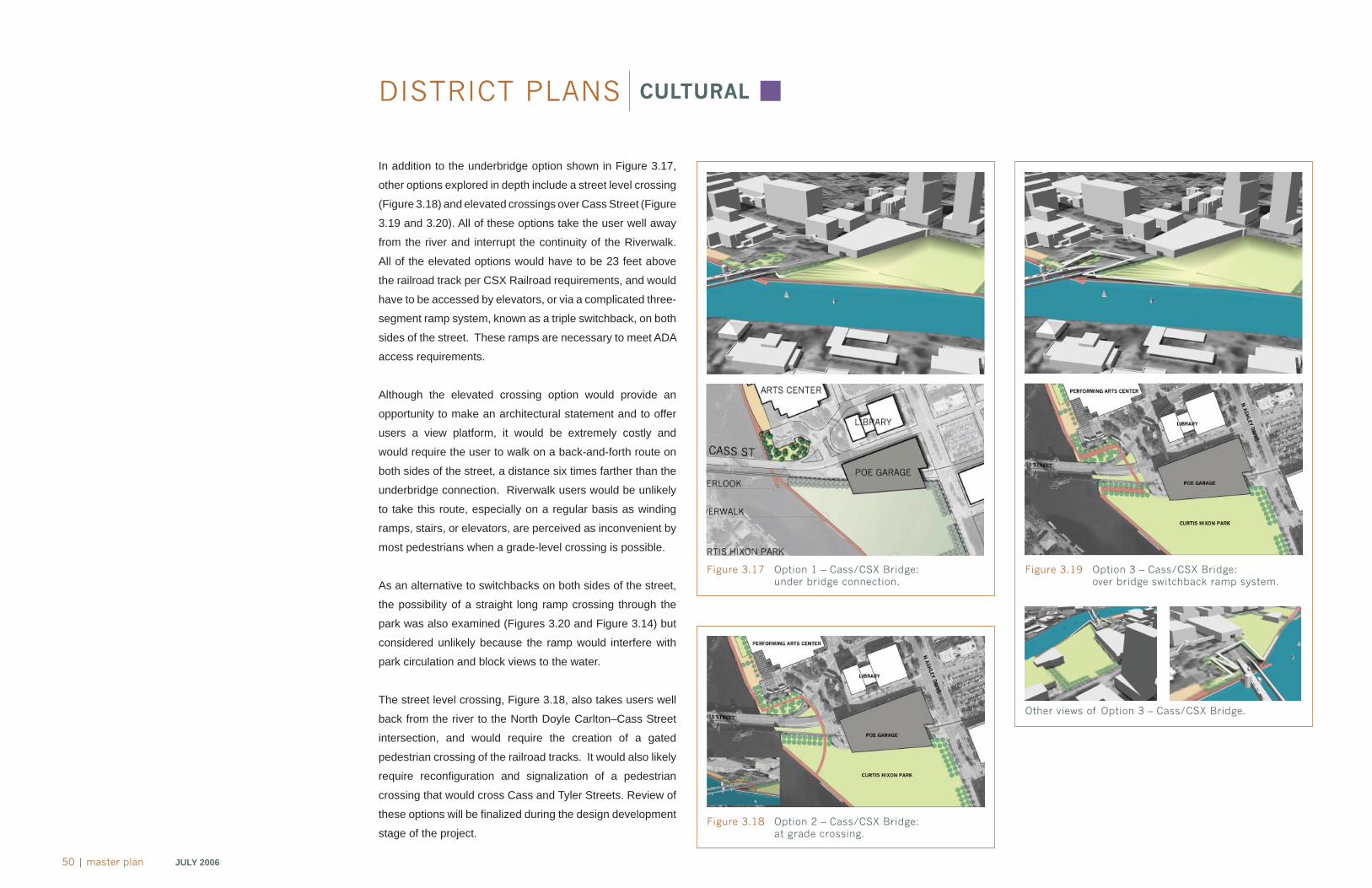
50 | master plan JULY 2006
DISTRICT PLANS CULTURAL
In addition to the underbridge option shown in Figure 3.17,
other options explored in depth include a street level crossing
(Figure 3.18) and elevated crossings over Cass Street (Figure
3.19 and 3.20). All of these options take the user well away
from the river and interrupt the continuity of the Riverwalk.
All of the elevated options would have to be 23 feet above
the railroad track per CSX Railroad requirements, and would
have to be accessed by elevators, or via a complicated three-
segment ramp system, known as a triple switchback, on both
sides of the street. These ramps are necessary to meet ADA
access requirements.
Although the elevated crossing option would provide an
opportunity to make an architectural statement and to offer
users a view platform, it would be extremely costly and
would require the user to walk on a back-and-forth route on
both sides of the street, a distance six times farther than the
underbridge connection. Riverwalk users would be unlikely
to take this route, especially on a regular basis as winding
ramps, stairs, or elevators, are perceived as inconvenient by
most pedestrians when a grade-level crossing is possible.
As an alternative to switchbacks on both sides of the street,
the possibility of a straight long ramp crossing through the
park was also examined (Figures 3.20 and Figure 3.14) but
considered unlikely because the ramp would interfere with
park circulation and block views to the water.
The street level crossing, Figure 3.18, also takes users well
back from the river to the North Doyle Carlton–Cass Street
intersection, and would require the creation of a gated
pedestrian crossing of the railroad tracks. It would also likely
require reconfi guration and signalization of a pedestrian
crossing that would cross Cass and Tyler Streets. Review of
these options will be fi nalized during the design development
stage of the project.
Figure 3.17 Option 1 – Cass/CSX Bridge: under bridge connection.
Figure 3.19 Option 3 – Cass/CSX Bridge: over bridge switchback ramp system.
Figure 3.18 Option 2 – Cass/CSX Bridge: at grade crossing.
Other views of Option 3 – Cass/CSX Bridge.
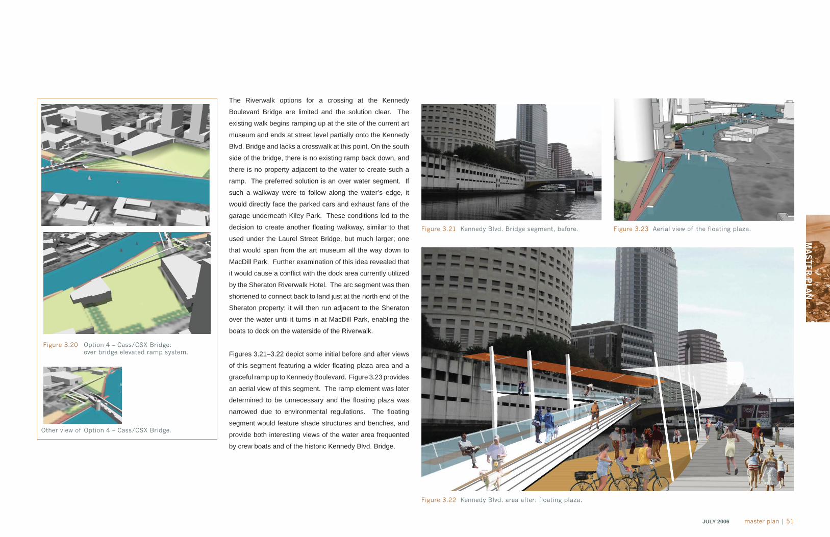
MA
ST
ER
PLA
N
JULY 2006 master plan | 51
The Riverwalk options for a crossing at the Kennedy
Boulevard Bridge are limited and the solution clear. The
existing walk begins ramping up at the site of the current art
museum and ends at street level partially onto the Kennedy
Blvd. Bridge and lacks a crosswalk at this point. On the south
side of the bridge, there is no existing ramp back down, and
there is no property adjacent to the water to create such a
ramp. The preferred solution is an over water segment. If
such a walkway were to follow along the water’s edge, it
would directly face the parked cars and exhaust fans of the
garage underneath Kiley Park. These conditions led to the
decision to create another fl oating walkway, similar to that
used under the Laurel Street Bridge, but much larger; one
that would span from the art museum all the way down to
MacDill Park. Further examination of this idea revealed that
it would cause a confl ict with the dock area currently utilized
by the Sheraton Riverwalk Hotel. The arc segment was then
shortened to connect back to land just at the north end of the
Sheraton property; it will then run adjacent to the Sheraton
over the water until it turns in at MacDill Park, enabling the
boats to dock on the waterside of the Riverwalk.
Figures 3.21–3.22 depict some initial before and after views
of this segment featuring a wider fl oating plaza area and a
graceful ramp up to Kennedy Boulevard. Figure 3.23 provides
an aerial view of this segment. The ramp element was later
determined to be unnecessary and the fl oating plaza was
narrowed due to environmental regulations. The fl oating
segment would feature shade structures and benches, and
provide both interesting views of the water area frequented
by crew boats and of the historic Kennedy Blvd. Bridge.
Figure 3.21 Kennedy Blvd. Bridge segment, before.
Figure 3.22 Kennedy Blvd. area after: floating plaza.
Figure 3.23 Aerial view of the floating plaza.
Figure 3.20 Option 4 – Cass/CSX Bridge: over bridge elevated ramp system.
Other view of Option 4 – Cass/CSX Bridge.
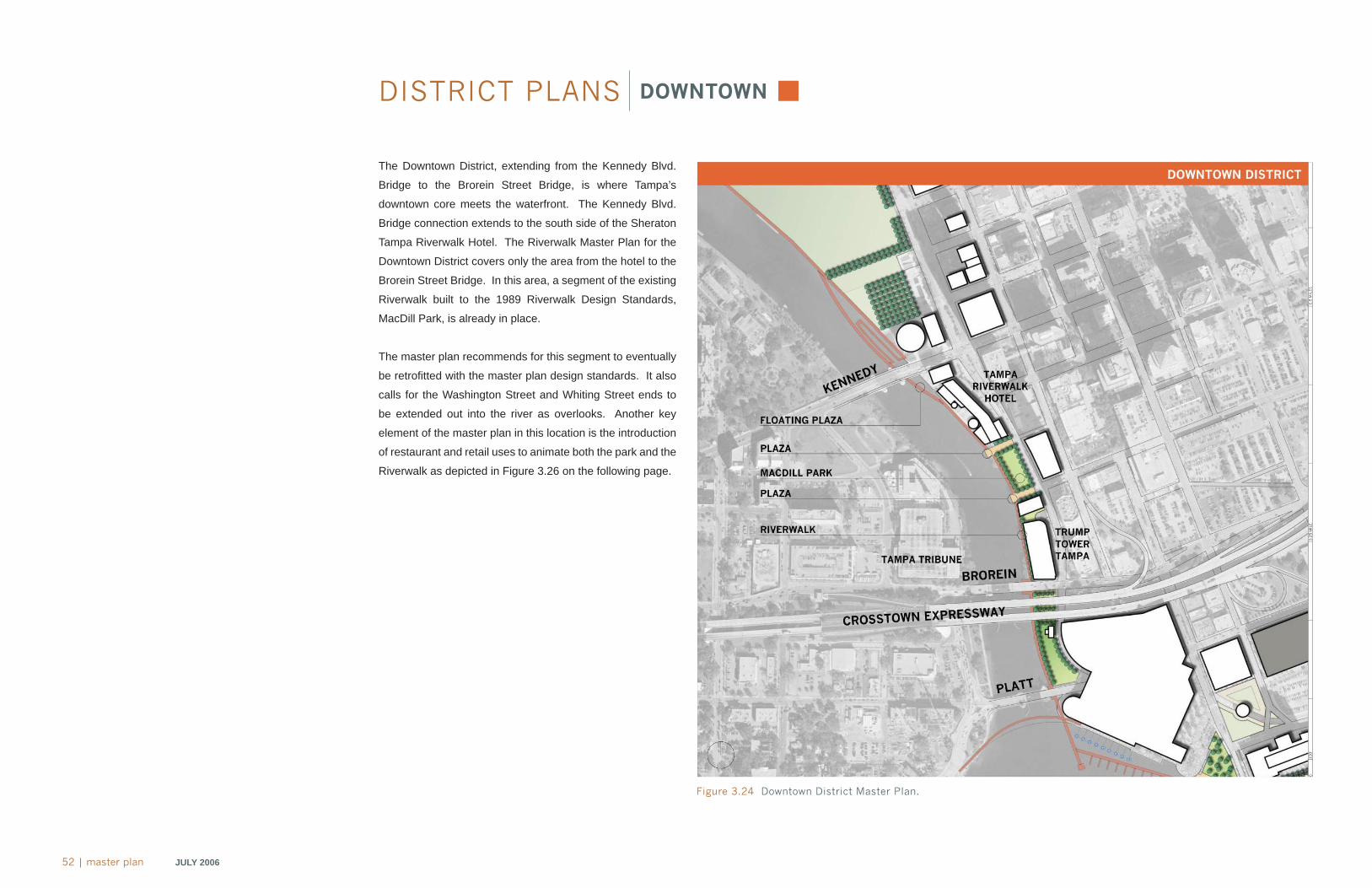
52 | master plan JULY 2006
DISTRICT PLANS DOWNTOWN
The Downtown District, extending from the Kennedy Blvd.
Bridge to the Brorein Street Bridge, is where Tampa’s
downtown core meets the waterfront. The Kennedy Blvd.
Bridge connection extends to the south side of the Sheraton
Tampa Riverwalk Hotel. The Riverwalk Master Plan for the
Downtown District covers only the area from the hotel to the
Brorein Street Bridge. In this area, a segment of the existing
Riverwalk built to the 1989 Riverwalk Design Standards,
MacDill Park, is already in place.
The master plan recommends for this segment to eventually
be retrofi tted with the master plan design standards. It also
calls for the Washington Street and Whiting Street ends to
be extended out into the river as overlooks. Another key
element of the master plan in this location is the introduction
of restaurant and retail uses to animate both the park and the
Riverwalk as depicted in Figure 3.26 on the following page.
Figure 3.24 Downtown District Master Plan.
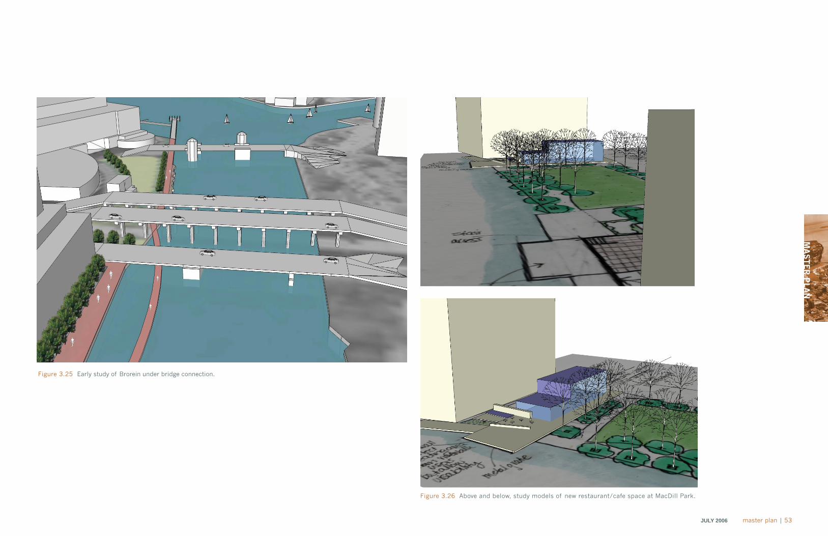
MA
ST
ER
PLA
N
JULY 2006 master plan | 53
Figure 3.25 Early study of Brorein under bridge connection.
Figure 3.26 Above and below, study models of new restaurant/cafe space at MacDill Park.
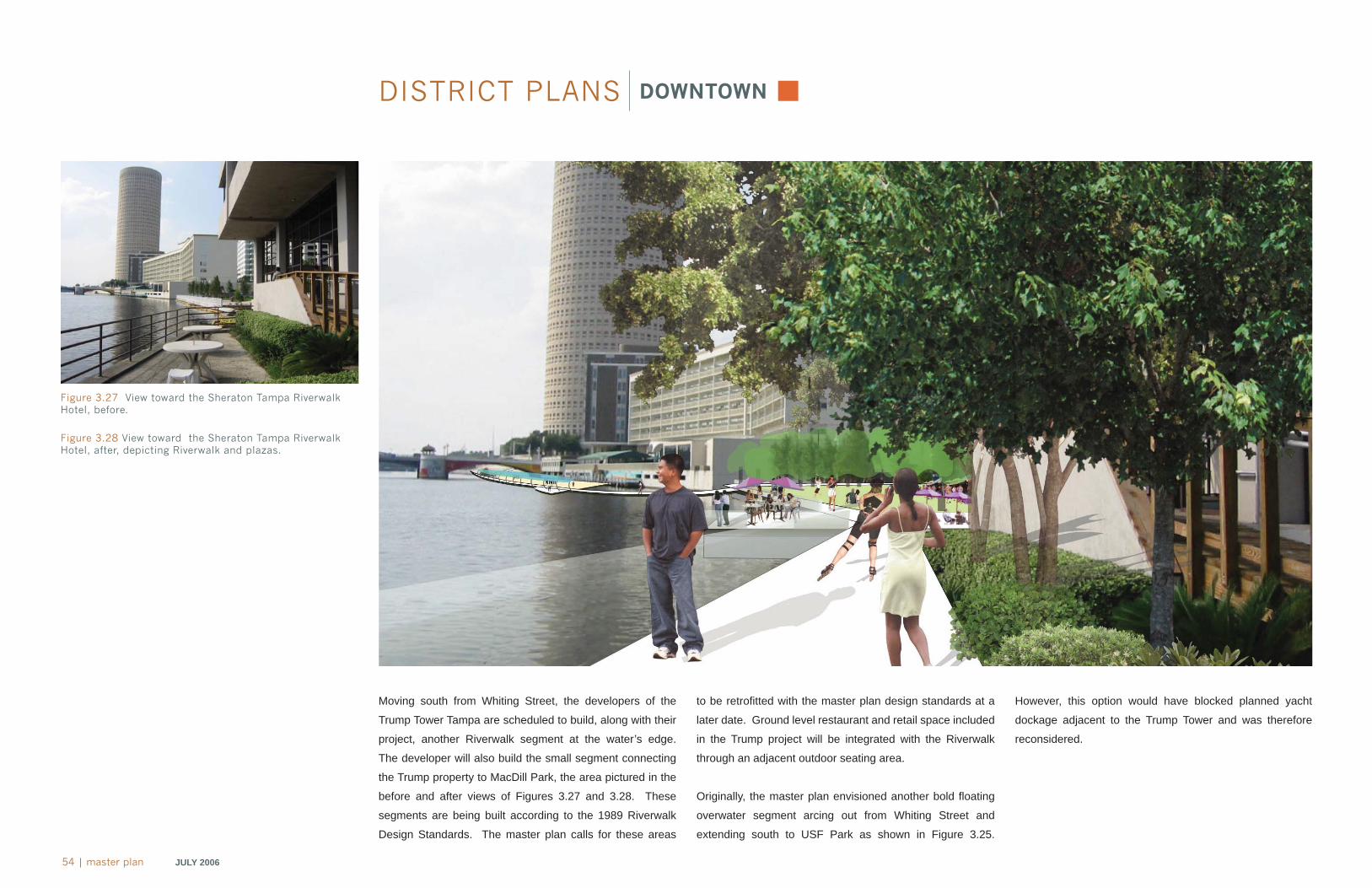
54 | master plan JULY 2006
Figure 3.27 View toward the Sheraton Tampa Riverwalk Hotel, before.
Figure 3.28 View toward the Sheraton Tampa Riverwalk Hotel, after, depicting Riverwalk and plazas.
DISTRICT PLANS DOWNTOWN
Moving south from Whiting Street, the developers of the
Trump Tower Tampa are scheduled to build, along with their
project, another Riverwalk segment at the water’s edge.
The developer will also build the small segment connecting
the Trump property to MacDill Park, the area pictured in the
before and after views of Figures 3.27 and 3.28. These
segments are being built according to the 1989 Riverwalk
Design Standards. The master plan calls for these areas
to be retrofi tted with the master plan design standards at a
later date. Ground level restaurant and retail space included
in the Trump project will be integrated with the Riverwalk
through an adjacent outdoor seating area.
Originally, the master plan envisioned another bold fl oating
overwater segment arcing out from Whiting Street and
extending south to USF Park as shown in Figure 3.25.
However, this option would have blocked planned yacht
dockage adjacent to the Trump Tower and was therefore
reconsidered.
MA
ST
ER
PLA
N
JULY 2006 master plan | 55
Figure 3.29 Before: Inaccessible riverfront adjacent to Sheraton Tampa Riverwalk Hotel.
Figure 3.30 After: Riverwalk and Floating Plaza connecting to MacDill Park.
56 | master plan JULY 2006
DISTRICT PLANS GATEWAY
The Gateway District, extending from the Brorein Bridge to
the Harbour Island Bridge, is named for its prominent location
at the intersection of entrances to the Hillsborough River and
Garrison Channel and for the three important bridges that
cross through the district. These bridges connect downtown
with the area west of the river and south of the channel.
Beginning at the north end of the district, the master plan
illustrates a connection under the Brorein Bridge linking the
Trump Tower property to USF Park on the south side of the
bridge. This connection will follow the form of the Platt Street
underbridge connection, which has been designed and
permitted and is currently being bid for construction. This
design consists of a fi xed over water connection that will
be built to the 1989 Riverwalk Design Standards. Alternate
options considered for Platt Street, as shown in Figure 3.32
on the following page, included a pedestrian connection off
of the water; a curved fl oating over water connection; and an
elevator tower over street connection. However, because
a Platt Street connection had already been designed and
permitted and was ready for construction to be bid, the city
determined that the best course of action was to proceed
with building according to the existing plan. The master plan
calls for both the Brorein and Platt Street connections to be
retrofi tted with the master plan design standards in the long
Figure 3.31 Gateway District Master Plan.
MA
ST
ER
PLA
N
JULY 2006 master plan | 57
Figure 3.32 Platt Street Bridge, Options 1 – 3.
Figure 3.33 Tampa Convention Center, Option 1: Riverwalk and floating marina.
Figure 3.34 Tampa Convention Center, Option 2:Fixed over-water riverwalk adjacent to terrace.
Figure 3.35 Tampa Convention Center, Option 3:Refurbish existing Riverwalk segment.
58 | master plan JULY 2006
Figure 3.37 View toward Crossstown Expressway, before.
Figure 3.38 View toward Crosstown Expressway, after: USF Park and Riverwalk.
recently completed walkway in USF Park, which was built
according to the 1989 Riverwalk Design Standards, will
later be retrofi tted with the Riverwalk Master Plan Design
Standards at the appropriate time.
A special Gateway District feature proposed was a large
iconic tower (Figure 3.36) with its base in USF Park rising up
past the elevated freeway bridge and serving as a landmark
for the Riverwalk and as a symbolic element connecting
motorists on the freeway above with the park below.
Another key element of the master plan for the Riverwalk in
this district is a pedestrian bridge connecting the Bayshore
Boulevard promenade with the Riverwalk as shown in Figures
3.36 and 3.41 (on the following page). This is an important
Riverwalk connection that would greatly increase the number
of Riverwalk users. The bridge should be iconic in form and
designed to refl ect the “gateway” character of this location.
It is likely that such a bridge would be completed as a future
enhancement.
DISTRICT PLANS GATEWAY
Figure 3.36 Initial studies of potential iconic tower and pedestrian bridge in USF Park.
term.
Initially, the EDAW team had proposed a long fl oating over
water connection (as shown in Figures 3.37 and 3.38), in
keeping with the large scale movements and portals of
the Gateway District. This option repeats the meandering
theme established by the Laurel Street and Kennedy Blvd.
over water connections, which would have extended all
the way from the Trump property to a connection with the
Tampa Convention Center. Cost and permitting concerns
precluded this option from being pursued. Instead, the
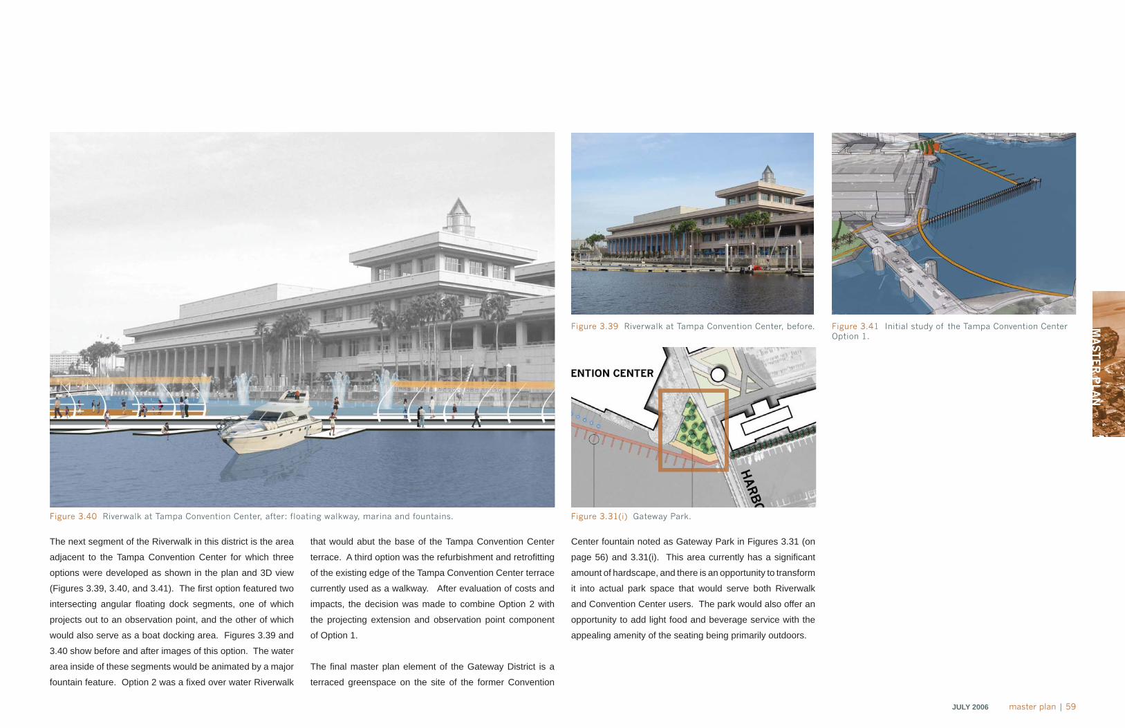
MA
ST
ER
PLA
N
JULY 2006 master plan | 59
Figure 3.39 Riverwalk at Tampa Convention Center, before.
Figure 3.40 Riverwalk at Tampa Convention Center, after: floating walkway, marina and fountains.
The next segment of the Riverwalk in this district is the area
adjacent to the Tampa Convention Center for which three
options were developed as shown in the plan and 3D view
(Figures 3.39, 3.40, and 3.41). The fi rst option featured two
intersecting angular fl oating dock segments, one of which
projects out to an observation point, and the other of which
would also serve as a boat docking area. Figures 3.39 and
3.40 show before and after images of this option. The water
area inside of these segments would be animated by a major
fountain feature. Option 2 was a fi xed over water Riverwalk
that would abut the base of the Tampa Convention Center
terrace. A third option was the refurbishment and retrofi tting
of the existing edge of the Tampa Convention Center terrace
currently used as a walkway. After evaluation of costs and
impacts, the decision was made to combine Option 2 with
the projecting extension and observation point component
of Option 1.
The fi nal master plan element of the Gateway District is a
terraced greenspace on the site of the former Convention
Center fountain noted as Gateway Park in Figures 3.31 (on
page 56) and 3.31(i). This area currently has a signifi cant
amount of hardscape, and there is an opportunity to transform
it into actual park space that would serve both Riverwalk
and Convention Center users. The park would also offer an
opportunity to add light food and beverage service with the
appealing amenity of the seating being primarily outdoors.
Figure 3.41 Initial study of the Tampa Convention Center Option 1.
Figure 3.31(i) Gateway Park.
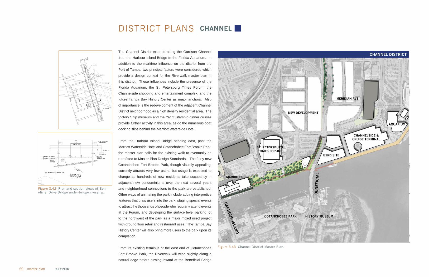
60 | master plan JULY 2006
DISTRICT PLANS CHANNEL
The Channel District extends along the Garrison Channel
from the Harbour Island Bridge to the Florida Aquarium. In
addition to the maritime infl uence on the district from the
Port of Tampa, two principal factors were considered which
provide a design context for the Riverwalk master plan in
this district. These infl uences include the presence of the
Florida Aquarium, the St. Petersburg Times Forum, the
Channelside shopping and entertainment complex, and the
future Tampa Bay History Center as major anchors. Also
of importance is the redevelopment of the adjacent Channel
District neighborhood as a high density residential area. The
Victory Ship museum and the Yacht Starship dinner cruises
provide further activity in this area, as do the numerous boat
docking slips behind the Marriott Waterside Hotel.
From the Harbour Island Bridge heading east, past the
Marriott Waterside Hotel and Cotanchobee Fort Brooke Park,
the master plan calls for the existing walk to eventually be
retrofi tted to Master Plan Design Standards. The fairly new
Cotanchobee Fort Brooke Park, though visually appealing,
currently attracts very few users, but usage is expected to
change as hundreds of new residents take occupancy in
adjacent new condominiums over the next several years
and neighborhood connections to the park are established.
Other ways of animating the park include adding interpretive
features that draw users into the park, staging special events
to attract the thousands of people who regularly attend events
at the Forum, and developing the surface level parking lot
to the northwest of the park as a major mixed used project
with ground fl oor retail and restaurant uses. The Tampa Bay
History Center will also bring more users to the park upon its
completion.
From its existing terminus at the east end of Cotanchobee
Fort Brooke Park, the Riverwalk will wind slightly along a
natural edge before turning inward at the Benefi cial Bridge
Figure 3.43 Channel District Master Plan.
Figure 3.42 Plan and section views of Ben-eficial Drive Bridge under-bridge crossing.
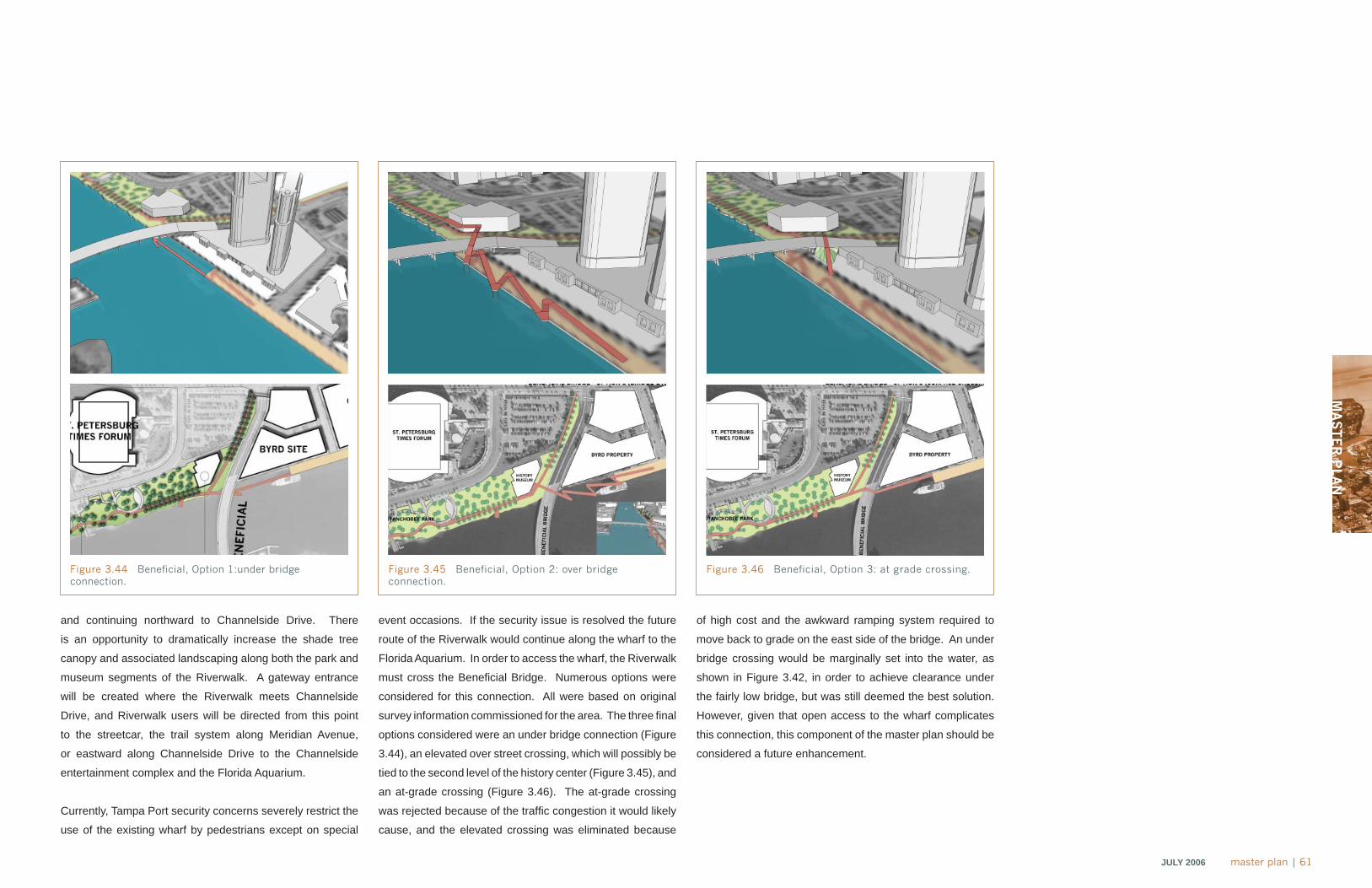
MA
ST
ER
PLA
N
JULY 2006 master plan | 61
and continuing northward to Channelside Drive. There
is an opportunity to dramatically increase the shade tree
canopy and associated landscaping along both the park and
museum segments of the Riverwalk. A gateway entrance
will be created where the Riverwalk meets Channelside
Drive, and Riverwalk users will be directed from this point
to the streetcar, the trail system along Meridian Avenue,
or eastward along Channelside Drive to the Channelside
entertainment complex and the Florida Aquarium.
Currently, Tampa Port security concerns severely restrict the
use of the existing wharf by pedestrians except on special
event occasions. If the security issue is resolved the future
route of the Riverwalk would continue along the wharf to the
Florida Aquarium. In order to access the wharf, the Riverwalk
must cross the Benefi cial Bridge. Numerous options were
considered for this connection. All were based on original
survey information commissioned for the area. The three fi nal
options considered were an under bridge connection (Figure
3.44), an elevated over street crossing, which will possibly be
tied to the second level of the history center (Figure 3.45), and
an at-grade crossing (Figure 3.46). The at-grade crossing
was rejected because of the traffi c congestion it would likely
cause, and the elevated crossing was eliminated because
of high cost and the awkward ramping system required to
move back to grade on the east side of the bridge. An under
bridge crossing would be marginally set into the water, as
shown in Figure 3.42, in order to achieve clearance under
the fairly low bridge, but was still deemed the best solution.
However, given that open access to the wharf complicates
this connection, this component of the master plan should be
considered a future enhancement.
Figure 3.44 Beneficial, Option 1:under bridge connection.
Figure 3.45 Beneficial, Option 2: over bridge connection.
Figure 3.46 Beneficial, Option 3: at grade crossing.
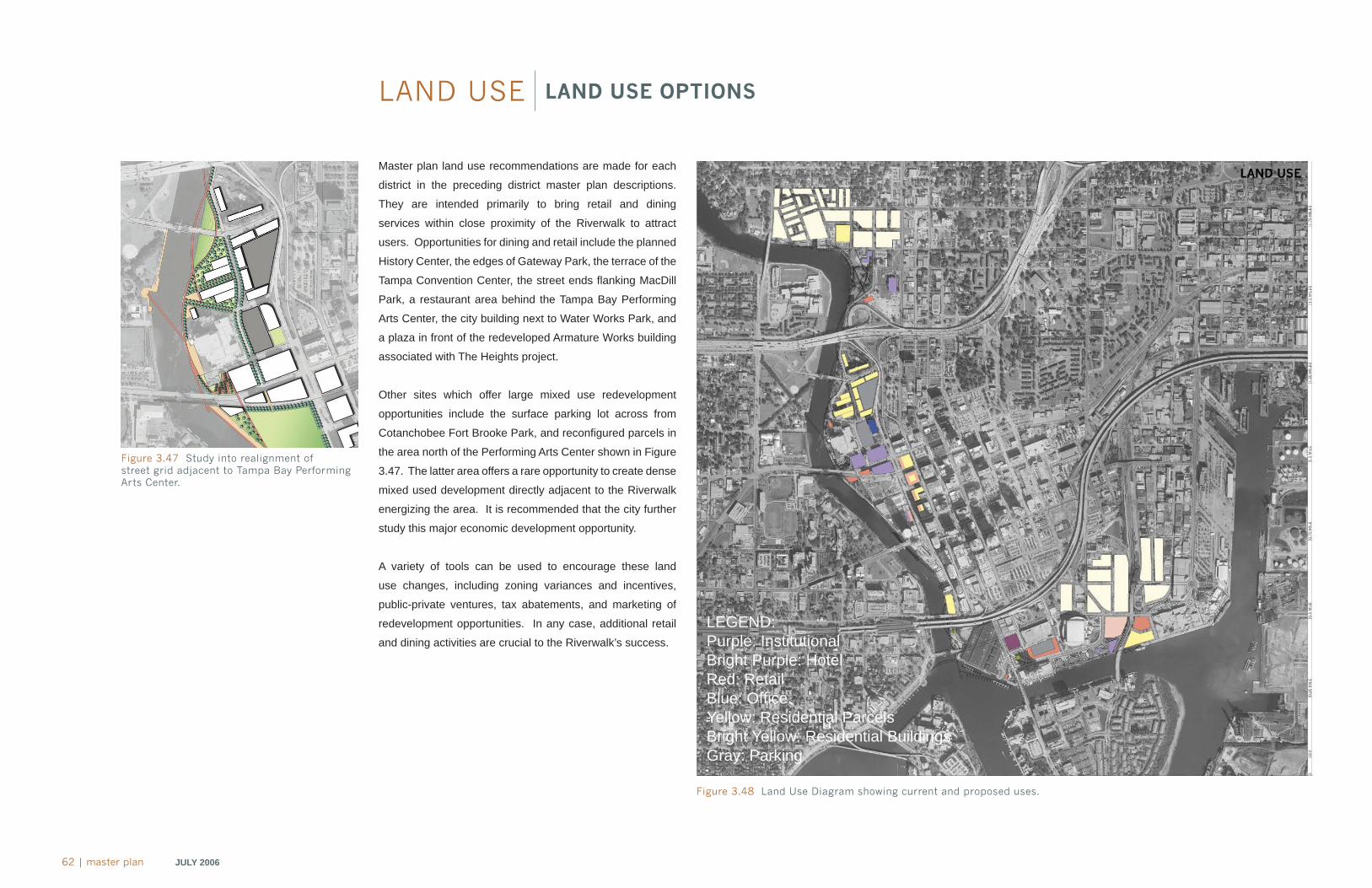
62 | master plan JULY 2006
LAND USE LAND USE OPTIONS
Master plan land use recommendations are made for each
district in the preceding district master plan descriptions.
They are intended primarily to bring retail and dining
services within close proximity of the Riverwalk to attract
users. Opportunities for dining and retail include the planned
History Center, the edges of Gateway Park, the terrace of the
Tampa Convention Center, the street ends fl anking MacDill
Park, a restaurant area behind the Tampa Bay Performing
Arts Center, the city building next to Water Works Park, and
a plaza in front of the redeveloped Armature Works building
associated with The Heights project.
Other sites which offer large mixed use redevelopment
opportunities include the surface parking lot across from
Cotanchobee Fort Brooke Park, and reconfi gured parcels in
the area north of the Performing Arts Center shown in Figure
3.47. The latter area offers a rare opportunity to create dense
mixed used development directly adjacent to the Riverwalk
energizing the area. It is recommended that the city further
study this major economic development opportunity.
A variety of tools can be used to encourage these land
use changes, including zoning variances and incentives,
public-private ventures, tax abatements, and marketing of
redevelopment opportunities. In any case, additional retail
and dining activities are crucial to the Riverwalk’s success.
Figure 3.48 Land Use Diagram showing current and proposed uses.
Figure 3.47 Study into realignment of street grid adjacent to Tampa Bay Performing Arts Center.
LEGEND:Purple: InstitutionalBright Purple: HotelRed: RetailBlue: Offi ceYellow: Residential ParcelsBright Yellow: Residential BuildingsGray: Parking
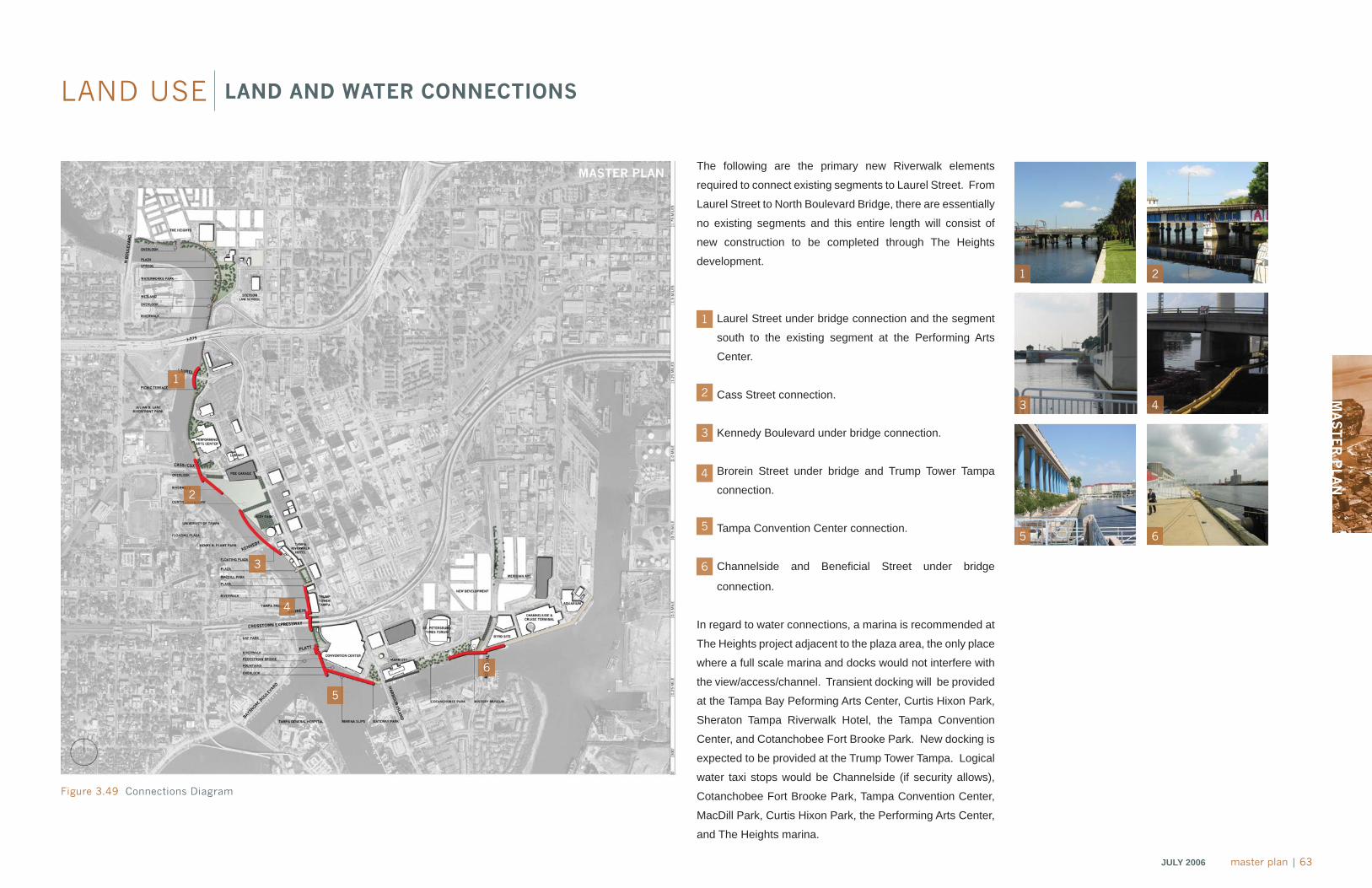
MA
ST
ER
PLA
N
JULY 2006 master plan | 63
LAND USE LAND AND WATER CONNECTIONS
The following are the primary new Riverwalk elements
required to connect existing segments to Laurel Street. From
Laurel Street to North Boulevard Bridge, there are essentially
no existing segments and this entire length will consist of
new construction to be completed through The Heights
development.
Laurel Street under bridge connection and the segment
south to the existing segment at the Performing Arts
Center.
Cass Street connection.
Kennedy Boulevard under bridge connection.
Brorein Street under bridge and Trump Tower Tampa
connection.
Tampa Convention Center connection.
Channelside and Benefi cial Street under bridge
connection.
In regard to water connections, a marina is recommended at
The Heights project adjacent to the plaza area, the only place
where a full scale marina and docks would not interfere with
the view/access/channel. Transient docking will be provided
at the Tampa Bay Peforming Arts Center, Curtis Hixon Park,
Sheraton Tampa Riverwalk Hotel, the Tampa Convention
Center, and Cotanchobee Fort Brooke Park. New docking is
expected to be provided at the Trump Tower Tampa. Logical
water taxi stops would be Channelside (if security allows),
Cotanchobee Fort Brooke Park, Tampa Convention Center,
MacDill Park, Curtis Hixon Park, the Performing Arts Center,
and The Heights marina.
Figure 3.49 Connections Diagram
1
2
3
4
5
6
1
3
5
2
4
6
1
2
3
4
5
6
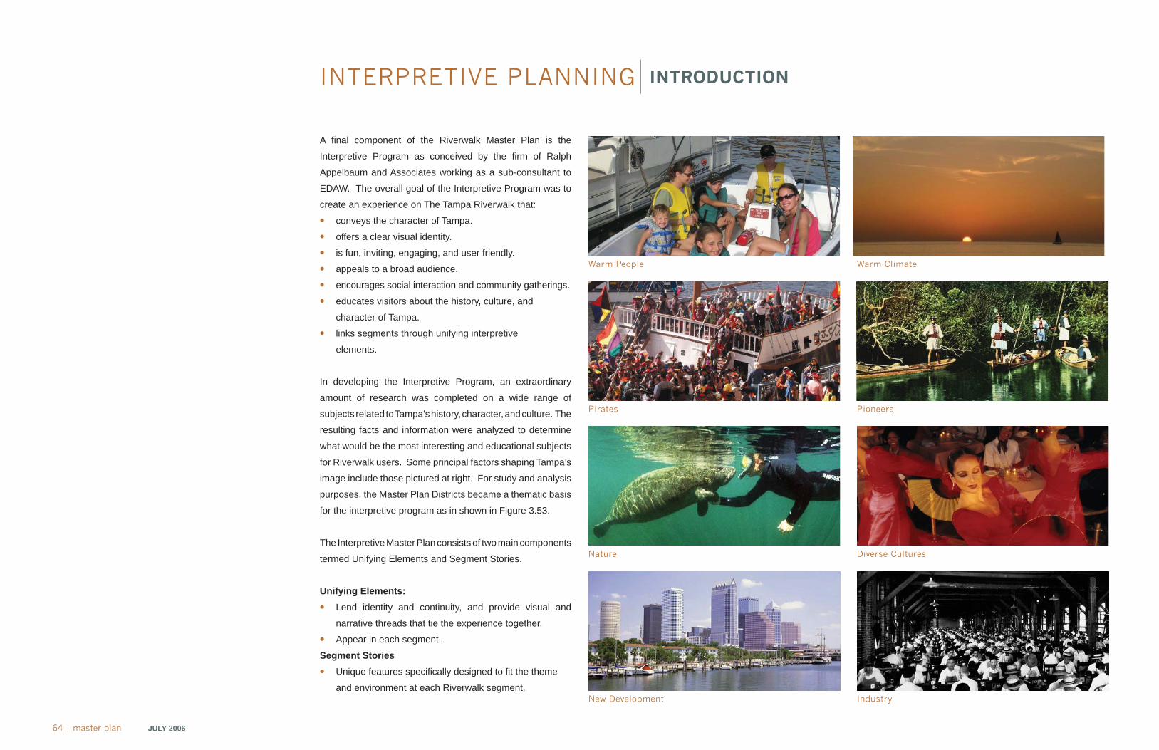
64 | master plan JULY 2006
INTERPRETIVE PLANNING INTRODUCTION
Warm People
Pirates
Nature
New Development
Warm Climate
Pioneers
Diverse Cultures
Industry
A fi nal component of the Riverwalk Master Plan is the
Interpretive Program as conceived by the fi rm of Ralph
Appelbaum and Associates working as a sub-consultant to
EDAW. The overall goal of the Interpretive Program was to
create an experience on The Tampa Riverwalk that:
• conveys the character of Tampa.
• offers a clear visual identity.
• is fun, inviting, engaging, and user friendly.
• appeals to a broad audience.
• encourages social interaction and community gatherings.
• educates visitors about the history, culture, and
character of Tampa.
• links segments through unifying interpretive
elements.
In developing the Interpretive Program, an extraordinary
amount of research was completed on a wide range of
subjects related to Tampa’s history, character, and culture. The
resulting facts and information were analyzed to determine
what would be the most interesting and educational subjects
for Riverwalk users. Some principal factors shaping Tampa’s
image include those pictured at right. For study and analysis
purposes, the Master Plan Districts became a thematic basis
for the interpretive program as in shown in Figure 3.53.
The Interpretive Master Plan consists of two main components
termed Unifying Elements and Segment Stories.
Unifying Elements:
• Lend identity and continuity, and provide visual and
narrative threads that tie the experience together.
• Appear in each segment.
Segment Stories
• Unique features specifi cally designed to fi t the theme
and environment at each Riverwalk segment.
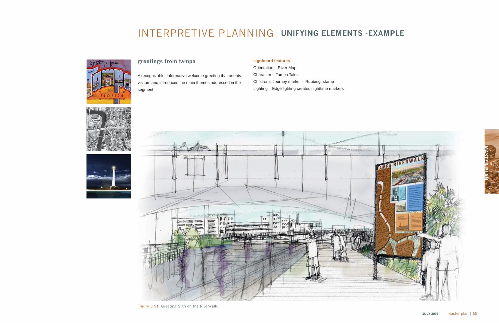
MA
ST
ER
PLA
N
JULY 2006 master plan | 65
INTERPRETIVE PLANNING UNIFYING ELEMENTS -EXAMPLE
greetings from tampa
A recognizable, informative welcome greeting that orients
visitors and introduces the main themes addressed in the
segment.
Figure 3.51 Greeting Sign on the Riverwalk.
signboard features
Orientation – River Map
Character – Tampa Tales
Children’s Journey marker – Rubbing, stamp
Lighting – Edge lighting creates nighttime markers
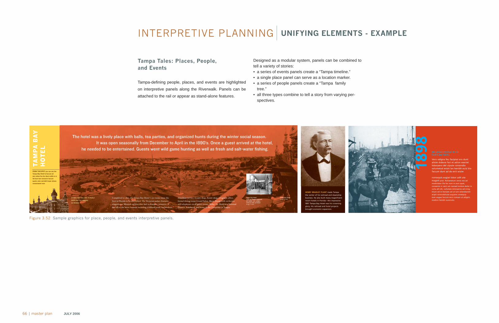
66 | master plan JULY 2006
INTERPRETIVE PLANNING
Tampa Tales: Places, People, and Events
Tampa-defi ning people, places, and events are highlighted
on interpretive panels along the Riverwalk. Panels can be
attached to the rail or appear as stand-alone features.
Figure 3.52 Sample graphics for place, people, and events interpretive panels.
Designed as a modular system, panels can be combined to tell a variety of stories:• a series of events panels create a “Tampa timeline.”• a single place panel can serve as a location marker.• a series of people panels create a “Tampa family
tree.”• all three types combine to tell a story from varying per-
spectives.
UNIFYING ELEMENTS - EXAMPLE
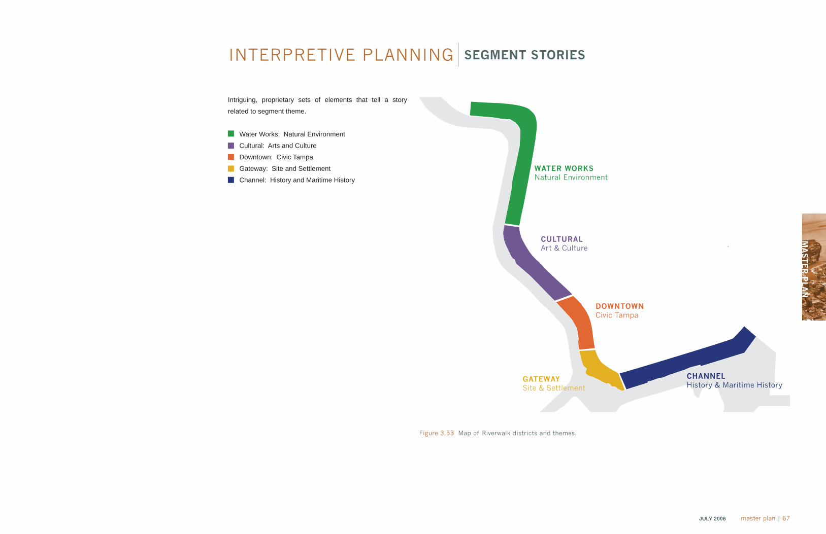
MA
ST
ER
PLA
N
JULY 2006 master plan | 67
INTERPRETIVE PLANNING SEGMENT STORIES
Intriguing, proprietary sets of elements that tell a story
related to segment theme.
• Water Works: Natural Environment
• Cultural: Arts and Culture
• Downtown: Civic Tampa
• Gateway: Site and Settlement
• Channel: History and Maritime History
Figure 3.53 Map of Riverwalk districts and themes.
WATER WORKSNatural Environment
CULTURAL Art & Culture
DOWNTOWN Civic Tampa
GATEWAYSite & Settlement
CHANNEL History & Maritime History
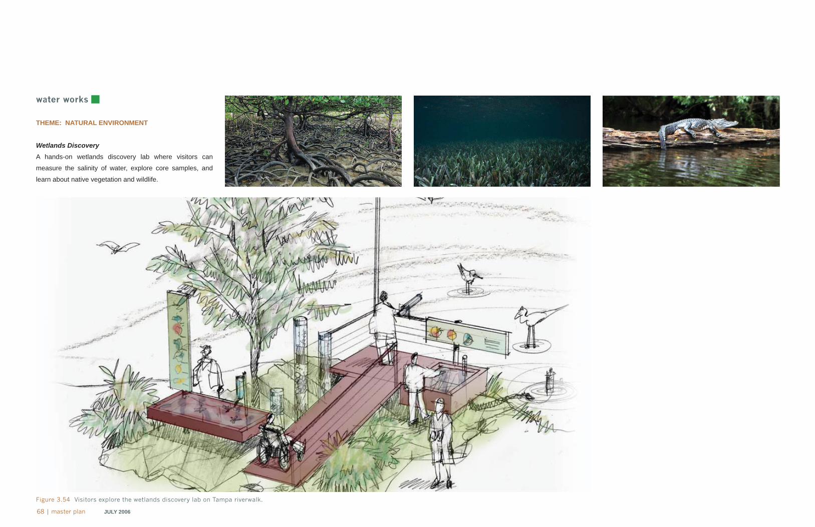
68 | master plan JULY 2006
water works
THEME: NATURAL ENVIRONMENT
Wetlands DiscoveryA hands-on wetlands discovery lab where visitors can
measure the salinity of water, explore core samples, and
learn about native vegetation and wildlife.
Figure 3.54 Visitors explore the wetlands discovery lab on Tampa riverwalk.
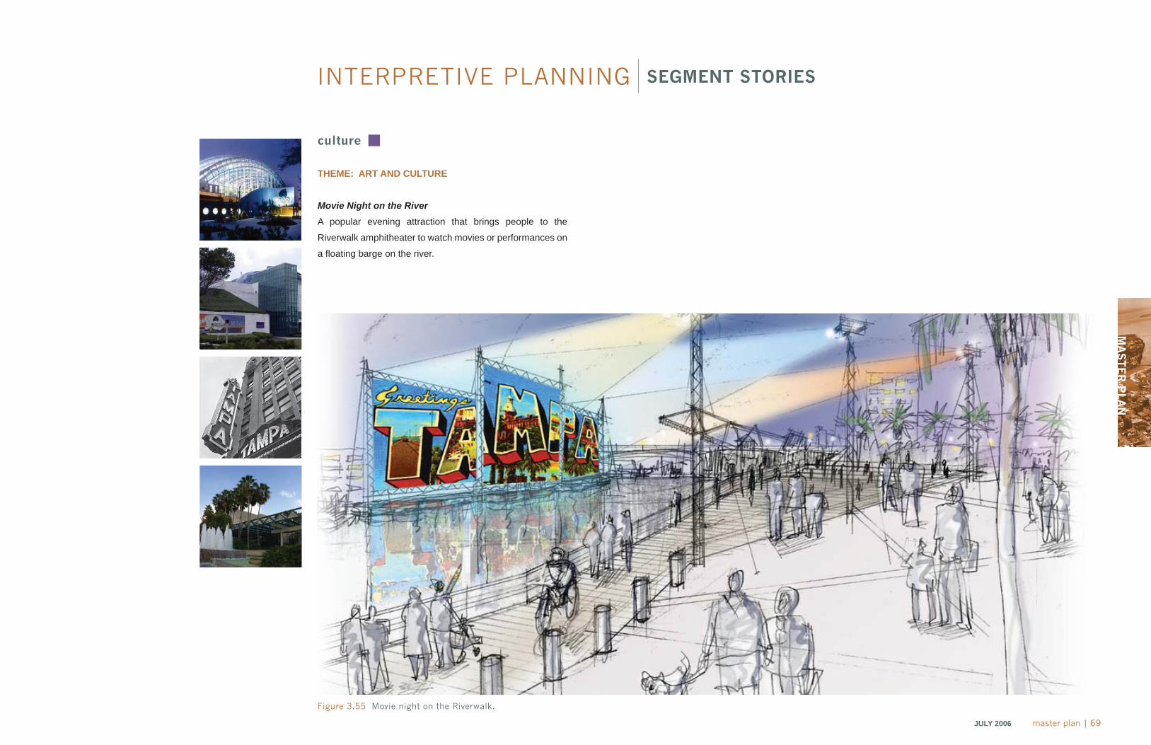
MA
ST
ER
PLA
N
JULY 2006 master plan | 69
culture
THEME: ART AND CULTURE
Movie Night on the RiverA popular evening attraction that brings people to the
Riverwalk amphitheater to watch movies or performances on
a fl oating barge on the river.
Figure 3.55 Movie night on the Riverwalk.
INTERPRETIVE PLANNING SEGMENT STORIES
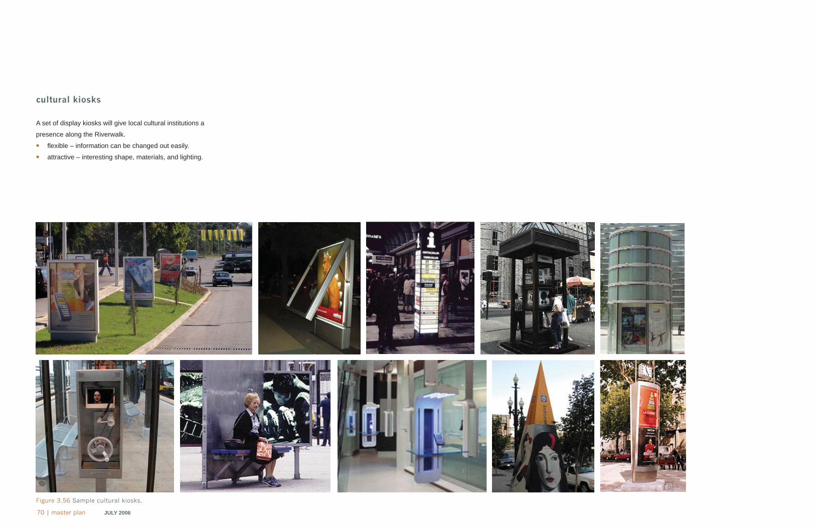
70 | master plan JULY 2006
cultural kiosks
A set of display kiosks will give local cultural institutions a
presence along the Riverwalk.
• fl exible – information can be changed out easily.
• attractive – interesting shape, materials, and lighting.
Figure 3.56 Sample cultural kiosks.
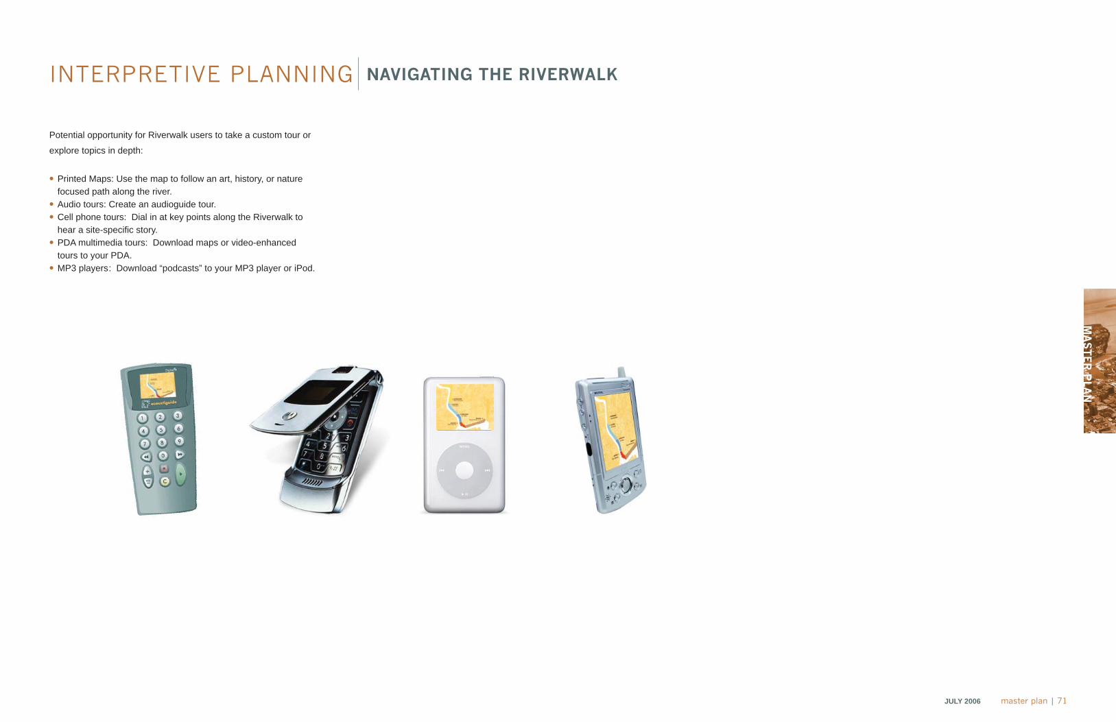
MA
ST
ER
PLA
N
JULY 2006 master plan | 71
NAVIGATING THE RIVERWALK
Potential opportunity for Riverwalk users to take a custom tour or
explore topics in depth:
• Printed Maps: Use the map to follow an art, history, or nature focused path along the river.
• Audio tours: Create an audioguide tour.• Cell phone tours: Dial in at key points along the Riverwalk to
hear a site-specifi c story.• PDA multimedia tours: Download maps or video-enhanced
tours to your PDA.• MP3 players: Download “podcasts” to your MP3 player or iPod.
INTERPRETIVE PLANNING
2010 planchapter 4
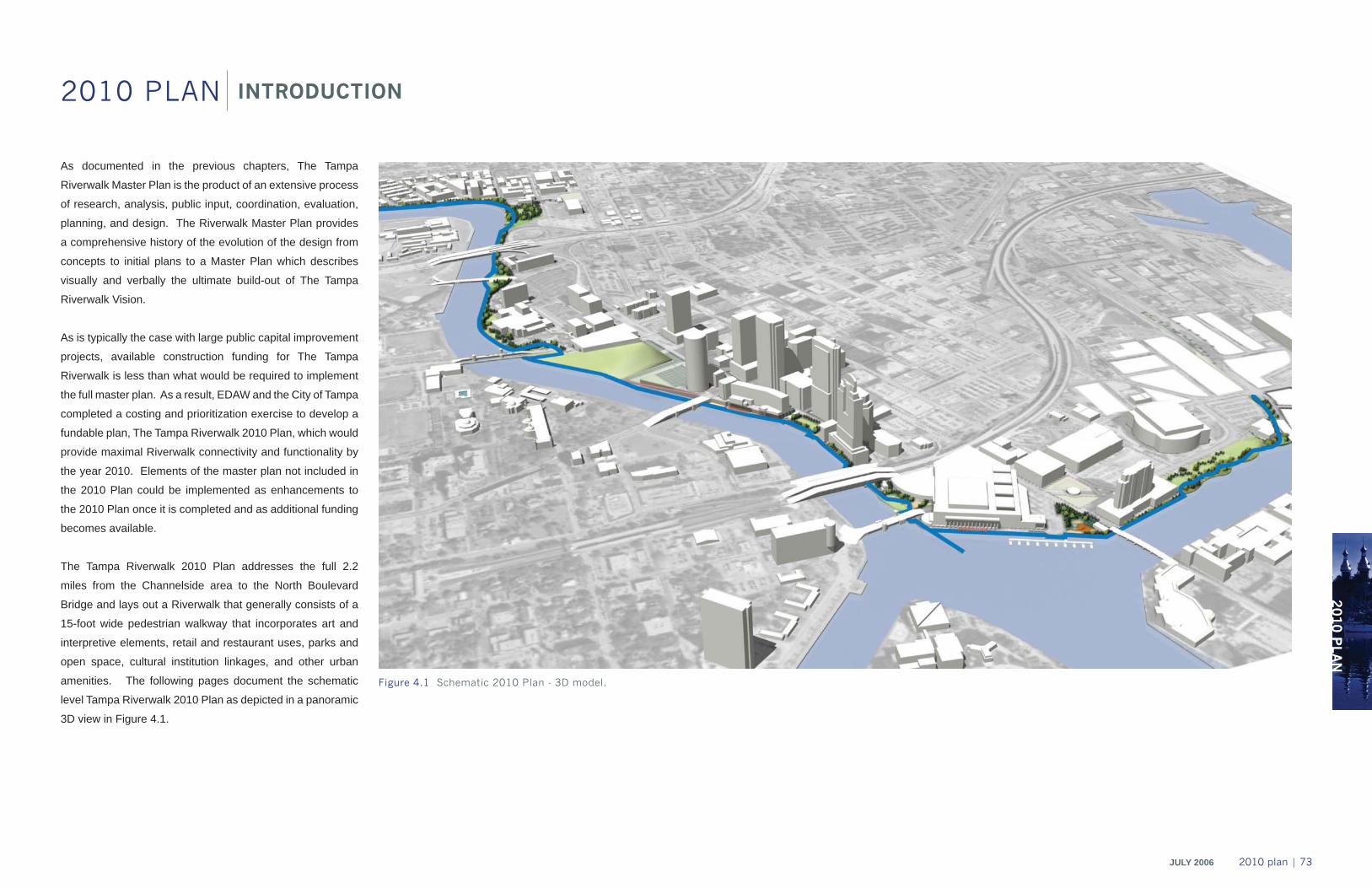
2010 P
LAN
2010 PLAN
JULY 2006 2010 plan | 73
As documented in the previous chapters, The Tampa
Riverwalk Master Plan is the product of an extensive process
of research, analysis, public input, coordination, evaluation,
planning, and design. The Riverwalk Master Plan provides
a comprehensive history of the evolution of the design from
concepts to initial plans to a Master Plan which describes
visually and verbally the ultimate build-out of The Tampa
Riverwalk Vision.
As is typically the case with large public capital improvement
projects, available construction funding for The Tampa
Riverwalk is less than what would be required to implement
the full master plan. As a result, EDAW and the City of Tampa
completed a costing and prioritization exercise to develop a
fundable plan, The Tampa Riverwalk 2010 Plan, which would
provide maximal Riverwalk connectivity and functionality by
the year 2010. Elements of the master plan not included in
the 2010 Plan could be implemented as enhancements to
the 2010 Plan once it is completed and as additional funding
becomes available.
The Tampa Riverwalk 2010 Plan addresses the full 2.2
miles from the Channelside area to the North Boulevard
Bridge and lays out a Riverwalk that generally consists of a
15-foot wide pedestrian walkway that incorporates art and
interpretive elements, retail and restaurant uses, parks and
open space, cultural institution linkages, and other urban
amenities. The following pages document the schematic
level Tampa Riverwalk 2010 Plan as depicted in a panoramic
3D view in Figure 4.1.
INTRODUCTION
Figure 4.1 Schematic 2010 Plan - 3D model.
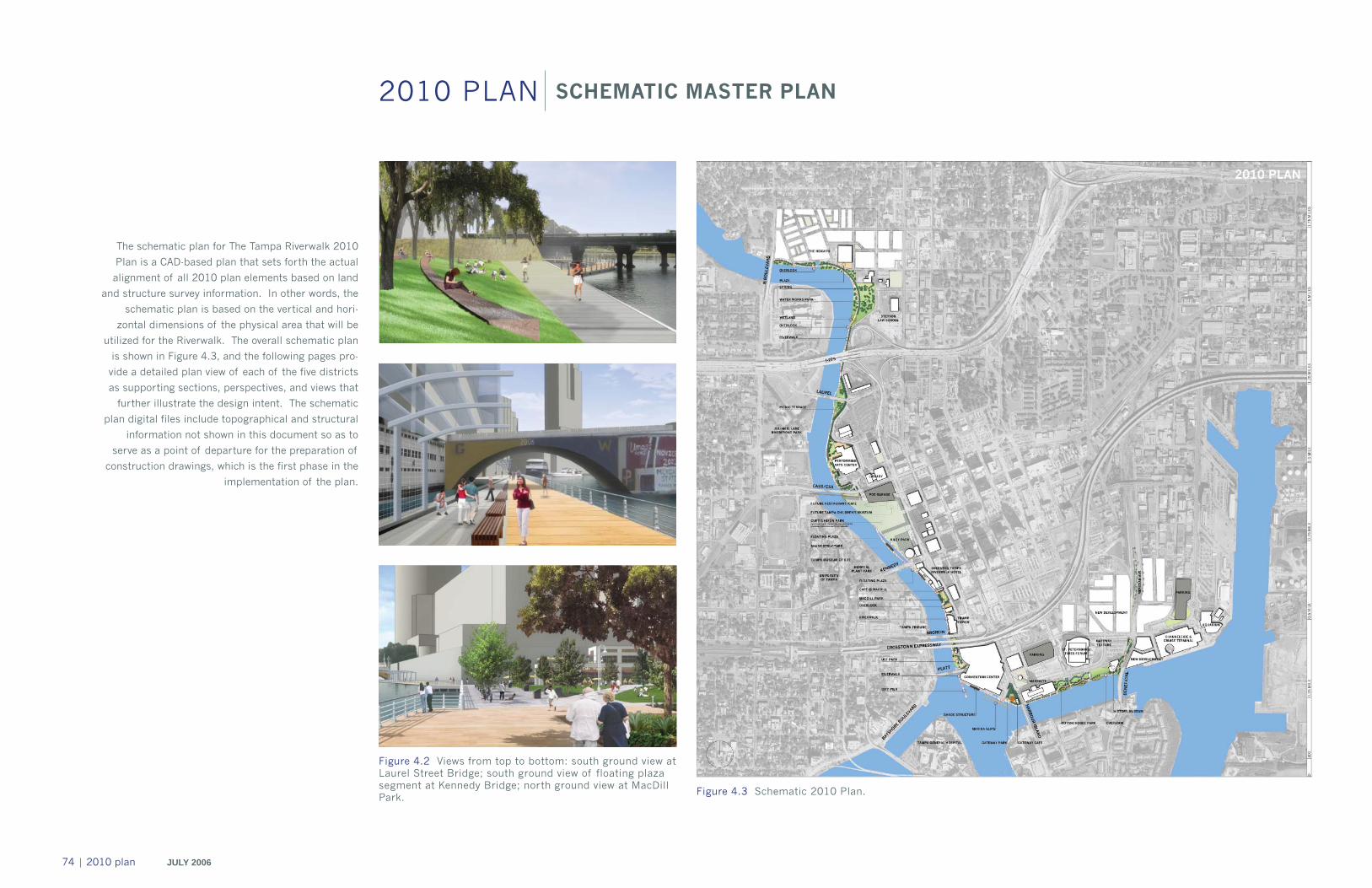
74 | 2010 plan JULY 2006
2010 PLAN
Figure 4.3 Schematic 2010 Plan.
The schematic plan for The Tampa Riverwalk 2010
Plan is a CAD-based plan that sets forth the actual
alignment of all 2010 plan elements based on land
and structure survey information. In other words, the
schematic plan is based on the vertical and hori-
zontal dimensions of the physical area that will be
utilized for the Riverwalk. The overall schematic plan
is shown in Figure 4.3, and the following pages pro-
vide a detailed plan view of each of the five districts
as supporting sections, perspectives, and views that
further illustrate the design intent. The schematic
plan digital files include topographical and structural
information not shown in this document so as to
serve as a point of departure for the preparation of
construction drawings, which is the first phase in the
implementation of the plan.
SCHEMATIC MASTER PLAN
Figure 4.2 Views from top to bottom: south ground view at Laurel Street Bridge; south ground view of floating plaza segment at Kennedy Bridge; north ground view at MacDill Park.
2010 P
LAN
2010 PLAN
JULY 2006 2010 plan | 75
The primary Riverwalk components addressed by the
2010 Plan and needed to establish full connectivity
along the whole length of the project are shown here
as connections. The area north of the Cass Street
Bridge up to the North Blvd. Bridge not marked as a
connection will be built by The Heights developers.
Laurel Street under bridge connection.
Cass Street connection into Curtis Hixon Park.
Kennedy Blvd. under bridge connection.
Brorein Street under bridge connection .
Tampa Convention Center connection.
History Center connection to Channelside.
1
2
3
4
Figure 4.4 Schematic 2010 Plan - connections diagram.
1
2
3
4
56
1
3
5
2
4
6
CONNECTIONS
5
6
76 | 2010 plan JULY 2006
2010 DISTRICTS
Figure 4.5 Water Works District - Schematic 2010 Plan.
As depicted in Figure 4.5, the Riverwalk begins at the North Boulevard Bridge and winds gently through The Heights project area
where it bridges a small inlet and intersects the edge of a pedestrian plaza fronting a retail/restaurant structure. Tree-shaded green
space provides spaces for picnicking on the grass, and two overlooks aligned with planned streets provide gathering and viewing
space. A marina is envisioned close to the plaza area, but its size and location will be dependent on the fi nal Heights plans. The
Riverwalk then follows a sweeping curve through Water Works Park (Figure 4.5), which is also partially set back from the river, and
bridges another small existing inlet with an additional overlook. Passing under I-275, the Riverwalk is slightly cantilevered over the
water to provide a 15-foot width in a manner that preserves a general arcing alignment. At Laurel Street, the Riverwalk arcs over
the water again in a fl oating segment that runs beneath the Laurel Bridge, and the adjacent land becomes shaded park space that
terraces gently down to the water’s edge, as illustrated in Figures 4.7, 4.8, and 4.9. For the area from the North Boulevard Bridge
to the south side of Water Works Park, a set of design standards linked to the character of The Heights development will be used.
From the park south, the new Riverwalk design standards will be utilized. Depending on the evolution of The Heights design, the
city may implement an alternate alignment in the Water Works District.
WATER WORKS
Figure 4.7 Section view of Laurel Street picnic terraces and underbridge connection.
Figure 4.6 Water Works Park
Ashley Plaza Hotel
N Doyle Carlton Drive Sidewalk Picnic Terraces
2010 P
LAN
JULY 2006 2010 plan | 77
Figure 4.9 Riverwalk at Laurel Street picnic terraces.Figure 4.8 Laurel Street underpass.
.
Riverwalk
Laurel Street Bridge
Julian B. Lane Riverfront Park
78 | 2010 plan JULY 2006
Figure 4.10 Cultural District- Schematic 2010 Plan.
As depicted in Figure 4.10, the Cultural District Riverwalk segment begins just north of the Tampa Bay Performing Arts Center
and follows the river’s edge to Cass Street. A planned new restaurant at the Tampa Bay Performing Arts Center will enliven
the area. The new Riverwalk design standards will be utilized in this entire segment, and the plaza area adjacent to the
Riverwalk will be repaved. At Cass Street, the preferred crossing option at the time of the completion of the 2010 Plan is the
elevated structure depicted in Figure 4.13. Final confi guration of the Cass Street crossing and Curtis Hixon Park segments
will be further studied and fi nalized during the design development stage of the Riverwalk. The fi nal design of this crossing
may change depending on the fi nal redesign of Curtis Hixon Park. A triple switchback ramp leads to the elevated crossing
on the north side of Cass Street and a dual ramp on the south side parallel to Cass Street, where the river returns to grade
in the Park and then runs along the river’s edge. On the south side of the park, where the current walkway begins ramping
up to Kiley Gardens, the Riverwalk will arc out over the water to cross beneath the Kennedy Boulevard Bridge via a fl oating
overwater segment that will provide shade and viewing spaces as shown in Figures 4.11 and 4.12.
Figure 4.11 Ground level view south of the Riverwalk with floating plaza connecting underneath the Kennedy Boulevard Bridge.
CULTURAL2010 DISTRICTS
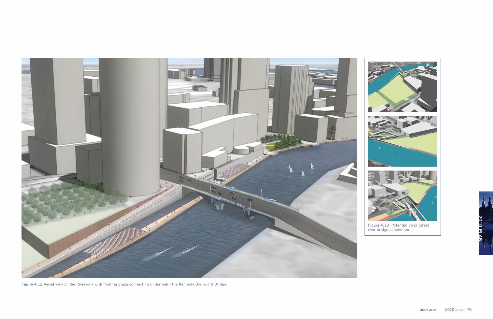
2010 P
LAN
JULY 2006 2010 plan | 79
Figure 4.12 Aerial view of the Riverwalk with floating plaza connecting underneath the Kennedy Boulevard Bridge.
Figure 4.13 Potential Cass Street over bridge connection.
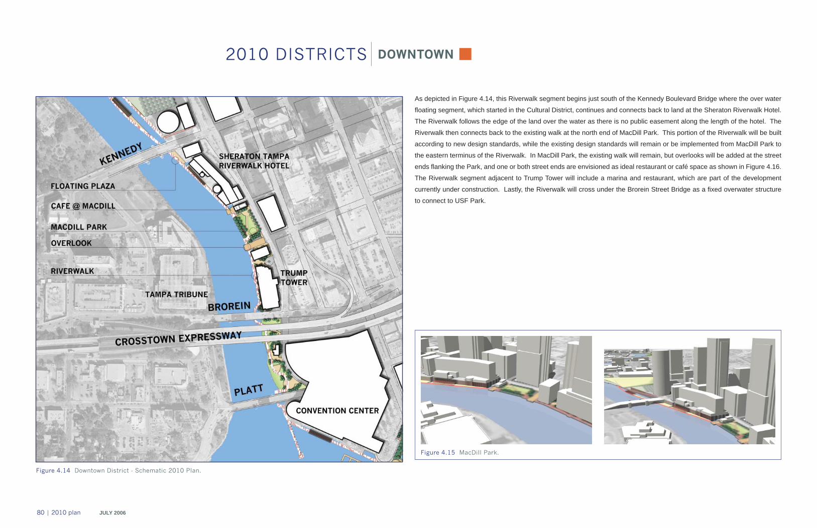
80 | 2010 plan JULY 2006
Figure 4.14 Downtown District - Schematic 2010 Plan.
DOWNTOWN
As depicted in Figure 4.14, this Riverwalk segment begins just south of the Kennedy Boulevard Bridge where the over water
fl oating segment, which started in the Cultural District, continues and connects back to land at the Sheraton Riverwalk Hotel.
The Riverwalk follows the edge of the land over the water as there is no public easement along the length of the hotel. The
Riverwalk then connects back to the existing walk at the north end of MacDill Park. This portion of the Riverwalk will be built
according to new design standards, while the existing design standards will remain or be implemented from MacDill Park to
the eastern terminus of the Riverwalk. In MacDill Park, the existing walk will remain, but overlooks will be added at the street
ends fl anking the Park, and one or both street ends are envisioned as ideal restaurant or café space as shown in Figure 4.16.
The Riverwalk segment adjacent to Trump Tower will include a marina and restaurant, which are part of the development
currently under construction. Lastly, the Riverwalk will cross under the Brorein Street Bridge as a fi xed overwater structure
to connect to USF Park.
2010 DISTRICTS
Figure 4.15 MacDill Park.
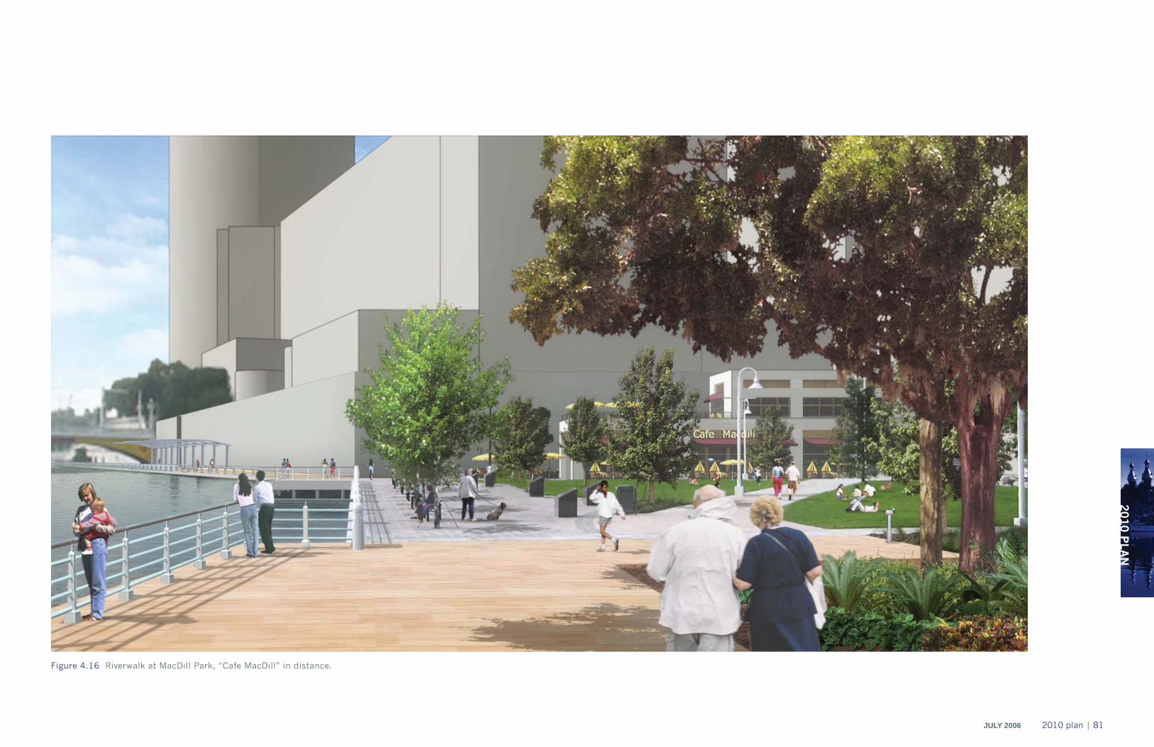
2010 P
LAN
JULY 2006 2010 plan | 81
Figure 4.16 Riverwalk at MacDill Park, “Cafe MacDill” in distance.
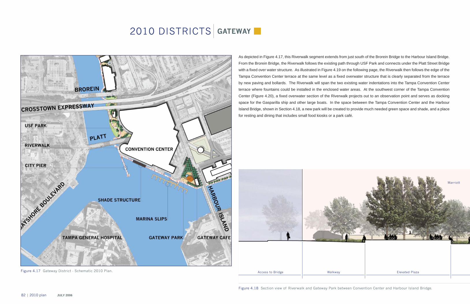
82 | 2010 plan JULY 2006
Figure 4.18 Section view of Riverwalk and Gateway Park between Convention Center and Harbour Island Bridge.
Figure 4.17 Gateway District - Schematic 2010 Plan.
As depicted in Figure 4.17, this Riverwalk segment extends from just south of the Brorein Bridge to the Harbour Island Bridge.
From the Brorein Bridge, the Riverwalk follows the existing path through USF Park and connects under the Platt Street Bridge
with a fi xed over water structure. As illustrated in Figure 4.19 on the following page, the Riverwalk then follows the edge of the
Tampa Convention Center terrace at the same level as a fi xed overwater structure that is clearly separated from the terrace
by new paving and bollards. The Riverwalk will span the two existing water indentations into the Tampa Convention Center
terrace where fountains could be installed in the enclosed water areas. At the southwest corner of the Tampa Convention
Center (Figure 4.20), a fi xed overwater section of the Riverwalk projects out to an observation point and serves as docking
space for the Gasparilla ship and other large boats. In the space between the Tampa Convention Center and the Harbour
Island Bridge, shown in Section 4.18, a new park will be created to provide much needed green space and shade, and a place
for resting and dining that includes small food kiosks or a park café.
GATEWAY2010 DISTRICTS
Elevated PlazaWalkwayAccess to Bridge
Marriott
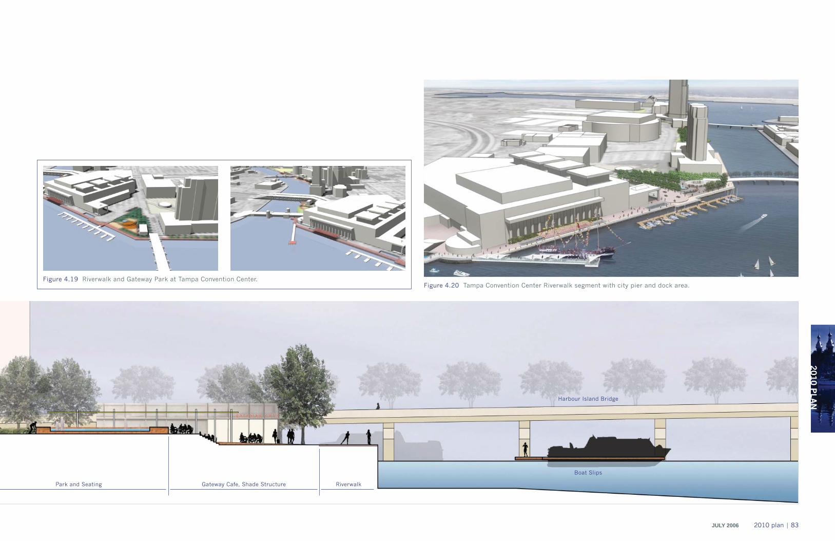
2010 P
LAN
JULY 2006 2010 plan | 83
Figure 4.20 Tampa Convention Center Riverwalk segment with city pier and dock area.Figure 4.19 Riverwalk and Gateway Park at Tampa Convention Center.
RiverwalkGateway Cafe, Shade Structure Park and Seating
Boat Slips
Harbour Island Bridge
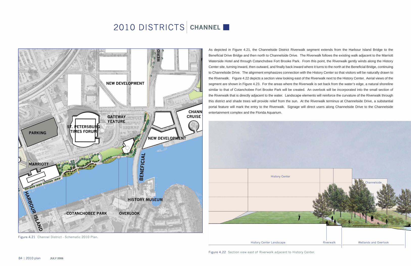
84 | 2010 plan JULY 2006
Figure 4.22 Section view east of Riverwalk adjacent to History Center.
Figure 4.21 Channel District - Schematic 2010 Plan.
As depicted in Figure 4.21, the Channelside District Riverwalk segment extends from the Harbour Island Bridge to the
Benefi cial Drive Bridge and then north to Channelside Drive. The Riverwalk follows the existing walk adjacent to the Marriott
Waterside Hotel and through Cotanchobee Fort Brooke Park. From this point, the Riverwalk gently winds along the History
Center site, turning inward, then outward, and fi nally back inward where it turns to the north at the Benefi cial Bridge, continuing
to Channelside Drive. The alignment emphasizes connection with the History Center so that visitors will be naturally drawn to
the Riverwalk. Figure 4.22 depicts a section view looking east of the Riverwalk next to the History Center. Aerial views of the
segment are shown in Figure 4.23. For the areas where the Riverwalk is set back from the water’s edge, a natural shoreline
similar to that of Cotanchobee Fort Brooke Park will be created. An overlook will be incorporated into the small section of
the Riverwalk that is directly adjacent to the water. Landscape elements will reinforce the curvature of the Riverwalk through
this district and shade trees will provide relief from the sun. At the Riverwalk terminus at Channelside Drive, a substantial
portal feature will mark the entry to the Riverwalk. Signage will direct users along Channelside Drive to the Channelside
entertainment complex and the Florida Aquarium.
CHANNEL2010 DISTRICTS
History Center Landscape Riverwalk Wetlands and Overlook
History Center
Channelside
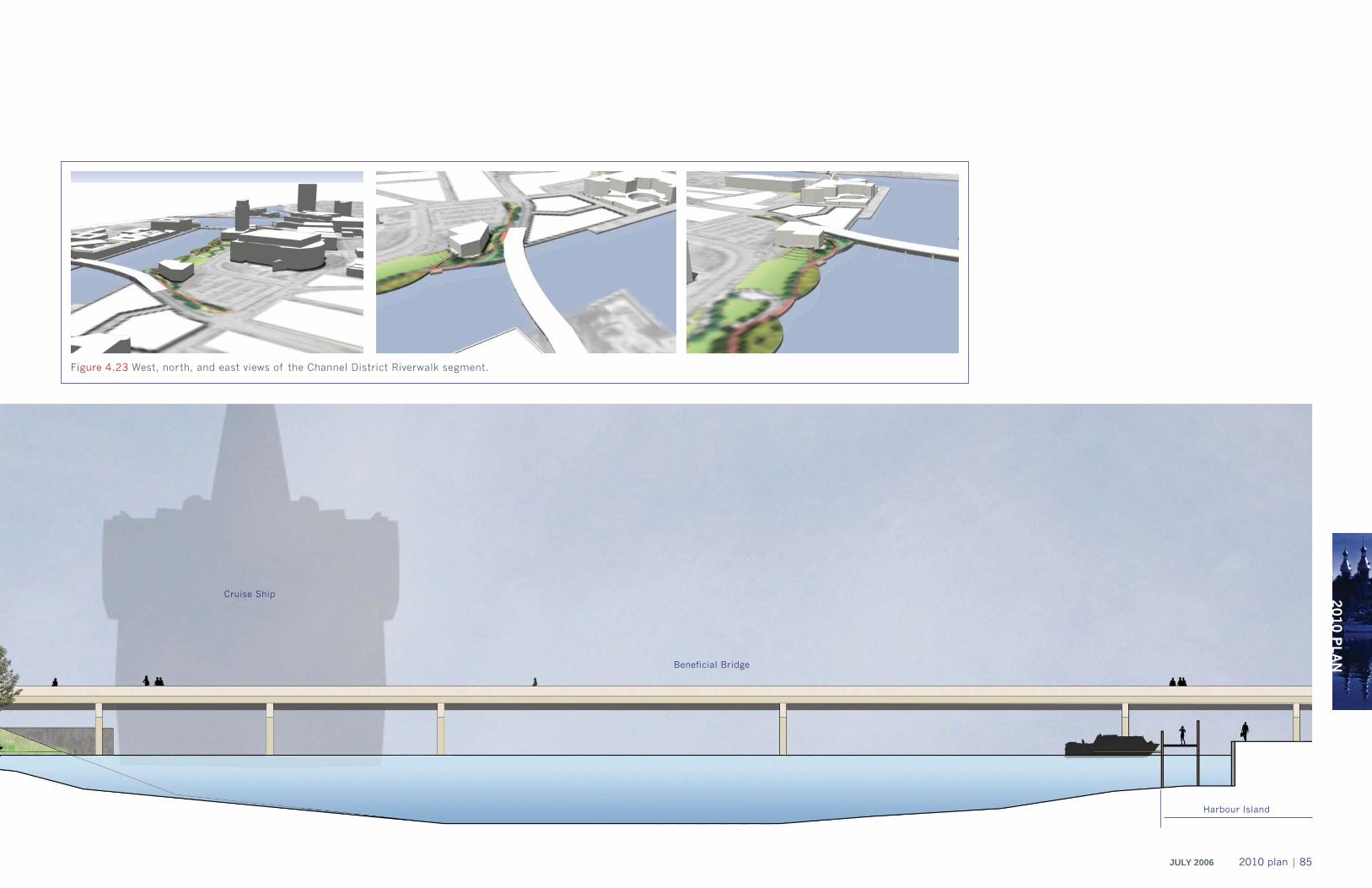
2010 P
LAN
JULY 2006 2010 plan | 85
Figure 4.23 West, north, and east views of the Channel District Riverwalk segment.
Cruise Ship
Harbour Island
Beneficial Bridge

A number of project elements were identifi ed in the Master Plan
that were not included in the 2010 plan due to funding, phasing,
or other concerns. They include the following:
Channel District, Benefi cial Bridge ConnectionThe Master Plan identifi ed an under bridge crossing as the
preferred option. The segment would be marginally set into
the water to achieve clearance under the bridge. However,this
component of the Master Plan will be deferred until all issues
regarding the Riverwalk area east of the Benefi cial Bridge
have been resolved.
Gateway District, Convention Center SegmentThe Master Plan called for a triangular Riverwalk in this location
made up of a segment abutting the existing terrace, the “City Pier”
segment extending into Garrison Channel, and a third segment
connecting these two at an angle. This confi guration would create
a space of enclosed water which would be enlivened through an
array of signature fountains. Funding limitations resulted in the
the third element and fountain being deferred to a future phase.
Gateway District, Pedestrian BridgeAnother key element of the Master Plan is a pedestrian bridge
connecting Bayshore Boulevard with the Riverwalk. This is
an important Riverwalk element for establishing east to west
connectivity and increasing the number of Riverwalk users.
However, it is a very complex project that will be explored by
the city in the future through transportation planning.
Gateway District, Gateway TowerA proposed large iconic tower rising from USF Park up past
the freeway bridge and serving as a landmark for the Riverwalk
was recommended to be addressed by the city’s Public Art
Program.
ENHANCEMENTS TO THE 2010 PLAN
Channel District - Beneficial Bridge connection.
Gateway District - Convention Center segment. Gateway District - Gateway Tower.
Gateway District - pedestrian bridge.
86 | 2010 plan JULY 2006

2010 P
LAN
JULY 2006 2010 plan | 87
implementationchapter 5
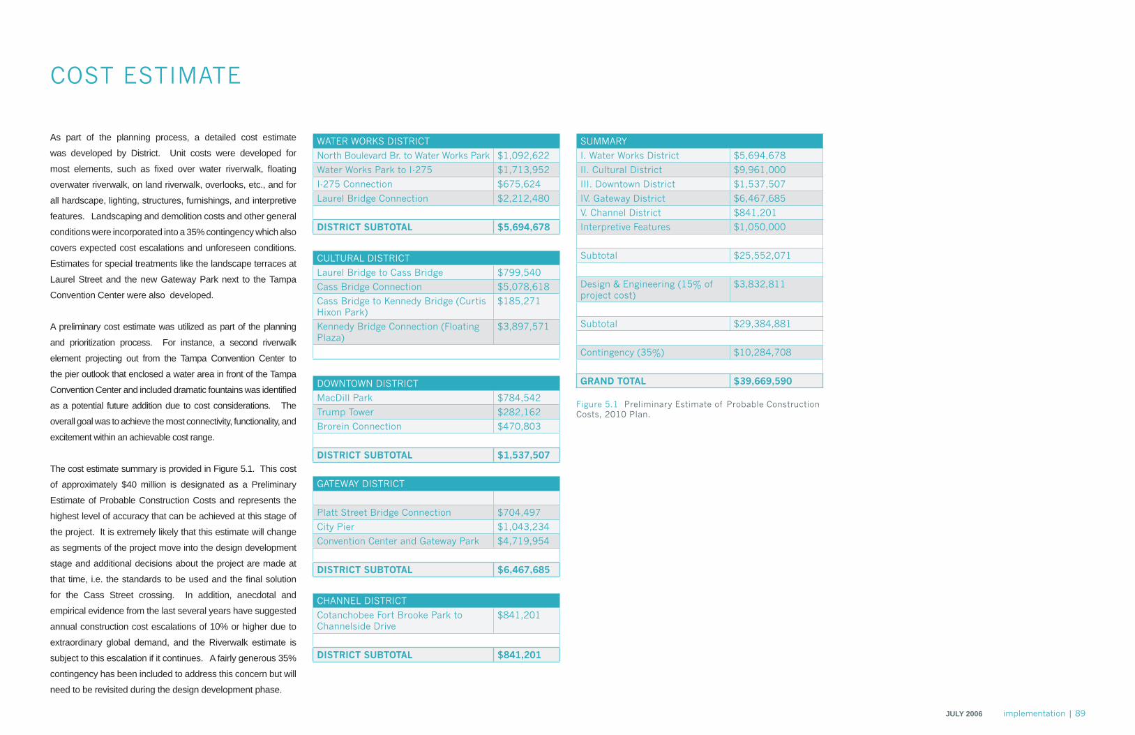
IMP
LEM
EN
TATIO
NJULY 2006 implementation | 89
As part of the planning process, a detailed cost estimate
was developed by District. Unit costs were developed for
most elements, such as fi xed over water riverwalk, fl oating
overwater riverwalk, on land riverwalk, overlooks, etc., and for
all hardscape, lighting, structures, furnishings, and interpretive
features. Landscaping and demolition costs and other general
conditions were incorporated into a 35% contingency which also
covers expected cost escalations and unforeseen conditions.
Estimates for special treatments like the landscape terraces at
Laurel Street and the new Gateway Park next to the Tampa
Convention Center were also developed.
A preliminary cost estimate was utilized as part of the planning
and prioritization process. For instance, a second riverwalk
element projecting out from the Tampa Convention Center to
the pier outlook that enclosed a water area in front of the Tampa
Convention Center and included dramatic fountains was identifi ed
as a potential future addition due to cost considerations. The
overall goal was to achieve the most connectivity, functionality, and
excitement within an achievable cost range.
The cost estimate summary is provided in Figure 5.1. This cost
of approximately $40 million is designated as a Preliminary
Estimate of Probable Construction Costs and represents the
highest level of accuracy that can be achieved at this stage of
the project. It is extremely likely that this estimate will change
as segments of the project move into the design development
stage and additional decisions about the project are made at
that time, i.e. the standards to be used and the fi nal solution
for the Cass Street crossing. In addition, anecdotal and
empirical evidence from the last several years have suggested
annual construction cost escalations of 10% or higher due to
extraordinary global demand, and the Riverwalk estimate is
subject to this escalation if it continues. A fairly generous 35%
contingency has been included to address this concern but will
need to be revisited during the design development phase.
COST ESTIMATE
SUMMARY
I. Water Works District $5,694,678
II. Cultural District $9,961,000
III. Downtown District $1,537,507
IV. Gateway District $6,467,685
V. Channel District $841,201
Interpretive Features $1,050,000
Subtotal $25,552,071
Design & Engineering (15% of project cost)
$3,832,811
Subtotal $29,384,881
Contingency (35%) $10,284,708
GRAND TOTAL $39,669,590
Figure 5.1 Preliminary Estimate of Probable Construction Costs, 2010 Plan.
WATER WORKS DISTRICT
North Boulevard Br. to Water Works Park $1,092,622
Water Works Park to I-275 $1,713,952
I-275 Connection $675,624
Laurel Bridge Connection $2,212,480
DISTRICT SUBTOTAL $5,694,678
CULTURAL DISTRICT
Laurel Bridge to Cass Bridge $799,540
Cass Bridge Connection $5,078,618
Cass Bridge to Kennedy Bridge (Curtis Hixon Park)
$185,271
Kennedy Bridge Connection (Floating Plaza)
$3,897,571
DOWNTOWN DISTRICT
MacDill Park $784,542
Trump Tower $282,162
Brorein Connection $470,803
DISTRICT SUBTOTAL $1,537,507
GATEWAY DISTRICT
Platt Street Bridge Connection $704,497
City Pier $1,043,234
Convention Center and Gateway Park $4,719,954
DISTRICT SUBTOTAL $6,467,685
CHANNEL DISTRICT
Cotanchobee Fort Brooke Park to Channelside Drive
$841,201
DISTRICT SUBTOTAL $841,201
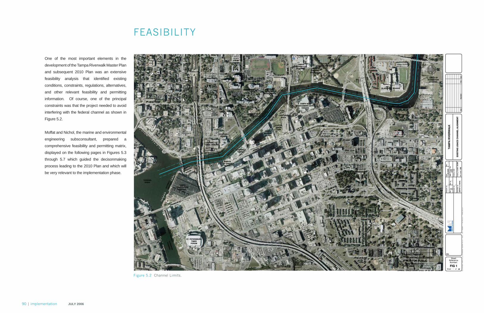
90 | implementation JULY 2006
FEASIBILITY
One of the most important elements in the
development of the Tampa Riverwalk Master Plan
and subsequent 2010 Plan was an extensive
feasibility analysis that identifi ed existing
conditions, constraints, regulations, alternatives,
and other relevant feasibility and permitting
information. Of course, one of the principal
constraints was that the project needed to avoid
interfering with the federal channel as shown in
Figure 5.2.
Moffat and Nichol, the marine and environmental
engineering subsconsultant, prepared a
comprehensive feasibility and permitting matrix,
displayed on the following pages in Figures 5.3
through 5.7 which guided the decisonmaking
process leading to the 2010 Plan and which will
be very relevant to the implementation phase.
Figure 5.2 Channel Limits.
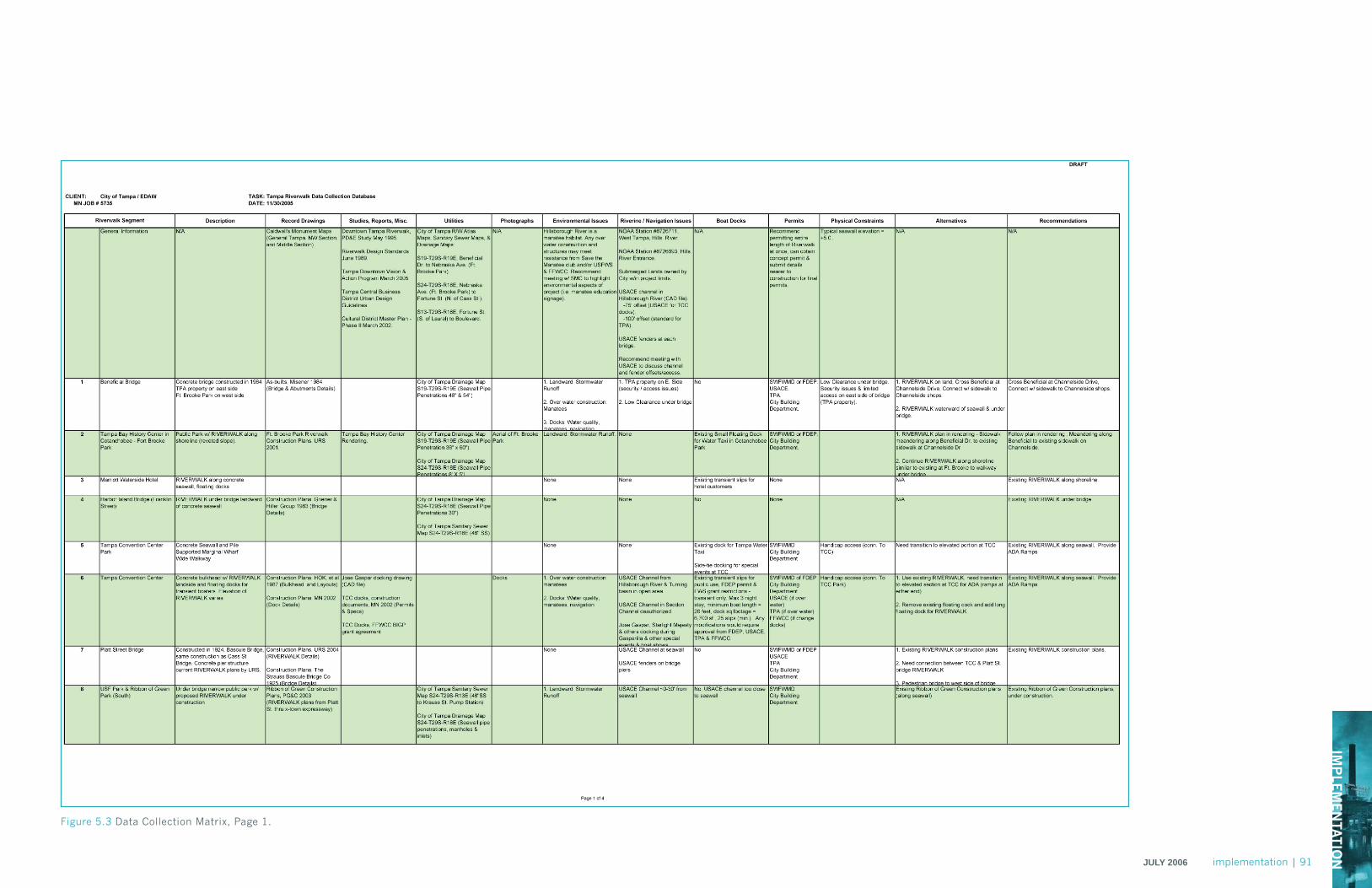
IMP
LEM
EN
TATIO
NJULY 2006 implementation | 91
Figure 5.3 Data Collection Matrix, Page 1.

92 | implementation JULY 2006
Figure 5.4 Data Collection Matrix, Page 2.
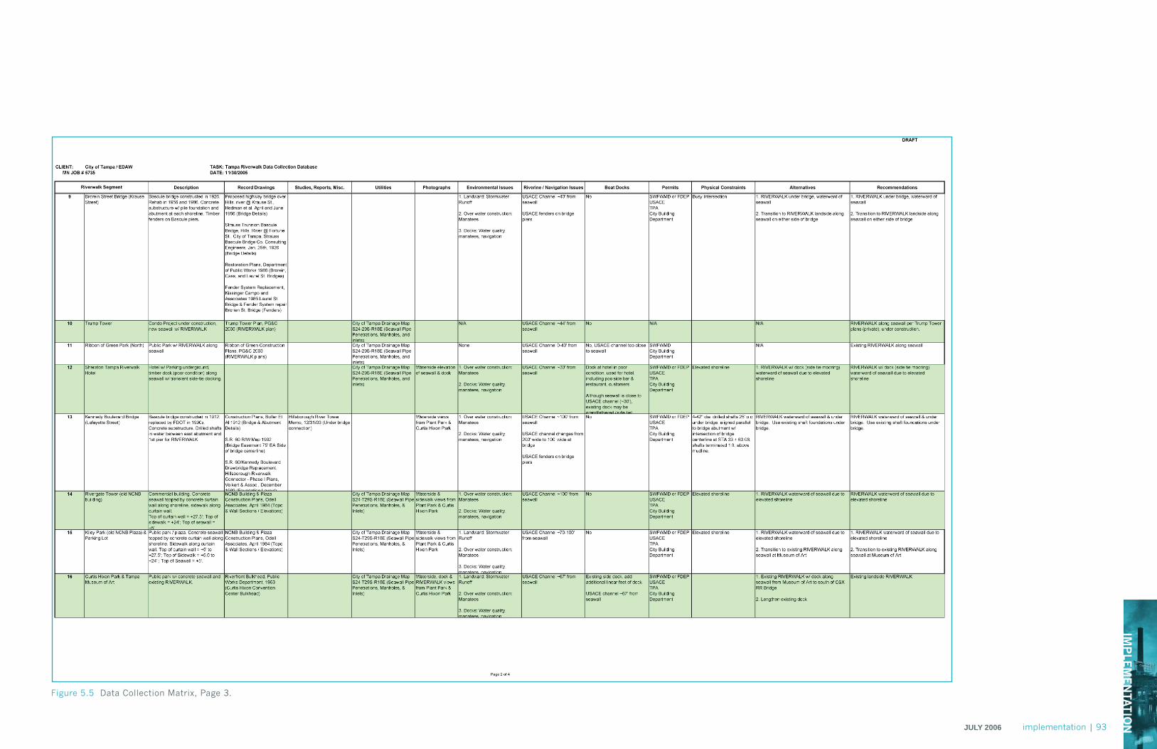
IMP
LEM
EN
TATIO
NJULY 2006 implementation | 93
Figure 5.5 Data Collection Matrix, Page 3.
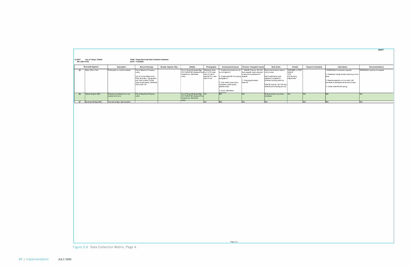
94 | implementation JULY 2006
Figure 5.6 Data Collection Matrix, Page 4.
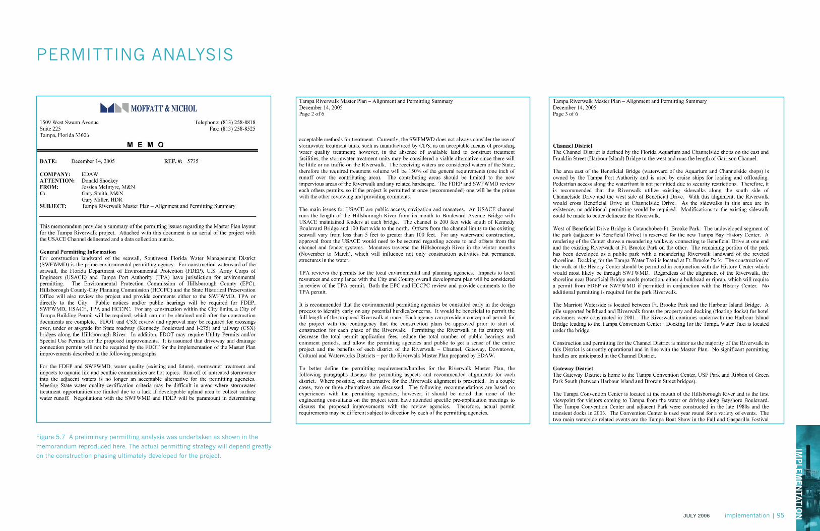
IMP
LEM
EN
TATIO
NJULY 2006 implementation | 95
PERMITTING ANALYSIS
Figure 5.7 A preliminary permitting analysis was undertaken as shown in the
memorandum reproduced here. The actual permitting strategy will depend greatly
on the construction phasing ultimately developed for the project.
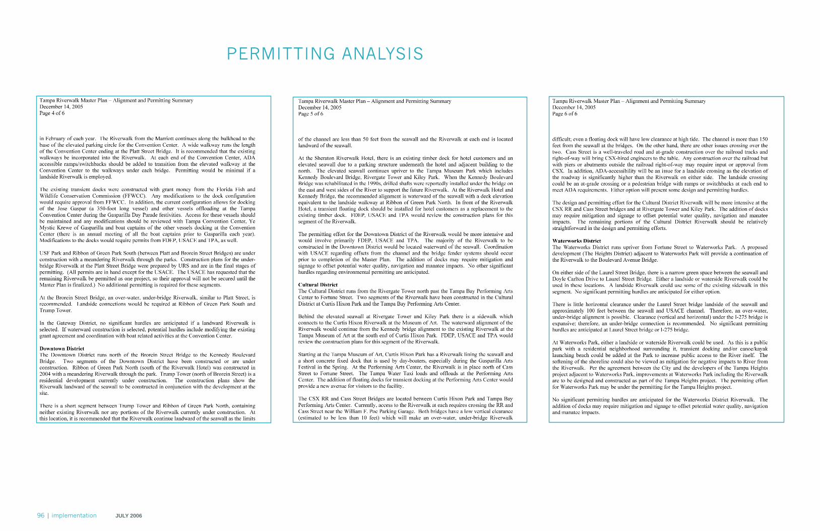
96 | implementation JULY 2006
PERMITTING ANALYSIS
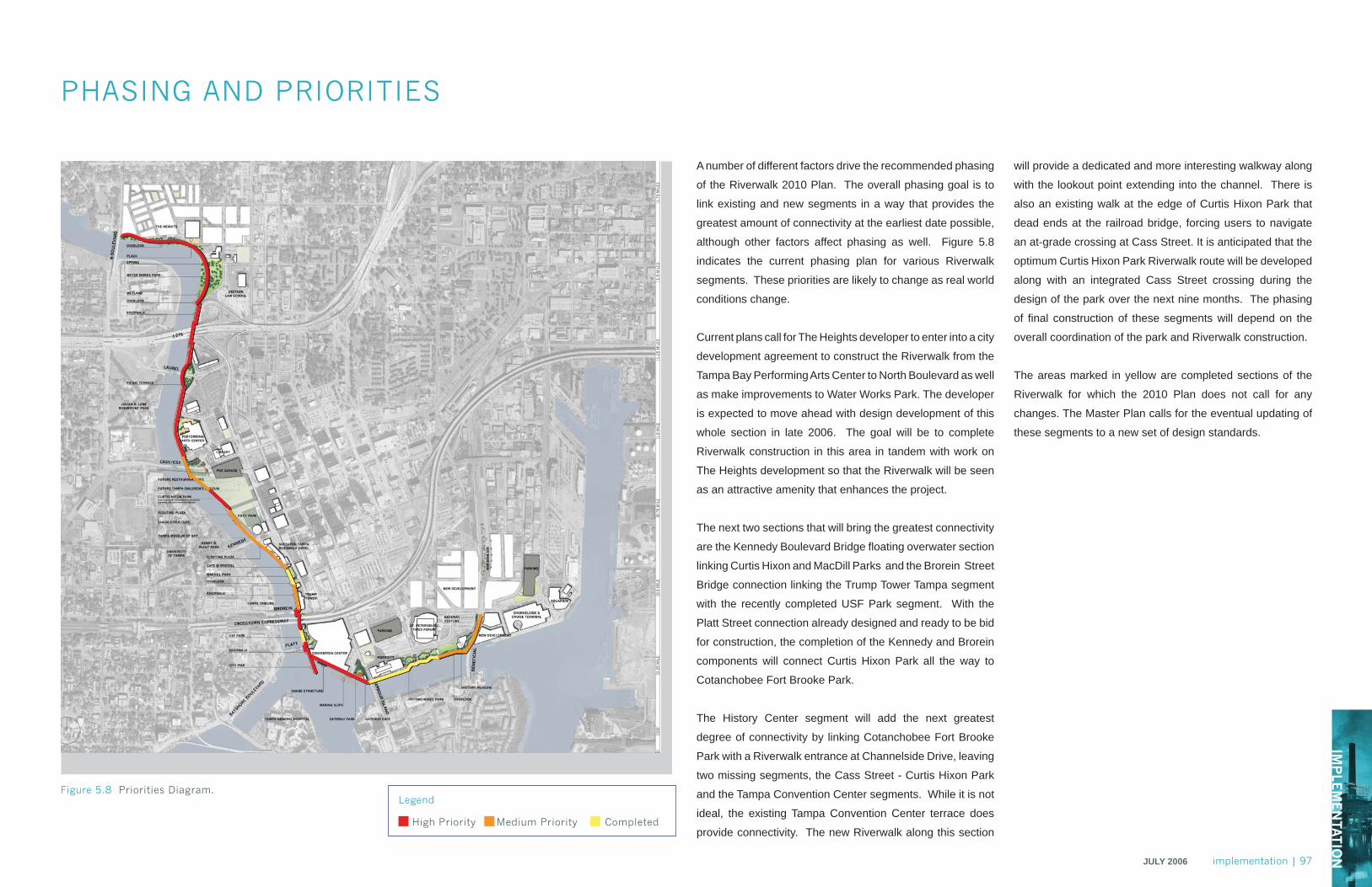
IMP
LEM
EN
TATIO
NJULY 2006 implementation | 97
PHASING AND PRIORITIES
A number of different factors drive the recommended phasing
of the Riverwalk 2010 Plan. The overall phasing goal is to
link existing and new segments in a way that provides the
greatest amount of connectivity at the earliest date possible,
although other factors affect phasing as well. Figure 5.8
indicates the current phasing plan for various Riverwalk
segments. These priorities are likely to change as real world
conditions change.
Current plans call for The Heights developer to enter into a city
development agreement to construct the Riverwalk from the
Tampa Bay Performing Arts Center to North Boulevard as well
as make improvements to Water Works Park. The developer
is expected to move ahead with design development of this
whole section in late 2006. The goal will be to complete
Riverwalk construction in this area in tandem with work on
The Heights development so that the Riverwalk will be seen
as an attractive amenity that enhances the project.
The next two sections that will bring the greatest connectivity
are the Kennedy Boulevard Bridge fl oating overwater section
linking Curtis Hixon and MacDill Parks and the Brorein Street
Bridge connection linking the Trump Tower Tampa segment
with the recently completed USF Park segment. With the
Platt Street connection already designed and ready to be bid
for construction, the completion of the Kennedy and Brorein
components will connect Curtis Hixon Park all the way to
Cotanchobee Fort Brooke Park.
The History Center segment will add the next greatest
degree of connectivity by linking Cotanchobee Fort Brooke
Park with a Riverwalk entrance at Channelside Drive, leaving
two missing segments, the Cass Street - Curtis Hixon Park
and the Tampa Convention Center segments. While it is not
ideal, the existing Tampa Convention Center terrace does
provide connectivity. The new Riverwalk along this section
Figure 5.8 Priorities Diagram.Legend
High Priority Medium Priority Completed
will provide a dedicated and more interesting walkway along
with the lookout point extending into the channel. There is
also an existing walk at the edge of Curtis Hixon Park that
dead ends at the railroad bridge, forcing users to navigate
an at-grade crossing at Cass Street. It is anticipated that the
optimum Curtis Hixon Park Riverwalk route will be developed
along with an integrated Cass Street crossing during the
design of the park over the next nine months. The phasing
of fi nal construction of these segments will depend on the
overall coordination of the park and Riverwalk construction.
The areas marked in yellow are completed sections of the
Riverwalk for which the 2010 Plan does not call for any
changes. The Master Plan calls for the eventual updating of
these segments to a new set of design standards.

riverwalkTHE TAMPA RIVERWALK
MASTER PLAN
July 2006