Embed Size (px)
Citation preview
8/9/2019 RO2-Appeal Statement 2010-06-21
http://slidepdf.com/reader/full/ro2-appeal-statement-2010-06-21 1/50
8/9/2019 RO2-Appeal Statement 2010-06-21
http://slidepdf.com/reader/full/ro2-appeal-statement-2010-06-21 2/50
53-57 The Street, Ashtead
Appeal Statement
for
Ashtead Resident’s Association in conjunction with Save Ashtead’s Village Environment (S.A.V.E)
project number: 100524
prepared by: Steve Parsonsposition: Associate Director
issue date: 21st June 2010status: Final
232 High StreetGuildford
SurreyGU1 3JF
T 01483 531300F 01483 531333
E [email protected] www.motion-uk.co.uk
8/9/2019 RO2-Appeal Statement 2010-06-21
http://slidepdf.com/reader/full/ro2-appeal-statement-2010-06-21 3/50
Contents
Section
1.0 Introduction 3 2.0 Useful Background 3 3.0 Transport Issues 3
Trip Attraction 3 Trip Distribution 3 PICADY Analysis 3 Servicing and Road Safety 3
4.0 Summary 3

8/9/2019 RO2-Appeal Statement 2010-06-21
http://slidepdf.com/reader/full/ro2-appeal-statement-2010-06-21 4/50
Appendices
Appendix A Personal Injury Accident Records
Appendix B TRICS Outputs
Appendix C Craddocks Parade Survey and Analysis
Appendix D Drawing 12.3 rev A
Appendix E Swept Path Analysis
8/9/2019 RO2-Appeal Statement 2010-06-21
http://slidepdf.com/reader/full/ro2-appeal-statement-2010-06-21 5/50
53-57 The Street, Ashtead
Appeal Statement page 1
1.0 Introduction
Qualifications and Experience
1.1 This statement has been prepared by Steven Leslie Parsons. I hold a H.N.C in Civil
Engineering, a Post Graduate Diploma in Transportation Planning and Engineering and
am a Member of the Chartered Institute of Highways and Transportation (M.C.I.H.T).
I am an Associate Director of Motion Transport Planning Limited and have over 20
years experience in the field of transportation planning, traffic engineering and
highway safety.
1.2 During my career I have been responsible for assessing the highway and
transportation implications of development proposals on behalf of several highway
authorities, most recently for Surrey County Council where I was employed as aPrincipal Transportation Development Control Officer for 6 years before joining Motion
Transport Planning. I have particular expertise in appraising the impact of
development proposals on the highway network and the acceptability of development
proposals in respect of highway safety and capacity.
1.3 Motion Transport Planning (MTP) specialises in advising developers and professionals
in the development field on all matters concerning transportation, highways and
traffic.
Scope of this Statement
1.4 Motion Transport Planning has been appointed by Ashtead Resident’s Association in
conjunction with ‘Save Ashtead’s Village Environment’ (S.A.V.E), in respect of the
appeal by Tesco Stores Limited against the decision, by Mole Valley District Council, to
refuse planning application MO/2009/1322. The planning application was refused on
the 10th November 2009 and the appeal is to be determined by way of a Public
Inquiry.
1.5 By way of a background to the planning history of the site an earlier planning
application (ref MO/2008/1127) to provide a Tesco’s foodstore with a GFA of 2,177
square metres (1,115 square metres of retail floor space) and 9 residential dwellings,
was refused by the Mole Valley District Council on 1st August 2008 for several reasons
including reasons on highways and transport grounds. The application was also
recommended for refusal by the Highway Authority.
8/9/2019 RO2-Appeal Statement 2010-06-21
http://slidepdf.com/reader/full/ro2-appeal-statement-2010-06-21 6/50
53-57 The Street, Ashtead
Appeal Statement page 2
1.6 The scheme was subsequently revised and submitted as planning application
MO/2009/1322, and is now the subject of this appeal. The latest scheme remains
largely similar to the previous scheme, but with a reduction in the overall GFA of the
foodstore by 809 square metres, and a reduction in the overall retail floor space by
365 square metres. Planning application MO/2009/1322 was refused by the Planning
Authority for six reasons, three of which related to highways and transport matters
and which have been duplicated below.
Reason 3
‘It has not been demonstrated that alternative off-street parking can be provided for
the existing users of long term parking spaces in the Peace Memorial car park and
sufficient provision for the staff of the development. This would result in cars being
parked on surrounding roads to the detriment of local amenity and leading to
conditions which would be prejudicial to the free flow of traffic and convenience of
other highway users. The proposals would therefore be contrary to PPS4 ‘Planning for
Sustainable Economic Growth’ policy EC18 and Mole Valley Local Plan policies ENV22
‘General Development Control Criteria’ and MOV2 ‘The Movement Implications of
Development’.
Reason 5
‘The proposed development, if permitted, would lead to a significant increase in traffic
at the difficult junction of Woodfield Lane and The Street, a busy and important road,
which is classified as the A24 and forms part of the Primary route network where sight
lines and visibility in the leading traffic direction is severely restricted by the property
adjacent to the junction, and, the close proximity of the proposed pedestrian crossing
to the junction, and with the increased traffic movement would lead to conditions
prejudicial to the safety and free flow of traffic, contrary to Mole Valley Local Plan
policy MOV2 ‘The Movement Implications of Development’.
Reason 6
‘In the absence of a completed legal agreement, under Section 106 of the Town andCounty Planning Act 1990, the proposal fails to provide an infrastructure contribution
in accordance with the Council’s adopted Code of Practice for Planning Obligations and
Infrastructure Provision February 2008 and the other negotiated developer
contributions in this case, and is therefore contrary to policy CS17 of the Mole Valley
Core Strategy’.
8/9/2019 RO2-Appeal Statement 2010-06-21
http://slidepdf.com/reader/full/ro2-appeal-statement-2010-06-21 7/50
53-57 The Street, Ashtead
Appeal Statement page 3
1.7 A Transport Assessment was produced by Colin Buchanan and Partners Limited to
accompany planning application MO/2009/1322. The Transport Assessment concluded
that:
► ‘The development proposals can be accommodated on the local transport
network;
► Safety and capacity improvements to the junction of Woodfield Lane/The
Street/Grove Road/Rectory Lane are proposed, and will further reduce the
impacts; and
► An assessment of car parking availability is included in this Transport
Assessment, and the replacement Woodfield Lane car park on the development
site can accommodate the development traffic. A robust assessment of the peak
use of the car parks reveal there is sufficient capacity in the village for all users’.
1.8 This statement assesses the supporting documentation produced on behalf of Tesco
Stores Limited by Colin Buchanan and Partners Limited. This statement sets out the
site’s location in respect to travel and transport and provides a critique of certain
elements of the work undertaken to demonstrate the traffic impact and road safety
implications of the appeal proposal. Specifically this statement assesses the following
points, which have been explored in greater detail within Section 3 of this statement.
► Trip Attraction;
► Trip Distribution;
► PICADY Analysis; and
► Road Safety and Servicing Arrangements.
8/9/2019 RO2-Appeal Statement 2010-06-21
http://slidepdf.com/reader/full/ro2-appeal-statement-2010-06-21 8/50
53-57 The Street, Ashtead
Appeal Statement page 4
2.0 Useful Background
Existing Site
2.1
The appeal site is located at 53-57 The Street within the village centre of Ashtead.The site is bounded by the Peace Memorial Hall car park to the north, A1 and A3 land
uses to the east and west and The Street (A24) to the south. Ashtead rail station is
located approximately 1.2 kilometres north from the site.
Local Highway Network
2.2 The proposed foodstore fronts directly onto The Street (A24) which is a two-way
carriageway, approximately 8 metres wide, subject to a speed limit of 30mph. On
street parking is permitted on both sides of the carriageway with restrictions operating
Monday to Saturday.
2.3 To the northeast, The Street connects with Epsom Road (A24) providing access
towards Epsom town centre. To the southwest, The Street connects with Woodfield
Lane, approximately 110 metres from the frontage of the site, and continues to form a
link with Leatherhead Road, (A24) providing access towards junction 9 of the M25, as
well as Leatherhead.
2.4 Woodfield Lane serves as the main access point into and out of the Peace Memorial car
park. It is a two-way carriageway approximately 5.3 metres wide, subject to a speed
limit of 30mph. It is subject to parking restrictions in the form of double yellow lines
on both sides of the carriageway for the majority of its length. To the north it provides
access towards Ashtead rail station and Craddocks Parade where a Tesco Express store
is located, whilst to the south it connects with The Street (A24).
Road Safety Study
2.5 Personal Injury Accident (PIA) statistics, a copy of which has been attached as
Appendix A, have been obtained from Surrey County Council for the period of
January 2005 to February 2010. The study area includes the following sections of
road:
► The Street (A24), section between its junctions with Park Lane to the north and
the Shell petrol filling station to the south; and
► Woodfield Lane at its junctions with the Peace Memorial car park and The Street
(A24).
2.6 A total of 15 PIA’s occurred within the study area, of which three were classified as
serious and the other 12 as slight.
8/9/2019 RO2-Appeal Statement 2010-06-21
http://slidepdf.com/reader/full/ro2-appeal-statement-2010-06-21 9/50
53-57 The Street, Ashtead
Appeal Statement page 5
2.7 Specifically, a total of 10 of the identified PIA’s occurred at or within the vicinity of The
Street (A24) / Grove Road / Woodfield Lane / Rectory Lane junction, of which two
were classified as serious and eight as slight.
2.8 Six of the 15 identified PIA’s involved pedestrians of which two were classified as
serious and four were classified as slight. Five of the pedestrian PIA’s occurred at or
within the vicinity of The Street (A24) / Grove Road / Woodfield Lane / Rectory Lane
junction, of which one was classified as serious.
2.9 The PIA record demonstrates a high incidence of PIA’s at or within the vicinity of The
Street (A24) / Grove Road / Woodfield Lane / Rectory Lane junction and a high
incidence of pedestrian PIA’s. The number and severity of pedestrian PIA’s is of
particular concern and reflects the High Street nature of the study area and the
vulnerability of pedestrians when conflict occurs with vehicles.
2.10 It is concluded that it is paramount that the appeal proposal should pay particular
regard to enhancing pedestrian safety and the impact of additional vehicular trips
using the problematic junction at The Street (A24) /Grove Road / Woodfield Lane /
Rectory Lane.
8/9/2019 RO2-Appeal Statement 2010-06-21
http://slidepdf.com/reader/full/ro2-appeal-statement-2010-06-21 10/50
8/9/2019 RO2-Appeal Statement 2010-06-21
http://slidepdf.com/reader/full/ro2-appeal-statement-2010-06-21 11/50
53-57 The Street, Ashtead
Appeal Statement page 7
3.6 Paragraph 14.6 of the Good Practice Guide discusses the correlation between GFA and
vehicle trips. It states “Figure 14.3 appears to show that food superstores do not
display any relationship between GFA and vehicle trips, therefore giving a big error
margin and limiting the accurate use of the Estimate feature (the estimate feature
provides an estimate of trips for a known GFA). Paragraph 14.6 goes on to state “It is
known that there is in fact a relationship between GFA and level of trips for food
superstores, but that other, external factors have such an influence on trip generation,
that they influence the scatterplot accordingly.”
3.7 Paragraph 14.7 states that.”Figure 14.3 shows that when a relatively small data
sample for food superstores is displayed in a rank order list, it appears that there is no
relationship between GFA (x axis) and vehicle trips (y axis)”.
3.8 For these reasons it is considered imperative that stores with a similar GFA to that now
being proposed at Ashtead are used as a basis for predicting trip rates. However
having explored the TRICS database it is apparent that no similar Tesco’s stores exist
in which case it would be reasonable to expect the appellant to survey existing
established stores that are of a similar floor area and similar in terms of location,
accessibility and parking. Such an approach would provide a realistic estimate of trip
rates compared to the flawed assessment that has been carried over into the 2009
Transport Assessment.
Department for Transport’s ‘Guidance on Transport Assessment’
3.9 The above document provides guidance on quantifying development trip generation.
At paragraph 4.61 it states that “Typically trip generation assessments are based on
the identification of suitable (person or vehicle) trip rates, having regard to industry
standard databases such as TRICS, GENERATE and TRAVL. These trip rates should be
derived on the basis of site-specific details of the proposed development – for
example, proposed gross floor area, number of dwelling units, number of hotel rooms,
availability and accessibility of non-car modes of travel, provision and nature of travel
plans.”
3.10 It is considered that this guidance clarifies that trip rates should be based on similar
developments as a number of factors can influence travel behaviour. In this case it is
considered unreasonable to determine trip rates per 100 sq.m of GFA on trip rates for
larger superstores. As these larger stores have a much greater retail floor area it is
reasonable to assume that customers will be carrying out a larger shop (i.e. a weekly
shop) that will result in a greater length of time spent in the store. A smaller store by
comparison will naturally have a much quicker turn around of customers and as such is
likely to have a higher trip rate per 100 sq.m of GFA.
8/9/2019 RO2-Appeal Statement 2010-06-21
http://slidepdf.com/reader/full/ro2-appeal-statement-2010-06-21 12/50
53-57 The Street, Ashtead
Appeal Statement page 8
3.11 The DfT’s Guidance on Transport Assessments clarifies at paragraph 4.62 that “If sites
with comparable accessibility as well as scale and location cannot be found when using
a standard database system, 85th percentile trip generation rates should be considered
as a starting point for assessment of the baseline trip generation.”
3.12 It is considered that the TRICS sites used to determine trip rates (SCC2) are not
directly comparable in terms of accessibility, scale and location and as such 85 th
percentile trip rates should be used to robustly assess the impact of the appeal
proposals. By using average trip rates derived from non-comparable sites the
appellant has failed to take into account guidance contained within the TRICS Good
Practice Guide and by using 50th percentile trips rates has failed to take into account
the Department for Transports’ Guidance on Transport Assessments’. As such the
potential traffic impact of the appeal proposal appears to have been underestimated,
which has considerable, material knock on effects when considering matters of
highway capacity, road safety and car parking accumulation.
Further comments
3.13 The 2009 Transport Assessment suggests that given the GFA of the foodstore for the
appeal proposals has reduced in size compared with the previous scheme, trips
generated by the foodstore will also be reduced on a pro-rata basis.
3.14 It is considered likely for a Tesco’s foodstore, with a retail floor space of 750 square
metres, to offer a similar range of product categories to a Tesco’s foodstore which has
an additional 365 square metres of retail floor space. On this basis, the operation of a
smaller store is unlikely to result in a reduction of customer trips on a pro-rata basis as
has been claimed within the 2009 Transport Assessment.
3.15 The TRICS database has been analysed to obtain Saturday trip rates for smaller
foodstores (less than 3000 square metres) that are comparable (in GFA) to the appeal
proposals. Surveys contained within the database and undertaken prior to the year
2002 have been omitted. This search method results in a total of 12 surveys for
foodstores located within the UK. All sites located outside of England and within
London have been omitted together with those sites incorporating foodstores whereby
the nature, location or operation differs materially from the appeal proposals (for
example M&S or CO-OP stores). Three Sainsbury’s sites have been identified and a
copy of the TRICS outputs for these three sites is attached as Appendix B.
3.16 This exercise shows that with smaller stores as the GFA decreases the trip rate
increases. It is concluded that the GFA of smaller foodstores is not directly
proportional to the trip rate per 100 sq.m of GFA. It cannot be assumed that a
reduction in trips can be applied on a pro rata basis when there is a reduction in GFA.
8/9/2019 RO2-Appeal Statement 2010-06-21
http://slidepdf.com/reader/full/ro2-appeal-statement-2010-06-21 13/50
53-57 The Street, Ashtead
Appeal Statement page 9
3.17 Additionally by exploration of the TRICS database it is apparent that Tesco’s stores
have higher trip rates that those obtained at other similar food stores. Again this
points to the need to either use 85th percentile trip rates (as recommended by the
Department for Transport) or to base trip rates on a number of surveys carried out at
comparable Tesco stores.
3.18 S.A.V.E. has carried out a survey of the Craddocks Parade Tesco’s Store. This survey
suggests a much higher trip rate per 100 sq.m of GFA than that predicted within the
2009 Transport Assessment, which have been derived from much larger stores.
Indeed using the methodology suggested by S.A.V.E., where trips rates are based on
the survey results of the Craddocks parade store and factored up, pro-rata, to
represent the GFA of the appeal proposals results in trip arrivals up to 6.8 times higher
than that estimated within the 2009 Transport Assessment. A copy of the survey
results and analysis carried out by S.A.V.E. has been attached as Appendix C.
3.19 Such are the flaws in the trips analysis that has been carried over in the 2009
Transport Assessment that the traffic impact has been underestimated to a level where
the impact on the Woodfield Lane / The Street (A24) junction is likely to be in excess
of that predicted within the 2008 Transport Assessment, which was recommended for
refusal by the Highway Authority.
3.20 It is concluded that the applicant has failed to quantify the traffic impact of the appeal
proposals; has failed to demonstrate that the appeal proposals would not lead to a
significant increase in traffic at the junction of Woodfield Lane and The Street, where
sight lines in the leading traffic direction are severely restricted, and; has failed to
demonstrate that the increased traffic movement as a result of the appeal proposals
would not lead to conditions prejudicial to the safety and free flow of traffic on the
neighbouring highway.
Trip Distribution
3.21 The 2009 Transport Assessment presents at Table 5.2 a breakdown of the proportion
of vehicles (as a percentage) using each access and egress. From this table it is
possible to determine the percentage split of vehicles departing and accessing the
proposed store car park.
3.22 Vehicles can only depart from the car park via the Woodfield Lane access whilst
vehicles can gain access from the site via either Woodfield Lane or directly from the
established access from The Street.
8/9/2019 RO2-Appeal Statement 2010-06-21
http://slidepdf.com/reader/full/ro2-appeal-statement-2010-06-21 14/50
53-57 The Street, Ashtead
Appeal Statement page 10
3.23 In respect to vehicles departing the site Table 5.2 of the 2009 Transport Assessment
confirms that it is predicted that up to 56% of vehicle trips departing from the site will
turn right into Woodfield Lane to travel towards the north (i.e. towards the railway
station and residential area of Ashtead). During the pm peak only 44% of vehicles are
predicted to turn left into Woodfield Lane to travel to the south via the The Street
(A24) / Woodfield Lane junction. It appears that the distribution of traffic departing
the site is as set out within the 2008 transport Assessment, which at paragraph 11.2
confirms that the distribution is based on observed traffic turning movements although
no detail of how or when this survey was carried out has been provided within the
Transport Assessment.
3.24 Whilst it is noted that the distribution is based on observed turning movements it is
considered likely that the majority of vehicular trips departing the site will require
access to the A24 and will therefore pass through the Woodfield Lane / The Street
junction. The Street (A24) provides a principal strategic highway link between
Leatherhead and Junction 9 of the M25 (to the south) and Epsom and Ewell (to the
north). Vehicular trips to and from the appeal site are unlikely to follow the
established pattern of observed turning movements as a Tesco’s store will be likely to
attract an element of ‘pass by’ or divert trips that will be attracted to the site and will
require access back onto the A24. Additionally the presence of an established Tesco
Express store to the north at Craddocks Parade, will reduce the number of vehicle trips
to and from this part of Ashtead.
3.25 Ashtead residents have carried out a traffic survey of turning movements at the car
park egress onto Woodfield Lane. Counts were taken between 09:00 and 20:00 hours
on Friday the 14th May 2010 and Saturday 15th May 2010. The turning movements for
all vehicles departing the car park were observed as follows:
Vehicles departing car park
and turning left (Woodfield
Lane southbound)
Vehicles departing car park and
turning right (Woodfield Lane
northbound)
Friday 14th May2010
54.5% 45.5%
Saturday 15th May2010
57% 43%
3.26 The assumption that have been made within the 2008 Transport Assessment and
carried over into the 2009 Transport Assessment in respect to the distribution of traffic
departing the car park is considered flawed and results in an underestimation of the
impact at the Woodfield Lane / The Street (A24) junction.
8/9/2019 RO2-Appeal Statement 2010-06-21
http://slidepdf.com/reader/full/ro2-appeal-statement-2010-06-21 15/50
53-57 The Street, Ashtead
Appeal Statement page 11
3.27 It is considered that a much greater percentage of vehicles would turn left on
departing the car park and would therefore travel through the Woodfield Lane / The
Street (A24) junction. These additional movements have not been assessed as part of
the junction modelling carried out to assess whether the Woodfield Lane / The Street
(A24) junction can accommodate the additional trips associated with the appeal
proposal.
3.28 As a result of the flawed traffic distribution it is considered that the appellant has failed
to demonstrate that the The Street (A24) / Woodfield Lane junction can satisfactorily
accommodate the traffic impact of the appeal proposals.
PICADY Analysis
3.29 The 2009 Transport Assessment states that a junction capacity assessment has been
undertaken at the Woodfield Lane / The Street (A24) / Grove Road / Rectory Lane
junction using the industry standard software PICADY.
3.30 PICADY is a computer program for predicting capacities, queue lengths and delays at
non-signalised major/minor priority junctions. However, the software has its
limitations. It is unable to model five-arm junctions, and as such Rectory Lane has not
been included within the junction model. In addition, controlled pedestrian crossings
are located approximately 50 metres to the northeast and southwest of the junction on
The Street (A24). The effect of the operation of these crossings on the Woodfield Lane
/ The Street (A24) / Grove Road / Rectory Lane junction has not been considered.
3.31 It is acknowledged that no queue length data has been provided within the 2009
Transport Assessment and it is therefore not possible to validate the PICADY models
for the existing situation. There is no evidence that the applicant has verified the
PICADY results for the base situation to reflect observed conditions on site.
3.32 A site visit has been undertaken by MTP to measure the geometry of the junction.
Tables 3.1, 3.2, 3.3 and 3.4 provide a comparison of the geometric measurements
used within the assessments undertaken by Colin Buchanan with those measurements
obtained directly on site by MTP.
Data ItemAssessment undertaken
by Colin Buchanan(metres)
Measurements Observedon Site by MTP
(metres)
Width of carriageway 6.52 5.5
Width of kerbed centralreserve
0.0 0.0
Width of right turninglane
3.0 2.8
Visibility 180 180
Major road right turnblocks traffic
NO NO
Table 3.1 Geometric Measurements of The Street (major arm opposite Grove Road) – Existing
Situation
8/9/2019 RO2-Appeal Statement 2010-06-21
http://slidepdf.com/reader/full/ro2-appeal-statement-2010-06-21 16/50
53-57 The Street, Ashtead
Appeal Statement page 12
Data ItemAssessment undertaken
by Colin Buchanan(metres)
Measurements Observedon Site by MTP
(metres)
Width of carriageway 6.38 6.5
Width of kerbed centralreserve
0.0 0.0
Width of right turninglane
3.0 3.2
Visibility 86 86
Major road right turnblocks traffic
NO NO
Table 3.2 Geometric Measurements of The Street (major arm opposite Woodfield Lane) –
Existing Situation
Data ItemAssessment undertaken
by Colin Buchanan(metres)
Measurements Observedon Site by MTP
(metres)
Lane 1 width 3.17 2.5
Lane 2 width 0.0 0.0
Visibility to left 19 15
Visibility to right 16 15Table 3.3 Geometric Measurements of Grove Road (minor arm) – Existing Situation
Data ItemAssessment undertaken
by Colin Buchanan(metres)
Measurements Observed
on Site by MTP(metres)
Lane 1 width 2.93 2.4
Lane 2 width 2.85 2.4
Visibility to left 58 35
Visibility to right 25 15Table 3.4 Geometric Measurements of Woodfield Lane (minor arm) – Existing Situation
3.33 There are many discrepancies between the geometric measurements used within the
PICADY assessment and those measured on site by MTP. It is noted that in the
majority of cases where discrepancies occur that the measurements included within
the PICADY assessment overestimate lane widths and available visibility. As such the
capacity assessment is flawed and is likely to overestimate the capacity of the
junction. It is considered that the geometry of the existing junction needs to be
revisited and remodelled using software that can model the characteristics of the
junction.
3.34 Paragraph 6.2.13 of the Transport Assessment states that the junction improvement
proposal results in an increase in capacity, which is a result of increased lane widths.
Section 6.3 of the report concludes that “the proposed modification to The
Street/Woodfield Lane junction will ensure that this junction can cater for future traffic
conditions. Most importantly, however, the junction improvement proposed offers
benefits to drivers and an enhanced pedestrian crossing facility for Woodfield Lane”.
8/9/2019 RO2-Appeal Statement 2010-06-21
http://slidepdf.com/reader/full/ro2-appeal-statement-2010-06-21 17/50
53-57 The Street, Ashtead
Appeal Statement page 13
3.35 MTP have undertaken a review of drawing number 17186-OS-001, produced by Colin
Buchanan, showing the proposed junction improvements. Tables 3.5, 3.6, 3.7 and 3.8
provide a comparison of the geometric measurements used within the Transport
Assessment for ‘with junction improvement’ scenarios against those measured by MTP
directly from drawing number 17186-OS-001.
Data ItemAssessment undertaken
by Colin Buchanan(metres)
Measurements Observedon Site by MTP
(metres)
Width of carriageway 6.79 6.4
Width of kerbed centralreserve
0.0 0.0
Width of right turninglane
2.7 2.7
Visibility 180 180
Major road right turnblocks traffic
NO NO
Table 3.5 Geometric Measurements of The Street (major arm opposite Grove Road) – WithJunction Improvements
Data ItemAssessment undertaken
by Colin Buchanan(metres)
Measurements Observedon Site by MTP
(metres)
Width of carriageway 6.55 5.75
Width of kerbed centralreserve
0.0 0.0
Width of right turninglane
3.0 2.8
Visibility 86 86
Major road right turnblocks traffic NO NO
Table 3.6 Geometric Measurements of The Street (major arm opposite Woodfield Lane) – With
Junction Improvements
Data ItemAssessment undertaken
by Colin Buchanan(metres)
Measurements Observedon Site by MTP
(metres)
Lane 1 width 3.17 2.6
Lane 2 width 0.0 0.0
Visibility to left 19 15
Visibility to right 16 15Table 3.7 Geometric Measurements of Grove Road (minor arm) – With Junction Improvements
Data ItemAssessment undertaken
by Colin Buchanan(metres)
Measurements Observedon Site by MTP
(metres)
Lane 1 width 3.12 2.3
Lane 2 width 3.22 2.3
Visibility to left 60 50
Visibility to right 26 26Table 3.8 Geometric Measurements of Woodfield Lane (minor arm) – With Junction
Improvements
3.36 Similarly, there are discrepancies between the geometric measurements used within
the assessments undertaken by Colin Buchanan for ‘with junction improvement’
scenarios and those measured by MTP from drawing number 17186-OS-001.
8/9/2019 RO2-Appeal Statement 2010-06-21
http://slidepdf.com/reader/full/ro2-appeal-statement-2010-06-21 18/50
53-57 The Street, Ashtead
Appeal Statement page 14
3.37 In particular, MTP have undertaken a review of the effective carriageway width at
Woodfield Lane on approach to its junction with The Street, with and without the
proposed junction improvements. Table 3.9 sets out the total effective width (inside
and outside lanes) at 5 metre intervals over a distance of 20 metres.
Total effective widthat Woodfield Lane
Measurements Observedon Site by MTP
(metres)
Measured by MTP withreference to drawing
number 17186-OS-001
(metres)
Give-way 11 11
5 metre set back 5.6 5.7
10 metre set back 5.6 4.6
15 metre set back 5.6 4
20 metre set back 4 4Table 3.9 Total Lane Width at Woodfield Lane on approach to its junction with The Street
3.38 Table 3.9 suggests that at 5 metres back from the give-way line a marginal increase in
the width of the carriageway at Woodfield Lane on approach to its junction with TheStreet is proposed. However, beyond this point the proposed effective width is less
than the existing situation.
3.39 Whilst the proposals may provide a pedestrian crossing facility the implementation of a
pedestrian island and raised table reduces the overall effective width of the
carriageway, as shown in Table 3.9.
3.40 Furthermore, the introduction of formal pedestrian activity at the junction would
interfere with the free flow of traffic and overall operation of the junction.
3.41 In summary it is considered that the use of PICADY to assess the operation of the
Woodfield Lane / The Street (A24) junction is inappropriate and the PICADY
assessment that has been carried out is flawed. Additionally it appears that incorrect
geometries have been used within the PICADY assessment and the results of the base
scenario have not been verified with on-site conditions. As such it is concluded that
the PICADY analysis cannot be relied on and the applicant has failed to demonstrate
that the Woodfield Lane / The Street (A24) junction can satisfactorily accommodate
the additional traffic associated with the appeal proposal.
8/9/2019 RO2-Appeal Statement 2010-06-21
http://slidepdf.com/reader/full/ro2-appeal-statement-2010-06-21 19/50
53-57 The Street, Ashtead
Appeal Statement page 15
Servicing and Road Safety
Servicing
3.42 The Transport Assessment states that it is proposed for the servicing area to be
located at the rear of the proposed store. Service vehicles will enter from the existing
car park access on The Street (A24) and exit along the private access that runs along
the eastern boundary of the site and then back out onto The Street (A24). Swept path
analysis for an articulated vehicle (16.5 metres) is included within the 2009 Transport
Assessment (at Appendix A). However, this drawing shows the vehicle travelling on
the car park access road and then onto the private access that runs along the eastern
boundary of the site. Swept path analysis to demonstrate the manoeuvrability of the
vehicle departing at the junction of the private access and The Street (A24) has not
been included within the 2009 Transport Assessment.
3.43 The 2008 Transport Assessment included swept analysis for a 16.5 metre articulated
vehicle departing the site at the private access. Drawing number 12.3 revision A, a
copy of which is provided at Appendix D of this statement, demonstrates that there is
insufficient area to satisfactory accommodate an articulated vehicle leaving the site at
The Street (A24) in a southbound direction.
3.44 Drawing 12.3 shows that a departing articulated vehicle would encroach on the public
footway whilst travelling extremely close to the adjacent building and vehicles parked
on the southern side of the carriageway on The Street (A24). The trailer of the vehicle
appears to be dragged over circa 7.0 metres of the adjacent footway where
pedestrians are likely to be waiting for the service vehicle to depart. This is a very
serious safety flaw particularly with regard to the High Street location and the
incidence of pedestrian PIA’s that have been identified within Section 2 of this
statement. Clearly the consequences and severity of PIA’s between HGV’s and
pedestrians is of grave concern and appears to have been overlooked.
3.45 No assessment has been included of a 16.5 metre articulated vehicle turning left out of
the private site access onto The Street (A24). MTP has carried out swept path analysisof this turning movement and drawing number 100524-TK01, attached as Appendix
E, demonstrates the swept path of an articulated vehicle carrying out this manoeuvre.
8/9/2019 RO2-Appeal Statement 2010-06-21
http://slidepdf.com/reader/full/ro2-appeal-statement-2010-06-21 20/50
53-57 The Street, Ashtead
Appeal Statement page 16
3.46 It can be seen from drawing 100524-TK01 that a 16.5 metre articulated vehicle
departing the site cannot do so without using the whole width of the carriageway (i.e.
involving southbound vehicles to wait when necessary) as well as areas of the
carriageway that are designated for on-street parking. The swept path analysis that
has been carried out results in a vehicle having to manoeuvre extremely close to the
adjacent building that runs alongside the north east boundary of the narrow private
access. It is understood that this private access will also provide pedestrian access to
the flats above the proposed Tesco store as well as flats that are proposed above the
neighbouring property. This results in additional conflict between HGV’s and
pedestrians within the confines of this narrow access where physical obstructions exist
either side of the access. Again this has serious safety consequences in respect to the
safe use of this access by pedestrians.
3.47 On the basis of the above, and having regard to the PIA record, it is considered that
the appeal proposal has not been provided with adequate servicing arrangements and
the consequences of allowing the appeal proposal, in its current form, would be to
prejudice road safety on the neighbouring highway.
Junction improvements at the Woodfield Lane / The Street (A24) junction
3.48 It is claimed that the Woodfield Lane / The Street (A24) junction would be subject to
improvements that offer safety benefits to drivers and an enhanced pedestrian
crossing facility for Woodfield Lane. These improvements have been commented on
below.
3.49 It is recognised that one of the main shortfalls of the existing junction is the restricted
visibility splay that is available in the leading direction. It is alleged (as annotated on
Drawing 17186-OS-001 produced by Colin Buchanan and Partners Limited) that
visibility in this direction will be improved to achieve a sight line of 2.4 metres by 30
metres. It is unclear how this improvement will be achieved as any alterations to kerb
lines appear to be limited. Furthermore from drawing 17186-OS-011, and from on site
observations, it appears that a 30 metre sight line cannot be achieved and that the
‘improved’ sight line in this direction would only be circa 2.4 metres by 28 metres.
This compares to an established sight line of circa 22 metres.
3.50 It is considered that a sight line of 28 metres (or indeed 30 metres) represents a
significant shortfall, in terms of visibility, when judged against guidance contained
within Manual for Streets or the Design Manual for Roads and Bridges.
3.51 In reviewing the proposed junction improvements it is also noted that the pedestrian /
vehicle intervisibility splay (to the east side of Woodfield Lane) of 19 metres appears
to pass through the corner of the existing building. It is observed that sight lines for
pedestrian crossing Woodfield Lane are restricted by this building and results inadditional safety concerns for pedestrians crossing at the proposed crossing point.
8/9/2019 RO2-Appeal Statement 2010-06-21
http://slidepdf.com/reader/full/ro2-appeal-statement-2010-06-21 21/50
53-57 The Street, Ashtead
Appeal Statement page 17
3.52 It is concluded that the appeal proposals will result in a material increase in traffic
departing via Woodfield Lane to gain access to The Street (A24). It is contended that
the increase in traffic is likely to be materially higher than that demonstrated within
the 2009 Transport Assessment. I conclude that the appeal proposals will result in a
material increase in traffic via a substandard junction, which will prejudice road safety
and the free flow of traffic on the neighbouring highway.
8/9/2019 RO2-Appeal Statement 2010-06-21
http://slidepdf.com/reader/full/ro2-appeal-statement-2010-06-21 22/50
53-57 The Street, Ashtead
Appeal Statement page 18
4.0 Summary
4.1 MTP has been appointed by Ashtead Resident’s Association in conjunction with Save
Ashtead’s Village Environment (S.A.V.E), in respect of the appeal by Tesco Stores
Limited against the decision, by Mole Valley District Council, to refuse planning
application MO/2009/1322. The planning application was refused on the 10th
November 2009 and the appeal is to be determined by way of a Public Inquiry.
4.2 This statement assesses the supporting documentation produced on behalf of Tesco
Stores Limited by Colin Buchanan and Partners Limited. This statement provides an
assessment of Trip Attraction; Trip Distribution; PICADY Analysis; and Road Safety and
Servicing Arrangements.
4.3 Having carried out this assessment it is concluded that:
► The Personal Injury Accident (PIA) record demonstrates a high incidence of PIA’s
at or within the vicinity of The Street (A24) / Grove Road / Woodfield Lane /
Rectory Lane junction and the high incidence of pedestrian PIA’s;
► The number and severity of pedestrian PIA’s is of particular concern and the
appeal proposal should pay particular regard to enhancing pedestrian safety and
the impact of additional vehicular trips using the problematic junction at The
Street (A24) /Grove Road / Woodfield Lane / Rectory Lane;
► By using average trip rates derived from non-comparable sites the appellant has
failed to take into account guidance contained within the TRICS Good Practice
Guide 2010;
► By using 50th percentile trips rates the Applicant has failed to take into account
the Department for Transports’ ‘Guidance on Transport Assessments’;
► The GFA of smaller foodstores is not directly proportional to the number of
vehicle trips. As such a reduction in GFA from that proposed as part of the 2008
planning application is unlikely to result in a reduction of customer trips on a
pro-rata basis as has been claimed within the 2009 Transport Assessment;
► The traffic impact of the appeal proposals have been underestimated, which has
a material knock on effects when considering matters of highway capacity, road
safety and- car parking accumulation;
► As a result of the flawed trip analysis and flawed traffic distribution the appellant
has failed to demonstrate that The Street (A24) / Woodfield Lane junction can
satisfactorily accommodate the traffic impact of the appeal proposals;
8/9/2019 RO2-Appeal Statement 2010-06-21
http://slidepdf.com/reader/full/ro2-appeal-statement-2010-06-21 23/50
53-57 The Street, Ashtead
Appeal Statement page 19
► The use of PICADY to assess the operation of the Woodfield Lane / The Street
(A24) junction is inappropriate and the PICADY assessment that has been
carried out is flawed;
► Incorrect geometries have been used within the PICADY assessment and the
results of the base scenario appear not to have been verified with on-site
conditions. As such it is concluded that the PICADY analysis cannot be relied on
and the applicant has failed to demonstrate that the Woodfield Lane / The Street
(A24) junction can satisfactorily accommodate the additional traffic associated
with the appeal proposal;
► the appeal proposal has not been provided with adequate servicing
arrangements and the consequences of allowing the appeal proposal, in its
current form, would be to prejudice road safety on the neighbouring highway;
and
► The appeal proposals will result in a material increase in traffic via a substandard
junction, which will prejudice road safety and the free flow of traffic on the
neighbouring highway.
4.4 It is concluded that the applicant has failed to quantify the traffic impact of the appeal
proposals; has failed to demonstrate that the appeal proposals would not lead to a
significant increase in traffic at the substandard junction of Woodfield Lane and The
Street, where sight lines in the leading traffic direction are severely restricted; and,
has failed to demonstrate that the increased traffic movement as a result of the appeal
proposals would not lead to conditions prejudicial to the safety and free flow of traffic
on the neighbouring highway. As such I respectfully request that the appeal be
dismissed.

8/9/2019 RO2-Appeal Statement 2010-06-21
http://slidepdf.com/reader/full/ro2-appeal-statement-2010-06-21 24/50
Appendix A
8/9/2019 RO2-Appeal Statement 2010-06-21
http://slidepdf.com/reader/full/ro2-appeal-statement-2010-06-21 25/50
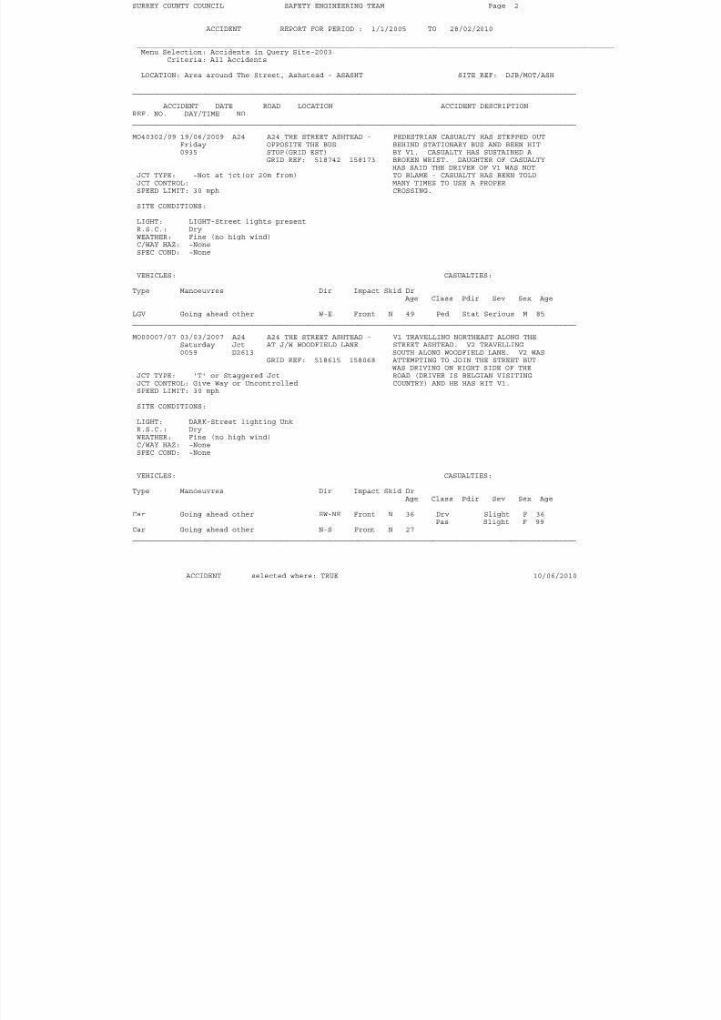
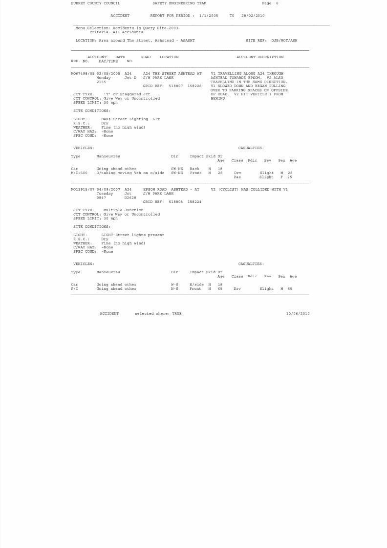
SURREY COUNTY COUNCIL SAFETY ENGINEERING TEAM Page 1
ACCIDENT REPORT FOR PERIOD : 1/1/2005 TO 28/02/2010 ______________________________________________________________________________________________________________Menu Selection: Accidents in Query Site-2003
Criteria: All Accidents LOCATION: Area around The Street, Ashstead - ASASHT SITE REF: DJB/MOT/ASH
______________________________________________________________________________________________________ ACCIDENT DATE ROAD LOCATION ACCIDENT DESCRIPTIONREF. NO. DAY/TIME NO.______________________________________________________________________________________________________ MO85253/06 09/05/2006 A24 A24 THE STREET ASHTEAD - INJURED PARTY WAS WALKING ALONG
Tuesday OUTSIDE SHELL PETROL FOOTPATH FROM ASHTEAD TOWARDS1400 STATION LEATHERHEAD. HAS STEPPED INTO PATH
GRID REF: 518658 158102 OF V1 WITHOUT LOOKING JCT TYPE: ~Not at jct(or 20m from)JCT CONTROL:SPEED LIMIT: 30 mph SITE CONDITIONS: LIGHT: LIGHT-Street lights presentR.S.C.: DryWEATHER: Fine (no high wind)C/WAY HAZ: ~None
SPEC COND: ~None
VEHICLES: CASUALTIES: Type Manoeuvres Dir Impact Skid Dr
Age Class Pdir Sev Sex Age Car Going ahead left hand bend E-W Front N 35 Ped S Slight F 15______________________________________________________________________________________________________ MO92126/06 03/10/2006 A24 A24 THE STREET ASHTEAD - V2 TRAVELLING NORTHEAST ON A24. V1
Tuesday 60 METRES EAST OF J/W TRAVELLING IN SAME DIRECTION1330 WOODFIELD LANE OVERTAKING V2. AS V1 PASSED V2 ITS
GRID REF: 518661 158102 TRAILER HIT V2 CAUSING RIDER TOFALL OFF.
JCT TYPE: ~Not at jct(or 20m from)JCT CONTROL:SPEED LIMIT: 30 mph SITE CONDITIONS: LIGHT: LIGHT-No Street lightsR.S.C.: DryWEATHER: Fine (no high wind)C/WAY HAZ: ~NoneSPEC COND: ~None
VEHICLES: CASUALTIES: Type Manoeuvres Dir Impact Skid Dr
Age Class Pdir Sev Sex Age LGV Going ahead other SW-NE O/side N 62P/C Going ahead other SW-NE Front N 72 Drv Slight M 72______________________________________________________________________________________________________
ACCIDENT selected where: TRUE 10/06/2010
8/9/2019 RO2-Appeal Statement 2010-06-21
http://slidepdf.com/reader/full/ro2-appeal-statement-2010-06-21 26/50
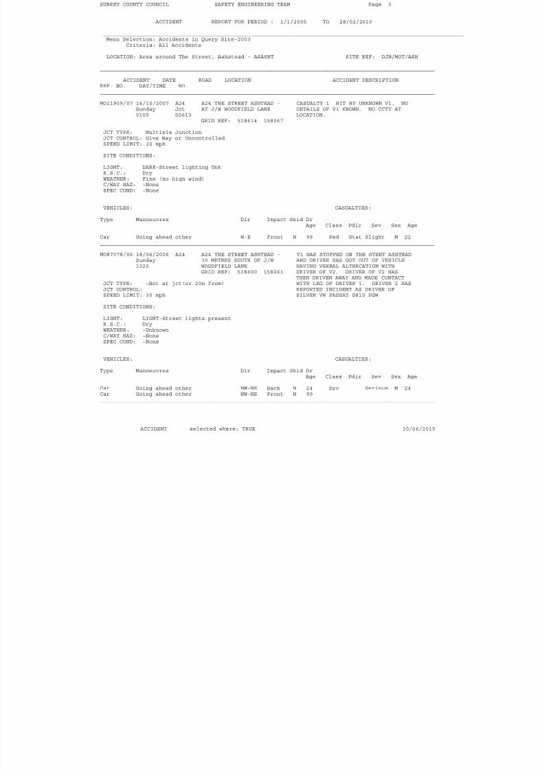
SURREY COUNTY COUNCIL SAFETY ENGINEERING TEAM Page 2
ACCIDENT REPORT FOR PERIOD : 1/1/2005 TO 28/02/2010 ______________________________________________________________________________________________________________Menu Selection: Accidents in Query Site-2003
Criteria: All Accidents LOCATION: Area around The Street, Ashstead - ASASHT SITE REF: DJB/MOT/ASH
______________________________________________________________________________________________________ ACCIDENT DATE ROAD LOCATION ACCIDENT DESCRIPTIONREF. NO. DAY/TIME NO.______________________________________________________________________________________________________ MO40302/09 19/06/2009 A24 A24 THE STREET ASHTEAD - PEDESTRIAN CASUALTY HAS STEPPED OUT
Friday OPPOSITE THE BUS BEHIND STATIONARY BUS AND BEEN HIT0935 STOP(GRID EST) BY V1. CASUALTY HAS SUSTAINED A
GRID REF: 518742 158173 BROKEN WRIST. DAUGHTER OF CASUALTYHAS SAID THE DRIVER OF V1 WAS NOT
JCT TYPE: ~Not at jct(or 20m from) TO BLAME - CASUALTY HAS BEEN TOLDJCT CONTROL: MANY TIMES TO USE A PROPERSPEED LIMIT: 30 mph CROSSING. SITE CONDITIONS: LIGHT: LIGHT-Street lights presentR.S.C.: DryWEATHER: Fine (no high wind)C/WAY HAZ: ~None
SPEC COND: ~None
VEHICLES: CASUALTIES: Type Manoeuvres Dir Impact Skid Dr
Age Class Pdir Sev Sex Age LGV Going ahead other W-E Front N 49 Ped Stat Serious M 85______________________________________________________________________________________________________ MO00007/07 03/03/2007 A24 A24 THE STREET ASHTEAD - V1 TRAVELLING NORTHEAST ALONG THE
Saturday Jct AT J/W WOODFIELD LANE STREET ASHTEAD. V2 TRAVELLING0059 D2613 SOUTH ALONG WOODFIELD LANE. V2 WAS
GRID REF: 518615 158068 ATTEMPTING TO JOIN THE STREET BUTWAS DRIVING ON RIGHT SIDE OF THE
JCT TYPE: 'T' or Staggered Jct ROAD (DRIVER IS BELGIAN VISITINGJCT CONTROL: Give Way or Uncontrolled COUNTRY) AND HE HAS HIT V1.SPEED LIMIT: 30 mph SITE CONDITIONS: LIGHT: DARK-Street lighting UnkR.S.C.: DryWEATHER: Fine (no high wind)C/WAY HAZ: ~NoneSPEC COND: ~None
VEHICLES: CASUALTIES: Type Manoeuvres Dir Impact Skid Dr
Age Class Pdir Sev Sex Age Car Going ahead other SW-NE Front N 36 Drv Slight F 36
Pas Slight F 99Car Going ahead other N-S Front N 27______________________________________________________________________________________________________
ACCIDENT selected where: TRUE 10/06/2010
8/9/2019 RO2-Appeal Statement 2010-06-21
http://slidepdf.com/reader/full/ro2-appeal-statement-2010-06-21 27/50
SURREY COUNTY COUNCIL SAFETY ENGINEERING TEAM Page 3
ACCIDENT REPORT FOR PERIOD : 1/1/2005 TO 28/02/2010 ______________________________________________________________________________________________________________Menu Selection: Accidents in Query Site-2003
Criteria: All Accidents LOCATION: Area around The Street, Ashstead - ASASHT SITE REF: DJB/MOT/ASH
______________________________________________________________________________________________________ ACCIDENT DATE ROAD LOCATION ACCIDENT DESCRIPTIONREF. NO. DAY/TIME NO.______________________________________________________________________________________________________ MO11909/07 14/10/2007 A24 A24 THE STREET ASHTEAD - CASUALTY 1 HIT BY UNKNOWN V1. NO
Sunday Jct AT J/W WOODFIELD LANE DETAILS OF V1 KNOWN. NO CCTV AT0100 D2613 LOCATION.
GRID REF: 518614 158067 JCT TYPE: Multiple JunctionJCT CONTROL: Give Way or UncontrolledSPEED LIMIT: 30 mph SITE CONDITIONS: LIGHT: DARK-Street lighting UnkR.S.C.: DryWEATHER: Fine (no high wind)C/WAY HAZ: ~None
SPEC COND: ~None
VEHICLES: CASUALTIES: Type Manoeuvres Dir Impact Skid Dr
Age Class Pdir Sev Sex Age Car Going ahead other W-E Front N 99 Ped Stat Slight M 22______________________________________________________________________________________________________ MO87078/06 18/06/2006 A24 A24 THE STREET ASHTEAD - V1 HAS STOPPED ON THE STEET ASHTEAD
Sunday 30 METRES SOUTH OF J/W AND DRIVER HAS GOT OUT OF VEHICLE1320 WOODFIELD LANE HAVING VERBAL ALTERCATION WITH
GRID REF: 518600 158063 DRIVER OF V2. DRIVER OF V2 HASTHEN DRIVEN AWAY AND MADE CONTACT
JCT TYPE: ~Not at jct(or 20m from) WITH LEG OF DRIVER 1. DRIVER 2 HASJCT CONTROL: REPORTED INCIDENT AS DRIVER OFSPEED LIMIT: 30 mph SILVER VW PASSAT S810 PGW SITE CONDITIONS: LIGHT: LIGHT-Street lights presentR.S.C.: DryWEATHER: ~UnknownC/WAY HAZ: ~NoneSPEC COND: ~None
VEHICLES: CASUALTIES: Type Manoeuvres Dir Impact Skid Dr
Age Class Pdir Sev Sex Age Car Going ahead other NW-NE Back N 24 Drv Serious M 24Car Going ahead other NW-NE Front N 99______________________________________________________________________________________________________
ACCIDENT selected where: TRUE 10/06/2010
8/9/2019 RO2-Appeal Statement 2010-06-21
http://slidepdf.com/reader/full/ro2-appeal-statement-2010-06-21 28/50
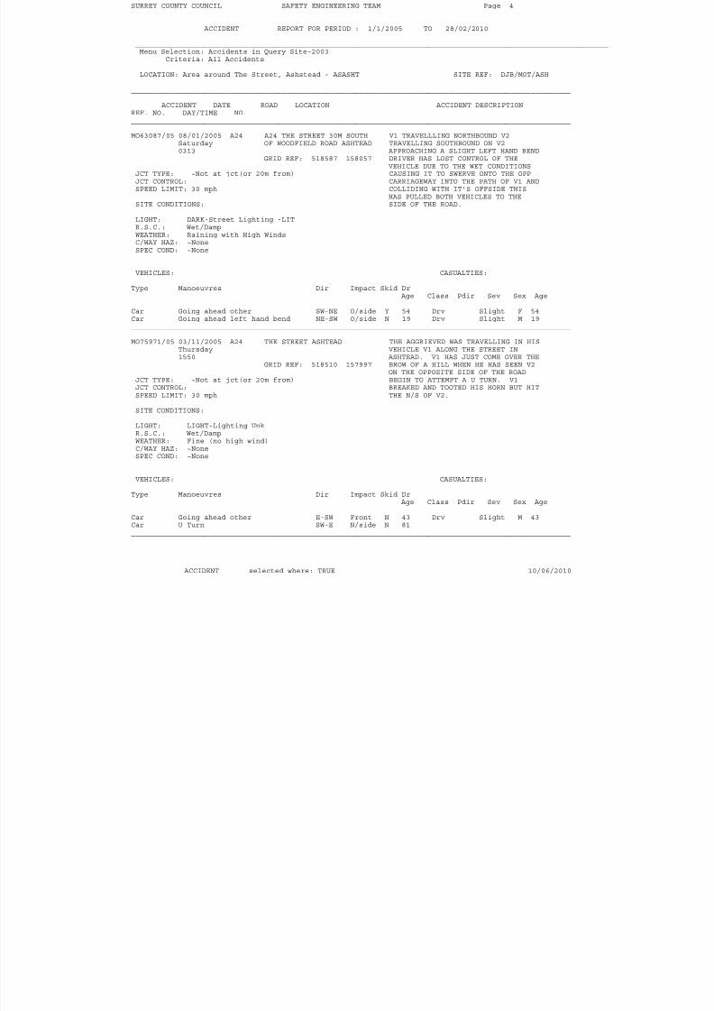
SURREY COUNTY COUNCIL SAFETY ENGINEERING TEAM Page 4
ACCIDENT REPORT FOR PERIOD : 1/1/2005 TO 28/02/2010 ______________________________________________________________________________________________________________Menu Selection: Accidents in Query Site-2003
Criteria: All Accidents LOCATION: Area around The Street, Ashstead - ASASHT SITE REF: DJB/MOT/ASH
______________________________________________________________________________________________________ ACCIDENT DATE ROAD LOCATION ACCIDENT DESCRIPTIONREF. NO. DAY/TIME NO.______________________________________________________________________________________________________ MO63087/05 08/01/2005 A24 A24 THE STREET 30M SOUTH V1 TRAVELLLING NORTHBOUND V2
Saturday OF WOODFIELD ROAD ASHTEAD TRAVELLING SOUTHBOUND ON V20313 APPROACHING A SLIGHT LEFT HAND BEND
GRID REF: 518587 158057 DRIVER HAS LOST CONTROL OF THEVEHICLE DUE TO THE WET CONDITIONS
JCT TYPE: ~Not at jct(or 20m from) CAUSING IT TO SWERVE ONTO THE OPPJCT CONTROL: CARRIAGEWAY INTO THE PATH OF V1 ANDSPEED LIMIT: 30 mph COLLIDING WITH IT'S OFFSIDE THIS
HAS PULLED BOTH VEHICLES TO THESITE CONDITIONS: SIDE OF THE ROAD. LIGHT: DARK-Street Lighting -LITR.S.C.: Wet/DampWEATHER: Raining with High WindsC/WAY HAZ: ~None
SPEC COND: ~None
VEHICLES: CASUALTIES: Type Manoeuvres Dir Impact Skid Dr
Age Class Pdir Sev Sex Age Car Going ahead other SW-NE O/side Y 54 Drv Slight F 54Car Going ahead left hand bend NE-SW O/side N 19 Drv Slight M 19______________________________________________________________________________________________________ MO75971/05 03/11/2005 A24 THE STREET ASHTEAD THE AGGRIEVED WAS TRAVELLING IN HIS
Thursday VEHICLE V1 ALONG THE STREET IN1550 ASHTEAD. V1 HAS JUST COME OVER THE
GRID REF: 518510 157997 BROW OF A HILL WHEN HE HAS SEEN V2
ON THE OPPOSITE SIDE OF THE ROADJCT TYPE: ~Not at jct(or 20m from) BEGIN TO ATTEMPT A U TURN. V1JCT CONTROL: BREAKED AND TOOTED HIS HORN BUT HITSPEED LIMIT: 30 mph THE N/S OF V2. SITE CONDITIONS: LIGHT: LIGHT-Lighting UnkR.S.C.: Wet/DampWEATHER: Fine (no high wind)C/WAY HAZ: ~NoneSPEC COND: ~None
VEHICLES: CASUALTIES: Type Manoeuvres Dir Impact Skid Dr
Age Class Pdir Sev Sex Age Car Going ahead other E-SW Front N 43 Drv Slight M 43Car U Turn SW-E N/side N 81______________________________________________________________________________________________________
ACCIDENT selected where: TRUE 10/06/2010
8/9/2019 RO2-Appeal Statement 2010-06-21
http://slidepdf.com/reader/full/ro2-appeal-statement-2010-06-21 29/50
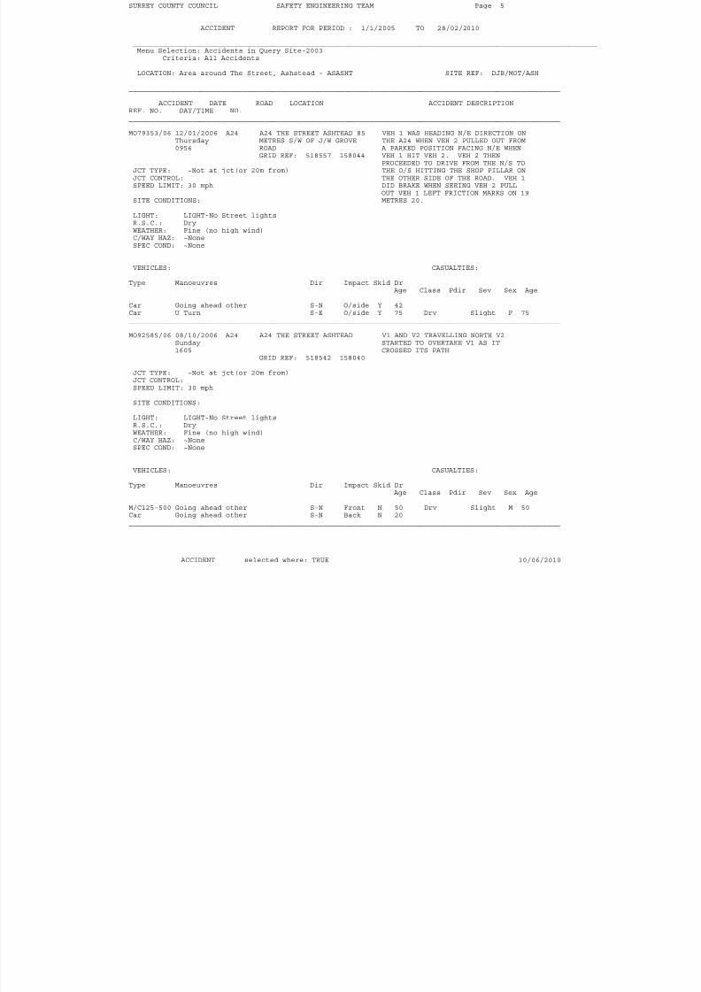
SURREY COUNTY COUNCIL SAFETY ENGINEERING TEAM Page 5
ACCIDENT REPORT FOR PERIOD : 1/1/2005 TO 28/02/2010 ______________________________________________________________________________________________________________Menu Selection: Accidents in Query Site-2003
Criteria: All Accidents LOCATION: Area around The Street, Ashstead - ASASHT SITE REF: DJB/MOT/ASH
______________________________________________________________________________________________________ ACCIDENT DATE ROAD LOCATION ACCIDENT DESCRIPTIONREF. NO. DAY/TIME NO.______________________________________________________________________________________________________ MO79353/06 12/01/2006 A24 A24 THE STREET ASHTEAD 85 VEH 1 WAS HEADING N/E DIRECTION ON
Thursday METRES S/W OF J/W GROVE THE A24 WHEN VEH 2 PULLED OUT FROM0956 ROAD A PARKED POSITION FACING N/E WHEN
GRID REF: 518557 158044 VEH 1 HIT VEH 2. VEH 2 THENPROCEEDED TO DRIVE FROM THE N/S TO
JCT TYPE: ~Not at jct(or 20m from) THE O/S HITTING THE SHOP PILLAR ONJCT CONTROL: THE OTHER SIDE OF THE ROAD. VEH 1SPEED LIMIT: 30 mph DID BRAKE WHEN SEEING VEH 2 PULL
OUT VEH 1 LEFT FRICTION MARKS ON 19SITE CONDITIONS: METRES 20. LIGHT: LIGHT-No Street lightsR.S.C.: DryWEATHER: Fine (no high wind)C/WAY HAZ: ~None
SPEC COND: ~None
VEHICLES: CASUALTIES: Type Manoeuvres Dir Impact Skid Dr
Age Class Pdir Sev Sex Age Car Going ahead other S-N O/side Y 42Car U Turn S-E O/side Y 75 Drv Slight F 75______________________________________________________________________________________________________ MO92585/06 08/10/2006 A24 A24 THE STREET ASHTEAD V1 AND V2 TRAVELLING NORTH V2
Sunday STARTED TO OVERTAKE V1 AS IT1605 CROSSED ITS PATH
GRID REF: 518542 158040
JCT TYPE: ~Not at jct(or 20m from)JCT CONTROL:SPEED LIMIT: 30 mph SITE CONDITIONS: LIGHT: LIGHT-No Street lightsR.S.C.: DryWEATHER: Fine (no high wind)C/WAY HAZ: ~NoneSPEC COND: ~None
VEHICLES: CASUALTIES: Type Manoeuvres Dir Impact Skid Dr
Age Class Pdir Sev Sex Age M/C125-500 Going ahead other S-N Front N 50 Drv Slight M 50Car Going ahead other S-N Back N 20______________________________________________________________________________________________________
ACCIDENT selected where: TRUE 10/06/2010
8/9/2019 RO2-Appeal Statement 2010-06-21
http://slidepdf.com/reader/full/ro2-appeal-statement-2010-06-21 30/50
SURREY COUNTY COUNCIL SAFETY ENGINEERING TEAM Page 6
ACCIDENT REPORT FOR PERIOD : 1/1/2005 TO 28/02/2010 ______________________________________________________________________________________________________________Menu Selection: Accidents in Query Site-2003
Criteria: All Accidents LOCATION: Area around The Street, Ashstead - ASASHT SITE REF: DJB/MOT/ASH
______________________________________________________________________________________________________ ACCIDENT DATE ROAD LOCATION ACCIDENT DESCRIPTIONREF. NO. DAY/TIME NO.______________________________________________________________________________________________________ MO67498/05 02/05/2005 A24 A24 THE STREET ASHTEAD AT V1 TRAVELLING ALONG A24 THROUGH
Monday Jct D J/W PARK LANE ASHTEAD TOWARDS EPSOM. V2 ALSO2155 TRAVELLING IN THE SAME DIRECTION.
GRID REF: 518807 158226 V1 SLOWED DOWN AND BEGAN PULLINGOVER TO PARKING SPACES ON OFFSIDE
JCT TYPE: 'T' or Staggered Jct OF ROAD. V2 HIT VEHICLE 1 FROMJCT CONTROL: Give Way or Uncontrolled BEHINDSPEED LIMIT: 30 mph SITE CONDITIONS: LIGHT: DARK-Street Lighting -LITR.S.C.: DryWEATHER: Fine (no high wind)C/WAY HAZ: ~None
SPEC COND: ~None
VEHICLES: CASUALTIES: Type Manoeuvres Dir Impact Skid Dr
Age Class Pdir Sev Sex Age Car Going ahead other SW-NE Back N 18M/C>500 O/taking moving Veh on o/side SW-NE Front N 28 Drv Slight M 28
Pas Slight F 25______________________________________________________________________________________________________ MO11915/07 04/09/2007 A24 EPSOM ROAD ASHTEAD - AT V2 (CYCLIST) HAS COLLIDED WITH V1
Tuesday Jct J/W PARK LANE0847 D2628
GRID REF: 518808 158224 JCT TYPE: Multiple JunctionJCT CONTROL: Give Way or UncontrolledSPEED LIMIT: 30 mph SITE CONDITIONS: LIGHT: LIGHT-Street lights presentR.S.C.: DryWEATHER: Fine (no high wind)C/WAY HAZ: ~NoneSPEC COND: ~None
VEHICLES: CASUALTIES: Type Manoeuvres Dir Impact Skid Dr
Age Class Pdir Sev Sex Age Car Going ahead other W-S N/side N 18P/C Going ahead other N-S Front N 65 Drv Slight M 65______________________________________________________________________________________________________
ACCIDENT selected where: TRUE 10/06/2010
8/9/2019 RO2-Appeal Statement 2010-06-21
http://slidepdf.com/reader/full/ro2-appeal-statement-2010-06-21 31/50
SURREY COUNTY COUNCIL SAFETY ENGINEERING TEAM Page 7
ACCIDENT REPORT FOR PERIOD : 1/1/2005 TO 28/02/2010 ______________________________________________________________________________________________________________Menu Selection: Accidents in Query Site-2003
Criteria: All Accidents LOCATION: Area around The Street, Ashstead - ASASHT SITE REF: DJB/MOT/ASH
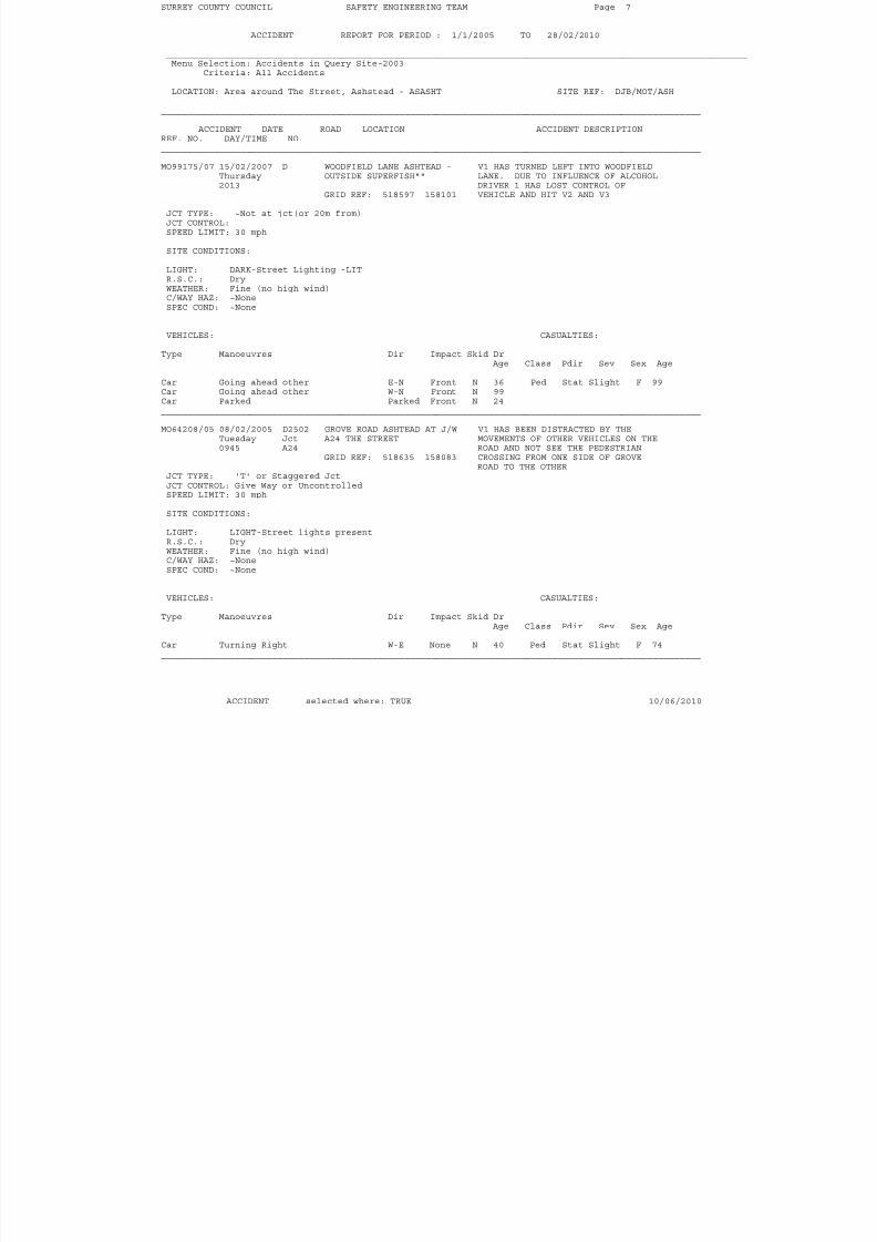
______________________________________________________________________________________________________ ACCIDENT DATE ROAD LOCATION ACCIDENT DESCRIPTIONREF. NO. DAY/TIME NO.______________________________________________________________________________________________________ MO99175/07 15/02/2007 D WOODFIELD LANE ASHTEAD - V1 HAS TURNED LEFT INTO WOODFIELD
Thursday OUTSIDE SUPERFISH"" LANE. DUE TO INFLUENCE OF ALCOHOL2013 DRIVER 1 HAS LOST CONTROL OF
GRID REF: 518597 158101 VEHICLE AND HIT V2 AND V3 JCT TYPE: ~Not at jct(or 20m from)JCT CONTROL:SPEED LIMIT: 30 mph SITE CONDITIONS: LIGHT: DARK-Street Lighting -LITR.S.C.: DryWEATHER: Fine (no high wind)C/WAY HAZ: ~None
SPEC COND: ~None
VEHICLES: CASUALTIES: Type Manoeuvres Dir Impact Skid Dr
Age Class Pdir Sev Sex Age Car Going ahead other E-N Front N 36 Ped Stat Slight F 99Car Going ahead other W-N Front N 99Car Parked Parked Front N 24______________________________________________________________________________________________________ MO64208/05 08/02/2005 D2502 GROVE ROAD ASHTEAD AT J/W V1 HAS BEEN DISTRACTED BY THE
Tuesday Jct A24 THE STREET MOVEMENTS OF OTHER VEHICLES ON THE0945 A24 ROAD AND NOT SEE THE PEDESTRIAN
GRID REF: 518635 158083 CROSSING FROM ONE SIDE OF GROVEROAD TO THE OTHERJCT TYPE: 'T' or Staggered JctJCT CONTROL: Give Way or UncontrolledSPEED LIMIT: 30 mph SITE CONDITIONS: LIGHT: LIGHT-Street lights presentR.S.C.: DryWEATHER: Fine (no high wind)C/WAY HAZ: ~NoneSPEC COND: ~None
VEHICLES: CASUALTIES: Type Manoeuvres Dir Impact Skid Dr
Age Class Pdir Sev Sex Age Car Turning Right W-E None N 40 Ped Stat Slight F 74______________________________________________________________________________________________________
ACCIDENT selected where: TRUE 10/06/2010
8/9/2019 RO2-Appeal Statement 2010-06-21
http://slidepdf.com/reader/full/ro2-appeal-statement-2010-06-21 32/50
SURREY COUNTY COUNCIL SAFETY ENGINEERING TEAM Page 8
ACCIDENT REPORT FOR PERIOD : 1/1/2005 TO 28/02/2010 ______________________________________________________________________________________________________________Menu Selection: Accidents in Query Site-2003
Criteria: All Accidents LOCATION: Area around The Street, Ashstead - ASASHT SITE REF: DJB/MOT/ASH
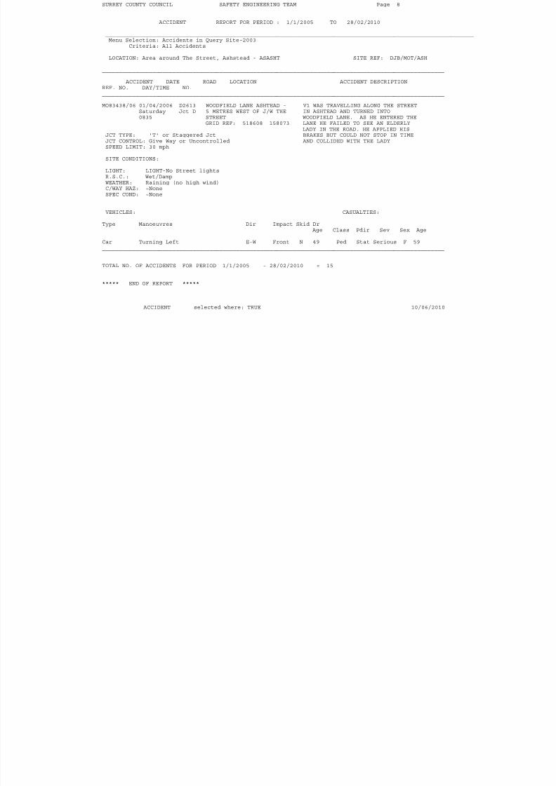
______________________________________________________________________________________________________ ACCIDENT DATE ROAD LOCATION ACCIDENT DESCRIPTIONREF. NO. DAY/TIME NO.______________________________________________________________________________________________________ MO83438/06 01/04/2006 D2613 WOODFIELD LANE ASHTEAD - V1 WAS TRAVELLING ALONG THE STREET
Saturday Jct D 5 METRES WEST OF J/W THE IN ASHTEAD AND TURNED INTO0835 STREET WOODFIELD LANE. AS HE ENTERED THE
GRID REF: 518608 158073 LANE HE FAILED TO SEE AN ELDERLYLADY IN THE ROAD. HE APPLIED HIS
JCT TYPE: 'T' or Staggered Jct BRAKES BUT COULD NOT STOP IN TIMEJCT CONTROL: Give Way or Uncontrolled AND COLLIDED WITH THE LADYSPEED LIMIT: 30 mph SITE CONDITIONS: LIGHT: LIGHT-No Street lightsR.S.C.: Wet/DampWEATHER: Raining (no high wind)C/WAY HAZ: ~None
SPEC COND: ~None
VEHICLES: CASUALTIES: Type Manoeuvres Dir Impact Skid Dr
Age Class Pdir Sev Sex Age Car Turning Left E-W Front N 49 Ped Stat Serious F 59______________________________________________________________________________________________________
TOTAL NO. OF ACCIDENTS FOR PERIOD 1/1/2005 - 28/02/2010 = 15
***** END OF REPORT *****
ACCIDENT selected where: TRUE 10/06/2010

8/9/2019 RO2-Appeal Statement 2010-06-21
http://slidepdf.com/reader/full/ro2-appeal-statement-2010-06-21 33/50
Appendix B

8/9/2019 RO2-Appeal Statement 2010-06-21
http://slidepdf.com/reader/full/ro2-appeal-statement-2010-06-21 34/50
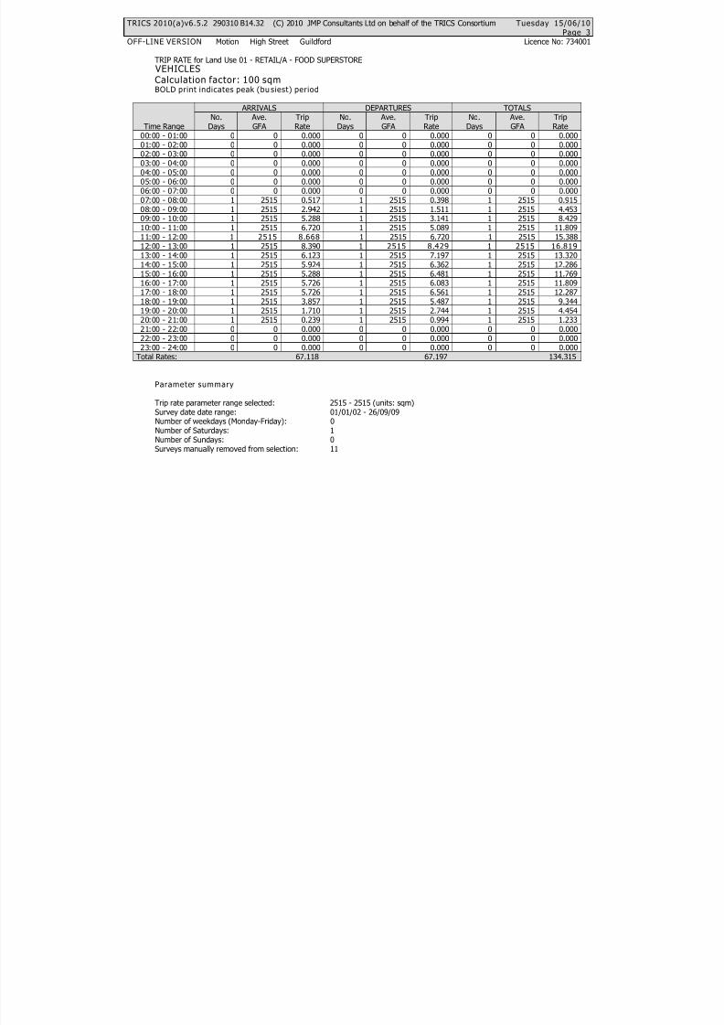
TRICS 2010(a)v6.5.2 290310 B14.32 (C) 2010 JMP Consultants Ltd on behalf of the TRICS Consortium Tuesday 15/06/10Page 1
OFF-LINE VERSION Motion High Street Guildford Licence No: 734001
TRIP RATE CALCULATION SELECTION PARAMETERS:
Land Use : 01 - RETAILCategory : A - FOOD SUPERSTORE
VEHICLES
Selected regions and areas:
03 SOUTH WESTDC DORSET 1 days
Filtering Stage 2 selection:
Parameter: Gross floor areaRange: 2515 to 2515 (units: sqm)
Public Transport Provision:Selection by: Include all surveys
Date Range: 01/01/02 to 26/09/09
Selected survey days:Saturday 1 days
Selected survey types:Manual count 1 daysDirectional ATC Count 0 days
Selected Locations:Edge of Town Centre 1
Selected Location Sub Categories:No Sub Category 1
Filtering Stage 3 selection:
Use Class:A1 1 days
Population within 1 mile:5,001 to 10,000 1 days
Population within 5 miles:25,001 to 50,000 1 days
Car ownership within 5 miles:1.1 to 1.5 1 days
Petrol filling station:Excluded from count or no filling station 1 daysIncluded in the survey count 0 days
Travel Plan:No 1 days

8/9/2019 RO2-Appeal Statement 2010-06-21
http://slidepdf.com/reader/full/ro2-appeal-statement-2010-06-21 35/50
TRICS 2010(a)v6.5.2 290310 B14.32 (C) 2010 JMP Consultants Ltd on behalf of the TRICS Consortium Tuesday 15/06/10Page 2
OFF-LINE VERSION Motion High Street Guildford Licence No: 734001
LIST OF SITES relevant to selection parameters
1 DC-01-A-17 SAINSBURYS, SHERBORNE DORSETLUDBOURNE ROAD
SHERBORNEEdge of Town Centre
No Sub CategoryTotal Gross floor area: 2515 sqm
Survey date: SATURDAY 25/10/03 Survey Type: MANUAL
8/9/2019 RO2-Appeal Statement 2010-06-21
http://slidepdf.com/reader/full/ro2-appeal-statement-2010-06-21 36/50
TRICS 2010(a)v6.5.2 290310 B14.32 (C) 2010 JMP Consultants Ltd on behalf of the TRICS Consortium Tuesday 15/06/10Page 3
OFF-LINE VERSION Motion High Street Guildford Licence No: 734001
TRIP RATE for Land Use 01 - RETAIL/A - FOOD SUPERSTORE VEHICLESCalculation factor: 100 sqmBOLD print indicates peak (bu siest) period
ARRIVALS DEPARTURES TOTALSNo. Ave. Trip No. Ave. Trip No. Ave. Trip
Time Range Days GFA Rate Days GFA Rate Days GFA Rate0 0 0.000 0 0 0.000 0 0 0.00000:00 - 01:000 0 0.000 0 0 0.000 0 0 0.00001:00 - 02:000 0 0.000 0 0 0.000 0 0 0.00002:00 - 03:000 0 0.000 0 0 0.000 0 0 0.00003:00 - 04:000 0 0.000 0 0 0.000 0 0 0.00004:00 - 05:000 0 0.000 0 0 0.000 0 0 0.00005:00 - 06:000 0 0.000 0 0 0.000 0 0 0.00006:00 - 07:001 2515 0.517 1 2515 0.398 1 2515 0.91507:00 - 08:001 2515 2.942 1 2515 1.511 1 2515 4.45308:00 - 09:001 2515 5.288 1 2515 3.141 1 2515 8.42909:00 - 10:001 2515 6.720 1 2515 5.089 1 2515 11.80910:00 - 11:001 2515 8.668 1 2515 6.720 1 2515 15.38811:00 - 12:001 2515 8.390 1 2515 8.429 1 2515 16.81912:00 - 13:00
1 2515 6.123 1 2515 7.197 1 2515 13.32013:00 - 14:001 2515 5.924 1 2515 6.362 1 2515 12.28614:00 - 15:001 2515 5.288 1 2515 6.481 1 2515 11.76915:00 - 16:001 2515 5.726 1 2515 6.083 1 2515 11.80916:00 - 17:001 2515 5.726 1 2515 6.561 1 2515 12.28717:00 - 18:001 2515 3.857 1 2515 5.487 1 2515 9.34418:00 - 19:001 2515 1.710 1 2515 2.744 1 2515 4.45419:00 - 20:001 2515 0.239 1 2515 0.994 1 2515 1.23320:00 - 21:000 0 0.000 0 0 0.000 0 0 0.00021:00 - 22:000 0 0.000 0 0 0.000 0 0 0.00022:00 - 23:000 0 0.000 0 0 0.000 0 0 0.00023:00 - 24:00
Total Rates: 67.118 67.197 134.315
Parameter summary
Trip rate parameter range selected: 2515 - 2515 (units: sqm)Survey date date range: 01/01/02 - 26/09/09Number of weekdays (Monday-Friday): 0Number of Saturdays: 1Number of Sundays: 0Surveys manually removed from selection: 11
8/9/2019 RO2-Appeal Statement 2010-06-21
http://slidepdf.com/reader/full/ro2-appeal-statement-2010-06-21 37/50
TRICS 2010(a)v6.5.2 290310 B14.32 (C) 2010 JMP Consultants Ltd on behalf of the TRICS Consortium Tuesday 15/06/10Page 1
OFF-LINE VERSION Motion High Street Guildford Licence No: 734001
TRIP RATE CALCULATION SELECTION PARAMETERS:
Land Use : 01 - RETAILCategory : A - FOOD SUPERSTORE
VEHICLES
Selected regions and areas:
07 YORKSHIRE & NORTH LINCOLNSHIRENY NORTH YORKSHIRE 1 days
Filtering Stage 2 selection:
Parameter: Gross floor areaRange: 2300 to 2300 (units: sqm)
Public Transport Provision:Selection by: Include all surveys
Date Range: 01/01/02 to 26/09/09
Selected survey days:Saturday 1 days
Selected survey types:Manual count 1 daysDirectional ATC Count 0 days
Selected Locations:Suburban Area (PPS6 Out of Centre) 1
Selected Location Sub Categories:No Sub Category 1
Filtering Stage 3 selection:
Use Class:A1 1 days
Population within 1 mile:10,001 to 15,000 1 days
Population within 5 miles:25,001 to 50,000 1 days
Car ownership within 5 miles:1.1 to 1.5 1 days
Petrol filling station:Excluded from count or no filling station 1 daysIncluded in the survey count 0 days
Travel Plan:No 1 days

8/9/2019 RO2-Appeal Statement 2010-06-21
http://slidepdf.com/reader/full/ro2-appeal-statement-2010-06-21 38/50
TRICS 2010(a)v6.5.2 290310 B14.32 (C) 2010 JMP Consultants Ltd on behalf of the TRICS Consortium Tuesday 15/06/10Page 2
OFF-LINE VERSION Motion High Street Guildford Licence No: 734001
LIST OF SITES relevant to selection parameters
1 NY-01-A-05 SAINSBURY'S, NORTHALLERTON NORTH YORKSHIREHIGH STREET
NORTHALLERTONSuburban Area (PPS6 Out of Centre)
No Sub CategoryTotal Gross floor area: 2300 sqm
Survey date: SATURDAY 26/09/09 Survey Type: MANUAL
8/9/2019 RO2-Appeal Statement 2010-06-21
http://slidepdf.com/reader/full/ro2-appeal-statement-2010-06-21 39/50
TRICS 2010(a)v6.5.2 290310 B14.32 (C) 2010 JMP Consultants Ltd on behalf of the TRICS Consortium Tuesday 15/06/10Page 3
OFF-LINE VERSION Motion High Street Guildford Licence No: 734001
TRIP RATE for Land Use 01 - RETAIL/A - FOOD SUPERSTORE VEHICLESCalculation factor: 100 sqmBOLD print indicates peak (bu siest) period
ARRIVALS DEPARTURES TOTALSNo. Ave. Trip No. Ave. Trip No. Ave. Trip
Time Range Days GFA Rate Days GFA Rate Days GFA Rate0 0 0.000 0 0 0.000 0 0 0.00000:00 - 01:000 0 0.000 0 0 0.000 0 0 0.00001:00 - 02:000 0 0.000 0 0 0.000 0 0 0.00002:00 - 03:000 0 0.000 0 0 0.000 0 0 0.00003:00 - 04:000 0 0.000 0 0 0.000 0 0 0.00004:00 - 05:000 0 0.000 0 0 0.000 0 0 0.00005:00 - 06:000 0 0.000 0 0 0.000 0 0 0.00006:00 - 07:001 2300 0.478 1 2300 0.261 1 2300 0.73907:00 - 08:001 2300 2.826 1 2300 1.870 1 2300 4.69608:00 - 09:001 2300 6.348 1 2300 4.565 1 2300 10.91309:00 - 10:001 2300 7.348 1 2300 9.043 1 2300 16.39110:00 - 11:001 2300 9.304 1 2300 7.957 1 2300 17.26111:00 - 12:001 2300 8.348 1 2300 8.739 1 2300 17.08712:00 - 13:00
1 2300 9.000 1 2300 7.913 1 2300 16.91313:00 - 14:001 2300 7.478 1 2300 7.130 1 2300 14.60814:00 - 15:001 2300 7.217 1 2300 7.739 1 2300 14.95615:00 - 16:001 2300 7.783 1 2300 8.609 1 2300 16.39216:00 - 17:001 2300 6.565 1 2300 7.130 1 2300 13.69517:00 - 18:001 2300 4.652 1 2300 5.696 1 2300 10.34818:00 - 19:001 2300 2.130 1 2300 2.261 1 2300 4.39119:00 - 20:001 2300 0.609 1 2300 0.957 1 2300 1.56620:00 - 21:001 2300 0.261 1 2300 0.435 1 2300 0.69621:00 - 22:001 2300 0.043 1 2300 0.130 1 2300 0.17322:00 - 23:000 0 0.000 0 0 0.000 0 0 0.00023:00 - 24:00
Total Rates: 80.390 80.435 160.825
Parameter summary
Trip rate parameter range selected: 2300 - 2300 (units: sqm)Survey date date range: 01/01/02 - 26/09/09Number of weekdays (Monday-Friday): 0Number of Saturdays: 1Number of Sundays: 0Surveys manually removed from selection: 11
8/9/2019 RO2-Appeal Statement 2010-06-21
http://slidepdf.com/reader/full/ro2-appeal-statement-2010-06-21 40/50
TRICS 2010(a)v6.5.2 290310 B14.32 (C) 2010 JMP Consultants Ltd on behalf of the TRICS Consortium Tuesday 15/06/10Page 1
OFF-LINE VERSION Motion High Street Guildford Licence No: 734001
TRIP RATE CALCULATION SELECTION PARAMETERS:
Land Use : 01 - RETAILCategory : A - FOOD SUPERSTORE
VEHICLES
Selected regions and areas:
02 SOUTH EASTWS WEST SUSSEX 1 days
Filtering Stage 2 selection:
Parameter: Gross floor areaRange: 2094 to 2094 (units: sqm)
Public Transport Provision:Selection by: Include all surveys
Date Range: 01/01/02 to 26/09/09
Selected survey days:Saturday 1 days
Selected survey types:Manual count 1 daysDirectional ATC Count 0 days
Selected Locations:Neighbourhood Centre (PPS6 Local Centre) 1
Selected Location Sub Categories: Village 1
Filtering Stage 3 selection:
Use Class:A1 1 days
Population within 1 mile:1,001 to 5,000 1 days
Population within 5 miles:25,001 to 50,000 1 days
Car ownership within 5 miles:0.6 to 1.0 1 days
Petrol filling station:Excluded from count or no filling station 1 daysIncluded in the survey count 0 days
Travel Plan:Not Known 1 days

8/9/2019 RO2-Appeal Statement 2010-06-21
http://slidepdf.com/reader/full/ro2-appeal-statement-2010-06-21 41/50
TRICS 2010(a)v6.5.2 290310 B14.32 (C) 2010 JMP Consultants Ltd on behalf of the TRICS Consortium Tuesday 15/06/10Page 2
OFF-LINE VERSION Motion High Street Guildford Licence No: 734001
LIST OF SITES relevant to selection parameters
1 WS-01-A-11 SAINSBURYS,NR PULBOROUGH WEST SUSSEXSTANE STREET
NEAR PULBOROUGHNeighbourhood Centre (PPS6 Local Centre)
VillageTotal Gross floor area: 2094 sqm
Survey date: SATURDAY 22/03/03 Survey Type: MANUAL

8/9/2019 RO2-Appeal Statement 2010-06-21
http://slidepdf.com/reader/full/ro2-appeal-statement-2010-06-21 42/50
TRICS 2010(a)v6.5.2 290310 B14.32 (C) 2010 JMP Consultants Ltd on behalf of the TRICS Consortium Tuesday 15/06/10Page 3
OFF-LINE VERSION Motion High Street Guildford Licence No: 734001
TRIP RATE for Land Use 01 - RETAIL/A - FOOD SUPERSTORE VEHICLESCalculation factor: 100 sqmBOLD print indicates peak (bu siest) period
ARRIVALS DEPARTURES TOTALSNo. Ave. Trip No. Ave. Trip No. Ave. Trip
Time Range Days GFA Rate Days GFA Rate Days GFA Rate0 0 0.000 0 0 0.000 0 0 0.00000:00 - 01:000 0 0.000 0 0 0.000 0 0 0.00001:00 - 02:000 0 0.000 0 0 0.000 0 0 0.00002:00 - 03:000 0 0.000 0 0 0.000 0 0 0.00003:00 - 04:000 0 0.000 0 0 0.000 0 0 0.00004:00 - 05:000 0 0.000 0 0 0.000 0 0 0.00005:00 - 06:000 0 0.000 0 0 0.000 0 0 0.00006:00 - 07:000 0 0.000 0 0 0.000 0 0 0.00007:00 - 08:001 2094 4.011 1 2094 1.289 1 2094 5.30008:00 - 09:001 2094 5.635 1 2094 4.632 1 2094 10.26709:00 - 10:001 2094 7.593 1 2094 6.113 1 2094 13.70610:00 - 11:001 2094 7.784 1 2094 8.596 1 2094 16.38011:00 - 12:001 2094 8.453 1 2094 8.023 1 2094 16.47612:00 - 13:00
1 2094 8.262 1 2094 9.169 1 2094 17.43113:00 - 14:001 2094 4.967 1 2094 6.686 1 2094 11.65314:00 - 15:001 2094 5.683 1 2094 6.399 1 2094 12.08215:00 - 16:001 2094 8.023 1 2094 6.686 1 2094 14.70916:00 - 17:001 2094 7.498 1 2094 7.593 1 2094 15.09117:00 - 18:001 2094 7.975 1 2094 8.309 1 2094 16.28418:00 - 19:001 2094 2.483 1 2094 4.202 1 2094 6.68519:00 - 20:000 0 0.000 0 0 0.000 0 0 0.00020:00 - 21:000 0 0.000 0 0 0.000 0 0 0.00021:00 - 22:000 0 0.000 0 0 0.000 0 0 0.00022:00 - 23:000 0 0.000 0 0 0.000 0 0 0.00023:00 - 24:00
Total Rates: 78.367 77.697 156.064
Parameter summary
Trip rate parameter range selected: 2094 - 2094 (units: sqm)Survey date date range: 01/01/02 - 26/09/09Number of weekdays (Monday-Friday): 0Number of Saturdays: 1Number of Sundays: 0Surveys manually removed from selection: 11

8/9/2019 RO2-Appeal Statement 2010-06-21
http://slidepdf.com/reader/full/ro2-appeal-statement-2010-06-21 43/50
Appendix C
8/9/2019 RO2-Appeal Statement 2010-06-21
http://slidepdf.com/reader/full/ro2-appeal-statement-2010-06-21 44/50
As a comparison to the predicted trip rates to the proposed Tesco store in The Street, visit counts
were undertaken to the Tesco store in Craddocks Parade. Two counts were undertaken, one
covering 4 p.m. to 6 p.m. on Friday, 12 February 2010, which included the weekday peak hour of 5
p.m. to 6 p.m. on a Friday, and the other count was for daytime on Friday 23 April 2010. The figures
are as follows.
Time Period Arrival visits16:00-17:00 135
17:00-18:00 185
Arrivals 12 February 2010
Time Period Arrival visits
08:00-09:00 76
09:00-10:00 92
10:00-11:00 99
11:00-12:00 131
12:00-13:00 125
13:00-14:00 11314:00-15:00 109
15:00-16:00 177
16:00-17:00 181
17:00-18:00 168
18:00-19:00 183
19:00-20:00 137
Arrivals 23 April 2010
The above figures are counts of individuals or groups of people visiting together, and so represent
the number of shopping visits by groups of one or more people. Due to the nature of the parking
arrangements at Craddocks Parade, it is not possible to count the number of car trips being made to
the store.
Tesco state at [reference needed] that 84% of shopping trips will be by car. Therefore, multiplying
the above figures by 84% will give the predicted car trips.
Time Period Car trips
16:00-17:00 113
17:00-18:00 155
Arrivals 12 February 2010
Time Period Car trips
08:00-09:00 64
09:00-10:00 77
10:00-11:00 83
11:00-12:00 110
12:00-13:00 105
13:00-14:00 95
14:00-15:00 92
15:00-16:00 149
16:00-17:00 152
17:00-18:00 14118:00-19:00 154
19:00-20:00 115
Arrivals 23 April 2010
8/9/2019 RO2-Appeal Statement 2010-06-21
http://slidepdf.com/reader/full/ro2-appeal-statement-2010-06-21 45/50
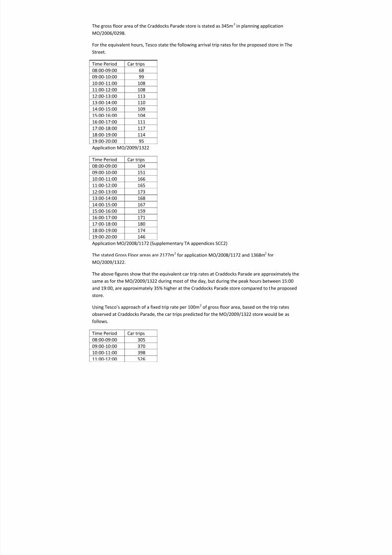
The gross floor area of the Craddocks Parade store is stated as 345m2
in planning application
MO/2006/0298.
For the equivalent hours, Tesco state the following arrival trip rates for the proposed store in The
Street.
Time Period Car trips
08:00-09:00 68
09:00-10:00 99
10:00-11:00 108
11:00-12:00 108
12:00-13:00 113
13:00-14:00 110
14:00-15:00 109
15:00-16:00 104
16:00-17:00 111
17:00-18:00 117
18:00-19:00 11419:00-20:00 95
Application MO/2009/1322
Time Period Car trips
08:00-09:00 104
09:00-10:00 151
10:00-11:00 166
11:00-12:00 165
12:00-13:00 173
13:00-14:00 168
14:00-15:00 16715:00-16:00 159
16:00-17:00 171
17:00-18:00 180
18:00-19:00 174
19:00-20:00 146
Application MO/2008/1172 (Supplementary TA appendices SCC2)
The stated Gross Floor areas are 2177m2
for application MO/2008/1172 and 1368m2
for
MO/2009/1322.
The above figures show that the equivalent car trip rates at Craddocks Parade are approximately thesame as for the MO/2009/1322 during most of the day, but during the peak hours between 15:00
and 19:00, are approximately 35% higher at the Craddocks Parade store compared to the proposed
store.
Using Tesco’s approach of a fixed trip rate per 100m2
of gross floor area, based on the trip rates
observed at Craddocks Parade, the car trips predicted for the MO/2009/1322 store would be as
follows.
Time Period Car trips
08:00-09:00 305
09:00-10:00 370
10:00-11:00 398
11:00-12:00 526

8/9/2019 RO2-Appeal Statement 2010-06-21
http://slidepdf.com/reader/full/ro2-appeal-statement-2010-06-21 46/50
12:00-13:00 502
13:00-14:00 454
14:00-15:00 438
15:00-16:00 711
16:00-17:00 727
17:00-18:00 675
18:00-19:00 735
19:00-20:00 550
Predicted trip rates for MO/2009/1322 based on Craddocks Parade observations

8/9/2019 RO2-Appeal Statement 2010-06-21
http://slidepdf.com/reader/full/ro2-appeal-statement-2010-06-21 47/50
Appendix D
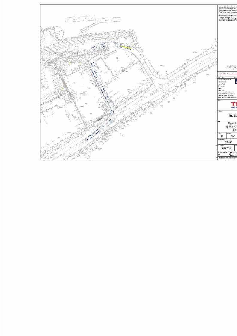
8/9/2019 RO2-Appeal Statement 2010-06-21
http://slidepdf.com/reader/full/ro2-appeal-statement-2010-06-21 48/50

8/9/2019 RO2-Appeal Statement 2010-06-21
http://slidepdf.com/reader/full/ro2-appeal-statement-2010-06-21 49/50
Appendix E
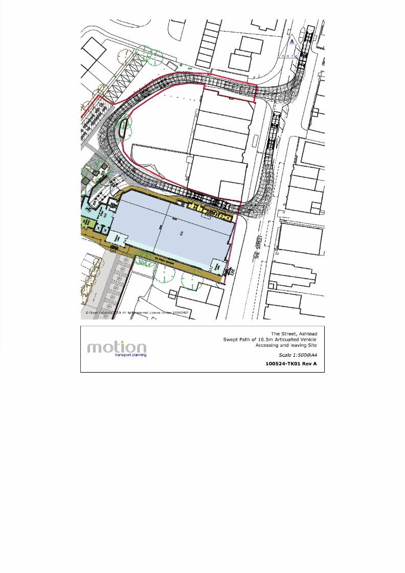
8/9/2019 RO2-Appeal Statement 2010-06-21
http://slidepdf.com/reader/full/ro2-appeal-statement-2010-06-21 50/50