Embed Size (px)
Citation preview
Sample Flood Safety PlanCalifornia Department of Water Resources
March 2011
DRAFT
[ Flood Ops Element ]

Draft
Sample Flood Safety Plan
California Department of Water Resources Agreement No. 4600007756 Activity No. 10661B March 2011

10661B
Booklet Contents
Foreword
Part I: A Guide to Using This Sample Flood Safety Plan
Part II: Sample Flood Safety Plan
Part III: References and Supporting Documents
Sample Flood Safety Plan i March 2011

10661B
Sample Flood Safety Plan ii March 2011
10661B
Foreword
It is important for local agencies to have complete and up-to-date plans to guide critical actions during a flood emergency event. A good flood safety plan:
• Directs resources effectively during the emergency • Helps prioritize actions • Streamlines communication • Identifies possible problems • Provides locations and procedures to obtain necessary resources • Provides management structure for the emergency work • Saves lives and protects property during a flood emergency
AB156 (Laird) added WC 9650 to the California Water Code (WC 9650) in October 2007. The statute conditions the expenditure of funds by the State of California for the upgrade of a State Plan of Flood Control project levee, where that levee protects an urban area where more than 1000 people reside, to the requirement that the local agency responsible for the operation and maintenance of the project levee and any city or county protected by the project levee agree to adopt a safety plan within two years. WC 9650 also specifies several elements that need to be in a safety plan.
Thus, local maintaining agencies and communities within the Central Valley must agree to adopt a “flood safety plan” with specific elements to be eligible for funds to upgrade their flood control facilities.
To help these Central Valley agencies meet WC 9650 requirements, DWR is providing templates to jump-start the development of a plan that will satisfy those conditions. A local agency may use one of the following options to prepare a safety plan:
(1) Modify an existing emergency plan: A local agency may have already prepared a flood emergency response plan for its community. In this case the agency must review the law to make sure all requirements of the law (summarized later in this document) are met. If the existing plan does not include some of the requirements, the agency may amend its plan to include additional requirements. The Sample Safety Plan prepared in Part II of this document may help the agency to prepare any additional parts needed to complete its safety plan.
(2) Use the local flood emergency response plan template and deep flooding example flood emergency response plan for Marysville, California. To aid local agencies, cities, and counties across the State, the California Department of Water Resources (DWR) has prepared a “statewide local flood emergency response plan template” and examples of flood emergency response plans for different types of flood dangers. These flood types
Sample Flood Safety Plan iii March 2011
10661B
include deep flooding (flooding in areas protected by high levees, such as the City of Marysville), alluvial fan flooding, such as experienced by the City of San Bernardino, and local creek and stream flooding similar to Arcata. The goal of the statewide flood emergency response plan template and example project, which is being developed in parallel with the sample flood safety plan in this document, is to develop tools that will help local communities across the State incorporate flood emergency response plans into their local emergency response plans. DWR is preparing to publish and distribute both the statewide template for the flood emergency response plan as well as the example flood emergency response plans for the communities mentioned.
Local Central Valley agencies can choose to use the statewide template and Marysville example flood emergency response plan as a basis to satisfy the WC 9650 requirements. However, both the statewide flood emergency response plan template and the Marysville deep flooding example do not cover all WC 9650 requirements. If this template is used, the agency should add the following elements that are also required by WC 9650 to the template:
a. Flood-fight plan element b. Floodwater removal element c. A complete evacuation plan d. Requirements on siting new essential services building e. A levee patrol element (A levee patrol element is included within the Marysville
sample, but not cited within the statewide flood emergency response plan template)
By itself, the flood emergency response plan template does not contain all the elements called for under WC 9650. Agencies may contact DWR for further information on the flood emergency response plan template.
(3) Use the Sample Flood Safety Plan presented in Part II of this document as a template that can be modified for local conditions. This sample safety plan already includes sections that directly address and satisfy the minimum WC 9650 requirements. The Sample Flood Safety Plan is not meant to replace existing safety or emergency response procedures or documents now in use by agencies. Rather, it provides a general framework and typical language that may be integrated in existing plans so that those plans would comply with WC 9650 requirements.
Sample Flood Safety Plan iv March 2011
10661B
PART I: A Guide to Using This Sample Flood Safety Plan
Legal Requirements AB156 (Laird) was passed by the California State Legislature and signed by the Governor on October 10, 2007. It amended several sections of the water code, including adding WC 9650. That section requires:
Commencing July 1, 2008, the allocation or expenditure of funds by the state for the upgrade of a project levee, if that upgrade is authorized on or after July 1, 2008, that protects an area in which more than 1,000 people reside, shall be subject to the requirement that the local agency responsible for operations and maintenance of the project levee and any city or county protected by the project levee, including a charter city or charter county, enter into an agreement to adopt a safety plan within two years.
This requirement potentially affects a number of facilities and agencies within the Central Valley and their ability to secure State funds to upgrade flood control infrastructure.
The template contained in Part II of this document is a generic Sample Safety Plan that provides the basic outline and substance for a safety plan as defined by WC 9650. It can be modified and tailored by local agencies for their own specific conditions. The Department of Water Resources developed this Sample Safety Plan to help local planners and their agencies meet the requirements of developing a safety plan.
WC 9650 of the water code also requires a safety plan to have the following minimum contents:
(1) A flood preparedness plan that includes storage of materials that can be used to reinforce or protect a levee when a risk of failure exists. (see Section 6 and Flood Fight Appendix)
(2) A levee patrol plan for high water situations. (see Levee Patrol Appendix)
(3) A flood-fight plan for the period before State or federal agencies assume control over the flood fight. (see Flood Fight Appendix)
(4) An evacuation plan that includes a system for adequately warning the general public in the event of a levee failure, and a plan for the evacuation of every affected school, residential care facility for the elderly, and long-term health care facility. (see Evacuation Appendix)
(5) A floodwater removal plan. (see Floodwater Removal Appendix)
(6) A requirement, to the extent reasonable, that either of the following applies to a new building in which the inhabitants are expected to be essential service providers:
Sample Flood Safety Plan v March 2011
10661B
(A) The building is located outside an area that may be flooded. (B) The building is designed to be operable shortly after the floodwater is removed.
The safety plan shall be integrated into any other local agency emergency plan and shall be coordinated with the State emergency plan.
Several supporting references and documents can be found in Part III, References and Supporting Documents. These match federal emergency planning guidance (Comprehensive Preparedness Guide [CPG] 101). DWR adapted the format and content recommended in CPG 101 to the requirements of flood emergency operations. This ensures the resulting plan will address flood response while also keeping the plan in conformity with the State of California Emergency Plan and consistent with the Standardized Emergency Management System (SEMS).
How to Use This Template This Sample Flood Safety Plan provides the minimum outline and general information categories needed to construct a flood safety plan acceptable under WC 9650 criteria. Agencies should review the sample and modify its contents by adding specific information, policies, procedures, and references applicable to the local agency, city, or county developing the plan. The sample is in a fill-in-the-blanks format. This should provide flexibility in producing a comprehensive document as well as allow efficient production of a legally adequate document.
The Sample Safety Plan is not meant to replace existing safety or emergency response procedures or documents now in use by agencies. Rather, it provides a general framework and typical language that may be integrated into existing plans so that those plans would comply with WC 9650 requirements. If an agency has no plan, the sample plan can be used to formulate a legally sufficient and workable plan.
The Sample Safety Plan generally has sample text that may be used directly or modified as needed. However, there are two special annotations:
Symbol Instruction/Definition
{{NOTE: }} Indicates that the following text contains special instruction on what may be done to construct or develop the particular section of the plan.
(Agency/Jurisdiction) The appropriate agency name will replace this designation and is highlighted to alert the planner. This is the fill-in-the-blank variable. Other “fill-ins” are similarly noted.
The Sample Safety Plan is written to address the needs of Local Maintaining Agencies (LMAs). The term “LMA” refers broadly to special districts, Reclamation Districts, Levee Districts, and State Maintenance Areas. However, cities and counties can use the Sample Flood Safety Plan by eliminating or modifying a few apparent references in the text.
The Sample Safety Plan is written with more general information within the body of the plan text and details and specifics on particular flood safety plan elements as described in the appendices.
Sample Flood Safety Plan vi March 2011
10661B
Sample Flood Safety Plan vii March 2011
This presentation format style is consistent with the format and content recommended in CPG 101 and in conformity with the State of California Emergency Plan.
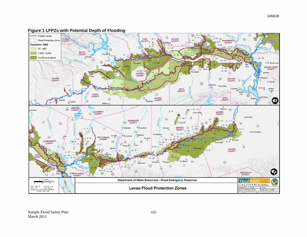
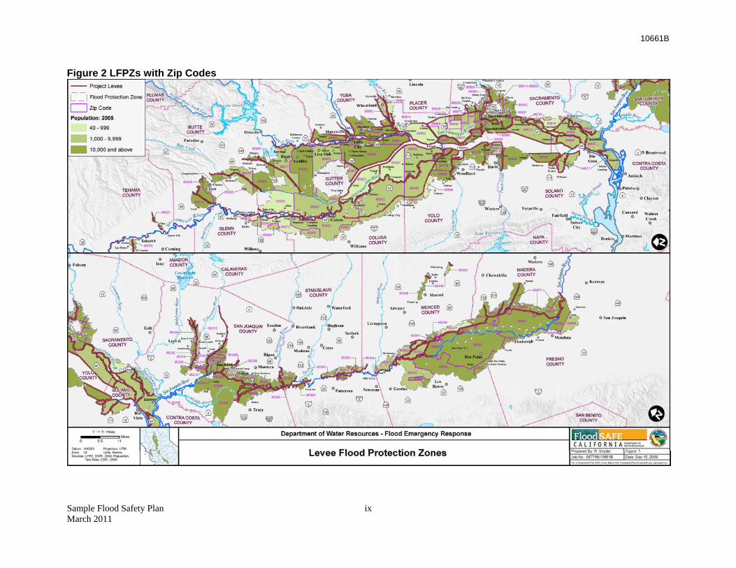
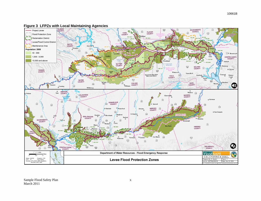
Potential Jurisdictions Affected AB156 required DWR to prepare and maintain maps for Levee Flood Protection Zone (LFPZ) maps. These maps designate lands and locations in the Central Valley where flood levels were estimated to be more than three feet deep if a project levee were to fail. These maps were recently compiled and are available from DWR and can be found on the DWR website: http://www.water.ca.gov/floodmgmt/lrafmo/fmb/fes/levee_protection_zones.cfm.
Using GIS technology, the LFPZ maps were overlaid with zip code boundaries of communities in the area.1 This overlay identified those communities defined by the zip code areas that were shown to be protected by project levees and any with a population greater than 1,000 people were further defined. Incorporated cities, generally meeting the population requirement, were also identified from the zip code layer information as were counties. Besides cities and counties, special flood maintenance districts, such as reclamation districts and LMAs, were also denoted on the GIS layering.2 Those entities that maintain project levees were further denoted.
Figure 1 shows the areas protected by project levees and the approximate depths of the inundation should those levees fail. Project levees, cities, counties, and waterways are also shown. Figure 2 again shows the levee protection zones, but also includes the zip code areas and associated zip codes. The estimated population range (2005) within the zip code area is also noted by color coding. Finally, Figure 3 again presents the protection zones, but the map shows the boundaries of LMAs that provide levee maintenance in the Central Valley. The listing of incorporated cities, counties, and LMAs that may have to comply with the aforementioned WC 9650 requirements was compiled from this information. Cities that were within a mile of a protection zone were also included in the agency list to make sure potential candidate agencies were not overlooked.
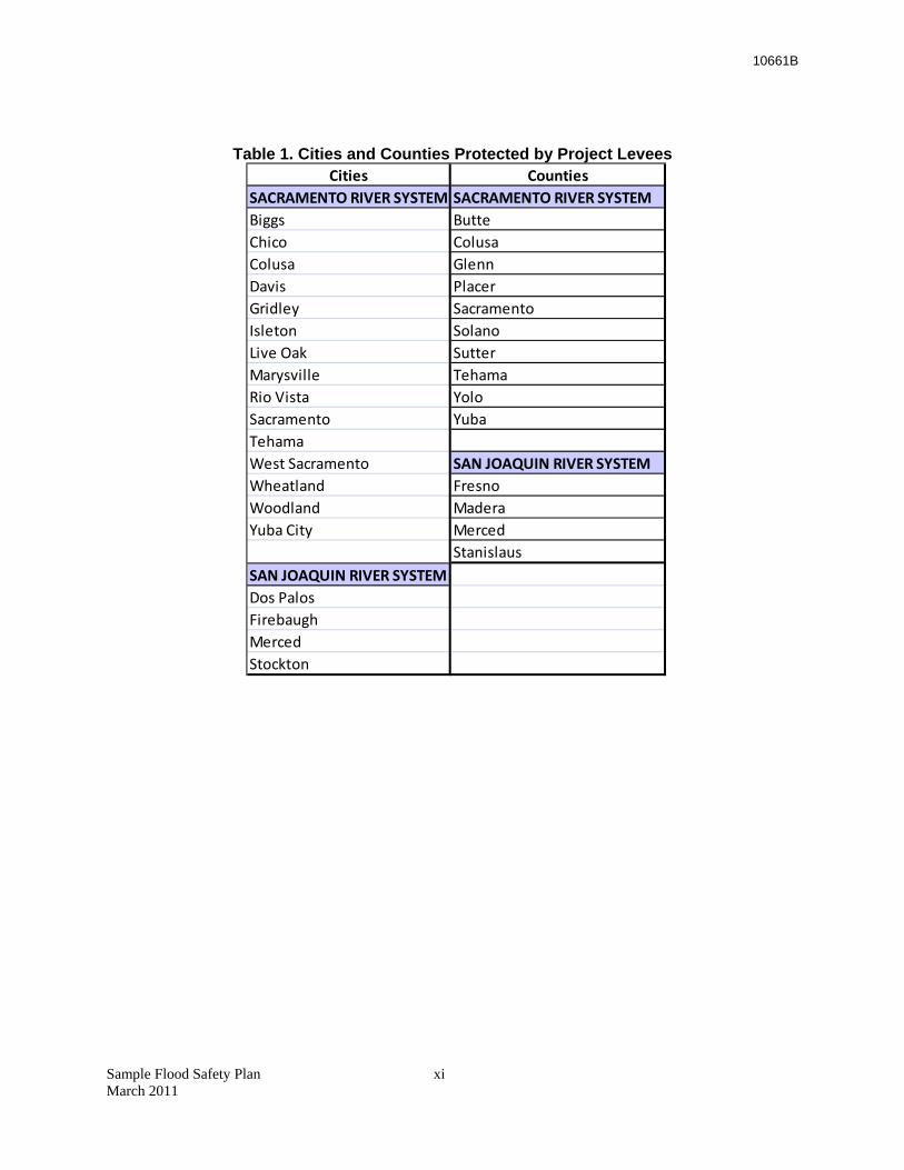
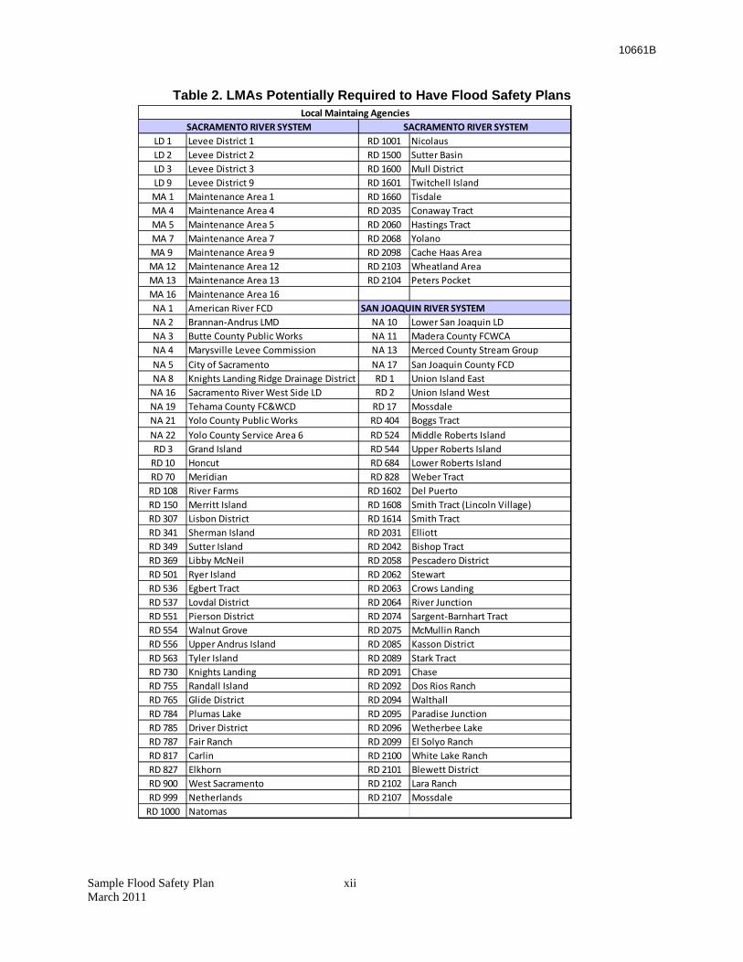
From this analysis, a list of cities and counties protected by project levees and LMAs responsible for maintaining those levees was developed. These LMAs must meet the WC 9650 requirements of submitting Safety Plans. Table 1 lists the cities and counties that are protected by project levees. Table 2 lists LMAs that may have to adopt a Flood Safety Plan to receive State funds to upgrade their levees.
1 The zip code layer was derived from a 2006 ESRI zip code polygon feature class called U.S. Zip Code Areas (Five-Digit); data for 2005 population within each zip code also came from this shapefile. 2 The LMA boundaries are from the most recent (2009) California Levee Database geodatabase submitted by DWR.
10661B
Figure 1 LFPZs with Potential Depth of Flooding
Sample Flood Safety Plan viii March 2011
10661B
Figure 2 LFPZs with Zip Codes
Sample Flood Safety Plan ix March 2011
10661B
Sample Flood Safety Plan x March 2011
Figure 3 LFPZs with Local Maintaining Agencies
10661B
Table 1. Cities and Counties Protected by Project Levees
Cities CountiesSACRAMENTO RIVER SYSTEM SACRAMENTO RIVER SYSTEMBiggs ButteChico ColusaColusa GlennDavis PlacerGridley SacramentoIsleton SolanoLive Oak SutterMarysville TehamaRio Vista YoloSacramento YubaTehamaWest Sacramento SAN JOAQUIN RIVER SYSTEMWheatland FresnoWoodland MaderaYuba City Merced
StanislausSAN JOAQUIN RIVER SYSTEMDos PalosFirebaughMercedStockton
Sample Flood Safety Plan xi March 2011
10661B
Sample Flood Safety Plan xii March 2011
Table 2. LMAs Potentially Required to Have Flood Safety Plans
LD 1 Levee District 1 RD 1001 NicolausLD 2 Levee District 2 RD 1500 Sutter BasinLD 3 Levee District 3 RD 1600 Mull DistrictLD 9 Levee District 9 RD 1601 Twitchell IslandMA 1 Maintenance Area 1 RD 1660 TisdaleMA 4 Maintenance Area 4 RD 2035 Conaway TractMA 5 Maintenance Area 5 RD 2060 Hastings TractMA 7 Maintenance Area 7 RD 2068 YolanoMA 9 Maintenance Area 9 RD 2098 Cache Haas AreaMA 12 Maintenance Area 12 RD 2103 Wheatland AreaMA 13 Maintenance Area 13 RD 2104 Peters PocketMA 16 Maintenance Area 16NA 1 American River FCDNA 2 Brannan‐Andrus LMD NA 10 Lower San Joaquin LDNA 3 Butte County Public Works NA 11 Madera County FCWCANA 4 Marysville Levee Commission NA 13 Merced County Stream GroupNA 5 City of Sacramento NA 17 San Joaquin County FCDNA 8 Knights Landing Ridge Drainage District RD 1 Union Island EastNA 16 Sacramento River West Side LD RD 2 Union Island WestNA 19 Tehama County FC&WCD RD 17 MossdaleNA 21 Yolo County Public Works RD 404 Boggs TractNA 22 Yolo County Service Area 6 RD 524 Middle Roberts IslandRD 3 Grand Island RD 544 Upper Roberts IslandRD 10 Honcut RD 684 Lower Roberts IslandRD 70 Meridian RD 828 Weber TractRD 108 River Farms RD 1602 Del PuertoRD 150 Merritt Island RD 1608 Smith Tract (Lincoln Village)RD 307 Lisbon District RD 1614 Smith TractRD 341 Sherman Island RD 2031 ElliottRD 349 Sutter Island RD 2042 Bishop TractRD 369 Libby McNeil RD 2058 Pescadero DistrictRD 501 Ryer Island RD 2062 StewartRD 536 Egbert Tract RD 2063 Crows LandingRD 537 Lovdal District RD 2064 River JunctionRD 551 Pierson District RD 2074 Sargent‐Barnhart TractRD 554 Walnut Grove RD 2075 McMullin RanchRD 556 Upper Andrus Island RD 2085 Kasson DistrictRD 563 Tyler Island RD 2089 Stark TractRD 730 Knights Landing RD 2091 ChaseRD 755 Randall Island RD 2092 Dos Rios RanchRD 765 Glide District RD 2094 WalthallRD 784 Plumas Lake RD 2095 Paradise JunctionRD 785 Driver District RD 2096 Wetherbee LakeRD 787 Fair Ranch RD 2099 El Solyo RanchRD 817 Carlin RD 2100 White Lake RanchRD 827 Elkhorn RD 2101 Blewett DistrictRD 900 West Sacramento RD 2102 Lara RanchRD 999 Netherlands RD 2107 MossdaleRD 1000 Natomas
SACRAMENTO RIVER SYSTEM
SAN JOAQUIN RIVER SYSTEM
SACRAMENTO RIVER SYSTEMLocal Maintaing Agencies
10661B
Part II: Sample Flood Safety Plan
Sample Flood Safety Plan xiii March 2011

Draft
(Jurisdiction) Flood Safety Plan
(DATE)

10661B
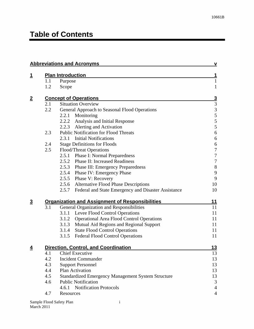
Table of Contents
Abbreviations and Acronyms v
1 Plan Introduction 1 1.1 Purpose 1 1.2 Scope 1
2 Concept of Operations 3 2.1 Situation Overview 3 2.2 General Approach to Seasonal Flood Operations 3
2.2.1 Monitoring 5 2.2.2 Analysis and Initial Response 5 2.2.3 Alerting and Activation 5
2.3 Public Notification for Flood Threats 6 2.3.1 Initial Notifications 6
2.4 Stage Definitions for Floods 6 2.5 Flood/Threat Operations 7
2.5.1 Phase I: Normal Preparedness 7 2.5.2 Phase II: Increased Readiness 7 2.5.3 Phase III: Emergency Preparedness 8 2.5.4 Phase IV: Emergency Phase 9 2.5.5 Phase V: Recovery 9 2.5.6 Alternative Flood Phase Descriptions 10 2.5.7 Federal and State Emergency and Disaster Assistance 10
3 Organization and Assignment of Responsibilities 11 3.1 General Organization and Responsibilities 11
3.1.1 Levee Flood Control Operations 11 3.1.2 Operational Area Flood Control Operations 11 3.1.3 Mutual Aid Regions and Regional Support 11 3.1.4 State Flood Control Operations 11 3.1.5 Federal Flood Control Operations 11
4 Direction, Control, and Coordination 13 4.1 Chief Executive 13 4.2 Incident Commander 13 4.3 Support Personnel 13 4.4 Plan Activation 13 4.5 Standardized Emergency Management System Structure 13 4.6 Public Notification 3
4.6.1 Notification Protocols 4 4.7 Resources 4
Sample Flood Safety Plan i March 2011
10661B
4.7.1 Staffing 4 4.7.2 Integration with Police, Fire Responders 4 4.7.3 Getting and Training Volunteers 4 4.7.4 Cal EMA and DWR Assistance 5
4.8 Disaster Intelligence 5 4.8.1 Information Needed and Resources 5
4.9 Essential Services 6
5 Communications 8 5.1 Communications Organization 8 5.2 Public Alerting Systems 8
5.2.1 Emergency Alert System (EAS) 8 5.2.2 Emergency Digital Information Service (EDIS) 8
5.3 Local Radio Systems 9 5.3.1 Radios 9 5.3.2 Consolidated Public Safety Communications System (CPSCS) 9 5.3.3 Local Communications Support Resources 9 5.3.4 Telephone Systems 10 5.3.5 Weak Links 11
5.4 Protocols for Contacting Levee Patrols 11 5.4.1 Other Communications Protocols 11
5.5 Integration and Interoperability 11 5.6 Media Interface 12
6 Administration, Finance, and Logistics 14 6.1 Master Mutual Aid Agreement 14 6.2 Record Keeping 14 6.3 Resource Tracking 14 6.4 Stockpiles – Location and Access 15 6.5 Staging Areas 15 6.6 Evacuation Centers 15 6.7 Equipment 16
7 Plan Development and Maintenance 18 7.1 Plan Development 18 7.2 Plan Review and Maintenance 18 7.3 Training and Exercises 19 7.4 Evaluation 19
8 Authorities and References 20 8.1 Federal 20 8.2 State 20 8.3 Local 20
Appendix A Communications Support 22 A.1 Communications Support 22
Sample Flood Safety Plan ii March 2011
10661B
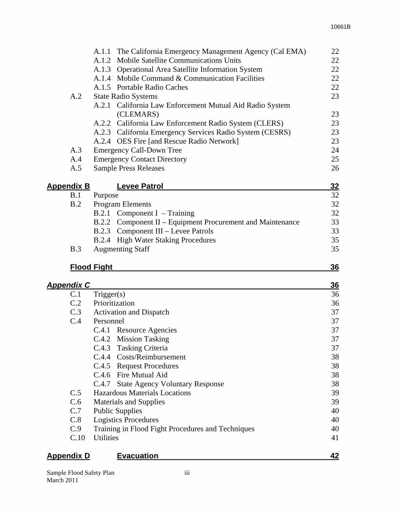
A.1.1 The California Emergency Management Agency (Cal EMA) 22 A.1.2 Mobile Satellite Communications Units 22 A.1.3 Operational Area Satellite Information System 22 A.1.4 Mobile Command & Communication Facilities 22 A.1.5 Portable Radio Caches 22
A.2 State Radio Systems 23 A.2.1 California Law Enforcement Mutual Aid Radio System
(CLEMARS) 23 A.2.2 California Law Enforcement Radio System (CLERS) 23 A.2.3 California Emergency Services Radio System (CESRS) 23 A.2.4 OES Fire [and Rescue Radio Network] 23
A.3 Emergency Call-Down Tree 24 A.4 Emergency Contact Directory 25 A.5 Sample Press Releases 26
Appendix B Levee Patrol 32 B.1 Purpose 32 B.2 Program Elements 32
B.2.1 Component I – Training 32 B.2.2 Component II – Equipment Procurement and Maintenance 33 B.2.3 Component III – Levee Patrols 33 B.2.4 High Water Staking Procedures 35
B.3 Augmenting Staff 35
Flood Fight 36
Appendix C 36 C.1 Trigger(s) 36 C.2 Prioritization 36 C.3 Activation and Dispatch 37 C.4 Personnel 37
C.4.1 Resource Agencies 37 C.4.2 Mission Tasking 37 C.4.3 Tasking Criteria 37 C.4.4 Costs/Reimbursement 38 C.4.5 Request Procedures 38 C.4.6 Fire Mutual Aid 38 C.4.7 State Agency Voluntary Response 38
C.5 Hazardous Materials Locations 39 C.6 Materials and Supplies 39 C.7 Public Supplies 40 C.8 Logistics Procedures 40 C.9 Training in Flood Fight Procedures and Techniques 40 C.10 Utilities 41
Appendix D Evacuation 42
Sample Flood Safety Plan iii March 2011
10661B
Sample Flood Safety Plan iv March 2011
D.1 Considerations 42 D.2 Public Notification 42
D.2.1 Emergency Siren System 43 D.2.2 Emergency Alert System 43 D.2.3 Reverse 9-1-1 43 D.2.4 Vehicle Loudspeaker Systems 44
D.3 Operations 44 D.4 Maps 44
Appendix E Flood Water Removal 48 E.1 Priorities 48
E.1.1 Alternative 1 – No Immediate Dewatering Needed 48 E.1.2 Alternative 2 – Close Breach; No Water Removal 48 E.1.3 Alternative 3 – Repair Breach and Remove Water by Pumping 49 E.1.4 Alternative 4 – Repair Breach and Remove Water by Making a
Relief Cut 49 E.1.5 Environmental Considerations 49
E.2 Contractors and Vendors 49
10661B
Abbreviations and Acronyms
Cal EMA California Emergency Management Agency
Cal Fire California Department of Forestry and Fire Protection
Cal OSHA California Division of Occupational Safety and Health
CB Citizens’ Band
CCC California Conservation Corps
CDEC California Data Exchange Center
CERT Community Emergency Response Team
CESRS California Emergency Services Radio System
CLEMARS California Law Enforcement Mutual Aid Radio System
CLERS California Law Enforcement Radio System
CNG California National Guard
CNRFC California-Nevada River Forecast Center
CPSCS Consolidated Public Safety Communications System
DWR California Department of Water Resources
EAS Emergency Alert System
EDIS Emergency Digital Information Service
EMS Emergency Management System
EOC Emergency Operations Center
FCC Federal Communications Commission
FEMA Federal Emergency Management Agency
FOC Flood Operations Center
FSP Flood Safety Plan
GPS Global Positioning System
IC Incident Commander
ICP Incident Command Post
ICS Incident Command System
JIC Joint Information Center
Sample Flood Safety Plan v March 2011
10661B
Sample Flood Safety Plan vi March 2011
LMA Local Maintaining Agency
MECU Mobile Emergency Coordination Unit
NWS National Weather Service
OA Operational Area (County)
OASIS Operational Area Satellite Information System
OES Office of Emergency Services
PIO Public Information Officer
PL 84-99 Public Law No. 84-99 (1984) gives the Corps of Engineers authority for emergency management activities.
PSAP Public Safety Answering Point
RACES Radio Amateurs Civil Emergency Services
RD Reclamation District
REOC Cal EMA’s Regional Emergency Operations Center
RIMS Response Information Management System
SEMS Standardized Emergency Management System
SOC Cal EMA’s State Operations Center
USACE U.S. Army Corps of Engineers
USBR U.S. Bureau of Reclamation
10661B
1 Plan Introduction
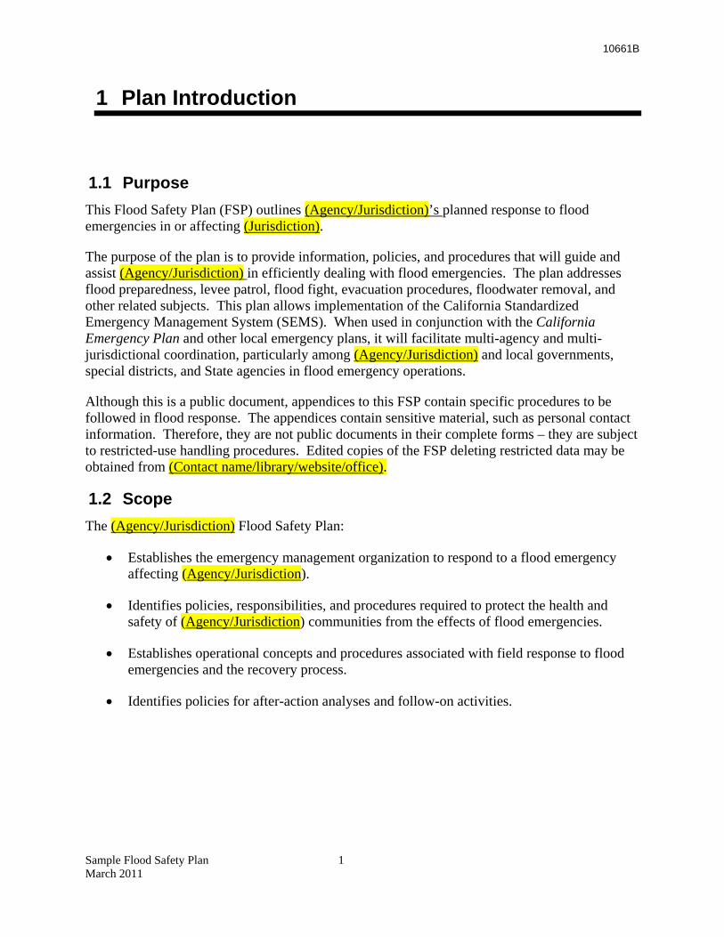
1.1 Purpose This Flood Safety Plan (FSP) outlines (Agency/Jurisdiction)’s planned response to flood emergencies in or affecting (Jurisdiction).
The purpose of the plan is to provide information, policies, and procedures that will guide and assist (Agency/Jurisdiction) in efficiently dealing with flood emergencies. The plan addresses flood preparedness, levee patrol, flood fight, evacuation procedures, floodwater removal, and other related subjects. This plan allows implementation of the California Standardized Emergency Management System (SEMS). When used in conjunction with the California Emergency Plan and other local emergency plans, it will facilitate multi-agency and multi-jurisdictional coordination, particularly among (Agency/Jurisdiction) and local governments, special districts, and State agencies in flood emergency operations.
Although this is a public document, appendices to this FSP contain specific procedures to be followed in flood response. The appendices contain sensitive material, such as personal contact information. Therefore, they are not public documents in their complete forms – they are subject to restricted-use handling procedures. Edited copies of the FSP deleting restricted data may be obtained from (Contact name/library/website/office).
1.2 Scope The (Agency/Jurisdiction) Flood Safety Plan:
• Establishes the emergency management organization to respond to a flood emergency affecting (Agency/Jurisdiction).
• Identifies policies, responsibilities, and procedures required to protect the health and safety of (Agency/Jurisdiction) communities from the effects of flood emergencies.
• Establishes operational concepts and procedures associated with field response to flood emergencies and the recovery process.
• Identifies policies for after-action analyses and follow-on activities.
Sample Flood Safety Plan 1 March 2011

10661B
Sample Flood Safety Plan 2 March 2011
10661B
2 Concept of Operations
2.1 Situation Overview (Agency/Jurisdiction) is located in the Sacramento-San Joaquin Valley. Areas adjacent to rivers, sloughs, creeks, and drainage canals and other low-lying areas are subject to flooding. State and local protective facilities, such as dams, bypasses, and levees, afford a level of flood protection; however, the flood events of 1986, 1995, 1997, and 1998 demonstrated that there is still a significant flood threat in the valley.
(Jurisdiction) is vulnerable to a number of flooding sources caused by river floods, levee failures, drainage pump failure, and dam failure. These may produce large losses to public infrastructure and private property. Deep flooding caused by levee failure or overtopping remains a significant threat to valley locations.
{{NOTE: Agency should expand on location and details of potential flooding threats for the jurisdiction here.}}
2.2 General Approach to Seasonal Flood Operations (Agency/Jurisdiction) is responsible for the following levee segments, drainage facilities, and flood control structures.
Facility Name River/Stream Location
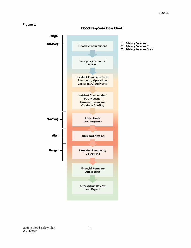
Flood response levels for (Agency/Jurisdiction) will be based on river stage for (Name) River at (Name) gage. Not all flooding in the jurisdiction may be based on river stage. Therefore, for (Jurisdiction), additional flood prone areas will be based on specific criteria developed for those areas. [list areas and criteria here] The following diagram shows in general how resources are mobilized and various actions initiated as a function of river stage or other criteria. This section defines the specific level of commitment by (Jurisdiction) for specific triggers.
Sample Flood Safety Plan 3 March 2011
10661B
Figure 1
Sample Flood Safety Plan 4 March 2011
10661B
2.2.1 Monitoring
(Jurisdiction’s) flood stage monitoring is comprised of observing the readings from specific real-time, telemetered stream gages that report the conditions on water courses that affect potential flooding in the jurisdiction. For each gage location on a stream or water course, stages or flows have been categorized into three levels: monitoring stage, danger stage, or flood stage.
The real-time gages can be accessed through the internet through the California Data Exchange Center (CDEC) within the California Department of Water Resources website (www.water.ca.gov). CDEC includes links to the National Weather Service and links to satellite photos. CDEC provides information on all of the California rivers and reservoirs. This allows direct monitoring of outflows at key dams affecting (Jurisdiction). The following dams may affect (Jurisdiction): (list dams, reservoirs).
[Critical gages may also be accessed on the Internet at ___________ for (Jurisdiction)]
2.2.2 Analysis and Initial Response
After compiling monitoring and surveillance information, the (Jurisdiction) decides if it is necessary to begin flood operations or direct flood fight resources to specific areas where flooding is occurring or may occur soon. (Jurisdiction) emergency personnel also monitor the flood stage information or monitoring system and are in constant communication with flood control staff throughout the storm episode.
Local Maintaining Agencies (LMAs) begin levee patrols to monitor these conditions when triggering events occur.
2.2.2.1 Patrol Trigger
“A” District begins levee patrols when the elevation reaches (#) ft at (location) on the (name) River.
The “B” District patrols on two levees on the (Name) River just downstream from the A levees patrols when the elevation reaches (#) ft at (location) on the (Name) River. If patrols observe boils or slumping down on levees, B District will begin flood fight preparations.
If conditions exceed their capabilities on any of the levee systems, the LMAs will call the (Agency/ Jurisdiction) or DWR for technical assistance. If conditions continue to worsen, LMAs may contact (Name county) for mutual aid resources. The DWR Flood Operations Center (FOC) may request support from the U.S. Army Corps of Engineers (USACE) under PL 84-99.
2.2.3 Alerting and Activation
As coordinated operations continue, local jurisdictions will brief their administrators. These positions often serve as the Directors for Emergency Operations at the Emergency Operations Center (EOC). Depending on the flooding situation, the EOC will be activated and staff will respond to the EOC to coordinate operational area response to the disaster with other agencies.
Sample Flood Safety Plan 5 March 2011
10661B
The DWR FOC may also be made operational. County EOCs remain operational until the threat from flooding is contained and controlled.
2.3 Public Notification for Flood Threats 2.3.1 Initial Notifications
Initial notification is often limited in detail. For example, a flash flood warning may be issued by the National Weather Service (NWS) for a general area or location where there is a threat to the public. Some emergency actions might be needed, but not enough to warrant EOC activation. A follow-up call from the EOC to the notifying party or agency can be made to obtain further detail.
• A flash flood watch means it is possible that rain may cause flash flooding in specified areas.
• A flash flood warning means flash flooding is highly likely, imminent, or is occurring.
• A flood watch means long-term flooding is possible in specified areas.
• A flood warning means long-term flooding is either imminent or is occurring.
The local Emergency Office or EOC may receive direct warning from DWR, NWS, or the California Emergency Management Agency (Cal EMA). The U.S. Bureau of Reclamation (USBR), USACE, or other agency that locally controls dams will advise of dam incidents, significant releases, or significant changes in releases. The county is responsible for warnings in unincorporated areas. Various incorporated areas have responsibility for evacuation notification of the public within their boundaries. They are also responsible for activating their own emergency response plans for the flooding threat.
2.4 Stage Definitions for Floods The following information describes the preparedness activities and flood watch operations used by the (Agency/Jurisdiction).
In riverine flooding, river stages generally dictate the phase.
PHASE I: Normal Preparedness (Routine Activities)
-- at or below river advisory stage: El ____’
PHASE II: Increased Readiness (Monitor/Preliminary action)
-- river warning stage: El ____’
PHASE III: Emergency Preparedness -- river flood stage: El ____’
PHASE IV: Emergency Phase -- river danger stage: El ____’
PHASE V: Recovery
Sample Flood Safety Plan 6 March 2011
10661B
In (name other type) flooding, (rainfall, creek stage, or other) generally dictates the phase. (Describe Phase and stage as necessary:)
PHASE I: Normal Preparedness (routine activities)
-- (rainfall, creek stage, or other) stage
PHASE II: Increased Readiness (monitor/preliminary action)
-- (rainfall, creek stage, or other) stage
PHASE III: Emergency Preparedness -- (rainfall, creek stage, or other) stage
PHASE IV: Emergency Phase -- (rainfall, creek stage, or other) stage
PHASE V: Recovery
2.5 Flood/Threat Operations Some floods will be preceded by a buildup period, providing advance warning to those who might be affected. Others occur without advance warning, requiring mobilization and commitment of the emergency organization after the onset of the emergency situation. (Agency/Jurisdiction) must be prepared to respond promptly and efficiently. In all flood situations, this plan will be implemented in several phases. In the case of slow rise flood threats, the phases are initiated based on various river elevations.
2.5.1 Phase I: Normal Preparedness
Departments having emergency responsibilities assigned in this FSP prepare service support plans, operating procedures, and checklists detailing the use and disposition of their resources in an emergency. Such plans and procedures include coordination and communication lines with counterpart organizations of other departments and jurisdictions.
During this Phase, Flood Fight Training is generally given. (Agency/Jurisdiction) conducts pre-season coordination and plans review meeting with (nearby Jurisdictions.)
The procedure checklist shall be reviewed periodically and updated where necessary. River advisory stages would fall under this phase. The river advisory stage occurs when the elevation of the (Name) River is at or below (#) feet at (location).
2.5.2 Phase II: Increased Readiness
This phase begins with monitoring when conditions exist that could result in a flood, such as continuing and excessive rainfall, an unusually rapid snowmelt, or rising rivers.
The river warning stage would trigger Phase II (monitor/initial action). The river warning stage is initiated when the elevation of the (Name) River reaches (#) feet at (location).
Sample Flood Safety Plan 7 March 2011
10661B
As this situation develops, the Chief Executive of (Agency/Jurisdiction), or a designee, will evaluate information, decide upon necessary action, and initiate appropriate response. Generally this means to put the emergency response plan into limited operation. This includes alerting key personnel, ensuring readiness of essential resources, and preparing to move resources to the threatened area when required. (Agency/Jurisdiction) will coordinate with the following EOCs (if operational).
(Agency/Jurisdiction) EOC goes into operation. The extent of staffing is event-driven and at the discretion of the EOC Director.
The EOC monitors communications, receives information on field situations, weather, river, and reservoir stages, directs response, coordinates with adjacent and local agencies, provides and coordinates resources and assets, provides information, arranges for State, federal, and volunteer resources, activates mutual aid from adjacent agencies, and plans, organizes, controls, and documents actions during the flood event.
State and federal actions in this phase include the following: DWR FOC monitors flooding situations on a daily operational schedule. If LMAs begin to encounter extensive problems, the FOC extends hours to 24-hour operations and increases coordination efforts for State support of flood fight operations. Typically the Cal EMA State Operations Center (SOC) and the Cal EMA Regional Operations Center for the Inland Region (REOC), the FOC, and the Dam Management Center operated by USACE are all activated to some degree as flood threats increase. Adjacent counties and cities decide when and at what level they will activate their EOCs.
2.5.3 Phase III: Emergency Preparedness
This phase begins when an evaluation of the situation indicates it is a matter of “when” rather than “if” emergency conditions will exist. The river flood stage would exist under this phase. The river flood stage starts when the (Name) River reaches (#) feet at (location).
The Chief Executive of (Agency/Jurisdiction), or a designee, will immediately put emergency plans into full operation and conduct operations as follows:
• Advise responders to activate resources and advise the County Office of Emergency Services.
• Where resources appear insufficient, prepare to apply for and receive mutual aid. • Contact the Office of Emergency Services to give available information as to the kind of
threat, its imminence, potential severity, area affected, and associated problems. Reports will include action being planned or taken, as well as possible deficiencies in critical emergency resources.
• Should the possible or expected emergency develop, ensure that ALL alerted agencies are promptly notified of this new change in conditions. This may also prompt immediate public notification, as is required by the nature of the threat.
• Recommend that the EOC be opened when projections clearly indicate a potential need for EOC multi-agency coordination.
Sample Flood Safety Plan 8 March 2011
10661B
2.5.4 Phase IV: Emergency Phase
This phase can be initiated by a river danger stage of: (Name) River reaches (#) feet at (location) or upon occurrence of a flood emergency requiring extraordinary effort. The nature of response operations is dependent upon the characteristics and requirements of the situation. The emergency organization will be mobilized to cope with the specific situation. Each service, when mobilized, will operate according to the provisions of this FSP. Priority will be given to operations such as the following:
• Survey and evaluate the emergency situation and advise the (Agency/Jurisdiction) EOC and FOC
• Have the EOC immediately notify the (Chief Executive) of (Agency/Jurisdiction) • Mobilize, allocate, and position personnel and materials for patrolling and flood fight • Establish staging areas for personnel, supplies, and equipment • Establish Evacuation Centers to aid in managing the movement of people from the area • Produce and disseminate emergency information and advice to other EOCs when a Joint
Information Center is not operational • Protect, control, and allocate vital resources • Restore or activate essential facilities and systems
All the preceding actions are based on extensive local coordination of plans and response. In addition, there are daily briefings at the FOC involving all parties. When local resources are committed to the maximum and additional materials/personnel are required to control or alleviate the emergency, requests for mutual aid will be initiated through the county EOC.
2.5.5 Phase V: Recovery
(Agency/Jurisdiction) will address identified recovery needs. Governmental assistance could be required for an extended period. Recovery activities would include:
• Removal of debris • Clearance of roadways • Demolition of unsafe structures • Re-establishment of public services and utilities • Provision of care and welfare for the affected population including temporary housing for
displaced persons • Care of animals and disposal of carcasses
This stage has three major objectives:
• Reinstatement of family autonomy and the provision of essential public services • Permanent restoration of public property along with reinstatement of public services • Performance of research to uncover residual hazards, to advance knowledge of disaster
phenomena, and to provide information to improve future flood operations
Sample Flood Safety Plan 9 March 2011
10661B
2.5.6 Alternative Flood Phase Descriptions
{{NOTE: A jurisdiction may choose to employ alternative flood emergency response phases to help manage the flood emergency for their particular situation. For example, in the following list, Phase I, Normal Preparedness and elements of Phase II, Increased Readiness, have been combined into one phase, Preparedness, to reduce the number of management phases to four:
1. Preparedness
2. Increased Readiness
3. Activation
4. Initial Recovery
A jurisdiction may also choose to name the phases in a different way, depending upon their preferences or situations.
Alternative phasing or phase naming can be employed as long as each phase is defined in the plan with specific triggers and complementary actions and delegated responsibilities for each level.}}
2.5.7 Federal and State Emergency and Disaster Assistance
State and federal support during the Emergency Phase:
• (Agency/Jurisdiction) will consider requesting Cal EMA and DWR support during the Emergency Phase. California Mutual Aid and USACE assistance are available when resources beyond local capability are needed for flood fight operations.
Emergency Phase support following flooding:
• If the County declares a disaster, the Governor may support it by proclaiming a State of Emergency and then requesting the President make a National Disaster declaration for the affected area.
• If the President declares the area a national disaster, assistance from the Federal Emergency Management Agency (FEMA) will be requested.
• If residential flooding occurs, regardless of the declaration, USACE can provide federal funds for recovery operations for up to 30 days following the incident.
• USACE assistance can also be requested to repair eroded and damaged levees following high flows. Request for this authority must be made in a timely manner (30 days).
Sample Flood Safety Plan 10 March 2011
10661B
3 Organization and Assignment of Responsibilities
3.1 General Organization and Responsibilities 3.1.1 Levee Flood Control Operations
The (Name reclamation district/local maintaining area) exists within the (Name) County unincorporated area and has responsibility for the levees within its jurisdiction. The district has a (Engineer/contracted firm) to help with flood fight responsibilities during flood emergencies. The (Name district) can request mutual aid and coordinates with the (Name) County Operational Area during flooding episodes.
3.1.2 Operational Area Flood Control Operations
The (Name) County Operational Area Flood Operations are coordinated through its EOC. The EOC ensures proper communication and coordination among all entities responding to the flood.
3.1.3 Mutual Aid Regions and Regional Support
Mutual Aid requests go to the Inland Region REOC and then are passed to other counties in the region. (Other counties will only supply what they can without endangering their own response capability.) The REOC may then request resources from the SOC, DWR, and USACE.
3.1.4 State Flood Control Operations
DWR is responsible for State flood control operations through its FOC, Division of Flood Management, other divisions, and their flood management and flood fight technical experts. DWR coordinates with USACE, USBR, and other agencies. DWR also operates CDEC, which monitors rainfall, stream flow, river stages, and reservoir releases across the State. DWR will work with other State agencies as needed during flood emergencies.
3.1.5 Federal Flood Control Operations
The USACE and the USBR have responsibilities for federal flood activities in California. The USACE has a major responsibility for overseeing reservoir releases and supporting the State’s effort in maintaining the levees and structures associated with the State Plan of Flood Control. The USACE can support emergency work as requested by the State under Public Law 84-99, which includes levee flood fighting. The USBR has responsibility for their dam releases and reservoir operations.
Sample Flood Safety Plan 11 March 2011

10661B
Sample Flood Safety Plan 12 March 2011
10661B
Sample Flood Safety Plan 13 March 2011
4 Direction, Control, and Coordination
4.1 Chief Executive The (Chief Executive) of (Agency/Jurisdiction) establishes overall policies and priorities, providing direction for local flood response. Responsibility for managing emergency response within these policies and priorities is delegated to the EOC Manager and, on scene, to the Incident Commander (IC), who reports to the EOC Manager. The EOC supports Incident Response by supplying resources, equipment, and supplies. Where supplies are limited, the EOC establishes priorities for allocation.
4.2 Incident Commander The IC at the flood fight scene is in charge of all resources responding to that emergency site. The IC may assign missions to flood fight crews acquired under Mutual Aid from other governmental agencies, tasking them to perform specific tasks to facilitate the response. Based on these missions, the crews’ normal supervisors will direct State and federal crews.
4.3 Support Personnel Flood fight crews responding from other areas pursuant to mutual aid – and contractors hired to undertake repairs – receive work assignments from the organization that requested or hired them. Organized crews will work under the immediate control of their own supervisors in response to missions assigned by the IC.
4.4 Plan Activation (Names and Titles) have authority to activate this plan based on the previously identified stages.
4.5 Standardized Emergency Management System Structure Under SEMS, common structure and terminology combine to ensure smoother communication and better coordination of interjurisdiction and interagency response to flood emergencies. The five sections below have uniform responsibilities throughout California – whether the governmental level is a special district, city, county, or the State.
• Command Staff • Operations • Planning and Intelligence • Logistics • Finance and Administration
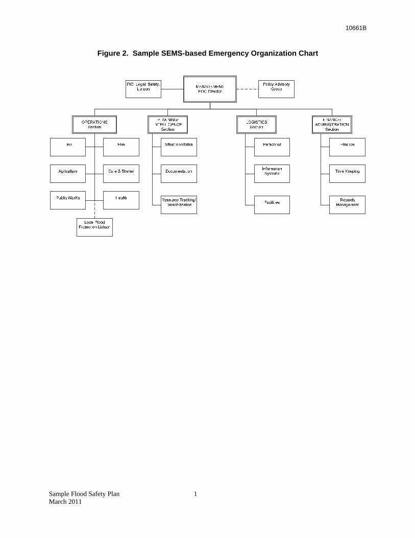
10661B
Figure 2. Sample SEMS-based Emergency Organization Chart
Sample Flood Safety Plan 1 March 2011
10661B
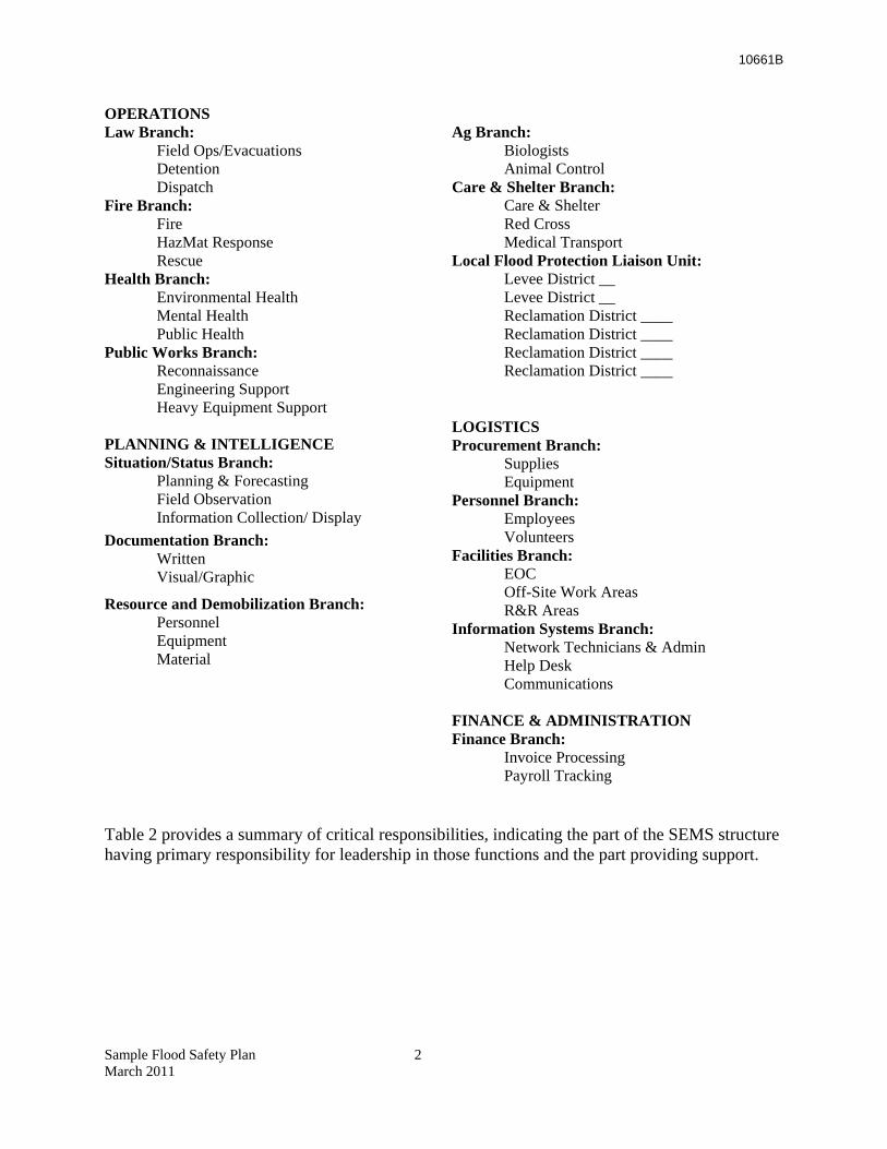
OPERATIONS Law Branch:
Field Ops/Evacuations Detention Dispatch
Fire Branch: Fire HazMat Response Rescue
Health Branch: Environmental Health Mental Health Public Health
Public Works Branch: Reconnaissance Engineering Support Heavy Equipment Support
PLANNING & INTELLIGENCE Situation/Status Branch:
Planning & Forecasting Field Observation Information Collection/ Display
Documentation Branch: Written Visual/Graphic
Resource and Demobilization Branch: Personnel Equipment Material
Ag Branch:
Biologists Animal Control
Care & Shelter Branch: Care & Shelter Red Cross Medical Transport
Local Flood Protection Liaison Unit: Levee District __ Levee District __ Reclamation District ____ Reclamation District ____ Reclamation District ____ Reclamation District ____
LOGISTICS Procurement Branch:
Supplies Equipment
Personnel Branch: Employees Volunteers
Facilities Branch: EOC Off-Site Work Areas R&R Areas
Information Systems Branch: Network Technicians & Admin Help Desk Communications
FINANCE & ADMINISTRATION Finance Branch:
Invoice Processing Payroll Tracking
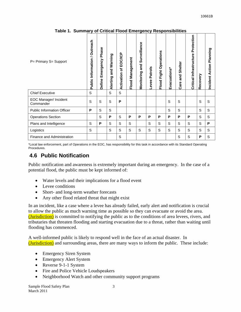
Table 2 provides a summary of critical responsibilities, indicating the part of the SEMS structure having primary responsibility for leadership in those functions and the part providing support.
Sample Flood Safety Plan 2 March 2011
10661B
Table 1. Summary of Critical Flood Emergency Responsibilities
P= Primary S= Support
Publ
ic In
form
atio
n / O
utre
ach
Def
ine
Emer
genc
y Ph
ase
Ale
rtin
g an
d W
arni
ng
Act
ivat
ion
of E
OC
/ICP
Floo
d M
anag
emen
t
Mon
itorin
g an
d Su
rvei
llanc
e
Leve
e Pa
trol
s
Floo
d Fi
ght O
pera
tions
Evac
uatio
ns*
Car
e an
d Sh
elte
r
Crit
ical
Infr
astr
uctu
re P
rote
ctio
n
Rec
over
y
Inci
dent
Act
ion
Plan
ning
Chief Executive S S S
EOC Manager/ Incident Commander S S S P
S S
S S
Public Information Officer P S S S S S S
Operations Section S P S P P P P P P P S S
Plans and Intelligence S P S S S S S S S S S P
Logistics S S S S S S S S S S S S
Finance and Administration S S S P S
*Local law enforcement, part of Operations in the EOC, has responsibility for this task in accordance with its Standard Operating Procedures.
4.6 Public Notification Public notification and awareness is extremely important during an emergency. In the case of a potential flood, the public must be kept informed of:
• Water levels and their implications for a flood event • Levee conditions • Short- and long-term weather forecasts • Any other flood related threat that might exist
In an incident, like a case where a levee has already failed, early alert and notification is crucial to allow the public as much warning time as possible so they can evacuate or avoid the area. (Jurisdiction) is committed to notifying the public as to the conditions of area levees, rivers, and tributaries that threaten flooding and starting evacuation due to a threat, rather than waiting until flooding has commenced.
A well-informed public is likely to respond well in the face of an actual disaster. In (Jurisdiction) and surrounding areas, there are many ways to inform the public. These include:
• Emergency Siren System • Emergency Alert System • Reverse 9-1-1 System • Fire and Police Vehicle Loudspeakers • Neighborhood Watch and other community support programs
Sample Flood Safety Plan 3 March 2011
10661B
• The (Jurisdiction) Operator and “311” system for the public to call for more information. {{NOTE: Select those that are applicable.}}
4.6.1 Notification Protocols
The Public Notification System is activated by the (Chief Executive of Jurisdiction) to provide public instructions to local TV and radio stations before activating sirens. All media outlets must be notified of the emergency such that they are providing public alert announcements. The actual verbal or written messages that will be given – whether through the media or other messaging systems – are the responsibility of the Public Information Officer, the EOC, and the Joint Information Center when it is open. Sample notices are contained in Part III, References and Supporting Documents. In case of an evacuation, the (Agency/Jurisdiction) will notify the area’s special needs care providers of the emergency. These providers will be asked to notify their clients in the affected area and give instructions to their clients. {{NOTE: Service providers will need ongoing training that the (Agency/Jurisdiction) would provide as to how this evacuation coordination will occur, and as to how combined resources can work together to effect a successful evacuation of the special needs clients. Currently, only some of the service providers are prepared to offer this notification support, or may only provide client notification during work hours.}}
4.7 Resources 4.7.1 Staffing
(Agency/Jurisdiction) employs staff that functions as emergency responders. Additional flood emergency response staffing comes from other (Agency/Jurisdiction) employees.
4.7.2 Integration with Police, Fire Responders
SEMS creates a set of personnel, policies, procedures, facilities, and equipment that is integrated into a common organizational structure designed to improve emergency response operations of all types and complexities. SEMS creates a flexible, scalable response organization providing a common framework within which people can work together effectively. These people may be drawn from multiple agencies that do not routinely work together. So, SEMS provides standard response and operation procedures to reduce problems and potential miscommunications on such incidents.
4.7.3 Getting and Training Volunteers
One of the most import aspects of flood response in (Agency/Jurisdiction) is the myriad of government and non-government agencies and organizations and local businesses that partner with (Agency/Jurisdiction). The volunteer groups provide critical personnel and resources.
(Agency/Jurisdiction) maintains a Community Emergency Response Team (CERT) Program. CERT educates people about disaster preparedness for hazards that may affect their area and trains them in basic disaster response skills. Using the training learned in the classroom and during exercises, CERT members assist others in their neighborhood or workplace during an event when professional responders are not immediately available to help. CERT members also Sample Flood Safety Plan 4 March 2011
10661B
support emergency response agencies by taking a more active role in emergency preparedness projects in their community. (Agency/Jurisdiction) has registered all CERT members as Disaster Service Workers.
4.7.4 Cal EMA and DWR Assistance
During emergency response to flooding or storms (Agency/Jurisdiction) may require assistance in performing sand bagging, emergency debris clearance, and similar activities to save lives and protect public safety. These activities often require the use of trained crews to augment local personnel. In accordance with SEMS, once local resources are depleted or reasonably committed, mutual aid is accessed and coordinated within the Operational Area (OA). If (Name) County OA resources are not sufficient or timely, then the request is forwarded to the REOC. The REOC evaluates and fills requests by coordinating mutual aid from unaffected OAs, tasking a State agency, or accessing federal assistance. Due to the nature of the need and the resource, requests for crews are usually tasked to a State agency. Details of acquiring additional resources are contained in Appendix C.
4.8 Disaster Intelligence Disaster intelligence means the tools and techniques (Agency/Jurisdiction) used to identify, collect, analyze, and disseminate information on the current and future extent and consequences of the flood.
4.8.1 Information Needed and Resources
4.8.1.1 Weather Forecast
The advent of satellite imagery and sophisticated computer models has significantly improved the ability to forecast times and intensities of rainfall. Managing flood response requires knowledge and understanding of the implications of weather predictions for other parts of the watershed as well as the local area. The National Weather Service provides daily briefings on upcoming weather as part of its role in the DWR FOC. (Agency/Jurisdiction) participates in these briefings starting at the River Advisory stage.
4.8.1.2 River Forecast
In addition to precipitation forecasts, the emergency manager also must know how resulting runoff will affect reservoir storage, releases from dams, and ultimately the amount of water flowing in the river. Hydrologists for DWR work with the National Weather Service in the California-Nevada River Forecast Center (CNRFC) to provide twice daily forecasts of river height at various points. These forecasts are issued as “River Bulletins” and (Agency /Jurisdiction) subscribes to DWR’s email distribution system. In addition, (Agency/Jurisdiction) regularly reviews the website of the CDEC, which provides data on reservoirs, rivers, and rainfall. (http://cdec.water.ca.gov/)
More specifically, CDEC provides information on precipitation, river forecasts, river stages, snowfall, and reservoir storage. The information is presented as tables, but is also available in graphical format that compares current conditions to historical data.
Sample Flood Safety Plan 5 March 2011
10661B
4.8.1.3 Flood-Related Events, such as Levee Slumps or Boils
As important as it is to anticipate the potential situation, it is equally as vital to be aware of current conditions and sudden shifts in those conditions. (Agency/Jurisdiction) maintains regular contact with Levee Patrols and other field responders. This ensures it quickly learns of any changes in the situation, facilitating prompt response.
4.8.1.4 Traffic Information
Similarly, (Agency/Jurisdiction) maintains regular contact with Law Enforcement, County Department of Transportation, Caltrans, and others to ensure situational awareness of traffic issues. Reports from (Department) apprise emergency managers of flooded intersections due to storm drains being stopped up.
4.8.1.5 Maps of Staging Areas and Stockpiles
(Agency/Jurisdiction) has tasked the Administration/Finance Branch with maintaining its inventory of flood response materials and supplies at their locations. Details are contained in Section 9.
4.9 Essential Services If the inhabitants are expected to be essential service providers, it is the policy of Agency/Jurisdiction that new buildings shall be required to be located outside an area that may be flooded in the event of any levee failure or they will be designed to be operable shortly after the floodwater is removed. They shall be constructed to minimize and resist flood hazards, either through location outside likely flooded areas or through design. It is also the policy of Agency/Jurisdiction that the structural systems and details set forth in working drawings and specifications are carefully reviewed by local responsible agencies using qualified personnel, and that the construction process is carefully and completely inspected.
It is further the policy of Agency/Jurisdiction that the nonstructural components vital to the operation of essential services buildings shall also be able to resist, insofar as practical, the effects of flooding. Agency/Jurisdiction recognizes that certain nonstructural components housed in essential services buildings, including, but not limited to, communications systems, main transformers and switching equipment, and emergency backup systems, are essential to facility operations and that these nonstructural components should be given adequate consideration during the design and construction process to assure, insofar as practical, continued operation of the building after a flood.
“Essential Services Building” means any building used (or designed to be used), or any building that a portion of which is used (or designed to be used), as a hospital, fire station, police station, or jail. These buildings would also include sheriff’s offices, emergency operations centers, and emergency communications centers.
Sample Flood Safety Plan 6 March 2011

10661B
Sample Flood Safety Plan 7 March 2011
10661B
5 Communications
This section provides an overview of available communications systems. Supporting State communications resources are listed in Appendix A.
5.1 Communications Organization The fully staffed Communications Organization consists of a Communications Chief (Public Information Officer or PIO), available Communications Technicians, Message Center Operators, and Messengers (if needed). Personnel for these positions come from the (Agency/Jurisdiction) staff. Additional personnel are available from the local Radio Amateurs Civil Emergency Services (RACES) organization and from State agencies through Mutual Aid. {{NOTE: Adjust this paragraph to reflect only those positions used by your organization. There must at least be a Communications Chief.}}
5.2 Public Alerting Systems 5.2.1 Emergency Alert System (EAS)
The EAS is a network of public and private broadcast stations and interconnecting facilities. The system is authorized by the FCC to operate in a controlled manner during a war, state of public peril or disaster, or other national emergency.
The system is used within (Jurisdiction) on a voluntary basis during day-to-day situations that pose a threat to the safety of life and property. (Jurisdiction) uses a commercial broadcast facility – (call letters, frequency) – as the central point of information dissemination under the EAS format. Access to EAS is coordinated through the (Name) County Office of Emergency Services. (Please refer to Appendix D Evacuation.)
{{NOTE: Further specifics about activation protocols, including authority, contact points, procedures, and mechanisms need to be added here after being worked out locally.}}
5.2.2 Emergency Digital Information Service (EDIS)
EDIS is California’s state-of-the-art method for emergency public information: alerting, informing, and reassuring the public. Distributed to the public by television or radio, a message can be text, image or sound. EDIS is an advanced tool that enables local, State, federal, and allied agencies to distribute public information instantly to the public and the media. EDIS is a service of Cal EMA in partnership with private, local, State, and federal organizations. For access to EDIS, contact (Jurisdiction) OES at (phone number).
The purpose of EDIS is to alert, inform, and reassure the public about current or foreseen threats to public safety. Any bulletin that serves those purposes is appropriate for distribution on EDIS, provided that it is clear, concise, timely, accurate, correctly prioritized, and targeted to the affected geographic area.
Sample Flood Safety Plan 8 March 2011
10661B
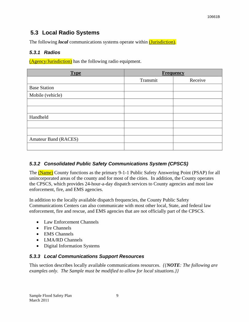
5.3 Local Radio Systems The following local communications systems operate within (Jurisdiction).
5.3.1 Radios
(Agency/Jurisdiction) has the following radio equipment.
Type Frequency Transmit Receive
Base Station
Mobile (vehicle)
Handheld
Amateur Band (RACES)
5.3.2 Consolidated Public Safety Communications System (CPSCS)
The (Name) County functions as the primary 9-1-1 Public Safety Answering Point (PSAP) for all unincorporated areas of the county and for most of the cities. In addition, the County operates the CPSCS, which provides 24-hour-a-day dispatch services to County agencies and most law enforcement, fire, and EMS agencies.
In addition to the locally available dispatch frequencies, the County Public Safety Communications Centers can also communicate with most other local, State, and federal law enforcement, fire and rescue, and EMS agencies that are not officially part of the CPSCS.
• Law Enforcement Channels • Fire Channels • EMS Channels • LMA/RD Channels • Digital Information Systems
5.3.3 Local Communications Support Resources
This section describes locally available communications resources. {{NOTE: The following are examples only. The Sample must be modified to allow for local situations.}}
Sample Flood Safety Plan 9 March 2011

10661B
5.3.3.1 Mobile Emergency Coordination Unit (MECU)
(Jurisdiction) OES maintains a fully equipped mobile communications vehicle (Mobile Emergency Coordination Unit - MECU) that may be used to support or enhance existing emergency communications anywhere in the county. The MECU is totally self-contained and possesses public safety and local government radio dispatch capabilities for use during emergency situations. The MECU is stationed at the County OES center. Requests for use of the MECU by any local government agency must be forwarded to the County OES or the Operational Area EOC, when activated.
5.3.3.2 Radio Amateur Civil Emergency Services (RACES)
The RACES network operates on amateur radio frequencies (UHF, VHF, HF) by authority of the FCC in support of emergency communications operations. RACES can augment existing public radio systems, substitute for damaged or inoperable systems, and establish communications links with otherwise inaccessible areas. RACES capabilities also include the transmission of data and video signals by means of sophisticated communications relays and data processing equipment.
(Jurisdiction) has an assigned volunteer Auxiliary Communications Support Officer who functions as the Area RACES Coordinator, with a contingent of locally based volunteers assigned to each municipality within the county. (Jurisdiction) maintains a separate RACES communications post within the EOC. In addition, several cities and public non-profit organizations within the county maintain similar RACES communications capabilities. These are highly dynamic capabilities provided by skilled volunteers. Capabilities included multi-channel amateur radios, radio transmitted electronic data systems, and the ability to transmit and receive remote video.
All RACES volunteers serve as Disaster Service Workers when officially activated. Several cities have well-established amateur radio organizations assigned to support their local EOC operations. When the EOC is activated, local RACES networks coordinate with the RACES Coordinator stationed at the EOC.
5.3.3.3 Citizens’ Band Radio (CB)
The FCC permits CB radio operations in emergency services activities on a voluntary basis under the direction of emergency services authorities. However, uncontrolled frequency use, overloading, and poor transmission quality limit the usefulness of this system. The EOC will/will not actively monitor CB channels. (Agency/Jurisdiction) uses CB as a backup system, recognizing that CB communications are usually monitored.
5.3.4 Telephone Systems
5.3.4.1 Common Carrier Telephone Service
Common carrier phone service is available throughout the area to support all emergency systems. A directory of emergency contacts is found in Appendix A.
Sample Flood Safety Plan 10 March 2011
10661B
5.3.4.2 Cellular Phones
(Agency/Jurisdiction) maintains a bank of (number) cellular phones along with a copy of the operations and distribution instructions. The Logistics Section is responsible for coordinating and authorizing the distribution of these resources. Prioritization will be coordinated with the Operations Section. Each Group and Unit Leader must identify requirements for cellular phones to the Operations Sections Chief.
5.3.5 Weak Links
Telecommunications are composed of many subsystems, each interconnected and interdependent. A radio network, for example, may use a combination of telephone lines, microwave circuits, satellite interfaces, underground and overhead cables, and secondary radio paths. The failure of any link in this electronic “chain” can disable a large portion of the system.
(Agency’s/Jurisdiction’s) solution to these communications weaknesses has been to develop a fault-tolerant system. In this system, a failure of one weak link can be addressed by additional capacity elsewhere in the system.
5.3.5.1 Loss of Power
Loss of emergency power has been the primary cause of communications failure in past emergencies. (Agency’s/Jurisdiction’s) solution to power loss has been to ensure proper installation and generator maintenance. (Agency/Jurisdiction) tests its generator(s) regularly and maintains adequate stockpiles of diesel/gasoline.
5.4 Protocols for Contacting Levee Patrols Initial contact with the Levee Patrol Team(s) shall be in accordance with the Activation Tree (Appendix A). Generally, communications with Levee Patrol Teams will be through the (Agency) Operations Chief.
5.4.1 Other Communications Protocols
All other communications shall be in accordance with the Incident Communications Plan, as documented on ICS forms ICS 204 and ICS 205.
5.5 Integration and Interoperability {{NOTE: Interoperability is essential to effective emergency management during flood response. At the most basic level, interoperability allows two or more parties to exchange information directly. First responders at the scene can instantly connect and communicate with each other, make the contacts needed to bring in additional resources, coordinate rescue missions, and provide other forms of response to threats and emergencies. This section gives the planner options in addressing this issue.}}
The most practical solution is to link radio systems together. The manner in which radio systems are linked will depend on variables such as existing communication infrastructures, population density, and geographic features. The goal is to find the most cost-effective means to link first responder radio systems. Sample Flood Safety Plan 11 March 2011
10661B
(Agency/Jurisdiction) has chosen to meet interoperability needs by {{NOTE: SELECT APPLICABLE SOLUTION}}:
• Maintaining several spare handheld radios to exchange on scene • Using cross band repeaters, which can connect an 800 MHz site with a VHF or UHF
radio site • Using a switching mechanism that connects different radio systems using telephone lines
or the internet • Using cell phone • Collocating dispatch personnel
5.6 Media Interface The (Jurisdiction) EOC will establish a Joint Information Center and designate a Public Information Officer (PIO). A PIO is a spokesperson responsible for developing and releasing information about the incident to the news media, to incident personnel, and to other agencies and organizations. Only one PIO will be assigned for each incident, including incidents operating under Unified Command and multi-jurisdiction incidents. The PIO may have Assistant PIOs as necessary, and the Assistant PIO may also represent assisting agencies or jurisdictions. An Assistant PIO may be assigned to help an Incident Commander on scene.
(Sample Press releases are in Part III. References and Supporting Documents)
Sample Flood Safety Plan 12 March 2011

10661B
Sample Flood Safety Plan 13 March 2011
10661B
6 Administration, Finance, and Logistics
6.1 Master Mutual Aid Agreement The foundation of California’s emergency planning and response is a statewide mutual aid system. Mutual Aid is designed to ensure that adequate resources, facilities, and other support are provided to jurisdictions whenever their own resources prove inadequate to cope with a situation. The basis for the system is the California Disaster and Civil Defense master Mutual Aid Agreement, as provided for in the California Emergency Services Act. It created a formal structure, within which each jurisdiction retains control of its own personnel and facilities, but can give and receive help whenever it is needed. State government, on the other hand, is obligated to provide available resources to assist local jurisdictions in emergencies.
(Agency/Jurisdiction) has developed and maintains a current emergency plan compatible with the California Master Mutual Aid Agreement. This Flood Safety Plan is a component of that plan and is designed to apply local resources in meeting flood response requirements of the immediate community or its neighbors. This Flood Safety Plan is coordinated with those of neighboring jurisdictions to ensure mutual compatibility.
6.2 Record Keeping (Agency/Jurisdiction) tracks, records, and reports on all (Agency/Jurisdiction) flood response personnel time. (Agency/Jurisdiction) collects and maintains documentation on all emergency information needed for reimbursement by Cal EMA or FEMA. (Agency/Jurisdiction) is aware of the requirement to retain these records for audit purposes for three years after receiving the last FEMA payment for flood-related expenditures.
6.3 Resource Tracking
Comprehensive resource management is a key management principle. It implies that all assets and personnel during an event need to be tracked and accounted for. It ensures maintenance of accountability over all resources. Thus, they can be moved quickly to support preparation and response to an incident and ensure a fluid demobilization.
Resource management involves coordinating and overseeing the acquisition and deployment of tools, supplies, equipment, and people during a flood. The objective of resource management is to (a) maximize efficient resource use while maintaining cost-effectiveness and resource safety, (b) consolidate control of single resources in order to reduce communications activity, and (c) instill resource accountability. Resource management enhances the benefit of mutual-aid agreements and improves interoperability.
Flood response resources include: (1) personnel or equipment to perform a specific operation, and (2) supplies and facilities to support on-scene incident operations. The SEMS Logistics Section typically orders supply items (e.g., food) and facilities (e.g., equipment staging). The Sample Flood Safety Plan 14 March 2011
10661B
SEMS Finance/Administration Section tracks the use of and maintains records on the resources applied to flood response.
6.4 Stockpiles – Location and Access (Agency/Jurisdiction) maintains stockpiles of flood fight equipment and supplies in the following locations.
Location Access Contact Emergency Access
6.5 Staging Areas (Agency/Jurisdiction) has identified the following sites for use as Staging Areas for incoming resources.
Location Address Phone
6.6 Evacuation Centers (Agency/Jurisdiction) has identified the following sites for use as Shelter and Care facilities.
Location Address Contact
Sample Flood Safety Plan 15 March 2011
10661B
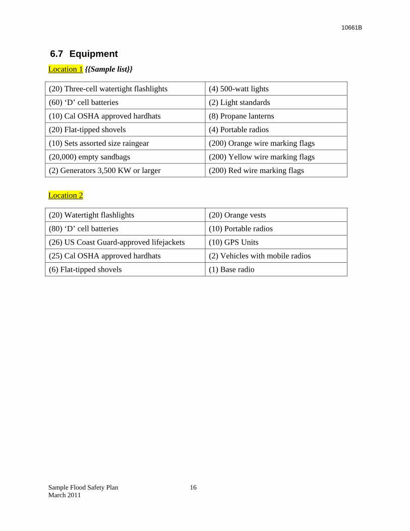
6.7 Equipment Location 1 {{Sample list}}
(20) Three-cell watertight flashlights (4) 500-watt lights
(60) ‘D’ cell batteries (2) Light standards
(10) Cal OSHA approved hardhats (8) Propane lanterns
(20) Flat-tipped shovels (4) Portable radios
(10) Sets assorted size raingear (200) Orange wire marking flags
(20,000) empty sandbags (200) Yellow wire marking flags
(2) Generators 3,500 KW or larger (200) Red wire marking flags
Location 2
(20) Watertight flashlights (20) Orange vests
(80) ‘D’ cell batteries (10) Portable radios
(26) US Coast Guard-approved lifejackets (10) GPS Units
(25) Cal OSHA approved hardhats (2) Vehicles with mobile radios
(6) Flat-tipped shovels (1) Base radio
Sample Flood Safety Plan 16 March 2011

10661B
Sample Flood Safety Plan 17 March 2011
10661B
7 Plan Development and Maintenance
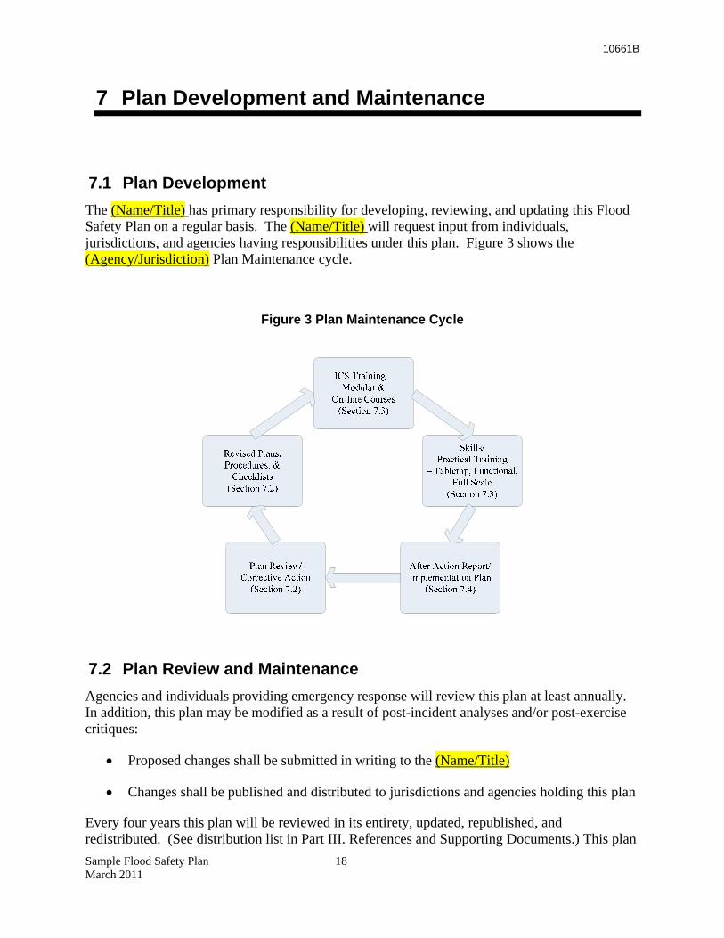
7.1 Plan Development The (Name/Title) has primary responsibility for developing, reviewing, and updating this Flood Safety Plan on a regular basis. The (Name/Title) will request input from individuals, jurisdictions, and agencies having responsibilities under this plan. Figure 3 shows the (Agency/Jurisdiction) Plan Maintenance cycle.
Figure 3 Plan Maintenance Cycle
7.2 Plan Review and Maintenance Agencies and individuals providing emergency response will review this plan at least annually. In addition, this plan may be modified as a result of post-incident analyses and/or post-exercise critiques:
• Proposed changes shall be submitted in writing to the (Name/Title)
• Changes shall be published and distributed to jurisdictions and agencies holding this plan
Every four years this plan will be reviewed in its entirety, updated, republished, and redistributed. (See distribution list in Part III. References and Supporting Documents.) This plan Sample Flood Safety Plan 18 March 2011
10661B
also may be modified whenever responsibilities, procedures, laws, rules, or regulations pertaining to emergency management and operations change.
• Jurisdictions and agencies having assigned responsibilities under this plan are obligated to inform the (Name/Title) when changes occur or are imminent.
• These changes will be incorporated into this plan, published, and distributed to jurisdictions and agencies holding this plan (see Distribution List).
7.3 Training and Exercises All emergency responders from Agency/Jurisdiction are strongly encouraged to take advantage of FEMA’s on-line training. In addition, (Name/Title) will notify holders of this plan of training opportunities or scheduled exercises associated with flood emergency management and operations, such as DWR’s annual Flood Fight sessions. Individual jurisdictions and agencies are responsible for maintaining training records. This plan will be exercised regularly. The (Name/Title) will conduct emergency preparedness exercises in accordance with an annual exercise schedule. Jurisdictions and agencies having assigned responsibilities under this plan must ensure assigned personnel are properly trained to carry out these responsibilities. See also specific training for Levee Patrol and Flood Fight.
Finally, after a draft of the Flood Water Removal Appendix is complete, (Agency/Jurisdiction) will conduct a Tabletop Exercise. A tabletop is a problem-solving or brainstorming session. Problems are tackled one at a time and talked through without stress. A session like this gives planners an opportunity to review the proposed decision and determine if changes are needed. The Appendix will then be made final.
7.4 Evaluation The (Name/Title) will coordinate and facilitate post-incident analyses following emergencies and exercises. An After-Action Report and Implementation Plan will be prepared by (Name/Title) and distributed to those jurisdictions and agencies involved in the emergency or exercise.
Sample Flood Safety Plan 19 March 2011
10661B
8 Authorities and References
The following sources provide authorities for planning, conducting, and/or supporting flood emergency operations.
8.1 Federal • Federal Civil Defense Act of 1950 (Public Law 920, as amended)
• Robert T. Stafford Disaster Relief and Emergency Assistance Act of 1988 (Public Law 93-288, as amended)
• Army Corps of Engineers Flood Fighting (Public Law 84-99)
8.2 State • California Emergency Services Act (Chapter 7, Division 1 of Title 2 of the Government
Code)
• Standardized Emergency Management System (SEMS) Regulations (Chapter 1 of Division 2 of Title 19 of the California Code of Regulations) and (California Government Code §8607 et sec)
• Hazardous Materials Area Plan Regulations (Chapter 4 of Division 2, Title 19, Article 3, §2720-2728 of the California Code of Regulations ) and (California Health and Safety Code, Division 20, Chapter 6.95, Section 25503.5)
• California Department of Water Resources Flood Control (California Water Code §128)
8.3 Local • Resolution of the (Governing Body) relative to Workers’ Compensation Insurance for
Registered Volunteer Disaster Service Workers, dated ___________.
• Resolution of the (Governing Body) adopting the California Disaster and Civil Defense Master Mutual Aid Agreement, dated ___________.
• Adoption of the (Agency/Jurisdiction) Flood Safety Plan on (Date) by the (Governing Body).
Sample Flood Safety Plan 20 March 2011

10661B
Sample Flood Safety Plan 21 March 2011
10661B
Appendix A Communications Support
A.1 Communications Support The following are sources of communications support available to local emergency operations, with support being dependent upon the type and magnitude of the emergency.
A.1.1 The California Emergency Management Agency (Cal EMA)
Cal EMA maintains several communications support capabilities available for use by local governments during major emergencies. Note: All requests for Cal EMA communications support will be directed to the (Name) County Operational Area EOC (or County OES if the EOC is not activated) for processing. Technical advice also is available by contacting the Cal EMA Warning Center at (916) 845-8911.
A.1.2 Mobile Satellite Communications Units
Cal EMA maintains and operates several mobile satellite communications units that can be driven, transported by trailer, or airlifted to any location in the state to provide dedicated voice and data satellite transmission capability. These mobile units are positioned throughout the state and may be sent into local jurisdictions to support emergency communication needs. The mobile satellite communications units are part of the statewide Operational Area Satellite Information System (OASIS) network.
A.1.3 Operational Area Satellite Information System
There are independent OASIS locations through the EOC, allowing for rapid, reliable communications with Regional/State and Operational Area Command Centers. Locations are in the EOC and in the (Jurisdiction) Communications Center.
A.1.4 Mobile Command & Communication Facilities
Cal EMA maintains two mobile command facilities available for use during major emergencies. These mobile command complexes consist of integrated communications and command vans and appropriate support vehicles and equipment.
The primary purpose of these mobile command units is to provide initial field communications information until more sophisticated communications are established and/or restored. Each of the complexes is equipped for operations on each of the major state radio systems, the OASIS, mutual aid radio systems, and amateur radio (RACES) frequencies. Radio operators must be provided by the responsible agency.
A.1.5 Portable Radio Caches
Sample Flood Safety Plan 22 March 2011
Cal EMA also maintains caches of portable radios capable of operating on selected statewide law enforcement and fire and rescue mutual aid frequencies. These radios are available to local governments upon request.
10661B
A.2 State Radio Systems Several public safety radio networks are operated and maintained by the State of California for the purpose of coordinating interagency public safety communications. {{NOTE: LMAs and Reclamation Districts may choose to leave this section out of their plan, as they generally lack access to these systems.}}
A.2.1 California Law Enforcement Mutual Aid Radio System (CLEMARS)
CLEMARS interconnects law enforcement agencies of all counties and numerous cities. This system is microwave-interconnected to provide statewide coverage. There are CLEMARS frequencies in each Public Safety radio band (except the 220-222 MHz band). CLEMARS is used for on-scene Law Enforcement communications. The nationwide Law Enforcement frequency of 155.475 is included in the CLEMARS plan.
A.2.2 California Law Enforcement Radio System (CLERS)
CLERS – various frequencies in 150 and 450 MHz bands – is the Law Enforcement ‘dispatcher to dispatcher’ mutual aid network, and consists of 26 ‘cells’ covering the state. CLERS also serves as the State’s distribution network for Emergency Alert System (EAS) program feeds, and is occasionally used by California Highway Patrol aircraft to coordinate with their operations bases.
A.2.3 California Emergency Services Radio System (CESRS)
CESRS – 153.755 MHz [154.980 input] – is a local government system that serves all Cal EMA facilities, a number of State agencies other than Cal EMA, and county-level emergency management agencies participating in the system. This system is also microwave-interconnected for statewide coverage.
A.2.4 OES Fire [and Rescue Radio Network]
OES Fire – 154.160 and 154.220 (with a combination of 33 and 159 MHz inputs) – serves fire support equipment. Radio equipment on this network is located with fire service agencies in 52 counties. The network employs mountaintop mobile relays and interconnects to the State Microwave System to provide statewide coverage.
Sample Flood Safety Plan 23 March 2011
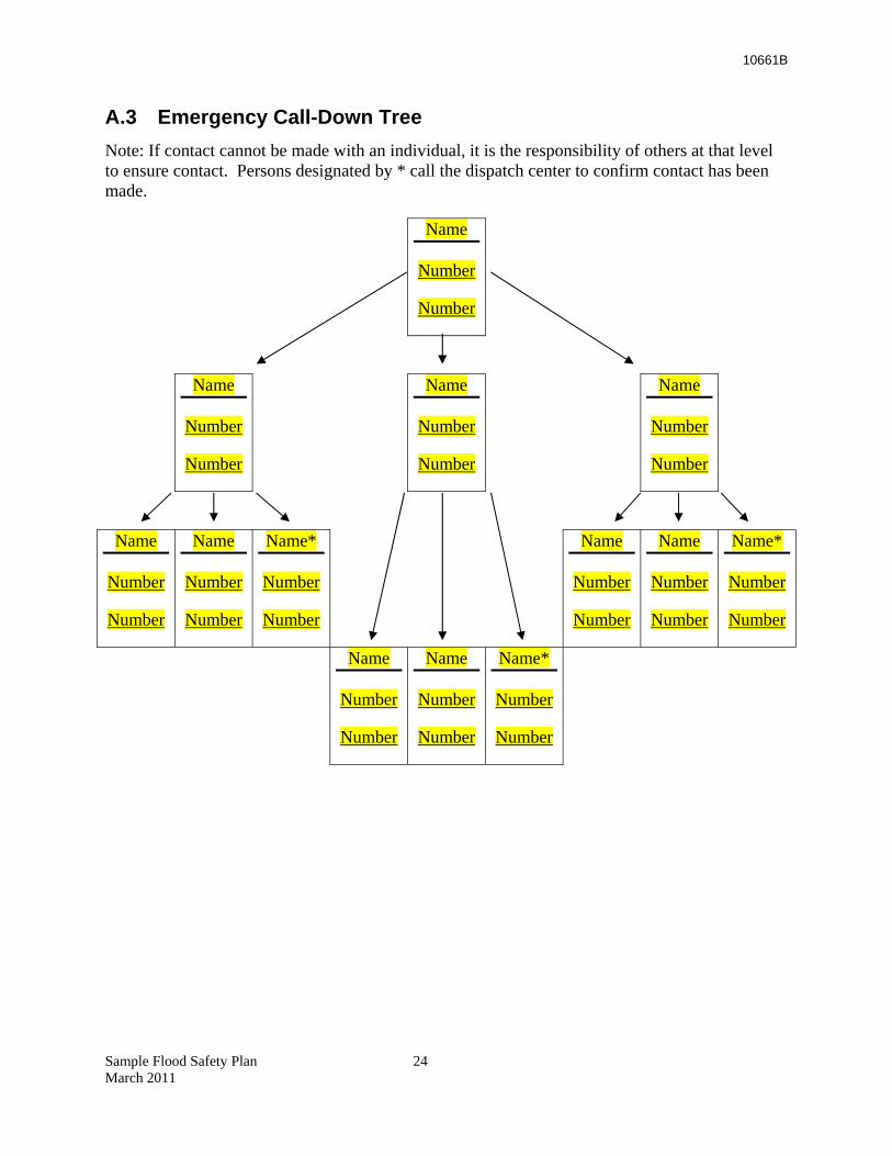
10661B
A.3 Emergency Call-Down Tree Note: If contact cannot be made with an individual, it is the responsibility of others at that level to ensure contact. Persons designated by * call the dispatch center to confirm contact has been made.
Name
Number
Number
Name
Number
Number
Name
Number
Number
Name
Number
Number
Name
Number
Number
Name
Number
Number
Name*
Number
Number
Name
Number
Number
Name
Number
Number
Name*
Number
Number
Name
Number
Number
Name
Number
Number
Name*
Number
Number
Sample Flood Safety Plan 24 March 2011
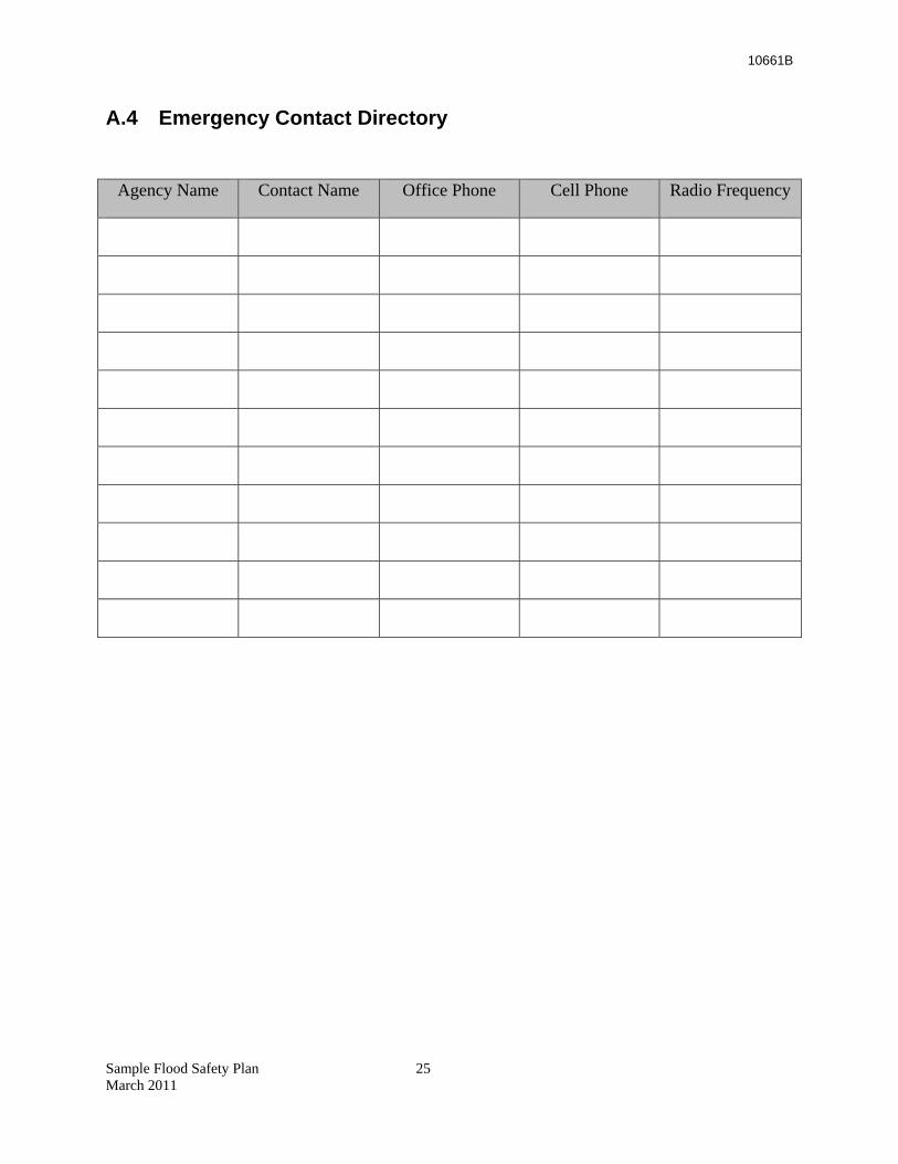
10661B
A.4 Emergency Contact Directory
Agency Name Contact Name Office Phone Cell Phone Radio Frequency
Sample Flood Safety Plan 25 March 2011
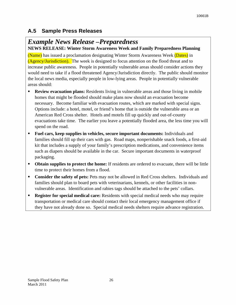
10661B
A.5 Sample Press Releases
Example News Release –Preparedness NEWS RELEASE: Winter Storm Awareness Week and Family Preparedness Planning (Name) has issued a proclamation designating Winter Storm Awareness Week (Dates) in (Agency/Jurisdiction). The week is designed to focus attention on the flood threat and to increase public awareness. People in potentially vulnerable areas should consider actions they would need to take if a flood threatened Agency/Jurisdiction directly. The public should monitor the local news media, especially people in low-lying areas. People in potentially vulnerable areas should: Review evacuation plans: Residents living in vulnerable areas and those living in mobile
homes that might be flooded should make plans now should an evacuation become necessary. Become familiar with evacuation routes, which are marked with special signs. Options include: a hotel, motel, or friend’s home that is outside the vulnerable area or an American Red Cross shelter. Hotels and motels fill up quickly and out-of-county evacuations take time. The earlier you leave a potentially flooded area, the less time you will spend on the road.
Fuel cars, keep supplies in vehicles, secure important documents: Individuals and families should fill up their cars with gas. Road maps, nonperishable snack foods, a first-aid kit that includes a supply of your family’s prescription medications, and convenience items such as diapers should be available in the car. Secure important documents in waterproof packaging.
Obtain supplies to protect the home: If residents are ordered to evacuate, there will be little time to protect their homes from a flood.
Consider the safety of pets: Pets may not be allowed in Red Cross shelters. Individuals and families should plan to board pets with veterinarians, kennels, or other facilities in non-vulnerable areas. Identification and rabies tags should be attached to the pets’ collars.
Register for special medical care: Residents with special medical needs who may require transportation or medical care should contact their local emergency management office if they have not already done so. Special medical needs shelters require advance registration.
Sample Flood Safety Plan 26 March 2011
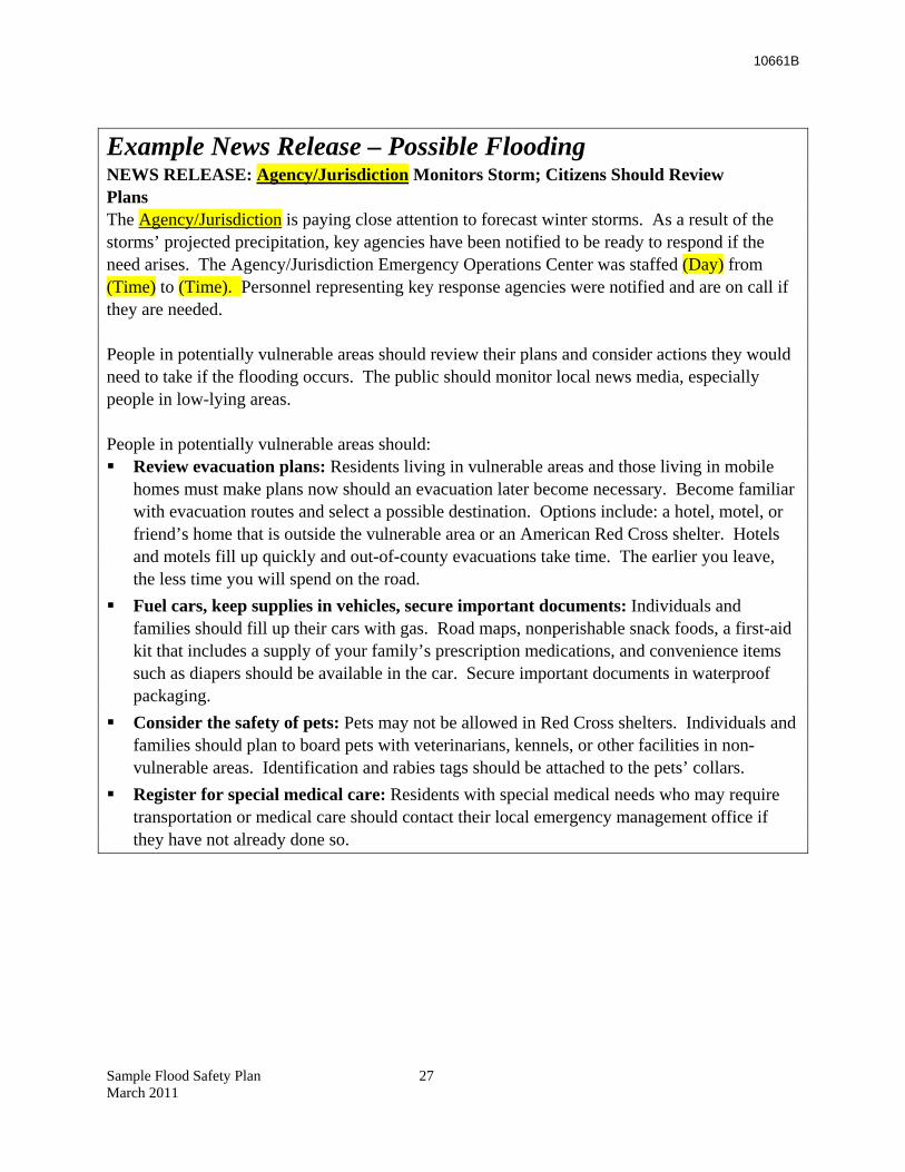
10661B
Example News Release – Possible Flooding NEWS RELEASE: Agency/Jurisdiction Monitors Storm; Citizens Should Review Plans The Agency/Jurisdiction is paying close attention to forecast winter storms. As a result of the storms’ projected precipitation, key agencies have been notified to be ready to respond if the need arises. The Agency/Jurisdiction Emergency Operations Center was staffed (Day) from (Time) to (Time). Personnel representing key response agencies were notified and are on call if they are needed. People in potentially vulnerable areas should review their plans and consider actions they would need to take if the flooding occurs. The public should monitor local news media, especially people in low-lying areas. People in potentially vulnerable areas should: Review evacuation plans: Residents living in vulnerable areas and those living in mobile
homes must make plans now should an evacuation later become necessary. Become familiar with evacuation routes and select a possible destination. Options include: a hotel, motel, or friend’s home that is outside the vulnerable area or an American Red Cross shelter. Hotels and motels fill up quickly and out-of-county evacuations take time. The earlier you leave, the less time you will spend on the road.
Fuel cars, keep supplies in vehicles, secure important documents: Individuals and families should fill up their cars with gas. Road maps, nonperishable snack foods, a first-aid kit that includes a supply of your family’s prescription medications, and convenience items such as diapers should be available in the car. Secure important documents in waterproof packaging.
Consider the safety of pets: Pets may not be allowed in Red Cross shelters. Individuals and families should plan to board pets with veterinarians, kennels, or other facilities in non-vulnerable areas. Identification and rabies tags should be attached to the pets’ collars.
Register for special medical care: Residents with special medical needs who may require transportation or medical care should contact their local emergency management office if they have not already done so.
Sample Flood Safety Plan 27 March 2011
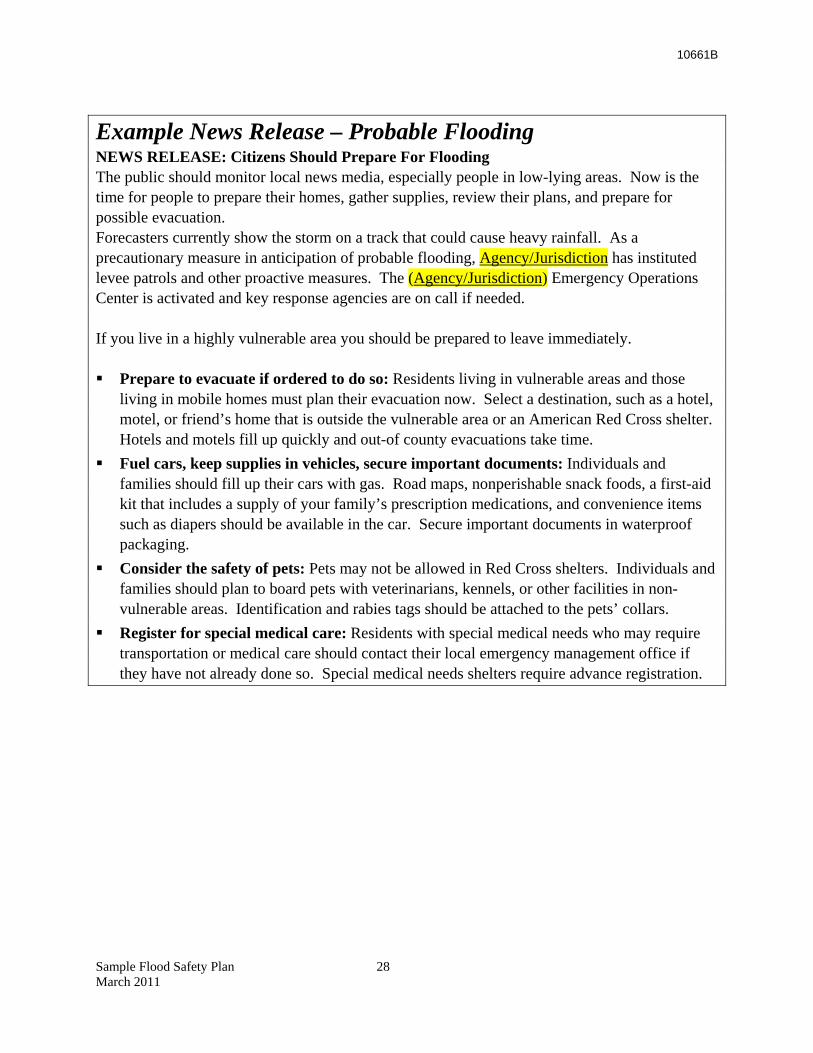
10661B
Example News Release – Probable Flooding NEWS RELEASE: Citizens Should Prepare For Flooding The public should monitor local news media, especially people in low-lying areas. Now is the time for people to prepare their homes, gather supplies, review their plans, and prepare for possible evacuation. Forecasters currently show the storm on a track that could cause heavy rainfall. As a precautionary measure in anticipation of probable flooding, Agency/Jurisdiction has instituted levee patrols and other proactive measures. The (Agency/Jurisdiction) Emergency Operations Center is activated and key response agencies are on call if needed. If you live in a highly vulnerable area you should be prepared to leave immediately. Prepare to evacuate if ordered to do so: Residents living in vulnerable areas and those
living in mobile homes must plan their evacuation now. Select a destination, such as a hotel, motel, or friend’s home that is outside the vulnerable area or an American Red Cross shelter. Hotels and motels fill up quickly and out-of county evacuations take time.
Fuel cars, keep supplies in vehicles, secure important documents: Individuals and families should fill up their cars with gas. Road maps, nonperishable snack foods, a first-aid kit that includes a supply of your family’s prescription medications, and convenience items such as diapers should be available in the car. Secure important documents in waterproof packaging.
Consider the safety of pets: Pets may not be allowed in Red Cross shelters. Individuals and families should plan to board pets with veterinarians, kennels, or other facilities in non-vulnerable areas. Identification and rabies tags should be attached to the pets’ collars.
Register for special medical care: Residents with special medical needs who may require transportation or medical care should contact their local emergency management office if they have not already done so. Special medical needs shelters require advance registration.
Sample Flood Safety Plan 28 March 2011
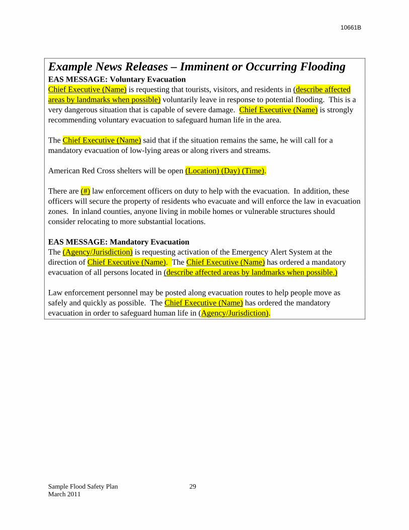
10661B
Example News Releases – Imminent or Occurring Flooding EAS MESSAGE: Voluntary Evacuation Chief Executive (Name) is requesting that tourists, visitors, and residents in (describe affected areas by landmarks when possible) voluntarily leave in response to potential flooding. This is a very dangerous situation that is capable of severe damage. Chief Executive (Name) is strongly recommending voluntary evacuation to safeguard human life in the area. The Chief Executive (Name) said that if the situation remains the same, he will call for a mandatory evacuation of low-lying areas or along rivers and streams. American Red Cross shelters will be open (Location) (Day) (Time). There are (#) law enforcement officers on duty to help with the evacuation. In addition, these officers will secure the property of residents who evacuate and will enforce the law in evacuation zones. In inland counties, anyone living in mobile homes or vulnerable structures should consider relocating to more substantial locations. EAS MESSAGE: Mandatory Evacuation The (Agency/Jurisdiction) is requesting activation of the Emergency Alert System at the direction of Chief Executive (Name). The Chief Executive (Name) has ordered a mandatory evacuation of all persons located in (describe affected areas by landmarks when possible.) Law enforcement personnel may be posted along evacuation routes to help people move as safely and quickly as possible. The Chief Executive (Name) has ordered the mandatory evacuation in order to safeguard human life in (Agency/Jurisdiction).
Sample Flood Safety Plan 29 March 2011
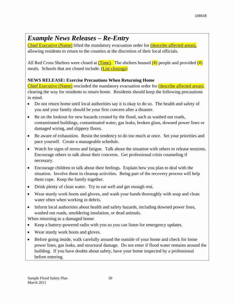
10661B
Example News Releases – Re-Entry Chief Executive (Name) lifted the mandatory evacuation order for (describe affected areas), allowing residents to return to the counties at the discretion of their local officials. All Red Cross Shelters were closed at (Time). The shelters housed (#) people and provided (#) meals. Schools that are closed include: (List closings) NEWS RELEASE: Exercise Precautions When Returning Home Chief Executive (Name) rescinded the mandatory evacuation order for (describe affected areas), clearing the way for residents to return home. Residents should keep the following precautions in mind. • Do not return home until local authorities say it is okay to do so. The health and safety of
you and your family should be your first concern after a disaster. • Be on the lookout for new hazards created by the flood, such as washed out roads,
contaminated buildings, contaminated water, gas leaks, broken glass, downed power lines or damaged wiring, and slippery floors.
• Be aware of exhaustion. Resist the tendency to do too much at once. Set your priorities and pace yourself. Create a manageable schedule.
• Watch for signs of stress and fatigue. Talk about the situation with others to release tensions. Encourage others to talk about their concerns. Get professional crisis counseling if necessary.
• Encourage children to talk about their feelings. Explain how you plan to deal with the situation. Involve them in cleanup activities. Being part of the recovery process will help them cope. Keep the family together.
• Drink plenty of clean water. Try to eat well and get enough rest. • Wear sturdy work boots and gloves, and wash your hands thoroughly with soap and clean
water often when working in debris. • Inform local authorities about health and safety hazards, including downed power lines,
washed out roads, smoldering insulation, or dead animals. When returning to a damaged home: • Keep a battery-powered radio with you so you can listen for emergency updates. • Wear sturdy work boots and gloves. • Before going inside, walk carefully around the outside of your home and check for loose
power lines, gas leaks, and structural damage. Do not enter if flood water remains around the building. If you have doubts about safety, have your home inspected by a professional before entering.
Sample Flood Safety Plan 30 March 2011
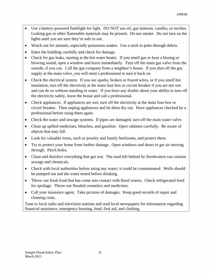
10661B
Sample Flood Safety Plan 31 March 2011
• Use a battery-powered flashlight for light. DO NOT use oil, gas lanterns, candles, or torches. Leaking gas or other flammable materials may be present. Do not smoke. Do not turn on the lights until you are sure they’re safe to use.
• Watch out for animals, especially poisonous snakes. Use a stick to poke through debris. • Enter the building carefully and check for damage. • Check for gas leaks, starting at the hot water heater. If you smell gas or hear a hissing or
blowing sound, open a window and leave immediately. Turn off the main gas valve from the outside, if you can. Call the gas company from a neighbor’s house. If you shut off the gas supply at the main valve, you will need a professional to turn it back on.
• Check the electrical system. If you see sparks, broken or frayed wires, or if you smell hot insulation, turn off the electricity at the main fuse box or circuit breaker if you are not wet and can do so without standing in water. If you have any doubts about your ability to turn off the electricity safely, leave the house and call a professional.
• Check appliances. If appliances are wet, turn off the electricity at the main fuse box or circuit breaker. Then unplug appliances and let them dry out. Have appliances checked by a professional before using them again.
• Check the water and sewage systems. If pipes are damaged, turn off the main water valve. • Clean up spilled medicines, bleaches, and gasoline. Open cabinets carefully. Be aware of
objects that may fall. • Look for valuable items, such as jewelry and family heirlooms, and protect them. • Try to protect your home from further damage. Open windows and doors to get air moving
through. Patch holes. • Clean and disinfect everything that got wet. The mud left behind by floodwaters can contain
sewage and chemicals. • Check with local authorities before using any water; it could be contaminated. Wells should
be pumped out and the water tested before drinking. • Throw out fresh food that has come into contact with flood waters. Check refrigerated food
for spoilage. Throw out flooded cosmetics and medicines. • Call your insurance agent. Take pictures of damages. Keep good records of repair and
cleaning costs. Tune to local radio and television stations and read local newspapers for information regarding financial assistance, emergency housing, food, first aid, and clothing.
10661B
Appendix B Levee Patrol
B.1 Purpose The purpose of levee patrols is to have qualified personnel visually evaluate the performance of the (Agency/Jurisdiction) levee system. Their intent is to determine the condition of the levee and to identify potential and existing problems:
• Threats • Instabilities • Seepage conditions • Erosion points • Freeboard
Implementation of this procedure will ensure each member of the Levee Patrol Team is capable of participating in precautionary actions and emergency response that may occur with (Agency/ Jurisdiction)’s levee system.
This program will predominantly be undertaken by the (Agency), with operational support from the (Jurisdiction). The major objectives of this procedure are to:
• Develop a training program to ensure qualified personnel are available for use • Ensure materials, equipment and supplies are available to implement this procedure and
are maintained in a serviceable condition to meet the needs of the (Agency/Jurisdiction) • Ensure action levels are established and in place to manage potential challenges • Prepare members to recognize the interface between allied agencies should escalating
events require large-scale operations • Prepare members to patrol levees to locate potential problems, to alert the EOC, and to
actively coordinate work, using flood fight and other methods, to resolve problems and minimize adverse consequences
B.2 Program Elements The levee patrol program has three basic components – Training, Equipment Procurement and Maintenance, and Levee Patrols.
B.2.1 Component I – Training
All participants will complete the following training to become qualified for levee patrol. Classroom (3 hours)
• Basic levee design • Recognizing potential problem characteristics • Notification/warning system
Sample Flood Safety Plan 32 March 2011
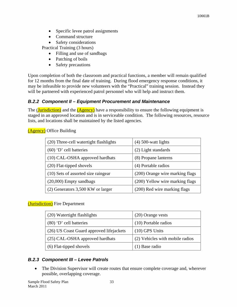
10661B
• Specific levee patrol assignments • Command structure • Safety considerations
Practical Training (3 hours) • Filling and use of sandbags • Patching of boils • Safety precautions
Upon completion of both the classroom and practical functions, a member will remain qualified for 12 months from the final date of training. During flood emergency response conditions, it may be infeasible to provide new volunteers with the “Practical” training session. Instead they will be partnered with experienced patrol personnel who will help and instruct them.
B.2.2 Component II – Equipment Procurement and Maintenance
The (Jurisdiction) and the (Agency) have a responsibility to ensure the following equipment is staged in an approved location and is in serviceable condition. The following resources, resource lists, and locations shall be maintained by the listed agencies.
(Agency) Office Building
(20) Three-cell watertight flashlights (4) 500-watt lights
(60) ‘D’ cell batteries (2) Light standards
(10) CAL-OSHA approved hardhats (8) Propane lanterns
(20) Flat-tipped shovels (4) Portable radios
(10) Sets of assorted size raingear (200) Orange wire marking flags
(20,000) Empty sandbags (200) Yellow wire marking flags
(2) Generators 3,500 KW or larger (200) Red wire marking flags
(Jurisdiction) Fire Department
(20) Watertight flashlights (20) Orange vests
(80) ‘D’ cell batteries (10) Portable radios
(26) US Coast Guard approved lifejackets (10) GPS Units
(25) CAL-OSHA approved hardhats (2) Vehicles with mobile radios
(6) Flat-tipped shovels (1) Base radio B.2.3 Component III – Levee Patrols
• The Division Supervisor will create routes that ensure complete coverage and, wherever possible, overlapping coverage.
Sample Flood Safety Plan 33 March 2011
10661B
• The Division Supervisors will physically account for all personnel working under their
control on an hourly basis. • All members will receive a safety briefing prior to commencing patrols and will use all
provided safety gear.
B.2.3.1 Motor Patrols
• The levee motor patrol will be initiated when slow rise flood waters reach # ft at (location), or at the direction of the (Jurisdiction) OES Director, or upon request from the (Agency). The levee motor patrol will consist of the following:
o Two four-wheel drive vehicles with mobile radio capabilities. o Two trained and currently qualified observers per vehicle. o Patrol areas will be divided as shown on the attached map. {{Note: Attach a
map showing how areas of the levee will be divided for patrol purposes.}}. Radio designators will be designated as Division A or B.
o Patrol crews will be rotated on a 12-hour frequency. o Completion of a Division Activity Log will be required for each shift using
ICS Form 214). o All members will receive a safety briefing and utilize appropriate safety gear.
B.2.3.2 Walking Patrol
• The levee walking patrol will be initiated when slow rise flood waters reach # ft at (location). A levee walking patrol will consist of:
• Teams of two personnel physically walking a designated section of levee. One person will be positioned at the toe of the land side of the levee. The second will be assigned to the top of the levee.
• Foot patrols will check visually for potential problems with the levee as per training. • Areas of concern will be identified using a yellow wire flag. • All yellow flags will be evaluated by the Division Supervisor conducting motor patrol
activities. • Upon evaluation of the potential problem area, the Division Supervisor will either:
o “Orange Flag” the area, which means at the present time the levee condition is performing as designed or
o “Red Flag” the area, which indicates a potential problem requiring action such as an engineer’s review. All red flag conditions will be reported to Command immediately for evaluation by the Engineer.
• All levee foot patrol personnel will have the following at a minimum:
o Three-cell watertight flashlight o Cal OSHA-approved hardhat
Sample Flood Safety Plan 34 March 2011
o Raingear, if warranted; each individual is responsible for boots
10661B
Sample Flood Safety Plan 35 March 2011
o Orange reflective vest o (10) Yellow marking flags o Global Positioning System (GPS) unit to establish latitude and longitude of
trouble sites o U.S. Coast Guard-approved lifejacket o One member of each foot-patrol team will be equipped with a portable radio,
operating on (frequency). Radio communication should be minimized to prevent channel overload. All radio communication will be in plain English, with no jargon or acronyms.
• Walking patrol personnel should be rotated on an 8-hour frequency.
B.2.4 High Water Staking Procedures
• High water staking: Record the extent of high water by placing markers (stakes) periodically as the event progresses
• Reference those high water locations with suitable surveying or GPS locations • Provide that information to the jurisdiction and DWR upon request
B.3 Augmenting Staff When local personnel resources are depleted or reasonably committed, mutual aid is requested and coordinated within the Operational Area (OA). If OA resources are not sufficient or timely, the request is then forwarded to the Cal EMA Regional Emergency Operations Center (REOC). The REOC evaluates and fills requests by (a) staff from unaffected OAs, (b) tasking a State agency, or (c) accessing federal assistance. (see Appendix C, Section 4 for Procedures.)
10661B
Appendix C Flood Fight
C.1 Trigger(s) At the River Warning Stage or upon notification of a potential problem by a levee patrol, establish necessary staging areas for supplies, equipment, and personnel. (Agency/Jurisdiction) has ensured the staging areas are a safe distance from other emergency facilities, such as evacuation centers, shelters, and Incident Command Posts. If required by the situation, commence filling sandbags.
C.2 Prioritization (Agency/Jurisdiction) will use available resources and personnel to address boils, rising water/loss of freeboard, slumps, and sloughs to the full extent of its training and capability.
Based on input from levee patrols and other informed observers, the (Jurisdiction) EOC establishes a Unified Command to set priorities for flood fight operations. All Incident Commanders conduct an Initial Unified Command Meeting. This meeting provides responsible agency officials with an opportunity to discuss and concur on important issues prior to joint incident action planning. The agenda for the command meeting includes the following:
• Set jurisdictional/agency priorities and objectives • Present jurisdictional limitations, concerns, and restrictions • Develop a collective set of incident objectives • Establish and agree on acceptable priorities • Adopt the overall strategy or strategies to accomplish objectives • Agree on the basic organization structure • Designate the most qualified and acceptable Operations Section Chief (the Operations
Section Chief will normally be from the jurisdiction or agency that has the greatest involvement in the incident, although that is not essential)
• Agree on General Staff personnel designations and planning, logistics, and finance agreements and procedures
• Agree on the resource ordering process to be followed and cost-sharing procedures • Agree on informational matters, designating one official to act as the Unified Command
spokesperson
The members of the Unified Command must be authorized to decide and act on behalf of the jurisdiction or agency they represent. Such decisions/actions may include ordering of additional resources in support of the Incident Action Plan, possible loaning or sharing of resources to other jurisdictions, and agreeing to financial cost-sharing arrangements with participating agencies.
Sample Flood Safety Plan 36 March 2011
10661B
C.3 Activation and Dispatch The (Chief Executive) of (Agency/Jurisdiction) has the authority to activate this Appendix. Dispatch of Flood Fight Teams shall be in accordance with priorities set by the (Jurisdiction) EOC.
C.4 Personnel (Agency/Jurisdiction) maintains a cadre of emergency responders. Additional flood emergency response staffing comes from other (Agency/Jurisdiction) employees and from volunteers.
When the (Agency/Jurisdiction) requires additional people for sand bagging, emergency debris clearance, diking, and similar activities to save life and protect public safety, assistance may come from trained crews to augment local personnel. In accordance with SEMS, when local resources are depleted or reasonably committed, mutual aid is requested and coordinated within the (Name) County Operational Area (OA). If OA resources are not sufficient or timely, the request is then forwarded to the REOC. The REOC evaluates and fills requests by coordinating mutual aid from unaffected OAs, tasking a State agency, or accessing federal assistance. Due to the nature of the need and the resource, requests for hand crews are usually tasked to a State agency.
C.4.1 Resource Agencies
The California Conservation Corps (CCC) has trained civilian crews. The California Department of Forestry and Fire Protection (Cal Fire) supervises crews from the California Department of Corrections and California Youth Authority. The California National Guard (CNG) also has personnel available. Both CCC and Cal Fire have contract services for various types of projects. CNG is only available through State tasking. In addition to crews, CNG and Cal Fire have mobile kitchens and similar support resources available. Cal Fire can also provide trained section leaders for ICS and SEMS organizations.
C.4.2 Mission Tasking
Cal EMA controls missions and mission assignments for State resources and coordinates requests for federal resources. If Cal EMA receives a request for crews that meets the criteria for State agency tasking and if an agency has the capability, Cal EMA will issue a mission number authorizing the agency to respond. Once tasked, that agency will work directly with the requesting agency and provide the resource within the definition and limits of the mission authorization.
C.4.3 Tasking Criteria
For all missions (a) there must be actual or imminent danger to life or public safety, and (b) locally available resources, including private sector contracting, must be inadequate or untimely. Maintenance or recovery activities should be dealt with by contract and will not be authorized by Cal EMA. Ex Post Facto mission numbers will not be authorized unless it can be clearly demonstrated that properly coordinating the request would have caused an inordinate delay and that such delay would have resulted in severe injury or loss of life.
Sample Flood Safety Plan 37 March 2011
10661B
C.4.4 Costs/Reimbursement
State agencies tasked under a Cal EMA mission number respond free of charge. Crews may require feeding and sheltering; transport vehicles may require gas and maintenance. These services are usually paid for or provided by the requesting agency unless otherwise agreed to at the time of the request.
C.4.5 Request Procedures
Following coordination within the (Name) County OA, the EOC will forward unfilled requests to the Inland REOC Operations Section. The REOC will follow up with the (Name) County OA EOC to resolve any questions and to monitor resource delivery.
• Requests should be completed using the Response Information Management System (RIMS) on a RIMS Mission Request/Tasking form. If RIMS is unavailable, hard copy of the form should be faxed to the Inland REOC via the State Warning Center. If faxing is infeasible, phone in the request using the RIMS format. All requests made by RIMS or fax must be confirmed by phone.
• Requests must contain a clear description of the mission to be performed and the number of personnel needed.
• Requests must not specify the agency from which the crew is being requested (i.e., three California Conservation Corps crews). This allows Cal EMA to make mission tasking based upon availability and need, and avoids over-tasking of a single agency. If there are operational reasons to specify an agency, please explain them in the mission statement of the request form.
• The (Name) County OA EOC must take special care not to duplicate requests with any possibly made via another Mutual Aid System. Accordingly, EOC Branches must coordinate their requests closely. In particular, crews for flood fight should not be requested via Fire Mutual Aid channels (see below).
C.4.6 Fire Mutual Aid
Unlike procedures for other types of emergencies, crews supervised by Cal Fire for flood fight are not accessible under the Fire and Rescue Mutual Aid Plan. All requests for crews for flood fight must follow emergency services channels, regardless of the requesting agency. In view of the natural tendency for requests made by fire agencies to remain in fire channels, it is critical that the (Name) County OA Region Fire Branch coordinator and the (Name) County OA Construction and Engineering Branch coordinator communicate closely to avoid confusion and delay.
C.4.7 State Agency Voluntary Response
Sample Flood Safety Plan 38 March 2011
During non-emergency conditions or non-proclaimed emergencies, State agencies may respond to requests as a locally available resource. Such responses do not receive mission numbers and may not be covered under Mutual Aid and provisions of the Emergency Services Act. Further, all costs are born by the State agency and/or the requesting agency pursuant to any agreement or understanding between them. Resources committed under such responses may be redirected to higher priority missions during emergencies.
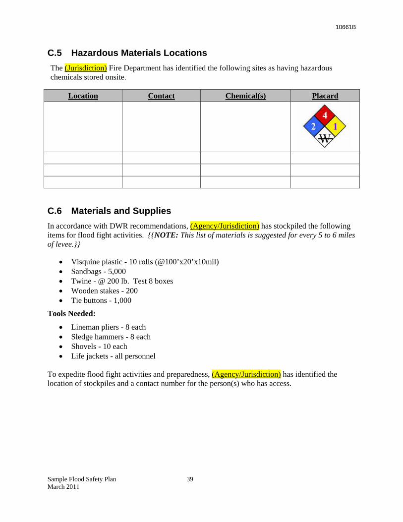
10661B
C.5 Hazardous Materials Locations The (Jurisdiction) Fire Department has identified the following sites as having hazardous chemicals stored onsite.
Location Contact Chemical(s) Placard
C.6 Materials and Supplies In accordance with DWR recommendations, (Agency/Jurisdiction) has stockpiled the following items for flood fight activities. {{NOTE: This list of materials is suggested for every 5 to 6 miles of levee.}}
• Visquine plastic - 10 rolls (@100’x20’x10mil) • Sandbags - 5,000 • Twine - @ 200 lb. Test 8 boxes • Wooden stakes - 200 • Tie buttons - 1,000
Tools Needed:
• Lineman pliers - 8 each • Sledge hammers - 8 each • Shovels - 10 each • Life jackets - all personnel
To expedite flood fight activities and preparedness, (Agency/Jurisdiction) has identified the location of stockpiles and a contact number for the person(s) who has access.
Sample Flood Safety Plan 39 March 2011
10661B
Location Contact Person Telephone Number
C.7 Public Supplies (Agency/Jurisdiction) has placed supplies of sand bag at strategic sites. Citizens affected or threatened by flooding may secure sand and sandbags at these locations.
Sandbag Stock Pile Sites
Location Address Contact Phone
C.8 Logistics Procedures Resource Management will track the rate of consumables used. When the approximate date of complete consumption approaches the date of reasonable delivery, the Logistic Chief shall be apprised. The Logistic Branch shall initiate procurement in consultation and coordination with the Finance/Administration Branch. The Logistics Chief will notify the Operations Chief.
If the Operations Chief is concerned about possible loss of essential consumables, the Operations Chief may request procurement from the Logistics Chief. In no case will any member of the Operations Branch initiate procurement. In no case will the Logistics Branch begin procurement without advising the Finance/Administration Branch.
C.9 Training in Flood Fight Procedures and Techniques Personnel from (Agency/Jurisdiction) participate in DWR Flood Fight training, which DWR provides annually. Also, see the DWR Flood Fight Manual: http://www.water.ca.gov/floodmgmt/docs/flood_fight_methods.pdf
Sample Flood Safety Plan 40 March 2011
10661B
Sample Flood Safety Plan 41 March 2011
C.10 Utilities In general, coordination with utilities will be the responsibility of the OA EOC. When on-scene coordination is needed, the Utility Representative becomes part of the IC’s staff. In principal, the Utility Representative gives advice to the IC; in practice the Representative often works directly with the Operations Section Chief.
10661B
Appendix D Evacuation
D.1 Considerations {{NOTE: In developing this Appendix, the planner needs to address concerns that cannot be included in a template format. These include:
• Where do people go if local shelters will be flooded or otherwise be inadequate? (Think “Houston from New Orleans.”)
• What Evacuation Centers will the Jurisdiction use to manage the large outflow of people?
• Which directions will evacuees go and will routes be above water – even sheet flooding? • How will evacuees obtain food, water, and medical care? • Critical care facilities – Hospitals/jails/EOC. Do these meet criteria for Essential
Services Building and will they remain in operation as required by Water Code WC 9650?
A resource for addressing these issues is Guidelines for Inter-County Sheltering Caused by Large-Scale Evacuations of People at http://www.cdsscounties.ca.gov/coplanners/res/pdf/doc5.pdf}}
D.2 Public Notification The decision to evacuate rests with the (Jurisdiction) EOC; the instructions to be given to the public are the responsibility of the Public Information Officer (PIO), the Joint Information Center and the EOC.
Public awareness is extremely important during an emergency. In fact, it is the key to a successful evacuation. In the case of a potential flood the public must be kept informed of water levels and their implications for a flood event, levee conditions, short- and long-term weather forecasts, and any other threat that might exist. (Jurisdiction) is committed to notifying the public about conditions that cause a flood threat and starting evacuations due to the threat without waiting until an actual disaster has commenced.
{{NOTE: Select only those systems applicable to the area.}}
A well-informed public will respond better to an emergency situation. In (Jurisdiction) and surrounding areas, there are several ways to inform the public. These include:
• Emergency Siren System • Emergency Alert System • Emergency Digital Information System • Reverse 911 System • Fire and Police Vehicle Loudspeakers
Sample Flood Safety Plan 42 March 2011
10661B
D.2.1 Emergency Siren System
The Emergency Siren System is a primary warning system. It has been modified so that the EOC can activate one siren, a group of sirens, or all sirens, depending on the need. The siren system is tested at 11:00 am on the last Friday of each month. Public education as to the significance and meaning of the sirens is a key component of this system.
The Emergency Siren System is activated by the (Jurisdiction and title of person). Before a siren is activated, local radio and television outlets are notified such that they are providing public alert announcements. In a large event, all notifications must be handled by the EOC through the Joint Information Center. Coordination must occur among all call centers, public safety dispatch centers, and the EOC prior to siren activation. In localized immediate need events, the (Agency or Title) must coordinate with the (Jurisdiction) PIO and the media to provide information. It is very important that all notification be coordinated to prevent confusion.
The Emergency Siren System works with the Emergency Alert System (EAS). Once Emergency Sirens are activated, the public turns on the radio (station call letters and frequency) or the television (station call letters and channel) for emergency announcements. The public also may find significant information on the National Weather Service radio or via media outlets using the Emergency Digital Information System.
D.2.2 Emergency Alert System
The EAS provides emergency information by radio, television, and cable television. There are strict rules on how to activate the system. The only individuals that can activate the EAS are (Job Titles). The EAS should only be activated in extreme emergencies by these authorized individuals.
In an emergency it is very important that all the media outlets are kept informed of the emergency. Once the EOC is open it is the EOC’s responsibility to keep the media informed on a regular basis so that current information flows to the public.
The (Job Titles) have authority to activate the EAS and must supply the message through the PIO. The details of EAS activation are in the (Jurisdiction) Emergency Plan as well as in the EOC and the Joint Information Center.
D.2.3 Reverse 9-1-1
(Jurisdiction) has contracted with (Company Name) to make telephone contact with households and businesses to alert them to an emergency. The system can make 96 calls a minute with a 30-second message. This allows for messages going to nearly 3,000 telephones each hour. If more capability is needed, the (Jurisdiction) can contact (Company Name) for additional capacity. The system expands in increments of 3,000 messages per hour. Messages are sent to phone numbers in the database that identifies the name and location of any caller to the 911 system.
The Reverse 911 can be activated by (Job Titles). They can either provide a discrete message to be sent or ask for a pre-recorded evacuation (or other) message be sent, and direct the company as to the target area. The message to be sent should be crafted or reviewed by the Joint Information Center, which is made up of PIOs from Police, Fire, Utilities, and other departments. Sample Flood Safety Plan 43 March 2011
10661B
D.2.4 Vehicle Loudspeaker Systems
All Fire and Police vehicles have loudspeaker systems. The (Police/Sheriff) Department also has helicopters with loudspeakers to make announcements over neighborhoods. The loudspeakers are very useful for neighborhood actions, directing traffic and warning people not to enter areas. Since the Emergency Sirens do not have the capability to provide voice instructions, the vehicle loudspeakers are the best way to give directions to the public. Loudspeakers are especially useful for persons without a radio, television, or phone, or during late night hours when most of the public is likely in bed and away from media (for EAS alerts) or their phones (for Reverse 911 alerts).
In the case of emergencies these vehicles can drive through a neighborhood and make announcements; they can also make an all-clear announcement once the emergency is over. To ensure consistent information and best use of resources, the IC must coordinate messages and activities with the EOC. All vehicles must be transmitting the same message via the loudspeakers to avoid confusion. Messages must be direct and simple. Those needing detailed information may call the Sacramento 311 number for more information, or check the EAS TV or radio sources.
(Jurisdiction) has a website on which to post maps, evacuation routes, open shelter locations, city operator telephone numbers, and any other numbers that might be useful during the evacuation emergency. The website is maintained by the (Jurisdiction’s) web master. All emergency information that goes on the website needs approval by the EOC Director. An additional website providing emergency related information is the ___________ site. This new site is dedicated to providing the public preparedness related material in addition to information generated by an actual emergency event. Future capacities of the outreach efforts of this forum include e-mail alerts and use of social networks, such as Twitter.
D.3 Operations The decision to evacuate rests with the (Jurisdiction) EOC. Operational responsibility rests with local law enforcement, possibly assisted by local fire personnel. If it appears that an evacuation may be necessary due to conditions in the field, the IC will provide that recommendation to the (Jurisdiction) EOC. If the need to evacuate is extremely urgent, the Flood Fight IC or Operations Chief may communicate directly with their Law Enforcement counterpart in the field and advise the (Jurisdiction) EOC. The (Jurisdiction) EOC will advise nearby communities and reception centers.
D.4 Maps Figure D-1 is a map showing the locations of selected critical facilities in (Jurisdiction). Critical facilities include schools, hospitals, and nursing facilities, as well as hazardous material storage areas. Addresses and latitudes/longitudes of these facilities are maintained in a database by the (Jurisdiction or Area Council of Governments). The OA maintains a listing of other special needs populations, including areas where demographics indicate a need for contact in a language other than English.
Sample Flood Safety Plan 44 March 2011
10661B
Figure D-2 is a map showing the evacuation routes, highlighted in purple, from (area). Information related to routes and traffic conditions will be provided using the EAS. Potential flooding areas are shown in (hatched or green). Primary shelter and care facilities are labeled with “P”; alternatives are labeled with “A.” If deemed necessary by the (Jurisdiction) EOC, buses and drivers will be obtained from the (Name) school district and staged at the (Name) fairgrounds. For individual rescue situations, helicopters are available from (Department/Agency) or mutual aid through the (Jurisdiction) EOC. Operational responsibility for post-evacuation security and patrols rests with local law enforcement, possibly assisted by local fire personnel.
Sample Flood Safety Plan 45 March 2011
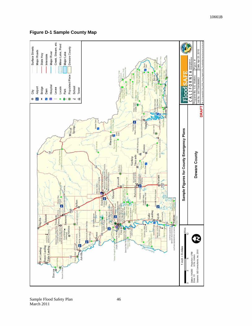
10661B
Figure D-1 Sample County Map
Sample Flood Safety Plan 46 March 2011
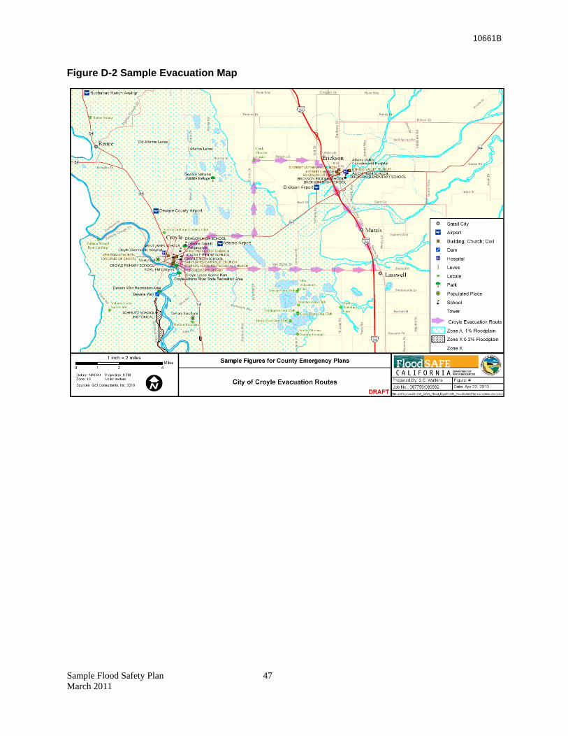
10661B
Sample Flood Safety Plan 47 March 2011
Figure D-2 Sample Evacuation Map
10661B
Appendix E Flood Water Removal
With overtopping or failure of a levee flood protection system, the lands protected by the levee system may become partially or fully inundated. Depending on the situation, there may be an immediate need to dewater that area to prevent further flooding or to protect the overall integrity of the flood protection system, or to remove the water to recover the area to pre-flood conditions. Flood water removal is an integral part of flood emergency response and needs to be considered in planning for floods.
A plan for flood water removal should describe alternatives to dewater areas protected by a jurisdiction’s levees. It should address how this will be carried out, where activities will occur, and who will be responsible for carrying out those activities.
E.1 Priorities [Please note that this part of the plan cannot be fill-in-the-blanks format. A dewatering plan(s) is dependent upon the characteristics of the Agency/Jurisdiction and their evaluation of risk and resources.
Considerations include:
• How many people are affected by the flooding?
• What is the value of the flooded area?
• What are the long-term consequences and ramifications?
E.1.1 Alternative 1 – No Immediate Dewatering Needed
Based on the situation, it may be advisable to take no immediate action. For example, an inundated agricultural area with no threat to life and property may be left flooded until waters naturally recede. Due to public perception and expectations, this may be a difficult decision to reach, albeit logical. For some areas this choice can be made in advance of a flood event. LMAs, local governments, DWR, USACE, and Cal EMA must work together to ensure everyone understands the reasoning and supports the choice.
E.1.2 Alternative 2 – Close Breach; No Water Removal
Closing the opening in a failed levee is generally the first step of any levee breach repair. It may be necessary to wait for the inflow to slow before taking this action. Rock and suitable materials must be available to armor the ends of the break before closing the opening with additional suitable material. After the breach is closed, it may be cost-effective to simply let the ground dry out on its own depending on the extent of flooding. Equipment and contractors must be mobilized, the ends of the breach must be able to be accessed, and material for the closure must be available.
Sample Flood Safety Plan 48 March 2011
10661B
Sample Flood Safety Plan 49 March 2011
E.1.3 Alternative 3 – Repair Breach and Remove Water by Pumping
After the breach is closed, this alternative would remove water using available on-site or perhaps portable pumps. For large flooded areas, the time and expense for this can be extensive.
Providing information on pump suppliers, possible locations for pumps, and other logistics before the event would be part of the plan.
E.1.4 Alternative 4 – Repair Breach and Remove Water by Making a Relief Cut
The situation may warrant excavating a second breach in a levee system to allow flood waters to drain from behind the land side of a levee. This effort may also limit the depth of those flood waters behind the levee and prevent further flooding of areas within the basin, and may be employed under emergency conditions.
Contractors, equipment, locations of the excavated breach, and material supplies should be included in the plan. Consideration should be given in that the second breach must now be closed as well as the first.
E.1.5 Environmental Considerations
Flood Water Removal projects are generally exempt from CEQA. Statutory exemptions include “emergency projects such as actions required to restore damaged facilities or mitigate an emergency” (CEQA Guidelines Section 15269) http://ceres.ca.gov/topic/env_law/ceqa/guidelines/art18.html). Nevertheless, (Agency/Jurisdiction) will consult legal counsel before making a final decision.
E.2 Contractors and Vendors • Provide list and contact information.
Contractor/Vendor Type Service
Address Phone
10661B
PART III: References and Supporting Documents
References The following documents may be helpful to Flood Safety Plan developers. They elaborate on emergency concepts that apply in flooding emergencies.
• Guidelines for Coordinating Flood Emergency Operations (completed in compliance with the Flood Emergency Action Team [FEAT]: Initiative Number 1) (8 pages) http://www.oes.ca.gov/Operational/OESHome.nsf/PDF/Guidelines%20for%20Coordinating%20Flood%20Emergency%20Operations/$file/Feat1.pdf
Provides a concept of operations for coordinating emergency response at the field level among local, State, and federal agencies with flood control responsibilities.
• Flood Preparedness Guide for Levee (sic) Maintaining Agencies (completed in compliance with the Flood Emergency Action Team [FEAT]: Initiative Number 3) (6 pages) http://www.water.ca.gov/floodmgmt/docs/floodprepguide_4lmas.pdf
Describes the response process under SEMS. Provides questions for developing a local maintaining agency emergency plan. Lists standards for stockpiling materials.
• Legal Guidelines for Flood Evacuation (completed in compliance with the Flood Emergency Action Team [FEAT]: Initiative Number 2) (35 pages) http://www.oes.ca.gov/Operational/OESHome.nsf/PDF/Legal%20Guidelines%20for%20Flood%20Evacuation/$file/Feat2.pdf
Cites laws and regulations pertaining to authorities for ordering flood evacuation.
• Guidelines for Inter-County Sheltering Caused by Large-Scale Evacuations of People (Approximately 20 pages) http://www.cdsscounties.ca.gov/coplanners/res/pdf/doc5.pdf
Developed in response to Winter Storms of 1997, which resulted in evacuation of 150,000 persons. Describes procedures for evacuation and care of 10,000 or more evacuees. • SEMS Resource Ordering and Tracking: A Guide for State and Local Government
(Approximately 50 pages with attachments) http://www.cesa.net/library/SEMS%20Resource%20Ordering%20Guide.pdf
Provides a description of how emergency managers order and track resources. • Protocol for Closure of Delta Waterways (completed in compliance with the Flood
Emergency Action Team [FEAT]: Initiative Number 7) (7 pages)
Sample Flood Safety Plan xiv March 2011
10661B
Sample Flood Safety Plan xv March 2011
http://www.water.ca.gov/floodmgmt/docs/protocol_closure_delta.pdf
Identifies responsibilities and conditions for closure of Delta Waterways. Addresses both pleasure and commercial boat traffic restrictions. • Memorandum of Understanding for Animal Care During Disasters (completed in
compliance with the Flood Emergency Action Team [FEAT]: Initiative Number 6) (3 pages) http://www.oes.ca.gov/Operational/OESHome.nsf/PDF/Memorandum%20of%20Understanding%20for%20Animal%20Care%20During%20Disasters/$file/Feat6.pdf
Provides a model for ensuring pre-event planning; includes agreements for animal care when evacuations are necessary. • Standardized Emergency Management System (SEMS) Guidance for Special Districts (27
pages) http://www.oes.ca.gov/Operational/OESHome.nsf/PDF/SEMS%20Guidance%20for%20Special%20Districts%20to%20OES/$file/SEMSDistGuid10-5-07.pdf
Analyzes different types of special districts and possible emergency management relationships consistent with the requirements of SEMS.
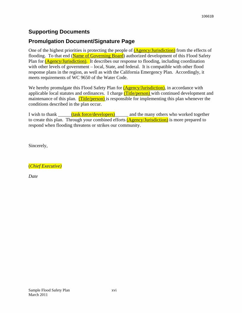
10661B
Supporting Documents Promulgation Document/Signature Page One of the highest priorities is protecting the people of (Agency/Jurisdiction) from the effects of flooding. To that end (Name of Governing Board) authorized development of this Flood Safety Plan for (Agency/Jurisdiction). It describes our response to flooding, including coordination with other levels of government – local, State, and federal. It is compatible with other flood response plans in the region, as well as with the California Emergency Plan. Accordingly, it meets requirements of WC 9650 of the Water Code.
We hereby promulgate this Flood Safety Plan for (Agency/Jurisdiction), in accordance with applicable local statutes and ordinances. I charge (Title/person) with continued development and maintenance of this plan. (Title/person) is responsible for implementing this plan whenever the conditions described in the plan occur.
I wish to thank (task force/developers) and the many others who worked together to create this plan. Through your combined efforts (Agency/Jurisdiction) is more prepared to respond when flooding threatens or strikes our community.
Sincerely,
(Chief Executive)
Date
Sample Flood Safety Plan xvi March 2011
10661B
Approval and Implementation On (Date), the (Name of governing body) approved the attached Flood Safety Plan for (Agency/ Jurisdiction). (Title/person) has responsibility for continued development and maintenance of this plan.
[Attach Copy of Resolution, if appropriate.]
Record of Changes It is important to keep the plan up to date so it will be accurate and useful in a flood emergency. This section tracks all updates and changes to the plan to ensure that all participants can be certain of having the most current document.
RECORD OF CHANGES
CHANGE NUMBER
DATE OF CHANGE
DATE ENTERED
SUMMARY OF CHANGE ENTERED BY
Sample Flood Safety Plan xvii March 2011
10661B
Sample Flood Safety Plan xviii March 2011
Record of Distribution Copies of this plan have been distributed to the following individuals, offices, organizations, and interested parties. {{SAMPLE LIST}}
DISTRIBUTION LIST Administrative Services .....................1 Agricultural Commissioner ................1 Assessor .............................................1 Auditor - Controller ...........................1 Board of Supervisors..........................5 Clerk - Recorder .................................1 Building Inspection ............................1 Planning .............................................1 Coroner ..............................................1 County Administrative Officer ..........1 County Counsel ..................................1 District Attorney ................................1 Health & Human Services .................1 Public Health ......................................1 Environmental Health ........................1 Mental Health.....................................1 Social Services ...................................1 Information Services ..........................1 Library................................................1 Personnel ............................................1 Public Defender .................................1 Public Works ......................................1
Purchasing ..........................................1 Sheriff ................................................1 Office of Emergency Services/EOC ..2 Reserve Stock (located in OES) .........5 Contiguous Counties A .........................................................1 B .........................................................1 Etc. .....................................................1 Cities A .........................................................1 B .........................................................1 Etc. .....................................................1 Special Districts State Agencies Federal Agencies Other American Red Cross ..........................1 Office of Education ............................1 Emergency Medical Service .............1 Telephone Company ..........................1 Utility .................................................1 Salvation Army .................................1
Hazard Analysis Summary This section provides a listing and general assessment of flood hazards within or affecting (Agency/Jurisdiction).
Creeks and Streams
Natural Streams/____(name)__ River Tributaries
This is a group of about (#) watercourses in the (general area) portion of (Jurisdiction). The group is characterized predominantly by natural vegetation and limited channel capacity. Consequently, these creeks lack the capacity to contain a 100-year flood and some have significantly less capacity. Environmental and regulatory restrictions limit the ability to significantly improve most of these creeks. Out-of-bank flooding (has/has not) occurred during the larger historical storms of record, with notable structure flooding in this vicinity.
Tributary watercourses in this stream group include: A, B, C, D, etc.
10661B
Sample Flood Safety Plan xix March 2011
___(name)_______ Creek Stream Group
Approximately (#) streams are located in the (general area) part of (Jurisdiction) and they ultimately drain into (Name) Creek and then the (Name) River. While areas along (Name) Creek have seen flooding in the past, much of this area has developed more recently and thus the channels tend to have 100-year protection.
Tributary watercourses in this stream group include: A, B, C, D, etc.
Levees and Dams
Levees are often used to contain excessive flows in the (Name) River. While most levees perform satisfactorily during flooding, failures occasionally occur. Levees require maintenance and inspection to remain properly functioning. Levees are found in the general area in this jurisdiction near specific location(s).
Operation of existing dams strongly affects flooding potential for areas in (Agency/Jurisdiction). There is always an extreme chance that an incident at a dam may cause an uncontrolled release of water. The following major dams affect flows in this (Agency/Jurisdiction): {{List}}
Capability Assessment (Agency/Jurisdiction) has developed a list of specific events that will “trigger” emergency response actions. Priorities have been established for protective actions and a methodology exists for changing those priorities during flood response. Methods and equipment for communication have been established. Staffing levels are adequate and the training and exercise program ensures a proper level of readiness. Written documentation of procedures and techniques exists for levee emergencies such as boils, overtopping, sloughing, or other incident.
(Agency/Jurisdiction) has staging areas for response teams, as well as stockpiles of materials and supplies. (Note: These staging areas are separate from the evacuation centers described elsewhere in this plan.) Security for these sites has been arranged with the (Police Department/Sheriff). Logistics procedures for augmenting available supplies and equipment exist. Mutual aid arrangements have been made with (Name nearby communities).
Planning Assumptions {{NOTE: This section of the Sample may contain assumptions that do not apply to your agency/jurisdiction. Some that do apply may not be included. Please adjust the information accordingly.}}
• Public warning is provided through a variety of means; e.g., National Weather Service (NWS) announcements, National Oceanic & Atmospheric Administration radio, standard radio and television Emergency Alert System (EAS) bulletins. {{NOTE: The following is an optional comment for those locales having this capability.}} A reverse 911 system is also in place to alert residents about potential emergency situations in their specific neighborhoods. These systems advise citizens and authorities about flood threats or actual flooding conditions.
10661B
Sample Flood Safety Plan xx March 2011
• With adequate warning and timely reaction by emergency response agencies, loss of life, injury, and property damage can be reduced. Careful planning and coordination has been done to protect affected populations through timely warning and protective measures.
• Mutual aid systems will be made available during flooding situations that exceed the resources of (Agency/Jurisdiction) and those of nearby cities and special districts.
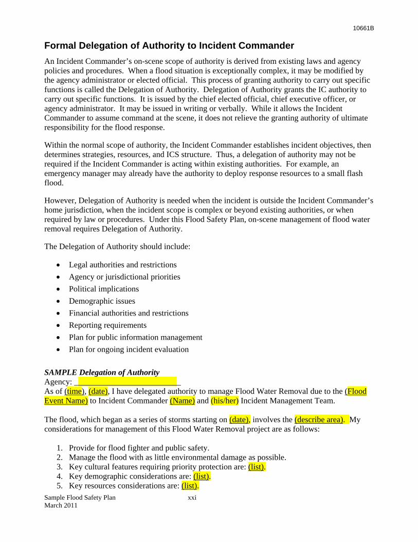
10661B
Sample Flood Safety Plan xxi March 2011
Formal Delegation of Authority to Incident Commander An Incident Commander’s on-scene scope of authority is derived from existing laws and agency policies and procedures. When a flood situation is exceptionally complex, it may be modified by the agency administrator or elected official. This process of granting authority to carry out specific functions is called the Delegation of Authority. Delegation of Authority grants the IC authority to carry out specific functions. It is issued by the chief elected official, chief executive officer, or agency administrator. It may be issued in writing or verbally. While it allows the Incident Commander to assume command at the scene, it does not relieve the granting authority of ultimate responsibility for the flood response.
Within the normal scope of authority, the Incident Commander establishes incident objectives, then determines strategies, resources, and ICS structure. Thus, a delegation of authority may not be required if the Incident Commander is acting within existing authorities. For example, an emergency manager may already have the authority to deploy response resources to a small flash flood.
However, Delegation of Authority is needed when the incident is outside the Incident Commander’s home jurisdiction, when the incident scope is complex or beyond existing authorities, or when required by law or procedures. Under this Flood Safety Plan, on-scene management of flood water removal requires Delegation of Authority.
The Delegation of Authority should include:
• Legal authorities and restrictions • Agency or jurisdictional priorities • Political implications • Demographic issues • Financial authorities and restrictions • Reporting requirements • Plan for public information management • Plan for ongoing incident evaluation
SAMPLE Delegation of Authority Agency: __________________________ As of (time), (date), I have delegated authority to manage Flood Water Removal due to the (Flood Event Name) to Incident Commander (Name) and (his/her) Incident Management Team. The flood, which began as a series of storms starting on (date), involves the (describe area). My considerations for management of this Flood Water Removal project are as follows:
1. Provide for flood fighter and public safety. 2. Manage the flood with as little environmental damage as possible. 3. Key cultural features requiring priority protection are: (list). 4. Key demographic considerations are: (list). 5. Key resources considerations are: (list).
10661B
Sample Flood Safety Plan xxii March 2011
6. Restrictions for water removal actions include: (list). 7. The (Agency/Jurisdiction) advisor will be (Name) (Function/Title). 8. The flood borders private property that must be protected if practical. (Name) of the
(Department Name) will be the local representative. 9. Manage the flood water removal cost-effectively for the values at risk. 10. Approval for above expenditures (limit) is to be made by (Name/Title). 11. Provide training opportunities for (Agency/Jurisdiction) personnel to strengthen our
organizational capabilities. This Delegation of Authority is subject to weekly review by (Name/Governing Body). (Signature and Title of Agency Administrator) (Date)


Edmund G. Brown Jr.Governor
John LairdNatural Resources Agency
Mark CowinDirector
Department of Water Resources
Prepared by GEI Consultants, Inc. forThe California Department of Water ResourcesNaser Bateni, Program Manager (PE 36128)
For additional information, contact:William Croyle(916) [email protected]
Or, visit us on the Web at: www.water.ca.gov