Embed Size (px)
Citation preview

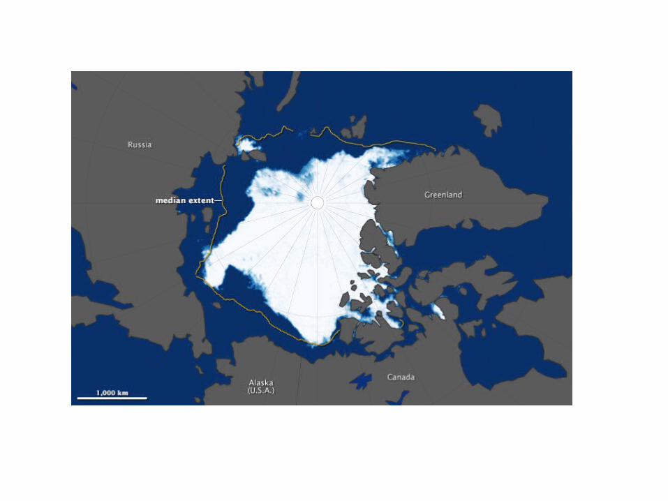
Sandy Siberia 2
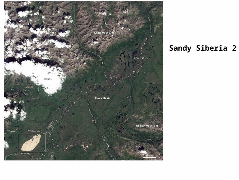
Sandy Siberia 1
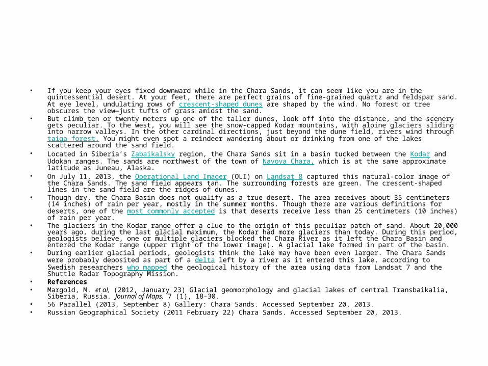
• If you keep your eyes fixed downward while in the Chara Sands, it can seem like you are in the quintessential desert. At your feet, there are perfect grains of fine-grained quartz and feldspar sand. At eye level, undulating rows of crescent-shaped dunes are shaped by the wind. No forest or tree obscures the view—just tufts of grass amidst the sand.
• But climb ten or twenty meters up one of the taller dunes, look off into the distance, and the scenery gets peculiar. To the west, you will see the snow-capped Kodar mountains, with alpine glaciers sliding into narrow valleys. In the other cardinal directions, just beyond the dune field, rivers wind through taiga forest. You might even spot a reindeer wandering about or drinking from one of the lakes scattered around the sand field.
• Located in Siberia’s Zabaikalsky region, the Chara Sands sit in a basin tucked between the Kodar and Udokan ranges. The sands are northwest of the town of Navoya Chara, which is at the same approximate latitude as Juneau, Alaska.
• On July 11, 2013, the Operational Land Imager (OLI) on Landsat 8 captured this natural-color image of the Chara Sands. The sand field appears tan. The surrounding forests are green. The crescent-shaped lines in the sand field are the ridges of dunes.
• Though dry, the Chara Basin does not qualify as a true desert. The area receives about 35 centimeters (14 inches) of rain per year, mostly in the summer months. Though there are various definitions for deserts, one of the most commonly accepted is that deserts receive less than 25 centimeters (10 inches) of rain per year.
• The glaciers in the Kodar range offer a clue to the origin of this peculiar patch of sand. About 20,000 years ago, during the last glacial maximum, the Kodar had more glaciers than today. During this period, geologists believe, one or multiple glaciers blocked the Chara River as it left the Chara Basin and entered the Kodar range (upper right of the lower image). A glacial lake formed in part of the basin.
• During earlier glacial periods, geologists think the lake may have been even larger. The Chara Sands were probably deposited as part of a delta left by a river as it entered this lake, according to Swedish researchers who mapped the geological history of the area using data from Landsat 7 and the Shuttle Radar Topography Mission.
• References• Margold, M. et al, (2012, January 23) Glacial geomorphology and glacial lakes of central Transbaikalia, Siberia, Russia. Journal of Maps,
7 (1), 18-30. • 56 Parallel (2013, September 8) Gallery: Chara Sands. Accessed September 20, 2013. • Russian Geographical Society (2011 February 22) Chara Sands. Accessed September 20, 2013.
• Сентябрь 2013, Казахстан
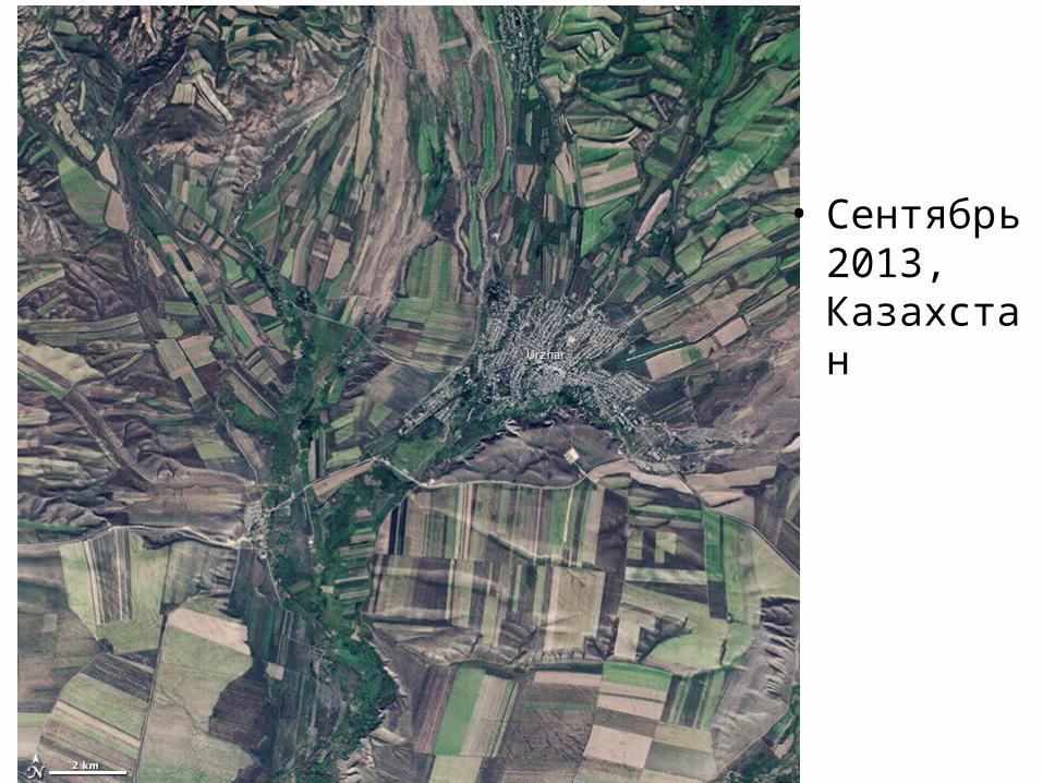
Сентябрь 2013, Казахстан • September 22, the autumnal equinox, marks the beginning of fall in the Northern Hemisphere, but the fall harvest
begins early in the harsh continental climate of eastern Kazakhstan. By September 9, 2013, when the Operational Land Imager (OLI) on the Landsat 8 satellite acquired this image, several fields were already harvested and bare. Others were dark green with pasture grasses or ripening crops. The fields fill the contours of the land, running long and narrow down mountain valleys and spreading in large squares over the plains.
• Agriculture is an important segment of the economy in Kazakhstan: the country’s dry climate is ideal for producing high quality wheat for export. However, 61 percent of the country’s agricultural land is pasture for livestock. The area shown in this image, far eastern Kazakhstan near the Chinese border, is a minor wheat-growing region and may also produce sunflowers, barley, and other food crops.
• An artifact of Soviet-era collective farms, most of the farms in Kazakhstan are large, covering more than 5,000 hectares (12,500 acres). Some of the larger fields in the image reflect the big business side of agriculture. However, family farms and small agriculture businesses account for 35 percent of the country’s agricultural production, and some of these are visible as well, particularly in the uneven hills and mountains.
• Nearly all agriculture in Kazakhstan is rain fed. Farmers in this region have designed their fields to take advantage of rain flowing down hills, allowing the natural shape of the land to channel water to crops. The effect is a mosaic of green and tan with tones matching the natural vegetation in the mountains to the north.
• References• Foreign Agricultural Service (2010, January 19) Kazakstan agricultural overview. United States Department of
Agriculture. Accessed September 24, 2013. • Foreign Agricultural Service (2013, March 16) Kazakhstan wheat production: An overview. United States
Department of Agriculture.< Accessed September 24, 2013. • Akim Tarbagatay Region Geography of the region and its brief history. Accessed September 24, 2013.
Сентябрь 2013, Узбекистан
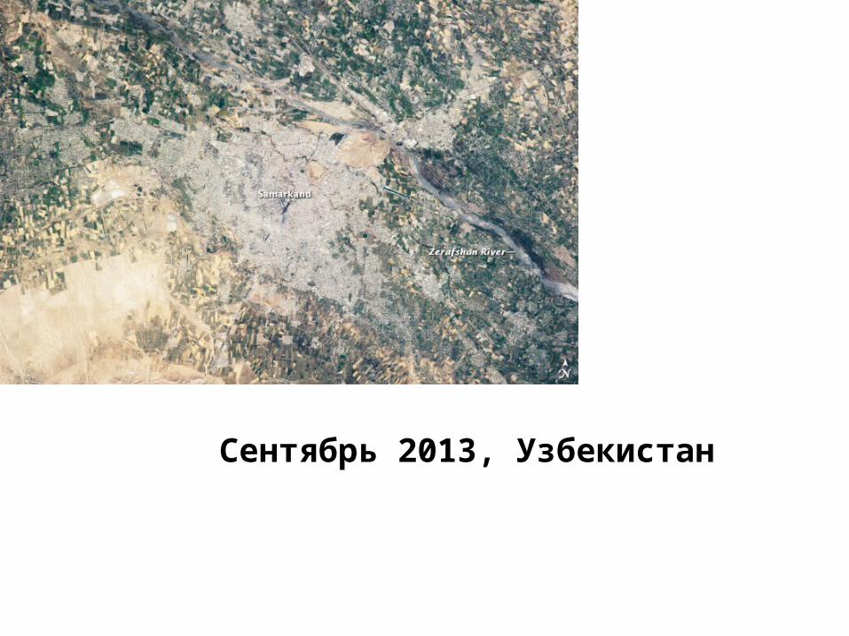
Сентябрь 2013, Узбекистан • The historical Silk Road—or as some scholars prefer, Silk Routes, as there were
several “roads”)—provided trade routes between Asia and Europe from as far back as 200 BC. Parts of the Silk Road are still used today for the transport of goods. The city of Samarkand, featured in this photograph from an astronaut on the International Space Station, is one of the oldest and most historically important cities along the Road, occupying a central position between China and Western Europe.
• The city is thought to have been founded around 700 BC. In addition to its continual role as a trade center, Samarkand has been the site of many notable events in the city’s long history, including invasions by Alexander the Great (329 BC) and Genghis Khan (1220 AD). In 1370, Samarkand became the capital city of the empire of Tamerlane (or Timur); later, it was the capital city of the Uzbek Soviet Socialist Republic (1925-1930). It was named to the UNESCO World Heritage List in 2001.
• Today, Samarkand is the second largest city in the Republic of Uzbekistan, formed in 1991. The urban area (image center) is located within a large oasis in the Zerafshan River Valley. Historical accounts of Samarkand describe it as a “paradise,” and its favorable climate today still supports extensive agriculture around the city's edges. In keeping with its status as a World Heritage site, the city attracts many international visitors to its historical and cultural monuments. As the capital of the Samarkand Province, it also serves as the regional government administrative center.