Embed Size (px)
Citation preview
SARPY COUNTY PLANNING & BUILDING DEPARTMENT
RECOMMENDATION REPORT
SPECIAL USE PERMIT (SUP 17-008) FRANK SLADEK
COMMERCIAL RECREATION AND CAMPING AREA IN THE AG/FP ZONING DISTRICT
PLANNING COMMISSION HEARING OF: November 21, 2017
I. GENERAL INFORMATION
A. APPLICANT: Frank Sladek 11303 Buffalo Road Springfield, NE 68059
B. SUBJECT PROPERTY OWNER: Frank Sladek 11303 Buffalo Road Springfield, NE 68059
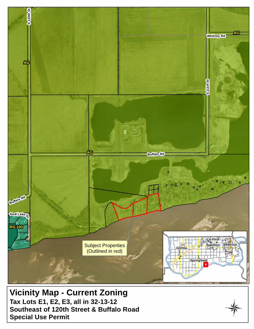
C. SUBJECT PROPERTY LOCATION: Southeast of 120th and Buffalo Road along the Platte River.
D. LEGAL DESCRIPTION: Tax Lots E1, E2, E3, all in Section 32, Township 13N, Range 12E of the 6th P.M. Sarpy County, NE.
E. SUBJECT PROPERTY SIZE: 7 acres +/-.
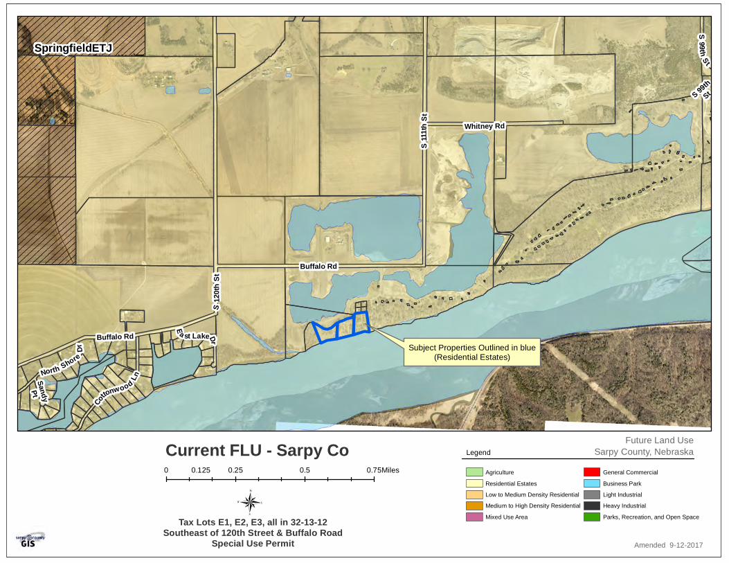
F. EXISTING FUTURE LAND USE AND ZONING DESIGNATIONS: Future Land Use Designations: Residential Estates Zoning: AG/FP (Agricultural/Flood Plain)
G. REQUESTED ACTION(S): To approve a Special Use Permit for a Commercial Recreation and Camping Area in the AG Zoning District.
H. Purpose of Request: Sites on the property are leased annually for recreational and camping purposes which is allowed by Special Use Permit in the AG Zoning District.
II. BACKGROUND INFORMATION
A. EXISTING CONDITION OF SITE: The property is a recreational camping area along the Platte River that has operated for many years. Currently provides 26 pad sites for recreational vehicles from April 1st to October 31st. Applicant is working with Sarpy County Planning Department to bring the property into compliance with current zoning regulations.
B. SURROUNDING AREA CURRENT ZONING AND LAND USE DESIGNATIONS The surrounding areas are all zoned AG (Agricultural) and AG/FP (Agricultural-Flood Plain) and are designated as Residential Estates the Future Land Use Map. The
majority of the properties immediately adjacent to the subject property are used for commercial recreation.
C. RELEVANT CASE INFORMATION: Sarpy County Zoning Regulations requiring a Special Use Permit for seasonal
dwellings and commercial camping areas date back to 1976 if not longer The property currently has 26 leased recreational vehicle sites. The property has operated as a seasonal recreational area for many years. The applicant is working with Sarpy County to bring the property into compliance
with current zoning regulations and building codes. Code requires that all RV and appurtenant structures that prohibit flow to be removed from the Flood Plain from October 31 to April 1 of each year. Any existing appurtenant structures prohibiting flow must be rectified so that they
can be removed from the area as required by code. The RV sites are served with individual water. Each RV contains their own
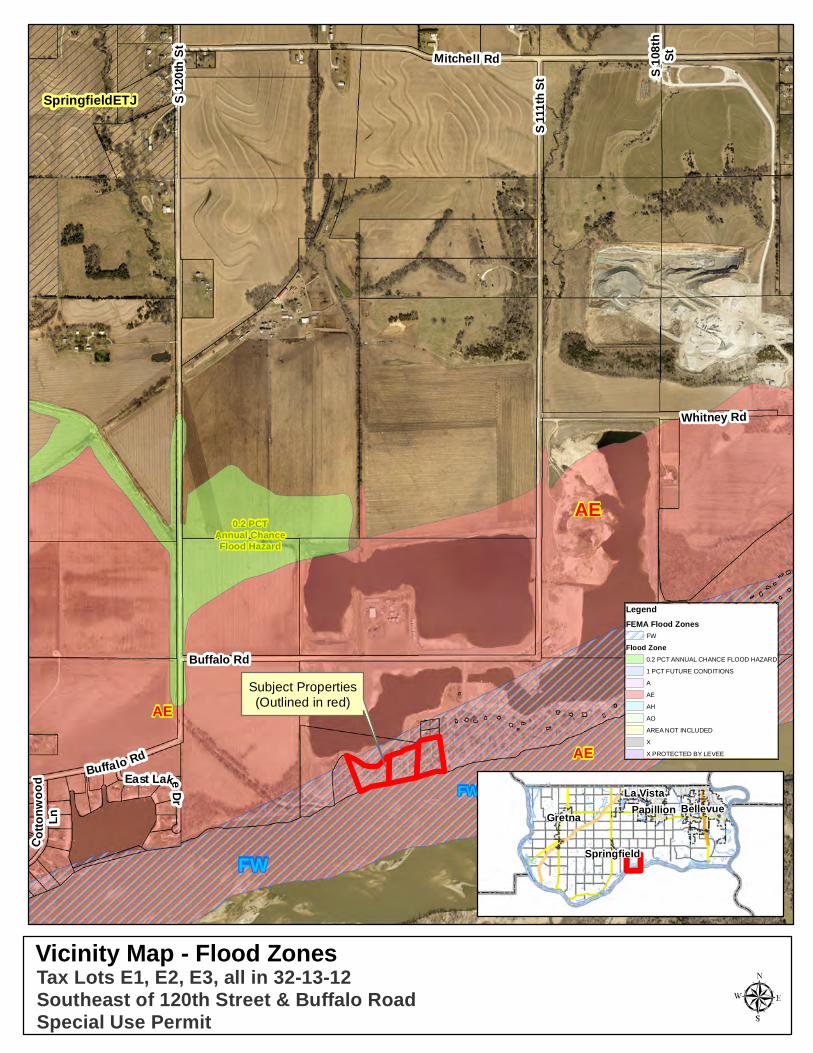
wastewater storage tank which are emptied weekly by a contracted pumping service. According to the Flood Insurance Rate Maps (FIRM) issued by the Federal
Emergency Management Agency (FEMA), the majority of the property is located in the Flood Way of the Platte River and will have to comply with all applicable regulations in Section 30 of the Sarpy County Zoning Regulations, Flood Plain Regulations. Any man-made improvements to the land or any new/existing structures/camping
sites located within the designated Flood Plain will require the approval of a Flood Plain Development Permit prior to making any such improvements pursuant to Section 30 of the Sarpy County Zoning Regulations. With limited access to the site and without the ability for any additional access
points, staff would recommend that the pad sites for this area be limited to 26. The access is gated but is available 24 hours a day, 7 days a week during camping season. The applicant has submitted an Emergency Action Plan for the property but the
Papio-Missouri NRD would like to have additional details on addressing how the recreational vehicles could be removed during a flood event or if they are anchored to prevent flotation, and how they are anchored.
D. APPLICABLE REGULATIONS: Sarpy County Zoning Regulations:
- Section 9, AG Agricultural District - Section 41 – Special Use Permits - Section 30 – Flood Plain Regulations
III. ANALYSIS / STAFF COMMENTS
A. COMPREHENSIVE PLAN: The Comprehensive Plan shows the area as Residential Estates.
B. TRAFFIC AND ACCESS: The area is currently accessed by a single access easement via from Buffalo Road. The access is gated and the applicant will need to
work with the Springfield Fire Department and Sarpy County Sherriff to ensure access.
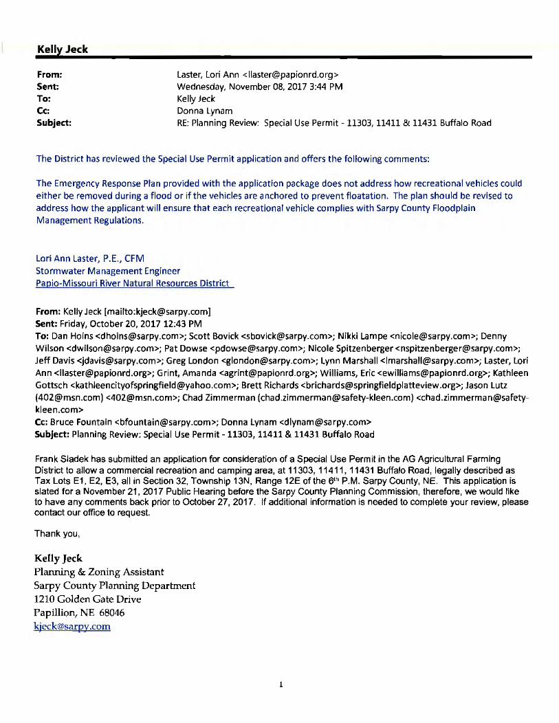
C. OTHER AGENCY REVIEW/COMMENTS: The applications were sent to area jurisdictional agencies or departments that may have an interest. At the time of this staff report, comments were received from the Papio-Missouri NRD and are attached for your review. If any additional comments are received, they will be presented at the Public Hearing.
D. PUBLIC NOTIFIATION AND PUBLIC COMMENTS: Notice of the public hearing for this application was published in area newspapers,
notification letters also were sent out to property owners within 300 feet of the subject property, and the subject property was posted with a sign indicating a zoning action was pending on it. Those comments received with regard to the application are attached to this report.
If any additional comments should be received, they will be presented at the Public Hearing.
E. GENERAL COMMENTS: For public health and safety reasons, staff recommends that the applicant consider
future construction of a facility to serve as a storm shelter for use during severe weather situations. Staff recommends that 26 pad sites be the maximum allowed. Any man made improvements to the site and all activities occurring on the site must
meet the rules and regulations of local, state and federal requirements which include Flood Plain Regulations. Applicant accompany Sarpy County Planning Department staff on an annual
inspection of the property during the month of November Provide access for emergency response staff. (Sarpy County Sheriff and Springfield
Fire and Rescue) To allow access for emergency vehicles, interior roads must be a minimum of 10
foot wide per traffic lane with an additional 8 feet if parallel parking is allowed, must maintain a 30 foot internal radius, trees and brush must be kept clear to the side and above the roads (minimum clearance of 16 feet above the roadway surface).
IV. STAFF RECOMMENDATIONS:
Staff recommends APPROVAL of a Special Use Permit allowing for a Commercial Recreation and Camping Area in the AG/FP (Agricultural/Flood Plain) zoning district to allow for 26 pad sites for recreational vehicles meeting the conditions as noted in the staff report. Staff makes this recommendation as the request is in conformance with the Sarpy County Zoning Regulations and Future Land Use Map.
V. PLANNING COMMISSION RECOMMENDATION:
MOTION: SPECIAL USE PERMIT
VI. ATTACHMENTS TO REPORT: 1. Operational/Emergency Plan 2. Site Map

3. Comments Received 4. Current Zoning Map 5. Current Future Land Use Map 6. Flood Zone Map
VII. COPIES OF REPORT SENT TO: 1. Frank Sladek (owner and applicant) 2. Public Upon Request
Business/Operational Plan
Project Detail
I operate a recreational campground on the Platte River outside of Springfield, NE at 11303, 11411, and
11431 Buffalo Rd 68059. I host approximately 26 campers from April 1 through October 31.
Improvements
I personally make no improvements to the property however; occasionally the renters will make their
own improvements, i.e. patios. I have made it clear to my renters that any improvements they make are
their responsibility.
Operating Hours
I host approximately 26 campers from April 1 through October 31. Each year during this timeframe, the
campground is accessible 24/7 to lease holders. The entire campground is fenced and gated. My
campers carry an annual lease for their site. I do not offer weekend camping.
Property Management
I live on the property, manage the campground myself, and do not have any employees. All of my
campers are responsible for maintaining their own lots.
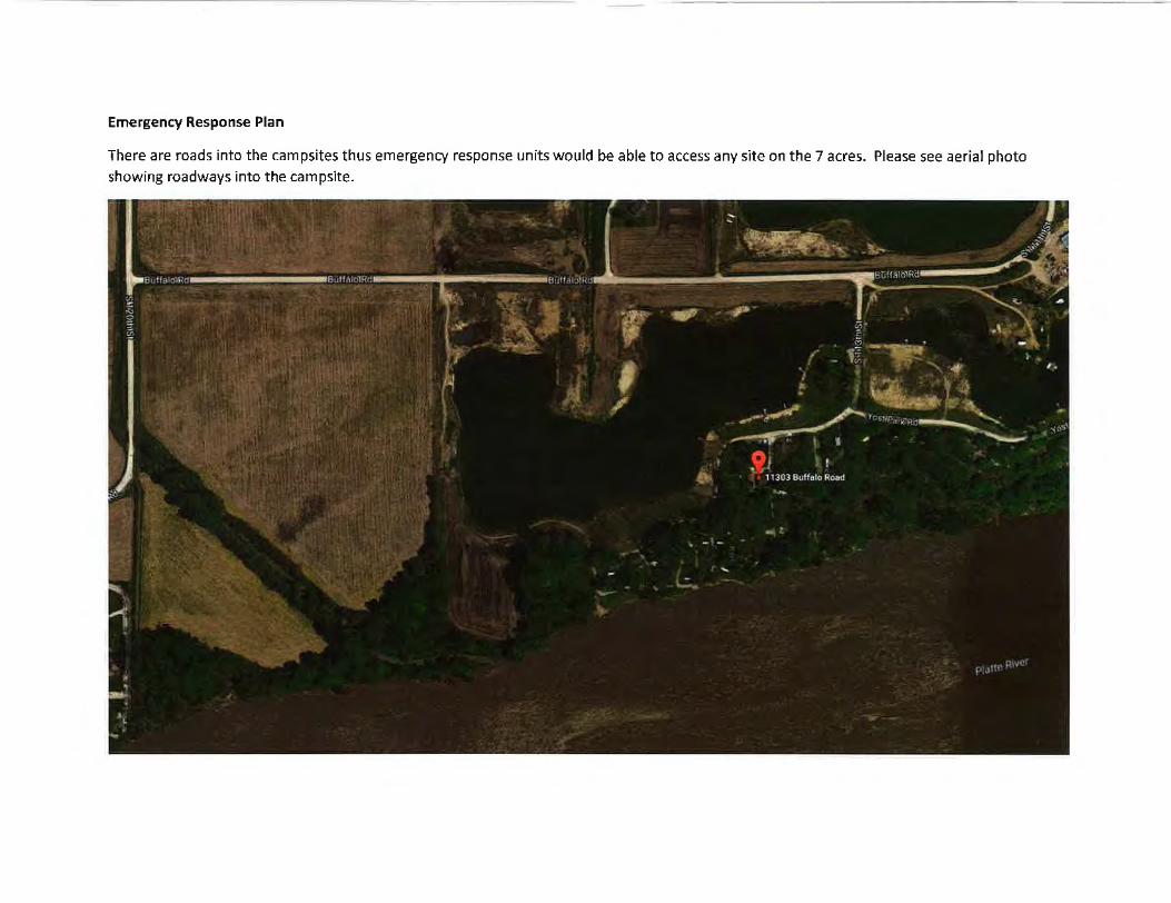
Eme rgency Response Plan
There are roads into the campsites thus emergency response units would be able to access any site on the 7 acres. Please see aerial photo
showing roadways into the campsite.
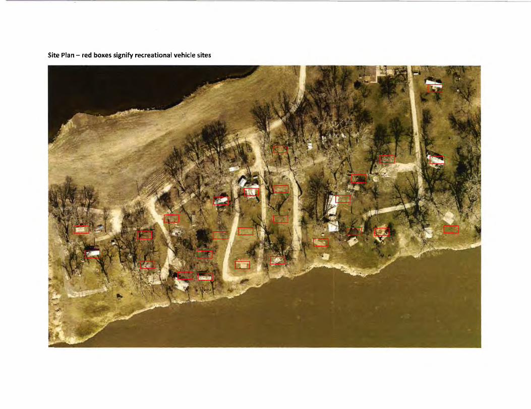
Site Plan - red boxes signify recreational vehicle sites
Kelly Jeck
From: Sent: To:
Laster, Lori Ann <I laster@pa pion rd.o rg > Wednesday, November 08, 2017 3:44 PM Kelly Jeck
Cc: Donna Lynam Subject: RE: Planning Review: Special Use Permit - 11303, 11411 & 11431 Buffalo Road
The District has reviewed the Special Use Permit application and offers the following comments:
The Emergency Response Plan provided with the application package does not address how recreational vehicles could either be removed during a flood or if the vehicles are anchored to prevent floatation. The plan should be revised to address how the applicant will ensure that each recreational vehicle complies with Sarpy County Floodplain Management Regulations.
Lori Ann Laster, P.E., CFM Stormwater Management Engineer Papio-Missouri River Natura l Resources District
From: Kelly Jeck [mailto :[email protected]} Sent: Friday, October 20, 2017 12:43 PM To: Dan Hains <[email protected]>; Scott Bovick <[email protected]>; Nikki Lampe <[email protected]>; Denny Wilson <[email protected]>; Pat Dowse <[email protected]>; Nicole Spitzenberger <[email protected]>; Jeff Davis <[email protected]>; Greg London <[email protected]>; Lynn Marshall <[email protected]>; Laster, Lori
Ann <[email protected]>; Grint, Amanda <[email protected]>; Williams, Eric <[email protected]>; Kathleen Gottsch <kathleen cit yofspringfield@ya hoo .com>; Brett Richards < bricha rd s@springfield pl atteview .org>; Jason Lutz ([email protected]) <[email protected]>; Chad Zimmerman ([email protected]) <chad.zimmerman@safetykleen.com> Cc: Bruce Fountain <[email protected]>; Donna Lynam <[email protected]> Subject: Planning Review: Special Use Permit -11303, 11411 & 11431 Buffalo Road
Frank Sladek has submitted an application for consideration of a Special Use Permit in the AG Agricultural Farming District to allow a commercial recreation and camping area, at 11303, 11411 , 11431 Buffalo Road, legally described as Tax Lots E1, E2, E3, all in Section 32, Township 13N, Range 12E of the 61h P.M. Sarpy County, NE. This application is slated for a November 21 , 2017 Public Hearing before the Sarpy County Planning Commission, therefore, we would like to have any comments back prior to October 27, 2017. If additional information is needed to complete your review, please contact our office to request.
Thank you ,
Kelly Jeck Planning & Zoning Assistant Sarpy County Planning Department 1210 Golden Gate Drive Papillion, NE 68046 [email protected]
1
RS-100
AG
AG
AG
East Lake Dr
Buffalo Rd
S 111
th St
S 120
th St
Whitney Rd
Buffalo Rd
Vicinity Map - Current Zoning
BellevuePapillionLa Vista
Gretna
Springfield
Tax Lots E1, E2, E3, all in 32-13-12Southeast of 120th Street & Buffalo RoadSpecial Use Permit
Subject Properties(Outlined in red)
SpringfieldETJ
S 99thSt
North Shore
Dr
E a st LakeDr
SandyPt
Buffalo Rd
S12
0thSt
Cottonwood Ln
S99th
S t
S111
thSt
Whitney Rd
Buffalo Rd
Current FLU - Sarpy CoAgriculture
Residential Estates
Low to Medium Density Residential
Medium to High Density Residential
Mixed Use Area
General Commercial
Business Park
Light Industrial
Heavy Industrial
Parks, Recreation, and Open Space
Future Land UseSarpy County, NebraskaLegend
Amended 9-12-2017
0 0.25 0.5 0.750.125 Miles
Tax Lots E1, E2, E3, all in 32-13-12Southeast of 120th Street & Buffalo Road
Special Use Permit
Subject Properties Outlined in blue(Residential Estates)
SpringfieldETJ
Cotto
nwoo
dLn
S 108
thSt
East LakeDr
Buffalo Rd
S12
0thSt Mitchell Rd
Whitney Rd
Buffalo Rd
S 111
th St
FW
AE
AE
Vicinity Map - Flood Zones
AE
LegendFEMA Flood Zones
FW
Flood Zone0.2 PCT ANNUAL CHANCE FLOOD HAZARD
1 PCT FUTURE CONDITIONS
A
AE
AH
AO
AREA NOT INCLUDED
X
X PROTECTED BY LEVEE
0.2 PCTAnnual ChanceFlood Hazard
Tax Lots E1, E2, E3, all in 32-13-12Southeast of 120th Street & Buffalo RoadSpecial Use Permit
FW
BellevuePapillionLa Vista
Gretna
Springfield
Subject Properties(Outlined in red)