Embed Size (px)
Citation preview
DURG VISHWAVIDYALAYA,
DURG (C.G.) Website - www.durguniversity.ac.in, Email - [email protected]
SCHEME OF EXAMINATION
&
SYLLABUS
of
M.A./M.Sc.(Geography) Semester Exam
UNDER
FACULTY OF SCIENCE Session 2017-18
(Approved by Board of Studies) Effective from July 2017
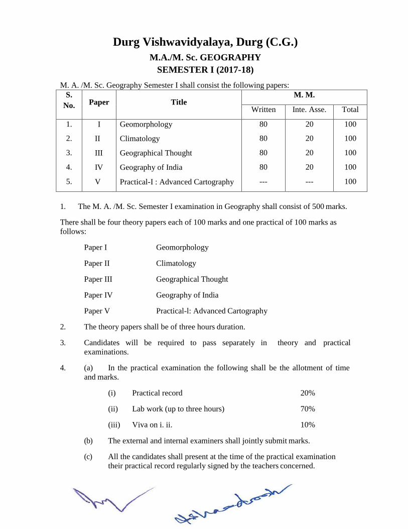
Durg Vishwavidyalaya, Durg (C.G.)
M.A./M. Sc. GEOGRAPHY
SEMESTER I (2017-18)
M. A. /M. Sc. Geography Semester I shall consist the following papers:
S.
No.
Paper
Title M. M.
Written Inte. Asse. Total
1.
2.
3.
4.
5.
I
II
III
IV
V
Geomorphology
Climatology
Geographical Thought
Geography of India
Practical-I : Advanced Cartography
80
80
80
80
---
20
20
20
20
---
100
100
100
100
100
1. The M. A. /M. Sc. Semester I examination in Geography shall consist of 500 marks.
There shall be four theory papers each of 100 marks and one practical of 100 marks as
follows:
Paper I Geomorphology
Paper II Climatology
Paper III Geographical Thought
Paper IV Geography of India
Paper V Practical-l: Advanced Cartography
2. The theory papers shall be of three hours duration.
3. Candidates will be required to pass separately in theory and practical
examinations.
4. (a) In the practical examination the following shall be the allotment of time
and marks.
(i) Practical record 20%
(ii) Lab work (up to three hours) 70%
(iii) Viva on i. ii. 10%
(b) The external and internal examiners shall jointly submit marks.
(c) All the candidates shall present at the time of the practical examination
their practical record regularly signed by the teachers concerned.
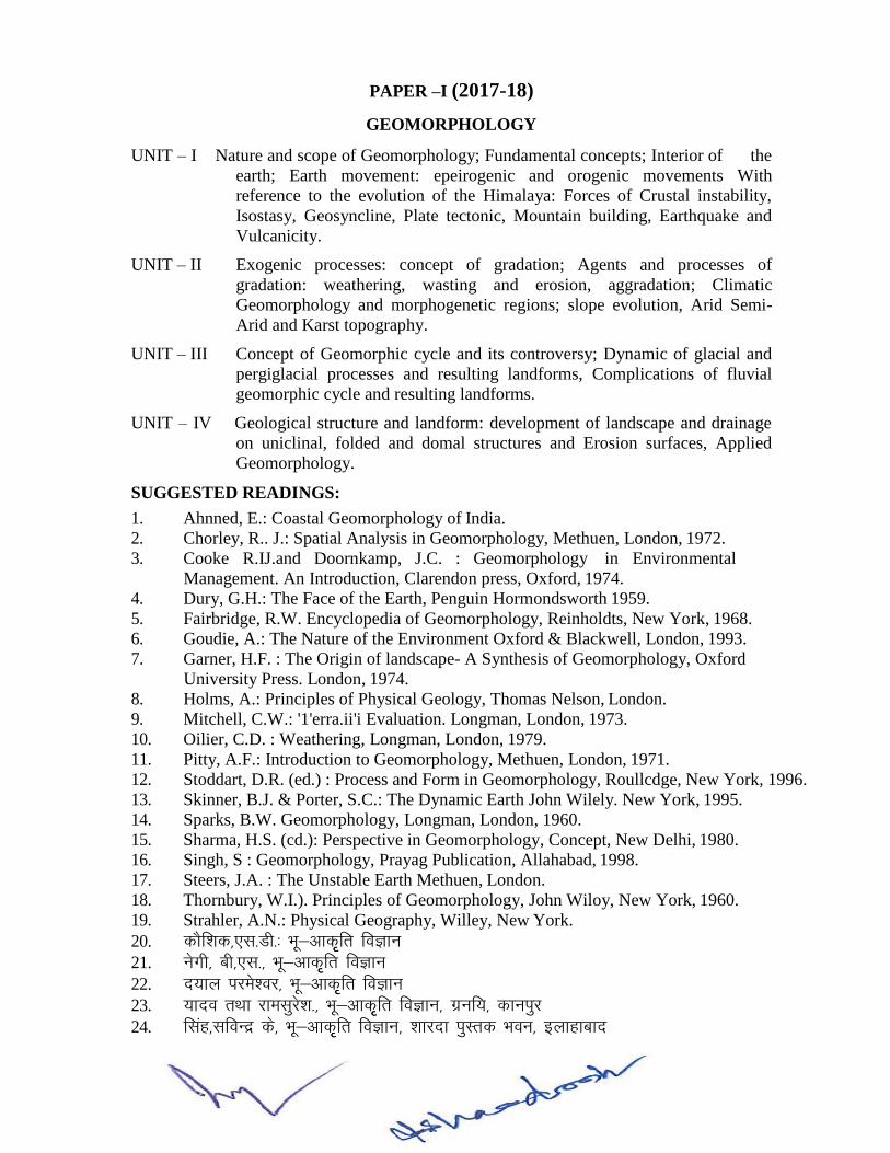
PAPER –I (2017-18)
GEOMORPHOLOGY
UNIT – I Nature and scope of Geomorphology; Fundamental concepts; Interior of the
earth; Earth movement: epeirogenic and orogenic movements With
reference to the evolution of the Himalaya: Forces of Crustal instability,
Isostasy, Geosyncline, Plate tectonic, Mountain building, Earthquake and
Vulcanicity.
UNIT – II Exogenic processes: concept of gradation; Agents and processes of
gradation: weathering, wasting and erosion, aggradation; Climatic
Geomorphology and morphogenetic regions; slope evolution, Arid Semi-
Arid and Karst topography.
UNIT – III Concept of Geomorphic cycle and its controversy; Dynamic of glacial and
pergiglacial processes and resulting landforms, Complications of fluvial
geomorphic cycle and resulting landforms.
UNIT – IV Geological structure and landform: development of landscape and drainage
on uniclinal, folded and domal structures and Erosion surfaces, Applied
Geomorphology.
SUGGESTED READINGS:
1. Ahnned, E.: Coastal Geomorphology of India.
2. Chorley, R.. J.: Spatial Analysis in Geomorphology, Methuen, London, 1972.
3. Cooke R.IJ.and Doornkamp, J.C. : Geomorphology in Environmental
Management. An Introduction, Clarendon press, Oxford, 1974.
4. Dury, G.H.: The Face of the Earth, Penguin Hormondsworth 1959.
5. Fairbridge, R.W. Encyclopedia of Geomorphology, Reinholdts, New York, 1968.
6. Goudie, A.: The Nature of the Environment Oxford & Blackwell, London, 1993.
7. Garner, H.F. : The Origin of landscape- A Synthesis of Geomorphology, Oxford
University Press. London, 1974.
8. Holms, A.: Principles of Physical Geology, Thomas Nelson, London.
9. Mitchell, C.W.: '1'erra.ii'i Evaluation. Longman, London, 1973.
10. Oilier, C.D. : Weathering, Longman, London, 1979.
11. Pitty, A.F.: Introduction to Geomorphology, Methuen, London, 1971.
12. Stoddart, D.R. (ed.) : Process and Form in Geomorphology, Roullcdge, New York, 1996.
13. Skinner, B.J. & Porter, S.C.: The Dynamic Earth John Wilely. New York, 1995.
14. Sparks, B.W. Geomorphology, Longman, London, 1960.
15. Sharma, H.S. (cd.): Perspective in Geomorphology, Concept, New Delhi, 1980.
16. Singh, S : Geomorphology, Prayag Publication, Allahabad, 1998.
17. Steers, J.A. : The Unstable Earth Methuen, London.
18. Thornbury, W.I.). Principles of Geomorphology, John Wiloy, New York, 1960.
19. Strahler, A.N.: Physical Geography, Willey, New York.
20. dkSf”kd],l-Mh-% Hkw&vkd`fr foKku 21. usxh] ch],l-] Hkw&vkd`fr foKku
22. n;ky ijes”oj] Hkw&vkd``fr foKku
23. ;kno rFkk jkelqjs”k-] Hkw&vkd``fr foKku] xzuf;] dkuiqj
24. flag]lfoUnz ds] Hkw&vkd`fr foKku] “kkjnk iqLrd Hkou] bykgkckn
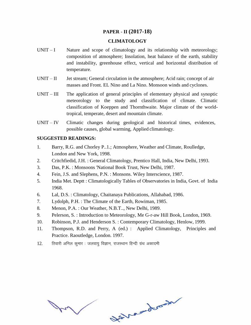
PAPER - II (2017-18)
CLIMATOLOGY
UNIT – I Nature and scope of climatology and its relationship with meteorology;
composition of atmosphere; Insolation, heat balance of the earth, stability
and instability, greenhouse effect, vertical and horizontal distribution of
temperature.
UNIT – II Jet stream; General circulation in the atmosphere; Acid rain; concept of air
masses and Front. EL Nino and La Nino. Monsoon winds and cyclones.
UNIT – III The application of general principles of elementary physical and synoptic
meteorology to the study and classification of climate. Climatic
classification of Koeppen and Thornthwaite. Major climate of the world-
tropical, temperate, desert and mountain climate.
UNIT – IV Climatic changes during geological and historical times, evidences,
possible causes, global warming, Applied climatology.
SUGGESTED READINGS:
1. Barry, R.G. and Chorley P..1.; Atmosphere, Weather and Climate, Roulledge,
London and New York, 1998.
2. Critchfiedid, J.H. : General Climatology, Prentico Hall, India, New Delhi, 1993.
3. Das, P.K. : Monsoons 'National Book Trust, New Delhi, 1987.
4. Fein, J.S. and Slephens, P.N. : Monsons. Wiley Interscience, 1987.
5. India Met. Deptt : Climatologically Tables of Observatories in India, Govt. of India
1968.
6. Lal, D.S. : Climatology, Chaitanaya Publications, Allahabad, 1986.
7. Lydolph, P.H. : The Climate of the Earth, Rowiman, 1985.
8. Menon, P.A. : Our Weather, N.B.T.., New Delhi, 1989.
9. Pelerson, S. : Introduction to Meteorology, Me G-r-aw Hill Book, London, 1969.
10. Robinson, P.J. and Henderson S. : Contemporary Climatology, Henlow, 1999.
11. Thompson, R.D. and Perry, A (ed.) : Applied Climatology, Principles and
Practice. Raoutledge, London. 1997.
12. frokjh vfuy dqekj % tyok;q foKku] jktLFkku fgUnh xzaFk vdkneh
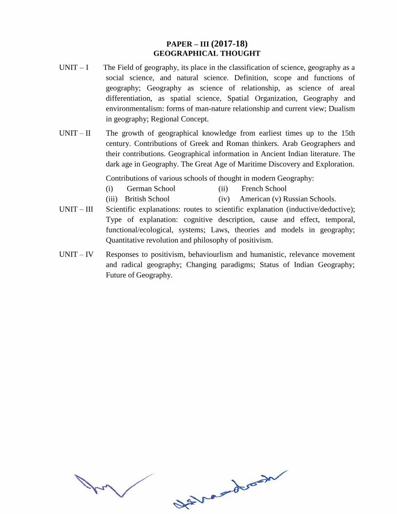
PAPER – III (2017-18) GEOGRAPHICAL THOUGHT
UNIT – I The Field of geography, its place in the classification of science, geography as a
social science, and natural science. Definition, scope and functions of
geography; Geography as science of relationship, as science of areal
differentiation, as spatial science, Spatial Organization, Geography and
environmentalism: forms of man-nature relationship and current view; Dualism
in geography; Regional Concept.
UNIT – II The growth of geographical knowledge from earliest times up to the 15th
century. Contributions of Greek and Roman thinkers. Arab Geographers and
their contributions. Geographical information in Ancient Indian literature. The
dark age in Geography. The Great Age of Maritime Discovery and Exploration.
Contributions of various schools of thought in modern Geography:
(i) German School (ii) French School
(iii) British School (iv) American (v) Russian Schools.
UNIT – III Scientific explanations: routes to scientific explanation (inductive/deductive);
Type of explanation: cognitive description, cause and effect, temporal,
functional/ecological, systems; Laws, theories and models in geography;
Quantitative revolution and philosophy of positivism.
UNIT – IV Responses to positivism, behaviourlism and humanistic, relevance movement
and radical geography; Changing paradigms; Status of Indian Geography;
Future of Geography.
SUGGESTED READINGS:
1. Abler, Ronald; Adams, John S. Gold, Peler : Spatial Organization : The
Geographer's view of the world. Prentice Hall, N.J. 1971.
2. Ali S.M. : The Geography of Puranas, Peoples Publishing House, Delhi, .1968.
3. Amedeo, Douglas : An Introduction to Scientific Reasonign in Geography,
John Wiley, U.S.A. 1971.
4. Dikshit, R.D. (ed.): The Art & Science of Geography Rand Me Nally & Co., 1959.
5. Hartshorne, R.: Perspectives on Nature of Geography Rand Me Nally & Co., 1959.
6. Husain, M. : Evolution of Geographic Thought, Rawat Pub., Jaipur, 1984.
7. Johnston, R.J.: Philosophy and Human Geography, Edward Arnold, London, 1983.
8. Johnston, R.J.: The Future of Geography, Methuen, London, 1988.
9. Minshull, R.: The Changing Nature of Geography, Hutchinson University Library,
London, 1970.
10. Ali, S. M.- Arab Geography.
11. Taylor, G.: Geography in the 20th Century.
12. Dikshit, R.D.: Geographical Thought : A Contexual History of Ideas, Prentice Hall of
India, New Delhi.
13. Harvey D. : Explanation in Geography.
14. flag mtkxj % HkkSxksfyd fpUru dk fodkl
15. f=ikBh ,oa fcjys% HkkSxksfyd fpUru dk fodkl ,oa fof/kra=
16. dkSf”kd] ,l]Mh-% % HkkSxksfyd fopkj/kkjkvksa dk bfrgkl ,o fof/kra=
17. flag] txnh”k % HkkSxksfyd fparu dk ewyk/kkj-
PAPER – IV (2017-18)
GEOGRAPHY OF INDIA
UNIT – I Physical and Biological elements in the Geography of India: Geological
structure, relief, climate, Drainage, vegetation and soils.
UNIT – II Agriculture: Major characteristics and problems, Impact of infrastructural and
institutional factors on agriculture. Important crops-wheat, rice, cotton,
sugarcane, oil-seeds, tea and coffee, Agricultural regions. Green revolution,
Agro-climatic regions.
UNIT – III Sources of power: Coal; Petroleum, Natural gas. Hydroelectricity and Atomic
energy. Mineral resources with special reference to iron ore, manganese and
bauxite. Industrial development with special reference to iron and steel, cement,
cotton, jute, sugar and paper industries; Industrial regions.
UNIT – IV Regional division of India: Purpose and Methodology. Major schemes of
regions of India: O.H.K. Spate and R.L. Singh. Physical and cultural geography
of Chhattisgarh State.
SUGGESTED READINGS:
1. Centre for Science & Environment (1988) State of India's Environment, New Delhi.
2. Desphande C.D. India. : a Regional Interpretation ICSSR & Northern Book Centre 1992.
3. Dreza, Jean & AMartya. Sen (ed.) India Economic Development and Social
opportunity Oxford University Person, New Delhi. 1996.
4. Kundu A. Raza Moonis : lndian Economy : the Regional Dimension Speclaum
Publishers, New Delhi, 1992.
5. Robinson, Francs : The Cambridge Encyclopedia of India, Pakistan, Bangladesh, Sri
Lanka, Nepal, Bhutan & Maldives Cambridge University Press, London, 1989.
6. Singh R.L. (ed.) : India - A Regional Geography National Geographical Society, India
Varanasi, 1971.
7. Spale OHK & ATA Learnont-India & Pakistan Methuen, London. 1967.
8. Tirtha R. & Gopal Krishna, Emerging India Reprinted by Rawat Publications, Jaipur 1996.
9. Sharma T.C. and O. Coutinho : Economic and Commercial Geography of India.
10. vxzoky ih-lh- Hkkjr dk HkkSfrd dk Hkwxksy] ,f”k;k izdk”ku da-]jk;iqj 2003
11. caly lqjs”kpaUn % Hkkjr dk HkkSfrd dk Hkwxksy] feuk{kh izdk”ku ] esjB- 12. oekZ jkefoykl] Hkkjr % ,d HkkSxksfyd foospu ] Hkonh; izdk”ku J`axkj?kkV & v;ks/;k] QStkckn] fiu
&224123]2007
PAPER – V (2017-18)
PRACTICAL I - ADVANCED CARTOGRAPHY
Graphs and Diagrams: Triangular graph. Logarithmic and semi logarithmic graphs, scatter
graphs; climatograph. Proportional circles, spheres and cubes.
Thematic Maps: Choropleth maps, isolines, Flow maps, isochrones and class intervals.
Morphometric Analysis: Profiles, Slope Analysis; Altimetric, and Clinographic curves; Block
Diagrams.
SUGGESTED READING:
1. Monk house F.J. & H.R. Wilkinson: Maps and Diagrams, Methuen, London.
2. ekWd gkml rFkk fofYdUlu ¼vuq-izks-iszepUn vxzoky½ % ekufp= rFkk vkjs[k e-iz- fganh xzaFk
vdkneh
3. ghjkyky% izk;ksfxd Hkwxksy-
4. “kekZ] ts- ih- izk;ksfxd Hkwxksy]
Durg Vishwavidyalaya, Durg (C.G.)
M.A./M. Sc. GEOGRAPHY (2017-18)
SEMESTER – II M. A. /M. Sc. Geography Semester II shall consist the following papers:
S.
No.
Paper Title M. M.
Written Inte. Asse. Total
1.
2.
3.
4.
5.
VI
VII
VIII
IX
X
Economic and Natural Resource
Management
Oceanography
Regional Development and Planning
Social Geography
Practical-II : Map Projections, Map
Interpretation and Surveying
80
80
80
80
---
20
20
20
20
---
100
100
100
100
100
1. The M. A./M. Sc. Semester II examination in Geography shall consist of 500
marks.
There shall be four theory papers each of 100 marks and one practical of 100 marks
as follows:
Paper VI Economic and Natural Resource Management.
Paper VII Oceanography
Paper VIII Regional Development and Planning
Paper IX Social Geography
Paper X Practical-II : Map Projections, Interpretation and Surveying.
2. The theory papers shall be of three hours duration.
3. Candidates will be required to pass separately in theory and practical examinations.
4. (a) In the practical examination the following shall be the allotment of time and marks.
(i) Practical record 20%
(ii) Lab work (up to three hours) 40%
(iii) Field work (up to three hours) 30%
(iv) Viva on i, ii & iii above 10%
(b) The external and internal examiners shall jointly submit marks.
(c) Candidates shall be examined in survey individually. They will however be allowed
to take the help of a labourer each at their own expense.
(d) All the candidates shall present at the time of the practical examination their
Practical record regularly signed by the teachers concerned.
PAPER- VI (2017-18)
ECONOMIC AND NATURAL RESOURCE MANAGEMENT
UNIT – I Nature and scope of economic Geography; fundamental concepts in
economic geography; classification of economies, sectors of economy
(primary, secondary, tertiary). Meaning, nature and classification of
resources, Resource appraisal: human wants and social objective,
technological status and resources. Appraisal of quality and quantity of
human resources, relation between population and resource, natural
resources and economic development, resource adequacy and scarcity,
limits to growth. Resource use, concept of absolute and relative abundance
of resources, optimum, under use, misuse and over use of resources.
UNIT – II World pattern of major natural resources: land and soils, biotic resources,
water resources mineral and energy resources, oceanic resources.
UNIT – III Classification of Industries, Theories of industrial location; case studies of
selected industries; Iron and Steel; Aluminium, Chemical, Textile. Means
of transport, International trade, trade blocks, globalization and Indian
economy.
UNIT– IV Conservation and management of resources; evolution of the concept,
principles, philosophy and approaches to conservation, resource
conservation and management methods. Policy making and resource
management; sustainable development of resources.
SUGGESTED READING:
Ahemd, Jaleel - Natural Resources in Low Income Contries.
Bennet, II.II. - Elements of Soil Conservation.
Ciriacy, Wantrup,S.V.& - Natural resources: Quality & Quantity
Persons (eds.)
Betall,R.C. & R.O.Buehanan - Industrial Activity and Economic Geography.
Edvard and Rosers - Agricultural Resources.
Freeman, T.W. - Geography and Planning.
Fryer, D.M. - World Economic Development.
Isard, Walter - Method of Regional Analysis.
Mehta, M.M. - Human Resource Development Planning.
Owen, O.S. - Natural Resource Conservation.
Peach, W.N.& James, A. - Zimmerman’s World Resources Contenting and
Conservation.
Parkin’s,E.A. & J.R. Whitakr - Our Natural Resource and their conservation.
Renner, G.T. - Conservation of National Recourses.
Stamp, L.D. - Land of Britain Its use and Misue.
Smith, G.H.(ed.) - Conservation. of Natural Recourses.
Symoos, L. - Agriculture Geography.
Thomas W.L.(et.al.reds.) - Man’s Role in Changing the face of the Earth.
Wales, H.& H.O. Lathrop - The Conservation of Natural Recourses.
Wheeler, T.O. et al - Economic Geography, John Wiler New York 1995.
PAPER – VII (2017-18)
OCEANOGRAPHY
UNIT – I Nature and scope of Oceanography; Distribution of land and water; Major
features of ocean basins; Marine sediments. Physical and chemical
properties of sea water.
UNIT – II Interlink between atmospheric circulation and circulation pattern in the
oceans, surface currents, Thermohaline, waves and tides.
UNIT– III Marine-biological environment : Bio-geochemical cycle in the ocean.
biozones, types of organisms; plankton, nekton and benthos, food and
mineral resources of the sea. Major marine environments; coastal :
esturary, deltas, barrier island, rocky coasts : Open : reefs, continental
shelf, continental slope and deep : Pelagic environment and floor of the
ocean basins.
UNIT – IV Impact of Humans on the marine environment. Law of the sea; exclusive
economic zone; marine deposits and formation of coral-reefs.
SUGGESTED READINGS:
1. Davis Rechard J.A. : "Oceanography-An Introduction to the Marine
Environment". Wm. C. Brown Iowa, 1986.
2. Duxbury, C.A. and Duxbury B. : An Introduction to the world's Oceans-C. Brown.
Iowa 2nd ed., 1986.
3. Garrison, T. : "Oceanography - An Introduction to Marine Science" Books/Cole,
Pacific Grove, USA, 2001.
4. Gross, M. Grant : Oceanography, a View of the earth, prantice-Hall inc, New
Delhi, 1987.
5. King C.A.M. Oceanography for Geographers 1962.
6. Sharma, R. C. "The Oceans" Rajesh N. Delhi, 1985.
7. Urnmerkutty, A.N.P. Science of the Eceans and Human life, NBT, New Delhi,
1985.
8. Ornmany, F.D. : The Ocean.
9. Sharma, R. C. & M. Vital : Oceanography : A Brief Introduction kislaya Pub. New
Delhi.
10. Siddartha, K.. : Oceanography : A Brief Introduction, Kislya Pub. New Delhi.
11. usxh ]ch-,l-% tyok;q rFkk leqnz foKku-
12. flag] lfoUnz flag & leqnz foKku] iz;kx iqLrd Hkou] bykgkckn ¼m-iz-½ 2011
13. yky] Mh- ,l & leqnz foKku]
PAPER – VIII (2017-18)
REGIONAL DEVELOPMENT AND PLANNING
UNIT – I Regional Planning: Definition, Scope, evolution and Objectives. Region
and Regionalism, Planning Regions: Concept and Delineation. Type of
Regions. Central Place Theory, Concept of core and periphery Friedmann's
Model of Spatial Organisation and Economic Growth.
UNIT – II Regional Development Theories: Development Theories of Myrdal and
Hirschman, Economic and Export Base model, Frank's Theory of Under
development.
UNIT – III Approaches and Strategies of Regional Development: Growth Pole Theory
Agropolitan Development, Community Development, River Basin
Planning, Metropolitan Planning (with reference to India).
UNIT– IV Regional Planning in India. Regional Imbalances and Inequalities,
Indicators of Regional Development; Regional Policies in Five Year Plans,
Centre State Relations and Multilevel Planning, Planning for special
problem Regions: Hill areas, Tribal areas, Drought prone areas, Command
areas and River basins. Regional development and planning in India.
SUGGESTED READING:
1. Daysch, C.H.J. & others: Studies in Regional Planning.
2. Deckinsonm R.E. : City Region and Regionalism.
3. Freeman, E.W. : Geography arid Planning.
4. Golksin A. : Regional Planning and Development.
5. Keeble, L. : Principle and Practice of Town and Country Planning.
6. Stamp L.D. : The Land of Britain : Its use and Misure.
7. Sdasyuk. Gatina and Dengupta, P. : Economic Regionalization of India problems
and Approaches.
8. Desai, P.B. & others : Regional Perspective of Industrial and Urban Growth the
case of Kanpur, Bombay, 1969.
9. Prakash, Rao V.L. & S.P. : Regional Planning.
10. Censuts of India : Economic and Socio Cultural Dimensions of regionalization (An
Indo-USSR Collaborative Study)
11. Friedmann J. & Alonsow : Regional Development and Planning, M.I.T. Press.
12. Misra R.P. (ed.) : Regional Planning : Concept; Techniques, Policies and cade
studies Mysore 1969.
13. Misra, R.P. & others : Regional Development and Planning in India.
14. Timbergen : Essays on World Regional Planning.
15. Lord, W. : Methods of Regional Analysis, M.I.T., I960.
16. Zimmerinan, E.W. : World Resources and Industries.
17. Burton & Kates : Reading in Resource Management Conservation.
18. Burton & Kates : Regional Planning in India.
19. Ahamed, Enayet : Regional Planning with particular Reference to India. Vol. I and
li New Delhi.
20. Bhatt L.S. and others: Micro level planning - A Case Study of Karnal Area,
Hyryana (K.B. Publishing, New Delhi)
21. Bhatt LS : Regional Planning in India, Statistical Publishing Society, Calcutta,
1973.
22. Gosal GS, and G. Krishanan : Regional Disparities in levels of Socio-economic
Development in Punjab, Vishal Publications Kurukshetra, 1984.
23. Chandna, R.C. : Regional Planning : A comprehensive 'Text-Kajyani Publishers.
24. Ray Choudhari, Jayasri : An Introduction to Development and Regional Planning
Orient Longman.
25. Sundaram, KV (ed) Geography and Plann8ing, Essaya in houour of VLS Prakasa
Rao, Concept Publishing Co., New Delhi, 1985.
26. Raza, Meomis (ed) Regional Development, Hefitage Publishiers, Delhi, 1988.
27. Mishra R.P. et al : Multilevel Planning, Heritage Phulishers Delhi,1980.
28. JhokLro Ogh -ds- ,oa vU; % izknsf”kd fu;kstu ,oa larqfyr fodkl-
29. vks>k] j?kqukFk% izknsf”kd fu;kstu dk Hkwxksy]-
30. “kekZ] jkthoykspu % izknsf”kd ,oa uxjh; fu;kstu-
31. pUnzkdj] bUnze.k % O;kogkfjd Hkwxksy] olqU/kjk izdk”ku] xksj[kiqj] 1998-
PAPER – IX (2017-18) SOCIAL GEOGRAPHY
UNIT– I Definition, meaning and scope of Social geography and its Nature and
relationship with other Social sciences. Development of Social Geography,
Approaches to the study of Social Geography.
UNIT– II Concept of Society – Social Environment, Geographic bases of Social
Formation. Social Geography of India - Social Stratification, Caste and
Class. Social organization and groups, Social transformation and change in
India, Religion and linguistic group of India. Evolution of Socio-Cultural
Regions of India.
UNIT – III Social well- being– meaning and indicators of Social well- being. Quality
of life, Pattern and bases of rural and urban society. Deprivation and
discrimination issues relating to women and under privileged groups.
Cultural Realms and Cultural Region of the World.
UNIT – IV Social development planning – meaning and importance. Public policy and
social planning in India: Review of Five year Plans strategies to improve
social well-being in tribal, hill, drought and flood prone Areas.
SUGGESTED READINGS:
1 Ahmad Aijazuddin, Social Geography, Rawat Publication, New Delhi, 1999.
2 De Blij. H.D. Human Geography. John Wiley and son, New York.
3 Dreze Jean, Amariya Sen,Economic Development and Social opportunity. Oxford
University Press. New Delhi. 1996
4 Dubey. S.C : lndian Society. National Book Trust, New Delhi, 1991.
5. Gregory. D . and J. Larry (Eds.) Social. relations and spatial structures.
MC Millan. 1985.
6. Haq. Mahbubul : Reflections on Human Development. Oxford University Press,
New Delh6.
7. Jones, Emrys, Reading in Social Geography, Oxford University Press, Ely House,
London, 1977.
8. Jones, Emrys and John Eyles, An Introduction to Social Geography, Oxford
University Press, London,1977.
9. Maioney. Clarence: People of South Asia, Winston, New York, 1974.
10. Planning Commission, Government of India: Report on Development of Tribal
areas, 1981.
11. Rao, M.S.A.. Urban Sociology in India, Orient Iongman, 1970.
12. Schwartzberg Joseph : An Historical Atlas of South Asia, University of Chicago
Press, (Chicago, 1978.
13. Sen, Amartya & Dreze Jean. Indian Development : Selected Regional
Perspectives. Oxford University Pres-s, 1996
14. Smith, David: Geography : A welfare Approach, Edward Arnold, London, 1977.
15. Sopher, David. An Expoloration of Inda, Cornell University Press, 1980.
16. Subba. Rao. Personality of India : Pre and Proto Historic foundation of India and
Pakistan, M.S. University Baroda. Vadodai'a, 1958
17. ekS;Z] ,l-Mh-] lkekftd Hkwxksy “kkjnk iqLrd Hkou]11 ;qfuoflZVh jksM bykgkckn&2]2004-
PAPER – X (2017-18)
PRACTICAL II- MAP PROJECTIONS, INTERPRETATION AND SURVEYING
Map Projections: Mathematical/Graphical construction of world
projections. Interpretation of Maps: Geological Maps.
Principles and methods of topographical surveying involving the use of Theodolite and
Dumpy level. Solution of problems in Surveying.
Topographical Information – International series, South east Asia Series, Indexing,
Classification & Interpretation of topographical sheets.
SUGGESTED READINGS:
1. Davis, R. C. & E. S. Forte : Surveying : Theory and Practical.
2. Kanetkar, T.R. & S.V. Kulkarni: Surveying and leveling part I & IJ A.V.G.
Prakashan, Poona.
3. Monkhouse F.J. & H.R. Wilkinson: Maps and Diagrams, Methuen, London.
4. ekWd gkml rFkk fofYdUlu ¼vuq-izks-iszepUn vxzoky½ % ekufp= rFkk vkjs[k e-iz- fganh xzaFk
vdkneh -
5. ghjkyky% izk;ksfxd Hkwxksy-
Durg Vishwavidyalaya, Durg (C.G.)
M.A./M. Sc. GEOGRAPHY
SEMESTER III (2017-18)
M.A. /M. Sc. Geography Semester III shall consist the following papers:
S.
No.
Paper
Title M. M.
Written Inte. Asse. Total
1.
2.
3.
4.
5.
XI
X II
XIII (A)
OR
XIII (B)
XIV
XV
Population Geography
Settlement Geography
Remote Sensing Techniques
OR
Biogeography and Ecosystem
Research Methodology
Practical-III : Remote Sensing and
Quantitative Techniques
80
80
80
80
80
---
20
20
20
20
20
---
100
100
100
100
100
100
1. The M.A. /M. Sc. Semester III examination in Geography shall consist of 500 marks.
There shall be four theory papers each of 100 marks and one practical of 100 marks as' follows:
Paper XI : Population Geography
Paper XII : Settlement Geography
Paper XIII (A) : Remote Sensing Techniques
OR Paper XIII (B) : Biogeography and Ecosystem
Paper XIV : Research Methodology
Paper XV : Practical – III: Remote Sensing and Quantitative Techniques
2. The theory papers shall be of three hours duration.
3. Candidates will be required to pass separately in theory and practical examinations.
4. (a) In the practical examination the following shall be the allotment of time and marks.
(i) Practical record : 20%
(ii) Lab work (up to Four hours) : 70%
(iii) Viva on i.& ii. Above : 10%
(b) The external and internal examiners shall jointly submit marks.
(c) All the candidates shall present at the time of the practical examination their practical
record regularly signed by the teachers concerned.
SEMESTER – III (2017-18)
PAPER - XI
POPULATION GEOGRAPHY
UNIT – I Definition and scope of Population Geography. Relation of Population Geography
with other subjects of social sciences. Historical development of Population
Geography in western countries and in India. Sources of population data, Census and
its history.
UNIT – II Distribution of Population: The concept of population density and its types. Factors
affecting population distribution. Distribution & Density of population in the world
with special reference to Europe, Asia and India. Growth of population: Measure of
decennial and annual rates of population growth, prehistoric and modern trends of
population growth in the world. Regional aspect of population growth in India.
Population theories. Demographic transition.
UNIT– III Population composition in terms of age and sex, rural, urban residence, educational
status and occupational structure. Significance of these elements in population
analysis, factors affecting their composition in population, broad world patterns and
detailed spatial patterns in India. Fertility and Mortality of population: Significance
and factor. Indices and rates. World pattern and pattern in India. Human
Development Index and its Components.
UNIT– IV Migration of population: Causes, characteristics and types. Methods of estimating
value of internal migration. Important international migrations of the world, internal
migration in India: Population and Resources: Population-Resource regions.
Population Regions: Concept and methods, population regions of India, population
policies of India.
SUGGESTED READINGS:
1. Bilasborruw, Richard Ii and Daniel Hogan, Population and Deforestation in the
Humid Eropics, International Union for the Scientific Study of Population, Belgium 1999.
2. Boglia, D.J. Principles in Demography, John Wiley, New York 1969.
3. Bose, Ashish el at. : Population in India's Development (1947-2000); Vikas Publishing
House, New Delhi, 1974.
4. Census of India, India : A State Profile, 1991.
5. Chandna, R. C. Geography of Population, Concept, Determinants and Patterns. Kalyani
Publishers, New York, 2000.
6. Clarke, John 1. Population Geography, Pergamon Press, Oxford, 1973.
7. Crook, Nigel Principles of Population and Development Pergmaon Press. New York 1997.
8. Daugherty, Helen Gin, Kenneth C.W. Kammeyir, An Introduction to Population (Second
Edition), The Guilford Press, New York, London, 1998.
9. Garnicr, B.J. Geography of population Longrrian, London. 1970.
10. oclihar, Ra)esh, The Veclic People : Their History and Geography Orient I ongman Ltd.,
New Delhi, 2000.'
11. Mamoria, C.B. India's Population Problem, Kitab Mahal New Delhi, 1981.
12. Mjtra, Ashok India's Population : Aspects of Quality and (control Vol I & 11. Abhiman
Publications, New Delhi, 1978.
13. Premi, M.K. India's Population : Heading Towards a Billion, B.R.., Publishing Corporation
1991.
14. Srinivasan, K. and M. Vlassoff, Population Development Nexus in India :Challenges for the
New Millennium Lata Me Graw-Hill, New Delhi, 2001.
15. Srinivasan K. Basic Demographic Techniques and Applications Sage, Publications, New
Delhi, 1998.
16. Sunda.ra.m K. V. a.nd Sudesh Nangia., (ed.) Population Geography, Henlage
Publications, Delhi, 1986.
17. UNDP : Human Development Report, Oxford University Press, Oxford, 2000.
18. United Nations, Methods for Projections of urban and Rural Population No. VIII, New
York, 1974.
19. Woods R.. Population Amalysis' in Geography Longman, London, 1979.
20. Zeiinsky Wilbur, A Prologue to Population Geography, Prentic Hall, 1966.
21. c?ksy] vuqlqb;k % vuqlwfpr tkfr;ksa ,oa vuqlwfpr tutkfr;ksa esa iztuurk izfr:Ik %
NRrhlx<+ jkT; ds jk;iqj laHkkx ds fo”ks’k lanHkZ esa^] ia- jfo”kadj “kqDy fo”ofo|ky;]
jk;iqj] 2002-
22. c?ksy] vuqlqb;k % f”k”kq eR;ZRkk % fla?kbZ ifCy”klZ ,.M fMLVªhC;wVj] jk;iqj] 2004-
23. “kekZ] ljyk % vkS|ksfxd uxjksa esa tula[;k vkizokl ¼fHkykbZ ,oa dksjck uxj ds
fo”ks’k lanHkZ esa½] i-a jfo”kadj “kqDy fo”ofo|ky;] jk;iqj] 2002-
24. “kekZ] ljyk % NRrhlx<+ csflu esa xzkeh.k f”k”kq eR;Zrk izfr:Ik- - iaMk] ch-ih- %
tula[;k Hkwxksy-
25. vks>k] j?kqukFk % tula[;k Hkwxksy- ghjkyky % tula[;k Hkwxksy-
26. pUnuk] vkj-lh- % tula[;k Hkwxksy- f=ikBh]
27. jkenso % tula[;k Hkwxksy-
SEMESTER – III (2017-18)
PAPER - XII
SETTLEMENT GEOGRAPHY
UNIT – I Meaning, Objectives and Scope of Settlement Geography; Evolution, Distribution,
Types and Patterns of Rural Settlements; Rural House Types; Rural Service Centers.
UNIT – II Evolution and growth of urban settlements; The Geographical setting of Urban
Centers: Site, Situation and Location.
UNIT – III Rank- size-relationship; Cities as Central Places, Central Place Theory, Growth
Centre Theory.
UNIT – IV City- Country Relationship: Umland, Rural-Urban Fringe.
SUGGESTED READINGS:
1. Abercrombee, Sir P. : Town and Country planning 1961.
2. Alani, Shah Manzoor : Hyderabad Secuiidrabad (Twin Cities) A. study in urban geography)
3. Alam, S.M. & V.V. Tokshishevesky : Urbanization in developing countries.
4. Berry Brain .1. L. : Geographic Prospective on Urban .Systems.
5. Bresse, C. & D.F. Whiteman : An approach to Urban Planning
6. Dickinson, R.E, : City, Religion and Regionalism.
7. Gallion and Fisher : The Urban Pattern.
8. Grifitth, , J.P : A study of Urban constructions in India.
9. Gibbs : Urban Research Methods.
10. Mayor, H.M. & (.,'.1''. Kohn : Readings in Urban Geography.
11. Morgan, F.W. : Ports and Harbours.
12 Mumford L. : Culture of cities.
13. Robson, W.A. : Great cities of world.
14. Robson, B.T. : Urban Growth : An approach, Methuen, London.
15. Carter, Harold : Study of Urban Geography, London, Edward Arnold, 1979.
16. Singh R.I.,. & K.N. Singh : Readings in Rural Settlement Geography, NGSI Varanasi, 1975.
17- flag] mtkfxj % uxjh; Hkwxksy
SEMESTER – III (2017-18)
PAPER – XIII (A)
REMOTE SENSING TECHNIQUES
UNIT– I Historical development of remote sensing as a technology - Relevance of remote
sensing in Geography - Concepts and basics: Energy source, energy and radiation
principles, energy interactions in the atmosphere and earth surface features, remote
sensing systems: platform sensors and radiation records. Microwave sensing
interpretation of SLAR imageries, thermal imageries.
UNIT– II Remote Sensing Satellite: platforms LANDSAT, SPOT, NOAA, RADARSAT, IRS,
INSAT: principles and geometry of scanners and CCD arrays, orbital characteristics
and data products - MSS, TM, LISS I & II, SPOTPLA & MLA, SLAR.
UNIT– III Image Processing: Types of imagery, techniques of visual interpretation, ground
verification transfer of interpreted thematic information to base maps-digital
processing: rectification and restoration, image enhancement - contrast manipulation,
Classification: Supervised and Unsupervised, post-classification analysis and
accuracy assessment.
UNIT– IV Applications: Air photo and image interpretations, arid mapping land use and land
cover, land evaluation, urban land use, landform and its processes, weather studies
and studies of water resources: integration of Remote Sensing and GIS. Remote
sensing and hazard management, remote sensing and environmental management.
SUGGESTED READINGS:
1. American Society of Photogrammetry: Manual of Remote Sensing. ASP, Falls Church V.A., 1983. 2. Barrett E.C. and L.F. Curtis : Fundamentals of Remote Sensing and Air Photo Interpretation on,
Memillan, New York, 1992.
3. Compbell J.: Introduction to Remote Sension, Guilford, New York, 1989.
4. Curran, Paul J.: Principles of Remote Sensing. Longman, London, 1985.
5. Hord R.M. : Digital Image Processing of Remotely Sensed Date, Academic, New York, 1983. 6. Luder D„ Aerial Photography Interpretation: Principles and Application, CcGraw Hill, New York,
1959.
7. Pratt W.K. Digital Image Processing. Wiley, New York, 1978. 8. Rao D. P. (eds.): Remote Sensing for Earth Resources, Association of Exploration Geophysicist,
Hederabad, 1998.
9. Thomas M. Lollesand and Ralph W. Kefer, Remote Sensing and Image Interpretation, Wiley & sons,
New York, 1994.
10. Aronoff S. Geographic Information Systems : A. Management Perspective, Publication Offiawa,
1989.
11. Burrough P.A. Principles of Geographic Information Systems for Land Reson Assessment Oxford
University Press, New York, 1986.
12. Fraser Taylor D.R. Geographic information Systems. Pergamor Press, Oxford 1990. 13. Maquire D.J.M.F. Goodchild and D.W. Rhind (eds.). Geographic information System 'Principles
arid Application. Taylor & Francis, Washingron, 1991.
14. Mark S. Monmonier. Computer - assisted Cartography, Prentice-Hall, Englewood Cliff, Jersey, 1982.
15. Peuquet D. .1. and D.F.- Marble, Introductory Reading in Geographic. Information System Taylor &
Francis, Washington, 1990.
16. Star J. and J. Estes, Geographic Information Systems : An Introduction, Prentice Englewood Cliff,
New Jersey, 1994.
17. pkSfu;ky] nsoh nRRk % lqnwj laosnu ,oa HkkSxksfyd lwpuk iz.kkyh-
PAPER – XIII (B) (2017-18)
BIOGEOGRAPHY AND ECOSYSTEM
UNIT– I Definition and scope of Biogeography Environment, Habitat and Plant-animal
association, Biome Types.
UNIT– II Elements of plant geography, distribution of forests and major communities. Plant
successions in newly formed land forms. Zoogeography and its Environmental
Relationship. Palaeo botanical and Palaeo climatological records of environmental
change.
UNIT– III Ecosystems: concept and components, Ecosystem-form and function: tropic level,
ecological pyramids, ecological niche, energy and nutrients in the ecosystem,
hydrological cycle, food chains and food webs. Major terrestrial ecosystems of the
world: agriculture, forests, grassland and desert. Population growth and environment.
UNIT– IV Biodiversity and its Conservation. Preservation and conservation of the ecosystem
through resource management, Environment legislation. The Stockholm conference,
the Earth summit, Environmental laws in India (the Wild Life Act, Water Act, Forest
Act, Environment Protection Act and National Environment Tribunal Act).
SUGGESTED READINGS -
1. Agrawal D.P. : Man and Environment in India through Ages, Book & Books, 1992. 2. Bradshaw, M.J. : Earth and Living Planet, ELBS. London, 1979.
3. Cox, C.D. and Moore, P.D. : Biogeography : An Ecological and Evolutionary Approach 5th
edn.
Blackwell, 1993.
SEMESTER – III (2017-18)
PAPER - XIV
RESEARCH METHODOLOGY
UNIT – I Research Methodology-An Overview; Procedure of scientific Research, Defining
Research Problem; Formulating Hypothesis; Research Design.
UNIT – II Methods of Data Collection: Observation, Questionnaire, Schedule and Interview;
Sampling: Sampling Methods, Size of Sample;
UNIT – III Processing and Analysis of Data: Processing- Editing, Coding, Classification and
Tabulation, Analysis – Measurement of Central Tendency, Dispersion, Correlation.
UNIT – IV Preparation of Research Reports: Steps, Layout and Types of Reports
1. Gaur, R. : Environment and Ecology of Early Man in Northern India R. B. Publication Corporation
1987.
2. Hoyt, J.B. Man and the Earth, Prentice Hall, U.S.A. 1992.
3. Huggett. R.J. : Fundamentals of Biogeography, Routledge, U.S. A. 1998.
4. Illes, J. : Introduction to Zoogeography, Mcmillan, London, 1974. 5. Khoshoo, T. N. and Sharma. M. (eds) : Indian Geosphere-Biosphere Har-Anand Publiction, Delhi
1991
6. Lapedes, D.N.(ed) : Encyclopedia of Environmental Science, McGraw Hill, 1974. 7. Mathur H.S. : Essentials of Biogeography, Anuj Printers, Jaipur, 1998.
8. Pears, N. : Basic Biogeography, 2nd
edn. Longman, London, 1985. 9. Simmons, I.G. Biogeography, Natural and Cultural, Longman, London, 1974.
10. Tivy J. : Biogeography: A Study of Plants in Ecosphere 3rd
edn. Oliver and Boyd, U.S. A., 1992.
11. Ackerman, E.A. : Geography as a Fundamental Research Discipline, University of Chicago
Research Papers, 1958
12. Agarwal, A. and Narain, S. : The Citizens Fith Report. Centre for Science and Environmental, New
Delhi, 1999.
13. Bertalanffy, L. : General Systems Theory, George Bragiller, New York, 1958.
14. Bodkin, E. : Environmental studies, Charles E Merril Pub. Co., Columbus, Ohio, 1982.
15. Chandana, R.C. : Environmental Awareness, Kalyani Publishers, New Delhi, 1958. 16. Chorley, R.J. : Geomorphology and General Systems Theory, U.S.G.S. Professional Paper, 500B,
1962.
17. Eyre, S.R. and Jones, G.R.J. (eds) Geography as Human Ecology, Edwares Arnold, London, 1966.
18. Kormondy, E.J. : Concepts of Ecology, Prentice Hall, 1989. 19. Manners, I.R. and Mikesell, M.W. (eds.) Prespectives on Environment, Commission on College
Geography, Publ. No. 13 Washington, D.C., 1974.
20. Nobel and Wright : Environmental Science, Prentice Hall, New York, 1996.
21. Odum, E.P.: Fundamentals of Ecology, W.B. Saunders, Philadelphia, 1971. 22. Russwurm, L.H. and Sommerville, E. (eds.) : Man’s Natural Environment-A Systems Approach,
Duxbury, Massachuselts, 1985.
23. Sharma, H.S. : Ranthambhore Sanctuary – Dilemma of Eco-development, Concept, New Delhi,
2000.
24. Simmons, I.G. : Ecology of Natural Resources, Edward Arnold, London, 1981.
25. Singh S. : Environmental Geography, Prayag Publications, Allahabad, 1991.
26. Smith, R.L. : Man and his Environment : An Ecosystem Approach, Harper & Row, London, 1992.
27. U.N.E.P. : Global Environmental Outlook, U.N. Pub. , New ork, 1998.
28. World Resources Institute : World Resoources, (Latest Report) Washington.
29. dqyJs’B] dkerk izlkn% tSo Hkwxksy-
SUGGESTED READING:
1. Selltiz, C.M. Jahoda, M. Deutsch
and others.
Research Methods in Social Relations, Holt, . New
York, 1961.
2. Goode, W and P.K, Hatt Methods in Social Research, Mc Graw Hill,
.Tokyo, 1962.
3. Harvey, David . Explanation in Geography, Edward Arnold,
London, 1971
4. Chorley, R.J. and P. Hagg & tt (ed) Models in Geography, Methuen,
London, 1967.
5. Minshull, R. Introduction to Models in Geography. Longman
London, 1975.
6. Sheskin, I.M. Survey Research for Geographers Scientific
Publisher, Jodhpur, 1987.
7. Kothari, C. R. Research Methodo!ogy : Methods and Techniques,
Wishwa Prakashan, 1994.
8. Misra H.N. and V.P. Singh Research Methodology in Geography: Social,
Spatial and Policy Dimensions, Rawat Publications
New Delhi, 1998.
9. Har Prasad Research Methods and Techniques in Geography,
Rawat Publications, New Delhi. 1992.
SEMESTER – III (2017-18)
PAPER - XV PRACTICAL -III
Remote Sensing, Interpretation of Topographical Sheets and Quantitative Techniques
1. Principles of Photogrammetery: - Air Photo- Stereo test, Orientation of stereo model
under mirror stereoscope, Preparation of photo/line index and determination of photo scale,
Use of parallax bar and determination of heights, Identification of features on aerial photo
graph, Tracing of details from stereo pair, Interpretation of physical and cultural details,
Preparation of Land use map pre field interpretation, Field visit for ground truthing.
2. Remote Sensing:– Study of satellite Image – Annotation Identification of features on FCC
imageries, Tracing of details from satellite imageries, Basic Principles of Image
interpretation, Interpretation of Physical and Cultural details and preparation of land use and
land cover map using IRS Images. Pre field visit.
Statistical Techniques:
Product moment and Rank Correlation Coefficients, Linear Regression. Hypothesis Testing:
Chi-Square test, t-test & F test, Sampling Techniques, Point, Line and Area Sampling.
SUGGESTED READINGS:
1. American Society of Photogrammetry : Manual of Remote Sensing. ASP, Falls Church V.A.
1983.
2. Barren E.C. and I...F. Clirtis : Fundamentals of Remote Sensing and Air Photo
Interpretation 'on, Memillan, New York, 1992.
3. Conipbell .1. : Introduction to Remote Sension, Glinford, "New York, 1989.
4. Clirran, Paul J. : Principles of Remote Sensing. Longman, London, 1985.
5. Hord R.M. : Digital Image Processing of Remotely Sensed Date, Academic, New York,1983
6. Luder D., Aerial Photograpliy Interpretation : Principles and Application, Cc Graw Hill,
New York, 1959.
7. Pratt W.K. Digital Image Processing. Wiley, New York, 1978.
8. Rao D. P.. (eds.) : Remote Sensing for Earth Resources, Association of Exploration
Geophysicisi, Hederabad, 1998.
9. Thomas M. Lollesand and Ralph W. Keler, Remote Sensing and Image
Interpretation, Wiley & sons. New York, 1994.
10. Aronoff S. Geographic Information Systems: A Management Perspective,
Publication Offawa, 1989.
11. Burroligh P..A. Principles of Geographic Information Systems for Land Reson
Assessment Oxford University Press, New York, 1986.
12. Fraser Taylor D.R. Geographic information Systems. Pergamor Press, Oxford 1990.
13. Maquire D.J.M.F. Goodchiln and D.W. Rhind (eds.). Geographic information System
Principles and Application. Taylor& Francis, Washingron, 1991.
14. Mark S. Monrnonicr. Computer-assisted Cartography, Prentice Hall, Englewood Cliff,
Jersey, 1982.
15. Peuquer D.J. and D.F. Marble, Introductory Reading in Geographic Information System
Taylor & Francis, Washington, 1990.
16. Star J. and J. Estes, Geographic Information Systems; An Introduction, Prentice Eaglewood
Cliff, New Jersey. 1994.
M.A./M. Sc. GEOGRAPHY
SEMESTER IV (2017-18)
M.A./M.Sc. Geography Semester IV shall consist the following papers:
S.
No. Paper Title M. M.
Written Int. Ass. Total
1.
2.
3.
4.
5.
6.
XVI
X VII
XVIII (A)
OR
XVIII (B)
XIX
XX
Urban Geography
Agricultural Geography
Geographical Information System
OR
Environmental Geography
Field Work (Physical and Socio- Economic)
Practical-IV :Geographical Information System and
Quantitative Techniques
80
80
80
80
---
---
20
20
20
20
---
---
100
100
100
100
100
100
1. The M.A./M.Sc. Semester IV examination in Geography shall consist of 500 marks.
There shall be three theory papers and one Field Work report each of 100 marks and one practical of 100 marks as follows.
S. No. Paper Title
1. XVI : Urban Geography
2. XVII : Agricultural Geography 3. XVIII (A) : Geographical Information System
OR
4. XVIII (B) : Environmental Geography 5. XIX : Field Work (Physical and Socio- Economic)
6. XX : Practical-IV :Geographical Information System and
Quantitative Techniques
2. The theory papers shall be of three hours duration.
3. Candidates will be required to pass separately in theory and practical examinations.
4. Candidates will be required to submit their Field Report in three copies in hard
bound at least one hundred pages for Valuation.
5. (a) In the practical examination the following shall be the allotment of time
and marks
(i) Practical record 20%
(ii) Lab Work (up to Four Hours) 70%
(iii) Viva on i & ii above 10%
(b) The external and internal examiners shall jointly submit marks.
(c) All the candidates shall present at the time of practical examination their
practical record regularly signed by the teacher concerned.
SEMESTER – IV (2017-18) PAPER-XVI
URBAN GEOGRAPHY
UNIT – I Definition, Objective and Scope of urban geography, General Nature of City
Structure.
UNIT – II Internal structure: Morphology and Land use. Theories of Urban Structure: The
Concentric Zone Theory, the Sector Theory, the Multiple Nuclei Theory.
Commercial Structure of Cities; The Central Business District (CBD),
UNIT – III Centrifugal and Centripetal forces in Geography, Economic Base of Towns: Basic, Non-
basic concept. Urban Functions: Functional Classification of Towns: Webb, Harris,
and Nelson.
UNIT – IV Contemporary Urban Issues: Urban renewal, Urban sprawl, Slums, Environmental
Pollution, Urban Planning; Landuse Planning, Urban and Metropolitan Planning in
India.
SUGGESTED READINGS:
1. Abercrombee, Sir P. : Town and Country planning 1961.
2. Alam, Shah Manzoor : Hyderabad Securdrabad (Twin Cities) A. study in urban geography)
3. Alam, S.M. & V.V.Tokshishevesky : Urbanization in developing countries.
4. Berry Brain .1. L. : Geographic Prospectives on Urban .Systems.
5. Bresse, C. & D.F. Whiteman : An approach to Urban Planning
6. Dickinson, R.E, : City, Religion and Regionalism.
7. Gallion and Fisher : The Urban Pattern.
8. Grifitth, , J.P : A study of Urban constructions in India.
9. Gibbs : Urban Research Methods.
10. Hall P. : Urban and Regional Planning, Rout ledge, London, 1992.
11. Kundu, A. : Urban Development and Urban Research in India, Khanna Publication, 1992.
12. Mayor, H.M. & Kohn : Readings in Urban Geography.
13. Morgan, F.W. : Ports and Harbours.
14. Mumford L. : Culture of cities.
15. Nangia Sudesh : Delhi Metropolitan Region ; A Study in Settlement Geography, Rajesh
Publication, 1976.
16. Robson, W.A. : Great cities of world.
17. Robson, B.T.: Urban Growth : An approach, Methuen, London.
18. Smailes, A E : The Geography of Town, Hutchinson, London, 1953.
19. Tewari, Vinod K, Jay A : Indian Cities : Ecological
20. Weinstein, VLS Prakash Rao (editors) : Perspectives, Concept, 1986.
21. Carter, Harold: Study of Urban Geography, London, Edward Arnold, 1979.
22. Singh R.I.,. & K.N. Singh: Readings in Rural Settlement Geography, NGSI Varanasi, 1975. 23. flag]mtkxj % uxjh; Hkwxksy- 24. dju],e-ih- % uxjh; Hkwxksy- 25. caly lqjs”k pUn % uxjh; Hkwxksy- 26. flag] vkseizdk”k % uxjh; Hkwxksy- 27. frokjh vkj-lh-% vkf/kokl Hkwxksy iz;kx iqLrd Hkou] bykgkckn 1997- 28. dj.k ,ao ;kno% vkf/kokl Hkwxksy- 29. ;kno jkelqjs”k % vkf/kokl Hkwxksy-
SEMESTER – IV (2017-18)
PAPER – XVII
AGRICULTURAL GEOGRAPHY
UNIT – I Nature, scope, significance and development of agricultural geography. Approaches
to the study of agricultural geography: Commodity, systematic and regional
systems. Origin and dispersal of agriculture. Sources of agricultural data.
UNIT – II Determinants of agricultural land use - Physical, economic, social, and technological
Land holding and land tenure systems, Land reforms, land use Agriculture policy
and planning. Selected agricultural concepts and their measurements; cropping
pattern, crop concentration, intensity of cropping, degree of commercialization,
diversification and specialization, efficiency and productivity, crop combination
regions and agricultural development.
UNIT – III Theories of agricultural location based on several multi-dimensioned factors:-Von
Thunen's theory of agricultural location and its recent modifications; Whittlesey’s
classification of agricultural regions; land use and land capability.
UNIT – IV Contemporary Issues: Food, nutrition and hunger, food security, drought and food-
security, .food aid Programmes; role of irrigation, fertilizers, insecticides and
pesticides, technological know-how. Employment in the agricultural sector: landless
labourers, woman, children: occupational and agricultural activities.
SUGGESTED READINGS:
1. Bayliss Smith, IP.: The Ecology of Agricultural Systems. Cambridge University London,
1987.
2. Berry, BJ.L et. al. : The Geography of economic Systems. Prentice Hall, New York, 1976.
3. Brown, L.R. : The Changing World Food Prospects - The Nineties and Beyond, World Watch
Institute, Washington D.C., 1990.
4. Dyson, T. : Population and Food - Global Trends and Furure Prospects. Routledgle. London,
1996.
5 Gregor, H.P. : Geography of Agriculture. Prentice Hall, New York, 1970.
6. Grigg, D.B. : The Agricultural Systems of the World. Cambridge University Press, New York
1974.
7. Hartshorn, T.N. and Alexander, J.W. : Economic Geography. Prentice Hall, New Delhi, 1988
8. Mannion, A.M. : Agriculture and Environment Change, John Wiley, London, 1995.
9. Morgan W.B. and Norton , R.J.C. : Agricultural Geography. Mathuen, London, 1971.
10. Morgan, W.B.:Agriculture in the Third World - A Spatial Analysis. Westview Boulder, 1978.
11. Sauer, C.O. : Agricultural Origins and Dispersals,. M.I.T. Press, Mass, U.S.A., 1988.
12. Singh, J. and Dhillon, S.S. : Agricultural Geography. Tata McGraw Hill' Pub.; Delhi, 1988.
13. Tarrant, J.R. : Agricultural Geography. Wiley, New York, 1974.
14. dqekj izehyk ,oa “kekZ % df’k Hkwxksy] e-iz- fgUnh xzaFk vdkneh-
SEMESTER – IV (2017-18) PAPER – XVIII (A)
GEOGRAPHICAL INFORMATION SYSTEM
UNIT – I Spatial Science : Geography as a spatial science, maps and spatial information
dynamics of spatial information, elements of information technology, Geographic
objects and their relations definition and development of GIS, computer environment
for GIS.
UNIT – II Spatial Data: Elements of spatial data: data sources: Primary and secondary census
and sample data, quality and error variations Raster and vector data structures, data
conversion comparison of raster and vector data bases, methods of spatial
interpolation – GIS data formats for the computer environment.
UNIT – III GIS Technology: Coordinate system-basic principles of cartography and computer
assisted cartography for GIS – remote sensing data as a data source for GIS
integration of GIS and remote Sensing-GPS and GIS: technology, data generation
and limitations – visualization in GIS-Digital Elevation Models (DEM and TINS).
UNIT – IV GIS Application: GIS as a Decision Support System –expert system for GIS-basic
flow chart for GIS application – GIS standard legal system and national GIS policy
application of GIS in Land Information System, Urban Management, Environmental
Management and Emergency Response System.
SUGGESTED READINGS:
1. American Society of Photogrammetry : Manual of Remote Sensing. ASP, Falls Church V.A., 1983.
2. Barrett E.C. and L.F. Curtis : Fundamentals of Remote Sensing and Air Photo Interpretation on,
Memillan, New York, 1992.
3. Compbell J. : Introduction to Remote Sension, Guilford, New York, 1989.
4. Curran, Paul J. : Principles of Remote Sensing. Longman, London, 1985.
5. Hord R.M.:Digital Image Processing of Remotely Sensed Date, Academic, New York, 1983.
6. Luder D„ Aerial Photography Interpretation : Principles and Application, CcGraw Hill, New York,
1959.
7. Pratt W.K. Digital Image Processing. Wiley, New York, 1978.
8. Rao D. P. (eds.) : Remote Sensing for Earth Resources, Association of Exploration Geophysicist,
Hederabad, 1998.
9. Thomas M. Lollesand and Ralph W. Kefer, Remote Sensing and Image Interpretation, Wiley &
sons, New York, 1994.
10. Aronoff S.Geographic Information Systems: A. Management Perspective, Publication Offiawa,
1989.
11. Burrough P.A. Principles of Geographic Information Systems for Land Reson Assessment
Oxford University Press, New York, 1986.
12. Fraser Taylor D.R. Geographic information Systems. Pergamor Press, Oxford 1990.
13. Maquire D.J.M.F. Goodchild and D.W. Rhind (eds.). Geographic information System
'Principles arid Application. Taylor & Francis, Washingron, 1991.
14. Mark S. Monmonier. Computer-assisted Cartography,Prentice-Hall, Englewood Cliff, Jersey, 1982.
15. Peuquet D. .1. and D.F.- Marble, Introductory Reading in Geographic. Information System Taylor &
Francis, Washington, 1990.
16. pkSfu;ky] nsoh nRr]% lqnwj laosnu ,oa HkkSxksfyd lwpuk iz.kkyh-
SEMESTER – IV (2016-17) PAPER – XVIII (B)
ENVIRONMENTAL GEOGRAPHY
UNIT – I Environment: Meaning, definition, concepts and theories related to environment.
Environment and its components: Classification, Characteristics and their
interdependent relationship, Development of the environmental studies and their
approaches: Development of environmentalism in Geography.
UNIT – II Environment and development. Ecological concepts; Geography as human ecology;
Ecosystem: meaning definition, Concept and components. Main terrestrial
ecosystems of the world-forests and agriculture.
UNIT – III Environmental hazards- natural and human made, environmental pollution : meaning
definition, nature and types-air, water, noise and others. Ecological impacts of
pollution. Resource use and ecological imbalance with special reference to soil,
forests and water resources.
UNIT – IV Environmental Management: meeting, importance and approaches, need for
environmental policy and laws. Preservation and conservation of environment
through resource management (Green revolution, Chipko movement, National
Parks). Environmental Actions: concept, need and importance Stockholm
Conference, Earth Summit, E.I.A. definition and methods and need for EM
Environmental education and People’s participation.
Suggested Readings :
1. Agrawal, Anil and Sunita Narain. Dying Wisdom : The Fourth citizen Report. Centre for
Science and Environment, New Delhi, 1998.
2. Burton I.; R.W. Kates & G.F. Whiley. The Environment as Hazards. O. U.P. New York,
1978, Carledge, Bryen. Population and the Environment, O.U.P., New York, 1995. 3. Chandna, R.C. Environmental Awareness Kalyani Punlishers, New Delhi, 1998.
4. Dawson, J. and J.C. Doornkamp, eds.: Evaluating the Human Environment. Edward
Amold, London, 1975 5. Detwyler, J.R.: Man,s impact on Environment. Pelican, 1970.
6. Edington, J.M. & M.A. Edington : Ecology and Environmental Planning. Chapmap &
Hall, London, 1977. 7. Goudie, Andrew. The Human Impact on the Natural Environment, Blackwell Oxford,
U.K. 1994
8. Jain, R. K., L.V. Urban and G.S. Stacy; Environmental Impact Analysis-A New
Dimension in Decision-Making. Van Norstrand Reinhold Co. New York, 1977. 9. Khoshoo, T.N. Environmental Concepts and Strategies. Ashish Publishing House, New
Delhi. 10. Mohan, M. Ecology and Development. Rawat Publications; Jaipur, 2000.
11. Munn, R.E. Environmental Impact Assessment : Principles and Procdures. John Wiley &
Sons, New York, 1979. 12. Narain, Sunita. The Citizen Fifth Report. Centre for Science and Environment, New Delhi
2003.
13. Mukherji, A and V. K. Agnihotri : Environment and Development.
Concept Pu. Co. New Delhi, 1993. 14. Rudig Wolfgeng. Environmental Policy Edward Elger Publishing Ltd. UK. 1998. 15. Saxena, H.M. Environmental Geography. Rawat Punlications, Jaipur, 1999 16. Saxena, H.M. Environmental Management. Rawat Punlications, Jaipur, 2000
17. Sharma, B.L. & Puar P: Global Environmental Challenges. Rohini Books, Publishers &
Distriburors, Jaipur, 2004. 18. Singh, K.N. and D.N. Singh : Population Growth, Environment and Development Issues,
Impacts and Responds. Environment & Development Study Centre, Varanasi, 1991. 19. Singh, R. B. and S. Mishra : Environmental Law in India : Issues and responses, Concept
Pub. Co. New Delhi, 1966. 20. Singh, S. Environmental Geography. Prayag Pustak Sadan, Allahabad, 2000. 21. Smith, R.L. : Man and his Environment: An Ecosystem Aproach. Harper & Row. London,
1992. 22. U.N.E.P.: Global Environmental Outlook. U.N. Pub. New York.
23. voLFkh ,u- ,e- ,oa vkj-ih- frokjh i;kZoj.k Hkwxksy] e/;izns”k xzFk vdkneh, Hkksiky A 24. usxh] ih- ,l- % ifjfLFkfrdh; fodkl ,oa i;kZoj.k Hkwxksy] jLrksxh ,UM dEiuh] esjB] 1995A
25. j?kqoa”kh v:.k vkSj pUnzys[kk j?kqca”kh % i;kZoj.k rFkk iznw’k.k] e/;izns”k fgUnh xzFk vdkneh] Hkksiky] 1989 26. lfoUnz flag % i;kZoj.k Hkwxksy] iz;kx iqLrd lnu bykgkckn] 1993 A
27. “kekZ] ch ,y % i;kZoj.k % lkfgU; Hkou] vkxjk] 1992A 28. frokjh] fot; dqekj % i;kZoj.k vkSj ifjfLFkfrdh] fgeky; ifCyf”kax gkml] fnYyh 1998 A
29. frokjh] fot; dqekj] % i;kZoj.k v/;;u] fgeky; ifCyf”kax gkml] fnYyh] 1998 A
SEMESTER – IV, (2017-18)
PAPER - XIX
FIELD WORK (PHYSICAL AND SOCIO- ECONOMIC)
UNIT – I Trace the prominent features of area to be surveyed. Identify salient landform
features of selected area on a topographical sheet. Identify the landforms on the
surface, while in the field. Also note the agents of erosion, transportation and
deposition associated with the landforms.
UNIT – II Identity and classify the Bio-diversity in the area (Flora & fauna). Observe the
relationship of various landforms, flora and fauna with land-use, settlement structure
and life style of people.
Socio – Economic
UNIT – III Procure a cadastral map of the village/town for field mapping of the features of land-
use and land quality. Procure/prepare the settlement –site map through rapid survey
to map the residential, commercial, recreational (parks, playground), educational,
religious and other prominent features. Conduct a socio-economic survey of the
households with a structured questionnaire. Supplement the information by personal
observations and perceptions.
UNIT – IV Based on observations of the land-use and results of the socio-economic enquiry of the
households, prepare a critical field-survey report. Photographs and sketches, in addition
to maps and diagrams, may supplement the report.
SEMESTER – IV, (2016-17)
PAPER - XX PRACTICAL-IV
GEOGRAPHICAL INFORMATION SYSTEM AND QUANTITATIVE
TECHNIQUES
Geographical Information System
An overview of GIS software, Elements of GIS: Data capture-verification and
preprocessing-data storage and maintenance of databases-Database Management
Systems: Spatial data creation, Editing the layers and table creation, Creation of
non Spatial data, data manipulation, analysis (integrated analysis of spatial and
attribute data, overlay analysis, neighborhood operations and connectivity
functions) and spatial modeling-output format and generation. Buffer analysis,
Network Analysis, Creation of DEM & TIN Generation of thematic map.
GPS – Demonstration and handling of Hand held GPS receivers, Checking and
updating of existing map, Use of GPS to Check/update the existing topographical
map, Ground truthing by GPS.
Quantitative Techniques:
Running mean, Mean centre, Nearest Neighbor Analysis; Lorenz Curve, Normal
distribution curve, Probability.
SUGESSTED READINGS:
1. Singh, R.L. & P.K. Dutt : Elements of Practical Geography Students trends.
2. Monkhouse, F.J. & H.R. Wilkinson; Maps and Diagrams Mathuen, London.
3. Mahmood, Aslam 1971 : Statistical Methods in Geographical studies Rajesh Pub.,
New Delhi.
4. Gregory, S. Statistical Methods and The Geographer.
5. Hammond & Mccullah 1977 : Quantitative Techniques in Geography, Clarendon
Press,Oxford.
6. Fitz, Gomid, B.P. : Science in Geography, Developments in Geographical Method,
Oxford University Press.
7. Yeaters, M. : An Introduction to Quantitative Analysis in Human Geography,
McGraw Hill, New York.
8. ekWd gkml rFkk fofYdUlu 1976 % ekufp= rFkk vkjs[k] e-iz- dsnkjukFk ] jkeukFk] esjB-
9. usxh] Mh-,l- % Hkwxksy esa vk/kkjHkwr lkaf[;dh] dsnkjukFk ] jkeukFk] lsB-
10. ghjkyky % izk;ksfxd Hkwxksy] fdrkc?kj] dkuiqj-
11. vkj-lh- frokjh ,oa lq/kkdj f=ikBh % vfHkuo iz;ksxkRed Hkwxksy] iz;kx iqLrd Hkou] bykgkck