Embed Size (px)
Citation preview
1
Z:\Marine\071_MPAs\ScottishMPAProject\Scottish Guidance\Site assessment\Faroe-Shetland sponge belt\Faroe-Shetland sponge belt - data confidence assessment - v1.4.doc
Scottish MPA Project
Data confidence assessment
Faroe-Shetland Sponge Belt MPA proposal
Document version control
Version Date Author Reason / Comments
Version 1.0 28/11/2012 I Marengo Creating Data Confidence Assessment from Faroe_Shetland Sponge Belt - proposal development audit - v1_1.doc (28/11/2012 I Marengo ed.)
Version 1.1 05/12/2012 Jon Davies Detailed review
Version 1.2 07/12/2012 I Marengo Addition of new maps throughout based on shape changes made in light of new survey data
Version 1.3 13/12/2012 Pete Chaniotis Action of detailed review comments and prepare for release
Version 1.4 10/01/2013 Pete Chaniotis Minor additional track changes and re-release
Distribution list
Format Version Issue date Issued to
Electronic 0.1
2
Z:\Marine\071_MPAs\ScottishMPAProject\Scottish Guidance\Site assessment\Faroe-Shetland sponge belt\Faroe-Shetland sponge belt - data confidence assessment - v1.4.doc
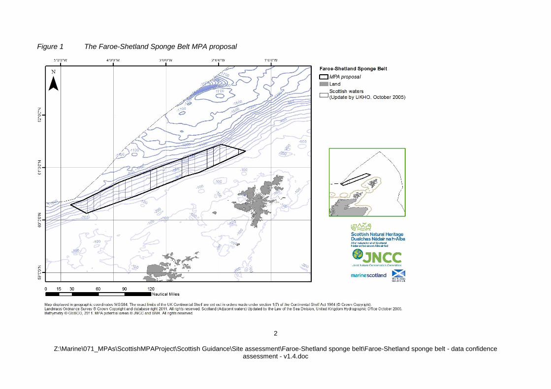
Figure 1 The Faroe-Shetland Sponge Belt MPA proposal
3
Z:\Marine\071_MPAs\ScottishMPAProject\Scottish Guidance\Site assessment\Faroe-Shetland sponge belt\Faroe-Shetland sponge belt - data confidence assessment - v1.4.doc
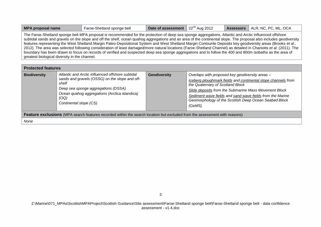
MPA proposal name Faroe-Shetland sponge belt Date of assessment 22nd
Aug 2012 Assessors ALR, NC, PC, ML, OCA
The Faroe-Shetland sponge belt MPA proposal is recommended for the protection of deep sea sponge aggregations, Atlantic and Arctic influenced offshore subtidal sands and gravels on the slope and off the shelf, ocean quahog aggregations and an area of the continental slope. The proposal also includes geodiversity features representing the West Shetland Margin Paleo-Depositional System and West Shetland Margin Contourite Deposits key geodiversity areas (Brooks et al., 2012). The area was selected following consideration of least damaged/more natural locations (Faroe-Shetland Channel) as detailed in Chaniotis et al. (2011). The boundary has been drawn to focus on records of verified and suspected deep sea sponge aggregations and to follow the 400 and 800m isobaths as the area of greatest biological diversity in the channel.
Protected features
Biodiversity Atlantic and Arctic influenced offshore subtidal sands and gravels (OSSG) on the slope and off-shelf
Deep sea sponge aggregations (DSSA)
Ocean quahog aggregations (Arctica islandica) (OQ)
Continental slope (CS)
Geodiversity Overlaps with proposed key geodiversity areas –
Iceberg ploughmark fields and continental slope channels from the Quaternary of Scotland Block
Slide deposits from the Submarine Mass Movement Block
Sediment wave fields and sand wave fields from the Marine Geomorphology of the Scottish Deep Ocean Seabed Block
(GeMS)
Feature exclusions (MPA search features recorded within the search location but excluded from the assessment with reasons)
None
4
Z:\Marine\071_MPAs\ScottishMPAProject\Scottish Guidance\Site assessment\Faroe-Shetland sponge belt\Faroe-Shetland sponge belt - data confidence assessment - v1.4.doc
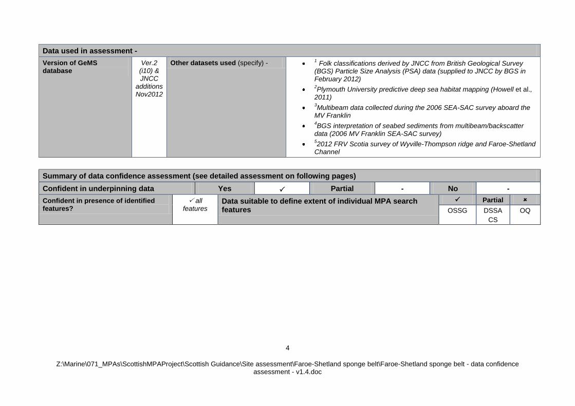
Data used in assessment -
Version of GeMS database
Ver.2 (i10) & JNCC
additions Nov2012
Other datasets used (specify) - 1 Folk classifications derived by JNCC from British Geological Survey (BGS) Particle Size Analysis (PSA) data (supplied to JNCC by BGS in February 2012)
2Plymouth University predictive deep sea habitat mapping (Howell et al.,
2011)
3Multibeam data collected during the 2006 SEA-SAC survey aboard the
MV Franklin
4BGS interpretation of seabed sediments from multibeam/backscatter
data (2006 MV Franklin SEA-SAC survey)
52012 FRV Scotia survey of Wyville-Thompson ridge and Faroe-Shetland
Channel
Summary of data confidence assessment (see detailed assessment on following pages)
Confident in underpinning data Yes Partial - No -
Confident in presence of identified features?
all features
Data suitable to define extent of individual MPA search features
Partial
OSSG DSSA
CS
OQ
5
Z:\Marine\071_MPAs\ScottishMPAProject\Scottish Guidance\Site assessment\Faroe-Shetland sponge belt\Faroe-Shetland sponge belt - data confidence assessment - v1.4.doc
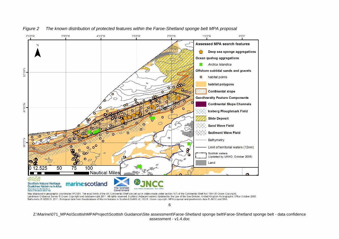
Summary The habitat map (UKSeaMap 2010) predicts that offshore subtidal sands and gravels is the dominant habitat in the proposal (Maps A-C). Multiple records from six AFEN and SEA surveys undertaken between 1996 and 2006
confirm the presence offshore subtidal sands and
gravels within the predicted distribution of the feature on the slope. These surveys provided good coverage of data points across the proposal on the slope and bathyal region. The shape of the proposal was designed to ensure we have represented the range of habitat biotopes described within this part of the SEA4 region. We have high confidence in the presence and extent of offshore subtidal sands and gravels within the proposed boundary, given the number, even distribution (when considered in combination) and age of the evidence available for this feature. Based on survey data from 2006, we are confident in the presence of deep sea sponge aggregations in the north-eastern portion of the proposal boundary (Maps A-C) (note: this approach assumes that no significant disturbance has occurred to the feature in the intervening years). In addition, provisional analysis suggests that data collect from a survey of the area in 2012 aboard the FRV Scotia supports the likely presence of deep sea sponge aggregations across the proposal boundary. The data points falling within the area are considered to be ‘least damaged, more natural’ which indicates relatively low levels of anthropogenic activity occur in the area local to the feature records. The boundary of the proposal encompasses the predicted distribution of the feature based on modelling work (Howell et. al., 2011)
2 (Map F).
We are confident in the presence of ocean quahog based on the findings of multiple surveys in 1998 and 1999 (Maps A-C). Given that ocean quahog are exceptionally long-lived (Ridgeway & Richardson, 2010), there is a high potential that the species is present in the proposal, despite the age of the species records (note: this approach assumes that no significant disturbance has occurred to the feature in the intervening years). The data points also fall within the area considered to be ‘least damaged, more natural’ which indicates relatively low levels of anthropogenic activity in the area local to the feature records. Our knowledge of feature extent is limited to the survey design used when generating presence data for ocean quahog. This means the sample data can only be used to provide an indication of feature extent. Although ocean quahog is not characteristic of any particular habitat, it is known to occur in a range of sediments from coarse clean sand to muddy sand in the infralittoral, circalittoral, circalittoral offshore and bathybenthic offshore environment – inhabiting a depth range from 4-400m (Witbaard & Bergman, 2003; Sabatini & Pizzolla, 2008). We have used British Geological Survey PSA data
1 SEA4 sample data
2 , and
UK SeaMap 2010 data to verify the presence of potentially suitable habitat for colonisation of ocean quahog aggregations as a proxy to define the possible extent of the feature.
6
Z:\Marine\071_MPAs\ScottishMPAProject\Scottish Guidance\Site assessment\Faroe-Shetland sponge belt\Faroe-Shetland sponge belt - data confidence assessment - v1.4.doc
Figure 2 The known distribution of protected features within the Faroe-Shetland sponge belt MPA proposal
7
Z:\Marine\071_MPAs\ScottishMPAProject\Scottish Guidance\Site assessment\Faroe-Shetland sponge belt\Faroe-Shetland sponge belt - data confidence assessment - v1.4.doc
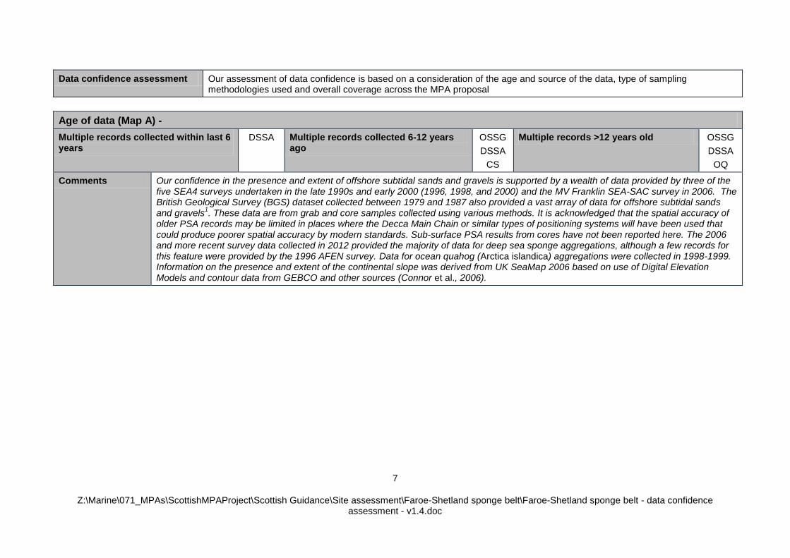
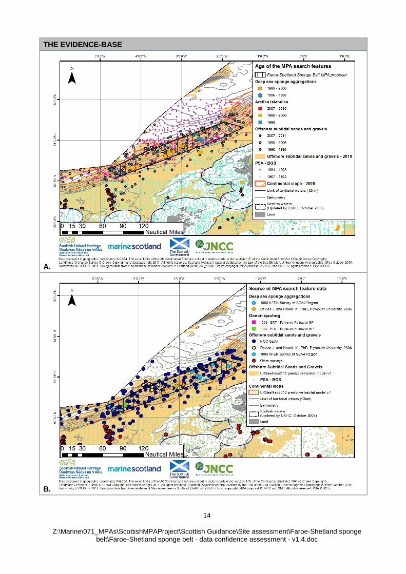
Data confidence assessment Our assessment of data confidence is based on a consideration of the age and source of the data, type of sampling methodologies used and overall coverage across the MPA proposal
Age of data (Map A) -
Multiple records collected within last 6 years
DSSA
Multiple records collected 6-12 years ago
OSSG
DSSA
CS
Multiple records >12 years old OSSG
DSSA
OQ
Comments Our confidence in the presence and extent of offshore subtidal sands and gravels is supported by a wealth of data provided by three of the five SEA4 surveys undertaken in the late 1990s and early 2000 (1996, 1998, and 2000) and the MV Franklin SEA-SAC survey in 2006. The British Geological Survey (BGS) dataset collected between 1979 and 1987 also provided a vast array of data for offshore subtidal sands and gravels
1. These data are from grab and core samples collected using various methods. It is acknowledged that the spatial accuracy of
older PSA records may be limited in places where the Decca Main Chain or similar types of positioning systems will have been used that could produce poorer spatial accuracy by modern standards. Sub-surface PSA results from cores have not been reported here. The 2006 and more recent survey data collected in 2012 provided the majority of data for deep sea sponge aggregations, although a few records for this feature were provided by the 1996 AFEN survey. Data for ocean quahog (Arctica islandica) aggregations were collected in 1998-1999. Information on the presence and extent of the continental slope was derived from UK SeaMap 2006 based on use of Digital Elevation Models and contour data from GEBCO and other sources (Connor et al., 2006).
8
Z:\Marine\071_MPAs\ScottishMPAProject\Scottish Guidance\Site assessment\Faroe-Shetland sponge belt\Faroe-Shetland sponge belt - data confidence assessment - v1.4.doc
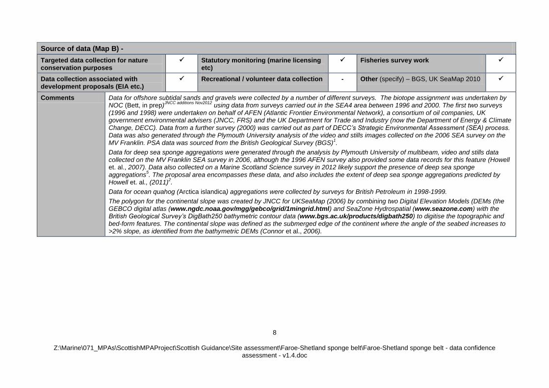
Source of data (Map B) -
Targeted data collection for nature conservation purposes
Statutory monitoring (marine licensing etc)
Fisheries survey work
Data collection associated with development proposals (EIA etc.)
Recreational / volunteer data collection - Other (specify) – BGS, UK SeaMap 2010
Comments Data for offshore subtidal sands and gravels were collected by a number of different surveys. The biotope assignment was undertaken by NOC (Bett, in prep)
JNCC additions Nov2012 using data from surveys carried out in the SEA4 area between 1996 and 2000. The first two surveys
(1996 and 1998) were undertaken on behalf of AFEN (Atlantic Frontier Environmental Network), a consortium of oil companies, UK government environmental advisers (JNCC, FRS) and the UK Department for Trade and Industry (now the Department of Energy & Climate Change, DECC). Data from a further survey (2000) was carried out as part of DECC’s Strategic Environmental Assessment (SEA) process. Data was also generated through the Plymouth University analysis of the video and stills images collected on the 2006 SEA survey on the MV Franklin. PSA data was sourced from the British Geological Survey (BGS)
1.
Data for deep sea sponge aggregations were generated through the analysis by Plymouth University of multibeam, video and stills data collected on the MV Franklin SEA survey in 2006, although the 1996 AFEN survey also provided some data records for this feature (Howell et. al., 2007). Data also collected on a Marine Scotland Science survey in 2012 likely support the presence of deep sea sponge aggregations
5. The proposal area encompasses these data, and also includes the extent of deep sea sponge aggregations predicted by
Howell et. al., (2011)2.
Data for ocean quahog (Arctica islandica) aggregations were collected by surveys for British Petroleum in 1998-1999.
The polygon for the continental slope was created by JNCC for UKSeaMap (2006) by combining two Digital Elevation Models (DEMs (the GEBCO digital atlas (www.ngdc.noaa.gov/mgg/gebco/grid/1mingrid.html) and SeaZone Hydrospatial (www.seazone.com) with the British Geological Survey’s DigBath250 bathymetric contour data (www.bgs.ac.uk/products/digbath250) to digitise the topographic and bed-form features. The continental slope was defined as the submerged edge of the continent where the angle of the seabed increases to >2% slope, as identified from the bathymetric DEMs (Connor et al., 2006).
9
Z:\Marine\071_MPAs\ScottishMPAProject\Scottish Guidance\Site assessment\Faroe-Shetland sponge belt\Faroe-Shetland sponge belt - data confidence assessment - v1.4.doc
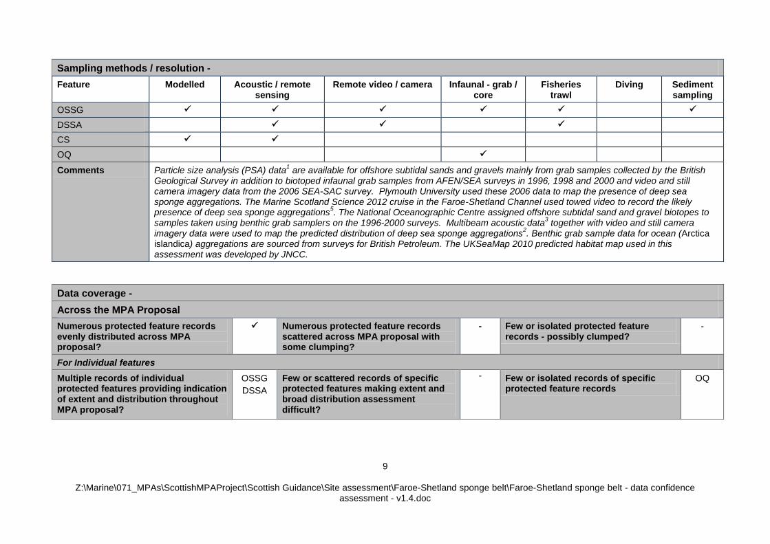
Sampling methods / resolution -
Feature Modelled Acoustic / remote sensing
Remote video / camera Infaunal - grab / core
Fisheries trawl
Diving Sediment sampling
OSSG
DSSA
CS
OQ
Comments Particle size analysis (PSA) data1 are available for offshore subtidal sands and gravels mainly from grab samples collected by the British
Geological Survey in addition to biotoped infaunal grab samples from AFEN/SEA surveys in 1996, 1998 and 2000 and video and still camera imagery data from the 2006 SEA-SAC survey. Plymouth University used these 2006 data to map the presence of deep sea sponge aggregations. The Marine Scotland Science 2012 cruise in the Faroe-Shetland Channel used towed video to record the likely presence of deep sea sponge aggregations
5. The National Oceanographic Centre assigned offshore subtidal sand and gravel biotopes to
samples taken using benthic grab samplers on the 1996-2000 surveys. Multibeam acoustic data3 together with video and still camera
imagery data were used to map the predicted distribution of deep sea sponge aggregations2. Benthic grab sample data for ocean (Arctica
islandica) aggregations are sourced from surveys for British Petroleum. The UKSeaMap 2010 predicted habitat map used in this assessment was developed by JNCC.
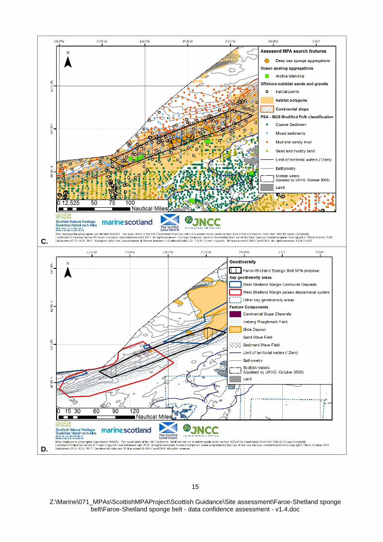
Data coverage -
Across the MPA Proposal
Numerous protected feature records evenly distributed across MPA proposal?
Numerous protected feature records scattered across MPA proposal with some clumping?
- Few or isolated protected feature records - possibly clumped?
-
For Individual features
Multiple records of individual protected features providing indication of extent and distribution throughout MPA proposal?
OSSG
DSSA
Few or scattered records of specific protected features making extent and broad distribution assessment difficult?
- Few or isolated records of specific protected feature records
OQ
10
Z:\Marine\071_MPAs\ScottishMPAProject\Scottish Guidance\Site assessment\Faroe-Shetland sponge belt\Faroe-Shetland sponge belt - data confidence assessment - v1.4.doc
Data coverage -
Across the MPA Proposal
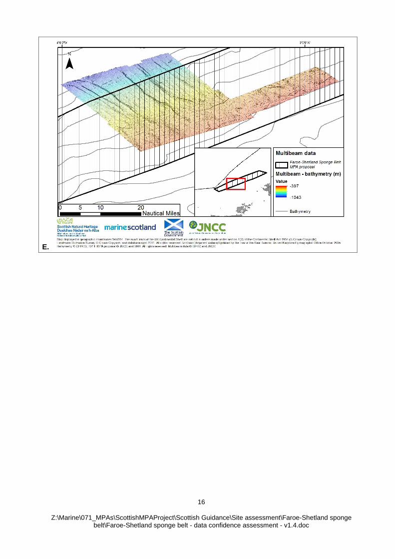
Are acoustic remote sensing data available to facilitate the development of a full coverage predictive seabed habitat map?
No, there is only partial coverage of multibeam data from the 2006 MV Franklin SEA-SAC survey (Map E & F) of which BGS has interpreted to map the sediment type (Map G). Further data are anticipated from the 2012 FRV Scotia survey of Wyville-Thompson ridge and Faroe-Shetland Channel which collected sidescan sonar data
5
Comments Continental slope (CS)
UKSeaMap 2010 (in GeMS v2i10) - The continental slope large scale feature intersects with the entirety of the proposal.
Atlantic and Arctic influenced offshore subtidal sands and gravels (OSSG) on the slope and off-shelf
UKSeaMap 2010 (GeMS v2i10) - The habitat map predicts that offshore subtidal sands and gravel habitats occur across the proposal (comprising ~97% of the total area). More specifically, the following habitats are predicted to occur: Arctic slope coarse sediment and Arctic slope mixed sediment, Arctic slope sand and muddy sand, Arctic upper bathyal coarse sediment, Arctic upper bathyal mixed sediment, Arctic upper bathyal sand and muddy sand, Atlantic slope coarse sediment, Atlantic slope mixed sediment and Atlantic slope sand and muddy sand.
1Folk classifications derived by JNCC from British Geological Survey (BGS) Particle Size Analysis (PSA) data (supplied to JNCC by
BGS in February 2012) - (i.e. folk classifications based on PSA data points underpinning the BGS substrate map upon which the predicted habitat map is based) - Of the 150 sediment samples collected by the BGS (between 1979 and 1987) within the predicted extent of the offshore subtidal sands and gravel habitats, 8 record the presence of the modified folk class/EUNIS ‘sand and muddy sand’, 88 record the presence of ‘mixed sediments and 34 record the presence of ‘coarse sediment’ and are evenly distributed within the extent of the predicted offshore subtidal sands and gravels within the proposal. 20 record the presence of ‘mud and sandy mud’ which are not a Folk class considered part of the OSSG feature.
N.B. There are further BGS records for the modified folk class/EUNIS ‘coarse sediment’, ‘mixed sediment’, sand and muddy sand’ (in addition to ‘mud and sandy mud’) within the areas predicted to be offshore deep sea muds, suggesting that the predicted boundary between this feature and the offshore subtidal coarse sediments is uncertain.
Plymouth University - Identification of areas of nature conservation importance in deep waters of the UK continental shelf (GeMS v2i10) (referred to in Map B, as: Davies, J., Howell H., 2006, PhD, Plymouth University) – There are seven clusters of survey data points from a SEA survey commissioned by DECC in 2006 which record the presence of offshore subtidal sands and gravels in the central area of the proposal on the slope. All points intersect with the predicted extent of offshore subtidal sands and gravel habitats.
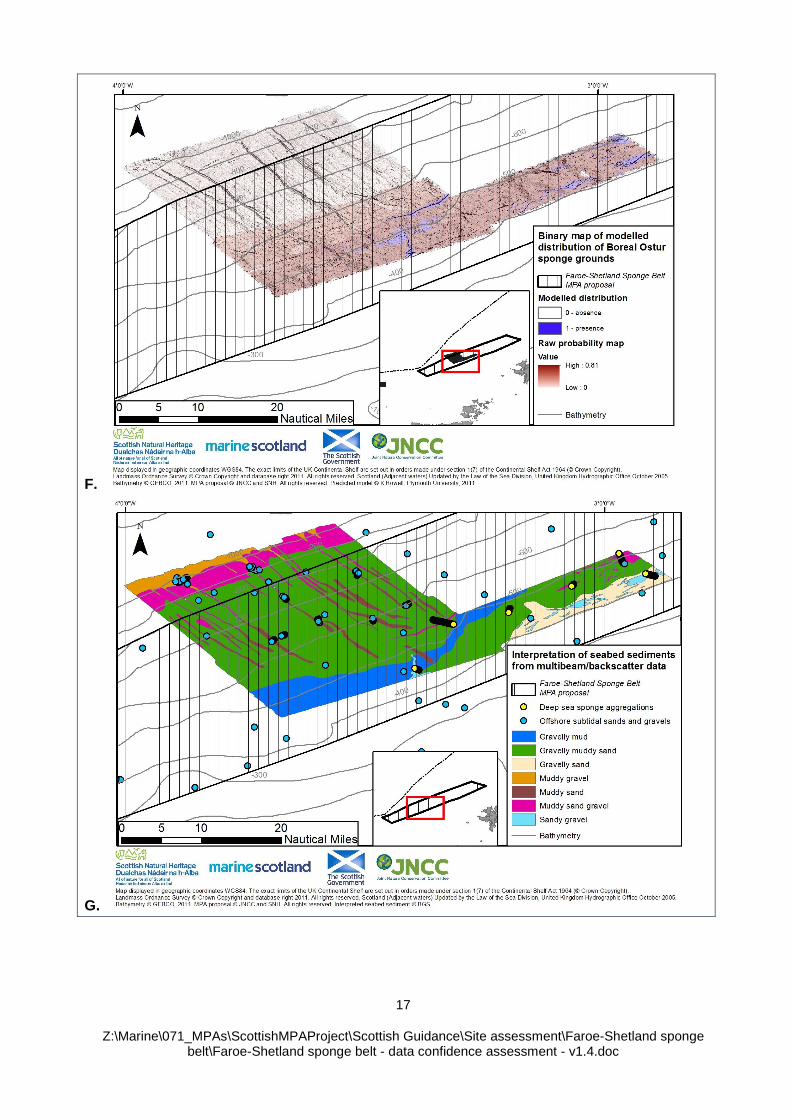
BGS interpretation of seabed sediments from multibeam/backscatter data (2006 MV Franklin SEA-SAC survey) – BGS mapped mixed, coarse and sand sediments through expert interpretation of the block of multibeam and backscatter data from the 2006
11
Z:\Marine\071_MPAs\ScottishMPAProject\Scottish Guidance\Site assessment\Faroe-Shetland sponge belt\Faroe-Shetland sponge belt - data confidence assessment - v1.4.doc
Data coverage -
Across the MPA Proposal
survey (Map G).
2012 NOC biotope analysis SEA4 AFEN and DTI data (Bett, 2012) (referred to in Map B as: NOC SEA4) (GeMS JNCC additions Nov2012) - There are multiple records from the benthic sampling element of three multidisciplinary surveys conducted between 1996 and 2000 which are scattered across the proposal. One of the data points confirms the presence of offshore subtidal sands and gravels in the bathyal region. The remaining data points lie on the slope. One of the records overlaps with an area predicted by UKSeaMap 2010 to be offshore deep sea muds. This point lies within >0.5km distance from the predicted boundary with the adjacent offshore subtidal sands and gravels area; given the likely errors in knowing the position of the sampling device on the seabed, combined with the coarse resolution of the map should be considered further confirmation of the feature. The remaining points intersect with the predicted extent of offshore subtidal sands and gravel habitats. There is one record which identified offshore deep sea muds on the slope, in the central/northern region of the proposed boundary. The point lies on the area predicted to be offshore subtidal sands and gravels. Bett (2012) described the SEA4 region as being portioned into eight primary (proposed) biotopes. Six are sand and muddy sand biotopes, 2 of these are represented within the Faroe-Shetland sponge belt proposed area; Spionidae-Capitellidae-Syllidae in Atlanto-Arctic sand and muddy sand (300-600m), Cirratulidae-Maldanidae-Maldanidae in Arctic sand and muddy sand (600-1200m).
N.B. MSS Coral by-catch records collated from trawl surveys 2000-2009 – There is one record collected in 2008 that found the presence of soft coral (specifically, gorgonian) within the area predicted to be offshore subtidal sands and gravels.
Deep sea sponge aggregations (DSSA)
1996 AFEN Survey of the SEA4 Region (GeMS v2i10) – There are three records from an AFEN survey in 1996 which show deep sea sponge aggregations in the north-eastern area of the proposal.
Plymouth University - Identification of areas of nature conservation importance in deep waters of the UK continental shelf (GeMS v2i10) (referred to in Map B, as: Davies, J., Howell H., 2006, PhD, Plymouth University) – There are six clusters of data points from the SEA survey in 2006 analysed by Plymouth University for JNCC which record the presence of deep sea sponge aggregations in the central area of the proposal. All records in GeMS are determined as ‘certain’. The work carried out by Howell et.al., (2011)
2
created modelled distributions for deep sea sponges using multibeam and video and stills imagery data collected during the 2006 SEA survey within the proposal area using the Average Predicted Probability threshold. These model outputs predicted areas of boreal type ‘Ostur’ sponge grounds on the Wyville Thompson Ridge (WTR), and on the continental slope of the Faroe-Shetland Channel (Map F). This sponge feature is reported as being centred around the 500m contour within the Faroe-Shetland Channel in a region where temperature was observed to fluctuate from below 0 to more than 7.8°C (Howell et. al., 2010).
52012 FRV Scotia survey of Wyville-Thompson ridge and Faroe-Shetland Channel – There are multiple survey points where towed
video were carried out that may support the presence of deep sea sponge aggregations across the MPA proposal but these data are still being processed. These data focussed around the 500m contour line.
12
Z:\Marine\071_MPAs\ScottishMPAProject\Scottish Guidance\Site assessment\Faroe-Shetland sponge belt\Faroe-Shetland sponge belt - data confidence assessment - v1.4.doc
Data coverage -
Across the MPA Proposal
Ocean quahog (Arctica islandica) aggregations (OQ) (restricted extent)
1998 - ERT - Foinaven Foinaven BP (GeMS v2i10) – There is a cluster of records) of ocean quahog (Arctica islandica) within the central area of the proposed boundary.
1999 - ERT - Foinaven Foinaven BP (GeMS v2i10) – There are two records of ocean quahog (Arctica islandica) in the same location as the cluster of datapoints recorded in 1998 - ERT - Foinaven Foinaven BP dataset (i.e. within the central area of the proposed boundary).
1Folk classifications derived by JNCC from British Geological Survey (BGS) Particle Size Analysis (PSA) data (supplied to JNCC by
BGS in February 2012) - (i.e. folk classifications based on PSA data points underpinning the BGS substrate map upon which the predicted habitat map is based) - Of the 150 sediment samples collected by the BGS (between 1979 and 1987) within the predicted extent of the offshore subtidal sands and gravel habitats, 8 record the presence of the modified folk class/EUNIS ‘sand and muddy sand’ and 34 record the presence of ‘coarse sediment’ and are evenly distributed within the extent of the predicted offshore subtidal sands and gravels within the proposal. These are considered suitable habitat type for ocean quahog colonisation
(Witbaard & Bergman, 2003; Sabatini & Pizzolla, 2008) and therefore may support the presence of ocean quahog based on this.
UKSeaMap 2010 (GeMS v2i10) - The habitat map predicts a large range of offshore subtidal sands and gravels habitats (see the data coverage section for Atlantic and Arctic influenced offshore subtidal sands and gravels (OSSG) on the slope and off-shelf for the full list) but by far the most dominant habitat is Arctic Slope coarse sediment. Therefore these areas may support the presence of ocean quahog.
2012 NOC biotope analysis SEA4 AFEN and DTI data (Bett, 2012) (referred to in Map B as: NOC SEA4) (GeMS JNCC additions Nov2012) - There are multiple records from the benthic sampling element of five multidisciplinary surveys conducted between 1996 and 2000 which are scattered across the proposal. Bett (2012) described the SEA4 region as being portioned into eight primary (proposed) biotopes. Six are sand and muddy sand biotopes, 2 of these are represented within the Faroe-Shetland sponge belt proposed area; Spionidae-Capitellidae-Syllidae in Atlanto-Arctic sand and muddy sand (300-600m), Cirratulidae-Maldanidae-Maldanidae in Arctic sand and muddy sand (600-1200m). Therefore these areas may support the presence of ocean quahog..
Geodiversity
Geodiversity features representing key geodiversity areas in Scotland’s seas are distributed across the majority of the proposal. To the east of the proposal there are sediment wave fields and sand wave fields from the Marine Geomorphology of the Scottish Deep Ocean Seabed block and slide deposits from the Submarine Mass Movement block. There features are representative of the West Sheltand Margin Contourite Deposits key geodiversity area. To the west of the proposal there are iceberg ploughmark fields and continental slope channels from the Quaternary of Scotland block. These features are representative of the West Shetland Margin Palaeo-Depositional System key geodiversity area (Brooks et al., 2012)
GeMSv1it10. These iceberg ploughmarks can be seen in the TOBI sidescan data collected during the
AFEN and DTI surveys of 1996 and 2000.
13
Z:\Marine\071_MPAs\ScottishMPAProject\Scottish Guidance\Site assessment\Faroe-Shetland sponge belt\Faroe-Shetland sponge belt - data confidence assessment - v1.4.doc
Data coverage -
Across the MPA Proposal
N.B. GeMS is populated with data on priority marine features and the search features used to drive the selection of Nature Conservation MPAs. Non-MPA search feature/priority marine feature data are not included in the geodatabase but shall be considered as part of future work on the data confidence assessments for the Nature Conservation MPA proposals to improve the assessment of feature presence and extent.
14
Z:\Marine\071_MPAs\ScottishMPAProject\Scottish Guidance\Site assessment\Faroe-Shetland sponge belt\Faroe-Shetland sponge belt - data confidence assessment - v1.4.doc
THE EVIDENCE-BASE
A.
B.
15
Z:\Marine\071_MPAs\ScottishMPAProject\Scottish Guidance\Site assessment\Faroe-Shetland sponge belt\Faroe-Shetland sponge belt - data confidence assessment - v1.4.doc
C.
D.
16
Z:\Marine\071_MPAs\ScottishMPAProject\Scottish Guidance\Site assessment\Faroe-Shetland sponge belt\Faroe-Shetland sponge belt - data confidence assessment - v1.4.doc
E.
17
Z:\Marine\071_MPAs\ScottishMPAProject\Scottish Guidance\Site assessment\Faroe-Shetland sponge belt\Faroe-Shetland sponge belt - data confidence assessment - v1.4.doc
F.
G.
18
Z:\Marine\071_MPAs\ScottishMPAProject\Scottish Guidance\Site assessment\Faroe-Shetland sponge belt\Faroe-Shetland sponge belt - data confidence assessment - v1.4.doc
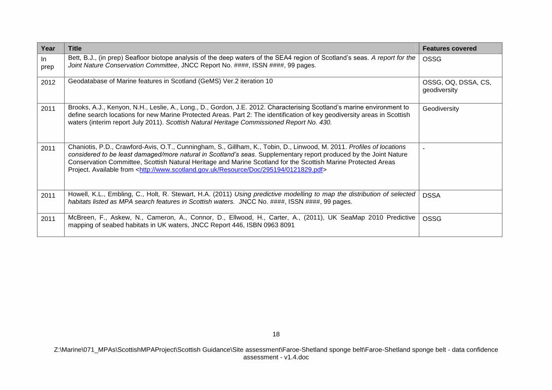
Year Title Features covered
In prep
Bett, B.J., (in prep) Seafloor biotope analysis of the deep waters of the SEA4 region of Scotland’s seas. A report for the Joint Nature Conservation Committee, JNCC Report No. ####, ISSN ####, 99 pages.
OSSG
2012 Geodatabase of Marine features in Scotland (GeMS) Ver.2 iteration 10 OSSG, OQ, DSSA, CS, geodiversity
2011 Brooks, A.J., Kenyon, N.H., Leslie, A., Long., D., Gordon, J.E. 2012. Characterising Scotland’s marine environment to define search locations for new Marine Protected Areas. Part 2: The identification of key geodiversity areas in Scottish waters (interim report July 2011). Scottish Natural Heritage Commissioned Report No. 430.
Geodiversity
2011 Chaniotis, P.D., Crawford-Avis, O.T., Cunningham, S., Gillham, K., Tobin, D., Linwood, M. 2011. Profiles of locations considered to be least damaged/more natural in Scotland’s seas. Supplementary report produced by the Joint Nature Conservation Committee, Scottish Natural Heritage and Marine Scotland for the Scottish Marine Protected Areas Project. Available from <http://www.scotland.gov.uk/Resource/Doc/295194/0121829.pdf>
-
2011 Howell, K.L., Embling, C., Holt, R. Stewart, H.A. (2011) Using predictive modelling to map the distribution of selected habitats listed as MPA search features in Scottish waters. JNCC No. ####, ISSN ####, 99 pages.
DSSA
2011 McBreen, F., Askew, N., Cameron, A., Connor, D., Ellwood, H., Carter, A., (2011), UK SeaMap 2010 Predictive mapping of seabed habitats in UK waters, JNCC Report 446, ISBN 0963 8091
OSSG
19
Z:\Marine\071_MPAs\ScottishMPAProject\Scottish Guidance\Site assessment\Faroe-Shetland sponge belt\Faroe-Shetland sponge belt - data confidence assessment - v1.4.doc
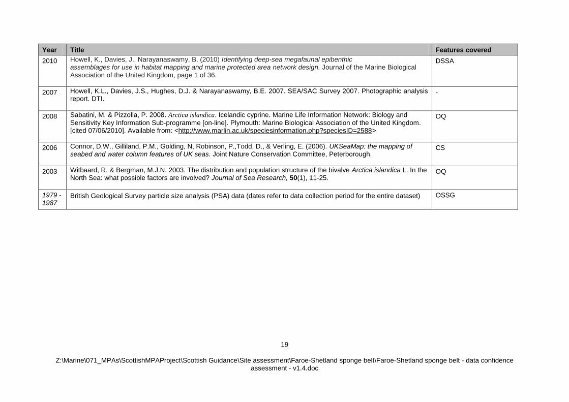
Year Title Features covered
2010 Howell, K., Davies, J., Narayanaswamy, B. (2010) Identifying deep-sea megafaunal epibenthic assemblages for use in habitat mapping and marine protected area network design. Journal of the Marine Biological Association of the United Kingdom, page 1 of 36.
DSSA
2007 Howell, K.L., Davies, J.S., Hughes, D.J. & Narayanaswamy, B.E. 2007. SEA/SAC Survey 2007. Photographic analysis report. DTI.
-
2008 Sabatini, M. & Pizzolla, P. 2008. Arctica islandica. Icelandic cyprine. Marine Life Information Network: Biology and
Sensitivity Key Information Sub-programme [on-line]. Plymouth: Marine Biological Association of the United Kingdom. [cited 07/06/2010]. Available from: <http://www.marlin.ac.uk/speciesinformation.php?speciesID=2588>
OQ
2006 Connor, D.W., Gilliland, P.M., Golding, N, Robinson, P.,Todd, D., & Verling, E. (2006). UKSeaMap: the mapping of seabed and water column features of UK seas. Joint Nature Conservation Committee, Peterborough.
CS
2003 Witbaard, R. & Bergman, M.J.N. 2003. The distribution and population structure of the bivalve Arctica islandica L. In the North Sea: what possible factors are involved? Journal of Sea Research, 50(1), 11-25.
OQ
1979 -1987
British Geological Survey particle size analysis (PSA) data (dates refer to data collection period for the entire dataset)
OSSG