Embed Size (px)
Citation preview
Pag
e1
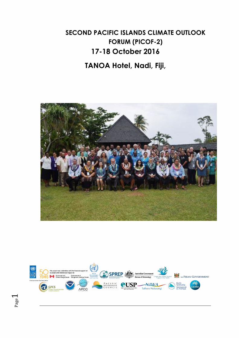
SECOND PACIFIC ISLANDS CLIMATE OUTLOOK
FORUM (PICOF-2)
17-18 October 2016
TANOA Hotel, Nadi, Fiji,
Pag
e2
Background
The Second Pacific Island Climate Outlook Forum (PICOF-2) provides an opportunity to bring together
the providers of climate information i.e. the National Meteorological and Hydrological Science
Services (NMHSs) and one of the end users of this information, the Disaster Risk Reduction (“DRR”)
Community or the National Disaster Management Offices (NDMOs) at the country level, in a
roundtable discussion where information can be exchanged and provide guidance on decision-making.
PICOF-2 also proved the opportunity for NMHSs to discuss the tropical cyclone season ahead for the
southern Pacific Countries as well as discuss in depth the likelihood of an El Nino Southern Oscillation
(ENSO) event and its likely impacts in the region.
The concept of PICOF has been implemented for several years in the PI region through online
teleconferences offered under three separate arrangements; the Climate and Oceans Services
Program in the Pacific (COSPPac) Online Climate Outlook Forum (OCOF), the Island Climate Update
(ICU) Forums and the Pacific ENSO Application Climate (PEAC) Centre Forum.
The specific objectives of PICOF-2 included the following:
i. To compare the various seasonal climate forecast guidance for the Pacific region and
discuss how these are produced in terms of accuracy, utility, weaknesses and strengths of
the regionally produced guidance;
ii. To compare and refine national level consensus-based climate outlooks for the upcoming
season (November–December–January);
iii. To continue capacity building/human resource development activities for the Pacific
region, particularly in seasonal prediction;
iv. To discuss how NMHSs are currently accessing and assessing the available guidance,
making them nationally-relevant and disseminating them to users and the use of games
to assist in this effort;
v. To provide a platform for the stakeholders through the PICOF to share and exchange
experiences and knowledge on wet/tropical cyclone season and its prediction;
vi. To discuss how representatives from the DRR sector are using or may use the guidance
(or some derivative from it);
vii. To identify the needs of the DRR sector for climate services;
viii. To build collaboration and partnerships among NMHSs and the DRR sector;
ix. To discuss opportunities for integrating climate information into disaster risk reduction
and disaster management.
Meeting Outputs
Improve the understanding of how seasonal climate outlooks are produced, how they are and
can be made regionally and nationally relevant, and how they can be tailored to the needs of
users from the DRR community.
Launch of the Disaster Resilience in Pacific Small Island States which is funded by the Russian
Government and implemented through UNDP. This three-year project will provide direct
technical and financial assistance to 14 PICs in the area of climate early warning systems,
disaster preparedness and recovery, and disaster risk financing.
Pag
e3
PICOF-2 Statement on “Impacts and lessons learned from the 2015/16 El Nino for
Climate/DRRDM and outlook and preparations for the 2016/17 La Nina.
Regional Consensus Forecast (rainfall and SST for Nov 2016-Jan 2017) for SW Pacific Islands
and North Pacific Islands.
Session 1: Opening of the PICOF-2 and Overview Statements
Mr. Lui Naisara, Deputy Secretary of Transport-Fiji Government welcomed on behalf of the
government of Fiji the participants from WMO, SPREP, UNDP, PICS Panel, Russian
Delegation, NMHSs, NMDO, Partners of PMC and CROP agencies.
Ravind Kumar (Director Fiji Met Service) in his opening statement acknowledged the
Pacific’s vulnerability to disasters and the importance of PICOF in preparing and providing
the information to government to for the upcoming cyclone season.
Dr Netatua Pelesikoti thanked the members, delegates and participants for the support on
behalf of the Director General of SPREP. She highlighted the importance of discussions on
El Niño and its impacts and noted the lessons learned from the FINPAC practitioner’s
workshop where NMH’s, NDMO’s and communities are working in disaster preparedness
and turning early warnings into early actions. She also acknowledged the need to seek
support and partnership outside of the Pacific region such as the new Regional Disaster
Resilience in the Pacific Small Island Developing States (RESPAC) Russia project. Regional
Disaster Resilience in the Pacific Small Island Developing States
Mr. Bakhodir Burhhanov (Country Director and UNDP’s Head of Regional Policy and
Programme in Fiji) recognised ongoing recovery efforts in Fiji after Cyclone Winston. He
emphasised the need to simplify complex weather information so that communities can
understand and take necessary precautions. .
Mr, Dmitry Maximychev (MFA Russia) recognised the importance of the second PICOF to
prepare the Pacific and reassured the region of Russia’s commitment to increase funding in
development assistance. Mr Maximychev recognised the partnership between UNDP and
Russian Trust Fund for Development of 35 million USD over the next four years. RESPAC
(7.5million) is the largest project from the Trust Fund and will focus on strengthening early
warning systems and climate preparedness at the local and national level and fund post
recovery efforts.
Ms Lisa Anne Jepsen the WMO representative acknowledged the supporters, organizations
and participants of the Second PICOF. She echoed the need to strengthen communication
between NMHSs and end-users and also stressed the importance of institutionalising PICOF
and taking on board lessons learned through consultations and NCOFs. She also recognised
the challenges faced by the region and sees the value of having regional OCOFs and at the
same time offers the challenge to participants to not only take on board the outlooks for
planning purposes, but also discuss ways and look at how to make the PICOF process
sustainable.
Pag
e4
Dr. Andrew Tait from NIWA and the chair of PICS Panel introduced the program for the
next two days, the sessions and what was expected from the participants.
Session 2: Looking Back and Learning- Presentation of 2015-2016 El Nino
A joint presentation from the regional providers (BoM, NIWA & NOAA) was presented by
Dr Nicholas and Dr Simon McGree on the physical evolution of the 2015/2016 El Nino
The dynamic models predicted El Niño well except for the statistical models
peak strength was under predicted by most models, what occurred was warmer than what
was predictive and the demise of El Niño was also well predicted although a few models
hung on to the event a little too long meaning that the peak in the model prediction occurred
after the peak in the observations.
Key Discussion Points:
1. The discussion looked at the performance of the models in predicting the 2015 El
Niño event compared to the 2014/2015 event. There wasn’t enough confidence in the
models in 2014 to declare an official El Niño status due to:
a. the sea surface temperatures (SST) never reaching official El Niño thresholds
b. the Southern Osciliation Index (SOI) showed a mismatch between the ocean
and atmosphere
c. No coupling of the ocean and the atmosphere.
2. Discussions regarding the timing of an official declaration and implications to
national authorities when models are not in agreement causing delays or non-
declaration of El Niño events
3. Regional centres encouraged national agencies to consider other El Niño like impacts
to issue national statements and clarified that a declaration is issued only when it is a
full blown El Niño event as in the case of the 2015-2016 period
4. Papua New Guinea (PNG) noted the importance of using national impacts especially
when you have an early onset of El Nino like impacts sooner than expected and the
use of other indicators declare El Niño status. Drought impacts were already felt in
the province early March-April 2014
5. Discussions on national response from Met Services on issuance of statements and
reactions from communities from PNG, Palau and Samoa was shared with examples
of islands declaring El Niño status ahead of the official declaration
6. Lessons learned from 2014 events was discussed with regional institutions advising
national met services to consider national indicators and not limit consideration to just
El Niño indicators to declare an El Niño event.
7. Met services were also encouraged by regional centres to consider national historical
data to fine the lag time between ENSO showing in central Pacific and national onset
and not wait until onset of impacts to issue warning.
Pag
e5
Recommendations
1. National Met services to consider other indicators and not rely primarily on El Niño
indicators to declare events
2. NMS’s to conduct research and look into historical data to find the lag time between
ENSO showing in central Pacific and national onset
Session 3: Lessons Learnt from 2015/16 El Nino and actions (processes) taken
to respond to Tropical Cyclones/ENSO and DRR.
The session broke into 5 groups based on location and similar climatic experiences
1. Cook Islands, Niue, Samoa and Tonga
2. PNG, Vanuatu and Solomon Islands
3. Palau, Federated States of Micronesia (FSM) and Republic of the Marshall Islands
(RMI)
4. Kiribati and Tuvalu
5. Fiji Met, Fiji Hotel’s Association, Ministry of Agriculture, Fiji Sugar Association, Fiji
Electricity Authority, Fiji Water Authority, Fiji National Disaster Management Office
The following questions provided guidance for the 5 groups to allow the flow of discussion
on how each country/group responded to the 2015/2016 El Niño event in terms of
information and communication.
Key Discussion Points
a) What information on the El Nino 2015/2016 was provided by the Met Services
- Monthly bulletins
- newsletter using information from OCOF’s
- Seasonal forecast updates
- Rainfall predictions
- El Niño outlooks provided every two months
- Media releases
- Sector specific reports prepared upon request
- Drought analysis
- ENSO forecasts (Red Cross Alert)
b) What type of information is required? Were there any information gaps?
- All Met variables (rainfall, temperature, winds etc)
- Land temperature
- Use of simple words and awareness materials similar to the climate crab
video
- Impact based forecasting as it is easier for communities to understand
- Sector specific products and forecasting
c) Was the information delivered in a timely manner for your sector? At what time
should the information be delivered?
- The information was delivered on time for some countries
Pag
e6
- The provinces in PNG and the Northern Pacific already experienced El Niño
before an official statement was issued
- Fiji Sugar Association and other sectors would like to have a 12 month in
advance or earlier
o Planting alternative crops needs more than a year’s notice
d) How was it packaged (text, map or table etc) How should the message be
packaged? What it easy to understand?
- Quarterly reports
- Monthly conference
- Emails
- Drought statements
- Text products
- Currently use maps, graphs tables and text in the outlooks.
- Communicate by email and on the website
- Hard copies provided to NDMO
- Newspaper articles, TV interviews,
- Radio talk-back shows in multiple languages
- Translation of technical terms into local languages
e) How should the message be communicated? (SMS, email, newspaper article,
radio etc)
- Use all media outlets including social media
- Use simple and easy to understand jargon
- Use cartoons, infographics or videos
- National awareness programs and workshops
- Radio talkback shows
- Partnership with NDMO and Red Cross to deliver the message
Recommendations
1. NMS’s to use simple language and jargons when communicating information to
communities and sectors
2. Use impact based information to deliver messages
3. Use multiple languages and different ways (cartoons, drawings, talkback shows) to
deliver key messages
4. Engage communities and conduct more awareness programs and activities well in
advance before the onset of events
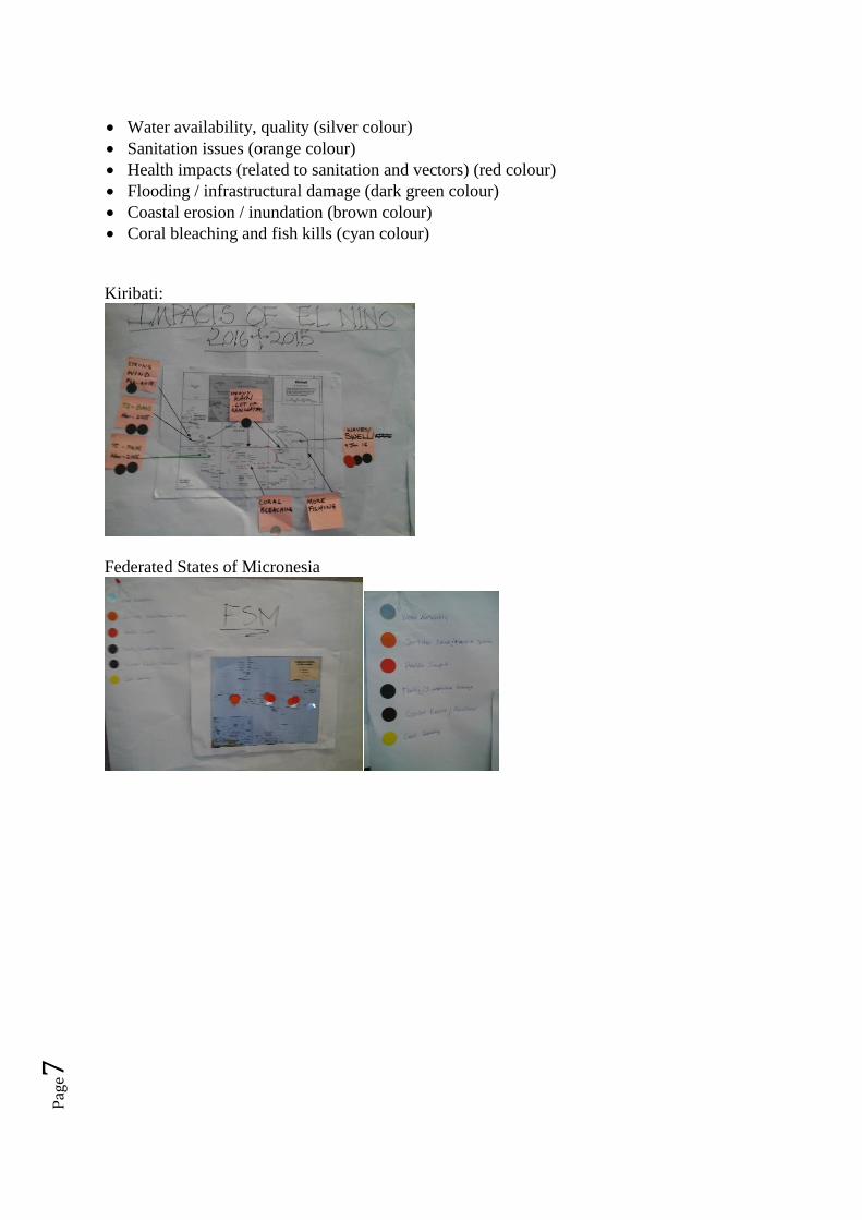
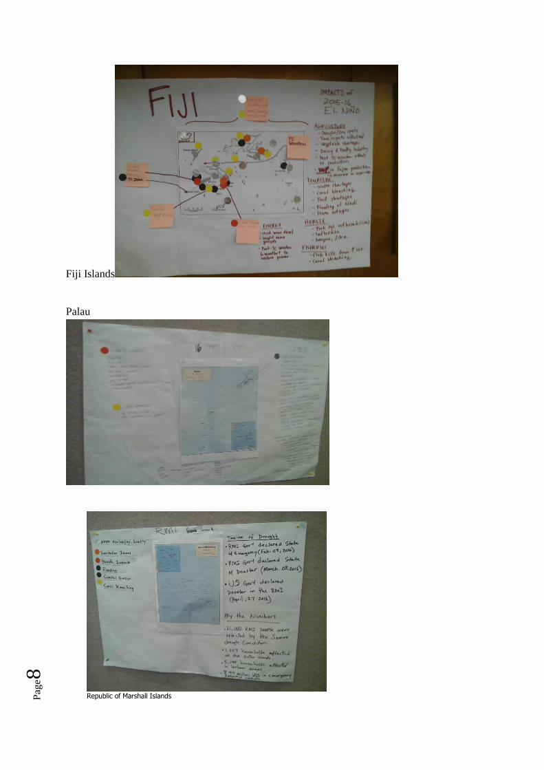
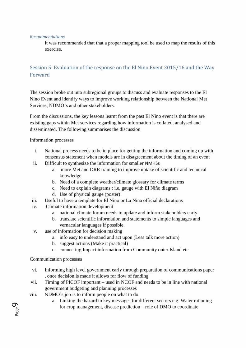
Session 4: Impacts Seen on the Ground and Mapping with special emphasis on
DRR
The session broke out into country groups in which they mapped out the impacts for the
following
Pag
e7
Water availability, quality (silver colour)
Sanitation issues (orange colour)
Health impacts (related to sanitation and vectors) (red colour)
Flooding / infrastructural damage (dark green colour)
Coastal erosion / inundation (brown colour)
Coral bleaching and fish kills (cyan colour)
Kiribati:
Federated States of Micronesia
Pag
e8
Fiji Islands
Palau
Republic of Marshall Islands
Pag
e9
Recommendations
It was recommended that that a proper mapping tool be used to map the results of this
exercise.
Session 5: Evaluation of the response on the El Nino Event 2015/16 and the Way
Forward
The session broke out into subregional groups to discuss and evaluate responses to the El
Nino Event and identify ways to improve working relationship between the National Met
Services, NDMO’s and other stakeholders.
From the discussions, the key lessons learnt from the past El Nino event is that there are
existing gaps within Met services regarding how information is collated, analysed and
disseminated. The following summarises the discussion
Information processes
i. National process needs to be in place for getting the information and coming up with
consensus statement when models are in disagreement about the timing of an event
ii. Difficult to synthesize the information for smaller NMHSs
a. more Met and DRR training to improve uptake of scientific and technical
knowledge
b. Need of a complete weather/climate glossary for climate terms
c. Need to explain diagrams : i.e, gauge with El Niño diagram
d. Use of physical gauge (poster)
iii. Useful to have a template for El Nino or La Nina official declarations
iv. Climate information development
a. national climate forum needs to update and inform stakeholders early
b. translate scientific information and statements to simple languages and
vernacular languages if possible.
v. use of information for decision making
a. info easy to understand and act upon (Less talk more action)
b. suggest actions (Make it practical)
c. connecting Impact information from Community outer Island etc
Communication processes
vi. Informing high level government early through preparation of communications paper
, once decision is made it allows for flow of funding
vii. Timing of PICOF important – used in NCOF and needs to be in line with national
government budgeting and planning processes
viii. NDMO’s job is to inform people on what to do
a. Linking the hazard to key messages for different sectors e.g. Water rationing
for crop management, disease prediction – role of DMO to coordinate
Pag
e10
ix. Key relationships are the clusters, utilising existing networks and working groups who
are experts in managing its own sectors
a. Adding to the messaging of the NMHSs ( partnership with the media, make
sure this is prominent in the outlook
x. Key challenge is the simplifying the complex science information (use pictures)
/translation difficult to keep meaning clear
a. Real need for impact forecasting using past events as examples
b. Still need work on actions to prepare for slow onset hazards
c. People often don’t do anything until impacts start
xi. Having information readily available and accessible from Met services and NDMO
xii. Strengthening of coordination and execution of roles and responsibilities of key
stakeholders
xiii. Strengthen the efficiency of the dissemination of information to all from national level
to community level
a. Isolated island- work with existing local initiatives to relay information,
collect impact status, example water project on Christmas Island
xiv. utilization of information with ongoing and or planned works of stakeholders/sectors
to enable informed decision making
xv. Strengthen partnerships collaborations between agencies to improve execution of
roles in terms of efficiency
Recommendations
1. It was recommended that NMS’s have national climate outlook forum’s(NCOF) to
discuss the seasonal outlook and use the event as a way to strengthen relationships
with stakeholders, increase awareness, build capacity and work with the local media.
Session 6: “Looking Forward and Preparing”
This session was a joint presentation of the 2016-2017 La Nina Forecast presented by Simon
McGee of the Australian Bureau and Dr. Nicolas Fauchereau of NIWA.
Based on the presentations, the following were the key recommendations from the
discussions
Recommendations
1. From the scenarios presented regardless of which one the NMHSs use, preparing the
islands and country for these events should be the paramount objective and should get
communities prepared from start
2. NMHSsNMS’s were advised that NOAA, BOM and NIWA all have different
thresholds for declaring events. BoM uses a more conservative threshold and NMS’s
should consider and monitor all three(NIWA, BoM, NIWA) and also keep in mind
that the La Nina and El Nino are not always the main players causing the events
Pag
e11
Session 7: Presentation on current Tropical Cyclone outlook
The session consisted of a joint presentations from NOAA, BoM and NIWANIWA and is
summarised as follows:
For the upcoming cyclone season the region will experience
1. near average numbers of tropical cyclones (TC) for the 2016–17 season (November
2016 to April 2017).
2. Approximately 8 to 10 named tropical cyclones are expected (climatology: 12.4)
3. Tropical Cyclone activity is elevated for the Pacific Island countries to the north of
the Coral Sea and close to the International Date Line near Tonga and Niue
Recommendations
1. Regional statement – it was recommended that the following should be included in the
regional statement
a. The use of key messages
b. even if La Nina is not fully declared it is important to prepare as we are still
seeing La Nina like impacts and these should also be included in the statements
2. Focus on sea anomalies, coral bleaching, statement to be brief, coordination between Met
and NDMO, excellent coordination during El Nino and worth promoting
3. Max- 3-4 pages for the regional statement and should not take away from the National
outlook
Session 8: Consensus Forecast for Pacific Islands (November 2016-January
2017)
The Session focussed on the presentations of Global Climate Models for Consensus Forecast
from the different models: POAMA, SCOPIC, and Multi-model ensembles (eight models).
This was the first time a consensus forecast methodology has been attempted for rainfall and
temperature.
The purpose of a consensus forecast is to provide and highlight gaps and information so that
the information could be nationalised. Most NMS’s employ SCOPIC as a tool for climate
predictions and it is consistent with the dynamic modelling.
The Republic of Korea-Pacific Islands Climate Prediction Services (ROKPI-CLIPS) is a project
providing access to building capacity of countries to familiarise and learn how to use
dynamical modelling so that NMHSs eventually increase capacity and decrease reliance on
regional centres.
Pag
e12
Session 9: Country Group Discussions on the provision and use of Climate
information
During this session, individual countries presented their individual national outlooks, possible
impacts and key messages, channels and level of communication to be used at each stage of
an event, impacts to look out for that is visible and can be used as indicators for issuing the
different levels of warning (eg. drought/drought watch) and actions to be taken at each level.
There were no recommendations from this session
Session 10: Plenary discussion on Key Next Steps and PICOF-2 Statement
The Plenary discussion focussed on a consensus PICOF-2 Statement reporting on Impacts
and lessons learned from the 2015/16 El Nino for Climate/DRRDM and outlook and
preparations for the 2016/17 La Nina. A final statement was approved and circulated after the
session.
Closing Remarks by the Director of the Climate Change Division for SPREP followed
immediately after this session.


![Energy [R]evolutionR]evolucion_Canary Islands EN_web.pdf6 ‘Energy [R]evolution: A Sustainable World Energy Outlook’, Greenpeace International, 2007, 2008 , 2010, 2012 and 2015](https://img.pdfslide.net/doc/110x75/602ec6205c68a16b396a3c36/energy-revolution-revolucioncanary-islands-enwebpdf-6-aenergy-revolution.jpg)